Embed Size (px)
Citation preview
THE MEGALITHIC CULTURE OF THE CORAZIMPLATEAU, EASTERN GALILEE, ISRAEL:
NEW EVIDENCE FOR A CHRONOLOGICALAND SOCIAL FRAMEWORK
YOSEF STEPANSKY Israel Antiquities Authority, Northern DistrictP.O.B. 1298, Safed 13611, Israel
Received: 4 - 11 - 2004 e-mail: [email protected]: 18 - 4 - 2005
ABSTRACT Within the framework of the ongoing archaeological survey of the Corazim plateau under the
auspices of the Israel Antiquities Authority (IAA) during the years 1990-2002, 450 dolmens and afew hundred more Tumuli Cairns were recorded – more than half of the Megalithic burial-fieldknown to exist in this area, which is the largest of its kind within Israel west of the Jordan. Theyconsist of several types, including a relatively rare group of closed oval-shaped dolmens with acorbelled roof. In general, their characteristics are similar to those of the more well known Dolmensof the Golan and it seems reasonable to include both within a common chronological and culturalframework. The finds gathered from excavations and surveys (including an MBIIa bronze chiselaxe) and the recent discovery of some IB (MBI) – MBIIa rural and semi-nomadic settlements (e.g.H. Berech west of Corazim) indicate that the Corazim plateau dolmen phenomena should be datedto the end of the 3rd – early 2nd Millennia B.C.E., and pertains to a semi-nomadic populationsustaining during that period in this area.
KEYWORDS: Basalt, Dolmen, Tumulus, Tomb, Intermediate Bronze Age (IB), Semi-Nomadic
39
Mediterranean Archaeology and Archaeometry, Vol. 5, No 1, pp. 39-50Copyright © 2005 MAA
Printed in Greece. All rights reserved
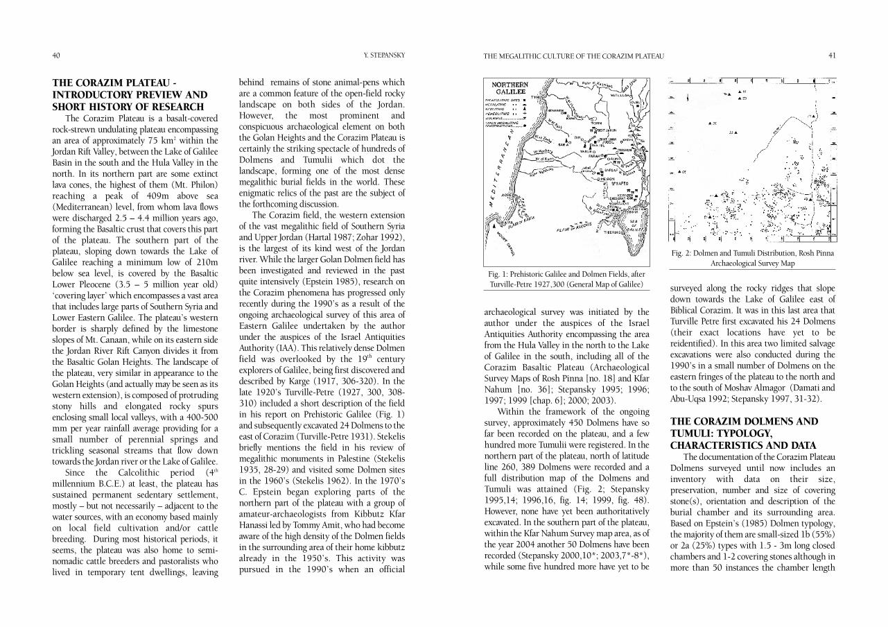
THE CORAZIM PLATEAU -INTRODUCTORY PREVIEW ANDSHORT HISTORY OF RESEARCH
The Corazim Plateau is a basalt-coveredrock-strewn undulating plateau encompassingan area of approximately 75 km2 within theJordan Rift Valley, between the Lake of GalileeBasin in the south and the Hula Valley in thenorth. In its northern part are some extinctlava cones, the highest of them (Mt. Philon)reaching a peak of 409m above sea(Mediterranean) level, from whom lava flowswere discharged 2.5 – 4.4 million years ago,forming the Basaltic crust that covers this partof the plateau. The southern part of theplateau, sloping down towards the Lake ofGalilee reaching a minimum low of 210mbelow sea level, is covered by the BasalticLower Pleocene (3.5 – 5 million year old)‘covering layer’ which encompasses a vast areathat includes large parts of Southern Syria andLower Eastern Galilee. The plateau’s westernborder is sharply defined by the limestoneslopes of Mt. Canaan, while on its eastern sidethe Jordan River Rift Canyon divides it fromthe Basaltic Golan Heights. The landscape ofthe plateau, very similar in appearance to theGolan Heights (and actually may be seen as itswestern extension), is composed of protrudingstony hills and elongated rocky spursenclosing small local valleys, with a 400-500mm per year rainfall average providing for asmall number of perennial springs andtrickling seasonal streams that flow downtowards the Jordan river or the Lake of Galilee.
Since the Calcolithic period (4th
millennium B.C.E.) at least, the plateau hassustained permanent sedentary settlement,mostly – but not necessarily – adjacent to thewater sources, with an economy based mainlyon local field cultivation and/or cattlebreeding. During most historical periods, itseems, the plateau was also home to semi-nomadic cattle breeders and pastoralists wholived in temporary tent dwellings, leaving
behind remains of stone animal-pens whichare a common feature of the open-field rockylandscape on both sides of the Jordan.However, the most prominent andconspicuous archaeological element on boththe Golan Heights and the Corazim Plateau iscertainly the striking spectacle of hundreds ofDolmens and Tumulii which dot thelandscape, forming one of the most densemegalithic burial fields in the world. Theseenigmatic relics of the past are the subject ofthe forthcoming discussion.
The Corazim field, the western extensionof the vast megalithic field of Southern Syriaand Upper Jordan (Hartal 1987; Zohar 1992),is the largest of its kind west of the Jordanriver. While the larger Golan Dolmen field hasbeen investigated and reviewed in the pastquite intensively (Epstein 1985), research onthe Corazim phenomena has progressed onlyrecently during the 1990’s as a result of theongoing archaeological survey of this area ofEastern Galilee undertaken by the authorunder the auspices of the Israel AntiquitiesAuthority (IAA). This relatively dense Dolmenfield was overlooked by the 19th centuryexplorers of Galilee, being first discovered anddescribed by Karge (1917, 306-320). In thelate 1920’s Turville-Petre (1927, 300, 308-310) included a short description of the fieldin his report on Prehistoric Galilee (Fig. 1)and subsequently excavated 24 Dolmens to theeast of Corazim (Turville-Petre 1931). Stekelisbriefly mentions the field in his review ofmegalithic monuments in Palestine (Stekelis1935, 28-29) and visited some Dolmen sitesin the 1960’s (Stekelis 1962). In the 1970’sC. Epstein began exploring parts of thenorthern part of the plateau with a group ofamateur-archaeologists from Kibbutz KfarHanassi led by Tommy Amit, who had becomeaware of the high density of the Dolmen fieldsin the surrounding area of their home kibbutzalready in the 1950’s. This activity waspursued in the 1990’s when an official
40 41Y. STEPANSKY THE MEGALITHIC CULTURE OF THE CORAZIM PLATEAU
archaeological survey was initiated by theauthor under the auspices of the IsraelAntiquities Authority encompassing the areafrom the Hula Valley in the north to the Lakeof Galilee in the south, including all of theCorazim Basaltic Plateau (ArchaeologicalSurvey Maps of Rosh Pinna [no. 18] and KfarNahum [no. 36]; Stepansky 1995; 1996;1997; 1999 [chap. 6]; 2000; 2003).
Within the framework of the ongoingsurvey, approximately 450 Dolmens have sofar been recorded on the plateau, and a fewhundred more Tumulii were registered. In thenorthern part of the plateau, north of latitudeline 260, 389 Dolmens were recorded and afull distribution map of the Dolmens andTumuli was attained (Fig. 2; Stepansky1995,14; 1996,16, fig. 14; 1999, fig. 48).However, none have yet been authoritativelyexcavated. In the southern part of the plateau,within the Kfar Nahum Survey map area, as ofthe year 2004 another 50 Dolmens have beenrecorded (Stepansky 2000,10*; 2003,7*-8*),while some five hundred more have yet to be
surveyed along the rocky ridges that slopedown towards the Lake of Galilee east ofBiblical Corazim. It was in this last area thatTurville Petre first excavated his 24 Dolmens(their exact locations have yet to bereidentified). In this area two limited salvageexcavations were also conducted during the1990’s in a small number of Dolmens on theeastern fringes of the plateau to the north andto the south of Moshav Almagor (Damati andAbu-Uqsa 1992; Stepansky 1997, 31-32).
THE CORAZIM DOLMENS ANDTUMULI: TYPOLOGY,CHARACTERISTICS AND DATA
The documentation of the Corazim PlateauDolmens surveyed until now includes aninventory with data on their size,preservation, number and size of coveringstone(s), orientation and description of theburial chamber and its surrounding area.Based on Epstein’s (1985) Dolmen typology,the majority of them are small-sized 1b (55%)or 2a (25%) types with 1.5 - 3m long closedchambers and 1-2 covering stones although inmore than 50 instances the chamber length
Fig. 1: Prehistoric Galilee and Dolmen Fields, afterTurville-Petre 1927,300 (General Map of Galilee)
Fig. 2: Dolmen and Tumuli Distribution, Rosh PinnaArchaeological Survey Map
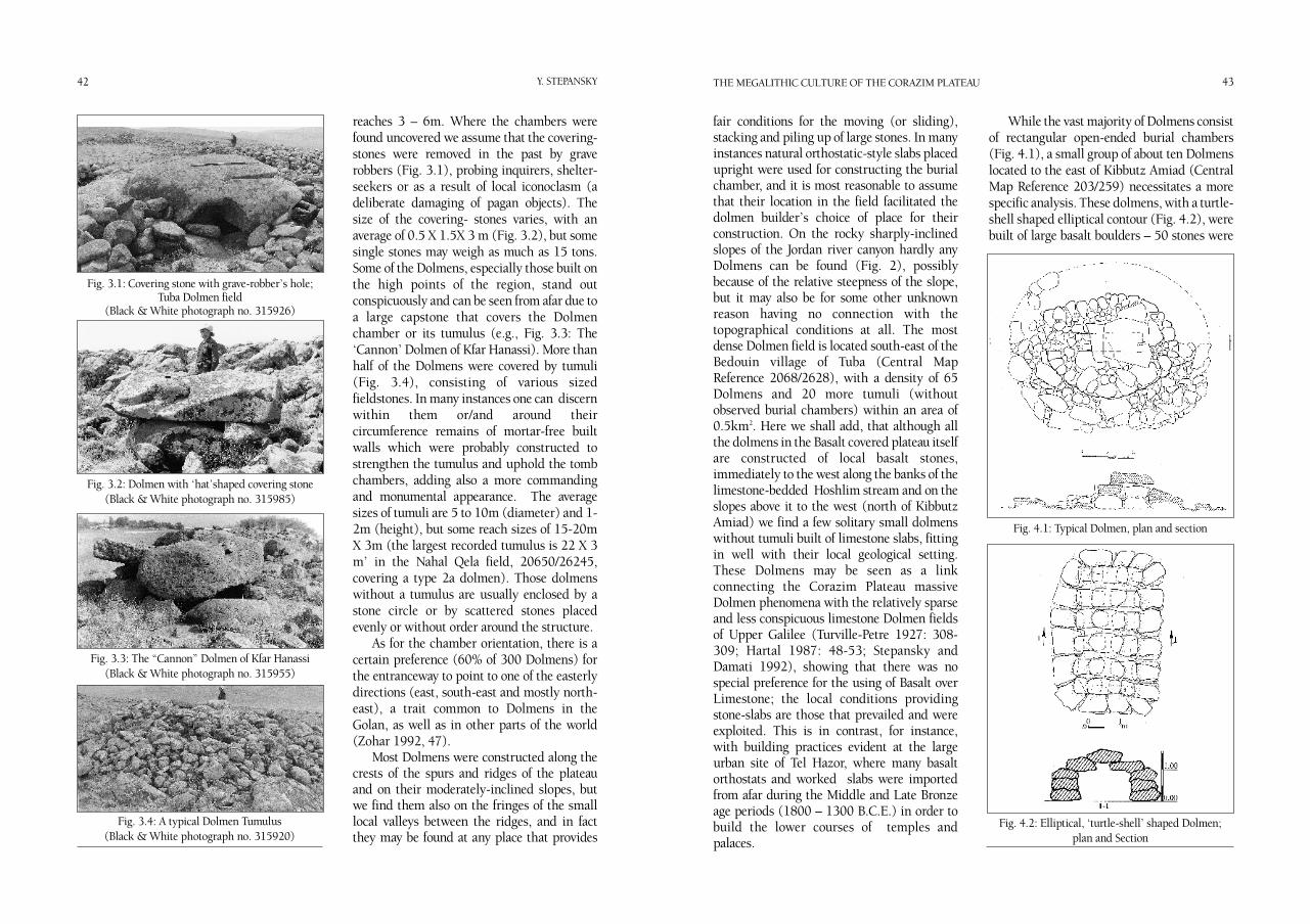
reaches 3 – 6m. Where the chambers werefound uncovered we assume that the covering-stones were removed in the past by graverobbers (Fig. 3.1), probing inquirers, shelter-seekers or as a result of local iconoclasm (adeliberate damaging of pagan objects). Thesize of the covering- stones varies, with anaverage of 0.5 X 1.5X 3 m (Fig. 3.2), but somesingle stones may weigh as much as 15 tons.Some of the Dolmens, especially those built onthe high points of the region, stand outconspicuously and can be seen from afar due toa large capstone that covers the Dolmenchamber or its tumulus (e.g., Fig. 3.3: The‘Cannon’ Dolmen of Kfar Hanassi). More thanhalf of the Dolmens were covered by tumuli(Fig. 3.4), consisting of various sizedfieldstones. In many instances one can discernwithin them or/and around theircircumference remains of mortar-free builtwalls which were probably constructed tostrengthen the tumulus and uphold the tombchambers, adding also a more commandingand monumental appearance. The averagesizes of tumuli are 5 to 10m (diameter) and 1-2m (height), but some reach sizes of 15-20mX 3m (the largest recorded tumulus is 22 X 3m’ in the Nahal Qela field, 20650/26245,covering a type 2a dolmen). Those dolmenswithout a tumulus are usually enclosed by astone circle or by scattered stones placedevenly or without order around the structure.
As for the chamber orientation, there is acertain preference (60% of 300 Dolmens) forthe entranceway to point to one of the easterlydirections (east, south-east and mostly north-east), a trait common to Dolmens in theGolan, as well as in other parts of the world(Zohar 1992, 47).
Most Dolmens were constructed along thecrests of the spurs and ridges of the plateauand on their moderately-inclined slopes, butwe find them also on the fringes of the smalllocal valleys between the ridges, and in factthey may be found at any place that provides
42 43Y. STEPANSKY THE MEGALITHIC CULTURE OF THE CORAZIM PLATEAU
fair conditions for the moving (or sliding),stacking and piling up of large stones. In manyinstances natural orthostatic-style slabs placedupright were used for constructing the burialchamber, and it is most reasonable to assumethat their location in the field facilitated thedolmen builder’s choice of place for theirconstruction. On the rocky sharply-inclinedslopes of the Jordan river canyon hardly anyDolmens can be found (Fig. 2), possiblybecause of the relative steepness of the slope,but it may also be for some other unknownreason having no connection with thetopographical conditions at all. The mostdense Dolmen field is located south-east of theBedouin village of Tuba (Central MapReference 2068/2628), with a density of 65Dolmens and 20 more tumuli (withoutobserved burial chambers) within an area of0.5km2. Here we shall add, that although allthe dolmens in the Basalt covered plateau itselfare constructed of local basalt stones,immediately to the west along the banks of thelimestone-bedded Hoshlim stream and on theslopes above it to the west (north of KibbutzAmiad) we find a few solitary small dolmenswithout tumuli built of limestone slabs, fittingin well with their local geological setting.These Dolmens may be seen as a linkconnecting the Corazim Plateau massiveDolmen phenomena with the relatively sparseand less conspicuous limestone Dolmen fieldsof Upper Galilee (Turville-Petre 1927: 308-309; Hartal 1987: 48-53; Stepansky andDamati 1992), showing that there was nospecial preference for the using of Basalt overLimestone; the local conditions providingstone-slabs are those that prevailed and wereexploited. This is in contrast, for instance,with building practices evident at the largeurban site of Tel Hazor, where many basaltorthostats and worked slabs were importedfrom afar during the Middle and Late Bronzeage periods (1800 – 1300 B.C.E.) in order tobuild the lower courses of temples andpalaces.
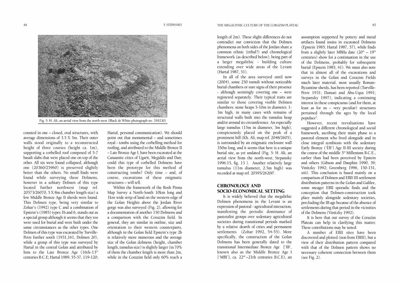
While the vast majority of Dolmens consistof rectangular open-ended burial chambers(Fig. 4.1), a small group of about ten Dolmenslocated to the east of Kibbutz Amiad (CentralMap Reference 203/259) necessitates a morespecific analysis. These dolmens, with a turtle-shell shaped elliptical contour (Fig. 4.2), werebuilt of large basalt boulders – 50 stones were
Fig. 3.1: Covering stone with grave-robber’s hole;Tuba Dolmen field
(Black & White photograph no. 315926)
Fig. 3.2: Dolmen with ‘hat’shaped covering stone(Black & White photograph no. 315985)
Fig. 3.3: The “Cannon” Dolmen of Kfar Hanassi (Black & White photograph no. 315955)
Fig. 3.4: A typical Dolmen Tumulus (Black & White photograph no. 315920)
Fig. 4.1: Typical Dolmen, plan and section
Fig. 4.2: Elliptical, ‘turtle-shell’ shaped Dolmen;plan and Section
44 45Y. STEPANSKY THE MEGALITHIC CULTURE OF THE CORAZIM PLATEAU
counted in one – closed, oval structures, withaverage dimensions of 3.5 X 5m. Their outerwalls stood originally to a reconstructedheight of three courses (height ca. 1m),supporting a corbelled roof composed of 5-7basalt slabs that were placed one on top of theother. All six were found collapsed, althoughone (20360/25960) is preserved slightlybetter than the others. No small finds werefound while surveying these Dolmens,however in a solitary Dolmen of this typelocated further northwest (map ref.20573/26070, 5 X 8m chamber length size) afew Middle Bronze Age II sherds were found.This Dolmen type, being very similar toZohar’s (1992) type C and a combination ofEpstein’s (1985) types 1b and 6, stands out asa special group although it seems that they toowere used for burial and were built under thesame circumstances as the other types. OneDolmen of this type was excavated by Turville-Petre further south (1931,161, Dolmen 20),while a group of this type was surveyed byHartal in the central Golan and attributed byhim to the Late Bronze Age (16th-13th
centuries B.C.E; Hartal 1989, 55-57, 119-120;
Hartal, personal communication). We shouldpoint out that monumental – and sometimesroyal - tombs using the corbelling method forroofing, and attributed to the Middle Bronze II– Late Bronze Age I, have been excavated at theCanaanite cities of Ugarit, Megiddo and Dan;could this type of corbelled Dolmens havebeen the prototype for this method ofconstructing tombs? Only time – and, ofcourse, excavations of these enigmaticstructures – will tell.
Within the framework of the Rosh PinnaMap Survey a North-South 10km long and1km wide strip of land on the western edge ofthe Golan Heights above the Jordan Rivergorge was also surveyed (Fig. 2), allowing fora documentation of another 150 Dolmens anda comparison with the Corazim field. Ingeneral, they are similar in outline, size andorientation to their western counterparts,although in the Golan field Epstein’s type 2bis relatively more numerous and the averagesize of the Golan dolmens (height, chamberlength, tumulus size) is slightly larger (in 70%of them the chamber length is more than 2m,while in the Corazim field only 60% reach a
length of 2m). These slight differences do notcontradict our conviction that the Dolmenphenomena on both sides of the Jordan share acommon ethnic (tribal?) and chronologicalframework (as described below), being part ofa larger megalithic - building cultureextending over wide areas of the Levant(Hartal 1987, 51).
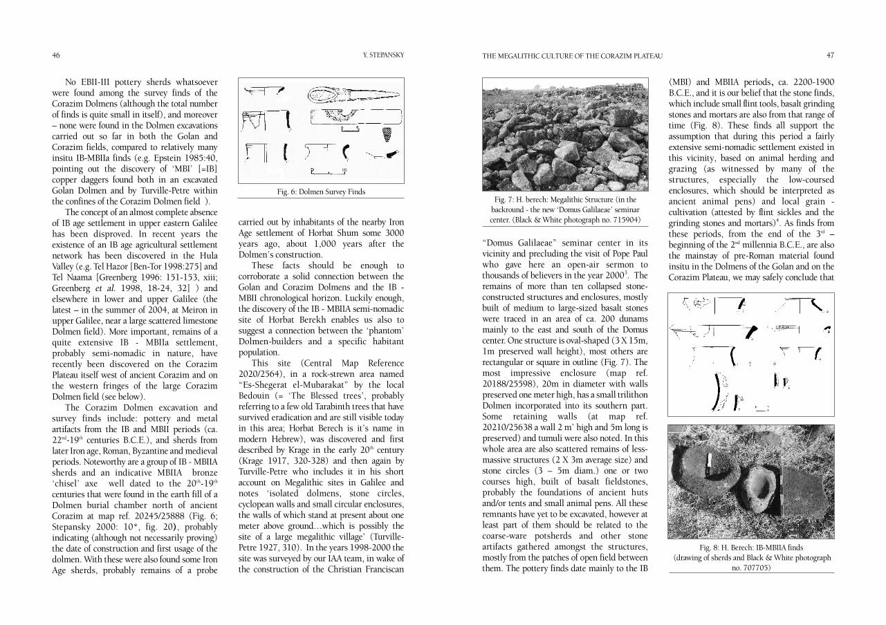
In all of the area surveyed until now(2004), some 250 tumuli without noticeableburial chambers or sure signs of their presence- although seemingly covering one – wereregistered separately. Their typical traits aresimilar to those covering visible Dolmenchambers: stone heaps 5-10m in diameter, 1-3m high, in many cases with remains ofstructural walls built into the tumulus heapand/or around its circumference. An especiallylarge tumulus (15m in diameter, 3m high),conspicuously placed on the peak of aprominent hill (Kh. Ali, map ref. 2048/2605),is surrounded by an enigmatic enclosure wall350m long, and it seems that here is a uniqueburial site, as yet undated (Fig. 5: H. Ali, anaerial view from the north-west; Stepansky1996:15, fig. 13 ). Another relatively largetumulus (11m diameter, 2.5m high) wasrecorded at map ref. 20595/262001.
CHRONOLOGY AND SOCIO-ECONOMICAL SETTING
It is widely believed that the megalithicDolmen phenomena in the Levant is anexpression of pastoral - agricultural interaction,manifesting the periodic dominance ofpastoralist groups over sedentary agriculturalsocieties during transitional periods markedby a relative dearth of cities and permanentsettlements (Zohar 1992, 54-55). Morespecifically, the construction of the GolanDolmens has been generally dated to thetransitional Intermediate Bronze Age [‘IB’,known also as the Middle Bronze Age I[‘MBI’], ca. 22nd –21th centuries B.C.E), an
assumption supported by pottery and metalartifacts found insitu in excavated Dolmens(Epstein 1985; Hartal 1987, 57), while findsfrom a slightly later MBIIa date (20th – 19th
centuries) show for a continuation in the useof the Dolmens, probably for subsequentburial (Epstein 1985, 41). We must also notethat in almost all of the excavations andsurveys in the Golan and Corazim Fieldsmuch later material, most usually Roman-Byzantine sherds, has been reported (Turville-Petre 1931; Damati and Abu-Uqsa 1991;Stepansky 1997), indicating a continuinginterest in these conspicuous (and for them, atleast as for us – very peculiar) structurespertained through the ages by the localpopulace2.
However, recent reevaluations havesuggested a different chronological and socialframework, ascribing their main phase to apastoral element who lived alongside and inclose integral symbiosis with the sedentaryEarly Bronze (‘EB’) Age II-III society duringthe course of the middle 3rd Millenium B.C.E.,earlier than had been perceived by Epsteinand others (Gibson and Dauphin 1990, 39;Vinitzky 1992; Greenberg 1996, 150-151,xiii). This conclusion is based mainly on acomparison of Dolmen and EBII-III settlementdistribution patterns in the Golan and Galilee,some meager EBII sporadic finds and theconception that Dolmen-construction tookplace mainly alongside sedentary societies,precluding the IB age because of the absence ofsettlements during that period in the vicinitiesof the Dolmens (Vinitzky 1992).
It is here that our survey of the CorazimPlateau can help in clarifying this matter.These contributions may be noted:
A number of EBII sites have beendiscovered and plotted (non from EBIII), but aview of their distribution pattern comparedwith that of the Dolmen pattern shows nonecessary coherent connection between them(see Fig. 2).
Fig. 5: H. Ali, an aerial view from the north-west (Black & White photograph no. 359230)
46 47Y. STEPANSKY THE MEGALITHIC CULTURE OF THE CORAZIM PLATEAU
No EBII-III pottery sherds whatsoeverwere found among the survey finds of theCorazim Dolmens (although the total numberof finds is quite small in itself), and moreover– none were found in the Dolmen excavationscarried out so far in both the Golan andCorazim fields, compared to relatively manyinsitu IB-MBIIa finds (e.g. Epstein 1985:40,pointing out the discovery of ‘MBI’ [=IB]copper daggers found both in an excavatedGolan Dolmen and by Turville-Petre withinthe confines of the Corazim Dolmen field ).
The concept of an almost complete absenceof IB age settlement in upper eastern Galileehas been disproved. In recent years theexistence of an IB age agricultural settlementnetwork has been discovered in the HulaValley (e.g. Tel Hazor [Ben-Tor 1998:275] andTel Naama [Greenberg 1996: 151-153, xiii;Greenberg et al. 1998, 18-24, 32] ) andelsewhere in lower and upper Galilee (thelatest – in the summer of 2004, at Meiron inupper Galilee, near a large scattered limestoneDolmen field). More important, remains of aquite extensive IB - MBIIa settlement,probably semi-nomadic in nature, haverecently been discovered on the CorazimPlateau itself west of ancient Corazim and onthe western fringes of the large CorazimDolmen field (see below).
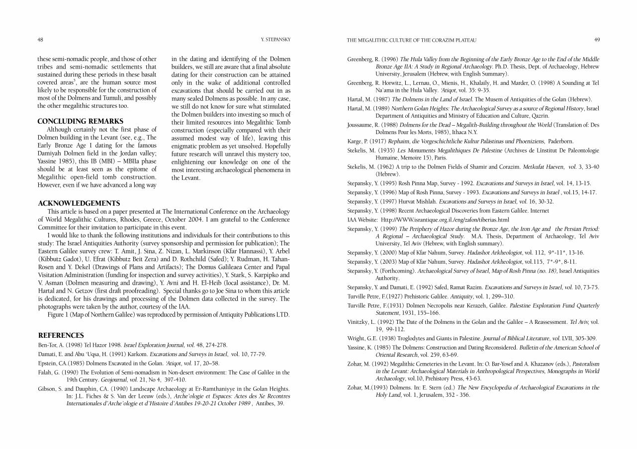
The Corazim Dolmen excavation andsurvey finds include: pottery and metalartifacts from the IB and MBII periods (ca.22nd-19th centuries B.C.E.), and sherds fromlater Iron age, Roman, Byzantine and medievalperiods. Noteworthy are a group of IB - MBIIAsherds and an indicative MBIIA bronze‘chisel’ axe well dated to the 20th-19th
centuries that were found in the earth fill of aDolmen burial chamber north of ancientCorazim at map ref. 20245/25888 (Fig. 6;Stepansky 2000: 10*, fig. 20), probablyindicating (although not necessarily proving)the date of construction and first usage of thedolmen. With these were also found some IronAge sherds, probably remains of a probe
carried out by inhabitants of the nearby IronAge settlement of Horbat Shum some 3000years ago, about 1,000 years after theDolmen’s construction.
These facts should be enough tocorroborate a solid connection between theGolan and Corazim Dolmens and the IB -MBII chronological horizon. Luckily enough,the discovery of the IB - MBIIA semi-nomadicsite of Horbat Berekh enables us also tosuggest a connection between the ‘phantom’Dolmen-builders and a specific habitantpopulation.
This site (Central Map Reference2020/2564), in a rock-strewn area named“Es-Shegerat el-Mubarakat” by the localBedouin (= ‘The Blessed trees’, probablyreferring to a few old Tarabinth trees that havesurvived eradication and are still visible todayin this area; Horbat Berech is it’s name inmodern Hebrew), was discovered and firstdescribed by Krage in the early 20th century(Krage 1917, 320-328) and then again byTurville-Petre who includes it in his shortaccount on Megalithic sites in Galilee andnotes ‘isolated dolmens, stone circles,cyclopean walls and small circular enclosures,the walls of which stand at present about onemeter above ground…which is possibly thesite of a large megalithic village’ (Turville-Petre 1927, 310). In the years 1998-2000 thesite was surveyed by our IAA team, in wake ofthe construction of the Christian Franciscan
“Domus Galilaeae” seminar center in itsvicinity and precluding the visit of Pope Paulwho gave here an open-air sermon tothousands of believers in the year 20003. Theremains of more than ten collapsed stone-constructed structures and enclosures, mostlybuilt of medium to large-sized basalt stoneswere traced in an area of ca. 200 dunamsmainly to the east and south of the Domuscenter. One structure is oval-shaped (3 X 15m,1m preserved wall height), most others arerectangular or square in outline (Fig. 7). Themost impressive enclosure (map ref.20188/25598), 20m in diameter with wallspreserved one meter high, has a small trilithonDolmen incorporated into its southern part.Some retaining walls (at map ref.20210/25638 a wall 2 m’ high and 5m long ispreserved) and tumuli were also noted. In thiswhole area are also scattered remains of less-massive structures (2 X 3m average size) andstone circles (3 – 5m diam.) one or twocourses high, built of basalt fieldstones,probably the foundations of ancient hutsand/or tents and small animal pens. All theseremnants have yet to be excavated, however atleast part of them should be related to thecoarse-ware potsherds and other stoneartifacts gathered amongst the structures,mostly from the patches of open field betweenthem. The pottery finds date mainly to the IB
(MBI) and MBIIA periods, ca. 2200-1900B.C.E., and it is our belief that the stone finds,which include small flint tools, basalt grindingstones and mortars are also from that range oftime (Fig. 8). These finds all support theassumption that during this period a fairlyextensive semi-nomadic settlement existed inthis vicinity, based on animal herding andgrazing (as witnessed by many of thestructures, especially the low-coursedenclosures, which should be interpreted asancient animal pens) and local grain -cultivation (attested by flint sickles and thegrinding stones and mortars)4. As finds fromthese periods, from the end of the 3rd –beginning of the 2nd millennia B.C.E., are alsothe mainstay of pre-Roman material foundinsitu in the Dolmens of the Golan and on theCorazim Plateau, we may safely conclude that
Fig. 6: Dolmen Survey FindsFig. 7: H. berech: Megalithic Structure (in the
backround - the new ‘Domus Galilaeae’ seminarcenter. (Black & White photograph no. 715904)
Fig. 8: H. Berech: IB-MBIIA finds(drawing of sherds and Black & White photograph
no. 707705)
Greenberg, R. (1996) The Hula Valley from the Beginning of the Early Bronze Age to the End of the MiddleBronze Age IIA: A Study in Regional Archaeology. Ph.D. Thesis, Dept. of Archaeology, HebrewUniversity, Jerusalem (Hebrew, with English Summary).
Greenberg, R. Horwitz, L., Lernau, O., Mienis, H., Khalaily, H. and Marder, O. (1998) A Sounding at TelNa’ama in the Hula Valley. ‘Atiqot, vol. 35: 9-35.
Hartal, M. (1987) The Dolmens in the Land of Israel. The Musem of Antiquities of the Golan (Hebrew). Hartal, M. (1989) Northern Golan Heights: The Archaeological Survey as a source of Regional History, Israel
Department of Antiquities and Ministry of Education and Culture, Qazrin. Joussaume, R. (1988) Dolmens for the Dead – Megalith-Building throughout the World (Translation of: Des
Dolmens Pour les Morts, 1985), Ithaca N.Y.Karge, P. (1917) Rephaim, die Vorgeschichtliche Kultur Palästinas und Phoeniziens, Paderborn.Stekelis, M. (1935) Les Monuments Megalithiques De Palestine (Archives de L̀institut De Paleontologie
Humaine, Memoire 15), Paris. Stekelis, M. (1962) A trip to the Dolmen Fields of Shamir and Corazim. Metkufat Haeven, vol. 3, 33-40
(Hebrew). Stepansky, Y. (1995) Rosh Pinna Map, Survey - 1992. Excavations and Surveys in Israel, vol. 14, 13-15. Stepansky, Y. (1996) Map of Rosh Pinna, Survey - 1993. Excavations and Surveys in Israel , vol.15, 14-17. Stepansky, Y. (1997) Hurvat Mishlah. Excavations and Surveys in Israel, vol. 16, 30-32. Stepansky, Y. (1998) Recent Archaeological Discoveries from Eastern Galilee. Internet IAA Website: Http://WWW.israntique.org.il./eng/zafon/tiberias.htmlStepansky, Y. (1999) The Periphery of Hazor during the Bronze Age, the Iron Age and the Persian Period:
A Regional – Archaeological Study. M.A. Thesis, Department of Archaeology, Tel AvivUniversity, Tel Aviv (Hebrew, with English summary).
Stepansky, Y. (2000) Map of Kfar Nahum, Survey. Hadashot Arkheologiot, vol. 112, 9*-11*, 13-16.Stepansky, Y. (2003) Map of Kfar Nahum, Survey. Hadashot Arkheologiot, vol.115, 7*-9*, 8-11. Stepansky, Y. (Forthcoming). Archaeological Survey of Israel, Map of Rosh Pinna (no. 18), Israel Antiquities
Authority.Stepansky, Y. and Damati, E. (1992) Safed, Ramat Razim. Excavations and Surveys in Israel, vol. 10, 73-75. Turville Petre, F.(1927) Prehistoric Galilee. Antiquity, vol. 1, 299–310.Turville Petre, F.(1931) Dolmen Necropolis near Kerazeh, Galilee. Palestine Exploration Fund Quarterly
Statement, 1931, 155–166.Vinitzky, L. (1992) The Date of the Dolmens in the Golan and the Galilee – A Reassessment. Tel Aviv, vol.
19, 99-112.Wright, G.E. (1938) Troglodytes and Giants in Palestine. Journal of Biblical Literature, vol. LVII, 305-309. Yassine, K. (1985) The Dolmens: Construction and Dating Reconsidered. Bulletin of the American School of
Oriental Research, vol. 259, 63-69. Zohar, M. (1992) Megalithic Cemeteries in the Levant. In: O. Bar-Yosef and A. Khazanov (eds.), Pastoralism
in the Levant: Archaeological Materials in Anthropological Perspectives, Monographs in WorldArchaeology, vol.10, Prehistory Press, 43-63.
Zohar, M.(1993) Dolmens. In: E. Stern (ed.) The New Encyclopedia of Archaeological Excavations in theHoly Land, vol. 1, Jerusalem, 352 - 356.
48 49Y. STEPANSKY THE MEGALITHIC CULTURE OF THE CORAZIM PLATEAU
these semi-nomadic people, and those of othertribes and semi-nomadic settlements thatsustained during these periods in these basaltcovered areas5, are the human source mostlikely to be responsible for the construction ofmost of the Dolmens and Tumuli, and possiblythe other megalithic structures too.
CONCLUDING REMARKSAlthough certainly not the first phase of
Dolmen building in the Levant (see, e.g., TheEarly Bronze Age I dating for the famousDamiyah Dolmen field in the Jordan valley;Yassine 1985), this IB (MBI) – MBIIa phaseshould be at least seen as the epitome ofMegalithic open-field tomb construction.However, even if we have advanced a long way
in the dating and identifying of the Dolmenbuilders, we still are aware that a final absolutedating for their construction can be attainedonly in the wake of additional controlledexcavations that should be carried out in asmany sealed Dolmens as possible. In any case,we still do not know for sure what stimulatedthe Dolmen builders into investing so much oftheir limited resources into Megalithic Tombconstruction (especially compared with theirassumed modest way of life), leaving thisenigmatic problem as yet unsolved. Hopefullyfuture research will unravel this mystery too,enlightening our knowledge on one of themost interesting archaeological phenomena inthe Levant.
ACKNOWLEDGEMENTSThis article is based on a paper presented at The International Conference on the Archaeology
of World Megalithic Cultures, Rhodes, Greece, October 2004. I am grateful to the ConferenceCommittee for their invitation to participate in this event.
I would like to thank the following institutions and individuals for their contributions to thisstudy: The Israel Antiquities Authority (survey sponsorship and permission for publication); TheEastern Galilee survey crew: T. Amit, J. Sina, Z. Nizan, L. Markinson (Kfar Hannassi), Y. Arbel(Kibbutz Gadot), U. Efrat (Kibbutz Beit Zera) and D. Rothchild (Safed); Y. Rudman, H. Tahan-Rosen and Y. Dekel (Drawings of Plans and Artifacts); The Domus Galileaea Center and PapalVisitation Administration (funding for inspection and survey activities), Y. Stark, S. Karpipko andV. Asman (Dolmen measuring and drawing), Y. Avni and H. El-Heib (local assistance), Dr. M.Hartal and N. Getzov (first draft proofreading). Special thanks go to Joe Sina to whom this articleis dedicated, for his drawings and processing of the Dolmen data collected in the survey. Thephotographs were taken by the author, courtesy of the IAA.
Figure 1 (Map of Northern Galilee) was reproduced by permission of Antiquity Publications LTD.
REFERENCESBen-Tor, A. (1998) Tel Hazor 1998. Israel Exploration Journal, vol. 48, 274-278.Damati, E. and Abu ‘Uqsa, H. (1991) Karkom. Excavations and Surveys in Israel, vol. 10, 77-79. Epstein, CA.(1985) Dolmens Excavated in the Golan. ‘Atiqot, vol. 17, 20–58.Falah, G. (1990) The Evolution of Semi-nomadism in Non-desert environment: The Case of Galilee in the
19th Century. Geojournal, vol. 21, No 4, 397-410. Gibson, S. and Dauphin, CA. (1990) Landscape Archaeology at Er-Ramthaniyye in the Golan Heights.
In: J.L. Fiches & S. Van der Leeuw (eds.), Arche’ologie et Espaces: Actes des Xe RecontresInternationales d’Arche’ologie et d’Histoire d’Antibes 19-20-21 October 1989 , Antibes, 39.
NOTES1 Smaller heaps of stones whose function is difficult to evaluate (many of them possibly the result of agricultural stone
clearing or – more probably – the remains of space clearing efforts in preparation for pitching tents or buildingtemporary huts) were not included in the tumuli data, even though we cannot rule out the possibility that some ofthem may cover burial remains.
2 The Dolmens may have nurtured the biblical tradition of the shadowy giant-people who are labeled in the OldTestament ‘Rephaim’, reminiscent of the mythical folklore regarding the Dolmens and Menhirs of Europe andelsewhere as ‘Giant’ structures (Wright 1938). The passage in Deuteronomy 3:11 which describes the legendary kingOg’s resting place as a large ‘beadstead of iron’ probably refers to a basalt-constructed chamber-tomb Dolmen (contrato Joussaume 1988:258, who maintains that ‘nowhere is there a biblical mention of a chamber-tomb’). The Dolmensare also probably referred to in the New Testament as ‘tombs’ where outcasts from the surrounding towns lived andtook shelter (Mark Chap. V). One of these towns was probably Corazim, surrounded by Dolmens. It is interesting tonote that until this day the native Bedouin of the area call the Dolmens of this area ‘Dan’, a term meaning ‘shelter’,possibly preserving the tradition mentioned in the New Testament. During Late Roman times, the Jewish populacesaw them as Pagan entities, and they are referred to in the Talmud as ‘Merkolis’ or ‘Beit Kolis’ (relating to the pagangod Mercury; see, for example, Mishna Sanhedrin, Chap.7:6, and numerous references in Tractate Avoda Zarah).
3 The site was chosen for the Pope’s visit because of its proximity to Biblical Corazim, The Mt. Of Beautititudes andCapernaum, with a beautiful view overlooking the Lake of Galilee and many Christian sites. Although the visit hadnothing to do with the Megalithic site presented here, the Pope and the public were presented with a writtendescription of the site and of the unique Megalithic remains strewn all over the area. Megalithic structural remainswere fenced off and the site, albeit partly damaged by the continuous construction work of Domus Galileaea, is mostlypreserved until today (2004) in the open rocky area to the east and south of the Domus center.
4 The semi-nomadic nature of livelihood referred to here is not one of a transitional phase between nomadism andsedentarization based on agriculture, but rather a distinct and prolonged mode of life. This part of Galilee, withdissected landforms and an average of 400-500mm yearly precipitation, allows for a diverse economy in a non-desertenvironment where crop growing can be conveniently combined with stockherding. This mode of life has beendiscerned as the main character of Galilee- Bedouin “Nomadism” in the 19th century c.e. (Falah 1990) and untilrecently was the mainstay of the Zangariya and El-Heib tribes who have been living on the Corazim Plateau since the18th century at least (today they are gathered in the village of Tuba-Zangariya on the NE part of the plateau).
5 We believe that in the future more IB-MBIIa sites will be discovered. Pottery finds from these periods are hard to detectwithout a previous mechanical cleaning of the area, as had been done within the confines of the Domus Galilea underarchaeological supervision prior to the construction of the building. Most of the finds were discovered immediatelyunder the top layer of brush, stone and dirt covering the surface, without any observed stratigraphic context.
50 Y. STEPANSKY