Embed Size (px)
Citation preview
THE MASTER PLAN OF THE ANDALUSIAN NETWORK OF
PR O T E C T E D AR E A S. AN O P P O RT U N I T Y F O R T H E
E S TA B L I S H M E N T O F C O N S E RVAT I O N S Y S T E M S I N T H E
MEDITERRANEAN AREA1
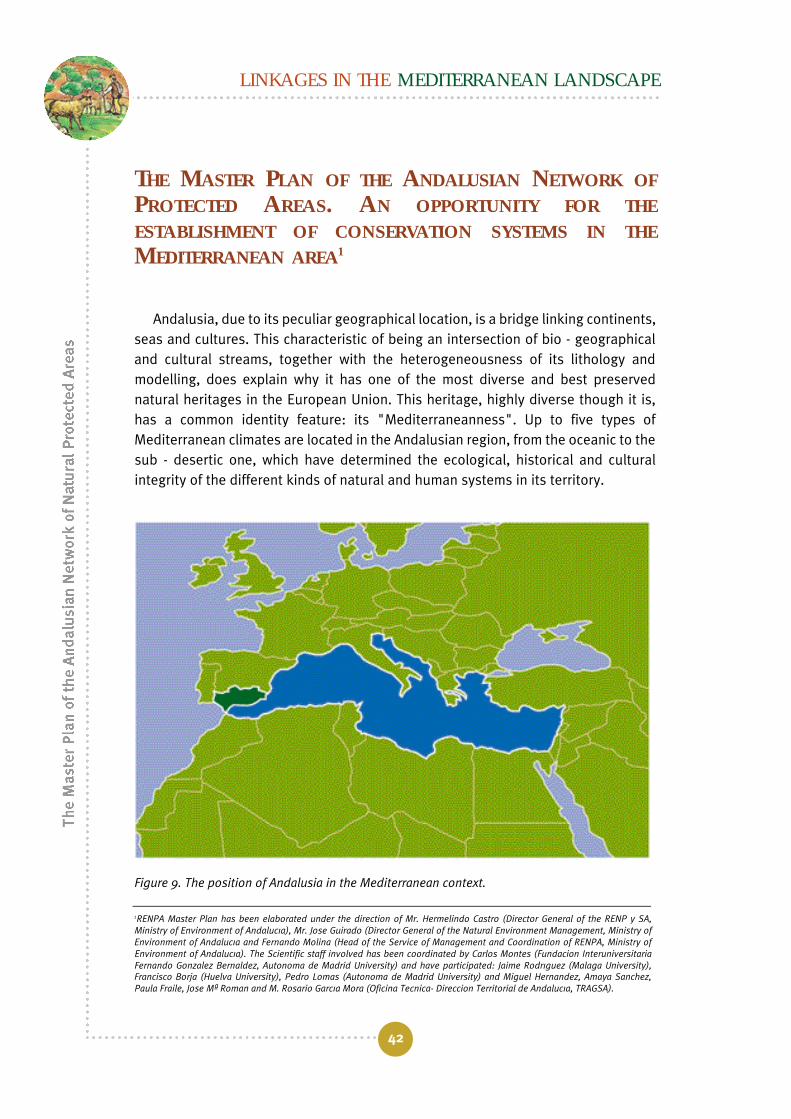
Andalusia, due to its peculiar geographical location, is a bridge linking continents,seas and cultures. This characteristic of being an intersection of bio - geographicaland cultural streams, together with the heterogeneousness of its lithology andmodelling, does explain why it has one of the most diverse and best preservednatural heritages in the European Union. This heritage, highly diverse though it is,has a common identity feature: its "Mediterraneanness". Up to five types ofMediterranean climates are located in the Andalusian region, from the oceanic to thesub - desertic one, which have determined the ecological, historical and culturalintegrity of the different kinds of natural and human systems in its territory.
Figure 9. The position of Andalusia in the Mediterranean context.
LINKAGES IN THE MEDITERRANEAN LANDSCAPE
42
1RENPA Master Plan has been elaborated under the direction of Mr. Hermelindo Castro (Director General of the RENP y SA,Ministry of Environment of Andalucía), Mr. José Guirado (Director General of the Natural Environment Management, Ministry ofEnvironment of Andalucía and Fernando Molina (Head of the Service of Management and Coordination of RENPA, Ministry ofEnvironment of Andalucía). The Scientific staff involved has been coordinated by Carlos Montes (Fundación InteruniversitariaFernando González Bernáldez, Autónoma de Madrid University) and have participated: Jaime Rodríguez (Málaga University),Francisco Borja (Huelva University), Pedro Lomas (Autónoma de Madrid University) and Miguel Hernández, Amaya Sánchez,Paula Fraile, José Mª Román and M. Rosario García Mora (Oficina Técnica- Dirección Territorial de Andalucía, TRAGSA).

In the littoral field, the Andalusian region shows two clearly different sea - fronts:one facing the Atlantic Ocean and the other, the Mediterranean Sea, whichcontribute to highlighting the high degree of biological, cultural and landscapediversity of the region’s natural heritage. The processes which characterize theMediterranean nature of the Andalusian territory end up moving through such ahighly permeable border as the coastal - littoral strip, towards the interior of themarine environment. This, in conjunction with the peculiarity of the physical andecological processes typical of our regional seas, has determined to a great extentthe use to which human settlements have put the coastal areas to, and itsconsequences for the integrity of the marine ecosystems, whose landscape structurecould undoubtedly share the "cultural" nature usually associated with the terrestriallandscape.
RENPA’s Master Plan. Towards an Integrated Planning ofProtected Areas
The concept of protected area and the use which has been made of such areas,have undergone quite important changes over the last century in an internationalcontext and also in the Andalusian context. Initially, the justification for the creationof protected areas was based on the maintenance of landscape and wildlifesanctuaries, which became privileged locations to be enjoyed by a few. Nowadays,the protected natural heritage is recognised as a basic need for the welfare and eventhe survival of many societies, since the flow of goods and services being generatedfor mankind is immense. Nevertheless, and in spite of the fact that the recognition ofthe instrumental value of protected areas has gradually increased, their capability togenerate environmental services is put every day under a growing threat stemmingfrom numerous tension factors, which act on different scales and do it basically fromoutside their administrative boundaries. This happens because the protected areaswere envisaged, years ago, as isolated entities having a management model more orless unrelated to the whole of the territory where they were located. Today, we knowwith absolute certainty that protected areas, if they are to perform their ecologicaland social functions, cannot be managed as islands in the territory, and that they areinseparably linked with the ecological, social and economic, historical and culturalreality of the social and ecological systems of their environment.
This is the reason why, since the World Park Congress held in Caracas in 1992,numerous international, European and national institutions related to theconservation of nature are both demanding and promoting a new challenge in themanagement of protected areas: to adopt a planning of an integrational nature. The
The role of protected areas in the territorial context
43

idea consists in evolving from isolated protected areas to the creation of networks orsystems making it possible, on the one hand, to maintain ecological connectionslinking protected - area ecosystems and, on the other hand, to move towards a greaterintegration of the conservation policy - based upon protected areas - into the territorialplanning, as well as to improve institutional and administrative coordination.
In this context, and at a national level, Spain’s Action Plan for protected areas(EUROPARC-España, 2002), in addition to encouraging the move from administrativenetworks to ecological ones, does recommend, as a priority, the preparation of a planningdocument for each regional system of protected areas that includes its relationship withterritorial planning and the definition of its contents. Likewise, it recommends theintegration of the Natura 2000 Network into the general protection outline of eachterritorial environment, by defining the management of future ZEC’s within the frameworkof the appropriate networks or systems of areas in each self-governing region.
The Self-Governing Region of Andalusia, ever since Act 2/89 on the inventory ofnatural protected areas was promulgated fourteen years ago, has created, both interms of numbers and area, one of the largest regional administrative networks ofprotected areas in the European Union (RENPA), consisting of 144 protected areasand covering more than 18% of the regional protected area (Figure 10). However, theintensity and the speed with which the RENPA’s configuration process has takenplace has prevented the carrying -out of a deep analysis of the path already coveredand, above all, a reconsideration, in global terms, of the management of thisimportant protected natural heritage.
Besides, throughout all this period of time, certain legal instruments andinitiatives have been developed which facilitate and provide an excellent opportunityto put into effect the necessary changes in the natural protected area policy of theAndalusian region, and which enable the RENPA to produce a new concept for theintegration and coordination of sectorial policies having a territorial repercussion. Inthis way, an important set of rules and regulations concerning the environment andbeing regional in scope has been promulgated, which directly or indirectly bears onthe conservation of Andalusian protected areas. The Andalusian Forestry Act 2/92and its Rules of Implementation, the Decree 208/97; the Environmental ProtectionAct 7/94; the Forest Fire Prevention Act 5/99, and the Fauna and Flora Act, still to bepassed by Parliament, among the most important, deserve mention.
On the other hand, the enforcement at a national level of two legal provisions suchas the Habitats Directive (EEC Directive 92/43), for the development of the Natura 2000Network, concerning which it does take and ambitious proposal of SCIs as a starting
LINKAGES IN THE MEDITERRANEAN LANDSCAPE
44

point, as well the national Act 4/89 on the Conservation of Natural Areas and the Faunaand Flora, as amended by Act 41/97, in which a new framework of responsibilities is setup for the joint management of national parks by the State’s Central Administrationand the concerned self - governing region, requires a series of important changes in thepolicy of conservation of the Andalusian natural protected areas.
In this regard, and for the purpose of guaranteeing the conservation of theAndalusian network of protected areas at the dawn of the new century, andcorrecting certain inaccuracies it has been deemed to be basic to have a Master Planfor RENPA (hereinafter called RENPA’s PD), which, in the framework and according tothe guidelines laid down in the Andalusian Environmental Plan may become thehigher level in the planning scheme concerning the region’s protected areas, andestablish a new vision of the protected heritage, determining how it must be plannedand managed.
The role of protected areas in the territorial context
45
Figure 10. The Andalusian Network of Natural Protected Areas has been configured in the last fewdecades, both in terms of numbers and area, as the largest regional administrative network ofprotected areas in the European Union. It currently includes 144 protected areas (all, regional,national and international in scope) and covers more than 18% of the regional territory.
LINKAGES IN THE MEDITERRANEAN LANDSCAPE
46
In this regard, the Master Plan has been conceived as the strategy andplanification document that establishes-starting from a conceptual model ofreference - the management goals, guiding principles, criteria and guidelines, thesectorial plans and programmes as well as the necessary procedures concerning themanagement of the Andalusian Network of Protected Areas by taking an ecosystemicapproach to it. In this regard, the RENPA’s Master Plan has been put forward as abasic tool for the creation and the definition of a Planning System for the Andalusianprotected areas that may allow to reach the following goals:
• To guarantee the conservation of the Andalusian natural heritage, byhomogenising, guiding and providing with coherence the taking ofdecisions by the managers involved in the conservation of the RENPA’sprotected areas. To that end, the Master Plan does establish a common andstandardized framework for managing the RENPA as a unit and in anintegrated manner, acknowledging the peculiarities and the role playedwithin the system by each protected area that the RENPA consist of.
• To integrate into the same conceptual framework and action strategy theresults and the resources of the numerous action plans, programmes andstrategies, with a view to guaranteeing the conservation of the Andalusiannatural heritage. In this regard, the RENPA’s Master Plan means aconnection, integration and coordination point of the different sectorialpolicies undertaken by the Andalusian environmental Administration havinga repercussion, be it direct or indirect, on the region’s protected areas.
• To coordinate the actions to be put into effect by the Andalusianenvironmental Administration and those undertaken by other local,regional and national public bodies, as well as the guidelines laid down inother international initiatives on conservation. Specially, the MaBProgramme on Biosphere Reserves, the Ramsar Convention and theBarcelona Convention for the protection of the maritime environment andthe Mediterranean’s coastal zone.
The Master Plan takes as a reference the legislation and the documents onenvironmental and territorial planning officially approved by the Andalusian RegionalGovernment, and the basic principles, general objectives and recommendationsenvisaged in the Action Plan for Spain’s Natural Protected Areas (EUROPARC-España,2002). This is a unique opportunity to go in depth into a conceptual model of referencethat defines and justifies some useful planning and management guidelines on how toadapt this important natural protected heritage to the new socio - political and economicscenarios which are emerging at the beginning of this century. With the preparation of

The role of protected areas in the territorial context
47
the Master Plan the development has been intended of a functional and organizationalstructure, dynamic as well as flexible, that may enable the RENPA to respond, inconservation and development terms, to a highly changing and globalized worldcontext. In the final analysis, this is a question of reviewing and improving the networkof natural areas existing in Andalusia for the purpose of finding solutions to the wholeset of its problems beyond the specific conservation objectives of each protected areas.
The Master Plan’s management guidelines are based upon a previous work inwhich, using the Logical Framework methodology as applied to the planning ofprotected areas, the analysis and the diagnosis have been performed of the startingsituation, identifying RENPA’s potential and establishing the causes of the mainmanagement problems and mistakes, as well as finding a scientific and technicaljustification for the network model and the planning system to be created(Department of the Environment, awaiting publication).
Finally, the vast experience gathered by the Andalusian environmental administrationthroughout the whole of this quantitative (declaration of protected areas) and qualitative(management of protected areas) process leading to the establishment of the RENPA,infuses it with a soundness and an advanced and advantageous starting position fromwhich to launch this new phase which opens with the implementation of the Master Planand which tries to move the RENPA from being an administrative network to becoming aplanification system. A new stage in which we shall be talking more often in terms of
Box 4 The most important challenges the RENPA’s Master Plan is beingfaced with:
• To Consolidate an Active Management Model, that is to say, that both at the level ofthe RENPA and at that of the protected areas the network consists of, there must bea management plan in which specific and measurable objectives are identified towhich the necessary material and human resources be allocated, and whichenvisages a management efficiency monitoring and assessment programme.
• To Create a Representative and Functional Network that guarantees theecological connections linking the ecosystems included in the protected areas, for thepurpose of preserving their ecological integrity and, as a result, the conservation of thebiological diversity they harbour.
• To Integrate the RENPA into the Territorial Planning and into other sectorialpolicies, seeking a high degree of institutional cooperation and coordination.
• To Incorporate the RENPA into the Life of the Population both rural and urban, sothat by enhancing its economic, educational, recreational and spiritual value a sharedfeeling be generated concerning the protection and custody of a natural and culturalheritage that determines one of the identity signs and roots of the Andalusian people.

ecological networks, conservation systems, ecological integrity, connectivity, ecologicalfunctions, biological diversity, goods and services, sustainable development, territorialplanning and regulation or cultural landscapes.
Aim and Scope of the Master Plan
The framework objective of the Master Plan is to provide the necessarymechanisms to contribute to the building of a territorial model of Andalusia,enabling the conservation of the ecological integrity and the biodiversity of itsecosystems, by fostering a rational use of its environmental and cultural services inorder to facilitate a sustainable, balanced and solidary economic development.
The Master Plan of the RENPA covers all eight provinces which make up theterritory of the Andalusian Self - Governing Region. It is aimed at the planning andmanagement of all natural areas, located within the Self Governing Region ofAndalucía, holding a special protection regime according to all, regional, national orEuropean Union laws, as well as international conventions and accords (Decree95/2003). Likewise, the Plan’s Programmes and Actions are directed to all sectors ofsociety, regardless of their belonging to the urban or to the rural environment, andtry to involve individuals, associations and institutions whose work and area ofresponsibility may directly or indirectly contribute to the conservation and thesustainable use of the natural and cultural heritage of Andalusia.
Basic Objectives
The purpose of the Master Plan is that of consolidating the RENPA as an adequate,efficient and well - managed planning system. To that end, it is necessary to achievea series of basic objectives which are developed by means of a series of sectorialplans and programmes (Box 5).
1 . To guarantee the conservation of the ecological and cultural integrity as well asthat of the biodiversity of the RENPA, using the development of an ecologicalnetwork being representative of the natural and semi - natural (cultural)ecosystems and of the species of the microbiota, Fauna y Flora of Andalusia.
2 . To incorporate the RENPA into the Andalusian territorial modelestablished in the Andalusian Territorial Regulation Plan - and in othersectorial policies - for the purpose of creating forums and mechanisms
LINKAGES IN THE MEDITERRANEAN LANDSCAPE
48

for the coordination and cooperation between institutions that make itsintegration easier into different economic sectors, so that localcommunities may profit from the wide range of goods and servicesgenerated by protected areas.
3. To optimise the RENPA’s management capability by providing it withthe necessary resources, by laying down management principles, criteriaand guidelines and by putting into effect a procedure for the assessmentof the efficaciousness and the efficiency of the management.
4 . To increase the support given to RENPA by the Andalusian population b ydisseminating the social value of its functions, by promoting participativemodels of management through their collegiate bodies and by takingadvantage of the opportunities provided by protected areas for environmentaleducation and public use, for the purpose of enhancing public awareness ofthe importance and the need for their conservation and custody.
5. To improve the level of the scientific, technical and interdisciplinaryknowledge of the natural and social and economic systems of the RENPA.
6. To boost international cooperation and to support, within the field of itsresponsibilities for matters pertaining to the environment, the fulfilmentof the international commitments made by Spain concerningagreements, directives and policies, European as well as international,related to the conservation of protected areas.
The role of protected areas in the territorial context
49
Box 5 To reach the goal set by the Master Plan, the latter is structured into sectorialp r o g r a m m e s , developed by means of general objectives that set the appropriateframework to define specific objectives. Specific objectives are achieved through a set ofparticularized actions at the level of RENPA, UEG and Protected Area.
General Objective of RENPA’s PD Sectorial Programme
To guarantee the conservation of RENPA’secological integrity and biodiversity.
Conservation and Restoration of RENPA’secological integrity, biodiversity andgeological diversity.
• RENPA’s representativeness and Connectivity
• Development of the Natura 2000 Network • Environmental Quality

In short, what is intended is to develop the necessary mechanisms to carry out aqualitative change in the current model of management of the Andalusian protectedareas and to envisage a new paradigm according to which the RENPA must beunderstood as an adaptable, dynamic and regulated social and economic systemhaving the capability to be ahead of and respond to the perturbations stemming fromthe rapid, deep and globalizing changes which characterize society in the earlyTwenty-First century. To achieve that it is necessary to move:
• From the priority and sole conservation of unique species and theirhabitats, to also taking into consideration the protection of thebiophysical processes determining the ecological integrity of the
LINKAGES IN THE MEDITERRANEAN LANDSCAPE
50
General Objective of RENPA’s PD Sectorial Programme
To integrate RENPA into the Andalusianterritorial model.
To optimise RENPA’s management capability
To increase RENPA’s level of support amongthe Andalusian population.
To improve and to incorporate theinterdisciplinary, scientific and technicalknowledge of RENPA’s natural and social andeconomic systems into the taking ofmanagement decisions.
To boost international cooperation and tosupport the fulfilment of the internationalcommitments made by Spain with regard toagreements, directives and policies, bothEuropean and international, related to theconservation of protected areas.
• Strengthening the Inter-institutional Coor-dination and Cooperation Capability
• Sustainable Development • Strengthening the Andalusian Network of
Biosphere Reserves
• RENPA’s Registry and Environmental Information • Administrative Organization • Compliance with and Improvement of the Legal
Framework • Training of technicians • Monitoring and Assessment of the Efficiency of
Management
• Environmental Education • Public Use and Ecological Tourism • Raising Public Awareness, Participation and Social
I n t e g r a t i o n .• Image and Communication
• Technological Research and Innovation • Information and Documentation
• National and International Cooperation

continental and maritime ecosystems which maintain biodiversity inAndalusia.
• From a conservation policy based on the declaration and management ofisolated protected areas, to the devising, creation and integratedmanagement of a system of protected areas.
• From the concept of protected areas as an end in themselves for theconservation of nature, to their being deemed to be a basic territorialplanification and regulation tool.
• From the traditional custom of considering and exploiting the naturalresources in the protected areas as isolated elements, to envisaging themas components of an ecological system by fostering sustainability modelsbased upon the multiple use of their goods and services as against asectorial and fragmented use.
• From a sectorial and competitive vision of the management of protectedareas, to a different, cooperative and integrated one, by coordinating andenviromentalizing other sectorial policies affecting different constituentelements of the territory where they are located.
As a result of everything contained in the preceding paragraphs, four priority axesare defined around which the new model for the configuration and management ofthe RENPA is intended to be organized:
• The conservation of the ecological integrity, the cultural integrity andthe biodiversity of its protected areas.
• The sustainable development or rational use of the goods and services ofits ecosystems.
• The integration of the conservation policy into the territorial planning policy.
• The improvement of the scientific interdisciplinary knowledge appliedto the management of the protected areas.
The Master Plan does, in turn, establish a series of sectorial plans related to theconservation of wetlands and marine protected areas in Andalusia. Both sectorial
The role of protected areas in the territorial context
51

LINKAGES IN THE MEDITERRANEAN LANDSCAPE
52
plans originate from the need to guarantee the conservation of the Andalusianheritage contained in this highly valuable ecosystems; to integrate into the samemanagement concept and strategy the different plans and programmes of theAndalusian Ministry of Environment concerning these ecosystems, and to establishcoordination mechanisms among the different levels of government. In both plans,the management principles and criteria, the sectorial programmes, the prioritizedactions and the necessary procedures are laid down to achieve the coexistence of themaintenance, respectively, of the ecological integrity of the Andalusian wetlands andthe maritime areas, with the sustainable utilization of the multiple goods andservices their functions provide society with. The ultimate end of both sectorial plansis to conserve the ecological integrity of both types of systems by fostering a rationaluse of the same in order to maintain their ecological, social and economic, historicaland cultural functions over time.
Concept and Functions of Protected Areas in Andalucía
Protected natural areas are defined within the framework of the RENPA’s MasterPlan as a functional and administrative unit - whether continental or marine -managed within the framework of a planning system which, in maintaining theintegrity of its ecosystems, contributes to the conservation of the biodiversity andthe environmental and cultural services of an ecologically interconnected territory ondifferent time and space scales.
From this perspective, the RENPA and the Andalusian natural protected areas thatmake it up cease to have as their sole end the conservation of their fauna, flora andmineral wealth to adopt a multifunctional character and become a tool for:
• The conservation of biological, geological and cultural diversity asevidenced in the maintenance of Andalusia’s most representative naturaland cultural landscapes.
• The conservation of key natural processes (hydrological cycle, nutrientcycles, transfers of nutrients, of individuals, of migrating species,propagules, pollination, mitigation of natural perturbations, etc.) to thesustainability of the territory.
• The setting of standards to assess and predict changes as againstdifferent uses and to make it possible to understand how certain actionscan alter the landscape.

• The development of living observatories concerning managementexperiences that enhance sustainable development models and may beshown to society and be extrapolated to the territory as a whole.
• The enjoyment, the environmental education and the awareness of theneed to conserve nature.
An Ecoregional Vision. Conserving Beyond the Boundariesof Protected Areas
The RENPA’s Master Plan does adopt an ecoregional vision and, to that end, anecological regionalization process has been established in Andalusia, being hierarchicalin nature, on the basis of which a set has been defined of continental and marineecoregions (Figure 11). However, the natural ecosystems being characteristic of eachone of the ecoregions have a different general use (or suitability) capability and aspecific aptness for certain types and intensity levels of human activity (agriculture,cattle breeding, forestry, etc.). In this regard, in order to maintain the functionality andthe retrieval capability of the ecosystems integrated into these units against naturaland/ or man - made perturbations, it is necessary to assume that such units also reflectthe different traditional - use systems (be they extensive or semi - extensive), which havejointly evolved with the natural ecosystems instituting a set of semi - natural ecosystemsor cultural landscapes, more or less varied and typical of each eco -region.
In the Master Plan, these ecoregions are deemed to be the basic management unitson a global scale (Ecological Management Units), which determine the territory intowhich the conservation and use regulation policy is intended to be integrated. Theyrepresent an space sphere having ecological and territorial significance, which ischaracterized by the inclusion of an interconnected mosaic of more or lessheterogeneous uses, in which the natural areas are a first - class tool within theintegrated planification, by means of which a contribution to the multiple managementof the territory is intended to be made. The ultimate objective is, therefore, to maintainthe sustainability of the flow of the goods and services of the ecosystems - bothprotected and unprotected - of each Ecological Management Unit (UEG).
RENPA’s Master Plan is proposing, as an attempt, 11 Ecological Management Unitsfor the continental ecosystems (Figure 11). Based on these UEGs, coordination andaction proposals are being organized reaching beyond the boundaries of theAndalusian protected areas, achieving, at the same time, the integration of theseareas into the specific context of their territorial matrix.
The role of protected areas in the territorial context
53

LINKAGES IN THE MEDITERRANEAN LANDSCAPE
54
Figure 11. Continental ecoregions in Andalusia (a). Under the Master Plan they are deemed to bethe RENPA’s Ecological Management Units, that is to say, areas having ecological and territorialsignificance on the basis of which conservation proposals are organized and coordinatedreaching beyond the boundaries of the Andalusian protected areas (b).
In the case of the Andalusian regional seas, the ecological regionalization process, atleast at a preliminary level, is conditioned by the following elements:

The role of protected areas in the territorial context
55
• The currently poor level of scientific knowledge concerning the spatialdistribution of species, habitats or physical characteristics more or lesseasy to chart.
• The putting into effect of the ecosystemic approach, which prevents thedelimitation of well - defined borders between regions whose differencesare basically determined by flows of a physical and ecological nature, and
• The combination of these elements leads to the definition of five largemarine ecoregions (Figure 11) in which the hydrodynamics, and itsrepercussions on the biological productivity, the structure ofcommunities and the behaviour of migrating species, do create the basisfor further special analysis on a finer scale which, gradually, get closer tothe cartography of the habitats and populations of the relevant species.
La combinación de estos elementos lleva a la definición de cinco grandesecorregiones marinas (Figura 11) en las que la hidrodinámica, y sus implicacionessobre la productividad biológica, estructura de comunidades y comportamiento deespecies migradoras conforman la base para posteriores análisis espaciales deescala más fina que, progresivamente, vayan aproximándose a la cartografía de loshábitats y las poblaciones de especies relevantes.
Leading Principles for the Management of the RENPA
The Master Plan of the RENPA does adopt some leading principles for preparingand putting into effect the different actions suggested in its sectorial plans andprogrammes. It is also intended that they act as regulation principles in the taking ofdecisions by mangers and other social sectors involved in the conservation and themanagement, whether direct or indirect, of Andalusian protected areas.
In this way, the preparation and the implementation of the plans, programmes andprojects, as well as the taking of decisions related to the management of the RENPA,shall be based on the following general principles:
• The conservation of the ecological integrity, which must be the chiefobjective of the management programmes. Its protection does guaranteethe functions being produced by the environmental goods and serviceswhich, in turn, are generated by the ecosystems, as well as the preservationof the biodiversity, by protecting the key biophysical factors and processeslinking the species with their habitats;

LINKAGES IN THE MEDITERRANEAN LANDSCAPE
56
• The soundness in the taking of decisions, based upon the availability ofa better interdisciplinary scientific and technical knowledge(environmental, social and technological sciences) of the natural systemsin the protected areas and of the relationships established between thelatter and the associated human systems;
• The prevention, through the promotion of a management model in whichactions are directed towards anticipating problems, and not only towardsacting once these have already arisen. To that end Environmental ImpactAssessment procedure is deemed to be basic in all those projects whichmay affect the conservation of the ecological integrity and thebiodiversity of the RENPA’s protected areas;
• The precaution, against the uncertainty of the negative effects which, onthe ecological integrity and the biodiversity of a protected area, maygenerate a certain activity, the viability or otherwise of its implementationbeing determined on the basis of the necessary scientific, technical,social and economic information;
• The participation, by providing access to information and by fostering citizenparticipation at all levels, in the planning and management of the RENPA;
• The monitoring and the assessment, by incorporating a continuousmonitoring, assessment and adjustment procedure to face the changesthat may come about in the social demands and needs during theimplementation of the Master Plan. To that end, the Plan does adopt anadaptable management model, which is translated into sectorialprogrammes with objectives devised in such a way that they can bemonitored and assessed - on different space and time scales through anindicator system;
• The inter - institutional coordination, for the purpose of boosting a fluidcommunication, a harmonization of actions and an active participation byand among the different official bodies and the different social actorsinvolved in the conservation and the management of Andalusianprotected areas, in addition to obtaining the highest degree of support inthe implementation of their sectorial plans and programmes. To reachthat goal, the Master Plan incorporates the Strategic EnvironmentalAssessment of plans and programmes into the taking of decisions, as themost suitable instrument to achieve the correct coordination between thesectorial policies and the protected area policy;

The role of protected areas in the territorial context
57
• The diffusion of initial information and of that generated by theimplementation of the Master Plan, using different ways and media andin a clear and responsible manner, for communication purposes and inorder to involve specialists and average citizens in the ideas and actionsenvisaged in the different sectorial plans and programmes. What isintended is to increase the knowledge and the understanding ofecological, social and economic, and cultural and historical values of theAndalusian protected areas and to promote social awareness of the needfor their conservation; and
• The environmental fairness and ethics. The Master Plan will beimplemented by accepting the limits set by an environmental ethicsSpromoting the adoption of attitudes and values in favour of theconservation of the Andalusian protected areas, on the basis of social andeconomic fairness, environmental sustainability, solidarity andcooperation.
Box 6 Basic Criteria for the management of the ecological integrity and thehealth of RENPA’s ecosystems
1. The need to put into effect a multi - disciplinary and an interdisciplinary approach, bothin the diagnosis of the state of integrity and health of the ecosystems and in themanagement aimed at the conservation of these characteristics.
2. The need to protect the persistency of the physical, biological, geological andchemical processes which, on different space and time scales, determine theheterogeneousness of the habitats and support the dynamics of the ecosystems andmaintain biodiversity.
3. The need to protect the persistency and the natural variability of the ecologicalprocesses which, on different space and time scales, determine the biodiversity andthe productivity of the ecosystems.
4. The need to know, control and predict the effects of the potential external sources ofperturbation which, on different space and time scales or in an unpredictable manner,may affect the integrity and health of the ecosystems.
5 . The need to know and manage functional biodiversity (key and engineering species).
6. The need to put into effect an adaptable management model in view of the progressof the scientific knowledge and the responses and evolution of the social andeconomic component of the management process.

LINKAGES IN THE MEDITERRANEAN LANDSCAPE
58
The RENPA’s Planning System (SPR)
The fast growth in the number and in the area covered by protected areas in Andalusiahas to be accompanied with a proportional increase of the RENPA’s managementcapability, capable of dealing, in all their dimension, with the global threats to theirconservation. In such a context, within the framework of the Master Plan, the RENPA’sPlanning System has been defined, having as its purposes: a) carrying out a global andintegrated management of the Andalusian protected areas based on their ecologicalrelationships and on their social, economic and cultural connections; and b) supplying thenecessary conceptual tools and methodological procedures to guarantee that the wholeof the Andalusian protected areas amount to more than the administrative sum of its parts.
This new organizational structure of the planning and management of theAndalusian protected areas is defined in the framework of the Master Plan as aninterdependent set of natural and semi - natural areas, legally protected or managedby other means, ecologically and administratively connected, related to the more orless transformed matrix in which they are located and having as its purpose that ofpreserving the eco - cultural integrity and the biodiversity of the territory in order tomaintain a sustainable flow of environmental goods and services towards society.
From this perspective, the RENPA’s protected areas do have, vis-à-vis thedevelopment of their regulation and management plans, a dual character within ahierarchy of administrative and ecological relationships (Figure 12). On the one hand,the protected area is an administrative unit legally delimited by technical and politicalcriteria and managed by means of its appropriate Use and Management Ruling Plan(PRUG). It is a part, at a first level, of the provincial administrative network (together withthe rest of PA of the province in which it is located) and, at a second level, of the regionaladministrative network or RENPA (together with the rest of PA of Andalusia).
On the other hand, and from a functional point of view, the protected area is a partof an Ecological Management Unit, that is to say, of a certain ecoregion, definedaccording to scientific criteria, with which it shares, beyond its administrative limits,essential biophysical processes. From this functional point of view, the managementof the protected area becomes integrated, according to the protection concept, intothe UEG to which it belongs through its corresponding PORN, reaching beyond, inthis way, the administrative limits of the area and even the provincial borders. Theprotected area must maintain a weft of ecological relationships with other protectedareas included in the same UEG, and keep certain biophysical links with areasbelonging to other UEGs in order to, as a whole, create the RENPA’s ConservationSystem - a group of protected areas maintaining ecological links in the context of amore or less transformed territorial matrix.

The role of protected areas in the territorial context
59
This functional vision infuses the RENPA’s administrative management with anecoregional nature, in which the administrative network being managed by taking aneco-regional approach and in the context of the territorial regulation does define themanagement model known as RENPA’s Planning System.
With the RENPA’s Planning System the creation is intended of an appropriatecontext to preserve the natural and cultural ecosystems along with the biodiversity socharacteristic of the Andalusian region. To reach that goal it is necessary to achieve:
• The conservation of a minimal sample of the ecosystems - natural andcultural landscapes so characteristic of the Andalusian natural heritage,
• The maintenance of the key biophysical processes which preserve theecological integrity of the terrestrial, aquatic - continental and maritimeecosystems so characteristic of Andalusia,
Figure 12. The RENPA’s Planning System is understood as a hierarchical organizational structurethat enables the management of its protected areas as interdependent administrative entitieswhich interact, from an ecoregional perspective and through the regulation of the territory, withthe more or less transformed matrix in which they are located.

LINKAGES IN THE MEDITERRANEAN LANDSCAPE
60
• The maintenance of viable populations of the microbiota, flora and faunaspecies so characteristic of the region, and
• The sustainable use of the environmental services of the Andalusianecosystems, by promoting development models adjusted to theecosystems’ capability to absorb and regenerate.
In order to achieve these objectives - on a local and a regional scale - the RENPA’sPlanning System has been established incorporating the following definitorycharacteristics:
• Representativeness. It must include a diversity, both in terms of numbersand in terms of area, of the Andalusian terrestrial, aquatic - continentaland maritime ecosystems (eco-diversity), as well as a sample of thepopulations and the communities of the microbiota, flora and faunaspecies (biodiversity) typical of each Andalusian ecoregion.
• Equilibrium. The existence must be avoided of a redundancy of thespecies and ecosystems included in the RENPA.
• Coherence. A representative and balanced system must, consequently,be a coherent one, with mutually complementary constituent elementswhich provide something significant and different from the whole. Eacharea in the RENPA must, therefore, contribute to the network’sadministrative and ecological coherence.
• Consistency. The management objectives of each one of the RENPA’sprotection concepts not only must adjust themselves to the specificneeds being typical of each area, but also contribute to the ecoregionalobjectives and to those of the entire planning system, in order to provideit with a greater resistance, stability and adaptation capability to faceperturbations and changes.
• Efficiency and Equitableness. Both the protected areas and the RENPAmust reach their management goals on the basis of an adequate balanceand an equitable distribution of ecological, social, and financial costs andprofits, committing the lowest number of areas and the smallestextension of protected area.

Protection levels of the Andalusian natural areas
To be able to serve the purpose of conserving Andalusia’s biodiversity bymaintaining the ecological integrity and the soundness of its ecosystems, it isnecessary to take into account, as one of the starting points, the levels or types ofconversation rules and regulations at our disposal. In Andalusia, three protectionlevels are superimposed
1. The general environmental legislation and that enacted by the Andalusian Self- Governing Region in particular, which constitute a first level of horizontalprotection being universally binding everywhere in the Andalusian territory,whether protected or non protected. Consideration must be given, due to theirdirect involvement in the RENPA, to the regional Acts 2/92 on AndalusianForestry; 1/94 on Territorial Regulation; 7/94 on Environmental Protection;5/99 on Forest Fires as well as that on the Flora and the Fauna, the latter still tobe passed by the Legislature.
2. The SCIp put under no protection concept yet. They constitute a secondprotection level, due to the very nature of the proposal and, as laid down in theHabitat Directive, these areas have, from the start, the benefit of a basicpreventive protection regime that ought to prevent them from undergoingmajor transformations before they are, in the context of the RENPA’s planningsystems, given a legal protection concept or they are integrated into an existinglegal status. It is, therefore, a potentially protectable area reserve.
3. The RENPA’s protected areas. They are the third protection level which concernsthose Andalusian natural protected areas having their own legal regulation underthe protection figure by virtue of which they have been declared protected areas.
The Role of Protected Areas in the SPR
To create a consistent planning system it is necessary to have a range ofprotection concepts making the existence possible of a management capability ondifferent scales and with different intensities, and to be able to achieve theconservation objectives respectively put forward at the levels of area, UEG andsystem. It is intended that each area and each protection concept, either current orfuture, acquire heir significance within the system as a whole. In Andalusia we have,by virtue of the national Acts 4/89, on the Conservation of Natural Areas, and3/2001, on Marine Fishing; and the regional Act 2/89, on the Inventory of Natural
The role of protected areas in the territorial context
61

Protected Areas, nine protection concepts for the RENPA’s protected areas, whichinclude, with the exception of Category III, the entire set of the types of protectedareas that the IUCN (1994) considers necessary to encompass the wide spectrum ofconservation objectives of a wide territory. (Box 7 and Figure 13)
LINKAGES IN THE MEDITERRANEAN LANDSCAPE
62
Box 7 Role played by the different types of protected areas in the RENPA’splanning system
Nation - wide concepts
1. National Park (IUCN Category II . Protected area managed, in the main, for theconservation of ecosystems and for recreational purposes).
Areas of a considerable extension and highly representative of the natural system towhich they belong. Human intervention is limited, which is why natural ecosystemsprevail over the cultural ones. They can have human settlements but not inhabited urbanareas. Their environment is susceptible of being declared a peripheral protection area.They would act, within the planning system, as essential core areas, maintaining very -well conserved natural ecosystems whose function would consist in being the source offlows of species and ecological processes, as well as acting as ecosystems of referenceto asses and to predict changes vis - à - vis different uses, and to set standards and pointsof reference in ecological restoration programmes.
2 . Natural Park (IUCN Category V. Protected area specially managed, for theconservation of terrestrial and maritime landscapes and for recreational purposes).
Large areas scarcely transformed or modelled by centuries - old human activity intocultural landscapes. Its main purpose is the conservation of the ecological, cultural,aesthetic, educational and scientific values, but also the sustainable social andeconomic development and the public use compatible with the conservation goals.They maintain important extensions of representative natural and cultural ecosystems.They would act as large core areas within the system although, due to their large size,they can contain core areas and corridors inside them.
3. Natural Reserve (IUCN Category I. Protected area managed, in the main, forscientific purposes or for the protection of nature).
Barely transformed intermediate - size areas intended for the conservation ofnatural ecosystems or communities which, due to their unaltered ecologicalprocesses, rarity, fragility, importance or uniqueness have a special value. They areareas intended for strict conservation, research and monitoring. Their use by thepublic is restricted. In the RENPA this concept has been used for the protection ofcontinental and littoral wetlands. They would act as source core - areas or as transitpoints in the marshy networks established by aquatic birds.

The role of protected areas in the territorial context
63
4. Protected Landscape (Not equivalent to any IUCN Category).
Natural areas encompassing a landscape structure and some cultural values worthyof special protection. In the RENPA, this concept has been used mainly for theprotection of those conserved areas of a linear character (rivers and river - banks)which facilitate functional connections to other natural areas, both protected and non- protected, in their environment. Their main management objectives are focused onthe preservation of ecological and social and cultural flows in the territory, thesustainable development, the research and the performance of activities of public useand environmental education. They would act as eco - cultural corridors linking thesystem’s large core areas and the maritime and continental areas.
5. Natural Monument (IUCN Category III. Protected area managed, in the main,for the conservation of specific natural characteristics).
Areas of small or very small size, declared such for the protection of uniqueelements in the rural environment. They are micro - reserves for the conservation ofgeological formations, individuals or populations of fauna and flora species whosehabitats are restricted. They require hardly complex management measures throughspecific plans or strategies for the conservation of those species, communities or thatgeological diversity.
6. Marine Reserve (IUCN Category III . Protected area managed, in the main, forthe sustainable utilization of the natural ecosystems).
This concept originated with the Spanish national fishing authority (MAPA) and seemsto come close, in their conservationist objectives, to the highest protection level ("A"reserve or degree) as defined by the Andalusian Self - Governing Region in thetypification and zoning of uses applied to RENPA’s protected areas. However, in the"Marine Reserve" certain professional fishing activities as well as recreational activities(such as scuba - diving) are allowed, except in a core area defined as "Total Reserve" inwhich no type whatsoever of maritime fishing, removal of fauna or flora, or underwateractivities, with the exception of those having scientific purposes, are allowed. In thisway, the "Marine Reserve", as the concept has been implemented in the RENPA’smaritime protected areas, would be the equivalent to the concept of "Natural Park"(UICN Category V), except in the core designated as "Total Reserve", which would be theequivalent to the nation - wide concept of "Natural Reserve", defined, though, for themaritime environment, as well as to category IA of the IUCN. They would act as core areaswithin the maritime subsystem and as source areas.

The Conservation System’s Constituent Elements
The characteristics of heterogeneousness and spatial configuration of theAndalusian landscape, typical of the Mediterranean nature, demand an ecoregionalperspective in the devising and development of a model for the management of theRENPA and the protected areas the network consists of. Because of this, theecological network model currently put into effect in other non - Mediterraneancountries, based on three well - defined elements (core areas, buffering areas andcorridors) aimed to increase biological connectivity and to break the isolation of the
LINKAGES IN THE MEDITERRANEAN LANDSCAPE
64
Self - Governing Region - wide concepts
7. Natural Spot (IUCN Category II. Protected area managed, in the main, for theconservation of ecosystems and for recreational purposes).
Intermediate - size areas having exceptional values due to the state of conservationof their natural and cultural ecosystems - landscapes, or to the maintenance ofpopulations and/ or communities of unique plants or animals. The priority purpose isthe conservation of their natural values, but traditional activities are also allowed forthe sustainable exploitation of their resources. Public use is possible if compatiblewith the conservation objectives. They could act as buffering zones or to increaseconnectivity within the system.
8. Natural Reserve under Agreement (IUCN Category IV. Protected areamanaged, in the main, for conservation under supervised management).
Private property, highly managed, areas of variable size which, in spite of not havingexceptional natural values, do maintain habitats of threatened species or culturalecosystems of interest, which are susceptible of being conserved by means ofcooperation agreements between the owners and the environmental authority. Sincethe conservation objective is closely linked with the maintenance of the rational useof its resources, they could act as areas for the maintenance of heterogeneousnessand for the configuration of agricultural or forestal matrices in which the protectedareas are included.
9. Periurban Park (Not equivalent to any IUCN Category).
Areas of small or intermediate size close to urban areas. They can be artificial or highlymanaged, and their objective is that of being used by the nearby population for thepurposes of open - air recreation, rest or leisure. Recreational activities are the prioritythrough a public use programme. They can act as recreational areas to alleviate thepressure on the public use of other, more natural areas, as well as for environmentaleducation activities. Their function in the system would be that of lightening the pressureof social use of other nearby and better conserved protected areas.

populations of species inhabiting protected areas in territories deeply transformedby man (Figure 7), is clearly insufficient for the protection of nature in Andalusia.
The model to be adopted by the RENPA is, in general, in keeping with the conservationsystems suggested for the Mediterranean region in the first part of this document, basedon the functionality of the heterogeneous mosaic of traditional uses of the territory in
The role of protected areas in the territorial context
65
Figure 13. In RENPA as a whole, each protection concept plays an important role and has a specificsignificance within the Conservation System. The nine protection concepts, nation and region -wide, existing in the RENPA make it possible to encompass in Andalusia the wide spectrum ofconservation objectives typical of a large territory.

which, in a manner that changes over time, ecosystems having different degrees ofmaturity (natural, semi - natural and artificial) combine, coexist and complement eachother (Figure 8). Anyhow, and as it is the case in the rest of the Mediterranean region,there are some ecosystems (e.g.: wetlands) in which the connections linking each otherin the shape of an ecological network are basic for the persistency of their working asecological systems (Consejería de Medio Ambiente, 2002).
RENPA’s conservation system must be understood as a coherent and consistentassembly of elements and areas existing in the Andalusian territory which, managedfrom an ecoregional perspective and within the territorial regulation framework,guarantee the conservation of biodiversity in Andalusia. The components the systemis made up of have complementary functions which, in a dynamic and flexible way, areconnected to shape a territorial structure subordinated to the achievement of theconservation objectives of the RENPA as a whole. These components are:
• Essential conservation areas
These are the core areas, and must provide a minimal area of natural and culturalecosystems to guarantee the working of the system. These are areas acting as corner- stones from which the environmental regulation of the entire territory isundertaken, for the purpose of shaping a coherent spatial structure enabling themaintenance of the landscape’s essential ecological flows.
This group includes the largest part of the intermediate and large - size areas inthe RENPA. It contains, to begin with, the natural areas protected under the conceptsof National Park, Natural Reserve and Natural Spot, whose main purpose it is toprotect a representative sample of the best - conserved ecosystems and to enablethe existence of viable populations and communities of the characteristic species ofthe Andalusian natural heritage. Because of this, conservation objectives are apriority. Within the system, these protected areas can act as recipients and sourcesof organisms for the re - colonization of other areas, in addition to contributing to theconservation of organisms showing local extinction patterns and re - colonization atthe level of meta - populations.
Secondly, the largest - extension protected areas are included in these core areas:the natural parks, which cover 67% of the RENPA’s entire area. These large areaswould have the twofold objective of conservation and sustainable development.With regard to conservation, they would be aimed at preserving assets belonging toa typical sample of the most representative cultural landscapes in Andalusia, which
LINKAGES IN THE MEDITERRANEAN LANDSCAPE
66
maintain a high level of biodiversity and are the habitat of some emblematic andthreatened species, such as the Iberian lynx or the imperial eagle. On the other hand,and due to their extension, they are - together with the national parks - key areas forthe conservation of essential processes in the maintenance of territorial integrity,such as happens, by way of example, with regard to the maintenance of the naturalwefts related to the hydrological cycle.
• Areas of interest for the conservation
They are areas located in the vicinity of the essential conservation areas. Theirpriority function consists in acting as buffering areas or peripheral protection areas,but also in improving connectivity among the best conserved areas in the system byacting as stepping - stones.
Included in this group are:
• The intermediate and large - size pLICs (18% of the pLICs in Andalusia). Inspite of the natural values that these areas do incorporate, their selectionas future components of the Natura 2000 Network has been basicallymade by taking into consideration the connection function that theyperform, by territorially completing the protected areas of the largenatural parks,
• The non - protected areas harbouring traditional use systems, whetherextensive of semi - extensive. These areas play an important role in thesystem as a whole, for they represent living cultural landscapes of a greatecological heterogeneousness, suitable, on the one hand, for harbouringa large degree of biological diversity and, on the other hand, forcontributing to the increase in the permeability of the matrix where theessential conservation areas are located, and
• The source areas, that is to say key areas for the conservation of essentialecological processes for the maintenance of the ecological integrity of theterritory. This group includes, for instance, the aquifers’ replenishmentareas, the headwaters of hydrographic basins or the slope systems whichmaintain the integrated agrarian and mountain systems.
In the preservation of these areas of interest for the conservation, a highlysignificant role may be played by the regional protection concept Natural Reserve
The role of protected areas in the territorial context
67

under Agreement, since by means of this concept the use is encouraged of goodpractices and the shared management through the joint responsibility of differentsocial groups (landowners, farmers, hunters, etc) having a direct interest in theconservation of the territory. The joint responsibility management agreements alreadyhave a legal character and have been implemented in several places in Andalusia forthe conservation of the fauna, through cooperation agreements between the ownersand the environmental authority. In exactly the same way, some of the measuresincluded in the Andalusian Forestry Plan (for forest areas) and in the AndalusianAgriculture Modernization Plan (for agricultural areas), can become important tools forthe maintenance of the traditional uses contributing to the conservation of theterritorial matrix into which the RENPA is integrated.
• Areas or elements of interest for the connectivity
Included in this group are those elements or areas whose existence, due to theirhaving certain spatial configuration, does facilitate the maintenance of the biologicalflows (movement of species) and the biophysical wefts (hydrological circulationabove and below ground, nutrient circulation, etc.) connecting the protected areas toa network configuration (protected areas + linear corridors) or to a territorial systemone (protected areas + territorial matrix + corridors). They constitute the ecologicaland cultural corridors of the RENPA’s Conservation System. Such corridors can belinear (river courses and banks, hedges, stonewalls or certain types of livestockways) or transit spots (scattered wetlands in a transformed matrix, island forests,thicket spots or even groups of isolated trees).
In order to encourage the conservation of these landscape elements which enhanceconnectivity, the Andalusian Forestry Plan (2002-2006) includes among its objectives"to coordinate the natural environment, by connecting the different elements and areasmaking it up, and to diversify the rural landscape". To that end, it incorporates differentstrategies such as the development of the Andalusian Livestock Way Plan; the retrievaland regulation of the Andalusian river - bank network, or the creation and conservationof forest enclaves and living hedges in agricultural land.
The legal protection of some of the most significant and largest ecologicalcorridors can be achieved by means of the concept of protected landscape, used inAndalusia for the first time for the protection of the middle - low course of theGuadiamar River for the purpose of retrieving the ecoregional connection betweenSierra Morena and the Andalusian Atlantic coast (Arenas, 2003). Likewise, as a partof the SCI proposal for Andalusia, an important number of river stretches have been
LINKAGES IN THE MEDITERRANEAN LANDSCAPE
68

included which, in a general context, contribute to the improvement of the territorialconnections through the river systems.
Be that as it may, for the general protection of all those types of elements or areaswhose existence within the territory contributes to the maintenance or theenhancement of ecological connection areas included in the RENPA, the Master Planputs forward, in the framework of the Territorial Regulation Plan (POTA) thepreparation of a Plan on Elements Having an Incidence on Connectivity (PEIC). ThePEIC is envisaged as one of the measures laid down in its strategy for theconfiguration of a Regional Protection System of Natural and Cultural Resources of aTerritorial Interest, and whose goal is that of integrating protection elements intoeach other, with a view to generating coherent and interconnected networks. Underthe said PEIC the uses would be regulated which are compatible with themaintenance of the connectivity function performed by a set of indispensableelements for the maintenance of the territory’s biophysical relationship weft.
• Unique areas or elements
These are areas or elements of small or very small dimensions which, even thoughthey are neither essential nor indispensable for the working of the system, play avery important role for the conservation of some types of very restricted habitats, forthe development of specific stages of the life cycle of some species or even of uniqueindividuals belonging to some arboreal species. Also included in this group are spotshaving geological or geomorphologic formations of outstanding value.
They constitute opportunistic reserves or microreserves, whose creation is importantfor the conservation of certain unique elements of the biotic or geotic structure of theecosystems. By way of example, the protection of certain rare, endemic or threatenedspecies may require the protection of very specific spots, although these may not meetthe protection conditions imposed upon the RENPA as a whole. The Natural Monumentprotection concept would be the most appropriate one to these cases.
The Architecture of the System. Integration of RENPA into theAndalusian Territorial Model
As it has been justified in the preceding sections, only through the integration ofthe conservation policy into the territorial regulation policy will the conservation bepossible of the Andalusian natural heritage, whose rich and varied eco - diversity and
The role of protected areas in the territorial context
69

biodiversity are closely linked with the heterogeneousness and the temporal andspatial configuration of a Mediterranean landscape, modelled by man for centuries.
Andalusia, the fourth largest region in the European Union, has historically been aregion with a productive structure closely linked with the traditional and rational use ofits natural resources (mainly in the spheres of agriculture and fishing) keeping a well -distributed and balanced population with hardly any uninhabited zones. Thus, inconjunction with the territory’s network of natural infrastructures, consisting inecological junctions and interconnections, the Andalusian Mediterranean culture hasbuilt another rural network, perfectly integrated into the natural one, by imitating itsnatural production cycles and preserving the essential biophysical processes. But inthe last three decades, and specially since Spain’s entry into the European Union, veryfast and very important changes are taking place in Andalusia’s productive systems, asa result of the modernization of its agriculture and of a belated and slowindustrialization process along with the gradual growth of tertiary activities such as thetourism and the service sector at large. The result is a transformation of the Andalusianeconomy, growing increasingly more globalized, from a predominantly rural basetowards a mixed (i.e., urban and rural) economy in which, basically, the service sectorand, moderately, the industrial one, are starting to acquire an ever greater importance.
Gradually, Andalusia is being configured as an agriculture and service - sectorregion, specially a touristic one, whose specialization levels are highest in theseareas and lowest in industry. This change process is taking place in an incompleteand accelerated manner, making increasingly clear that strong social, economic andcultural contradictions are currently arising in Andalusia, as a result of the saidcoexistence, which is undergoing a crisis, of modernity with traditions; or of theurban world with the rural world.
Such a change in the productive structure of Andalusia is giving rise to the buildingof a new artificial network of urban areas, large and medium - size ones, interconnectedthrough new communication infrastructures, growing increasingly apart from thenatural and cultural networks. This fact is creating important alterations to thestructure, the working and the dynamics of the Andalusian territory, as well as thegradual isolation of the natural ecosystems - whether protected or non protected -stemming from the enlargement of a territorial matrix successively more homogeneousdue to rural intensification or abandonment. The medium - term consequence is agradual loss of the region’s biological and cultural diversity.
This is the reason why, in Andalusia and in the rest of the Mediterranean worldalike, the eco - cultural dimension of territorial regulation, it being understood as the
LINKAGES IN THE MEDITERRANEAN LANDSCAPE
70

The role of protected areas in the territorial context
71
spatial expression of society’s economic, social and cultural policy, aimed atachieving a balanced development, at improving the quality of life, at managingnatural resources in a responsible way and at rationally using the territory, acquirespriority significance.
The Decree (103/99) on the Foundations and Strategies of the AndalusianTerritory Regulation Plan (POTA) does set, as the framework objective of the self -governing region’s territorial policy, the vertebration of the Andalusian region bymeans of the consolidation of a common ground from a political, social, economicand cultural point of view. In this context, the RENPA’s Planning System isendeavouring to develop the ecological dimension of Andalusian Territorial Modellaid down by the POTA, for the purpose of fostering the sustainable use of theenvironmental and cultural services related to the vast Andalusian natural heritage.It is necessary to bear in mind that the sustainable exploitation of the natural andcultural resources is one of the basic principles on which both the Model and theMaster Plan stand up.
The Andalusian Territorial Model - the desirable territorial image whose functionit is to play the role of a frame of reference for the entire set of sectorial activities,public as well as private, to take place in Andalusia - is structured, in the manner ofa network or system, into three mutually dependent components (Figure 14)
a) The Regional Urban - Area System, consisting of large - size (>100.000inhabitants), medium - size (20.000 – 100.000 inhabitants) small - size(5.000-20.000 inhabitants) population settlements, and rural settlements(<5.000 inhabitants).
b) The Internal and External Relation System, consisting of the transportand communications network, which includes in an integrated mannerthe linkages which are established to connect the different types ofpopulation settlements in the urban - area system.
c) The Ecological System or natural foundations and the extensive uses ofthe land.
Out of these three constituent elements, it is the first, the urban - area system, the onemaking up the fundamental scope of reference of the Territorial Model for the devisingand the implementation of the strategies laid down by the Plan. On how the latter is goingto be structured and evolve will depend, to a great extent, the conservation of theAndalusian natural heritage, to which it is closely bound by an interdependence

relationship. It is necessary to take into account that in Andalusia the future of the mostthriving economic sectors, namely, intensive agriculture and tourism, is very closelyrelated to the sustainable exploitation of the environmental services provided by itsnatural and cultural ecosystems (use of water, land, energy, biodiversity, landscapes).
Figure 14. The RENPA (including the future Natura 2000 Network) plays an essential role in theconfiguration of the Territorial Model established in the Andalusian Territorial Regulation Plan.
On the one hand, the model’s natural base is shaped through six large TerritorialUnits or physically homogeneous areas having common development problems andopportunities. They constitute coherent environments on which commondevelopment strategies are put forward, in keeping with the sustainablemanagement of their resources. These units have a good correspondence with theorganization of the urban - area system, which is why, broadly speaking, they can beconsidered as the natural environment with which the Andalusian humansettlements establish more or less close ecological and economic links. They are,therefore, the primary productive base associated with the said system, and theyconstitute the referent used in the identification of the fields in which sub - regionalTerritorial Regulation Plans are put into effect.
LINKAGES IN THE MEDITERRANEAN LANDSCAPE
72

These POTA Territorial Units are, up to some extent, the equivalent of the EcologicalManagement Units included in the RENPA’s Master Plan and they make it possible toincorporate the natural and cultural variability of the Andalusian territory, by settingthe burden or reception capability of the different economic activities being compatiblewith the maintenance of the ecological integrity of its ecosystems. In this context, it isnecessary to take into account the essential role played by the area currently under theprotection of the RENPA - along with that being potentially protectable (pLICs) - in theterritorial coordination and regulation of Andalusia. The territorial importance of theAndalusian proposal concerning SCIs is stressed by the fact that it covers almost 30%of the whole of Andalusia and that it affects 90% of the Andalusian municipal areas.These data give relevance to the fact that the conservation of the eco -cultural valuesof a large part of the Andalusian rural environment is closely linked with environmentalmanagement. Some ecoregions are, practically in their entirety, protected areas and insome others, the area already protected or protectable, covers the majority of theirrespective areas. The significance, in terms of numbers and area covered, of protectedareas in Andalusia succeeds in finally taking the RENPA and the future Natura 2000Network away from the conservation sanctuary model, to become basic tools for theplanning and the management of the territory.
It is, therefore, quite clear that in order to achieve the objective set by theAndalusian territorial policy-vertebrating and strengthening its physical coordinationby promoting the sustainable use of natural an cultural resources - it is basic to havethe planning and management model of the current and of the future RENPA(including the future Natura 2000 Network). What we are dealing with here is, in thefinal analysis, the integration of territorial regulation policies into the protected areapolicy, with a view to encouraging a regulation of the uses of the land that could makean economic development possible as determined by the endogenous possibilitiesbeing characteristic of each one of the UEG that make up the Andalusian territory.
This is the reason why in order to conserve the eco-cultural heritage of Andalusia, bycombining the policies of territorial regulation and conservation, the RENPA’s PlanningSystem is defined within the framework of the POTA and that of the Master Plan,providing what is known as the Regional System for the Protection of Natural and CulturalResources of Territorial Interest, laid down in the POTA for the integrated conservation ofthe natural heritage resources having an ecological content and significance.
Under the RENPA’s Planning System the coherence is being sought of the relationshipweft that maintains the ecological integrity of the ecosystems; an integrity by means ofwhich the territorial order established in the POTA supports itself. It is thus necessary, inthe first place, to assess whether the current and the future Andalusian transport and
The role of protected areas in the territorial context
73

communications system, as defined by the Infrastructure Master Plan (1997 -2007) andconsisting of an infrastructure network (roads, railways, hydraulic works) is integratedinto, or otherwise does interrupt or alter, the ecological flows determining the territory’snatural networks. The break - up of the natural and rural networks entails a degradationof the ecological foundations of the Territorial Model and, accordingly, a loss of theregion’s economic development capability, due to the high degree of dependency of theAndalusian productive system on the sustainable use of the environmental servicesprovided by its ecosystems.
On the other hand, and from the ecoregional vision’s perspective being fosteredin the Master Plan, the priority functions of the areas included in the RENPA areestablished within the framework of the different UEG within which they are located.In this manner, protected areas, far from being a tension factor in the area, becomea unique opportunity to promote social cohesion and territorial cooperation. Whatthis is all about is the seeking of management strategies, appropriate to each UEG,that enable the harmonious and balanced coexistence of the conservation of thenatural and cultural heritage with the economic development of the local population,through the sustainable use of the rich and varied flow of environmental servicesgenerated by the continental and marine ecosystems.
• The Andalusian protected areas in the environment of the mainurban areas
The fast and asymmetric growth of the economy of the main urban areas isentailing an intense territorial transformation having negative repercussions on theconservation of the Andalusian natural heritage, something which makes itimportant to determine the role to be played the RENPA’s protected areas and bytheir relationships with the structure and the evolution of the Urban - Area RegionalSystem and, specially, with the main cities and their Regional Centres. TheAndalusian large cities and metropolitan areas, located, in the main, in the coast andin the interior meadows, are home to more than 50 % of the Andalusian populationand harbour the most important industrial and tertiary activities. These main urbanareas are the most important focal points of the demand of natural resources (water,energy and raw materials) as well as the main source of solid and liquid waste. Byway of example, the demand for resources and the generation of waste, measured interms of area and pressure on the ecosystems (ecological mark), of the Sevillemetropolitan area requires and area eleven times larger than the one it currently hasto achieve sustainability. Likewise, the Andalusian population requires somethinglarger than another Andalusia to satisfy its needs in a sustainable manner.
LINKAGES IN THE MEDITERRANEAN LANDSCAPE
74

The urban regional centres have, therefore, a huge capability to transform the near-by rural areas where, in many cases, natural emblematic protected areas are located(Seville/ Huelva - Doñana, Granada - Sierra Nevada, Almería - Cabo de Gata- Níjar, etc).On the other hand, it is also necessary to bear in mind that it is in these main urbanareas where the greatest part of the demand for the public use of the RENPA’a areasoriginates. Due to this twofold nature, source of perturbations and demand for nature,the main urban areas, envisaged as a whole, are focal points in the Master Plan. On theone hand, the Plan does foster, within the framework of the POTA and as a part of thestrategies concerning the urban - area system, the development of territorial regulationinstruments that may boost a balanced metropolitan area of influence, that may, inturn, enable the conservation of adjoining rural areas and the protected areassupported by them. On the other hand, the Plan considers the protected areas close tothe large cities as nature and culture schools, but also as a source of touristic andrecreational services. This is why its sectorial programmes on Environmental Educationand Public Use include specific actions aimed at increasing, from its very origin and notonly in the natural areas, an environmental awareness of the social value and thefunctions of the RENPA. What is intended through it all is to create among citizens aproactive current of opinion in favour of its custody and conservation. In this regard, itsupports the Andalusian Environmental Education Strategy, which also stresses theimportance of the natural protected areas as one of the essential scenarios for thedevelopment of its lines of action.
The role of protected areas in the territorial context
75
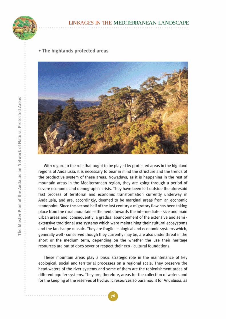
LINKAGES IN THE MEDITERRANEAN LANDSCAPE
76
• The highlands protected areas
With regard to the role that ought to be played by protected areas in the highlandregions of Andalusia, it is necessary to bear in mind the structure and the trends ofthe productive system of these areas. Nowadays, as it is happening in the rest ofmountain areas in the Mediterranean region, they are going through a period ofsevere economic and demographic crisis. They have been left outside the aforesaidfast process of territorial and economic transformation currently underway inAndalusia, and are, accordingly, deemed to be marginal areas from an economicstandpoint. Since the second half of the last century a migratory flow has been takingplace from the rural mountain settlements towards the intermediate - size and mainurban areas and, consequently, a gradual abandonment of the extensive and semi -extensive traditional use systems which were maintaining their cultural ecosystemsand the landscape mosaic. They are fragile ecological and economic systems which,generally well - conserved though they currently may be, are also under threat in theshort or the medium term, depending on the whether the use their heritageresources are put to does sever or respect their eco - cultural foundations.
These mountain areas play a basic strategic role in the maintenance of keyecological, social and territorial processes on a regional scale. They preserve thehead-waters of the river systems and some of them are the replenishment areas ofdifferent aquifer systems. They are, therefore, areas for the collection of waters andfor the keeping of the reserves of hydraulic resources so paramount for Andalusia, as

The role of protected areas in the territorial context
77
well as the origin of vectorial connections of the source - drain type (water flows,nutrients, fauna and cattle movement, etc) linking the mountains, the slopes and thevalleys and determining the natural productivity of the soils. Likewise, they includethe largest part of the natural and cultural Andalusian forestal ecosystems, amongwhich the holm oak and cork oak meadows stand out. The heterogeneousness andthe configuration of its natural and cultural ecosystems explain why the Andalusianhighlands are one of the most important biodiversity spots at a national level, andeven at a Mediterranean level (as it happens, by way of example, in Sierra Nevada).On the other hand, more than half the archaeological zones and the historicalmonuments of Andalusia are located in mountain areas.
The conservation of such a vast natural and cultural heritage is the frameworkobjective and the raison d’être for the protected areas included in the mountain UEGwithin the RENPA’s planning system. To reach this goal is quite a viable proposition,for it is in the mountain areas where the largest part of Andalusia’s protected areasis located. It is the regional protected - area zone, that is to say, that of the largeAndalusian natural parks.
In view of the Mediterranean character of the highland natural world, a prerequisitefor its conservation is the maintenance of its natural, agricultural, forestal and pastorallandscapes. In other words, the preservation of a living territorial and cultural heritage.Because of this, the natural parks located in mountain areas also have a role to play inthe comprehensive development of the affected territory, by fostering and supporting

LINKAGES IN THE MEDITERRANEAN LANDSCAPE
78
economic initiatives compatible with the conservation of the ecological and culturalintegrity of their ecosystems. The objective is to eliminate from these mountain areasthe excessive dependence on economic subsidies which reduce the endogenousdevelopment initiatives, and to reverse their social and economic marginality by meansof an appreciation, whether or not it is acknowledged by the market, of theirenvironmental services. Among the economic reactivation activities deserve specialmention those related to rural tourism, for they are fundamentally based upon a high -quality and diverse natural and cultural landscape. In the final analysis, what isintended to achieve is that the natural parks located in these mountain areas be seenby the local population local as income, employment, and welfare opportunities.
In short, protected areas being a part of the highland area have, within theirregional context, the twofold purpose of conserving, on the one hand, the keyecological processes existing between the mountain areas and the valleys; specially,the ones related to the superficial and subterranean water flows, as well as theirbiological, geological and cultural diversity; and, on the other hand, they must act asa bridge between conservation and lasting social and economic development.
For the protected areas located in the highlands to perform this twofold function,the RENPA’s Master Plan, in the context of a Mediterranean territorial matrix, ispromoting different actions as a part of several of its sectorial programmes. For theconservation of the forestal or agricultural landscape mosaic it finds useful tools inthe Andalusian Forestry Plan which, in its 2002 - 2006 adaptation, has as one of itsbasic goals "to articulate the Andalusian natural environment by connecting thedifferent forestal elements and areas that it consists of and to diversify the rurallandscape", through a strategy aimed at the creation and conservation of forestalenclaves and living hedges in agricultural landscapes. In the same way, and withinthe Forestry Plan’s framework, it is of great importance the implementation of itsstrategy concerning the comprehensive management of meadows. On the otherhand, and with regard to the diversification of the agricultural landscape maintainingcertain management practices, several programmes of the new agriculturalmodernization plan (2002 - 2006) are taken as references. The said plan is beingimplemented by the Department of Agriculture and Fisheries, and as a part of itdifferent measures and programmes for rural development are coordinated for thepurpose of modernizing agricultural production and its integration intoenvironmental policies.
To perform its function as the driving force of comprehensive development, theMaster Plan is incorporating the conceptual weft, the objectives and themethodological procedures of the MaB Biosphere Reserve Programme, and isincluding among its sectorial programmes one for the strengthening of this

international protection concept. Nowadays, under the philosophy of the MaBProgramme, the Sustainable Development Plans (PDS) of the RENPA’s natural parksare being put into effect. It is in these mountain areas where the multiple purpose ofnatural parks in keeping with the Biosphere Reserve model - conservation,sustainable development and logistic support (education, participation, public useand research and monitoring) - acquires its best territorial expression.
• Protected areas in the context of plantation lowlands and thecountryside
The protected areas integrated into the Andalusian plantation lowlands and thecountryside are immersed in a territorial matrix largely transformed andhomogeneous. In the low countryside there has been a movement from a traditionalextensive mixed - farming and rotatory system to a highly technified monoculture ofherbaceous crops, while in the plantation lowlands the use of irrigation has beenintensified for industrial crops. Only in the highland countryside, the olive grove, oneof Andalusia’s most emblematic forestal crops, and one of the greatest ecologicalsignificance, has found stability.
The role of protected areas in the territorial context
79

These are areas with a high demand for superficial and subterranean water, aswell as for phytosanitary products and fertilizers, which is why they create seriousproblems related to the intensive exploitation of aquifers and to the pollution of rivercourses and subterranean waters. These interior agricultural works have stabilizedtheir population around medium - size cities (20.000 - 100.000 inhabitants) whichhave lost a large part of their cultural identity and which are supported by intensiveagriculture and agro - industrial complexes. This development model has given riseto major changes in the structure and the working of the territory, which have alteredthe ecological wefts and flows which used to act as a connection between thehighland and the coast ecosystems (Sierra Morena and the Atlantic coast and thebridges with the Andalusian Mountain Ranges), due, in the main, to the destructionof the river - bank forests and to the pollution of the waters in the courses of theaffluent river systems in the right and the left banks of the Guadalquivir. The resultof this fast transformation process has been the creation of a homogeneouslandscape, dotted with a considerable number of countryside wetlands of a highecological value, included in the RENPA as natural reserves.
The RENPA’s Master Plan is dealing with the conservation of these wetlandecosystems by attempting to break their gradual ecological isolation in theframework of their own sectorial plan called the Andalusian Wetland Plan (Consejeríade Medio Ambiente, 2002). In this manner, it is intended that at the heart of thefuture Andalusian Wetland Committee there be coordination with other regional andnational authorities linked with the management of some constituent element ofthese ecosystems. On the one hand, with the hydrological authority, with a view tofostering the efficient use of the superficial and subterranean waters whichdetermine the hydrological regime and the hydrological period of the wetlands, and,on the other hand, with the agricultural administration, with a view to fostering therational use and the good practices in their emptying basins.
The wetlands are envisaged as basic stopover or transit points for theconservation of the biological connectivity created by the flows established byaquatic birds between source and satellite wetlands, and which constitute theAndalusian marshy networks, connected, in turn, to other national and internationalnetworks. On the other hand, within the framework of the Master Plan, it is deemedto be determining for the retrieval of the connection function between the highlandsand the coast, and between the highlands and the valleys that these ecological unitsused to perform, to prioritise in this area the strategy of the Forestry Plan on thereclamation and regulation of the Andalusian river - bank network. Likewise, it is ofgreat interest within the framework of the Andalusian Livestock Way Plan toprioritise in the valley and countryside areas, the conservation/ restoration of
LINKAGES IN THE MEDITERRANEAN LANDSCAPE
80

elements of this cultural network performing, besides, the function of ecologicalcorridors.
• The protected areas in the arid Andalusian southeast
The arid Andalusian southeast does maintain ecosystems of great uniquenessand rarity in the context of the European Union, which contribute to theenhancement of the high degree of biodiversity in the Andalusian region. Although ithas undergone some significant transformations as a result of reforestation andground erosion processes, in general its ecosystems do maintain good levels ofecological integrity. For the RENPA’s Master Plan, to the basic purpose of theprotected natural areas which currently cover a small part of this Unit, namely, theconservation of these unique ecosystems, is added, besides, that of appreciatingthese arid ecosystems/ landscapes in order to boost a sustainable developmentbased on a specialized type of rural tourism. This function is covered by theAndalusian Forestry Plan, which intends to launch, as a part of its Protected NaturalAreas and Public Use programme, one measure aimed at "adding value to aridity" bymeans of the granting of subsidies and through publicity campaigns to promotesustainable rural tourism.
The role of protected areas in the territorial context
81

• Protected areas in the littoral of Andalusia
Andalusia has an important marine dimension divided up into two marine basins:the Atlantic and the Mediterranean. Its littoral façade, connecting the continental andthe marine environments, consists in a strip 875 Km. in length (17,5 % of the Spanishcoastline) for an area which does not exceed 10% of the region’s territory. Far frombeing a homogeneous strip, this extension harbours an exceedingly high diversity ofecosystems of great ecological, cultural and economic value. In the Atlantic coast arelocated some of the most important and best kept riverine and littoral complexes inthe European Union, among which stands out the Abalario - Doñana, which harboursriverine marshlands, riverine and tidal wetlands, dune fields, beaches, pools, salt -works and estuaries. By way of contrast, the Mediterranean façade is characterizedby rocky coasts, littoral lakes and beaches.
The Andalusian littoral strip is the location of the most productive, dynamic andcompetitive sectors of Andalusia, which is the reason why this area is undergoing,since the last quarter of the Twentieth Century, the fastest and most importanttransformations in the traditional productive system. Along with these changes, adegradation and destruction of its valuable natural heritage is being brought about.Some of the main activities of the regional productive system are being introducedinto this territory, such as harbour installations, airports, industrial and power -
LINKAGES IN THE MEDITERRANEAN LANDSCAPE
82

generation complexes and, above all, a type of tourism specialized in "sun andbeaches", as well as the new "plastic - wrapped" agriculture, these last twoactivities being the most dynamic ones from an economic point of view.
Such an intense economic flow has given rise to the highest population growth inthe region. The Andalusian coast is currently home to 33% of the Andalusianpopulation, a figure which significantly grows during the summer with the arrival oftourists. It includes five of the nine large urban areas in Andalusia, as well as animportant number of medium - size cities and specialized urban environments, suchas the Costa del Sol, where population density reaches far too high figures (1.381inhabitants/ Sq. Km in the Torremolinos area).
Since such a growth, based on a relentless demand for land, has taken placewithout any regulation criteria and plans appropriate to the characteristics of theterritory, important and serious unbalances have occurred in the demand for and theexploitation of its natural resources. Demand for building space has caused roughlyhalf the Andalusian coast to be urbanized. Water demand from the numerous urbanareas and, above all, the "plastic - wrapped" agriculture, has created seriousoverexploitation problems in coastal aquifers, as is the case, for instance, in theCampo de Dalias in the west of Almería, in addition to the alteration of the rivernetwork of the neighbouring highlands. The pollution problems affecting continental
The role of protected areas in the territorial context
83

and marine waters, beaches and soils are basically created by urban and agriculturalwaste and, in the marine environment, by large harbour and industrial complexessuch as those in Huelva or Algeciras.
The result, a summary of the whole set of these tension factors, has been thetaking over and the degradation of a large part of the Andalusian coast. This fact hasbeen translated into an intense process of fragmentation affecting naturalecosystems, the resulting fragments being left isolated in a deeply transformedenvironment; some of the most valuable ecosystems have even lost a large part oftheir original area (e.g.: the Guadalquivir marshlands, the Bay of Cadiz, etc.).Nowadays, part of these fragments of natural ecosystems, some of which are asemblematic as the Doñana Natural Area o or the Cabo de Gata Natural Park, are areasincluded in the RENPA, scattered like islands throughout the Atlantic and theMediterranean coast.
The seriousness of the problems created by the unsustainable growth modelbeing put into effect in the Andalusian coast - and which is mortgaging its naturalassets, the very base of its touristic and economic heritage -, turns it into one of thehighest - priority areas for the implementation of the Andalusian territorial policy.Because of that, several Sub - Regional Territorial Regulation Plans are being put intoeffect which, within the framework of the POTA, are trying to set regulation modelsfor littoral sectors compatible with the conservation of their natural heritage.
The RENPA’s Master Plan lays down that its littoral protected areas must developa management model having greater influence and weight beyond their boundariesand thus break their gradual isolation. The entire protected area in the Andalusiancoastline covers a considerable stretch of land (229.163,75 Ha) and almost 30% ofthe entire coastal area has been catalogued by the Special Plans for the Protectionof the Physical Environment. Taking this as a starting point, and in view of the veryhigh transformation rate that the Andalusian coast is being subjected to, theimplementation of the representativity criterion is deemed to be a priority for theeffective conservation of a representative fraction of each one of the genetic -functional types in its ecosystems. It is, therefore, quite urgent to protect theecological diversity of the Andalusian coast by increasing, to the greatest possibleextent, the size of the protected coastal area and the number of spots included in it.With their greatest part already under protection, the RENPA’s littoral areas aredestined to play a pre - eminent role - not in an isolated manner, but as a whole - inthe fostering of sustainable touristic development strategies, re - orienting thecurrent model towards a quality offer based on the health and the landscape qualityof their ecosystems. The protected areas and the cultural landscape must be the
LINKAGES IN THE MEDITERRANEAN LANDSCAPE
84

driving force and the base for a new diversified and qualified touristic offer,compatible with the conservation of natural and landscape values of the Andalusiancoast. In short, the Master Plan establishes the protection, in the short term, of themaximum of littoral area having ecosystems in a good state of conservation for,simultaneously, enhancing the adding of value to that heritage.
In this approach, whereby protected areas are deemed to be one of the moreimportant assets of the Andalusian coastal region, it is fundamental to encourage theawareness of the population and the economic sectors and to maintain a minimalreserve of this natural capital (the current protected areas) to guarantee itsrenewability.
• Protected areas in the seascape
The marine scope of the Andalusian coast is one of the most valuable naturalheritages in the European territory. Facing to two biological and geographicalprovinces as different as the Atlantic Ocean and the Mediterranean Sea, the strictlymarine Andalusian ecosystems show, accordingly, a far higher degree of biologicaldiversity than the one that could be expected from its already important size. The
The role of protected areas in the territorial context
85
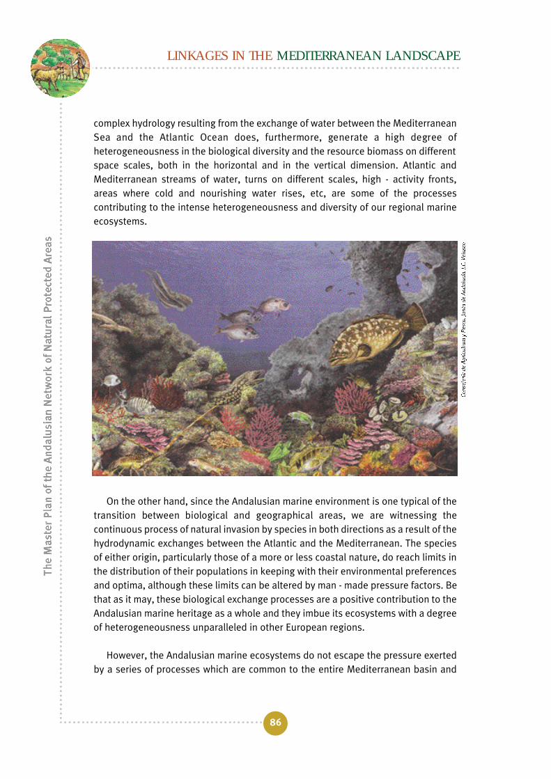
complex hydrology resulting from the exchange of water between the MediterraneanSea and the Atlantic Ocean does, furthermore, generate a high degree ofheterogeneousness in the biological diversity and the resource biomass on differentspace scales, both in the horizontal and in the vertical dimension. Atlantic andMediterranean streams of water, turns on different scales, high - activity fronts,areas where cold and nourishing water rises, etc, are some of the processescontributing to the intense heterogeneousness and diversity of our regional marineecosystems.
On the other hand, since the Andalusian marine environment is one typical of thetransition between biological and geographical areas, we are witnessing thecontinuous process of natural invasion by species in both directions as a result of thehydrodynamic exchanges between the Atlantic and the Mediterranean. The speciesof either origin, particularly those of a more or less coastal nature, do reach limits inthe distribution of their populations in keeping with their environmental preferencesand optima, although these limits can be altered by man - made pressure factors. Bethat as it may, these biological exchange processes are a positive contribution to theAndalusian marine heritage as a whole and they imbue its ecosystems with a degreeof heterogeneousness unparalleled in other European regions.
However, the Andalusian marine ecosystems do not escape the pressure exertedby a series of processes which are common to the entire Mediterranean basin and
LINKAGES IN THE MEDITERRANEAN LANDSCAPE
86

The role of protected areas in the territorial context
87
which operate on different scales. Some of these processes take place on a global,basin scale (such is the case of the different effects of the climatic change or theincrease in the ultra-violet radiation) and some other do it on a local scale (such asthe case of the eutrophicating of a specific bay or the destruction of a stretch ofPosidonia oceanica meadow). Nevertheless, the intense physical connectivity typicalof the fluid environments and the peculiarities of that connectivity in the Atlantic -Mediterranean marine environment which encompasses the Andalusian coastenable the interaction between and the proliferation of processes on different scales.The generic effects that derive and can be expected from global planetary changes,such as the global warming or the reduction in the ozone layer and the increase inthe ultra - violet radiation, as well as the possible responses by the ecosystems(terrestrial and marine), are the subject matter of continuous research and debate,basically on the basis of the use of predictive models. Although the EuropeanEnvironment Agency (EEA, 2001) includes some predictions made by the PNUMA/PAM concerning the possible effects of the global climatic changes on specificMediterranean areas and on the Andalusian dimension of the regional marineecosystems, given the current state of knowledge, it is not possible to make anyassessment in this respect.
Within the scope of the most specific problems affecting regional marineecosystems in Andalusia and, consequent upon the ecoregions and ManagementUnits defined in this Master Plan, the identification is possible of the followingprocesses or driving forces that, acting as pressure agents, entail a whole sequel ofdirect and indirect effects:
I. Urban development pressure on the coast • Modification of the uses of the land, with invasion of the marine -
terrestrial public domain.• Erosion and modification of the littoral profile, with alteration to
the distribution of sediments.• Fragmentation of habitats and communities.• Input of organic materials and inorganic nutrients. • Loss of aesthetic and cultural values.
II. Touristic and recreational uses of coastal waters • Physical fragmentation and destruction of habitats, populations
and communities• Generic pollution (solid waste, organic and inorganic inputs, etc)• Release of invading species; generally, of an exotic and
opportunistic nature (that is to say, having great capability todisperse, to use resources and to displace indigenous species).

III. Agricultural activities at the hydrographical - basin level • Input of organic materials (either natural or synthetic) and inorganic
nutrients.• Input of sediments, erosion and modification of the littoral profile.
IV. The fishing industry • General overexploitation of populations and exhaustion of fishing
grounds.• Exploitation of immature fish through illegal nets and non -
industrial fishing.• Physical destruction of habitats and communities by different
trawling nets used under illegal conditions.
V. Intensive aquiculture activities • Input of organic matter and inorganic nutrients. • Overexploitation of populations of small fish species for the
fattening of cultured carnivorous species.
VI. Industrial activity • Input of toxic materials (heavy metals, synthetic organic
compounds, etc)
VII. Marine transport • Input of diverse chemical products, in a more or less diffuse (e.g.: tank
cleaning) or concentrated way in the event of a maritime accident. • Release of invading species; generally, of an exotic and
opportunistic nature.
We could identify an additional eighth driving force: the lack of knowledge andawareness by the citizenry of the social value represented by the maintenance of theintegrity of marine regional ecosystems. One of the fundamental goals of theRENPA’s Master Plan is to contribute, through several of its Sectorial Programmes, toimproving the level of knowledge by the users concerning the value of marineecosystems in order to finally integrate the citizens’ attitude into the saidecosystems’ protection and conservation process.
The set of identified pressure factors, by acting either individually orsynergistically, do determine some of the general problems which characterizethe current state of the marine environment and the marine ecosystems inAndalusia:
LINKAGES IN THE MEDITERRANEAN LANDSCAPE
88
Eutrophicating of coastal waters
The eutrophicating process derives from an increase in the rate of input of organicmatter to the ecosystem, which results in the enrichment of inorganic nutrients (inthe main, nitrogen and sulphur) and in the increase of the biomass and the system’sprimary production. It is generally assumed that the increase in the input of nutrientsderives from human activities (urban sewage, agriculture, aquiculture, etc). Itsnegative consequences range from changes in the specific composition of thecommunities, to the reduction in specific diversity, the risk of proliferation of toxicspecies, the reduction in the oxygenation of waters and sediments and the resultingincrease in the mortality rate of animal populations. In short, a loss of the integrityand health values of the affected marine ecosystems.
The eutrophicating problem could be significant in areas close to river water inputs(specially important in the Gulf of Cadiz), urban developed areas with dumping ofuntreated waste or semi - closed environments under strong human pressure (by wayof example, the case of the Bay of Cadiz). On an open or oceanic - water scale (pelagicecosystems), both Atlantic and Mediterranean, the predominantly oligotrophic nature(scarcity of nutrients and low primary productivity, in particular in the interior of theMediterranean Basin) results if the eutrophicating not being a specially significantproblem in these waters, which ought not to be used as an argument to prevent allnecessary measures from being put into practice for the alleviation of thisdegradation process on a coastal ecosystemic scale.
Human health hazards
In a diffuse way, such a hazard does exist throughout the whole coast in the vicinityof spillages, in general through submarine outlets, of untreated sewage of an urbanorigin and effluents having an industrial origin. However, the different ComprehensiveCleaning Up Plans put into effect over the last few years on a municipality ormunicipality community scale, as well as the immediate implementation of the EUFramework Directive on Waters make it possible to believe that the presence ofpathogenous organisms or that of toxic compounds in recreational - use waters be aminor hazard now and will be a controlled one in the future.
Reduction in fishing resources
Thanks to the differential development of aquiculture and to the grater extent ofthe continental shelf in the Gulf of Cadiz, the problem of exhaustion of fishinggrounds is a more serious problem in the case of the UEG in the basin of the Sea of
The role of protected areas in the territorial context
89

LINKAGES IN THE MEDITERRANEAN LANDSCAPE
90
Alborán, particularly for the whole of the demersal resources (those linked with thesolid substratum) and, specifically, for the stocks of immature fishes exploitedthrough forbidden non - industrial techniques (e.g. the use of a small dragnet) o bymeans of illegally used techniques (e.g. trawling above authorized depths).
It is important to highlight the concern that currently links the intensiveaquiculture activities (particularly the one intended for the fattening of carnivorousspecies, whose extreme example would be the tuna fish) with the overexploitation ofpopulations if small pelagic fish (sardine, anchovy, etc) to be used to feed thecultured species. If the individuals to be fattened come, in turn, from wild stocks (asit happens in the abovementioned example), such commercial activity not onlyjeopardises the survival in the wild of the populations of the species havingcommercial value (something that must be considered a common asset), but also ofthose populations, also wild, that they required for food. Without a doubt that willeventually affect in a negative way both the integrity and the health of the regionalmarine ecosystems on a wide time and space scale, as will the sustainability of thevery social and economic activity of intensive aquiculture, which creates economicprofits originated from and concentrated on the exploitation of a common asset.
Reduction in biodiversity
The most significant general consequence of all these processes, acting eitherisolatedly or synergetically, is the reduction in general biodiversity or that affecting somebiological groups in particular. Such a reduction is basically shown through the reductionin the area they occupy and in the distribution area of many populations of the Andalusianmarine environment, the populations entering a decline process and experiencing anincrease in their vulnerability in the face of new external changes or perturbations.
It is important to emphasize the potential role which does play or could play thesubstitution of autochthonous species for invading species generally exotic andopportunistic in nature, a process which, according to what has been expounded atthe beginning of this analysis of marine UEGs, must not be mistaken for thebiological exchanges which are a natural part of process of configuration of theAndalusian marine ecosystems along the Atlantic - Mediterranean gradient.
Whatever the origin of the species artificially introduced (transport and release inballast water, accidental leaks from aquarium - type installations or, even, theconsequence of engineering works such as the opening of the Suez Canal Suez), theresult is a biodiversity loss with changes in the structure of the communities, a trendtowards homogenisation with adjoining regions and, in short, a loss of biologicalidentity by the affected ecosystems.

The role of protected areas in the territorial context
91
The Master Plan, in taking into consideration and paying attention to the sustainableconservation of the regional marine ecosystems, envisages the development of anAndalusian Plan for Protected Marine Areas, with a Sectorial Plan status equivalent tothat of the Andalusian Wetland Plan and other already in existence, in which, by meansof a set of Sectorial Programmes, the inventory is identified of specific actions makingit possible to guarantee the conservation and sustainable development objectivesbeing the conceptual and political foundation of the RENPA.
A hierarchical planning
For the performance of the functions of the protected areas in the Andalusianterritorial context, it is necessary for the RENPA to be organised as a system whichmust work in a coherent way starting from an institutional Master Plan which,subordinated to the existing legal framework, lays down the guidelines which mustrule the planning and the management of the Andalusian protected heritage, fromthe network level to that of protected area. Such a planning not only has to beintegrated into other sectorial projects but also must have an integrational characterconcerning the planning of the territory as a whole.
The Master Plan does adopt a hierarchical, or from - top - to - bottom, planningmodel to guarantee the coherence of the RENPA. The model establishes threeplanning and management levels.
The first level consists in the Master Plan itself, in which the managementprinciples, criteria, guidelines, plans and programmes are laid down, as are thesystem’s components and architecture. For the national parks, the managementmodel is established in the National Park Network’s Master Plan, prepared by theMinistry of the Environment and enacted in 1999.
The second planning level is made up of the Ecological Management Units set upin the ecological regionalization of Andalusia (Figure 11). At this level, the RENPA’sMaster Plan intends to carry out an effective administrative coordination of theNatural Resources Regulation Plans (PORN) of the protected areas which share thesame functional unit, which, in turn, must determine the measures (regulation,administration or contract - related) which are necessary for getting the SCIs readyin each UEG. To this end, the Master Plan suggests the preparation of the Regulationand Management Programmes of the Andalusian Ecological Units (POGUEA).
At this level, therefore, a planning is put forward not being regulated by the UEG,which must be understood to be one not requiring a legal support. This would enable,

on the one hand, the coordination and articulation, in the framework of the RENPAplanning systems, of such changes as it is necessary to include in the PORNs of theSCIs , in order to meet the planning and management requirements demanded by theDirective, adapting them to the biophysical and historical and cultural characteristicsof the territory of the UEG where they are located. Likewise, the POGUEA, in addition toenabling the harmonization of all management programmes affecting the same UEG,would facilitate the coordination with other planning instruments such as the RegionalForestal PORN established by the Andalusian Forestry Law or the Sub-RegionalRegulation Plans developed by the Andalusian Territorial Regulation Plan.
The last level would consist of the Use and Management Ruling Plans (PRUG), inwhich the specific plans are laid down for the management and regulation of usesand activities of each protected area in the RENPA.
With this from - top - to - bottom planning model, in which a hierarchy ofmanagement objectives is established, the solution is attempted to one of the mostimportant problems related to the long - term viability of the programmes for themanagement of protected areas: the fragmentation and the scarce coordinationamong the different authorities involved in the exploitation - conservation of theAndalusian natural heritage. To overcome such a problem, the planning through thehierarchical organization and operation model of the natural and man - madesystems, makes the development easier of a coordinated, multi - dimensional andhierarchical management of the ecosystems’ environmental services. In short, itmakes it possible to develop integrated models for the management of the naturalenvironment at different planning levels, from a regional to a local scale. It thereforefacilitates the establishment of an integrated flow of information from top to bottomand vice versa, an easy one to understand by managers, planners, technicians,scientists and, in general, people responsible for the management of naturalsystems.
The Master Plan envisages a sectorial programme for the monitoring andassessment of the efficiency of the management, that enables the measurement ofchanges in the System and in the elements that it consists of, and, accordingly, thefeeding back of the series which consecutively links diagnosis with regulation withmanagement.
In short, the Master Plan both defends and fosters and environmental policy inwhich protected areas are a tool within the territorial regulation policy and never anend. This objective is achieved by boosting multidimensional models for thesustainable exploitation of the ecosystems’ environmental services. What it does
LINKAGES IN THE MEDITERRANEAN LANDSCAPE
92

concern is the modulating of an ecologically heterogeneous territory, by boostingdiverse human activities resulting in ecosystems, whether protected or nonprotected, with different stages of ecological succession. But, besides, the differentfunctional types of ecosystems have to be interconnected by a wide variety ofprocesses and wefts, which become apparent on different time and space scales. Inthis way, rather than devoting our attention to seeking and protecting areas beingunique from an aesthetic, a biological or an ecological point of view, we mustencourage the implementation of policies and instruments promoting the multiplemanagement of the territory, in keeping with the functionality of the ecologicalsystems on different space scales. The existence of a powerful network of protectedareas, both in terms of numbers and in terms or area, is an important territorialstrength to achieve the physical articulation of Andalusia based on a eco - culturalheritage with an excellent state of ecological health.
The role of protected areas in the territorial context
93
Figure 15. Hierarchical, of from - top - to - bottom, Planning Model established in the RENPA’sMaster Plan which conceives the management of the Andalusian protected heritage as a set ofmutually dependent analysis and management levels. This hierarchical organization makes itpossible to plan and to manage the RENPA from a multiple - dimension and multiple - scaleperspective and conceive it as a whole, that is to say, as an integrated and single unit