Embed Size (px)
Citation preview
SEPTEMBER 2013
The Malvern Hills Conservators
An NVC Survey of the Malvern Hills Conservators’ Holding 2013 855000
Malvern Hills Conservators An NVC Survey of the Malvern Hills Conservators’ Holding 2013 i 855000 (00)
RSK GENERAL NOTES Project No.: 855000-1 (00) Title: A NVC Survey of the Malvern Hills Conservators’ Holding 2013 Client: Malvern Hills Conservators Date: 11th November 2013 Office: Coventry Status: Final version for issue Authors Dr Jonathan Mitchley/ Dr
Steven Heathcote/ Matthew Davies
Technical reviewer
Dr Richard Carter
Signature
Signature
Date: 11th November 2013 Date: 11th November 2013
Project manager
Louise Denning
Quality reviewer
Dr Richard Carter
Signature
Signature
Date: 11th November 2013 Date: 11th November 2013
RSK Environment (RSK) has prepared this report for the sole use of the client, showing reasonable skill and care, for the intended purposes as stated in the agreement under which this work was completed. The report may not be relied upon by any other party without the express agreement of the client and RSK. No other warranty, expressed or implied, is made as to the professional advice included in this report.
Where any data supplied by the client or from other sources have been used, it has been assumed that the information is correct. No responsibility can be accepted by RSK for inaccuracies in the data supplied by any other party. The conclusions and recommendations in this report are based on the assumption that all relevant information has been supplied by those bodies from whom it was requested.
No part of this report may be copied or duplicated without the express permission of RSK and the party for whom it was prepared.
Where field investigations have been carried out, these have been restricted to a level of detail required to achieve the stated objectives of the work.
This work has been undertaken in accordance with the quality management system of RSK Environment.
Malvern Hills Conservators An NVC Survey of the Malvern Hills Conservators’ Holding 2013 ii 855000 (00)
CONTENTS 1 EXECUTIVE SUMMARY..................................................................................................................1 2 INTRODUCTION ..............................................................................................................................4
2.1 Purpose of the Report ..............................................................................................................4 2.2 Project Brief ..............................................................................................................................4 2.3 Ecological Background.............................................................................................................4 2.4 Structure of the Report .............................................................................................................5
3 METHODS........................................................................................................................................6 3.1 General.....................................................................................................................................6 3.2 Changes to Survey Methods from the 2006 Survey ................................................................6 3.3 Site of Special Scientific Interest (SSSI) Assessment Criteria.................................................7 3.4 Constraints and Site Coverage ................................................................................................7 3.5 Plant Nomenclature..................................................................................................................8
4 NVC TYPES .....................................................................................................................................9 4.1 General.....................................................................................................................................9 4.2 Synopsis of Previously Recorded NVC types ..........................................................................9
4.2.1 Calcicolous Grassland Communities............................................................................9 4.2.2 Calcifugous Grassland Communities ...........................................................................9 4.2.3 Heath Communities....................................................................................................10 4.2.4 Mesotrophic Grasslands.............................................................................................11 4.2.5 Tall-herb and Bracken Communities ..........................................................................11 4.2.6 Scrub and Woodland Communities............................................................................12
4.3 Additional NVC Types identified during the 2013 survey.......................................................12 4.3.1 Mesotrophic Grasslands.............................................................................................12 4.3.2 Mire Communities.......................................................................................................21 4.3.3 Aquatic communities ..................................................................................................23 4.3.4 Scrub and Woodland Types .......................................................................................24
4.4 Areas of NVC types................................................................................................................27 4.5 Changes in NVC types ...........................................................................................................29
4.5.1 Introduction.................................................................................................................29 4.5.2 Changes in scrub vegetation: automated approaches...............................................30 4.5.3 Some field observations on vegetation change .........................................................32
5 NON-SSSI AREAS.........................................................................................................................35 5.1 Introduction.............................................................................................................................35 5.2 Woodland areas .....................................................................................................................35 5.3 Grassland areas .....................................................................................................................36 5.4 Malvern Common ...................................................................................................................37
5.4.1 General Description and Location..............................................................................37 5.4.2 Floristic Composition and Area ..................................................................................37 5.4.3 Assessment against SSSI Criteria .............................................................................39 5.4.4 Setting the Common Standards Monitoring targets ...................................................40
6 NOTABLE PLANT SPECIES.........................................................................................................45 7 REFERENCES ...............................................................................................................................52
Malvern Hills Conservators An NVC Survey of the Malvern Hills Conservators’ Holding 2013 iii 855000 (00)
TABLES Table 3-1 Grouping of vegetation types for hard-copy mapping, with notes where communities have been grouped. . .......................................................................................................................................6 Table 4-1 Vegetation referable to the NVC type MG1 Arrhenatherum elatius grassland ....................13 Table 4-2 Vegetation referable to the MG5 Cynosurus cristatus-Centaurea nigra grassland .............15 Table 4-3 Vegetation referable to the MG6 Lolium perenne-Cynosurus cristatus grassland ..............17 Table 4-4 Vegetation referable to the NVC type MG9a Holcus lanatus-Deschampsia cespitosa grassland, Poa trivialis sub-community.................................................................................................21 Table 4-5 Vegetation referable to the NVC type M23a Juncus effusus/acutiflorus-Galium palustre rush-pasture, Juncus acutiflorus sub-community.. ...............................................................................22 Table 5-1: Selected quadrats recorded from Malvern Common...........................................................38 Table 5-2: Quadrat data from mire vegetation on Malvern Common ...................................................39 Table 5-3. Common Standard Monitoring targets for the MG5 grassland in the proposed Malvern Common SSSI ......................................................................................................................................41 Table 5-4. Common Standards Monitoring guidance for the M23 community found on Malvern Common based on the guidance for "Lowland Rush Pastures" ...........................................................43 Table 6-1 Details of rare and notable plant species recorded during the 2013 survey. .......................46 FIGURES FIGURE 1 SURVEY AREA, MALVERN HILLS CONSERVATORS LAND HOLDINGS FIGURE 2 GROUPED NVC COMMUNITIES (MAP 1 TO 12) FIGURE 3 NEW AREAS OF SCRUB SINCE 2006 (MAP 1 TO 8) FIGURE 4 TARGET AREAS FOR SCRUB CLEARANCE (MAP 1 TO 8) FIGURE 5 NEW AREAS OF GRASSLAND SINCE 2006 (MAP 1 TO 8) FIGURE 6 SSSI AND ASNW AREAS (MAP 1 TO 2) FIGURE 7 PROPOSED NEW SSSI AREA FIGURE 8 FIELD MAP AND QUADRAT LOCATIONS (MAP 1 TO 2) FIGURE 9 TARGET NOTES (VEGETATION CHANGE) (MAP 1 TO 2) APPENDICES APPENDIX A FIGURES .......................................................................................................................54 APPENDIX B QUADRAT DATA ..........................................................................................................55 APPENDIX C SPECIES LISTS ............................................................................................................56 APPENDIX D PHOTOGRAPHS...........................................................................................................57
Malvern Hills Conservators A NVC Survey of the Malvern Hills Conservators’ Holding 2013 1 855000 (00)
1 EXECUTIVE SUMMARY
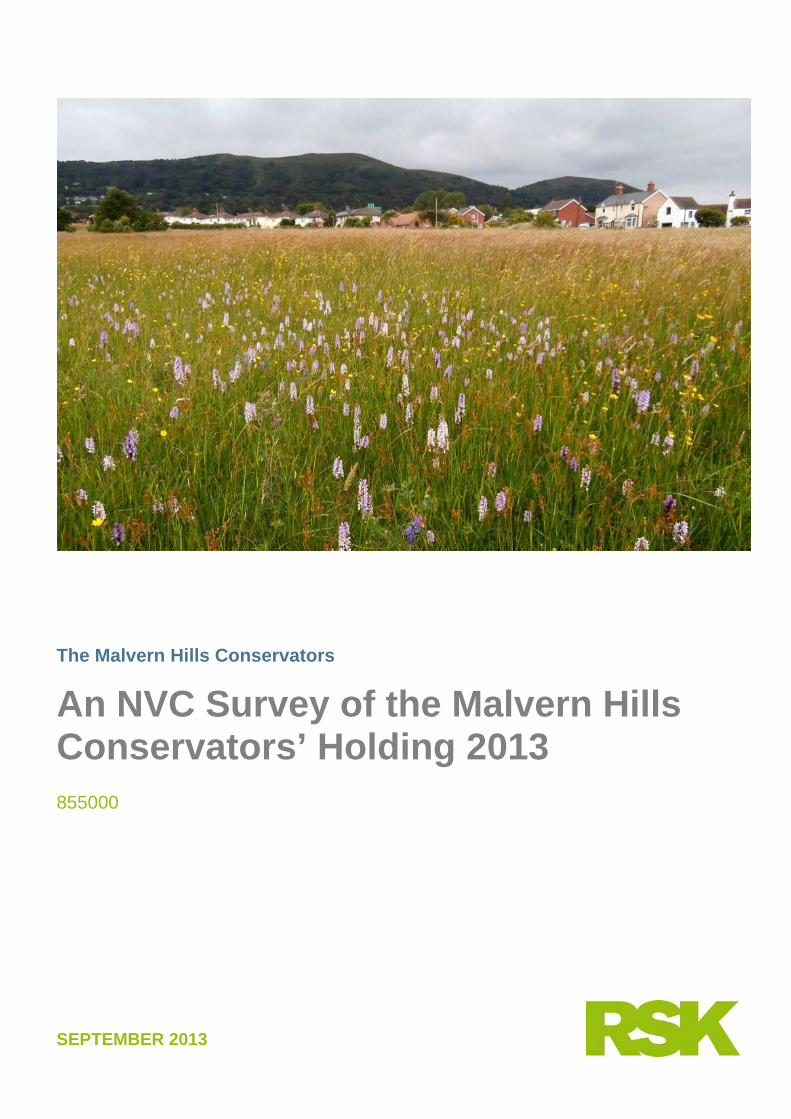
1. This report presents the results of a detailed National Vegetation Classification (NVC) survey of the land holdings of the Malvern Hills Conservators. The surveys were carried out in June and July 2013. This document draws on the report of a previous vegetation survey of the Malvern Hills carried out by Carter Ecological Ltd in 2006; 2007.
2. The aim of this survey is to create an updated vegetation dataset that will provide a clear
picture of the flora and vegetation in the Malvern Hills Conservators’ land holding.
3. This will allow an understanding of recent vegetation changes since the last survey in 2006 and will provide baseline information to feed into the next site management plan.
4. The objectives are:
• To map the vegetation communities and sub-communities of the entire holding of the Malvern Hills Conservators using the NVC methodology.
• To identify those areas of open vegetation that have recently been colonised by scrub/ young woodland as distinct from ‘woodland’.
• To identify, quantify and discuss key areas of habitat changes since the 2006 NVC survey.
• To identify and define those non-SSSI habitats that meet SSSI selection guidelines (based on the JNCC criteria).
• To record the presence / absence, abundance and condition of rare and scarce species as noted in the original SSSI notification.
5. The land holdings of the Malvern Hills Conservators were surveyed using standard NVC
methods by botanists from RSK Group between the 17th June and 17th July 2013.
6. Maps of amalgamated vegetation types are presented using RSK’s colour coding system.
7. Scrub and woodland constitutes the largest area of the vegetation on the Malvern Hills. The woodlands (distinct from scrub) predominate on the lower slopes and account for 30.7% of the total land surveyed.
8. A number of different scrub types were mapped and together they cover 105.91ha of the Malvern Hills (about 9% of the land area); they are potentially indicative of low intensity management or lack of management.
9. The upland grassland and other communities are most abundant on the main ridge of the hills, and the most common communities are the Pteridium aquilinum (Bracken) dominated types (U20 and W25) together covering 175.45 ha (15.3%).
10. Among the plant communities recorded, those of the most ecological and conservation value are the upland grasslands (U1, U2 and U4), which together extend over 102.21 ha (8.9%).
Malvern Hills Conservators A NVC Survey of the Malvern Hills Conservators’ Holding 2013 2 855000 (00)
The upland calcicolous grassland community CG10 is a grassland of especially high conservation value but limited in extent (2.87 ha).
11. The most widespread mesotrophic grassland community is MG6 grassland, covering 141 ha. There are a number species-rich examples, especially MG6c the Trisetum flavescens sub-community, which is worthy of further study.
12. There was a total of 14.54 ha of MG5 grassland at several locations in the lowland commons.
13. There was a significant amount of MG1 grassland, indicative of unmanaged grassland areas, covering 66.73 ha.
14. Improved grassland, MG7, and related open vegetation types (OV21 and OV23) cover 51.97 ha predominantly along road verges and in recreation areas.
15. A total of 10.07 ha of the often species-rich Juncus mire community, M23, were mapped, predominantly on Castlemorton Common and Malvern Common, but also in small patches in wet flushes elsewhere.
16. Temporal development from open vegetation towards scrub and Pteridium aquilinum (Bracken) communities between [2006-2013] was analysed using the GIS system and the two methods described below.
17. In the first method we compared scrub and Pteridium aquilinum (Bracken) communities between the survey dates in 2006 and 2013. This map output identifies areas of new scrub since 2006 and shows that there has been an increase in scrub of 7.6 ha. The largest scrub increase was of the U20 Pteridium aquilinum-Galium saxatile community (3.38 ha).
18. In an extension of this first method we used a similar analysis to identify areas of
grassland new since 2006. This analysis shows an increase of 7.51 ha of new grassland communities. Of this new grassland 28.6% is MG1, and 23.4% is priority acid grassland communities (U1, U2 and U4).
19. In the second method we grouped woodland, scrub, Pteridium aquilinum (Bracken) and
priority grassland categories as mapped in 2013. The output is a series of maps which show the juxtaposition of primary and secondary scrub with priority grasslands. In total this defines 22.9 ha of priority scrub clearance areas which might be converted to open habitat.
20. We also evaluated vegetation changes by comparing the vegetation maps from 2006
with the vegetation in the field during our 2013 survey. A number of areas are identified showing different types of vegetation change, e,g. some areas have shown increasing Betula pubescens (Downy Birch).
21. We have identified some areas where there have been grassland gains from scrub but
also a number of areas where there have been losses of grassland extent or quality. Management changes such as increasing frequency of mowing might help revert some of these areas of lower value grassland to more species-rich types.

Malvern Hills Conservators A NVC Survey of the Malvern Hills Conservators’ Holding 2013 3 855000 (00)
22. We evaluated a number of areas falling outside the current SSSI network to identify any
non-SSSI habitats that might meet SSSI selection guidelines on botanical grounds (based on JNCC criteria).
23. We assessed the data against the botanical criteria for selection of SSSI for grasslands
and woodlands. There were two areas of species-rich woodland, Park Wood and Hollybush Roughs, but overall, we do not think these merit individual SSSI designation although they might merit inclusion in adjacent woodland SSSI areas.
24. A number of grassland areas were considered including Hollybed Common and the area
of Castlemorton Common currently outside the existing SSSI. We could not justify the incorporation of these additional areas into the existing SSSI, although they undoubtedly have value for wildlife and conservation.
25. We also evaluated five areas of species-rich, neutral lowland meadow (referable to the
NVC type MG5 Cynosurus cristatus - Centaurea nigra grassland) at Newland (1.69 ha), Great Malvern along Albert Road North (1.57 ha), Malvern Common (8.81 ha), Hall Green (1.09 ha) and Rydd Green (1.32 ha). Overall four of these areas were not considered to qualify as potential SSSI although we would encourage further evaluation of the conservation value of these lowland meadows.
26. The largest of these areas, Malvern Common, was considered to qualify for SSSI status
according to the criteria. It comprises areas of species-rich MG5 Cynosurus cristatus - Centaurea nigra grassland and M23 Juncus effusus/acutiflorus-Galium palustre rush-pasture mire. A full analysis is provided together with a map showing the boundary of the proposed Malvern Common SSSI.
27. We did not systematically search all previously recorded locations for rare plant species
on the Hills. Surveyors were, however, aware of the plants on the list and the vegetation types in which they are likely to occur, and rare plants were incidentally recorded. A total of 25 of the species on the Notable Flora list were recorded during our surveys and details for each are presented.
Malvern Hills Conservators A NVC Survey of the Malvern Hills Conservators’ Holding 2013 4 855000 (00)
2 INTRODUCTION 2.1 Purpose of the Report
This report presents the results of a detailed National Vegetation Classification (NVC) botanical survey of the land holdings of the Malvern Hills Conservators. The surveys were carried out in June and July 2013. This document draws on the report of a previous vegetation survey of the Malvern Hills carried out by Carter Ecological Ltd1 in 2006 (Carter Ecological Ltd 2006).
2.2 Project Brief The aim of this NVC survey is to create an updated vegetation dataset that will provide a clear picture of the flora and vegetation in the Malvern Hills Conservators’ land holding. This will allow an understanding of recent vegetation changes since the last survey in 2006 and provide baseline information to feed into the next site management plan. The objectives were:
• Using the NVC methodology, to map the vegetation communities and sub-communities of the entire holding of the Malvern Hills Conservators (as shown in Appendix A – Figure 1).
• To identify those areas of open vegetation that have recently been colonised by scrub/ young woodland as distinct from ‘woodland’.
• To identify, quantify and discuss key areas of habitat changes since the relevant previous NVC survey.
• To identify and define those non-SSSI habitats that meet SSSI selection guidelines (based on the JNCC criteria).
• To record the presence / absence, abundance and condition of rare and scarce species as noted in the original SSSI notification.
2.3 Ecological Background
The previous survey report (Carter Ecological Ltd 2006; 2007) included details of the ecological background to the Malverns Hills area including a discussion of other previous surveys; Countryside Consultancy (2003) and Davies (1994). The 2013 survey includes some additional parcels of land of significant size not included in the previous survey. There is a large area of common land around Castlemorton Common (including the Castlemorton Common SSSI) and Hollybed Common, Malvern Link Common and a field adjacent to Albert Road North. These
1 Now part of the RSK Group
Malvern Hills Conservators A NVC Survey of the Malvern Hills Conservators’ Holding 2013 5 855000 (00)
commons are all located on the east side of the hills, and were historically maintained probably by grazing and/or mowing. They all remain as landscapes with trees, although grazing continues only on Castlemorton and Hollybed Commons. The land at Old Hills (Ordnance Survey Grid Reference SO 82660 48804) is an additional new area for the 2013 survey. The Old Hills are an area of mixed grassland, scrub and woodland. The hills are on mudstone and siltstone bedrock, close to the River Severn.
2.4 Structure of the Report The remainder of the report is structured as follows:
• Section 3 gives details of the methods; • Section 4 discusses the NVC communities; • Section 5 discusses the non-SSSI areas; • Section 6 discusses the notable plants; and • Section 7 lists the references.
The remaining sections of the report provide the appendices.
• Appendix A Figures. • Appendix B Quadrat Data (electronic copy only) • Appendix C Species lists (electronic copy only). • Appendix D Photographs.
Malvern Hills Conservators A NVC Survey of the Malvern Hills Conservators’ Holding 2013 6 855000 (00)
3 METHODS 3.1 General
The land holdings of the Malvern Hills Conservators were surveyed in their entirety as mapped on the 1st June 2013. Recording was led by Dr Richard Carter and Louise Denning. Dr Richard Carter has over 25 years consultancy experience and is a full member of CIEEM and a Chartered Environmentalist. Louise Denning has 12 years consultancy experience and is also a full member of CIEEM and a Chartered Environmentalist. Six other botanical specialists from RSK carried out parts of the survey; Charles Campbell, Matthew Davies, Richard Finch, Dr Steven Heathcote, Dr Jonathan Mitchley and Corin Simmonds. Surveys took place between the 17th June and 17th July 2013.
3.2 Changes to Survey Methods from the 2006 Survey The field survey and NVC diagnosis and GIS mapping methods used for the NVC survey on the Malvern Hills in 2013 follow those set out in the report of the botanical survey of the Malvern Hills in 2006/2007 (Carter Ecological Ltd 2006). As in the earlier survey, many vegetation types were recorded in the 2013 survey, including transitions and mosaics, and it was not possible to represent all of these by means of colour coding in hard-copy maps. For the purposes of hard-copy mapping, closely related vegetation types were therefore grouped together following the same procedure as in earlier reports into 26 categories to which simple colour codes could be assigned. The groupings are shown in Table 3.1. Transitions and mosaics were mapped as the first NVC code appearing in the GIS database, so U1b-U2a is mapped as U1b, and U4b + OV27b is mapped as U4b. In the maps some colour-blocks have compartment boundaries within them, and this always implies that similar but different vegetation types have been grouped together. The full and detailed information remains searchable in the GIS product.
Table 3-1 Grouping of vegetation types for hard-copy mapping, with notes where communities have been grouped. Abbreviations follow the standard NVC codes except for ‘SCu’ which refers to unclassified scrub, ‘Wu’ unclassified woodland and elsewhere the suffix ‘u’ refers to unclassified NVC types, i.e. not conforming to any particular sub-community.
Amalgamated NVC Communities Notes Hardstanding / No Access / Open Water / Arable Areas where no NVC type is assigned Aquatic and related communities A7 A8 Au MG11 OV28 OV35 S12 S19 S22 S23 Communities with permanent to near-
permanent inundation
Malvern Hills Conservators A NVC Survey of the Malvern Hills Conservators’ Holding 2013 7 855000 (00)
Amalgamated NVC Communities Notes Mesotrophic grasslands and mires MG1 Arrhenatherum grassland MG1e Ditto species-rich MG5 Hay meadow MG6 Lolium-Cynosurus pasture MG6c Ditto species-rich MG7 OV21 OV23 Communities of highly improved habitats MG9 Deschampsia pasture MG10 Juncus pasture M23 Juncus Mire Upland grasslands and bracken U20 W25 Communities dominated by Bracken U1 Festuca-Agrostis-Rumex grassland U1b lichen var. Ditto lichen-rich U2 Deschampsia flexuosa grassland U4 Festuca-Agrostis-Galium grassland CG10 Upland calcicolous grassland VM Vaccinium myrtillus Scrub and woodland and open vegetation W2 W6 Wet Woodlands W8 Ash woods on base rich soils W10 W16 Oak woodlands on base-poor soils Wu W12 Secondary woodland types SCu W21 W22 Mature scrub vegetation W23 Gorse scrub W24 Bramble scrub OV24 OV25 OV26 OV27 Tall herb vegetation, typically species-
poor
3.3 Site of Special Scientific Interest (SSSI) Assessment Criteria The biological SSSI selection criteria are divided by habitats (Nature Conservancy Council 1989). The assessment of habitats is based on the floristics, primarily using the NVC classification (Rodwell 2006). We assessed grassland and woodland sites not currently part of the Malvern Hills SSSI, against the SSSI selection criteria and against Natural England’s condition assessment methodology (English Nature 2007) to determine if they were of sufficient quality to be put forwards for inclusion in the SSSI network for the Malvern Hills area. In this evaluation we addressed only habitat and floristic criteria for the selection of SSSIs.
3.4 Constraints and Site Coverage We were able to survey 96% of land within the Conservators’ holdings. There were a number of quarries and steep rock faces not fully accessible, and these were assessed from a safe location. Consequently some details of mapping in these areas are
Malvern Hills Conservators A NVC Survey of the Malvern Hills Conservators’ Holding 2013 8 855000 (00)
approximations. The same was true for some woodland on steeper slopes. Aquatic features were assessed only from the banks. The occurrence of rare plants was recorded on an incidental basis, and there was no deliberate attempt to search for these plants in known or potential new locations. Surveys were undertaken during June and July, which is an optimal time of year for recording vascular plants in grasslands and most other habitats. In woods, vernal herbs such as Adoxa moschatellina (Moschatel), Anemone nemorosa (Wood Anemone) and Hyacinthoides non-scripta (Bluebell) are likely to have been under-recorded, making sub-community determinations especially difficult. The same is also true of many of the spring ephemerals in the grassland, several of which are rare plants in the Malvern Hills, e.g. Moenchia erecta (Upright Chickweed) and Scleranthus annuus (Annual Knawel).
3.5 Plant Nomenclature Plant nomenclature follows Stace (2010) for vascular plants and Hill et al. (2008) for bryophytes. Plant species were identified carefully, but at any time of year some species will be indeterminable because they are not in flower, or because only scrappy plants are available. Doubtful identifications are preceded in this report by ‘cf.’ where the plant is very probably the species indicated, but it is impossible to distinguish it from similar members of the genus with certainty.
Malvern Hills Conservators A NVC Survey of the Malvern Hills Conservators’ Holding 2013 9 855000 (00)
4 NVC TYPES 4.1 General
The Malvern Hills area includes a very diverse array of vegetation types including a range of acid grasslands, and Pteridium aquilinum (Bracken) and Rubus fruticosus agg. (Bramble) and other scrub on the higher hills. On the lower-lying commons and road verges there is a range of mesotrophic grasslands, rush pastures, mires, Ulex europaeus (Gorse) scrub, Ulex gallii (Western Gorse) scrub, and other scrub and woodland types. In addition there are areas of open vegetation and some small areas of aquatic vegetation. The report of the 2006 survey (Carter Ecological Ltd 2006) details the approach to determining NVC communities in the field and from quadrat data. The 2006 report, and especially the 2007 report, explains our approach to dealing with issues of vegetation ecology such as vegetation transitions and mosaics. The 2013 survey covered the area surveyed from 2006 but in addition includes the remaining extensive areas of vegetation in the commons, scrub and woodland. The maps showing the grouped NVC communities are given in Figure 2 Map 1 to 12.
4.2 Synopsis of Previously Recorded NVC types Here we list the NVC type mapped in the 2006 survey (further details are included in Carter Ecological Ltd 2006) followed by details of the additional NVC types which were either minor constituents in the previous reports and only briefly described or which were mapped for the first time in 2013 survey, and for these communities we provide more detailed information.
4.2.1 Calcicolous Grassland Communities Only one calcicolous grassland type was mapped in 2006:
• CG10a Festuca ovina-Agrostis capillaris-Thymus praecox grassland, Trifolium repens-Luzula campestris sub-community.
The following rare or scarce plant species was recorded from this vegetation type in 2013 (Section 6.1): Calluna vulgaris (Heather) and Helianthemum nummularium (Common Rock-rose).
4.2.2 Calcifugous Grassland Communities The following calcifugous grassland types were mapped in 2006:
• U1 Festuca ovina-Agrostis capillaris-Rumex acetosella grassland, lichen variant;
Malvern Hills Conservators A NVC Survey of the Malvern Hills Conservators’ Holding 2013 10 855000 (00)
• U1b Festuca ovina-Agrostis capillaris-Rumex acetosella grassland, typical sub-community;
• U1b Festuca ovina-Agrostis capillaris-Rumex acetosella grassland, typical sub-community, open variant;
• U1 Festuca ovina-Agrostis capillaris-Rumex acetosella grassland, undifferentiated, a standard NVC type;
• U2a Deschampsia flexuosa grassland, Festuca ovina-Agrostis capillaris sub-community;
• U2a Deschampsia flexuosa grassland, Festuca ovina-Agrostis capillaris sub-community, open variant;
• U2b Deschampsia flexuosa grassland, Vaccinium myrtillus sub-community; and
• U4b Festuca ovina-Agrostis capillaris-Galium saxatile grassland, Holcus lanatus-Trifolium repens sub-community.
In addition, U4a Festuca ovina-Agrostis capillaris-Galium saxatile grassland, typical sub-community was mapped in one location; though we now have reservations about the NVC diagnosis (see Section 4.4).
It was not necessary to map transitions among U1 types or among U2 types, but the following transitions are more-or-less common, and were widely mapped in 2006:
• U1b and U1-undifferentiated on the one hand to U2a on the other; • U1-undifferentiated to U4-undifferentiated; • U1b, U1- undifferentiated and U2a on the one hand to mesotrophic
grassland communities including Mg1a, MG1a Epilobium angustifolium variant and OV23a on the other;
• U1b, U1-undifferentiated and U2a on the one hand to tall-herb and fern communities including OV27b, U20a, U20c and W25b on the other; and
• U1b, U1-undifferentiated and U2a on the one hand to scrub communities including W23 undifferentiated on the other.
The following rare or scarce plant species were recorded from the acid grassland vegetation types in 2013 (Section 6.1): Arenaria serpyllifolia (Thyme-leaved Sandwort), Calluna vulgaris (Heather; and in transitions with CG10), Cerastium semidecandrum (Little Mouse-ear), Filago minima (Small Cudweed), Moenchia erecta (Upright Chickweed; and in transitions with CG10), Ornithopus perpusillus (Bird's-foot), Potentilla tabernaemontani (Spring Cinquefoil),Scleranthus annuus (Annual Knawel), Stellaria pallida (Lesser Chickweed), Teesdalia nudicaulis (Shepherd's Cress) and Trifolium ornithopodioides (Bird's-foot Clover).
4.2.3 Heath Communities In the 2006 report the only vegetation loosely referable to heath was:
• U20b Pteridium aquilinum-Galium saxatile community, Vaccinium myrtillus-Dicranum scoparium sub-community.
In addition, pure stands of Vaccinium myrtillus (Bilberry) were simply mapped as Vaccinium myrtillus stands, i.e. as a non-NVC vegetation type.
Malvern Hills Conservators A NVC Survey of the Malvern Hills Conservators’ Holding 2013 11 855000 (00)
4.2.4 Mesotrophic Grasslands The following mesotrophic grassland types were mapped in 2006:
• MG1a Arrhenatherum elatius grassland, Festuca rubra sub-community;
• MG1a Arrhenatherum elatius grassland, Festuca rubra sub-community, Epilobium angustifolium variant;
• MG1a Arrhenatherum elatius grassland, Festuca rubra sub-community, Centranthus ruber variant;
• MG1b Arrhenatherum elatius grassland, Urtica dioica sub-community; • MG6a Lolium perenne-Cynosurus cristatus grassland, typical sub-
community; • MG10a Holcus lanatus-Juncus effusus rush-pasture, typical sub-
community and • OV23a Lolium perenne-Dactylis glomerata community, typical sub-
community. It was not necessary to map transitions among these mesotrophic grassland types, and transitions from calcifugous types to mesotrophic types are covered above. In the previous surveys, the MG5 Cynosurus cristatus-Centaurea nigra grasslands
and MG6 Lolium perenne-Cynosurus cristatus grasslands were noted as additional
grassland types (RSK 2006, page 47) because they were only recorded from a few
localities in 2006. These two grassland types were mapped much more widely in the
extended area of the 2013 survey and so these grassland types are describe in more
detail in section 4.3.
4.2.5 Tall-herb and Bracken Communities The following tall-herb and Pteridium aquilinum (Bracken) communities were mapped in 2006:
• OV27b Epilobium angustifolium community, Urtica dioica-Cirsium arvense sub-community;
• U20a Pteridium aquilinum-Galium saxatile community, Anthoxanthum odoratum sub-community;
• U20c Pteridium aquilinum-Galium saxatile community, species-poor sub-community;
• W25a Pteridium aquilinum-Rubus fruticosus underscrub, Hyacinthoides non-scripta sub-community; and
• W25b Pteridium aquilinum-Rubus fruticosus underscrub, Teucrium scorodonia sub-community.
All possible transitions between these four types are common, though they are more often mapped as mosaics than as transitions per se. To distinguish between W25a and W25b it is necessary to see herbaceous species in the field-layer close up. Bramble
Malvern Hills Conservators A NVC Survey of the Malvern Hills Conservators’ Holding 2013 12 855000 (00)
scrub was not the main interest, so it was seldom possible to walk through it to do this, and W25 vegetation was therefore often mapped as W25 undifferentiated (W25u).
4.2.6 Scrub and Woodland Communities Scrub and woodland:
• W23 Ulex europaeus-Rubus fruticosus scrub, undifferentiated; • W24 Rubus fruticosus-Holcus lanatus underscrub, undifferentiated; and • W16a Quercus spp.-Betula spp.-Deschampsia flexuosa woodland,
Quercus robur sub-community, and they have been mapped separately from other woodland in places where they are invading grassland.
4.3 Additional NVC Types identified during the 2013 survey
4.3.1 Mesotrophic Grasslands The following additional mesotrophic grassland types were mapped in 2013:
• MG1e Arrhenatherum elatius grassland, Centaurea nigra sub-community;
• MG5 Cynosurus cristatus-Centaurea nigra grassland; • MG5b Cynosurus cristatus-Centaurea nigra grassland, Galium verum
sub-community; • MG6b Lolium perenne-Cynosurus cristatus grassland, Anthoxanthum
odoratum sub-community; • MG6c Lolium perenne-Cynosurus cristatus grassland, Trisetum
flavescens sub-community; • MG7 Lolium perenne leys and related grasslands; • MG7e Lolium perenne leys and related grasslands, Lolium perenne-
Plantago lanceolata grassland; and • MG9a Holcus lanatus-Deschampsia cespitosa grassland, Poa trivialis
sub-community.
Further details’ regarding each of these vegetation types is given below.
4.3.1.1 MG1e Arrhenatherum elatius grassland, Centaurea nigra sub-community In the lowland areas of the Malvern Hills MG1 Arrhenatherum elatius grassland occurs widely in roadside vegetation, managed by sporadic and irregular mowing, most notably as the MG1a Arrhenatherum elatius grassland, Festuca rubra sub-community and the MG1b Arrhenatherum elatius grassland, Urtica dioica sub-community which are typical of such situations. In 2013, in addition to the two widespread sub-communities RSK also mapped MG1e Arrhenatherum elatius grassland, Centaurea nigra sub-community. This sub-community is the most species-rich of the MG1 Arrhenatherum elatius grasslands and Arrhenatherum elatius (False Oat-grass) itself is less dominant than in the other sub-communities and there are a range of species also associated with hay-meadows such as Centaurea cf.
Malvern Hills Conservators A NVC Survey of the Malvern Hills Conservators’ Holding 2013 13 855000 (00)
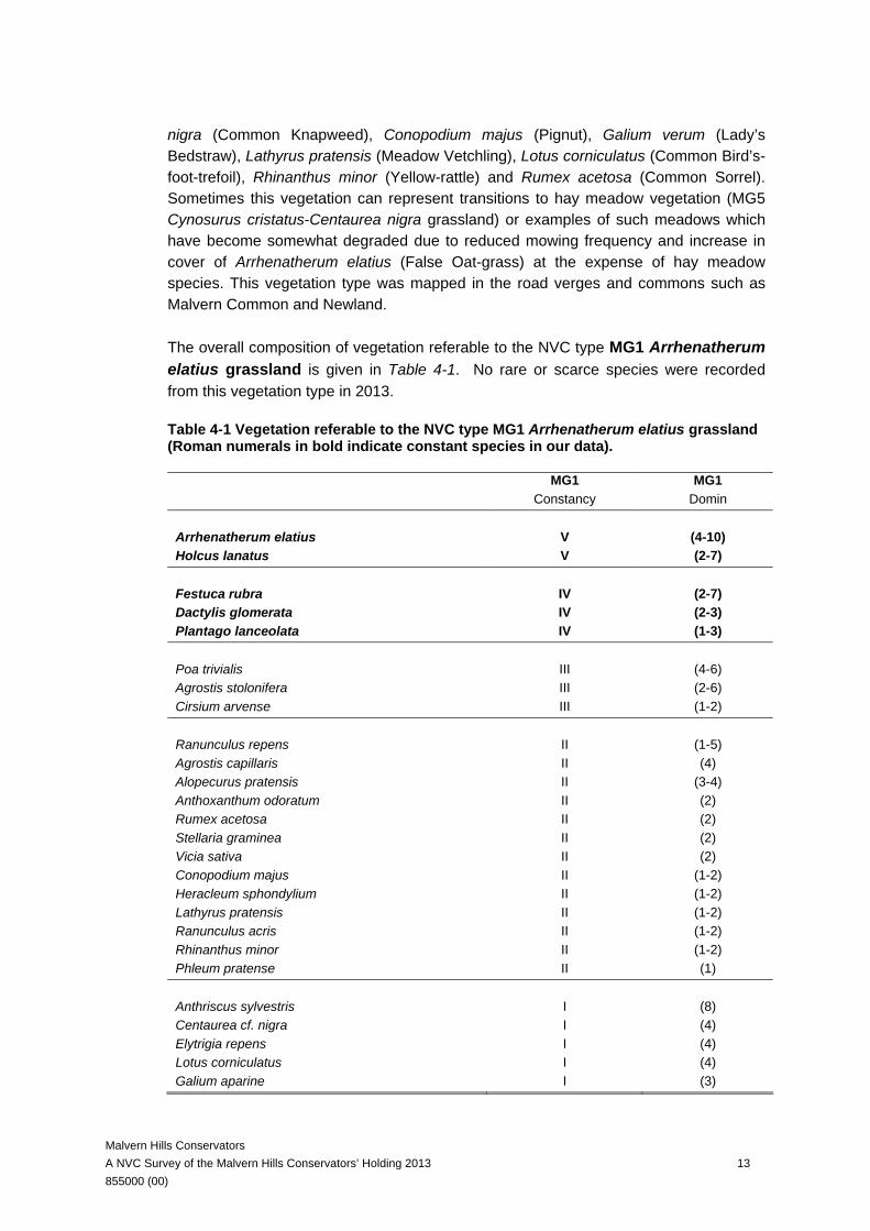
nigra (Common Knapweed), Conopodium majus (Pignut), Galium verum (Lady’s Bedstraw), Lathyrus pratensis (Meadow Vetchling), Lotus corniculatus (Common Bird’s-foot-trefoil), Rhinanthus minor (Yellow-rattle) and Rumex acetosa (Common Sorrel). Sometimes this vegetation can represent transitions to hay meadow vegetation (MG5 Cynosurus cristatus-Centaurea nigra grassland) or examples of such meadows which have become somewhat degraded due to reduced mowing frequency and increase in cover of Arrhenatherum elatius (False Oat-grass) at the expense of hay meadow species. This vegetation type was mapped in the road verges and commons such as Malvern Common and Newland. The overall composition of vegetation referable to the NVC type MG1 Arrhenatherum elatius grassland is given in Table 4-1. No rare or scarce species were recorded from this vegetation type in 2013.
Table 4-1 Vegetation referable to the NVC type MG1 Arrhenatherum elatius grassland (Roman numerals in bold indicate constant species in our data).
MG1 MG1 Constancy Domin Arrhenatherum elatius V (4-10) Holcus lanatus V (2-7) Festuca rubra IV (2-7) Dactylis glomerata IV (2-3) Plantago lanceolata IV (1-3) Poa trivialis III (4-6) Agrostis stolonifera III (2-6) Cirsium arvense III (1-2) Ranunculus repens II (1-5) Agrostis capillaris II (4) Alopecurus pratensis II (3-4) Anthoxanthum odoratum II (2) Rumex acetosa II (2) Stellaria graminea II (2) Vicia sativa II (2) Conopodium majus II (1-2) Heracleum sphondylium II (1-2) Lathyrus pratensis II (1-2) Ranunculus acris II (1-2) Rhinanthus minor II (1-2) Phleum pratense II (1) Anthriscus sylvestris I (8) Centaurea cf. nigra I (4) Elytrigia repens I (4) Lotus corniculatus I (4) Galium aparine I (3)
Malvern Hills Conservators A NVC Survey of the Malvern Hills Conservators’ Holding 2013 14 855000 (00)
MG1 MG1 Constancy Domin Achillea millefolium I (2) Allium vineale I (2) Convolvulus arvensis I (2) Galium verum I (2) Vicia tetrasperma I (2) Cerastium fontanum I (1) Cynosurus cristatus I (1) Geum urbanum I (1) Lathyrus nissolia I (1) Taraxacum sect. Ruderalia I (1) Veronica chamaedrys I (1) Number of species per quadrat 12-17 Number of quadrats 5
4.3.1.2 MG5 Cynosurus cristatus-Centaurea nigra grassland The earlier surveys (2006) focused in the hills and just a few commons so MG5 Cynosurus cristatus-Centaurea nigra grassland, which is the central lowland hay meadow vegetation type of Britain, was recorded as an additional grassland type. However, in 2013 the survey included more lowland commons and other areas with meadow vegetation that is clearly referable to the NVC type MG5 Cynosurus cristatus-Centaurea nigra grassland. This vegetation is characteristic of those commons managed by regular annual mowing for hay, sometimes with follow-up grazing of the aftermath growth. The vegetation is rich in herbs and can present a very colourful appearance in the summer months before mowing. The main grasses are Agrostis capillaris (Common Bent), Anthoxanthum odoratum (Sweet Vernal-grass), Cynosurus cristatus (Crested Dog’s-tail), Dactylis glomerata (Cock’s-foot), Festuca rubra (Red Fescue) and Holcus lanatus (Yorkshire-fog). A wide range of associated herbs includes Centaurea cf. nigra (Common Knapweed), Lotus corniculatus (Common Bird’s-foot-trefoil), Plantago lanceolata (Ribwort Plantain), Ranunculus acris (Meadow Buttercup), Ranunculus repens (Creeping Buttercup), Trifolium pratense (Red Clover) and Trifolium repens (White Clover). Our vegetation could usually be assigned to one of the sub-communities. The majority of the MG5 Cynosurus cristatus-Centaurea nigra grassland was mapped in the northern part of the study area in the Commons and along the road verges. Hay meadow vegetation of this kind is a relatively scarce vegetation type in Britain, and can be of high conservation value (Nature Conservancy Council 1989). The example at Malvern Common is especially extensive for the region as a whole and forms an interesting mosaic with other species-rich communities such as M23 Juncus effusus/acutiflorus-Galium palustre rush-pasture and is discussed as a possible new SSSI designation in Section 5.
Malvern Hills Conservators A NVC Survey of the Malvern Hills Conservators’ Holding 2013 15 855000 (00)
The overall composition of vegetation referable to the NVC type MG5 Cynosurus cristatus-Centaurea nigra grassland is given in Table 4-2. The following rare or scarce species were recorded from this vegetation type in 2013 (Section 6.1): Helictotrichon pubescens (Downy Oat-grass). A number of other rare and scarce species have also been recorded from these vegetation types (Barnett & Garner 2005).
Table 4-2 Vegetation referable to the NVC type MG5 Cynosurus cristatus-Centaurea nigra grassland (Roman numerals in bold indicate constant species in our data)
MG5 MG5 Constancy Domin Agrostis capillaris V (3-8) Holcus lanatus V (1-8) Anthoxanthum odoratum V (1-6) Lotus corniculatus IV (1-8) Ranunculus repens IV (1-7) Plantago lanceolata IV (1-6) Ranunculus acris IV (1-5) Trifolium pratense IV (1-5) Potentilla erecta III (3-5) Festuca rubra III (2-5) Cynosurus cristatus III (1-5) Rumex acetosa III (1-4) Trifolium repens III (1-4) Luzula campestris III (1-3) Rhinanthus minor II (3-6) Carex leporina II (1-6) Hypochaeris radicata II (1-6) Lolium perenne II (1-6) Festuca ovina II (2-5) Centaurea cf. nigra II (1-5) Pedicularis sylvatica II (2-4) Alopecurus pratensis II (1-4) Lotus pedunculatus II (1-4) Achillea millefolium II (1-3) Cerastium fontanum II (1-2) Dactylis glomerata II (1-2) Achillea ptarmica I (4-7) Poa trivialis I (1-7) Calliergonella cuspidata I (3-6) Carex flacca I (1-6) Lathyrus pratensis I (3-5) Leontodon saxatilis I (2-5) Carex hirta I (1-5)
Malvern Hills Conservators A NVC Survey of the Malvern Hills Conservators’ Holding 2013 16 855000 (00)
Galium verum I (2-4) Danthonia decumbens I (1-4) Juncus effusus/ conglomeratus I (1-4) Nardus stricta I (1-4) Hordeum secalinum I (2-3) Leontodon hispidus I (2-3) Linum catharticum I (1-3) Rhytidiadelphus squarrosus I (1-3) Phleum pratense I (1-2) Heracleum sphondylium I (1-2) Scorzoneroides autumnalis I (1-2) Stellaria graminea I (1-2) Silaum silaus I (1) Number of species per quadrat 9-30 Number of quadrats 20
4.3.1.3 MG5a Cynosurus cristatus-Centaurea nigra grassland, Lathyrus pratensis sub-community This sub-community is characterised by species indicative of slightly wetter soil conditions, and as well as the community constants includes e.g. Lathyrus pratensis (Meadow Vetchling), Lotus pedunculatus (Greater Bird's-foot-trefoil) and Juncus spp. This vegetation type was mapped in Malvern Link Common, Great Malvern and Newland.
4.3.1.4 MG5b Cynosurus cristatus-Centaurea nigra grassland, Galium verum sub-community This sub-community is characteristic of lighter, drier soils and as well as the community constants also includes a range of drier grassland species such as Briza media (Quaking-grass) and Trisetum flavescens (Yellow Oat-grass) the sedge Carex flacca (Glaucous Sedge) and the herb Galium verum (Lady’s Bedstraw). This vegetation type was mapped in Malvern Common and Malvern Links.
4.3.1.5 MG5c Cynosurus cristatus –Centaurea nigra grassland, Danthonia decumbens sub-community
This sub-community is characteristic of more acid soils and in addition to the community constants includes some species more indicative of calcifugous grasslands and in our samples included Danthonia decumbens (Heath-grass), Potentilla erecta (Tormentil), and Luzula campestris (Field Wood-rush). This grassland type was mapped as part of mosaics with other sub-communities in Malvern Links Common.
4.3.1.6 MG6 Lolium perenne-Cynosurus cristatus grassland In the previous survey (2006) which focused on the upland areas of the Malvern Hills, the lowland vegetation type MG6 Lolium perenne-Cynosurus cristatus grassland was only included as an additional type. However in the 2013 survey, which includes a number of lowland commons and road verges, MG6 Lolium perenne-Cynosurus cristatus grassland was the most abundant of the mesotrophic grassland types
Malvern Hills Conservators A NVC Survey of the Malvern Hills Conservators’ Holding 2013 17 855000 (00)
characterising many of the grazed pastures on improved and semi-improved commons. MG6 Lolium perenne-Cynosurus cristatus grassland is often a grazed grassland type usually with frequent and even abundant Cynosurus cristatus (Crested Dog’s-tail), Lolium perenne (Perennial Rye-grass) and Holcus lanatus (Yorkshire-fog). In the more agriculturally improved locations the associated species may be limited to the species most tolerant of grazing and nutrient enrichment, such as Bellis perennis (Daisy), Cerastium fontanum (Common Mouse-ear), Plantago lanceolata (Ribwort Plantain), Trifolium repens (White Clover) and Taraxacum sect. Ruderalia (Common Dandelion). In less intensively managed situations the vegetation can be more varied and species-rich especially in MG6c Lolium perenne – Cynosurus cristatus grassland, Trisetum flavescens sub-community. In other situations this vegetation can include indicators of wetter ground such as Alopecurus geniculatus (Marsh Foxtail) and Deschampsia cespitosa (Tufted Hair-grass) (the NVC defines some of these as variants of the typical sub-community) and this can be indicative of transitions to the vegetation types of wetter areas such as MG9 Holcus lanatus-Deschampsia cespitosa grassland, with species such as Deschampsia cespitosa (Tufted Hair-grass) and Lotus pedunculatus (Greater Bird's-foot-trefoil) and even Pedicularis sylvatica (Lousewort). The composition of vegetation referable to the NVC type MG6 Lolium perenne-Cynosurus cristatus grassland and the three sub-communities is given in Table 4-3. The following rare or scarce species were recorded from this vegetation type (mainly the Trisetum flavescens (Yellow Oat-grass) sub-community) in 2013 (Section 6.1): Bromopsis erecta (Upright Brome), Bupleurum tenuissimum (Slender hare’s-ear), Filipendula vulgaris (Dropwort), Koeleria macrantha (Crested Hair-grass), Oenanthe pimpinelloides (Corky-fruited Water-dropwort) and Rumex pulcher (Fiddle Dock). Overall, from the results of the 2013 survey, the MG6 grasslands of the Malvern Hills area are considered especially worthy of further research. Mosaics of such vegetation types were mapped in the lowland commons throughout the study area, specific locations are given below under the sub-community descriptions.
Table 4-3 Vegetation referable to the NVC type MG6 Lolium perenne-Cynosurus cristatus grassland and sub-communities (Roman numerals in bold indicate constant species in our data)
MG6a MG6a MG6b MG6b MG6c MG6c Constancy Domin Constancy Domin Constancy Domin Agrostis capillaris V (3-7) V (1-7) V (1-6) Cynosurus cristatus V (1-6) V (2-8) V (3-6) Holcus lanatus V (1-6) V (2-7) III (1-4) Lolium perenne V (1-8) V (1-6) IV (1-4) Trifolium repens IV (1-6) V (1-8) V (2-6) Plantago lanceolata II (2-3) V (1-6) V (1-6) Trifolium pratense I (3) V (1-5) V (1-4) Festuca rubra III (2-8) IV (1-6) V (1-7)
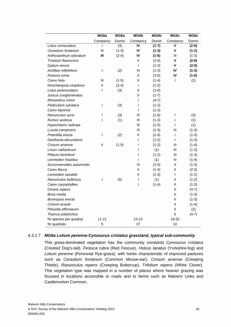
Malvern Hills Conservators A NVC Survey of the Malvern Hills Conservators’ Holding 2013 18 855000 (00)
MG6a MG6a MG6b MG6b MG6c MG6c Constancy Domin Constancy Domin Constancy Domin Lotus corniculatus I (3) IV (1-7) V (2-6) Cerastium fontanum III (1-3) IV (1-3) V (1-2) Anthoxanthum odoratum III (2-4) IV (1-5) III (1-3) Trisetum flavescens II (2-6) V (2-6) Galium verum I (1-3) V (2-5) Achillea millefolium I (2) III (1-3) IV (1-3) Festuca ovina II (3-5) IV (1-6) Carex hirta III (1-5) II (1-4) I (2) Deschampsia cespitosa II (2-4) I (1-2) Lotus pedunculatus I (3) II (1-6) Juncus conglomeratus II (1-7) Rhinanthus minor I (4-7) Pedicularis sylvatica I (3) I (1-2) Carex leporina I (1-3) Ranunculus acris I (3) III (1-6) I (3) Rumex acetosa I (1) III (1-3) I (1) Hypochaeris radicata III (1-5) I (1) Luzula campestris III (1-3) III (1-3) Potentilla erecta I (2) II (1-4) I (1-3) Danthonia decumbens I (1-2) I (1-3) Cirsium arvense II (1-5) I (1-2) III (1-4) Linum catharticum I (1) III (1-3) Phleum bertolonii I (1-2) III (1-3) Leontodon hispidus I (1) III (1-4) Scorzoneroides autumnalis III (1-5) II (1-3) Carex flacca II (1-4) II (2-3) Leontodon saxatilis II (1-3) I (1-2) Ranunculus bulbosus I (5) I (1) II (1-2) Carex caryophyllea I (1-4) II (1-3) Ononis repens II (4-7) Briza media II (1-3) Bromopsis erecta II (1-3) Cirsium acaule II (1-4) Pilosella officinarum II (2) Thymus polytrichus II (4-7) Nr species per quadrat 11-21 15-22 19-32 Nr quadrats 5 37 10
4.3.1.7 MG6a Lolium perenne-Cynosurus cristatus grassland, typical sub-community This grass-dominated vegetation has the community constants Cynosurus cristatus (Crested Dog’s-tail), Festuca rubra (Red Fescue), Holcus lanatus (Yorkshire-fog) and Lolium perenne (Perennial Rye-grass), with herbs characteristic of improved pastures such as Cerastium fontanum (Common Mouse-ear), Cirsium arvense (Creeping Thistle), Ranunculus repens (Creeping Buttercup), Trifolium repens (White Clover). This vegetation type was mapped in a number of places where heavier grazing was focused in locations accessible to roads and to farms such as Malvern Links and Castlemorton Common.
Malvern Hills Conservators A NVC Survey of the Malvern Hills Conservators’ Holding 2013 19 855000 (00)
4.3.1.8 MG6b Lolium perenne-Cynosurus cristatus grassland, Anthoxanthum odoratum sub-community In this more species-rich type of MG6 Lolium perenne – Cynosurus cristatus grassland, Anthoxanthum odoratum (Sweet Vernal-grass) is diagnostic together with Agrostis capillaris (Common Bent) and with species of less improved grassland such as Ranunculus acris (Meadow Buttercup), Rumex acetosa (Common Sorrel), Hypochaeris radicata (Cat’s-ear) and Luzula campestris (Field Wood-rush). In the context of the Malvern Hills this vegetation can mark out transitions to the vegetation of more calcifugous swards such as U4 Festuca ovina-Agrostis capillaris-Galium saxatile grassland, including calcifugous indicators species such as Danthonia decumbens (Heath-grass), Luzula campestris (Field Wood-rush), Scorzoneroides autumnalis (Autumn Hawkbit) and Potentilla erecta (Tormentil). Mosaics of such vegetation types were mapped in the Old Hills and Malvern Link Common, to the north Middle Hills and Castlemorton Common to the south of the study area.
4.3.1.9 MG6c Lolium perenne-Cynosurus cristatus grassland, Trisetum flavescens sub-community This is the most species-rich sub-community of the MG6 Lolium perenne-Cynosurus cristatus grassland and the diagnostic species here are Trisetum flavescens (Yellow Oat-grass) and Phleum bertolonii (Smaller Cat's-tail), but also some calcicolous species including some which do not feature in the NVC tables for MG6 Lolium perenne – Cynosurus cristatus grassland, such as Briza media (Quaking-grass), Bromopsis erecta (Upright Brome), Cirsium acaule (Dwarf Thistle), Ononis repens (Common Restharrow), Pilosella officinarum (Mouse-ear-hawkweed) and Thymus polytrichus (Wild Thyme). This kind of vegetation was mapped in the Castlemorton Common area and is more species-rich than the samples given in the NVC volumes (our samples had between 19 and 32 species per quadrat compared with 11 to 20 species in the NVC tables for MG6c Lolium perenne-Cynosurus cristatus grassland, Trisetum flavescens sub-community). We interpret this rather interesting vegetation in the Malvern Hills as marking transitions to more calcicolous swards of CG2 Festuca ovina-Avenula pratensis grassland or CG3 Bromus erectus grassland, and although CG2 and CG3 per se were not recorded in the area, the species pool available in the locality clearly includes some of the species of these calcicolous vegetation types.
4.3.1.10 MG7 Lolium perenne leys and related grasslands
This is vegetation of improved agricultural pastures and of amenity and recreational swards. The swards are grass-dominated and species-poor and centred around the abundance of the main pasture grass Lolium perenne (Perennial Rye-grass). During the 2013 surveys we found examples of several of the sub-communities usually characterised by the presence of one or more distinctive grasses such as Alopecurus
Malvern Hills Conservators A NVC Survey of the Malvern Hills Conservators’ Holding 2013 20 855000 (00)
pratensis (Meadow Foxtail) in MG7c the Lolium perenne-Alopecurus pratensis grassland. In other situations Lolium perenne (Perennial Rye-grass) is accompanied by broad-leaved herbs such as Plantago species as in MG7e Lolium perenne-Plantago lanceolata grassland. This is vegetation of reseeded road verges and lawns which are regularly mown and which receive moderate trampling. In similar situations but where there is greater disturbance MG7 Lolium perenne leys and related grasslands may be replaced by OV23 Lolium perenne-Dactylis glomerata community and this community is discussed in the 2006 report (Carter Ecological 2006). These types of vegetation were widely mapped in the lowland commons and road verges. No rare or scarce species were recorded from this vegetation type in 2013.
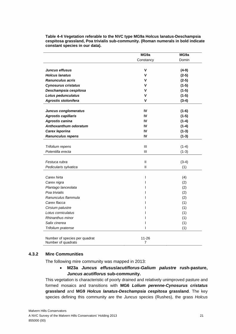
4.3.1.11 MG9 Holcus lanatus-Deschampsia cespitosa grassland This vegetation is characteristic of wetter soils in pastures and occurred quite extensively on the lowland commons usually in mosaics and transitions with MG6 Lolium perenne-Cynosurus cristatus grassland and also M23 Juncus effusus/acutiflorus-Galium palustre rush-pasture. Deschampsia cespitosa (Tufted Hair-grass) is the characteristic species which helps define this vegetation, but in our samples it was never dominant, but instead co-dominant or co-occurring with a range of mesotrophic grassland species such as Holcus lanatus (Yorkshire-fog), Agrostis spp. (Bents), Carex leporina (Oval Sedge), Festuca rubra (Red Fescue), Poa trivialis (Rough Meadow-grass), Dactylis glomerata (Cock’s-foot) and Cynosurus cristatus (Crested Dog’s-tail). In addition, marking areas with wetter soils were some accompanying poor-fen species such as Juncus conglomeratus (Compact Rush), Juncus effusus (Soft-rush) and Lotus pedunculatus (Greater Bird's-foot-trefoil) and also Ranunculus flammula (Lesser Spearwort) and Pedicularis sylvatica (Lousewort). This vegetation type was quite characteristic of many of the lowland commons and was mapped in transitions and mosaics with MG6 Lolium perenne-Cynosurus cristatus grassland and the vegetation of wetter soils with M23 Juncus effusus/acutiflorus-Galium palustre rush-pasture and mapped for example in Castlemorton Common. The composition of vegetation referable to the NVC type MG9a Holcus lanatus-Deschampsia cespitosa grassland, Poa trivialis sub-community is presented in Table 4-4. The following rare or scarce species were recorded from this vegetation type in 2013 (Section 6.1) Lythrum portula (Water-purslane).
Malvern Hills Conservators A NVC Survey of the Malvern Hills Conservators’ Holding 2013 21 855000 (00)
Table 4-4 Vegetation referable to the NVC type MG9a Holcus lanatus-Deschampsia cespitosa grassland, Poa trivialis sub-community. (Roman numerals in bold indicate constant species in our data).
MG9a MG9a Constancy Domin Juncus effusus V (4-9) Holcus lanatus V (2-5) Ranunculus acris V (2-5) Cynosurus cristatus V (1-5) Deschampsia cespitosa V (1-5) Lotus pedunculatus V (1-5) Agrostis stolonifera V (3-4) Juncus conglomeratus IV (1-6) Agrostis capillaris IV (1-5) Agrostis canina IV (1-4) Anthoxanthum odoratum IV (1-4) Carex leporina IV (1-3) Ranunculus repens IV (1-3) Trifolium repens III (1-4) Potentilla erecta III (1-3) Festuca rubra II (3-4) Pedicularis sylvatica II (1) Carex hirta I (4) Carex nigra I (2) Plantago lanceolata I (2) Poa trivialis I (2) Ranunculus flammula I (2) Carex flacca I (1) Cirsium palustre I (1) Lotus corniculatus I (1) Rhinanthus minor I (1) Salix cinerea I (1) Trifolium pratense I (1) Number of species per quadrat 11-26 Number of quadrats 7
4.3.2 Mire Communities The following mire community was mapped in 2013:
• M23a Juncus effusus/acutiflorus-Galium palustre rush-pasture, Juncus acutiflorus sub-community.
This vegetation is characteristic of poorly drained and relatively unimproved pasture and formed mosaics and transitions with MG6 Lolium perenne-Cynosurus cristatus grassland and MG9 Holcus lanatus-Deschampsia cespitosa grassland. The key species defining this community are the Juncus species (Rushes), the grass Holcus
Malvern Hills Conservators A NVC Survey of the Malvern Hills Conservators’ Holding 2013 22 855000 (00)
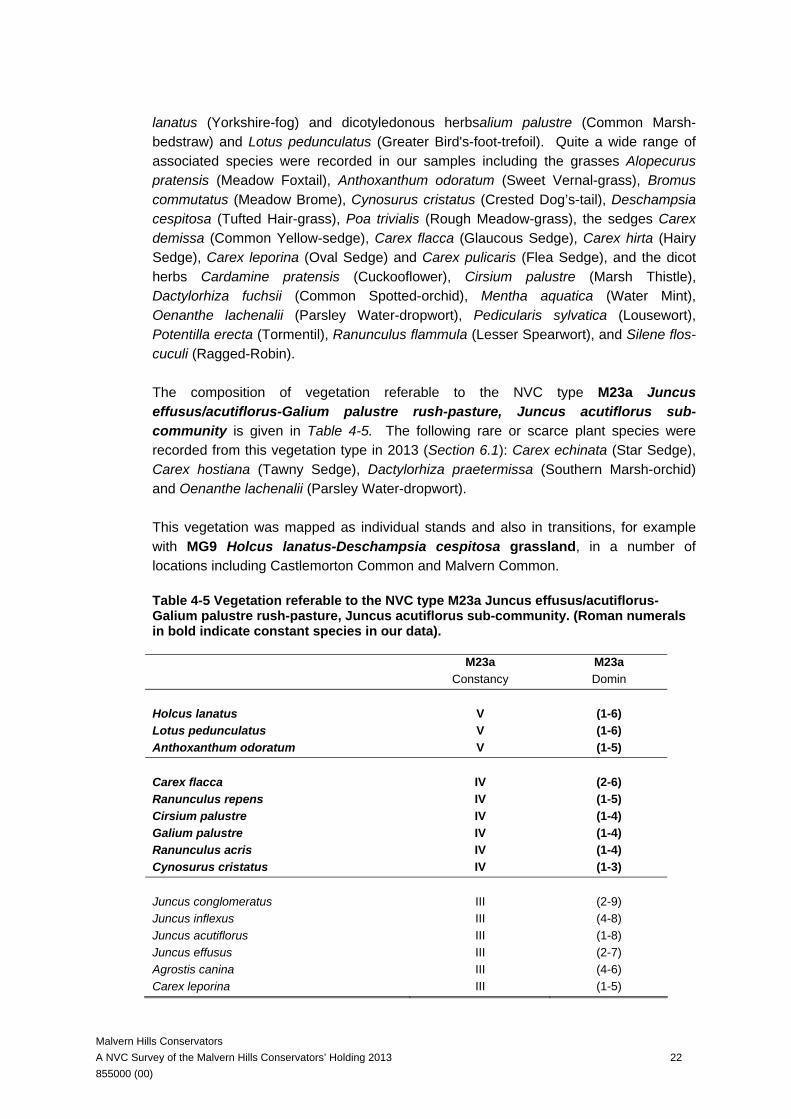
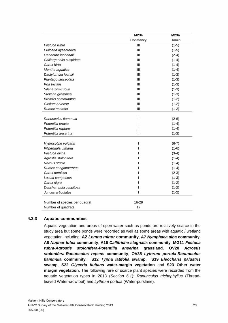
lanatus (Yorkshire-fog) and dicotyledonous herbsalium palustre (Common Marsh-bedstraw) and Lotus pedunculatus (Greater Bird's-foot-trefoil). Quite a wide range of associated species were recorded in our samples including the grasses Alopecurus pratensis (Meadow Foxtail), Anthoxanthum odoratum (Sweet Vernal-grass), Bromus commutatus (Meadow Brome), Cynosurus cristatus (Crested Dog’s-tail), Deschampsia cespitosa (Tufted Hair-grass), Poa trivialis (Rough Meadow-grass), the sedges Carex demissa (Common Yellow-sedge), Carex flacca (Glaucous Sedge), Carex hirta (Hairy Sedge), Carex leporina (Oval Sedge) and Carex pulicaris (Flea Sedge), and the dicot herbs Cardamine pratensis (Cuckooflower), Cirsium palustre (Marsh Thistle), Dactylorhiza fuchsii (Common Spotted-orchid), Mentha aquatica (Water Mint), Oenanthe lachenalii (Parsley Water-dropwort), Pedicularis sylvatica (Lousewort), Potentilla erecta (Tormentil), Ranunculus flammula (Lesser Spearwort), and Silene flos-cuculi (Ragged-Robin). The composition of vegetation referable to the NVC type M23a Juncus effusus/acutiflorus-Galium palustre rush-pasture, Juncus acutiflorus sub-community is given in Table 4-5. The following rare or scarce plant species were recorded from this vegetation type in 2013 (Section 6.1): Carex echinata (Star Sedge), Carex hostiana (Tawny Sedge), Dactylorhiza praetermissa (Southern Marsh-orchid) and Oenanthe lachenalii (Parsley Water-dropwort). This vegetation was mapped as individual stands and also in transitions, for example with MG9 Holcus lanatus-Deschampsia cespitosa grassland, in a number of locations including Castlemorton Common and Malvern Common.
Table 4-5 Vegetation referable to the NVC type M23a Juncus effusus/acutiflorus-Galium palustre rush-pasture, Juncus acutiflorus sub-community. (Roman numerals in bold indicate constant species in our data).
M23a M23a Constancy Domin Holcus lanatus V (1-6) Lotus pedunculatus V (1-6) Anthoxanthum odoratum V (1-5) Carex flacca IV (2-6) Ranunculus repens IV (1-5) Cirsium palustre IV (1-4) Galium palustre IV (1-4) Ranunculus acris IV (1-4) Cynosurus cristatus IV (1-3) Juncus conglomeratus III (2-9) Juncus inflexus III (4-8) Juncus acutiflorus III (1-8) Juncus effusus III (2-7) Agrostis canina III (4-6) Carex leporina III (1-5)
Malvern Hills Conservators A NVC Survey of the Malvern Hills Conservators’ Holding 2013 23 855000 (00)
M23a M23a Constancy Domin Festuca rubra III (1-5) Pulicaria dysenterica III (1-5) Oenanthe lachenalii III (2-4) Calliergonella cuspidata III (1-4) Carex hirta III (1-4) Mentha aquatica III (1-4) Dactylorhiza fuchsii III (1-3) Plantago lanceolata III (1-3) Poa trivialis III (1-3) Silene flos-cuculi III (1-3) Stellaria graminea III (1-3) Bromus commutatus III (1-2) Cirsium arvense III (1-2) Rumex acetosa III (1-2) Ranunculus flammula II (2-6) Potentilla erecta II (1-4) Potentilla reptans II (1-4) Potentilla anserina II (1-3) Hydrocotyle vulgaris I (6-7) Filipendula ulmaria I (1-6) Festuca ovina I (3-4) Agrostis stolonifera I (1-4) Nardus stricta I (1-4) Rumex conglomeratus I (1-4) Carex demissa I (2-3) Luzula campestris I (1-3) Carex nigra I (1-2) Deschampsia cespitosa I (1-2) Juncus articulatus I (1-2) Number of species per quadrat 16-29 Number of quadrats 17
4.3.3 Aquatic communities Aquatic vegetation and areas of open water such as ponds are relatively scarce in the study area but some ponds were recorded as well as some areas with aquatic / wetland vegetation including: A2 Lemna minor community, A7 Nymphaea alba community, A8 Nuphar lutea community, A16 Callitriche stagnalis community, MG11 Festuca rubra-Agrostis stolonifera-Potentilla anserina grassland, OV28 Agrostis stolonifera-Ranunculus repens community, OV35 Lythrum portula-Ranunculus flammula community, S12 Typha latifolia swamp, S19 Eleocharis palustris swamp, S22 Glyceria fluitans water-margin vegetation and S23 Other water margin vegetation. The following rare or scarce plant species were recorded from the aquatic vegetation types in 2013 (Section 6.1): Ranunculus trichophyllus (Thread-leaved Water-crowfoot) and Lythrum portula (Water-purslane).

Malvern Hills Conservators A NVC Survey of the Malvern Hills Conservators’ Holding 2013 24 855000 (00)
4.3.4 Scrub and Woodland Types Much of the woodland surveyed was difficult to assign to an NVC type unambiguously. This is probably due to the relatively young nature of woodlands in the Malvern Hills which have likely developed through the colonisation of abandoned pastures, meadows and common land by shrubs and trees as a result of relaxation of grazing in the early to mid 20th century. The following additional scrub and woodland communities were mapped in 2013:
• W2 Salix cinerea-Betula pubescens-Phragmites australis woodland; • W6a Alnus glutinosa-Urtica dioica woodland, typical sub-
community; • W8 Fraxinus excelsior-Acer campestre-Mercurialis perennis woodland; • W8d Fraxinus excelsior-Acer campestre-Mercurialis perennis
woodland, Hedera helix sub-community; • W10 Quercus robur-Pteridium aquilinum-Rubus fruticosus woodland; • W21 Crataegus monogyna-Hedera helix scrub; • In addition a category of mixed deciduous secondary woodland, referred to
as Wu, was recorded which does not conform to any published NVC type. The following rare or scarce plant species were recorded from some of the woodland vegetation types in 2013 (Section 6.1): Cardamine impatiens (Narrow-leaved Bitter-cress), Ceratocapnos claviculata (Climbing Corydalis), Sorbus torminalis (Wild Service-tree) and Torilis nodosa (Knotted Hedge-parsley).
4.3.4.1 W2 Salix cinerea-Betula pubescens-Phragmites australis woodland
Small areas of Willow woodland have been mapped associated with wetter soils for example along the streams which crosses Castlemorton Common. Salix cinerea (Grey Willow) is dominant with frequent Rubus fruticosus agg. (Bramble) and locally frequent Fraxinus excelsior (Ash). The field-layer includes frequent Brachypodium sylvaticum (False Brome) and Pteridium aquilinum (Bracken).
4.3.4.2 W6a Alnus glutinosa-Urtica dioica woodland, typical sub-community
Small areas of Alder woodland have been mapped associated with wetter soils. Alnus glutinosa (Alder) is dominant with some Fraxinus excelsior (Ash) and in the shrub-layer Corylus avellana (Hazel) and Salix cinerea (Grey Willow). The field-layer including disturbance indicators such as Urtica dioica (Common Nettle).
4.3.4.3 W8 Fraxinus excelsior-Acer campestre-Mercurialis perennis woodland Some stands could be assigned at least tentatively to W8 Fraxinus excelsior-Acer campestre-Mercurialis perennis woodland. These were often the more mature woodlands on the upper slopes of the hills. The canopy has Fraxinus excelsior (Ash), sometimes including Quercus robur (Pedunculate Oak) and Castanea sativa (Sweet Chestnut), the shrub-layer has Acer campestre (Field Maple), Corylus avellana (Hazel) and Sambucus nigra (Elder), and the field-layer has varying amounts of Mercurialis

Malvern Hills Conservators A NVC Survey of the Malvern Hills Conservators’ Holding 2013 25 855000 (00)
perennis (Dog’s Mercury), Allium ursinum (Ramsons) and Circaea lutetiana (Enchanter’s-nightshade). The best example of W8 Fraxinus excelsior-Acer campestre-Mercurialis perennis woodland is Park Wood, an area known to be ancient semi-natural woodland. The woodland consisted of blocks of high-canopy Fraxinus excelsior (Ash) woodland, with sparse understory. During our survey we found 21 ancient woodland indicator species (based on the list for Worcestershire as described in Kirby & Goldberg (2004)) which were Anemone nemorosa (Wood Anemone), Allium ursinum (Ramsons), Carex pendula (Pendulous Sedge), Carex remota (Remote Sedge), Carex sylvatica (Wood-sedge), Chrysosplenium oppositifolium (Opposite-leaved Golden-saxifrage), Euphorbia amygdaloides (Wood Spurge), Galium odoratum (Woodruff), Hyacinthoides non-scripta (Bluebell), Lamiastrum galeobdolon (Yellow Archangel), Lysimachia vulgaris (Yellow Loosestrife), Melica uniflora (Wood Melick), Mercurialis perennis (Dog’s Mercury), Milium effusum (Wood Millet), Polystichum setiferum (Soft Shield-fern), Primula vulgaris (Primrose), Prunus avium (Wild Cherry), Quercus petraea (Sessile Oak), Ulmus glabra (Wych Elm), Veronica montana (Wood Speedwell) and Viola cf. riviniana (Common Dog-violet). There are several other ancient woodland indicator species and notable species reported from this wood including Epipactis helleborine (Broad-leaved Helleborine) and Paris quadrifolia (Herb-Paris) (Bennet & Garner 2005, MHC 2006). This was part of a mosaic with recently-coppiced woodland blocks with re-growth of Acer campestre (Field Maple) and Corylus avellana (Hazel) stools, and a more dense ground layer of eutrophic species including Galium aparine (Cleavers) and Rubus fruticosus agg. (Bramble). The management plan notes that this woodland is one of the few in the Malvern Hills on limestone bedrock (MHC 2006) which gives the woodland a more distinct flora.
4.3.4.4 W10 Quercus robur-Pteridium aquilinum-Rubus fruticosus woodland / W16 Quercus spp.-Betula spp.-Deschampsia flexuosa woodland.
Some woodland stands could be assigned at least tentatively to W10 Quercus robur-Pteridium aquilinum-Rubus fruticosus or to the related but generally more upland type W16 Quercus spp.-Betula spp.-Deschampsia flexuosa woodland. These were often the more mature woodlands on the lower slopes of the hills. The canopy has Quercus robur (Pedunculate Oak) and/or Quercus petraea (Sessile Oak) (and hybrids are very likely Stace 2010 page 290) and the shrub-layer Betula pubescens (Downy Birch) and Ilex aquifolium (Holly) with Lonicera periclymenum (Honeysuckle). The woodland on the east-facing slope at Hollybush Roughs is ancient semi-natural woodland. This woodland is referable to W10 Quercus robur-Pteridium aquilinum-Rubus fruticosus woodland. We found a total of 13 ancient woodland indictor species for Worcestershire present in Hollybed Roughs. These include the woody species Malus sylvestris (Crab Apple) and the herbs Anemone nemorosa (Wood Anemone), Athyrium filix-femina (Lady-fern), Dryopteris affinis (Golden-scaled Male-fern), Hyacinthoides non-scripta (Bluebell), Luzula forsteri (Southern Wood-rush),
Malvern Hills Conservators A NVC Survey of the Malvern Hills Conservators’ Holding 2013 26 855000 (00)
Mercurialis perennis (Dog’s Mercury), Oxalis acetosella (Wood-sorrel), Poa nemoralis (Wood Meadow-grass), Polystichum setiferum (Soft Shield-fern), Schedonorus giganteus (Giant Fescue), Veronica montana (Wood Speedwell) and Viola riviniana (Common Dog-violet). This wood is adjacent to secondary Ash woodland, and it is likely that these ancient woodland species will have been able to colonise the secondary woodland, thus blurring the boundaries.
4.3.4.5 W14 Fagus sylvatica-Rubus fruticosus woodland
Some areas with abundant Fagus sylvatica (Beech) could be at least tentatively assigned to W14 Fagus sylvatica-Rubus fruticosus woodland. The vegetation is rather species-poor, the canopy is dominated by Fagus sylvatica (Beech), with Acer pseudoplatanus (Sycamore), Carpinus betulus (Hornbeam) and Fraxinus excelsior (Ash) the shrub-layer is poorly developed and the field-layer is dominated by Hyacinthoides non-scripta (Bluebell).
4.3.4.6 W21 Crataegus monogyna-Hedera helix scrub
Crataegus monogyna (Hawthorn) is a frequent tree in the lowland commons of the Malvern Hills and the vegetation can be referred to W21 Crataegus monogyna-Hedera helix scrub where there is abundant Crataegus monogyna (Hawthorn). The shrub-layer is dominated by Crataegus monogyna (Hawthorn) with some Fraxinus excelsior (Ash) and a range of shrubs including Betula pendula (Silver Birch), Corylus avellana (Hazel), Sambucus nigra (Elder) and the field-layer is dominated by Geum urbanum (Wood Avens).
4.3.4.7 Mixed Broad-leaved Deciduous Secondary Woodland
Much of the woodland stands sampled could not unambiguously be assigned to an NVC woodland type (including some we have included in W8 Fraxinus excelsior-Acer campestre-Mercurialis perennis woodland and W10 Quercus robur-Pteridium aquilinum-Rubus fruticosus woodland above), and so were grouped under this heading. Acer pseudoplatanus (Sycamore) is a prominent canopy tree together with key tree species from both W8 Fraxinus excelsior-Acer campestre-Mercurialis perennis woodland and W10 Quercus robur-Pteridium aquilinum-Rubus fruticosus woodland, namely Fraxinus excelsior (Ash) and Quercus robur (Pedunculate Oak) sometimes with Sorbus aucuparia (Rowan) and Castanea sativa (Sweet Chestnut) and shrub-layer with Acer campestre (Field Maple), Corylus avellana (Hazel), Crataegus monogyna (Hawthorn), Betula pendula (Silver Birch) and Sambucus nigra (Elder). The field-layer includes varying amounts of typical woodland species such as Rubus fruticosus agg. (Bramble), Hyacinthoides non-scripta (Bluebell), Mercurialis perennis (Dog’s Mercury), Circaea lutetiana (Enchanter’s-nightshade), Dryopteris spp. (Male and Buckler ferns) and Geum urbanum (Wood Avens) as well as more ruderal species.
Malvern Hills Conservators A NVC Survey of the Malvern Hills Conservators’ Holding 2013 27 855000 (00)
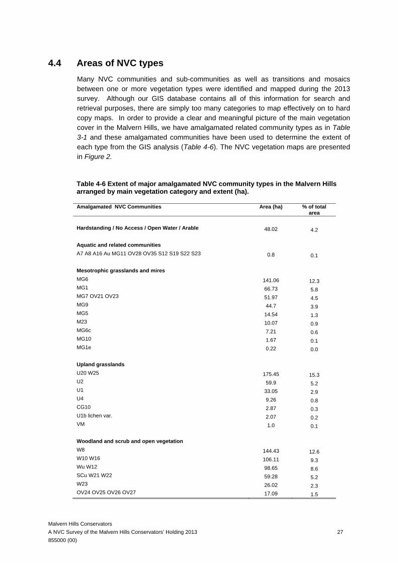
4.4 Areas of NVC types Many NVC communities and sub-communities as well as transitions and mosaics between one or more vegetation types were identified and mapped during the 2013 survey. Although our GIS database contains all of this information for search and retrieval purposes, there are simply too many categories to map effectively on to hard copy maps. In order to provide a clear and meaningful picture of the main vegetation cover in the Malvern Hills, we have amalgamated related community types as in Table 3-1 and these amalgamated communities have been used to determine the extent of each type from the GIS analysis (Table 4-6). The NVC vegetation maps are presented in Figure 2.
Table 4-6 Extent of major amalgamated NVC community types in the Malvern Hills arranged by main vegetation category and extent (ha).
Amalgamated NVC Communities Area (ha) % of total area
Hardstanding / No Access / Open Water / Arable 48.02 4.2 Aquatic and related communities A7 A8 A16 Au MG11 OV28 OV35 S12 S19 S22 S23 0.8 0.1 Mesotrophic grasslands and mires MG6 141.06 12.3 MG1 66.73 5.8 MG7 OV21 OV23 51.97 4.5 MG9 44.7 3.9 MG5 14.54 1.3 M23 10.07 0.9 MG6c 7.21 0.6 MG10 1.67 0.1 MG1e 0.22 0.0 Upland grasslands U20 W25 175.45 15.3 U2 59.9 5.2 U1 33.05 2.9 U4 9.26 0.8 CG10 2.87 0.3 U1b lichen var. 2.07 0.2 VM 1.0 0.1 Woodland and scrub and open vegetation W8 144.43 12.6 W10 W16 106.11 9.3 Wu W12 98.65 8.6 SCu W21 W22 59.28 5.2 W23 26.02 2.3 OV24 OV25 OV26 OV27 17.09 1.5

Malvern Hills Conservators A NVC Survey of the Malvern Hills Conservators’ Holding 2013 28 855000 (00)
W24 20.61 1.8 W2 W6 2.86 0.2 Total 1145.6 100%
Scrub and woodland accounts for the largest area of the vegetation on the Malvern Hills. The woodlands (distinct from scrub) predominate on the lower slopes and account for 30.7% of the total land surveyed. Between woodland types there is a roughly even division between Ash woodland (W8), Oak and Birch woodland (W10/W16) (although only very broadly referable to these woodland NVC types see Section 4.3.4) and unclassified secondary woodland (Wu – with a very small amount of Beech woodland - W12, and wet Willow and Alder woodland W2 and W6).
A number of different scrub types were mapped and together these cover 105.9 ha of the Malvern Hills (about 9% of the land area) and are indicative of low intensity management or lack of management. Section 4.5 discusses changes in scrub area as identified from a comparison of the 2006 and 2013 surveys.
Among the plant communities recorded, those of the most ecological and conservation value are the upland grasslands (U1, U2 and U4), which together extend over 102.2 ha (8.9%). The upland calcicolous grassland community CG10 is a grassland of especially high conservation value but limited in extent (2.87 ha).
The most widespread mesotrophic grassland community is MG6 grassland, covering 141.1 ha. This grassland covers large areas of the lowland commons and pastures and the different sub-communities are indicative of mild and sometimes more extreme agricultural improvement, but with sufficient management to prevent encroachment of coarse grasses. The 2013 survey has mapped a number species-rich examples, especially MG6c the Trisetum flavescens sub-community, which we mapped as a separate type and which covered over 7.21 ha. In general terms the MG6 grasslands of the Malvern Hills area are extensive and considered worthy of further study.
There was 14.5 ha of MG5 grassland mapped, a nationally important BAP habitat type, and this was mapped at several locations in the lowland commons. Species-rich examples and mosaics with other vegetation types, e.g. in Malvern Common, are discussed in Section 5 in terms of potential new SSSI designations.
There was a significant amount of MG1 grassland, indicative of unmanaged marginal grassland areas, covering 66.7 ha, the best examples being MG1e Arrhenatherum elatius grassland, Centaurea nigra sub-community which we have mapped as a separate type in the hard copy maps, but which covers just 0.22 ha in total.
Improved grassland, MG7, and related open vegetation types (OV21 and OV23) cover 52.0 ha predominantly along road verges and in recreation areas.
A total of 10.07 ha of the often species-rich Juncus mire community, M23, were mapped, predominantly on Castlemorton Common and Malvern Common, but also small patches in wet flushes elsewhere.
Malvern Hills Conservators A NVC Survey of the Malvern Hills Conservators’ Holding 2013 29 855000 (00)
4.5 Changes in NVC types
4.5.1 Introduction The objective was to compare the vegetation mapping in 2006 with that in 2013 to identify those areas that have changed significantly in terms of vegetation between the two survey periods 2006-2013. We used a combination of automated methods using the GIS system and field observations based on comparing vegetation maps from 2006 with actual vegetation observed in the field in 2013. There are some constraints relevant to the interpretation of vegetation change. Any field mapping exercise will be subject to field errors due to poor or ambiguous sight lines in the field, difficulties in interpreting the vegetation cover and extent on areas of uneven terrain such as steep slopes, and other practical problems associated with surveying large and heterogeneous areas. There will also be some errors associated with defining vegetation boundaries and differences between surveyor opinions. As a result, some “changes” will reflect these differences of interpretation and opinion, e.g. defining apparent change which does not reflect a real change but which is due for example, to differences in accessibility and clarification of vegetation in different surveys. An example here is on slopes where enhanced access can more clearly reveal the extent of areas of slope vegetation such as Pteridium aquilinum (Bracken) etc more clearly in one survey than another. This is not change of interest to this project. Other apparent changes might reflect real but unimportant change. Examples here include shifts between related sub-communities of similar vegetation types, e.g. MG1a Arrhenatherum elatius grassland, Festuca rubra sub-community to MG1b Arrhenatherum elatius grassland, Urtica dioica sub-community; generally this is not change of interest to this project. However, shifts between contrasting sub-communities might be significant e.g. between MG1e Arrhenatherum elatius grassland, Centaurea nigra sub-community and MG1b Arrhenatherum elatius grassland, Urtica dioica sub-community which in this case would reflect a shift from a more species-rich to a less species-rich vegetation type. Finally, other identified changes might reflect real and significant vegetation change, e.g. change from one community to another, e.g. change from MG5 Cynosurus cristatus-Centaurea nigra grassland to MG1 Arrhenatherum elatius grassland which could reflect changes in mowing frequency or timing or other management changes.
We have attempted to focus on this final category - the real and significant change – by checking the GIS map outputs with our own knowledge and experience of the area and other evidence such as our field notes. However, inevitably the analysis of change is
Malvern Hills Conservators A NVC Survey of the Malvern Hills Conservators’ Holding 2013 30 855000 (00)
not entirely an objective process and this needs to be borne in mind when reading this section and interpreting the graphical output.
4.5.2 Changes in scrub and Pteridium aquilinum (Bracken) vegetation: automated approaches
4.5.2.1 Introduction
The objective is to compare the vegetation mapping in 2006 with that in 2013 focusing on increases in scrub and bracken cover to identify those areas of open vegetation that have recently been colonised by scrub/ young woodland as distinct from ‘woodland’. Due to the large extent of the area surveyed our approach was to use the 2006 and 2013 habitat mapping to calculate habitat change automatically using the GIS system. We outline two approaches to evaluating changes in scrub vegetation below but for both approaches the areas mapped only in the 2013 survey (and outside the 2006 survey area) were removed. Any areas from the 2006 survey which were not revisited were also removed, resulting in two legitimately comparable areas of 793.83 ha. All parcels of the same community were then merged together. Finally, using the GIS, we automatically calculated the areas of each unique NVC community.
We have taken two automated approaches to identifying and mapping the change in scrub and bracken vegetation between 2006 and 2013. These can be viewed as first steps towards a strategic approach to scrub and bracken management in the Malvern Hills, we would emphasise that these are first steps as a degree of ground-truthing is required to make best use of these outputs.
4.5.2.2 Method 1: Identifying new areas of scrub and bracken (2006-2013)
In the first method we prepared a set of GIS maps for each of the survey dates 2006 and 2013 in which we identified areas mapped as woodland i.e. any of Wu, W2, W6, W8, W10, W16. In addition we also identified areas mapped as scrub or bracken but here we defined two categories: primary scrub and secondary scrub as follows. Primary scrub was defined as any parcels mapped as discreet scrub communities, i.e. any of SCu, U20, W21, W23, W24, W25. Secondary scrub was defined as any parcels mapped as mosaics or transitions between any scrub type with other vegetation types e.g. MG1+U20. In this way we were able to produce two sets of maps showing the distribution of woodland, established scrub (primary) and scrub mosaics (secondary) for 2006 and 2013. The next step was to “clip” the 2013 scrub layer with the 2006 scrub layer resulting in the locations of “new” scrub since 2006 (Figure 3). This map output provides an overview of areas that might be targeted for scrub and/or bracken clearance.
Malvern Hills Conservators A NVC Survey of the Malvern Hills Conservators’ Holding 2013 31 855000 (00)
Overall this analysis indicates that there has been an increase in scrub and bracken of 7.6 ha. The largest increase was of the U20 Pteridium aquilinum-Galium saxatile community (3.38 ha).
4.5.2.3 Areas of new grassland (2006-2013)
Having identified area of new scrub we looked for the reverse case, i.e. areas mapped as scrub in 2006 which were mapped as grassland in 2013. To identify and calculate areas of new grassland since 2006 we took the prepared data sets used the in new scrub calculations and clipped any 2013 parcels outside of 2006 areas classified scrub (woodland, primary scrub or secondary scrub). Any woodland, primary scrub or secondary scrub left within the clipped 2013 dataset was then removed leaving only new grassland community areas. These results are presented as maps of new grassland since 2006 in Figure 5. The analysis shows 7.25 ha of grassland mapped in 2013 which were mapped as scrub in 2006. We can consider these as new grassland areas and 29.66% is MG1, and of 24.41% are acid grassland communities (U1, U2 and U4).
4.5.2.4 Method 2: Prioritising scrub associated with priority grasslands (2013)
The first method provides a broad overview of areas of new scrub identified from the mapping comparing 2006 and 2013. An additional output would be to prioritise existing scrub areas (2013 mapping) in terms of potential conservation benefits of management. For example, scrub associated with valuable grassland habitats could be a greater priority for scrub control action than scrub associated with lower grade grasslands. This approach (the second method) involved grouping woodland, scrub and grassland categories as follows: Woodland includes Wu, W2, W6, W8, W10, W16; Primary scrub includes SCu, U20, W21, W23, W24, W25; Secondary scrub includes where primary scrub is part of a mosaic or transition but not
dominant e.g. MG1+U20; Primary scrub and priority grassland includes a transition between the two but scrub
is dominant e.g. W23+U1; Priority grassland and primary scrub includes a transition between the two but priority
grassland is dominant e.g. U1+W23; Secondary priority grassland includes where priority grassland is part of a mosaic or
transition but not dominant e.g. MG1+U1; and Priority grassland includes U1, U1b lichen var., U2, U4. The output is a series of maps (Figure 4) which show the juxtaposition of primary and secondary scrub with priority grasslands. This provides a step towards a strategic tool for prioritising scrub management. In theory, the priority scrub clearance areas are

Malvern Hills Conservators A NVC Survey of the Malvern Hills Conservators’ Holding 2013 32 855000 (00)
those areas of transitions between primary scrub (the dominant type) and priority grassland (red areas in Figure 6 maps 1 to 8) or priority grassland (the dominant type) and primary scrub (orange areas in Figure 4 maps 1 to 8). The results show that primary scrub and priority grassland covers 14.77 ha and that priority grassland and primary scrub covers 8.16 ha. In total this defines 22.93 ha of priority scrub clearance areas which might be converted to open habitat (Figure 4 maps 1 to 8).
4.5.3 Some field observations on vegetation change
4.5.3.1 Introduction
During our the 2013 mapping work for the survey area repeated from 2006 we were able to refer to the 2006 maps at the same time as carrying out the 2013 survey. In this way we were able to consider areas of habitat change on a case by case basis and below we outline some of these observations based on target notes the locations of which are given in Figure 8. Target note 1: The northernmost grassland areas on the hills were mostly mapped as U2a but they are quite mesotrophic and remapped as MG1a or U2 transitional to MG1. This area looks only lightly managed and appears to be an area where real change has occurred. Bracken areas here are rolled and this appears to have opened out the vegetation (W25 + MG1a in 2006, and MG1a transitional to U20a in 2013) Target note 2: An area of grassland and rush pasture at Birches farm which was mapped as a mosaic of MG6 and MG10 in 2006 but included more extensive areas of M23 in the 2013 mapping suggesting that the area has increased in wetness since 2006. Target note 3: Area mapped as W25 in 2006, and mapped as U20/MG1 in 2013 and representing an area of grassland gain, see also Figure 5. Target note 4: An area of grassland on a north-west slope mapped with frequent Vaccinium in 2006 and re-mapped as U2b (Vaccinium myrtillus sub-community) from U2a (Festuca ovina-Agrostis capillaris sub-community) in 2013. This could have been overlooked originally, but in conversation with the Natural England officer who did the very first NVC survey, her opinion was that Vaccinium vegetation has expanded on the hills since then, so this could be real change. Target note 5: The soils here are relatively thin and the scrub/bracken downslope fairly light, so this is an area where there could be relatively easy grassland gains by clearing the edges. Also, west of this, a small area mapped as U2a in 2006 looks to have scrubbed up to MG1/W23 in the 2013 mapping.
Malvern Hills Conservators A NVC Survey of the Malvern Hills Conservators’ Holding 2013 33 855000 (00)
Target note 6: This bracken area was mapped as W25 in 2006, however in 2013 it looked to have been rolled and the vegetation has opened out to U20a with elements of MG1a/U4. East of this area, bracken recorded as W25 in 2006 is closer to U20c in 2013. This could relate to survey inaccuracies in difficult terrain, but there are grassy areas and livestock paths through it, so it could be opening out. It could be that this whole area is relatively recent bracken encroachment on U4, and with further rolling and grazing this could be another relatively easy grassland gain.
Target note 7: An area recorded as Vaccinium in 2006 and mapped as U2b in 2013 reflecting opening out of some area of Vaccinium and colonisation by fine grasses. Target note 8: An area mapped as MG1 in 2006 and as W23/U20 in 2013 and representing one of the areas of new scrub in 2013, see also Figure 3. Target note 9: An example of an area where there has been Betula pendula (Silver Birch) colonisation. Target note 10: Area of roadside grassland mapped as MG5 in 2006 and as MG1e in 2013 possibly indicating vegetation change caused by the impact of reduced frequency of mowing. Target note 11: Area mapped as U4 in 2006 and as MG1 2013 and an indication of change from acid grassland to less interesting mesotrophic grassland. Target note 12: Area mapped as U4 in 2006 and as U20 in 2013 and an example of loss of acid grassland to Pteridium aquilinum (Bracken) encroachment. Target note 13: Area mapped as MG6 in 20o6 and as U20 in 2013 and an example of loss of mesotrophic grassland to Bracken encroachment. Target note 14: Area mapped as MG5 in 2006 and as MG1 in 2013 and an example of loss of species-rich meadow to rank Arrhenatherum grassland. This area is included in the boundary of the proposed Malvern Common SSSI (see Section 5) and would benefit from increased mowing frequency with removal of cuttings to enhance botanical diversity. Target note 15: Area mapped as MG6 in 2006 and as MG1 in 2013, another example of a shift to taller rank grassland, possibly reflecting a decrease in frequency of management by mowing or grazing management. Target note 16: An area mapped as U20 in 2006 but where there has been Betula pendula (Silver Birch) colonisation. Target note 17: An area mapped as U20 in 2006 but where there has been Betula pendula (Silver Birch) colonisation.
Malvern Hills Conservators A NVC Survey of the Malvern Hills Conservators’ Holding 2013 34 855000 (00)
Target note 18: Areas mapped as W25 in 2006 and as MG1 in 2013, representing grassland gain from scrub (see also Figure 5). Target note 19: Area mapped as U1b in 2006 and as U20/W25 in 2013 and representing areas of loss of acid grassland to scrub (see also Figure 3).
Malvern Hills Conservators A NVC Survey of the Malvern Hills Conservators’ Holding 2013 35 855000 (00)
5 NON-SSSI AREAS 5.1 Introduction
Some of the new areas included in the 2013 survey area fall outside of the designated SSSIs and the one of the objectives of the 2013 survey was to determine whether any of these currently non-SSSI areas do actually reach the criteria for SSSI designation. This section discusses those parts of the survey area that we consider to be of sufficient botanical quality to qualify for SSSI status, but which are not currently included in the SSSI boundary. We evaluated the botanical data against the criteria for selection of SSSI for grasslands and woodlands (the two main vegetation types encountered during the survey).
5.2 Woodland areas Figure 6 shows the SSSI boundaries within the Malvern Hills area and the existing Ancient Semi-natural Woodland and Plantation Ancient Woodland. The best example of W8 Fraxinus excelsior-Acer campestre-Mercurialis perennis woodland is Park Wood, an area designated as ancient semi-natural woodland. The woodland consisted of blocks of high-canopy Fraxinus excelsior (Ash) woodland, with sparse understory. During our survey we found 21 ancient woodland indicator species (based on the list for Worcestershire as described in Kirby & Goldberg (2004)) which were Anemone nemorosa (Wood Anemone), Allium ursinum (Ramsons), Carex pendula (Pendulous Sedge), Carex remota (Remote Sedge), Carex sylvatica (Wood-sedge), Chrysosplenium oppositifolium (Opposite-leaved Golden-saxifrage), Euphorbia amygdaloides (Wood Spurge), Galium odoratum (Woodruff), Hyacinthoides non-scripta (Bluebell), Lamiastrum galeobdolon (Yellow Archangel), Lysimachia vulgaris (Yellow Loosestrife), Melica uniflora (Wood Melick), Mercurialis perennis (Dog’s Mercury), Milium effusum (Wood Millet), Polystichum setiferum (Soft Shield-fern), Primula vulgaris (Primrose), Prunus avium (Wild Cherry), Quercus petraea (Sessile Oak), Ulmus glabra (Wych Elm), Veronica montana (Wood Speedwell) and Viola cf. riviniana (Common Dog-violet). There are several other ancient woodland indicator species and notable species reported from this wood including Epipactis helleborine (Broad-leaved Helleborine) and Paris quadrifolia (Herb-Paris) (Bennet & Garner 2005, MHC 2006). This was part of a mosaic with recently-coppiced woodland blocks with re-growth of Acer campestre (Field Maple) and Corylus avellana (Hazel) stools, and a more dense ground layer of eutrophic species including Galium aparine (Cleavers) and Rubus fruticosus agg. (Bramble). The management plan notes that this woodland is one of the few in the Malvern Hills on limestone bedrock (MHC 2006) which gives the woodland a more distinct flora.
Malvern Hills Conservators A NVC Survey of the Malvern Hills Conservators’ Holding 2013 36 855000 (00)
An additional area on the east-facing slope at Hollybush Roughs is ancient semi-natural woodland. This woodland is referable to W10 Quercus robur-Pteridium aquilinum-Rubus fruticosus woodland. We found a total of 13 ancient woodland indictor species for Worcestershire present in Hollybed Roughs. These include the woody species Malus sylvestris (Crab Apple) and the herbs Anemone nemorosa (Wood Anemone), Athyrium filix-femina (Lady-fern), Dryopteris affinis (Golden-scaled Male-fern), Hyacinthoides non-scripta (Bluebell), Luzula forsteri (Southern Wood-rush), Mercurialis perennis (Dog’s Mercury), Oxalis acetosella (Wood-sorrel), Poa nemoralis (Wood Meadow-grass), Polystichum setiferum (Soft Shield-fern), Schedonorus giganteus (Giant Fescue), Veronica montana (Wood Speedwell) and Viola riviniana (Common Dog-violet). This wood is adjacent to secondary Ash woodland, and it is likely that these ancient woodland species will have been able to colonise the secondary woodland, thus blurring the boundaries.
Overall, we do not think these merit individual SSSI designation although they might merit inclusion in adjacent woodland SSSI areas, see Figure 6. Apart from these two areas, much of the woodland on the hills is included within the existing SSSI boundary. There were no outstanding examples of woodland outside of the SSSI boundary that would warrant inclusion as part of the SSSI for their botanical merit. Most of the woodland is secondary mixed broadleaved woodland of little distinct botanical interest.
5.3 Grassland areas Areas of grassland which we considered included Hollybed Common which is not currently a statutory designated site for Nature Conservation. Hollybed Common is a large area of semi-natural grassland, which has been managed by grazing as common land for a long time. The common consists primarily of MG6 Lolium perenne – Cynosurus cristatus grassland, MG9 Holcus lanatus-Deschampsia cespitosa grassland and U1/W25. The areas of U1 Festuca ovina-Agrostis capillaris-Rumex acetosella grassland are of higher conservation significance, particularly as the examples on Hollybed Common are of a more typical lowland meadow character, different to the acid grassland communities found on the hills. However the total extent of U1 is only 1.01 ha (2.65%). There are 19 notable plant species reported from Hollybed common (Bennett & Garner (2005); 5 found during the RSK survey). There are also 8 Waxcap fungi present on Hollybed Common (Spence & Spence 2008). It is felt that under the assessment criteria it is difficult to justify the inclusion of Hollybed Common into a SSSI, due to the large proportion of MG6b Lolium perenne-Cynosurus cristatus grassland, Anthoxanthum odoratum sub-community grassland despite parts of it being of higher conservation and ecological value. Further consideration by Natural England may be required at the landscape scale due to its proximity adjacent to Castlemorton Common SSSI and the Malvern Hills SSSI.
Another area which we considered was Castlemorton Common and currently a total area of 158 ha is included in the Castlemorton Common SSSI. This area includes a full
Malvern Hills Conservators A NVC Survey of the Malvern Hills Conservators’ Holding 2013 37 855000 (00)
range of mesotrophic and mire communities along with areas of scrub. The areas of Castlemorton Common outside the SSSI boundary consist of 46.9 ha MG6 Lolium perenne – Cynosurus cristatus grassland and 22.7% MG9 grassland. Other habitats cover 30.0% of the area (approximately 22% is scrub communities, 4% is M23 mire, 3% is the roads and the remaining ~8% consists of miscellaneous grassland communities). On these grounds it is difficult to justify the inclusion of these additional areas into the existing SSSI, although they undoubtedly have a high value for wildlife and conservation. We also considered a number of areas of grassland outside of the current SSSI boundary that were of high botanical value. For example, five areas of species-rich, neutral lowland meadow (referable to the NVC type MG5 Cynosurus cristatus - Centaurea nigra grassland) were mapped at Newland (1.69 ha), Great Malvern along Albert Road North (1.57 ha), Malvern Common (8.81 ha), Hall Green (1.09 ha) and Rydd Green (1.32 ha). The SSSI selection guidelines (English Nature 1989, para 3.5) states that any single community of MG grassland of 5 ha or more should be considered for selection. Four of these areas are between 1.09 and 1.69 ha and so we do not consider them further here, however, bearing in mind the national importance of MG5 grassland we would encourage further evaluation of the conservation value of these lowland meadows. For this report we focus on the largest area at Malvern Common for further evaluation. The following section provides a description of this grassland and the botanical features and their location and fit with the SSSI selection guidelines. Figure 7 shows the boundary of the Malvern Common proposed SSSI according to our analysis below.
5.4 Malvern Common
5.4.1 General Description and Location Part of Malvern Common is covered in species-rich, neutral lowland meadow (referable to the NVC type MG5 Cynosurus cristatus - Centaurea nigra grassland). This occurs in mosaic and transition with a mire community (referable to the NVC type M23 Juncus effusus/acutiflorus-Galium palustre rush-pasture) on wetter soils around the edges, and with rank grassland on road verges and in unmanaged areas. The vegetation was sampled in a series of eight quadrats, which included the variation in vegetation across the common including the mire vegetation and the neutral lowland meadow.
5.4.2 Floristic Composition and Area The table below (Table 5-1) presents the data from quadrats recorded in the species-rich, neutral lowland meadow on the common. In this table, Quadrat 2 matched most closely with MG5b Cynosurus cristatus-Centaurea nigra grassland, Galium verum sub-community, and Quadrat 3 with MG5 Cynosurus cristatus - Centaurea nigra grassland undifferentiated, with matching coefficients of over 50. Species highlighted
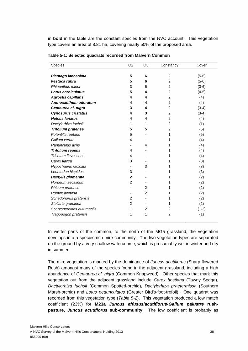
Malvern Hills Conservators A NVC Survey of the Malvern Hills Conservators’ Holding 2013 38 855000 (00)
in bold in the table are the constant species from the NVC account. This vegetation type covers an area of 8.81 ha, covering nearly 50% of the proposed area.
Table 5-1: Selected quadrats recorded from Malvern Common
Species Q2 Q3 Constancy Cover Plantago lanceolata 5 6 2 (5-6) Festuca rubra 5 6 2 (5-6) Rhinanthus minor 3 6 2 (3-6) Lotus corniculatus 5 4 2 (4-5) Agrostis capillaris 4 4 2 (4) Anthoxanthum odoratum 4 4 2 (4) Centaurea cf. nigra 3 4 2 (3-4) Cynosurus cristatus 4 3 2 (3-4) Holcus lanatus 4 4 2 (4) Dactylorhiza fuchsii 1 1 2 (1) Trifolium pratense 5 5 2 (5) Potentilla reptans 5 - 1 (5) Galium verum 4 - 1 (4) Ranunculus acris - 4 1 (4) Trifolium repens 4 - 1 (4) Trisetum flavescens 4 - 1 (4) Carex flacca 3 - 1 (3) Hypochaeris radicata - 3 1 (3) Leontodon hispidus 3 - 1 (3) Dactylis glomerata 2 - 1 (2) Hordeum secalinum 2 - 1 (2) Phleum pratense - 2 1 (2) Rumex acetosa - 2 1 (2) Schedonorus pratensis 2 - 1 (2) Stellaria graminea 2 - 1 (2) Scorzoneroides autumnalis 1 2 2 (1-2) Tragopogon pratensis 1 1 2 (1)
In wetter parts of the common, to the north of the MG5 grassland, the vegetation develops into a species-rich mire community. The two vegetation types are separated on the ground by a very shallow watercourse, which is presumably wet in winter and dry in summer. The mire vegetation is marked by the dominance of Juncus acutiflorus (Sharp-flowered Rush) amongst many of the species found in the adjacent grassland, including a high abundance of Centaurea cf. nigra (Common Knapweed). Other species that mark this vegetation out from the adjacent grassland include Carex hostiana (Tawny Sedge), Dactylorhiza fuchsii (Common Spotted-orchid), Dactylorhiza praetermissa (Southern Marsh-orchid) and Lotus pedunculatus (Greater Bird's-foot-trefoil). One quadrat was recorded from this vegetation type (Table 5-2). This vegetation produced a low match coefficient (23%) for M23a Juncus effusus/acutiflorus-Galium palustre rush-pasture, Juncus acutiflorus sub-community. The low coefficient is probably as
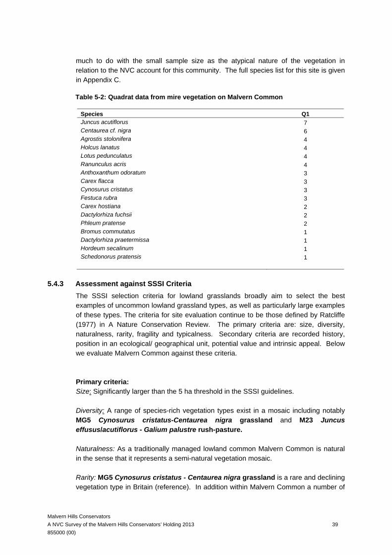
Malvern Hills Conservators A NVC Survey of the Malvern Hills Conservators’ Holding 2013 39 855000 (00)
much to do with the small sample size as the atypical nature of the vegetation in relation to the NVC account for this community. The full species list for this site is given in Appendix C.
Table 5-2: Quadrat data from mire vegetation on Malvern Common
Species Q1 Juncus acutiflorus 7 Centaurea cf. nigra 6 Agrostis stolonifera 4 Holcus lanatus 4 Lotus pedunculatus 4 Ranunculus acris 4 Anthoxanthum odoratum 3 Carex flacca 3 Cynosurus cristatus 3 Festuca rubra 3 Carex hostiana 2 Dactylorhiza fuchsii 2 Phleum pratense 2 Bromus commutatus 1 Dactylorhiza praetermissa 1 Hordeum secalinum 1 Schedonorus pratensis 1
5.4.3 Assessment against SSSI Criteria The SSSI selection criteria for lowland grasslands broadly aim to select the best examples of uncommon lowland grassland types, as well as particularly large examples of these types. The criteria for site evaluation continue to be those defined by Ratcliffe (1977) in A Nature Conservation Review. The primary criteria are: size, diversity, naturalness, rarity, fragility and typicalness. Secondary criteria are recorded history, position in an ecological/ geographical unit, potential value and intrinsic appeal. Below we evaluate Malvern Common against these criteria. Primary criteria: Size: Significantly larger than the 5 ha threshold in the SSSI guidelines. Diversity: A range of species-rich vegetation types exist in a mosaic including notably MG5 Cynosurus cristatus-Centaurea nigra grassland and M23 Juncus effusus/acutiflorus - Galium palustre rush-pasture. Naturalness: As a traditionally managed lowland common Malvern Common is natural in the sense that it represents a semi-natural vegetation mosaic. Rarity: MG5 Cynosurus cristatus - Centaurea nigra grassland is a rare and declining vegetation type in Britain (reference). In addition within Malvern Common a number of

Malvern Hills Conservators A NVC Survey of the Malvern Hills Conservators’ Holding 2013 40 855000 (00)
rare and scarce plants were recorded in our 2013 survey and a number of others are listed by Barnett & Garner (2005; these would need to be confirmed by independent survey) Carex binervis (Green-ribbed Sedge), Carex distans (Distant Sedge), Carex hostiana (Tawny Sedge), Dactylorhiza praetermissa (Southern Marsh-orchid), Dactylorhiza x transiens, Filipendula vulgaris (Dropwort), Galeopsis speciosa (Large-flowered Hemp-nettle), Helictotrichon pratensis (Meadow Oat-grass), Marrubium vulgare (White Horehound), Anacamptis morio (Green-winged Orchid) and Rosa agrestis (Small-leaved Sweet-briar). Fragility: MG5 Cynosurus cristatus - Centaurea nigra grassland is sensitive to agricultural improvements such as inputs of mineral fertilisers and also to inappropriate management (e.g. intensive grazing, early mowing for silage) or neglect of management both of which can result in conversion to less diverse and less interesting types of grassland and scrub which are difficult to restore to the original type. Typicalness: The lowland meadow on Malvern Common is a good fit for MG5 Cynosurus cristatus - Centaurea nigra grassland and it has a good abundance of the constant species found in this community. Secondary criteria: Recorded history: Unknown but worthy of further investigation into local historical and documentary sources. Position in an ecological/ geographical unit: The Malvern Hills sit at the crossroads of eastern and western and southern and more northern areas of Britain and as such represent a potentially interesting biogeographical gradient. Potential value: Management planning and action has the potential to maintain and enhance the botanical and zoological diversity of this site. Intrinsic appeal: Malvern Common is located within a residential community and there is uninterrupted access to the common which is a key green and wildlife space providing significant intrinsic and amenity appeal.
5.4.4 Setting the Common Standards Monitoring targets All SSSIs are assessed on a regular basis against a set of criteria derived to provide a consistent assessment across SSSIs (JNCC 2004). The Common Standards Monitoring for Lowland Meadows, which includes MG5 Cynosurus cristatus - Centaurea nigra grassland, was used to set targets for the drier grasslands on the proposed SSSI. Details of the targets are given in Table 5-3. Targets for the wetter areas of M23 Juncus effusus/acutiflorus-Galium palustre rush-pasture were set against the Common Standard Monitoring guidance of Lowland Purple Moor Grass and Rush Pasture habitats (Table 5-4).

Malvern Hills Conservators A NVC Survey of the Malvern Hills Conservators’ Holding 2013 41 855000 (00)
Table 5-3. Common Standard Monitoring targets for MG5 grassland in the proposed Malvern Common SSSI
Attributes Guidance on Targets Targets with Explanation Extent No significant loss of feature. The total area for MG5 within the proposed SSSI is
8.8 ha out of a site total of 18.24 ha (48.3%). Monitoring should ensure this area is maintained.
Sward composition: grass:herb ratio
Target should be set to register a low or decreasing herb cover as unfavourable. As a generic standard, the grass:herb ratio normally should fall within the range 40-90% herb cover. Within this range, local targets can be set to register a decrease in herb cover by 20% or more as unfavourable.
The current percent composition of herbs is 70-75% of the sward.
Sward composition: frequency of positive indicators
Targets should be set to register a low or declining frequency of key indicators as unfavourable. As a generic standard, the frequencies of positive indicators should, at the very least, confirm the presence of the target community. Local targets could also be set for site-specific positive indicator species, to register a decrease in frequency of 20% or more as unfavourable.
The following species are selected as key indicators for the area of proposed SSSI, with constancy and abundance in brackets: Centaurea cf. nigra (IV, 3-6) Galium verum (II, 2-4) Leontodon hispidus (I, 3) Lotus corniculatus (III, 4-5)
Sward composition: frequency of negative indicators - agricultural weeds
Target should be set to register high or increasing frequency/cover as unfavourable. As a generic standard, no species should be more than occasional throughout the sward or together more than 5% cover. Occasionally, local targets for S. jacobaea and A. sylvestris may be set to accept swards with either species frequent as favourable. More stringent local frequency targets can be set, if appropriate, to register increase in frequency of 10% or more as unfavourable.
The agricultural weeds were absent from the quadrats of MG5 Cynosurus cristatus - Centaurea nigra grassland and not significantly frequent or abundant in the wider area surveyed.
Sward composition: cover of negative indicators - agriculturally favoured species
Target should be set to register high or increasing cover as unfavourable. As a generic standard, no species should be individually at more than 10% cover, or collectively at more than 20% cover. More stringent local cover targets can be set, if appropriate, to register an increase of cover of 5% individually or 10% collectively as unfavourable.
The following agriculturally favoured species Lolium perenne, Phleum pratense, Bromus hordeaceus, Holcus lanatus and Trifolium repens currently comprise up to 15% of the sward, with no single species more than 10% overall.
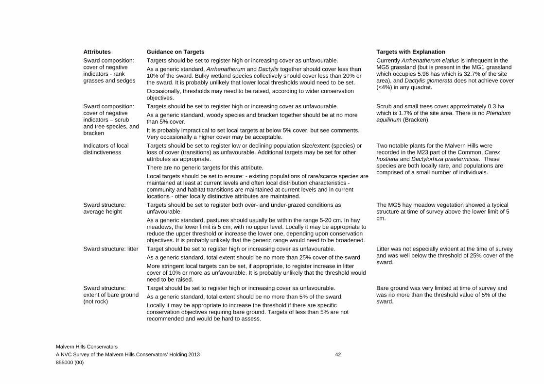
Malvern Hills Conservators A NVC Survey of the Malvern Hills Conservators’ Holding 2013 42 855000 (00)
Attributes Guidance on Targets Targets with Explanation Sward composition: cover of negative indicators - rank grasses and sedges
Targets should be set to register high or increasing cover as unfavourable. As a generic standard, Arrhenatherum and Dactylis together should cover less than 10% of the sward. Bulky wetland species collectively should cover less than 20% or the sward. It is probably unlikely that lower local thresholds would need to be set. Occasionally, thresholds may need to be raised, according to wider conservation objectives.
Currently Arrhenatherum elatius is infrequent in the MG5 grassland (but is present in the MG1 grassland which occupies 5.96 has which is 32.7% of the site area), and Dactylis glomerata does not achieve cover (<4%) in any quadrat.
Sward composition: cover of negative indicators – scrub and tree species, and bracken
Targets should be set to register high or increasing cover as unfavourable. As a generic standard, woody species and bracken together should be at no more than 5% cover. It is probably impractical to set local targets at below 5% cover, but see comments. Very occasionally a higher cover may be acceptable.
Scrub and small trees cover approximately 0.3 ha which is 1.7% of the site area. There is no Pteridium aquilinum (Bracken).
Indicators of local distinctiveness
Targets should be set to register low or declining population size/extent (species) or loss of cover (transitions) as unfavourable. Additional targets may be set for other attributes as appropriate. There are no generic targets for this attribute. Local targets should be set to ensure: - existing populations of rare/scarce species are maintained at least at current levels and often local distribution characteristics - community and habitat transitions are maintained at current levels and in current locations - other locally distinctive attributes are maintained.
Two notable plants for the Malvern Hills were recorded in the M23 part of the Common, Carex hostiana and Dactylorhiza praetermissa. These species are both locally rare, and populations are comprised of a small number of individuals.
Sward structure: average height
Targets should be set to register both over- and under-grazed conditions as unfavourable. As a generic standard, pastures should usually be within the range 5-20 cm. In hay meadows, the lower limit is 5 cm, with no upper level. Locally it may be appropriate to reduce the upper threshold or increase the lower one, depending upon conservation objectives. It is probably unlikely that the generic range would need to be broadened.
The MG5 hay meadow vegetation showed a typical structure at time of survey above the lower limit of 5 cm.
Sward structure: litter Target should be set to register high or increasing cover as unfavourable. As a generic standard, total extent should be no more than 25% cover of the sward. More stringent local targets can be set, if appropriate, to register increase in litter cover of 10% or more as unfavourable. It is probably unlikely that the threshold would need to be raised.
Litter was not especially evident at the time of survey and was well below the threshold of 25% cover of the sward.
Sward structure: extent of bare ground (not rock)
Target should be set to register high or increasing cover as unfavourable. As a generic standard, total extent should be no more than 5% of the sward. Locally it may be appropriate to increase the threshold if there are specific conservation objectives requiring bare ground. Targets of less than 5% are not recommended and would be hard to assess.
Bare ground was very limited at time of survey and was no more than the threshold value of 5% of the sward.
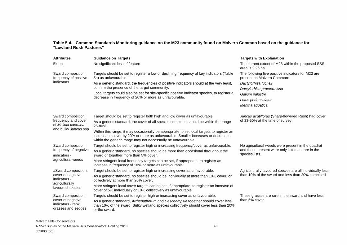
Malvern Hills Conservators A NVC Survey of the Malvern Hills Conservators’ Holding 2013 43 855000 (00)
Table 5-4. Common Standards Monitoring guidance on the M23 community found on Malvern Common based on the guidance for "Lowland Rush Pastures"
Attributes Guidance on Targets Targets with Explanation Extent No significant loss of feature The current extent of M23 within the proposed SSSI
area is 2.26 ha. Sward composition: frequency of positive indicators
Targets should be set to register a low or declining frequency of key indicators (Table 5a) as unfavourable. As a generic standard, the frequencies of positive indicators should at the very least, confirm the presence of the target community. Local targets could also be set for site-specific positive indicator species, to register a decrease in frequency of 20% or more as unfavourable.
The following five positive indicators for M23 are present on Malvern Common: Dactylorhiza fuchsii Dactylorhiza praetermissa Galium palustre Lotus pedunculatus Mentha aquatica
Sward composition: frequency and cover of Molinia caerulea and bulky Juncus spp
Target should be set to register both high and low cover as unfavourable. As a generic standard, the cover of all species combined should be within the range 25-80%. Within this range, it may occasionally be appropriate to set local targets to register an increase in cover by 20% or more as unfavourable. Smaller increases or decreases within the generic range may not necessarily be unfavourable.
Juncus acutiflorus (Sharp-flowered Rush) had cover of 33-50% at the time of survey.
Sward composition: frequency of negative indicators - agricultural weeds
Target should be set to register high or increasing frequency/cover as unfavourable. As a generic standard, no species should be more than occasional throughout the sward or together more than 5% cover. More stringent local frequency targets can be set, if appropriate, to register an increase in frequency of 10% or more as unfavourable.
No agricultural weeds were present in the quadrat and those present were only listed as rare in the species lists.
#Sward composition: cover of negative indicators - agriculturally favoured species
Target should be set to register high or increasing cover as unfavourable. As a generic standard, no species should be individually at more than 10% cover, or collectively at more than 20% cover. More stringent local cover targets can be set, if appropriate, to register an increase of cover of 5% individually or 10% collectively as unfavourable.
Agriculturally favoured species are all individually less than 10% of the sward and less than 20% combined
Sward composition: cover of negative indicators - rank grasses and sedges
Targets should be set to register high or increasing cover as unfavourable. As a generic standard, Arrhenatherum and Deschampsia together should cover less than 10% of the sward. Bulky wetland species collectively should cover less than 20% or the sward.
These grasses are rare in the sward and have less than 5% cover
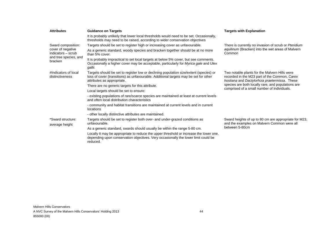
Malvern Hills Conservators A NVC Survey of the Malvern Hills Conservators’ Holding 2013 44 855000 (00)
Attributes Guidance on Targets Targets with Explanation It is probably unlikely that lower local thresholds would need to be set. Occasionally, thresholds may need to be raised, according to wider conservation objectives
Sward composition: cover of negative indicators – scrub and tree species, and bracken
Targets should be set to register high or increasing cover as unfavourable. As a generic standard, woody species and bracken together should be at no more than 5% cover. It is probably impractical to set local targets at below 5% cover, but see comments. Occasionally a higher cover may be acceptable, particularly for Myrica gale and Ulex gallii.
There is currently no invasion of scrub or Pteridium aquilinum (Bracken) into the wet areas of Malvern Common
#Indicators of local distinctiveness
Targets should be set to register low or declining population size/extent (species) or loss of cover (transitions) as unfavourable. Additional targets may be set for other attributes as appropriate. There are no generic targets for this attribute. Local targets should be set to ensure: - existing populations of rare/scarce species are maintained at least at current levels and often local distribution characteristics - community and habitat transitions are maintained at current levels and in current locations - other locally distinctive attributes are maintained.
Two notable plants for the Malvern Hills were recorded in the M23 part of the Common, Carex hostiana and Dactylorhiza praetermissa. These species are both locally rare, and populations are comprised of a small number of individuals.
*Sward structure: average height
Targets should be set to register both over- and under-grazed conditions as unfavourable. As a generic standard, swards should usually be within the range 5-80 cm. Locally it may be appropriate to reduce the upper threshold or increase the lower one, depending upon conservation objectives. Very occasionally the lower limit could be reduced.
Sward heights of up to 80 cm are appropriate for M23, and the examples on Malvern Common were all between 5-80cm

Malvern Hills Conservators A NVC Survey of the Malvern Hills Conservators’ Holding 2013 45 855000 (00)
6 NOTABLE PLANT SPECIES A document describing the Notable Flora on the Malvern Hills Conservators Land was published by Barnett & Garner (2005). This work includes plants that are scarce or rare in the UK or Worcestershire, or in a few cases, where they are rare or scarce on the Conservator’s land. The publication also gives details of the locations where these plants are found. The publication includes a total of 79 species, subspecies, varieties or interspecific hybrids. The botanical survey in 2013 did not include a systematic search all possible locations for rare plant species on the Hills. However, the surveyors were aware of the plants on the list and the vegetation types in which they were likely to occur, and looked for them whenever such vegetation types were encountered. All records were incidental, and they do not represent a thorough survey of the current status of any of the species. It is likely that a number of ephemeral species would not have been visible above ground at the time of survey. A total of 25 of the species on the Notable Flora list were recorded during our surveys. The details for each plant are presented in Table 6-1.
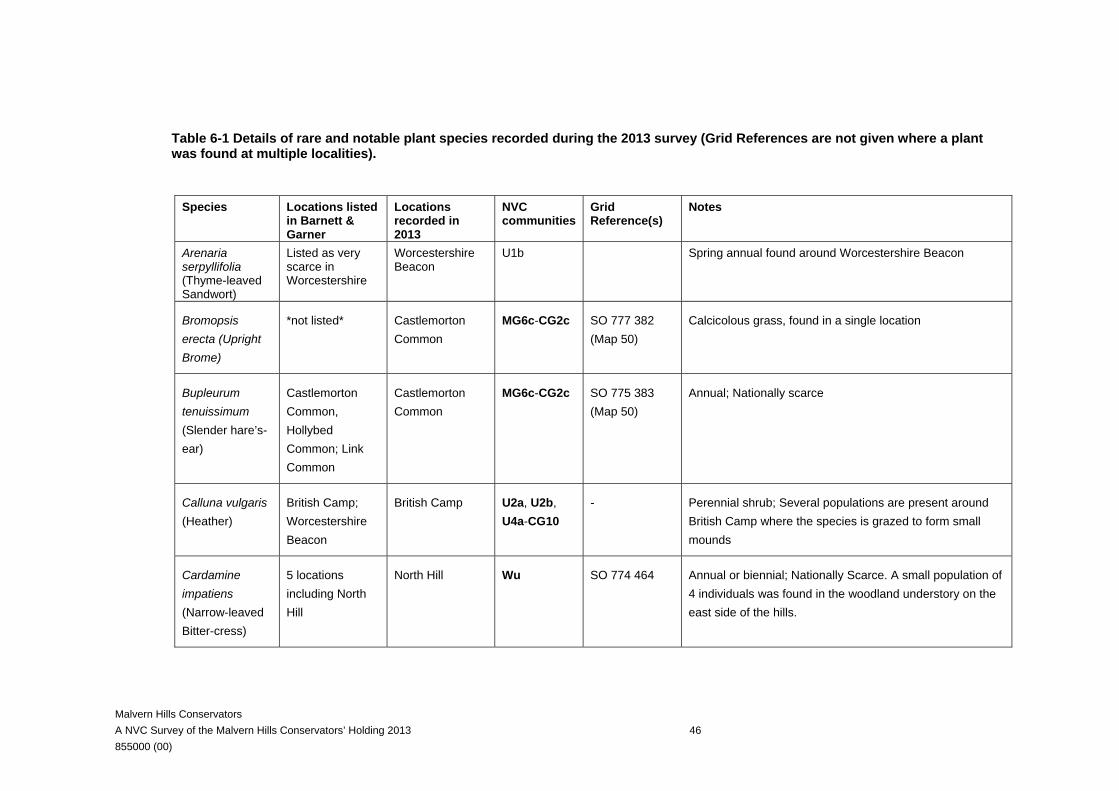
Malvern Hills Conservators A NVC Survey of the Malvern Hills Conservators’ Holding 2013 46 855000 (00)
Table 6-1 Details of rare and notable plant species recorded during the 2013 survey (Grid References are not given where a plant was found at multiple localities).
Species Locations listed
in Barnett & Garner
Locations recorded in 2013
NVC communities
Grid Reference(s)
Notes
Arenaria serpyllifolia (Thyme-leaved Sandwort)
Listed as very scarce in Worcestershire
Worcestershire Beacon
U1b Spring annual found around Worcestershire Beacon
Bromopsis erecta (Upright Brome)
*not listed* Castlemorton Common
MG6c-CG2c SO 777 382 (Map 50)
Calcicolous grass, found in a single location
Bupleurum tenuissimum (Slender hare’s-ear)
Castlemorton Common, Hollybed Common; Link Common
Castlemorton Common
MG6c-CG2c SO 775 383 (Map 50)
Annual; Nationally scarce
Calluna vulgaris (Heather)
British Camp; Worcestershire Beacon
British Camp U2a, U2b, U4a-CG10
- Perennial shrub; Several populations are present around British Camp where the species is grazed to form small mounds
Cardamine impatiens (Narrow-leaved Bitter-cress)
5 locations including North Hill
North Hill Wu SO 774 464 Annual or biennial; Nationally Scarce. A small population of 4 individuals was found in the woodland understory on the east side of the hills.
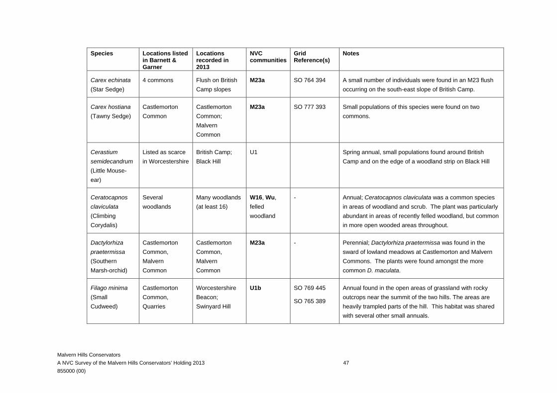
Malvern Hills Conservators A NVC Survey of the Malvern Hills Conservators’ Holding 2013 47 855000 (00)
Species Locations listed in Barnett & Garner
Locations recorded in 2013
NVC communities
Grid Reference(s)
Notes
Carex echinata (Star Sedge)
4 commons Flush on British Camp slopes
M23a SO 764 394 A small number of individuals were found in an M23 flush occurring on the south-east slope of British Camp.
Carex hostiana (Tawny Sedge)
Castlemorton Common
Castlemorton Common; Malvern Common
M23a SO 777 393 Small populations of this species were found on two commons.
Cerastium semidecandrum (Little Mouse-ear)
Listed as scarce in Worcestershire
British Camp; Black Hill
U1 Spring annual, small populations found around British Camp and on the edge of a woodland strip on Black Hill
Ceratocapnos claviculata (Climbing Corydalis)
Several woodlands
Many woodlands (at least 16)
W16, Wu, felled woodland
- Annual; Ceratocapnos claviculata was a common species in areas of woodland and scrub. The plant was particularly abundant in areas of recently felled woodland, but common in more open wooded areas throughout.
Dactylorhiza praetermissa (Southern Marsh-orchid)
Castlemorton Common, Malvern Common
Castlemorton Common, Malvern Common
M23a - Perennial; Dactylorhiza praetermissa was found in the sward of lowland meadows at Castlemorton and Malvern Commons. The plants were found amongst the more common D. maculata.
Filago minima (Small Cudweed)
Castlemorton Common, Quarries
Worcestershire Beacon; Swinyard Hill
U1b SO 769 445
SO 765 389
Annual found in the open areas of grassland with rocky outcrops near the summit of the two hills. The areas are heavily trampled parts of the hill. This habitat was shared with several other small annuals.
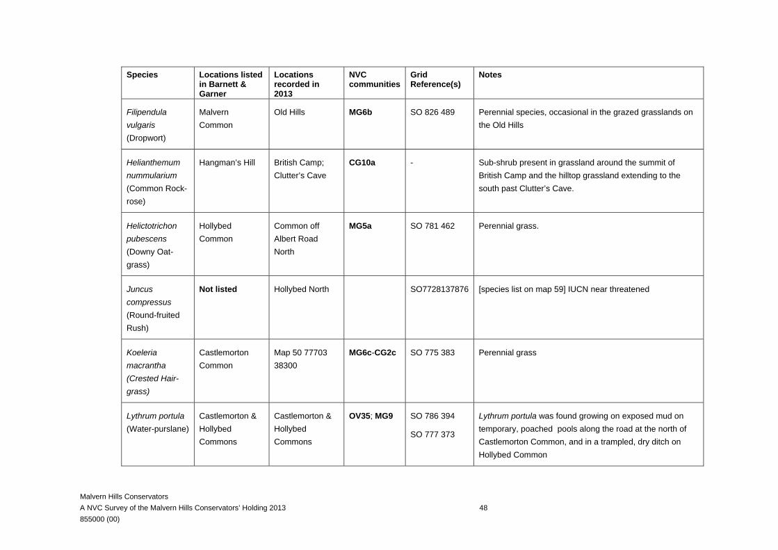
Malvern Hills Conservators A NVC Survey of the Malvern Hills Conservators’ Holding 2013 48 855000 (00)
Species Locations listed in Barnett & Garner
Locations recorded in 2013
NVC communities
Grid Reference(s)
Notes
Filipendula vulgaris (Dropwort)
Malvern Common
Old Hills MG6b SO 826 489 Perennial species, occasional in the grazed grasslands on the Old Hills
Helianthemum nummularium (Common Rock-rose)
Hangman’s Hill British Camp; Clutter’s Cave
CG10a - Sub-shrub present in grassland around the summit of British Camp and the hilltop grassland extending to the south past Clutter’s Cave.
Helictotrichon pubescens (Downy Oat-grass)
Hollybed Common
Common off Albert Road North
MG5a SO 781 462 Perennial grass.
Juncus compressus (Round-fruited Rush)
Not listed Hollybed North SO7728137876 [species list on map 59] IUCN near threatened
Koeleria macrantha (Crested Hair-grass)
Castlemorton Common
Map 50 77703 38300
MG6c-CG2c SO 775 383 Perennial grass
Lythrum portula (Water-purslane)
Castlemorton & Hollybed Commons
Castlemorton & Hollybed Commons
OV35; MG9 SO 786 394
SO 777 373
Lythrum portula was found growing on exposed mud on temporary, poached pools along the road at the north of Castlemorton Common, and in a trampled, dry ditch on Hollybed Common
Malvern Hills Conservators A NVC Survey of the Malvern Hills Conservators’ Holding 2013 49 855000 (00)
Species Locations listed in Barnett & Garner
Locations recorded in 2013
NVC communities
Grid Reference(s)
Notes
Moenchia erecta (Upright Chickweed)
Listed as rare in Worcestershire
British Camp and Clutter’s Cave
U1 SO 765 395
SO 762 393
Annual of short turf.
Oenanthe lachenalii (Parsley Water-dropwort)
Castlemorton & Hollybed Commons
Castlemorton Common
M23a - Perennial species of inundated soils found in the wetter areas of Castlemorton Common
Oenanthe pimpinelloides (Corky-fruited Water-dropwort)
Hollybed Common; Old Hills;
Castlemorton & Hollybed Commons
MG6b - Perennial species of grazed pasture
Ornithopus perpusillus (Bird's-foot)
Listed as scare in Worcestershire
Worcestershire Beacon
U1b Listed as locally uncommon in the SSSI citation; a few individuals were found in the open, rocky ground along the ridge approaching the Worcestershire Beacon.
Potentilla tabernaemontani (Spring Cinquefoil)
Hangmans Hill Hangmans Hill to British Camp
U1b SO 762 393 Perennial species found growing in the hilltop grasslands to the south of British Camp on the west-facing slopes
Ranunculus trichophyllus (Thread-leaved Water-crowfoot)
Castlemorton Common
Castlemorton Common
Aquatic habitats
- Aquatic annual or perennial found in a single pond on Castlemorton Common.
Malvern Hills Conservators A NVC Survey of the Malvern Hills Conservators’ Holding 2013 50 855000 (00)
Species Locations listed in Barnett & Garner
Locations recorded in 2013
NVC communities
Grid Reference(s)
Notes
Rumex pulcher (Fiddle Dock)
Castlemorton & Hollybed Commons
Hollybed Common
MG6c SO 779 373 A single individual was found growing in a grazed area of grassland on the eastern edge Hollybed Common
Scleranthus annuus (Annual Knawel)
Swinyards & Hangmans Hills
Pinnacle Hill U1b SO 768 416 Over 100 individuals of this small annual found growing in the short-sward, rocky areas of trampled grassland along the trail at the peak of the middle hills
Sorbus torminalis (Wild Service-tree)
Not listed Along North End Land and Mayfield
Hedgerow tree
SO 79212 46944 and SO 79376 46847
UK BAP priority species and listed in the SSSI citation as a “less common in the Malverns”
Stellaria pallida (Lesser Chickweed)
Castlemorton Common; Hangmans & Ragged Stone Hills
Worcestershire Beacon
U1 SO 760 400 A few plants of this annual were found on the stone steps on the ascent between the British Camp Car Park and the hill top in May.
Teesdalia nudicaulis (Shepherd's Cress)
Worcestershire Beacon
Worcestershire Beacon
U1 SO 769 442 50 plants of this winter-annual were found in the short-swards of turf near the top of the Worcestershire Beacon
Torilis nodosa (Knotted Hedge-parsley)
Castlemorton & Hollybed Commons
Hollybed North Open vegetation in hedge bank
- Annual, a small population of this species were present on a dry, open sandy bank between a road and a hedgerow
Malvern Hills Conservators A NVC Survey of the Malvern Hills Conservators’ Holding 2013 51 855000 (00)
Species Locations listed in Barnett & Garner
Locations recorded in 2013
NVC communities
Grid Reference(s)
Notes
Trifolium ornithopodioides (Bird's-foot Clover)
Hollybed Common, British Camp
Worcestershire Beacon
U1 SO 769 445
Trifolium ornithopodioides was found in the open rocky ground close to the summit of the Worcestershire Beacon
Malvern Hills Conservators A NVC Survey of the Malvern Hills Conservators’ Holding 2013 52 855000 (00)
7 REFERENCES Barnett, K. & Garner, P. G. (2005) Notable Flora on the Malvern Hills Conservators Land. Published online by the Malvern Hills Conservators at http://www.malvernhills.org.uk/Content/Notable%20Flora.pdf
Carter Ecological Ltd (2006) NVC Survey of grassland in the Malvern Hills (C489). Carter Ecological Ltd, Banbury, UK.
Carter Ecological Ltd (2007) Variation in the grassland of the Malvern Hills (C620). Carter Ecological Ltd, Banbury, UK.
Countryside Consultants (2003). National Vegetation Classification (NVC) Phase II Survey of Grassland within the Malvern Hills Site of Special Scientific Interest. Report to the Malvern Hills Conservators and English Nature. Davies, S. (1994). The Malvern Hills SSSI: Feasibility Study for the Re-introduction of Grazing. M.Sc. Thesis, University College London. English Nature (2000). Monitoring the Condition of Lowland Grassland SSSIs 1: English Nature’s Rapid Assessment Method. English Nature Research Reports 315, English Nature, Peterborough.
Hill, M.O., Blackstock, T.H., Long, D.G. & Rothero, G.P. (2008). A Checklist and Census Catalogue of British and Irish Bryophytes. British Bryological Society, Middlewich.
Kirby, K. & Goldberg, E. (2004). Ancient woodland: guidance material for local authorities. English Nature, Peterborough.
Malloch, A.J.C. (1999). Match II. University of Lancaster, Lancaster. Malvern Hills Conservators (2006). Management Plan for 2006 – 2012. Malvern Hills Conservators. Accessed online at http://www.malvernhills.org.uk
Nature Conservancy Council (1989) Guidelines for selection of biological SSSIs. JNCC, Peterborough, UK. Published online at http://jncc.defra.gov.uk/page-2303
Ratcliffe, D.A. ed. (1977). A Nature Conservation Review. 2 vols. Cambridge, Cambridge University Press.
Malvern Hills Conservators A NVC Survey of the Malvern Hills Conservators’ Holding 2013 53 855000 (00)
Rodwell, J.S. (1991a). British Plant Communities 1: Woodlands and Scrub. Cambridge University Press, Cambridge.
Rodwell, J.S. (1991b). British Plant Communities 2: Mires and Heaths. Cambridge University Press, Cambridge.
Rodwell, J.S. (1992). British Plant Communities 3: Grasslands and Montane Communities. Cambridge University Press, Cambridge.
Rodwell, J.S. (1995). British Plant Communities 4: Aquatic Communities, Swamps and Tall-herb Fens. Cambridge University Press, Cambridge.
Rodwell, J.S. (2000). British Plant Communities 5: Maritime Communities and Vegetation of Open Habitats. Cambridge University Press, Cambridge.
Rodwell, J.S. (2006). National Vegetation Classification: User’s Handbook. Joint Nature Conservation Committee, Peterborough.
Rodwell, J.S., Dring, J.C., Averis, A.B.G., Proctor, M.C.F., Malloch, A.J.C., Schaminee, J.H.J. & Dargie, T.C.D. (2000). Review of Coverage of the National Vegetation Classification. Joint Nature Conservation Committee, Peterborough.
Spence, S. & Spence, G. (2008). Fungi survey of the Southern Hills and Castlemorton. Malvern Hills Conservators. Accessed online at http://www.malvernhills.org.uk
Stace, C.A. (2010). New Flora of the British Isles, 3rd edition. Cambridge University Press, Cambridge.