Embed Size (px)
Citation preview

Japan Review, 2008,20:�–52
The Making of the Japan Sea and the Japanese Mountains: Understanding Japan’s Volcanism in Structural Context
Gina L. Barnes School of Oriental and African Studies, University of London, U.K.
Many people, including scholars, routinely think that Japan has always been a set of volcanic islands. However, its geohistory speaks differently: not only are the basic building blocks of the archipelago primarily sedimentary in nature, they formed part of the Eurasian continental edge until relatively recently. In a previous article (Japan Review 15, 200�), I traced the development of the major geological belts of Japan from 450 to 15 million years ago, ending with the formation of the archipelago itself upon the opening of the Japan Sea. In this sequel, I look more in detail at the mechanisms and causes of the rifting of the archipelago and then at the subsequent formation of its mountain chains and lowland basins. In these two processes of rifting and mountain-building, we find two very different kinds of volcanism contributing to the overall geological composition of Japan: alkali rifting volcanics and sub-alkaline subduction volcanics acting at very different times, locations and circumstances. And taking the larger tectonic processes into the future, we find that the Japan Sea is already beginning to close, bringing new patterns to the earthquakes that plague the archipelago. New geological concepts and terms used to discuss these matters are fully described in the Glossary, with geology lessons on rifting, folding and faulting, gravity and isostasy, in Appendix 1. Barnes 200� should be consulted for the table of geological periods, previously introduced processes, and specific figures referred to below.
Keywords: Japanese geology, volcanos, back-arc basin formation, Japan Sea, neotectonics, rifting
Introduction To refute:
“The Japanese Islands have experienced no drastic change from the earliest Miocene to the present.”1
Merely thirty-five years ago it was thought, even by the most progressive Japanese geophysicists of the day, as the above quotation shows, that the Japan Sea had existed at least from earliest Miocene times (24–5 Ma) and perhaps even from Palaeogene (ca. 65–24 Ma)
�
4 Gina L. Barnes
or Cretaceous times (144–65 Ma) 2 (Table 1). However, revolutionary advances in palaeomagnetic dating in the 1980s dramatically changed this picture. On the basis of those new data, it was postulated that the Japanese archipelago did not exist in its current form until 15 Ma in the Middle Miocene, when the processes of continental rifting to make the Japan Sea pushed the Eurasian fringe out to form a series of offshore islands. Since then, everything in Japan has changed—and so has our knowledge of these transformations changed in only the last three decades.
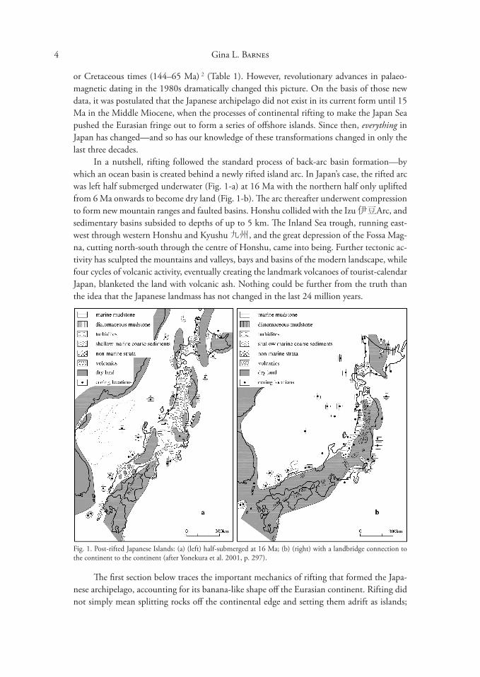
In a nutshell, rifting followed the standard process of back-arc basin formation—by which an ocean basin is created behind a newly rifted island arc. In Japan’s case, the rifted arc was left half submerged underwater (Fig. 1-a) at 16 Ma with the northern half only uplifted from 6 Ma onwards to become dry land (Fig. 1-b). The arc thereafter underwent compression to form new mountain ranges and faulted basins. Honshu collided with the Izu 伊豆Arc, and sedimentary basins subsided to depths of up to 5 km. The Inland Sea trough, running east-west through western Honshu and Kyushu 九州, and the great depression of the Fossa Magna, cutting north-south through the centre of Honshu, came into being. Further tectonic activity has sculpted the mountains and valleys, bays and basins of the modern landscape, while four cycles of volcanic activity, eventually creating the landmark volcanoes of tourist-calendar Japan, blanketed the land with volcanic ash. Nothing could be further from the truth than the idea that the Japanese landmass has not changed in the last 24 million years.
Fig. 1. Post-rifted Japanese Islands: (a) (left) half-submerged at 16 Ma; (b) (right) with a landbridge connection to the continent to the continent (after Yonekura et al. 2001, p. 297).
The first section below traces the important mechanics of rifting that formed the Japanese archipelago, accounting for its banana-like shape off the Eurasian continent. Rifting did not simply mean splitting rocks off the continental edge and setting them adrift as islands;
5 The Making of the Japan Sea and the Japanese Mountains
it also involved much generation of magma, which rose through the cracks as the Earth’s Eurasian crust was being stretched thinner. This magma, whether extruded as basalt lava or as volcanic ash, was generally alkaline in nature, thus differing in chemical composition to the later calc-alkaline volcanic products associated with the subduction of oceanic plates. Such chemical details are addressed below in the Green Tuff section and in Appendix 1 under “Igneous Geochemistries.”
The second section investigates the consequences for Honshu of back-arc basin opening: the literal splitting of the island into two tectonically different regimes by the intrusion of the Izu Arc. With the Japanese archipelago pushing eastwards away from the continent, it overrode the newly formed Philippine Plate in the southwest, causing a new calc-alkaline subduction zone to form.� Moreover, the Izu volcanic islands carried on the edge of the Philippine Plate began to plough into Honshu, causing the fracture zone of the Fossa Magna and the bending of earlier geological belts—originally formed parallel to the NE-SW trending coastline—around the intruding Izu Arc.
In the third section, we examine the subsequent uplift of the archipelago and formation of its mountainous topography. The earliest extant but now extinct subduction volcanoes—from the Miocene (ca. 16–5 Ma) and later Plio-Pleistocene (from 5 Ma)—are contrasted with the alkali rifting volcanics, and then the establishment of Quaternary subduction zone volcanism is reviewed. However, few of Japan’s mountains are actually volcanoes: several other mechanisms have thrust up mountainous areas and mountain chains. Case studies of these mechanisms gives one a feel for the variety of stresses acting on the Japanese archipelago in its tectonically vulnerable position. Finally, the fourth section looks at the formation of the inter-montane basin structures of Japan through yet further processes of rifting and faulting. Many of these processes are currently active and are restructuring the archipelago’s topographic layout. Their effects are both short- and long-term, with varying impact on people’s lives today.
In order to understand these various phenomena, the basic structural geology principles of folding, faulting4, gravity and isostasy,5 rifting mechanics, and volcanic geochemistry6 will be introduced into our toolkit (see Appendix 1). Also important are the concepts of extensional tectonics, causing the stretching and rifting of the continental crust, and compressional tectonics, resulting in folding and faulting and uplift of the new archipelago. While we cannot take a purely chronological approach to all the changes that took place to form the current Japanese landscape, a thematic approach, drawing examples from various parts of Japan, allows an overview of the shaping of modern Japan.
Table 1. Chronological Eras Referred to in This Article
Cretaceous 144–65 Ma Palaeogene 65–24 Ma Miocene 24–5 Ma Pliocene 5–2 Ma Quaternary 2 Ma-presentPleistocene 2 Ma-10 Ka Early Quaternary 2 Ma - 700 Ka
Middle Quaternary 700 Ka - 1� Ka Late Quaternary 12 Ka – present
Holocene 10 Ka-present Ma = million years ago Ka = thousand years ago
6 Gina L. Barnes
Opening and Closing of the Japan Sea
Competing Hypotheses
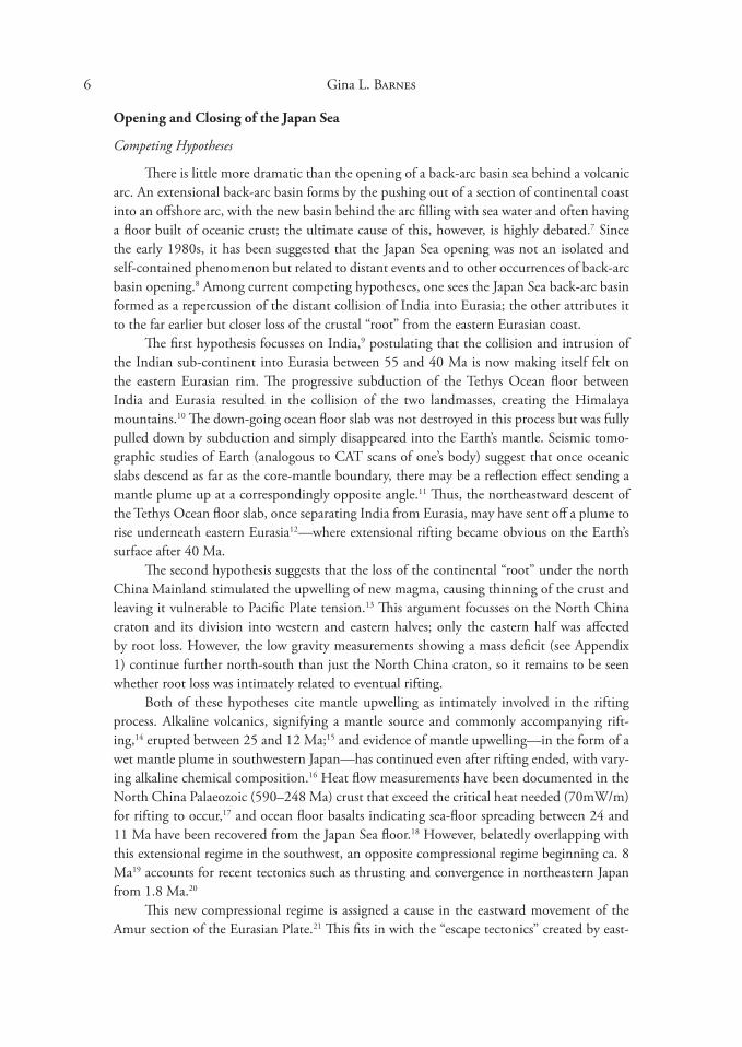
There is little more dramatic than the opening of a back-arc basin sea behind a volcanic arc. An extensional back-arc basin forms by the pushing out of a section of continental coast into an offshore arc, with the new basin behind the arc filling with sea water and often having a floor built of oceanic crust; the ultimate cause of this, however, is highly debated.7 Since the early 1980s, it has been suggested that the Japan Sea opening was not an isolated and self-contained phenomenon but related to distant events and to other occurrences of back-arc basin opening.8 Among current competing hypotheses, one sees the Japan Sea back-arc basin formed as a repercussion of the distant collision of India into Eurasia; the other attributes it to the far earlier but closer loss of the crustal “root” from the eastern Eurasian coast.
The first hypothesis focusses on India,9 postulating that the collision and intrusion of the Indian sub-continent into Eurasia between 55 and 40 Ma is now making itself felt on the eastern Eurasian rim. The progressive subduction of the Tethys Ocean floor between India and Eurasia resulted in the collision of the two landmasses, creating the Himalaya mountains.10 The down-going ocean floor slab was not destroyed in this process but was fully pulled down by subduction and simply disappeared into the Earth’s mantle. Seismic tomographic studies of Earth (analogous to CAT scans of one’s body) suggest that once oceanic slabs descend as far as the core-mantle boundary, there may be a reflection effect sending a mantle plume up at a correspondingly opposite angle.11 Thus, the northeastward descent of the Tethys Ocean floor slab, once separating India from Eurasia, may have sent off a plume to rise underneath eastern Eurasia12—where extensional rifting became obvious on the Earth’s surface after 40 Ma.
The second hypothesis suggests that the loss of the continental “root” under the north China Mainland stimulated the upwelling of new magma, causing thinning of the crust and leaving it vulnerable to Pacific Plate tension.1� This argument focusses on the North China craton and its division into western and eastern halves; only the eastern half was affected by root loss. However, the low gravity measurements showing a mass deficit (see Appendix 1) continue further north-south than just the North China craton, so it remains to be seen whether root loss was intimately related to eventual rifting.
Both of these hypotheses cite mantle upwelling as intimately involved in the rifting process. Alkaline volcanics, signifying a mantle source and commonly accompanying rifting,14 erupted between 25 and 12 Ma;15 and evidence of mantle upwelling—in the form of a wet mantle plume in southwestern Japan—has continued even after rifting ended, with varying alkaline chemical composition.16 Heat flow measurements have been documented in the North China Palaeozoic (590–248 Ma) crust that exceed the critical heat needed (70mW/m) for rifting to occur,17 and ocean floor basalts indicating sea-floor spreading between 24 and 11 Ma have been recovered from the Japan Sea floor.18 However, belatedly overlapping with this extensional regime in the southwest, an opposite compressional regime beginning ca. 8 Ma19 accounts for recent tectonics such as thrusting and convergence in northeastern Japan from 1.8 Ma.20
This new compressional regime is assigned a cause in the eastward movement of the Amur section of the Eurasian Plate.21 This fits in with the “escape tectonics” created by east

7 The Making of the Japan Sea and the Japanese Mountains
west faulting along the Tibetan Plateau after its attainment of maximum uplift following the India-Eurasia collision.22 The current hypothesis argues that, by squashing the landmass north of the plateau eastwards, the plateau has perhaps 25% more space to accommodate compression from the continuing collisional tectonics triggered by the arrival of the Indian sub-continent.2� The recent effects in Japan have been compression of the archipelago between the Pacific Plate and the Amur Plate (a sub-section of Eurasia), both moving towards each other. This compression reverses the rifting processes in place since the Miocene, and the occurrence of recent destructive earthquakes on a line from Niigata 新潟 to Kōbe 神戸
(Fig. 2) is possibly related to the beginning of compressive closing of the Japan Sea. The map of vector arrows in Fig. 2, showing direction and velocity of landmass movement in different areas of Japan, clearly indicates that western Honshu and Kyushu are moving southeastwards against the rest of Japan which is moving westwards.24 Kōbe is located at the juncture of these trajectories.
Fig. 2. Plate boundaries, major tectonic lines, and vector arrows (after Taira 2001, figs. 1, 4). The MTL leads into the Kinki Triangle (containing Kobe) from the west. GPS vector data representing crustal movement during the period from January 1997 to July 1999.
8 Gina L. Barnes
These long-distance relationships of Japan to Eurasia must, of course, be coordinated with more local causes and effects. But what we can now see in recent as well as ancient Japanese geohistory is that the geology of the archipelago cannot be understood in a narrow geographical framework: worldwide tectonic events must be taken into account to explain the pressures, movements, and rock compositions appearing in its geological record. The formation of the Japan Sea back-arc basin and creation of the Japanese archipelago off the Eurasian continent was one of the major rearrangements of the western Pacific landmasses in the Neogene (24–2 Ma). It was also the last large-scale tectonic transformation to affect the Japanese landmass as a whole, setting the stage for the modification of the landscape into what we see today.
The first indication of rifting is often the extrusion of huge amounts of low-silica lava (basalt) without formation of volcanoes per se. In East Asia, such “flood basalts” as they are called occur on the North China Mainland, while Japan was subjected primarily to the extrusion of higher-silica volcanic ash (tephra) in the “Green Tuff Movement.” Both these products are calc-alkaline in nature, in contrast to sub-alkaline products of subduction volcanics, established later. Potassium-argon (K-Ar) datings of 24–25 Ma indicate an early Miocene start to this particular alkali volcanic activity.25 The events of landscape sculpting from the pre-rifting phase to the end of the Green Tuff Movement, covering the period from 25 to 5 Ma, are summarized in Appendix 2 for the different areas of the archipelago. These events form the background sequence to the details discussed below.
The Japan Sea Basin and Sea
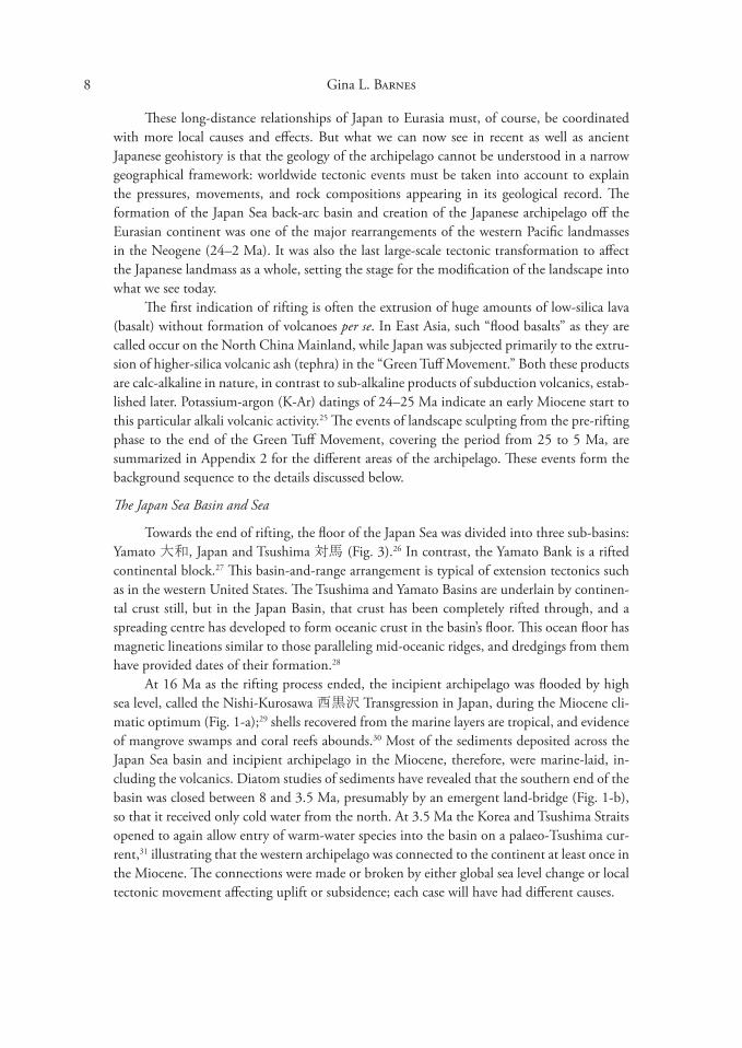
Towards the end of rifting, the floor of the Japan Sea was divided into three sub-basins: Yamato 大和, Japan and Tsushima 対馬 (Fig. �).26 In contrast, the Yamato Bank is a rifted continental block.27 This basin-and-range arrangement is typical of extension tectonics such as in the western United States. The Tsushima and Yamato Basins are underlain by continental crust still, but in the Japan Basin, that crust has been completely rifted through, and a spreading centre has developed to form oceanic crust in the basin’s floor. This ocean floor has magnetic lineations similar to those paralleling mid-oceanic ridges, and dredgings from them have provided dates of their formation.28
At 16 Ma as the rifting process ended, the incipient archipelago was flooded by high sea level, called the Nishi-Kurosawa 西黒沢 Transgression in Japan, during the Miocene climatic optimum (Fig. 1-a);29 shells recovered from the marine layers are tropical, and evidence of mangrove swamps and coral reefs abounds.�0 Most of the sediments deposited across the Japan Sea basin and incipient archipelago in the Miocene, therefore, were marine-laid, including the volcanics. Diatom studies of sediments have revealed that the southern end of the basin was closed between 8 and �.5 Ma, presumably by an emergent land-bridge (Fig. 1-b), so that it received only cold water from the north. At �.5 Ma the Korea and Tsushima Straits opened to again allow entry of warm-water species into the basin on a palaeo-Tsushima current,�1 illustrating that the western archipelago was connected to the continent at least once in the Miocene. The connections were made or broken by either global sea level change or local tectonic movement affecting uplift or subsidence; each case will have had different causes.
9 The Making of the Japan Sea and the Japanese Mountains
Fig. �. The Japan Sea Basin (after Okamura et al. 1995, figs. 1, 4, 15).
“Green Tuff” Volcanics
As in other instances of continental rifting around the world, alkali flood basalts, characteristic of the early stages of rifting, were first deposited on dry land—the Eurasian mainland in this case, as known from North China.�2 Subsequently, volcanic products were deposited into freshwater lakes as rifted blocks subsided and the depressions filled with water. During the Nishi-Kurosawa Transgression (Appendix 2) and as the Japan Sea basin opened up between 19 and 15 Ma, volcanics were extruded into marine waters; these took on a characteristic green colour through chemical reaction with ocean water (metasomatism),�� and the thick layers of volcanics that were deposited caused other green minerals to form at higher temperatures and pressures. The green colour became the defining characteristic of sediments laid down during this time.
The term “Green Tuff” was originally the name of a stratigraphic unit in northeast Japan, the Green Tuff Formation,�4 but it has been extended to account for a wide zone of Miocene alkaline volcanics�5 stretching from the Kuril Islands north of Hokkaido down

10 Gina L. Barnes
through western Honshu into the Ryūkyū 琉球 Islands and across Honshu into the Izu Arc (Fig. 4). The west coast of Sado 佐渡 Island (located in Fig. 4, photo) is a particularly good area to see these bluish-green tuff layers exposed along the seashore. The name “Green Tuff” is unfortunate, though, because a) not all the volcanics lithified as tuff—there were lavas as well; b) not all the rocks in the zone are even igneous—many are non-igneous sedimentary; and c) not all green rocks in the zone are tuff.
The quantities of volcanic materials produced during this submarine stage are staggering: deposits at least 5 to 10 km deep are known in the Fossa Magna part of the Green Tuff Zone.�6 This indicates continuing and rapid subsidence of the submarine basins, which then kept collecting the volcanic effusions. These products are interdigitated with the marine muds, sands and coastal gravels that were generated by erosion following tectonic uplift. Marine and volcanic layers from this period are widespread across northern Japan today, especially on the northwestern coast of Tōhoku 東北 which was the last region to become dry land (cf. Fig. 1-b).
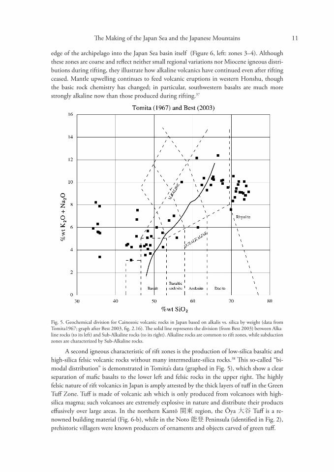
The igneous geochemistry of this zone is as distinctive as the metasomatic greenness. The proportions of two alkaline elements in the volcanics, potassium (K) and sodium (Na), when plotted as oxides against silica, are used to distinguish between alkaline and sub-alkaline igneous rocks (e.g., Fig. 5). Alkaline igneous rocks are commonly observed in continental rift zones and ocean island hot spots; they differ from the sub-alkaline products of mid-oceanic rift zones and island arcs—a category which includes calcium-rich (calc-alkaline) products characteristic of subduction volcanoes. Fig. 6 (left) illustrates the present-day clinal distribution across the Japanese Islands of increasing alkalinity towards the west, especially across the western, inner
Fig. 4. Green Tuff Zone (map, above left), containing Tōhoku minor fold zone, and southwestern Japan’s Miocene volcanoes (after Chigakudan 1995, fig. �-1; Sugimura and Ueda 197�, fig. 7.�). Exposed green tuff along western shore of Sado Island provides fantastic seashore scenery (author’s photo).
11 The Making of the Japan Sea and the Japanese Mountains
edge of the archipelago into the Japan Sea basin itself (Figure 6, left: zones �–4). Although these zones are coarse and reflect neither small regional variations nor Miocene igneous distributions during rifting, they illustrate how alkaline volcanics have continued even after rifting ceased. Mantle upwelling continues to feed volcanic eruptions in western Honshu, though the basic rock chemistry has changed; in particular, southwestern basalts are much more strongly alkaline now than those produced during rifting.�7
Fig. 5. Geochemical division for Cainozoic volcanic rocks in Japan based on alkalis vs. silica by weight (data from Tomita1967; graph after Best 200�, fig. 2.16). The solid line represents the division (from Best 200�) between Alkaline rocks (to its left) and Sub-Alkaline rocks (to its right). Alkaline rocks are common to rift zones, while subduction zones are characterized by Sub-Alkaline rocks.
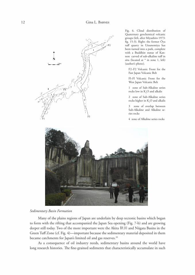
A second igneous characteristic of rift zones is the production of low-silica basaltic and high-silica felsic volcanic rocks without many intermediate-silica rocks.�8 This so-called “bimodal distribution” is demonstrated in Tomita’s data (graphed in Fig. 5), which show a clear separation of mafic basalts to the lower left and felsic rocks in the upper right. The highly felsic nature of rift volcanics in Japan is amply attested by the thick layers of tuff in the Green Tuff Zone. Tuff is made of volcanic ash which is only produced from volcanoes with high-silica magma; such volcanoes are extremely explosive in nature and distribute their products effusively over large areas. In the northern Kantō 関東 region, the Ōya 大谷 Tuff is a renowned building material (Fig. 6-b), while in the Noto 能登 Peninsula (identified in Fig. 2), prehistoric villagers were known producers of ornaments and objects carved of green tuff.
12 Gina L. Barnes
Fig. 6. Clinal distribution of Quaternary geochemical volcanic groups (left, after Miyashiro 197�: fig. 15-�). Right: the former Ōya tuff quarry in Utsunomiya has been turned into a park, complete with a Buddhist statue of Kan-non carved of sub-alkaline tuff in situ (located at * in zone 1, left) (author’s photo).
F2–F2 Volcanic Front for the Fast Japan Volcanic Belt
Fl–Fl Volcanic Front for the West Japan Volcanic Belt
1 zone of Sub-Alkaline series rocks low in K2O and alkalis
2 zone of Sub-Alkaline series rocks higher in K2O and alkalis
� zone of overlap between Sub-Alkaline and Alkaline series rocks
4 zone of Alkaline series rocks
Sedimentary Basin Formation
Many of the plains regions of Japan are underlain by deep tectonic basins which began to form with the rifting that accompanied the Japan Sea opening (Fig. 7-b) and are growing deeper still today. Two of the more important were the Akita 秋田 and Niigata Basins in the Green Tuff Zone (cf. Fig. 4)—important because the sedimentary material deposited in them became catchments for Japan’s limited oil and gas reserves.�9
As a consequence of oil industry needs, sedimentary basins around the world have long research histories. The fine-grained sediments that characteristically accumulate in such

The Making of the Japan Sea and the Japanese Mountains 1�
Fig. 7. Progressive subsidence and uplift following the rifting of Japan (after Yonekura et at. 2001, fig. 10.1.6). a Uplift patterns of major mountain blocks from ca. 15 Ma; angle of line indicates rate, calibrated to figures for 1
m/1000 years and 2m/1000 years given at right. At least half (50-66%) of the current altitude of the Japanese mountain ranges has been achieved in the last 2-� Ma, as calculated by three different methods of estimating altitudinal change (cf. Yoshikawa et at. 1981: �9).
b Subsidence patterns for major sedimentary basins from ca. 17 Ma; angle of line indicates rate calibrated to figure for -lm/1000 years given at right.
basins often include organic matter that has avoided full decomposition thanks to a lack of oxygen.40 This organic matter survives as hydrocarbon compounds in mudrocks called “oil shales” formed from marine deposition, while natural gases take refuge in reservoirs of nearby porous rocks.41 In Japan, many small oil and gas fields formed in the sedimentary basins of the Green Tuff Zone, created during and after rifting of the Japan Sea. Most petroleum in this zone is found in the “hard shales” (siliceous shale) and “black shales” (dark grey mudstone).42
In the Niigata gas fields, samples of porous and finely cracked rhyolitic (highly felsic) green tuff hosting natural gases have been brought up by coring at depths from 2.5 to 4.� km,4� but
14 Gina L. Barnes
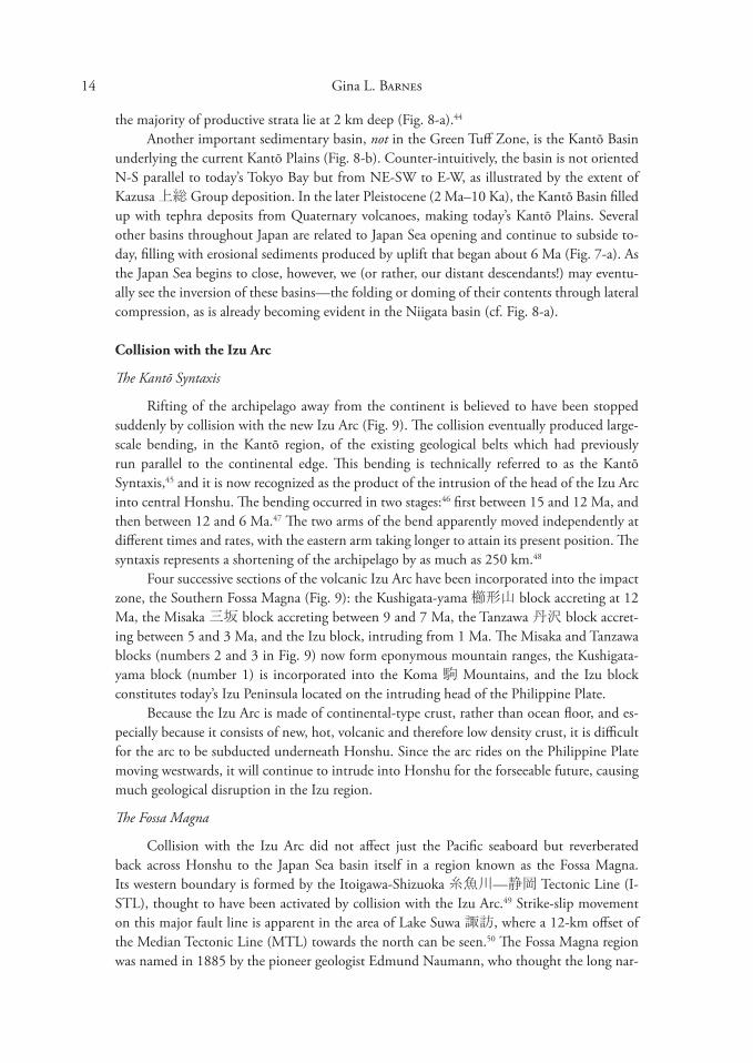
the majority of productive strata lie at 2 km deep (Fig. 8-a).44
Another important sedimentary basin, not in the Green Tuff Zone, is the Kantō Basin underlying the current Kantō Plains (Fig. 8-b). Counter-intuitively, the basin is not oriented N-S parallel to today’s Tokyo Bay but from NE-SW to E-W, as illustrated by the extent of Kazusa 上総 Group deposition. In the later Pleistocene (2 Ma–10 Ka), the Kantō Basin filled up with tephra deposits from Quaternary volcanoes, making today’s Kantō Plains. Several other basins throughout Japan are related to Japan Sea opening and continue to subside today, filling with erosional sediments produced by uplift that began about 6 Ma (Fig. 7-a). As the Japan Sea begins to close, however, we (or rather, our distant descendants!) may eventually see the inversion of these basins—the folding or doming of their contents through lateral compression, as is already becoming evident in the Niigata basin (cf. Fig. 8-a).
Collision with the Izu Arc
The Kantō Syntaxis
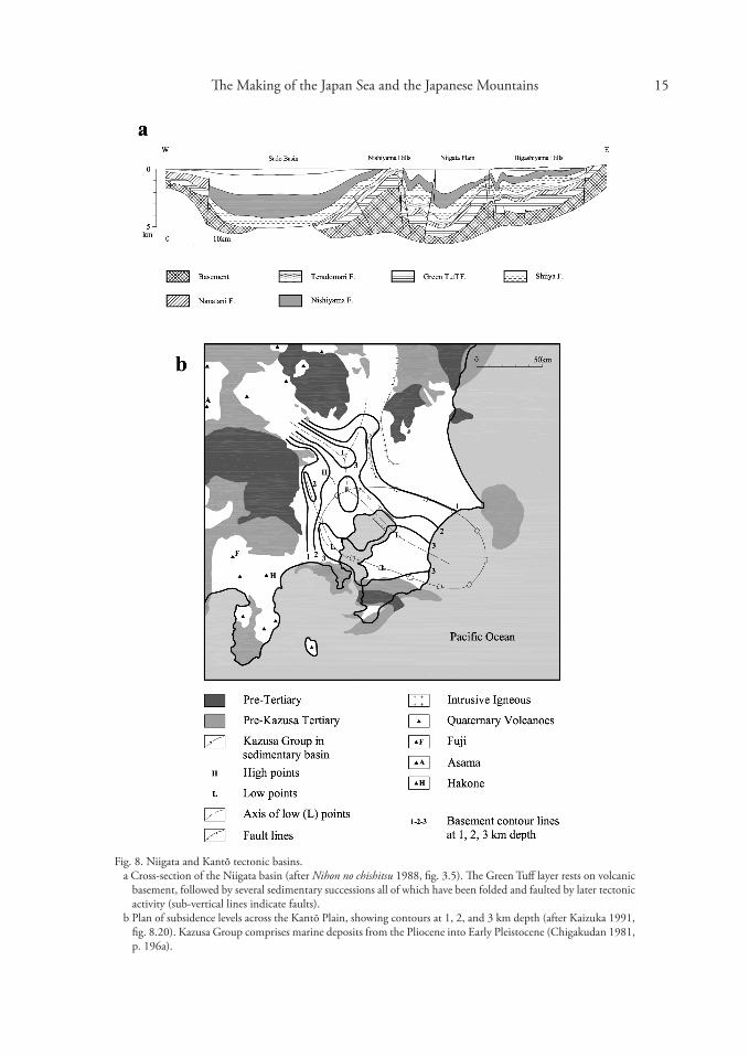
Rifting of the archipelago away from the continent is believed to have been stopped suddenly by collision with the new Izu Arc (Fig. 9). The collision eventually produced large-scale bending, in the Kantō region, of the existing geological belts which had previously run parallel to the continental edge. This bending is technically referred to as the Kantō Syntaxis,45 and it is now recognized as the product of the intrusion of the head of the Izu Arc into central Honshu. The bending occurred in two stages:46 first between 15 and 12 Ma, and then between 12 and 6 Ma.47 The two arms of the bend apparently moved independently at different times and rates, with the eastern arm taking longer to attain its present position. The syntaxis represents a shortening of the archipelago by as much as 250 km.48
Four successive sections of the volcanic Izu Arc have been incorporated into the impact zone, the Southern Fossa Magna (Fig. 9): the Kushigata-yama 櫛形山 block accreting at 12 Ma, the Misaka 三坂 block accreting between 9 and 7 Ma, the Tanzawa 丹沢 block accreting between 5 and � Ma, and the Izu block, intruding from 1 Ma. The Misaka and Tanzawa blocks (numbers 2 and � in Fig. 9) now form eponymous mountain ranges, the Kushigatayama block (number 1) is incorporated into the Koma 駒 Mountains, and the Izu block constitutes today’s Izu Peninsula located on the intruding head of the Philippine Plate.
Because the Izu Arc is made of continental-type crust, rather than ocean floor, and especially because it consists of new, hot, volcanic and therefore low density crust, it is difficult for the arc to be subducted underneath Honshu. Since the arc rides on the Philippine Plate moving westwards, it will continue to intrude into Honshu for the forseeable future, causing much geological disruption in the Izu region.
The Fossa Magna
Collision with the Izu Arc did not affect just the Pacific seaboard but reverberated back across Honshu to the Japan Sea basin itself in a region known as the Fossa Magna. Its western boundary is formed by the Itoigawa-Shizuoka 糸魚川—静岡 Tectonic Line (ISTL), thought to have been activated by collision with the Izu Arc.49 Strike-slip movement on this major fault line is apparent in the area of Lake Suwa 諏訪, where a 12-km offset of the Median Tectonic Line (MTL) towards the north can be seen.50 The Fossa Magna region was named in 1885 by the pioneer geologist Edmund Naumann, who thought the long nar
15 The Making of the Japan Sea and the Japanese Mountains
Fig. 8. Niigata and Kantō tectonic basins. a Cross-section of the Niigata basin (after Nihon no chishitsu 1988, fig. �.5). The Green Tuff layer rests on volcanic
basement, followed by several sedimentary successions all of which have been folded and faulted by later tectonic activity (sub-vertical lines indicate faults).
b Plan of subsidence levels across the Kantō Plain, showing contours at 1, 2, and � km depth (after Kaizuka 1991, fig. 8.20). Kazusa Group comprises marine deposits from the Pliocene into Early Pleistocene (Chigakudan 1981, p. 196a).
16 Gina L. Barnes
Fig. 9. The Kantō Syntaxis bending of once-parallel geological belts, and the MTL, around the intruding head of the Izu Arc; the accreted Kushigata-yama (1), Misaka (2) and Tanzawa (�) Mountains are in foremost position (after Chigakudan 1995, fig. �-6; Taira 1990, fig. 6-2; Hashimoto 1991, fig. 5.8; Takahashi and Saitō 1997, fig. 7). The subduction zone thrust fault outlines the current surface edge of the intruding Izu block on the Philippine Plate, forming the Izu Peninsula.
row valley transecting central Honshu from north to south along the I-STL was like a “big trough” (i.e. fossa magna, in Latin).51 The eastern boundary, however, is less definitive. Naumann hypothesized that a fault ran between Mt. Yatsugatake 八ヶ岳 and the Kantō Mountains (Fig. 10, nos. 11 and 17) to form the eastern boundary.52 Instead, a fault further east is postulated to constrain the syntaxis: the Kashiwazaki-Chōshi 柏崎—銚子 tectonic line (K-CTL)5� (Fig. 9). Many Fossa Magna scholars, however, are reluctant to accept this as the eastern boundary fault because doing so would include most of the Kantō region, thus going

17 The Making of the Japan Sea and the Japanese Mountains
against Naumann’s original definition of the Fossa Magna as excluding the Kantō Mountains and by inference anything east of them.
Two Plate Regimes
The Izu Arc is important to Japan in a second, less spectacular but certainly meaningful way: it serves to separate the archipelago into two tectonic regimes. The Japanese Islands west of the I-STL are now subject to the subduction activities of the Philippine Plate as well as to stress from the Pacific Plate behind it,54 while NE Japan receives the full brunt of the Pacific Plate. These plates are moving at different directions, speeds and angles, and the ages of the subducting plates are radically different (Table 2); as a result the stresses placed on NW and SE Japan have varied in detail. However, both areas show evidence of compression exerted
Fig. 10. Distribution of mountain complexes, plains, and volcanoes (after Yonekura et al. 2001, fig. 1.�.2. Numbers of mountains mentioned in the text are keyed to the original publication; see Yonekura for full list).
18 Gina L. Barnes
by the plates on the newly positioned archipelago, and general uplift is thought to have been initiated by the increased rate and angle of subduction of the Pacific and Philippine Plates after 1� Ma.55
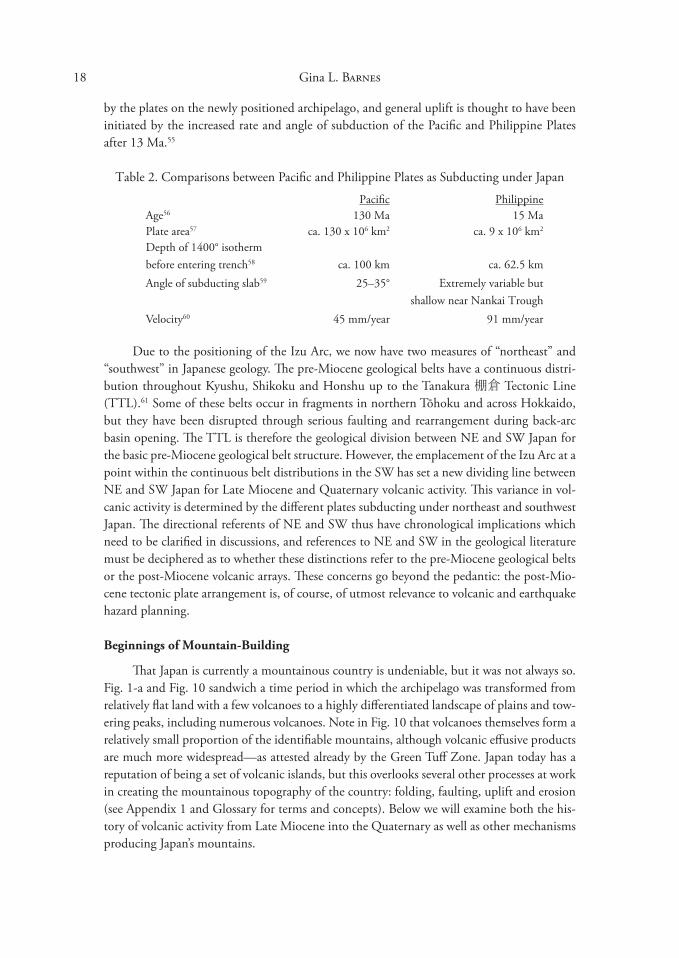
Table 2. Comparisons between Pacific and Philippine Plates as Subducting under Japan
Pacific Philippine Age56 1�0 Ma 15 Ma Plate area57
Depth of 1400° isotherm ca. 1�0 x 106 km2 ca. 9 x 10⁶ km2
before entering trench58 ca. 100 km ca. 62.5 km Angle of subducting slab59 25–�5° Extremely variable but
shallow near Nankai Trough Velocity60 45 mm/year 91 mm/year
Due to the positioning of the Izu Arc, we now have two measures of “northeast” and “southwest” in Japanese geology. The pre-Miocene geological belts have a continuous distribution throughout Kyushu, Shikoku and Honshu up to the Tanakura 棚倉 Tectonic Line (TTL).61 Some of these belts occur in fragments in northern Tōhoku and across Hokkaido, but they have been disrupted through serious faulting and rearrangement during back-arc basin opening. The TTL is therefore the geological division between NE and SW Japan for the basic pre-Miocene geological belt structure. However, the emplacement of the Izu Arc at a point within the continuous belt distributions in the SW has set a new dividing line between NE and SW Japan for Late Miocene and Quaternary volcanic activity. This variance in volcanic activity is determined by the different plates subducting under northeast and southwest Japan. The directional referents of NE and SW thus have chronological implications which need to be clarified in discussions, and references to NE and SW in the geological literature must be deciphered as to whether these distinctions refer to the pre-Miocene geological belts or the post-Miocene volcanic arrays. These concerns go beyond the pedantic: the post-Miocene tectonic plate arrangement is, of course, of utmost relevance to volcanic and earthquake hazard planning.
Beginnings of Mountain-Building
That Japan is currently a mountainous country is undeniable, but it was not always so. Fig. 1-a and Fig. 10 sandwich a time period in which the archipelago was transformed from relatively flat land with a few volcanoes to a highly differentiated landscape of plains and towering peaks, including numerous volcanoes. Note in Fig. 10 that volcanoes themselves form a relatively small proportion of the identifiable mountains, although volcanic effusive products are much more widespread—as attested already by the Green Tuff Zone. Japan today has a reputation of being a set of volcanic islands, but this overlooks several other processes at work in creating the mountainous topography of the country: folding, faulting, uplift and erosion (see Appendix 1 and Glossary for terms and concepts). Below we will examine both the history of volcanic activity from Late Miocene into the Quaternary as well as other mechanisms producing Japan’s mountains.
19 The Making of the Japan Sea and the Japanese Mountains
Japan as an Incipient Orogenic Belt?
“Mountain-building” is a classic topic in geology, known as “orogeny,” and is characteristically associated with subduction zones. Initial studies focussed on the European Alps (the “Alpine orogeny,” since discredited as a single orogenic event),62 and now the primary case study is the Himalayas, which is predicated on the condition that two continental masses (Eurasia and the Indian sub-continent) were drawn together into collision through the complete subduction of the Tethys Ocean floor previously existing between them. This case is somewhat different from Japan, where subduction of the ocean floor is continuing, and furthermore, there are no large continents looming on the eastern horizon for eventual collision. This is not to imply, however, that collision tectonics are absent from Japan: the best and current example is the collision of Honshu and the Izu Arc.
Thrust-faulted mountains. During collision, mountains are developed mainly through thrust faulting, which thickens the continental crust by causing one section of crust to ride up onto another. The landmasses of both Honshu and the head of the Izu Arc are being thickened in this way, in the case of the latter from ca. 22 km to greater than 40 km thick.6� The Tanzawa Mountains (Fig. 9 no. �, Fig. 10 no.18) are an interesting product of collision: they were once part of the deeply buried (plutonic) middle crust in the Izu chain which segmented into an independent block, accreted to Honshu, and has been lifted up and exposed as high mountains. This process began around 6 Ma and accelerated after 2 Ma, giving the Tanzawa Mountain block a current altitude of around 1700 m (Fig. 7-a).
On the western side of the I-STL is more evidence of the pressure exerted by the intruding Izu Arc. Three mountain ranges in the southern Japan Alps are arrayed obliquely along the I-STL: the Hida 飛騨, Kiso 木曾 and Akaishi 赤石 Ranges (Fig. 10, nos. 20, 21, 22). These are all parts of the Kantō Syntaxis, but their altitudes are due to further fault movement. In the Hida Range, thrust faulting from the east along the I-STL has pushed up the mountains mainly towards the west (Fig. 11-a), while the Kiso Range is more a pop-up block, bordered by two reverse faults (Fig. 11-b). The Hida Range is the first among Japan’s mountain ranges to show accelerated uplift (cf. Fig. 7-a), starting around 6 Ma, when the Izu Arc began to impact, and rising faster and higher than any others at an average rate of 1 m per 1000 years—currently resulting in eleven peaks over �000 m.64
Movement along strike-slip faults can also cause the uplift of deeply buried crust to form mountains. In western Japan, the MTL (Median Tectonic Line) has perhaps exhumed the Sanbagawa 三波川 metamorphic belt and Ryōke 領家 belt on its south side, and erosion of their original cover has “unroofed” these belts and left them exposed as mountains (Fig. 11-c). Earlier examples of mountain formation aided by strike-slip faulting are the Kitakami 北上 and Abukuma 阿武隈 Mountains of eastern Tōhoku (Fig. 10, nos. 6, 7); both are isolated fragments of pre-Miocene southwestern geological belts that have been tectonically rearranged, exhumed and uplifted.
Folded mountains. Orogenic belts are often referred to as “fold belts” because of the great amount of folding of strata during crustal thickening. In Japan, folding has primarily resulted from being squeezed between plates moving in opposing directions rather than collision per se. Two major fold zones have been identified: in northeastern Japan, 65 and in southwest Japan. 66

20 Gina L. Barnes
Fig. 11. Faulted and folded mountains. a Thrust-faulting in the Hida Mountains (after Machida et al. 2006, fig. 4.�.2b). b Horst-faulted mountains in the Kiso Range (after Machida et al. 2006, fig. 1.1.2). c Southwestern Fold Zone (left) and MTL exhumation of the Sanbagawa metamorphic belt to form the Shikoku
Mountains (right) (after Ota et al. 2004, fig. 1.2.2). Abbreviations: AC Accrectionary Complex MTL Median Tectonic Line M-T Mino-Tanba AC N-HTL Nagato-Hida Tectonic Line Mz Maizuru AC Kr Kurosegawa Belt Sm Shimanto AC Sb Sanbagawa burial metamorphics Cb Chichibu AC Ry Ryōke contact metamorphics g granite
Folded landscapes in the Northeastern Zone are of two types. The first is post-rift folding on a 50-km wavelength (Fig. 12, left) and expressed in the major N-S orientation of elongate mountain basins (Fig. 12, right). The second is a much smaller wrinkling of surface sediments from the beginning of the Pleistocene. The axes of the larger basins are oriented

21 The Making of the Japan Sea and the Japanese Mountains
in slightly different directions, NNW-SSE, and NNE-SSW, depending on the direction and source of compression: the descending Kurile Forearc descending from the northeast or the Pacific Plate respectively. The smaller undulations are mainly limited to the western half of Tōhoku and Hokuriku 北陸, where soft marine and alluvial sediments in the Green Tuff Zone were vulnerable to later pressure (cf. Fig. 4).
The greater Niigata sedimentary basin illustrates both these processes (Fig. 8-a). The primary folding of the Neogene layers occurred approximately on a 50-km wavelength, from the Echigo 越後 Mountains backing the Niigata coast to Sado Island offshore. Folding of the surface layers has subsequently occurred on a much shorter wavelength, illustrated around the areas of the Nishiyama 西山 and Higashiyama 東山 Hills in the basin profile; this lesser activity started only half a million years ago67 submarinely, as the hilly regions of southern Niigata did not emerge from the sea until the Mid-Pleistocene.68 With emergence, folding shifted to faulting, with the Pleistocene fault system following the strike of the existing folds, indicating continuing E-W compression.
Fig. 12. Basin and mountain formation in Tōhoku from deep folding on 50-km E-W wavelength (after Nihon no chishitsu 1989, figs. 8.2, 5.14). Left: Folded Miocene and Quaternary strata in southeastern Aomori prefecture (between nos. 2 and 5 on right). Right: 1. Shimokita Plains, 2. Kitakami Plains, �. Aomori Plains, 4. Tsugaru Plains, 5. Hanawa / Ōdate / Takanosu Basins, 6. Noshiro / Akita Plains, 7. Honjō Plains, 8. Yokote Basin, 9. Kitakami Basin, 10. Senkita Plains, 11. Shinjō / Obanazawa Basin, 12. Shonai Plains, 1�. Yamagata Basin, 14. Sendai Plains, 15. Hamadōri Plains, 16. Fukushima Basin, 17. Yonezawa Basin, 18. Aizu Basin, 19. Kōriyama / Shirakawa Basin.
Southwestern Japan also became the focus of folding parallel to the MTL, with most of the results visible in western Honshu. The folding occurred between 7 and 5 Ma on an E-W axis with a relatively long wavelength of 150 km, forming an extensive syncline, the Seto 瀬戸 trough,69 and uplifting the backbone ranges of Shikoku Island and western Honshu (cf. Fig. 10). The Seto trough originally extended from the southern end of modern Nagano 長野 prefecture through Kyushu,70 and it now provides a home for today’s Inland Sea. Uplift of dry land in the backbone ranges, with subsidence of the Seto trough, still continues.
22 Gina L. Barnes
The mountains of western Honshu contain an interesting example of uplifting and exposure of a granite body (Fig. 10, nos. �5, �6). Granite is a felsic (high-silica) igneous rock that forms from the cooling of magma in chambers that feed volcanoes above; such extinct and cold chamber granites are called plutons. Usually these chambers sit about 5 km below the land surface, but as the land is uplifted, the volcanoes they produced are worn away and the sedimentary surface rocks are stripped off, leaving the plutons unroofed at the surface. Fig. 11-c illustrates several plutons (Ry) under southwestern Honshu, becoming exposed in the Inland Sea area. These are part of the Cretaceous batholith (a series of plutons joined together) that formed along the edge of the Eurasian continent about 90 Ma, now preserved in the Ryōke 領家 geological belt.71
Establishment of Volcanic Chains
The Japanese Islands have gone through several phases of volcanic activity in eras past; we began here with the Green Tuff Movement (25–5 Ma) associated with rifting—most of which happened underwater along the western edge of Japan. From ca. 15 Ma, the newly initiated subduction of the Philippine Plate caused four other kinds of volcanism on the eastern side of Japan, including the formation of the first chains of volcanoes on dry land. These were no longer alkali rift products but calc-alkaline products from subduction zone igneous processes. The first volcanic chain formed in the Setouchi 瀬戸内 region (along the Seto trough) between 16 and 12 Ma, and upon its cessation, the Tōhoku region became active from 12 Ma into the Plio-Pleistocene.72 All these early volcanoes are now extinct and were subsequently replaced by the modern chains: from 7 Ma in western Honshu and Kyushu,7� and from 700 Ka in Tōhoku. This is an extremely simplified rendition of events, but these major activities allow a general grasp of the changes in the volcanic system over the last 25 million years.
The Setouchi Volcanic Zone. The Setouchi zone is a special case of sub-alkaline magmatism in the forearc zone (convex side of an arc) of southwestern Japan at the end of back-arc basin opening. In contrast to the alkali rift volcanics, the Setouchi extrusions are the first andesitic (intermediate-silica) post-rifting products in western Japan, signalling the establishment of subduction volcanics (Figure 4: triangles). Lasting from 16 to 12 Ma,74 the magmatic activity represents the initiation of subduction of the Philippine Plate after, actually, two riftings. While the Japan Sea was in the process of rifting (25–15 Ma), the Philippine Plate was also undergoing rifting (�0–17 Ma)75 to form the Shikoku back-arc basin behind the volcanic Izu Arc.76 This rifting took place at right angles to the Japan Sea rifting, and possibly pushed the Izu Arc as far north as the eastern edge of the Kantō region before it slipped back into its current position in west Kantō (Barnes 200�, Fig. 8-c).
When the newly generated oceanic crust from the Shikoku basin on the Philippine Plate began to be subducted under the southwestern portion of the newly created Japanese archipelago, this crust was young, hot and buoyant and caused the eruption of high-magnesium andesite, a rock unknown in Tōhoku.77 These andesitic volcanoes erupted along a Setouchi volcanic front that parallelled the MTL from Kyushu through Shikoku and the Kii 紀伊
Peninsula (Fig. 4). The type of andesite produced came to be known as sanukite, named by Weinschenk in 1891 after the pre-modern province of Sanuki in northern Shikoku Island.78
Although most of these Late Miocene volcanoes are eroded and no longer appear as conical mountains, they form important components of some current mountain ranges, such as Mt.

The Making of the Japan Sea and the Japanese Mountains 2�
Nijō 二上 on the border between Nara and Osaka prefectures. Sanukite from several Inland Sea areas including Mt. Nijō was a major resource for stone-tool making in the prehistoric period, and the chemical variations along this extensive zone allow for chemical sourcing to trace manufacturing and distribution of stone tools.
Tōhoku volcanic chains. From about 12 Ma,79 Tōhoku experienced massive volcanic activity through the effusion of huge amounts of volcanic materials resulting in the formation of large calderas. These eruptions were especially severe at the end of the Green Tuff tectonic regime between 7 and 5 Ma but continued into the Pliocene and Early Pleistocene from 4 to 2 Ma.80 More than 40 calderas have been identified, most of them aligned down the centre of Tōhoku, with diameters ranging from 1 to 20 km.81 The products from these early volcanoes are shown in Fig. 1� as volcanic rock and pyroclastic flow distributions.
The current volcanic regime in Tōhoku began about 700,000 years ago in the Middle Quaternary. The volcanoes that succeded the Plio-Pleistocene calderas are arranged in four linear groupings, indicating a gradual shifting of the northeastern Volcanic Front westwards. This multiple arrangement is distinctive of the Northeastern Honshu Arc, one of four volcanic arcs that make up the two volcanic belts of the Quaternary system (cf. Fig. 6). The East Japan Volcanic Belt (F2), created by the subduction of the Pacific Plate, is responsible for the volcanic activity in the Kurile, Northeastern Honshu and Izu Arcs, with differing physical and geochemical properties from the west.
Western Japan volcanism. The southwestern Volcanic Front (Fig. 6, F1), which produced the Setouchi volcanic zone, shifted further southwest by ca. 7 Ma,82
stimulating volcanic activity that continues up to today, especially in Kyushu (the Ryūkyū Arc). There is, however, evidence that at least two andesitic volcanoes along the coast of the Japan Sea (SW Honshu Arc) are caused by crustal melting due to plume upwelling rather than subduction.8� Around 4 Ma, the rate of subduction accelerated perhaps in conjunction with the formation of the Okinawa 沖縄 Trough,84 an-
Fig. 1�. Distribution of Pliocene and Quaternary volcanic activity in Tōhoku (after Nihon no chishitsu 1989, fig. 6.1). Quaternary volcanoes are grouped into four chains of increasing distance from the current Volcanic Front (cf. Figure 6).
24 Gina L. Barnes
other rift zone that may develop into another back-arc basin in future. The volcanoes in the central and southern Kyushu portion of the arc have been highly explosive: eruptions at Mt. Aso 阿蘇, Aira 姶良 (Fig. 10, nos. 1�, 14) and Kikai 喜界 have spread pyroclastic flow material over the entire island and ash debris far to the north across the archipelago, leaving calderas that compete with the Plio-Pleistocene calderas of Tōhoku in size.
Neotectonics
When discussing fold zones above, it was noted that around 5 Ma there was a change in compression direction from N-S (affecting southwestern Honshu) to E-W (affecting mainly northeastern Honshu). This change has been identified as the beginning of a new (neo) tectonic regime for the Japanese Islands. Traditionally “neotectonics” is a term used to describe the activity of plate tectonics in the Pacific Rim region from the Miocene onwards, which, in Japan, would include rifting of the archipelago.85 More recent usage, however, confines it to the change in tectonic regime noted from ca. 4 to � Ma and fully developed by 2 Ma.86 The cause is specified as both the eastward movement of the incipient Amur Plate87 and a shift in the direction of subduction of the Philippine Plate.88 The results have been the development of new, large fault zones or reactivation of old ones.
The major players in neotectonic faulting include the MTL, which has been reactivated but in the opposite direction; in the Cretaceous, left-lateral strike-slip fault action brought the Shimanto 四万十 Belt into position from the southwest. The MTL is now a right-lateral fault, turning the southwestern Outer Zone into a micro-plate (the Nankai 南海 forearc sliver) that is travelling west.89 However, southern Kyushu is travelling to the SE as a result of the opening of the Okinawa Trough.90 Meanwhile, an incipient subduction zone is developing along the western coast of Tōhoku, feeding into the MTL through a splayed fault that has created the Kinki 近畿 Triangle, with movement along the Rokkō 六甲 Mountains on the west being responsible for the 1995 Kōbe earthquake.
Beyond the Rokkō Movement
During the Pleistocene the neotectonic development of alternating basins and mountain ridges within the Kinki Triangle provided Japan with its civilizational homelands: the Nara, Osaka and Kyoto basins. The tectonics were originally described as a product of time transgressive activity along the boundary faults of the Kinki Triangle and independent movement of blocks which either uplifted or subsided.91 The Osaka Bay basin, oriented NE-SW, was judged to have formed first in the early Pleistocene, with the more strictly N-S oriented basins forming after middle Pleistocene in what was termed the Rokkō Movement.
In general terms, as noted above, uplift is usually a result of compression while subsidence results from extension. Moreover, extension, which produces subsiding basins, is governed by normal faults. The basins in the Kinki Triangle, however, are bounded by reverse faults (Fig. 14: F4, F5), which are indicative of compression, and indeed E-W compression is acknowledged as the overarching neotectonic regime. So, how could compression cause basin formation?
This problem has been termed a “mechanical inconsistency” and approached through deformation modelling (Fig. 14).92 The important ingredients in the model are: 1) the MTL and its parallel echelon fault, the Arima-Takatsuki 有馬—高槻 Tectonic Line (ATTL), are
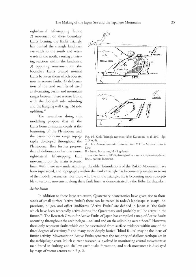
25 The Making of the Japan Sea and the Japanese Mountains
right-lateral left-stepping faults; 2) movement on these boundary faults forming the Kinki Triangle has pushed the triangle landmass eastwards in the south and westwards in the north, causing a twisting reaction within the landmass; �) opposing movement on the boundary faults created normal faults between them which operate now as reverse faults; 4) deformation of the land manifested itself as alternating basins and mountain ranges between these reverse faults, with the footwall side subsiding and the hanging wall (Fig. 16) side uplifting.9�
Fig. 14. Kinki Triangle tectonics (after Kusumoto et al. 2001, figs. 2, 5, 6, 8). ATTL = Arima-Takatsuki Tectonic Line; MTL = Median Tectonic Line F = faults, B = basins, H = highlands 1: = reverse faults of 80° dip (straight-line = surface expression, dotted line = bottom location).
The researchers doing this modelling propose that all the faults formed simultaneously at the beginning of the Pleistocene and the basin-mountain range topography developed throughout the Pleistocene. They further propose that all deformation has one cause: right-lateral left-stepping fault movement on the main tectonic lines. With these new understandings, the older formulations of the Rokkō Movement have been superseded, and topography within the Kinki Triangle has become explainable in terms of the model’s parameters. For those who live in the Triangle, life is becoming more susceptible to tectonic movement along these fault lines, as demonstrated by the Kōbe Earthquake.
Active Faults
In addition to these large structures, Quaternary neotectonics have given rise to thousands of small surface “active faults”; these can be traced in today’s landscape as scarps, depressions, bulges, and offset landforms. “Active Faults” are defined in Japan as “the faults which have been repeatedly active during the Quaternary and probably will be active in the future.”94 The Research Group for Active Faults of Japan has compiled a map of Active Faults occurring throughout the archipelago—on land and on the adjoining ocean floor.95 However, these only represent faults which can be ascertained from surface evidence within one of the three degrees of certainty,96 and many more deeply buried “blind faults” may be the locus of future activity. Movement on Active Faults generates the majority of shallow earthquakes in the archipelagic crust. Much current research is involved in monitoring crustal movement as manifested in faulting and shallow earthquake formation, and such movement is displayed by maps of vector arrows as in Fig. 2.
26 Gina L. Barnes
Reflections
Japan is one of the most active landmasses in the world and is constantly changing shape, size, and height on a rapid geological timescale. To occupants and visitors, earthquakes and volcanic eruptions are the day-to-day evidence of such changes that must be worried about. But a knowledge of how the islands came into being and what kind of stresses they are currently subjected to puts these events into a long-term context that not only aids disaster planning but illustrates magnificent aspects of Earth history and operational mechanics. As made clear by the environmental movement to “save the Earth,” this is a living planet with its own rules of operation and regularities. However much we see it as “steady-state earth,”97
Japan has neither always been nor will always be the same mountainous island chain existing in today’s slice of time.
Acknowledgments: Thanks are due all organizations which gave me access to important research collections: SOAS, University of London; University College London; The Open University; The British Library; The Geological Society of London; International Research Center for Japanese Studies (Nichibunken), Kyoto; and Durham University Library. Specific individuals who have facilitated this research and understanding are David Hughes, Forrest Pitts, Paul Williams, Geoffrey West, Iwamori Hikaru, one unknown reviewer, and several Open University tutors. Their comments and guidance were gratefully received and much appreciated, but any mistakes remain my own. The line drawings herein were all skillfully redrawn on computer by Linda Bosveld and Janine Wilson of the Durham Archaeological Services, Durham University. Thank you both for expert work. And many thanks to Japan Review editor Jim Baxter for his patience and support in seeing this article through to publication.
Appendix 1: The Geology Lessons
Operative Processes in Shaping the Islands
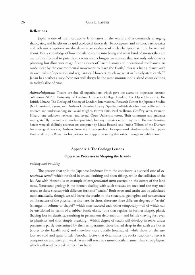
Folding and Faulting
The process that split the Japanese landmass from the continent is a special case of extensional stress98 which resulted in crustal faulting and then rifting, while the collision of the Izu Arc with Honshu is an example of compressional stress exerted on the centre of the land mass. Structural geology is the branch dealing with such stresses on rock and the way rock reacts to those stresses with different forms of “strain.” Both stress and strain can be calculated mathematically, though we will leave the maths to the structural geologists and concentrate on the nature of the physical results here. In short, there are three different degrees of “strain” (changes in volume or shape)99 which may succeed each other temporally—all of which can be envisioned in terms of a rubber band: elastic (one that regains its former shape), plastic (having lost its elasticity, resulting in permanent deformation), and brittle (having lost even its plasticity and thus simply breaking). Which degree of strain will develop in rocks under pressure is partly determined by their temperature: those buried deep in the earth are hotter (closer to the Earth’s core) and therefore more ductile (malleable), while those on the surface are cold and quite brittle. Another factor that determines the rock’s reaction to stress is composition and strength: weak layers will react in a more ductile manner than strong layers, which will tend to break rather than bend.

27 The Making of the Japan Sea and the Japanese Mountains
Both folding and faulting can play roles in crustal “lengthening” and “shortening,” terms which refer to the horizontal extent of a piece of the Earth’s crust and which have implications for changes in thickness of that crust. Lengthening occurs in extensional environments and results in crustal thinning, while shortening occurs in compressional environments and results in crustal thickening. There are other processes which contribute to such changes in crustal thickness that will be mentioned in the appropriate places, and all these processes together account for the great variability in continental crust thickness (anywhere between 10 and 75 km thick at a particular point) compared to the relatively uniform thickness (between 5 and 7 km) of oceanic crust.
Folding (Fig. 15) is a plastic form of strain that occurs in hot or weak rock. Normally it occurs when rocks are buried and subject to high temperatures deep in the Earth’s crust; by the time these folded rocks have risen to the surface, much time has passed and they have cooled in their passage upwards. Folded rocks exposed at the surface therefore are usually evidence of folding processes that occurred in the distant past at deep levels. However, we shall see that in Japan Sea back-arc basin formation, hot magma has risen very close to the surface under the basin floor, bringing a hotter environment to shallower depths, and so folding could have occurred in the more recent rather than distant past. In Japan, such folding just prior to 2 Ma has resulted in the formation of long-wave and short-wave undulations exposed in the current landscape; these contrast with the much older folded rocks formed at deeper levels in earlier times and now exposed on the surface.
In contrast to folding, faulting is a brittle form of strain that occurs in the upper, cold
Fig. 15. Fold geometry and terminology (drawing by author). (a) If three stratigraphic layers are folded as shown, a paired anticline and syncline are formed, with the youngest layer on top and the oldest layer on the bottom. However, if the stratigraphic succession is not known, then the terms “antiform” and “synform” are used. Folds may be symmetrical as in (a), with the limbs of equal length and angle, or (b) asymmetrical, with limbs describing different angles and being different lengths. The maximum point of fold is called the hinge point or zone, and the successive hinge points of the different layers form the hinge line or fold axis. If the hinge line is vertical, the fold is called an upright fold, as in (a); but it may be lying horizontal to the ground surface, in which case the fold is on its side and termed a “recumbent fold” (c). A fold can even be completely overturned, reversing the stratigraphic layering (d). On each stratum, the hinge points across its width at maximum fold define the fold axis, and often this angle is not horizontal to the surface but plunges downward at an angle (e). All these variables go to describing the type of fold seen in the geological matrix.
28 Gina L. Barnes
crust (Fig. 16). We have already met a form of faulting in the tectonic lines that bound many of the geotectonic units forming the Japanese landmass. The MTL (Median Tectonic Line) is a major strike-slip fault, like the San Andreas fault of California, that allows large areas of land to slip by each other; in such faults, movement occurs along its “strike” (the directional orientation of the fault plane). The Tanakura Tectonic Line (TTL) is another such strike-slip fault, which facilitated the movement of a fragment of the metamorphic Hida Belt into its current position on the eastern edge of Tōhoku during back-arc basin formation. The TTL is also important as the dividing line between two distinct geological provinces in modern Japan: the northeast and the southwest.100
Strike-slip faults (Fig. 16: far left) are only one of three different kinds of faults. Normal faults (Fig. 16: delineated by A-C-B-D) result from extensional stress and are an agent of crustal lengthening. Reverse faults (Fig. 16: left centre) result from compressional stress and are an agent of crustal shortening. Very low-angle reverse faults are called “thrust faults” (Fig. 16: lower right); these are common in subduction and collision zones and are the cause of much uplift and crustal thickening by displacing the upper rock body great distances over the underlying rock. In the last three cases, the footwall nominally belongs to the rock body that stays stable while the hanging wall belongs to the one that moves. A strike-slip fault moves laterally either right or left, determined by standing on one side of the fault looking across to the other and seeing which way the far side is moving: to one’s right, or to one’s left (it does not matter which side of the fault one stands on!).
Although this investigation is being framed in terms of successive extensional and compressional regimes, in fact, the two kinds of stress are often contemporaneous and sometimes
Fig. 16. Major types of faults (after Lomnitz 1974, �.7). The sense of movement between the footwall and hanging wall can be vertical, horizontal or diagonal at various angles, giving rise to further naming patterns. The fault may have a linear exposure (the fault line) on the ground surface as well as an embedded plane of movement (the fault plane), but many embedded faults do not have sub-aerial exposure (blind faults) and cannot be identified on the ground.
FW Footwall (the rock body underneath the fault plane) HW Hanging wall (the rock body above the fault plane) A—B The distance from A—B across the fault plane indicates the “strike” direction; strike-slip faults move
along the strike C--D The distance from C—D down the fault plane indicates the “dip” direction; normal faults move down
the dip while reverse and thrust fault move up dip.
29 The Making of the Japan Sea and the Japanese Mountains
are even required together for complementary distribution of stress. Moreover, a particular stress environment can be confined to a very small region, so that in the Plio-Pleistocene of Japan from 2 Ma, different stresses were acting on different regions, resulting in different forms of strain. All of this contributes to a very complicated and ungeneralizable geohistory.
Uplift and Subsidence
Uplift has been mentioned above as an important process in Japanese Island development, but it cannot be ascribed to a single cause: various factors operate under different conditions. A mantle plume can uplift and stretch a whole region of crust above it through thermal expansion—thought to be responsible for the rifting of eastern Eurasia and eventual back-arc basin formation of the Japan Sea.101 Magma rising into a volcanic chamber can also cause local expansion of the ground surface—as seen in the spectacular �00 m rise of the Usu 有珠 Volcano over 20 months in 1944–1945 before it erupted.102 If magma is being fed into a chain of volcanoes, then the whole chain will tend to rise through magma infiltration and thermal expansion of the country rock.
Subduction can also uplift areas if we think of the subducting slab in terms of thrust faults. A slow-moving slab may jack up an overriding plate to a greater degree than a fast-moving slab.10� Areas of collision also characteristically involve thrust faults which result in uplift through crustal thickening around the collision boundary. The transfer of material from the subducting slab to the overriding plate—one process of underplating—can act to uplift the leading edge of the continent, and underplating by magmatic activity will also contribute to uplift. These ocean floor and igneous rock additions to the continent from underneath add thickness to the crust. Another process that uplifts land surfaces is folding; the greater the fold amplitude, the thicker the crust. The convex parts of folds (cf. Fig. 15-a, c, e) represent initially uplifted areas. An increase in altitude of the land surface through these thickening activities serves to encourage erosion, which feeds the opposite process, subsidence. The dating of uplift is most often accomplished by monitoring when the deposition of coarse erosional materials started!
Subsidence is the reverse of uplift, first exemplified by the concave parts of folded areas (Fig. 15-b, d). These concave areas can serve as sumps for deposited material and subside even further through the weight of added sediments through time. Sediment loading of the crust is facilitated by the deposition of both erosional and volcanic products. Another cause of subsidence is thermal cooling, causing contraction so that extinct volcanic ranges will naturally subside as they cool. Faulted basins also represent areas of subsidence and can continue to subside through repeated faulting and sediment loading. The Japan Sea basin represents a particular kind of faulted basin, a rifted basin created through crustal extension, that will be discussed below.
Isostasy and Gravity
The above are fairly localized examples of subsidence and uplift, but they may be discussed within the larger principles of isostasy. Most of us are acquainted with isostasy in terms of the rebound (uplift) of landmasses after being depressed by the great ice sheets. Ice loading will depress a land surface; so will sediment loading. When these overlying layers are removed (by melting or erosion), the land surface underneath will rise again. The main principle is that the mass of the crust (and whatever is on top of it—water, ice, lava) should be in equilibrium

�0 Gina L. Barnes
with the mass of the underlying mantle, so that when the crust grows heavier, the mantle is squashed away, and when the crust grows lighter, the mantle flows in under it to replace the missing mass. As these movements of mantle material take place in solid but ductile rock, they take enormous amounts of time, so that most landmasses show mass excesses or deficits for long periods before they attain equilibrium.
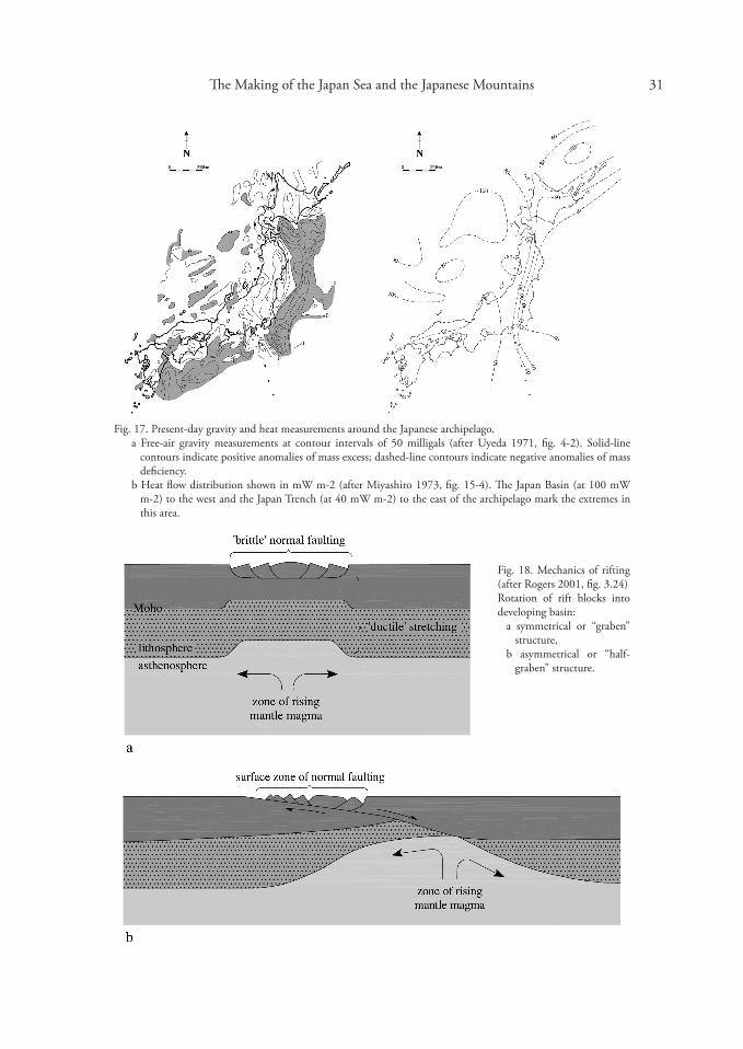
Whether a landmass is currently in equilibrium or not can be read from gravity measurements.104 Such measurements around the Japanese Islands today (Fig. 17, left) show mass deficits underneath the Japan Trench and the Japan Sea (not enough crust to balance the underlying mantle) and a mass excess in the archipelago (mass above that has yet to displace the mantle). The fact that these areas are not now in equilibrium with the mantle but are either in excess or deficit means that they are still moving upwards or downwards to eventually attain that equilibrium.
Erosion is one of the equilibriating processes that serves to decrease the volume of the landmass when it exhibits mass excess (by eroding away exposed surfaces) and increase crustal mass in areas of mass deficiency (by depositing material in sedimentary basins). The Earth always strives for equilibrium, so uplift and subsidence can be thought of as processes that always trigger their counterparts into action, though the time frame may be very long indeed for these processes to act. Rates of uplift and erosion during the Quaternary in Japan are positively correlated;105 at ca. 10 cm per 1000 years, uplift operates at nearly ten times the world average.106 A high rate of precipitation has been identified as the chief erosional agent in Japan.107
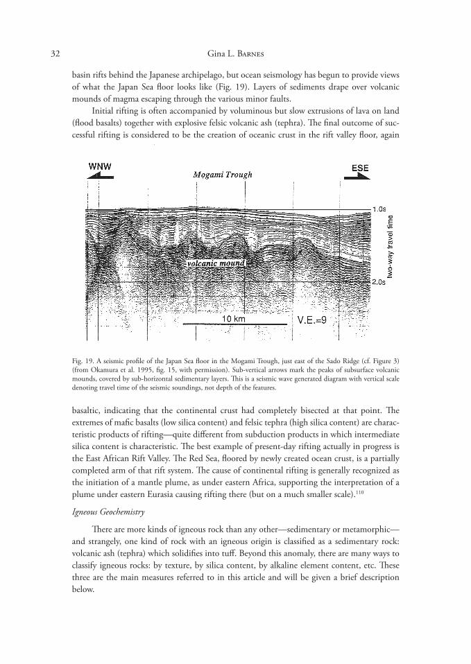
Rifting Mechanics
Rifting is a special case of brittle faulting of the Earth’s surface. In the lay imagination, rifting might be visualized as the pulling apart of two rock bodies, leaving an empty canyon in between. But this is not what happens in reality. Rifting consists of a complex series of normal faulting and block rotation, so that successive pieces of rock at the edges of the ever-widening rift slip further down into the developing canyon. Meanwhile, the canyon floor is stretched thinner and thinner until the continental crust breaks completely and melt generated by the rising mantle under the thinned layers intrudes to start building oceanic crust. Such areas are marked by higher heat flow, as seen in the Japan Basin (Fig. 17, right). Theoretically, the rifting of blocks can happen symmetrically or asymmetrically (Fig. 18-a, b), and the fault lines separating the rotated blocks characteristically dip towards the centre of the valley from either side of the rift. The subsided blocks commonly become covered with erosional sediments from the rift edge, effusive volcanics erupting from below, and perhaps marine sediments if the valley becomes flooded. At the eastern edge of the Japan Sea, normal faults have been identified in the vicinity of Sado Island—presumably marking where rifted blocks have slipped down towards the continent into the opening sea basin. Interestingly, such normal faults are now highly outnumbered by reverse faults, indicating compression. These are the first indications of the formation of an incipient subduction zone, which will close the Japan Sea, following the edge of the Okhotsk Plate down the west side of northern Japan.108
The study of worldwide rifting and the volcanics accompanying them was revolutionized in 1985 with the application of specialized deep seismic techniques,109 producing visual images of a rift’s deep structure. Such techniques have not yet been fully applied to back-arc
The Making of the Japan Sea and the Japanese Mountains �1
Fig. 17. Present-day gravity and heat measurements around the Japanese archipelago. a Free-air gravity measurements at contour intervals of 50 milligals (after Uyeda 1971, fig. 4-2). Solid-line
contours indicate positive anomalies of mass excess; dashed-line contours indicate negative anomalies of mass deficiency.
b Heat flow distribution shown in mW m-2 (after Miyashiro 197�, fig. 15-4). The Japan Basin (at 100 mW m-2) to the west and the Japan Trench (at 40 mW m-2) to the east of the archipelago mark the extremes in this area.
Fig. 18. Mechanics of rifting (after Rogers 2001, fig. �.24) Rotation of rift blocks into developing basin:
a symmetrical or “graben” structure,
b asymmetrical or “halfgraben” structure.
�2 Gina L. Barnes
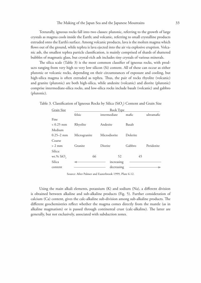
basin rifts behind the Japanese archipelago, but ocean seismology has begun to provide views of what the Japan Sea floor looks like (Fig. 19). Layers of sediments drape over volcanic mounds of magma escaping through the various minor faults.
Initial rifting is often accompanied by voluminous but slow extrusions of lava on land (flood basalts) together with explosive felsic volcanic ash (tephra). The final outcome of successful rifting is considered to be the creation of oceanic crust in the rift valley floor, again
Fig. 19. A seismic profile of the Japan Sea floor in the Mogami Trough, just east of the Sado Ridge (cf. Figure �) (from Okamura et al. 1995, fig. 15, with permission). Sub-vertical arrows mark the peaks of subsurface volcanic mounds, covered by sub-horizontal sedimentary layers. This is a seismic wave generated diagram with vertical scale denoting travel time of the seismic soundings, not depth of the features.
basaltic, indicating that the continental crust had completely bisected at that point. The extremes of mafic basalts (low silica content) and felsic tephra (high silica content) are characteristic products of rifting—quite different from subduction products in which intermediate silica content is characteristic. The best example of present-day rifting actually in progress is the East African Rift Valley. The Red Sea, floored by newly created ocean crust, is a partially completed arm of that rift system. The cause of continental rifting is generally recognized as the initiation of a mantle plume, as under eastern Africa, supporting the interpretation of a plume under eastern Eurasia causing rifting there (but on a much smaller scale).110
Igneous Geochemistry
There are more kinds of igneous rock than any other—sedimentary or metamorphic— and strangely, one kind of rock with an igneous origin is classified as a sedimentary rock: volcanic ash (tephra) which solidifies into tuff. Beyond this anomaly, there are many ways to classify igneous rocks: by texture, by silica content, by alkaline element content, etc. These three are the main measures referred to in this article and will be given a brief description below.
The Making of the Japan Sea and the Japanese Mountains ��
Texturally, igneous rocks fall into two classes: plutonic, referring to the growth of large crystals as magma cools inside the Earth; and volcanic, referring to small crystalline products extruded onto the Earth’s surface. Among volcanic products, lava is the molten magma which flows out of the ground, while tephra is lava ejected into the air via explosive eruption. Volcanic ash, the smallest tephra particle classification, is mainly comprised of shards of shattered bubbles of magmatic glass, but crystal-rich ash includes tiny crystals of various minerals.
The silica scale (Table �) is the most common classifier of igneous rocks, with products ranging from very high to very low silicon (Si) content. All of these can occur as either plutonic or volcanic rocks, depending on their circumstances of exposure and cooling, but high-silica magma is often extruded as tephra. Thus, the pair of rocks rhyolite (volcanic) and granite (plutonic) are both high-silica, while andesite (volcanic) and diorite (plutonic) comprise intermediate-silica rocks, and low-silica rocks include basalt (volcanic) and gabbro (plutonic).
Table �. Classification of Igneous Rocks by Silica (SiO2) Content and Grain Size
Grain Size Rock Type felsic intermediate mafic ultramafic
Fine < 0.25 mm Rhyolite Andesite Basalt Medium 0.25–2 mm Microgranite Microdiorite Dolerite Coarse > 2 mm Granite Diorite Gabbro Peridotite Silica: wt.% SiO2 66 52 45Silica increasingcontent decreasing
Source: After Palmer and Easterbrook 1999, Plate 6.12.
Using the main alkali elements, potassium (K) and sodium (Na), a different division is obtained between alkaline and sub-alkaline products (Fig. 5). Further consideration of calcium (Ca) content, gives the calc-alkaline sub-division among sub-alkaline products. The different geochemistries reflect whether the magma comes directly from the mantle (as in alkaline magmatism) or is passed through continental crust (calc-alkaline). The latter are generally, but not exclusively, associated with subduction zones.

Gina L. Barnes �4
App
endi
x 2.
Chr
onol
ogy
of Ja
pan
Sea
Bas
in R
iftin
g an
d R
ift V
olca
nics
Ma 1
N. K
yush
u-C
hūgo
ku-S
hiko
ku
Kin
ai-H
okur
iku-
Kan
tō
Tōho
ku-W
. Hok
kaid
o1�
5–11
0 Fo
rmat
ion
of M
edia
n Te
cton
ic L
ine:
begi
nnin
g of
left-
late
ral m
ovem
ent
120– 65
Hiro
shim
a Tec
toni
csem
plac
emen
t of t
he H
irosh
ima
gran
ite b
atho
lith
and
Ryōk
e gr
anite
in R
yōke
Bel
t5�
C
aino
zoic
max
imum
hig
h se
a le
vels1
50
55 R
iftin
g be
gins
subs
iden
ce o
f sed
imen
tary
bas
ins
Volc
anic
fron
t: Sa
n’in
to S
. Kor
eade
ep m
agm
a/hi
gh a
lkal
i vol
cani
cser
upte
d on
dry
land
=pr
ecur
sors
of G
reen
Tuff
Mos
t act
ive
volc
anic
sSe
cond
pha
se o
f MT
L m
ovem
ent
40–
�7 �5
Effec
t of l
arge
-sca
le p
late
tect
onic
s
Smal
l-sca
le g
rani
te e
mpl
acem
ent
Begi
nnin
g of
Pac
ific
Plat
e su
bduc
tion
form
atio
n of
two
volc
anic
cha
ins
Gen
eral
upl
iftVo
lcan
ic e
xtru
sions
on
dry
land
�2–
27
�0 P
hilip
pine
pla
te su
bduc
tion
open
ing
Shik
oku
/ Tsu
shim
a ba
sins
mov
emen
t of S
W Ja
pan
to so
uth
�2 2 S
ado
Tect
onic
s:vo
lcan
ic e
xtru
sions
on
dry
land
28 N
oto
(and
esite
)27
Nyu
(rhy
olite
)
gran
ite e
mpl
acem
ent i
n H
idak
a Be
ltO
kush
iri Is
land
bas
alts,
and
esite
sth
eole
iitic
bas
alt n
orth
of O
kush
iri
25–
20
Intr
usio
n of
Wes
tern
Sea
25
Kan
azaw
a (r
hyol
ite)
Fres
hwat
er la
ke fo
rmat
ion
2�–2
1 U
plift
, mafi
c vo
lcan
ics
25 H
alf-g
rabe
n fa
ultin
g N
NE-
SSW
Hea
vy e
rosio
n of
upl
ifted
land
24 G
reen
Tuff
Tec
toni
cs
22 G
reen
Tuff
Tec
toni
cs21
For
mat
ion
of #
1 In
land
Sea
and
Kan
tō
colla
pse
basin
s
Gre
en T
uff T
ecto
nics
Fres
hwat
er la
kes
Volc
anic
fron
t mov
ed 1
00 k
m E
Plat
e su
bduc
tion
at h
ighe
r ang
lean
d lo
wer
spee
d

�5 The Making of the Japan Sea and the Japanese Mountains
20–
18
Felsi
c vo
lcan
ics e
rupt
NW
-SE
Ande
sites
in fr
eshw
ater
Rhy
olite
/dac
ite p
yroc
lasti
c flo
ws
18–1
4 Se
touc
hi v
olca
nics
then
upl
ift
Con
tinue
d rif
ting ce
pt
essi
on
buku
ma
mts
arin
e tr
ansg
rW
ext
ensio
n
els
E- e su
bsid
ence
ex
coar
se g
rav
M assiv
M Kita
kam
i / A
este
rn d
eep
rift b
asin
fills
w/
W
18–
17
essio
n eg
rpl
ift a
nd r
U
17–
14
Rap
id fo
rmat
ion
of se
dim
enta
ry:
basin
s and
tran
sgre
ssio
nLo
cal v
olca
nic
activ
ity :
felsi
c vo
lcan
ics fi
ll ba
sins
basa
lt / d
oler
ite in
trus
ions
Form
atio
n of
Ryū
kyū
Trou
gh
Larg
e se
dim
enta
ry b
asin
s for
med
Mar
ine
tran
sgre
ssio
n to
form
sh
allo
w se
aVo
lcan
ic tu
ffs /
pyro
clas
tics
14 D
isapp
eara
nce
of #
1 In
land
Sea
16–
14
Dee
peni
ng a
nd b
road
enin
g of
oce
an fl
oor
begi
nnin
g of
Nish
i-Kur
osaw
a Tra
nsgr
essio
n16
–15
gr
eate
st ex
tent
of N
eoge
ne se
a2
depo
sitio
n of
mar
ine
laye
rs
15
SW Ja
pan
rota
tes 4
5° c
ount
er-c
lock
wis
e in
to p
rese
nt p
osit
ion
NE
Japa
n ro
tate
s 40°
clo
ckw
ise
into
pre
sent
po
siti
on
15
c ba
sin
rift
ing
ea b
ack-
arap
an S
nd o
f JE
NW
Kyu
shu
subm
erge
d Ba
salts
at b
asin
mar
gin
Com
pres
sion
from
EN
Eup
lift o
f nor
ther
n H
idak
a Be
lt
Rap
id p
late
subd
uctio
n:fe
lsic
then
mafi
c vo
lcan
ics
15–1
4 an
desit
ic v
olca
nics
1� S
anuk
i and
esite
s & a
lkal
i gra
nite
s
Fold
ing
/ fau
lting
of s
ubm
arin
e se
dim
enta
ry b
asin
sal
kali
mafi
c ig
neou
s roc
ksas
soc.
with
Chi
shim
a ba
ck-a
rc
basin
form
atio
n
�6 Gina L. Barnes
12 10
12–1
1 hi
gh a
lkal
i bas
alts
Upl
ift o
f Chū
goku
bac
kbon
ere
gres
sion
of se
a
Empl
acem
ent o
f gra
nite
plu
tons
gene
ral u
plift
, esp
. of H
ida
Ran
geth
en c
essa
tion
of u
plift
& e
rosio
n co
lder
, low
ered
sea
leve
ls
8 U
plift
and
ero
sion
Kan
tō se
dim
enta
ry c
entre
s mov
e no
rth
Pres
ent-d
ay b
ackb
one
volc
anic
cha
info
rmed
& u
plift
ed to
dry
land
sepa
ratin
g ea
st/w
est T
ohok
u
7–5
Rhy
olite
, and
esite
& b
asal
t lav
asFo
rmat
ion
from
sout
h of
#2
Inla
nd S
ea in
pres
ent t
roug
hC
ontin
ued
uplif
t on
nort
h an
d so
uth
40 e
rupt
ions
form
ing
cald
eras
5 En
d of
Gre
en T
uff T
ecto
nics
Ligh
t gre
y ar
ea =
pre
-rift
ing
phas
e (5
5–25
Ma)
, Dar
k gr
ey a
rea
= rif
ting
phas
e (2
5–15
Ma)
, Gre
en a
rea
= m
arin
e tr
ansg
ress
ions
(5�
Ma,
16–
15 M
a). H
eade
r num
bers
with
in c
hart
giv
e da
te M
a fo
r ind
ivid
ual e
vent
s; al
l dat
ings
are
app
roxi
mat
e, fo
r gui
danc
e on
ly, u
nles
s not
ed.
Sour
ce: N
ihon
no
chish
itsu,
vol
. 1. (
1990
, pp.
2�8
–45)
; vol
. 2 (1
989,
pp.
244
–52)
; vol
. 4 (1
988,
pp.
265
–74)
; vol
. 5 (1
988,
pp.
2�8
–42)
; vol
. 6 (1
987,
pp.
2�9
–44)
; vol
. 7 (1
987,
pp.
22
�–9)
; vol
. 8 (1
991,
pp.
214
–15)
; vol
. 9 (1
992,
pp.
�15
–17)
.
Not
es: 1
, � A
ccor
ding
to th
e co
mpo
site
mar
ine δ1
8O re
cord
for t
he C
aino
zoic
(Wils
on e
t al.
2000
, fig.
4.1
5).
2 O
kam
ura
et a
l 199
5, p
. 175
.
The Making of the Japan Sea and the Japanese Mountains �7
REFERENCES
Barnes 200� Gina L. Barnes. “Origins of the Japanese Islands: the New ‘Big Picture.’” Japan Review 15 (200�), pp. �–50.
Best 200� Myron G. Best. Igneous and Metamorphic Petrology. San Francisco: W.H. Freeman and Co., 200�.
Blake and Argles 200� Stephen Blake and Tom Argles. Growth and Destruction: Continental Evolution at Subduction Zones. Milton Keynes: The Open University, 200�.
Bogatikov 2000 Oleg Bogatikovol. Magmatism and Geodynamics: Terrestrial Magmatism Throughout the Earth’s History. Amsterdam: Gordon and Breach Science Publishers, 2000.
Cavazza et al. 2004 William Cavazza, François Roure and Peter A. Ziegler. “The Mediterranean Area and the Surrounding Regions: Active Processes, Remnants of Former Tethyan Oceans and Related Thrust Belts.” In The TRANSMED Atlas: the Mediterranean Region from Crust to Mantle, ed. W. E. A. Cavazza. Berlin: Springer, 2004.
Chen and Chen 2005 Chen Chow-Son and Chen Chein-Chih. “Taiwan Model: Combination of MT and Seismicity.” Society of Exploration Geophysicists (SEG) meeting abstracts http://66.102.1.104/scholar?hl=en&lr=&q=cache:IdWDIDKnuqoJ:www.seg.org/ meetings/past/seg1998/techprog/em1/papr1�56.pdf+%22angle+of+subduction%22+ philippine+plate [accessed 18 Jan 08].
Chigakudan 1981 Chigaku Dantai Kenkyūkai 地学団体研究会, ed. Chigaku jiten 地学事典. Rev. ed. Heibonsha, 1981.
Chigakudan 1995 ———, ed. Nihon rettō no oitachi 日本列島のおいたち. Tokyo: Tōkai Daigaku Shuppankai, 1995.
Chigakudan 1996 ———, ed. Chigaku jiten 地学事典 [Cyclopedia of Earth Sciences]. Revol. ed. Heibonsha, 1996 (in Japanese with English title).
Davis and Reynolds 1996 George H. Davis and Stephen J. Reynolds, eds. Structural Geology of Rocks and Regions. 2nd ed. New York: John Wiley & Sons, Ltd., 1996.
Foulger 2002 Foulger, Gillian. “Plumes, or Plate Tectonic Processes?” Astronomy and Geophysics 4�:6 (2002), pp. 19–2�.

�8 Gina L. Barnes
Fournier et al. 1994 Marc Fournier, Laurent Jolivet, Philippe Huchon, Konstatin Sergeyev, and Leonic Oscorbin. “Neogene strike-slip faulting in Sakhalin and the Japan Sea opening.” Journal of Geophysical Research 99: B2 (1994), pp. 2701–2725.
Harris and Whalley 2001 Nigel Harris and John Whalley. Mountain Building. Milton Keynes: Open University, 2001.
Hashimoto 1991 Hashimoto Mitsuo, ed. Geology of Japan. Tokyo & Dordrecht: Terra Scientific Publishing Company & Kluwer Academic Publishers, 1991.
Huzita 1962 Huzita Kazuo. “Tectonic Development of the Median Zone (Setouti) of Southwest Japan, since the Miocene.” Journal of Geoscience, Osaka City University 6 (1962), pp. 10�–44.
Huzita 1969 ———. “Tectonic Develolpment of Southwest Japan in the Quaternary Period.” Journal of Geoscience, Osaka City University 12 (1969), pp. 5�–70 (in English).
Iowa State University of Science and Technology 2004 “Glossary of Geologic Terms.” Department of Geological and Atmospheric Sciences. http://www.ge-at.iastate.edu/glossary.shtml. [This glossary of geologic terms is based on the glossary in Earth: An Introduction to Geologic Change, by S. Judson and S.M. Richardson (Englewood Cliffs, N.J.: Prentice Hall, 1995].
Iwamori 1991 Iwamori Hikaru. “Zonal Structure of Cenozoic Basalts Related to Mantle Upwelling in Southwest Japan.” Journal of Geophysical Research 96:B4 (1991), pp. 6157–6170.
Iwamori 1992 ———. “Degree of Melting and Source Composition of Cenozoic Basalts in Southwest Japan: Evidence for Mantle Upwelling by Flux Melting.” Journal of Geophysical Research 97:B7, pp. 10,98�-10,995.
Jackson 1997 Julia A. Jackson, ed. Glossary of Geology. 4th ed. Alexandria, Virginia: American Geological Institute, 1997.
Jolivet et al. 1994 Laurent Jolivet, Tamaki Kensaku, and Marc Fournier. “Japan Sea, Opening History and Mechanism: A Synthesis.” Journal of Geophysical Research 99 (B11):22 (1994), pp. 2�7–22, �60.
Kaizuka 1998 Kaizuka Sōhei 貝塚爽平. Hattatsu-shi chikeigaku 発達史地形学. Tōkyō Daigaku Shuppankai, 1998.
The Making of the Japan Sea and the Japanese Mountains �9
Katsudansō Kenkyūkai 1980 Katsudansō Kenkyūkai 活断層研究会 (Research Group for Active Faults in Japan), eds. Nihon no katsudansō: Bunpuzu to shiryō 日本の活断層:分布図と資料. Tōkyō Daigaku Shuppankai, 1980.
Katsudansō Kenkyūkai 1991 ———. Shinpen Nihon no katsudansō: Bunpuzu to shiryō 新編日本の活断層:分布
図と資料. Tōkyō Daigaku Shuppankai, 1991.
Katsudansō Kenkyūkai 1992 ———. Maps of Active Faults in Japan with an Explanatory Text. University of Tokyo Press, 1992 (in Japanese and English) [this is a condensed version of Katsudansō Kenkyūkai 1991].
Kimura et al. 1991 Kumura Toshio, Hayami Itaru, and Yoshida Shizuo. Geology of Japan. University of Tokyo Press, 1991.
Kimura et al. 2005 Kimura Jun-Ichi, Robert J. Stern, and Yoshida Takeyoshi. “Reinitiation of Subduction and Magmatic Responses in SW Japan during Neogene Time.” Geological Society of America Bulletin 117:7/8 (2005), pp. 969–986.
Koizumi 1992 Koizumi Itaru. “Biostratigraphy and Paleoceanography of the Japan Sea Based on Diatoms: ODP Leg 127.” In Pacific Neogene: Environment, Evolution and Events, eds. R. Tsuchi and J. C. J. Ingle. University of Tokyo Press, 1992.
Kosaka 1995 Kosaka Tomoyoshi 小坂共栄. “Chūkigansō: Fossa maguna no hassei to hatten” 中期岩層—フォッサマグナの発生と発展. In Fossa magna フォッサマグナ, ed. N. Yamashita. Tōkai Daigaku Shuppankai, 1995.
Kusky et al. 2007 Timothy M. Kusky, Brian F. Windley, and Zhai Mingguo. “Lithospheric Thinning in Eastern Asia; Constraints, Evolution, and Tests of Models.” In Mesozoic Sub-continental Lithospheric Thinning under Eastern Asia, ed. M. Zhai, B. F. Windley, T. M. Kusky, and Q. Meng. London: The Geological Society, 2007.
Kusumoto et al. 2001 Kusumoto Shigekazu, Fukuda Yoichi, Takemura Keiji, and Takemoto Shuzo. “Forming Mechanism of the Sedimentary Basin at the Termination of Right-lateral Left-stepping Faults and Tectonics around Osaka Bay.” Chigaku zasshi 地学雑誌 110:1 (2001), pp. �2–4� (in English).
Lomnitz 1974 Cinna Lomnitz. Global Tectonics and Earthquake Risk. Developments in Geotectonics 5. Amsterdam: Elsevier Scientific Pub. Co., 1974.

40 Gina L. Barnes
Machida et al. 2006 Machida Hiroshi 町田洋, Matsuda Tokihiko 松田時彦, Umitsu Masatomo 海津正
倫, and Koizumi Takeei 小泉武栄. Nihon no chikei 5: Chūbu 日本の地形5:中部. Tōkyō Daigaku Shuppankai, 2006.
Marsaglia 1995 Kathleen M. Marsaglia. “Interarc and Backarc Basins.” In Tectonics of Sedimentary Basins, ed. C. J. Busby and R. V. Ingersoll. Malden, MA: Blackwell Science, 1995.
Maruyama et al. 1997 Maruyama Shigenori, Isozaki Yukio, Kimura Gaku, and Terabayashi Masaru. “Paleogeographic Maps of the Japanese Islands: Plate Tectonic Synthesis from 750 Ma to the Present.” The Island Arc 6:1 (1997), pp. 121–142.
Miyashiro 197� Miyashiro Akiho. Metamorphism and Metamorphic Belts. London: George Unwin & Allen, 197�.
Miyashiro 1994———. Metamorphic Petrology. London: UCL Press, 1994.
Neuendorf et al. 2005 Klaus K.E. Neuendorf, James P. Mehl, and Julia A. Jackson, eds. Glossary of Geology. 5th ed. Alexandria, Virginia: American Geological Institute, 2005.
Nihon no chishitsu 1986 Nihon no Chishitsu Henshū Iinkai 日本の地質編集委員会. Nihon no chishitsu 3: Kantō chihō 日本の地質3:関東地方. Kyōritsu Shuppan, 1986.
Nihon no chishitsu 1987 ———. Nihon no chishitsu 6: Kinki chihō 日本の地質6:近畿地方. Kyōritsu Shuppan, 1987.
Nihon no chishitsu 1988 ———. Nihon no chishitsu 4: Chubū chihō I 日本の地質4:中部地方 I. Kyōritsu Shuppan, 1988.
Nihon no chishitsu 1989 ———. Nihon no chishitsu 2: Tōhoku chihō 日本の地質2:東北地方. Kyōritsu Shuppan, 1989.
Niigata-ken Chishitsuzu Kaitei Iinkai 2000 Niigata-ken Chishitsuzu Kaitei Iinkai 新潟県地質図改訂委員会, ed. Niigata-ken chishitsuzu setsumeisho 新潟県地質図説明書. Niigata-ken Shōkō Rōdōbu Shōkō Shinkōka, 2000.
Nunn 1994Patrick D. Nunn. Oceanic Islands. Oxford: Blackwell, 1994.
Ogawa 1982 Ogawa Yujiro. “Tectonics of Some Forearc Fold Belts in and around the Arc-arc Cross
41 The Making of the Japan Sea and the Japanese Mountains
ing Area in Central Japan.” In Trench-forearc Geology: Sedimentation and Tectonics on Modern and Ancient Active Plate Margins, ed. J. K. Leggett. Oxford: Blackwell Scientific, 1982.
Okamura et al. 1995 Okamura Yukinobu, Watanabe Mahito, Morigiri Rie, and Satoh Mikio. “Rifting and Basin Inversion in the Eastern Margin of the Japan Sea.” The Island Arc 4 (1995), pp. 166–81.
Oreskes 1999 Naomi Oreskes. The Rejection of Continental Drift: Theory and Method in American Earth Science. Oxford University Press, 1999.
Ōta et al. 2004 Ōta Yōko 太田陽子, Naruse Toshiro 成瀬敏郎, Tanaka Shingo 田中真吾, and Okada Atsumasa 岡田篤正, eds. Nihon no chikei 6: Kinki, Chūgoku, Shikoku 日本の地形
6:近畿、中国、四国. Tōkyō Daigaku Shuppankai, 2004.
Pavlides 1995 Spyros B. Pavlides. “Palaeoseismology: A Branch of Neotectonics Linking Geological, Seismological and Archaeological Data—an Introduction.” In Archaeoseismology, eds. S. Stiros and R. E. Jones. The British School at Athens, 1995.
Rogers 2001 Nick Rogers. From Rifting to Drifting: Mantle Plumes and Continental Break-up. Milton Keynes: The Open University, 2001.
Rymer and Drury 200� Hazel Rymer and Steve Drury. Earth’s Engine. Milton Keynes: The Open University, 200�.
Smith 1982 A. J. Smith. “The Neogene to Recent Geology of Japan and its Surrounding Seas.” Proceedings of the Geologists' Association 9�:2 (1982), pp. 161–78.
Smith and Rymer 2001 Peter J. Smith and Hazel Rymer. The Physical and Chemical Properties of the Earth, 2nd ed. Milton Keynes: The Open University, 2001.
Sugimura and Uyeda 197� Sugimura Arata and Uyeda Seiya. Island Arcs: Japan and its Environs. Developments in Geotectonics �. Amsterdam: Elsevier, 197�.
Taira 1990 Taira Asahiko 平朝彦. Nihon Rettō no Tanjō 日本列島の誕生. Iwanami Shinsho, 1990.
Taira 2001 ———. “Tectonic Evolution of the Japanese Island Arc System.” Annual Review of Earth and Planetary Sciences 29 (2001), pp. 109–�4.
42 Gina L. Barnes
Takahashi and Saito 1997 Takahashi Masaki and Saito Kazuo. “Miocene Intra-arc Bending at an Arc-arc Collision Zone, Central Japan.” The Island Arc 6 (1997), pp. 168–182.
Tamaki 1995 Tamaki Kensaku. “Opening Tectonics of the Japan Sea.” In Backarc Basins: Tectonics and Magmatism, ed. B. Taylor. New York: Plenum Press, 1995.
Tanaka 1977 Tanaka Keisaku and Nozawa Tamotsu. Geology and Mineral Resources of Japan. �rd ed. Kawasaki: Geological Survey of Japan, 1977.
Tapponnier et al. 1982 P. Tapponnier, A. Peltzer, A.Y. Le Dain, R Armijo, and P. Cobbold. “Propagating Extrusion Tectonics in Asia: New Insights from Simple Experiments with Plasticine.” Geology 10:12 (1982), pp. 611–616.
Tateishi and Iwao 2001 Tateishi Masaki 立石雅昭 and Kobayashi Iwao 小林巌雄. “Niigata Heiya to Kyūryō, Hitobito no Kurashi” 新潟平野と丘陵、人々の暮らし. In Ikiteiru chikyū: Niigata kara kenshō suru Nihon rettō no kako, genzai, mirai 生きている地球—新潟から検証
する日本列島の過去、現在、未来, ed. Niigata University Public Lectures Committee. Niigata University, 2001.
Tatsumi 1982 Tatsumi Yoshiyuki. “Origin of High-magnesian Andesites in the Setouchi Volcanic Belt, Southwest Japan, II: Melting Phase Relations at High Pressures.” Earth and Planetary Science Letters 60 (1982), pp. �02–17.
Tatsumi 198� ————. “Generation of Arc Basalt Magmas and Thermal Structure of the Mantle Wedge in Subduction Zones.” Journal of Geophysical Research 88(B7) (198�), pp. 5815– 5825.
Tatsumi and Ishizaka 1982 Tatsumi Yoshiyuki and Ishizaka Kyoichi. “Origin of High-magnesian Andesites in the Setouchi Volcanic Belt, Southwest Japan, I: Petrographical and Chemical Characteristics.” Earth and Planetary Science Letters 60 (1982), pp. 29�–�04.
Tomita 1967 Tomita Toru. “Volcanic Geology of the Cenozoic Alkaline Petrographic Province of Eastern Asia.” In Geology and Mineral Resources of the Far East, ed. T. Ogura. University of Tokyo Press, 1967.
Tsuchi 1992 Tsuchi Ryuichi. “Pacific Neogene Climatic Optimum and Accelerated Biotic Evolution in Time and Space.” In Pacific Neogene: Environment, Evolution and Events, ed. R. Tsuchi and J. C. J. Ingle. University of Tokyo Press, 1992.

The Making of the Japan Sea and the Japanese Mountains 4�
Tucker 2001 Maurice E. Tucker. Sedimentary Petrology: an Introduction to the Origin of Sedimentary Rocks. �rd ed. Blackwell Science, 2001.
Uemura 2000 Uemura Takeshi. “Geological Outline of the Niigata Prefecture.” In Niigata-ken chishitsuzu setsumeisho 新潟県地質図説明書, ed. Niigata-ken Chishitsuzu Kaitei Iinkai 新潟県地質図改訂委員会. Niigata-ken Shōkō Rōdōbu Shōkō Shinkōka, 2000 (in English).
Uyeda 1971 Uyeda Seiya 上田誠也. Atarashii chikyūkan 新しい地球観. Iwanami Shinsho, 1971.
Yamashita 1995 Yamashita Noboru 山下昇, ed. Fossa Magna フォッサマグナ. Tokai University Press, 1995 (in Japanese with English title).
Yonekura et al. 2001 Yonekura Nobuyuki 米倉伸之, Kaizuka Sōhei 貝塚爽平, Nogami Michio 野上道男, and Chinzei Kiyotaka 鎮西清高, eds. Nihon no chikei 1: Sōsetsu 日本の地形1:総
説. Tōkyō Daigaku Shuppankai, 2001.
Yoshikawa et al. 1981 Yoshikawa Torao, Kaizuka Sohei and Ota Yoko. The Landforms of Japan. Tokyo: University of Tokyo Press, 1981.
Zhai et al. 2007 Zhai Mingguo, Brian F. Windley, Timothy M. Kusky and Meng Qingren, eds. Mesozoic Sub-continental Lithospheric Thinning under Eastern Asia. Geological Society Special Publication No. 280. London: The Geological Society, 2007.
NOTES
1 Sugimura and Uyeda 197�, p. 92.2 Smith 1982, p. 175; see Table 1 in Barnes 200�.� Kimura et al. 2005.4 Cf. Davis and Reynolds 1996.5 Cf. Smith and Rymer 2001.6 Rymer and Drury 200�, p. �2.7 Marsaglia 1995. 8 Tapponnier et al. 1982; Jolivet et al. 1994.9 Tapponnier et al. 1982.10 Harris and Whalley 2001, p. 156.11 Blake and Argles 200�, p. 1�.12 The term “plume” is used advisedly here, respecting Foulger’s recent challenging of the plume/hot spot concept (2002). 1� Zhai et al. 2007.14 Best 200�, pp. �06–�08, �92–�94.15 Kimura et al. 2005, p. 969.
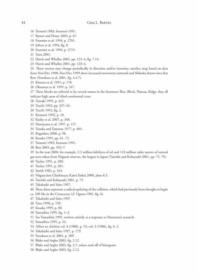
44 Gina L. Barnes
16 Tatsumi 198�; Iwamori 1991.17 Rymer and Drury 200�, p. 67.18 Fournier et al. 1994, p. 2701.19 Jolivet et al. 1994, fig. 8.20 Fournier et al. 1994, p. 2719.21 Taira 2001.22 Harris and Whalley 2001, pp. 12�–4, fig. 7.14. 2� Harris and Whalley 2001, pp. 12�–4. 24 These vectors may change periodically in direction and/or intensity; another map based on data from Nov/Dec 1998–Nov/Dec 1999 show increased movement eastward and Shikoku drawn into that flow (Yonekura et al. 2001, fig. 4.4.7). 25 Kimura et al. 1991, p. 178.26 Okamura et al. 1995, p. 167.27 These blocks are referred to by several names in the literature: Rise, Block, Plateau, Ridge; they all indicate high areas of rifted continental crust. 28 Tamaki 1995, p. 415. 29 Tsuchi 1992, pp. 2�7–4�. �0 Tsuchi 1992, fig. 2.�1 Koizumi 1992, p. 18. �2 Kusky et al. 2007, p. �40.�� Maruyama et al. 1997, p. 1�7.�4 Tanaka and Tamotsu 1977, p. 40�.�5 Bogatikov 2000, p. 98.�6 Kosaka 1995, pp. 61, 72.�7 Tatsumi 198�; Iwamori 1991. �8 Best 200�, pp. �92–7.�9 In the year 2000, for example, 2.2 million kilolitres of oil and 110 million cubic metres of natural gas were taken from Niigata’s reserves, the largest in Japan (Tateishi and Kobayashi 2001, pp. 75, 79).40 Tucker 1991, p. 200. 41 Tucker 1991, p. 201.42 Smith 1982, p. 16�.4� Niigata-ken Chishitsuzu Kaitei Iinkai 2000, plate 6.�.44 Tateishi and Kobayashi 2001, p. 75. 45 Takahashi and Saito 1997.46 These dates represent a radical updating of the collision, which had previously been thought to begin ca. 100 Ma in the Cretaceous (cf. Ogawa 1982, fig. 6). 47 Takahashi and Saito 1997.48 Taira 1990, p. 150.49 Kosaka 1995, p. 80.50 Yamashita 1995, fig. 1–�.51 See Yamashita 1995, written entirely as a response to Naumann’s research. 52 Yamashita 1995, p. ��.5� Nihon no chishitsu vol. 4 (1988), p. 55; vol. � (1986), fig. 6. 2. 54 Takahashi and Saito 1997, p. 179. 55 Yonekura et al. 2001, p. �09. 56 Blake and Argles 200�, fig. 2.12.57 Blake and Argles 200�, fig. 2.7; values read off of histogram. 58 Blake and Argles 200�, fig. 2.12.
45 The Making of the Japan Sea and the Japanese Mountains
59 Pacific Plate measured from seismic tomographic images in Rymer and Drury 200�, fig. 4.4; Philippine Plate estimate from Chen and Chen 2005.60 Blake and Argles 200�, fig. 2.12.61 Barnes 200�, fig. 6-b.62 Cavazza et al. 2004, p. 1. 6� Kimura et al. 2005, p. 972.64 Machida et al. 2006, p. 169.65 This section is based on Nihon no chishitsu vol. 2 (1989), pp. 250–52, with some interpolation as to cause. 66 Named in Taira 2001, fig. 11 and dated to 7 Ma.67 Tateishi and Kobayashi 2001, p. 77. 68 Uemura 2000, p. 195. 69 Nihon no chishitsu vol. 6 (1987), p. 24�; Yonekura et al. 2001, p. �0�70 Yonekura et al. 2001, p. �0�; Chigakudan 1996, p. 691.71 Barnes 200�, fig. 7a.72 Kimura et al. 2005, pp. 974, 98�.7� Kimura et al. 2005, p. 975. 74 Tatsumi and Ishizaka 1982, p. 294; Taira 2001, pp. 120–1. 75 Tatsumi 1982, p. �14.76 Barnes 200�, fig. 8c.77 Kimura et al. 2005, p. 974.78 Tatsumi and Ishizaka 1982, p. 294.79 Kimura et al. 2005, p. 98�.80 Nihon no chishitsu vol. 2 (1989), p. 25081 Nihon no chishitsu vol. 2 (1989), p. 251. 82 Taira 2001, p. 121. 8� Iwamori 1991; the two volcanoes are Daisen and Sanbe-san.84 Kimura et al. 2005, p. 98�.85 Chigakudan 1981, p. 826. Pavlides (1995) gives a short introduction to definitions of “neotectonics,” which generally fall into two groups: those which limit themselves to particular time periods, and those which consider any geological activity as far back as necessary in order to explain Quaternary and ongoing present-day tectonics.86 Taira 2001.87 Taira 2001.88 Cf. Kusumoto 2001, p. 41. 89 Taira 2001, p. 111.90 Taira 2001, p. 11�. 91 Hujita 1962, 1969. 92 Kusumoto et al. 2001. 9� Kusumoto et al. 2001. 94 Katsudansō Kenkyūkai 1992, p. �.95 Katsudansō Kenkyūkai 1980, 1991, 1992.96 Katsudansō Kenkyūkai 1992, p. 11. Three levels of certainty are used in identifying an Active Fault: I: “when it is certain, based on conclusive evidence, that the fault has been active during the Quaternary”; II: “when a fault is thought to be active because the sense of displacement as well as the location can be estimated, but there is no conclusive evidence”; III: “when the lineaments may be associated with active faulting but the sense of displacement is unknown or [other factors caused] the lineaments” (ibid., p. 15–17, their brackets). (Certainty level III is designated as a “concealed” or blind fault.)

46 Gina L. Barnes
97 Oreskes 1999, p. 20.98 Also called “tension” or “tensile” stress.99 Strain as defined by Miyashiro 1994, p. 15.100 See Barnes 200�, fig. 6b for locations of these tectonic lines.101 Barnes 200�, p. 2�.102 See fig. �.15 in Nunn 1994. 10� Cross and Pilger, referred to in Nunn 1994, p. 119.104 See Smith and Rymer 2001, pp. 125–44 for an explanation of gravity calculations and the methodology of the Free Air anomaly. 105 Yoshikawa in Nunn 1994, p. 156. 106 Nunn 1994, p. 156. 107 Sakaguchi in Nunn 1994, p. 156. 108 Okamura et al. 1995, fig. 1.109 These are seismic reflection and refraction techniques and seismic tomography; cf. Rogers 2001, pp. 52–8.110 Cf. Rogers 2001, chapter �.
GLOSSARY
Terms defined in Barnes 200� are not repeated here; original quotes may be excerpts or simplifications. References (listed in full in bibliography):
¤=IowaStateUniversityofScienceandTechnology2004 † = Neuendorf et al. 2005 ‡ = Jackson 1997
accretionary prism “A general wedge-shaped mass of tectonically deformed sediment . . . formed when pelagic sediment, oceanic-floor basalt, and trench-fill turbidite are scraped off the downgoing plate during the process of subduction.”†
active fault “A fault on which slip has occurred recently and is likely to occur in the future.”†
alkali minerals “SILICATE minerals that contain alkali metals but little calcium.”‡ alkaline Characterized by ALKALI MINERALS. alkaline volcanics Extrusive rocks having ALKALI MINERALS. alkali rifting volcanics Extrusive rocks produced during rifting, containing ALKALI MIN
ERALS but otherwise characterized by a bimodal distribution of basalt and RHYOLITE.
andesite (andesitic) “A fine-grained volcanic rock of intermediate composition, consisting largely of plagioclase and one or more mafic minerals.”¤
anticline “A fold, generally convex upward, whose core contains the stratigraphically older rocks.”† cf. SYNCLINE
antiform “A fold whose limbs close upward in strata for which the stratigraphic sequence is not known.”‡ cf. ANTICLINE
basin-and-range “A topography, landscape, or physiographic province characterized by a series of tilted fault blocks forming longitudinal, asymmetric ridges or mountains and broad, intervening basins.”†
batholith “A large, generally discordant PLUTONIC body having an aerial extent of . . .

47 The Making of the Japan Sea and the Japanese Mountains
100k2 or more and no known floor.”† blind fault “A fault that does not appear at the Earth’s surface as an outcrop.”† boundary faults The faults around the edge of a large crustal block, marking its boundaries
and isolating it from another block. breccia “A clastic rock in which the gravel-sized particles are angular in shape and make up
an appreciable volume of the rock.”¤ brittle “Said of a rock that fractures at less than �-5% deformation or STRAIN.”† calc-alkaline/calc-alkalic “Said of a series of igneous rocks in which the weight percentage
of SILICA is between 56 and 61 when the weight percentages of CaO and of K2O+Na2O are equal.Ӡ
caldera “A large, basin-shaped volcanic depression, more or less circular . . . formed by collapse during eruption” of a volcano.†
compression “Squeezing a material from opposite directions.”¤ “A system of forces or STRESSES that tends to decrease the volume of, or shorten, a substance.”†
continental crust “The part of the crust that directly underlies the continents and continental shelves. Averages about �5 km in thickness, but may be over 70 km thick under largest mountain ranges.”¤
core-mantle boundary “Boundary marking the separation between the Earth’s core (radius ~�,480 km) and the mantle at ~2,890 km depth.”†
country rock The pre-existing rock “intruded by and surrounding an igneous intrusion.”‡ crustal lengthening Occurs in ExTENSIONAL environments and results in the stretching
and thinning of the crust to cover more area. crustal shortening Occurs in COMPRESSIONAL environments and results in crustal
thickening as the crust is squeezed into less area. crustal thickening Same as crustal shortening. crustal thinning Same as crustal legthening. diorite An coarser-grained INTRUSIVE rock having the same intermediate SILICA com
position as ANDESITE. ductile “Structural behavior in which a material deforms permanently without fractur
ing.”¤ elastic “Non-permanent structural deformation during which the amount of deformation
(STRAIN) is proportional to the STRESS.”¤ erosion “Processes whereby the materials of the Earth’s crust are loosened, dissolved, or worn
away, and simultaneously moved from one place to another by natural agencies.Ӡ escape tectonics The deformation and extrusion of crust sideways from a collision zone;
used particularly in relation to the collision of the Indian Continent with Eurasia and the expulsion of East and Southeast Asia to the east and southeast.
extension “A STRAIN term signifying increase in length.” extensional stress Same as tension extensional tectonics Deformation caused by stretching or tension on Earth’s crust; charac
terized by RIFTING, thinning of the crust, and FAULT BASIN formation. extrusive “Said of igneous rock that has been erupted onto the surface of the Earth . . .
includ[ing] LAVA flows and pyroclastic material such as VOLCANIC ASH.Ӡ cf. INTRUSIVE
48 Gina L. Barnes
fault, see STRIKE-SLIP, NORMAL, THRUST faults fault basin “A depression separated from the surrounding area by faults.”† fault gouge “Soft, uncemented, pulverized clay-like material found along some faults.”¤ faulting A brittle form of STRAIN that occurs in the upper, cold crust resulting in “a rock
rupture along which there has been differential movement of the rock on either side.”¤ fault line “The trace of a FAULT PLANE on the ground surface or on a reference plane.”† fault plane “A fault surface that is more or less planar.”† fault zone “A fault that is expressed as a zone of numerous small fractures, BRECCIA, and/or
FAULT GOUGE.”† felsic “Igneous rock having abundant light-colored minerals . . . (quartz, feldspars, feld
spathoids, muscovite)”‡; “a mnemonic adjective derived from feldspar+lenad (feldspatho id)+SILICA+c”.†
flood basalts (plateau basalts) “Basaltic LAVAS that occur as vast accumulations of horizontal or subhorizontal flows, which were erupted from fissures in rapid succession over large areas.”†
fold belt (orogenic belt) “A linear or arcuate region that has been subjected to FOLDING and other deformation” during mountain building.‡
folding A plastic form of STRAIN that occurs in hot or weak rock. footwall “The body of rock that lies below an inclined FAULT PLANE.”¤ cf. HANGING
WALL. Fossa Magna Lit. ‘large trough’, the name applied to the fault-bounded depression running
north to south across Honshū from the Itoigawa River in Niigata to Shizuoka. geotectonic Same as tectonic. “Usually applied when the features being described are of
regional scale or larger.Ӡ graben Same as RIFT, a depression bounded by NORMAL FAULTS on both sides; a half-
graben is only bound by a normal fault on one side. gravity measurements, by gravimeter “registering differences in the weight of a constant
mass as the gravimeter is moved from place to place,”‡ usually expressed in milligals. hanging wall “The body of rock that lies above an inclined FAULT PLANE.”¤ cf. FOOT
WALL. Hida Belt The block of continental crust comprising the Noto Peninsula and its surrounding
area. high-silica See FELSIC horst “An elongate block that is bounded on both sides by NORMAL FAULTS that dip
away from one another.”† ice loading The weight of large areas of ice (caps, glaciers) as it depresses the Earth’s surface. intermediate-silica Igneous rock having between 54 and 65% silica, characterized by AN
DESITE. intrusive Igneous rock which has solidified within the Earth’s crust. cf. ExTRUSIVE isostasy (isostatic) “The condition of equilibrium, comparable to floating, of units of the
lithosphere above the asthenosphere.”¤ lacustrine “Pertaining to, produced by, or formed in a lake or lakes.”† lava “Molten rock that flows at the Earth’s surface.”¤ left-lateral “Displacement along a [STRIKE-SLIP] FAULT such that, in plan view, the side
opposite the observer appears displaced to the left.”‡
49 The Making of the Japan Sea and the Japanese Mountains
low-silica see MAFIC mafic “Referring to a generally dark-colored igneous rock with significant amounts of one
or more ferromagnesian minerals, or to a magma with significant amounts of iron and magnesium.”¤
magma chamber “A reservoir of magma in the shallow part of the lithosphere from which volcanic materials are derived.”‡
magmatism “The development and movement of magma, and its solidification to igneous rock.”†
mantle plume “A hypothetical column of hot, partially molten material that rises from an indeterminate depth in the mantle and is thought by some geologists to provide a driving force for plate movement.”¤
mass deficit A lack of crustal mass to balance the mass possessed by the mantle directly underlying it.
mass excess An excess of crustal mass than the mass of the underlying mantle. Median Tectonic Line (MTL) A major STRIKE-SLIP FAULT running from Kyushu
through Shikoku and Kii Peninsula into the Kantō region. metamorphic belt A GEOTECTONIC unit comprised of “rock derived from pre-existing
rocks by mineralogical, chemical, and/or structural changes, essentially in the solid state, in response to marked changes in temperature, pressure, shearing STRESS, and chemical environment.”‡
metasomatism “The metamorphic processes that occur as a result of the passage of chemically active fluids through a rock, adding to or removing constituents during metamorphism.”¤
mid-oceanic ridge “A continuous, seismically active, median mountain range extending through the North and South Atlantic Oceans, the Indian Ocean, and the South Pacific Ocean....the source of new [oceanic] crustal material.”†
mudstone “A general term that includes clay, silt, claystone, siltstone, shale, and argillite . . . when the amounts of clay and silt are not known or specified.”†
normal fault “A fault in which the HANGING WALL has moved downward relative to the FOOTWALL. The angle of the fault is usually 45-90°, and in mose cases close to 60°.”†
oceanic crust “That part of the crust underlying the ocean basins. Composed of basalt and having a thickness of about 5 km.”¤
offset landforms Massive or linear landscape features that have been cut by an ACTIVE FAULT and parts on either side of the fault offset by several centimetres to kilometres.
orogenic belts “Linear to arcuate in plan, intensely deformed crustal belt associated with mountain building.”¤
oxide “A mineral compound characterized by the linkage of oxygen with one or more metallic elements.”†
palaeomagnetism “The study of natural remanent magnetization of Earth materials in order to determine the direction, and indirectly intensity, of the Earth’s magnetic field in the geologic past.”†
plastic “Permanent deformation of the shape or volume of a substance, without rupture.”‡ pluton (plutonic) “An igneous intrusion.”¤ c.f. INTRUSIVE pop-up block “A mass of rock uplifted by reverse slip on two faults that dip toward a com
mon point beneath the rock mass.Ӡ Compare HORST
50 Gina L. Barnes
potassium argon (K-Ar) dating “A method used for the dating of potassium-bearing rocks by using the ratio of radioactive 40K to its daughter, 40Ar.”¤
reactivation New movement on an old or pre-existing fault. reverse fault “A fault on which the HANGING WALL has moved upward relative to the
FOOTWALL. The dip of the fault is usually greater than 45°.”† rhyolite (rhyolitic) Having the FELSIC chemical composition of granite but “commonly
exhibiting flow texture”† with large crystals in a glassy groundmass. rift (rifting) “A valley caused by extension of the Earth’s crust. Its floor forms as a portion of
the crust moves downward along NORMAL FAULTS.”¤ rift zone “A system of crustal fractures.”‡ right-lateral “Displacement along a [STRIKE-SLIP] FAULT such that, in plan view, the
side opposite the observer appears displaced to the right.”‡ root “The downward extension of lower-density crustal material as ISOSTATIC compensa
tion for its greater mass and high topographic elevation.Ӡ sedimentary basins Basins which serve as catchments for EROSIONAL materials carried to
them from surrounding areas. sediment loading The weight of deposited sediments that cause the underlying strata to
compress. seismology “The study of earthquakes, and of the structure of the Earth by both natural and
artificially generated seismic waves.”† seismic tomography “A technique for three-dimensional imaging of the Earth’s interior by
using a computer to compare the seismic records from a large number of stations. Similar in concept to a cat scan used for medical purposes.”¤
seafloor spreading (centre) “A process whereby new OCEANIC CRUST is formed by upwelling of magma at the center of MID-OCEAN RIDGES and by a moving-away of the new material from the site of upwelling at rates of one to ten centimeters per year.”†
silica (silicate) “Silicon dioxide (SiO2) . . . the basic chemical constituent common to all silicate minerals and magmas.”¤
siliceous shale “A hard, fine-grained rock of shaly texture with an exceptional amount of SILICA (as much as 85%).”†
strain “Change in the shape or volume of a body as a result of STRESS.”¤ Degrees of strain: ELASTIC, PLASTIC, and BRITTLE.
stratigraphic unit “A stratum or body of adjacent strata recognized as a unit in the classification of a rock sequence with respect to any of the many characters, properties, or attributes that rocks may possess.”‡
stress “In a solid, the force per unit area, acting on any surface within it [COMPRESSION]...also, by ExTENSION, the external pressure which creates the internal force.”† cf. STRAIN
strike “The direction or trend taken by a . . . FAULT PLANE, as it intersects the horizontal.”‡
strike-slip fault “A fault on which the movement is parallel to the fault’s STRIKE”†, allowing large areas of crust to slip by each other (e.g. the San Andreas fault in California).
structural geology “The branch of geology that deals with the form, arrangement, and internal structure of the rocks,”† especially analyzing STRESS on rock and the way rock reacts with different forms of STRAIN.

51 The Making of the Japan Sea and the Japanese Mountains
sub-alkaline
“Igneous rock that contains no ALKALI MINERALS other than feldspars.”† subduction zone volcanism Volcanic activity in subduction zones, characterized by CALC
ALKALINE products. subsidence “The sudden sinking or gradual downward settling of the Earth’s surface with
little or no horizontal motion.”† syncline “A fold of which the core contains the stratigraphically younger rocks; it is generally
concave upward.”† cf. ANTICLINE. synform “A fold whose limbs close downward in strata for which the stratigraphic sequence
is unknown.”‡ cf. SYNCLINE Tanakura Tectonic Line (TTL) A STRIKE-SLIP FAULT located in Tōhoku. tectonic basins Basins formed by tectonic deformation, i.e. FOLDING or FAULTING. Tethys Ocean An ocean of eastern Pangea that separated Laurasia from Gondwana and “was
largely obliterated by the Alpine-Himalayan continental collision.”† thermal expansion The tendency for things to expand in volume when heated. thrust fault “A fault which a dip of 45° or less over much of its extent, on which the HANG
ING WALL has moved upward relative to the FOOTWALL,Ӡ allowing a large block of crust to ride up on another.
tuff “Consolidated or cemented VOLCANIC ASH and lapilli.”† underplating “Addition of material to the base of an ACCRETIONARY PRISM [or] . . .
addition of igneous rock to the base of the crust.Ӡ unroofing The process following mountain building in which earlier, often metamorphic,
rock layers are stripped away by EROSION. uplift “A structurally high area in the crust, produced by positive movements that raise or
upthrust the rocks, as in a dome or arch.”† upper crust The upper few kilometres of relatively cold CONTINENTAL CRUST. vector “A format for processing and displaying graphic data. Vector data are represented by
strings of coordinate pairs defining the true position of features represented by points, lines, and areas.”
volcanic See ExTRUSIVE volcanic ash ExTRUSIVE dust-sized glassy fragments of shattered magma bubbles plus
mineral crystals.
要旨
日本海の生成と山脈の隆起:日本の火山活動の構造学的研究
ジーナ・バーンズ
学者も含めて多くの人々が日本という国は元来火山列島だと考
えているが、その地史は、そうではないことを物語っている。
つまり、列島の基礎的な地質構造帯(geotectonic units)が主と
して堆積岩からなっているというだけではなく、つい最近まで
52 Gina L. Barnes
ユーラシア大陸の一部分であったということである。既発表論
文(Japan Review 15 [200�], pp. 1–50 )では、4億5000万年前から
1500 万年前までの日本の主要な構造帯の形成を明らかにし、最
後に日本海が開いて日本列島が出来上がった過程を説明した。
今回は、日本列島が大陸から離れた原因やしくみをより詳細
に見たのち、その結果としての山脈と盆地の形成に焦点をあて
る。リフティング(rifting 、背弧拡大)と山の形成というその
過程には、日本列島の形成に作用した二つのまったく異なる火
山活動がみられる。ひとつは、リフティングに伴うアルカリ火
山岩、もうひとつはプレートの沈み込み運動から生じる弱アル
カリ性火山岩があり、これら二つの活動は時代、位置、環境な
どまったく異なる条件下で起こっている。しかも、より大きな
構造上の変化の可能性を考慮に入れたとき、日本列島を悩ます
地震の形態を変えながら、日本海はすでに狭まり始めているこ
とがわかるのである。これらの問題を議論するための新しい地
学概念や用語については、リフティング、褶曲、断層、重力、
均衡などの地学的作用とともに、Glossary において解説し、Appendix 1 では、様々な地質年代の岩石層、地殻変動のプロセス、
特定の事例を参照されたい。