Embed Size (px)
Citation preview

The Lunar Mapping and M d li P jModeling Project
Sarah Noble, Raymond French, Mark Nall, and Kimberly Muery
NASA Marshall Space Flight Center
https://ntrs.nasa.gov/search.jsp?R=20100005131 2019-08-30T08:57:28+00:00Z

Project Background and Overview• LMMP was initiated in 2007 to help in making the anticipated
results of the LRO spacecraft useful and accessible to pConstellation
• The LMMP is managing and developing a suite of lunar i d d li t l d d t th t t thmapping and modeling tools and products that support the
Constellation Program (CxP) and other lunar exploration activities
• In addition to the LRO Principal Investigators, relevant activities and expertise that had already been funded by NASA was identified at ARC CRREL (Army Cold RegionsNASA was identified at ARC, CRREL (Army Cold Regions Research & Engineering Laboratory), GSFC, JPL, & USGS
• LMMP is a cost capped, design‐to‐cost project (Project budget was established prior to obtaining Constellation needs)

Customers
• Main customer is the Constellation program Th i f ti id d th h LMMP ill i t th iThe information provided through LMMP will assist them in:– planning tasks in the areas of landing site evaluation and selection
– design and placement of landers and other stationary assets
– design of rovers and other mobile assets
– developing terrain‐relative navigation (TRN) capabilities
– assessment and planning of science traversesassessment and planning of science traverses
• Other customersScience community– Science community
– Commercial community (e.g. GLXP teams)
Ed ti /P bli O t h it– Education/Public Outreach community
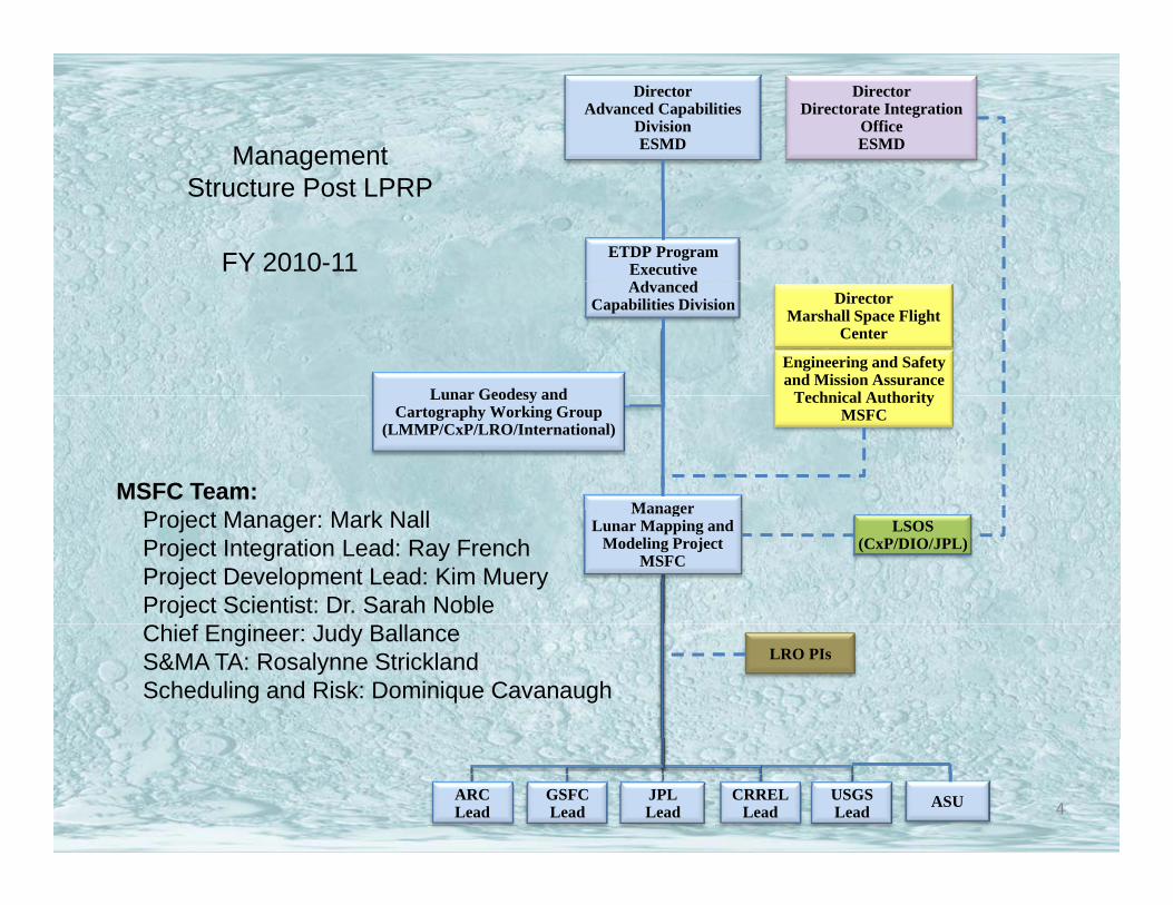
Director Advanced Capabilities
DivisionESMD
DirectorDirectorate Integration
OfficeESMDManagement
FY 2010-11 ETDP Program ExecutiveAd d
gStructure Post LPRP
Advanced Capabilities Division
Lunar Geodesy and
DirectorMarshall Space Flight
Center
Engineering and Safety and Mission Assurance
Technical Authority
Manager
Lunar Geodesy andCartography Working Group
(LMMP/CxP/LRO/International)
Technical AuthorityMSFC
MSFC Team:Manager
Lunar Mapping and Modeling Project
MSFC
LSOS(CxP/DIO/JPL)
Project Manager: Mark NallProject Integration Lead: Ray FrenchProject Development Lead: Kim MueryProject Scientist: Dr. Sarah Noble
LRO PIsChief Engineer: Judy BallanceS&MA TA: Rosalynne StricklandScheduling and Risk: Dominique Cavanaugh
4ARCLead
GSFCLead
JPLLead
CRRELLead
USGSLead ASU

LMMP TeamARC
• Regional Apollo visible base imagery mosaics • Regional DEMs • EPO web-based neo-geography interfaces
USGS
• Local/site visible base imagery mosaics• Regional/polar visible base imagery mosaics• Local/site DEMs
JPL
• Visualization system infrastructure, web portal and interoperable GIS infrastructure
• Local/site DEMs (stereo photoclinometry)H d t (i l di l )• Hazard assessment maps (including slope maps)
ASU • Local/site DEMs
CRREL
Desktop visualization client Integrated Lunar Information
• Web-based visualization system digital overlay tools
5
GSFC• Desktop visualization client – Integrated Lunar Information Architecture for Decision Support

Data Sources
• LRO• LRO• M3
• Kaguya (gravity model)
• Apollo (metric & p (panoramic cameras)
• ClementineClementine
• Prospector

Data Products
• “Passthrough”–e.g. LOLA DEM, Clementine, Prospector, gravity model, lighting model
• Modify–e.g. mosaicking basemap, georeferencinglocal images
• Create…Create…

Created Products ‐ DEMs
Regional DEMs using scanned Apollo metricscanned Apollo metric camera data
Covers ~18% of the Moon (low latitudes)
Small section of DEM from orbit 33. DEM resolution ~40m/pixel
Map showing coverage of metric camera data

DEMsLocal DEMs from LOLA NAC coveringNAC covering the 50 CxP regions of interest
Preliminary USGS Aristarchus Pl t (DEM 1) f JSC/ASUPlateau (DEM 1) from JSC/ASU Apollo Pan Cam Scans
Malapert (left) and Ap 15 (right) ROIs showingMalapert (left) and Ap 15 (right) ROIs showing in red the NAC images acquired through the 1st
month of mapping orbit

Created Products ‐ Hazard Maps
• Craters
• Boulders
Sl• Slopes
• Surface Roughness

Data Products Process
H ld lid ti dit
Produce preliminary data products In some cases using Apollo or other historic data
Acquire final data sets from LRO teams
Hold process validation auditsThese have occurred
Produce final products
Acquire final data sets from LRO teams. Adjust methods, if necessary.
Ingest into LMMP system
Produce final products
Hold final product validation auditsTo insure that products are of high quality, display correctly, and meet CxP’s needs
Release to Public (or where appropriate, CxP internal use)

LMMP System
LunarMapper ILIADS l hSTKLunarMapper ILIADS GoogleEarth ArcGISSTK
X‐GISLMMP Portal
GIS
Gravity SurfaceRo ghness
Ingestion
Data Products
Data DistributionValidation
Nomenclature
Authentication
Hazards
Data Processing
TemperatureRock &Craters Contours Slopes
Roughness
Imagery ElevationMineralogy

Portal

Lunar Mapper
14

Lunar Mapper
15

Integrated Lunar Information Architecturefor Decision Support (ILIADS)for Decision Support (ILIADS)
Lunar Surface Traverse Tool (oblique view)
16Goldstone Radar of South Pole (oblique view)

Integrated Lunar Information Architecturefor Decision Support (ILIADS)for Decision Support (ILIADS)
Clementine with high-res Lunar Orbiter
17
South Pole hazard analysis (surface roughness)

LMMP Milestones• Apr 2009 – Formulation review
• Jun 2009 – LRO launched!Jun 2009 LRO launched!
• Jun 2009 – Requirements review
A S 2009 I di id l d t• Aug‐Sep 2009 – Individual product process validation audits
• Sep 2009 – Preliminary System design audit
• Dec 3rd 2009 – Beta release of Mapper, ILIADS, ppPortal, infrastructure and content
• Late 2010/Early 2011 – Version 1 releaseLate 2010/Early 2011 Version 1 release


![Foodservice Equipment, Supplies & Design | PJP · 2019. 3. 14. · PJP SALES REP # MONTH [ ] YEAR [ ] PRINCIPALS ... A seller that enters data elements from paper into an electronic](https://img.pdfslide.us/doc/110x75/6088202ed36f02038c37924a/foodservice-equipment-supplies-design-pjp-2019-3-14-pjp-sales-rep.jpg)