Embed Size (px)
Citation preview

Flor Yenin Cerón Rojas.
Escuela Nacional de Antropología e Historia. Mexico, B.A. Program in History.
THE LIENZO OF CITLALTEPEC: AN INDIGENOUS HISTORICAL-CARTOGRAPHIC DOCUMENT
FROM LA MIXTECA IN GUERRERO1.
Abstract: The Lienzo de Citlaltepec, better known as Lienzo de Aztactepec y Citlaltepec, is a historical-
cartographic indigenous document from the Mixtec zone of La Montaña de Guerrero, which narrates some events
about the recent Colonial history after the Spanish conquest. It also shows the territory of the indigenous señorío
[chiefdom] of Citlaltepec-Metlatónoc. This is one of the few indigenous documents from the Mixtec region in the
state of Guerrero. It is currently housed in the Alfeñique Museum in Puebla. The space occupied by the señorío of
Citlaltepec pertained to the central-eastern part of the state of Guerrero. This is an important document because it has
information that may increase the little knowledge there is about Prehispanic and colonial Mixtec culture in Guerrero.
The Lienzo de Citlaltepec shows an extensive territory, as well as a complex political organization.
Keywords: Lienzo de Citlaltepec, historical-cartographic document, indigenous codices, indigenous writing,
Montaña de Guerrero.
----------------------------------------------------------------------------------------------------------------------------------------------
INTRODUCTION.
The region of La Montaña in the state of Guerrero belongs to the eastern geopolitical section of the state,
which borders with Oaxaca and Puebla. It includes 19 municipalities, concentrating the highest number of indigenous
population, among whom the following languages are spoken: Mixtec, Tlapanec, and Nahuatl.2 Besides, because of
its social and cultural characteristics, this region is one of the richest in the state of Guerrero in terms of Colonial
documents of indigenous tradition. An example of this is the Lienzo de Aztactepec y Citlaltepec, which comes from
the Mixtec municipality of Metlatónoc. This zone is characterized by being one of the poorest, not just of Mexico but
of the world.3
1 I thank Famsi for its financial support for this research (grant number 05052). 2 See Moyao Morales (1992: 76) and the following website: www.municipios.com.mx/guerrero/mexico-12.html 3 This information can be seen in the following article: “En Metlatónoc, el municipio más pobre del país, el médico solo receta te de limón” [in Metlatónoc, the poorest municipality in the country, the doctor just prescribes lemon tea”], in the following website: www.cronica.com.mx/nota.php?id_nota=161395.

The Lienzo de Aztactepec y Citlaltepec, also known as Códice de las vejaciones [codex of vexations] (figure
1), is a codex of a historical-cartographic kind from the late 16th century, currently found in the Alfeñique Museum of
in the city of Puebla. This is a document of indigenous tradition, pertaining to the Mixtec region of Guerrero. In the
Lienzo one can see the territory pertaining to the señorío of Citlaltepec-Metlatónoc, encompassing the central-eastern
part of the La Montaña region. This document is important because it has information that may increase the little
knowledge we have about the Prehispanic and Colonial Mixtec culture in Guerrero. Besides, the Lienzo de Aztactepec
y Citlaltepec shows a complex political organization, above all the power struggle of the indigenous rulers and their
lineage against the European conquerors in the 16th century.
Figure 1
The new political and economic order established by the Europeans during the conquest increased the fights
among the indigenous chiefdoms which were in this area before the arrival of the Spanish in Mexico. An example of
this is that the Mixtec chiefdoms were displaced by the Nahua and the Tlapanec during the Pre-Columbian era.
Basauri says the following about this:
“Malinaltepec was founded upon the ancient Mixtec chiefdom of Moyo-Zatañu (which was provisionally
passed to Alacatlatzala after the invasion). It gained more importance because of its geographical location and
probably with the Spanish invasion and domination. Its expansion follows its course and two communities are
founded: Moyotepec and Tejocote. More important is its advance to the south, in an attempt to dominate the
commercial route to the sea. This way the following [localities] appeared: Paraje Montero, Yerba Santa,
Iliatenco, Xochitenco, Tierra Blanca, Tilapa, Tierra Colorada, Rincón, and Tlaxacalixtlahuaca. This last
invasion virtually dismembered the compact area inhabited by the Mixtec, and almost separated the chiefdom
of Coapinola from the rest (Basauri 1990: 403-404).
The Lienzo de Aztactepec y Citlaltepec is proof of the dizzying change experienced in the 16th century with
the arrival of the Spanish. In order to understand the information found in the Lienzo, an ethnohistorical work was
undertaken, based on the decipherment of glyphs and glosses found in the document, as well as gathering information
about the towns of Citlaltepec and Metlatónoc in the Archivo General de la Nación (AGN) [General Archive of the
Nation], and also doing fieldwork in La Montaña de Guerrero. This research resulted in a proposed reading of the
Lienzo, on the basis of seven identified scenes, which complement each other and constitute one whole item in the
narrative of the document.
THE SCENES OF THE LIENZO DE AZTACTEPEC Y CITLALTEPEC
Scene 1. The geographic setting.
The Lienzo is oriented toward the west. In the borders of the codex the cardinal directions are indicated, with
the gloss reading “Oriente” [orient, or east] in the lower part.4 On the right-hand margin is the abbreviated word
“Nte”, meaning north, and in the left-hand edge is a gloss reading “sur” [south]. A sketch was made in which the
initials N, S, O and P are written, which pertain to the cardinal directions. The most important localities in the Lienzo
were numbered and identified in the geography of La Montaña de Guerrero. Therefore, the stream crossing the
document is the Piedra parade River, and to the south of it is the location of “Chilixtlahuaca” [in the plain of chili],
now a cuadrilla [quarter] of the town of Zitlaltepec; to the northeast is “Metlatónoc” [in the place of the small metate,
or grindstone], which pertains to the present head town of the municipality bearing this name. It borders with
Coicoyan de las Flores, Oaxaca, therefore the codex shows the boundaries between Guerrero and Oaxaca. To the
southeast is “Aztactepec” [hill of the heron], which is a hill of great size and the inhabitants within the region regard it
as an important geographic reference. To the west is found Zitlaltepec (“Citlaltepec” in the document), which now is
4 The words in this text which appear in bold face and between inverted commas indicate the interpretation of the glyphs not accompanied by glosses. The words in italics and between inverted commas are the glosses found in the document.

a town belonging to the municipality of Metlatónoc. It borders with the Tlapanec municipality of Malinaltepec.
Finally, the town of “Chochoapa” is located on the east side of the Piedra Parada River, between Zitlaltepec and
Metlantónoc (figure 2).
The landscape in the Lienzo shows the typical flora and fauna in the region, such as serpents, jaguars or
ocelots, crows, humming birds, egrets. Also shown are the kinds of water currents, roads and man-made constructions
such as Christian temples and walls. There is a road shown in the Lienzo, located on the lower right side, starting in
the “tzuitzuitepec” hill [hill of the humming bird] and ending in the place where the canvas is torn. The representation
of this avenue consists of two parallel lines. The footprints which are seen in the document also show roads used by
the characters: one of them originates in “Cihuaixtlahuaca” [woman’s plain] and ends in “Citlaltepec”. Another road
starts in “Chochoapa” [ditch of the parrot], crosses the Piedra Parada River, and ends again in “Citlaltepec” [hill of

the star]. The third road starts in “Mextlijezpe” [three magueys] and ends in the name glyph “Llano de ave” [bird
plain]. The last road starts in the “tzuitzuitepec” hill, mentioned above, and ends between the hills of “Teoquitla
Xochapo” [where the sacred plant shoot flowers] and “Mextlijezpe”.
Another important element of the landscape in the Lienzo shows broken terrain which is characteristic of La
Montaña de Guerrero, through the small hills recorded under the name glyphs used as borders. Among these points
five stand out because of their size, which are “Xuchitepec” [hill of the flower], Tzuitzuitepec”, “Atliemaxac” [where
water is divided], “Caucatepec” [in the hill of cacao], and “Atzcatepec” [hill of the egret, “Kuzami” in Mixtec]. In
total there are 29 name glyphs indicating the limits of the chiefdom of Citlaltepec-Metlatónoc, and 11 towns found
within its territory.
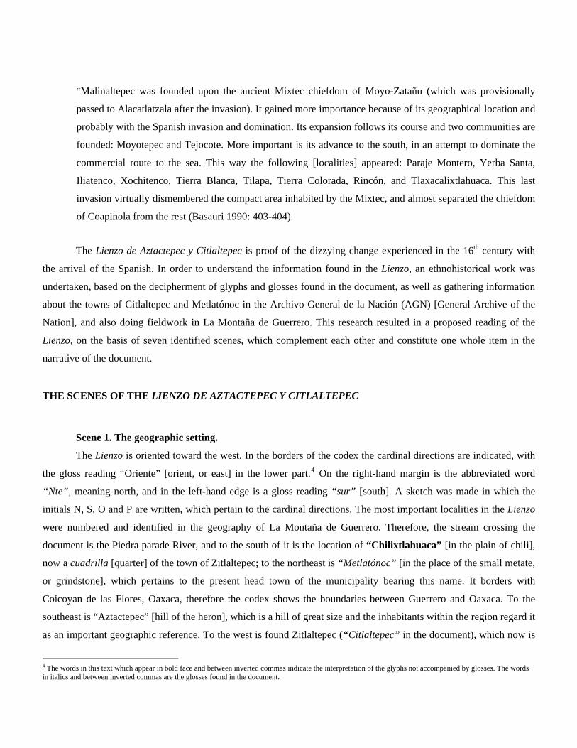
The geographic space shown in the Lienzo can be compared with the following maps: the first one is a plan
accompanying the documents pertaining to the processes of land demarcation and land grants of the town of
Zitlaltepec5 (Barrera 1961; Planoteca of the RAN, Plan number 2037), in which we can see that in relation to the
codex at present the comisaría of Zitlaltepec is to the north, while the Cerro de la Estrella [Hill of the Star] in
represented in the codex to the south of the said town. Likewise, the cuadrilla [quarter] of Chilixtlahuaca, also shown
in the Lienzo, is seen to the south of Zitlaltepec, only it is not on the other side of the river as is shown in the codex
(figure 3). The second map is a sketch drawn during fieldwork in 2005 and 2006, showing the location of important
hills as well as the location of the towns neighboring Zitlaltepec (figure 4). Lastly, in the third map one can see the
location of Zitlaltepec and Metlatónoc in relation to other important localities of La Montaña de Guerrero (Figure 5).
5 These documents are in the RAN.


Scene 2. The war between indigenous lords.
The proposed reading of the Lienzo starts on the upper right quadrant of the document, where there is a fight
among indigenous people (figure 6). The battle is taking place between “Citlaltepec” and a name glyph consisting of
a water canal with some pants on top. The 14 characters composing this scene are oriented to the south. The first two

warriors are on one side of the church of “Citlaltepec”, one of them is carrying a mace and has the sign for
“asentadera” or “base” [seat or base, “Tzintli” in Nahuatl] over his head. He is holding another character by the
hair, although this warrior has no anthroponym (i.e. personal name glyph) or gloss that would identify him. Lord
“Asentadera” appears twice, capturing other two men, one of them is over the name glyph “Cozcapec” or “Cerro del
Collar” [hill of the necklace], which is located to the north of “Citlaltepec”. The “Cozcapec” name glyph consists of
a hill of trapezoid shape, with some threaded beads on the top of the hill. On the right hand side there is a seated
indigenous noble man, in front of him there is a Spaniard who is talking to him. Neither of them has a gloss or name
glyph to identify him. Under these men there are two warriors with maces and shields, holding other lords by the hair,
two of them have a name glyph: “Snake” and “Bird”. At their feet there are two glosses, the first one reads “Ygua
cogmiimechque amochca”, and the second one reads “Tlapaneca”, which probably indicates the ethnic affiliation of
one of these characters.

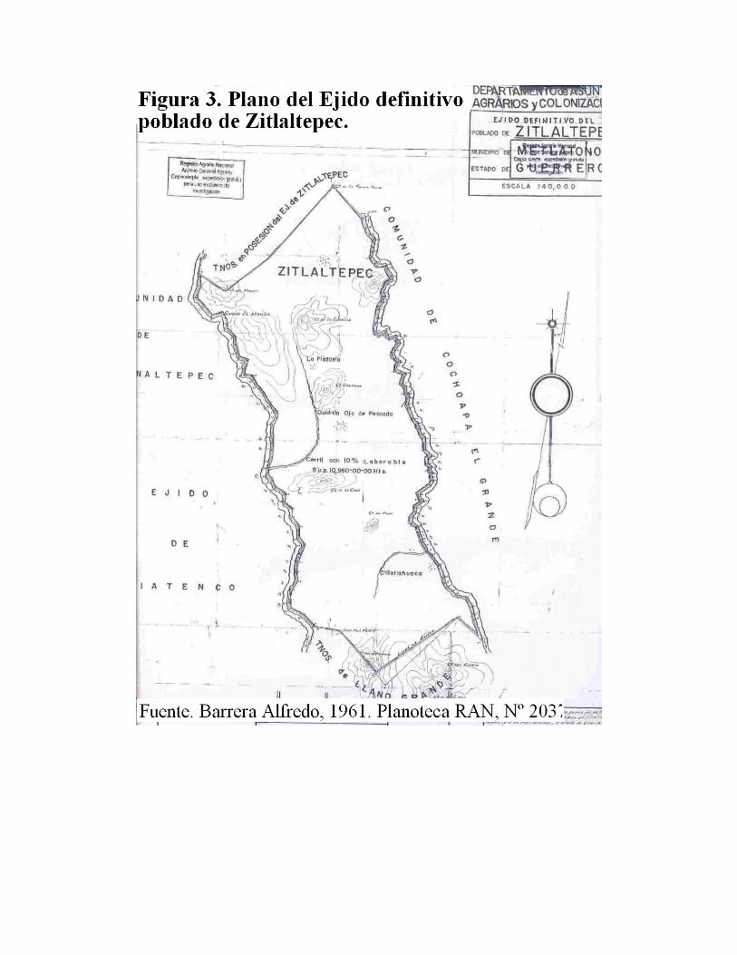
Scene 3. Capture and death at Metlatónoc.
The next scene is found in the lower left part of the document (figure 7), and is taking place in “Metlatonoc”.
We can see an indigenous lord with a rope around the neck, which is being held by a Spaniard. The indigenous lord is
wearing European garments, but his rank is indicated by a royal diadem he is wearing on his head. He has no name
glyph or gloss to reveal his identity, but he probably was a ruler of “Metlatonoc” and his name may be
“Ciuacohualli”, since he is on one side of the church representing this locality, and there is a reference to this ruler on
the same scene. The Spaniard pulling the indigenous nobleman is holding a staff in his hand and is in front of another
European individual, who is wearing a hat, Western clothing, and is bearded. Neither of the Spanish individuals has a
gloss indicating his identity, but they may be Francisco Guillén and Joan de Tovar, encomenderos [Spanish colonists
who were granted Indian laborers by royal decree] of Jicayan de Tovar6 (del Paso y Troncoso 1905: 301). Because
Jicayan de Tovar and Metlatónoc are so close to each other, the encomenderos tried to submit the indigenous people
within this region,7 killing or apprehending those who refused to obey or who simply stood in the way of their plans.
The encomienda, as is known, was a Spanish institution of oppression against the Indians. Therefore, as we can see in
the Lienzo de Aztactepec y Citlaltepec, the way in which the Spaniards treated and killed the Indians shows a strong
opposition between both groups, but at the same time it shows a strong internal conflict among the Indians, of which
the Spanish conquerors took advantage.
Between the two Spanish lords there was a place name, but the canvas is torn in this spot. Above this place an
indigenous man is shown, with an arrow piercing his stomach, and there are two glosses on the side. The first one
reads “Tlacxipe(hua)li”, meaning “men are flayed”, the other one is “Xiltu cuaca”, which translates as “Where
xilotes are eaten” or “On the tip of the xilote” [xilote refers to the green, tender corn cob], and may be a reference to
the place name that is torn. Above the person pierced by the arrow there are two sticks crossed by a third stick, and
besides them there is a dead Indian who has been beheaded. These sticks may be a gallows, or the place where the
person was beheaded. It is possible that the lord of Metlatónoc, who was captured by the Spaniard, was murdered in
the same way as the other two dead lords, since the gloss located besides the church reads “they left him unconscious,
they speared him, he became full of worms, and his respectable woman and little son brought him since they said that
6 Jicayan de Tovar is located 10 km to the south of Metlatónoc. At present Jicayan pertains to the municipality of Tlacoachistlahuaca, on the border between Guerrero and Oaxaca. 7 In the 16th-century Relaciones Geográficas of Antequera it is mentioned that Xicayan de Tovar had five subjects, but they don’t say who they were (Acuña 1984: 283).
he was finished” (Glass 1964: 184).8 Finally there are three indigenous noble men, who are gathered around the
beheaded lord. They are Lord “Lluvia” [rain], Lord “Ahuitzli” [water thorn], and Lord “Teohtiaitzocapili”. Finally,
the gloss above them on the left hand side states “Ciuhacohualli Pilicatca”, or “the lord Ciuhacohualli is hanged”.
This is probably what the lords “Lluvia” and “Ahuitzli” are saying, referring to the indigenous lord who had been
captured by the Spaniards.
Scene 4. Lord Rain.
After Lord “Ciuhacohualli” is killed his wife hears of the event, and goes to Metlatónoc in order to collect her
husband. This scene starts in the “Cerro del Maguey” [Hill of the Maguey] where there are two characters seated in
front of each other (figure 8). Their name glyphs are flowers of different kind, there is a gloss reading “Xochitl”
[flower]. From them originate footprints that go across the river and end at a kneeling woman. In front of the woman
there is a lord above the place called “Llano del ave” [plain of the bird]; this person’s name glyph is a water spring.
Above these characters are two seated lords on a small bench. Their name glyphs are a feather for the first one, and
for the other one a horizontal rectangle with several divisions. We haven’t identified the meaning of this glyph yet.
They seem to be witnessing the interview between the lady and Lord “Agua” [water].
8 The translation presented by Glass was made by Mariano J. Rojas.

In the same scene, above “Huitztepec” [Hill of the hummingbird] there is a seated lord named “Quiatziitl” or
“the noble lord Rain”. This character appears in scene 3, talking to lord “auitztli” about the death of lord
“Ciuhacohualli”, since the name glyph he is carrying is the same one. Under him there is a water current divided in
two, it may be the toponym for Metlatónoc, whose Mixtec name is Iyu tiano, meaning “broken river”.9 Besides, this
name glyph is very close to the church and the gloss representing Metlatónoc. In front of lord “Quiatziitl” there is the
following Nahuatl phrase: “nica: tlapa amo içe[n] ihua bedora ( o bexora) ymatl[n] do[n] mateo xoares g[arci]a
yhua don alo[n]ço de camarco Alca[l]de mayor yriçe tlapa xihuil 1572.”, which may be translated as: “here in Tlapa
it was not made, and also Bedora (Bexora) [Imatlan] and Mateo Xoares García, and Don Antonio de Camargo Alcalde
Mayor [magistrate who exercises ordinary jurisdiction in a town]. I made this in Tlapa in the year of 1572”.10
9 This information was provided by Jacinto Mejía, who lives in Metlatónoc, during fieldwork in October, 2005. 10 There is another translation, presented by Glass: “Here in Tlapa, Becerra (or Bedora?) is not in the hands of Don Marcos Juárez, nor of Don Alonso de Camargo, alcalde mayor of Tlapa, in the year of 1572” (Glass 1964: 184).

Following with the story in the scene, from the “cerro del colibrí” [hill of the hummingbird] footprints go
back to “Mexcayezpe”. The interpretation for this is that when the lady hears that her husband has died, she leaves
“Mexcayezpe” in order to go to the place called “Llano del pájaro” [plain of the bird] and has an interview with
Lord “Agua” [Water], who tells her that her dead husband is in Metlatónoc, when she arrives there she goes back to
“Mexcayezpe”.
Scene 5. Citlaltepec.
The story that takes place here deals with an important woman leaving a town named “Ciualixtahuaca” or
“Llano de las mujeres” [plain of the women] toward Citlaltepec or “Cerro de la estrella” [hill of the star]. The scene is
composed primarily of two women who meet in the first town. The woman on the left is in a royal seat and in her left
hand she is carrying a flower as a sign of power. The phrase in front of the face of the lady from “Citlaltepec” talks
about her arrival at this town (figura 9). The seat on which she is seated is within the name glyph of
“Ciuaixtlahuaca”, which is depicted by a plain under which there is a snake which stands out because of its size. This
also gives the town the name of “Ciuaixtlahuaca” in Nahuatl, or Yodzo coo in Mixtec, meaning “in the plain of the
snake”.

The other lady is kneeling down with her hands together on her chest. From under the feet of the seated lady
come footprints going toward Citlaltepec, whose name glyph is composed of the glyph for “star” on top of a hill.
Close to the name glyph there is a tree of great size,11 and on the right hand side is the depiction of a Christian temple
with an atrium and a tower in which there is a bell. At present in the atrium of the new church in Zitlaltepec there are
two bells from Colonial times. They could be the same bells shown in the Lienzo (figures 10 and 11).
11 Zitlaltepec is characterized by temperate climate with abundant forests of oak, ocote (torch pine) and pine trees. This could be seen during our field trip in 2006.


Another important element in the scene is the tree on one side of the church in “Citlaltepec”. According to
Dehouve, “trees were planted in the center of town in order to represent their fathers and mothers. Perhaps they

evoked an European or Prehispanic tradition, or rather a custom of syncretism” (Dehouve 2001: 132). Therefore, this
element also works as a symbol of foundation and settling down. We can see in the Lienzo a church near the name
glyph for “Citlaltepec”. This place is currently found in the quadrant of “Pueblo Viejo” in Zitlaltepec, where we
found the ruins of pyramidal bases during a survey of the area. We also found the foundations of the “old church” as
the locals call it; this may be the one shown in the Lienzo,12 indicating a very old settlement at the site (figures 12 and
13). Likewise, on one of the walls of the new church of Zitlaltepec there is a piece of carved stone with the shape of a
“Xipe Totec” mask (figure 14). The Mixtec area of Guerrero is very poorly known from an archaeological
perspective, and the archaeological data gathered during new research could be of great help for us to work out the
Prehispanic history of the region.
12 I would like to thank the authorities of the town of Zitlaltepec for allowing me to walk around these places, since they are sacred sites and are closely protected by the local people. Special thanks to the commissar of communal properties, Don Brigido Ortiz and his family, for the support they gave me during fieldwork (February 2006).


In front of the “Citlaltepec” name glyph is a lord or principal on his petate (reed mat) seat, the name of this
nobleman is “Flecha con llamas” [arrow with fire]. This lord comes from “Chochoapa” because he is shown again
on the other side of the river near the church of that town. He is with another lord, also named “Flecha” [arrow]. Lord
“Flecha con llamas” and Lord “Flecha” leave “Chochoapa”, go across the Piedra Parada River and arrive at
Citlaltepec, as is pointed out by the footprints coming from their feet.
It is striking that the two ladies have no name glyphs or glosses identifying them, however it is also important
to point out that they are at the front of the exit from “Cihuaixtlahuaca” to “Citlaltepec” in order to establish
themselves there, because of the conflicts caused by the change of political and territorial order due to the European
conquest. Therefore, indigenous noblewomen had the same political power as men. The Lord “Flecha con llamas”
acts as support and witness of the founding woman’s authority.
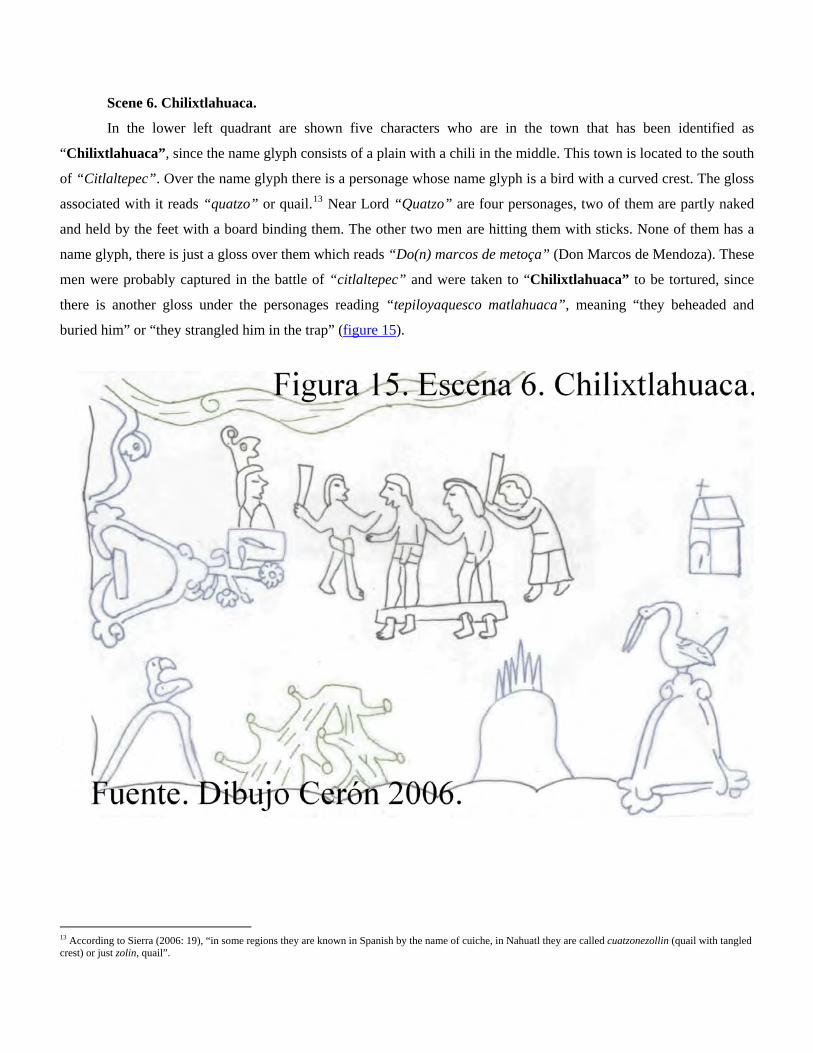
Scene 6. Chilixtlahuaca.
In the lower left quadrant are shown five characters who are in the town that has been identified as
“Chilixtlahuaca”, since the name glyph consists of a plain with a chili in the middle. This town is located to the south
of “Citlaltepec”. Over the name glyph there is a personage whose name glyph is a bird with a curved crest. The gloss
associated with it reads “quatzo” or quail.13 Near Lord “Quatzo” are four personages, two of them are partly naked
and held by the feet with a board binding them. The other two men are hitting them with sticks. None of them has a
name glyph, there is just a gloss over them which reads “Do(n) marcos de metoça” (Don Marcos de Mendoza). These
men were probably captured in the battle of “citlaltepec” and were taken to “Chilixtlahuaca” to be tortured, since
there is another gloss under the personages reading “tepiloyaquesco matlahuaca”, meaning “they beheaded and
buried him” or “they strangled him in the trap” (figure 15).
13 According to Sierra (2006: 19), “in some regions they are known in Spanish by the name of cuiche, in Nahuatl they are called cuatzonezollin (quail with tangled crest) or just zolin, quail”.

Scene 7. The lineage.
The last scene refers to the lineage of the chiefdom of Citlaltepec-Metlatónoc. This lineage is composed of 10
rulers, who appear on the upper part of the document, on one side of the name glyphs which serve as boundary for this
chiefdom (figure 16). All of them are on a petate (reed mat) seat, and are wearing their tiara or royal diadem. The first
lord has as name glyph a snake with a knot in the middle of the body; the name glyph of the next lord consists of a
plant with two leaves, but there is no gloss to clarify his name. The name glyph of the third ruler is confusing, it may
be a plant or a hand. The next lord is named “Estrella” [star]. The fifth lord has a name glyph a sort of plant, while
the sixth ruler is named “Tlacatecotetl” or “Piedra del demonio” [stone of the devil]. The name of the seventh lord is
“Flor” [flower]. The last three noblemen have no name glyph or gloss to identify them.
Final remarks.
The political order shown in this document is important in the colonial history of La Montaña de Guerrero,
because it shows that since Prehispanic times Metlatónoc, Citlaltepec, and Cochoapa were part of a single chiefdom.
These three towns had to unite in order to address both internal and external struggles, which were caused or
accentuated by the Spanish conquest. The power struggle was cause of ill treatment and killings made by Indians and
Spaniards alike, since the protagonists of these fights and abuse seen in scenes 2 and 6 are indigenous people.
In scene 3 the Spaniards are the ones punishing and abusing the Indians, especially the noble ones. This may
be because during the first years of Spanish rule there was a power struggle between the conquerors (members of the
military and friars) and the indigenous noblemen. The latter were in some way obstructing the Spanish conquerors,
since the political and religious power resided in the rulers, and at he same time they were the keepers and
transmitters of the ancient social order. Therefore the rulers were the most fragile and vulnerable members of the
indigenous social structure in front of the Spaniards. On the other hand, the encomenderos were at the bottom of the
new social structure of the European conquerors in New Spain. It is well known that the encomenderos were a threat
to the Crown because they were gaining strength and power by having the indigenous towns under their control. This
greed made them make a series of abuses toward the local populations. However, the local people tried to solve the
situation by making their case to the Spanish authorities by means of “Judiciary Codex”,14 such as the Lienzo de
Aztactepec y Citlatepec. Thus the authorities of Tlapa, which then was the Colonial head town of the La Montaña
region, were the first to give testimony about this document, since their names are written on the document. The
surname Juárez is found in the gloss of scene number 3, pertaining to the alcalde mayor [magistrate who exercises
ordinary jurisdiction in a town] of Tlapa, Lorenzo Juárez de Mendoza de Tlapa (AGN, Ramo Indios Vol. 2 Exp. 16.
1582).
About the abuses perpetrated by the Spaniards against the indigenous people, we have found several
testimonies in documents made by the government of New Spain as well as in documents of indigenous tradition.
Such is the case of a small map which is found together with a colonial record dated 1622 (AGN, Tierras, Volume
3331, expediente 24), pertaining to the town of Tecalpolco, Taxco, Guerrero (figure 17). In this document there is a
request to the authorities that the Indians of Tecalpolco not be mistreated by the travelers who are on the way to
Acapulco. The scribe depicted these mistreatments with a semi-naked man tied to a pole:
14 The study of the various themes present in the judiciary codex, as well as the definition of this concept, can be seen in Ruiz y Valle (1998).


“Joseps de celi for the naturals [i.e. Indians] of the town of los reyes Tecalpolco jurisdiction of Tasco, I say that on the
highway to acapulco [in] the town of san Francisco of the said partido [district] they force with prison and lashes and all kinds of
ill treatments my parties [i.e. the Indians] to give service and food to the travelers, therefore it is truth that many go through the
said town of los reyes and there are so few Indians that they hardly can fulfill in their own town their obligation toward the
travelers which come and go to and from the town of Acapulco and so they are not disturbed and vexed… you may command that
the justice protect them and aware of the above it may not allow [people] to go to the said town more than to their own town, and
that they once again choose a mayor who would protect and defend them from the people from the town of san francisco and from
the same travelers in which they have been with justice don Diego Barrientos” (AGN. Ramo Tierras, Vol. 3331, Expediente 24).
This case is a graphic example of the way in which punishments were used against the Indians, who were kept
naked and tied to a pole. We can see this in the map mentioned above and in the Lienzo de Aztactepec y Citlaltepec.
On the other hand, Indian history has been totally linked with the territory: during the Colonial period the
problems of land boundaries between Metlatónoc, Zitlaltepec, Cochoapa, and other towns were still present. An
example of this is a fight between these three towns and the Jicayan chiefdom during the 18th century (AGN, Ramo
Indios, Vol. 638, Exp. 8). Another important aspect of the history of Metlatónoc and Zitlaltepec is the use they gave to
their lands for cattle raising by the haciendas, which caused agrarian conflicts and the definition of land boundaries
between these towns and their neighbors. About this Dehouve says the following: “there is information about these
haciendas from at least 1660, and they still existed until the years of the Mexican Revolution”. The owners of the
haciendas were from Puebla or Jesuits, and their servants were Indians from Puebla (Dehouve 1994: 98). The same
author later says this:
“...the most important consequences of the activity of these haciendas, among the Indians of the Sierra [mountains] was
connected with land rental. In order to take possession over extensive pasture lands, some towns took legal action against
others, while the “caciques” [chieftains] descended from the pre-Cortesian [i.e. Prehispanic] nobility took advantage of
their rank in order to rent lands to the haciendas. There was a case in which the Indians of Metlatónoc, who were in
conflict with the cacica [female chieftain] of Zitlaltepec, tried to stop the herds from passing and shot more than 14
heads of cattle in 1741” (Ibíd.: 99).
Metlatónoc at present is one of the poorest places in the world, its level of marginalization can be compared
with parts of Africa of extreme poverty, as mentioned above. This situation has made the local inhabitants to be
distrustful and incredulous about the government and outsiders, also creating internal political conflicts, the same as in
past times. For this reason during my stay in Metlatónoc it was virtually impossible to have an interview with the
authorities who deal with agrarian matters and communal properties, which at present are topics of great complexity.
However, I thank all those people who helped me with this research during my stay in La Montaña de Guerrero.

Finally, I would like to point out that the inhabitants of Zitlaltepec had no previous knowledge of the Lienzo, which
used to belong to them centuries ago. Therefore, I gave the town authorities a photographic copy of the document
(figure 18).
ABBREVIATIONS.
RAN. Registro Agrario Nacional.
AGN. Archivo General de la Nación.
FAMSI. Foundation for the Advancement of Mesoamerican Studies.
DOCUMENTS IN ARCHIVES.
AGN, Ramo Indios Vol 2. Exp. 16. 1582.
AGN, Ramo Indios. Vol 638 Exp. 8.

AGN. Ramo Tierras, Vol 3331, Expediente 24.
CARTOGRAPHY.
Anónimo. 1622, Mapa de Tetevtzinco, Santa María la Concepción y Los Reyes Tecalpolco, Taxco. Dimensiones: 41 x 32 cm. Mapa manuscrito indígena. (Mapoteca del AGN, Nº 978/1025). Barrera Alfredo. 1961. Ejido definitivo del poblado de Zitlaltepec. Escala 1: 40, 000. Plano. (Planoteca del RAN, Nº 2037).
BIBLIOGRAPHY.
Acuña Rene. (1984), “Relaciones Geográficas del Siglo XVI. Antequera”, 2nd volume, Serie Antropológicas,
UNAM- I.I.A , México.
Basauri Carlos. (1990), “La población indígena de México.” Volume III, Colección Presencias, Dirección general de
publicaciones de CONACULTA- INI, 2da edición, México. D.F.
Dehouve Daniéle. (1994), “Entre el caimán y el jaguar”, Colección Historia de los pueblos indígenas de México,
Coordinadores Teresa Rojas Rabiela y Humberto Ruz, INI, 1era edición, México.
Del Paso y Troncoso. (1905), “Suma de Visitas de Pueblos por Orden Alfabético.” Papeles de la Nueva España. 2da
Serie Geografía y Estadística, Tomo 1.
Glass John B (1964), “Catálogo de la Colección de Códices”, INAH. México.
Martínez Rescalvo y Obregón Téllez. (1991), “La Montaña de Guerrero. Economía, historia y sociedad.” INI.
Universidad Autónoma de Guerrero.1era edición.
Moyao Morales Eliseo. (1992), “Guerrero. Investigación Básica para la Acción Indigenista.” INEGI.
México.
Ruiz Medrano Ethelia y Valle Perla (1998), “Los Colores de la Justicia. Códices Jurídicos del Siglo XVI. En la
Bibliothèque Nationale de France », Journal de la Société des Americanistes, Tome 84-2, pp 227-241.

Sánchez Alejandro. En Metlatónoc, el municipio más pobre del país, el médico solo receta té de
limón.”[www.cronica.com.mx/nota.php?id_nota=161395]
Sierra León Longega (2006), “La Codorniz. Animal Mítico”, Arqueología Mexicana, Vol XIV, Nº 81, México,
Pp.18-23.
Internet Links.
www.municipios.com.mx/guerrero/mexico-12.html
www.cronica.com.mx/nota.php?id_nota=161395
Flor Yenin Cerón Rojas.
Escuela Nacional de Antropología e Historia. Lic. Etnohistoria.