Embed Size (px)
Citation preview

THE LAVA CAVES OF KHAYBAR, SAUDI ARABIA
JOHN J. PINT UIS Commission on Volcanic Caves
Ceibas 172, Pinar de La Venta, CP 45221 Zapopan, Jalisco, Mexico, [email protected]
(Published in Proceedings, 15th International Congress of Speleology, July 2009, Kerrville, Texas, pp. 1873-1878)
Abstract Harrat Khaybar is a lava field ~12,000 km2 in area, located north of Medina in western Saudi Arabia. Its lavas and volcanoes are mildly alkaline and the age of its flows ranges from five million years old to historic. No speleological studies are known to have been carried out in Khaybar until Dahl Rumahah, a 208-m-long lava tube, located in northern Khaybar, was mapped in 2003. Rumahah was found to contain large quantities of bones of many kinds along with hyena, wolf and fox coprolites as well as a wooden gouging tool. Because calcite-rich water percolated through ceiling cracks, the cave is decorated with calcite stalactites, curtains and flowstone. In 2007, explorers found and mapped Umm Jirsan Lava Tube System, consisting of three passages separated by two collapses. This system has a typical ceiling height of 8 to12 m and some passages as wide as 45 m. With a total length of 1481.2 m, it is the largest surveyed cave system in Saudi Arabia and the longest lava-tube system in the entire Arabian Peninsula. It is expected that much longer systems will be discovered in Harrat Khaybar because Umm Jirsan is only one of some 40 strings of collapses mapped by helicopter in the 1980s. Caches of human and animal bones were found lying on the surface of meter-deep sediment in Umm Jirsan Cave, including a human skull fragment carbon dated at 4040±30 years BP and an unidentified animal bone 2285±30 years old. It is speculated that the surveyed caves may be three million years old, but Harrat Khaybar also has very young lava, such as the flow from Qidr Volcano which is thought to have last erupted in 1800 AD. Numerous cave entrances have been spotted on Qidr and geologists report having observed delicate lava stalactites inside one of them. However, none of these younger caves have yet been mapped. Because of the large number of lava-cave entrances documented and because of archeologically significant findings in the mapped caves, it is suggested that Harrat Khaybar may be one of the world’s most promising sites for vulcanospeleology. 1. Introduction Vulcanospeleology in Saudi Arabia is a young science which probably began in 2001 (Pint, 2006). Since then, maps of seven volcanic caves have been published (Saudi Cave Unit, 2007; Pint, 2009). Because the country has over 80,000 km2 of lava fields—most of difficult access—the discovery of which areas might particularly interest speleologists has been a slow process. An assessment of the speleological potential of one lava field, Harrat Khaybar, was presented in 2006 at the XII International Symposium on Vulcanospeleology (Pint, 2008). New discoveries in 2007 confirmed some of the speculations made earlier and a more accurate and complete exposition of the subject is presented below. 2. Harrat Khaybar Harrat Khaybar is located north of Medina in western Saudi Arabia, between 39° and 41° longitude E and 25°and 26° latitude N (Fig. 1). It has an area of ~12,000 km2. The lavas and volcanoes in Harrat Khaybar are mildly alkaline with low Na and K content and include alkali olivine basalt (AOB), hawaiite, mugearite, benmoreite, trachyte and comendite. The age of the Khaybar lavas ranges from ~5 million years old to historic.
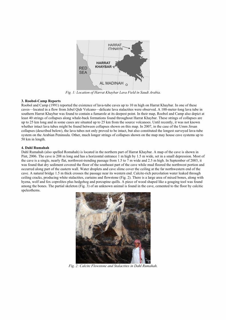
Fig. 1: Location of Harrat Khaybar Lava Field in Saudi Arabia.
3. Roobol-Camp Reports Roobol and Camp (1991) reported the existence of lava-tube caves up to 10 m high on Harrat Khaybar. In one of these caves—located in a flow from Jebel Qidr Volcano—delicate lava stalactites were observed. A 100-meter-long lava tube in southern Harrat Khaybar was found to contain a fumarole at its deepest point. In their map, Roobol and Camp also depict at least 40 strings of collapses along whale-back formations found throughout Harrat Khaybar. These strings of collapses are up to 25 km long and in some cases are situated up to 25 km from the source volcanoes. Until recently, it was not known whether intact lava tubes might be found between collapses shown on this map. In 2007, in the case of the Umm Jirsan collapses (described below), the lava tubes not only proved to be intact, but also constituted the longest surveyed lava-tube system on the Arabian Peninsula. Other, much longer strings of collapses shown on the map may house cave systems up to 50 km in length. 4. Dahl Rumahah Dahl Rumahah (also spelled Romahah) is located in the northern part of Harrat Khaybar. A map of the cave is shown in Pint, 2006. The cave is 208 m long and has a horizontal entrance 1 m high by 1.5 m wide, set in a small depression. Most of the cave is a single, nearly flat, northwest-trending passage from 1.5 to 7 m wide and 2.5 m high. In September of 2003, it was found that dry sediment covered the floor of the southeast part of the cave while mud floored the northwest portion and occurred along part of the eastern wall. Water droplets and cave slime cover the ceiling at the far northwestern end of the cave. A natural bridge 1.5 m thick crosses the passage near its western end. Calcite-rich percolation water leaked through ceiling cracks, producing white stalactites, curtains and flowstone (Fig. 2). There is a large area of mixed bones, along with hyena, wolf and fox coprolites plus hedgehog and porcupine quills. A piece of wood shaped like a gouging tool was found among the bones. The partial skeleton (Fig. 3) of an unknown animal is found in the cave, cemented to the floor by calcitic speleothems.
Fig. 2: Calcite Flowstone and Stalactites in Dahl Rumahah.
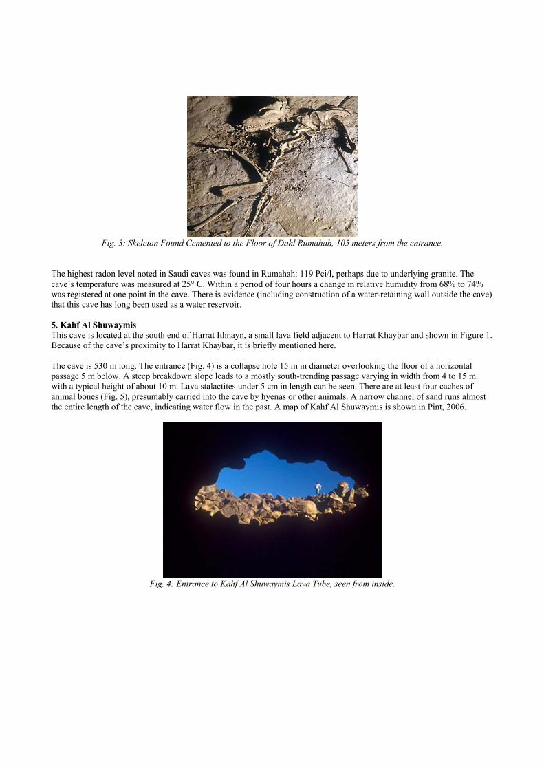
Fig. 3: Skeleton Found Cemented to the Floor of Dahl Rumahah, 105 meters from the entrance.
The highest radon level noted in Saudi caves was found in Rumahah: 119 Pci/l, perhaps due to underlying granite. The cave’s temperature was measured at 25° C. Within a period of four hours a change in relative humidity from 68% to 74% was registered at one point in the cave. There is evidence (including construction of a water-retaining wall outside the cave) that this cave has long been used as a water reservoir. 5. Kahf Al Shuwaymis This cave is located at the south end of Harrat Ithnayn, a small lava field adjacent to Harrat Khaybar and shown in Figure 1. Because of the cave’s proximity to Harrat Khaybar, it is briefly mentioned here. The cave is 530 m long. The entrance (Fig. 4) is a collapse hole 15 m in diameter overlooking the floor of a horizontal passage 5 m below. A steep breakdown slope leads to a mostly south-trending passage varying in width from 4 to 15 m. with a typical height of about 10 m. Lava stalactites under 5 cm in length can be seen. There are at least four caches of animal bones (Fig. 5), presumably carried into the cave by hyenas or other animals. A narrow channel of sand runs almost the entire length of the cave, indicating water flow in the past. A map of Kahf Al Shuwaymis is shown in Pint, 2006.
Fig. 4: Entrance to Kahf Al Shuwaymis Lava Tube, seen from inside.
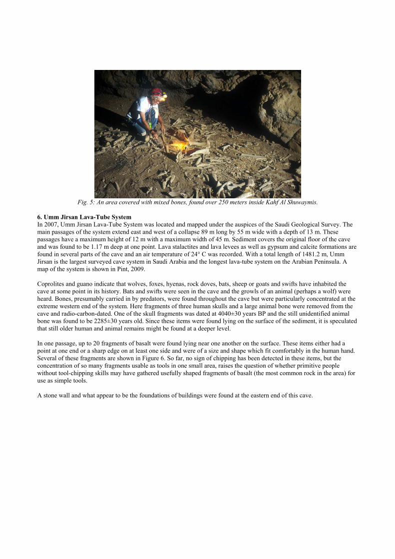
Fig. 5: An area covered with mixed bones, found over 250 meters inside Kahf Al Shuwaymis.
6. Umm Jirsan Lava-Tube System In 2007, Umm Jirsan Lava-Tube System was located and mapped under the auspices of the Saudi Geological Survey. The main passages of the system extend east and west of a collapse 89 m long by 55 m wide with a depth of 13 m. These passages have a maximum height of 12 m with a maximum width of 45 m. Sediment covers the original floor of the cave and was found to be 1.17 m deep at one point. Lava stalactites and lava levees as well as gypsum and calcite formations are found in several parts of the cave and an air temperature of 24° C was recorded. With a total length of 1481.2 m, Umm Jirsan is the largest surveyed cave system in Saudi Arabia and the longest lava-tube system on the Arabian Peninsula. A map of the system is shown in Pint, 2009. Coprolites and guano indicate that wolves, foxes, hyenas, rock doves, bats, sheep or goats and swifts have inhabited the cave at some point in its history. Bats and swifts were seen in the cave and the growls of an animal (perhaps a wolf) were heard. Bones, presumably carried in by predators, were found throughout the cave but were particularly concentrated at the extreme western end of the system. Here fragments of three human skulls and a large animal bone were removed from the cave and radio-carbon-dated. One of the skull fragments was dated at 4040±30 years BP and the still unidentified animal bone was found to be 2285±30 years old. Since these items were found lying on the surface of the sediment, it is speculated that still older human and animal remains might be found at a deeper level. In one passage, up to 20 fragments of basalt were found lying near one another on the surface. These items either had a point at one end or a sharp edge on at least one side and were of a size and shape which fit comfortably in the human hand. Several of these fragments are shown in Figure 6. So far, no sign of chipping has been detected in these items, but the concentration of so many fragments usable as tools in one small area, raises the question of whether primitive people without tool-chipping skills may have gathered usefully shaped fragments of basalt (the most common rock in the area) for use as simple tools. A stone wall and what appear to be the foundations of buildings were found at the eastern end of this cave.

Fig. 6: Items found in the east passage of Umm Jirsan System. Foreground: Pointed or sharp-edged basalt fragments.
Background: basalt rock with mortar-like form. The pen is 12 cm long.
7. Umm Quradi Cave In February of 2003, an attempt was made to survey Dahl Umm Quradi, a lava tube located in southern Harrat Khaybar. Just outside the cave entrance, a member of the team was seriously injured and had to be rescued by helicopter, resulting in the cancellation of the survey. However, it was noted that the cave has a walk-in entrance measuring 2 x 3 m and a vertical (collapse) entrance 4 m in diameter and ca. 5 m deep (Fig. 7). A local geologist estimates the length of this lava tube at 100-200 m and reports seeing entrances to other caves in the area (Pers. com. by Jamal Shawali, 2003).
Fig. 7: Collapse entrance to Dahl Umm Quradi in southern Harrat Khaybar.
8. Collapses on Jebel Qidr Sometime in the late 1990’s, German explorer Uwe Hoffman visited the basaltic stratovolcano Jebel Qidr, located near the center of Harrat Khaybar. At the foot of the volcano, he observed and photographed collapses which appear to be in lava tubes, one of which is shown in Figure 8. In 2004, geologist A. Gregory observed and photographed other such collapses on the flanks of the same volcano. According to Roobol et al. (2002), this volcano may have last erupted in 1800 A.D., suggesting that lava caves in this flow may be among the youngest and most pristine in Saudi Arabia.
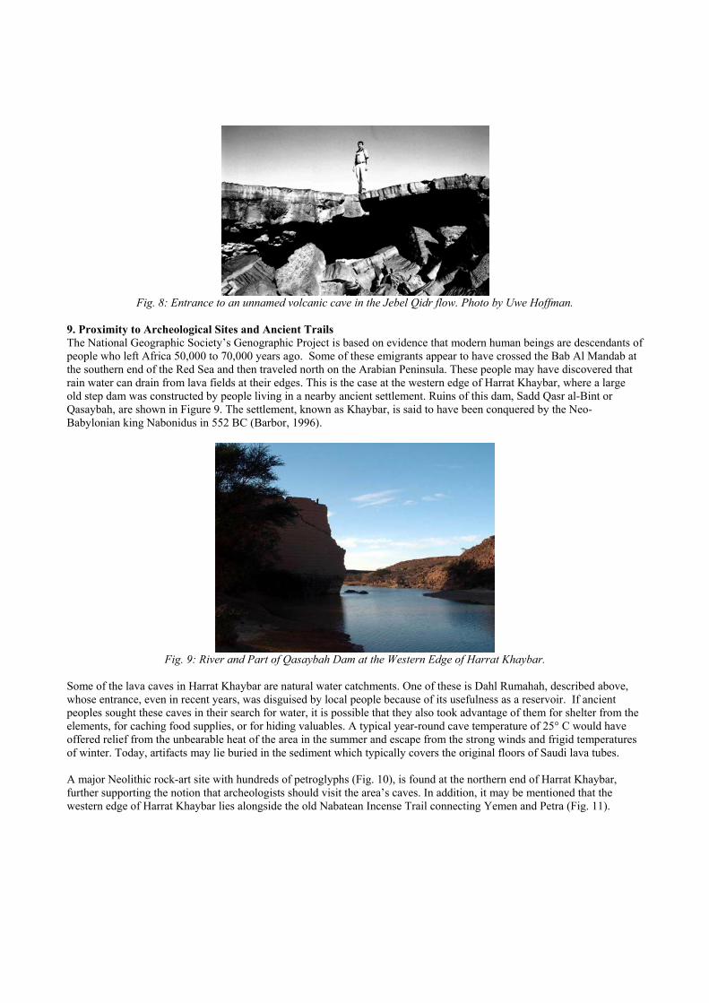
Fig. 8: Entrance to an unnamed volcanic cave in the Jebel Qidr flow. Photo by Uwe Hoffman.
9. Proximity to Archeological Sites and Ancient Trails The National Geographic Society’s Genographic Project is based on evidence that modern human beings are descendants of people who left Africa 50,000 to 70,000 years ago. Some of these emigrants appear to have crossed the Bab Al Mandab at the southern end of the Red Sea and then traveled north on the Arabian Peninsula. These people may have discovered that rain water can drain from lava fields at their edges. This is the case at the western edge of Harrat Khaybar, where a large old step dam was constructed by people living in a nearby ancient settlement. Ruins of this dam, Sadd Qasr al-Bint or Qasaybah, are shown in Figure 9. The settlement, known as Khaybar, is said to have been conquered by the Neo-Babylonian king Nabonidus in 552 BC (Barbor, 1996).
Fig. 9: River and Part of Qasaybah Dam at the Western Edge of Harrat Khaybar.
Some of the lava caves in Harrat Khaybar are natural water catchments. One of these is Dahl Rumahah, described above, whose entrance, even in recent years, was disguised by local people because of its usefulness as a reservoir. If ancient peoples sought these caves in their search for water, it is possible that they also took advantage of them for shelter from the elements, for caching food supplies, or for hiding valuables. A typical year-round cave temperature of 25° C would have offered relief from the unbearable heat of the area in the summer and escape from the strong winds and frigid temperatures of winter. Today, artifacts may lie buried in the sediment which typically covers the original floors of Saudi lava tubes. A major Neolithic rock-art site with hundreds of petroglyphs (Fig. 10), is found at the northern end of Harrat Khaybar, further supporting the notion that archeologists should visit the area’s caves. In addition, it may be mentioned that the western edge of Harrat Khaybar lies alongside the old Nabatean Incense Trail connecting Yemen and Petra (Fig. 11).
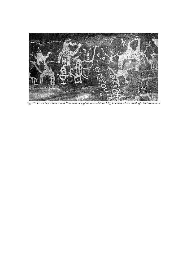
Fig. 10: Ostriches, Camels and Nabatean Script on a Sandstone Cliff Located 22 km north of Dahl Rumahah.

Fig. 11: Map showing the major lava fields of Saudi Arabia and two old caravan trails (after Sabir, 1991).
10. Conclusions 1. Harrat Khaybar offers excellent possibilities for the discovery of many lava caves in its ancient and recent flows. This lava field may house some of the longest lava caves in the world.
2. Archeological surveys of the caves in Harrat Khaybar should be undertaken because of their proximity to archeological sites and ancient migration and trade routes. 11. Acknowledgements The author wishes to thank the Saudi Geological Survey for supporting field trips to Harrat Khaybar and Mamdoah Al-Rashidi, headmaster of the Shuwaymis School System, for his generous hospitality and assistance.
12. References
BARBOR, P. (1996): Desert Treks from Jeddah, Stacey International, p. 16
PINT, J. (2006): Vulcanospeleology in Saudi Arabia. Acta Carsologica 35, 107-119 PINT, J. (2008): Prospects for Lava-Cave Studies in Harrat Khaybar, Saudi Arabia. Proceedings of the X, XI, and XII International Symposia on Vulcanospeleology, AMCS, p. 197-200. PINT, J. (2009): Umm Jirsan: Arabia’s Longest Lava-tube System. Paper accepted for presentation at the 15th International Congress of Speleology. ROOBOL, M.J. AND CAMP, V.E. (1991): Geologic map of the Cenozoic lava field of Harrats Khaybar, Ithnayn, and Kura, Kingdom of Saudi Arabia: Saudi Directorate General of Mineral Resources Geoscience Map GM-131, with explanatory text, 60 p.
ROOBOL, M.J., PINT, J.J., AL-SHANTI, M.A., AL-JUAID, A.J., AL-AMOUDI, S.A. & PINT, S. (2002): Preliminary survey for lava-tube caves on Harrat Kishb, Kingdom of Saudi Arabia: Saudi Geological Survey Open-File report SGS-OF-2002-3, 35 p., 41 figs., 1 table, 4 apps., 2 plates.
SABIR, H. (1991): Map of Old Roads and Water Resources: Saudi Directorate General of Mineral Resources Map BRGM-TR-11-3, Appendix 2.
SAUDI CAVE UNIT (2007): Maps of caves surveyed by Saudi Geological Survey, Kingdom of Saudi Arabia: Saudi Geological Survey Data-File Report SGS-DF-2005-14, 59 p, 58 figs.