Embed Size (px)
Citation preview

ARPA ORDER NL'MBER 189-1
The Land Border of South Vietnam:
Some Physical and Cultural Characteristics
IT. Connors. M.G. Weiner and]. A Wilson
January 1970
R-483-ARPA
A REPORT PREPARED FOR
DECLASSIFIED Authority: EO 12958, as amended Chief, Declass Br, Dir. & Rec. WHS
MAR 1 4 2006
THE ADVANCED RESEARCH PROJECTS AGENCY

This study is prPst>n!Pd as a compPtPnl trt>atmtenl of the suhjt>ct, worthy of publication. Tht> Rand Corporation vout'hcs for the quality of tht> research, without necessarily endor:;ing the opinion~ and conclusions of the authors.
Published by The RAND Corporation

-iii-
PREFACE
The data presented in this Report were collected and organized
as part of a study of the land border of South Vietnam, undertaken
by Rand for the Advanced Research Projects Agency. The parent study,
of which this is a part, is primarily concerned with counterinfiltra
tion systems for South Vietnam. The material presented here should
enable the design and operation of alternative counterinfiltration
systems to be related to the physical and cultural characteristics
of the border.
This detailed description of the South Vietnamese border zone
should be of use in a wide range of related studies. Because of this
broad applicability, this study is being published as a Rand Report.


-v-
SUMMARY
This Report presents a compilation of detailed data on physical
and cultural characteristics of the 1700-km land border of South Viet
nam. The physical data comprise topography, vegetation (types and
density), foot trafficability, movement routes (roads, tracks, trails,
and waterways), and climatology. The cultural data concern the composi
tion and density of the ethnic and tribal populations along the entire
land border.
For convenience of organization and presentation of data, the
border is divided into 107 sectors, each approximately 16 km in length.
A series of maps is presented to indicate the location of each sector
and a summary of its major characteristics.
The detailed data from which these maps were prepared are included
in an appendix, as is a general description of the climatological in
fluences in Southeast Asia.


-vii-
ACKNOWLEDGMENTS
The authors wish to acknowledge the assistance of their Rand
colleagues, Joseph M. Carrier, who provided data on the tribal pop
ulation of the South Vietnamese border, and Charles Schutz, who pre
pared the climatological description presented in Appendix B.

-ix-
CONTENTS
PREFACE ••••••• 0 ••••••••••••••••••••••••••••••••••••••••••••••••• iii
SUMMARY • • • • • • • • • • • • • • • • • • • • • • • • • • • • • ' • • • t • • • • ~ • • • .. • .. • • • • .. • • .. • • • • v
ACKNOWLEDGMENTS ••••••• 0 ......................................... .. vii
LIST OF FIGURES ................................................... xi
LIST OF TABLES . . . . . . . . . . . . . . . . . . . . . . . . . . . . . . . . . . . . . . . . . . . . . . . . . . XV
Section I. INTRODUCTION 1
II. PHYSICAL AND CULTURAL CHARACTERISTICS OF THE BORDER OF SOUTH VIETNAM .•....... , ...•......•..•...•....• , . . 7
Topography ........•••.••.• , • . . . . . . • . . • • • . . . . • . • • . • • • . . . 7 Vegetation . . . . . . . . . . • . . . • . . . . . . . . . . . . . . . . • • . • . • . . . . • • • . 8 Foot Trafficabili ty ..... , ...............•.......... , . , . 13 Population , , ... , . , , , , . , ... , , .... , . , •...• , . • . . . . . . . . . . . . 14 Ethnic Composition and Population ....•........•.....•. , 15 Movement Routes .•. , .. , . , .. , ...... , ...... , ... , . . . . . . . . . . 17
III. SUMMARY OF CHARACTERISTICS ... .. ... . . ..... .. ....... ....... 61
Appendix A. DETAILED DATA ON BORDER-ZONE SECTORS B. CLIMATOLOGY ALONG THE LAND BORDER OF SOUTH VIETNAM ...... .
REFERENCES .... , ..... , ..... , . , .................................. .
65 140
145


1.
2.
3.
4.
5.
6.
7.
8.
9.
10.
11.
12.
13.
14.
15.
16.
17.
18.
19.
20.
21.
22.
23.
24.
25.
26.
27.
28.
29.
30.
31.
32.
33.
-xi-
LIST OF FIGURES
South Vietnam ..........................•....•................
Example of information available for border-zone sectors .... .
Predominant topography of Sectors 1- 23 .................... .
Predominant topography of Sectors 24 - 42
Predominant topography of Sectors 43 - 63
Predominant topography of Sectors 64- 93 ................... .
Predominant topography of Sectors 94- 107 .................. .
Predominant vegetation of Sectors 1- 23 ...............•.....
Predominant vegetation of Sectors 24- 42 .•..................
Predominant vegetation of Sectors 43 - 63
Predominant vegetation of Sectors 64 - 93
Predominant vegetation of Sectors 94- 107 .................. .
Foot trafficability of Sectors 1 - 23 .... , •..•...............
Foot trafficability of Sectors 24 - 42 ...................... .
Foot trafficability of Sectors 43 - 63 ...................... .
Foot trafficability of Sectors 64 - 93 ...................... .
Foot trafficability of Sectors 94- 107 ..................... .
Population density of Sectors 1- 23 ........................ .
Population density of Sectors 24 - 42
Population density of Sectors 43 - 63
Population density of Sectors 64 - 93 ....................... .
Population density of Sectors 94- 107 ..•....................
Ethnic composition of Sectors 1 - 23 ......•..................
Ethnic composition of Sectors 24- 42 ...•....................
Ethnic composition of Sectors 43 - 63 ....................... .
Ethnic composition of Sectors 64 - 93 . , ...••..........•...•..
Ethnic composition of Sectors 94 - 107 ...................... .
Road data for Sectors 1- 23 ...•.•....•....•..........•... •••
Road data for Sectors 24 - 42
Road data for Sectors 43 - 63
Road data for Sectors 64 - 93
Road data for Sectors 94 - 107
. .............................. .
.................. ' ............. .
Tracks-trails data for Sectors 1- 23 .•....•.................
3
4
21
22
23
24
25
26
27
28
29
30
31
32
33
34
35
36
37
38
39
40
41
42
43
44
45
46
47
48
49
so 51
34.
35.
36.
-xii-
Tracks-trails data for Sectors 24 - 42
Tracks-trails data for Sectors 43 - 63
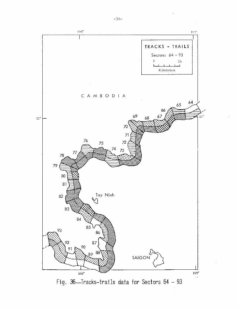
Tracks-trails data for Sectors 64 - 93
52
53
54
37. Tracks-trails data for Sectors 94- 107 ......•.............. 55 38. Waterways in Sectors 1 - 23 . . . . . . . . . . . . . . . . . . . . . . . . . . . . . . . . . 56 39. I.Jaterways in Sectors 24
40. Waterways in Sectors 43
41. I.Jaterways in Sectors 64
42. Waterways in Sectors 94
42 . . . . . . . . . . . . . • . . . . . . . . . . . . . . . . . . 57
63 . . . . . . . . . . . . . . . . . . . . . . . . . . . . . . . . 58
93 . . . . . . . . . . . . . . . . . . . . . . . . . . . . . . . . 59
107 . . . . . . . . . . . . . . . . . . . . . . . . . . . . . . . 60 43.
44.
45.
46.
47.
48.
49.
so. 51.
52.
53.
54.
55.
56.
57.
58.
59.
60.
61.
62.
63.
64.
65.
66.
67.
68.
The border regions of South Vietnam .....•.......•.......••..
Configuration and location of Sectors 1 - 3
Configuration and location of Sectors 4 - 6
Configuration and location of Sectors 7 - 9
Configuration and location of Sectors 10 - 12
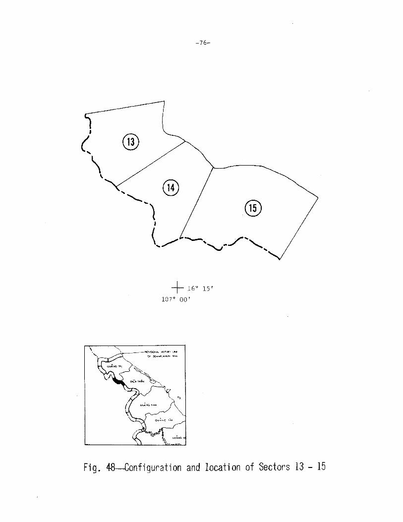
Configuration and location of Sectors 13 - 15
Configuration and location of Sectors 16 - 18
Configuration and location of Sectors 19 - 21
Configuration and location of Sectors 22 - 24
Configuration and location of Sectors 25 - 27
Configuration and location of Sectors 28 - 30
Configuration and location of Sectors 31 - 33
Configuration and location of Sectors 34 - 36
Configuration and location of Sectors 37 - 39
Configuration and location of Sectors 40 - 42
Configuration and location of Sectors 43 - 45
Configuration and location of Sectors 46 - 48
Configuration and location of Sectors 49 - 51
Configuration and location of Sectors 52 - 54
Configuration and location of Sectors 55 - 57
Configuration and location of Sectors 58 - 60
Configuration and location of Sectors 61 - 63
Configuration and location of Sectors 64 - 66
Configuration and location of Sectors 67 - 69
Configuration and location of Sectors 70 - 72
Configuration and location of Sectors 73 - 75
62
68
70
72
74
76
78
80
82
84
86
88
90
92
94
96
98
100
102
104
106
108
no 112
114
116

-xiii-
69. Configuration and location of Sectors 76 - 78 ................ 118
70. Configuration and location of Sectors 79 - 81 ••••••• t ••••••• 120
71. Configuration and location of Sectors 82 - 84 ................ 122
72. Configuration and location of Sectors 85 - 87 'I' t '' e I'' t t ''I 124
73. Configuration and location of Sectors 88 - 90 ............... 126
74. Configuration and location of Sectors 91 - 93 .............. ' 128
75. Configuration and location of Sectors 94 - 96 ............... 130
76. Configuration and location of Sectors 97 - 99 • 't •• I.' I I •••• I 132
77. Configuration and location of Sectors 100 - 102 ............. 134
78. Configuration and location of Sectors 103 - 105 •••••••• .0 •••• 136
79. Configuration and location of Sectors 106 and 107 ........... 138
80. Seasonal rainfall patterns I I'''' t ''lIte' I' e I.e I I.'' e I' t'' I e t 144


-xv-
LIST OF TABLES
1. Topography of the Border Zone................................ 8
2. Distribution of Vegetation Classes in the Border Zone ........ 11
3. Vegetation of the Border Zone ................................ 12
4. Areas of Difficult Trafficability in the Border Zone ......... 14
5. Population Density of the Border Zone ....•...•..............• 15
6. Ethnic Groups and Tribal Population in the Border Zone ....... 16
7. Road Density of the Border Zone ..........•...•............... 18
8. Trails and Tracks Entering the Border Zone ................... 19
9. Waterways of the Border Zone ........•.••.....••..........•.•. 20
10. Summary of Characteristics of Regions in South Vietnamese Border Zone . . . . . . . . . . . . . . . . . . • . . . . . . . . . . . . . . . . . . . . . . . . . . . . . 64
11. Average Seasonal Rainfall Along the Border of South Vietnam ................... , .......................... 142


-1-
I. INTRODUCTION
The land border of South Vietnam is over 1700 km (1070 mi) in
* length and extends from the Gulf of Tonkin to the Gulf of Thailand.
South Vietnam has common borders with North Vietnam, Laos, and Cam
bodia. The border between North Vietnam and South Vietnam is not an
international boundary, but a provisional military demarcation line
that was established by the 1954 Geneva Conference and the Central
Mixed Commission for Vietnam. Ruling No. II of the Commission defines
the line, which is about 75 km long and runs through a demilitarized
zone (DMZ) that varies in width from 6 to 10 km. (2 )
The border between Laos and South Vietnam is defined by a series
of agreements and accords and is over 400 km long. (J)
The border between Cambodia and South Vietnam was established by
treaties negotiated between France and Cambodia in the 19th century
and by decrees of the colonial period (which began in the middle of
the 19th century and ended with the French defeat at Dien Bien Phu
in 1954). Six sections of this border, which is over 1200 km long,
are indefinitely defined or are in dispute. Most of the disputed
areas are small, the largest being about 9 km long and 4 km wide.
There is also a territorial dispute between Cambodia and South Viet
nam over several small islands in the Gulf of Thailand. (4
)
For convenience in collecting and describing data on the physical
and cultural characteristics of the border areas, we have defined a
border zone extending from the border line to a depth of 10 km into
* Based on map measurements using the 1:50,000 scale map of Army Map Service Series L-7014.(1)

-2-
South Vietnam, This border zone is indicated in Fig. 1. The depth of
10 km was chosen because the area within this range incorporates vari
ations in terrain and other characteristics that are generally repre
sentative of the area to a depth of over 30 km, and because 10 km is
close to the maximum range of 105-mm artillery.
The border zone ''as then subdivided into 107 sectors, each 16 km
in length. This sector length allowed aggregation of detail intuitively
determined to be consistent with the reliability of a 1:50,000 scale map
and resulted in a manageable number of sector units. Also, a border
length of 16 km would be within the range of 155-mm artillery if the
artillery were located in the center of the sector. The data presented
in this Report are organized in terms of the 107 sectors, which are num
bered consecutively from the eastern end of the DMZ (Sector 1) to the
Gulf of Thailand (Sector 107).
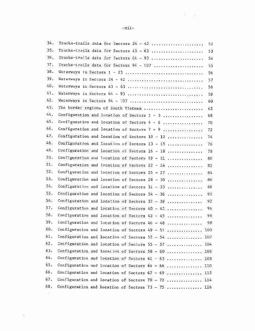
The types of information available for each sector are illustrated
in Fig. 2, using Sector 1 as an example. The characteristics presented -1~
and the sources from \>hich they were taken are described below.
Topography
The following four categories of topography were established on
the basis of relative relief and contour-line density: flat; flat,
subject to inundation; rolling; and rough. The minimum and maximum el
evations (high and lo" points) in each sector were taken from 1:50,000
scale maps and recorded, usually to the nearest 50 m. The frequency of
contour lines in each sector was evaluated from topographical maps.
Vegetation
Fifteen types of vegetation were identified from several map
** sources. The percentage of each type of vegetation in an area was
determined by planimeter measurements on 1:50,000 scale maps. The
planimetered area was then converted to a percentage of the entire
area of the sector.
* The basic data are presented in detail in Appendix A.
** These vegetation types are described in Section II.

-3-
.... ooe·
I \ I
l \
\
T H A I L A N D I
LA 0 s
CAMBODIA
Fig. l--South Vietnam
LEGEND
Border zone Corps boundaries RVN province
boundaries
....
w
:~.(~' w~
_;, F6 ..... '
w
~S) u (0
p 12
G8 p 12
Sector 1
LEGEND
---w------
G,F,P,U 6-10, 12
11
Roads Tracks -trails Waterways Foot trafficability Vegetation type Urban area
Gulf of
Tonkin
~;::t ....
/ \"- j!o \...../" '-"' w ~,... .-' ~ ~
w£ P12 .,.-? / ' ' ,, ./ , I 'L<
;\ \ I/ ,_, .... ~--~ ........ -..1_~ \I , I ----/j~"T ' ' _.. w \. --.<..._. __ ...,---t'!" /o/ / ,\ ,,,, '\ I'\{ II w
11, j.,P" ""''!'..... t__,
,....v I W
_.. w (
........_, I ' I WI I I \'1 ;>"'""~'--.;, ' \
- \ I
Fig. 2--Example of information available for border-zone sectors
I ..,_ I

-5-
Trafficabili ty
Foot trafficability was determined primarily from Tactical Scale
Study maps (S) and Army ~lap Service Series L-7014 maps. (l) The classi
fication into Good, Fair, Poor, and Unsuitable used by the Tactical
Scale Study maps was also used here (seep. 13). The percentage of
trafficability of each type was determined by the use of planimetry,
similar to the technique used for vegetation. Separate measurements
were made for trafficability in wet and dry seasons.
Population
Population data on ethnic Vietnamese and Cambodians in South Viet
nam were obtained from the Hamlet Evaluation System study reported by
H d U S Mil . A . C d V . ( 6 ) Th d ea quarters •. 1 1tary ss1stance omrnan , 1etnam. ese ata
were correlated for each sector by plotting villages and hamlets in
each sector according to the Universal Transverse Mercator grid coor
dinates of the sector. Ethnic minority groups in particular sectors
were identified from map data and reports. Population estimates for
the ethnic minority groups were based on the number of household units
or dwellings multiplied by a factor of 10 occupants per dwelling unit.
Movement Routes
The data on movement routes (roads, tracks, trails, and waterways)
were also obtained from various maps. A numerical count was made of
the roads, tracks (routes capable of being used by animal-drawn carts),
and trails. Waten•ays were divided into two classes, small and large.
Any stream or canal with a width of 50 m or less was considered a small
waterway; those more than 50 m wide were considered large.
Two counts were made for all movement routes: the number of routes
that crossed the border, and the number that crossed the sides or rear
boundaries of each sector.
* Because of the movement and relocation of some of the ethnic minority groups, the estimates of tribal population in each sector should be regarded as crude at best.
-6-
Climatology
The climatological conditions along the land border of South Viet(7)
nam were identified from an earlier Rand study. A general descrip-
tion of these conditions is given in Appendix B.

-7-
II. PHYSICAL AND CULTURAL CHARACTERISTICS
OF THE BORDER OF SOUTH VIETNAM
In this section, the physical and cultural characteristics of
the South Vietnamese border are summarized in tabular form, and a
series of maps is presented for each major characteristic, indicating
the nature of each sector in terms of those characteristics. Data
for each sector were taken from several sources and reduced to nu
merical form. The detailed data sheets are given in Appendix A.
Topography
Each sector of the border zone was classed as one of the four
types defined below:
1. Flat: topography in which there are few contour lines and
little elevation change.
2. Flat, subject to inundation: flat topography in which flood
ing occurs, or swamp or marshland.
3. Rolling: topography in which there are relatively frequent
contour lines but no sharp elevation changes.
4. Rough: topography in which there is a heavy concentration
of contour lines and sharp elevation changes.
Table 1 summarizes the topographical characteristics of the bor
der zone.
About 40 percent of the border zone is flat, and about 60 percent
has rolling or rough topography. The flat areas lie at the extreme
eastern end of the DMZ and along about one-half of the Cambodia-South

-8-
Table 1
TOPOGRAPHY OF THE BORDER ZONE
Type of No. of Percent of Topography Sectors Border
Flat 18 17 Flat, subject to
inundation 26 24 Rolling 32 30 Rough 31 29
Vietnam border, the border zone between Tay Ninh (in III Corps) and
the Gulf of Thailand being flat and subject to inundation. The other
half of the Cambodia-South Vietnam border is almost all rolling ter
rain. The topography of the border with Laos is almost entirely rough. ' *
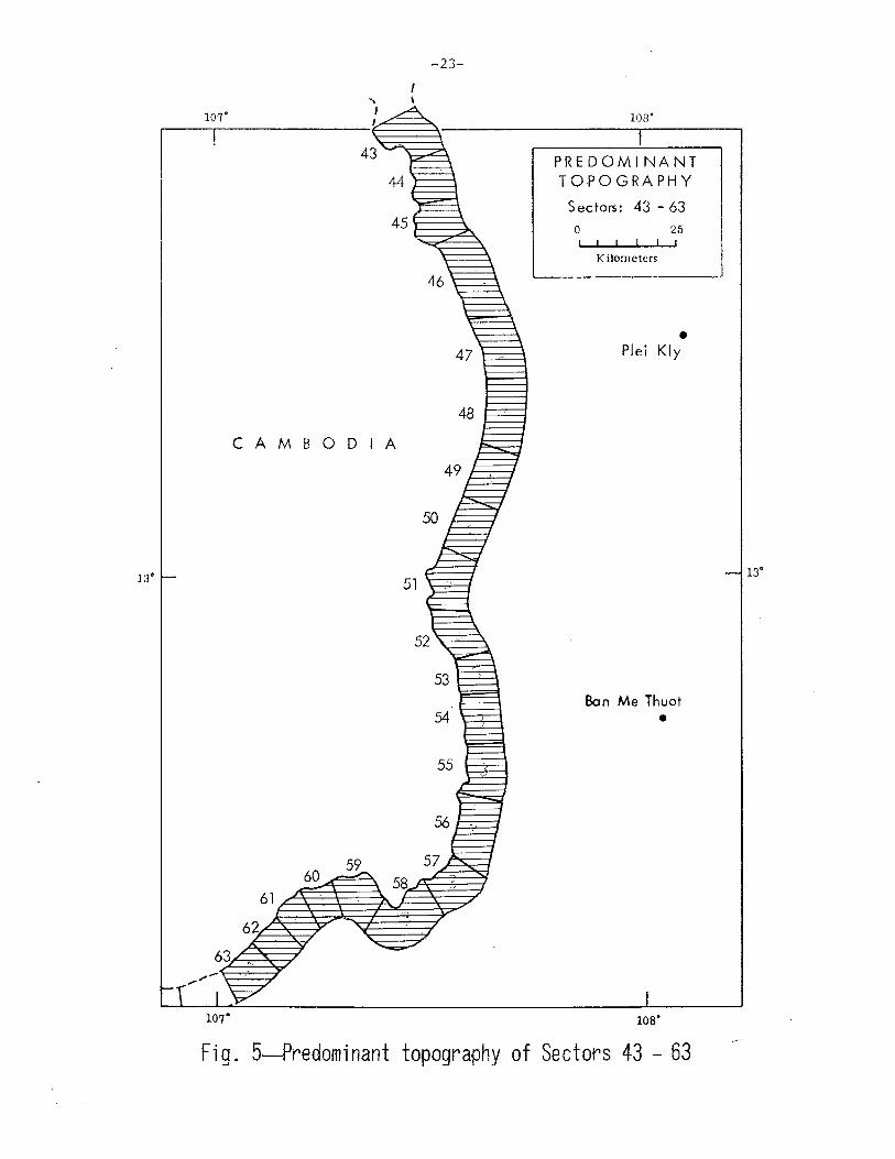
The predominant topography, by sector, is shown in Figs. 3 through 7.
Vegetation
The following fifteen classes of vegetation are found along the
border:
1. Multicanopy forest with dense undergrowth. This type of for
est is a dense, 2- or 3-layered mixture of broad-leafed trees, decidu
ous or evergreen, depending on altitude. The trees are usually from
20 to 30 m in height, with an occasional single tree reaching 50 m.
The crowns of the uppermost layers generally overlap, seeming to form
an impenetrable cover when viewed from directly above, but appearing
somewhat less dense on hillsides or adjacent to cleared areas when
viewed obliquely. Tree trunks are from 0.5 to 1.5 min diameter and
are generally spaced 2 to 3 m apart. Undergrowth is dense, particu
larly where sunlight reaches the forest floor, such as along waterways.
Some elephant grass is found along stream courses in hilly areas.
2. Multicanopy forest with dense undergrowth and bamboo. This
type of vegetation is similar to type 1, except that it also includes
* Maps depicting _border-zone characteristics are grouped at the end of this section. Figures 3 through 7 are located on pp. 21 - 25.
-9-
dense clumps of bamboo, particularly in the low valleys. The stems
of the most common variety of bamboo are from 1 to 5 in. in diameter
and from 3 to 15 m in height. Bamboo grows in tight clumps between
0.6 and 1.0 min diameter, which in dense undergrowth are generally
spaced about 3 m apart.
3. Multicanopy forest with light undergrowth. Except for the
amount of undergrowth, this class of vegetation is identical to type 1.
4. Single-canopy forest with dense undergrowth and galleries.
The single-canopy forest consists primarily of deciduous trees form
ing a more-or-less discontinuous cover. The trees vary from 4 to 25
m in height, depending on their location; their diameter varies from
0.2 to 0.8 m. The density of the trees varies considerably, also de
pending on the situation, but a spacing of from 5 to 10 m is common.
Undergrowth is similar to that found in multicanopy forests. Inter
mittent grass areas often contain "gallery" forests, i.e., relatively
dense rows of trees bordering the stream courses, so named because the
crowns of the bordering trees often overlap.
5. Single-canopy forest with light undergrowth and bamboo. This
type of vegetation is similar to type 4, except for the presence of
bamboo and the difference in density of undergrowth.
6. Single-canopy forest with light undergrowth, rubber and palm
plantations. The trees in rubber plantations are generally 10 to 20 m
in height and have trunk diameters of 24 to 30 em. Spacing between
trees varies from 3 to 5 m, with rows about 8 m apart. The crowns
of the trees quite often touch, forming a closed canopy. Undergrowth
density varies from very light to fairly heavy, depending on the level
of activity on the plantation. Palm plantations consist of coconut
trees averaging 25 to 30 m in height and having diameters of from 0.4
to 0.5 m. The trees are generally spaced 5 m or more apart, with the
area between them clear of undergrowth, unless the trees have been
abandoned, in which case a dense undergrowth can occur.
7. Brushwoods and coffee and tea plantations. This class of
vegetation consists of natural low undergrowth and coffee and tea
bushes in plantations. The natural brush--grasses, brush, and scrub
deciduous trees--varies in height from 1 to 3 m. It is often found

-10-
on abandoned slash-and-burn plots, along stream courses, and on some
foothills. Coffee and tea plantations consist of bushlike plants from
3 to 15 m in height. The larger coffee plants are laid out in parallel
rows about 5 m apart, while the small tea plants are generally planted
in rows 1.2 m apart.
8. Dune grass, and casuarina on sand. This type of vegetation,
which consists of a mixture of grass, brush, and (occasionally) thickets
of date palms and stands of small trees, is often found in beach areas.
(Casuarina is a small scrub pine from 3 to 4 m in height, often found
on beach ridges.)
9. Sugar-cane plantations. Sugar cane can form very dense stands
of closely meshed leafy stems, varying in ·height with the stage of
growth but capable of reaching over 4 m.
10. Dry crops, open areas, pineapple plantations, and upland rice.
This category includes open meadows, grass areas, and a number of dif
ferent crops. Most of these crops, such as taro, beans, sweet potatoes,
and pineapples, are relatively low to the ground. On the other hand,
some of the crops, such as corn, tobacco, sugar cane, and the grasses,
can reach to a height of 4 m.
11. Urban-area vegetation. This category includes the trees,
grasses, shrubs, and crops associated with dwelling areas. Fruit trees,
such as banana and coconut trees, and vegetable plots and gardens are
often found in and around individual houses.
12. Rice, single crop. This category consists of irrigated rice
grown in fields surrounded by dikes 1 to 3 m high. The rice plants
are planted in rows and vary in height from 1 to 1.5 m at maturity.
The fields remain covered with at least 0.15 m of water until 2 to 6
weeks before harvest. At harvest time, the rice is stacked in the
field in bundles. During the dry season the fields are either left
in stubble or planted in dry crops.
13. Swamps, inundated brushwoods, and saline areas. This type of
vegetation is characterized by dense reeds and grass and brushwoods
subject to seasonal inundations. The grasses and reeds can grow to
a height of.2 m.

-11-
14. Fresh-water swamp. Grasses, shrubs, and trees, many with
aerial root systems, comprise this category. The proportion of each
type of plant depends on the particular situation.
15. Marsh. This vegetation category includes bushes, reeds,
floating aquatic plants, and grasses in perennially wet or inundated
lowlands. The average height of the grasses and reeds varies from
1 to 2 m.
The percentage of the border zone covered by each type of vege
tation is shown in Table 2.
Table 2
DISTRIBUTION OF VEGETATION CLASSES IN THE BORDER ZONE
Vegetation Class
1. Multicanopy forest with dense undergrowth 2. Multicanopy forest with dense undergrowth
and bamboo 3. Multicanopy forest with light undergrowth 4. Single-canopy forest with dense undergrowth
and galleries 5. Single-canopy forest with light undergrowth
and bamboo
6. Single-canopy forest with light undergrowth, rubber and palm plantations
7. Brushwoods and coffee and tea plantations 8. Dune grass, and casuarina on sand 9. Sugar-cane plantations
10. Dry crops, open areas, pineapple plan-tations, and upland rice
11. Urban-area vegetation 12. Rice, single crop 13. Swamps, inundated brushwoods, and saline
areas 14. Fresh-water swamp 15. Marsh
Percent of Border Zone
46.0
2.0 < 1.0
< 1.0
3.0
13.0 10.0
< 1.0 < 1.0
2.0
< 1.0 12.0
1.0 < 1.0
9.0

-12-
The fifteen classes of vegetation fall into four main types:
1. Grassland or plantation vegetation which does not generally
grow to great heights and which is not usually found in areas
subject to inundation (includes classes 7, 8, 9, 10, and 11). 2. Riceland or marsh and swamp vegetation found in areas subject
to inundation (includes classes 12, 13, 14, and 15).
3. Single-canopy forest (includes classes 4, 5, and 6).
4. Multicanopy forest (includes classes 1, 2, and 3).
Based on this categorization, each border sector can be classified
in terms of its predominant vegetation. A summary of the vegetation in
the border zone is presented in Table 3.
Table 3
VEGETATION OF THE BORDER ZONEa
No. of Type of Vegetation Sectors
Cropland (dry) 7 Riceland or marsh (wet) 26 Single-canopy forest 14 Multicanopy forest 60
Percent of Border
7 24 13 56
aThese data differ slightly from those in Table 2 for several categories. This results from considering only the predominant vegetation type in each sector.
Figures 8 through 12 (pp. 26 - 30) show the predominant type of
vegetation in each sector. Comparison of these maps with the topogra
phy maps (Figs. 3 through 7) indicates the expected general relation
ship between topography and vegetation, i.e., the flatlands tend to be
crop areas and the areas of rolling and rough topography tend to be cov
ered with single-canopy or multicanopy forest.

-13-
Foot Trafficability
Foot trafficability refers to the suitability of the ground sur
face for movement on foot. This measure combines topography, vegeta
tion, the presence of surface water, and other natural factors. For
this study, the four-part classification of the Tactical Scale Study
maps was used. (S) This classification defines trafficability as fol
lows:
1. Good: " ... conditions do not significantly hinder progress
or moderately restrict choices of direction of movement."
2. Fair: " ... conditions moderately hamper progress or moder
ately restrict choices of direction of movement."
3. Poor: " ... conditions severely hinder progress or greatly
restrict choices of direction of movement."
4. Unsuitable: " ... conditions preclude all but local movement."
Areas within each sector were designated as G, F, P, or U, as
illustrated in Fig. 2; these areas were then measured by planimeter
and the values converted into percentages of the total area of the
sector. Measurements and conversion were done for foot trafficability ;'\
in both the wet and dry seasons.
A preliminary analysis of the planimetered foot-trafficability
data indicated that they could be visually represented best by com
bining the "poor" and "unsuitable" terrain into a single composite
type and then indicating the percentage of that type occurring in
each sector. All the remaining terrain--"good" and "fair"--was then
considered as being trafficable with minimum difficulty. The advan
tage of this simplified categorization is that it provides a more
quantitative measure of the infiltration potential of each sector
than would be possible by simply identifying the dominant level of
trafficability, as was done with types of vegetation. For studies
of infiltration, as contrasted to more-or-less conventional military
movement, it is doubtful that "unsuitable" is a particularly meaning
ful term.
* The percentages for each sector are presented in Appendix A.

-14-
Table 4 shows the distribution of the difficult-trafficability
areas for both the wet and the dry season.
Table 4
AREAS OF DIFFICULT TRAFFICABILITY IN THE BORDER ZONE
Percent of Sector No. of Sectors Percent of Border Comprising Poor and Wet Dry Wet Dry Unsuitable Terrain Season Season Season Season
Less than 10 4 7 4 6 10 to 39 7 17 7 16 40 to 70 14 19 12 18 More than 70 82 64 77 60
Table 4 indicates that between 60 and 77 percent of the border
zone, depending on the season of the year, is primarily poor or un
suitable (i.e., difficult) for foot trafficability. Only 4 to 6 per
cent of the border zone contains less than 10 percent of difficult
terrain and hence can be considered trafficable with minimum diffi-
culty.
The distribution of difficult terrain in each sector is shown in
Figs. 13 through 17 (pp. 31- 35).
Population
The population of the South Vietnam border zone is a mixture of
ethnic Vietnamese, tribal and religious groups, and Vietnamese with
Cambodian backgrounds. The population density is highly variable,
with some portions of the Laos-South Vietnam border being essentially
uninhabited and some sections of the Cambodia-South Vietnam border
having populations of over 400 inhabitants per square kilometer.
For this study, data on the ethnic Vietnamese and Cambodian
* groups were primarily obtained from Ref. 6; data on minority groups,
* Population data are subject to variation because of continual population movement and displacement.

-15-
particularly on the Montagnard tribes of the highland areas, were
taken from various studies and maps.
The population in the border zone is close to 500,000, the major
concentrations occurring at the eastern end of the DMZ and in the area
between Tay Ninh and the Gulf of Thailand. Table 5 summarizes the num
bers of sectors having various population-density levels. The density
ranges for each sector are shown in Figs. 18 through 22 (pp. 36- 40).
Table 5
POPULATION DENSITY OF THE BORDER ZONE
Population Density No. of Percent of (inhabitants/sq km) Sectors Border
Less than 20 86 80 20 to 100 11 11
101 to 200 3 3 201 to 300 5 4 ~1 to 400 1 1 More than 400 1 1
Ethnic Composition and Population
The border areas of South Vietnam, particularly in the Laos-South
Vietnam border and the portions of the Cambodia-South Vietnam border
north of Tay Ninh province are largely inhabited by ethnic minority
* groups. The precise tribal areas of the border are not clearly delim-
ited, and some movement of the tribal groups occurs continuously.
The major ethnic groups of the border zone and estimates of tribal
** populations of the border sectors are presented in Table 6, Tribal-
population data are pre-1964, i.e., before the intensification of mil
itary activities in Vietnam. Tribal-population estimates for each
* These groups are described in Refs. 8 through 11.
** It was not possible to determine from the available data how much overlap there is between the data of Ref. 6 and those in Table 6, Spot checks indicate that a large part of the ethnic minority population of the border sectors is not included in the data of Ref. 6.

-16-
sector were derived by counting the number of house symbols on the Army
Map Series L-7014 maps and then multiplying them by 10 (an estimated
number of inhabitants per household). This factor is probably conser
vative; the actual number of household residents is no doubt higher,
based on descriptions of tribal life, but some units have been aban
doned during the course of the Vietnamese war. The tribal population
in each sector is given in Appendix A.
Table 6
ETHNIC GROUPS AND TRIBAL POPULATION
IN THE BORDER ZONE(l,B-ll)
Group Symbol a Population
Vietnamese v ... Cambodian c ... Brou BR 9,650 Pacoh PA 2,900 Phuong PH 2, 800 Katu KA 1,900 Jeh JE 1,900 Kayong KG 1,600 Jarai JA 6,600 Rhade RH 500 Mnong MW 5,100 Stieng ST 4,900 Unknown u 900
Total ... 38,750
aUsed in ethnic-composition maps (Figs. 23 through 27).
The ongoing war has brought about many changes in ethnic popula
tions, including the following:
1. An estimated 7,500 Jeh and Sedang tribesmen have become ref
ugees and moved from the border area.
2. An estimated 12,000 Brou tribesmen were relocated because of
the fighting in the Khe Sanh area.

-17-
3. An estimated 8,000 Jarai were relocated to regions away from
the border in 1967 and 1968.
4. An unknown number of Stieng, Mnong, and Katu have relocated
to regions away from the border.
Because of these and other changes, data on the locations of eth
nic minority tribes and estimates of their population in the border
zone cannot be accepted with high confidence.
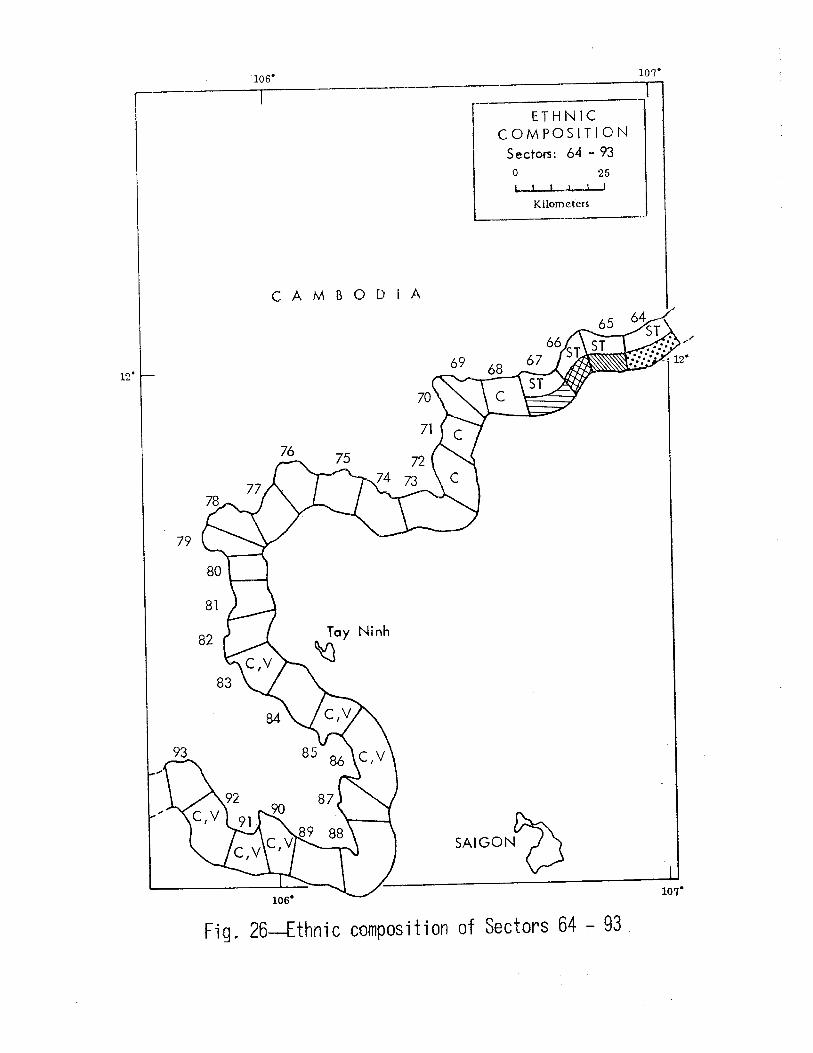
Figures 23 through 27 (pp. 41 - 45) show the occupying ethnic
group(s) of each sector and, where there are tribal populations, their
density. No density designations are included for nontribal sectors.
Movement Routes
There are three major types of movement routes in the border zone:
roads, tracks and trails, and waterways. Using available data, we have
identified and counted these routes; however, this count can be consid
ered only a rough approximation of the actual number, for several rea
sons: (1) The only maps available for some portions of the border were
several years old. (2) It is likely that some trails and ,,,aterways are
not included on the available maps. (3) Some additional trails or tracks
have undoubtedly been created since the source maps were published.
Two forms of data were used for all of the movement routes, a count
of the routes crossing the border into each sector and a count of the
routes entering each sector on its remaining three sides. In a general
sense, the routes crossing the border represent potential avenues for
infiltration, and those crossing the other sides of the sectors repre
sent potential avenues either for leaving the sector or for gaining
access to the sector (e.g., by forces attempting to intercept the in
filtrators on surface routes).
Roads
A road is defined as any movement route with adequate 1•idth and
surface to support motorized vehicles at some time of the year. Most

-18-
of the roads are designated by route numbers of the national, provin
cial, interprovincial, etc., highway system of South Vietnam. The
data on road density are summarized in Table 7.
Table 7
ROAD DENSITY OF THE BORDER ZONE
Roads Crossing Border Roads Entering Sector No. of No. of Percent of No. of Percent of Roads Sectors Border Sectors Border
0 80 75 52 49 1 to 2 25 23 32 30 3 to 5 2 2 19 18 More than 5 0 0 4 3
As indicated in Table 7, about 75 percent of the sectors have no roads
that cross the border--and another 23 percent have only one or two roads
crossing the border. However, about 51 percent of the sectors have at
least one road that exits from them, and over 21 percent of the sectors
have three or more exit roads. In other words, there are more roads that
permit access to the border sectors from inside the country than from out
side.
Figures 28 through 32 (pp. 46 - 50) present the data on numbers
of roads in the border zone. Access to the border from either side is
generally sporadic, the larger number of roads being in the Cambodia
South Vietnam border zone, particularly opposite Saigon.
Trails and Tracks
Trails and tracks are defined as movement routes whose widths or
surface conditions do not usually permit the passage of motorized ve
hicles. Trails are generally about 1 m wide and are used primarily
for foot traffic; tracks are generally about 1 to 3 m wide and can be
used for animal-drawn vehicles. As indicated earlier, the available
data are very unreliable, since the number of trails or tracks can
change rapidly, as new ones are easily established.

-19-
Available maps show about 650 trails or tracks crossing the bor
der. The distribution of these routes is summarized in Table 8, and
data for the individual sectors are presented in Figs. 33 through 37
(pp. 51- 55).
Table 8
TRAILS AND TRACKS ENTERING THE BORDER ZONEa
Trails/Tracks Trails /Tracks Crossing Border Entering Sector
No. of Percent of No. of Percent of Number Sectors Border Sectors Border
0 13 12 4 4 1 to 4 42 40 20 19 5 to 9 26 24 10 9
10 to 18 21 20 46 44 19 to 25 3 3 8 7 More than 25 1 1 18 17
aNo data are available on Sector 107.
The data on trails and tracks reflect a somewhat different pic
ture than do the road data. Not only are there many more trails and
tracks than there are roads, but with a few exceptions (13 out of 106
sectors) there are tracks or trails crossing the border into every
sector, as indicated in the tracks/trails maps. Also, some sectors
are shown to have more movement routes crossing the border than routes
entering or exiting the sector. While part of this apparent differ
ence may be the result of inadequacies in the available data, it may
be that some of the ethnic minority groups along the border have de
veloped trails to cross the border, while there is little movement
laterally or toward the interior of the country.
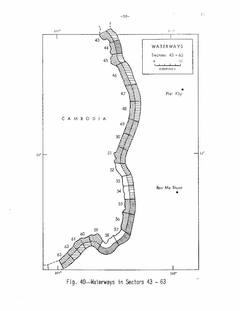
Waterways
The waterways in the border area of South Vietnam range from large
* rivers, such as the Mekong, to small, intermittent streams. For this
* Intermittent streams were not considered to be potentially sig-nificant waterways for movement and hence were not included in the waterway count.

-20-
study, waterways were divided into two groups: (1) large waten•ays,
defined as permanent streams or canals, 50 m or more in width, enter
ing, or themselves comprising, one of the boundaries of a sector; and
(2) small waterways, defined as all permanent streams or canals less
than 50 m wide. (The numbers of large and small permanent streams in
each sector are given in Appendix A.) Table 9 and Figs. 38 through 42
(pp. 56 - 60) show the overall distribution of waterways (large and
small combined).
Table 9
WATERWAYS OF THE BORDER ZONE
Waterways Waterways Crossing Border Entering Sector
No. of Percent of No. of Percent of Number Sectors Border Sectors Border
0 47 44 7 6 1 to 4 45 42 42 40 5 to 9 7 6 29 27
10 to 18 6 6 13 12 19 to 25 1 1 3 3 More than 25 1 1 13 12

17.
\
' '\ \ \
N 0 R T H
VIETNAM
,_ r '-- I
I
6
L A 0 S
-21-
107.
16. !-----------------,
LEGEND (All maps of topography)
~· ...... 1 .......
Flat
Flat 1 subject to inundation
Rolling
Rough
107°
23
PREDOMINANT TOPOGRAPHY
Sectors: 1- 23 0 25
I I I I
Kilometers
Gulf of
Tonkin
Hue
Fig. 3-Predominant topography of Sectors l - 23
16°

15"
107° ,-I I I '-
L A 0 S
CAMBODIA
-22-
40
41
42
107°
' \ '\
'--,0 \ ' )
ws·
PREDOMINANT TOPOGRAPHY
Sectors: 24 - 42 0
I I t I
K ilomcters
• Kontum
Pleiku •
108.
25
Fig. 4--Predominant topography of Sectors 24 - 42
15°
13°
., 107" I
I
43
44
45
CAMBODIA
59 60 58
61
62
63
107°
-23-
46
47
48
49
50
57 "
los·
PREDOMINANT TOPOGRAPHY
Sectors: 43 - 63
0 25
Kilometers
• Plei Kly
Ban Me Thuot
•
1os·
fig. 5-Predominant topography of Sectors 43 - 63
13°

12"
-24-
106.
CAMBODIA
PREDOMINANT TOPOGRAPHY
Sectors: 64 - 93 0 25
I I t I
Kilometers
SAIGONO
Fig. 6--Predominant topography of Sectors 64 - 93
107°
12°

n•
1o·
-25-
105.
CAMBODIA
Gulf of
Thailand
1os·
PREDOMINANT TOPOGRAPHY
Sectors: 94 - 107 0 25 ....,_.,_.....~be~
Kilometers
Long Xuyen
•
Fig. ?-Predominant topography of Sectors 94 - 107
1o·

N 0 R T H
VIETNAM
6
7
9
L A 0 S
16" ~--------------------~
LEGEND (All maps of vegetation)
I I Crop Ia nd (dry)
:;·:·:·:·:·:·:1 Rice, etc . t t I I I I I •
I I Single-canopy forest
Multi canopy forest
107°
-26-
107"
23
PREDOMINANT VEGETATION
Sectors: 1- 23 0 25
I I I I
Kilometers
Gulf of
Tonk in
Hue
Fig. 8-Predominant vegetation of Sectors 1 - 23
17°
16"

15"
-27-
107"
L A 0 S
32
CAMBODIA
', \ \
'--.._~ t ' )
107"
108"
PREDOMINANT VEGETATION
Sectors: 24 - 42 0
I I I I
Kilometers
• Kontum
Pleiku •
108.
25
Fig. 9--Predominant vegetation of Sectors 24 - 42
15 •

13°
-28-
43
45
CAMBODIA
49
50
107°
los·
PREDOMINANT VEGETATION
Sectors: 43 - 63 0 25
I I I I
Kilometers
• Plei Kly
Ban Me Thuot •
1os·
Fig. 10-Predominant v€getation of Sectors 43 - 63
13°

12°
-29-
106'
CAMBODIA
PREDOMINANT VEGETATION
Sectors: 64 ·· 93 0 25
I I I I
Kilometers
Fig. 11--Predominant vegetation of Sectors 64 - 93
107"

11"
10'
-30-
105'
CAMBODIA
Gulf of
Thailand
105'
PREDOMINANT VEGETATION
Sectors: 94 - 107 0
I I I I
K ilomelPrs
Long Xuyen 0
25
Fig. 12--Predominant vegetation of Sectors 94 - 107
' '
10"

17"
16.
N 0 R T H
VIETNAM
7
L A 0 S
LEGEND (All maps of trafficability) Percent of poor or unsuited
terrain
Border
E:3 Wet season Dry season
<10
~::;:;:;:;:;:~ 10-39
1 1 4o -7o ~ >70
-31-
107"
FOOT TRAFFICABILITY
Sectors: 1- 23 0 25
I I ! I
Kilometers
Gulf of
Tonkin
Hue
107°
Fig. 13--foot trafficability of Sectors l- 23
16°

15.
-32-
10'7°
24
L A 0 S
CAMBODIA
', \ \
'----~ \ \ )
107°
31
1os•
FOOT TRAFFICABILJTY
Sectors: 24 - 42 0 L I I I I
Kilometers
• Kontum
Pleiku •
108.
25
Fig. 14-Foot trafficability of Sectors 24- 42

13°
-33-
107°
CAMBODIA
51
107°
1os·
FOOT TRAFFICABILITY
Sectors: 43 - 63 0 25
1 I I I
Kilometers
• Plei Kly
Ban Me Thuot •
1os·
Fig. 15--Foot trafficability of Sectors 43- 63
13°

-34-
106° 107°
FOOT TRAfFICABILITY
Sectors: 64 - 93 0 25
I I 1 I
Kilome!ers
CAMBODIA
12°
SAIGONO
107"
Fig. 16--foot traffi cab il ity of Sectors 64 - 93

n•
1o·
-35-
los·
CAMBODIA
Gulf of
Thailand
105°
FOOT TRAFFICABI LITY
Sectors: 94 - 107 0 25
Kilometers
Long Xuyen
•
Fig. 17--Foot trafficability of Sectors 94- 107
10°

)7'
16'
\
' \ \
N 0 R T H
VIETNAM
\
6
7
L A 0 S
LEGEND (All population maps)
People per sg. km.
I I r············3 ....... . . . . . .
' ! •••••
I I ~ ~ t~~~~~~~~m~~~mm
< 20
20-100
101 -200
201 -300
301 -400
< 400
-36-
107'
107°
POPULATION
Sectors: 1- 23 0 25
\
I I I I I
Kilometers
Gulf of
Tonkin
I \ \~\ -, \
\ '
Hue
'~;-- .....
\., ./', ,,.,"(
Fig. IS--Population density of Sectors l - 23
l
17°
16'

15"
-37-
107°
24
LA 0 S
CAMBODI
', \ \
'--,~ \ \ )
1os·
POPULATION
Sectors: 24 - 42 0
I I I I
Kilometers
• Kontum
Pleiku •
108.
25
Fig. 19--Population dBnsity of SBctors 24 - 42
15°

13°
-38-
107°
CAMBODIA
51
107°
1os·
POPULATION
Sectors: 43 - 63
0 25 I I I I
Kilometers
• Plei Kly
Ban Me Thuot •
108"
Fig. 20--Population density of Sectors 43 - 63
13"

-39-
106" 107"
POPULATION
Sectors: 64 - 93 0 25
I I
Kilometers
CAMBODIA
12"
Fig. 21--Population density of Sectors 64 - 93

11"
10"
-40-
1os·
CAMBODIA
Gulf of
Thailand
103
105"
POPULATION
Sectors: 94 - 107 0
Kilometers
Long Xuyen
•
25
Fig. 22-Population density of Sectors 94 - 107
10°

-41-
107'
N 0 R T H
V I E T t'-1 A M
17'
7
L A 0 S
LEGEND* (All ethnic composition maps)
Tribal popu I at ion density per sq. km. 16'
Ethnic identification Population density
< 1
1 -3
3-6
6-10
10-15
> 15
* Ethnic symbol from Table 6
107"
ETHNIC COMPOSITION
Sectors: 1- 23 0 25
I I I I
Kilometers
Gulf of
Tonk in
Hue
Fig. 23--Ethnic composition of Sectors 1 - 23
16'

1.5° -
107"
24
L A 0 S
CAMBODI
107"
-42-
' ' \ \
'--"~ \ \ )
108"
ETHNIC -1 COMPOSITION
Sectors: 24 - 42 0
I I t I
Kilometers
• Kontum
Pleiku •
108.
25
Fig. 24-Ethnic composition of Sectors 24 - 42
15"

13°
-43-
107"
45
CAMBODIA
51
52
53
54
107"
ws·
ETHNIC COMPOSITION
Sectors: 43 - 63 0 25
K ilorneters
• Plei Kly
Ban Me Thuot •
1os·
Fig. 25--Ethnic composition of Sectors 43 - 63
. 13"
12.
los·
CAMBODIA
ETHNIC COMPOSITION
Sectors: 64 - 93
0 25 I l 1 I
Kilometers
Fig. 26--Ethnic composition of Sectors 64 - 93
107.

n·
1o· -
-45-
los·
CAMBODIA
Gulf of
Thailand
1os•
ETHNIC COMPOSITION
Sectors: 94 - 107 0 25
Kilometers
Long Xuyen
•
Fig. 27--Ethnic composition of Sectors 94- 107
; /
' \
1o·

N 0 R T H
v I E T N A M
17"
6
7
L A 0 S
16" - LEGEND
(All road-data maps)
c==J Crossing border ~ Entering sector
Number of roads
0
1:::::;:::::::~ 1 -2
l I 3-5
~ Over 5
-46-
107"
107"
ROADS
Sectors: 1-23 0 25
I I I I
Kilometers
Gulf of
Tonk in
\ ',~,
I ' -, \ \ '
Hue
\~1-- ... \." _/1 \.
"·/'(
Fi~. 28--Road data for Sectors l - 23
17°
16°

15"
-47-
107°
L A 0 S
CAMBODIA
107"
1os·
ROADS
Sectors: 24 - 42 0
I 1 I I
Kilometers
• Kontum
Pleiku •
108.
25
Fig. 29--Road data for Sectors 24 - 42
15"

107"
13°
107"
-48-
CAMBODIA
108"
~------~----~ l ROADS
Sectors: 43 - 63
0 I I I I
Kilometers
25
• Plei Kly
Ban Me Thuot
•
108"
Fig. 30--Road data for Sectors 43 - 63
13"

-49-
106" 107°
ROADS
Sectors: 64 - 93
0 25 I I I I
Kilometers
CAMBODIA
12°
fig. 31--Road data for Sectors 64 - 93

11"
w·
-so-
105°
CAMBODIA
Gulf of
Thailand
105"
ROADS
Sectors: 94 - 107 0
Kilometers
Long Xuyen
•
25
Fig. 32--Road data for Sectors 94 - 107
-~-
1o·

1'7.
16' -
N 0 R T H
VIETNAM
\
6
7
L A 0 S
LEGEND (All track-trail maps)
r---1 Crossing border c==J Entering sector
Number of tracks-trails
I I t·············l • ! I I I I I .·.·.·.·.·.·. I I ~ 1888@ liiimmmmml
0
1 -4
5-9
10-18
19-25
Over 25
-51-
107'
10'7°
TRACKS - TRAILS
Sectors: 1- 23 0 25
I I I I I
Kilometers
Gulf of
Tonk in
Hue
Fig. 33--Tracks-trails data for SBctors l - 23
16'

15.
107°
I I l ...
LA 0 S
CAMBODI
107"
-52-
1os·
TRACKS -TRAILS
Sec tors: 24 - 42 0
I I t I
Kilometers
• Kontum
Pleiku •
108.
25
Fig. 34--Tracks-trails data for Sectors 24- 42
15"

13°
-53-
107°
CAMBODIA
107°
1os·
TRACKS - TRAILS
Sectors: 43 - 63 0 25
I I I I
Kilometers
• Plei Kly
Ban Me Thuot •
108"
fig. 35--Tracks-trails data for Sectors 43- 63
13°
-54-
]t)6"
TRACKS -TRAILS
Sectors: 64 - 93 0 25
I I I I
Kilometers
CAMBODIA
12"
SAIGONO
107"
Fig. 36--Tracks-trails data for Sectors 64- 93

n•
10"
-55-
105"
CAMBODIA
Gulf of
Thailand
105"
TRACKS- TRAILS
Sectors: 94 - 107 0
Kilometers
Long Xuyen
•
25
Fig. 37--Tracks-trails data for Sectors 94- 107
' \
10"

)7'
16'
N 0 R T H
VIETNAM
6
LA 0 S
LEGEND (A II waterway maps )
r-1 Crossing border r=.===:J Entering sector
Number of waterways
I I r············1 ....... . . . . . . . I I ~'W m® tmmm11m11111
0
1 -4
5-9
10-18
19-25
Over 25
-56-
107"
107°
WATERWAYS
Sectors: 1- 23 0 25
I I I I
Kilometers
Gulf of
Tonkin
Hue
Fig. 38-Waterways in Sectors l - 23
16'

107"
I I I 1..
24
L A 0 S
CAMBODI
107"
-57-
108"
WATERWAYS
Sectors: 24 - 42
0 I I I I
Kilometers
• Kontum
Pleiku •
108.
25
Fig. 39--Wat€rways in Sectors 24 - 42
15"
107'
13"
107"
-58-
48
CAMBODIA
WATERWAYS
Sectors: 43 - 63
0 25 I I I I
Kilometers
• Plei Kly
Ban Me Thuot
•
108"
Fig. 40-Waterways in Sectors 43 - 63
1.
13'

-59-
lOG" 10'7°
WATERWAYS
Sectors: 64 - 93
0 25
Kilometers
CAMBODIA
12.
SAIGON~ 107"
Fig. 41--Waterways in Sectors 64 - 93

n•
1o·
-60-
CAMBODIA
Gulf of
Thailand
1os•
WATERWAYS
Sectors: 94 - 107 0 25
K ilorneters
Long Xuyen
•
Fig. 42--Waterways in Sectors 94 - 107
-61-
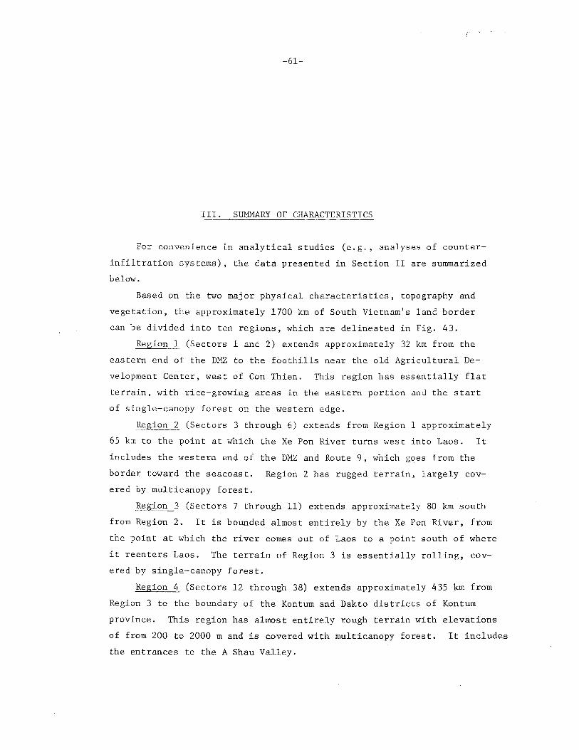
III. SUMMARY OF CHARACTERISTICS
For convenience in analytical studies (e.g., analyses of counter
infiltration systems), the data presented in Section II are summarized
below.
Based on the two major physical characteristics, topography and
vegetation, the approximately 1700 km of South Vietnam's land border
can be divided into ten regions, which are delineated in Fig. 43.
Region 1 (Sectors 1 and 2) extends approximately 32 km from the
eastern end of the DHZ to the foothills near the old Agricultural De
velopment Center, west of Con Thien. This region has essentially flat
terrain, with rice-growing areas in the eastern portion and the start
of single-canopy forest on the western edge.
Region 2 (Sectors 3 through 6) extends from Region l approximately
65 km to the point at which the Xe Pon River turns west into Laos. It
includes the western end of the DMZ and Route 9, which goes from the
border toward the seacoast. Region 2 has rugged terrain, largely cov
ered by multicanopy forest.
Region 3 (Sectors 7 through 11) extends approximately 80 km south
from Region 2. It is bounded almost entirely by the Xe Pon River, from
the point at which the river comes out of Laos to a point south of where
it reenters Laos. The terrain of Region 3 is essentially rolling, cov
ered by single-canopy forest.
Region 4 (Sectors 12 through 38) extends approximately 435 km from
Region 3 to the boundary of the Kontum and Dakto districts of Kontum
province. This region has almost entirely rough terrain with elevations
of from 200 to 2000 m and is covered with multicanopy forest. It includes
the entrances to the A Shau Valley.

i \ I l
,.,.
THAILAND
\
)
)
I /
LA 0 S
CAMBODIA
-62-
LEGEND
__, Border zone
~ Corps boundaries ,-..__/ RVN pr-ovince
boundaries
Fig. 43--The border regions of South Vietnam
110"

-63-
Region 5 (Sectors 39 through 47) extends from Region 4 approxi
mately 45 km to the boundary line between Pleiku and Darlac provinces,
just south of where the Ya Lop River enters Cambodia. The terrain in
the region is moderately rolling, with multicanopy forest at elevations
from 100 to 1000 m.
Region 6 (Sectors 48 through 53) extends from Region 5 along the
border of Darlac province to a point just north of the boundary between
Darlac and Quang Due provinces, a distance of approximately 97 km. The
terrain is moderately rolling, covered with single-canopy forest, and
has elevations ranging from 100 to 500 m.
Region 7 (Sectors 54 through 64) extends from Region 6 approxi
mately 177 km to the point where South Vietnam Route 14A reaches the
border. It has moderately rolling terrain, with multicanopy forest.
Region 8 (Sectors 65 through 81) extends from Region 7 approxi
mately 274 km to the intersection of South Vietnam Interprovisional
Route 13 (LTL 13) and the border. This region has essentially flat
terrain with elevations of less than 200 m and is largely covered
with multicanopy forest.
Region 9 (Sectors 82 through 98) extends from Region 8 approxi
mately 274 km to a point just east of where the Hekong River enters
South Vietnam. Region 9 is part of the }fekong Delta and has gener
ally flat terrain with elevations of less than 50 m. Much of the
area is subject to inundation, and a major part of the region is marsh
land or riceland.
Region 10 (Sectors 99 through 107) extends from Region 9 to the
Gulf of Thailand, approximately 145 km. It includes the area where
the Mekong Channel and the Bassac River enter South Vietnam. The ter
rain of Region 10 is generally flat, except for isolated highlands
reaching elevations of up to 600 m. It is largely a rice-growing area.
Data on population level and movement routes (particularly the
numbers of tracks and trails crossing the border) are also of great
value in studies of counterinfiltration systems. Table 10 summarizes
the major characteristics of the ten border regions--their border
lengths, approximate geographical limits, predominant topography and
vegetation, estimated population, and numbers of tracks and trails
that cross the border.

Table 10
SUMMARY OF CHARACTERISTICS OF REGIONS IN SOUTH VIETNAMESE BORDER ZONE
Tracks & Sectors Approximate Limits Border Trails
in of Re ion Length a Region Region North South (km) Topography Vegetation Populationb
Crossigg Border
1
2
3
4
5
6
7
8
9
10
1-2 Gulf of Foothills 32 Flat to Rice, single crop; 6,174 Tonkin west of rolling single-canopy for-
Con Thien est, dry crops
3-6 Foothills Exit of Xe 65 Rough Multicanopy forest; 1,650 west of Pan River brushwoods Con Thien
7-ll Exit of Xe Entrance 80 Rolling Brushwoods; multi- 6,500 Pan River of Xe Pan canopy forest
River
12-38 Entrance Kontum- 435 Rough Multicanopy forest; 15,202 of Xe Dakto dis- brushwoods Pon trict Rive::: boundary
39-4 7 Kontum- Ya Lop 145 Rolling Multicanopy forest; 6, 700 Dakto dis- River single-canopy forest trict boundary
48-53 Ya Lop Dar lac- 97 Rolling Single-canopy forest 300 River Quang Due
boundary
54-64 Dar lac- Route 14A 177 Rolling Hulticanopy forest; 15,364 Quang Due single-canopy forest boundary
65-81 Route 14A Route LTL 274 Flat Multicanopy forest; 10,028 13 single-canopy forest
82-98 Route LTL Mekong 274 Flat, sub- Rice, single crop; 196,982 13 River ject to marsh
inundation
99-107 Hekong Gulf of 145 Flat, sub- Rice, single crop; 223,253 River Thailand ject to marsh
inundation -- - -- -- ---- L__
aTotal border length~ 1,724 km.
bincludes ethnic Vietnamese, Cambodians, and tribal groups; total border-zone population
cTotal tracks/trails crossing border = 648.
48
48
55
103
51
19
76
101
104
43
- ------~~~
482,153.
I 0\ +:I

-65-
Appendix A
DETAILED DATA ON BORDER-ZONE SECTORS
This appendix presents the detailed data on physical and cultural
characteristics of the 107 sectors of the border zone. The locations
and general outlines of the sectors are indicated by maps (Figs. 44
through 79) which include reference geographical coordinates. The
sectors are outlined in groups of three on 1:250,000 scale maps; small
scale inserts are also given for each outline map to show sector loca
tions with respect to the total border zone.
An environmental-detail summary is given for the three sectors
depicted by each map. These summaries provide the following data,
reduced to numerical form (as much as possible), for each sector.
1. Sector number
2. Map reference (the sheet number(s) of the Army Map Service
Series L-7014 maps for the sector)
3. Total area (the area of the sector, in square kilometers,
based on planimeter measurements)
4. Border in waterway (the percentage of the sector's border
that is composed of waterways)
5. Topographic class (flat; flat, subject to inundation; rolling;
rough)
6. Elevation (the maximum and minimum elevation points of the
sector, measured to the nearest 50 m)
7. Vegetation type (the percentage of the sector covered by the
various vegetation classes described in Section II, based on
planimeter measurement)

-66-
8. Foot trafficability (the percentage of the sector that falls
into each of the classes of trafficability during the wet and
dry seasons, based on planimeter measurement)
9. Movement routes (the number of tracks and trails, roads, and
waterways crossing the border and entering the other sides
of the sector)
10. Population (the estimated ethnic Vietnamese and Ca~bodian
population, and its approximate density per square kilometer;
the name of the principal ethnic group (or tribe), and the
* estimated population of that group )
* Some sectors are labeled "Uninhabited," although they are, in fact, nominally occupied. These are sectors that were sho~~ in Ref. 6 to have a population of 0, but in many cases a visual examination of topographic maps indicated that this may be inaccurate. Other sectors are shown in this appendix to have no population, yet are given tribal designations. This indicates that the tribal group shown considers the area to be their territory and may occasionally enter the sector. Where there are no tribal groups in a sector, the ethnic designation (Vietnamese or Cambodian) is given in the space labeled "TRIBES." In these cases, the total population (taken solely from Ref. 6) and the "tribal" population are identical and are not to be considered additive.

-67-
DATA SUMHARIES

-68-
...r~ ~-
;' , ,-.)
, ------../ /-...
Fig. 44--Configuration and location of Sectors l - 3

-69-
SUMMARY OF CHARACTERISTICS OF SECTORS 1 - 3
SECTOR NO: 1 MAP REF: 6442 IV
TOTAL AREA (SQ KM) : __ .;.1~52=--. ____ _ BORDER IN WA'j.'ERWAY ('7.) : __ 5_2 _________ _
TOPOGRAPHIC CLASS :, _ _,F'-'1"-"a'-'=t'------------ ELEVATION (M) MAX :_.::.5.::.0 __ MIN: SL
VEGETATION-TYPE:
%:
2 3 4 5 6 7 8 9 10 11 12 13 14 15
FOOT TRAFFICABILITY (%):
WET /DRY SEASON:
MOVEMENT ROUTES:
CROSSING BORDER/ENTER SECTOR:
15 1 28 8 47
GOOD
27 I 2
FAIR
2 7 I 98
TRACKS, TRAILS
29 I 40
ROADS
2/5
POOR
46/0
UNSUITED
0/0
LARGE WATERWAYS
o I 3
SMALL WATERWAYS
2/8
POPULATION' 4 I 574 a PER SQ KM :.....;:;.3.;;.0 __ TRIBES: Ethnic Vietnamese POP: 4,5748
8Does not include 25,650 refugees.
SECTOR NO: 2 MAP REF: _.::6,:::34::,:2=..=I:___, 6442 IV
TOTAL AREA (SQ KM) :_~124.:::_6 _____ _ BORDER IN WATERWAY (%) :_--'"'64;x__ __________ _
TOPOGRAPHIC CLASS : _ _.R~o~1_.l,!,.in!!Jg"'----------- ELEVATION (M) MAX: 150 MIN: SL
VEGETATION-TYPE: 1 2 3 4 5 6 8 9 10 11 12 13 14 15
%: 15
FOOT TRAFFICABILITY (%):
WET/DRY SEASON;
HOVE}1El\T ROUTES ;
CROSSING BORDER/ENTER SECTOR:
30 16
GOOD
o I 19
FAIR
69/65
TRACKS I TRAILS
19 /72
22 3 14
ROAOC
1 I 6
POOR
15/16
UNSUITED
161 0
LARGE WATERWAYS
0 /1
SMALL WATERWAYS
3 I 13
POPULATION: 1,600 PER SQ KM: 11 TRIBES: Ethnic Vietnamese POP: 1, 600
SECTOR NO: _3_
TOTAL AREA (SQ KM) : 185
TOPOGRAPHIC CLASS: Rou h
VEGETATION-TYPE: 1 2 3
%: 69
FOOT TRAFFICABILITY (%):
WET/DRY SEASON:
MOVE}lENT ROUTES:
CROSSING BORDER/ENTER SECTOR:
MAP REF: 6342 I
4
BORDER IN 'V/ATERWAY
ELEVATION
5 6 8 9 10
11 19
GOOD
0 /0
FAIR
24 I 2 7
TRACKS I TRAILS
15 I 54
ROADS
0 /0
(%): 0
(M) MAX:
11 12
1
POOR
6 Is
750
13
MIN:
14 15
UNSUITED
70 I 68
SL
LARGE WATERWAYS
0/1
SMALL WATERWAYS
2/18
POPULATION :_,_0 __ PER SQ KM:_~O __ TRIBES :,_~B!!Jr~o~u'-----------POP: 300

\ _1--1'10'1~ Ml.1TAA'f liNE
Of [)E M.a.ICAU;:t-l 1954
-70-
+ 16° 45 1
106° 45'
Fig. 45--Configuration and location of Sectors 4 - 6

-71-
S~~y OF CHARACTERISTICS OF SECTORS 4 - 6
SECTOR N0: __ 4_ MAP REF: 6342 I 6342 Dl
TOTAL AREA (SQ KM) :, _ _:1::...5::...0 _____ _ BORDER IN WATERWAY(%): 0
TOPOGRAPHIC CLASS :_...,:R....:o....:u.::g....:h _________ _ ELEVATION (M) MAX: 1500 MIN : __ 1_o_o __
VEGETATION-TYPE: 2 3 4 5 6
%: 94 2 3
FOOT TRAFFICABILITY (%): GOOD
WET /DRY SEASON: o I o
8 9 10 11
< 1
FAIR
3/3
12
POOR
Of 0
13 14 15
UNSUITED
97 1 97
MOVEMENT ROUTES:
CROSSING BORDER/ENTER SECTOR:
TRACKS I TRAILS
3 /16
ROADS
0 /O
LARGE WATERWAYS
o I o SMALL WATERWAYS
1/19
POPULATION :____,0,__ PER SQ KM:--"-0 __ TRIBES: __ ~Br~o~u~---------- POP: 350
SECTOR NO: 5 MAP REF: 6342 III , 6342 IV
TOTAL AREA (SQ KM) :_..::;_6:=_8 _____ _ BORDER IN WATERWAY (%) :__;!.0 ___________ _
TOPOGRAPHIC CLASS :_...£R~ol!.u.=.gh!o!_ _________ _ ELEVATION (M) MAX: 1600 MIN: 400
VEGETATION-TYPE: 1 2 3 4 5 6
%: 84 2
FOOT TRAFFICABILITY (%):
WET/DRY SEASON:
GOOD
OIO
14
8 9 10 11 12 13 14 15
FAIR
10/10
< 1
POOR
112
UNSUITED
89188
MOVE~!ENT ROUTES :
CROSSING BORDER/ENTER SECTOR:
TRACKS, TRAILS
15/12
ROADS
0/0
LARGE WATERWAYS
o I o SMALL WATERWAYS
0/0
POPULATION :_~0 __ PER SQ KM:__::O:.__ __ TRIBES:_~Br~o~u~-------------- POP: 300
SECTOR NO: 6 MAP REF: 6342 III , 6342 IV
TOTAL AREA (SQ KM) : __ 1~2::..:4~------- BORDER IN WATERWAY (%) :_--"Oc._ ______________ _
TOPOGRAPHIC CLASS :_---'R~o~u!.!g:.!.h!...-______________ _ ELEVATION (M) MAX:...,.;l~3~5~0 __ MIN: 600
VEGETATION-TYPE: 2 3 4
%: 30 2
FOOT TRAFFICABILITY (%):
WET/DRY SEASON:
MOVEMENT ROUTES:
CROSSING BORDER/ENTER SECTOR:
6 8 9 10 ll 12 13 14 15
< 1 1 67
GOOD
o ;o FAIR
38 I 40
TRACKS I TRAILS
15/ 34
ROADS
o lo
< 1
UNSUITED
sa I 57
LARGE WATERWAYS
olo SMALL WATERWAYS
2 /2
POPULATION : __ o __ PER SQ KM: __ o __ TRIBES : __ Br_o..._u _________________ _ POP: 700
+ 16° 30'
106° 30'
-72-
I
\ 0 ~ '1
'
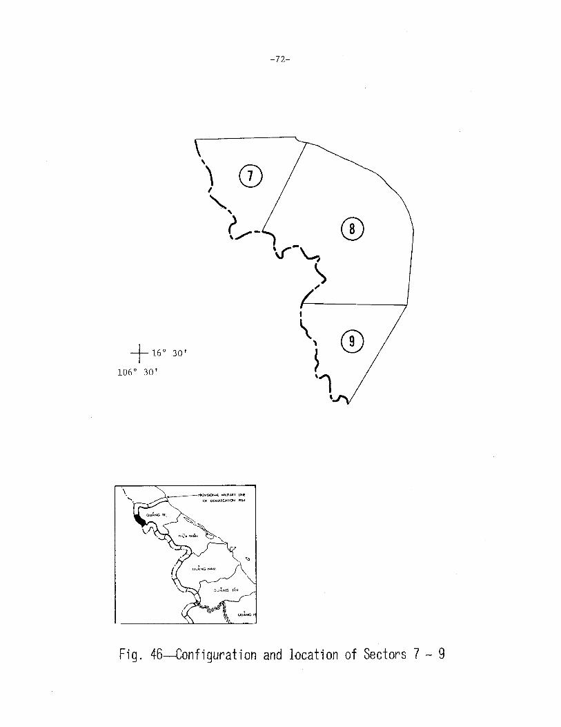
Fig. 46--Configuration and location of Sectors 7 - 9

-73-
SUMMARY OF CHARACTERISTICS OF SECTORS 7 - 9
SECTOR NO: _7_
TOTAL AREA (SQ KM): 67
TOPOGRAPHIC CLASS: Rolling
\"EGETATION-TYPE: 1 2
fo: 1 73
FOOT TRAFFICABILITY (%):
WET/DRY SEASON:
:tOVENENT ROUTES;
CROSSING BORDER/ENTER SECTOR:
MAP REF: 6342 III
4
BORDER IN WATERWAY
ELEVATION
GOOD
o I o
6
25
8 9
FAIR
12 /12
TRACKS I TRAILS
5/28
10
~ 1 I 1
(%): 35
(M) MAX:
11 12
POOR
0 I o
1000
13
MIN:
14 15
UNSUITED
88188
200
LARGE WATERWAYS
0/ 0
SMALL WATERWAYS
4 I o
POPULATION :_O __ PER SQ KM: __ o __ TRIBES: __ ~Br~o~u~-------------------- POP: 600
SECTOR NO: 8 MAP REF: 6342 III '----- ----- ------
TOTAL AREA (SQ KM) :_1_7_4 ______ _ BORDER IN WATERWAY (%) :~1c:e0~0 ________________ _
TOPOGRAPHIC CLASS :-R~o::..;1::..:1::..:i:.::n:l2g _________ _ ELEVATION (M) MAX :-'t-9.><.:00~-- MIN: 200
\"EGETATION-TYPE: 2 3 4 5 6 8 9 10 11 12 13 14 15
fo; 65 4
"'"l!OT TRAFFICABILITY (to):
WET/DRY SEASON:
:-KJVENENT ROUTES :
CROSSING BORDER/ENTER SECTOR:
1 1 29
GOOD
o I o FAIR
1&' 18
TRACKS, TRAILS
15/46
ROADS
o I 2
POOR
2 I 2
UNSUITED
80 I 80
LARGE WATERWAYS
0/0
SMALL WATERWAYS
2/6
POPULATION : _ __,c___ PER SQ 101: _ _:.0 __ TRIBES: __ ~B~r~o~u ____________ _ POP: 2800
SECTOR NO: 9 MAP REF: 6341 IV 6342 III
TOTAL AREA (SQ KM) : __ ....::6..:..7 ______ _ BORDER IN \oiATERWAY
TOPOGRAPHIC CLASS : _..::.R:::::o:-=1.=.1-=.i n:.:Jg:..._ ___________ _ ELEVATION
VEGETATION-TYPE: 2
/.: 3
FOOT TRAFFICABILITY (%):
WET/DRY SEASON:
MOVENENT ROUTES:
CROSSING BORDER/ENTER SECTOR:
4 5
GOOD
o I o
6
96
8 9
FAIR
90 /90
TRACKS I TRAILS
11/16
10
1
ROADS
1/1
(%): 100
(M) MAX: 750 MIN: 200
11 12 13 14 15
POOR UNSUITED
o I o
LARGE WATERWAYS
0/ 0
10/10
SMALL WATERWAYS
1 I 3
POPULATION ;, _...:0:..__ PER SQ KM:_O~--- TRIBES: __ ~B~r~ou~---------------- POP: 1100

-74-
®
+ 16° 30'
@
\ ......
_1.-~~ MiliTARY lNE
Of OEM.U:CAliON t9~~
Fig. 47--Gonfiguration and location of Sectors 10 - 12

-75-
SUMMARY OF CHARACTERISTICS OF SECTORS 10 - 12
SECTOR NO:_l_O_ MAP REF: __,6:.:::3...:..4 :::...1 ...::;I"--, 6341 rJ
TOTAL AREA (SQ KM) :_5_7 ______ _ BORDER IN WATERWAY(%): 100 --------------------TOPOGRAPHIC CLASS :_.....:Rc;.;o:....:l:.:1;.::ic.:.:n!it.g ________ _ ELEVATION (M) MAX:_5_0_0 __ MIN: 200
VEGETATION-TYPE:
%:
2 3 4 5 6 7 8 9 10 11 12 13 14 15
1
FOOT TRAFFICABILITY (%):
WET/DRY SEASON;
HOVEHENT ROUTES;
CROSSING BORDER/ENTER SECTOR:
98 1
GOOD
OJ 0
FAIR
83 1 83
TRACKS I TRAILS
10/10
ROADS
0 /2
POOR
OJO
UNSUITED
7;7
LARGE WATERWAYS
o I o SMALL WATERWAYS
2/1
POPULATION :__:0::____ PER SQ KM:--'0 __ _ TRIBES : __ Br_o_u __________ _ POP: 1200
SECTOR NO:__jj__ MAP REF: 6341 I 6342 II
TOTAL AREA (SQ KM) :_.:~4""-8 _____ _ BORDER IN WATERWAY (7,) :_2_4 ___________ _
TOPOGRAPHIC CLASS : _ _.o:R::::o-=.1=-b.:::.:' n:.;:g,__ _______ _ ELEVATION (M) MAX:_50_0 __ _ MIN: 200
VEGETATION-TYPE :
%:
1 2 3 4 5 6 8 9 10 11 12 13 14 15
3
FOOT TRAFFICABILITY (%):
WET/DRY SEASON:
MOVEHENT ROUTES:
CROSSING BORDER/ENTER SECTOR:
13
GOOD
o I o
84
FAIR
49j49
TRACKS I TRAILS
14/19
ROADS
0/1
POOR
0 f8
UNSUITED
Slf 43
LARGE WATERWAYS
0/ 0
SMALL WATERWAYS
1/ 0
POPULATION :_---"-0 __ PER SQ KM:_--"0'---- TRIBES:_~B~r~ou~-----------POP: 800
SECTOR NO:~ MAP REF: 6341 I
TOTAL AREA (SQ KM) : _ _,_30"'-'9'------- BORDER IN 'l/ATERWAY
TOPOGRAPHIC CLASS : __ .,Ro'"-'u~h,__ ________ _ ELEVATION
VEGETATION-TYPE: 2 3 4
%: 44 1
FOOT TRAFFICABILITY (%) :
WET /DRY SEASON:
MOVEHENT ROUTES:
CROSSING BORDER/ENTER SECTOR:
5 6 7 8 9
6 1 48
9QQQ FAIR
0/0 1/
TRACKS I TRAILS
13 /30
5
10
ROADS
0/0
6342 II
(%): 0
(M) MAX: 900 MIN: 200
11 12 13 14 15
POOR UNSUITED
4 I 1 95 /94
LARGE WATERWAYS
<J I 2
SMALL WATERWAYS
0/~
POPULATION :_....:0:..__ PER. SQ KM:_.:..O __ TRIBES: __ ~B~ro~u~---------------POP: 1500
• ( ® \
\
-76-
+ 16° 15'
107° 00 I
®
Fig. 48--Configuration and location of Sectors 13- 15

-77-
SU~mARY OF CHARACTERISTICS OF SECTORS 13 - 15
SECTOR NO:_l_3_ MAP REF: 6341 I
IOTA L AREA (SQ KM) ; ---.:9:...:7 ______ _ BORDER IN WATERWAY (7.) :_..c:.O __________ _
TOPOGRAPHIC CLASS : __ :...:R:::o-=u£g.:.:.h ________ _ ELEVATION (M) MAX; 1000 MIN: 300
\'EGETA TION-TYPE: 3 4 6 7 8 10 11 12 13 14 15
fo: 30 6
FOOT TRAFFICABILITY (%):
WET/DRY SEASON:
GOOD
o I o
64
FAIR
3 I 3
~lOVENENT ROUTES:
CROSSING BORDER/ENTER SECTOR:
TRACKS I TRAILS
9 I 4
ROADS
0/0
POPULATION : ___,0,___ PER SQ KM:-.:=..0 __ TRIBES: Pacoh
:)ECTOR NCl: 14 MAP REF: 6341 I
10T,\L AREA (SQ KM) :_....:1::.::0:...:1'------- BORDER IN WATERWAY
TOPOGRAPHIC CLASS :_~R~o~u-".l!.!-1 _________ _ ELEVATION
\TGETATION-TYPE: 2 4 6 8 9 10
fo: 46 51 3
!JOT TRAFFICABILITY (lo): GOOD FAIR
WET/DRY SEASON; ob ll/11
: !IWEc[ENT ROUTES :
CROSSING BORDER/ENTER SECTOR:
TRACKS, TRAILS
7 /13
ROADS
o I o
POPFLATION :_--"'-0 __ PER SQ KM :_....:0~- TRIBES: Pacoh
SECTOR NO :____lj__ MAP REF: 6441 IV
POOR
0 IO
UNSUITED
97/ 97
LARGE WATERWAYS
o I 2
SMALL WATERWAYS
o I 6
POP: 1400
6441 IV
(%): 0
(M) MAX: 1300 MIN: 300
11 12 13 14 15
POOR UNSUITED
o I o 89 I 89
lARGE WATERWAYS
0 /0
SMALL WATERWAYS
o 1 4
POP: 500
TOTAL AREA (SQ 1<..'1) :_...h1.;c6J,..l ______ _ BORDER IN WATERWAY (%):___JOL-----------
TOPOGRAPHIC CLASS :_--.!.:R:::_ou=h;__ ________ _ ELEVATION (M) MAX :....:1:.:2:..::0..;:.0 __ MIN: 400
VEGETATION-TYPE: 2 3 4 5 6 8 10 ll 12 13 14 15
%: 54 4 1 3 37 1
FOOT TRAFFICABILITY (%): GOOD FAIR POOR
OIO
UNSUITED
95 /95 WET/DRY SEASON: Ol 0 5/
MOVE'1ENT ROUTES : TRACKS, TRAILS
CROSSING BORDER/ENTER SECTOR: 18/ 19
POPULATION : __ -"-0- 0 PER SQ KM:_~-- TRIBES:
~ 1/1
Pacoh
LARGE WATERWAYS
0/0
SMALL WATERWAYS
1 I 4
POP: 500

) )
I
)
'" '
-78-
@
® '-, ____ '\...
'
+ 16° 00'
107° 15'
Fig. 49--Configuration and location of Sectors 16 - 18

-79-
SU~illARY OF CHARACTERISTICS OF SECTORS 16 - 18
\ SECTOR NO :_1_6_ MAP REF: 6441 III , 6441 IV
TOTAL AREA (SQ KM) :_1:;_6:c.::O ______ _ BORDER IN WATERWAY (%): 24 -----------------TOPOGRAPHIC CLASS : __ Ro...cu:..;ge.:_h:__ ________ _ ELEVATION (M) MAX: 1500 MIN: 500
VEGETATION-TYPE: 3 4 6 8 10 11 12 13 14 15
/.: 57
FOOT TRAFFICABILITY (%):
WET/DRY SEASON:
MOVEHENT ROUTES:
CROSSING BORDER/ENTER SECTOR:
GOOD
0 I 0
4 39
FAIR
15/ 15
TRACKS I TRAILS
8/12
ROADS
o I 2
POPULATION: 0 PER SQ KM:_.:;_O __ TRIBES: Pacoh
SECTOR NO: 17 MAP REF: 6441 II
POOR
0 /6
UNSUITED
85/79
LARGE WATERWAYS
21 2
SMALL WATERWAYS
o I 3
POP: 500
6441 III , _____ ------
TOTAL AREA (SQ KM) :_1::..:3::..:3:__ ____ _ BORDER IN WATERWAY (7.) : _ _.u:__ _________ _
TOPOGRAPHIC CLASS :_~R!:::o'-"u"'-h'-'------------ ELEVATION (M) MAX: 1400 MIN: 500
VEGETATION-TYPE: 3 4 6 8 9 10
1.: 74 12 14
FOUT TRAFFICABILITY (/,): GOOD FAIR
WET /DRY SEASON: o I 0 17/17
c10H~lENT ROUTES : TRACKS, TRAILS ROADS
CROSSING BORDER/ENTER SECTOR: o I 16 o I 2
POPL'LATION :_-"'-0 __ PER SQ KM:--"0 __ TRIBES: Phuong
SECTOR N0:_18 __ MAP REF: 6441 II
TOTAL AREA (SQ KM) : _ _....1/..L _____ _ BORDER IN WATERWAY
11 12
POOR
1 I 2
13 14 15
UNSUITED
821 81
LARGE WATERWAYS
0 12
SMALL WATERWAYS
o I 3
POP: 200
(%): 0
TOPOGRAPHIC CLASS :_~R~o~u~h'----------- ELEVATION (M) MAX: 1600 MIN: 500
VEGETATION-TYPE: 3 4
%: 64
FOOT TRAFFICABILITY (%):
WET/DRY SEASON:
MO\'E:1ENT ROUTES :
CROSSING BORDER/ENTER SECTOR:
5 6 8 9
10 14 12
GOOD FAIR
o I o 20!20
TRACKS, TRAILS
2 I 12
10
ROADS
012
POPULATION : _ _.;:;.0 __ PER SQ I<M: _ ___:...O_ TRIBES : Phuong
11 12
POOR
1 I 1
13 14 15
UNSUITED
79/79
LARGE WATERWAYS
0 /1
SMALL WATERWAYS
o I 3
POP: 400

+ 16° 00' 107° 15'
\ '·
_1~-f'ROV~!t~Ct-~Al MliT~'f liNE
Of DEMAIICAl()N 191•
-80-
I
) I
I
®
I
~' J
I
I I
®
@
Fig. 50--Configuration and lacation of Sectors 19 - 21

-81-
SUMMARY OF CHARACTERISTICS OF SECTORS 19 - 21
SECTOR NO: 19 HAP REF: 6441 II 6541 III
'j:UTAL ARFJI (SQ K.'1) : __ 2-'-3-'-6 ______ _ BORDER IN WATERWAY (%) : __ o __________ _
TOPOGRAPHIC CLASS :_---"R'-"o-=u.a.:.:h _________ _ ELEVATION (M) MAX: 1200 ~!IN: 200
\TGET/\TION-TYPE: 3 4 5 6 8 10
7o: 88 3 9
FOOT TRAFFICABILITY (%): GOOD FAIR
WET/DRY SEASON: o/o 4/5
:-itlVEc-!ENT ROUTES: TRACKS, TRAILS ROADS
CROSSING BORDER/ENTER SECTOR: 3 17 1 I 1
POPULATION : __ 0,___ PER SQ K.'1: 0 TRIBES: Phuong
'-L.CTllR NO:~ ~lAP REF: 6440 I I
11 12
POOR
1 I o
13 14 15
UNSCITED
95 I 95
URGE WATERWAYS
OIO
S~1ALL WATERWAYS
o I 8
POP: 400
6441 II I 6540 IV , 6541 III
10'L\L AREA (SQ KH) : __ 15_4 _____ _ BORDER IN WATERWAY (i'.) : 0
TP!'<JC!c\Pl!IC ClASS : __ !;:,Ro~u~h"---------- ELEVATION
V~GE1~TION-TYPE: 3 4
< .lc>l TIUIFFICARILITY (1.):
WET /DRY SEASON:
:10\'E:'mNT ROUTES:
CROSSING BORDER/ENTER SECTOR:
5 6 8 9
12 10 3
GOOD FAIR
0/0 Ol
TRACKS I TRAILS
1 I 3
0
10
ROADS
0 /0
(M) MAX: 1500 ~liN: 300
11 12 13 14 15
POOR UNSL'ITED
o I o 100 /100
lARGE WATERWAYS
o I o SMALL WATERWAYS
o I 4
POPFIJITION: 0 PER SQ 101:._--"0 __ TRIBES: ___ _2P~h~u~o~nEg _______ ___ POP: 100
SECTOR NO :_2_1_ ~p REF: 6440 I
TOTAL AREA (SQ KM) : _ _.2,_,1"'3'--------- BORDER IN WATERWAY (%) :__::;_0 ___________ _
TOPOGRAPHIC CLASS:_~R~o~u~h _________ ___ ELEVATION (M) MAX: 1900 MIN: 600
VEGETATION-TYPE: 2 3 4 5 6
4
8 9
%: 87
FOOT TRAFFICABILITI (%):
WET/DRY SEASON:
c!OVEMENT ROUTES:
CROSSING BORDER/ENTER SECTOR:
3
GOOD
o I o
5
FAIR
o I o
TRACKS I TRAILS
0 I 9
10 11
ROADS
o 1 o
POPULATION :_0 __ _ PER SQ KM: __ o __ TRIBES: Phuong
12
POOR
Of 0
13 14 15
UNSUITED
100/ 100
LARGE WATERWAYS
Of 0
SMALL WftTERWAYS
o I 3
POP: 400
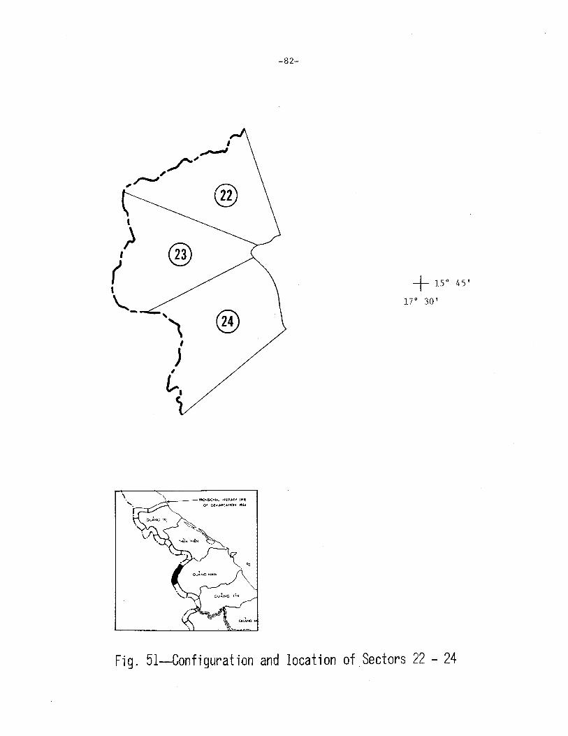
' ) I
( ' "-
®
,, ® I
J , £,.,
-82-
+ 15° 45'
17° 30'
Fig. 51-Configuration and location of Sectors 22 - 24

-83-
SUMMARY OF CHARACTERISTICS OF SECTORS 22 - 24
SECTOR NO:~ MAP REF: 6440 I
TOTAL AREA (SQ KM): __ 8_3 ______ _ BORDER IN WATERWAY (%) :_--'0"-------------
TOPOGRAPHIC CLASS :_~R~o~uc.:h"----------- ELEVATION (M) MAX: 1800 MIN: 800
\'EGETATION-TYPE: 2 3 4 5 6 8 10 11 12 13 14 15
%: 62
FOOT TRAFFICABILITY (%):
WET/DRY SEASON:
'10VHlENT ROUTES:
CROSSING BORDER/ENTER SECTOR:
GOOD
o ;o
24 14
FAIR
o 1 o
TRACKS, TRAILS
6 I 11
ROADS
0/ 0
POPULATION: 0 PER SQ KM : __ 0.:;...__ TRIBES: Phuong
SECTOR NO: 23 MAP REF: 6440 I
TOTAL AREA (SQ KM) :_.......::.9.=.1 _____ _ BORDER IN WATERl-IAY
TOPOGRAPHIC CLASS : __ R'-"o"'-'u""""-h'----------- ELEVATION
\'EGETATION-TYPE: 2 3 4 5 6 8
%: 71
l Oll1 TPv\FFICAB ILITY (/.) :
WET/DRY SEASON:
c10VC~[D/T ROUTES:
CROSSING BORDER/ENTER SECTOR:
GOOD
o I o
17 12
FAIR
0/0
TRACKS, TRAILS
4 /10
10
ROADS
o I o
POOR
o I o UNSUITED
100; 100
lARGE WATERWAYS
o I o SMALL WATERWAYS
0/ 1
POP: 600
6440 II 6440 III '
6440 IV
(%) : 0
(M) MAX: 1700 MIN: 800
11 12 13 14 15
POOR UNSUITED
0/0 100/ 100
LARGE WATERWAYS
olo SMALL WATERWAYS
o I o
POPULATION: __ 0::.__ PER SQ KM:_..;:O __ TRIBES : __ ___:Pc.::h:o:u::.o;.ong"--------- POP: 700
SECTOR NO; 24 MAP REF: ___;6::,:4:.:;4~0~I __ , 6440 II
TOTAL AREA (SQ KM) :_.=_:10~4!:.._ _____ _ BORDER IN WATERWAY (/.) :_----"'Oc__ _________ _
TOPOGRAPHIC CLASS : __ R~o>!..!u~hL_ ________ _ ELEVATION (M) MAX: 1500 MIN: 800
VEGETATION-TYPE: 2 3 4 5 6 7 8 9 10 11 12 13 14 15
/,: 79
FOOT TRAFFICABILITY (%):
WET/DRY SEASON:
MOVE~fENT ROUTES :
CROSSING BORDER/ENTER SECTOR:
GOOD
0 /0
5 16
FAIR
o I o
TRACKS, TRAILS
o I 13
ROADS
0/0
POPULATION: 0 PER SQ KM: _ _.:::O __ TRIBES: Katu
POOR
o I o UNSUITED
100/100
LARGE WATERWAYS
0/0
SMALL WATERWAYS
o I 2
POP: 500
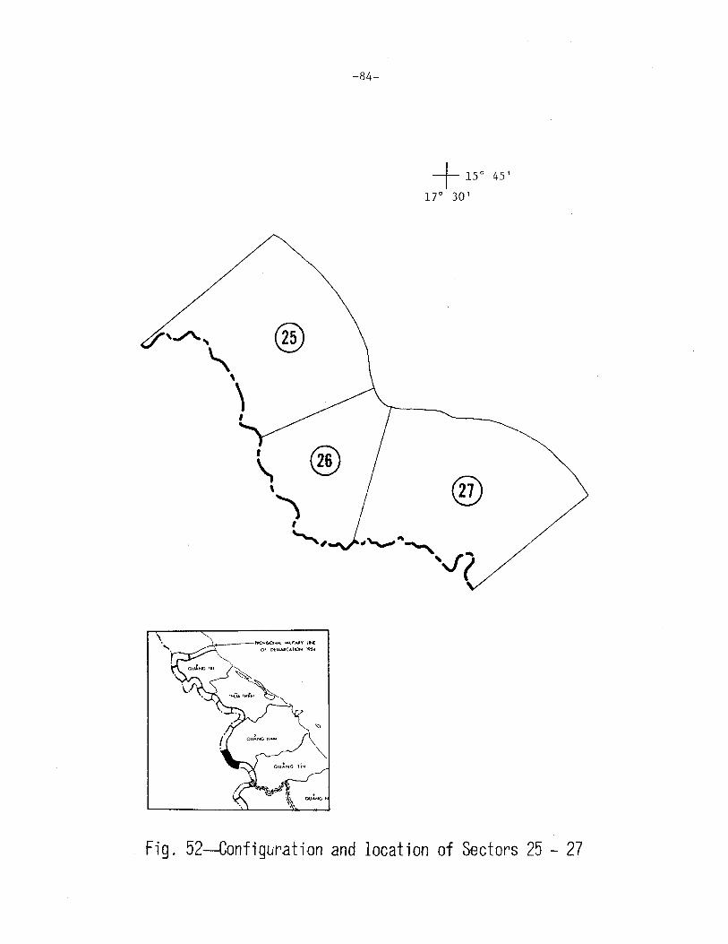
\ @ \
) I
"""''
-84-
+ 15° 45'
1r 3o'
®
Fig. 52--Configuration and location of Sectors 25 - 27

-85-
SUMMARY OF CHARACTERISTICS OF SECTORS 25 - 27
SECTOR NO:~ MAP REF: 6440 II '----- ----- -----
TOTAL AREA (SQ KM) :_.;o.;l3:;..:9'-------- BORDER IN WATERWAY (%) : _ _:0 __________ _
TOPOGRAPHIC CLASS: Rough -~~'----------------
ELEVATION (M) MAX: 1400 MIN: 400
VEGETATION-TYPE: 2 3 4 5 6 8 9 10 11 12 13 14 15
%: 62
FOOT TRAFFICABILITY (%):
WET/DRY SEASON:
HOVEMENT ROUTES:
CROSSING BORDER/ENTER SECTOR:
~ 0 I o
10 28
FAIR
o I o
TRACKS, TRAI:!.S
1 10
ROADS
o I o
POPULATION: 0 PER SQ KM: _ _:O:.___ TRIBES: Katu
SECTOR NO:~ MAP MAP REF: 6439 I
TOTAL AREA (SQ KH) : __,7~8:.__ _____ _ BORDER IN WATERWAY
TOPOGRAPHIC CLASS :_-'R~o._,u!.C.!..!h.__ ________ _ ELEVATION
VEGETATION-TYPE: 2 4
'7.: 88
FOOT TRAFFICABILITY (%):
WET/DRY SEASON:
~OVEMENT ROUTES:
CROSSING BORDER/ENTER SECTOR:
5 6 8 9
9 3
GOOD FAIR
0/0 o I o
TRACKS I TRAILS
o I 4
10
ROADS
olo
POOR
0/0
UNSUITED
100/ 100
LARGE WATERWAYS
0/0
SMALL WATERWAYS
o I 2
POP: 1200
6440 II
(%): 0
(M) MAX: 1400 MIN: 400
11 12 13 14 15
POOR UNSUITED
0/ 0 100 I 100
LARGE WATERWAYS
o I o SMALL WATERWAYS
ol 3
POPULATION :_~0'------ PER SQ KM: __ O=..__ TRIBES:_~K~a~tu~--------------POP : _ __::_0 ___ _
SECTOR N0:_2_7_ MAP REF: 6439 I
TOTAL AREA (SQ KH) :_..l1J..7~0 _____ _ BORDER IN WATERWAY
TOPOGRAPHIC CLASS : _ ___.R""o_..u.,._hl.!...._ ________ _ ELEVATION
VEGETATION-TYPE:
%: 95
FOOT TRAFFICABILITY (%):
WET/DRY SEASON:
MOVEMENT ROUTES:
3 4 5 6
1 4
GOOD
0/0
8 9
FAIR
0/0
CROSSING BORDER/ENTER SECTDR:
TRACKS I TRAILS
2 I 2
10
ROADS
0/0
6440 II 6539 IV 6540 III
(%): 0
(M) MAX: 1400 MIN: 400
11 12 13 14 15
POOR UNSUITED
1 I 1 99 I 99
LARGE WATERWAYS
0/0
SMALL WATERWAYS
0 I s
POPULATION : _ ___::0 __ PER SQ KM: __ ~O:__ TRIBES: _ _!!K::::_a~tu:!.-________ _ POP :_-.!2~0:!'0:.___
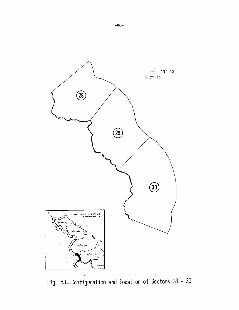
\
-86-
@ I
l._ """'"-.._ ( ~ @ ' '-' \.,
_1--~ MI.ITAAY lNf
Of ()fM.UCA.TION t9S<I '·
+ 15° 30'
1or 45'
@
Fig. 53--Configuration and location of Sectors 28 - 30

-87-
SUMMARY OF CHARACTERISTICS OF SECTORS 28 - 30
SECTOR NO:~ MAP REF: 6539 rv
TOTAL AREA (SQ KM) :_....;1;.::2...;;,6 _____ _ BORDER IN WATERWAY (7.) : __ o _________ _
TOPOGRAPHIC CLASS : _ __,:R~o~u""g!;.h ________ _ ELEVATION (M) MAX: 1600 MIN: 500
VEGETATION-TYPE: 1 2 3 4 5 6 8 9 10 11 12 13 14 15
%: 74 2 22 2
FOOT TRAFFICABILITY (%) : QQQ!! !M! !QQ! UNSUITED
WET /DRY SEASON: o I 2 2/ 21 21 I o 77/77
MOVEMENT ROUTES:
CROSSING BORDER/ENTER SECTOR:
TRACKS, TRAILS
2/1
~ o io
LARGE WATERWAYS
o I o SMALL WATERWAYS
Ojl
POPULATION :_..J.L._ PER SQ KM:_-._ TRIBES :. __ ....;U;;.;n;;.;.k;.;;n...;;,own.;;.;;;;.. _______ _ POP: 200
SECTOR NO:~ MAP REF: 6539 ry , _____ ----- -----
TOTAL AREA (SQ KM) :_..:1:..:6;.::1 _____ _ BORDER IN WATERWAY (%) :_,._ __________ _
TOPOGRAPHIC CLASS : __ .::Ro=ugc:..:h:!..._ _______ _ ELEVATION (M) MAX: 1600 MIN: 400
VEGETATION-TYPE: 1 2 3 4 5 6 8 9 10 11 12 13 14 15
%: 85 14 1
FOOT TRAFFICABILITY (%):
WET/DRY SEASON:
MOVEMENT ROUTES:
CROSSING BORDER/ENTER SECTOR:
~
o I< 1
FAIR
< 1 I 14
TRACKS, TRAILS
5 /3
ROADS
2 I o
POOR
14 I o UNSUITED
85 I 85
LARGE WATERWAYS
o I o SMALL WATERWAYS
0/ 0
POPULATION: __ ,;;;_O_ PER SQ KM:_O __ TRIBES: Uninhabited POP : _ __:o __ _
SECTOR NO:~ MAP REF: _6::.:5:.::3-""9--'I=---' 653 9 II , 6539 III , 6539 IV
TOTAL AREA (SQ KM) : _ _.20"'-7'-------- BORDER IN WATERWAY
TOPOGRAPHIC CLASS : __ Ro_u..,:g;:,..h _________ _ ELEVATION
VEGETATION-TYPE: 1 2 3 4
%: 79 1 5
FOOT TRAFFICABILITY (%):
WET /DRY SEASON:
MOVEMENT ROUTES :
CROSSING BORDER/ENTER SECTOR:
5 6 8 9
12 3
QQQ!! m! o I o o I
TRACKS I TRAILS
3/14
2
10
~ 0/2
POPULATION :_0::,.__ PER SQ KM: __ O'-- TRIBES : Unknown
(%): 0
(M) MAX: 2000 MIN: 400
11 12 13 14 15
~ UNSUITED
2 I o 98
LARGE WATERWAYS
o I o
I 98
SMALL WATERWAYS
o I 4
POP: 300

®
_1--~ M .. llAIY l~
~ OEMAIIC•fCN '195.
-88-
® + 15° OO'
106° 45'
Fig. 54--Configuration and location of Sectors 31 - 33

-89-
SUMMARY OF CHARACTERISTICS OF SECTORS 31 - 33
SECTOR NO: 31 MAP REF: 6539 II 6539 III , _____ -----
TOTAL AREA (SQ KM): 124
TOPOGRAPHIC CLASS; Rough
VEGETATION-TYPE: 2 3
%: 11 2
FOOT TRAFFICABILITY (%):
WET/DRY SEASON:
~!OVE:·!E NT ROUTES :
CROSSING BORDER/ENTER SECTOR:
BORDER IN WATERWAY(%):. 0 ~-------------
ELEVATION (M) MAX: 1599 MIN: 600
4 5 6 8 9 10 11 12 13 14 15
46 39 2
GOOD
o I o FAIR
0/ 2
TRACKS, TRAILS
7 I 14
ROADS
o I 3
POOR
2 I o UNSUITED
98 1 98
LARGE WATERWAYS
o;o SMALL WATERWAYS
o 1 4
POPULATION: 1802 PER SQ KM:-J.:14;t.... __ TRIBES: __ ~J~e~h ____________________ __ POP: 600
SECTOR NO:~ MAP REF: 6538 IV 6539 III ' IOTA L AREA (SQ KM) : __ __::.1::..5 0:::.._ ________ _ BORDER IN WATERWAY (%): 0
TOPOGRAPHIC CLASS : ____ ::.:,RO:::.:U::..:S>..:.h,__ ________________ _ ELEVATION (M) MAX: 1900 MIN: 700
VEGETATION-TYPE: 1
%: 38
FOOT TRAFFICABILITY (%);
WET/DRY SEASON:
MOVE~!E:-<T ROUTES :
3
CROSSING BORDER/ENTER SECTOR:
4
13
5 6 8 9
39 6
GOOD FAIR
0/0 0/6
TRACKS, TRAILS
2 I 11
10
ROADS
o I o
11
3
12 13 14 15
POOR UNSUITED
6/0
LARGE WATERWAYS
0/ 0
94/94
SMALL WATERWAYS
0/ 1
POPULATION : _O.c__ __ _ PER SQ KM:_..:;O __ __ TRIBES: ___ ~J~e~h __________________ __ POP: 400
SECTOR NO: 33 -----TOTAL AREA (SQ KM): 174
TOPOGRAPHIC CLASS: Rough
VEGETATION-TYPE: 1 2 3
%: 79 2
FOOT TRAFFICABILITY (%):
WET/DRY SEASON:
MOVEMENT ROUTES:
CROSSING BORDER/ENTER SECTOR:
MAP REF: _6_4"-3 8'---"I'----' 64 3 9 II 6439 III , 6538 IV
BORDER IN WATERWAY (7,) :_0:::__ ______________ __
ELEVATION (M) MAX: 2000 MIN: 800
4 5 6 8 9 10 11 12 13 14 15
4 5 10
GOOD
0/0
FAIR
o I 10
TRACKS, TRAILS
2 ;9
ROADS
o I o
POOR
101 0
UNSUITED
90 I 90
LARGE WATERWAYS
0/0
SMALL WATERWAYS
o I 2
POPULATION :_~0,___ PER SQ KM:----!0~- TRIBES:~J~e~h~------------------ POP: 900

'
<~@
@
-90-
®
+ 14° 45'
106° 45'
Fig. 55--Configuration and location of Sectors 34 - 36

-91-
SUMMARY OF CHARACTERISTICS OF SECTORS 34 - 36
SECTOR NO: 34 MAP REF: 6538 IV
TOTAL AREA (SQ KM) : __ 2_1_3 _____ _ BORDER IN WATERWAY (%): 0 --------------------TOPOGRAPHIC CLASS : __ R_o_u_,g"'-h'----------- ELEVATION (M) MAX: 1500 MIN: 600
VEGETATION-TYPE: 2 3 4 5 6 8 9 10 11 12 13 14 15
%: 67 4
FOOT TRAFFICABILITY (%):
WET/DRY SEASON:
MOVE~lE NT ROUTES :
CROSSING BORDER/ENTER SECTOR:
14 8
GOOD
o I o FAIR
o I 7
TRACKS I TRAILS
2/11
ROADS
o I 2
POPULATION : __ 0.;__ __ PER SQ KM:_O __ _ TRIBES: Kayong
SECTOR N0:_3_5__ MAP REF: 6538. IV
POOR
7 I o UNSUITED
93/93
LARGE WATERWAYS
o I 1
SMALL WATERWAYS
0 /10
POP: 900
TOTAL AREA (SQ KM) : __ -'8'-'0 _____ _ BORDER IN WATERI~AY (%) :--=0'-----------------
TOPOGRAPHIC CLASS : __ R_o_u..;::g;_:_h ___________ _ ELEVATION (M) MAX: 1100 MIN: 300
VEGETATION-TYPE: 1 2 3 4 6 8 9 10 11 12 13 14 15
'/.: 94
FOOT TRAFFICABILITY (%):
WET /DRY SEASON:
MOVEMENT ROUTES:
CROSSING BORDER/ENTER SECTOR:
5
GOOD
o I o
1
FAIR
o I 6
TRACKS I TRAIL'>
1/1
ROADS
o I o
POOR
6 I o UNSUITED
94 I 94
LARGE WATERWAYS
0 IO
SMALL WATERWAYS
1 I 1
POPULATION : _ _,0 __ PER SQ KH : _ ___,,____ TRIBES: _ _u!!un~inwhliaub~j~tked~----------- POP : _ _.;::_0 ____ _
SECTOR NO: 36 MAP REF: 6538 III , ---TOTAL AREA (SQ KM): 115
TOPOGRAPHIC CLASS: Rough
VEGETATION-TYPE: 2 3 4
%: 98
FOOT TRAFFICABILITY (%):
WET/DRY SEASON:
MOVEMENT ROUTES:
CROSSING BORDER/ENTER SECTOR:
BORDER IN \'IATERWAY
ELEVATION
5 6 7 8 9 10
1
GOOD
< 1/< 1
!!.!! < 11 2
TRACKS I TRAILS
I 1
ROADS
0/1
6538 IV
(%): 0
(M) MAX:
11 12
1
POOR
2 I <1
13
1100 MIN:
14 15
UNSUITED
971 97
500
LARGE WATERWAYS
0/0
SMALL WATERWAYS
o I 6
POPULATION :_0"'----- PER SQ KM:. ___ _::.O_ TRIBES :._K!!a:::.yL:o::.:nc:!:g~--------- POP: 300

I
-92-
\
,J /
I
" / • 107° 30('
14° 30' + I @ I I
' ('.,.J
~ @
®
Fig. 56--Configuration and location of Sectors 37 - 39
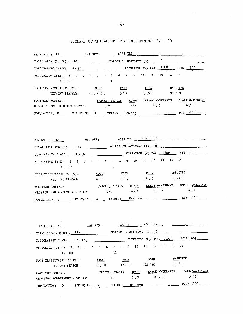
-93-
SUMMARY OF CHARACTERISTICS OF SECTORS 37 - 39
SECTOR N0;_3_7_ MAP REF: 6538 III
TOTAL AREA (SQ KM) :_::;_14.:..::8::..._ _____ _ BORDER IN WATERWAY ('7.) : __ __.:..o _________ _
TOPOGRAPHIC CLASS : _ _;R:..:..o:..:u::!:gc:.:h _________ _ ELEVATION (M) MAX: 1100 MIN: 600
VEGETATION-TYPE: 2 3 4 5 6 8 10 ll 12 13 14 15
%: 97
FOOT TRAFFICABILITY (%):
WET/DRY SEASON:
MOVEMENT ROUTES;
CROSSING BORDER/ENTER SECTOR:
.QQQQ < 1 I< 1
3
FAIR
o I 3
TRACKS , TRAILS
2 16
ROADS
ol o
POPULATION :____,0'---- PER SQ KM:_O::...__ TRIBES: Kayong
SECTOR NO: _3_8_ MAP REF: 653 7 IV
TOTAL AREA (SQ KM): 165
TOPOGRAPHIC CLASS: Rou h
VEGETATION-TYPE: 2 3
/.: 92
FOOT TRAFFICABILITY (%):
WET/DRY SEASON:
MOVEMENT ROUTES:
CROSSING BORDER/ENTER SECTOR:
4
BORDER IN WATERWAY
ELEVATION
5 6 8 9 10
8
GOOD
o I o FAIR
1 I 8
TRACKS, TRAILS
2/9
ROADS
o I o
POOR
3 I o
UNSUITED
96 96
LARGE WATERWAYS
0/0
6538 III )
(%): 0
(M) MAX: 1100
11 12 13 14
SMALL WATERWAYS
o I 6
POP: 400
:-!IN: 300
15
POOR
16 I 9
UNSUITED
LARGE WATERWAYS
o I o
83/ 83
SMALL WATERWAYS
o I 8
POPULATION: ___::.0~-- PER SQ KM:_.....:O'--- TRIBES: __ U~n:..:..k:..:..n:..:o:..:..w:..:..n _______ ___ POP: 300
SECTOR N0:_3_9_ MAP REF: 6437 I
TOTAL AREA (SQ KM) :_..:;13~9:..._ _____ _ BORDER IN VIATERWAY
TOPOGRAPHIC CLASS : __ ;::R::..ol:::..1::..:i:..::.n:.~~g"---------- ELEVATION
VEGETATION-TYPE: 1 2 3 4 5 6 7 8 9
%: 88
FOOT TRAFFICABILITY (%):
WET/DRY SEASON:
MOVEMENT ROUTES:
CROSSING BORDER/ENTER SECTOR:
~ o I o
12
FAIR
12 I 12
TRACKS, TRAILS
0/8
10
ROADS
0 IO
6537 IV
(%): 0
(M) MAX: 1100 MIN: 200
11 12 13 14 15
POOR UNSUITED
33 I 82 55 6
LARGE WATERWAYS
o I 1
SMALL WATERWAYS
0 /8
POPULATION : 0 PER SQ KM:_...::O:___ TRIBES :_--"U~n.uk>.!.nu:o~wl..!.n _______ ___ POP: 100

-94-
' I I
\ \
\ ,
, I
I
( ,, @
I
( '
@
®
+ 14° 00'
1or Jo'
Fig. 57--Configuration and location of Sectors 40 - 42

-95-
SUMMARY OF CHARACTERISTICS OF SECTORS 40 - 42
SECTOR NO:~ MAP REF: 6437 I
TOTAL AREA (SQ KM) : __ 1_1_5 _____ _ BORDER IN WATERWAY (%): 0
TOPOGRAPHIC CLASS :. _ __:R;:.:o:..:1:..::1c=i.:.:n.,_g ________ _ ELEVATION (M) MAX: 1000 MIN: 2000
VEGETATION-TYPE: 2 3 4
/,: 98
FOOT TRAFFICABILITY (%):
WET /DRY SEASON:
MOVEMENT ROUTES :
CROSSING BORDER/ENTER SECTOR:
GOOD
0 I 0
6 7
2
8
FAIR
3/3
TRACKS, TRAILS
o I 2
10
ROADS
0/ 0
11
57
12
POOR
I 70
13 14 15
UNSUITED
40 I 2 7
LARGE WATERWAYS
o I 2
SMALL WATERWAYS
0 1
POPULATION: 0 PER SQ KM:__:O"--- TRIBES: __ ~J~ar~a~i~---------- POP : _ ___oO __ _
SECTOR NO:~ MAP REF: 6437 II
TOTAL AREA (SQ KM) :_.,:1~6~1 _____ _ BORDER IN WATERWAY (%) :_.:_0 ___________ _
TOPOGRAPHIC CLASS : _ __::_Ro:::..1::.:1~i:..::n:;;;g.__ _______ _ ELEVATION (M) MAX:_1::.:0:.::0.:;.0 __ MIN: 200
VEGETATION-TYPE: 1 3 4 6 8 9 10 11 12 13 14 15
%: 100
FOOT TRAFFICABILITY (%):
WET/DRY SEASON:
MOVEMENT ROUTES:
CROSSING BORDER/ENTER SECTOR:
GOOD
o I o FAIR
o I o
TRACKS, TRAILS
2 I 41
ROADS
o I o
POOR
19/58
UNSUITED
81 42
LARGE WATERWAYS
o I 2
SMALL WATERWAYS
o I 4
POPULATION :.....c=.O __ _ PER SQ KM:-'0'---- TRIBES : __ ->!J~a..!o.r!!.a~i ---------POP: __ O __ _
SECTOR NO:~ MAP REF: 6437 II
TOTAL AREA (SQ KM) : _ __:12:....0 ______ _ BORDER IN ',oiATERWAY
TOPOGRAPHIC CLASS : _ ___:R;::o:..:1..=1.::.i.:,:,ng~-------- ELEVATION
VEGETATION-TYPE: 1 2 3 4 5 6 7 8 9 10
%: 97
FOOT TRAFFICABILITY (%):
WET/DRY SEASON:
MOVEMENT ROUTES:
CROSSING BORDER/ENTER SE~TOR:
1 2
FAIR GOOD
2 I 2 1 I< 1
TRACKS, TRAILS
8 I 48
ROADS
0/ 0
(%): 0
(M) MAX:
ll 12
POOR
57 I 60
700
13
MIN: 200
14 15
UNSUITED
40 I 3 7
LARGE WATERWAYS
0 12
SMALL WATERWAYS
o I 4
POPULATION : __ 0 __ PER SQ KM: __ 0.:;....._ TRIBES : ___ !!.J:!.ar::.;a:.:i=.------ POP: 400

-96-
@
I
\._, @ ) , ~L-----, I l @ ,,
' 13° 45' +
107° 30'
Fig. 58--Confi~uration and location of Sectors 43 - 45

-97-
SUMMARY OF CHARACTERISTICS OF SECTORS 43 - 45
SECTOR NO: 43 MAP REF: _64_3_6_I __ , 643 7 II 6536 IV 6537 III
TOTAL AREA (SQ KM) : __ 1_65 ______ _ BORDER IN WATERWAY (to): 69 --------------TOPOGRAPHIC CLASS :_--'R~o::..:1~1~i:.::n2g ________ _ ELEVATION (M) MAX:_6:..:0:...:0 __ _ MIN :_z_o_o __ _
VEGETATION -TYPE:
%:
2 4 6 7 8 9 10 ll 12 13 14 15
91
FOOT TRAFFICABILITY (%):
WET/DRY SEASON:
MOVEMENT ROUTES:
CROSSING BORDER/ENTER SECTOR:
GOOD
< ll 4
6 3
FAIR
8 I 6
TRACKS, TRAILS
15 I 36
ROADS
o I o
POOR
35 I 83
UNSUITED
57 /7
lARGE WATERWAYS
1/3
SMALL WATERWAYS
2 I 6
POPULATION :__:_0 __ PER SQ KM:._O;:__ __ TRIBES :_--=..Ja_r.;_a.:...i:._ ________ _ POP: 200
SECTOR NO:~ MAP REF: 6436 I 6536 IV
TOTAL AREA (SQ KM) :___,1'-"4~8 _____ _ BORDER IN WATERWAY (%) :_---=.1~00~------------
TOPOGRAPHIC ClASS :_...:.R.:.:o:...:1c.:::1-=.in:.:.:g"----------- ELEVATION (M) MAX :__:6_::_00:::.__ __ MIN: 100
VEGET . .';T!ON-TYPE: 2 4 5 6 8 9 10 11 12 13 14 15
fo: 82
FOOT Tfu\FFICABILITY (%):
WET/DRY SEASON:
~IOVEc!E:\T ROUTES :
CROSSING BORDER/ENTER SECTOR:
11
GOOD
o I 15
FAIR
16 I s
TRACKS I TRAILS
7 I 13
ROADS
o/ o
POOR
5 I 74
UNSUITED
79 I 6
lARGE WATERWAYS SMALL WATERWAYS
2 I 9 1 I 1
POPULATION :__,0'---- PER SQ KM:_.:;,.O __ TRIBES: __ ~J~a~ra~i~----------- POP: 500
SECTOR NO:~ MAP REF: 6436 I ' 6536 IV
TOTAL AREA (SQ KM) :_--"1~0-"-8 _____ _ BORDER IN WATERWAY (%): 48
TOPOGRAPHIC ClASS : _ ___::R:.::oc.:::1.=.1 ::.;i n~g.__ _______ _ ELEVATION (M) MAX: 700 MIN: 100
VEGETATION-TYPE: 2 3 4 5 6 7 8 9
%: 88
FOOT TRAFFICABILITY (%):
WET/ DRY SEASON :
MOVEMENT ROUTES:
CROSSING BORDER/ENTER SECTOR:
GOOD
< 1 I 15
11 1
FAIR
14/1
TRACKS , TRAILS
7 I 7
10
ROADS
1 I o
11 12 13 14 15
POOR UNSUITED
1 I 63 86 I 21
lARGE WATERWAYS
1/0
SMALL WATERWAYS
o I 6
POPULATION : _ __,0 __ PER SQ KM: _ _,!,;i_O_ TRIBES: ____ ~Ja~r~a~i~-------------- POP: 200

-98-
\
\ @
' \
\
\ \
\ @
\
\ ·~-----1
+ 13° 30'
107 9 45'
' I \ ® I
Fig. 59--Configuration and location of Sectors 46 - 48

-99-
SUMMARY OF CHARACTERISTICS OF SECTORS 46 - 48
SECTOR NO:~ MAP REF: 6536 III , 6536 rJ
TOTAL AREA (SQ KM) : __ 1_9_8 ______ _ BORDER IN WATERWAY (%) : 0 --~----------------
TOPOGRAPHIC CLASS :_---:R:.:.:o:;..:1c.::1-=i.:..:n"'--------- ELEVATION (M) MAX: 400 ____;_;;_;_ __ MIN: 100
VEGETATION-TYPE:
%: 37
4 5 6
35 13
8 9 10 11 12
ll 3
l3 14 15
FOOT TRAFFICABILITY (%):
WET/DRY SEASON:
HOVEHEii!T ROUTES:
CROSSING BORDER/ENTER SECTOR:
GOOD
3 I ss
TRACKS I TRAILS
3 I 13
ROADS
o I 3
POOR
3 I 36
UNSUITED
38/2
LARGE WATERWAYS
o I o SMALL WATERWAYS
4 I 6
POPULATION:...l.L __ PER SQ KM:_-=...0 __ TRIBES: ____ ~J~a~r~a~i ________ __ POP: 5000
SECTOR NO:__itL__ MAP REF: 6535 IV
TOTAL AREA (SQ KM) : __ .,:.1"'-89"------ BORDER IN WATERWAY
TOPOGRAPHIC CLASS : ___ .....::R.:::.o.:;_1 ::.:li::;n;s;g,__ ______ __ ELEVATION
VEGETATION-TYPE: 1
'7.: 60
FOOT TRAFFICABILITY (%):
WET/DRY SEASON:
4 5 6
2 33
GOOD
< 1 I 32
7 8 9 10
5
FAIR
34/ 6
;>JOVEHENT ROUTES :
CROSSING BORDER/ENTER SECTOR:
TRACKS, TRAILS
9 I 11
ROADS
o I o
POPULATION :----"0'----- PER SQ KM:_O::._ __ TRIBES: Jarai
SECTOR N0:__1L_ MAP REF: 6535 IV
6536 III '
(%): 0
(M) MAX: 800 MIN: 100
11 12 13 14 15
POOR UNSUITED
4 I 2 7
lARGE WATERWAYS
o I o
63/ 36
SMALL WATERWAYS
3 I 1
POP: 300
TOTAL AREA (SQ KM) :_----'1"-'9'-'7 _____ _ BORDER IN WATERWAY (%) :_~0:.__ _________ __
TOPOGRAPHIC ClASS : __ __:R.:.::o__:lc::l.::.i::.ong.,__ _________ _ ELEVATION (M) MAX :_4_0_0 __ MIN: 100
VEGETATION-TYPE:
%:
2 3 4 5 6 8 9 10 11 12 13 14 15
4
FOOT TRAFFICABILITY (%):
WET /DRY SEASON:
MOVEMENT ROUTES:
CROSSING BORDER/ENTER SECTOR:
85 3
GOOD
0 /< 1
FAIR
88 I 88
TRACKS, TRAIL'>
8/37
ROADS
o I o
POOR
o I 7
1
UNSUITED
121 5
LARGE WATERWAYS
0/2
SMALL WATERWAYS
2 I 3
POPULATION: 0 PER SQ KM: __ __::.O_ TRIBES : __ _:R.:..:h:::a:..:;d.::;e ________ _ POP: 200

-100-
I
I I
I ® I
I
I I
I I ®
I I
I
f ® ' ,1
+ 13° 15'
10r 45'
Fig. 50--Configuration and location of Sectors 49 - 51

-101-
SUMMARY OF CHARACTERISTICS OF SECTORS 49 - 51
SECTOR NO:~ MAP REF: 6535 III 6535 rv
TOTAL AREA (SQ KM) : ___ 1_7_4 _____ _ BORDER IN WATERWAY (7,) : __ o __________ _
TOPOGRAPHIC CLASS : __ __;:R::::.o.:.1.:.11:..:' n.:..;g'--------- ELEVATION (M) MAX:__::2..:.0..:.0 __ MIN: 100
VEGETATION-TYPE: 2
FOOT TRAFFICABILITY (%):
WET/DRY SEASON:
4
GOOD
o I 0
6
93 1
8 9 10 11 12 13 14 15
FAIR
94 I 94
POOR
< 1/1
UNSUITED
6 I 5
MOVEMENT ROUTES:
CROSSING BORDER/ENTER SECTOR:
TRACKS , TRAILS
6 I 17
ROADS
o I o LARGE WATERWAYS
1 I 2
SMALL WATERWAYS
I 2
POPULATION: 0 PER SQ KM:__;_O __ TRIBES: __ ~R~h~a~d~e _________ _ POP : __ 0_--'--
SECTOR NO: 50 MAP REF: 6535 III
TOTAL AREA (SQ KM) : __ ..::.1.:...;75~----- BORDER IN WATERWAY (%) :_0:::.._ __________ _
TOPOGRAPHIC CLASS : ___ R:.:;o::...:1::...:1::..:i::.:n"'g _______ _ ELEVATION (M) MAX:....;S::..:O~O'---- MIN: 100
VEGETATION-TYPE:
%: 9
2
FOOT TRAFFICABILITY (%):
WET/DRY SEASON:
4 6
89
GOOD
0 I 0
8 9 10 11 12 13 14 15
FAIR
85 I 86
POOR
o I 1
UNSUITED
15 13
MOVEclENT ROUTES :
CROSSING BORDER/ENTER SECTOR:
TRACKS I TRAILS
1 I o ROADS
o I o LARGE WATERWAYS
o I o SMALL WATERWAYS
3 I 4
POPULATION :_.::cO __ PER SQ KM :----"0 __ TRIBES: ___ ~R~ha~d~e~------- POP: __ 0-'----
SECTOR NO :_5_1_ MAP REF: 6534 IV , 6535 III
TOTAL AREA (SQ KM) :_....:1:.::3...::.0 _____ _ BORDER IN WATERWAY (%) :-=5e.!7 ___________ _
TOPOGRAPHIC CLASS : __ ....:R.:.:o:..:l..:.1.::.i~ng.,__ _______ _ ELEVATION (M) MAX: 500 MIN: 100
VEGETATION-TYPE: 1 2 3 4 5 6
%: 7 1
FOOT TRAFFICABILITY (%):
WET/DRY SEASON:
GOOD
o I o
92
8 9 10 11 12
FAIR
86 I 86
POOR
o I o
13 14 15
UNSUITED
14 I 14
MOVEMENT ROUTES :
CROSSING BORDER/ENTER SECTOR:
TRA<:KS I TRA II.S
1 /2
ROADS
0/ 0
LARGE WATERWAYS
1 I 1
SMALL WATERWAYS
o I 3
POPULATION : __ o __ PER SQ KM:_O __ TRIBES: ____ R_h_a_d_e _________ _ POP: __ o __ _

-102-
\
l ® \
\
'1.., ® \
I
+ 12° 45'
' 107° 45'
\ ' ? ® I
Fig. 51--Configuration and location of Sectors 52 - 54

-103-
SUMMARY OF CHA~~CTERISTICS OF SECTORS 52 - 54
SECTOR N0: ___ 5_2 ___ MAP REF: 6534 IV
TOTAL AREA (SQ KM) : ____ 10_9 ___________ _ BORDER IN WATERWAY (%): 100 -------------------TOPOGRAPHIC CLASS : __ R_ol_l_i_n-"g'--------- ELEVATION (M) MAX: 500 MIN: 100
VEGETATION-TYPE:
%:
1 2 3 4 5 6
FOOT TRAFFICABILITY (%):
WET/DRY SEASON:
GOOD
o I o
100
8 9 10 11 12 13 14 15
FAIR
98/98
POOR
0 /0
UNSUITED
2/2
MOVEMENT ROUTES:
CROSSING BORDER/ENTER SECTOR:
TRACKS I TRAILS
1/ 1
ROADS
o I o LARGE WATERWAYS
Ol 0
SMALL WATERWAYS
014
POPULATION:----"'-0 __ PER SQ KM: .. o.__ __ TRIBES: __ ~R~h=a~d=e _______ ___ POP: __ o __ _
SECTOR N0:_____2]__ MAP REF: 6534 III , _ __:.6:..:5:..:3_.:.4-=-IVo___ _________ --------
TOTAL AREA (SQ KM) :_-'1'-'-7...:.4 _____ _ BORDER IN WATERWAY (%) :....:1:.:0:..::0 _____________ _
TOPOGRAPHIC CLASS : _ __;R.:.:o:...:1:..::l.::.i n:.:.:g!2...-_______ _ ELEVATION (M) MAX :_::_5..:;,.00~---- MIN: 100
VEGETATiON-TYPE: 1 2 3 4 5 6
%: 1
FOOT TRAFFICABILITY (%):
WET/DRY SEASON:
GOOD
o I o
95 4
8 9 10 11 12 13 14 15
FAIR
99 I 99
POOR
o I 0
UNSUITED
1 I 1
MOVEMENT ROUTES :
CROSSING BORDER/ENTER SECTOR:
TRACKS, TRAILS
2 I 4
ROADS
o I o LARGE WATERWAYS
o I o SMALL WATERWAYS
0/6
POPULATION:____,,__ __ PER SQ KM :_O __ TRIBES: ___ ~R:.:.;ha~d~e'--------------- POP: 100
SECTOR NO:~ MAP REF: i~ 6534 III
TOTAL AREA (SQ KM) : _ __,1~5"'-4 _______________ _ OORnER IN WATERWAY (%) :~10::.:0~------------
TOPOGRAPHIC CLASS : ___ R_o_1_h_' n..:g:__ __________ _ ELEVATION (M) MAX: 500 MIN: 200
VEGETATION-TYPE:
%: 52
2 3 4 5 6
48
FOOT TRAFFICABILITY (%): GOOD
o I o WET/DRY SEASON:
8 9 10 11 12 13 14 15
FAIR
48/48
POOR
o I 51
UNSUITED
52/1
MOVEMENT ROUTES: TRA<:KS, TRAILS ROADS LARGE WATERWAYS SMALL WATERWAYS
CROSSING BORDER/ENTER SECTOR: 13/2 o I 1 0 I 0 O!k·S -. :> ~.;,;;.
POPULATION :_O _____ _ PER SQ KM:_O ___ _ TRIBES: Rhade POP: 200

{
J I
/ ,.
I
( /
I 1 , )
/
®
-104-
®
®
+ 12° 30'
107° 45'
Fig. 52--Configuration and location of Sectors 55 - 57

-105-
Su~RY OF CHARACTERISTICS OF SECTORS 55 - 57
SECTOR N0:_55 __ MAP REF: 6534 III , _____ ----- -----
TOTAL AREA (SQ KM) :_..::1.:::..54..:__ _____ _ BORDER IN WATERWAY (%): 100 --------------------TOPOGRAPHIC CLASS :_--'R--'-o--'-11"-'i--'-n-"g'---------- ELEVATION (M) MAX :__:...7.::..00:...._ __ MIN: 300
VEGETATION-TYPE:
%: 51
FOOT TRAFFICABILITY (%):
WET/DRY SEASON:
MOVEMENT ROUTES:
3 4 5 6
49
GOOD
o ;o
8 9 10 ll 12
FAIR
47 I 47
POOR
o I 43
l3 14 15
UNSUITED
53 I 10
CROSSING BORDER/ENTER SECTOR:
TRACKS I TRAILS
3(3
ROADS
o I 2
LARGE WATERWAYS
0/0
SMALL WATERWAYS
1 I 10
POPULATION : __ 0.::___ PER SQ KM:__;O __ TRIBES: __ ~M~n~o~n~g~--------- POP: 300
SECTOR N0:_5_6_ MAP REF: 6533 IV , 6534 III
TOTAL AREA (SQ KM) : _ _:1::...;4..:.8 ____ _ BORDER IN WATERWAY (%) :~1"-'0'-'0'------------
TOPOGRAPHIC CLASS : __ ..:.R..:.o..:.1..:.1.::.in..;!g~-------- ELEVATION (M) MAX:_9_0_0 __ MIN: 500
VEGETATION-TYPE: 3 4 5 6 8 9 10 11 12 13 14 15
1 %: 66
FOOT TRAFFICABILITY (%):
WET/DRY SEASON:
MOVEHENT ROUTES:
CROSSING BORDER/ENTER SECTOR:
6 11 12 2 2
GOOD
2 I 2
FAIR
2 9 I 31
TRACKS I TRAILS
14 I 2 7
ROADS
0 /4
POOR UNSUITED
2 I 64 67 3
LARGE WATERWAYS
o I o SMALL WATERWAYS
2 I 12
POPULATION: 7964 PER SQ KM:_5_4 __ _ TRIBES: __ ..:.M_n..:.o~ng~--------- POP: 2600
SECTOR NO: 57 MAP REF: 6533 IV
TOTAL AREA (SQ KM) : _______ 1~8!..!.7 ____ _ BORDER IN WATERWAY (%) : __ ~10~0::__ _________ _
TOPOGRAPHIC CLASS : ___ ..,:Rc:.::o:...:1:..:1:.:::ic:.::n.._g ______ _ ELEVATION (M) MAX: 1000 MIN: 800
VEGETATION-TYPE: 1 3 4 5 6 7 8 9 10 11 12 13 14 15
1.: 87
FOOT TRAFFICABILITY ('i'.):
WET/DRY SEASON:
MOVEMENT ROUTES:
CROSSING BORDER/ENTER SE<:TOR:
3 6 2
GOOD
<1 I< 1
FAIR
u/u
TRACKS , TRAILS
3 /19
ROADS
o I 3
2
POOR
< 1 I 87
UNSUITED
89 I 2
LARGE WATERWAYS
o I o SMALL WATERWAYS
2 I 13
POPULATION :_--'0~- PER SQ KM:_----'0"--- TRIBES:, ___ ~M~n~on~g~---------- POP: 400
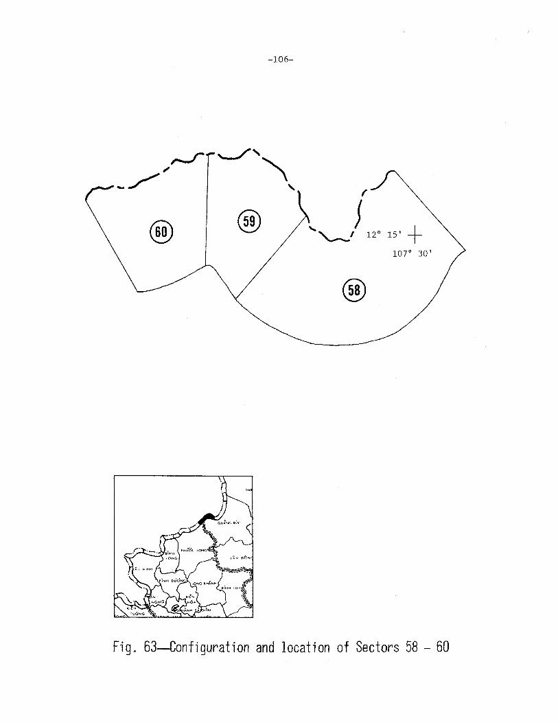
-106-
r
.... ......___) 12 ° 15' + 1or 30'
@
Fig. 53--Configuration and location of Sectors 58 - 60

-107-
SUMMARY OF CHARACTERISTICS OF SECTORS 58 - 60
SECTOR NO:~ MAP REF: ---"6-'-4.:::.;33::-=I:___, 6433 II 6533 III , 6533 IV
TOTAL AREA (SQ KM) : _ _:2:.:::3:..:::9 _____ _ BORDER IN WATERWAY (%): __ 58 __________ _
TOPOGRAPHIC CLASS : __ R_o_1_l_i_;ng"--------- ELEVATION (M) MAX :_1_0_0_0 __ MIN: 700
VEGETATION-TYPE: 2 3 4 6 8 9 10 11 12
18
13 14 15
/,: 72
FOOT TRAFFICABILITY (%):
WET /DRY SEASON:
HOVEMENT ROUTES:
CROSSING BORDER/ENTER SECTOR:
GOOD
o I o
7 3
FAIR
27 I 27
TRACKS I TRAILS
19 I 14
ROADS
o I 3
POOR
< 1 I 70
UNSUITED
73 3
LARGE WATERWAYS
0/0
SMALL WATERWAYS
0 /15
POPULATION : ___,0,____ PER SQ KM: _.;:.0 __ _ TRIBES: __ .:_M~n~o~ng~---------- POP: 1200
SECTOR N0:__22__ MAP REF: 6433 I 6433 II
TOTAL AREA (SQ KM) : _ _::1.:.04.:.._ _____ _ BORDER IN WATERWAY (%) :_.:.._7=._6 __________ ___
TOPOGRAPHIC CLASS : _ __:.:R:::.o::...l.:.:h::..:' n.:.c;g,__ _______ _ ELEVATION (M) MAX: 1000 MIN: 600
VEGETATION-TYPE: 1 3 4 5 6 7 8 9 10 11 12 13 14 15
%: 42 26 7 25
FOOT TRAFFICABILITY (%):
WET/DRY SEASON:
GOOD
o I o FAIR
58 /58
POOR
< 1 /41
UNSUITED
42 I 1
HOVENENT ROUTES :
CROSSING BORDER/ENTER SECTOR:
TRACKS I TRAILS
13 /34
ROADS
o I 3
LARGE WATERWAYS
o I o
POPULATION :_.:::.0 __ PER SQ KM:_O __ TRIBES : ___ M_n_o_n_:;:g:__ _______ _
SECTOR NO:__§Q__ MAP REF: ....;6::..;4~3.:::..3....:I=---• 6433 II 6433 III
TOTAL AREA (SQ KM) : __ 1""1~0~----- BORDER IN WATERWAY (/,) : 100
TOPOGRAPHIC CLASS : _ __;R::.:o::...:1:.:lc::i..:::ns;,.g ________ _ ELEVATION (M) MAX: 900
VEGETATION-TYPE: 1 3 4 5 6 8 9 10 11 12 13 14
%: 87 2 1 10
SMALL WATERWAYS
1 I 4
POP: 300
6433 IV
MIN: 400
15
FOOT TRAFFICABILITY (%): GOOD ~ POOR UNSUITED
WET/DRY SEASON:
MOVEMENT ROUTES:
CROSSING BORDER/ENTER SECTOR:
o I o 12 /12
TRACKS I TRAILS
9 19
ROADS
o I 3
1 I 37 87
LARGE WATERWAYS
o I o
I 51
SMALL WATERWAYS
3 I 7
POPULATION : _ __;0::..__ PER SQ KM: __ :::.O_ TRIBES: _ __;M~n~o~n~g~---------- POP: 300
-108-
I ; + 12° 15'
107° 15' I
I ®
r:-1 (' @
J
@
Fig. 54--Configuration and location of Sectors 61 - 63

-109-
SUMMARY OF CHARACTERISTICS OF SECTORS 61 - 63
SECTOR NO: 61 MAP REF: 6433 III , 6433 rv
TOTAL AREA (SQ KM) : _ __:.10~4~------ BORDER IN WATERWAY (%): 100
TOPOGRAPHIC CLASS : __ R_o_l_l_i_n.:::g ________ _ ELEVATION (M) MAX: 800 MIN: 300
VEGETATION-TYPE: 2 3 4 5 6 8 10 11 12 13 14 15
%: 95 4
FOOT TRAFFICABILITY (%): GOOD FAIR
WET/DRY SEASON: o I o 31 3
HOVE~IENT ROUTES: TRACKS, TRAILS
CROSSING BORDER/ENTER SECTOR: 2 3
ROADS
o I o
POOR
o I o UNSUITED
97 I 97
LARGE WATERWAYS
o I o SMALL WATERWAYS
3 I 8
POPULATION : ___,0"--- PER SQ KM : ___ 0"- TRIBES : __ _:S:...:tc::i.::e.:.ong..__ _______ _ POP: 100
SECTOR NO: _6_2_
TOTAL AREA (SQ KM): 87
TOPOGfu\PHIC CLASS: Rolling
VEGETATION-TYPE: 2 3
%: 98
FOOT TRAFFICABILITY (%):
WET/DRY SEASON:
MAP REF:
4 5
GOOD
o I 1
6
6433 III
BORDER IN WATERWAY
ELEVATION
8 9
FAIR
2 I 2
10
(%): 100
(M) MAX:
11 12
POOR
o I 3
700
13
MIN:
14 15
UNSUITED
98/ 94
200
:-lOVHIEi'/T ROUTES :
CROSSING BORDER/ENTER SECTOR:
TRACKS, TRAILS
o I 5
ROADS
o I o LARGE WATERWAYS
o I o SMALL WATERWAYS
3 I 6
POPULATION :__:_0 __ PER SQ KM: __ O __ TRIBES : __ _::_S.:..t ~::..;· e:..;:n'-"g'--------- POP: 100
SECTOR NO :_6_3_ MAP REF: 6433 III
TOTAL AREA (SQ KM) :_.;:1.:::.0::._9 ------BORDER IN WATERWAY (%) :----=.:10~0::..._ __________ _
TOPOGRAPHIC CLASS : _ _::R=..ol::.;1:.:i:.:n:.~;g,__ _______ _ ELEVATION (M) MAX :-'5::..:0::::0:__ __ MIN: 200
VEGETATION-TYPE:
%: 99
2 3 4 5 6
1
FOOT TRAFFICABILITY (%): GOOD
o I o WET/DRY SEASON:
8 9 10 11 12
FAIR
o I o POOR
o I 23
13 14 15
UNSUITED
100 I 77
MOVEMENT ROUTES:
CROSSING BORDER/ENTER SECTOR:
TRACKS , TRAILS
0 /4
ROADS
0/0
LARGE WATERWAYS
o I o SMALL WATERWAYS
1 I 4
POPULATION :_O __ _ PER SQ KM:_O __ _ TRIBES: __ ~S~t~i~e~n~g,__ ______ ___ POP: 1500

J
-~
I
I I
@
-110-
''---
@ ® 1or oo'
12° 00 1 +
Fig. 55--Configuration and location of Sectors 64 - 66

-lll-
SUMMARY OF CHARACTERISTICS OF SECTORS 64 - 66
SECTOR NO:~ MAP REF: ~63~3~2~1 ___ ,6332 II 6433 III
TOTAL AREA (SQ KM) :_.::;.17'-0'--------- BORDER IN WATERWAY (%) :_--'3--'8 __________ _
TOPOGRAPHIC CLASS: Rolling -----~~-------------
ELEVATION (M) MAX :_4_0_0 __ MIN: 200
VEGETATION-TYPE: l 2 3 4 5 6 8 9 10 11 12 13 14 15
i'.: 37 52 11
FOOT TRAFFICABILITY (%):
WET /DRY SEASON:
MOVEMENT ROUTES :
CROSSING BORDER/ENTER SECTOR:
GOOD
o I o FAIR
414
TRACKS , TRAILS
o I 6
ROADS
0 /2
POOR
0 IB UNSUITED
96 /88
LARGE WATERWAYS
o 1 1
SMALL WATERWAYS
1 16
POPULATION :...:0::__ __ PER SQ KM:__:;O __ _ TRIBES: __ -=S-=t~i~e~ng~--------- POP: 400
SECTOR N0:_6_5 __ MAP REF: 6332 I
TOTAL AREA (SQ KM) :_...:1.=.2:._2 ________ _ BORDER IN WATERWAY
TOPOGRAPHIC CLASS :_~F-=.1-=.a.::.t _________ _ ELEVATION
VEGETATION-TYPE: 2 3 4
%: 39 12
FOOT TRAFFICABILITY (%):
WET/DRY SEASON:
MOVEMENT ROUTES:
CROSSING BORDER/ENTER SECTOR:
5 6 8 9
7 41 1
GOOD FAIR
< 1/ < 1 43 I 43
TRACKS, TRAILS
6 /15
10
ROADS
1 I 3
6333 II
(%): 100
(M) MAX: 200 MIN: 100
11 12 13 14 15
POOR UNSUITED
0 /43 57 I 14
LARGE WATERWAYS
o I 2
SMALL WATERWAYS
o I 2
POPULATION: 102 PER SQ KM: _<-'---'1 __ TRIBES: __ ~S~t~i~e~n~g~--------- POP: 1000
SECTOR NO: 66 MAP REF: 6332 I
TOTAL AREA (SQ KM) : _ _:1..,_24~------- BORDER IN WATERWAY
TOPOGRAPHIC CLASS : _ _:..F.::.la=-t=------------ ELEVATION
VEGETATION-TYPE: 1 2 3 4
i'.: 52 2
FOOT TRAFFICABILITY (%):
WET/DRY SEASON:
MOVEMENT ROUTES:
CROSSING BORDER/ENTER SECTOR:
5 6 7 8 9 10
12 21 4
GOOD FAIR
s I 5 21/ 25
TRACKS , TRAILS
3 119
ROADS
0 /4
6332 IV 6333 II
(%): 100
(M) MAX: 200 MIN: SL
11 12 13 14 15
5 4
POOR UNSUITED
4 I 65
LARGE WATERWAYS
Ol 0
70/5
SMALL WATERWAYS
o I 3
POPULATION: 4494 PER SQ KM:_3_6 __ _ TRIBES :. ____ s_t_i_e_n..::g:...._ ______ _ POP: 1400

+ 12° 00'
106° 30' ~J/1 __
®
-ll2-
---
@ ®
Fig. 56--Configuration and location of Sectors 67 - 69
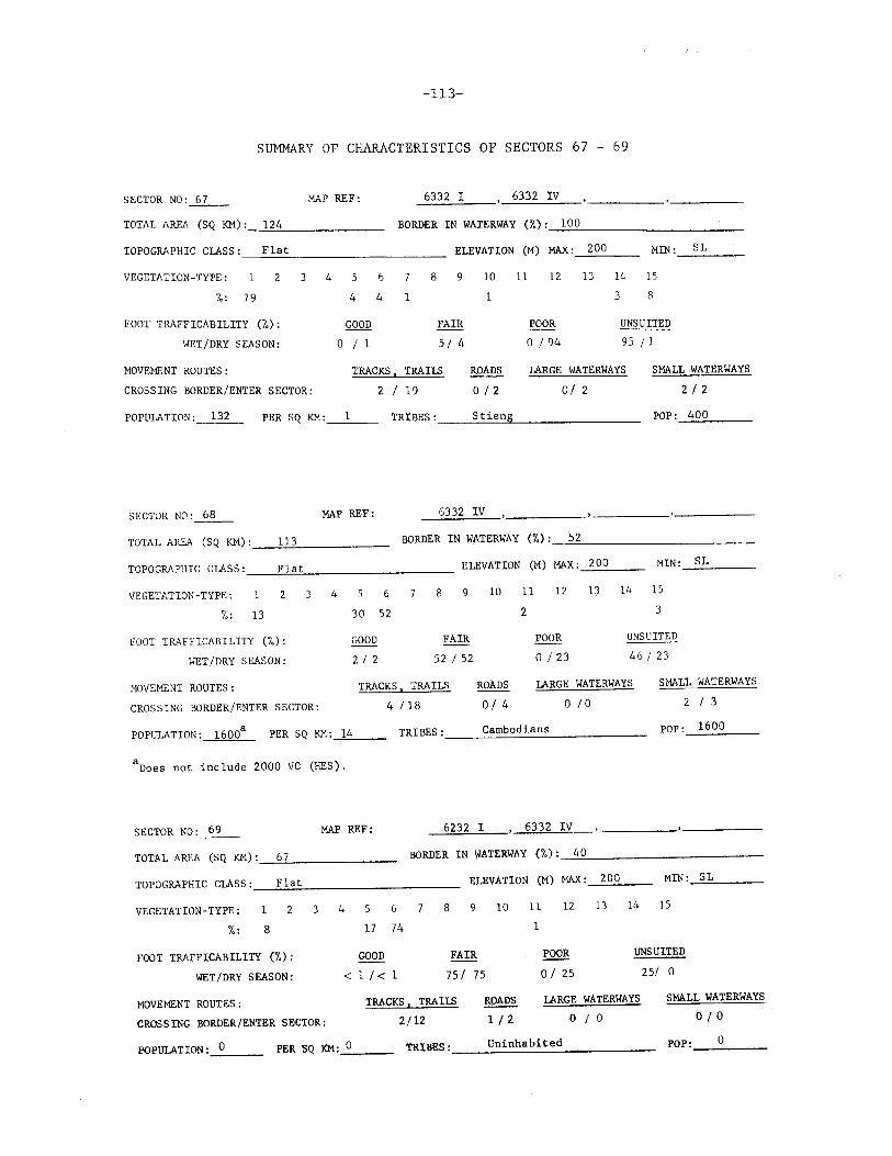
-113-
SUMMARY OF CHARACTERISTICS OF SECTORS 67 - 69
SECTOR N0:_6_7 __ MAP REF: _63_3-'2_1::..__, 6332 IV
TOTAL AREA (SQ KM) :_.:;;12:..:4"--------- BORDER IN WATERWAY (%) :_1_0_0 __________ _
TOPOGRAPHIC CLASS: Flat ------------------------ ELEVATION (M) MAX :_2_0_0 __ _ MIN: SL
VEGETATION-TYPE: 3 4 6 8 9 10 11
1
12 13 14 15
%: 79
FOOT TRAFFICABILITY (%):
WET/DRY SEASON:
MOVEMENT ROUTES:
CROSSING BORDER/ENTER SECTOR:
4 4 1
QQQQ o I 1
FAIR
5 I 4
TRACKS, TRAILS
2 19
ROADS
o I 2
3 8
POOR
o I 94
UNSUITED
95 I 1
LARGE WATERWAYS
o I 2
SMALL WATERWAYS
2 I 2
POPULATION: 132 PER SQ KM: __ _ TRIBES: ___ ~S_t~i~e~n2g _______ _ POP: 400
SECTOR NO:~ MAP REF: 6332 IV
TOTAL AREA (SQ KM) :_---!lc::l;::.3 ____ _ BORDER IN WATERWAY (%): 52
TOPOGRAPHIC CLASS : __ _=.F-"1!!-at=...__ ________ _ ELEVATION (M) MAX: 200 MIN: SL
VEGETATION-TYPE: 1 3 4 6 8 9 10 11 12 13 14 15
/,: 13 30 52 2 3
FOOT TRAFFICABILITY (/,): GOOD FAIR POOR UNSUITED
WET/DRY SEASON: 2 I 2 52 I 52 0 /23 46 I 23
MOVEMENT ROUTES:
CROSSING BORDER/ENTER SECTOR:
TRACKS I TRAILS
4 /18
ROADS
o I 4
LARGE WATERWAYS
o I o
POPULATION: 16008
PER SQ KM: -'1"-"4;....__ TRIBES: ___ c_a_m_b~o_d_i_an_s ______ _
8Does not include 2000 VC (HES).
SECTOR NO :_6_9 _ MAP REF: ---'6::.:2::::.3=-2 _,I"---' 63 3 2 IV
SMALL WATERWAYS
2 I 3
POP: 1600
TOTAL AREA (SQ KM) :_.:::_67"---------- BORDER IN WATERWAY (/,) :__::4~0~----------
TOPOGRAPHIC CLASS :_--=...F;:,:la:o.:t:__ _________ _ ELEVATION (M) MAX:___.;.2..;:0..:.0 __ MIN :__::S.::L __ _
VEGETATION-TYPE: 1 2
%: 8
FOOT TRAFFICABILITY (%):
WET/DRY SEASON:
MOVEMENT ROUTES:
CROSSING BORDER/ENTER SECTOR:
4 5 6 7 8 9 10 11 12 l3 14 15
17 74 1
GOOD
< 1 I< 1
!m 751 75
TRACKS I TRAILS
2112
ROADS
1 I 2
POOR
o I 25
UNSUITED
25/ 0
LARGE WATERWAYS
o I o SMALL WATERWAYS
010
POPULATION: 0 --- PER SQ KM:_O __ _ TRIBES: ___ u_n_i_n_h_a_b_i_te_d _______ ___ POP: ___ o __ _

-114-
+ 12° 00 1
106° 30'
\' \
\ @ '
rl t
® )
I \
\ ® \
Fig. 57--Configuration and location of Sectors 70 - 72

-115-
SUMMARY OF CHARACTERISTICS OF SECTORS 70 - 72
SECTOR NO :_7_0_ MAP REF: --..:6c::2.::c3 2:::--=I:....__, 63 32 IV
TOTAL AREA (SQ KM) : __ 1_5_2 _____ _ BORDER IN WATERWAY(%): 34 ---------------------TOPOGRAPHIC CLASS : ___ F_1_a_t _________ _ ELEVATION (M) MAX :_2_0_0 __ _ MIN: SL
VEGETATION- TYPE: 2 3 4 6 7 8 10 11 12 13 14 15
%: 20
FOOT TRAFFICABILITY (%):
WET/DRY SEASON:
HOVEMENT ROUTES:
CROSSING BORDER/ENTER SECTOR:
4 73 3
GOOD
o I o FAIR
76 I 76
TRACKS I TRAilS
4 I 11
ROADS
0/ 0
POOR
0 /20
UNSUITED
24/ 4
LARGE WATERWAYS
o I o SMALL WATERWAYS
0 2
POPULATION:--..::0:..___ PER SQ KM:---"0 __ _ TRIBES: __ ~Un~L~·n~h=a=b~i~te~d~-------- POP: __ O~--
SECTOR NO: 71 MAP REF: 6232 I 6332 IV
TOTAL AREA (SQ KM) : __ 1-'-24 _____ _ BORDER IN WATERWAY (i.) :_---.::.:83::._ __________ _
TOPOGRAPHIC CLASS : __ :..F,:;.:1a~t=----------- ELEVATION (M) MAX:__:..:_20_0 ____ _ MIN: SL
VEGETATION-TYPE: 1 3 4
%: 44
FOOT TRAFFICABILITY (%):
WET/DRY SEASON:
~!OVEMENT ROUTES :
CROSSING BORDER/ENTER SECTOR:
5 6 7 8 9
3 50 3
GOOD FAIR
< 1/ < 1 53 I 53
TRACKS I TRAIlS
5 /17
10
ROADS
o I 2
11 12 13 14 15
POOR
0 /46
UNSUITED
46 I o
LARGE WATERWAYS
0/ 0
SMALL WATERWAYS
o I 3
POPULATION: 400 PER SQ KM:_3 ___ TRIBES : __ _:C:.:a:.:;m.:::b.:::o.::.d.::.ia::.;n::.:s:__ _____ _ POP: 400
SECTOR NO :_72 __ MAP REF: _6::..::2:.::3.::.2 -'I=---• 62 3 2 II 6232 III , 6332 IV
TOTAL AREA (SQ KM) :_:;1~39;:__ _____ ___ BORDER IN WATERWAY
TOPOGRAPHIC CLASS :_.!..F.!..1!!.at=..._ __________ _ ELEVATION
VEGETATION-TYPE: 1 2 3 4
7.: 72
FOOT TRAFFICABILITY (%):
WET /DRY SEASON:
MOVEMENT ROUTES:
CROSSING BORDER/ENTER SECTOR:
5 6 7 8 9 10
1 19 4 2
QQQ!2 ~
0 /2 25 I 24
TRACKS, TRAILS
6 I 15
ROADS
o I o
(i.): 100
(M) MAX: 100 MIN: SL
11 12 13 14 15
1
POOR UNSUITED
1 I 74
LARGE WATERWAYS
0/0
74/ 0
SMALL WATERWAYS
o I 4
POPULATION: 500 PER SQ KM :____,4 __ TRIBES: ___ _:C~a~m~b~o~d~ia~n~s~---------- POP: 500

-116-
- -+- 11° 45'
... / \._- 106° 15'
®
® ®
Fig. 58--Configuration and location of Sectors 73 - 75

-117-
SUMMARY OF CHARACTERISTICS OF SECTORS 73 - 75
SECTOR NO :_7_3_ MAP REF: 6232 II , 6332 III
TOTAL AREA (SQ I<M) : _ ___:1:.::8..::..9 _____ _ BORDER IN WATERWAY (%) :_1_2 __________ _
TOPOGRAPHIC CLASS : ___ F_1_a_t _________ _ ELEVATION (M) MAX :__;1~0:;::.0 __ MIN: SL
VEGETATIO~-TYPE: 1 2 3 4 5 6 8
%: 83 1 12 3
10 11 12 13 14 15 1
FOOT TRAFFICABILITY (%):
WET/DRY SEASON:
GOOD
o I <1
FAIR
15 I 15
POOR
< 1 /83
UNSUITED
85 I 2
MOVEMENT ROUTES:
CROSSING BORDER/ENTER SECTOR:
TRACKS I TRAILS
3/ 18
ROADS
o I s LARGE WATERWAYS
o I o SMALL WATERWAYS
1 /4
POPULATION :___:0:..___ PER SQ I<M :_O __ _ TRIBES: ___ U_n_in_h_a_b_i_t_e_d _____ ___ POP: __ o __ _
SECTOR N0:_74 __ MAP REF: 6232 II 6232 III
TOTAL AREA (SQ KM) :_...::1:.:..7...:::6 _____ _ BORDER IN WATERWAY (%): 0
TOPOGRAPHIC CLASS :_--=.F..:1!!.a.=..t _________ _ ELEVATION (M) MAX: 100 MIN: SL
VEGETATION-TYPE: 2 3 4 5 6 8 9 10 11 12 13 14 15
%: 57 16
FOOT TRAFFICABILITY (%):
WET/DRY SEASON:
i-!OVEMENT ROUTES:
CROSSING BORDER/ENTER SECTOR:
10 4 5
GOOD FAIR
0 /4 14 /13
TRACKS, TRAILS
8 /8
4
ROADS
o I 3
3
POOR UNSUITED
3 /6 7 83 I 16
LARGE WATERWAYS
o I o
SMALL WATERWAYS
o I 4
POPULATION :-=0 __ _ PER SQ I<M:_O;:_ __ TRIBES : __ ...:U:o.!n.!..!i~n:.:;h.:::.a::_b~:.:· t:.:e:..::d:_ ____ ___ POP : _ __:_0 __ _
SECTOR N0:_7_5_ MAP REF: 6232 IV
TOTAL AREA (SQ KM) :--=.14"'3"---------- BORDER IN WATERWAY
TOPOGRAPHIC CLASS :_"-F"-1a_t;__ _________ _ ELEVATION
VEGETATION -TYPE: 1 2 3 4
fo: 40
FOOT TRAFFICABILITY (%):
WET/DRY SEASON:
MOVEMENT ROUTES:
CROSSING BORDER/ENTER SECTOR:
5 6 7 8 9
16 9
GOOD FAIR
0 119 49 I 32
TRACKS I TRAILS
10 112
10
19
ROADS
0 12
(lo) ; 0
(M) MAX: 100 MIN: SL
11 12 13 14 15
7 9
POOR UNSUITED
3 I 49 48 I o
LARGE WATERWAYS
010
SMALL WATERWAYS
o I 1
POPULATION :----'0"---- PER SQ I<M:_,O.____,._ TRIBES: ___ u_n_i_n_h_ab_i_t_e_d _____ ___ POP: __ o __ _

-118-
®
® @
-.
Fig. 59--Configuration and location of Sectors 76 - 78

-119-
S~~y OF CHARACTERISTICS OF SECTORS 76 - 78
SECTOR N0: ___ 7_6 ___ MAP REF: 6232 III
TOTAL AREA (SQ KM) :_-'9'-'6 ________ _ BORDER IN WATERWAY (%): 0
TOPOGRAPHIC ClASS : _ _,;F::...l::..:a::..:t:.._ ________ _ ELEVATION
VEGETATION-TYPE:
%: 78
2 3
FOOT TRAFFICABILITY (%):
WET/DRY SEASON:
MOVEMENT ROUTES :
CROSSING BORDER/ENTER SECTOR:
4 5 6 8 9
3 3
GOOD FAIR
o I 14 21/ 7
TRACKS I TRAILS
5 116
10
14
ROADS
G I 2
(M) MAX:
11 12
1
POOR
0 /79
100
13
MIN: SL
14 15
1
UNSUITED
79 0
LARGE WATERWAYS
o I o SMALL WATERWAYS
1 I 3
POPULATION: 0 PER SQ KM:....::O __ _ TRIBES: __ ~U~n~i~nh~a~b~L~·t~e~d~------- POP : __ o ____ _
SECTOR NCl: ___ 7_7 ___ MAP REF: 6132 II 6232 III '----- -----
TOTAL AREA (SQ KM) :_....::lc..:.6_;_4 ____ ___ BORDER IN WATERWAY (%) :_....:.0 ___________ ~
TOPOGRAPHIC CLASS : _ __:F.::_l::_a::_t __________ ELEVATION (M) MAX:__::.S~O __ _ MIN :_:S~L::..._ __ _
VEGETATION-TYPE: '\.
3 4 5 6 7 8 9 10 11 12 13 14 15
/,: 89
FOOT TRAFFICABILITY (%):
WET/DRY SEASON:
MOVEMENT ROUTES :
CROSSING BORDER/ENTER SECTOR;
GOOD
o I 2
2 2
FAIR
6/4
TRACKS, TRAILS
13 I 17
2
ROADS
1 I 3
5
POOR
o I 94
UNSUITED
94/ 0
LARGE WATERWAYS
o I o SMALL WATERWAYS
1 5
POPUlATION :_-"0 __ PER SQ KM:--=-0 __ _ TRIBES: __ ~Un~L~·n~h~a~b~i~t~ed~------- POP:_~O __ _
SECTOR NO:~ MAP REF: 6132 II
TOTAL AREA (SQ KM) :_~10:::..:2=------- BORDER IN WATERWAY (%) :---!OL-----------
TOPOGRAPHIC CLASS : __ .:..F.:..la:..;t:..._ ________ _ ELEVATION (M) MAX :-"'-50=---- MIN :~S~L __ _
VEGETATION-TYPE: 3 4 5 6 7 8 9 10 11 12 13 14 15
10 %: 79
FOOT TRAFFICABILITY (%):
WET I DRY S EASON :
MOVEMENT ROUTES:
CROSSING BORDER/ENTER SECTOR:
GOOD
0/0
8 1
FAIR
10 /12
TRACKS I TRAILS
11/10
ROADS
2 I 2
2
POOR
2 I 88
UNSUITED
88 /0
LARGE WATERWAYS
o I o SMALL WATERWAYS
o I 2
POPULATION :_D __ _ PER SQ KM:_D __ _ TRIBES: ____ U~n~L~·n~h~a~b~i~t~ed~------- POP: __ ::_O __

-120-
I
\ \ '---
'") ® I
Fig. 70--Configuration and location of Sectors 79 - 81

-121-
SUMMARY OF CHARACTERISTICS OF SECTORS 79 - 81
SECTOR N0:_7_9_ MAP REF: 6132 II
TOTAL AREA (SQ KM) :_-..:.7_:..4 _____ _ BORDER IN WATERWAY (%): 100 --------------------ELEVATION (M) MAX :---"5...;;0 __ _ Flat TOPOGRAPHIC CLASS: -------------------------
MIN:g__ __
VEGETATION-TYPE: 2 3 4 5 6 7 8 9 10 11 12 13 14 15
%: 86
FOOT TRAFFICABILITY (%):
WET/DRY SEASON:
MOVEMENT ROUTES :
CROSSING BORDER/ENTER SECTOR:
7 3
GOOD FAIR
o /3 10 I 8
TRACKS I TRA Il.S
s I 11
ROADS
2 I 2
1 3
POOR
< 1 I 89
UNSUITED
89 I o
LARGE WATERWAYS
o I o SHALL WATERWAYS
0 /2
POPULATION :_0 __ _ PER SQ KM :_0 __ TRIBES: __ ~U~n=in~h~a~b~i~t~e=d ______ __ POP :_....:0:___ __
SECTOR NO:~ MAP REF: 6131 I 6132 II
TOTAL AREA (SQ KM) : __ 8::..:7'------- BORDER IN WATERWAY (%) :_.:.:.10"-0'--------------
TOPOGRAPHIC CLASS : _ __:F::..:1::.:a:..:t:___ ________ _ ELEVATION (M) MAX:__:S:...:O ____ _ HIN: SL
VEGETATION-TYPE: 1 3 4 5 6 8 9 10 11 12 13 14 15
%: 87
FOOT TRAFFICABILITY (%):
WET /DRY SEASON:
:10\'EMENT ROUTES :
CROSSING BORDER/ENTER SECTOR:
GOOD
o I o
3 3
FAIR
6 I 6
TRACKS I TRAI1.5
8 /24
ROADS
1 I 2
POOR
0 /94
UNSUITED
94 0
LARGE WATERWAYS
o I o SMALL WATERWAYS
1 I 3
POPULATION :---"-0 __ _ PER SQ KM:__:O __ _ TRIBES: ___ ~U-'-n~i_:..n_ha.c..b.c..i_:..t_e_d _______ __ POP : __ 0:..__ __
SECTOR NO :_8_1 __ MAP REF: 6131 I
TOTAL AREA (SQ KM) :_.....:1::..:2:..::8:..._ ____ _ BORDER IN WATERWAY
TOPOGRAPHIC CLASS : ___ ....!F....!1~a.=t ___________ _ ELEVATION
VEGETATION-TYPE: 2 3 4
/,: 66
FOOT TRAFFICABILITY (%):
WET/DRY SEASON:
MOVEMENT ROUTES:
CROSSING BORDER/ENTER SECTOR:
5 6 7 8 9
6 11
GOOD FAIR
0/ 0 17/ 23
TRACKS I TRAILS
6 I 42
10
ROADS
3 /2
(%): 80
(M) MAX: 50 MIN: SL
11 12 13 14 15
6 11
POOR UNSUITED
6 I 77 77 I o
LARGE WATERWAYS
1 I 2
SMALL WATERWAYS
1 1
POPULATION :_0"--- PER SQ KM :__:;0 __ _ TRIBES : ___ ..;:.U:.::n:;:i.:.:nh::.::a:::b:..:i:..:t:..:e:..:d _____ _ POP : _ _.:::.0 __ _

-122-
®
11° 15'
®
'
Fig. 71--Configuration and location of Sectors 82 - 84
-123-
SUMMARY OF CHARACTERISTICS OF SECTORS 82 - 84
SECTOR NO :_8_2_ MAP REF: 6131 I
TOTAL AREA (SQ KM) : __ 12_6 ______ _ BORDER IN WATERWAY (%) :_o ___________ _
TOPOGRAPHIC CLASS: Flat, subject to inundation ELEVATION (M) MAX: 50 __..;;.~--
ML'I: SL
VEGETATION-TYPE: 1 3 4 5 6 8 10 11 12 13 14 15
'lo! 21
FOOT TRAFFICABILITY (%):
WET/DRY SEASON:
MOVEMENT ROUTES:
CROSSING BORDER/ENTER SECTOR:
GOOD
o I o
8 13
FAIR
22 I 45
TRACKS, TRAILS
16 /33
ROADS
o I o
24 34
~
24/55
UNSUITED
54/0
LARGE WATERWAYS
I 4
SMALL WATERWAYS
1 I o
POPULATION :___:0::.___ PER SQ KM: 0 TRIBES: Uninhabited POP: 0
SECTOR NO:_il]_ MAP REF: 6131 I 6131 II 6231 III 6231 IV
TOTAL AREA (SQ KM) :--'-9_1 _____ _ BORDER IN WATERWAY (%) :_O ___________ _
TOPOGRAPHIC CLASS: Flat, subject to inundation ELEVATION (M) MAX:-.:::.5~0 __ _ HIN: SL
VEGETATION-TYPE: 3 4 5 6 8 9 10 11 12 13 14 15
7o! 20
FOOT TRAFFICABILITY (%):
WET/DRY SEASON:
MOVEMENT ROUTES :
CROSSING BORDER/ENTER SECTOR:
GOOD
o I 1
2 20
FAIR
22 I 38
TRACKS, TRAILS
11/14
ROADS
1 I 2
17 40
POOR
17 /61
UNSUITED
61 I o
LARGE WATERWAYS
o I 3
SMALL WATERWAYS
o I 4
POPULATION: 4100 PER SQ KM:_;o4"'-5 __ TRIBES: Cambodians ethnic Vietnamese POP: 4100
SECTOR NO:~ MAP REF: _.;~..61.,..3'-'l'---""I""'I--, 6231 III , 6231 IV
TOTAL AREA (SQ KM) :_::.11...;74!..--_____ _ BORDER IN WATERWAY (%) :__,..::0~-----------
TOPOGRAPHIC CLASS: Flat, subject to inundation ELEVATION (M) MAX:~S~O ____ _ MIN :___..:::.S~L __ _
VEGETATION-TYPE:
%:
1 2 3 4 5 6 7 8 9 10 11 12 l3 14 15
37
FOOT TRAFFICABILITY (%):
WET/DRY SEASON:
MOVEMENT ROUTES :
CROSSING BORDER/ENTER SE~TOR:
GOOD
0 /10
4 4
FAIR
14 I 34
TRACKS I TRAILS
1 1 25
6
ROADS
1 1 1
30 18
POOR
30 I 56
UNSUITED
56 0
LARGE WATERWAYS
0/2
SMALL WATERWAYS
o 115
POPULATION :....::.0 __ _ PER SQ KM:--:;::0 __ TRlBES :, __ .....;U::..:n:;.::i:.:.n:::hc::a"'b.=i;.te;;.d::.-____ _ POP : __ 0:::..._ ___ _

-124-
@
\
\ I
\ \
I,.._._,__, -
> ®
@
+ 11° 00 1
106° 15'
Fig. 72--Configuration and location of Sectors 85 - 87

-125-
SUMMARY OF CHARACTERISTICS OF SECTORS 85 - 87
SECTOR NO:~ MAP REF: 6231 III
TOTAL AREA (SQ KM) :_....:1:..::5_:_7 ______ _ BORDER IN WATERWAY (%): 0 --------------------TOPOGRAPHIC CLASS: Flat, subject to inundation ELEVATION (M) MAX: 50 MIN :_S_L __ __
VEGETt\TlON-TYPE: 2 3 4
/,: 4
FOOT TRAFFICABILITY (%):
WET/DRY SEASON:
MOVEHENT ROUTES:
CROSSING BORDER/ENTER SECTOR:
-----6 8 9 10 11 12 13
78
14 15
GOOD
3 I 4
2
FAIR
4 I 80
TRACKS , TRAILS
o I 10
2 3 11
POOR
78 I 16
UNSUITED
ROADS
1 I 6
15
LARGE WATERWAYS
o I 2
0
SMALL WATERWAYS
2 I 4
POPULATION: 18,090 PER SQ KM: 115 TRIBES: Cambodians, ethnic Vietnamese POP: 18,090
SECTOR NO: _§_L_ MAP REF: 6230 I 6230 IV , 6231 II 6231 III
TOTAL AREA (SQ KM): 250
TOPOG~~PHIC CLASS: Flat, subject
VEGETATION-TYPE: 4
%:
FOOT TR..WFICABILITY (%):
WET/DRY SEASON:
MOVEciE);T ROUTES :
CROSSING BORDER/ENTER SECTOR:
BORDER IN WATERWAY
to inundation ELEVATION
6 8 9 10
3
GOOD FAIR
3 I 3 3 /65
TRACKS, TRAILS
2 /32
ROADS
3/7
(%): 0
(M) MAX: 50 MIN: SL
11 12 13 14 15
3 62 32
POOR UNSUITED
62 /32
LARGE WATERWAYS
0/ 4
32/ 0
SMALL WATERWAYS
4 I 11
POPULATION: 52,563a PER SQ }:}1;_2_0_3 __ TRIBES: Cambodians, ethnic Vietnamese POP: 52,563
aDoes not include 840 VC.
SECTOR NO: 87 MAP REF: 6230 I ' 6230 IV
TOTAL AREA (SQ KM): 91
TOPOGRAPHIC CLASS: Flat, subject
VEGETATION-TYPE: 1 2 3 4
%:
FOOT TRAFFICABILITY (%):
WET/DRY SEASON:
MOVE~IENT ROUTES :
CROSSING BORDER/ENTER SEC'l'OR:
BORDER IN WATERWAY
to inundation ELEVATION
5 6 8 10
GOOD
o I o FAIR
o I 29
TRACKS, TRAILS
o I 11
ROADS
0 11
(%): 0
(M) MAX:
11 12
2 26
POOR
29 I 71
so
13
MIN: SL
14 15
72
UNSUITED
7l 0
LARGE WATERWAYS
o I o SMALL WATERWAYS
7 9
POPULATION :_~0 __ PER SQ KM :__,0'---- TRIBES: _____ U~n~L~·n~h~a~b~i~t~e~d _______ _ POP: __ o __ _

-126-
' ""----
@
\
\ )
J @
10° 45' + 106° 15'
Fig. 73-Configuration and location of Sectors 88- 90

-127-
SUMMARY OF CHARACTERISTICS OF SECTORS 88 - 90
SECTOR NO:~ MAP REF: 6230 I 6230 III , 6230 I\
TOTAL AREA (SQ KM) :_2_6_7 ______ _ BORDER IN WATERWAY (%) : __ o __________ _
TOPOGRAPHIC CLASS: Flat, subject to inundation ELEVATION (M) MAX:_S_O __ _ MIN :_SL ___ _
VEGETATION-TYPE: 2 3 4 5 6
%:
FOOT TRAFFICABILITY (%):
WET/DRY SEASON:
GOOD
o I o
8 9 10 11 12 13 14 15
FAIR
o I 8
8
POOR
8 I 92
92
UNSUITED
92 I o
MOVEMF.NT ROUTES:
CROSSING BORDER/ENTER SECTOR:
TRACKS, TRAILS
1 I 18
ROADS
o I o LARGE WATERWAYS
o I 4
SMALL WATERWAYS
9 I 46
POPULATION :____::0 __ PER SQ KM:......::.O __ _ TRIBES: __ ~Un~L~·n~h~a~b~i~te~d~------- POP: __ ~O __
SECTOR NO:.._..§_L MAP REF: 6230 III , 6230 IV
TOTAL AREA (SQ KM) :_-=1..-:.9..c.7 ______ _ BORDER IN WATERWAY (%) :_....:0~-----------
TOPOGRAPHIC CLASS: Flat, subject to inundation ELEVATION (M) MAX:___:S::..::O:..._ __ HIN: SL
VEGETATION-TYPE:
%:
2345 6 7 89
6
10 11 12 13 14 15
31 7 1 55
FOOT TRAFFICABILITY (%):
WET/DRY SEASON:
GOOD
o I 31
FAIR
3 7 I 13
POOR
7 I 55
UNSUITED
56 I 1
MOVEMENT ROUTES:
CROSSING BORDER/ENTER SECTOR:
TRACKS , TRAILS
1 0
ROADS
o I o LARGE WATERWAYS
o I 2
SMALL WATERWAYS
10 30
POPULATION:_O.:...__ __ PER SQ KM:_O __ _ TRIBES: __ ....:U~n~i~n~ha~b~i~t~e~d _________ ___ POP : __ ...::0:...__
SECTOR N0:..2Q__ MAP REF: _,6<--'1""-3'"-0 _,I~-• 62 3 0 IV
TOTAL AREA (SQ KM) : __ 8_0 _____ _ BORDER IN WATERWAY (io) :_.=2.:;:6:...._ ___________ ___
TOPOGRAPHIC CLASS: Flat, subject to inundation ELEVATION (M) MAX :~5-"'0 __ _ MIN : _ _,8~1"----
VEGETATION-TYPE:
fo:
2 3 4 5 6 8 9 10 11 12 13 14 15
62
FOOT TRAFFICABILITY (%):
WET/DRY SEASON:
MOVEHENT ROUTES:
CROSSING BORDER/ENTER SECTOR:
GOOD
o I 9
FAIR
9 I 29
TRACKS I TRAILS
1 0
9
ROADS
o I o
29
POOR
29/62
UNSUITED
62 I o
LARGE WATERWAYS
1 I 1
SMALL WATERWAYS
2 I 12
POPULATION: 535 PER SQ KM:_7~-- TRIBES: Cambodians I ethnic Vietnamese POP: 535

-128-
_ ____,.,
\ + 11° 00'
\ 106° 00'
@
' '\ \
) ·® I
Fig. 74--Configuration and location of Sectors 91 - 93
-129-
SUMMARY OF CHARACTERISTICS OF SECTORS 91 - 93
SECTOR N0:_9_1_ MAP REF: 6130 I
TOTAL AREA (SQ KM) :_2_0_2 ______ _ BORDER IN WATERWAY (%): 48 -------------------TOPOGRAPHIC CLASS: Flat, subject to inundation ELEVATION (M) MAX: 50 MIN :_SL ___ _ -----VEGETATION-TYPE:
%:
2 4 5 6 8 9 10 11 12
55
13 14 15
2
FOOT TRAFFICABILITY (%):
WET/DRY SEASON:
MOVEMENT ROUTES:
CROSSING BORDER/ENTER SECTOR:
GOOD
1 I 2
FAIR
2 I 57
TRACKS I TRAILS
o I o
2
ROADS
1 I 3
1 40
POOR
57 I 41
UNSUITED
41 I o
LARGE WATERWAYS
2 I 2
SMALL WATERWAYS
2 I 19
POPULATION: 15,323 PER SQ KM: 76 TRIBES: Cambodians, ethnic Vietnamese POP: 15,323
SECTOR NC1:__21___ MAP REF: 6130 I
TOTAL AREA (SQ KM): 193
TOPOGRAPHIC CLASS: Flat, subject
VEGETATION-TYPE: 4
%:
FOOT TRAFFICABILITY (%):
WET/DRY SEASON:
MOVEMENT ROUTES :
CROSSING BORDER/ENTER SECTOR:
BORDER IN WATERWAY
to inundation ELEVATION
6 8 9 10
2 2
GOOD
o I 3
FAIR
5 I 24
TRACKS , TRAILS
4 I 4
ROADS
1 I 1
(%): 0
(M) MAX:
11 12
1 22
POOR
21 /73
so
13
73
~!IN: SL
14 15
UNSUITED
74/ 0
LARGE WATERWAYS
2 I s SMALL WATERWAYS
2 I 18
POPULATION: 6503 PER SQ KM: --=3'-"4'---- TRIBES:Cambodians, ethnic Vietnamese POP:~6~5~0~3 __ _
SECTOR N0: __ 9_3_ MAP REF: 6130 I 6130 IV
TOTAL AREA (SQ KM) : __ 1"-'0'-'9'--------- BORDER IN WATERio(AY (%) :_..:._0 __________ _
TOPOGRAPHIC CLASS: Flat, subject to inundation
VEGETATION-TYPE:
/.:
1 2 4 5 6
ELEVATION
8 9 10
2
FOOT TRAFFICABILITY (%): GOOD
o I 2
FAIR
WET/DRY SEASON:
MOVEMENT ROUTES:
CROSSING BORDER/ENTER SECTOR:
2
TRACKS, TRAILS
4 I l3
/11
ROADS
o lo
(M) MAX: 50 MIN: SL
11 12 13 14 15
69 28
POOR UNSUITED
11 186 87
LARGE WATERWAYS
3 I 1
1
SMALL WATERWAYS
4 /14
POPULATION : __ o __ __ PER SQ KM:_O __ _ TRIBES: __ ~U~n_i_n_h_a_b_i_te_d _______ __ POP : __ __:o __ _

-130-
+ ll0
00'
105° 30' ,.
-~ I~
_ __,_ ..-
,J ® I'
® @
Fig. 75--Configuration and location of Sectors 94 - 96

-131-
SUMMARY OF CHARACTERISTICS OF SECTORS 94 - 96
SECTOR NO:~ MAP REF: 6130 IV
TOTAL AREA (SQ KM) : __ 1_80 _____ _ BORDER IN WATERWAY (%) : __ 10_0 __________ _
TOPOGRAPHIC CLASS: Flat, subject to inundation ELEVATION (M) MAX :_5_0 __ _ MIN: SL
VEGETATION-TYPE: 2 3 4 5 6 8 9
%:
FOOT TRAFFICABILITY (%):
WET/DRY SEASON:
MOVE~lENT ROUTES :
CROSSING BORDER/ENTER SECTOR:
GOOD
0 /0
3
FAIR
o I 98
TRACKS, TRAILS
24 I 11
10 11
ROADS
1 /o
12
95
POOR
s I o
13 14 15
2
UNSUITED
95 I 2
LARGE WATERWAYS
2 I o SMALL WATERWAYS
4 32
POPULATION : ___,0 __ PER SQ KM:_..:.O __ TRIBES: ____ ~U~n=i~n~ha~b~L~·t~e~d ____________ __ POP : __ ...,:0;__ __
SECTOR N0:_9_5_ MAP REF: 6030 I 6130 IV
TOTAL AREA (SQ KM) : __ 1...;.5..:.9 _____ _ BORDER IN WATERWAY (7.) : __ 1_0_0 __________ _
TOPOGRAPHIC CLASS: Flat, subject to inundation ELEVATION
VEGETATION-TYPE:
%:
1 2 3 4
FOOT TRAFFICABILITY (%):
WET/DRY SEASON:
MOVEHENT ROUTES:
CROSSING BORDER/ENTER SECTOR:
6 8 9 10
GOOD
o I o FAIR
0/
TRACKS, TRAILS
16 I 30
84
ROADS
2 I o
(M) MAX: 50 MIN: SL
11 12 13 14 15
84 1 15
POOR UNSUITED
6 I o 94
LARGE WATERWAYS
o I 1
16
SMALL WATERWAYS
s 1 25
POPULATION: 4857a PER SQ KM:__::3_:1 __ TRIBES: Cambodians, ethnic Vietnamese POP: 4857a
8Does not include 492 VC.
SECTOR NO: 96 MAP REF: 6030 I
TOTAL AREA (SQ KM) : _ _,1,_.1""'1 _____ _ BORDER IN WATERWAY (%) :---21~0~0-----------
TOPOGRAPHIC CLASS: Flat, subject to inundation ELEVATION (M) MAX:....:5~0;__ __ _ MIN: SL
VEGETATION-TYPE:
7.:
3 4 5 6 8 9
FOOT TRAFFICABILITY (%):
WET/DRY SEASON:
MOVEMENT ROUTES:
CROSSING BORDER/ENTER SECTOR:
GOOD
o I o FAIR
o I 92
TRACKS, TRAILS
6 I 26
10 11 12
92
13 14 15
8
ROADS
0 IO
POOR
7 I o UNSUITED
93 I 8
LARGE WATERWAYS
2/0
SMALL WATERWAYS
8 I 27
POPULATION: 60568
PER SQ KM:.--=5:.::5'-- TRIBES:Cambodians, ethnic Vietnamese POP: 6056a
8 Daes not include 596 VC

-132-
+ 10° 45'
105° 15 1
Fig. 76--Configuration and location of Sectors 97 - 99

-133-
SUMMARY OF CHARACTERISTICS OF SECTORS 97 - 99
SECTOR :-10: 97 MAP REF: 6030 I
TOTAL ARL-'1 (SQ KM) :_--"'-1-'-'95:...._ _____ _ BORDER IN WATERWAY (%): 67 ~~-----------------
TOPOGRAPHIC CLASS: Flat, subject to inundation ELEVATION (M) MAX: 50 MIN: SL
VEGETATIO~-TYPE: 2
/,:
FOOT TRAFFICABILITY (7,):
\{EI /DRY SEASON:
HOVD!Et\T ROUTES:
3 4
CROSSING BORDER/ENTER SECTOR:
GOOD
o I o
6
5
8
FAIR
o I 63
TRACKS , TRAILS
13 I 16
10
ROADS
o I 4
ll 12
63
-----13 14 15 Water
17 15
POOR
43 Is
UNSUITED
57 /32
LARGE WATERWAYS
I 2
SMALL WATERWAYS
16 I 34
POPULATim;: 56,175 PER SQ KM:_2_8_8 __ TRIBES: Cambodians, ethnic Vietnamese POP: 56,175
SECTOR ~0:~ MAP REF: 6030 IV
TQT,\L ARL". (SQ 101) :_1~4'-'1'--..------ BORDER IN WATERl.JAY (%) : _ _:8 ____________ _
TOPOG~~PHIC CLASS: Flat subject to inundation ELEVATION
VEGETATIO':-TYPE:
%:
2
FOOT T~-\FICABILITY (%):
~.:::IjDRY SEASON:
>lOVE>!E~T ROUTES :
3 4
CROSSI;;G i3<_lRDER/ENTER SECTOR:
GOOD
0 i 0
6
5 2
8 9
FAIR
o I 39
TRACKS , TRAILS
4/ 14
10
ROADS
2 I 2
(N) MAX: 50 MIN: SL
11 12 l3 14 15 Water
41 1 38 13
POOR UNSUITED
34 ! 7 66 I 54
lARGE WATERWAYS
!1
SMALL WATERWAYS
6 I 8
POPULATIO\: 32,7 80 PER SQ KM: 232 TRIBES: Cambodians, ethnic Vietnamese POP: 32 780
SECTOR :\0 · 99 MAP REF: 6030 IV
TOTAL ARLI. (SQ KM) :_..::5_:.4 ______ _ BORDER IN WATERWAY (/,) :_!_:72=..._ __________ _
TOPOG~-'IPHIC CLASS: Flat, subject to inundation ELEVATION (M) MAX: __ ~S~O ____ _ MIN :__::S:.:l::..., __ _
VEGETATIO\-TYPE:
%:
2
FOOT TRAFFICABILITY (%):
\,t:T /DRY SEASON:
MOVEMENT ROUTES :
3 4
CROSSING BORDER/ENTER SECTOR:
GOOD
o I o
6
12
8
FAIR
0 /63
TRACKS, TRAILS
3 /13
10
ROADS
1 I o
11 12
63
13 14 15 Water
17 8
POOR
63 I 12
UNSUITED
37
LARGE WATERWAYS
1 I 2
25
SMALL WATERWAYS
4 I 14
POPULATI0\:17,836 PER SQ KM: 330 TRIBES:Cambodians, ethnic Vietnamese POP: 17,836

+ 10° 45'
105° 00 1
-134-
Fig. 77--Configuration and location of Sectors 100 - 102

-135-
SUMMARY OF CHARACTERISTICS OF SECTORS 100 - 102
SECTOR NO:l..Q.Q__ MAP REF: 6030 rJ
TOTAL AREA (SQ KM) :_8'-0'------------ BORDER IN WATERWAY (%): ___ 8 ______________________ __
TOPOGRAPHIC CLASS: Flat, subject to inundation ELEVATION (M) MAX: 50 •__::..:;_ __ MIN: SL
VEGETI'.TION-TYPE: 3 4
FOOT TRAFFICABILITY (/o) :
WET /DRY SEASON:
GOOD
o I o
6
8
9
FAIR
o I 86
10 1l 12
86
POOR
82/ 8
13 14 15 Water
3
UNSUITED
18 I 6
3
c10VH1ENT ROUTES :
CROSSING BORDER/ENTER SECTOR:
TRACKS I TRAILS
2 I 11
ROADS
o I 1
LARGE WATERWAYS
2 I 4
SMALL WATERWAYS
15 I 25
POPULATION: 20,128 PER SQ KM: 252 TRIBES: Cambodians, ethnic Vietnamese POP: 20,128
SECTOR NO :__lQL_ MAP REF: 6030 III , 6030 IV
TOTAL ARE,\ (SQ KH) : ___ 24_3 _____ _ BORDER IN WATERh'AY (%) : _ _::_0 ___________________ _
TOPOGRAPHIC CLASS: Flat, subject to inundation ELEVATION (H) MAX: 300 MIN: SL
\'EGETATION-TYPE: 2 3 4 5 6
5
8 9 10 ll 12
82
13 14 15 Water
Fcllll TJZ,\FFICABILITY (/o):
\.JET /DRY SEASON:
:·iOVEHEi\T ROUTES:
CROSSING 30RDER/ENTER SECTOR:
GOOD
0 I 0
FAIR
2/ 84
TRACKS, TRAILS
1/13
ROADS
o I 8
2 10
POOR
861 4
UNSUITED
12/ 12
LARGE WATERWAYS
o I 6
SMALL WATERWAYS
40 I 58
POPULATION:105,275 PER SQ KM: 433 TRIBES: Cambodians, ethnic Vietnamese POP: 105,275
SECTOR NO:~ MAP REF: 5930 II 6030 III
TOTAL AREA (SQ KM): 141 BORDER IN WATERWAY (/o)! 0
TOPOGRAPHIC CLASS: Flat, subject to inundation ELEVATION (M) MAX: 200 MIN: SL
VEGETATION-TYPE: 2 3 4 5 6 7 8 9 10 11 12 13 14 15
%: 8 3 6 58 25
FOOT TRAFFICABILITY (%): GOOD FAIR POOR UNSUITED
WET/DRY SEASON: 6 I 6 111 68 58/0 25 I 26
MOVEMENT ROUTES: TRACKS, TRAILS ROADS LARGE WATERWAYS SMALL WATERWAYS
CROSSING BORDER/ENTER SECTOR: o I 13 o I 3 o I 1 19 I 41
POPULATION: 27 904 PER SQ KM: 198 .TRIBES: Cambodians, ethnic Vietnamese POP: 27 904

-136-
--"""-------....... -../ + 10° 30'
104° 45'
I
I ,
Fig. 78--Configuration and location of Sectors 103- 105

-137-
SUMMARY OF CHARACTERISTICS OF SECTORS 103 - 105
SECTOR NO:~ MAP REF: 5929 I 5930 II
TOTAL /\REA (SQ KM) : _ __:2:..:2:.::2:.__ _____ _ BORDER IN WATERWAY (%): 0 -----------------------TOPOGRAPHIC CLASS: MIN: S.L Flat, subject to inundation ELEVATION (M) MAX; 600
---'---
VEGETf. TION -TYPE;
/.: 6
2 3 4
FOOT TRAFFICABILITY (/,):
WET/DRY SEASON;
HOVEc!ENT ROUTES:
CROSSING BORDER/ENTER SECTOR:
GOOD
4 I 5
6
5 5
8 9
FAIR
12/ 70
TRACKS I TRAILS
6 /17
10
7
ROADS
114
ll 12
60
POOR
61/ 2
13 14 15
17
UNSUITED
23 I 23
LARGE WATERWAYS
o I 1
SMALL WATERWAYS
4/ 27
POPULATION: 30 734 PER SQ KM:--=:.13::.:8::___ TRIBES: Cambodians, ethnic Vietnamese POP: 30 734
SECTOR NO:~ MAP REF: 5929 I 5929 IV , 5930 II , 5930 III
TOTAL AREA (SQ KM) :_=-16"-'7'-------- BORDER IN WATER\.fAY (%) : __ 0 ____________ _
TOPOGRAPHIC CLASS; Flat, subject to inundatjon ELEVATION (M) MAX:_;S;_:O:.__ ___ MIN:~SL=----
VI':GETATION-TYPE:
%:
2 3 4 5 6 8 9
FOOT TRAFFICABILITY (%):
WET/DRY SEASON:
MOVEHENT ROUTES:
CROSSING BORDER/ENTER SECTOR:
GOOD FAIR
olo o I 11
TRACKS, TRAILS
9 /"4
10
ROADS
olo
11 12
11
POOR
11/ 8
13 14 15
82
UNSUITED
89 I 81
LARGE WATERWAYS
o I o SHALL WATERWAYS
4/57
POPULATION: 4 895 PER SQ KM :_;:2_.::.9 ___ TRIBES: Cambodians, ethnic Vietnamese POP: 4,895
SECTOR NO:~ MAP REF: 592 9 IV
TOTAL AREA (SQ KM): 102 BORDER IN WATERWAY
TOPOGRAPHIC CLASS: Flat, subject to inundation ELEVATION
VEGETATION-TYPE: 3 4
%:
FOOT TRAFFICABILITY (%):
WET /DRY SEASON:
MOVEHENT .ROUTES:
CROSSING "BORDER/ENTER SECTOR:
5
GOOD
o I o
6 8 9
FAIR
0 /17
TRACKS, TRAILS
13 I 3
10
ROADS
0/0
5930 III
(/',) : 32
(M) MAX:
11 12
17
POOR
17 Is
50
13
8
HIN: SL
14 15
75
UNSUITED
83 I 75
LARGE WATERWAYS
1 I 1
SMALL WATERWAYS
4 I 32
POPULATION: 2 59 PER SQ KM:_:;:3 __ _ TRIBES: Cambodians, ethnic Vietnamese POP:. __ 2_59 __ _
-138-
+ 10° 30'
104° 30 1
Fig. 79--Configuration and location of Sectors 106 and 107

-139-
SUMMARY OF CHARACTERISTICS OF SECTORS 106 AND 107
SECTOR NO:~ MAP REF: 5929 IV
TOTAL ARF:A (SQ KH) :_.::::.2:::;02::.._ ______ _ BORDER IN WATERWAY (%): __ 0 _____________ __
TOPOGRAPHIC CLASS:
VEGETATION-TYPE:
2
Flat , subject to inundation ELEVATION (H) HAX :____:2=..0::.:0::__ __
3 4 5 6 8 10 ll 12
8
13
26
14
~!IN :_S_L __ _
15 Water
57
FOOT TRAFFICABILITY (to): GOOD
o I o FAIR
l/8
POOR
8 I 26
UNSUITED
WET/DRY SEASON:
o\OVE/·II':NT ROUTES:
CROSSING BORDER/ENTER SECTOR:
TRACKS I TRAILS
9 I 2
ROADS
o I 1
91
LARGE WATERWAYS
o I 2
66
SMALL WATERWAYS
15 I 34
POPULATION: 8 264 PER SQ KH:--"4'-"1'--- TRIBES:Cambodians, ethnic Vietnamese POP; 8 264
SECTOR NO: ___.lQ2_ MAP REF: 5842 II ' (L7011)
35 TOTAL AREA (SQ KH) :_-=..::: ______ _ BORDER IN WATERI.JAY (%)? 0
Flat, subject to inundation TOPOGRAPHIC CLASS : _ _:..=..:..!...-=-:::.::...<c.:__:_..:.._-=-=......::..;~.:...;__::..::...::'-='-"- ELEVATION (M) MAX:
\'EGETATION-TYPE: 1
%: 13
FOOT TRAFFICABILITY (%):
WET/DRY SEASON:
4
GOOD
o I o
6 8 9
FAIR
3 I 3 7
10 11
3
12
37
POOR
3 7 I 9
200
13
}!IN: _S_L ___ _
14 15
40
UNSUITED
60 I 54
:·!OVErlENT ROUTES :
CROSSING BORDER/ENTER SECTOR:
TRACKS, TRAILS
o I o ROADS
1 I o
LARGE WATERWAYS
o I o SHALL WATERWAYS
2 I o
POPULATION: 7, 958 PER SQ KN:_2_2_7 __ TRIBES: Cambodians, ethnic Vietnamese POP: 7, 958
8 Not available. Data was abstracted from Map Series L70ll, 1:50,000.
b8 km border length. 17 km consisting of access coastline.

-140-
Appendix B
CLIMATOLOGY ALONG THE LAND BORDER OF SOUTH VIETNAM
This appendix presents a general picture of climatological con
* ditions along the land border of South Vietnam. Major climatological '
factors of this area are the monsoon seasons, the intermonsoon months,
and the topography of the land.
The two great monsoons of Southeast Asia, and of South Vietnam in
particular, are driven principally by annually varying high- and low
pressure systems in East Asia (China) and Australia. These macroscale
pressure changes follow the sun, whose warmth modifies the winter highs
into thermally induced summer lows, resulting in a 180-deg shift of mon
soonal wind flow. During the southwest, or "wet" monsoon of summer,
air flows into the low-pressure area over East Asia, bringing moist
tropical, maritime, and equatorial air across the South Vietnamese bor-
** der. The Annam Range, however, shelters the downwind portions of the
border between Laos and South Vietnam and along the eastern DMZ, putting
these areas in a rain shadow, thereby making them relatively dry during
this wet season.
In winter, the "dry" northeast monsoon airflow from China covers
peninsular Southeast Asia with dry polar continental air moving out of
the Siberian high that develops over East Asia during the winter south
ward toward the low which becomes established over Australia. Though
* The data presented here are drawn from Ref. 7, which also in-cludes a bibliography of studies of climatological conditions in Southeast Asia.
** The mountain range running the length of the northern two-thirds of South Vietnam.

-141-
the northeast monsoon is related to South Vietnam's "dry" period, pas
sage of the polar continental air mass over the Gulf of Tonkin and the
South China Sea adds moisture to the lower levels. This moisture is
dropped on the upwind eastern portion of the DMZ and on the area be
tween the east coast of South Vietnam and the east slopes of the Annam
Range, making this one of the wettest times of the year at these loca
tions.
Table 11 shows the average rainfall in each sector of the border
zone for each season of the year.
The Southwest Monsoon
Along 97 percent of the land border of South Vietnam, the greatest
annual precipitation is recorded during the southwest monsoon, which
lasts approximately from May to September. The average precipitation
along the Cambodian border during the summer months (June through Au
gust) ranges from 5 to 10 in. per month from the Mekong River northward
to the southern tip of the Annam Range (l2°N), and from 20 to 30 in. per
month along the mountainous section in the north. Through Laos, the
Annam Range extends well into the southern panhandle, giving the area
the highest average annual precipitation west of the South Vietnamese
border. Along the DMZ, the annual rainfall decreases dramatically
near the coast, where the eastern 35 km have only 1 to 5 in. per month
during the summer, due to the blocking effect of the mountains and the
resulting rainshadow.
The Northeast Monsoon
South Vietnam, Laos, and Cambodia are comparatively dry during
the northeast monsoon, which lasts, roughly, from November to March.
Host of the land border has 1 in. or less of precipitation per month
during the winter (December through February). The rainiest portions
of the border are just north of the Gulf of Thailand, where the aver
age rainfall is 1 to 5 in. per month, and over the eastern portion

-142-
Table 11
AVERAGE SEASONAL RAINFALL ALONG THE BORDER OF SOUTH VIETNAM
Average Monthly Precipitation (in.)
',.'inter Fall
Sector (Doc Feb)8
Spr 1_ng a (Har May)
h Surrnner b
(June Aug) (Sept ~ov)b
l 2 3 4 5
6 7 8 9
10
ll 12 13 14 15
16 17 18 19 20
21 22 23
24 25 26 27 28 29
30 31 32 33 34
35 36 37 38 39
40 41 42
43 44 45 46 47
48 49 50 51 52
53 54
Sectors 1 - 23
j - 10 1 - 5 1 - 5 ; - 10 1 - 5 1 - 5
- 5 1 - 5 1 - 5 l - 5 1 5 5 - 10
l - 5 1 - 5 5 10
0. 5 - 1 1 - 5 10 - 20 0. 5 - 1 1 - 5 10 - 20 o. 5 - 1 1 - 5 10 - 20
l - 5 1 - 5 10 - 20 1 - 5 1 - 5 lO - 20
1 - 5 1 - 5 5 - 10 l - 5 1 - 5 5 - 10 1 - 5 1 - 5 5 - 10 1 - 5 1 - 5 5 - 10 1 - 5 1 - 5 5 - 10
1 - 5 1 - 5 5 - 10 1 - 5 1 - 5 5 - 10 l - 5 1 - 5 5 - 10 1 - 5 1 - 5 5 - 10 1 - 5 1 - 5 5 - 10
l - 5 l - 5 5 - 10 1 - 5 1 - 5 5 - 10 l - 5 l - 5 5 - 10
Sectors 24 - 42
1 - 5 1 - 5 10 - 20 l - 5 l - 5 10 - 20 l - 5 1 - 5 10 - 20 l - 5 l - 5 10 - 20 1 - 5 l - 5 10 - 20
0. 5 - l l - 5 10 - 20
c. 5 l l - 5 10 - 20 c.s - l 1 - 5 10 - 20 ~ .. 5 - l 1 - 5 10 - 20 (', 5 - 1 1 - 5 10 - 20
0. :s - 0. 5 1 - 5 10 - 20
0 . .:'5 - 0. 5 1 - 5 10 - 20 0. 25 - o. 5 l - 5 10 - 20 0. 25 - 0. 5 l - 5 10 - 20 0. 25 - 0. 5 1 - 5 10 - 20 0 25 - 0. 5 1 - 5 10 - 20
0. 25 - o. 5 l - 5 10 - 20 0 25 - o. 5 l - 5 10 - 20
0. 25 - 0. 5 l - 5 10 - 20
Sectors 43 - 63
0 25 - o. 5 1 - 5 10 - 20 0 25 - 0. 5 l - 5 20 - 30 0 25 - 0. 5 l - 5 20 - 30 0 25 - o. 5 l - 5 20 - 30 0 25 - 0. 5 l - 5 20 - 30
0.25- 0.5 l - 5 20 - 30 0.25- 0.5 1 - 5 20 - 30 0. 25 - o. 5 l - 5 20 - 30 0' :s - o. 5 l - 5 20 - 30 0' 25 - 0. 5 5 - 10 20 - 30
O.C\- 0.5 5 - 10 20 - 30 o. 25 - o. 5 5 - 10 20 - 30
aNorthcast monsoon occurs from December through March,
bSouth1.·est monsoon occurs from May through November.
10 - 20 10 - 20 10 - 20 10 - 20 10 - 20
10 - 20 10 - 20 10 - 20 10 - 20 10 - 20
10 - 20 10 - 20 10 - 20 10 - 20 20 - 30
20 - 30 20 - 30 20 - 30 20 - 30 20 - 30
20 - 30 20 - 30 20 - 30
10 - 20 10 - 20 10 - 20 10 - 20 10 - 20 10 - 20
10 - 20 10 - 20 10 - 20
5 - 10 5 - 10
5 - 10 5 - 10 5 - 10 5 - 10 j - 10
5 - 10 10 - 20 10 - 20
10 - 20 10 - 20 10 - 20 10 - 20 10 - 20
10 - 20 10 - 20 10 - 20 10 - 20 10 - 20
10 - 20 10 - 20
Avera~e Monthly Precipitation {in._l_
Winter Spring a b Summer b Fall Nov)b
Sector (Dec Feb)a (Mar May) ' (June t\ug) (Sept
Sectors 43 - 63 (Cent.)
55 0. 25 - 0. 0 5 - 10 co - 30 10 - 20
56 0. 25 - 0.5 5 -- 10 20 - 30 10 - 20
5 i 0. 25 0.5 5 10 20 - JO 10 - 20
58 0. 25 - 0. 5 5 - 10 20 - 10 10 - 20
59 0. 25 - 0.5 5 - 10 20 - 30 10 - 20
60 0. 25 - 0.5 5 - 10 20 - 30 10 - 20
61 0. 25 - o. 5 5 - 10 10,- 20 10 - 20
62 0. 25 - 0. 5 5 - 10 10 - 20 10 - 20
6] 0.25 - o. 5 5 - 10 10 - 20 10 - 20
Sectors 64 - 9 3
64 0.25 - 0. 5 5 - lO 10 - 20 10 - 20
65 0. 25 - 0. 5 5 - 10 10 - 20 10 - 20
66 o. 25 - 0. 5 5 - 10 10 - 20 10 - 20
6 7 0. 25 - 0. 5 5 - 10 JO - 20 10 - 20
68 0.25 - 0.5 1 - 5 10 - 20 5 - 10
69 o. 25 - 0.5 1 - 5 10 - 20 5 - 10
70 0.5 - 1 1 - 5 10 - 20 5 - 10
71 o. 5 - 1 1 - 5 10 - 20 5 - 10
72 0. 5 - J 1 - 5 10 - 20 10 - 20
73 0. 5 - 1 1 - 5 10 - 20 10 - 20
74 0. 5 - 1 1 - 5 10 - 20 10 - 20
75 0. 5 - 1 1 - 5 5 - 10 5 - 10
76 0. 5 - 1 1 - 5 5 - 10 5 - 10
77 o. 5 - l 1 - 5 5 - 10 5 - 10
78 o. 5 - 1 1 - 5 5 - 10 5 - 10
79 0. 5 - 1 l - 5 5 - lO 5 - 10
80 0. 5 - 1 l - 5 5 - 10 5 - 10
81 o. 5 - l l - 5 5 - 10 10 - 20
82 o. 5 - l l - 5 5 - 10 10 - 20
83 0. 5 - 1 l - 5 5 - 10 10 - 20
l - 5 5 - 10 10 - 20 84 o. 5 - l 85 o. 5 - l l - 5 5 - 10 10 - 20
86 o. 5 - 1 l - 5 10 - 20 10 - 20
87 0. 5 - 1 1 - 5 10 - 20 10 - 20
88 o. 0 - l 1 - 5 10 - 20 10 - 20
89 0. 5 - l l - 5 10 - 20 10 - 20
90 0. 5 - 1 l - 5 5 - 10 10 - 20
9l 1 - 5 1 - 5 5 - lO 10 - 20
92 l - 5 1 - 5 5 - 10 10 - 20
1 - 5 5 - 10 10 - 20 93 1 - 5
Sectors 94 - 107
94 1 - 5 1 - 5 5 - lO 10 - 20
95 1 - 5 1 - 5 5 - 10 i - 10
96 1 - 5 1 - 5 5 - lO 5 - 10
97 1 - 5 1 - 5 5 - lO 5 - 10
98 0. 5 - l l - 5 5 - 10 5 - 10
99 0. 5 - 1 1 - 5 5 - lO 5 - 10
100 0. 5 - 1 l - 5 5 - 10 5 - 10
101 1 - 5 l - 5 5 - 10 5 - 10
102 1 - 5 1 - 5 5 - 10 5 - 10
103 1 - 5 1 - 5 10 - 20 5 - 10
104 1 - 5 1 - 5 10 - 20 5 - 10
105 1 - 5 5 - 10 10 - 20 5 - 10 20 5 - 10
106 1 - 5 5 - 10 10 -
107 l - 5 5 10 10 - 20 5 - 10
-143-
of the DMZ, which has an average rainfall of 5 to 10 in. per month
during the "dry" season. The rainfall in the 3 percent of the border
terminating at the Gulf of Tonkin equals or exceeds, at this time, that
during the southwest monsoon.
Between the Monsoons
April and October are generally the months during lvhich the tran
sition from one monsoon to the other occurs along the border. The
spring transition, which is longer, is comparatively mild and can
occur any time from mid-March to early May. It is heralded by an
increase in rainshowers, with an occasional severe thunderstorm. The
change from the full effects of the northeast monsoon to those of the
southwest monsoon can, however, take place in as short a time as two
days. Severe thunderstorms may develop at any time of the year, though
they are more pronounced during the spring transition, which also brings
an end to the winter precipitation along the northern coast of South
Vietnam.
The fall transition occurs in October over South Vietnam, Laos,
and Cambodia; during this time the weather changes abruptly, with more
violent storms occurring. Heavy showers are the major factor; however,
many types of weather, including typhoons, occur to varying degrees.
The northern part of the land border receives most of its precipitation
in the fall (September through November), due to the transition. The
coastal area of South Vietnam, north of l2°N, receives about 61 percent
of its annual rainfall during this time, compared with about 14 percent
in the summer and about 17 percent in the winter.
Figure 80 shows the precipitation patterns for the four seasons
of the year in South Vietnam and the contiguous areas, based on the
indicated rainfall readings at selected sites.

LEGEND
Average monthly rainfall I in.)
-0-0.25
~ 0.25-0.50
mmmllll 0. 50- 1
~ 1-5
c::::J 5-10
~ 10-20
G u II
of
LEGEND
Average monthly rainfall lin.)
mm<5 c=J 5- 10
~ 10- 20
..a 20-30 .. 30-40
Thailand
WINTER
IDee.- Jan.- . )
SUMMER
(June- July-
-144-
LEGEND
Average monthly rainfall Un.) ·
lmm! 1-5
C:=J 5- 10
~ 10-20
Gulf
of
LEGEND
Average monthly rainfall I in.)
~ 1- 5
c:::=J 5- 10
~ 10- 20
~ 20-30
D1l\l 30-40
of
Thailand
Fig. SO--Seasonal rainfall patterns
SPRING
I Mar.- Apr.-
FALL
(Sept.- Oct.-
If
of
Gulf
of

-145-
REFERENCES
1. Army Map Series L-7014, U.S. Army Map Service, 1965.
2. Vietnam "Demarcation Line," International Boundary Study No. 19, Office of the Geographer, Department of State, Washington, D.C., 1962.
3. Laos-Vietnam Boundary, International Boundary Study No. 35, Office of the Geographer, Department of State, Washington, D.C., Revised 1966.
4. Cambodia-Vietnam Boundary (U), International Boundary Study No. 85, Office of the Geographer, Department of State, Washington, D.C., 1968 (Confidential).
5. Tactical Scale Study (U), Combined Intelligence Center Vietnam, Headquarters U.S. Military Assistance Command, Vietnam, various numbers and dates (Confidential).
6. Hamlet Evaluation System (U), Research and Analysis Division, Headquarters U.S. Military Assistance Command Vietnam (CORDS), 1969 (Confidential).
7. Schutz, c., Monsoonal Injtuences on Wind, Rain~ and Cloud Throughout Southeast Asia: A Study Covering the Peninsula and the Archipelago~ The Rand Corporation, RM-5418-PR, October 1967.
8. Montagnard Tribal Groups of the Republic of South Vietnam, U.S. Army Special Warfare School, Fort Bragg, North Carolina, 1964.
9. Hickey, G. c., The Major Ethnic Groups of the South Vietnamese Highlands, The Rand Corporation, RM-4041-ARPA, April 1964.
10. Hickey, G. C., The Highland People of South Vietnam: Social and Economic Development, The Rand Corporation, RM-5281-1-ARPA, August 1967.
11. Vietnam Statistical Yearbook, Vol. 14, National Institute of Statistics, South Vietnam, 1968.


DECLASSIFIED . . .. Authority: EO 12958, as amended Chief, Declass Br, Dir. & Rec. WHS
MAR l· 4 2UD6
Connors
Weiner
&
Wilson
c.n 0
= ~ n> :r ""0 n> :r' t-<: ~ til ::::l -· n Q.. !:... o:; :1) 0 ~ o-f :::l... Q..
Q n> o-f
0 ::: ..... ::; en ~ 0 = :"') g.. :r < .. Of ;;· ~ ., .... .. = ~ I» ::t ... , ::s ... ;· ~