Embed Size (px)
Citation preview
1
A A A A JOURNEY TO THE AFGHAN PAMIJOURNEY TO THE AFGHAN PAMIJOURNEY TO THE AFGHAN PAMIJOURNEY TO THE AFGHAN PAMIRRRR
The ForbiddenThe ForbiddenThe ForbiddenThe Forbidden Corridor of Corridor of Corridor of Corridor of WakhanWakhanWakhanWakhan Go HiraiGo HiraiGo HiraiGo Hirai
Introduction
On July 19, 2001, I stood on the eastern edge of Lake Victoria (Zorkul). It lay like a pureblue belt stretching westward between two sepia-colored mountain ranges running inparallel. The altitude was 4,200 m above sea level according to an altimeter (hereinafterexpressed as ca. xxxx m). This documentary report is on my third visit to the Wakhanarea in the Afghan Pamir since 1999. This journey was successfully completed under aguard provided by Commandant General Masood, who was assassinated by Talibanterrorists in September 2001.
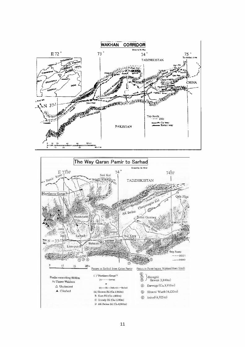
The Afghan (hereafter abbreviated as A-) Pamir refers to the east depth of the Wakhanarea which is said to occupy one-tenth of the whole Pamir and consists of three Pamirs:Qalan (Great), Khurd (Little) and Wakhan. The area is adjacent to Tadzhikistan,Pakistan and China.
At the end of 19th century, it was decided that the area should belong to Afghan territoryas a buffer zone among the three nations mentioned above (i.e. Imperial Russia, BritishIndia and China). Since the beginning of the 20th century, entry into the area has beenunder strict control. To the best of my knowledge, only A. Stein (1915), H.W. Tilman(1947), R.& S. Michaud (1967), Kabul University (1971), S.& A. Gladiew (1968), et al.walked into the area. They stepped mostly into Khurd Pamir area, except for A. Stein.
Ishkashim – Qala・・・・I・・・・Panja - Sarhad
After stopping at Ishkashim at the western extremity of Wakhan by crossing the border,we arrived on June 20 by a 4WD car at Qala-i-Panja, 100 km from Ishkashim to theeast of the River Oxus (Amu Darya) along its left bank. The river runs along a valleybetween the Shakhdarrha range to the south and the East Hindu-Kush range to thenorth.
It was a village of Wakhi (Wakhan’s people) with a population of a few hundred. On theriver side, there are the ruins of a castle of a past Mir (a local king). The river was about100 m wide to the opposite bank (Tadzhikistan). It can be easily forded in the dryseason. In February 1838, J. Wood crossed the river in this area and marched alongthe right bank of the Darya Pamir (Pamir River) upstream to discover its origin: Lake
2
Victoria. The downstream area from here is also called Ab-i-Panj (Five-River).
The following day, we moved to Sarhad, 80 km to the east. The party consisted of aninterpreter, an Afghani cook, a guard and myself. At a point 6 km ahead, a tributary ofthe Oxus (Pamir River) issuing from Lake Victoria flows into the main stream.
The Selsela Wakhan (Wakhan Range) extends eastward for 160 km, flanked by thetwo rivers. Last summer (2000) I visited Lake Victoria in Qalan Pamir along the former.This time we walked along the latter. At Sust, 10 km to the east, we crossed asuspension bridge built by former USSR troops to the right bank. We had seen similarbridges at three points before reaching Sarhad. Every bridge was built over a rapidstream point where the river bed was narrowed to about 20 m. A rough truck road ofgravel and crushed stones along the river ran in the valley or on the rock bank.
After encampment, we passed by Koh-i-Baba Tangi (6513m) soaring on the left bankand crossed Issik Jurab (Valley), the core part of the Selsela Wakhan, where there areKoh-i-Khan (ca. 6020m) and the highest Koh-i-Balandarin (ca. 6286m). Sarhad (ca.4200m) was near at hand. We saw three hot springs by the road.
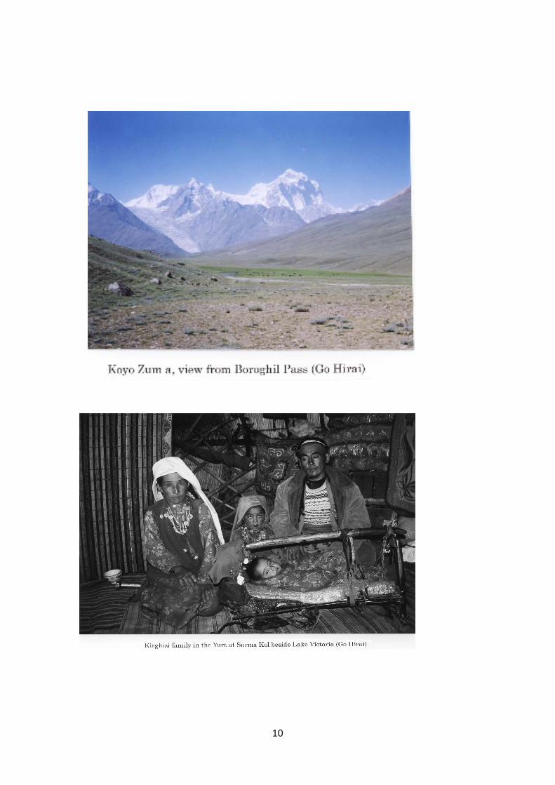
The northern slope of the snowy East Hindu-Kush Range extending to the BoroghilUwin pass (3840m) was some 10 km away in the far south. One darya (river) comingdown from the range joined the main stream and the river bed was stony. Here, in thefields watered through the valleys of the Selsela Wakhan Range in the north, we sawwheat, barley, and several kinds of beans and potatoes.
A number of guspan (fat-rumped sheep) and horses, and cattle (not raised east of thisarea) were grazing in the pasture. In the east, kash-gow (yak) replaced them. This wasthe east limit of farming for Wakhi. Apricot disappeared in the Baba Tangi area. Largetrees also disappeared in this area, such as willows, birches and aspens surroundingmud and stone houses scattered on both sides of the alluvial fan. The maximumtemperature here was 54℃ and the minimum night temperature was 2℃.
People say that on the west side of the confluence, there was a Tibetan Lien-yun thatwas captured by Chinese general Kao Hsien-chih in the 8th century. One of his threebattalions that captured it came down from Qalan Pamir via the “Northern Gorge” to thesouth and gathered here. Our purposes of study were as follows:
(1) to take a route directly reaching Sarhad from the Qalan Pamir side without takingthe route along Spat Kish Jurab (Valley) to Bahark, a half day eastward course thatwe covered in 2000.
3
(2) to find out about how Kirghizi (Kirghiz race), who do not care for any vegetables,fruits and green tea, obtain their necessary vitamin C.
Langar - Carwan Balaci - Bozai Gumbaz - Wakhjir Bil
On the second day, our caravan with two horses and two donkeys headed for BozaiGumbaz, 40 km to the east. A wide spreading river bed suddenly turned into a deepgorge which lasted as far as immediately before Bozai Gumbaz. Crossing the pass, werepeatedly made detours on mountainside and the rapids. On the third day, we passedLangar with Jialat (Holy place) and camped at Mirza Murat where several Wakhifamilies were settled.
On the fourth day, after passing by the stone tower of “Carwan Balaci” identified byStein as the “Red Buddha” referred to in Kao Hsien-chih’s record of war quoted byTilman, we saw the end of gorge soon. People cross a suspension bridge there, and godown along the left bank. Changing the direction to the south at Bai Kra of Wakhi’s Iraq(grazing encampment in summer only), they go over Irshad Uwin (4925 m), and reachBaba Gumdy, one of Pakistan Jialat. In the eastern vicinity of the suspension bridge,two rivers meet; a muddy main stream (locally called Ab-i-Wakhan) issuing fromWakhjir Bil (Uwin or Pass) and a clear tributary (called Darya Khurd Pamir) from easternKhurd Pamir. The confluence was in a stony river bed of a few hundred meters wide.
We proceeded through the arid right bank to Bozai Gumbaz, Kirghizi’s graveyard,where Kirghizi’s living grazing encampment (hereafter abbreviated to l.g.e.) started.Gumbaz, the grave, is built with a conic tower on a square base made of adobe and isapproximately three meters high. There were over ten graves standing there. However,no one could identify the grave of Bozai (a personal name). Here was the headquartersof Soviet troops, which came via Gunji Bai on the border at the time of the invasion.Rusty entangled barbed wires were left over. On the steppe in the valleys of the SelselaWakhan Range branches extending for several kilometers to the north, there wereencampments Ak Belius, summer l.g.e. of Wakhjir way residents.
On the fifth day, we went along the right bank of the main stream. Bushes of slimwillows, birches, low conifers and wild roses were absent on the west side of Langar.Instead, Showaq, a firmly rooted grass, and ote, dry dung of zou, replaced them as fuel.Around noon, I saw several yurts (portable tent house) and Kirghizi for the first time.The yurt is made over 50 willow stems and home made sheep felt. They belong to theSunnis. The control on women’s behavior is not so strict as in Wakhi who are Ismailis.
4
They exposed their faces. Married women wear white shawls covering deep round capsof colored embroideries down below the waists. Those with crimson colored shawls areunmarried women. Men wear rubber shoes or black boots of zou skin. At first glance,you can tell Kirghizi from Wakhi and other races. They are of Turko-Mongolian descent.Incidentally, Wakhi call themselves descendents of Alexander the Great. However, theyare regarded as Tadzhik race.
Assembling a yurt takes three hours by several people, and disassembling takes twohours. Kirghizi move in summer and winter (some move three times a year includingspring) with loaded zou and the family members, and all the cattle such as zous, quis(guspan or fat-rumped sheep), goats, and a small number of horses and donkeys. Mostof their family members remain in a settled place. Wakhjir way (or valley) is a winter(occasionally even spring) l.g.e. All move to the Ak Belius in summer.
On the next day, we camped in steppe. I found here and there the cranial bones ofMarco Polo’s sheep (Ovis poli or big wild sheep) with horns, some as long as 1.5 m, onpile ote, a fuel. The river beach continued for three km to the southeast and ended at aglacier end.
On the seventh day, we marched through a steep slope for 200 m along the mainstream then ascended slowly to the east in the valley of desert and steppe a fewhundred meters wide. The southern mountain range was higher and we saw smallglaciers at 5,000 m and above. Passing through boulders, we reached a 1.5 km wideshoulder of Wakhjir Bil pass (ca. 4950m) in three hours after the departure, where therewas a boundary mark with descriptions in the Afghan and Chinese languages. To thefar east, there were snowy mountains more or less of the same height, 5,000 m.
A lengthy glacier a few hundred m wide ran down from the north. When we approachedthe glacier end several hundred meters ahead, we found an exposed moraine 30 mhigh and springing water which I didn’t see two years before. That was the headwatersof the River Oxus. Water running from several points gathered and formed one stream.It soon separated into several branches then joined a southern stream. Forming a fewclear streams each several meters wide, they flowed down westward.
On the following day, we ascended along the river beach on the right bank extendingsoutheastward for a while. A muddy tributary soon disappeared. It was issuing from theend of a long glacier to the south not far from Pakistan.
Chaqumaqtin Kul - Qala Jilga - Sayutik - Ak Belius
5
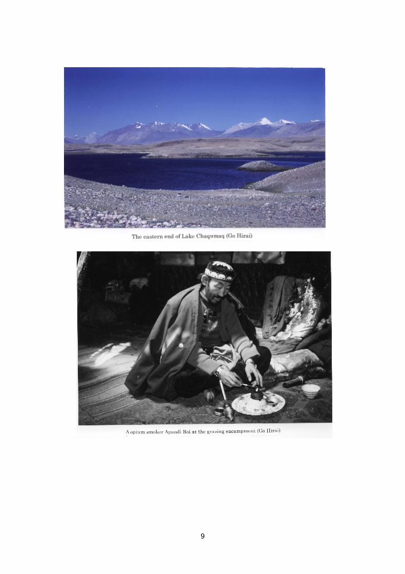
On the nineth day, we returned by the same route. All Kirghizi had already settled in itssummer l.g.e. Their stone-piled huts were deserted. On the morning of the second day,the way heading for the north made a sharp turn eastward for Khurd Pamir. Passing bya salty hot spring with crystallized salt in around, we saw a small stream of the KhurdPamir River disappearing in a northern valley toward its source. They went through aplateau-like desert and came to Chaqumaqtin Kul (Lake), amid sphagnum and lowplants. We were attacked by a swarm of mosquitoes there. The distance from the southof the lake to the mountain foot was assumed to be up to 1 km. In 10 km ahead, wepassed the east end of the lake from where the Ak Su (White stream) issued.
On the tenth day, we passed by several groups of yurts with many zous and quis, thenarrived at Qala Jilga. There lived more than a dozen people in six yurts and two stonecottages accommodating a group of soldiers. We stayed at a yurt of Mr. Abdul RasheedKhan, a chieftain of Khurd Pamir. He told me that their latest Kirghizi population in theA-Pamir was a little over 700.
During the following two days, we visited Sayutik (A-Kirghizi’s easternmost l.g.e.), 20km east of Qala Jigla, near Gunji Bai on the Tadzhikistan border, and returned. We sawAk Su with 200 m long river beds in the north of the desert in Sayutik, a broad valley 4km wide, and three rocky peaks of over 6,000 m covered with snow. They seemed to beeither in Tadzhikistan or China.
On July 9, we left Qala Jilga and went along the northern bank of Chaqumaqtin Kul forAk Belius, which was the starting point of Qalan Pamir.
Kirghizi’s Foods - Northern Bank of Chaqumaqtin Kul - Heaviest Opium Smoker -Ak Belius
The daily foods of Kirghizi include 30 cm-across round thin non (Bread), luogan (butter),kaimak (cream), istach (cheese), and kara chai (milk tea seasoned with rock salt).The salt content of kara chai was 0.3 to 0.6%. To important guests, they sometimesserve boiled sheep heads, mutton, soup, pie-like katama with kaimak inside, and shierbrinji (boiled rice in milk). For portable ration, they prepare bulsak (small fried bread).Flour and daily necessities are obtained in the bazaar or barter with a caravan merchant.The items are luogan, kurt, woolen felt and cow hide. A small amount of flour is alsosupplied annually by Agha Khan, the leader of local Ismaili. In summer, they eat stemsof a wild grass called chigri that grows by a small stream. They sometimes mixsomething like millet grains with kaimak. In summer and winter, they eat small onions
6
called piaz. However, these can hardly be considered sufficient for their vitamin Cneeds.
On the following day, we crossed a limpid stream of Ak Su – 20 m wide - to the northbank at the east end (ca. 4020m) of Chaqumaqtin Kul. The Ak Su formed a large poolseveral hundred m downstream, where the water turned slightly opaque and flowedfurther down. Standing on a dike-like height (ca. 4050m) at the east end, we saw asmall rock, which is called Chaqumaq (making fire) tin (stone), in the lake on the northside; the name of the lake was taken from this rock. Chilap is not the name of the lakebut of a nearby place. The mountain range on the north bank of the lake was lower inheight than the northern, gentle, and with small foothills. The valley was even smallerthan that along the Ak Su. Residential areas of Kirghizi in winter were mostly located onthe left (northern) bank of the Ak Su. People say that on the left bank they have lesssnow in winter than the southern (right) bank. The foot of the mountain was a desertwith grassy spots. We saw tracks of large vehicles of former USSR troops continuingtoward Bozai Gumbaz.
On that day, we stayed at the l.g.e. of the man of the greatest wealth in A-Pamir, ApandiBoi (rich man or local owner). He is a notorious taryak (crude opium) smoker and dailyconsumes one turi (about 18 g) a day. Ten turis of opium was bartered for two sheep.Over a half of the raw material for the total heroin consumed in Europe is said to beexported from Afghanistan. On the next day, we camped near the Yurt of Bostan Boi inAk Belius.
Going Over 4 Bils - Qalan Pamir - Sari Kul (Lake Victoria)
After two day’s encampment, we crossed the Ak Belius Bil, Grundy (another name:Warum) Bil and Kara Bil, and headed northwestward. At Shower Bil (ca. 4950m), wechanged the direction to the north, and reached the west end of Sari (Yellow) Kul on thefifth day. The lake is called Zor (Great) Kul, too. At the lake debouchment (ca. 4100m),we saw a clear stream about 100 m wide flowing down at a rate of 1 m/s westward. TheTadzhikistan territory on the north bank forms dike-like heights. In the low water season,cattle wade the stream. We went eastward on a gentle mountain foot extending 3 to 4km in the eastern part of the Selsela Wakhan Range. The foothills always lookedsepia-colored all over. Their spurs dropped down to the lake every several kilometers.In the middle of the foothills, a low dike-like terrace extended toward the lake. There wesaw the summer l.g.e. of Kirghizi in Qalan Pamir which looked like a green patch. There
7
were more than a dozen yurts. A herd of cattle numbering well over a hundred weregrazing. The pasture was some 100 m above the lake and extended 2 to 3 km towardthe foothill. In winter the cattle move down to the lake front. On July 19, we reached theeasternmost end (ca. 4150m) of the lake stretching east and west for about 18 km. Thelatitude was 37°26′N and the longitude, 73°42′E, as GPS indicated. To the east
was Tadzhikistan; on a slightly high hill, there was a stone piled tower with a horn ofMarco Polo’s sheep erected in the middle of two signs indicating the national borders.The Pamir River running west of the lake also divides the two nations. Kirghizi in QalanPamir go down to Khargush in Tadzhikistan, one and half days down-stream from thewestern end of the lake, to receive flour from Agha Khan around May. The Pamir Riverat that time can be forded easily.
On the way back, we took a route on the south side of the lake. The Selsela WakhanRange was 1,000 m or more above the lake level. To the west, a glacier was seen.The hilly northern Tadzhikistan side was a few hundred meters lower. The northernfoot was slightly narrower and looked more gentle. The green field seemed smaller.Nothing like houses or cattle could be observed. There was a road above the bank.There were more spurs, some extending toward the river and formed 1 km-widechannels. On July 21 we passed through desert and steppe and camped in the steppein due north of Shower Bil (ca. 4300m), where people had remained for the winter l.g.e.In summer 2000, we experienced the night temperature dropping to -15℃ due tosnow. This time, the daytime temperature was 13℃ and it fell to -3℃ at night.
Crossing Great Pamir; Shower Bil - Shakhdarrha - Sarhad; (Northern Gorge)
On July 22, we ascended for three hours on an approximately 600 m long rocky zigzagfoot path toward the Shower Bil. No grass strips were observed on the way. Right afterthe pass, we descended on a glacier end a few hundred meters wide to the south. Onthe way I changed my riding horse for a sure-footed zou. In two hours, we came downto a small grass field. A stream issuing from the glacier had grown into a 10 m widerapid stream. Its banks in the east and west made lush pastures, and dense growths of60-cm-tall wild onion lasted over 5 km. Valleys in the east and west were up to 1 kmlong. In the evening, we stayed in Wakhi’s Iraq around the Sarhad where hundreds ofsheep and yak were put out to graze. We saw people making pamir (cheese) in a fewhuts of piled stone. Wakhi churn milk in casks to make luogan (butter) and dry thecondensed whey under sunlight to make kurt. Kirghizi ferment kaimak in sheepstomachs over one summer to make luogan.
8
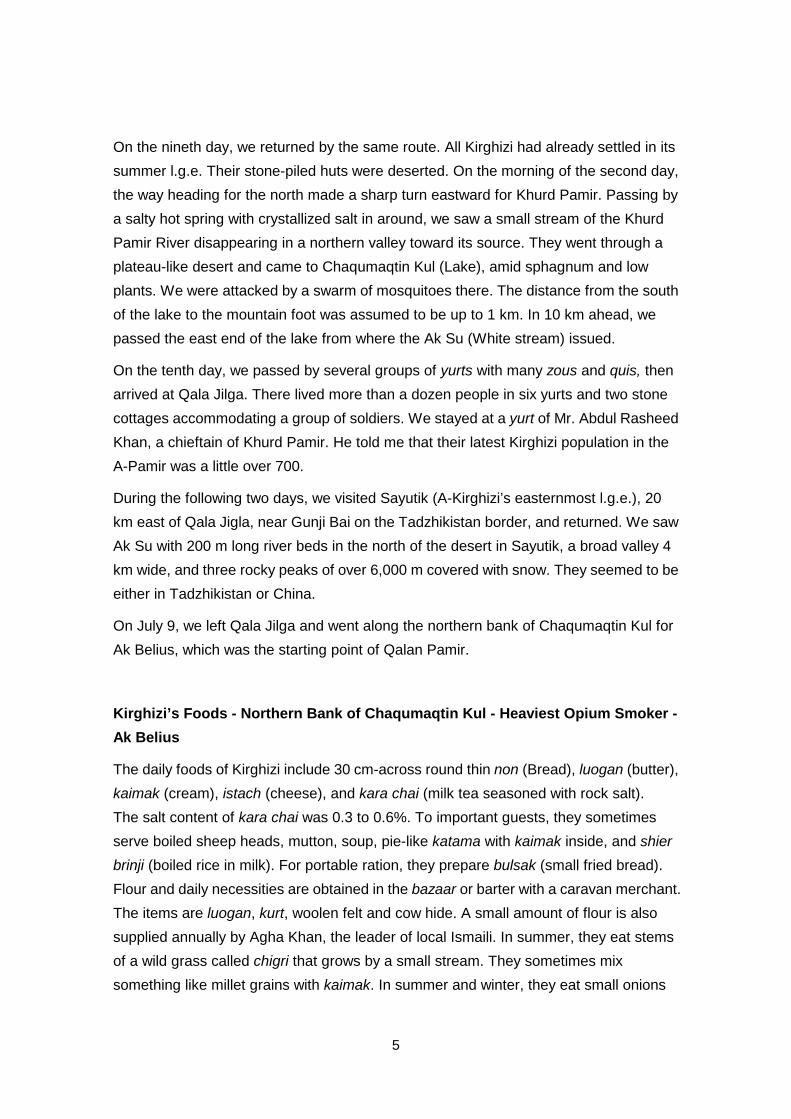
On the second day, we went down along a raging torrent called Shakhdarrha for aboutone hour and crossed it, riding a yak. The stream joined the Spat Kish Jurab severalkilometers to the south, beyond one mountain eastward where we had taken a journeylast summer, and flowed into the main stream at Baharak. We returned the animals andthe guide, and changed the direction to the south. Crossing two Uwins (ca. 4000m), wecamped in a depression.
On the third day, it was unusually rainy. We hastily descended in the rain for 1,000 mtoward Sarhad. This took us two hours. The rain was over on the way and we had aclear view of the opposite bank of the Oxus. Crossing the A-Great Pamir is achievablein two days under favorable conditions. The battalion of Kao Hsien-chih probably tookthis route providing sufficient pasture. A few days later we crossed the border and leftWakhan.
9
10
11