Embed Size (px)
Citation preview
170 GEOLOGI 67 (2015)
This autumn (September 3rd–12th), we went on a ten dayfield trip to the Isle of Mullin Western Scotland. The tripwas organized jointly between
Dr. Tobias Fusswinkel from the University ofHelsinki and Dr. Michael Marks from theUniversity of Tübingen in Germany. Theparticipants included 12 MSc and BScstudents from Tübingen, and 11 PhD and
MSc students from Helsinki. The start of thetrip was a bit rocky, as getting the rental carsproved to be more difficult than expected.After the initial troubles the trip could headtowards a different kind of rocky: Siccar Pointwith the famous unconformity described byJames Hutton (see magazine cover). It was alucky coincidence that there had not been anyrain in several days, as the steep climb to theunconformity would have been dangerous, if
PAULA NIINIKOSKI AND TOBIAS FUSSWINKEL
The Isle of Mull field trip –Cross-cutting geological time
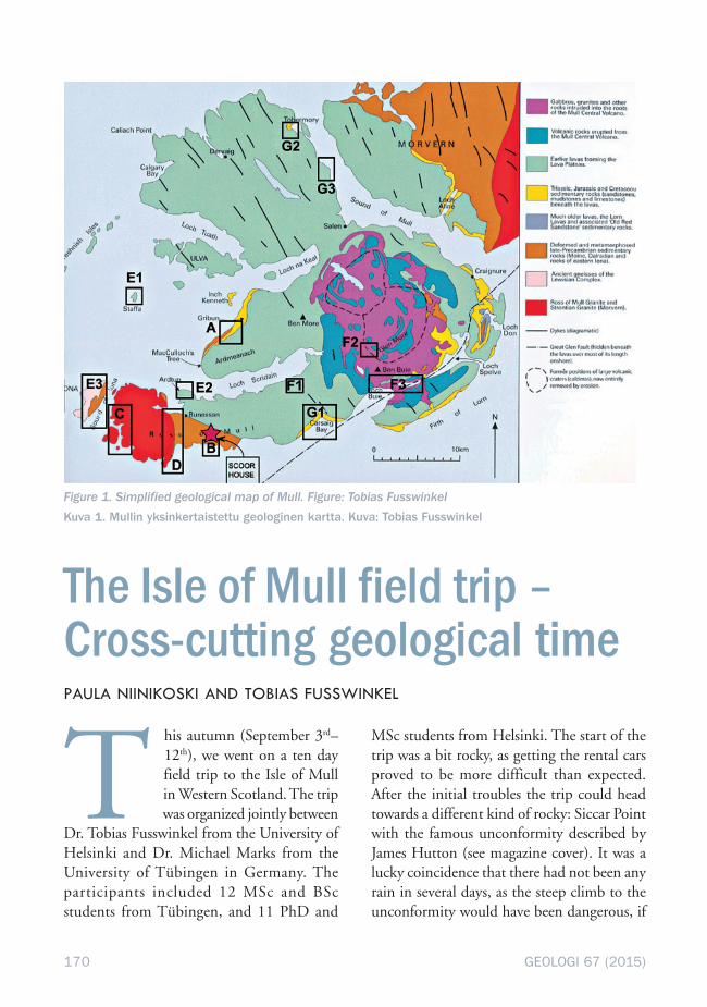
Figure 1. Simplified geological map of Mull. Figure: Tobias FusswinkelKuva 1. Mullin yksinkertaistettu geologinen kartta. Kuva: Tobias Fusswinkel

171GEOLOGI 67 (2015)
not impossible, had the ground been slippery.Even in good weather it was a bit of a challengeand prompted one of the students to pointout: “This is why Hutton came by boat!”
Siccar Point is a wonderful place to visitfor geology students, for one becauseimportant principles of geology are visiblethere in a large scale and also because it is oneof the key places that shaped geology into amodern day science. It was there in 1788 thatJames Hutton found the most strikingevidence for his theory of uniformitarianismand “Deep Time”, or, as we would put it, forgeological processes that work today in thesame way and at the same pace as in the past,and that the Earth must therefore be very, veryold. At the time this was a highly controversialconcept as it challenged the commonlyaccepted view of the Earth having been createdaround tea time on October 23rd, 4004 BC,as calculated by James Ussher (1581–1656).
At Siccar Point, a steeply dippingsuccession of Silurian greywackes andmudstones is unconformably overlain byshallowly dipping Devonian red sandstonesand conglomerates. The greywackes weredeposited on the continental slopes of Lau-rentia during subduction of the Iapetus Ocean,marking the onset of the Caledonian orogeny.After the closure of the ocean the now tiltedsedimentary succession was uplifted andexposed to the surface for 65 Ma, until theywere covered by erosional detritus of theCaledonian Mountain chain brought in by fastflowing rivers during the Devonian. Of course,Hutton knew little of this, but his extensivestudies of present day sedimentation anderosion rates immediately made him realizethat a geological formation like the one atSiccar point could never have formed in a fewthousand years.
After Siccar Point we started our journeytowards Mull, an Inner Hebridean island on
the western coast of Scotland, north of Islayand Jura. We spent the night in Oban, a townon the western coast, known as an importantmilitary base during World War II butnowadays mostly for tourism and itsreputation as the Seafood Capital of Scotland.On Saturday morning we took the ferry tothe Isle of Mull. What makes Mull a uniquespot for a geological field trip is that a vasttime span and variety of rock types, anddifferent geological processes are visible in arelatively small area. One can time travel fromthe Archean through the Paleo- and Mesozoicinto the Paleogene within a few hours’ drive(Fig. 1). Many travelers coming to the UKfrom other parts of Europe worry aboutdriving on the left side of the road. On Mullthis is no challenge, as the roads are mostlysingle track, so everyone drives in the middle.There is very little traffic and most troublecomes from sheep and cows roaming in thewild, and not respecting any traffic laws(Fig. 2).
Figure 2. Giving way to cows. They were not in ahurry. Photo: Tobias Fusswinkel
Kuva 2. Retkeläiset antavat tilaa lehmille, jotkaolivat sangen kiireettömiä. Kuva: Tobias Fuss-winkel
172 GEOLOGI 67 (2015)
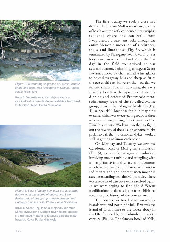
The first locality we took a close anddetailed look at on Mull was Gribun, a seriesof beach outcrops of a condensed stratigraphicsequence where one can walk fromNeoproterozoic basement rocks through theentire Mesozoic succession of sandstones,shales and limestones (Fig. 3), which isterminated by Paleogene lava flows. If one islucky one can see a fish fossil. After the firstday in the field we arrived at ouraccommodation, a charming cottage at ScoorBay, surrounded by what seemed at first glanceto be endless grassy hills and sheep as far asthe eye could see. However, the next day werealized that only a short walk away, there wasa sandy beach with exposures of steeplydipping and deformed Proterozoic meta-sedimentary rocks of the so called Moinegroup, crosscut by Paleogene basalt sills (Fig.4), a beautiful location for our mappingexercise, which was executed in groups of threeto four students, mixing the German and theFinnish students. Working together to figureout the mystery of the sills, or, as some mightprefer to call them, horizontal dykes, workedwell in getting to know each other.
On Monday and Tuesday we saw theCaledonian Ross of Mull granite intrusion(Fig. 5), its complex magmatic evolution,involving magma mixing and mingling withmore primitive melts, its emplacementmechanism into the Proterozoic meta-sediments and the contact metamorphicaureole extending into the Moine rocks. Therewas a little bit of detective work involved again,as we were trying to find the differentmodifications of alumosilicates to establish themetamorphic history of the contact area.
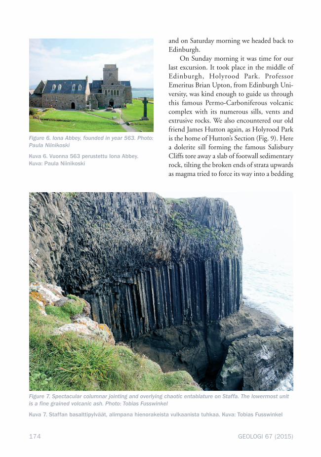
The next day we travelled to two smallerislands west and north of Mull. First was theisland of Iona, home to the oldest abbey inthe UK, founded by St. Columba in the 6thcentury (Fig. 6). The famous book of Kells,
Figure 3. Alternating sequence of Lower Jurassicshale and fossil rich limestone in Gribun. Photo:Paula Niinikoski
Kuva 3. Vuorottelevat varhaisjurakautisetsaviliuskeet ja fossiilipitoiset kalkkikivikerroksetGribunissa. Kuva: Paula Niinikoski
Figure 4. View of Scoor Bay, near our accommo-dation, with exposures of subvertical LateProterozoic Moine group metasediments andPaleogene basalt sills. Photo: Paula Niinikoski
Kuva 4. Scoor Bay, lähellä majapaikkaamme.Lähes pystysuoria Moinen myöhäisproterotsooi-sia metasedimettejä leikkaavat paleogeenisetbasaltit. Kuva: Paula Niinikoski

173GEOLOGI 67 (2015)
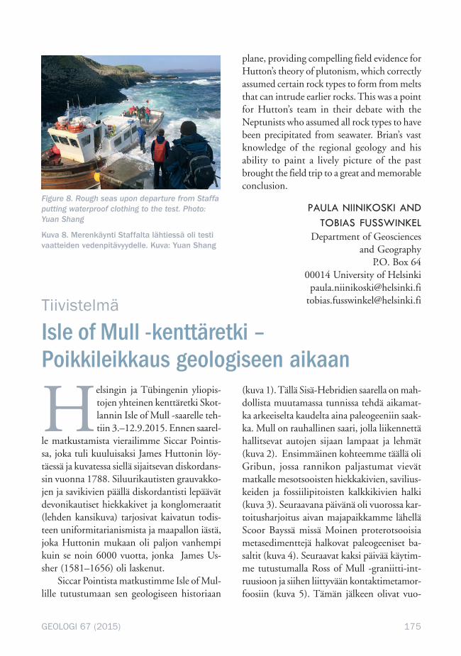
nowadays a tourist attraction in Dublin, wasactually written here, but moved to Ireland forsafekeeping during attacks by Vikings.Geologically Iona is made up of much olderrocks than those on mainland Mull,comprising partly migmatized orthogneisses,amphibolites, pegmatites and anorthosites.After Iona we took a boat to Staffa, home to amagnificent columnar basalt (Fig. 7) belongingto the 2000-meter thick Paleogene lava flowsuccession which covers most of Mull. Theweather was becoming windier, which made
the one hour boat ride a little bumpy. Luckily,we were able to get on the shore, which is notalways the case in bad weather (Fig. 8).
On Thursday we drove towardsTobermory, the largest town on the island andhome to a whisky distillery of the same name.On the way we looked at sediments rich inplant fossils in between different Paleogene lavaflows. The next day was spent in the MullCentral Volcanic Complex which intrudes thelava flows and is comprised of gabbros, picritesand granites. This concluded our stay on Mull
Figure 5. Students taking a close and detailed look at an aplitic vein within the Caledonian Ross of MullGranite. Photo: Tobias Fusswinkel
Kuva 5. Opiskelijat katsovat läheltä ja tarkasti apliittista juonta Ross of Mull -graniitissa. Kuva: TobiasFusswinkel
174 GEOLOGI 67 (2015)
and on Saturday morning we headed back toEdinburgh.
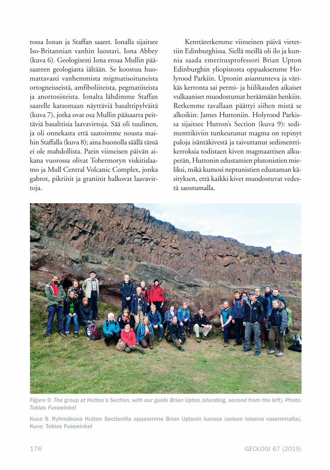
On Sunday morning it was time for ourlast excursion. It took place in the middle ofEdinburgh, Holyrood Park. ProfessorEmeritus Brian Upton, from Edinburgh Uni-versity, was kind enough to guide us throughthis famous Permo-Carboniferous volcaniccomplex with its numerous sills, vents andextrusive rocks. We also encountered our oldfriend James Hutton again, as Holyrood Parkis the home of Hutton’s Section (Fig. 9). Herea dolerite sill forming the famous SalisburyCliffs tore away a slab of footwall sedimentaryrock, tilting the broken ends of strata upwardsas magma tried to force its way into a bedding
Figure 6. Iona Abbey, founded in year 563. Photo:Paula Niinikoski
Kuva 6. Vuonna 563 perustettu Iona Abbey.Kuva: Paula Niinikoski
Figure 7. Spectacular columnar jointing and overlying chaotic entablature on Staffa. The lowermost unitis a fine grained volcanic ash. Photo: Tobias Fusswinkel
Kuva 7. Staffan basalttipylväät, alimpana hienorakeista vulkaanista tuhkaa. Kuva: Tobias Fusswinkel
175GEOLOGI 67 (2015)
Helsingin ja Tübingenin yliopis-tojen yhteinen kenttäretki Skot-lannin Isle of Mull -saarelle teh-tiin 3.–12.9.2015. Ennen saarel-
le matkustamista vierailimme Siccar Pointis-sa, joka tuli kuuluisaksi James Huttonin löy-täessä ja kuvatessa siellä sijaitsevan diskordans-sin vuonna 1788. Siluurikautisten grauvakko-jen ja savikivien päällä diskordantisti lepäävätdevonikautiset hiekkakivet ja konglomeraatit(lehden kansikuva) tarjosivat kaivatun todis-teen uniformitarianismista ja maapallon iästä,joka Huttonin mukaan oli paljon vanhempikuin se noin 6000 vuotta, jonka James Us-sher (1581–1656) oli laskenut.
Siccar Pointista matkustimme Isle of Mul-lille tutustumaan sen geologiseen historiaan
(kuva 1). Tällä Sisä-Hebridien saarella on mah-dollista muutamassa tunnissa tehdä aikamat-ka arkeeiselta kaudelta aina paleogeeniin saak-ka. Mull on rauhallinen saari, jolla liikennettähallitsevat autojen sijaan lampaat ja lehmät(kuva 2). Ensimmäinen kohteemme täällä oliGribun, jossa rannikon paljastumat vievätmatkalle mesotsooisten hiekkakivien, savilius-keiden ja fossiilipitoisten kalkkikivien halki(kuva 3). Seuraavana päivänä oli vuorossa kar-toitusharjoitus aivan majapaikkamme lähelläScoor Bayssä missä Moinen proterotsooisiametasedimenttejä halkovat paleogeeniset ba-saltit (kuva 4). Seuraavat kaksi päivää käytim-me tutustumalla Ross of Mull -graniitti-int-ruusioon ja siihen liittyvään kontaktimetamor-foosiin (kuva 5). Tämän jälkeen olivat vuo-
plane, providing compelling field evidence forHutton’s theory of plutonism, which correctlyassumed certain rock types to form from meltsthat can intrude earlier rocks. This was a pointfor Hutton’s team in their debate with theNeptunists who assumed all rock types to havebeen precipitated from seawater. Brian’s vastknowledge of the regional geology and hisability to paint a lively picture of the pastbrought the field trip to a great and memorableconclusion.
PAULA NIINIKOSKI ANDTOBIAS FUSSWINKEL
Department of Geosciencesand Geography
P.O. Box 6400014 University of Helsinki
[email protected]@helsinki.fi
Figure 8. Rough seas upon departure from Staffaputting waterproof clothing to the test. Photo:Yuan Shang
Kuva 8. Merenkäynti Staffalta lähtiessä oli testivaatteiden vedenpitävyydelle. Kuva: Yuan Shang
Isle of Mull -kenttäretki –Poikkileikkaus geologiseen aikaan
Tiivistelmä
176 GEOLOGI 67 (2015)
rossa Ionan ja Staffan saaret. Ionalla sijaitseeIso-Britannian vanhin luostari, Iona Abbey(kuva 6). Geologisesti Iona eroaa Mullin pää-saareen geologiasta iältään. Se koostuu huo-mattavasti vanhemmista migmatisoituneistaortogneisseistä, amfiboliiteista, pegmatiiteistaja anortosiiteista. Ionalta lähdimme Staffansaarelle katsomaan näyttäviä basalttipylväitä(kuva 7), jotka ovat osa Mullin pääsaarta peit-täviä basalttisia laavavirtoja. Sää oli tuulinen,ja oli onnekasta että saatoimme nousta mai-hin Staffalla (kuva 8); aina huonolla säällä tämäei ole mahdollista. Parin viimeisen päivän ai-kana vuorossa olivat Tobermoryn viskitislaa-mo ja Mull Central Volcanic Complex, jonkagabrot, pikriitit ja graniitit halkovat laavavir-toja.
Kenttäretkemme viimeinen päivä vietet-tiin Edinburghissa. Siellä meillä oli ilo ja kun-nia saada emeritusprofessori Brian UptonEdinburghin yliopistosta oppaaksemme Ho-lyrood Parkiin. Uptonin asiantunteva ja väri-käs kerronta sai permi- ja hiilikauden aikaisetvulkaaniset muodostumat heräämään henkiin.Retkemme tavallaan päättyi siihen mistä sealkoikin: James Huttoniin. Holyrood Parkis-sa sijaitsee Hutton’s Section (kuva 9): sedi-menttikiviin tunkeutunut magma on repinytpaloja isäntäkivestä ja taivuttanut sedimentti-kerroksia todistaen kiven magmaattisen alku-perän, Huttonin edustamien plutonistien mie-liksi, mikä kumosi neptunistien edustaman kä-sityksen, että kaikki kivet muodostuvat vedes-tä saostumalla.
Figure 9. The group at Hutton’s Section, with our guide Brian Upton (standing, second from the left). Photo:Tobias Fusswinkel
Kuva 9. Ryhmäkuva Hutton Sectionilla oppaamme Brian Uptonin kanssa (seisoo toisena vasemmalta).Kuva: Tobias Fusswinkel