Embed Size (px)
Citation preview
Unofficial English version provided by the author of the Italian paper published in: BOLLETTINO DELLA SOCIETÀ GEOGRAFICA ITALIANA
ROMA - Serie XIII, vol. IX (2016), pp. 241-251
MARIA RONZA - ELIODORO SAVINO1
THE INFLUENCE OF THE AUGUSTAN REGIO I ON THE ITALIAN
REGIONALIZATION DEBATE
1. Between «Latium et Campania»: a different perspective - The Augustan Regio I was a territorial aggregate of
Latium (vetus et adiectum) and Campania. Although it is accepted that these territorial contexts are
different, as it is suggested also by place names, the relationship between Rome and the other important
urban center of Phlegraean Fields (Misenum, Baiae, Puteoli) gave a unitary profile to this territorial
division. Baiae was a leisure destination, well known to the roman aristocracy; Misenum was the military
harbour of the roman army, while Puteoli was an important seaport to the trade flows. Many cities of
Campania played a strategical rule for Rome and its aristocracy, as pointed out from the high frequency
in affairs by sea and by land.
The territorial asset of Regio I does not result from ethnic criteria but, more probably, it is due to an
infrastructural network between Rome and the Southern Italy (Gambi, 1977). The Appian Way and the
Latin Way were certainly the most important routes to travel and trade.
Since the nineteenth century, the area comparable to the ancient Regio I was involved in a series of
regional models. We would also underline as several criteria of regionalization (hydrogeological
features, historical experiences and sense of identity, economic and functional forces) were chosen in
order to create regions. After the political unity of Italian peninsula (1861), the administrative
subdivision became the best way of governing the new country. The political debate on regionalization
highlighted the difficulties of making decisions and moving from theory to practice. The matter has
taken off again and it is due to the current territorial changes. Therefore, the Augustan perspective on
Regio I has been examined in order to consider its potentialities for a new territorial asset based on the
socio-economic dynamics between Lazio and Campania. 1Author contributions: Maria Ronza conceived and designed the research. She has written the third and the fourth paragraphs; she also made all the maps. Eliodoro Savino gave many suggestions for improving this article. He has written the first and the second paragraphs.
Unofficial English version provided by the author of the Italian paper published in: BOLLETTINO DELLA SOCIETÀ GEOGRAFICA ITALIANA
ROMA - Serie XIII, vol. IX (2016), pp. 241-251
2. The Augustan Regio I: economic relationship as a key factor of the territorial cohesion - The debate on the
Augustan discriptio is still open in relation to aim and reason of the Augustan regionalization. The regiones
of Italian peninsula are based on historic, ethnic and economic criteria. The mixture of
“regionalization” and “regionalism” is particularly clear in the Regio I. This region included Latium and
Campania, which are contiguous geographical areas linked by age-old relationship. However, these areas
were characterised by ethnic and cultural differences.
During the Augustan age, Rome grew approximately up to one million inhabitants (Morley, 1996).
According to reliable studies, the Urbs was at the climax of the demographic and urban growth
happening over the last two centuries, in the Republican age. Supplies of food were a priority for the
roman metropolis. This had led to an integrated system between Rome and neighbouring areas of
south-central Italy, mainly based on a high diversification of production. The relationships of
production and trade were closely related to the distance of these areas from Rome. We cannot say
exactly if Augustus took into consideration these elements. However, the economic relationship with
Rome became a unifying force between Latium and Campania, at the beginning of the Imperial age.
According to historical and epigraphical sources, the area within a twenty or twenty-five miles radius of
Rome is defined as suburban. Salubritas, otium and amoenitas were significant elements for increasing the
quality of life, contrary to the frenetic and unhealthy city life. However, only the roman emperors and
the most important senator’s families used to spend the summer and long periods in the suburbium
(Champlin, 1982).
In Latium antiquum, many towns lost their relevance becoming small villages in the beginning of the
Imperial age. Therefore, the roman elites preferred to spend their financial resources in the suburban
area more than in the old towns. They built luxurious houses, but also villae rusticae for the management
of agricultural funds. As usually in the suburban areas of the main pre-industrial cities, these agricultural
funds were reserved to the intensive farming of perishable foods and valuable products. This was
possible thanks to the Egyptian and Africans food imports of wheat, sufficient to Rome requests. Close
to the orchards and the horticultural plants, there were the valuable productions characteristic of villatica
pastio as, for instance, the honey production, the breeding of unusual species (thrushes, peacocks,
gophers, peculiar fishes) and the flower growing with the aim to satisfy the demand of the roman
aristocracy. Even the southern Lazio had close economic relations with Rome. The geographer Strabo
referred to this area: it was well-known for its soil fertility, farming production, but also for the lively
urban energy too.
Unofficial English version provided by the author of the Italian paper published in: BOLLETTINO DELLA SOCIETÀ GEOGRAFICA ITALIANA
ROMA - Serie XIII, vol. IX (2016), pp. 241-251
In the Ancient Campania, the incredible wheat and wine production supports a well-developed network
of towns. The agricultural surplus was offloaded on Rome, the largest market place of the ancient
world. Archaeological finds confirmed this strong trade relationship, clearly evidenced by a particular
kind of epigraphs known as indices nundinarii. These indices were inscriptions relating to nundinae: they
were periodic markets (every seven or eight days) taking place in some of the most important cities of
the Regio I.
Three indices are interesting for our research, referring to the middle of the first century A.D. and called
with regards to the places where each index was found. We refer to the index Pompeianus (Degrassi,
Inscriptiones Italiae, n.53), the index of Southern Lazio (the original place of this index is uncertain, perhaps
this could be from Fregellae, Degrassi, ibidem, n.49) and the index Pausilypensis (Degrassi, ibidem, n.52).
Roma and Capua (Volturno plain) are set out in sequence on each index. In the index Pompeianus and in
the index Pausilypensis, these two cities are respectively preceded by the most important harbour town of
the areas where were found: Puteoli and Minturnae. The indices nundinarii provide significant information
about the centres of products store and distribution. Therefore, it is possible to identify the trade flows
between Southern Lazio, Campania and Rome. The index Pompeianus points out the prominent position
of Puteoli. This town was the terminal of two trade flows regarding local specialist products: the cereals
from the ager Campanus and wine from the Vesuvian area. Other valuable products (fragrances, vases
from Capua, garum from Pompeii) used to get into the terminal of Puteoli.The index of Southern Lazio
highlights the rule of Minturnae as terminal for the trade of fine wines coming from the ager Falernus,
also confirmed by Latin literature and archaeological finds. Although the index Pausilypensis is a
fragmented source for our research, it gives rise to a trading function performed by Benevento
(Campania hinterland). This city is mainly considered as a marketplace for the wool coming from
Lucera (Apennine mountains). This product type was inexpensive but widely used.Perhaps, the trade
flow of fine textile products got through Benevento before arriving to Capua and stopping to the port
city of Puteoli where all these productions were shipped to Rome.
The inclusion of Rome in these three indices nundinarii attests the establishment of an integrated network
including the most important cities of the Regio I. This urban network was intended to direct local
products toward the metropolis of the first century AD. In Rome, there were nundinae since ancient
time (Storchi Marino, 1997). For our research, it is important to highlight the role played by the nundinae
in the Urbs. The nundinae were able to satisfy the needs of the metropolitan population, but also to
improve the trade of luxury products coming in Rome from all parts of the Empire. Probably, the
traders of Campania were allowed to buy and sell these luxury goods in many cities of the Regio I.
3. Regio I, a territorial context between uniform and heterogeneous geographical features. The Augustan perspective and
its suggestion in the Italian regionalization process. - During the Roman Empire, the cities have always played a
Unofficial English version provided by the author of the Italian paper published in: BOLLETTINO DELLA SOCIETÀ GEOGRAFICA ITALIANA
ROMA - Serie XIII, vol. IX (2016), pp. 241-251
key role in the territorial government. The long-term and frequent relationships between the Urbs and
the dynamic cities of Campania and Phlegrean coastline have been the cohesive forces able to
overcome ethnic and landscape differences existing between “Latium et Campania”. The study of
historical and epigraphic sources highlights how commercial and productive matters have oriented the
configuration and the boundaries of the Augustan Regio I more than natural and cultural features.
Therefore, functional criteria are the main keys of regionalization process (Polverini, 1998).
The establishment of a singular collaborative pattern between Rome (the metropolis of the past) and
the main cities of Campania coastline and hinterland is the result of several factors, like for example: a
continuous provision of food resources for the Urbs, a strategic positioning of the Roman military fleet,
a well-known amenity of places for Roman élites. Since the Republican period, the Appian Way and the
Latin Way were basic road networks connecting urban areas and rural settlements with a different
socio-economic profile between Latium et Campania. Then, during the Imperial period, the construction
of other ways - called Domitiana and Severiana - made stronger and more various these territorial
relationship.
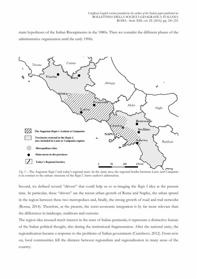
However, if we analyze the Italian administrative organization in the 1900s, we realize how the
Augustan idea regarding the Regio I has absolutely neglected. Today, Lazio and Campania are two
regions with different administrative authorities. An administrative boundary line between regions
divides the ancient Latium from the Campania felix. Unlike Regio I, northerly Lazio includes Tuscia, while
southerly Campania includes Cilento. Moreover, both regions extend over the Apennine mountains
(fig.1).
In view of the current situation, is it possible to consider the value and the persistence of Augustan
regionalist model for this area? During the scientific and political debate on Italian administrative
reorganization (Agnelli Foundation, 1994; SGI, 2014), are still relevant the principles of “Augustan
discriptio”, especially for Regio I? 2
It is not easy to answer these questions but this research tries to do this in two ways. First, we have
reinterpreted the geo-historical approach using new geographical methodologies like, for instance, the
georeference of historical maps in a GIS (Geographical Information System) data structure1. Overlaying
several layers about different ideas on Italian regionalization, it is possible to highlight their differences
and their changes during the time. In particular, we consider the border of the Augustan Regio I versus
21 The historical maps were turned into a digital format, using a laser scanner; in a GIS environment, all the maps are georeferenced on “Google Earth” by the well-known method of Ground Control Point (GCP). We were able to overlay historical maps, although the differences between geographical scale, projections, iconographic system. Then, it was possible to create a georeferenced geometrical layers (linear at first, polygonal later with geoprocessing tools). This approach has allowed us to make a comparative and analyse trough the different ideas of regionalization, since the nineteenth century until today.
Unofficial English version provided by the author of the Italian paper published in: BOLLETTINO DELLA SOCIETÀ GEOGRAFICA ITALIANA
ROMA - Serie XIII, vol. IX (2016), pp. 241-251
main hypotheses of the Italian Risorgimento in the 1880s. Then we consider the different phases of the
administrative organization until the early 1900s.
Fig. 1 – The Augustan Regio I and today’s regional asset. In the same area, the regional border between Lazio and Campania is in contrast to the unitary structure of the Regio I. Source: author’s elaboration.
Second, we defined several “drivers” that could help us to re-imaging the Regio I idea at the present
time. In particular, these “drivers” are the recent urban growth of Rome and Naples, the urban sprawl
in the region between these two metropolises and, finally, the strong growth of road and trail networks
(Ronza, 2014). Therefore, at the present, the socio-economic integration is by far more relevant than
the differences in landscape, traditions and customs.
The region idea aroused much interest in the asset of Italian peninsula; it represents a distinctive feature
of the Italian political thought, also during the institutional fragmentation. After the national unity, the
regionalization became a response to the problems of Italian government (Castelnovi, 2012). From now
on, local communities fell the distance between regionalism and regionalization in many areas of the
country.
The Augustan Regio I «Latium et Campania»
Territories external to the Regio I,
now included in Lazio or Campania regions
Metropolitan cities
Today’s Regional borders
Main towns in the provinces
Unofficial English version provided by the author of the Italian paper published in: BOLLETTINO DELLA SOCIETÀ GEOGRAFICA ITALIANA
ROMA - Serie XIII, vol. IX (2016), pp. 241-251
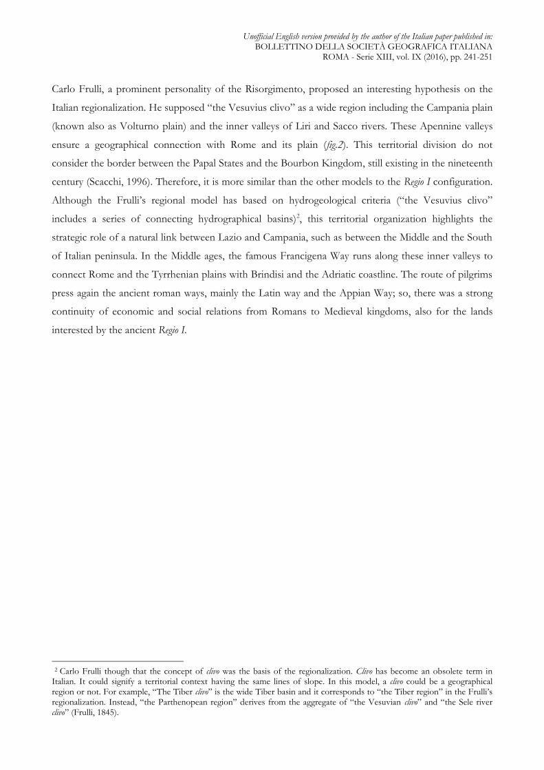
Carlo Frulli, a prominent personality of the Risorgimento, proposed an interesting hypothesis on the
Italian regionalization. He supposed “the Vesuvius clivo” as a wide region including the Campania plain
(known also as Volturno plain) and the inner valleys of Liri and Sacco rivers. These Apennine valleys
ensure a geographical connection with Rome and its plain (fig.2). This territorial division do not
consider the border between the Papal States and the Bourbon Kingdom, still existing in the nineteenth
century (Scacchi, 1996). Therefore, it is more similar than the other models to the Regio I configuration.
Although the Frulli’s regional model has based on hydrogeological criteria (“the Vesuvius clivo”
includes a series of connecting hydrographical basins)2, this territorial organization highlights the
strategic role of a natural link between Lazio and Campania, such as between the Middle and the South
of Italian peninsula. In the Middle ages, the famous Francigena Way runs along these inner valleys to
connect Rome and the Tyrrhenian plains with Brindisi and the Adriatic coastline. The route of pilgrims
press again the ancient roman ways, mainly the Latin way and the Appian Way; so, there was a strong
continuity of economic and social relations from Romans to Medieval kingdoms, also for the lands
interested by the ancient Regio I. 3
32 Carlo Frulli though that the concept of clivo was the basis of the regionalization. Clivo has become an obsolete term in Italian. It could signify a territorial context having the same lines of slope. In this model, a clivo could be a geographical region or not. For example, “The Tiber clivo” is the wide Tiber basin and it corresponds to “the Tiber region” in the Frulli’s regionalization. Instead, “the Parthenopean region” derives from the aggregate of “the Vesuvian clivo” and “the Sele river clivo” (Frulli, 1845).

Unofficial English version provided by the author of the Italian paper published in: BOLLETTINO DELLA SOCIETÀ GEOGRAFICA ITALIANA
ROMA - Serie XIII, vol. IX (2016), pp. 241-251
Fig. 2 – “The Vesuvius Clivo” in the regionalization model of Frulli (1845). Source: author’s elaboration.
However, the Frulli’s model effects on the Italian regionalization are marginal, mainly if compared with
the effects produced by Correnti’s model. Pietro Correnti was a patriot during the Risorgimento and a
senator at the time of the Italian Kingdom. His model was firstly used for statistical compartments, but
then this territorial division become the basis of the Italian administrative organization. Lucio Gambi,
an eminent Italian geographer, thought that the Correnti’s model was approximate because it was based
on ambiguous criteria for regional breakdown (Gambi, 1998). Although, national territory was divided
into units of administration for local and regional government, following the Correnti’s perspective.
The boundary between the Papal States and the Bourbon Kingdom, existing before the political
unification of Italian peninsula, was necessary to mark two different regions, called “Valle del Tevere”
and “Terra di Lavoro e Principati”.Unlike the Frulli’s model and by analogy with the present situation,
the first region includes Tuscia, while the second region includes Cilento and the Sele floodplain. It is
important to underline that the border between “Valle del Tevere” and “Terra di Lavoro e Principati”
was further north than the actual border between Lazio and Campania. In this way, an area uniform in
term of soil profile, agricultural production, social structure and economic organization - exactly “Terra
di Lavoro” - brought under one administration.
The Augustan Regio I «Latium et Campania»
Regional borders of the Frulli’s model (1845)
«The Vesuvian clivo»
Today’s Regional borders
«Clivi» on the Tyrrhenian coast
Unofficial English version provided by the author of the Italian paper published in: BOLLETTINO DELLA SOCIETÀ GEOGRAFICA ITALIANA
ROMA - Serie XIII, vol. IX (2016), pp. 241-251
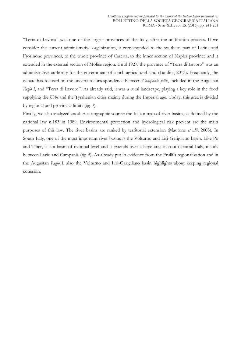
“Terra di Lavoro” was one of the largest provinces of the Italy, after the unification process. If we
consider the current administrative organization, it corresponded to the southern part of Latina and
Frosinone provinces, to the whole province of Caserta, to the inner section of Naples province and it
extended in the external section of Molise region. Until 1927, the province of “Terra di Lavoro” was an
administrative authority for the government of a rich agricultural land (Landini, 2013). Frequently, the
debate has focused on the uncertain correspondence between Campania felix, included in the Augustan
Regio I, and “Terra di Lavoro”. As already said, it was a rural landscape, playing a key role in the food
supplying the Urbs and the Tyrrhenian cities mainly during the Imperial age. Today, this area is divided
by regional and provincial limits (fig. 3).
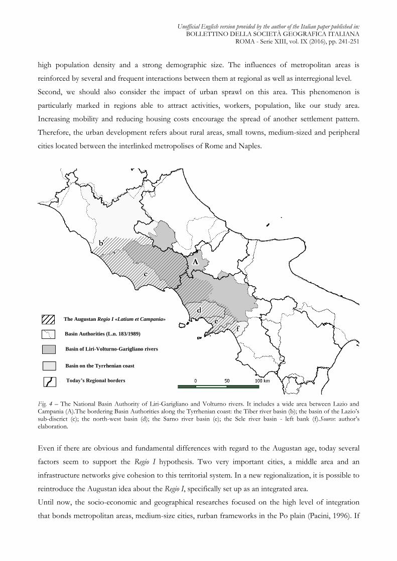
Finally, we also analyzed another cartographic source: the Italian map of river basins, as defined by the
national law n.183 in 1989. Environmental protection and hydrological risk prevent are the main
purposes of this law. The river basins are ranked by territorial extension (Mautone et alii, 2008). In
South Italy, one of the most important river basins is the Volturno and Liri-Garigliano basin. Like Po
and Tiber, it is a basin of national level and it extends over a large area in south-central Italy, mainly
between Lazio and Campania (fig. 4). As already put in evidence from the Frulli’s regionalization and in
the Augustan Regio I, also the Volturno and Liri-Garigliano basin highlights about keeping regional
cohesion.
Unofficial English version provided by the author of the Italian paper published in: BOLLETTINO DELLA SOCIETÀ GEOGRAFICA ITALIANA
ROMA - Serie XIII, vol. IX (2016), pp. 241-251
Fig. 3 – The province of “Terra di Lavoro” (1861-1927) and the Augustan Regio I:unitary perspective for the government of an area currently divided by regional and provincial borders.Source: author’s elaboration.
4. Urban dynamics and territorial changes. The Augustan pragmatism for a new regionalization. - Referring to the
regionalization process, the geographer Lucio Gambi puts in evidence how the central government
played its power to decide the regional boundaries, according to its aims and objectives (Gambi, 1977).
Therefore, there is a big difference between regionalism and regionalization. While the regionalism is a
long-term process that involves the identity of a community and the sense of belonging to a place, the
regionalization is a political and administrative division for the better management of socio-economic
changes and urban dynamics. The regionalization process must adapt to the territorial transformation.
Pragmatism and flexibility play a strategic role for the competitiveness and the economic growth of a
country.
In the area between Lazio and Campania (more or less corresponding to the ancient Regio I), there are
many elements against to the existing “regional status”. First, the recent institution of special authorities
for the government of large metropolitan areas is a new (and very important) management apparatus
for these newly developed socio-economic structures. Rome and Naples, respectively in Lazio and
Campania regions, are the most relevant cities in the south-central Italy. These metropolises have also a
Province of «Terra di Lavoro» (1861-1927)
The Augustan Regio I «Latium et Campania»
Metropolitan cities
Today’s Provincial borders
Today’s Regional borders
Unofficial English version provided by the author of the Italian paper published in: BOLLETTINO DELLA SOCIETÀ GEOGRAFICA ITALIANA
ROMA - Serie XIII, vol. IX (2016), pp. 241-251
high population density and a strong demographic size. The influences of metropolitan areas is
reinforced by several and frequent interactions between them at regional as well as interregional level.
Second, we should also consider the impact of urban sprawl on this area. This phenomenon is
particularly marked in regions able to attract activities, workers, population, like our study area.
Increasing mobility and reducing housing costs encourage the spread of another settlement pattern.
Therefore, the urban development refers about rural areas, small towns, medium-sized and peripheral
cities located between the interlinked metropolises of Rome and Naples.
Fig. 4 – The National Basin Authority of Liri-Garigliano and Volturno rivers. It includes a wide area between Lazio and Campania (A).The bordering Basin Authorities along the Tyrrhenian coast: the Tiber river basin (b); the basin of the Lazio’s sub-discrict (c); the north-west basin (d); the Sarno river basin (e); the Sele river basin - left bank (f).Source: author’s elaboration.
Even if there are obvious and fundamental differences with regard to the Augustan age, today several
factors seem to support the Regio I hypothesis. Two very important cities, a middle area and an
infrastructure networks give cohesion to this territorial system. In a new regionalization, it is possible to
reintroduce the Augustan idea about the Regio I, specifically set up as an integrated area.
Until now, the socio-economic and geographical researches focused on the high level of integration
that bonds metropolitan areas, medium-size cities, rurban frameworks in the Po plain (Pacini, 1996). If
The Augustan Regio I «Latium et Campania»
Basin Authorities (L.n. 183/1989)
Basin of Liri-Volturno-Garigliano rivers
Today’s Regional borders
Basin on the Tyrrhenian coast
Unofficial English version provided by the author of the Italian paper published in: BOLLETTINO DELLA SOCIETÀ GEOGRAFICA ITALIANA
ROMA - Serie XIII, vol. IX (2016), pp. 241-251
we analyse the current dynamics, it is now clear that the area between Lazio and Campania is moving
toward a new pattern of territorial and urban organization. We can suppose that an integrated system of
cities and rurban areas, driven by the two metropolises of Rome and Naples is growing. This situation
is currently taking place, although an administrative border divides the regions of Lazio and Campania.
Therefore, we believe that the Augustan perspective could have an increasing relevance to rethink the
Italian regionalization, mainly in the area corresponding to the ancient Regio I.
REFERENCES
CASTELNOVI M., Regioni alternative. Verso una nuova geografia amministrativa, Roma, Aracne, 2012.
CHAMPLIN E., The Suburbium of Rome, AJAH 7, 2, 1982, 99-117.
MAUTONE M., SBORDONE L., Città e organizzazione del territorio in Campania: analisi funzionale della rete
urbana di una regione squilibrata, Napoli, Edizioni Scientifiche Italiane, 1983.
DEGRASSI A., Inscriptiones Italiae, t. XIII, 2, Roma, 1963
GAMBI L., Le “regioni” italiane come problema storico, in “Quaderni storici”, XII, n.34, 1977, pp.275-298.
GAMBI L., L’invenzione delle regioni italiane, in “Geografia Antiqua”, 7, 1998, pp.89-92
FONDAZIONE GIOVANNI AGNELLI, Il nostro progetto geopolitico, in “Limes”, 4, 1994, pp. 147-156
FRULLI C., Fisiche regioni peninsulari e insulari dell’Italia, in “Annuario Geografico Italiano”, Ufficio di
Corrispondenza Geografica in Bologna, 1845, pp. 93-106.
LANDINI P., Il ritaglio amministrativo nell’evoluzione territoriale dello stato italiano, in M. CASTELNOVI (a cura
di), Il riordino territoriale dello Stato. Riflessioni e proposte della geografia italiana, Roma, SGI, 2013, pp.113-126.
MORLEY N., Metropolis and Hinterland, London, 1996.
MAUTONE M. ET ALII, Le acque in Campania, in M.G. GRILLOTTI DI GIACOMO (a cura di), Atlante
Tematico delle Acque d’Italia, Genova, Brigati Glauco Editore, 2008, pp.484-486.
PACINI M., Un federalismo dei valori. Percorso e conclusioni di un programma della fondazione Agnelli, Torino,
Edizioni della Fondazione Agnelli, 1996 (collana “Studi e ricerche”).
POLVERINI L., Le regioni dell’Italia romana, in “Geografia Antiqua”, 7, 1998, pp. 23-32.
RONZA M., Oltre le metropoli: il supporto della cartografia per una nuova regionalizzazione, in “Bollettino
Associazione Italiana Cartografia”, 152, 2014, pp. 20-35.
SCACCHI D., Alla ricerca di una regione. Il “Lazio” dalla Repubblica giacobina alla I guerra mondiale, in REGIONE
LAZIO - ASSESSORATO ALLA CULTURA, Atlante storico-politico del Lazio, Roma, Laterza, 1996, pp.89-123.
SOCIETÀ GEOGRAFICA ITALIANA, Proposta di riordino territoriale dell’Italia, Roma, SGI, 2013.
Unofficial English version provided by the author of the Italian paper published in: BOLLETTINO DELLA SOCIETÀ GEOGRAFICA ITALIANA
ROMA - Serie XIII, vol. IX (2016), pp. 241-251
SOLIN H., Sul concetto di Lazio nell'Antichità, in “Studi Storico Epigrafici sul Lazio Antico”, AIRF 15,
1996, pp.3-22.
STORCHI MARINO A., Reti interregionali integrate e circuiti di mercato periodico negli indices nundinarii del Lazio e
della Campania, in E. Lo Cascio (a cura di), Mercati permanenti e mercati periodici nel mondo romano, Bari 1997,
pp.93-130.
THE INFLUENCE OF THE AUGUSTAN REGIO I ON THE ITALIAN REGIONALIZATION
DEBATE. - The Augustan Regio I was a territorial aggregate of Latium (vetus et adiectum) and Campania.
Although it is accepted that these territorial contexts are different, as it is suggested also by place
names, the relationship between Rome and important urban center of Phlegrean Fields (Misenum, Baiae,
Puteoli) gave a unitary profile to this territorial division. Many cities of Campania hinterland and
coastline played a strategical rule for Rome, as pointed out from the high frequency in affairs by sea and
by land. The territorial asset of Regio I does not result from ethnic criteria but, more probably, it is due
to an infrastructural network between Rome and the Southern Italy. The Appian Way and the Latin
Way were certainly the most important routes to travel and trade.
In view of the current situation, is it possible to consider the value and the persistence of Augustan
regionalist model for this area? During the scientific and political debate on Italian administrative
reorganization, are still relevant the principles of “Augustan discriptio”, especially for Regio I? It is not
easy to answer these questions but this research tries to do this. We have reinterpreted the geo-
historical approach using new geographical methodologies like, for instance, the georeference of
historical maps in a GIS (Geographical Information System) data structure. In particular, we consider
the border of the Augustan Regio I versus main hypotheses of the Italian Risorgimento in the 1880s;
then we consider the different phases of the administrative organization until the early 1900s. Since the
nineteenth century, the area comparable to the ancient Regio I was involved in a series of regional
models. We would also underline as several criteria of regionalization (hydrogeological features,
historical experiences and sense of identity, economic and functional forces) were chosen in order to
create regions. The matter has taken off again and it is due to the current territorial changes. Therefore,
the Augustan perspective on Regio I has been examined in order to consider its potentialities for a new
territorial asset based on the socio-economic dynamics between Lazio and Campania.

Unofficial English version provided by the author of the Italian paper published in: BOLLETTINO DELLA SOCIETÀ GEOGRAFICA ITALIANA
ROMA - Serie XIII, vol. IX (2016), pp. 241-251
Maria Ronza, Department of Political Sciences, University of Naples “Federico II”, e-mail:
Eliodoro Savino, Department of Humanities, University of Naples “Federico II”, e-mail:


![26a Augustan Program[1]](https://img.pdfslide.us/doc/110x75/577ce3c61a28abf1038cfa67/26a-augustan-program1.jpg)