Embed Size (px)
Citation preview

FINNISH METEOROLOGICAL INSTITUTE CONTRIBUTIONS
No. 33
METEOROLOGICAL PRE-PROCESSING AND ATMOSPHERIC
DISPERSION MODELLING OF URBAN AIR QUALITY AND
APPLICATIONS IN THE HELSINKI METROPOLITAN AREA
Ari Karppinen
ACADEMIC DISSERTATION in applied physics. Helsinki University of Technology, Department of Engineering Physics and Mathematics. Dissertation for the degree of Doctor of Science in Technology to be presented with due permission of the Department of Engineering Physics and Mathematics, for public examination and debate in Auditorium E at Helsinki University of Technology (Espoo, Finland) on the 29th of November, 2001, at 13 o’clock.
Finnish Meteorological Institute Helsinki, 2001

ISBN 951-697-552-6
ISSN 0782-6117
Yliopistopaino
Helsinki 2001

Authors Name of project Ari Karppinen Title
Meteorological pre-processing and atmospheric dispersion modelling of urban air quality and applications in the Helsinki metropolitan area Abstract
This theses describes the boundary-layer parameterisation model, which is applied as a meteorological pre-processor by Finnish regulatory dispersion models. The parameterisation scheme is based on the energy-flux method, which evaluates the turbulent heat and momentum fluxes in the boundary layer. A comparison of the model predictions with those of the corresponding scheme of Berkowicz and Prahm, using the same synoptic input data is presented. The comparison shows the basic physical differences between these two models. Some numerical results calculated by these two pre-processors differ substantially, while the results for net radiation are statistically nearly identical. Meteorological profile data from Finnish sounding stations is compiled and the inversions (the temperature of the atmosphere increases with altitude) are classified according to the total depth of the inversion and the stability of the boundary layer, which was estimated directly from the temperature gradient in the layer from the ground up to 100 meters. The persistence of the inversions and the influence of cloudiness and wind speed on the temperature gradient are also addressed. The specific problems of an urban area is tackled, using measurements from a meteorological mast situated in the Helsinki metropolitan area by comparing them to those from the radiosonde profiles at the rural site of Jokioinen. Several common schemes for the height of the stable boundary layer are compared to results from our own method developed at Finnish Meteorological Institute (FMI). Based on this analysis a modification to the FMI method is suggested. An integrated modelling system for evaluating the traffic volumes, emissions from stationary and vehicular sources, and atmospheric dispersion of pollution in an urban area is described. The dispersion modelling is based on combined application of the Urban Dispersion Modelling system for stationary sources (UDM-FMI) and the road network dispersion model (CAR-FMI). The system includes also a meteorological pre-processing model (MPP-FMI) and a statistical and graphical analysis of the computed time series of concentrations. The modelling system contains a method, which allows for the chemical interaction of pollutants, originating from a large number of urban sources. An application of the integrated modelling system for estimating the NOX and NO2 concentrations in the Helsinki metropolitan area in 1993 is presented. The thesis finally presents a comparison of model predictions with the results of an urban measurement network. Publishing unit Finnish Meteorological Institute, Air Quality Research Classification (UDC) Key words 551.556.42, 504.054, 504.3, 681.3 : 519.876 Meteorological preprocessor, urban, model, air quality,
dispersion, nitrogen oxides ISSN and series title ISSN 0782-6117 Language ISBN English 951-697-552-6 Sold by Pages Price Finnish Meteorological Institute 94 P.O.Box 503, FIN-00101 Helsinki, Finland Note
Published by
Finnish Meteorological Institute P.O. Box 503 FIN–00101 HELSINKI Finland
Series title, number and report code of publication Finnish Meteorological Institute Contributions No. 33, FMI-CONT-33 Date November, 2001


Contents
List of original publications 6
1 Introduction 7
2 Aims of the study 7
3 Background 8
4 Influence of meteorology on the air quality 10
4.1 The meteorological pre-processing model 10
4.2 Intercomparison of meteorological pre-processing models 11
4.3 Modifications of the pre-processor in order to allow for urban conditions 12
4.4 Inversion strengths and mixing heights during stable stratification 14
5 Dispersion modelling in the Helsinki Metropolitan Area 17
5.1 Emission and atmospheric dispersion modelling system for an urban area 18
5.2 Comparison of model predictions with the data of a measurement network 22
6 Discussion 23
7 Conclusions 27
References 30
6
List of original publications
This thesis is based on five original publications.
[I] Karppinen, A., Joffre, S. M. and Vaajama, P., 1997: Boundary layer parameterisation
for Finnish regulatory dispersion models. International Journal of Environment and
Pollution 8, pp. 557-564.
[II] Karppinen, A., Joffre, S. M. and Kukkonen, J., 2000: The refinement of a
meteorological preprocessor for the urban environment. International Journal of
Environment and Pollution 14, pp. 565-572.
[III] Karppinen, A., Joffre, S. M., Kukkonen, J. and Bremer, P., 2001: Evaluation of
inversion strengths and mixing heights during extremely stable atmospheric
stratification, International Journal of Environment and Pollution 16, (in print).
[IV] Karppinen, A, Kukkonen, J., Elolähde, T.,Konttinen, M., Koskentalo, T. and
Rantakrans, E., 2000: A modelling system for predicting urban air pollution, Model
description and applications in the Helsinki metropolitan area. Atmospheric
Environment 34, pp 3723-3733.
[V] Karppinen, A, Kukkonen, J., Elolähde, T.,Konttinen, M. and Koskentalo, T., 2000: A
modelling system for predicting urban air pollution, Comparison of model predictions
with the data of an urban measurement network. Atmospheric Environment 34, pp
3735-3743.
The author has had an active role in all phases of the research reported in this thesis. He
has been involved in the planning of the calculations, the development of the computer
programs, and the interpretation of the results. The author has written the first version
of Publications I-V. He is responsible for all calculations in Publications I,II,IV,V and
most of the calculations in Publication III.

7
1 Introduction
This theses describes an integrated urban pollution modelling system, discusses
predicted concentration distributions of nitrogen oxides in the Helsinki metropolitan
area. and addresses the testing of the model against the results of an air quality
monitoring network.
The integrated atmospheric dispersion modelling system developed at FMI is based on
a combined application of the Urban Dispersion Modelling system for stationary
sources (UDM-FMI) and the road network dispersion model CAR-FMI (Contaminants
in the Air from a Road). Both dispersion models include a treatment of the chemical
transformation of nitrogen oxides. The dispersion modelling system was refined to take
into account the chemical interaction of pollutants from a large number of individual
sources.
This theses also describes and revises the method (FMI-MPP) used to estimate the
turbulence parameters from surface meteorological observation and compares some
basic physical properties of the method against other commonly used similar methods.
Special emphasis is taken to study the stable conditions and the different turbulence
characteristics of rural and urban conditions.
2 Aims of the study
The aims of this thesis were:
1) to describe the method used to estimate the turbulence parameters from surface
meteorological observation and to compare some basic physical properties of the
method against other commonly used similar methods.
2) to study the potential errors of the meteorological pre-processing system when
applied in urban environment and to revise the parameterisation method accordingly
3) to examine the behaviour of the stable mixing height calculation scheme routinely

8
used at FMI, by comparing the mixing height results calculated using rural
meteorological profile data (Jokioinen) vs. urban meteorological profile data
(Kivenlahti)
4) to refine the stable mixing height calculation scheme to better suit the conditions in a
heterogeneous environment
5) to combine the meteorological modelling system, traffic flow and emission
modelling systems together with the urban dispersion modelling system for assessing
the air quality in Helsinki Metropolitan area
6) to evaluate the performance of the modelling system by comparing the calculation
results with available experimental data in the Helsinki Metropolitan area
3 Background
Air pollution models are valuable tools for regulatory purposes, policymaking and
research applications. The most efficient method in air pollution research is commonly
the combined use of measurements and modeling.
Atmospheric dispersion models can be used for a wide variety of purposes, for instance:
− establishing source-receptor relationships,
− evaluation of the contribution to pollutant concentrations from various sources,
− estimating spatial concentration distributions and population exposure to pollution,
− optimisation for emission reduction strategies and analysis of emission scenarios,
− predicting the pollutant concentrations in time and
− analysing the representativity of measurement stations.
The models need as input parameters meteorological and geographical information,
together with source and emission data. Errors in the predictions of the models are
caused by:

9
− inaccuracies in estimating the model input values,
− deficiencies in modelling the physical and chemical phenomena,
− numerical inaccuracies of the models and
− random variability in the atmosphere.
A high priority should be given to evaluation of models, and their validation against
good-quality databases in order to control the inaccuracies of the modelling methods.
The main objective of local scale dispersion models is quantifying of the concentrations
of pollutants, which can cause adverse health effects for the population. In some cases,
the objectives include also the deposition of pollutants and the influence of air pollution
on the vegetation. Most of the local scale models have been developed for regulatory
purposes.
Models based on Gaussian concentration distributions have been very widely used for
regulatory purposes. Traditionally, these models have been based on Pasquill-Gifford
stability categories and the dispersion parameterisations have been very straightforward.
However, the models should be able to allow for the structure of the atmospheric
boundary layer and the various local scale effects, for instance, the influence of
buildings and obstacles, downwash phenomena and plume rise.
The latest generation of local scale models is used in combination with meteorological
pre-processing models, which are based on scaling theories of the atmospheric boundary
layer (ABL). In this case, the dispersion processes are described in terms of ABL
scaling parameters and the boundary layer height. Some of these models include
treatment of chemical transformation and deposition, plume rise, downwash phenomena
and dispersion of particles (for more detailed discussion, see Kukkonen, 2000).

10
4 Influence of meteorology on the air quality
4.1 The meteorological pre-processing model
Meteorological factors have a substantial influence on the atmospheric dispersion of air
pollution. Dispersion is particularly affected by the wind speed and direction,
atmospheric turbulence and the occurrence of inversion layers, ambient temperature and
the mixing height (e.g. Kukkonen et al., 1999). The turbulence parameters and mixing
heights are not routinely measured so they have to be inferred from the available
measurements, activity which is often referred as pre-processing the meteorological
data.
The parameterisation schemes used in the dispersion models of the Finnish
Meteorological Institute (FMI) are based on the energy flux method of van Ulden and
Holtslag (1985), while the parameterisation of the boundary layer height is based on
classical boundary layer models with a separate treatment for convective and stable
conditions.
In the van Ulden-Holtslag's scheme, the turbulent heat and momentum fluxes in the
boundary layer are estimated from synoptic weather observations. The original method
has been slightly modified, as at high latitudes the net radiation at the surface correlates
better with the sunshine duration than with the cloud cover.
The present method divides the net radiation into three parts: solar short-wave radiation,
blackbody radiation from clouds and ground, and long-wave radiation of (isothermal)
atmosphere. Short-wave radiation is approximated by a regression equation, which uses
observed hourly sunshine time as the explaining variable in the regression model. The
radiation from clouds is modelled by another regression equation, which uses the total
cloudiness and cloud height as explaining parameters.
Energy partition in the FMI-model utilises the modified Priestley-Taylor model (van
Ulden and Holtslag, 1985), which divides the evaporation into two parts. Consequently,
there are only two empirical parameters to be evaluated in the FMI-model. These

11
parameters depend on surface moisture conditions, which are estimated using synoptic
weather codes and the amount of rain.
The parameterisation of the mixing height (MH) uses actual radio soundings and the
previously calculated surface turbulence parameters. The summer MH parameterisation
is based on a slab model for daytime and modelling the integral heat flux at night. For
wintertime the MH evolution is driven by mechanical turbulence.
4.2 Intercomparison of meteorological pre-processing models
A comparison of the FMI model predictions with those of the corresponding model
(OML, see Olesen et al., 1992) applied in National Environmental Research Institute of
Denmark (NERI) is done, using the same synoptic input data for both models. The
meteorological data has been collected from southern Finland for year 1983. The data
was interpolated from 3-hourly measurements to hourly values.
Figure 1. The quantile-quantile plot of estimates of the sensible heat flux.

12
The net radiation estimates, by the OML model and FMI-MPP model agree very well
[I], except for a slight difference for net radiation values in the range from 200 to 400
W/m2. However, there are substantial differences in the computed turbulent heat flux
estimates shown in Figure 1.
The ratio of stable to unstable situations as evaluated by these two models is almost the
same. In stable conditions, the OML-model produces more negative energy flux values
than the FMI- model. In unstable conditions, the FMI model produces larger turbulent
heat flux values than the OML model. The results indicate that the two parameterisation
schemes divide the available energy between the latent and sensible heat fluxes
differently.
4.3 Modifications of the pre-processor in order to allow for urban conditions
The FMI meteorological pre-processor applied in combination with the regulatory
atmospheric dispersion models in Finland was originally designed for non-urban areas
only. In order to account for the urban conditions, the meteorological pre-processor has
to be modified [II].
The atmospheric surface layer is divided into two parts: a roughness sublayer of height
z* and an inertial sublayer. Monin-Obukhov similarity laws are expected to be valid
only in the inertial sublayer. Close to the ground surface, the local Reynolds stress
profile is used to recalculate the relevant turbulence parameters. In order to allow for
the influence of urban conditions, we have evaluated the roughness length zo and
introduced the zero-displacement height d for the Helsinki metropolitan area, using a
computational method discussed by Rotach (1997).
In stable conditions, the height of the urban roughness sublayer z* is used as a lower
limit for the Monin-Obukhov length L, as L can be interpreted as the depth of the
mechanically well-mixed layer. It is therefore plausible to assume that the Monin-
Obukhov length L ≥ z*≡ Lmin, since the roughness sublayer height z* is the height, at

13
which the urban roughness elements are by definition generating a more intense
turbulence field.
The influence of these modifications has been analysed by computing the dispersion
parameters used in the FMI dispersion modelling system, and comparing the revised
parameters with the previous "non-urban" model computations.
In unstable conditions, the urban vertical dispersion parameters are approximately half
of the corresponding rural values, at an effective dispersion height near the zero-plane
of displacement. Clearly, the urban roughness elements give rise to enhanced
turbulence above the roof top level and one would therefore expect the urban dispersion
parameters to be larger within this layer, compared with the corresponding non-urban
parameters.
However, the introduction of the displacement height and the exponentially decreasing
Reynolds stress results in clearly smaller numerical values of turbulence parameters in
the layer between roof top level and displacement height. This effect can be seen to be
consistent with the generally accepted picture of turbulent flow changing to laminar
flow close to a surface. In this case we can consider the urban roughness sublayer as a
layer within which the spatial average of Reynolds stress increases from zero to its
value in the inertial sublayer (Rotach, 1993).
In neutral conditions, the variation of the dispersion parameters with height is similar,
compared with the unstable cases. However, in stable conditions the imposed limit of
the Monin-Obukhov length substantially changes the situation. In extremely stable
conditions, the urban dispersion parameters exceed the corresponding rural values with
a large margin; the key factors influencing this ratio are stability and height of the
roughness sublayer.
The modifications can have a substantial influence on the computed concentrations
(Figure 2) for the ground level or near the ground level sources (e.g., traffic). The re-
evaluated friction velocity and dispersion parameters result in clearly lower
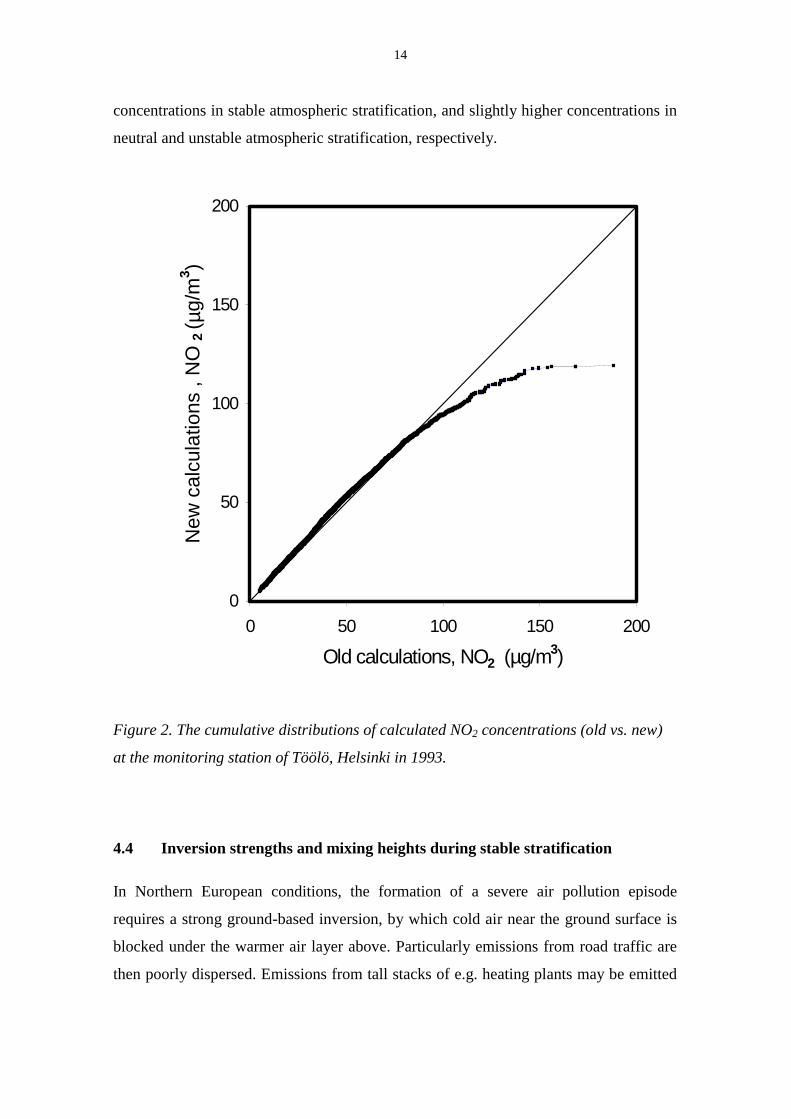
14
concentrations in stable atmospheric stratification, and slightly higher concentrations in
neutral and unstable atmospheric stratification, respectively.
Figure 2. The cumulative distributions of calculated NO2 concentrations (old vs. new)
at the monitoring station of Töölö, Helsinki in 1993.
4.4 Inversion strengths and mixing heights during stable stratification
In Northern European conditions, the formation of a severe air pollution episode
requires a strong ground-based inversion, by which cold air near the ground surface is
blocked under the warmer air layer above. Particularly emissions from road traffic are
then poorly dispersed. Emissions from tall stacks of e.g. heating plants may be emitted
0
50
100
150
200
0 50 100 150 200
Old calculations, NO2 (µg/m3)
New
cal
cula
tions
, N
O 2
( µg/
m3 )
15
above the inversion height, and therefore these do not influence substantially pollution
near the ground level.
Paper [III] discusses the results from a climatological study of surface inversions based
on an experimental dataset from three Finnish sounding stations. The inversions were
characterised according to their total depth and the stability of the boundary layer,
which was straightforwardly estimated directly from the temperature gradient in the
layer from the ground up to 100 meters. The persistence of the inversions as well as the
influence of cloudiness and wind speed on the temperature gradient was studied.
Furthermore, the measurements from a meteorological mast situated in the Helsinki
metropolitan area; particularly temperature inversions with a potential temperature
gradient larger than 0.1 oC/m, were selected for further analysis.
The behaviour of the meteorological pre-processing model [I], particularly the stable
mixing height scheme, is analysed utilising this experimental database. The observed
weak correlation between FMI-Jokioinen and FMI-Kivenlahti (FMI’s stable mixing
height calculation scheme using radiosonde profiles at Jokioinen and mast profiles at
Kivenlahti respectively) calculations is further studied by dividing the data according to
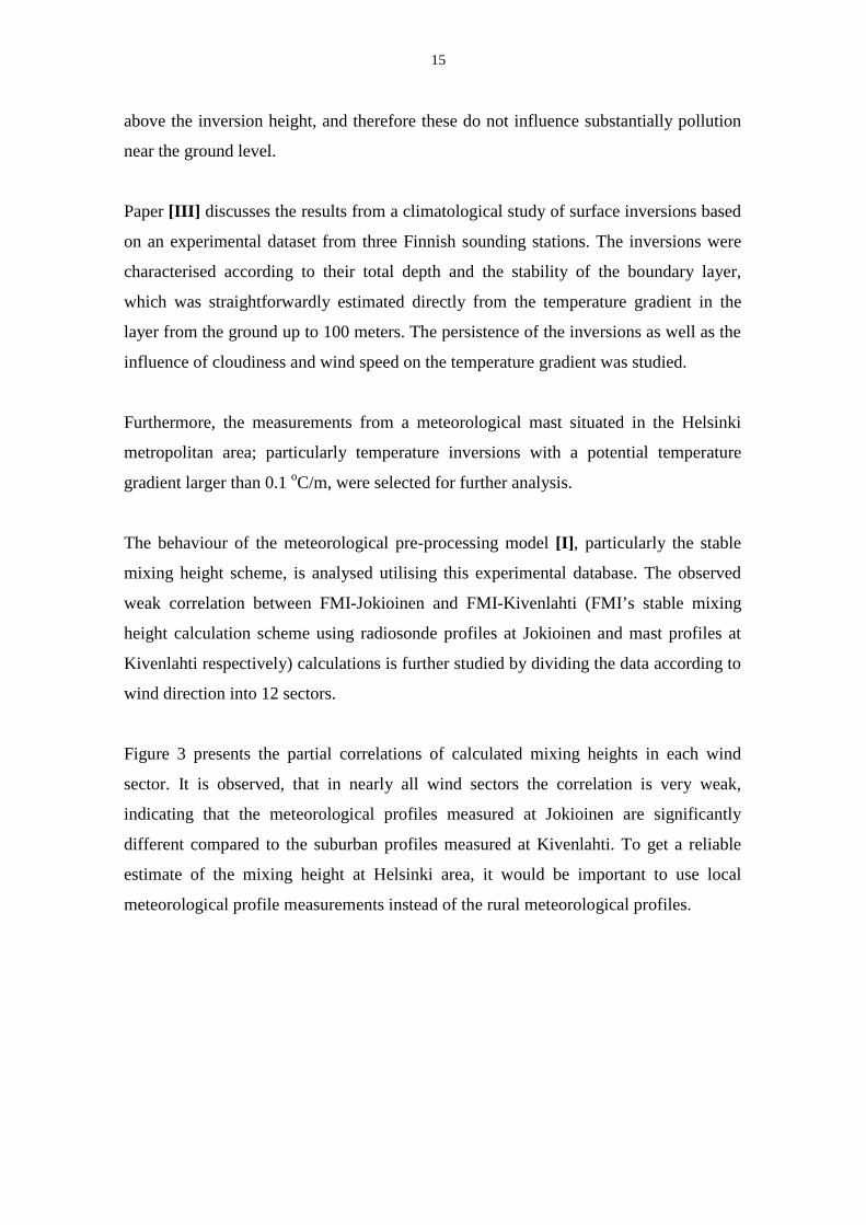
wind direction into 12 sectors.
Figure 3 presents the partial correlations of calculated mixing heights in each wind
sector. It is observed, that in nearly all wind sectors the correlation is very weak,
indicating that the meteorological profiles measured at Jokioinen are significantly
different compared to the suburban profiles measured at Kivenlahti. To get a reliable
estimate of the mixing height at Helsinki area, it would be important to use local
meteorological profile measurements instead of the rural meteorological profiles.

16
0
0,1
0,2
0,3
0,4
0,50
30
60
90
120
150
180
210
240
270
300
330
Figure 3. Partial correlations between the calculated mixing heights. The results of
FMI-mixing height calculation scheme using rural (Jokioinen) data are compared
against the results of FMI-mixing height calculation scheme using urban (Kivenlahti)
data.
The correlation of the calculated mixing heights is weakest for southerly (from the sea)
winds. This is quite an expected result, as the effect of the sea is not observed on the
mixing heights calculated using the soundings at Jokioinen, which is located 100 km
north from the Helsinki area.
The best correlation was obtained for the NE direction, which is one of the most “non-
urban” directions around Kivenlahti mast. However, before any final conclusions can
be made, a more detailed study on the possible local screening effects of the mast
structure for this wind direction must be performed.

17
Other commonly used schemes for determining the height of the stable boundary layer,
reported by Fisher et al. (1998), were also tested against the FMI-method and against
each other. Based on this analysis a modification is suggested to the FMI-MPP method.
5 Dispersion modelling in the Helsinki Metropolitan Area
Short-range atmospheric dispersion models have been developed and applied at the
Finnish Meteorological Institute since the early 1970’s. The following regulatory
models are available: the urban dispersion modelling system (Karppinen et al, 1998),
various models for local dispersion of vehicular pollution (e.g. CAR-FMI), the air
pollution information system, the dispersion model of odorous compounds and a hybrid
plume model for local-scale dispersion (Nikmo et al, 1999). All of these models are
routinely used in connection with a meteorological pre-processing model. Some of
these models have been reviewed by Kukkonen et al. (1997).
Similar urban scale modelling systems have also been developed in other European
countries. Examples of these are the Danish OML model (Olesen, 1995a) and the UK-
ADMS system of the United Kingdom (Carruthers et al., 1995). These models, as the
UDM-FMI system, also apply ABL scaling with the surface layer similarity theory. On
the other hand, various local scale Gaussian models using the Pasquill (or equivalent)
stability classes are still widely used in practical applications in many European
countries (see: Moussiopoulos et al., 1996).
A detailed description for the CAR-FMI model can be found in Härkönen et al., (1995),
(1996) and (1997a). The predictions of the CAR-FMI model have been compared
against experimental roadside datasets in Härkönen et al., (1997b) and Kukkonen et al.
(2000).

18
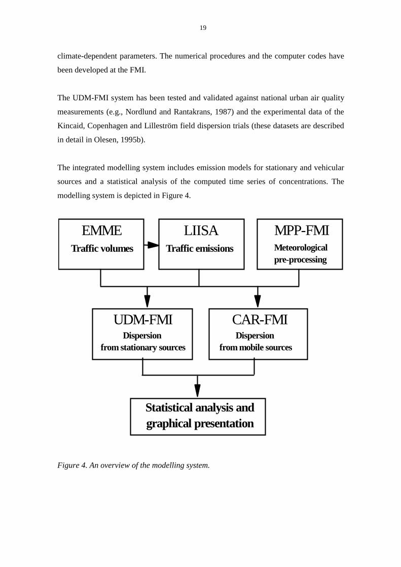
5.1 Emission and atmospheric dispersion modelling system for an urban area
Paper [IV] presents an overview of the structure of the integrated modelling system
developed and used at FMI, including the dispersion models and the meteorological pre-
processor model.
The dispersion models are based on Gaussian plume equations for various source
categories. The meteorological pre-processor [I], includes a mathematical
parameterisation of the atmospheric boundary layer (ABL), based on the surface layer
similarity theory.
The modelling system describes the dispersion processes in terms of ABL scaling
parameters (the Monin-Obukhov length scale, the friction velocity and the convective
velocity scale) and the boundary layer height. For instance, the dispersion parameters
are written explicitly as a function of these quantities (Karppinen et al., 1998). The
application of ABL scaling is physically a better approach than the use of the traditional
discrete stability categories (e.g., the Pasquill classes). Clearly, the diffusion properties
of the ABL are continuous functions of the atmospheric stratification.
Both experimental and theoretical investigations have shown that dry and wet
deposition processes, chemical transformation, plume rise and downwash can
substantially influence atmospheric concentrations. All these processes are included
into the model framework, including a treatment of the chemical transformation of
nitrogen oxides. A new model has been developed for evaluating the chemical
interaction of pollution from a large number of individual sources. This model allows
for the interdependence of urban background NO, NO2 and O3 concentrations and NO
and NO2 emissions from various source categories.
The model also allows for the influence of a finite mixing height and inversion layers,
as this can be of crucial importance especially in stable atmospheric conditions.
The mathematical structure of the modelling system is based on state-of-the-art
methodology. Results of domestic investigations have been used for evaluating some
19
climate-dependent parameters. The numerical procedures and the computer codes have
been developed at the FMI.
The UDM-FMI system has been tested and validated against national urban air quality
measurements (e.g., Nordlund and Rantakrans, 1987) and the experimental data of the
Kincaid, Copenhagen and Lilleström field dispersion trials (these datasets are described
in detail in Olesen, 1995b).
The integrated modelling system includes emission models for stationary and vehicular
sources and a statistical analysis of the computed time series of concentrations. The
modelling system is depicted in Figure 4.
EMME LIISA MPP-FMITraffic volumes Traffic emissions Meteorological
pre-processing
UDM-FMIDispersion
from stationary sources
CAR-FMIDispersion
from mobile sources
Statistical analysis and graphical presentation
Figure 4. An overview of the modelling system.

20
The concentrations of nitrogen oxides and nitrogen dioxide have been computed in the
Helsinki metropolitan area for one year, 1993. The concentration time series were
computed on a receptor grid, which contains approximately 10000 receptor points. The
receptor point network covers the whole Helsinki metropolitan area (approx. 900 km2),
and the largest grid intervals are 500 m. A more densely spaced grid was applied in the
Helsinki downtown area, the grid interval being 100 m. In the vicinity of the major
roads in the area, the smallest grid interval was 50 m. The variable receptor grid is
required in order to evaluate isoconcentration curves with adequate accuracy from the
computed data.
The NO2 concentrations in Helsinki are generally comparable with those in the major
Central European cities (Jol and Kielland, 1997, Kukkonen et al., 1999). In other
Finnish cities the NO2 concentration levels are usually somewhat lower than those in the
capital (Kukkonen et al., 1999).
Figures 5a-b show the computed annual means of NOx and NO2 concentrations at the
ground level in the Helsinki metropolitan area in 1993. The legend in the top left-hand
corner shows the absolute values of the pollutant concentration.

21
Tikkurila
Töölö
Leppävaara
Vallila
Figures 5a-b. Predicted spatial distribution of the yearly means of NOx (upper) and
NO2 (lower) concentrations (µg m-3) in the Helsinki metropolitan area in 1993.
22
5.2 Comparison of model predictions with the data of a measurement network
Paper [V] discusses the comparison of model predictions and the results of the air
quality monitoring network in the Helsinki metropolitan area (YTV) in 1993. Hourly
NO and NO2 concentration data has been utilized from two urban, two suburban and
one rural measurement station operated by the Helsinki Metropolitan Area Council.
There are no empirical factors in the applied modelling system, except for the chemical
transformation coefficients in the model UDM-FMI, for which we have applied the
values reported by Janssen et al. (1988). The original modelling system, without any
adjustments or calibration based on the data considered here has been utilized in this
study.
The data for this study is selected from the permanent multicomponent stations (Aarnio
et. al., 1995, Hämekoski and Koskentalo, 1998). These represent urban traffic (Töölö
and Vallila), suburban traffic (Leppävaara and Tikkurila) and regional background
conditions (Luukki).
Two urban monitoring stations, Töölö and Vallila, are located in the Helsinki downtown
area. The station of Töölö is situated in a small square in a busy crossing area,
surrounded by several buildings. The station of Vallila is situated in a small park, at the
distance of about 20 metres from a busy street.
The two suburban stations are located in the cities of Espoo and Vantaa. The station of
Leppävaara in Espoo is situated in a shopping and residential area; the distance of the
station to two major roads is approximately 200 m. The station of Tikkurila in Vantaa is
located in a residential area, about 200 metres from the nearest busy street. The
monitoring height is 4.0 m at the stations of Töölö, Vallila and Leppävaara, and 6.0 m at
the station of Tikkurila. Regional background concentrations were monitored in a rural
environment in Luukki, approximately 20 km to the northwest of downtown Helsinki.
As discussed in [IV], the regional background concentrations are based on data from
the monitoring station of Luukki, situated in the Northeastern part of the Helsinki
metropolitan area. The predicted regional background NOx concentration varies from a
23
minimum of 3 % in the urban area to a maximum of 34 % in the suburban area, of the
total measured concentration.
At three stations (Vallila, Leppävaara and Tikkurila), the predicted NOx concentrations
agree well with the measured data, although the model slightly under predicts the
concentrations. However, the modelling system clearly underpredicts the measured NOx
concentrations at the station of Töölö. This may be caused by the underprediction of
emissions near a busy junction, the influence on dispersion of surrounding major
buildings and street canyons, and uncertainties in the representativeness and pre-
processing of meteorological data.
At all the stations, the predicted NO2 concentrations agree well with the measured data.
The variation in time of the predicted and observed NO2 concentrations is also similar,
except for some deviations at the urban station of Vallila. At the station of Töölö the
predicted NO2 concentrations agree clearly better with the measured values, compared
with the corresponding results of NOx. The formation of NO2 from NO is in most cases
limited by the availability of ozone at Töölö, and the O3 concentration is in some cases
completely depleted. The predicted NO2 concentrations can therefore be realistic, if the
urban background concentrations of NO2 and O3 are predicted right, although the
predicted NOx concentration would be under predicted.
The predicted statistical parameters corresponding to the national guidelines agree well
with the measurements, except for some of the highest measured values, which are
slightly underpredicted. The agreement of the model predictions and measurements was
better for the two suburban measurement stations, compared with the two stations
located in downtown Helsinki. This was expected, taking into account the limitations of
the modelling system.
6 Discussion
The basic physical ideas of the FMI pre-processor (FMI-MPP) and the corresponding
model applied in Sweden and Denmark (Berkowicz and Prahm, 1982) are similar, while

24
the measurements required by the models are somewhat different. In FMI-MPP model
the short wave radiation is estimated by a regression equation, which uses observed
hourly sunshine duration as the regression model variable. The radiation from clouds is
modelled by another regression equation, which uses the total cloudiness and the cloud
height as parameters. The method of Berkowicz and Prahm uses two regression models,
one for daytime and one for nighttime, which apply synoptic measurements of
cloudiness as the most important variable.
The modelling of the net radiation differs substantially in these two models, but the
numerical results are nearly the same. The partitioning schemes for the turbulent
sensible and latent heat are clearly different in the models. The Berkowicz/Prahm-
model evaluates the surface resistances and the humidity deficit in a fairly complicated
way. The FMI model utilises the modified Priestley-Taylor model (van Ulden and
Holtslag, 1985), which divides the evaporation into two components. Consequently, in
the FMI model only two empirical surface moisture parameters have to be evaluated.
The numerical results of these two partitioning schemes also differ substantially, but the
ratio of stable to unstable situations as evaluated by the two models is almost the same.
The meteorological pre-processor has been modified in order to better represent urban
conditions. We have re-evaluated the roughness length, introduced the zero-
displacement height and divided the surface layer into a roughness sublayer and an
inertial sublayer. The friction velocity and Monin-Obukhov length are re-evaluated
using an empirically developed exponential Reynolds-stress profile in the roughness
sublayer.
The influence of the urban modifications of the FMI-MPP were investigated, by
computing the dispersion parameters used in the UDM-FMI dispersion modelling
system, and comparing the revised parameters with the corresponding previous "non-
urban" parameters. These modifications have a substantial influence on the computed
concentrations for the ground level or near the ground level sources (e.g., traffic). The
re-evaluated friction velocity and dispersion parameters result in lower concentrations
in very stable atmospheric stratification, and raised concentrations in neutral and
unstable atmospheric stratification, respectively.

25
Based on the analysis utilizing rural and urban meteorological profile data a
modification was made to the FMI-MPP stable mixing height calculation method. The
modified FMI–scheme gives physically resonable stable mixing heights and also the
correlation of the time-series of calculated mixing heights with the widely used
Zilitinkevich interpolation scheme is good.
The urban dispersion modelling system described in [IV] is based on Gaussian plume
equations for various source categories. The modelling system describes the dispersion
processes in terms of ABL scaling parameters (the Monin-Obukhov length scale, the
friction velocity and the convective velocity scale) and the boundary layer height.
Our modelling system contains a novel method, which allows for the chemical
interaction of pollutants, originating from a large number of urban sources. The system
properly takes into account, for instance, the depletion of O3 in the urban area. This
phenomenon can have a substantial influence on the computed results particularly in
episodic conditions, in which the atmospheric diffusion conditions are unfavourable.
The system presented is based on so-called quasi-steady state assumptions, i.e., it is
assumed that pollutant concentrations can be treated as though they resulted from a time
sequence of different steady states. This assumption is not valid e.g. during peak
concentration episodes, caused by accumulation of air pollution, and in the presence of
complex photochemical reactions. In the future, the results of the presented
computations will be compared with the ones obtained using Eulerian grid (for instance,
Yamartino et al., 1992) or Lagrangian models (for instance, Williams and Yamada,
1990). In these modelling systems the interactions of meteorology and chemistry can be
accounted for dynamically, and at least in principle in real-time.
The modelling approach adopted has certain inherent limitations, both concerning the
evaluation of emissions and atmospheric dispersion. Gaussian dispersion modelling
does not allow for the detailed structure of buildings and obstacles. However, the terrain
in the area is flat and the average height of the buildings is fairly low (most buildings
are lower than 15 - 20 m). The computed concentrations should be interpreted as

26
spatially averaged values (on the scale of the grid spacing, varying from 50 to 500 m),
while for instance, inside a street canyon the actual concentrations can vary
substantially on the scale of tens of meters.
On the other hand, the use of fairly simple dispersion models facilitates the evaluation
of the hourly time series of meteorological and emission conditions for one year, which
is required for the computation of statistical concentration parameters, defined in
national health-based air quality guidelines.
It was also possible to include emissions from a large number of sources (this study
included 5000 line sources, 169 point sources and area sources), a substantial number of
receptor points (10000), and to use a sufficiently dense computational grid.
Estimation of emissions also contains inherent limitations. Near the junctions of roads
and streets there is acceleration and deceleration of the traffic flow, as well as stops and
occasional congestion, which causes increased emissions. The emission modelling takes
properly into account the influence of vehicle acceleration and deceleration on the
emissions. The emissions, however, are assumed to be distributed evenly along each
line source in the numerical computations, although these can be strongly concentrated
in the immediate vicinity of the junctions. This effect can cause an underprediction of
traffic emissions near major junctions.
The predicted statistical parameters corresponding to the national guidelines agree well
with the measurements, except for some of the highest measured values, which are
underpredicted [V]. The agreement of the model predictions and measurements was
better for the two suburban measurement stations, compared with the two stations
located in downtown Helsinki. This was expected, taking into account the limitations of
the modelling system.
The modelling system, as presented in this theses, does not explicitly allow for the
influence of individual buildings and other obstructions. However, the system has
recently been extended to include also the street canyon dispersion model OSPM
(Hertel and Berkowicz, 1989; Niittymäki et al., 1999; Granberg et al., 2000). More

27
detailed nested computations, allowing also for the influence of buildings and detailed
traffic conditions can be performed for a smaller part of the modelling area.
7 Conclusions
The basic mathematical structure of the FMI pre-processor is described and the model
predictions are compared with those of the corresponding model applied in Sweden and
Denmark. The meteorological pre-processor is modified in order to better represent
urban conditions. We re-evaluated the roughness length, introduced the zero-
displacement height and divided the surface layer into a roughness sublayer and an
inertial sublayer. The friction velocity and Monin-Obukhov length are re-evaluated
using an empirically developed exponential Reynolds-stress profile in the roughness
sub layer.
These modifications can have a substantial influence on the computed concentrations
for the ground level or near the ground level sources. The re-evaluated friction velocity
and dispersion parameters result in clearly lower concentrations in stable atmospheric
stratification, and slightly higher concentrations in neutral and unstable atmospheric
stratification, respectively
A modification is suggested to the FMI-MPP stable mixing height calculation method.
The modified FMI–scheme gives very similar results for the stable mixingh heights as
the Zilitinkevich interpolation scheme. The study also clearly showed the importance of
using urban meteorological profile data as input for the meteorological preprocessor
instead of the routinely used rural profile data.
An overview of the other components (emissions, dispersion, atmospheric chemistry) of
the modelling system is accompanied with computational results of the nitrogen oxides
(NOx) and nitrogen dioxide (NO2) concentrations in the Helsinki metropolitan area in
1993. A comparison of model predictions with the results of an urban measurement
network is also presented.

28
The modelling system was fairly successful in predicting the urban NOx concentrations,
and successful in predicting the urban NO2 concentrations. The integrated dispersion
modelling system (UDM-FMI and CAR-FMI) has also been applied nationally in
numerous other cities. The model predictions and results from an urban measurement
network have been compared in several other cities, e.g. in the city of Turku (Pietarila
et al., 1997). The agreement of predicted and measured NO2 concentrations was very
similar to the results presented in this theses.
The modelling system developed has been an important assessment tool for the local
environmental authorities, and the municipal authorities have utilized the results of
these computational methods in urban planning. For instance, we have assessed
emissions, NO2 concentrations and potential NO2 exposures in the Transportation
System Plan for the Helsinki Metropolitan Area (Helsinki Metropolitan Area Board,
1999). This study evaluated environmental impacts for future traffic planning and land
use scenarios in the area. Three alternate scenarios for the year 2020 were considered:
(i) a “business-as-usual” scenario, (ii) a scenario, which emphasizes the use of private
cars and widely dispersed land-use, and (iii) a scenario, which assumes a transportation
system based on mainly public transport and compact land-use. The results can be
utilized, e.g. in order to check the contingency of air quality with national and European
Union air quality guidelines and limit values.

29
Acknowledgements
First I want to thank Mr. Pentti Vaajama (lately deceased), the “father” of the FMI
dispersion modelling system; this study would have never been done without Mr.
Vaajama’s original work in the 80’s.
This study was carried out at the Finnish Meteorological Institute during the years
1996-2000. I wish to express my gratitude to my supervisor, Doc. Jaakko Kukkonen for
his support and encouragement. I also wish to thank Prof. Sylvain Joffre for his
constructive criticism and suggestions for improving this thesis.
I would also like to thank all the other co-workers:
Ms. Tarja Koskentalo and Ms. Päivi Aarnio for providing the air quality measurement
data and also several useful comments and suggestions during the work; Mr. Jari
Härkönen for collaboration in the CAR-FMI -modelling, Mr. Erkki Rantakrans and Mr.
Harri Pietarila for collaboration in the UDM-FMI -modelling, Mr. Timo Elolähde and
Dr. Juhani Laurikko for traffic emission modelling, Ms. Pia Bremer for the inversion
studies and Ms. Merja Konttinen for statistical analysis.
I also thank Dr. Göran Nordlund, Mr. Risto Pesonen, Mr. Juha Nikmo and Mr. Esko
Valkonen for their cooperation. I am grateful for Technology Development Centre
(TEKES); Academy of Finland, Ministry of the Environment and Finnish
Meteorological Institute for their financial support.

30
References
Aarnio, P., Hämekoski, K., Koskentalo, T. and Virtanen, T.,1995. Air Quality, monitoring and air quality index in the Helsinki metropolitan area, Finland. In: Anttila, P. et al. (eds.), Proceedings of the 10th World Clean Air Congress, Espoo, Finland, May 28 - June 2, 1995. Vol. 2. The Finnish Air Pollution Prevention Society, Helsinki, pp. 201-204. Berkowicz, R. and Prahm, L., 1982. Sensible heat flux estimated from routine meteorological data by the resistance method. Journal of Applied Meteorology, 21, pp. 1845-1864. Carruthers, D.J., Edmunds, H.A., Ellis, K.L. and McHugh, C.A., 1995. The Atmospheric Dispersion Modelling System (ADMS): comparisons with data from the Kincaid experiment. International Journal of Environment and Pollution, 5, pp. 382-400. Fisher, B.E.A, Erbrink, J.J., Finardi, S., Jeannet, P., Joffre, S.M., Morselli, M.G., Pechinger, U., Seibert, P. and Thomson, D.J., 1998. Harmonisation of the pre-processing of meteorological data for atmospheric dispersion models. COST Action 710 – Final Report. European Comission, Brussels, ISBN 92-828-3302-X. Granberg, M., Niittymäki, J., Karppinen, A. and Kukkonen, J., 2000. Combined application of traffic microsimulation and street canyon dispersion models, and evaluation of the modelling system against measured data. In: Sucharov, L. and Brebbia, C.A. (eds.), Urban Transport VI, Urban Transport and the Environment for the 21st Century, WIT Press, Southampton, pp. 349 – 358. Helsinki Metropolitan Area Board, 1999. Helsinki Metropolitan Area Transportation System Plan, PLJ 1998. Helsinki Metropolitan Area Series A 1999:4. YTV Helsinki Metropolitan Area Council, Helsinki. Hertel, O. and Berkowicz, R., 1989. Modelling NO2 concentrations in a street canyon. DMU Luft-A131. National Environmental research Institute, Roskilde. Hämekoski, K. and Sihto, S., 1996. Transportation System 2020 and Air Quality in the Helsinki Metropolitan Area, Finland. In: Baldasano, J.M. and Sucharov, L.J. (eds.), Urban Transport and the Environment II, Computational Mechanics Publications, Southampton. Hämekoski, K. and Koskentalo, T., 1998. Air quality and monitoring strategy in the Helsinki metropolitan area, Finland. Environmental Monitoring and Assessment, 52, pp. 83-96. Härkönen, J., Valkonen, E., Kukkonen, J., Rantakrans, E., Jalkanen, L. and Lahtinen, K., 1995. An operational dispersion model for predicting pollution from a road. International Journal of Environment and Pollution, 5, pp. 602 - 610.
31
Härkönen, J., Valkonen, E., Kukkonen, J., Rantakrans, E., Lahtinen, K., Karppinen, A. and Jalkanen, L., 1996. A model for the dispersion of pollution from a road network. Finnish Meteorological Institute, Publications on Air Quality 23. Helsinki. Härkönen, J., Lahtinen, K., Valkonen, E. and Kukkonen, J., 1997a. An operational model for vehicular pollution from a road network. International Journal of Environment and Pollution, 8, pp. 436-437. Härkönen, J., Walden, J. and Kukkonen, J., 1997b: Comparison of model predictions and measurements near a major road in an urban area. International Journal of Environment and Pollution, 8, pp. 761-768. Janssen, L., van Wakeren, J., van Duuren, H. and Elshout, A., 1988. A classification of NO oxidation rates in power plant plumes based on atmospheric conditions. Atmospheric Environment, 22, pp. 43-53. Jol, A. and Kielland, G. (eds.), 1997. Air Pollution in Europe 1997: EEA Environmental Monograph No. 4. European Environment Agency, Copenhagen, 107 p. Karppinen, A., Kukkonen, J., Nordlund, G., Rantakrans, E., and Valkama, I., 1998. A dispersion modelling system for urban air pollution. Finnish Meteorological Institute, Publications on Air Quality 28. Helsinki, 58 p. Kukkonen, J., Härkönen, J., Valkonen, E., Karppinen, A. and Rantakrans, E., 1997: Regulatory dispersion modelling in Finland. International Journal of Environment and Pollution, 8, pp. 782-788. Kukkonen, J., Salmi, T., Saari, H., Konttinen, M. and Kartastenpää, R., 1999. Review of urban air quality in Finland. Boreal Environment Research, 4, No. 1, pp. 55-65. Kukkonen, J., 2000. Dispersion models. In: Bower, J. et al. (eds.), Monitoring ambient air quality for health impact assessment. World Health Organisation Regional Publications, European Series, No. 85. Copenhagen, Denmark, pp. 155-160. Kukkonen, J., Härkönen, J., Walden, J., Karppinen, A. and Lusa, K., 2000. Evaluation of the dispersion model CAR-FMI against data from a measurement campaign near a major road. Atmospheric Environment, 35, pp. 949-960. Moussiopoulos, N., Berge, E., Bohler, T., de Leeuw, F., Gronskei, K.-E., Mylona, S. and Tombrou, M., 1996. Ambient air quality, pollutant dispersion and transport models. European Environment Agency, Topic Report 19, Air Quality. Copenhagen. Niittymäki, J., Karppinen, A., Kukkonen, J., Ilvessalo, P. and Björk, E., 1999. CITYSIM – Validated assessment tool for simulating urban traffic and environmental impacts. In: Sucharov, L.J., (ed.). Urban Transport V, Urban Transport and the Environment for the 21st Century. Computational Mechanics Publications, Southampton, Boston. pp. 393 – 404.

32
Nikmo, J., Tuovinen, J.-P., Kukkonen, J. and Valkama, I., 1999. A hybrid plume model for local-scale dispersion. Atmospheric Environment, 33, pp. 4389-4399. Nordlund, G. and Rantakrans, E., 1987: The validity of mathematical air quality models (in Finnish). Finnish Meteorological Institute, Report 4, Helsinki, Finland. Olesen, H.R. and Brown, N., 1992. The OML Meteorological Preprocessor. 2nd edition. MST LUFT-A122. Air Pollution Laboratory, National Agency of Environmental Protection, Risø National Laboratory, DK-4000 Roskilde, Denmark. Olesen, H.R., 1995a: Regulatory dispersion modelling in Denmark. International Journal of Environment and Pollution, 5, pp. 412-417. Olesen, H.R., 1995b. Datasets and protocol for model validation. International Journal of Environment and Pollution, 5, pp. 693-701. Pietarila, H., Pesonen, R., Rasila, T. and Rantakrans, E., 1997. Air quality in the surroundings of the city of Turku (in Finnish). Finnish Meteorological Institute, Air Quality, Report. Helsinki. Rotach, M.W., 1993. Turbulence close to a rough urban surface Part I: Reynolds Stress. Boundary Layer Meteorology, 65, pp. 1-28. Rotach, M.W., 1997. Towards a Meteorological Preprocessor for Dispersion Models in the Urban Environment. International Journal of Environment and Pollution, 8, pp. 548-556. van Ulden, A.P. and Holtslag A.A.M., 1985. Estimation of Atmospheric Boundary Layer Parameters for Diffusion Applications. Journal of Climate and Applied Meteorology, 24, pp. 1196-1207. Williams, M. and Yamada, T., 1990. A microcomputer-based forecasting model: Potential applications for emergency response plans and air quality studies, Journal of the Air & Waste Management Association, 40, pp. 1266-1274. Yamartino, R.J., Scire, J.S., Carmichael, G.R. and Chang, Y.S., 1992. The CALGRID mesoscale photochemical grid model – I. Model formulation. Atmospheric Environment, 26A, pp. 1493-1512.