Embed Size (px)
Citation preview

Macalester CollegeDigitalCommons@Macalester College
Geography Honors Projects Geography Department
April 2007
The Influence of Ethnicity and Nationalism onSoviet and Post-Soviet Urbanization in Tallinn,Estonia and Kazan, Russia.Curran F. HughesMacalester College, [email protected]
Follow this and additional works at: http://digitalcommons.macalester.edu/geography_honors
Part of the Geography Commons
This Honors Project - Open Access is brought to you for free and open access by the Geography Department at DigitalCommons@Macalester College.It has been accepted for inclusion in Geography Honors Projects by an authorized administrator of DigitalCommons@Macalester College. For moreinformation, please contact [email protected].
Recommended CitationHughes, Curran F., "The Influence of Ethnicity and Nationalism on Soviet and Post-Soviet Urbanization in Tallinn, Estonia and Kazan,Russia." (2007). Geography Honors Projects. Paper 12.http://digitalcommons.macalester.edu/geography_honors/12

The Influence of Ethnicity and Nationalism onSoviet and Post-Soviet Urbanization in
Tallinn, Estonia and Kazan, Russia.
Curran HughesAdvisor: Dr. David Lanegran
Macalester College Senior Honors ProjectDepartment of Geography
April 30, 2007

Abstract
Ethnic identity affected urban planning and architecture to varying degrees across
the Soviet Union. Since the collapse of the Soviet Union, the landscapes of cities located
within its former boundaries have undergone dramatic change. In some cases these
changes have been heavily influenced by the surge of ethnic identity and nationalism
prevalent across the former Soviet bloc. This project specifically looks at the roles
ethnicity and nationalism have had in determining the development of the Soviet and
Post-Soviet urban landscapes in Tallinn, Estonia and Kazan, Russia.
Acknowledgements

I would like to thank David Lanegran for his support throughout the entirety of
my project as well as the assistance of my other readers James Von Geldern and Peter
Weisensel. I would also like to mention the Associated Colleges of the Midwest for the
research grant, which enabled me to carry out the necessary fieldwork to complete this
project in May 2006. Fieldwork allowed me to carry out necessary interviews, and I
express the sincerest gratitude to my informants. Lastly I wish to thank my parents,
Steve Hughes and Sue Cornish, for their endless support and care which allowed my to
successfully complete this project.

Table of Contents
Introduction and Maps iChapter I – A Brief Summary of theHistory of Tallinn and Kazan
1
-Tallinn 1-Kazan 9
Chapter II – Soviet Planning in Theoryand in Practice
19
Chapter III – The Application and Effectsof Soviet Urban Planning in Tallinn andKazan
40
-Tallinn 41-Kazan 63
Chapter IV – The Nature and Origins ofEthnic Identity and Nationalist Movementsin Estonia and Tatarstan
78
-Tallinn and Estonia 78-Kazan and Tatarstan 84
Chapter V – Analysis of Post-SovietUrban Planning in Tallinn and Kazan
90
-Tallinn 90-Kazan 111
Conclusion 129Bibliography 131

Hughes i
Introduction
Following the collapse of the Soviet Union, ethnic groups sought to define their
national identity and separate themselves from the Russian Soviet culture imposed upon
them for the past fifty to seventy years. This was a trend that spread from East Berlin and
Prague across Eurasia to Ulaanbaatar, Mongolia. Throughout the 1990’s theories
concerning the nature of ethnic identity and nationalism in the former Soviet bloc came to
the fore. In each case national identity appeared in many forms. In Eastern Europe
ethnic groups celebrated their cultural heritage. In the Balkans and the Caucasus the
same celebration of heritage took place but was overshadowed by internecine conflict and
genocide. In Central Asia, presidents-for-life legitimized their regimes through extreme
forms of ethnic nationalism.
One aspect of post-Soviet ethnic nationalism rarely examined by nationalist
theorists is how urban design, planning and architecture were affected by the surge of
nationalist fervor across Eurasia. The urban landscape of two cities in particular saw
dramatic change in the post-Soviet era. Tallinn, Estonia and Kazan, Russia sought to
redefine their urban landscapes in order to separate themselves from the previous
Russian-Soviet culture.
Tallinn, a city of 400 thousand, is located along the western edge of the Baltic
Sea, and consequently enjoys a unique cultural position. Located at the crossroads of
Western European and Russian cultures, the city strives to find its identity. Fifty-three

Hughes ii
percent of the city’s population is ethnic Estonian, while thirty-seven percent is ethnic
Russian. Religion is also clearly defined with Estonians predominantly Lutheran
Christian and Russians predominantly Orthodox. Kazan is likewise located at a cultural
crossroads but on the eastern edge of European Russia. Its population of 1.1 million is
forty-nine percent ethnic Tatar and forty-three percent ethnic Russian. The Tatar
population is predominantly Sunni Muslim and identifies with Tatars in other nations as
well as other Turkic and Muslim nationalities. The Russian population on the other hand
retains its Russian culture and remains Orthodox Christian.
Both cities therefore have a similar balance of ethnic and religious divisions
involving ethnic Russians. However Tallinn and Kazan have many differences, which
allow them to provide for proper comparison. Tallinn serves as a national capital while
Kazan remains only the capital of an autonomous republic located within the Russian
Federation. Tallinn looks to Western Europe for its traditions and Kazan looks south to
Turkic and Muslim nations.
Estonia and Tallinn’s governments used Tallinn as a showcase to define the
Estonian national identity. Kazan and Tatarstan’s governments did the same. Yet the
situation and manner of conveying identity varied greatly between these two cases. This
phenomenon is however not a recent development. The urban landscape of both cities
developed over centuries, and the nature of how ethnic identity and nationalism affected
these cities began during the course of the nineteenth and twentieth centuries.
The purpose of this project is to identify what factors were involved in
developing the Estonian and Tatar ethnic identities and how these identities affected
urban design, planning and architecture. Specifically, the Soviet and post-Soviet periods
will be examined in detail. Chapter I is a brief history of Tallinn and Kazan. This will
Hughes iii
provide an understanding of the historical factors affecting the development of each city’s
urban landscape and the national identity of the ethnicities involved.
Chapter II explains the evolution of Soviet urban planning and architectural
theory. This is important because both Tallinn and Kazan’s urban landscapes
dramatically changed under Soviet rule and a theoretical understanding of this transition
is necessary. In Chapter III the application of Soviet urban planning and architecture
specifically in Tallinn and Kazan will be examined. The development and effect of
national identity on Soviet planning and architecture are key attributes of this chapter.
In Chapter IV the nature of post-Soviet nationalism in Estonia and Tatarstan will
be analyzed through a theoretical framework. This theory will lay the groundwork for
Chapter V which is an in depth study of post-Soviet urban planning and architecture in
Tallinn and Kazan.
Interest and Methodology
The idea behind this project originated with two trips to Tallinn and Kazan in the
spring of the 2004. On both trips I knew very little about my destinations, but I became
very attached to both cities. The intricate mixture of Russian and Estonian or Russian
and Tatar culture intrigued me. I made a subsequent trip in 2005 to Tallinn and the city
had already changed dramatically in the course of just one year. I began independently
reading about the history of both cities, the nationalities involved, and the rapid changes
occurring in each city’s urban landscape.
In spring of 2006 I applied for a research grant from the Associated Colleges of
the Mid-West and began formally researching the topic. With the grant I conducted field
work in Tallinn and Kazan for three weeks in May of 2006. Fieldwork consisted of

Hughes iv
formal and informal interviews with urban planners, real estate agents, city officials,
residents, students, and members of the urban-planning faculty from Tallinn Technical
University and Kazan State University. I carried out observational fieldwork with
assistance from the faculty members at these two universities. Ilmar Pihlak, Olga (wished
to have last name omitted) and Dinar (last name omitted) were particularly generous with
their time and expertise. The majority of the information that they provided was used to
write Chapter V.
After completing my fieldwork I continued with formal research looking at
history, Soviet and Western urban planning theory, architectural theory, and theory
concerning nationalism and ethnic identity. My sources were varied and came from a
variety of institutions including the Macalester College Library, The Johns Hopkins
Eisenhower Library, the Library of the Tallinn Technical University, the Museum of
Estonian Architecture, and the Ayni State Library of Tajikistan, various academic
journals, and a wide variety of internet sources. Not all sources were available in English
and many citations refer to Russian sources. Additional background research was also
conducted Tajik, French, Dutch, and Spanish.
Notes to the Reader
-Throughout the project terminology is transliterated from the original Russian
and Tatar, both of which use the Cyrillic alphabet. The majority of terms transliterated
from Russian are the same as they were in the sources in which they were found. For
terms transliterated differently in a variety of sources, the one most common in the
sources available is used for this project. For example, mikrorayon, which is the version

Hughes v
used throughout the project, is also transliterated in some sources as microraion,
mikroraion, and microrayon.
-Official transliterations from the governments of Tatarstan and Kazan were used
for people’s names, place names, building names, and street names in Kazan. For
example, the president of Tatarstan, Mintimer Shaimiev, is transliterated as such because
this is the version used on the official website of the Republic of Tatarstan even though
other sources use different spellings.
-For people’s names, place names, building names, and street names in Tallinn,
the original Estonian is used since the language uses a modified version of the Latin
alphabet.
-Quotes from Russian sources were translated by the author. The original Russian
is provided in corresponding footnotes.
-In English, the titular nationality of Tatarstan is referred to as both “Tatar” and
“Tartar.” In Russian and Tatar language, only the transliterated Tatar is accepted as a
term for the nationality. Tartar specifically refers to tartar sauce and is also equivalent to
the colloquial English word “bollix.”
-Furthermore the English version of the official website of the Republic of
Tatarstan uses Tatar. Therefore Tatar is used throughout the entirety of this project
except for a few quotes where the original author of the cited work used “Tartar.”
-All images were photographed by the author between the years 2003 – 2006 in
Tallinn, Kazan or Moscow unless otherwise noted.
-Interviewed informants understood that information which they provided would
be made public and agreed to have their views and opinions published in this project.

Hughes vi
Maps relevant to this project can be found at the following URLs:
The Soviet Union in 1984:“Russia and the Former Soviet Republics Maps Maps – Perry-Castañeda MapCollection – UT Library Online,” (April 9, 2007).http://www.lib.utexas.edu/maps/commonwealth/soviet_union_admin_1984.jpg(accessed April 25, 2007).
Kazan City Map (in Russian):

Hughes vii
“Карта Казани – VIP Сайт КАЗАНЬ (Karta Kazani – VIP SaitKazan’),” (2004-2007). http://www.vipkazan.ru/info/firmsmap/ (accessed April25, 2007).
Tallinn City Map (Interactive):“Tallinn,” (2002-2006). http://www.tourism.tallinn.ee/map (accessed April 30,2007).

Hughes 1
Chapter I:A Brief Summary of the History of Tallinn and Kazan
Before exploring Soviet and post-Soviet urbanization in Tallinn and Kazan, it is
necessary to understand Tallinn and Kazan’s historical backgrounds. Both cities
developed between two cultural spheres, which vied for domination of tradition,
language, and even architecture. Tallinn, as part of Estonia as a whole, was wedged
between German and Russian spheres of influence. In contrast, Kazan was the northern
bastion of Turkic and Islamic culture in the heart of the vast Russian steppe. In the
following chapter the history of both Tallinn and Kazan will be separately summarized.
Tallinn
Finno-Ugric tribes settled in the vicinity of present day Tallinn during the second
millennium BCE.1 The hill upon which the Upper Old Town (Toompea) grew provided a
defensible position that attracted early settlers. The first mention of Tallinn was in 1154
when the Arab cartographer al-Idrisi included it in his map of the world titled “lawh al-
tarsim.”2 Tallinn did not become a city of any real importance until the early part of the
1 Karin Hallas, Krista Kodres and Mart Kalm. 20th Century Architecture in Tallinn(Tallinn, Estonia: The Museum of Estonian Architecture, 2000). Pg. 10.2 Hallas, 10.

Hughes 2
Image 1: Oleviste Church (13th-14thCentury).
13th century when it served as a transit point between Viking Scandinavia and
Byzantium. The Teutonic Order of Knights conquered the area and established Livonia,
now present-day Estonia and Latvia. During this period, Danish allies of the Teutonic
Order were given control of Tallinn and northern Estonia. The name Tallinn is actually
derived from the Estonian taani linn meaning “Danish Castle.” A member of the
Hanseatic League, Tallinn served an important role as a trade and artisan center
connecting Western Europe and medieval Rus.3
Medieval Livonia and German Culture:
With German and Danish control came
Western European culture and religion. German
lords and merchants became the ruling class in
Tallinn and other Livonian cities. Estonians on
the other hand were primarily concerned with
agriculture and lower level economic functions
in the cities.4 With German culture came German
architects and architecture. Therefore during the
middle ages, when Livonian cities began to
thrive, their urban landscape began to resemble
other German cities in the Hanseatic League. This is especially evident in medieval
churches built by German and Danish merchants like the Oleviste Church, which has the
third tallest church steeple in the world (as shown in Image 1).
3 Raun, Toivo U. Estonia and the Estonians (Stanford, CA: Hoover Institution Press,1987). Pg. 23.4 Ibid, 22.

Hughes 3
Considering religion, the German conquerors brought Catholicism and the clergy.
In comparison to neighboring areas, the Catholic Church was not successful in converting
the local pagan population. The Estonians considered German culture and religion
foreign and distant. Therefore pagan rituals and beliefs remained strong, and it was not
until Swedish rule that the broader Estonian population would accept Christianity.5
Swedish Control of Tallinn
With the rise of Muscovy, Poland, and Sweden during the fifteenth and sixteenth
centuries, the Teutonic Order in Livonia began to collapse. This was the beginning of the
Livonian Wars, when the three aforementioned forces vied for control of Livonia from
1561 to 1583. After twenty years of war, Russia’s Ivan the Terrible (Ivan IV) had given
up all claims to the area, giving Sweden and Poland control of Old Livonia.6 But Poland
and Sweden continued vying for regional dominance until 1629, with the Peace of
Altamark.7 In this agreement Sweden gained control of Tallinn and northern Livonia, or
Estland. These newly acquired lands were desirable for their agricultural potential and
served as Sweden’s breadbasket until 1710. Poland on the other hand took control of
southern Livonia, or Livland, where ethnic Latvians were the majority of the local
population. After six decades of war, famine, and disease the region was devastated. In
some parts of Estland and Livland up to seventy-five percent of the population perished.
Under Swedish and Polish rule, Estonians accepted Christianity and Western
European culture. Lutheranism became well established in everyday life. Christian
beliefs were however heavily interwoven with pagan traditions, giving Christianity in
5 Raun, 23.6 Ibid, 25-27.7 Ibid, 28.

Hughes 4
Estonia a unique character.8 Even today some of these pagan rituals continue, for
example locating cemeteries in untended forests. Ethnic Germans however remained the
ruling class under the Swedes, and actually gained a relative amount of autonomy from
the Swedish crown. Adoption of western culture and the ruling status of Germans would
continue until the Great Northern War, when Peter the Great (Peter I) of Russia
conquered the area.
Incorporation into the Russian Empire
Peter I saw an opportunity for conquering Estland and Livland when a weak
monarch, Charles XII, inherited the Swedish throne. The war lasted from 1700 till 1710
and was devastating for all sides involved. With the Swedish surrender of Tallinn in
1710, much of the eastern Baltic became part of the Russian Empire.
In the Russian Empire, Tallinn’s role as a port diminished because of the
establishment of St. Petersburg. Tallinn’s maritime economy declined while the rest of
Estonia continued to serve as an agricultural center. At the time of the Russian invasion
the majority of the Estonian population was rural and practiced agriculture. Tallinn’s
population was just over ten thousand in 1782.9
Germans remained the elite class; however Russians began appearing in the upper
echelons of society as well. Culturally, serfdom became an important issue, as it was
across the entire Russian empire. Russian-enforced serfdom on the Estonian population
further restricted Tallinn’s potential as a trade port because most of the local population
was tied to land and agriculture. Russian Orthodoxy also began to appear as another
8 Raun, 32.9 Raun, 52.

Hughes 5
major religion in the area. Many Estonians, especially in the areas bordering Russia
proper, began converting to Russian Orthodoxy.
Despite the rise of Russian culture, the most important thing that happened was
the “rise of a national consciousness among the Estonian-speaking population.”10 This
“consciousness” followed the end of serfdom in Estonia and the other Baltic provinces in
1819 (forty-two years before the rest of the Russian Empire).11 With national
consciousness came the desire for self-rule, which would take another century to
materialize. An important side effect to the end of serfdom in Estonia was the beginning
of rural to urban migration by ethnic Estonians, especially to Tallinn. By 1863 Tallinn
had doubled its 1782 population to over twenty thousand.12
Russification:
Between 1860 and 1900 Estonia experienced a period of state-imposed
russification. This was primarily a response to the unification of Germany in 1870-71.
The Tsarist regime feared that Baltic Germans would advocate the inclusion of the Baltic
provinces in the new German Reich.13 During this period German institutions were
attacked by the state and replaced with Russian ones, and Russian became the language
of trade and politics. Russian orthodoxy was also strongly advocated by both the state
and the clergy. During this period the Alexander Nevsky Orthodox Cathedral (see Image
2) was built opposite the governmental palace in Tallinn. Demographically, the area
changed as ethnic Russians migrated to Estonia, replacing Germans as the second largest
ethnic group.
10 Ibid, 38.11 Ibid, 38.12 Ibid, 52.13 Raun, 62.

Hughes 6
Image I2: Alexander Nevsky Cathedral (19thCentury).
A side effect of russification was the
sharp rise in Estonian nationalism. Russian
culture did not fill all the gaps left by the
emigrating Germans and the demise of their
culture in the region. In the last fifteen
years of the nineteenth century the Estonian
intelligentsia came to the fore. Secondary
education in Estonian became available for
the first time. Mass media in Estonian were
also available in addition to growing
Estonian literary societies. Along with rapid
industrialization came greater rural to urban
migration. By 1900 Tallinn’s population was well over 60,000.14
By the end of this period, there was a clear Estonian national consciousness, and
nationalist political parties began forming. They called for at least partial if not full
autonomy from the Russian Empire. By 1914 and the onset of WWI there was a well-
defined movement for Estonian self-rule. With the Russian Revolution and the collapse
of the empire this became reality. Estonia declared independence in 1918 and, defending
itself from German and Soviet forces, achieved sovereigntys in 192015.
Independence:
For the next twenty years after independence, Estonia sought to secure its
autonomy in the face of Nazi Germany and Stalin’s Soviet Union. This was also an
14 Hallas, 10.15 Raun, 107.

Hughes 7
integral period for the development of Estonian culture. No longer under the yoke of
German and Russian cultures, Estonians defined their own identity and culture.
Having been held behind for centuries by occupying cultures, the Estonians leap-
frogged ahead and were quick to embrace very modern philosophies for the advancement
of their country. Universal suffrage was one of the founding principals of the country.16
The artistic and architectural avant garde were held in especially high regard. The urban
landscape became architecturally diverse while Estonia got its first architecture school in
Tallinn. Constructivism, Bauhaus, functionalism, art nouveau, and even art deco all
competed for street space in Tallinn. In contrast to western modern styles, wooden
architecture also became a trademark of this period, and Tallinn is still defined by the
mass wooden housing projects of this era (shown in Image 3).
The End of Independence:
For the first time, Tallinn was becoming a distinctly Estonian city and Estonia
Estonian. This period of self-determination tragically ended in 1939 with the annexation
of Estonia and Latvia by the Soviet Union as agreed in the Molotov-Ribbentrop Pact.
Changing hands between Nazi and Soviet forces numerous times, Estonia eventually
became part of the Soviet Union after World War II. For the next forty-five years
Estonian culture and architecture would be heavily influenced by Soviet Russian culture.
In comparison to other regions in the Soviet Union, Estonia maintained a fair amount of
autonomy from Soviet culture and politics, therefore keeping its unique, but changing,
culture. This was a fate different than our other city of interest – Kazan.
16 Ibid, 84.

Hughes 8
Image 3: Independence era wooden apartment buildings east of Toompea.
Kazan
Kazan’s history differs from Tallinn’s in that it is heavily tied into Russia’s
history as a whole. Therefore instead of covering the spread of Kazan’s history, more
attention will be paid to the specific periods that helped define modern Tatar ethnic
identity and its role in Kazan. The periods which are most important are: the period prior
to and shortly after Kazan’s capture by Tsarist Russia, the reign of Catherine the Great,
the Soviet years, and the collapse of the USSR.
Kazan before and shortly after Russian Conquest

Hughes 9
Kazan was incorporated into the Muscovite principality in 1552. After three
successive military campaigns, Ivan the Terrible (Ivan IV) conquered the city and
destroyed the khanate of Kazan. Prior to 1552 Kazan had been the capital of the khanate
of Kazan, which ruled over the Russian principalities as part of the Golden Horde. The
Khanate enjoyed a fair amount of power thanks to the Mongol subjugation of Kieven Rus
in the thirteenth century.
Even though the region around Kazan had been inhabited since the second
millennium BCE, the predecessors of the Tatars, the Volga Bulgars, did not move into
the area until the sixth century CE. 17 Bulgars forced north by the invading Mongol
armies of Batu Khan founded the original city of Kazan in the thirteenth century.18 This
settlement was 45 km west of the Volga on the Kazanka River. In 1400 the Volga
Bulgars moved their city to its present location at the confluence of the Kazanka and
Volga rivers. A small hill running parallel to the Volga a few kilometers inland provided
a defensive position in a mostly flat landscape. This elevated position is where the
current kremlin stands and remains the physical and political center of the city.
In 1437 Ulu Mohammed conquered the Principality of Kazan and established the
Muslim khanate of Kazan. Located at the confluence of the Kazanka and Volga rivers,
the city became an important center of trade. The khanate struggled for dominance over
the steppe with the Muscovite Principality and the khanate of Crimea. In 1552, Ivan the
Terrible conquered the khanate as well as the khanate of Astrakhan to the south. These
acquisitions gave the Principality of Moscow complete control over the Volga region.
17 Deviatykh L. I., A.V. Belogazov, et al. Kazan’: Vremen cviazuiushchaia nit’ (Kazan,Russia: RITs “Titul,” 2000). Pg. 8.18 Bukharaev, Ravil. Kazan: the Enchanted City (London, UK: Flint River Press, 1995).

Hughes 10
As part of the Muscovite Principality, Kazan served as staging ground for Russian
expansion into Siberia. People and supplies went east while riches such as furs and
minerals funneled through the city to the rest of Russia.19 Dramatic population growth
resulted from Kazan’s importance as a staging area for eastern expansion. Prior to 1552,
the population of Kazan was almost exclusively ethnic Tatar.20 However Russian
immigrants, primarily merchants, began to move into the city and their numbers steadily
increased. Eventually, by the end of the 19th century ethnic Russians had become the
largest ethnicity represented in Kazan. At this time, Tatars only constituted 15-20 per
cent of the total population of 150,000. During this period the Tatar minority was
concentrated in the “lower town,” located west of the Bulak Canal and Lake Kaban.21
Despite the influx of ethnic Russians and Russian culture, the Tatars remained somewhat
segregated and managed to preserve much of their culture, language, and religion until
the twentieth century. For the most part, like in Estonia, the bulk of the Tatar population
remained rural. However, unlike in Estonia, rural Tatars did interact with Russians who
settled in the countryside and practiced agriculture. Thus, Tatarstan did not experience
the same rural/urban ethnic divide like in Estonia.
19 Millar, James R. Encyclopedia of Russian History (New York, NY: MacmillanReference USA, 2004). Pg. 732-733.20 Andrusz, Gregory et al. “The Socialist City” by David M. Smith in Cities AfterSocialism: Urban and Regional Change and Conflict in Post-Socialist Societies (Oxford,UK: Blackwell Publishers Ltd, 1996). Pg. 93.21 Ibid, 93.

Hughes 11
Image 4: Looking West across Lake Kaban, a lone minaret rises above the historically Tatar district.
Catherine the Great (Catherine II) and Kazan
Catherine the Great’s reign had a major effect on the urban development of Kazan
as an important city in the Volga region. In 1773 the Don Cossack Emelian Pugachev
claimed that he was Tsar Peter III and led a revolt against Catherine’s regime. His
campaign was successful for a short while and managed to take control of Kazan. His
forces pillaged the city, which suffered considerable damage. After Pugachev’s defeat in
1774, Catherine the Great rebuilt the city according to a grid layout, which still exists to
this day.22 Buildings built during this era were built in the classical Russian imperial
style. These buildings have survived to this day and are one of the characteristics that
make Kazan a unique Russian city.
22 Millar, 732-733.

Hughes 12
Image 5: The Kazan State University library(foreground) and one of the additions of the Sovietera behind.
Another important event during Catherine the Great’s reign was that in 1781
Kazan was re-established as a provincial capital.23 Even though it had become capital of
Kazan Province in 1708, Catherine the Great redefined the city’s regional role. This gave
the city an important political function in addition to its importance as a regional
economic center. Diversification of urban functions gave the city a platform from which
to further improve its status in Russia’s urban hierarchy.
In the latter part of the 18th
century Kazan became an important
center for light manufacturing. Examples
of industries in Kazan were food
production; preparing furs; and the
manufacture of soap, leather, and shoes.24
Drama and music theaters as well as
other institutions, supporting the Russian-
European style arts, are examples of high
order urban functions that arrived in
Kazan during this period. The
establishment of the University of Kazan
in 1804 solidified the development of the
city as an artistic and intellectual center of both Russian and Muslim-Tatar culture. The
university has always competed with academic institutions in Moscow and St. Petersburg
as one of the best in Russia.
23 Ibid, 732-733.24 Ibid, 732-733.

Hughes 13
The Russian Civil War, the Creation of Tatarstan, and the Soviet Era
Kazan was quickly involved in the civil war because of its strategic location on a
bend in the Volga. The Czech Legion, an important part of the White Army formed by
Czech and Slovak prisoners of war, captured the city in 1918. The city would serve as an
opportune staging ground for opposition to the Red Army. Because of its strategic
importance, Kazan and its surroundings was the location of the first decisive victory for
the Red Army. The city stayed in Bolshevik hands for the remainder of the war. Tatars
were torn between independence and integration into the emerging Soviet Union.
However Tatar communists like Mirsaid Sultan-Galiev led Tatars in the direction of
supporting the Bolsheviks because of their policy of “ethnic federalism.”25
The Tatar Republic was created in 1920 and soon became the Tatar Autonomous
Soviet Socialist Republic (ASSR), Kazan served as its capital. However, the borders
were drawn without regard of where ethnic Tatars actually lived. Therefore only half of
the republic’s population was ethnically Tatar and more Tatars lived outside of Tatarstan
than within it.
Neighboring provinces, like the Bashkir ASSR (now Bashkortostan), had
substantial Tatar minorities, up to twenty-five per cent of the total population.26 The
arbitrary delineation of Tatarstan’s borders alienated many Tatars seeing it as an
intentional policy of the Soviet Government to divide the Tatar population. More radical
nationalists went further by saying that the creation of the Tatar ASSR was “an attempt
both to divide the Tatar nation and control its core from Moscow.”27
25 Millar, 1521.26 Kremenyuk, Victor A. Conflicts in and Around Russia: Nation-Building in Difficulttimes (Westport, CT: Greenwood Press, 1994). Pg. 28-29.27 Kremenyuk, 28-29.

Hughes 14
During the 1930’s Kazan’s role as a center for heavy industry grew considerably.
Aircraft, transport, and agricultural machine production became important industries in
Kazan.28 These industries brought new laborers (both Russian and Tatar), and the
population of the city significantly increased. The Second World War allowed Kazan to
increase its status in the Soviet urban hierarchy because it escaped the war unscathed.
Therefore the historical city was preserved and many defense industries were moved to
the city and Tatarstan.
After the conclusion of the war, central Kazan was not rebuilt like other cities
located in European Russia. Since the historic city still survived, it was not entirely
restructured as a ‘socialist city’ and retained much of its capitalist nature. Ignoring the
historical center of the city, attention went to developing entirely new areas of the city
using new models of Soviet urban planning theory. As a result of population growth and
the expansion of the city, the traditional cultural segregation of Tatars and Russians
began to break down. Unlike other Soviet cities however, the two ethnic groups did
maintain a fair amount of spatial segregation. This was shown by a cartographical survey
conducted in 1974. The segregation of Russians and Tatars found in the study are
described as follows:
The proportion of Tartars has also increased, with migration from the surrounding
territory; by the time of the 1974 survey it had reached 31.1 per cent, with 64.1 per cent
of Russians, and the balance made up by other ethnic groups. Districts with relatively
high proportions of Tartars could still be identified, roughly corresponding with those at
the turn of the century. But nowhere did Tartars exceed 80 per cent of the total
population; they were to be found living in all parts of the city, often side by side with
Russians.29
28 Millar, 733.29 Andrusz, Smith, 93.

Hughes 15
Following World War II, new industries came to Kazan and Tatarstan as a whole.
Oil production throughout Tatarstan began in the 1940’s and in the 1970’s the Kama
automotive plant (KAMAZ) was established.30 Both of these industries brought
significant economic and population growth to Kazan and Tatarstan. Oil production and
the KAMAZ plant remain two of the most important industries in Tatarstan along with
electrical engineering, chemical production, defense industries and precision equipment
manufacture.31
The Collapse of the Soviet Union
On August 30, 1990 the local authorities of the Tatar ASSR declared
independence from the Russian Soviet Federative Socialist Republic (RSFSR) and
established the Tatar Soviet Socialist Republic. Therefore, in the eyes of the new Tatar
government, the Tatar SSR had the same legal status in the framework of the Soviet
Constitution as Estonia, Georgia and the other full SSR’s.32 This status was however
unofficial, but the collapsing Soviet Union and RSFSR were two weak to prevent this
declaration from gaining de facto recognition across the country.
In 1991, Tatarstan achieved considerable sovereignty and would spend the next
three years as an undefined entity separate from the Russian Federation. Mintimer
Shaimiev, the former Chairman of the Supreme Soviet of the Tatar Soviet Socialist
Republic, was elected president of the newly, self-proclaimed, independent Tatarstan.33
30 Millar, 1521.31 Vachnadze, George N. Russia’s Hotbeds of Tension (Commack, NY: Nove SciencePublishers, 1993). Pg. 105-107.32 Shaimiev, Mintimer. “Declaration on the State Sovereignty of the Tatar Soviet SocialistRepublic,” (Official Web-site of the Republic of Tatarstan, 1990), www.tatar.ru(accessed April 11, 2007).33 http://www.tatar.ru/
Hughes 16
When Russian authorities created the treaty of the Federation, Shaimiev refused to sign.
Between 1991 and 1994 Tatarstan acted as if it were an independent county, establishing
bilateral agreements not only with Russia, but also with countries such as Turkey and
Kazakhstan. In 1994 Shaimiev agreed to sign a bilateral treaty with the Russian
government. The treaty stipulated that Russia would handle a variety of issues
concerning foreign policy, federal taxes, and defense. Tatarstan on the other hand would
concern itself with all other issues including the right to conduct foreign economic policy
and the right to pardon prisoners.34
Tatarstan was able to negotiate with Russia because of its strong industrial and
economic base. The Russian authorities were also afraid of another Chechnya and were
willing to make more concessions to avoid such a fate. Tatarstan’s autonomy showed
over the years. Laws in Tatarstan contradicted federal Russian laws and Shaimiev
refused to send conscripts to the war in Chechnya.35 Another important aspect of
Tatarstan’s autonomy was its economic independence during the nineties. Unlike the rest
of the country, Shaimiev maintained state control of the republic’s resources and
productions centers.36 Oil was the most beneficial resource that the state maintained
control of because it gave Shaimiev’s government considerable economic leverage. The
Tatar government had permission from the federal government to sell up to five million
tons of oil a year on the international market. This gave the republic the power to
subsidize “the production of staple commodities.”37 Therefore the republic’s cost of
living was substantially lower than in other parts of the country during the 1990s.
34 http://www.tatar.ru/35 Jack, Andrew. Inside Putin’s Russia: can there be reform without democracy? (NewYork, NY: Oxford University Press, 2004). Pg. 231.36 Jack, 231.37 Vachnadze, 109.

Hughes 17
But Tatarstan’s economic and political autonomy dwindled over the years. For
example the republic had originally retained up to 70 percent of its taxes, while in 2001 it
only retained 30 percent and the rest went to the Russian Federation. Nonetheless,
Tatarstan still enjoys considerable autonomy, more so than any other entity in the Russian
Federation. This autonomy has in particular allowed Kazan to choose its own path in
terms of redefining the city in the post-Soviet era.
Conclusion:
Considering the histories of both Tallinn and Kazan, we see that at the onset of
the post-Soviet period, the two cities had uncertain futures. Tallinn has always leaned
toward the west, however Russians became a substantial part of the population. Even
though the Estonians had struggled to maintain their identity through the centuries,
Russian influence was substantial. The city was nevertheless eager to break away from
its Soviet shell and redefine itself as a truly Estonian city.
Kazan on the other hand had been in the heart of the Russian Empire and Soviet
Union for nearly 500 years. The Tatar identity had become lost in the haze of Soviet
ethnic politics. After 1991 the city understood that it held a unique place in the new
Russian Federation. It used its status as an ethnic homeland and Islamic center to set
itself apart from the rest of Russia. The city’s economic and political autonomy allowed
it to survive the hardships of economic transition better than other Russian cities.
Kazan’s new international connections to both the Turkic and Muslim worlds allowed it
to reestablish its role as the center of Islam in the new Russia. Its autonomy and Tatar
rule has given birth to a new era in the city’s history – Kazan as a Tatar city.

Hughes 18
Although both cities had emerged as culturally unique entities by the end of the
Soviet period, they shared common urban traits because of Soviet urban planning. In the
next chapter the various theories that constitute Soviet urban planning will be discussed
in detail. In the following chapter, the application of Soviet urban planning in Tallinn
and Kazan and its effects on each city will be explored

Hughes 19
Chapter II:Soviet Planning in Theory and in Practice
After the 1917 Russian Revolution the new leadership sought to create a more
urbanized society that was egalitarian, communal, and of course socialist. To this end,
planners in the Soviet Union had unprecedented freedom to develop theories for the
creation of Socialist cities. Soviet urban planning evolved in distinct stages influenced by
policies held by the country’s leadership. The four main evolutionary stages of Soviet
planning will be discussed in this chapter. The fundamentals and influences of each will
be looked at while analyzing how each influenced its successor.
The first stage of Soviet planning came from models developed during the 1920’s.
Utopian models aimed at creating an ideal socialist society defined this period in Soviet
planning. Few of these idealistic plans were ever implemented due to their
impracticality. The utopian models were succeeded by the linear city, implemented
during the first Five-Year plan, 1929-1934. Linear models were more practical and ideal
for the construction of entirely new cities, many of which were built during the first Five-
Year plan. Before the end of the first Five-Year plan however, the Soviet leadership had
already taken a radical turn in policy favoring a more hierarchical city. This change in
policy was embodied by the 1935 master plan for Moscow. After Stalin’s death a more

Hughes 20
egalitarian and inexpensive concept came into existence in order to satisfy nationwide
housing shortages – the mikrorayon.
Schools of Socialist Urban Planning During the 1920’s
During the 1920’s two schools of thought concerning socialist planning came to
the fore - the urbanist and de-urbanist schools. Although neither one of these schools
were fully implemented in any measure, aspects from both formed the foundation of all
succeeding planning models.38
The Urbanist School
The urbanist school of thought sought to “de-emphasize distinctions between the
agriculturalist and the proletarian”39 as well as promoting an entirely communal society in
which the nuclear family would eventually dissipate.40 Two of the most prominent
supporters of this school were architects L. Sabsovich and S.G. Strumilin. They believed
that a new urban system was necessary to achieve the school’s objectives.
The new urban system would consist of “self-contained” small cities limited to a
size of about 50,000 inhabitants. These small urban areas would consist of apartment
blocs organized around labor nodes such as factories. Employment nodes would
additionally serve the entertainment and domestic needs of a settlement’s inhabitants.
According to Marx, the workplace “is regarded as the central focus of an individual’s life
activity [therefore] social clubs and recreational activities [would be] best organized
38 Bater, James H. The Soviet City: Ideal and Reality (Beverly Hills, CA: SagePublications Inc., 1980). Pg. 22.39 Bater 1980, 23.40 Frolic, Michael B. The Soviet City (Ithica, NY: Cornell Soviet Studies Reprint, 1964).Pg. 285-286.

Hughes 21
around the place of work.” 41 Higher-level services, such as hospitals or administrative
offices, would be placed throughout these small cities in an egalitarian fashion, with
equal access to all inhabitants. Thus, unlike in capitalist cities, there would be no
hierarchy within the city. City centers would not act as the apex of social and political
activity.
Strumilin and Sabsovich not only wanted to create a new urban system, but went
so far as create an entirely new social system. They wanted communal residential blocks
without kitchens or shops so that all time not spent sleeping or relaxing would be spent in
communal spaces like state run cafeterias and stores.42 They even went so far as to
suggest that childrearing should be a communal practice. Children would live with their
parents only for the first six years of their life and then be transferred to the care of
trained childcare professionals. Parents would of course still have the opportunity to visit
their children in their spare time.43 Through this reorganization of society the traditional
hierarchy of the family would be dismantled.
By giving inhabitants easy access to the surrounding countryside the distinction
between the worker and the agriculturalist would be eradicated.44 The cities’ small size as
well as transportation routes connecting city and country could facilitate this. Therefore
agriculturalists could live in these small urban nodes and continue working in the
country.
Although there was no single model that served as the basis for the urbanist
school, the desired results were similar. One notable difference between the two models
41 Gregory D. Andrusz. “The built environment in Soviet theory and practice.”International Journal of urban and regional research, Vol:11, No: 4 (1987): 483.42 Andrusz 1987, 485.43 Frolic, 286.44 Bater, 22-23 & Frolic, 285-287.

Hughes 22
was Sabsovich’s desire to use high-rise living units while Strumilin planned for blocs of
only three or four stories. No matter the height of the residential units, both would be
organized in a similar fashion.
As a whole the school drew from already existing models created outside of the
Soviet Union, most notably Sir Ebenezer Howard’s garden city and Le Corbusier’s
radiant city. Despite the similarities, some key parts of the urbanist school differed
greatly from these western models. In the urbanist school, like the garden city, a defining
characteristic was how nature would be incorporated in the urban landscape. The
urbanist school however included much more green space in its plans since it would not
be hindered by the limitations of a capitalist system.45 Public ownership of land allowed
planners to ignore the parameters of a land market and liberally incorporate large tracts of
green space in their plans. Green space would also be protected and not subject to later
development.
Furthermore, the urban centers proposed by the urbanist school were not aimed at
promoting local capitalist activity. This was an important aspect of Howard’s original
1898 garden city plan in addition to his desire to maintain the difference between laborers
and agriculturalists.
Le Corbusier on the other hand had a different influence on the urbanist-school of
thought. His theoretical concept of providing workers improved living conditions to raise
morale and production was taken to heart by the urbanist-school. But Corbusier
developed this concept to achieve entirely different results. He wanted to avoid a
workers’ revolution rather than promote a new workers’ utopia. It is necessary to
mention one distinct similarity between Le Corbusier and the urbanist school. Locating
45 Bater, 23.

Hughes 23
high-rise residential buildings near the inhabitants’ workplaces was a fundamental
principle for both Le Corbusier and Sabsovich. This likeness would later be extremely
important in the development of the mikrorayon.
The De-Urbanist School
In strong contrast to the urbanist school were the de-urbanists who advocated the
creation of an entirely new urban system. Some supporters of the de-urbanist school
even wanted “to obliterate all memory and trace of the previous epoch”46 to make way for
a new system “felt to be more in keeping with basic Marxist ideology.”47 Eradicating the
very concept of the town and replacing it with a society where there would be no
distinction between city and country would achieve such a system. The “ribbon
development” created by M. Okhitovitch and Moisei Ginzburg48 would serve this purpose
and became representative of the de-urbanist movement. Ribbon developments would
consist of detached housing units located in natural surroundings along transportation
corridors.49 Residential units however remained close to areas of communal
consumption, dining facilities, and labor nodes. Units might even lack basic efficiencies
such as kitchens forcing residents to engage in communal activities.50 Therefore,
residents could have a private life while maintaining a communal lifestyle. Labor nodes
46 Andrusz 1987, 483.47 Bater, 23.48 Note: Moisei Ginzburg (in Russian: Моисей Гинзбург) is also transliterated toEnglish as Moisei Ginsberg.49 Bater, 23–24.50 Paperny, Vladimir. Architecture in the Age of Stalin: Culture Two. (Cambridge, UK:Cambridge University Press, 2002). Pg. 108.

Hughes 24
would be spread along the transportation corridors in “a manner that they would be
within specified time-distance bands of their potential users.”51
These ribbon developments would be continuous and spread across all of “the
habitable parts of the state.”52 Transportation would be dependent on the automobile
since residential units were detached and set apart from each other and nodes of
communal consumption.53 Reliance on the automobile was however impractical for
numerous reasons. The Soviet Union was the largest country in the world, most of which
was under snow for seven months of the year, therefore making the entire country
dependent on the car in the 1920’s would be difficult. Furthermore, the country was in
tatters after seven years of turmoil and did not have the economic capacity to build
enough cars, or general infrastructure, for the proposed ribbon developments to work.
Despite these impracticalities, the de-urbanist school had a significant effect on
future Soviet urban planning. Aspects of both schools lent to the development of the next
generation of Soviet urban planning – the linear city, which was actually applied to
planning and establishing a multitude of cities.
The First Five-Year Plan and The Linear City
With the onset of the first Five-Year plan in 1928 the Soviet leadership dismissed
the impractical utopian theorists of the 1920’s. This change in policy was clearly stated
in the May 29th edition of the newspaper Pravda in 1930: “The implementation of these
harmful and utopian proposals, which disregard both the actual resources of the country
and the degree of preparedness of the population, would lead to vast expenditures of
51 Bater, 24.52 Ibid, 23.53 Andrusz 1987, 486.

Hughes 25
money and would seriously discredit the very idea of a socialist transformation of a the
way of life.”54 Additionally, the article stated that due to the country’s state of “economic
and cultural backwardness” it was necessary to “concentrate most of [the country’s]
resources on rapid industrialization which alone will create the necessary material basis
for a radical transformation of the way of life.”55 Therefore instead of promoting the
development of idealist communes “research [would be] channeled into developing ways
of supplying accommodation as quickly and cheaply as possible.”56 This new policy
would remain the focus of Soviet urban planning for the rest of the regime’s existence.
The first attempt at achieving this combination of providing cheap and quick housing
while simultaneously promoting rapid industrialization was the linear city model.
Although the Soviet linear city was not a complete break from the utopian
models, and was in fact quite idealistic, it was a significant step towards reality. It
combined practical aspects of the 1920’s utopian models, like the transit corridor of the
ribbon development, with already existing western linear models.
The first applied model of a linear city was the Ciudad Lineal in Madrid, designed
by Don Arturo Soria and associates in the last decade of the nineteenth century.57 The
Ciudad Lineal was a residential development consisting of detached dwellings along a
modern transportation corridor – a streetcar line in the middle of a broad avenue. As
interest grew in this new form of urban planning a general concept became associated
with the term “linear plan.” It would be a new development built along a linear
transportation corridor facilitated by the most modern public transit available – the
54 Andrusz 1987, 487.55 Ibid, 487.56 Ibid, 487.57 George R. Collins. “Linear Planning throughout the World.” The Journal of theSociety of Architectural Historians, Vol: 18, No: 3 (1959): 74.

Hughes 26
streetcar or tram. This was in stark contrast to Ebenezer Howard’s garden city, which
supported new development in a radial pattern.
In the early twentieth century many urban planners recognized the linear city as
an alternative to Howard’s garden city. Its supporters considered the linear model a
practical approach “for the extension of existing cities, if not for the foundation of new
cities.”58 Through the 1930’s linear models were either implemented across Europe and
South America as means of urban expansion or renewal.
The linear city was further seen as a way to combine the best aspects of urban and
rural life. Early models of linear cities included abundant green space along
transportation corridors and easy access to the countryside.59 Plans implemented in the
early twentieth century generally consisted of detached housing units. Over time
however, advocates of the linear city began to include collective buildings, like
apartments, as part of the model. In addition, planners began experimenting with the idea
that the linear city would not just include residential communities but also industrial
enterprises. This concept caught the attention of Soviet urban planners searching for a
model that facilitated ‘quick and cheap’ development of housing and industry. During
the first Five-Year Plan (1928-1933) Nikolai Alexander Miliutin was the first Soviet
planner to create a Soviet linear city - Stalingrad (presently Volgograd).
58 Ibid, 77.59 Ibid, 78.
Hughes 27
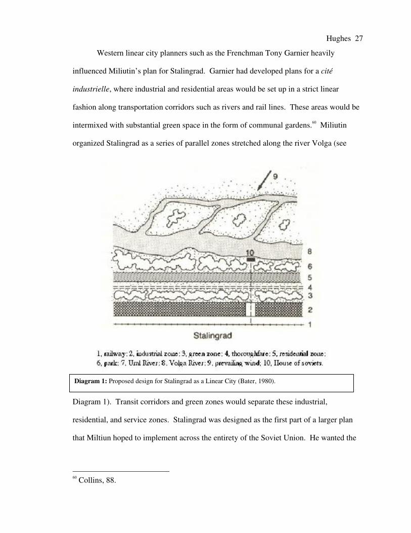
Diagram 1: Proposed design for Stalingrad as a Linear City (Bater, 1980).
Western linear city planners such as the Frenchman Tony Garnier heavily
influenced Miliutin’s plan for Stalingrad. Garnier had developed plans for a cité
industrielle, where industrial and residential areas would be set up in a strict linear
fashion along transportation corridors such as rivers and rail lines. These areas would be
intermixed with substantial green space in the form of communal gardens.60 Miliutin
organized Stalingrad as a series of parallel zones stretched along the river Volga (see
Diagram 1). Transit corridors and green zones would separate these industrial,
residential, and service zones. Stalingrad was designed as the first part of a larger plan
that Miltiun hoped to implement across the entirety of the Soviet Union. He wanted the
60 Collins, 88.

Hughes 28
entire country to consist of linear cities “systematically arranged in such a fashion to
break down the distinction between rural and urban proletariat.”61
Similar linear city models were applied during the first Five-Year Plan, such as
Magnitogorsk and Komsomolsk-na-Amure. However the actual implementation of linear
planning in these cities was limited. The Soviet leadership was so intent on developing
the industrial capacity of these new cities that the city designs were for the most part
ignored. The implementation of the linear design was only further hindered by shortages
of building materials and the lack of skilled laborers (Komsomolsk-na-Amure, for
example, was built by Komsomol volunteers).62 The architect behind Magnitogorsk, the
German Ernst May, was in fact so upset by the blatant disregard for his design that he left
the Soviet Union in disgust before the city was anywhere near completion.63
The Hierarchical Socialist City
Towards the end of the first Five-Year plan there was a major shift in the values
held by Stalin and therefore by Soviet society. Just as theoretical utopian urban planning
fell into disfavor with the Soviet leadership, the same happened to the linear city. Instead
of focusing on the collective, attention was given to the individual – the model citizen for
all Soviet citizens to emulate – a stakhanovite, or Stalin himself. When society began
focusing on some individuals as more important than others, the same happened to the
urban landscape. In 1931, Soviet leaders “decreed that further debate about the future
61 Collins, 87.62 von Geldern, James and Richard Stites. Mass Culture in Soviet Russia (Bloomington,IN: Indiana University Press, 1995). Pg. 243.63 Aaron Ritz. “Life in Magnitogorsk.” (Magnitogorsk, Russia, 2000),www.macalester.edu/geography/courses/geog261/aritz/housing.html (accessed April 11,2007).

Hughes 29
Image 1: The Second Architectural Planning Studio, Avenue of the Palace of the Soviets, 1936,(Paperny 2002).
form of the Soviet socialist city was redundant. All Soviet cities must be socialist by
virtue of their being part of the Union of Soviet Socialist Republics.”64
Just as society had taken steps backwards and become more hierarchical, so did
the city. Individual buildings and city districts became more important than others and
consequently received more attention. Buildings that were located in areas of high value
(and high traffic flow) were built taller and with more ornamentation. This was a stark
contrast to the functionalist and deconstructionist buildings of the Soviet Union’s first
fifteen years. This frame of mind was best exemplified by Stalin’s desire to build the
Palace of the Soviets, to be the tallest building in the world, as the centerpiece to his 1935
general plan for Moscow. It would stand where the Cathedral of Christ the Savior once
stood - along the banks of the Moscow River in the heart of the Soviet capital.
As the utopian theories of socialist urban planning fell into disfavor, there was no
universal agenda for the development of Soviet cities as there had been during the first
64 Bater, 26.

Hughes 30
Image 2: B.M. Iofan, V.A. Shchuko, and V.G. Gel’freikh,Place of the Soviets competition entry, 1930s. (Paperny 2002).
Five-Year plan. However certain principles became standard practice in planning and in
planning education. In James H. Bater’s book, The Soviet City,65 he states that it was “the
near universal application of these principles which has helped to standardize parts of all
Soviet cities.”66 Ten of these principles were recognized as the foundations of Soviet
planning when they were
prescribed as the basic
principles behind the 1935
general plan for Moscow.
These principles behind the
planning of Moscow can
further be considered
universal principles for the
entire Soviet Union since
Moscow is not only the
“Symbol of the Soviet
Union,”67 but also a
“laboratory for socialist city
planning.”68 Although these
principles maintained some of
65 Bater, James H. The Soviet City: Ideal and Reality (Beverly Hills, CA: SagePublications Inc., 1980).66 Bater, 27.67 Lappo, G., A. Chikishev and A. Bekker. Moscow: Capital of the Soviet Union(Moscow, USSR: Progress Publishers, 1976). Pg. 8.68 Lappo, Chikishev, and Bekker, 9.

Hughes 31
the basic concepts advocated by the utopian planners of the twenties, they also
demonstrate that a new era of Soviet urban planning had come into being. Bater listed
these ten principles as follows:69
1. Limited city size:70 Amenities, social services, and items of collective consumption
could all be provided efficiently and economically by limiting the city’s size. City
size would ideally be limited to 50 or 60,000. This concept was carried over from the
era of utopian planning, where Strumilin and Sabsovich prescribed that the optimal
size of a city be limited to 30 or 35,000 inhabitants.71 For already existing cities with
large populations, such as Moscow at 3.5 million, limits were set. Moscow’s upward
limit was set at 5 million.72
2. State Control of Housing: In order to ensure equality and that the standard of living
was hygienic, the design, administration, and planning of housing was centralized.
Although idealized by the utopian planners, only during the first Five-Year plan did it
come into practice, and even then it was nowhere near universal. For example the
majority of Magnitogorsk’s population lived in tents and privately built wooden
cabins by the end of the First-Five year plan.73 Even during NEP, Lenin allowed a
program of “quasi-private” land tenure. Mortgages were given to individuals and
communes to build their own housing.74 This non-hierarchical form of housing
control allowed collectives to build housing that was more suitable for their commune
and their environment. Under the 1935 principles, housing would be more equitable
across the entirety of the Soviet Union, and even its satellites, entirely disregarding
69 Bater, 27- 30.70 Note: Headings in italics are original author’s own words.71 Frolic, 286.72 Bater, 27.73 Ritz, Aaron.74 Andrusz, 1990, 260.

Hughes 32
Image 3: A housing block along ProspektMira built in 1937.
differences in local environment and tradition. The only variation would be the
amount of living space per capita measured in square meters. Therefore residential
units were designed for Muscovite culture and weather, leaving large Tajik families
in stuffy, cramped, hot apartments; and Yakuts froze during the harsh Siberian winter.
3. Planned Development of Residential Areas: Residential areas were planned so that
“day-to-day facilities like schools, shops and so forth would be within walking
distance.”75 This was initially done with the construction of the ‘super block’
accommodating up to 1,500 residents. An example of this type of construction in
Moscow would be in the area surrounding the Studentcheskaya Metro station, east of
the central city. In this area, super blocks surround courtyards with schools,
administrative centers, police stations, etc. Shops would be located on the ground
floor of these super structures. Another area in Moscow developed with “super
blocks” was along Prospekt Mira,
shown in Image 3. This third principle
was more fully applied after the Second
World War with the development of the
mikrorayon, which will be discussed
later in this chapter
4. Spatial Equality in the Distribution of
Items of Collective Consumption:
Ideally, items of collective consumption would be distributed throughout a Soviet city
in a fashion where all residents would have equal access to similar amenities. This
concept was not only limited to creating equality within cities, but also between. As
75 Bater, 28.

Hughes 33
Image 4: Communal dinning halls, orstolovaya, were spread out evenly acrossMoscow. They were not the most attractiveestablishments.
is evident with the urban hierarchy that already existed and continued to exist in the
Soviet Union, with Moscow as the primate city, its inter-urban application was
nowhere near as successful as its intra-urban application.
5. Limited Journey to Work: Forty-five minutes was considered the maximum amount
of time that one should have to travel to work.76 This was to be done by planning
residential areas around nodes of employment. This concept was originally an
integral characteristic of the urbanist models and the linear city, and remained
important throughout the entirety of the Soviet Union’s existence. One’s commute
would also be traveled on public transport, not private. Therefore Soviet cities, no
matter the size, received considerable investment for the development and
maintenance of their transit systems. As a result, Moscow currently has one of the
most efficient metro systems in the
world, and the second busiest after
Tokyo.
6. Stringent Land-Use Zoning: In order to
ensure that all of the principles were
successfully applied, strict zoning of
residential and industrial districts was
necessary. Green zones would often be
used as buffers in order to separate
areas creating pollution from residential
and amenity districts.77
76 Bater, 29.77 Bater, 29.

Hughes 34
7. Rationalized Traffic Flow: Routes of high traffic volume were to be concentrated and
segregated from residential districts allowing a more pleasant living atmosphere.
Industrial districts would be serviced by transit lines integrated with civil ones,
however they would be even more strictly separated from residential districts. In
Moscow, this rationalization of traffic flow made it an exploded radial city, where
only a handful of large avenues and boulevards handled the majority of traffic flow.
A similar phenomenon occurred in Tallinn and Kazan.
8. Extensive Green Space: Although green space played an important role in utopian
urban planning, its inclusion in city plans was meant for a different purpose. Green
space was supposed to be blended into the urban landscape, deconstructing the long
standing rural-urban divide which had forever separated the proletariat from the
peasantry. Under the 1935 principles on the other hand, green space would be strictly
segregated from residential and industrial zones. The Soviet leadership did not want
a “scruffy, rural-urban fringe.”78 With public ownership of land, it was easy for urban
planners to demarcate which areas would remain protected from development. Bater
points out that because of this, Soviet cities had far more green space than their
western counterparts. Green space would also be used in Soviet urban design to act
as lungs for a city, bringing in fresh air from the countryside, clearing away noxious
fumes created by industry.
78 Bater, 29.
Hughes 35
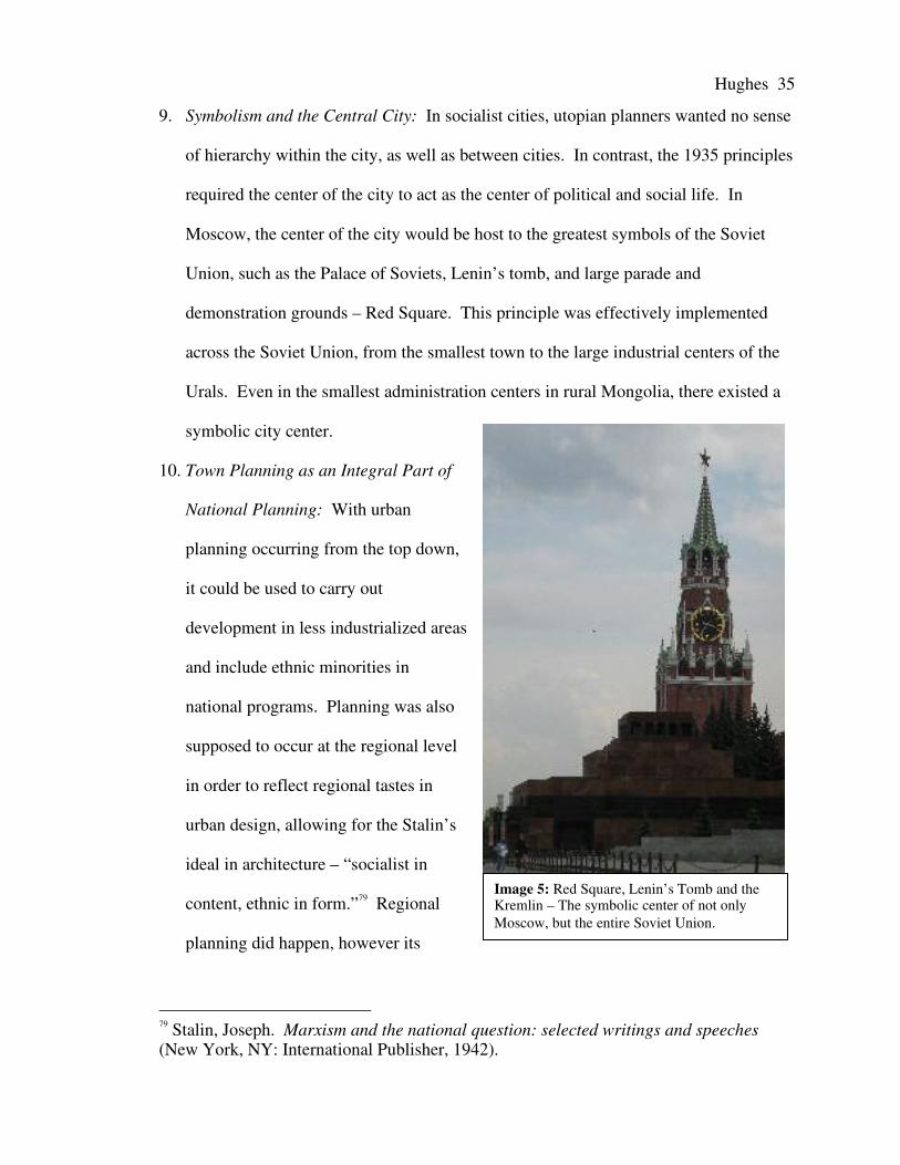
Image 5: Red Square, Lenin’s Tomb and theKremlin – The symbolic center of not onlyMoscow, but the entire Soviet Union.
9. Symbolism and the Central City: In socialist cities, utopian planners wanted no sense
of hierarchy within the city, as well as between cities. In contrast, the 1935 principles
required the center of the city to act as the center of political and social life. In
Moscow, the center of the city would be host to the greatest symbols of the Soviet
Union, such as the Palace of Soviets, Lenin’s tomb, and large parade and
demonstration grounds – Red Square. This principle was effectively implemented
across the Soviet Union, from the smallest town to the large industrial centers of the
Urals. Even in the smallest administration centers in rural Mongolia, there existed a
symbolic city center.
10. Town Planning as an Integral Part of
National Planning: With urban
planning occurring from the top down,
it could be used to carry out
development in less industrialized areas
and include ethnic minorities in
national programs. Planning was also
supposed to occur at the regional level
in order to reflect regional tastes in
urban design, allowing for the Stalin’s
ideal in architecture – “socialist in
content, ethnic in form.”79 Regional
planning did happen, however its
79 Stalin, Joseph. Marxism and the national question: selected writings and speeches(New York, NY: International Publisher, 1942).
Hughes 36
implementation occurred at varying degrees of success.
All of these principles can be found in Moscow after 1935, as well as in almost all
Soviet cities, with minor differences across the vast territory of the country. The 1935
plan for Moscow would serve as the model for all urban development across the entire
union. Buildings and plans in Moscow would be replicated in other cities, while Moscow
would continue developing new plans and prototypes for all to copy. This replication
eventually allowed for the development of yet another era of urban planning, one more
successful than any other – the mikrorayon.
The Mikrorayon
The mikrorayon was the answer to vast housing shortages following the Second
World War. Every detail of entire districts were to be centrally planned in Moscow,
prefabricated, and then built where housing was in high demand in a relatively short
amount of time. Mikrorayons “presented a reasonable, unified, distinctly socialist way of
building residential units.”80
Multiple mikrorayons would be organized into larger residential complexes.
Important every day low order functions would be within walking distance of all
residents, such as elementary education and small shops. Higher order functions, like
clinics, cultural centers, and local administration buildings, would be located in between
mikrorayons. Still higher order functions, like large sports and entertainment complexes
or regional administration facilities, would be centrally located between residential
complexes.
80 Frolic, 288.

Hughes 37
Diagram 2: Plan for a mikrorayon in the Noviye Cheriomushkii discrict of Moscow.(Frolic, 1964).
Image 6: A mikrorayon in the Timeryazevskayaregion of Moscow.
Maintaining the principle of rationalized traffic flow, transit was designed to flow
around mikrorayons, not through them. This provided a safe environment for raising
children, and the development of a supportive socialist community. In some cities
principles from earlier stages of the Soviet city would be implemented. One example can
be found in the southern mikrorayon districts of Kazan where a form of the linear city
was used. Running between mikrorayon residential districts was a main transportation
artery served by trams and buses. This directly corresponds to original western designs
of the linear city where residential districts would be organized along tram routes.
Although the mikrorayon could house large populations, up to 80,000 or even
100,000 people, it was not designed as a self-sufficient district. Mikrorayons were an
improved version of the ‘super-block’ built in the hierarchical Soviet city. Some
mikrorayon plans were modified and used for the construction of entirely new towns,

Hughes 38
generally scientific research communities. Therefore, even though the mikrorayon was
meant as a plan for urban districts, it was used as the foundation for town planning from
the 1960’s onward.
In addition to the mikrorayon, the larger makrorayon was also implemented in
particular cases. Makrorayons could often house up to 45,000 inhabitants, in comparison
to the 8-12,000 average of a mikrorayon. The makrorayon was essentially an expanded
mikrorayon that included the same basic functions but more of them to sustain the larger
population. An example of the makrorayon, Väike-Õismae in Tallinn, will be explored
in great detail in the next chapter. The makrorayon was however the exception in
developing new residential districts, and the mikrorayon remained the standard system of
urban planning.
Conclusion
In this chapter we see how Soviet urban planning evolved over time. Beginning
with idealistic utopian plans, the Soviet leadership decided that efficiency and symbolism
would be the driving forces behind urban planning. Therefore, by the mid-1960s the
Soviet city had become a uniform but hierarchical city with egalitarian housing districts,
the mikrorayon. There were however regional variances in planning and application of
directives from Moscow, some greater than others. The next chapter will look at our two
cities of interest, Tallinn and Kazan, and how Soviet planning was applied in each city.

Hughes 39
Chapter III:The Application and Effects of
Soviet Urban Planning in Tallinn and Kazan
The application and effects of Soviet urban planning in Tallinn and Kazan share
some similarities but were for the most part very different. The purpose of this chapter is
twofold. First, the local authorities’ role in urban planning will be examined. This will

Hughes 40
give a foundation from which to analyze how our two cities of interest managed planning
issues. Second, urban planning during the Soviet era in Tallinn and Kazan will be
examined independently.
The Planning Powers of Local Soviets81
According to Article 147 of the Constitution of the USSR local Soviets had
control over the planning of their territories’ economic and social development. They
had the power to organize and implement policies concerning construction and
maintenance within their jurisdictional areas. These powers were reinforced in 1974 by
Article 7 of a decree made by the Prezidiuma of the High Soviet of the USSR. This
decree stated that local Soviets had the authority to organize and conduct urban and
suburban planning in accordance with the capabilities of their territory’s economic
capacity. All of these rules applied to Soviets at the republic, oblast, and krai82 levels.83
Considering the previously stated planning policies, it is evident that Tallinn and Kazan
would be able to conduct their own urban planning without the hindrance of Moscow.
However this was not always the case as the regional authorities could only carry out
projects if the necessary resources remained within the territory’s economic capacity.
Therefore the central authorities of the Soviet Union could carry out larger projects
demanding high economic input. Such projects might include entities such as
mikrorayons and large industrial developments.
81 Note: In Russian Soviet means council. All levels of government were formed bySoviets; this ranged from the High Soviet of the entire Soviet Union, down to municipallevel Soviets.82 Oblast’ and krai were varying degrees of administrative districts in the USSR and arestill used in the Russian Federation. Oblast’ and krai can be ranslated as province andarea or region respectively.83 Mezhevich, M.N. Urbanizatsiia i razvitie gorodov v SSSR (Moscow, USSR:Akademiia Nauk SSSR, 1985). Pg. 104-105.

Hughes 41
These high level stipulations on planning had different implications for Tallinn
and Kazan. Tallinn was the capital of the Estonian Soviet Socialist Republic (SSR) and
had more autonomy than Kazan. As capital of the Tatar Autonomous Soviet Socialist
Republic (ASSR), Kazan had considerably less freedom in its planning. As an ASSR
within the Russian Soviet Federative Socialist Republic (RSFSR), the Tatar ASSR was
still subject to decisions made by the Soviet of the RSFSR. Therefore, if a project were
carried out across the entirety of the RSFSR, it would also be carried out in the Tatar
ASSR, and hence in Kazan. Meanwhile, Estonia’s status as a full SSR gave the Estonian
Soviet the power to conduct its own urban planning policies as long as they were
representative of the decisions and interests of the Communist Party of the Soviet Union
(CPSU). It is important to note that planning policies were universally applied to the five
largest Estonian cities (Tallinn, Tartu, Kohtla-Järve, Narva, and Parnü) because as of
1950 they were under the direct control of the Estonian SSR Council of Ministers.84
Ideally, the Tatar ASSR would also have the right to conduct its own planning policy as
long as it maintained the interest of the CPSU. However the policies of the High Soviet
of the RSFSR held precedent. Kazan received additional attention from the higher organs
of the USSR because of the city’s important role in the Soviet military-industrial
complex.
By examining Tallinn and Kazan’s statuses within the framework of the Soviet
Union, one can assume that the application of Soviet urban planning would be different
in the two cities. This was the exact case. Tallinn did indeed maintain more autonomy
while Kazan was highly subject to the whims of the central authorities, as will be
explored below.
84 Raun, 170.

Hughes 42
Tallinn
The leading factor differentiating Tallinn from other Soviet cities is that Estonia
was only fully incorporated into the Soviet Union in 1945. Even though Estonia
officially became part of the USSR in 1940 (according to the Molotov-Ribbentrop pact),
the Second World War and attempts at independence postponed their full incorporation
as an active member of the Soviet Union.85 Therefore the only two periods of Soviet
planning that Tallinn experienced were the post-WWII phase of Stalin’s hierarchical city
and the implementation of the mikrorayon. General post war reconstruction across
Estonia will first be examined followed by specifically examining the hierarchical city
and then the mikrorayon. The hierarchical city will however be broken up into two
periods: Stalinist Classicism, and post-Stalinism. Lastly an analysis of how Soviet
planning laid the groundwork for post-Soviet urbanization will be conducted.
Post World War II Reconstruction in Estonia
Following the Second World War, Tallinn’s urban landscape was devastated. Up
to fifty per cent of all buildings were destroyed due to fighting between Soviet, German,
and Estonian partisan forces.86 Damage in Tallinn paled in comparison to other Estonian
cities, such as Narva where ninety-seven per cent of the city was destroyed.
Demographically the country was devastated. Estimates state that over 100,000 Estonian
85 Note: The United States Government never recognized the incorporation of Estonia,Latvia, and Lithuania into the Soviet Union.86 Raun, 175.

Hughes 43
citizens, one tenth of the population, either perished or migrated during the course of the
war.87
Estonia’s highly educated population and strong pre-war industrial sector
attracted the central Soviet authorities’ attention. Therefore Estonia experienced heavy
investment in rebuilding the republic’s industrial capacity as well as replenishing its
housing stock. The most important part of the industrial sector was the oil shale reserves.
Oil shale was an integral part of rebuilding Estonia and the entire northwestern Soviet
Union’s industry. By 1946 the oil shale sector was completely rebuilt and expanding.88
This readily available energy resource allowed the Soviet authorities to quickly develop
the SSR’s industrial sector. Estonia’s industrial growth was further buttressed by its
strategic location on the Baltic with good natural harbors (especially Tallinn), and the
importation of dismantled German factories.89 All of these factors gave Estonia the
highest industrial growth of any SSR in the post World War II period. Estonia’s industrial
growth rate from 1940 to 1950 was 342 per cent, about twice the Soviet Union’s national
average.90
Tallinn’s strategic location as a port on the Baltic attracted considerable industrial
development. This can be seen by the city’s rapid population growth. In 1944 Tallinn’s
population was 133,700 inhabitants. In 1950 the population had reached 212,400 and by
1955 had swelled to 260,800 inhabitants. The republic’s industrial growth can also be
measured by the rise in rural to urban migration. By 1953 the Estonian urban population
climbed to 52.5 per cent from 31.3 per cent in 1945. 91 This demographic shift was
87 Ibid, 166.88 Ibid, 175.89 Raun, 175.90 Ibid, 176.91 Ibid, 183.

Hughes 44
primarily the result of the rural population trying to escape Stalin’s forced
collectivization.92
One of the most dramatic demographic changes that took place during
reconstruction was the influx of non-Estonian ethnicities in the Republic to compensate
for the lack of available labor that the region’s industrial growth required. …Raun gives
a description of this period in his book Estonia and the Estonians: 93
…the pace of industrialization was such that the Soviet authorities recruited workers from
the RSFSR for Estonian industry in, for example, the oil shale region and the large
factories in Narva. From the wartime low of 26,000 industrial workers at the end of the
German occupation, the number in Estonia more than tripled to 80,800 by 1950.
Although no figures are available on the ethnic composition of this labor force, there can
be no doubt that non-Estonians constituted a substantial minority.
The change in Estonia’s ethnic constituency can be more closely observed by the
population percentage that ethnic Estonians formed. In 1939 Estonians made up 92 per
cent of the total population of Estonia. However after Soviet reconstruction ethnic
Estonians only constituted 76 per cent of the Republic’s total population.94 This influx of
non-Estonian ethnicities would of course play a major role in defining Estonia and
Tallinn’s post-Soviet identity.
Reconstruction and Stalinist Classicism
Specifically looking at Tallinn’s urban landscape, the post-war era had dramatic
effects. A major factor in the city’s post-war development was half of all Estonian
92 Hallas, 14.93 Raun, 17694 Raun, 182.

Hughes 45
architects fleeing prior to Soviet occupation in 1940 and during the course of the war.95
That aside, as in much of the Soviet Union, replenishing housing stock was of the utmost
importance. In most situations this issue was satisfied by the construction of four or five
storey brick apartment buildings. These were prevalent in Tallinn, especially in the areas
east of the city center and near the industrial areas north of the center. However, because
of Tallinn’s special status as the capital of an SSR, the local authorities had a lot of
freedom to determine what to build and how. Furthermore, because the remaining
Estonian architects and planners had not learned “the compulsory vocabulary of Soviet
architecture”96 they had freedom of design. However by the end of the 1940’s Estonian
architects had succumbed to what was expected of them by their fellow Soviet architects
and designers. Stalinist Classicism had become standard in Tallinn by 1950.
The evolution of Estonian architecture and city planning from independence
through the Stalinist era and into the sixties can be traced by the career of architect Alar
Kotli. Prior to the 1940 Soviet occupation and WWII, Alar Kotli was a celebrated
Estonian architect who contributed greatly to the urban landscape of independence era
Tallinn. His two most important works for independent Tallinn were the redesigning of
the Parliament building’s south wing in Toompea and the President’s Office in Kadriorg.
Both of these buildings exemplified historicist design using a neo-baroque style as not to
detract from their historical surroundings. Aside from historicist styles, Kotli was an
advocate of the functionalist style exemplified by the Tallinn Technical School and house
designs in the garden city suburb of Merivälja.
The Parliament and President’s Office stand in strong contrast to Kotli’s buildings
built during the Stalinist period. The first Soviet era building of note by Kotli was the
95 Hallas, 14.96 Ibid, 15.

Hughes 46
Image 1: Vlasov’s apartment buildingon Tartu Road.
Estonia Theater and Concert Hall. Originally built between 1910 and 1913, the building
was badly damaged in 1944 during a Soviet air raid.97 Immediately thereafter, Kotli’s
design for restoration won the open competition. The Parliament and President’s Office
stand in strong contrast to Kotli’s buildings built
during the Stalinist period. The first Soviet era
building of note by Kotli was the Estonia Theater
and Concert Hall. Originally built between 1910
and 1913, the building was badly damaged in
1944 during a Soviet air raid.98 Immediately
thereafter, Kotli’s design for restoration won the
open competition. At this time, Kotli had not
succumbed to Soviet and Stalinist principals of
design and planning. Therefore restoration of the
concert hall “had in itself very little to do with
Stalinist principals of building.”99 The interior of
the building, not designed by Kotli and completed in 1951, did conform to Stalinist
principals and was lavishly decorated with Soviet symbols.
By the end of the 1940’s Kotli learned the demands of Stalinist design. This
evolution is apparent in the design of the Arts Foundation Building (1948-1953), on
Vabaduse Sqaure, and Kotli’s proposed design for the Tallinn House of Soviets. The
Arts Foundation Building is a classical example of Stalinist Classicism and its façade is
reminiscent of the detailing added to the Lubyanka in Moscow during the 1940’s. The
97 Hallas, 50.98 Hallas, 50.99 Ibid, 15.

Hughes 47
Image 2: The Sõprus (Friendship) Cinema, built in 1955and one of the last building in Tallinn designed usingStalinist Classicism.
design for the House of Soviets was a typical wedding-cake style reminiscent of the
skyscrapers in Moscow and reflected the celebrated Stalinist architect Alexander
Vasilievich Vlasov.
Vlasov was one of the major adherents of Stalinist Classicism and designed many
of the Stalinist era buildings in Kiev and Moscow.100 His apartment building on Tartu
Road in the emerging Soviet city center of Tallinn shares many similarities with
buildings in Moscow built during post-war reconstruction. Notable features include the
wedding cake appearance, use of classical themes like columns, and of course the
inclusion of Soviet symbols - a wreathed red star crowning a tall spire.
One building, which specifically met Stalin’s standards of “socialist in content,
nationalist in form,” is the Sõprus (Friendship) Cinema. Built in 1955 towards the end of
Stalinst Classicism, the building’s Stalinist character is expressed by the reliefs adorning
the entrance, which depict
mining, heavy industry, fishing
and the fine arts. However the
architects managed to
incorporate many Estonian
forms into the building’s design:
“[t]he nationalist form is
revealed by the application of
ethnographic relief
100 “А.В. Власов: Тверские памятные даты.” Тверская областная универсалная научная библиотека им. А.М. Горкого, (November,2000), http://www.library.tver.ru/tver_memodate/tmd-112.htm (accessed April 11,2007).

Hughes 48
ornamentation of Saaremaa dolomite and the columns resemble the sleeves of a Setu folk
costume.”101
Despite Estonian architects’ submission to Stalinist principals of architecture;
some architects continued to apply their own creativity and design buildings appropriate
for an ‘Estonian’ Tallinn. An example of this is the apartment building on 2 Niguliste
completed in 1954 in the center of the Old Town. Designed by Estonian architect Ilmar
Lassi, the building was meant to replace parts of the Old Town damaged during the war
while maintaining the area’s traditional character. The design completely defies the
norms of Soviet Classicism and Soviet architecture in general. The façade especially
stands out because it was designed “in the spirit of 17th century Netherlands
Mannerism.”102 Not in the spirit of 1940’s Stalinist Classicism.
Overall, in the 10-year period following WWII, the majority of new construction
took place in the previously developed parts of the city damaged during the war. Industry
and housing were the two primary concerns of the Estonian Soviet authorities. The most
dramatic development of this period was the shift in focus away from the Old Town.
Even though the Old Town was restored and still held the government’s seat of power,
the economic and cultural center of the city moved to the southwest, outside the city
walls. This new city center became the hub of the city’s public transit system, as well as
a symbolic city center with Soviet-Estonian, monuments in the parks and squares.
However in comparison to other cities, Tallinn’s city planners did not closely adhere to
the ten principals highlighted by Bater.
The city’s population grew quickly because of laborers migrating from the
RSFSR to fulfill Tallinn’s industrial labor needs. Government control of housing ensured
101 Hallas, 33.102 Hallas, 35.

Hughes 49
Images 3-4: Above – Housing in central Tallinnrebuilt in the post-war period. Below – A 1-317standardized apartment block with bay windows inKazan.
that certain standards were followed. One standard that Estonian architects continually
struggled with was the amount of living space per capita (in square meters) which could
not be exceeded. Estonian architects constantly pushed the limit of allotted living space
and by 1977 Estonia had the all-union high of 10.1 m2 per capita.103 However, in terms of
design and layout, there was no greater plan for all of Tallinn’s housing.
Considering that Tallinn had a pre-existing capitalist character, it was difficult to
implement many of the principals emphasized by Bater. Planned development of
residential areas, spatial equality of items of collective consumption, and the limited
journey to work were especially
difficult to impose upon the existing
city structure.
It is evident that many
principals were ignored for the sake
of efficiency. Residential areas
already well established before the
war were simply rebuilt or restored in
a fashion similar to their pre-war
state. In some districts, the five-
storey 1-317 standardized housing
block was used to develop new
districts of the city located near labor
nodes. The 1-317 block was a
nationally implemented housing unit
103 Bater, 106.

Hughes 50
designed as efficiently as possible to satisfy the post-war housing shortage. New areas
consisting of 1-317 blocks lacked ornamentation and were considered highly undesirable
in the Soviet era as well as the post-Soviet period, but the 1-317 block was not
implemented to the same extent in Tallinn as similar communities in Moscow and other
cities in the RSFSR.
Stalin’s death in 1953 brought drastic change to urban planning in Tallinn.
Stalinist Classicism fell into disfavor across the entire Soviet Union. In 1955, at the
Congress of the Soviet Union of Architects, “the previous decades were condemned as
the period of excess.”104 Thus in the fifties and sixties Estonian architects moved further
away from the Soviet Union’s centralized planning authorities. Due to Estonia’s large
economic and industrial capacity, most projects were within the Republic’s capacity.
Therefore assistance and design from the rest of the Soviet Union were not necessary as
long as the Estonian SSR upheld the ideals of the CPSU in its planning.
Khrushchev’s ‘Thaw’ and Post-Stalinism
Urban planning in Tallinn after 1955 was characterized by both experimentation
and conformity. Following Stalin’s death, foreign influences appeared in Tallinn’s
landscape. Experimentation resulted from the availability of Western architecture and
planning journals in addition to Estonian architects making foreign visits. However
conformity to national Soviet planning procedures came in the form of the mikrorayon.
Probably the largest effect of Stalin’s death was that plans for completely
reshaping Tallinn’s landscape were abandoned. One example is Vabaduse Square, where
a massive triumphal arch to the victory of the Soviet army was to be erected. Likewise,
104 Hallas, 16.
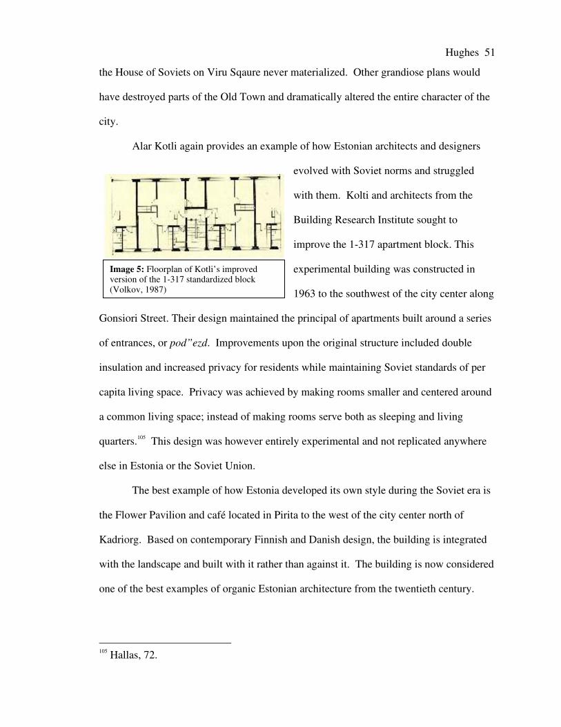
Hughes 51
Image 5: Floorplan of Kotli’s improvedversion of the 1-317 standardized block(Volkov, 1987)
the House of Soviets on Viru Sqaure never materialized. Other grandiose plans would
have destroyed parts of the Old Town and dramatically altered the entire character of the
city.
Alar Kotli again provides an example of how Estonian architects and designers
evolved with Soviet norms and struggled
with them. Kolti and architects from the
Building Research Institute sought to
improve the 1-317 apartment block. This
experimental building was constructed in
1963 to the southwest of the city center along
Gonsiori Street. Their design maintained the principal of apartments built around a series
of entrances, or pod”ezd. Improvements upon the original structure included double
insulation and increased privacy for residents while maintaining Soviet standards of per
capita living space. Privacy was achieved by making rooms smaller and centered around
a common living space; instead of making rooms serve both as sleeping and living
quarters.105 This design was however entirely experimental and not replicated anywhere
else in Estonia or the Soviet Union.
The best example of how Estonia developed its own style during the Soviet era is
the Flower Pavilion and café located in Pirita to the west of the city center north of
Kadriorg. Based on contemporary Finnish and Danish design, the building is integrated
with the landscape and built with it rather than against it. The building is now considered
one of the best examples of organic Estonian architecture from the twentieth century.
105 Hallas, 72.

Hughes 52
One of the most striking examples of how Estonia looked towards the west and
not the east for its urban identity is the Viru Hotel. Built by the Finns using Scandinavian
design, the 22-storey Viru Hotel was the first high-rise in Tallinn. Because of its height
and western design, the hotel stood out from Tallinn’s low-rise medieval and Soviet
skyline. An important aspect of the Viru’s construction was its location on Viru square,
at the heart of the city. Therefore the hotel’s construction was the first step towards the
development of a capitalist central business district.
During the late seventies and early eighties Tallinn’s urban planning was
overshadowed by grandiose projects in preparation for the 1980 Olympics. Even though
the Olympics were in Moscow, the regatta took place in Tallinn. Many projects were
controversial and then hastily completed in anticipation of the Olympics. Projects
included the Pirita Yachting Center, the Olümpia Hotel, and the City Hall entertainment,
sports, and cultural complex. The latter of these three was one of the most momentous
undertakings in Tallinn. The City Hall was a mega-structure in the style of a ziggurat. It
extended into the sea near the ferry terminal as part of a project to improve the neglected
waterfront area. The massive structure held Tallinn’s largest auditorium, an ice rink, a
café, and a bowling alley. The project received many awards and international
recognition. However its monstrous proportions meant difficult maintenance, which is
apparent in the building’s present state.
The most controversial building built during the latter years of the Soviet era was
a flower shop designed by Vilen Künnapu in 1983. A young architect striving to break
the mold of the Soviet city brought postmodernism to Tallinn. His project was extremely
controversial because its postmodern design stood out from the surrounding historical
buildings in the Old Town. Nevertheless the building was seen as a major step away

Hughes 53
Images 6: Olympic Yachting center in Pirita.
from principals of the Soviet landscape. Künnapu later enjoyed a successful career
reshaping Tallinn’s post-Soviet landscape.
Three or four “garden suburbs” existed in Tallinn by the end of Estonia’s inter-
war independence period. All were located on the city’s periphery and included the
suburbs Merivälja, Mähe, Nõmme, and Viimsi. These areas were established during the
interwar period and based on
Ebenezer Howard’s propesed
garden city, but did not strictly
adhear to his intended design.
Instead these suburbs were a
collection of individual plots
available for sale that families
could develop independently. Set
in a natural forested landscape, communal gardens differentiated these suburbs from
other suburban developments.106 Therefore they included some principals of the original
garden city, but did not exist as semi-autonomous districts with labor nodes.
In the 1960’s Tallinn’s Soviet government continued development of these garden
suburbs. New design standards and limitations on living space made the new housing
units more modest than those of the interwar period. New architecture in these districts
was heavily influenced by modern Finnish design altered to meet Soviet parameters. In
Merivälja, the modernist setting “became synonymous with Finnish-influenced organic
architecture, characterized by a broad wooden cornice, large windows and spray plaster
106 Torim, Leena. “Mähe Garden Suburb.” Estonian Architectural Review, (September,2005). http://www.solness.ee/majaeng/index.php?gid=44&id=597 (accessed April 11,2007).

Hughes 54
façades.”107 Although capitalist in nature, these suburbs upheld the principals of the
CPSU. They supported community gardens and the already existing communal design
fostered a socialist lifestyle. With the introduction of private property rights after
independence, these suburban landscapes were once again affected by private investment.
The Mikrorayon in Tallinn:
Despite constant attempts to break away or revolutionize the Soviet mold, Tallinn
was in dire need of large-scale housing projects to satisfy the city’s rapid growth. Stalin’s
mass industrialization had no place for consumer needs. By the 1950’s the entire Soviet
Union was facing a major housing crisis. Bater makes note of this in his book The Soviet
City: “a family per room had become the rule rather than the exception.”108 Following
Stalin’s death in 1953, the Soviet authorities reexamined the housing issue. The solution
to this crisis was the mikrorayon, as discussed earlier in chapter II.
In 1961 the mikrorayon had arrived in Tallinn. Even though the mikrorayon was
a nationally implemented planning policy, Tallinn managed to manipulate plans in favor
of Estonian standards. Three mikrorayon projects were carried out in Tallinn: Mustamäe,
Väike-Õismae, and Lasnamäe. Each of these will be examined independently in order to
observe the evolution of the mikrorayon’s design in Tallinn.
Mustamäe
Although smaller mikrorayon projects, like Pelugrand, were built at the very
beginning of the mikrorayon’s implementation, Mustamäe was the first large-scale
107 Hallas, 128.108 Bater, 99.
Hughes 55
project of this new urban planning style in Tallinn. Construction of Mustamäe started in
1961 and was completed by 1973.
Mustamäe was the least innovative of Tallinn’s large-scale housing projects.
Although designed by a group of Estonian architects, the plan was strongly influenced by
the Noviye Cheremushki mikrorayon project in Moscow.109 Noviye Cheremushki was the
first mass mikrorayon project and served as a model for all other projects throughout the
Soviet Union. This project strengthened Moscow’s role as the Soviet Union’s urban
planning laboratory.
Mustamäe was a larger consisted of nine mikrorayons, each with its own centers
of communal consumption and usage. Designed as a quick solution to the housing
problem, it supported between 80-100,000 inhabitants. The project was largely criticized
because of its poor construction, sub-standard infrastructure, and lack of innovative
design. The district used prefabricated apartment design 1-464, which was manufactured
in Tallinn and became an all-union standard.110 However the district underwent much
revising, and a variety of standardized buildings were added to the original plan. The
pre-fabricated concrete slab construction was considered too industrial and drab.
Therefore projects to diversify the landscape were continually carried out. Shops and
other services were housed in newer red brick buildings, and the building facades went
through numerous facelifts trying to reduce the district’s industrial sense of place.
The lack of innovative design made the project stand out from later projects. One
must consider that Estonian architects did not know how much leeway they had in
109 Volkov, L.M. Architecture of the Soviet Estonia (Moscow, USSR: Stroiizdat, 1987).Pg. 129.110 Volkov, 128-129.
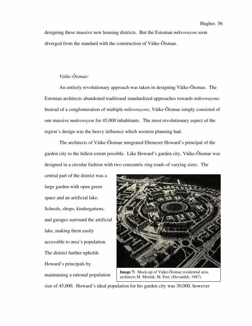
Hughes 56
Image 7: Mock-up of Väike-Õismae residential area,architects M. Meelak, M. Port, (Deviatikh, 1987).
designing these massive new housing districts. But the Estonian mikrorayon soon
diverged from the standard with the construction of Väike-Õismae.
Väike-Õismae:
An entirely revolutionary approach was taken in designing Väike-Õismae. The
Estonian architects abandoned traditional standardized approaches towards mikrorayons.
Instead of a conglomeration of multiple mikrorayons, Väike-Õismae simply consisted of
one massive makrorayon for 45,000 inhabitants. The most revolutionary aspect of the
region’s design was the heavy influence which western planning had.
The architects of Väike-Õismae integrated Ebenezer Howard’s principal of the
garden city to the fullest extent possible. Like Howard’s garden city, Väike-Õismae was
designed in a circular fashion with two concentric ring roads of varying sizes. The
central part of the district was a
large garden with open green
space and an artificial lake.
Schools, shops, kindergartens,
and garages surround the artificial
lake, making them easily
accessible to area’s population.
The district further upholds
Howard’s principals by
maintaining a rational population
size of 45,000. Howard’s ideal population for his garden city was 30,000, however

Hughes 57
Images 8-9: The “great wall of China” and the artificial lakein Väike-Õismae.
45,000 inhabitants stands in strong contrast to other housing projects of 100,000 or more
inhabitants.
Paldiski Mnt, a large separated highway with regular public transit service,
connects the district to the rest of Tallinn. Paldiski Mnt does not however run through
Väike-Õismae, therefore maintaining the principal that the mikrorayon should be a family
friendly haven removed from principal traffic corridors.
Väike-Õismae differs from Howard’s garden city in a number of ways. First, the
district does not include a ring of industrial enterprises along a circular railway line
surrounding the periphery. The district was instead strictly residential with readily
available domestic services for its occupants. Labor nodes remained in their already
existing locations established during Tallinn’s period as a capitalist city.
Another striking
difference between Väike-
Õismae and Howard’s garden
city was the style of housing
implemented. As a Soviet
socialist housing enterprise,
Väike-Õismae’s housing units
consisted of a variety of
standardized apartment
blocks. Howard’s ideal
instead required that each
family unit have its own plot
of land and build

Hughes 58
individualized dwellings meeting certain design standards. Howard did however intend
for the garden city to promote many socialist values such as common gardens and co-
operative kitchens.111 These were common principals for Soviet urban planning in the
1920’s, but not in the 1970’s.
Ranging from five storey blocks to sixteen storey towers, the district was an
imposing array of Soviet housing, especially the 300-meter long block on the inner ring
nick-named by locals “the great wall of China.” The use of sixteen storey apartment
towers as suburban residences are reminiscent of Le Corbusier’s principals making
housing more affordable for laborers by increasing the height of buildings and improving
their overall living conditions by incorporating extensive green space.
The revolutionary design of Väike-Õismae was well recognized both internally
and internationally. However the Soviet authorities did not replicate its idealistic design
anywhere else in the Soviet Union, or even again in Estonia. The last of the three major
housing projects in Tallinn, Lasnamäe, was the largest project and also a fresh mixture of
traditional mikrorayon designs complimented by entirely new concepts.
Lasnamäe:
Designed specifically as a dormitory suburb located to the far west of the central
city, Lasnamäe would be the last and largest mikrorayon project in Tallinn. Construction
started in 1977 and has in fact continued to this day. The project was immense and
intended to provide housing for up to 160,000 residents. The size of the project was
intended to support the ever-increasing amount of immigrants coming to Tallinn from
other parts of the Soviet Union.
111 Howard, Ebeneezer. Garden Cities of To-morrow (Cambridge, MA: The M.I.T.Press, 1965). Pg. 54.

Hughes 59
Diagram 1: Original design for Lasnamäe mikrorayon residential project (Deviatikh, 1987).
Lasnamäe’s original design was extensive. The area would be divided up into
eleven makrorayons further broken down into various other mikrorayons. Two ten-
kilometer expressways would intersect the territory providing easy access to the central
city and other employment nodes. A revolutionary concept was having the two
thoroughfares cut six to seven meters deep into the area’s limestone. This would reduce
sound pollution and eliminate the eyesore of an elevated highway. Additionally
pedestrian bridges and overpasses would span the expressways so that residents would
not feel cut off from other parts of the territory.

Hughes 60
Image 10: Highway cut into limetone in Lasnamäe.
An important aspect that set Lasnamäe apart from Mustamäe and Väike-Õismäe
was the quality and design of the apartment houses built. Not only were the materials of
higher quality but also the
unit designs were more
comfortable. The
uppermost floor of the nine
and sixteen storey blocks
were designed as studio flats
which attracted the artistic
and intellectual community to the area.112
The extensive undertaking of Lasnamäe was difficult to complete and was not
finished by the time of Estonia’s independence. Therefore only one of the two
expressways was completed and much of the region remains under construction.
However the entire area was recently redesigned according to different standards and
principles of urban planning. Thus, Lasnamäe’s final form will be completely different
than its intended form, which will be discussed in Chapter V.
Conclusion on Tallinn
Tallinn experienced three distinct stages of urban planning during the Soviet-era.
The post World War II period was integral in defining how Estonian architects would
work within the new framework of Stalinist Classicism. After 1955 Estonian designers
and planners were able to slowly break away from the parameters laid upon them during
the first part of their inclusion in the Soviet Union. Starting in the 1960’s the mikrorayon
112 Hallas, 135.

Hughes 61
came to Tallinn and redefined the urban landscape. Even though the mikrorayon
received the majority of attention and investment, individual projects that defined
Estonian-Soviet architecture continued to be executed until the end of the Soviet period.
This was a fate entirely different than the development of Kazan’s urban planning during
the Soviet era.
Kazan
Kazan’s urban development during the Soviet era stood in great contrast to
Tallinn. Unlike Tallinn the local Tatar population did not overtly resist the Soviet regime
through architecture and urban planning. Nevertheless ethnicity still played an important
role in defining the Soviet urban landscape for two reasons in particular. First, at the
beginning of the Soviet era Russians and Tatars were highly segregated and for the most
part remained so throughout Kazan’s history as a Soviet city. Second, Tatar architects
sought to create an organic Tatar style of architecture and design. This was quite a bit
more difficult in Kazan than in Tallinn because they did not have either the resources or
the freedom of Estonian architects. In the end, the foundation for Tatar architecture had
been laid, but would not be fully realized until after Kazan had escaped the influences of
the Soviet Regime. Factors such as various five-year plans and the effects of the Civil
War and the Second World War also greatly affected Kazan’s urban landscape.
The development of Soviet Kazan will be looked at by separately analyzing the
city's Soviet legacy in three distinct sections. First the growth and development of the
Tatar population in Kazan will be looked while paying attention to the role of the Tatar
ASSR in the Soviet Union and RSFSR. Thereafter the various stages of urban

Hughes 62
development prior to the Second World War will be examined. Lastly the city’s
evolution during and after the war will be analyzed.
Tatars, Russians, and Tatarstan
When the forces of Ivan the Terrible conquered Kazan, the city's population was
almost uniformly Tatar. However quickly following the khanate's conquest, Russians
began quickly moving into the city. Meanwhile the region's agrarian population
remained dominantly Tatar. By the end of the nineteenth century Tatars were fifteen per
cent of the city's 160,000 inhabitants and the city had become more of a Russian city than
a Tatar city.
These two populations were highly segregated during the Imperial era. The
Tatars were to the west and south west of the city center, between the Bulak Canal/Lake
Kaban and the Volga River. This part of the city maintained a different identity than
Russian parts of the city. Numerous mosques and bazaars reminiscent of Central Asia
defined the Tatar districts, often referred to as the Lower Town. The Tatars were
occupied with handcrafts, light manufacturing, and trading. In general, the Tatar districts
were poorer than the Russian ones and inhabited by the lower and lower-middle classes
of the city. However some Tatar merchants did manage to increase their social status
through their success in business. Successful Tatar merchants became more Russian, and
most wealthy Tatars bought houses in the Russian districts and integrated with the
Russian bourgeoisie and upper classes.113
Ethnic segregation began to wither in the Soviet period. Unlike other non-Slavic
ethnicities in the Soviet Union, Tatars were more readily accepted as equals by the
113 Bukharaev, 90-91.

Hughes 63
Russians in the union’s ethnic hierarchy. This was possible because the Tatars and
Russians in Kazan had been interacting with each other for centuries despite their
segregated districts. With industrialization, rural Tatars moved to centers of labor such
as Kazan. By 1970 Kazan’s Tatar population had increased to 35 per cent of the city's
one million inhabitants. Meanwhile, Russians only accounted for 60 per cent and the
remaining 5 per cent consisted of other nationalities from throughout the Soviet Union.
With the increase in Tatar residents, segregation significantly decreased. Districts were
now heavily mixed, and it was hard to define specific Russian parts of the city. In the
1974 survey of Kazan's ethnic patterns, the traditional Tatar districts remained
dominantly Tatar. But Tatars never made up more than eighty percent of any district's
population.
The influx of Tatar migrants generally moved to either the new mikrorayons or to
a type of suburb unique to the Soviet Union. The “captured village suburb” is where an
agricultural village loses its agrarian function due to a nearby expanding city. Inhabitants
of the former farming community abandon their traditional livelihood and occupy
themselves with low order professions in the city. However in Kazan, these “captured
suburbs” allowed Tatar rural migrants to slowly adapt to urban life without immersing
themselves in it. They could rent a small residence or build their own wooden dwelling,
avoiding the high costs of urban residency and continue small-scale farming.
Furthermore, these migrants would not have to apply for a Kazan residency permit until
they had secured a career that would supply them with an invitation for residency in the
city and the right to state provided housing.
Development of Tatar identity during the Soviet era is important because the
Soviets codified what it meant to be Tatar. Language, national dishes, national clothing,

Hughes 64
national sports, and national everything were selected as representations of Tatar culture.
This standardization unified the RSFSR’s second largest ethnic group (numbering seven
million in 1989) not only in Kazan and Tatarstan but also across the entirety of the Soviet
Union.
By standardizing the Tatar ethnicity historical traditions were adopted and
manipulated to fit the Soviet context. Some of characteristics of “Tatarness” remained
historically accurate, such as the language and many dishes. However some codified
traditions were entirely artificial, architecture in particular.
Tatar cities were last independent of Russian influence in 1552. Until 1917, the
Tatar urban population made up a very small percentage of the total urban population.
Nevertheless, mosques were prevalent under Russian rule, and maintained a style unique
to the area, though heavily influenced by Arabic and Ottoman Islamic traditions. Later,
during the Soviet anti-religious campaigns of the twenties and thirties, many Mosques in
Kazan and across the USSR were either torn down or deconsecrated (specifically
removing the minarets). Aside from mosques, Tatars had very little architecture to call
their own in 1917. Throughout the Soviet era attempts were made to bring “Tatar”
characteristics into the urban landscape. Therefore, a new style of architecture was born
in the name of national Tatar architecture. This was done by taking Tatar designs based
on historical Tatar motifs (from clothing and art) integrated with various epochs of Soviet
architecture ranging from constructivism to Stalinist Classicism to Bauhaus. Examples of
these will be discussed in the following two sections concerning the development of
Kazan's urban landscape.
Kazan Before WWII

Hughes 65
During the Soviet era Kazan turned into an important city in the Soviet urban
hierarchy. With its port on the Volga River, the city served as a major break-in-bulk
point intersected by the Trans-Siberian railroad. Kazan’s location along these transit
lines meant that the city could escape its role as an agricultural and political center to
become a major center of industry, commerce, and transit. Unlike Tallinn,
industrialization in Kazan took many decades and the city did not significantly increase
its status in the urban hierarchy for at least twenty-two years after its incorporation into
the USSR. Nevertheless the Soviet regime did transform Kazan’s urban landscape from
an imperialist provincial capital to a major Soviet center of economics, politics, and
culture.
The Sovietization of Kazan’s urban landscape began immediately following the
Civil War. During the war parts of the city were badly damaged during fighting between
the Czech Legion and Bolshevik forces. Shortages of everything caused the city to come
to an essential standstill. Manufacturing, food production, and transit services ceased to
function. War casualties, famine, and epidemics caused a drastic reduction of the
population. By 1920 the city’s population was reduced by sixty thousand, leaving an
approximate total of 146,000 inhabitants. Therefore at the close of the Civil War, in
1921, the Soviet authorities had much to deal with in order to revitalize the city.
Starting in 1922 the new regime began to renovate the city’s infrastructure.
Electrical power returned and the tramlines, which had not worked in four years, began to
operate again. Houses and other structures destroyed and damaged in the fighting were
either rebuilt or repaired. By 1923 the city began to return to its pre-war form, and by
1926 the city was reinvigorated. In 1926, the city’s population had increased by twelve

Hughes 66
thousand, diesel buses began operation, most private homes had been rebuilt, and forty
new governmental and cooperative buildings had been built.114
The city’s progress was however slowed by a devastating flood in 1926.
Approximately 2,600 houses were under water and people took refuge in schools and the
new government buildings in the higher sections of the city. Thus, the majority of the
1920’s were spent constantly rebuilding the city from war and flood damage.
By 1928 the city had for the most part completed its renovation and began its
transition into a new Soviet urban center. A power station was built on the banks of Lake
Kaban, providing power to sections of the city where it had not been previously available.
A campaign to improve the sanitary conditions of the city included building the banks of
the Bulak Canal, improving bridges, providing clean water and a new sewage system. By
1930 almost all of the private homes damaged during the civil war and 1926 flood had
been renovated or rebuilt. With these improvements, the city began to industrialize.
During the first Five-Year plan from 1929-1934, the city’s urban landscape began
to truly transform. The Leninskii raion115 received the most attention and many nearby
villages and hamlets were incorporated into the urban network because of the city’s rapid
growth. Throughout the city attention was given to the general improvement of
infrastructure and the overall standard of living. Roads were paved, new multi-storey
apartment buildings were built around labor nodes, and electrical service spread.
Establishing parks, squares, and erecting monuments around the city improved Kazan’s
aesthetic appeal. Kazan’s cultural and academic capacity also received attention during
the first Five-Year plan. Many new academic buildings were built, including student
114 Deviatikh, 138.115 Note: A raion can latterly be translated as region, but is the term used for an urbanadministrative district.

Hughes 67
Image 11: The Kazan Financial-Economics Institute.
dorms, institutes, and faculties. A major endeavor was the removal of the tramline on
Bauman Street.116 The street was converted into the city’s economic and cultural center,
moving it away from the upper town. This was a major shift towards the realization of
Stalin’s hierarchical city.
To the south of the city
center, the Stalinskii raion was
also transformed. New apartment
blocks, social clubs, schools, and
other communal structures were
added to the landscape. This was
extremely important since this
area would soon become an important industrial district supporting the river port built
after the war. Like the Leninskii raion, nearby agricultural villages were absorbed by the
expanding urban landscape. In the 1930’s the city grew to the south and north along the
banks of the Volga River. Not until after the Second World War did the city begin to
grow in other directions.
In terms of architecture, the city was slow to develop its “national” architectural
forms. Not only were “national” buildings not built, but also very few experimental
designs were implemented. This is unlike projects being carried out in Leningrad and
Moscow at the same time. During the twenties and thirties most buildings in Kazan were
built as economically as possible. Almost all of the city’s energy was given to the
development of the industrial sector and rebuilding the city from war and flood.
116 Note: Bauman Street is simply known as “Bauman” to locals and will be referred to inthis manner for the rest of the project.

Hughes 68
Therefore very few buildings of note were built during this period. Not until after the end
of the first Five-Year plan did architectural creativity appear in Kazan.
Stalinist Classicism came to Kazan with the realization of the hierarchical
Stalinist city. The Kazan Financial-Economics Institute was the first building designed in
the Stalinist Classical manner. The new building held an imposing position atop a hill in
the city center overlooking the bustling Tukaya Square at the end of Bauman. A
colonnaded front entrance and neo-classical motifs make the building stand out from the
neighboring imperialist era buildings. The building resembles a classical Greek temple
honoring Kazan’s intellectual power. Throughout the thirties other government and
academic buildings were built using Stalinist Classicism in the city center.
Despite the widespread construction of Stalinist buildings during the thirties there
was one major exception. The Dom Pechati, or Press House, on Bauman Street was a
remnant of the 1920’s utopian styles. This was the first constructivist building built in
Kazan and one of the first built outside of Moscow. The building stands out from the
Stalinist buildings of the 1930’s that were dominating the central city’s landscape. The
building is still regarded as one of Russia’s best examples of constructivist architecture.
Towards the end of the 1930’s, what would be considered Tatar national
architecture began to appear. The architect P.T. Speranskii studied Tatar designs and
motifs from clothing and art and began incorporating them in small projects like benches,
pavilions, kiosks, and small bridges.117 Speranskii’s work was important in defining the
foundation of Tatar architecture because, as previously mentioned, the Tatars lacked an
urban culture where specific architectural traits could be formalized. Therefore Tatar
117 Deviatikh, 194.

Hughes 69
organic architecture had to be created by integrating these traditional designs and artwork
in Soviet Russian architectural styles.
An example of how these designs were included in Stalinist Classicism is the
Cinema “Rodina” designed by architect P.S. Borisov. The façade, porticos, and interior
included “traditional Tatar ornamentation.”118 Meanwhile the building also maintained
its Soviet character and socialist purpose. Cinema “Rodina” is an example of how
Stalin’s principal “Socialist in content, national in form” was applied in Kazan.
Another example of how traditional motifs emerged in Stalinist Classicism is the
Dzhlil Opera and Ballet Theater on Ploshad’ Svobody, or Freedom Square. Construction
started prior to the Second World War using stereotypical Stalinist architecture, including
Tatar ornamentation for the interior design. However construction was halted due to the
war and the building was not actually completed until 1956. From the outside the
building resembles a classical Greek temple more than an opera house – a prime example
of Stalinist Classicism. However the interior is an intricate mixture of Tatar
ornamentation and classical imperialist theater architecture, similar to the Bolshoi
Theater in Moscow.
On the eve of the Second World War, Kazan was an odd conglomeration of
architectural styles. Ranging from traditional wooden Russian houses to neo-Classical
theaters to constructivist meeting spaces. No true Tatar architecture had been established,
however architects began subtly incorporating Tatar designs in public buildings and
smaller projects, like parks and monuments. The post-war period would take Kazan
down another path. Its rise in importance, increasing Tatar population, and economic
development would allow the city to develop a Tatar urban landscape while
118 Deviatikh, 194.

Hughes 70
simultaneously becoming more subject to the centralized regime of the Soviet union.
This bi-polar identity conflict turned post-war Kazan into an even more varied and
dynamic landscape.
Kazan During and After the Second World War
Kazan’s role in the Second World War as a new center for industry and commerce
had an unprecedented impact on the city’s development and rising importance in the
Soviet urban hierarchy. The city’s short, but safe, distance from the front made it a prime
location for the development of defense industries as well as a recipient of refugees. The
industrial areas of the occupied Soviet territories, as well as Moscow and St. Petersburg,
were devastated and inoperable for the majority of the conflict. Therefore most industries
in Kazan were converted to the production of war materiel. Furthermore, the central state
savings bank of the USSR moved to Kazan in 1941.119 With it came every bureaucrat
associated with the bank. This shifted the USSR’s financial heart and brought Kazan into
the upper echelons of the union’s urban hierarchy. Even though the bank returned to
Moscow after the war, Kazan’s importance as an economic and industrial center in the
Soviet Union remained.
119 Deviatikh, 140-141.

Hughes 71
Image 11: The Kazan river port complex on the Volga completed in 1962.
In the decades following the Second World War, Kazan’s economic and industrial
status continued to improve. This rise in status eventually gave the city a head start for
economic development after the collapse of the USSR. Despite Kazan’s rise in status, the
city received little attention in the years immediately following the war and its urban
landscape did not change much from its prewar form. The majority of the USSR’s
energy was given to areas devastated by the fighting. This lack of attention is especially
evident when one considers that the first building of note completed after the war was the
Dzhalil Opera and Ballet Theater in 1956 – eleven years after the war. Nevertheless
Kazan sill received investment in its industrial sector and continued to act as major center
of heavy industry and manufacturing.
After the completion of the Opera and Ballet Theater, the city continued upon its
original trajectory of rapid development. Towards the end of the fifties, the Soviet
authorities built two hydroelectric stations, Kuibishecskii and Volgagradskii, along the
middle section of the Volga. The dams created massive reservoirs, which brought the
course of the Volga closer to Kazan. With the construction of twenty-six kilometer dikes
along the Volga’s banks, the city was protected from floods while the river was now a

Hughes 72
Image 12: Corpus Dva, one of theadditions to the Kazan State Universitycampus to modernize Kazan’s urbanlandscape.
reasonable but safe distance from the heart of the city. This allowed for the construction
of the Kazan river port complex. The river
port began in 1957 and was completed in
1962. The surrounding region’s
agricultural productivity and the city’s
already strong industrial capacity made the
port an important break in bulk point
integral to not only Kazan’s economy but
the entire Soviet Union’s. The river port
made Kazan so important that the city was
given the name “Port of the fifth sea.”120
After completing the river port,
modern concrete buildings speckled
Kazan’s landscape. The first of such
projects was the Kazan circus building. Many of Kazan’s inhabitants refer to the
building as the flying saucer because of its otherworldly appearance. The circus was
built west of the Kremlin and stands out because of its industrial concrete exterior.
In the seventies the city authorities moved to modernize the city’s appearance and
skyline. The first part of the city to experience this modernization was Kazan State
University. During this period many new modern high-rises were added to the campus in
the heart of the city. This gave the central city the foundations for what resembled a
hierarchical capitalist central city. The Hotel Tatarstan, also built during this period,
further added to the city’s skyline. Outside of the city center the massive Tatar
120 Deviatikh, 142.

Hughes 73
Image 13: Gorki Raion where a form of the linear city model dependent on the tram (left side ofpicture) was incorporated into mikrorayon planning.
newspaper-magazine publishing house was constructed. Other than a handful of a half
dozen new high-rises, few others contributed to the “modernization” of Kazan’s city
center and urban landscape.
To the north of the city, the massive new Leningradskii and Moskovskii
mikrorayon/industrial districts were built. These districts were built using standard
models of mass construction and brought nothing new to the city’s urban landscape other
than homogenous apartment blocks. This stands in great contrast to Tallinn’s
implementation of mikrorayons. The Tatar authorities simply implemented designs
similar to those in Moscow instead of trying to improve the mikrorayon design.
There were however some attempts of incorporating mikrorayon design with
earlier epochs of Soviet urban planning. In many of the mikrorayon residential projects a
form of the linear city was incorporated. This is most apparent in the Novo-Savinovskii
and Gorki raions. Central multi-modal transit corridors lined with mikrorayon residential
districts characterize these areas. Of particular importance is the use of the tram in the

Hughes 74
Image 14: The Kamal Tatar State Academic Theater on Lake Kaban.
transit corridor, which was a key component of Don Arturo Soria’s original Ciudad
Lineal in Madrid.
One building of particular importance was the Kamal Tatar State Academic
Theater located on the northern shore of lake Kaban. This theater housed plays either
originally written in Tatar or translated to Tatar. The theater gave the city a center to
showcase non-Russian cultural events. Architecturally the building’s stark concrete
design added little to the city except that its interior was designed using traditional Tatar
motifs similar to those used in earlier “national” projects. Presently, many of Kazan’s
citizens believe that the interior decoration of the Kamal Theater, as well as the Hotel
Tatarstan, helped preserve traditional Tatar architectural designs so that they could be
replicated after the collapse of the Soviet Union.121
121 Deviatikh, 195.

Hughes 75
Conclusion:
Since the dawn of the Soviet era, Kazan’s urban landscape changed drastically.
In comparison to Tallinn, Kazan’s architectural development was quite limited. Unlike
Tallinn, Kazan never underwent any mass periods of reconstruction. The city was only
marginally damaged during the Civil War and the flood in 1926. Therefore Soviet
authorities could regulate the city’s growth during the Soviet period. Few experimental
architectural projects graced the city. Additionally, architecture was not used as a means
to speak out against an “occupying” culture. Therefore what was considered “Tatar”
architecture was quite limited, and generally confined to the interiors and ornamental
façades of large state projects. The overall design of most projects was anything but
Tatar. The lack of creative initiative in creating new urban districts and styles meant that
new parts of the city had a particularly Soviet feel to them. Nevertheless the central city
maintained its original form, which is a distinct similarity between Tallinn and Kazan.
The fact that Tatar architects did not use their designs as an expression of their
displeasure with the regime meant that Kazan had little architecture to call its own. After
the collapse of the Soviet Union this would have a drastic affect on the city’s urban
landscape when its administrators would try to redefine the city as a “Tatar city,” just as
Tallinn would try to redefine itself as an “Estonian city.” Chapter V will closely look at
this issue. How both cities, independent of central state planning, would redefine
themselves using their nationalist identity as expressed by the landscape and architecture.

Hughes 76
Chapter IVThe Nature and Origins of Ethnic Identity and
Nationalist Movements in Estonia and Tatarstan
With the collapse of the Soviet Union Kazan and Tallinn acquired the freedom to
make decisions concerning their city without the watchful eye of the CPSU. Nationalism
and ethnic identity heavily affected these decisions as well as political and economic
policies in each city. This chapter will examine the nature of the Tatar and Estonian
nationalist movements. Each movement will also be placed in the context of leading
theories concerning nationalist movements. Understanding the nature of these nationalist
movements will give a better picture of how ethnic identity and nationalism affected the
post-Soviet urban landscape. Combined with Chapter III, this chapter will provide a
basis from which to analyze each city’s post-Soviet urbanization in Chapter V.
Tallinn and Estonia
Estonian national identity did not appear with the collapse of the Soviet Union.
The movement evolved over time, starting in the mid-nineteenth century when an
Estonian educated middle class began to emerge. This new class fostered the perfect
setting for development of a national consciousness. Using historical traditions, the new
Estonian intelligentsia set out to define the Estonian nation. What was to become the

Hughes 77
Estonian national identity could be defined as a mixture of historical traditions adopted
and codified by a new and highly educated middle class.
One can deconstruct the national movement in Estonia by applying ethno-
symbolist theory. According to Anthony Smith in his article Nations and History122
national movements are derived from “an indigenous intelligentsia opposed to imperial
rule.” This new intellectual elite “will seek to mobilize ‘the people’ for political ends
through the rediscovery of ethno-history and the politicization of vernacular culture.”123
The rise of “an indigenous intelligentsia” is exactly what happened in Estonia
during the 19th century. Secondary education in Estonian became available for the first
time. The University of Tartu, established in 1802, was the first university in the entire
Russian Empire. This was actually a reopening of the original Academia Gustaviana
founded in 1632 by the King Gustavus Adolphus of Sweden. After reopening, from 1802
to 1893 instruction was in German and some Russian. After 1893, instruction was only
available in Russian.124 Therefore the academic community in Tartu existed in between
the Russian and German intellectual communities. Western philosophies held a certain
place in instruction, which stood in strong contrast to the Russian academic community.
Furthermore, it was during this period that the rise of the German national consciousness
took place. Thus the rise of the Estonian national consciousness had similar roots as that
in Germany and the concept of the nation state legitimized by that nation’s historical,
cultural and linguistic identity.
122 Smith, Anthony D. “Nations and History” in Understanding Nationalism, ed.Guibernan and John Hutchinson, (Cambridge, UK: Cambridge Polity Press, 2001).123 Smith 2001, 25.124 Tamul, Sirje. “Facts About the University of Tartu,” (Tartu Ülikool, June 2006),http://www.ut.ee/general/history (accessed April 9, 2007).

Hughes 78
Specifically considering the “rediscovery of ethno-history,” the Kalevipoeg was
written in verse by Friedrich Reinhold Kreutzwald and published in 1857. The
Kalevipoeg was the myth behind the origins of the Estonian people. The published
version was based on various versions of the story told throughout Estonian society. The
Kalevipoeg was the beginning of Estonian literary tradition.
The Kalevipoeg was used as a hallmark of the Estonian national movement.
Beginning in the 1870’s, Estonian students at the University of Tartu would meet to read
and discuss verses from the Kalevipoeg in Estonian. Students who attended these
meetings established the Estonian Students’ Society, which was one of the first nationally
minded movements in Estonia. In 1884 they adopted the blue, black, and white tricolor
as their flag.125 This flag later became the national flag of both the inter-war and post-
Soviet Republic of Estonia.
It was also during this period that the first song festivals were held in Tartu and
other cities throughout Estonia. The first official song festival was in 1869 in Tartu.
Although only two of the songs were of Estonian origin, the event was considered unique
to Estonia and the national movement.126 Thereafter, song festivals were held every five
years in Tartu and later in Tallinn. Estonians considered the song festival as an event that
identified the Estonian people and separated them from the Russian and German
populations.
Under Soviet rule, the Tallinn song festival continued every five years and
corresponded to “Red Holidays.” Despite attempts by the Soviet regime to use the song
125 Tamul (2004).126 “The Historical Overview of the Estonian Song Celebrations.” Estonian Song andDance Celebration Foundation,http://www.laulupidu.ee/vana/eng/index.php?th=5&fid=5-1 (accessed Monday April 9,2007).
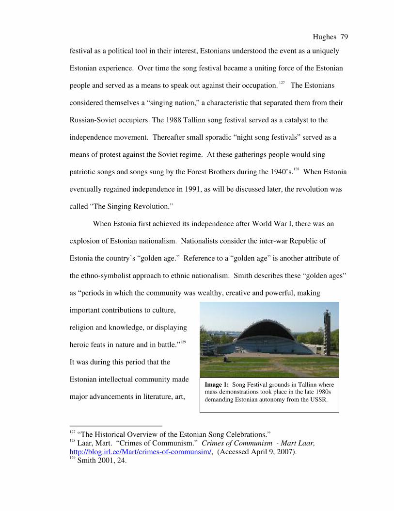
Hughes 79
Image 1: Song Festival grounds in Tallinn wheremass demonstrations took place in the late 1980sdemanding Estonian autonomy from the USSR.
festival as a political tool in their interest, Estonians understood the event as a uniquely
Estonian experience. Over time the song festival became a uniting force of the Estonian
people and served as a means to speak out against their occupation. 127 The Estonians
considered themselves a “singing nation,” a characteristic that separated them from their
Russian-Soviet occupiers. The 1988 Tallinn song festival served as a catalyst to the
independence movement. Thereafter small sporadic “night song festivals” served as a
means of protest against the Soviet regime. At these gatherings people would sing
patriotic songs and songs sung by the Forest Brothers during the 1940’s.128 When Estonia
eventually regained independence in 1991, as will be discussed later, the revolution was
called “The Singing Revolution.”
When Estonia first achieved its independence after World War I, there was an
explosion of Estonian nationalism. Nationalists consider the inter-war Republic of
Estonia the country’s “golden age.” Reference to a “golden age” is another attribute of
the ethno-symbolist approach to ethnic nationalism. Smith describes these “golden ages”
as “periods in which the community was wealthy, creative and powerful, making
important contributions to culture,
religion and knowledge, or displaying
heroic feats in nature and in battle.”129
It was during this period that the
Estonian intellectual community made
major advancements in literature, art,
127 “The Historical Overview of the Estonian Song Celebrations.”128 Laar, Mart. “Crimes of Communism.” Crimes of Communism - Mart Laar,http://blog.irl.ee/Mart/crimes-of-communsim/, (Accessed April 9, 2007).129 Smith 2001, 24.

Hughes 80
and architecture. “Heroic feats in battle” are exemplified by the Liberation War from
1918-1920 when the Estonians resisted both German and Bolshevik forces. The first
Estonian Prime Minister, Mart Laar, summarized the success of the inter-war republic as
follows: “In twenty years of freedom and independence, Estonia had made of itself a
normal European state.”130
During Soviet occupation, authorities suppressed this surge in nationalism.
Despite being part of the Soviet Union, the Estonian national consciousness survived.
The initial reaction to occupation was strong and in fact thousands of men who had
fought for Nazi Germany, Finland, or the Red Army during World War Two began a
guerilla war against the Soviet regime as a force called the Forest Brethren. Dissenters
were brutally repressed by Stalin and eventually armed resistance withered away by the
mid-1950’s.
Non-violent dissent appeared in all forms throughout Soviet occupation. Estonian
officials in the Communist Party of Estonia believed that they were working in the
interest of Estonia from inside the Soviet nomenclature. Other dissenters existed in the
form of underground intelligentsia, artists, student groups and overt political dissenters.
After Stalin’s death, western academic journals became available. This gave the Estonian
intelligentsia access to ideas from the west, which corresponded to western-based
Estonian academic traditions derived from the University of Tartu’s Germanic nature.
This affected architecture, which also became a form of protest against the Soviet-
Russian culture as demonstrated in Chapter III.131
Despite repression of Estonian culture by the Soviet regime, the most
fundamental aspects of national identity were retained. For example, the Estonian Song
130 Laar, Mart. “Crimes of Communism.”131 Hallas, 16.

Hughes 81
Festival continued as an official event as discussed earlier. Furthermore, the Estonians
identified with their Finnish brethren to the north who maintained their independence
from the Soviet Union. Residents of northern Estonia adopted parts of the Finnish
identity as their own because they had access to Finnish television channels.132 In
addition, after Stalin’s death Estonian intellectuals could make foreign visits therefore
adopting Western ideas and philosophies as their own, further separating the Estonian
academic community from the Russian.133
Demonstrations demanding greater economic and political autonomy from the
USSR began in 1987. These demonstrations gained much broader support and by 1989
the Estonian populace was no longer calling for autonomy, but full independence. In
1991 there was a united demonstration involving Estonia, Latvia, and Lithuania where
over two million people linked hands across all three republics. Full independence was
finally achieved on August 22, 1991 following the Putsch in Moscow.
Under Soviet rule, the Estonians had worked against the imposed Russian culture,
but could only live apart from it and never be free of its strong presence. Song lyrics
could be changed, food not eaten, and Russian language not spoken. But Tallinn’s urban
landscape was always subject to Soviet-Russian culture. The Estonians did have agency
to express their nationalist tendencies and separateness from the Russians in architecture,
but this remained within the Soviet framework. For example, integrating Ebenezer
Howard’s garden city with the mikrorayon. Despite the difficulties involved in
completely redefining an urban landscape, Tallinn’s government did manage to do such a
thing after 1991 as will be shown in Chapter V.
132 Laar, Mart. ‘Crimes of Communism.’133 Hallas, 16.

Hughes 82
Kazan and Tatarstan
Kazan’s immediate history following the collapse of the USSR was quite different
from Tallinn’s. Tatar nationalism was not as high profile as other national movements in
the Soviet Union. There were movements for Tatar self-determination during the early
part of the twentieth century in the name of pan-Turkism. But these were isolated
movements without widespread popular support. During the Soviet era Tatars integrated
with the ethnic Russian minority in Tatarstan, which accounted for 43% of the population
in 1989. Although the two populations were segregated before the formation of the
Soviet Union, by 1990 the situation was quite different. Inter-ethnic marriages and
Tatars who spoke Russian as their mother tongue were the norm rather than the
exception.
Towards the end of the 1980’s some nationalist groups advocated Tatar national
self-determination.134 In 1990 Tatarstan officially made demands for more autonomy
from the Soviet Union. On August 30, 1990 Chairman of the Supreme Soviet of the
Tatar ASSR, Mintimer Shaimiev, declared Tatarstan a full Soviet Socialist Republic.
From the perspective of the Tatar authorities Tatarstan would still be part of the Soviet
Union, but no longer as an ASSR subject to the RSFSR. This declaration created the
foundation from which the de facto Tatar SSR could establish its de facto independence
after the collapse of the Soviet Union.
134 Jack, 231.

Hughes 83
Image 2: The Tatar flag flies at thesame height as the flag of the RussianFederation in the Kazan Kremlin.
When the Soviet Union disintegrated, the Republic of Tatarstan saw itself as an
independent country and entered a state of undefined independence. This view was
grounded in that Tatarstan had previously been an SSR, howbeit for one year; therefore it
had the same rights to independence as Ukraine and Estonia. The Tatar authorities
carried out bilateral agreements with the Russian Federation and other sovereign states
such as Turkey and Kazakhstan. Eventually, in 1994, Tatarstan signed an agreement with
Russia as discussed in Chapter I.
During the period of 1991-1994 the government as well as other independent
groups moved to show how the Tatars were
historically and culturally different than
Russians. Signs in Tatar began to appear on
the streets. Elementary and higher education
taught in Tatar became more widely available.
Books were written which celebrated Kazan as
a Tatar city. In one book, Kazan – The
Enchanted Capital,135 Islam is termed “the
ancestral faith” and everything that is not
Russian is celebrated. Even so, there is still a
celebration of Kazan’s cultural and ethnic diversity.
Day of the Republic became an official holiday. Traditional Tatar fashion shows,
wrestling competitions, and dance performances were hallmarks of the celebration. The
majority of events were constructed traditions from the Soviet period when Stalin
standardized the identity of the USSR’s ethnic groups. What was considered national
135 Bukharaev, 1995.

Hughes 84
Image 3: Tatar man on theright is wearing a Tybeteyin Kazan.
dress incorporated the imagined with the historically
accurate, for example the tyubetey or skullcap, is worn in
Kazan as it is across both the Central Asian and Muslim
world.
Examining these events, Tatar nationalism lends
itself to modernist theories concerning the nature of
nationalist movements. Ernest Gellner defines
nationalism as:
…essentially the general imposition of a high culture on society, where previously low
culture had taken up the lives of the majority, and in some cases the totality, of the
population. It means that generalized diffusion of a school-mediated, academy-
supervised idiom, codified for the requirements of reasonably precise bureaucratic and
technological communication.136
The codified identity given to the Tatar people by the Soviet state served the
interests of the union’s bureaucratic machine. The people of Tatarstan were told what
their ethnic identity was by those who held power. Day of the Republic did not only
celebrate Tatarstan’s autonomy, but displayed Tatar fashion, song, sport, and folklore to
the broader population. The people identified with this culture and supported it without
regard to it being imposed upon them by an educated elite seeking to secure its own
power.
Tatar nationalism drew further support from the uncertainty of the situation in
1991 as the Soviet Union disintigrated. Eric Hobsbawm quotes Miroslave Hroche in
describing the collapsing state: “[nationalism] is ‘a subsititute for factors of integration in
136 Gellner, Ernest. “Nationalism and High Cultures,” in Nationalism, Ed. JohnHutchinson & Anthony D. Smith (Oxford, UK: Oxford University Press, 1994). Pg. 65.

Hughes 85
a disintegrating society. When society fails, the nation appears as the ultimate
guarantee.’”137 Following the collapse of the USSR and increased autonomy, the Tatar
government drew wide support from the local population. This is partially due to
Tatarstan’s economic policies during the nineties. In comparison to the rest of the
Russian Federation, costs of living remained low and through government subsidies
Tatarstan avoided many of the hardships associated with privatization. This alternative
system of economic restructuring provided by the Tatar national government further
strengthened the support of both the Tatar and Russian populations.
Unlike Estonian nationalism, Tatar nationalism was not driven by national self-
determination. An independent Tatar polity had not existed since 1552 and there are few
records describing the khanate of Kazan. Therefore, when Tatarstan acquired its de facto
independence, the republic’s government sought to strengthen the Tatar identity
separating Tatarstan from Russia reinforcing the Tatar government’s legitimacy to power.
One of the strongest government policies that defined Tatar ethnicity was Tatarizing the
urban landscape.
Considering the nature of nationalism in Estonia and Tatarstan major differences
in the movements become apparent. The Estonian national movement began in the mid-
nineteenth century as nationalist fervor swept across the rest of Eastern Europe. Estonian
nationalist leaders looked at the country’s past and used their historical oppression by
occupying powers as grounds for national self-determination. Incorporating philosophies
from the West with Estonian folklore, myths and traditions the Estonians established their
identity.
137 Hobsbawm, E.J. Nations and nationalism since 1780: Programme, myth, reality(Cambridge, UK: Cambridge University Press, 1992). Pg. 173.

Hughes 86
The Tatar nationalist movement however did not fully develop until the end of the
Soviet Union. Tatarstan did not experience the same wave of nationalism during the
nineteenth century experienced in Eastern Europe. The western concept of a nation did
not reach the region until the Soviet Union was established and Asiatic ethnic groups in
the USSR were defined as nations and prescribed an artificial cultural identity.
Additionally the Tatars had already been widely accepted by the Russian population and
vice versa. The Tatars saw Russians as equals, not occupiers. Therefore, as Hobsbawm
noted, it was only in a situation of uncertainty that Tatar nationalism became the guiding
light of the Tatar people.
Despite the differences in the nature of the movements, both acted quickly to
separate their identity from the Russian identity. This took place in the media, education,
economic policies, and in the landscape. The urban landscape became a political tool for
reinforcing Estonian and Tatar ethnic identity. In some cases inadvertent planning
policies defined the landscape as “national,” but in many cases the policies were
intentional. These intentional and inadvertent planning policies and architectural designs
will be examined in the next chapter in order to determine to what effect ethnic identity
and nationalism had on the urban landscape of Tallinn and Kazan respectively.
Hughes 87
Chapter VAnalysis of Post-Soviet Urban Planning
in Tallinn and Kazan
Post-Soviet urbanization in Tallinn and Kazan was, and still is, heavily affected
by the development of national identity of each city’s primary ethnic group. This
nationalization of the landscape was affected by numerous factors including history,
economics, politics, language, and identity. In this next chapter post-Soviet Urbanization
in Tallinn and Kazan will be closely examined in order to determine exactly what factors
played a decisive role in the development and nationalization of each city’s urban
landscape.
Tallinn
In the post-Soviet era, Tallinn has implemented a holistic approach to developing
its post-Soviet urban landscape. Tallinn’s rebirth can be explored by examining five
districts in particular – the Old Town and the harbor, the central business district, the sub-
urban periphery, the Soviet mikrorayon projects, and public transit. All of these areas
have received considerable attention from the city’s authorities. Each area has been
transformed in a different way in relation to what Tallinn’s government believed was
important in the lives of the city’s inhabitants and in the interests of the city’s future.
Hughes 88
The Old Town
The last time the Old Town received any considerable attention from the
government was after the Second World War. Despite some plans for restoration in the
1980’s, little was done to the Old Town since the post-war period. The Soviet regime’s
disregard for the Old Town was a blessing in disguise since it preserved what would
become one of Tallinn’s greatest assets in redefining the city’s identity. Developing
Tallinn’s Old Town had two distinct goals. First, like the Kazan Kremlin, which will be
discussed later, the Old Town was the seat of Estonia’s government. Therefore the
country’s government had a vested interest in preserving symbols that defined the new
Estonian state. Second, the Old Town had great potential as a major tourist attraction
providing a strong base for Tallinn’s economy.
When Tallinn first achieved independence there was great debate over the future
of the Old Town. Preservationists wanted to maintain the area’s heritage while forward-
looking investors wanted to develop the Old Town to its fullest potential. Debates
between the two sides, as well as issues of land ownership, prolonged the debate long
enough that the Old Town escaped mass development. The area retained much of its
original character and was made a UNESCO World Heritage site in 1997 guaranteeing
the Old Town’s preservation.138
One modern building was constructed before the Old Town became a protected
area. This was the shopping center on Viru Street in the eastern section of the Old Town.
The shopping center was built on three vacant lots of houses destroyed in World War II
that were never rebuilt. Therefore no historic buildings were sacrificed to make room for
138 “Europe and North America: Estonia.” UNESCO.ORG: Estonia, (2006),www.unesco.org (accessed April 11, 2007).

Hughes 89
Image 1: The Tallinn ferry terminal.
this ultra-modern structure. Designed by Estonian architects, the shopping center was
built using an array of limestone, glass, and wood separated into three sections giving the
appearance of the three original plots. The building follows the medieval street front and
is the same height as neighboring buildings so as not to be too intrusive on the historic
landscape. The modern architecture of this shopping center is important because it shows
how Estonian architects liberally synthesized different styles of Western European design
in order to create something uniquely Estonian.
The first project built after independence was the harbor passenger terminal to the
northeast of Old Town. Started in 1992, the terminal was built in three different stages
and consists of a variety of buildings. All parts of the harbor were built using
functionalist styles adopted from the west. The harbor terminal was considered of the
utmost importance because it would reestablish ties with Estonia’s neighbors, Finland
and Sweden. Completion of the harbor terminal established Tallinn as a node in the
Baltic ferry network increasing the
inflow of tourist and business traffic.
Currently up to thirty boats a day
travel between Helsinki and Tallinn.
The early establishment of Tallinn
has a node on the Baltic ferry network
was especially important in
establishing the tourist industry. The
harbor’s close proximity to the Old Town meant that visitors could make day trips from
Helsinki and enjoy the city’s scenic beauty with little transportation cost. Therefore after

Hughes 90
Image 2: Renovations on Toompea Castle, May 2006.
the harbors completion the importance of preserving the Old Town increased
significantly.
After the Old Town was declared a UNESCO World Heritage Site intensive
preservation of historical buildings began. In 1997, the interiors of the Parliament
Building, Toompea Castle and Palace were renovated. The exteriors were later renovated
and completed in 2006. During this same period the entirety of Old Town was renovated.
Churches, houses, streets, and the city walls where all publicly or privately renovated.
Currently the Old Town is the heart of Tallinn’s tourist industry as well as the city’s
center of religion and governance. Embassies and consulates have occupied many of the
more spacious houses in Toompea,
while the lower town is filled with
museums, galleries, restaurants, cafes,
hotels, bars, and shops. The Old
Town’s churches and medieval
character is appealing to foreign
visitors as well as the city’s residents.
Now the Old Town has become
a symbol for both Tallinn and Estonia.
Pictures of the Toompea Castle and the
Old Town’s skyline appear on the
government’s website. The Estonian
tri-color flies from the top of Toompea
Castle, and all signs are in Estonian, not Russian. The only remaining trace of the Soviet
Union’s legacy is the wreathed red stars adorning the Sõprus Theater. Additionally, the

Hughes 91
area surrounding the Church of St. Nicholas has been uncovered to display the
foundations of houses bombed during the second Soviet occupation in 1944. The site
was originally uncovered for development, however many of the city’s residents feel that
the area should remain undeveloped as a reminder of the city’s history and struggle for
independence.
The years of debate over the Old Town’s fate were determined the city’s future
development. In the Old Town focus was on preservation and emphasizing the Estonian
legacy in the city. Soviet symbols were eradicated from the landscape. The only
remaining Russian cultural symbols were the Alexander Nevesky Cathedral. Opposite
the cathedral however, the Estonian tri-color proudly stands atop Toompea Castle and
Palace. The fate of Kazan’s Kremlin, as will be discussed later, was quite different.
Unlike Kazan, there were no mega-projects establishing the titular nationalities claim to
the historic seat of governance and culture in Tallinn’s Old Town.

Hughes 92
Image 3: The restored Old Town walls looking over the Tallinn Harbor.
Once the future of the Old Town had been secured as a preserved historic area,
the government focused on other parts of the city. The government sought to develop
business, increase the standard of living, and spread the benefits of tourism. The new
shopping center on Viru Street and the harbor complex laid the foundation for modern
Estonian architecture. The new buildings could not be considered uniquely Estonian.
But Estonian architects took a modernist approach to redefining the urban landscape. A
myriad of ultra-modern designs would become the standard for new projects in Tallinn
while maintaining a policy of historic preservation. Where needed older buildings would
be incorporated into new buildings. This technique was not used in the Old Town, but
was a popular method of urban renewal in the Central Business District.

Hughes 93
Image 4: Interior of the Sokos shopping center located in theViru Hotel.
The Central Business District
This area of the city is usually referred to as “the center.” However it is necessary
to call it the central business district (CBD) in order to distinguish it from other cities
across the former Soviet Union. The central business district is a key attribute of
hierarchically organized capitalist cities in which high-level economic and cultural
functions are located. The rigid nature of Soviet urban planning prevented CBD’s from
organically evolving in socialist Soviet cities. Instead the Soviet city center was
characterized by Bater’s symbolic city center. During the inter-war independence period,
a fledgling CBD had come into existence. During perestroika the city authorities
continued in the direction of developing a CBD with the construction of the high-rise
Viru Hotel and entertainment complex. Despite forward-looking efforts, little else could
be done in the Soviet period to make the center a true CBD. In the years following
independence Tallinn’s city center became a focus of investment and is now becoming a
true hierarchical and capitalist central business district.
The CBD is home to Tallinn’s foremost theaters, concert halls, hotels, and
business centers. The initial establishment of two shopping centers guided the central
district towards becoming the city’s cultural and economic core. The lower levels of the
Viru hotel were turned into
the Sokos shopping center.
Now one of the main
shopping centers in Tallinn,
Sokos hosts a variety of high-
end shops and cafés. The
other shopping center was the

Hughes 94
Image 5: Tallinn’s central business district with the Old Town inforeground.
Finnish owned Stockmann department store. Finnish companies were among the first to
invest in Tallinn because of the similarity of languages and cultures. Therefore the
establishment of the Stockmann department store, which tailored its merchandise to
Estonian tastes, greatly appealed to the city’s Estonian residents.
During the late nineties, new high-rise office buildings and hotels dominated
Tallinn’s skyline. The first high-rise was begun in 1995 to satisfy the demand for office
space. The 24-storey modern office block redefined Tallinn’s CBD. Shortly thereafter,
other high-rises also
appeared. These include a
new 26-storey SAS
Radisson hotel and other
smaller buildings. The
construction of other high-
rise buildings continues to
this day and cranes accent
the city’s skyline.
Preservation of historic
buildings has had an effect on development in the CBD. Some older buildings have been
incorporated into the new high-rise urban landscape. Others have simply been left as
they were fifteen years ago, but are now wedged between modern skyscrapers.
As in the Old Town, the CBD has been stripped of most Soviet monuments. De-
Sovietizing the landscape continues to this day. Currently the process has been the focus
of much controversy between Estonian and Russian groups. One monument in question
has caused such uproar that it has attracted international attention. The Bronze Soldier of

Hughes 95
Tallinn was erected in 1947 to commemorate the Red Army’s “Liberation” of Tallinn
from Nazi Germany. Soldiers who died in or near Tallinn were previously buried at the
sight of the monument in 1945.
Estonian nationalist groups and political parties began calling for the removal of
the monument in May of 2006. They were however met by stiff resistance by ethnic
Russian and some Estonian war veterans and other Russian interest groups. These groups
gained further backing from the Russian government who threatened to sever diplomatic
relations with Estonia if the monument was removed. Despite these warnings from
Moscow, and from the European Union who did not want problems with Russia, the
Riigikogu (Estonian Parliament) passed two laws that enabled the removal of the Soviet
monument. The first of these two laws, passed January 10, 2007, allowed for the
protection or relocation to graveyards of bodies of fallen soldiers of either Estonian or
foreign decent.139 The second law prohibits the construction or preservation of any
monument “which glorifies the occupation of the Republic of Estonia, mass repressions
in Estonia…incites hatred or may cause breaches of public order.”140 The law further
states that the monument on Kaarli pst 13 in Tallinn, which is the address of the Bronze
Soldier, must be removed within thirty days of passing the law.
The debate concerning the Bronze Soldier of Tallinn shows that establishing
central Tallinn as an “Estonian” space is an issue of both municipal and national
importance. The Estonian national government’s involvement in this issue corresponds
to the actions taken by Kazan’s republic level government in redefining the Kazan
Kremlin as will be discussed later.
139 “Riigikogu, War Grave Protection Act.” Riigikogu (January 10, 2007),http://www.riigikogu.ee/ (accessed April 10, 2007).140 “Riigikogu, Disallowed Construction Removal Act.” Riigikogu (February 15, 2007),http://www.riigikogu.ee/ (accessed April 10, 2007).

Hughes 96
Image 6: New upper-middle class housing built by the Italianfirm Breatoni.
In the post-Soviet period, religion again became a factor in urban planning. New
churches keep appearing throughout the city. One of the first was a Methodist church in
between the CBD and the suburb of Kadriorg. Its design is innovative and resembles the
style of Finnish architect Eero Saarinen, whose father designed the Tallinn 1913 Master
Plan, which was never realized. The construction of a church near the CBD played an
important role in redefining Tallinn’s landscape. The Soviet authorities no longer
restricted development, and architects could express themselves in new ways.
The boom of the CBD increased the demand for nearby modern housing.
Demand has brought in new housing projects as well as the renovation of older buildings,
further changing the landscape.
One project is of particular
interest because it resembles the
wooden apartment buildings of
the interwar period. The project
was designed and built by the
Italian firm Breatoni and has
stunning views of the Old Town
and harbor.
Tallinn’s central
business district gives the city a Western European atmosphere, which separates Tallinn
from other post-Soviet cities. Furthermore, the CBD is standard for making the urban
landscape more Estonian, though not through overt nationalism as we will see in Kazan.
Instead of creating new ‘national’ architectural forms, the Estonians define their national
identity as Western and European. Estonian architects synthesize various European

Hughes 97
styles and create a distinctly Estonian-European form of architecture. Therefore Tallinn’s
urban landscape is not being nationalized through faux-historicism, as in Kazan, but
rather through post-modernism. This principal is especially apparent in the development
of Tallinn’s suburban periphery.
The Suburban Periphery
The growth of Tallinn’s suburban periphery is related to the nationalist notion that
Estonians have a unique relationship with their land. In his article “National Identity in
Estonia”141 Eiki Berg states “Estonians possess a unique relationship with the Estonian
territory that supposedly gives them a primordial right to that space.”142 Berg supports
this statement by citing the ethnic constituency of the urban and rural populations. In the
year 2000 only fifty-eight per cent of ethnic Estonians lived in urban areas while ninety-
one per cent of ethnic Russians were urban. This perspective of the Estonian attachment
to their land and natural surrounding can help explain the population shift to new
suburban communities outside the city. In the past decade commuter suburbs have
appeared throughout the Tallinn metropolitan area. These new areas can be characterized
by their innovative architecture, wooded settings, low density, and connectivity to
Tallinn’s urban core.
141 Berg, Eiki. “Local Resistance, National Identity and Global Swings in Post-SovietEstonia.” Europe-Asia Studies, Vol. 54, No. 1. (Jan., 2002), pp. 109-122.142 Berg, 111.

Hughes 98
Images 7-10: A variety of suburban communities. Clockwise from top right: a single-family unit in awealthy suburb; an upper-class commuter suburb; the Aaviku residential area, a middle-class community.
Tallinn’s suburban developments are a composition of modern, post-modern, and
constructivist styles. Some are gated communities that are separated from transportation
routes and other built up areas by the forests surrounding Tallinn. Other developments
are not gated and lie on major transportation corridors but are still attractive because of
their wooded, natural setting. Design typically emphasizes privacy while promoting a
sense of community. The Aaviku residential area for example is extremely dense but
houses are given individual yards in order to enhance the feeling of privacy. Other
communities are dense with shared yards and parking enhancing the feeling of
community. The more expensive communities consist of individually designed houses
with larger yards and private parking for multiple families.

Hughes 99
Image 11: High-density development in Kadriorg withparking underground.
These new suburban developments are all located in forest settings and greenery
is used to make them more comfortable and appealing to residents. Even though the
design of these suburban communities resembles new towns built in post-war
Scandinavia, they differ in principal. They do not have central shopping districts and are
poorly served by public transit. Therefore these communities are designed almost
exclusively for professionals commuting to the central city who possess a car.
In contrast to these low-density communities, multi-story developments have also
begun to appear in the suburban periphery. To the southeast of the central city, near
Väike Õismäe, new high-rise
apartment buildings have been
built near a new shopping
center. Another development in
Kadriorg was able to maximize
its space by locating its parking
facilities under the apartment
buildings. Generally these
higher density suburban
developments lie along transportation corridors and are better connected to the urban
core. There are however critics of these developments saying that they are too dense and
do not foster a healthy suburban community.
In addition to the population shift towards the periphery, other urban functions are
following the population trend. To the southeast of Tallinn a new, elite private school
was built near the wealthier suburban communities. The school’s design stands out from

Hughes100
Image 12: KUMU, the Art Museum of Estonia.
traditional designs. The ultra-modern school is set in the forest with large windows
looking out over the grounds.
Other functions that have moved to the periphery include a new hockey arena
near Väike Õismäe and the new Art Museum of Estonia, or KUMU. These projects
utilized available space in the suburban periphery and were designed to balance the
benefits of the tourist industry between the central and peripheral city. Both are easily
accessible by public transit and draw large numbers of visitors. KUMU’s modern
architecture is a site in itself and attendence is far higher than expected. The building
was designed by Finnish architects and, like other suburban projects, is integrated with
the surrounding landscape appealing to the Estonian primoridial attachment to the land.
The suburban periphery
has experienced rapid growth in
the last ten years, mostly through
private investment. The
government’s investment in the
periphery has included road
improvements and projects like
the new hockey arena and
KUMU. Besides these endeavors,
the government has had a small
role in developing the periphery. The government has instead concentrated on increasing
the overall standard of living for the greater population by renovating the Soviet
mikrorayons.

Hughes101
Image 13: Section of a mikrorayon in Lasnamäe. On the right are two new housing blocks replacingrun down Soviet blocks. The building on the left is the original Soviet block.
The Soviet Era Mikrorayons
Over the past decade the government established a project renovating the
residential blocks of the Soviet mikrorayons. If a residential block is structurally sound
and in decent condition, it will simply be renovated. If the block is too decrepit to repair,
then it is simply torn down and a new, modern housing unit will be built in its place.
This project is being implemented in the three major mikrorayon developments of
Mustamäe, Väike-Õismae, and Lasnamäe. Only in Lasnamäe are blocks being torn down
and replaced.
The government is primarily concerned with increasing the livability of the
housing units and the exterior of the buildings. Extra insulation is added to the sides of
the buildings to increase their efficiency. The façades of the balconies are covered in
color panels in order to reduce the drab and gray atmosphere of the residential units. The
stairwells, or pod’ezd, of the blocks are also renovated enhancing the industrial
construction. In addition to the residential blocks, schools and other amenities in the
mikrorayons are also renovated.

Hughes102
Image 14: Renovated apartment block in Lasnamäe
Prior to this project, the city experienced a major population movement from the
mikrorayons by both the Estonians and the Russians. Generally Estonians moved to the
periphery suburbs or other new housing developments because of the dilapidated state of
the mikrorayons and reminder
of Soviet occupation. Russians,
many of whom lost their jobs
when the Soviet Union
collapsed, moved back to the
Russian Federation. Those who
stayed remained in the
mikrorayons and now form the
bulk of the population in these regions. The renovations have improved the overall
standard of living and made previously undesirable residences more habitable. These
districts are now seeing a rise in investment as citizens privately renovate their own
apartments.
Transportation
Tallinn’s post-Soviet transportation system changed rapidly and can be examined
by looking at four different aspects of it – the harbor, airport, train station, and the city’s
internal public transport. Each facet of the transportation network was developed at a
different stage based on its importance to Tallinn’s economy. Nodes that connect Tallinn
and Estonia to the West, such as the harbor and the airport, were the first to receive
attention. The train station was later renovated after Estonia joined the European Union.

Hughes103
Image 15: Ferries in Tallinn Harbor, up to thirty a day run between Tallinn and Helsinki alone.
The city’s internal transportation network has received continual investment since
independence in 1991.
The harbor was renovated in 1992 and, as stated above, was the first step in
reinvigorating Tallinn’s transportation network. The harbor was extremely valuable in
establishing Tallinn’s tourist economy during the early stages of independence. The
increase in traffic promoted vital economic ties to other countries on the Baltic, especially
with Finland. Currently the harbor almost never experiences a lull in boat traffic and up
to thirty trips are made a day between the two cities. New boats arrive hourly unloading
commuters to and from Helsinki as well as regular tourists traveling the Baltic.
The airport was the second public transit feature that received attention and was
renovated in 1998. The original airport design, built 1976-1980, was intended to be
nationalistic in form. The roof of the airport is modeled after one of the few organic
Estonian architectural designs remaining from before the establishment of Livonia – the
threshing barn-cum-house utilized in agrarian Estonia. The renovations aimed at
westernizing the airport’s interior and making it more welcoming to tourists and visitors
on business.

Hughes104
Image 16: Sign at the newly renovatedTallinn train station.
The airport connects to major cities throughout Europe, including Helsinki eighty
miles away, and is regularly serviced by discount vacation airlines offering round trip
tickets for less than a hundred US dollars round trip. Tallinn also maintains flights to
Russia, but not as often as during the Soviet era. The availability of cheap flights to
Tallinn from the West has made the city a major destination for weekend tourists. Cheap
alcohol has further made Tallinn a popular party destination for stag and hen nights for
Brits.143 A variety of Estonian tourist companies, such as select-estonia.com, specifically
organize packaged deal stag and hen nights in Tallinn.
Recently completed in 2006, the train
station was the last major transit node
renovated. Track renewal was paid for by the
European Union while the station itself
received substantial public and private
investment. The station was westernized and
a new hotel was to the complex. Signs in the
station are written in English, Estonian, and
Russian because funding was received from
the EU that required all three languages be used. This stands out from the ferry terminal
and the airport where signs are only available in Estonian and English. The station is the
main point of entry for travelers coming from Russia as well as the predominant node for
connecting Tallinn to the rest of the former Soviet Baltic republics.
Renovation of the transportation network shows what forms of transit were most
important to the development of Tallinn’s economy, and displays what connections were
143 Note: Stag and hen nights for the English refer to either the equivalent of bachelor andbachelorette parties in the United States or simply a guys’ or girls’ night out.

Hughes105
most important to the people and the government. Reestablishing ties to old trading
partners and political allies such as Finland and Sweden was considered extremely
important. Construction of the passenger ferry terminal quickly reestablished these links.
Tallinn continued looking west and by renovating the airport the city became a
destination for discount weekend trips. Lastly, the train station was renovated which
secured connections to Russia, Latvia, and the rest of Estonia.
In examining Tallinn’s internal transportation network, few new additions have
been made. Trams, buses, and trolley buses service the city. The original Soviet transit
lines have been maintained and updated with new technology. Kneeling buses with
digital maps of routes have become the norm.144 Implementation of high-tech buses
stands in great contrast to Kazan’s ailing internal transportation network, as we will later
examine.
Despite improvements the transportation system and the road network are strained
by the weight of new population trends. The Soviet transportation network was designed
to bring people to the central city from the peripheral mikrorayon districts. Peripheral
population growth in the past decade has been so high that the system is no longer able to
support the city’s demands. A variety of solutions have been proposed and city
authorities are currently working to find a solution. Solutions range from improving the
road network even more or establishing new public transit lines, which will increase
service to areas with poor access to the transportation network.
Out of all of Tallinn’s transit systems the road network has experienced the most
change in the post-Soviet era. The original Soviet road network was not designed to
support a society where every family has a car. In the post-Soviet era however Estonian
144 Note: Kneeling buses are buses that use hydraulics to tilt towards passengers enteringthe bus making it easier for the elderly and disabled to ascend into the bus.

Hughes106
society has adopted the Western model and almost every family has at least one car. In
light of the changing societal trends the government resurfaced all roads and installed
new traffic lights. Overall the road network has been completely updated and is
comparable to any Western European city’s roads.
Growth of the car dependent periphery has however put unprecedented strain on
the main arteries connecting to the central city. The central city is located in between
Lake Ülemiste and Tallinn Harbor and all traffic must pass through the center in order to
cross from one side of the city to the other. Traffic jams are now an everyday fact of life.
The city’s authorities aim to solve this issue by improving public transportation and
building new roads to the south of Lake Ülemiste.
The investment that Tallinn has put into its internal transportation network has
visibly changed the atmosphere of the city. However the city is still adjusting to make its
Soviet designed network adapt to a western capitalist city. Nevetheless the city has taken
the correct steps in updating the existing network to temporarily satisfy the people’s
needs.
Conclusion on Tallinn
In examining the Old Town and harbor, central business district, suburbs, Soviet
mikrorayons, and public transportation one can see a trend in how Tallinn is redefining
its urban landscape. Investment and redevelopment focuses on reestablishing and
strengthening ties to the West. There is also a strong emphasis on preservation of
Estonian monuments and state symbols. The entirety of the Old Town is a preserved
historical area. Other symbolic structures, such as churches, are also being preserved.

Hughes107
However monuments and symbols promoting Estonia’s Soviet legacy have faced a wave
of criticism. This continues to this day concerning the Bronze Soldier monument.
In looking at architecture, functionalist, modern and post-modern styles with an
Estonian twist define Tallinn’s post-Soviet landscape. Tallinn seeks to define itself as an
“Estonian” city by changing its lifestyle and creating a Western European sense of place.
The car has become one of the primary forms of travel and anything Russian has
disappeared from the landscape. Tallinn and Estonia have not implemented expensive
projects that lay the groundwork for what Estonian architecture should be. There is no
concise model, as there was during the Soviet-era, which defined what it meant to be
Estonian and live in Estonia. This approach to redefining the urban landscape has
allowed Tallinn to separate itself from its Soviet past and identify with the European
community. In doing this Tallinn is not promoting an artificial heritage based on a
collection of historical traditions. Tallinn’s policies towards redefining the landscape
greatly contrast to Kazan’s method of development and promoting national identity.
Kazan
Kazan’s development has focused on three areas: the Kremlin, the city center,
and transit. Investment and improvement in each of these areas is applied quite
differently and each will be examined independently. Nevertheless, all three areas of
development are interconnected and dependent on each other for their success.

Hughes108
Image 17: Syuyumbike’sTower
The Kremlin145
Development and renovation of the Kremlin was critical to the city in many ways.
As the seat of Tatarstan’s government, it has a symbolic
function for the people and the government of not only
Kazan and Tatarstan, but also the Russian Federation.
Serving as the seat of Tatartan’s government, the Kazan
Kremlin stands in direct opposition Moscow’s Kremlin,
because during the nineties Tatarstan saw itself equal to, not
subordinate, to the federal government. Even now,
Tatarstan is trying to increase its autonomy within the
framework of the Russian Federation. Therefore continued
investment in the symbolism that the Kazan Kremlin
provides is necessary.
Restoration work on the Kazan Kremlin began in the
late 1980’s with the restoration of the Annunciation
Cathedral. The cathedral was badly damaged during the Civil War and never repaired.
Restoration of the cathedral continued through the nineties while restoration of other
parts of the Kazan Kremlin started. Government buildings, the Presidential Palace and
Syuyumbike’s Tower were among the first buildings to be renovated. Syuyumbike’s
Tower was considered extremely important since it has historically been the defining
monument in the Kazan Kremlin.
145 Note: In Russian, the term “Kremlin” simply refers to a fortress that housed a city’s orregion’s political and religious organs. Kremlins exist in many cities across Russia andare not limited to the Moscow Kremlin.

Hughes109
Image 18: Kul Sharif mosque.
In 1995 president Mintimer
Shaimiev made a bold move and declared
that the Kul Sharif mosque would be built
in the Kremlin on the site of an earlier
mosque of the same name from the
period of the Kazan khanate. In order to
finance the new mosque the president
established the Prezidentskii Fond, or
Presidential Fund. The fund is a one per
cent tax on business revenues across
Tatarstan to pay for city beautification
and renovation. Additionally, a variety of
private funds were also established in
Tatarstan, Russia, and across the Muslim
world.146 The idea of the mosque
attracted a lot of attention because it
would solidify Kazan’s desired role as the capital of Islam in Russia and reestablish links
between Tatarstan and the rest of the Islamic world.
In 1996 a design competition was held and the fanciful design that now dominates
the Kazan skyline was selected. Built to be the largest mosque in Russia, it has a central
cupola surrounded by four minarets. The mosque holds 1500 worshipers at one time.
The square surrounding the mosque supports another 10,000 worshipers for Friday
146 Kondreva, Olga. “’Kammenyi tsvetok’ kazanskomu millenimumu.” RossiiskaiaGazeta, (June, 2005), http://www.rg.ru/2005/06/25/mechet.html (accessed April 11,2007).

Hughes110
prayers. A library, museum of Islam in the Volga region, and a museum of ancient
manuscripts complete the complex.147
Architecturally the mosque serves as the model for modern Tatar architecture. As
during the Soviet era, there was no distinct Tatar architectural style. However, architects
who had been able to experiment and create a unique regional style now had the political
and economic freedom to do as they pleased. The resulting mosque is beyond lavish.
The central cupola served two symbolic purposes. Its design is modeled on the
Kazanskaya Shapka, or the khan’s crown. The second symbolic feature of the cupola is
to resemble the nomadic yurts used as mosques by the original Turkic peoples of the
Volga region. The crossbeams supporting the roof also represent the frame of the
traditional Turkic yurt. Therefore the architects claimed that the new design was Tatar in
its spirit and nature and laid the groundwork for further projects defining the Tatar
identity. These characteristics served as a basis for other projects in establishing Kazan’s
modern Tatar architecture.
147 Kondreva, Olga.
Image 19: Entrance to Kul Sharif mosque. Languages represented are Tatar, Russian, Arabic,and English.

Hughes111
Images 20-21: Kremlin renovations: Left – The Annunciation Cathedral and a recently addedmonument to the Tatar architects of the Kremlin. Right – The main gate.
Construction of the mosque received some criticism from the city’s inhabitants.
Many people believed that the proposed design was too extravagant and would destroy
the Kremlin’s atmosphere. Nevertheless, the government continued to build the 400
million Ruble mosque.148 It was completed in 2005 in time for the millennium celebration
of Kazan. When Kul-Sharif Mosque opened more than 5,000 people attended the event,
including delegations from fifty-one countries. President Shaimiev called the mosque
“our stone flower,” and Kazan’s mayor, Kamil Iskhakov, declared that the mosque was
“the symbol of our revival, our history, and our tolerance of all beings and other
religions.”149
Restoration continued on the rest of the Kremlin and the areas surrounding it
during the mosque’s ten-year construction. In the year 2000 the Kazan Kremlin was
148 2005 Russian Ruble = approx. 15.5 million US Dollars.149 Kondreva, Olga. Original in Russian: …”символ нашего возрождения,нашей истории, нашего толерантного отношения ко всем живущим, к разным религиям.”

Hughes112
made a UNESCO world heritage site. This declaration increased the city’s financing for
full restoration and preservation of the Kremlin. However no UNESCO funding could be
allocated for the construction of Kul Sharif mosque because it was not part of the historic
ensemble that UNESCO determined necessary to protect.
After the year 2000, restoration spread from individual buildings to other parts of
the Kremlin. The increase in finances allowed the government to focus on showcasing
archeological finds from the original sixteenth century Tatar Kremlin. Old Tatar
gravestones and the foundations of the khan’s palace are now visible alongside
meticulously kept gardens. Monuments commemorating Tatar poets, scholars and
leaders were also added to the Kremlin’s ensemble of monuments. Additionally, sections
of the walls were entirely rebuilt giving pedestrian access to the walls overlooking the
Kazanka and Volga rivers.
Restoration of the Kremlin is currently in its final stages. In its renovated form,
the Kazan Kremlin serves as the symbolic heart and spiritual center of the city. On any
given day, the Kremlin’s streets and squares are full of tourists, school groups, and locals
enjoying their national heritage. Unlike Moscow’s Kremlin, the Kazan Kremlin is open
to visitors and the republic’s citizens. Kazan’s inhabitants often refer to it as “their
Kremlin” and freely recall local legends that took place there.
President Shaimiev and the city authorities understood that renovating and
preserving the Kremlin was integral to the identity of the city and the Tatar nation. The
construction of the mosque told Tatars that the state was serving their interests and not
the Russian Federation’s. Preserving the orthodox churches allowed the Russian
population to also take pride in the Kremlin, and not consider it an exclusively Tatar or

Hughes113
Image 22: Area cleared for the ‘Program of LiquidatingDecrepit Residencies.
Islamic entity. Restoring the Kazan Kremlin did not distinctively Tatarize the city, but it
did establish the basis for Kazan’s future development and continued nationalization.
The City Center
If the Kremlin is the city’s symbolic political spiritual core, then Kazan’s city
center is the economic and cultural heart. Heavy investment has transformed the central
historic district from its former state. The republic’s government has taken particular
interest in rebuilding
according to its own vision.
President Shaimiev has
established a variety of
programs in order to carry out
his desire to turn Kazan into
an international economic and
cultural center. Private
investment is also playing an important part in redefining Kazan’s center and intensifies
the transition the city center is undergoing.
President Shaimiev created the State Housing Fund in 1995 to develop residential
construction throughout the republic. Part of this fund was the “Program of Liquidating
Decrepit Residencies.”150 In this program, residential units considered unfit for living
were either renovated or simply torn down. Demolished buildings would be cleared for
private or government investment. However this program left large sections of Kazan’s
historic center vacant and littered with rubble and trash.
150 “O fonde.” Istoriia GZhF, (2006). http://gilfondrt.ru/about/history. (accessed April11, 2007). Original in Russian: программа ликвидации ветхого жилья.

Hughes114
Images 23-24: Street sings in Tatar and Russian. Tatar is placed aboveRussian and is written in both Cyrillic (image left) and Latin (image above).
Areas most affected by this policy were in the lower town between the train
station and the Bulak Canal. This section of the historic district is strewn with empty lots
and half demolished buildings. The mosques in the lower town have however seen
considerable investment. New loudspeakers for the call to prayer have been installed and
the brightly painted mosques stand out from the decrepit surroundings. The square
surrounding the train station has also experienced considerable development from private
sources. This is complemented by the government’s vigorous renovation of the train
station. Other than mosques and the train station, the lower town has seen little interest
from the government.
As mentioned in previous chapters, the lower town has historically been the Tatar
district, hence the abundance of mosques. Even today, Russian is not commonplace in
this part of town. The bazaar, with Tatar and Turkish pop blaring from radios, is more
reminiscent of a Central Asian bazaar than a Russian market. Even though the republic
and municipal governments are trying to develop a Tatar city, they are unfortunately
ignoring and even destroying the city’s historically Tatar district.
In contrast, the upper-town has greatly benefited from this program of renovating
or rebuilding dilapidated structures. Historically the Russian district, the upper-town’s
character is being transformed by the city’s nationalistic development. Street signs are
labeled in Tatar (both Cyrillic and Latin) and Russian. The Tatar tri-color hangs from

Hughes115
Image 25: Clock on Baumanexhibiting ‘Tatar’ motifs.
buildings and street-lamps. Investment in the upper-town is concentrated on two streets in
particular – Bauman and Ulitsa Karla Marksa.
Kazan’s Bauman has become the equivalent of Moscow’s Arbat. During the
nineties the street was converted into a pedestrian mall. Older buildings were renovated
to create retail and office space. Now the street is lined with boutiques, restaurants and
outdoor beer gardens during the summer. Two of Kazan’s most luxurious hotels are on
opposite ends of Bauman. The Hotel Kazan lies on the northern end of the street. The
hotel has been gutted and is now being remodeled. The Shalyapin Palace hotel lies at the
far southern end of Bauman and was also recently
remodeled to accommodate western businessmen visiting
the city. In front of the hotel is a new monument
commemorating the Russian opera singer, Feodor Chaliapin,
a Kazan native.
The majority of Bauman is covered in signs written
in Russian and English, however Tatar is also present.
Cafeterias from the Soviet-era have been remodeled as
teahouses and attract Tatar clientele. Signs on the exterior
are in Tatar and the staff’s native tongue is Tatar. Dishes
unique to Kazan are served beside Russian entrées, such as
triugulniki, which resemble Central Asian samosas. One
private venture that Kazan’s citizens consider a sign of the
city’s economic success is the McDonald’s located in the central portion of Bauman.
Of particular importance on Bauman is the presence of monuments and other
small details considered Tatar. Ornate street lamps, benches, fountains, and small

Hughes116
Images 26-27: Kiosks on Bauman sell souvenirs and assortedIslamic items such as prayer beads and religious calendars.Notice the Tatar national flag as a backdrop to the picture of theholy Kaaba in Mecca on the right.
monuments line the street decorated using Tatar motifs. Two of these small additions are
of particular note – a clock adorned with small people wearing Tatar clothing playing
instruments. The clock is inscribed in Arabic and crowned by a miniature minaret. The
other monument of particular interest is located in the exact center of the street’s length.
It is a large bronze star set into the pavement giving distances to various cites around the
world. On opposite ends are Moscow and Mecca, demonstrating Kazan’s position
between the Russian and Islamic worlds.
The section furthest south of Bauman is still under construction and is more
ornate and fanciful than the northern section. The street is paved with bricks and granite
tiles lined by detailed pavilions, flowerbeds, and lavish granite benches. Miniature
dragons, the city’s symbol, adorn every new installment along Bauman.
Islam, which in Tatarstan is synonymous with the Tatar national identity, is also
being used to differentiate
the landscape and make it
less Russian. Kiosks
advertising in Tatar sell
Islamic prayer beads,
skullcaps, pictures of
Mecca, and Korans.
These same kiosks also
sell tourist maps, post
cards and books
promoting the city and republic. Therefore tourists visiting the city can plainly see that
Kazan is not a Russian city, but an Islamic Tatar city.

Hughes117
Image 28: Ulitsa Karla Marksa, pre-Soviet Imperialist architecture dominates the street.
After Bauman, Ulitsa Karla Marksa has received the most attention from the
city’s authorities and private investors. Running along the ridge of the long hill leading
to the Kremlin Ulitsa Karla Marksa is the focus of Kazan and Tatarstan’s government
offices. On the southern end lies Kazan State University. In between the campus and the
Kremlin one finds such important landmarks as the Opera and Ballet theater, republic and
city justice departments, a monument to Lenin, and the State History Museum.
What differentiates Ulitsa Karla Marksa from Bauman is the abounding presence
of Tatar used on signs. Every government building is labeled in both Russian and Tatar.
The government also heavily invested in beautifying the street. Young saplings line the
freshly paved street and sidewalks. New ornate street lamps stand by intricately designed
wrought iron advertising boards.

Hughes118
Image 29: The Piramida entertainment complex.
Unlike Bauman, Ulitsa Karla Marksa is not a major pedestrian thoroughfare.
Nevertheless, the street’s commercial function is still very important. International
companies, such as Lufthansa, locate their offices here. Numerous pizzerias and sushi
bars advertising in English attract the upper echelons of Kazan’s social circles.
In addition to development on these two streets, the government has invested
heavily in the city’s sports tourism industry. Three new facilities are intended to attract
sports fans from across Russia to the city. A new football (soccer) stadium and
basketball arena have been built in the central city to accommodate the city’s teams and
growing number of fans. The third venue is called Piramida or Pyramid. This
multifunctional entertainment facility has pool halls, movie theaters and a restaurant. The
primary purpose of Piramida was to host boxing matches, which attracts a different class
of sports fans. Kazan’s diversified sports tourism has driven the city’s investment in
regional transport as will be discussed later.

Hughes119
Image 30: New upper class housing in central Kazan.
New amenities in the central city attract private development and the city’s
wealthier citizens. Apartments in renovated historic buildings are selling above the
average price in Kazan. To meet demand, private developers are building new high-rise
apartment buildings on vacant lots in the upper town created by the President’s program
of urban renewal. Demand to live in the city center is so high that land values are more
than 1.3 times the city’s average price.151
Tatarization and development of the central city has had two distinctly different
results. First, a new atmosphere has been given to the central city. Kazan now stands out
from other Russian cities through the use of national and Islamic motifs in public art and
architecture. The high amount of government investment in city beautification and
nationalization has in turn provided an attractive setting for private investment. Thus
urban functions that have not existed in the central city since before the revolution are
returning. However, unlike Tallinn, Kazan’s central city has not evolved towards
151 Makhrova, Alla G. “Changing Housing Markets in Russian Cities.” GeographischeRundschau, International Edition. Vol. 3, No 1 (2007). Pg. 33.

Hughes120
becoming a defined central business district. From a distance one cannot distinguish the
central city and high real estate values by the presence of high-rises and skyscrapers.
This is slowly changing and some private investment is demanding denser development
because of increasing land values, but not to the same extent as Tallinn.
The Role of Transit
The internal and external transit systems of Kazan are important features of the
city’s post-Soviet development. Factors driving investment in certain forms of transit
while entirely disregarding others are of particular importance to understanding the city’s
development. Presently the public transit system is outdated and inefficient. Diesel
buses, electric trolley buses, trams, marshrutkas,152 and one metro line serve the city’s
public transit needs. The city has separated the system between the above ground and
metro transit systems. The above ground transit system is out of date by at least two
decades. Bus interiors smell of exhaust, are overcrowded, and breakdowns are not
uncommon. Trolley buses are just as crowded and often disconnect from the power
cables. Used buses discarded by countries in the West slowly replace dying Soviet era
buses. But this is only a temporary solution to a worsening problem. The tram system is
in even worse condition. The city has purchased some new trams, but the majority have
not been replaced for decades. The tram tracks are in such bad condition that when
approaching a switch, the conductor must stop the tram, exit and manually change the
direction of the rails before continuing. Therefore travel on any of these three forms of
transit is not only unpleasant but also unreliable.
152 Note: A marshrutka is a private minibus that follows a set route through the city andstops to pick up or drop off passengers anywhere along that route.

Hughes121
Images 31-32: Buses in Kazan. Left – An out of date bus from the Soviet-era. Right – a busdiscarded by the west and decorated with nationalist slogans.
Replacing the decrepit above ground system is the marshrutka. These private
mini-buses register with the city and their routes correspond to already existing bus and
trolley bus lines. In some cases marshrutkas also service peripheral areas with poor
access to the main forms of transport. Despite being more expensive, these private
enterprises have become a popular choice of travel. They are faster than buses, more
reliable, and will stop upon request instead of at designated stops.
The reason behind the poor state of the public transit system is that the municipal
transit authorities do not receive funding from either the city or republic governments.
Instead the public transit system is entirely dependent on fares for wages and
maintenance. Unfortunately fares only marginally cover the costs of the aging and
overburdened system.
Despite the condition of the transit system, the government has still invested in
covering buses, trolley buses, and trams in nationalistic colors and slogans. The Tatar
tricolor adorns the sides of buses with slogans promoting the city’s millennium
anniversary. Others are painted with ornate “national” designs and the city’s crest. Thus,
the government has more interest in decorating the transport system with nationalistic

Hughes122
displays and branding the Tatar identity upon the city than of providing reliable service to
citizens.
In comparison to the above ground system, the metro receives considerable
attention from the republic government and even from the federal government. The first
metro line opened for the millennium celebration as the first step towards establishing a
larger network. The final metro system will consist of four metro lines connecting areas
poorly serviced by other forms of transit to the city center. Areas in between the metro
lines will be connected by an above ground light-rail system encircling the city. Funding
for the metro comes from a project run by the federal government. The city can use these
specific metro funds to construct a system that fits the city’s needs. The first line is only
partially built and connects the Kremlin to Bauman Street, to the Gorki I mikrorayon
district south of the city center.
Authorities use the metro system as a showpiece of Tatarstan’s progress in the
past decade. It is clean, efficient, and well maintained. The walls are covered with
mosaics depicting Tatar heroes, art and folktales. Station names are written in Tatar and
Russian as are all announcements made over the intercom. The metro system has
however received a lot of criticism. Engineers recommended the system be built above
ground for structural integrity. Instead it was placed underground and many people think
it is too shallow and will collapse. It is believed that the government has focused too
much on decoration instead of concentrating on the system’s structural integrity and
efficiency. Another criticism of the metro is that it only serves the tourist industry and
not the needs of everyday citizens. Even though more lines are being built which will do
more to serve the city’s residents, the system’s completion is not scheduled until 2020.

Hughes123
Images 33-34: Left – Entrance to the Kremlin metro station. Right – Mosaic promoting Tatarfolk tales and art inside a metro station.
Externally, Kazan has focused on regional and national connections. The train
station was the first external transit node to undergo complete renovation. Next to the
main railway station a new suburban station was built. The government focused on
integrating Kazan with Tatarstan, and Tatarstan with Russia. Every day multiple trains
connect Kazan with Moscow. There will be an additional train station built in the
Northern part of the city for suburban trains in order to reduce traffic to the central station
and serve as a hub for the future light rail system.
In comparison, the international airport has received no attention. Yet, despite the
lack of investment in the airport, Tatarstan has its own airline and the city maintains
connections to various countries including Turkey, Germany, Uzbekistan, Azerbaijan and
China. In addition to the Tatar national airline, Turkish Air, Lufthansa, and other
international carriers operate to and from Kazan.
The river port has been renovated, but not rebuilt. Renovation was driven by the
city’s tourist industry. Kazan is now a major destination on Volga River cruises.

Hughes124
Although tourists on these cruises only come for day trips, it still brings considerable
revenue into the city. Renovation of the port has further allowed the city to retain its
importance as a break in bulk on the point middle-Volga exporting agricultural and
industrial products.
Kazan Conclusion
In examining the nature of Kazan’s post-Soviet urban development, it is evident
that Tatarizing the landscape has been used for two purposes. First, it was important for
the government of the new republic to gain the people’s support and trust. The
government was young, weak and only existed “in name” for the Tatar people. Tatar
nationalism was in its infant stages and adherents wanted symbols and traditions to
identify with. Symbolism came in the form of monuments and architecture, while some
Tatar pastimes established during the Soviet era provided tradition. Islam was a stronger
source of tradition and was effectively used by the government for this purpose.
As stated in Chapter IV, during times of uncertainty, nationalism is the “ultimate
guarantee.”153 Shaimiev and his government understood this and sought legitimacy for
their de facto independence. Redefining the urban landscape and giving it a uniquely
Tatar sense of place set Kazan apart from other Russian cities, giving the Tatars an
Eternal City as their protector and identity.
The second result of Tatarizing the landscape was increased trust in the city, and
therefore increased private investment. New private ventures have drastically altered the
landscape and brought considerable cash flow to the city. TatNeft, the Tatar oil
company, has a vested interest in improving Kazan’s image and promoting the republic’s
153 Hobsbawm, 173.

Hughes125
autonomy from the Russian Federation for purposes of taxation. Most private projects
however do not promote the realization of a Tatar landscape as intended by the Republic
and city governments. New post-modern housing projects in the city center are plentiful
and use none of the ornamentation or ideas prescribed either in the Soviet era or in the
construction of the Kul Sharif mosque. One project that certainly does not promote Tatar
national architecture is Piramida. Even though the project is part of the government’s
sports tourism program, it is a private venture. Its futuristic stone and glass exterior is
anything but Tatar.
Although Kazan’s nationalization of the landscape is more blatant than Tallinn’s,
it is possibly less defining. In general, the people have trouble identifying with the new
landscape as other extravagant projects, like Piramida, go up around them. Furthermore,
the government has done little to improve the general standard of living across the
republic. Therefore, Kazan’s nationalization of the landscape can be seen as an explosion
of creative talent repressed during the Soviet era expressed through ethnic faux-
historicism.

Hughes126
Conclusion
An urban landscape mirrors political and economic developments, but it also
contributes to evolving cultural and national identity. Estonia and Tatarstan lagged in
their development of urban culture, and therefore their urban landscapes before the
Russian revolution in 1917 were far from “Estonian” or “Tatar.” Tallinn was defined by
German, Swedish, and Russian urban culture, while Kazan was almost exclusively
defined by Imperial Russian culture. However one section of Kazan remained distinct as
a Tatar district and retained a somewhat different character than the rest of the city.
After 1918 both cities followed very different paths. Tallinn sought to break
away from its history of occupation and create a style of architecture unique to Estonia
while adopting western urban planning models. These developments separated Tallinn
from Russian cities and strengthened the Estonian notion that they were an outpost of
Western European culture on the borders of the Slavic Orthodox world.
Kazan on the other hand became even more subject to the centralized state. Until
World War II there was little development of “Tatar” architecture and planning. The

Hughes127
central organs of the Soviet regime executed projects that made Kazan evolve essentially
as a Soviet city.
After the Second World War, when Tallinn was subject to the Soviet regime,
architects, planners, and government officials exerted considerable agency within the
parameters established by the framework of the Soviet state. Soviet planning policy and
architecture was carried out in Tallinn, but Estonian architects and planners pushed their
creative freedom to the limits. Ideas that were either organic to Estonia or more often
imported from the West were used as a form of protest against the occupying regime.
In contrast Kazan was still limited by the parameters of the RSFSR in the post-
war era. But Russian and Tatar architects, designers, and planners integrated motifs from
historical Tatar clothing and art into projects. These endeavors were seen as promoting
the development of an organic Tatar style of architecture and design. Unlike Tallinn
elites in Kazan never embraced the notion that Soviet architecture could be manipulated
and altered as a form of protest against the imposed Russian culture.
In their current state, both Tallinn and Kazan have succeeded in redefining their
urban landscapes. Post-Soviet urban planning and architecture was, and still is, an
explosion of nationalistically driven creative talent repressed during the Soviet era.
Ethnic identity and nationalism have affected urban planning and architecture in two
distinct forms. In Tallinn, Western post-modernism is used to separate a modern
European-Estonian city from a modern Russian city. Meanwhile in Kazan, faux-
historicism is used to align the new Tatar urban landscape with the Islamic and Turkic
worlds, which distinguishes it from other cities across the Russian Federation.

Hughes128
Bibliography154
Chapter I
Andrusz, Gregory et al. “The Socialist City” by David M. Smith in Cities AfterSocialism: Urban and Regional Change and Conflict in Post-Socialist Societies. Oxford,UK: Blackwell Publishers Ltd, 1996.
Bukharaev, Ravil. Kazan: the Enchanted City. London, UK: Flint River Press,1995.
Deviatykh L. I., Belogazov A.V., et al. Kazan’: Vremen cviazuiushchaia nit’.Kazan, Russian Federation: RITs “Titul,” 2000.(Original in Russian): Девятых Л.И., Белогазов А.В., и.т.д. Казань:времен связующая нить. Казань, РФ: РИЦ «Титул», 2000.
Hallas, Karin, Krista Kodres and Mart Kalm. 20th Century Architecture in Tallinn.Tallinn, Estonia: The Museum of Estonian Architecture, 2000.
Jack, Andrew. Inside Putin’s Russia: can there be reform without democracy?New York, NY: Oxford University Press, 2004.
Kremenyuk, Victor A. Conflicts in and Around Russia: Nation-Building inDifficult times. Westport, CT: Greenwood Press, 1994.
Millar, James R. Encyclopedia of Russian History. New York, NY: MacmillanReference USA, 2004.
Shaimiev, Mintimer. “Declaration on the State Sovereignty of the Tatar SovietSocialist Republic.” Official Web-site of the Republic of Tatarstan, Original documentwritten August 30, 1990. http://www.tatar.ru (accessed April 11, 2007).
Raun, Toivo U. Estonia and the Estonians. Stanford, CA: Hoover InstitutionPress, 1987.
Vachnadze, George N. Russia’s Hotbeds of Tension Commack, NY: NovaScience Publishers, 1993.
154 Sources are listed in order of appearance by chapter. They are not limited to thechapter under which they are listed.

Hughes129
Chapter II
Andrusz, Gregory D. “The built environment in Soviet theory and practice.”International Journal of urban and regional research, Vol:11, No: 4 (1987): 478-499.
Bater, James H. The Soviet City: Ideal and Reality. Beverly Hills, CA: SagePublications Inc., 1980.
Collins, George R.. “Linear Planning throughout the World.” The Journal of theSociety of Architectural Historians, Vol: 18, No: 3 (1959): 74-93.
Frolic, Michael B. The Soviet City. Ithica, NY: Cornell Soviet Studies Reprint,1964.
Lappo, G., A. Chikishev and A. Bekker. Moscow: Capital of the Soviet Union.Moscow, USSR: Progress Publishers, 1976.
Paperny, Vladimir. Architecture in the Age of Stalin: Culture Two. Cambridge,UK: Cambridge University Press, 2002.
Ritz, Aaron. “Life in Magnitogorsk.” Magnitogorsk, Russia, (May, 2000).www.macalester.edu/geography/courses/geog261/aritz/housing.html (accessed April 11,2007).
Stalin, Joseph. Marxism and the national question: selected writings andspeeches. New York, NY: International Publisher, 1942.
Von Geldern, James and Richard Stites. Mass Culture in Soviet Russia.Bloomington, IN: Indiana University Press, 1995.
Chapter III
“A.V. Vlasov: Tverskie pamiatnye daty.” Tverskaia oblastnaia universalnaianauchnaia biblioteka im. A.M. Gorkogo, (November, 2000).http://www.library.tver.ru/tver_memodate/tmd-112.htm (accessed April 11, 2007).(Original in Russian): “А.В. Власов: Тверские памятные даты.”Тверская областная универсалная научная библиотека им. А.М.Горкого, (November, 2000). http://www.library.tver.ru/tver_memodate/tmd-112.htm(accessed April 11, 2007).
Howard, Ebeneezer. Garden Cities of To-morrow. Cambridge, MA: The M.I.T.Press, 1965.

Hughes130
Mezhevich, M.N. Urbanizatsiia i razvitie gorodov v SSSR. Moscow, USSR:Akademiia Nauk SSSR, 1985.(Original in Russian): Межевич, М.Н. Урбанизация и развитие городов в СССР. Москва, СССР. Академия Наук СССР, 1985.
Torim, Leena. “Mähe Garden Suburb.” Estonian Architectural Review,
(September, 2005). http://www.solness.ee/majaeng/index.php?gid=44&id=597 (accessedApril 11, 2007).
Volkov, L.M. Architecture of the Soviet Estonia. Moscow, USSR: Stroiizdat,1987.(Original In Russian): Волков, Л.М. Архитектура советской Эстонии.Москва, СССР: Стройиздат, 1987.
Chapter IV
Gellner, Ernest. “Nationalism and High Cultures” in Nationalism, ed. JohnHutchinson & Anthony D. Smith. Oxford, UK: Oxford University Press, 1994: 63-70.
Hobsbawm, E.J. Nations and nationalism since 1780: Programme, myth, reality.Cambridge, UK: Cambridge University Press, 1992.
Laar, Mart. “Crimes of Communism.” Crimes of Communism - Mart Laar.http://blog.irl.ee/Mart/crimes-of-communsim/ (accessed April 9, 2007).
Smith, Anthony D. “Nations and History” in Understanding Nationalism, ed.Guibernan and John Hutchinson. Cambridge, UK: Cambridge Polity Press, 2001.
Tamul, Sirje. “Facts About the University of Tartu.” Tartu Ülikool, (June 2006).http://www.ut.ee/general/history (accessed April 9, 2007).
“The Historical Overview of the Estonian Song Celebrations.” Estonian Songand Dance Celebration Foundation.http://www.laulupidu.ee/vana/eng/index.php?th=5&fid=5-1 (accessed Monday April 9,2007).
Chapter V
Berg, Eiki. ‘Local Resistance, National Identity and Global Swings in Post-SovietEstonia. Europe-Asia Studies, Vol. 54, No. 1. (Jan., 2002), pp. 109-122.
“Europe and North America: Estonia.” UNESCO.ORG: Estonia, (2006).www.unesco.org (accessed April 11, 2007).

Hughes131
Kondreva, Olga. “’Kammenyi tsvetok’ kazanskomu millenimumu.” RossiiskaiaGazeta, (June, 2005). http://www.rg.ru/2005/06/25/mechet.html (accessed April 11,2007).(Original in Russian): Кондрева, Ольга. “’Каменный цветок’ казанскому миллениуму.” Российская Газета, (June, 2005).http://www.rg.ru/2005/06/25/mechet.html (accessed April 11, 2007).
“O fonde.” Istoriia GZhF, (2006). http://gilfondrt.ru/about/history. (accessedApril 11, 2007).(Original in Russian): “О фонде.” История ГЖФ, (2006).http://gilfondrt.ru/about/history. (accessed April 11, 2007).
Makhrova, Alla G. “Changing Housing Markets in Russian Cities.”Geographische Rundschau, International Edition. Vol. 3, No 1 (2007). 28-35.
“Riigikogu, Disallowed Construction Removal Act.” Riigikogu (February 15,2007). http://www.riigikogu.ee/ (accessed April 10, 2007).
“Riigikogu, War Grave Protection Act.” Riigikogu (January 10, 2007).http://www.riigikogu.ee/ (accessed April 10, 2007).
Interviews:155
Dinar (wished to have last name omitted). Undergraduate student at Kazan State University. Faculty of Geology and Petrolium Engineering. Interviews conducted May 18-22, 2006. Concerning Tatar identity and Islam in Tatarstan and Bashkhortostan.
Ilmar Pihlak. Associate professor at Tallinn University of Technology. Faculty
of Civil Engineering: Department of Structural Design. Interviews and assisted field work conducted May 9-10, 2006.
Olga (wished to have last name omitted). Graduate student at Kazan State
University. Department of Geography and Urban Planning. Interviews and assisted field work conducted May 18-20, 2006.
Informal interviews were conducted in both Tallinn and Kazan with street
vendors, real-estate agents, students at Tallinn University of Technology and Kazan State University, restaurant workers, and private storeowners. These individuals either simply did not disclose their names or did not wish to disclose their names. Interviews in Tallinn conducted May 9-12, 2007. Interviews in Kazan Conducted May 18-22.
155 Note: the Majority of information used to write Chapter V came from these interviews.