Embed Size (px)
Citation preview

Ecology, 87(10), 2006, pp. 2523–2536� 2006 by the Ecological Society of America
THE INFLUENCE OF ARIDITY AND FIRE ON HOLOCENE PRAIRIECOMMUNITIES IN THE EASTERN PRAIRIE PENINSULA
DAVID M. NELSON,1,6 FENG SHENG HU,1,2 ERIC C. GRIMM,3 B. BRANDON CURRY,4 AND JENNIFER E. SLATE5
1Program in Ecology and Evolutionary Biology, University of Illinois, 265 Morrill Hall, 505 South Goodwin Ave.,Urbana, Illinois 61801 USA
2Department of Plant Biology, Department of Geology, University of Illinois, Urbana, Illinois 61801 USA3Illinois State Museum, Research and Collections Center, Springfield, Illinois 62703 USA
4Illinois State Geological Survey, Champaign, Illinois 61820 USA5Department of Biology, Northeastern Illinois University, Chicago, Illinois 60625 USA
Abstract. The role of climate and fire in the development, maintenance, and speciescomposition of prairie in the eastern axis of the tallgrass Prairie Peninsula intrigued earlyNorth American ecologists. However, evaluation of the long-standing hypotheses about theregion’s environmental history has been hampered by the scarcity of paleorecords. Weconducted multiproxy analyses on early and middle Holocene sediments from two Illinois,USA, lakes to assess long-term climatic, vegetational, and fire variability in the region.Sediment mineral composition, carbonate d18O, ostracode assemblages, and diatomassemblages were integrated to infer fluctuations in moisture availability. Pollen and charcoald13C were used to reconstruct vegetation composition, and charcoal influx was used toreconstruct fire. Results indicate that fire-sensitive trees (e.g., Ulmus, Ostrya, Fraxinus, andAcer saccharum) declined and prairie taxa expanded with increased aridity from 10 000 yr BPto 8500 yr BP. Between ;8500 yr BP and ;6200 yr BP, aridity declined, and prairie coexistedwith fire-sensitive and fire-tolerant (e.g., Quercus and Carya) trees. After ;6200 yr BP, prairietaxa became dominant, although aridity was not more severe than it was around 8500 yr BP.Along with aridity, fire appears to have played an important role in the establishment andmaintenance of prairie communities in the eastern Prairie Peninsula, consistent with thespeculations of the early ecologists. Comparison of our data with results from elsewhere in theNorth American midcontinent indicates that spatial heterogeneity is a characteristic feature ofclimatic and vegetational variations on millennial time scales.
Key words: charcoal; climate change; fire; grasslands; Holocene; paleoecology; pollen; tallgrass PrairiePeninsula.
INTRODUCTION
Unfortunately for the ecologist, the prairies of
Illinois were converted into cornfields long before
the development of ecology and phytogeography in
America, thus forever prohibiting the satisfactory
investigation of some questions of the most absorbing
interest and also of considerable importance in aiding
a clear understanding of American ecology and
phytogeography.
—Gleason (1909)
Early North American ecologists were intrigued by the
origin and persistence of prairie in the eastern tallgrass
Prairie Peninsula (Fig. 1). They considered the region to
be capable of supporting forest communities in the
absence of frequent fires that were ignited by Native
Americans (Gleason 1909, 1913, Cowles 1928, Transeau
1935). However, their studies of remnant prairies could
not adequately explain ecological issues of interest to
them, such as the species composition of the original
prairie communities and the environmental conditions
that led to prairie establishment and maintenance.
Questions and misconceptions regarding the vegetational
history of the Prairie Peninsula were first addressed by
what are now considered classic paleoecological studies
(e.g., Wright et al. 1963, McAndrews 1966). These, along
with numerous subsequent studies (e.g., Clark et al. 2001,
Camill et al. 2003, Nelson et al. 2004), demonstrated that
prairie expansion in Minnesota, USA occurred during
the warmer and drier middle Holocene, rather than
during the late-glacial period as was originally hypothe-
sized (e.g., Gleason 1922, Transeau 1935).
However, the extent of Holocene prairie expansion
into the eastern Prairie Peninsula, the region of primary
interest to Gleason (1909, 1913), Cowles (1928), and
Transeau (1935), remains unclear. Wright (1968) ex-
trapolated the pattern of vegetational change at
Kirchner Marsh and Lake Carlson in south-central
Minnesota (Fig. 1; Wright et al. 1963) by hypothesizing
that prairie expanded eastward throughout the Prairie
Peninsula ;8000 calibrated 14C years before present (yr
BP) because of increased aridity and then gradually
Manuscript received 15 November 2005; revised 16 March2006; accepted 21 March 2006. Corresponding Editor: L. C.Cwynar.
6 E-mail: [email protected]
2523

retreated westward during the remainder of the middle
Holocene, as aridity declined. Pollen assemblages from
Chatsworth Bog in central Illinois (Fig. 1) displayed an
expansion of nonarboreal pollen ;8000 yr BP (King
1981) and therefore appeared to confirm the extrapola-
tion of data from Minnesota to the eastern Prairie
Peninsula (i.e., Wright 1968). However, pollen assem-
blages from Roberts Creek (Baker et al. 1992) and
stalagmite isotopic evidence from Coldwater Cave
(Dorale et al. 1992) in the central region of the Prairie
Peninsula (Fig. 1) challenged the hypothesis of Wright
(1968) and the results of King (1981). These studies
suggested that a steep moisture gradient between
southeastern Minnesota and northeastern Iowa pre-
vented prairie from expanding into the central and
eastern Prairie Peninsula until after ;6000 yr BP.
Evaluation of the two alternative ideas addressing the
environmental history of the eastern Prairie Peninsula is
difficult because the only available record, from Chats-
worth Bog (King 1981), consists solely of pollen
assemblages. Furthermore, this record has a chronology
based on bulk sediment 14C dates that may be skewed
toward older age estimates (Grimm and Jacobson 2004),
thus complicating comparison with other records.
Understanding spatial and temporal dynamics of
middle Holocene plant communities in the eastern
Prairie Peninsula has implications beyond Gleason’s
desire to improve our knowledge of North American
phytogeography. Information on vegetational dynamics
during the middle Holocene is invaluable because the
prevailing climate was warm and dry, similar to
projections of anthropogenic climatic change in the
midcontinent of North America (IPCC 2001). Though
the paleorecord does not offer a precise analog for
anthropogenic change, a long-term perspective into
vegetational dynamics during warm and dry conditions
provides a context for anticipating future environmental
changes, which will likely surpass the historical range of
drought severity and variability (Woodhouse and Over-
peck 1998) and cause marked vegetational shifts near
forest–grassland ecotones (Allen and Breshears 1998).
We analyzed sediment cores from two Illinois lakes
for pollen, diatoms, ostracodes, minerals, carbonate
d18O, charcoal influx, and charcoal d13C. Here we report
the results and use them to infer factors influencing the
establishment and maintenance of prairie communities.
Reliable chronologies based on 17 accelerator mass
spectrometry (AMS) 14C dates facilitate comparison of
our records with other well-dated paleorecords from the
midwestern United States. This comparison helps clarify
long-term climatic, vegetational, and fire variability near
the transition between tallgrass prairie and forest.
STUDY SITES
The tallgrass Prairie Peninsula extended from the
eastern Dakotas through north-central Illinois prior to
European settlement (Fig. 1), which occurred AD 1840
in central Illinois (Transeau 1935, Anderson 1970). Our
two sites are located ;130 km apart near the eastern end
of this subbiome. Chatsworth Bog (40840 03300 N,
8881902300 W; 220 m elevation) is located between the
Paxton and Gifford moraines in central Illinois. The till-
plain soils of the watershed are moderately well drained
(Higgins 1996). Chatsworth Bog once covered ;25 ha
(King 1981), and it was connected as a second-order
watershed to the south fork of the Vermillion River.
Although called a ‘‘bog,’’ the site was a fen prior to
drainage for agricultural use. Oxidation and humifica-
tion of sediments have occurred above the drain tiles
(;1 m deep); however, the sediments below the upper
;1 m are well preserved. The mean July temperature
and mean annual precipitation at Pontiac, Illinois, USA,
;30 km northwest of Chatsworth Bog, were 23.78C and
87.1 cm, respectively, between 1950 and 2005 (data from
the Illinois State Climatologist’s Office of the Illinois
State Water Survey [available online]).7
FIG. 1. Pre-European-settlement vegetational map of themidwestern United States (adapted from Kuchler [1964]) withsites discussed in the text. Stars indicate locations with pollendata shown in Fig. 8b. Circles represent additional sitesmentioned in the text, but not shown in Fig. 8b. Siteabbreviations are: BW, Big Woods of Minnesota; CB, Chats-worth Bog; CC, Coldwater Cave; CL, Clear Lake; DL, DevilsLake; LM, Lake Mendota; ML, Moon Lake; NL, Nelson Lake;RC, Roberts Creek; SL, Steel Lake; WOL, West Olaf Lake. TheBig Woods of Minnesota includes Kimble Pond, French Lake,and Wolsfeld Lake. An oak woodland between the Big Woodsand the tallgrass prairie includes Lake Carlson, KirchnerMarsh, and Sharkey Lake. For detailed maps of Big Woodssite locations, see Grimm (1983) and Camill et al. (2003).
7 hhttp://www.sws.uiuc.edu/data/climatedb/i
DAVID M. NELSON ET AL.2524 Ecology, Vol. 87, No. 10

Nelson Lake (4184905800 N, 8882204800 W; 211 m
elevation) is located in northern Illinois on the western
flank of the St. Charles Moraine. Its watershed soils are
poorly drained to moderately well drained (Deniger
2004), and the watershed forms the headwaters of a
stream that flows to the Fox River. A large stand of fire-
sensitive forest existed AD 1840, about five kilometers
east of Nelson Lake on the east side of the Fox River, a
major fire break (Kilburn 1959). Nelson Lake has an
area of ;25 ha with a maximum depth of ;1.2 m. The
mean July temperature and mean annual precipitation
at Aurora, Illinois, USA, ;11 km south of Nelson Lake,
were 22.98C and 89.7 cm, respectively, between 1950 and
2005 (available online).7
Prior to European settlement, the dominant vegeta-
tion in the eastern Prairie Peninsula was tallgrass prairie
(Anderson 1970). Abundant prairie grasses included
Andropogon gerardii, Schizachyrium scoparium, Elymus
canadensis, Sorghastrum nutans, Spartina pectinata, and
Hesperostipa spartea (Kucera 1992; nomenclature fol-
lows Flora of North America Editorial Committee
1993). Woody species in north-central Illinois grew near
waterways and in isolated upland ‘‘prairie groves’’
(Boggess and Geis 1967). The most abundant upland
trees were Quercus spp. and Carya spp. Fire-sensitive
trees (Curtis 1959, Grimm 1984), such as Acer saccha-
rum, Fraxinus spp., and Ulmus spp., were restricted to
sites well protected from fire (Boggess and Geis 1967,
Rodgers and Anderson 1979), such as the eastern side of
water bodies (Gleason 1912, 1913).
MATERIALS AND METHODS
We obtained stratigraphically overlapping sediment
cores from Chatsworth Bog and Nelson Lake using a
square-rod piston corer (Wright 1991). At Chatsworth
Bog, we selected a core site in a topographic low point of
the former basin near the core location of King (1981)
based on historical photographs. We removed the upper
sediment from the plow zone with a bucket auger before
retrieving the lake sediment below. Nelson Lake was
cored in the center of the lake.
Sediment subsamples were sieved with distilled water
to isolate terrestrial plant macrofossils for AMS 14C
dating. The dates were converted to calibrated ages
using CALIB 5.0.1 (available online)8 with the atmo-
spheric decadal calibration data set.
For ostracode assemblage analysis, sediment subsam-
ples were gently washed through a sieve with 150-lmopenings. A minimum of 20 adult valves were identified
and counted from each sample (Delorme 1970a, b,
1971). Candona ohioensis valves at Chatsworth Bog
were soaked in 50% Clorox for 24 hours, triple rinsed
with distilled water, and air-dried. The valves (five, on
average) were then ground to a powder to create a
composite sample for a given core depth for d18O
analysis. d18O analysis was performed at the Illinois
State Geological Survey Stable Isotope Laboratory
(Champaign, Illinois, USA) and the Stanford University
Stable Isotope Laboratory (Stanford, California, USA).
Samples were reacted with ultrapure phosphoric acid in
automated Kiel devices (Finnigan, Bremen, Germany)
interfaced with Finnigan MAT 252 isotope ratio mass
spectrometers (IRMS, Finnigan, Bremen, Germany).
The analytical precision was ,0.1ø for internal
laboratory standards, and the average difference was
0.2ø for replicate samples.
The relative abundance of organic matter, carbonate,
and other inorganic matter was determined by loss-on-
ignition. Mineral composition was determined by X-ray
diffraction with a Scintag h-h (Scintag, Cupertino,
California, USA) diffractometer following conventional
procedures (Moore and Reynolds 1997). Sediment
subsamples for mineral analysis were washed through
a sieve with 150-lm openings to remove ostracode
valves. The abundance of each mineral was quantified as
the dry mass percentage of total major identified
minerals, including aragonite, calcite, dolomite, potas-
sium feldspar, plagioclase feldspar, and quartz (Hughes
et al. 1994). We summarized the mineral data using
principal component analysis (PCA).
Freeze-dried subsamples from Nelson Lake were
treated with 10% HCl and 30% H2O2 for diatom-
assemblage analysis. Diatoms were settled onto cover-
slips and mounted onto microscope slides with Naphrax
(a synthetic resin dissolved in toluene). We counted 300
diatom valves per sample at 10003magnification, except
in samples with poor diatom preservation, for which a
minimum of 100 valves were counted. Planktonic
diatoms (those living within the water column) were
identified to the lowest possible taxonomic level, where-
as benthic (bottom-dwelling) diatoms were characterized
as either small Fragilariaceae spp., Surirella spp., or
other pennates (Patrick and Reimer 1975, Krammer and
Lange-Bertalot 1991, Lange-Bertalot 1993). We sum-
marized the diatom-assemblage data using PCA.
Sediment subsamples were prepared for pollen anal-
ysis with standard methods (Fægri et al. 1989). Tablets
of exotic Lycopodium spores (Chatsworth Bog) or
polystyrene microspheres (Nelson Lake) were added to
each sample to determine pollen densities (Benninghoff
1962). At least 300 grains were counted per sample at
4003 magnification. Pollen accumulation rates of
individual taxa show similar patterns as pollen percen-
tages, except where noted, and therefore are not
presented. The pollen assemblages at Chatsworth Bog
and Nelson Lake were divided into zones using CONISS
(a stratigraphically constrained cluster analysis, Grimm
1987) and visual inspection.
We used detrended correspondence analysis (DCA) to
compare fossil–pollen assemblages from Chatsworth
Bog and Nelson Lake with pre-European-settlement
pollen assemblages from sites in the tallgrass prairie or
deciduous forest of the midwestern United States. For8 hhttp://CALIB.qub.ac.uk/CALIBi
October 2006 2525HOLOCENE DEVELOPMENT OF PRAIRIE PENINSULA

sites with a clear Ambrosia rise (see Fig. 6 for sources),
the pollen signature of European settlement in the
region (Grimm 2001, Wright et al. 2004), pollen
assemblages immediately below the Ambrosia rise were
included in the DCA. Only taxa with .2% abundance in
at least one sample from Chatsworth Bog and Nelson
Lake were included in the DCA. Pollen percentages of
taxa with .2% abundance were recalculated prior to
performing the DCA. We also compared our pollen
results with other well-dated paleorecords from the
midwestern United States. All statistical analyses were
performed using the program PAST (version 1.27;
Hammer et al. 2001; available online).9
Macroscopic charcoal particles were counted and
results converted into charcoal accumulation rates
(CHAR) following Nelson et al. (2004). At selective
stratigraphic levels, charcoal particles were isolated for
d13C analysis to estimate the relative abundance of C3
and C4 plants and help constrain our vegetational
reconstruction. C3 and C4 plants possess distinct d13Ccompositions primarily because they use different
enzymes for initial carbon fixation. C3 plants use
ribulose-1,5-bisphosphate for initial carbon fixation,
which discriminates more strongly against 13C than
phosphoenolpyruvate, the enzyme used for initial
carbon fixation in C4 plants. Each d13C sample was
composed of 40 randomly selected charcoal particles,
and d13C analysis was done at the University of
California-Davis Stable Isotope Facility (Davis, Cali-
fornia, USA) with an elemental analyzer interfaced with
a Europa Hydra 20/20 IRMS (PDZ-Europa, Crewe,
UK). The analytical precision was ,0.1ø for internal
laboratory standards, and the average difference was
1.2ø for replicate samples from each core. Given the
1.2ø error, we focus on the smoothed patterns at
centennial to millennial time scales in the charcoal d13Cdata. To estimate the relative abundance of C4 plants
from charcoal d13C values, we used a two-end-member
mixing model (Clark et al. 2001) based on the average
d13C values of C3 (�27ø) and C4 (�13ø) plants
(Cerling 1999).
RESULTS AND INTERPRETATIONS
Chronological control
Seven and thirteen AMS 14C dates were obtained
from Chatsworth Bog and Nelson Lake, respectively, to
construct age–depth relationships. We fit a mixed-effect
regression model (Heegaard et al. 2005) to the six
youngest dates at Chatsworth Bog and used linear
interpolation between the oldest two dates (Appendix
and Fig. 2a). Three dates on grass macrofossils in the
upper part of the Nelson Lake core were significantly
older than adjacent charcoal dates (Appendix and Fig.
2b). The grass macrofossils appeared to be from Zizania
aquatica, an aquatic species. We excluded these dates
from the age–depth model in favor of the charcoal-based
dates, because the dated grass material could have been
affected by a hard-water effect of ;600-1300 years. The
10 remaining dates from Nelson Lake were fit with a
mixed-effect regression model (Heegaard et al. 2005).
Sediment accumulation rates ranged from ;0.04 to 0.79
cm/yr at both sites.
Aridity reconstruction
We reconstructed aridity because it is the climatic
variable most important for determining the distribution
of prairie and forest (Changnon et al. 2002), and because
it encompasses the effect of temperature on evapotrans-
piration. We inferred aridity variations from a suite of
biotic and abiotic proxies sensitive to aridity (Fig. 3).
The ratio of the ostracode taxa Candona and Cypridopsis
vidua correlates with lake-level changes (Kitchell and
Clark 1979, Curry 2003) because Candona spp. prefer
profundal water, whereas Cypridopsis vidua is most
abundant among aquatic vegetation in the littoral zone.
For diatoms, benthic species increase at the expense of
planktonic species when lake levels are lower (Wolin and
Duthie 1999). Finally, increased detrital-mineral input
indicates aridity-induced increases in landscape insta-
bility (e.g., Clark et al. 2002), and carbonate d18Oincreases with aridity because of evaporative enrichment
(Kelts and Hsu 1978). The time spans differ among the
different proxy records at each site, primarily reflecting
the availability of suitable materials for the analysis of a
given proxy (e.g., ostracodes are absent in the early
Holocene sediments of Chatsworth Bog).
These proxies display both similarities and differences
in temporal patterns. As an example of similarities,
peaks ;6100 yr BP and troughs ;6500 yr BP and 5600
yr BP occur in (1) the Candona : Cypridopsis vidua ratio
at both sites, (2) d18O composition at Chatsworth Bog,
(3) PCA2 of diatom assemblages at Nelson Lake (PCA2
explains 22.9% of the diatom variance), with higher
PCA2 scores reflecting increased abundance of benthic
diatoms, and (4) PCA summaries of the mineral data at
both sites, with lower PCA2 scores at Chatsworth Bog
(PCA2 explains 19.9% of the mineral variance) and
higher PCA1 scores at Nelson Lake (PCA1 explains
55.1% of the mineral variance) reflecting higher amounts
of detrital minerals, such as quartz and feldspars (Fig.
3). In contrast, stratigraphic differences exist between
any two individual proxies when compared in detail. For
example, although d18O and PCA2 of the Chatsworth
Bog mineral data display similar fluctuations from
;6500 to 5000 yr BP, d18O remains high while PCA2
declines after ;4500 yr BP. Such differences are not
surprising given that proxy sensitivity to aridity may
vary through time and that each proxy may be affected
by variables other than aridity, such as moisture source
(d18O) (Kelts and Hsu 1978), windiness (detrital
minerals) (Clark et al. 2002), and salinity (ostracodes
and diatoms) (Laird et al. 1996, Curry 2003).9 hhttp://folk.uio.no/ohammer/past/index.htmli
DAVID M. NELSON ET AL.2526 Ecology, Vol. 87, No. 10

We created a composite aridity record for each site
using z scores, a means of standardizing different
proxies (e.g., Overpeck et al. 1997, Booth and Jackson
2003). Z scores were calculated for each aridity proxy at
each site as the number of standard deviations of a
sample from the mean, and z score values of all proxies
from a given core depth at each site were averaged to
create composite records. Prior to z score calculations,
the proxy data from each site was multiplied by �1, ifnecessary, to ensure that aridity fluctuations in proxies
with opposing signs were additive in the composite
records. The composite records highlight aridity, the
control common to all proxies, and mask the influence
of other controls. Thus the composite aridity records
should provide a more rigorous evaluation of moisture
variations than any individual proxy record. More
positive z scores indicate wetter conditions, and more
negative z scores, drier conditions (Fig. 4). The
composite aridity records from Chatsworth Bog and
Nelson Lake display strikingly similar patterns, indicat-
ing synchronous moisture fluctuations between our sites
(Fig. 4). In particular, aridity gradually increased after
10 000 yr BP to reach a peak ;8500 yr BP, and
gradually decreased until ;6500 yr BP. Aridity then
peaked at ;6100 yr BP, declined to a trough at ;5600
yr BP, and was relatively high after ;5000 yr BP.
Vegetational change inferred from pollen assemblages
Pollen assemblages show similar stratigraphic pat-
terns between Chatsworth Bog and Nelson Lake,
indicating regionally synchronous changes in vegetation
composition (Figs. 5–7). In zone 1 (from 10 000 to 9000
yr BP) at both sites, pollen of fire-sensitive woody taxa,
including Ulmus, Ostrya, Fraxinus nigra, and Acer
saccharum (Curtis 1959, Grimm 1984), are relatively
abundant (Fig. 5). The DCA1 score of this zone is the
FIG. 2. Age–depth curves, percentages of organic matter (OM), carbonate, and other inorganic matter (OIM) based on loss-on-ignition (mass), and lithological descriptions of the (a) Chatsworth Bog and (b) Nelson Lake cores. Age–depth models weredeveloped for each site as described in Chronological control. The three solid circles at Nelson Lake represent dates excluded fromthe age–depth model.
October 2006 2527HOLOCENE DEVELOPMENT OF PRAIRIE PENINSULA

lowest of the pollen zones at each site because DCA1
primarily separates woody from herbaceous pollen types
and these zones have a high proportion of arboreal
pollen (Fig. 6). On DCA1, zone 1 at both sites overlaps
with pre-European-settlement pollen assemblages from
Kimble Pond (Camill et al. 2003), which was surrounded
by closed deciduous forests in the Big Woods region of
southern Minnesota (Grimm 1984). Vegetation compo-
sition at Nelson Lake was probably more similar to that
of Kimble Pond than at Chatsworth Bog, as suggested
by the higher DCA2 score at Nelson Lake, because
mesic and fire-sensitive taxa (e.g., Acer saccharum and
Ostrya-type) have more positive values on DCA2 than
taxa with a greater tolerance of drier conditions and fire
(e.g., Quercus and Carya).
Around 9000 yr BP, woody taxa decline and herba-
ceous taxa begin to increase in the pollen diagrams of
both sites (Fig. 5). The herbaceous taxa include
FIG. 3. Records of proxies used to infer aridity at Chats-worth Bog (CB) and Nelson Lake (NL). Ostracode samplescontaining Candona spp., but no Cypridopsis vidua, wereassigned a value equal to the highest ratio of any sample thatcontained Candona spp. and Cypridopsis vidua. The log scale ofthe Candona :Cypridopsis vidua ratio reduces the magnitude ofdata variation. Mineral percentages for the CB PCA werecalculated without calcite because of a significant decliningtrend in carbonate after ;8.7 cal. ka BP (Fig. 2a), whichresulted in inflated values for the other minerals (a ‘‘percentageeffect’’); no strong declining trend in carbonate occurred at NL(Fig. 2b), so carbonate was not removed. Raw data arerepresented by circles and squares, and curves represent three-sample moving averages of the raw data. Gaps in the diatomPCA curve of Nelson Lake represent periods of .300 yearsduring which the sediments are void of diatoms.
FIG. 4. Comparison of composite aridity records fromChatsworth Bog and Nelson Lake with other data. Raw dataare represented by circles and squares, and the curves representthree-sample moving averages of the raw data. More positive zscores indicate wetter conditions, and more negative z scores,drier conditions. Solar insolation was calculated using Analys-eries hhttp://www.ncdc.noaa.gov/paleo/softlib/softlib.htmli.The percentage of the last glacial maximum ice area of theLaurentide Ice Sheet followed Shuman et al. (2002). Thearagonite : calcite (solid curve) and carbonate d18O (dashedcurve) data from West Olaf Lake (WOL) and Steel Lake (SL),respectively, indicate patterns of regional aridity in west-centralMinnesota (Nelson et al. 2004).
DAVID M. NELSON ET AL.2528 Ecology, Vol. 87, No. 10
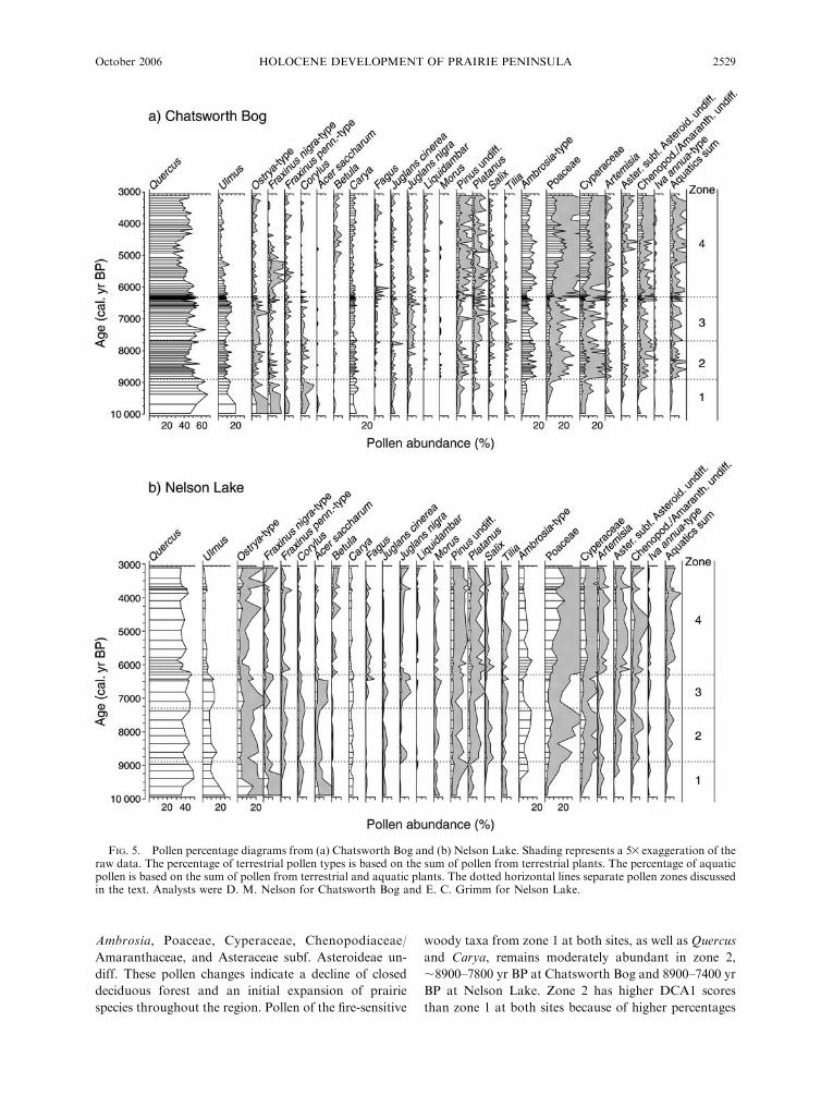
Ambrosia, Poaceae, Cyperaceae, Chenopodiaceae/
Amaranthaceae, and Asteraceae subf. Asteroideae un-
diff. These pollen changes indicate a decline of closed
deciduous forest and an initial expansion of prairie
species throughout the region. Pollen of the fire-sensitive
woody taxa from zone 1 at both sites, as well as Quercus
and Carya, remains moderately abundant in zone 2,
;8900–7800 yr BP at Chatsworth Bog and 8900–7400 yr
BP at Nelson Lake. Zone 2 has higher DCA1 scores
than zone 1 at both sites because of higher percentages
FIG. 5. Pollen percentage diagrams from (a) Chatsworth Bog and (b) Nelson Lake. Shading represents a 53 exaggeration of theraw data. The percentage of terrestrial pollen types is based on the sum of pollen from terrestrial plants. The percentage of aquaticpollen is based on the sum of pollen from terrestrial and aquatic plants. The dotted horizontal lines separate pollen zones discussedin the text. Analysts were D. M. Nelson for Chatsworth Bog and E. C. Grimm for Nelson Lake.
October 2006 2529HOLOCENE DEVELOPMENT OF PRAIRIE PENINSULA

of herbaceous pollen (Figs. 5–7). The transitions from
zone 1 to zone 2 show a trend towards DCA1 scores of
pre-European-settlement pollen assemblages from Lake
Mendota (Winkler et al. 1986) and Devils Lake (Baker
et al. 1992) in south-central Wisconsin (Fig. 6), where
the vegetation was largely open Quercus woodlands and
prairie (Curtis 1959). However, Quercus pollen was more
abundant at the Wisconsin sites than in zone 2 at
Chatsworth Bog and Nelson Lake. These data indicate a
mosaic of prairie and woodland in Illinois, somewhat
similar to that at European settlement in this region,
except that the woodland patches were richer in fire-
sensitive trees during the early portion of the middle
Holocene. The DCA1 scores of pollen zone 2 at our sites
are also similar to that of Wolsfeld Lake (Grimm 1983)
in the Big Woods of Minnesota, but the DCA2 scores
are farther from that of Wolsfeld Lake than from those
of the Wisconsin sites.
Beginning ;7700 yr BP at Chatsworth Bog and 7300
yr BP at Nelson Lake, prairie pollen types decline,
although not to pre-9000 yr BP levels, while fire-sensitive
woody taxa such as Ulmus, Ostrya, and Juglans nigra
increase (Fig. 5). Pollen of Acer saccharum increases at
Nelson Lake, but not at Chatsworth Bog. Correspond-
ing to the decline in herbaceous pollen, pollen zone 3
(7700–6300 yr BP at Chatsworth Bog and 7300–6300 yr
BP at Nelson Lake) at both sites is located between
zones 1 and 2 on DCA1 (Fig. 6). These changes in pollen
assemblages indicate a decline of prairie and an
expansion of forest.
About 6200 yr BP, woody taxa generally decline and
prairie taxa, particularly Poaceae, increase in pollen
abundance (Figs. 5–7). The DCA1 scores of zone 4
(;6200–3000 yr BP) are the highest at both sites (Fig. 6),
and they trend toward those of French Lake (Grimm
1983), near the western edge of Minnesota’s Big Woods,
Sharkey Lake (Camill et al. 2003) in oak woodland
adjacent to the Big Woods, and Clear Lake (Baker et al.
1992) in the tallgrass prairie of north-central Iowa, USA
(Figs. 1 and 6). However, Artemisia was more abundant
and Poaceae less abundant at the Minnesota and Iowa
sites. Zone 4 at neither site has DCA1 scores as high as
FIG. 6. DCA results of pollen assemblages from Chatsworth Bog (solid lines), Nelson Lake (dotted lines), and sites located intallgrass prairie or deciduous forest immediately prior to European settlement (sites shown in Fig. 1). The mean DCA score foreach zone (as in Fig. 5) is shown with one standard deviation from the mean. Abbreviations of pollen types included in the DCAare: Ac, Acer saccharum; Am, Ambrosia; Ar, Artemisia; As, Asteraceae subf. Asteroideae undiff.; Ca, Carya; Ch, Chenopodiaceae/Amaranthaceae undiff.; Co, Corylus; Fr, Fraxinus sum; Ju, Juglans sum; Pl, Platanus; Os, Ostrya-type; Po, Poaceae;Ul, Ulmus; andQu, Quercus. At Chatsworth Bog all zones are statistically different (P , 0.05) on Axis 1, but only 2 and 4 are different on Axis 2.At Nelson Lake, with the exception of zones 1 vs. 3, all zones are statistically different on Axis 1, as are zones 1 vs. 2, 1 vs. 3, 3 vs. 4,and 2 vs. 4 on Axis 2. For the same zones between Chatsworth Bog and Nelson Lake, only zone 4 is statistically different on Axis 1,and all zones are different on Axis 2. Pollen data from Kimble Pond and Sharkey Lake (Camill et al. 2003) were provided byP. Camill; pollen data from other sites were obtained from the North American Pollen Database hhttp://www.ngdc.noaa.gov/paleo/napd.htmli.
DAVID M. NELSON ET AL.2530 Ecology, Vol. 87, No. 10

the pre-European-settlement pollen assemblages from
Moon Lake (Laird et al. 1996) in eastern North Dakota,
USA (Figs. 1 and 6), where woody taxa were rare. These
data indicate that after ;6200 yr BP the eastern Prairie
Peninsula was dominated by tallgrass prairie and woody
plant communities containing primarily Quercus and
Carya.
Despite their broad similarity in temporal patterns, as
described above, differences exist between the pollen
records of Chatsworth Bog and Nelson Lake. These
differences probably reflect vegetational variation at
local scales. Pollen from fire-sensitive taxa such as
Ostrya, Acer saccharum, and Tilia were generally more
abundant at Nelson Lake than at Chatsworth Bog,
whereas pollen from more fire-tolerant taxa such as
Quercus was generally more abundant at Chatsworth
Bog (Figs. 5 and 6). A greater abundance of fire-sensitive
taxa at Nelson Lake probably resulted from the facts
that the soils are more poorly drained and that fire
breaks, such as rivers, are more abundant near this site.
After ;6200 yr BP, Cyperaceae pollen was more
abundant at Chatsworth Bog than at Nelson Lake,
which is probably related to local fen development at the
former site. This interpretation is supported by the
presence of aquatic snail taxa that live on or near
aquatic vegetation, such as Gyraulus, Helisoma, Physa,
and Valvata (Fig. 2a; Clarke 1981).
Abundance of C3 and C4 plants estimated
from charcoal d13C
Charcoal d13C data show different temporal patterns
between our two sites, suggesting local variation in the
C4 plant abundance of burned vegetation. For example,
C4 abundance declined from ;75% around 7600 yr BP
to ;40% around 6600 yr BP at Nelson Lake, but only
small fluctuations in C4 abundance occurred during this
same period at Chatsworth Bog (Fig. 7). Nonetheless,
several similarities in the two charcoal d13C records help
enhance our vegetational reconstruction. These records
reveal that C4 plants, probably C4 tallgrasses, were
continually present on the landscape no later than 9000
yr BP (Fig. 7). C4 plant abundance did not increase at
either site following the pollen-inferred increase in
prairie vegetation ;6200 yr BP. This result seems
counterintuitive given the fact that C4 grasses are
abundant in tallgrass prairies today. It also contradicts
FIG. 7. Non-arboreal pollen abundance (NAP; three-sample moving averages of raw data), composite aridity records, charcoald13C and %C4 abundance estimates, and CHAR (charcoal accumulation rates) at Chatsworth Bog and Nelson Lake. For the d13Cand %C4 graphs, the bars represent the raw data, and the curves are three-sample moving averages of the raw data. In addition tothe raw CHAR data, we use a log scale to reduce the variation of the CHAR time series.
October 2006 2531HOLOCENE DEVELOPMENT OF PRAIRIE PENINSULA

a stalagmite d13C record from northeastern Iowa which
suggests a large expansion of C4 plants after ;6000 yr
BP (Fig. 8a; Dorale et al. 1992).
The lack of a major charcoal d13C shift at our sites
;6200 yr BP probably indicates that C4 plants were
relatively abundant in burned areas before that time,
consistent with pollen evidence that prairie taxa were
present by ;9000 yr BP. Many mesic tree taxa (C3) such
as Ulmus, Ostrya, Fraxinus, and Acer saccharum, which
were abundant prior to ;6200 yr BP, are fire-sensitive.
Similar to the Big Woods region of southern Minnesota,
a buffer zone of fire-tolerant oaks may have existed
between the fire-sensitive trees and the highly flammable
prairie (Grimm 1984, Camill et al. 2003). Thus, prior to
;6200 yr BP, fires that did occur in the eastern Prairie
Peninsula were probably patchy. These fires primarily
consumed herbaceous plants, including C4 grasses,
which were likely most abundant in frequently burned
areas. Unlike charcoal d13C, stalagmite d13C depends on
the relative contributions of C3 trees, shrubs, and
herbaceous plants, as well as C4 grasses, to soil organic
matter. Therefore it is not surprising that stalagmite and
charcoal d13C records show different temporal patterns
of C4 plant abundance.
Our pollen and charcoal d13C data together suggest
that once prairie patches became established ;9000 yr
BP, they coexisted with communities dominated by
Quercus, Carya, and mesic deciduous woody species.
Such coexistence would have been facilitated by fire-
breaks and spatial separation of vegetational types with
different flammability and fire tolerance, similar to the
landscape in southern Wisconsin (Curtis 1959) and
Minnesota (Grimm 1984) prior to European settlement.
Fire reconstruction
Prairie ecosystems burn on annual to interannual time
scales (Gleason 1913, Anderson 1990). In these systems,
the high background values of charcoal accumulation
rates (CHAR), along with the relatively slow sedimen-
tation rates, make it difficult, if not impossible, to
distinguish individual fire events in lake-sediment
charcoal records. Thus CHAR in grasslands provide a
measure of changes in relative fire importance, which
reflects several controlling factors, such as fuel avail-
ability, fuel moisture, vegetational type, and/or ignition
frequency (Clark et al. 2001, Brown et al. 2005).
FIG. 8. Comparison of paleovegetational records. (a)Summary of vegetational changes at well-dated sites in thecentral and eastern Prairie Peninsula. The curves are three-sample moving averages of the raw data from each site, with theexception of Roberts Creek, for which the raw data are shownbecause of its relatively low temporal resolution. NAP standsfor non-arboreal pollen; VPDB stands for Vienna Peedee
Belemnite. Stalagmite d13C data from Coldwater Cave (Fig. 1)were obtained from the NOAA paleoclimatology web sitehftp://ftp.ncdc.noaa.gov/pub/data/paleo/speleothem/northamerica/usa/iowa/coldwater_cave.txti. (b) Percentage ofnon-arboreal pollen from well-dated lake-sediment coresspanning a northwest–southeast transect along the tallgrassprairie–forest border prior to European settlement. These sitesare represented by the stars in Fig. 1: ML, Moon Lake; WOL,West Olaf Lake; SH, Sharkey Lake; KP, Kimble Pond; CB,Chatsworth Bog; NL, Nelson Lake.
‹
DAVID M. NELSON ET AL.2532 Ecology, Vol. 87, No. 10

At Chatsworth Bog and Nelson Lake, CHAR
increased with the initial establishment of prairie taxa
after ;9000 yr BP (Fig. 7). CHAR remained overall low
to moderate at both sites prior to ;7000 yr BP, which is
consistent with the interpretation that fires were patchy
and unimportant during the early part of the middle
Holocene. Fire importance increased ;6700 yr BP at
Chatsworth Bog and 7200 yr BP at Nelson Lake, as
suggested by elevated CHAR values. CHAR remained
relatively high for the remainder of the record at Nelson
Lake, but dropped markedly ;6200 yr BP at Chats-
worth Bog. Although site-specific differences in fire
regimes (Gavin et al., in press; Hu et al., in press) may
account for this difference between our two CHAR
records, it is more likely that the CHAR decline at
Chatsworth Bog resulted from the development of the
lake into a fen at this time, which filtered runoff entering
the basin. This interpretation is supported by the fact
that, similar to CHAR, the total influx of pollen and
minerals also declined at Chatsworth Bog ;6200 yr BP
(data not shown). Thus, after ;6200 yr BP, low CHAR
values at Chatsworth Bog resulted from sedimentary
processes, whereas high CHAR values at Nelson Lake
reflected increased fire importance.
Fuel availability was probably not a limiting factor of
fire occurrence at our sites because CHAR values were
lowest prior to ;9000 yr BP, when woody species and
biomass were abundant. In the eastern Prairie Peninsula,
woody and herbaceous biomass was likely adequate for
fire occurrence throughout the early and middle
Holocene, in contrast to the northwestern Prairie
Peninsula and the Great Plains, where aridity was
greater and fuels were more limiting (e.g., Nelson et al.
2004, Brown et al. 2005). However, it is difficult to tease
apart the relative importance of the other factors
controlling fire occurrence.
DISCUSSION
This study provides the first multiproxy data set with
solid chronologies from the eastern Prairie Peninsula for
climate, vegetational, and fire reconstructions. These
data allow us to address the two alternative hypotheses
concerning the timing and causes of prairie establish-
ment in the region. They also help answer questions of
early North American ecologists concerning the devel-
opment and persistence of prairie following the last
glaciation.
Pollen-assemblage and charcoal d13C data from
Chatsworth Bog and Nelson Lake revealed that the
initial pulse of prairie development in the eastern Prairie
Peninsula was coeval with the early Holocene expansion
of prairie in Minnesota about 9000 yr BP (Fig. 8b;
Camill et al. 2003, Wright et al. 2004). The probable
causes for this prairie development were increased
temperature and decreased moisture resulting from high
summer insolation and the waning influence of the
Laurentide ice sheet (Fig. 4; Baker et al. 1992, Shuman
et al. 2002). However, this pulse of prairie development
lasted only ;1500 years. The abundance of trees,
including fire-sensitive taxa such as Ulmus, increased
after ;7700 yr BP at Chatsworth Bog and ;7300 yr BP
at Nelson Lake, and the full expansion of prairie did not
occur until ;6200 yr BP.
Despite the nearly synchronous initial increase of
prairie taxa ;9000 yr BP in Minnesota and Illinois,
major differences existed in the patterns of climatic
change and prairie development between these regions.
For example, mineral, d18O, and magnetic data from
several sites in Minnesota (Fig. 4; Camill et al. 2003,
Nelson et al. 2004) indicate that maximum aridity
occurred ;7800 yr BP, which led to the full expansion of
herbaceous taxa adapted to relatively high moisture
deficits. Following the peak aridity of the early middle
Holocene, aridity gradually decreased as summer
insolation declined (Fig. 4), which allowed woody plants
to become more abundant in Minnesota (Fig. 8b; also
see Wright et al. 2004). These data are consistent with
the suggestion by Wright (1968) that aridity gradually
declined in Minnesota during the middle Holocene, but
they contrast with the two-step expansion of prairie in
Illinois where prairie did not fully expand until after
;6200 yr BP. To the west of the tallgrass prairie at
Moon Lake, conditions were dry enough to support
herbaceous taxa throughout the Holocene (Fig. 8b),
although the driest conditions prevailed from ;9000 yr
BP to 5000 yr BP (Laird et al. 1996). Thus, considerable
spatial variability existed in climatic and vegetational
histories of the early and middle Holocene.
The pattern of prairie development in the eastern
Prairie Peninsula inferred from our new data is more
complicated than previously thought. On the basis of
pollen data from Roberts Creek and Devils Lake (Baker
et al. 1992) and speleothem isotopic data from Cold-
water Cave (Dorale et al. 1992), previous studies argued
that prairie development did not occur until after ;6000
years ago. Our data, on the other hand, revealed an
early pulse of prairie development that was interrupted
by mesic conditions until the major expansion of prairie
;6200 yr BP. Nonetheless, the Roberts Creek data do
show a small increase in non-arboreal pollen about 8500
yr BP (Fig. 8a), but the samples are widely spaced in
time and a possible early pulse of prairie development
may have been missed. In addition, Roberts Creek is in
the hilly driftless area of northeastern Iowa, which was
more forested than northeastern and central Illinois at
the time of European settlement (Fig. 1). Similarly, a
small increase in non-arboreal pollen occurred ;9000 yr
BP at Devils Lake (Fig. 8a), even though this site was
always within the deciduous forest. Webb et al. (1983)
produced a series of isopoll maps for ‘‘prairie forbs’’ that
showed the two-phase development of prairie in the
eastern Prairie Peninsula. These maps were anchored in
Illinois by King’s (1981) pollen data from Chatsworth
Bog, and our study supports this interpretation of early
Holocene prairie development.
October 2006 2533HOLOCENE DEVELOPMENT OF PRAIRIE PENINSULA

In addition to aridity, fire may have exerted an
important control on the establishment and mainte-
nance of prairie communities in the eastern Prairie
Peninsula. Our CHAR profiles from Chatsworth Bog
and Nelson Lake suggest that fire activity became
elevated ;500�1000 years prior to the full establishment
of prairie, ;6200 yr BP. Because this change in fire
importance did not coincide with any major shifts in our
aridity and vegetational records, it is possible that
increased fire ignitions resulted in more burns, contri-
buting to prairie expansion in the eastern Prairie
Peninsula. Both Native Americans and lightning might
have been important ignition sources, but evidence of
ignitions beyond the historical record is conjectural.
Fires may have also been important for the maintenance
of prairies. For example, a marked increase in effective
moisture occurred ;5800–5400 yr BP, as evidenced by
changes in all proxy indicators at both of our sites (Fig.
3). This change, however, did not cause woody taxa to
expand and prairie taxa to decline, probably because
fires remained important. These interpretations lend
support to the suggestion by early 20th century
ecologists that frequent fires prevented forest commun-
ities from dominating the region (Gleason 1912, 1913,
Cowles 1928, Transeau 1935).
Our results have implications for understanding
future climatic change and ecological response in the
eastern axis of the tallgrass Prairie Peninsula. Spatial
variations in early and middle Holocene climatic
conditions across the Prairie Peninsula are consistent
with instrumental records. For example, whereas the
1930s drought devastated native and agricultural eco-
systems throughout most of the midcontinent, the 1950s
and 1988 droughts were primarily restricted to the
south-central and northern Great Plains, respectively
(Woodhouse and Overpeck 1998). Thus, spatial varia-
bility in climatic change appears to be a common feature
of the North American midcontinent on annual to
millennial scales, and it is therefore prudent to anticipate
a wide range of complex sub-biome ecosystem responses
to future climatic change. Furthermore, our results
suggest that fire regimes interacted with climatic change
to exert dominant controls over vegetational dynamics
in the eastern Prairie Peninsula. However, anthropo-
genic domination will undoubtedly surpass the ecolog-
ical role of fires in any future change of the regional
landscape.
ACKNOWLEDGMENTS
P. Mueller, J. King, M. Colburn, P. Henne, R. Graham, R.Warren, J. Fergeson, and A. Fuhrmann provided fieldassistance; R. Van Voorhis assisted with pollen preparation;and B. Clegg identified Chatsworth Bog snails. We thank B.Clegg, M. Farmer, P. Henne, J. Tian, A. Henderson, G. Clarke,K. Wolfe, and two anonymous reviewers for helpful commentson earlier versions of the manuscript. We also thank P. Camillfor providing the Kimble Pond and Sharkey Lake pollen dataand contributors to the North American Pollen Databasehhttp://www.ngdc.noaa.gov/paleo/napd.htmli and the speleo-them data archive. This research was funded by NSF EAR 99-
05327 to Hu, a Packard Fellowship in Science and Engineeringto Hu, and support to Nelson by Francis M. and Harlie M.Clark Research Support Grants and the Philip W. SmithMemorial Fund. Funding for the Nelson Lake pollen studiesand 14C dating was received from the Kane County ForestPreserve District and the former Illinois Department of Energyand Natural Resources. We thank Jon Duerr, former ExecutiveDirector of the Kane County Forest Preserve Commission, forfacilitating our work at Nelson Lake.
LITERATURE CITED
Allen, C. D., and D. D. Breshears. 1998. Drought-induced shiftof a forest-woodland ecotone: rapid landscape response toclimate variation. Proceedings of the National Academy ofSciences (USA) 95:14839–14842.
Anderson, R. C. 1970. Prairies in the prairie state. Transactionsof the Illinois State Academy of Science 63:214–221.
Anderson, R. C. 1990. The historic role of fire in the NorthAmerican Grassland. Pages 8–17 in S. L. Collins and L. L.Wallace, editors. Fire in North American tallgrass prairies.University of Oklahoma Press, Norman, Oklahoma, USA.
Baker, R. G., L. J. Maher, C. A. Chumbley, and K. L. VanZant. 1992. Patterns of Holocene environmental change inthe midwestern United States. Quaternary Research 37:379–389.
Benninghoff, W. S. 1962. Calculation of pollen and sporedensity in sediments by addition of exotic pollen in knownquantities. Pollen et Spores 4:332–333.
Boggess, W. R., and J. W. Geis. 1967. Composition of anupland, streamside forest in Piatt County, Illinois. TheAmerican Midland Naturalist 78:89–97.
Booth, R. K., and S. T. Jackson. 2003. A high-resolution recordof late-Holocene moisture variability from a Michigan raisedbog, USA. Holocene 13:863–876.
Brown, K. J., J. S. Clark, E. C. Grimm, J. J. Donovan, P. G.Mueller, B. C. S. Hansen, and I. Stefanova. 2005. Fire cyclesin North American interior grasslands and their relation toprairie drought. Proceedings of the National Academy ofSciences (USA) 102:8865–8870.
Camill, P., C. E. Umbanhowar, R. Teed, C. E. Geiss, J.Aldinger, L. Dvorak, J. Kenning, J. Limmer, and K. Walkup.2003. Late-glacial and Holocene climatic effects on fire andvegetation dynamics at the prairie-forest ecotone in south-central Minnesota. Journal of Ecology 91:822–836.
Cerling, T. E. 1999. Paleorecords of C4 plants and ecosystems.Pages 445–469 in R. F. Sage and R. K. Monson, editors. C4
plant biology. Academic Press, San Diego, California, USA.Changnon, S. A., K. E. Kunkel, and D. Winstanley. 2002.Climate factors that caused the unique tall grass prairie in thecentral United States. Physical Geography 23:259–280.
Clark, J. S., E. C. Grimm, J. J. Donovan, S. C. Fritz, D. R.Engstrom, and J. E. Almendinger. 2002. Drought cycles andlandscape responses to past aridity on prairies of thenorthern Great Plains, USA. Ecology 83:595–601.
Clark, J. S., E. C. Grimm, J. Lynch, and P. G. Mueller. 2001.Effects of Holocene climate change on the C4 grassland/woodland boundary in the Northern Plains, USA. Ecology82:620–636.
Clarke, A. H. 1981. The freshwater molluscs of Canada.National museums of Canada, Ottawa, Canada.
Cowles, H. C. 1928. Persistence of prairies. Ecology 9:380–382.Curry, B. B. 2003. Linking ostracodes to climate and landscape.Pages 223–246 in L. E. Park and A. J. Smith, editors.Bridging the gap: trends in the ostracode biological andgeological sciences. The Paleontological Society Papers,Lancaster, Pennsylvania, USA.
Curtis, J. T. 1959. Vegetation of Wisconsin. University ofWisconsin Press, Madison, Wisconsin, USA.
Delorme, L. D. 1970a. Freshwater ostracodes of Canada. PartII. Subfamily Cypridopsinae and Herpetocypridinae, and
DAVID M. NELSON ET AL.2534 Ecology, Vol. 87, No. 10

family Cyclocyprididae. Canadian Journal of Zoology 48:253–266.
Delorme, L. D. 1970b. Freshwater ostracodes of Canada. PartIII. Family Candonidae. Canadian Journal of Zoology 48:1099–1127.
Delorme, L. D. 1971. Freshwater ostracodes of Canada. Part V.Families Limnocytheridae, Loxoconchidae. Canadian Jour-nal of Zoology 49:43–64.
Deniger, J. A. 2004. Soil survey of Kane County, Illinois.USDA, Natural Resources Conservation District, Washing-ton, D.C., USA.
Dorale, J. A., L. A. Gonzalez, M. K. Reagan, D. A. Pickett, M.T. Murrell, and R. G. Baker. 1992. A high-resolution recordof Holocene climate change in speleothem calcite from ColdWater Cave, northeast Iowa. Science 258:1626–1630.
Fægri, K., J. Iverson, P. E. Kaland, and K. Krzywinski. 1989.Textbook of pollen analysis. Wiley, New York, USA.
Flora of North America Editorial Committee. 1993. Flora ofNorth America North of Mexico. Oxford University Press,New York, USA.
Gavin, D. G., F. S. Hu, K. Lertzman, and P. Corbett. In press.Weak climatic control of forest fire history during the lateHolocene in southeastern British Columbia. Ecology.
Gleason, H. A. 1909. Some unsolved problems of the prairies.Bulletin of the Torrey Botanical Club 36:265–271.
Gleason, H. A. 1912. An isolated prairie grove and itsphytogeographical significance. Botanical Gazette 53:38–49.
Gleason, H. A. 1913. The relation of forest distribution andprairie fires in the middle west. Torreya 13:173–181.
Gleason, H. A. 1922. The vegetational history of the MiddleWest. Annals of the Association of American Geographers12:39–86.
Grimm, E. C. 1983. Chronology and dynamics of vegetationchange in the prairie–woodland region of southern Minne-sota, USA. New Phytologist 93:311–350.
Grimm, E. C. 1984. Fire and other factors controlling the BigWoods vegetation of Minnesota in the mid-19th century.Ecological Monographs 54:291–311.
Grimm, E. C. 1987. CONISS: a FORTRAN 77 program forstratigraphically constrained cluster analysis by the methodof increment sum of squares. Computers and Geosciences 13:13–35.
Grimm, E. C. 2001. Trends and paleoecological problems in thevegetation and climate history of the Northern Great Plains,U.S.A. Biology and Environment: Proceedings of the RoyalIrish Academy 101B:47–64.
Grimm, E. C., and G. L. Jacobson. 2004. Late-Quaternaryvegetation history of the eastern United States. Pages 381–402 in A. R. Gillespie, S. C. Porter, and B. F. Atwater,editors. The Quaternary period in the United States.Developments in Quaternary science. Elsevier, Amsterdam,the Netherlands.
Hammer, Ø., D. A. T. Harper, and P. D. Ryan. 2001. PAST:paleontological statistics software package for education anddata analysis. Palaeontologia Electronica 4:9.
Heegaard, E., H. J. B. Birks, and R. J. Telford. 2005.Relationships between calibrated ages and depth in strati-graphical sequences: an estimation procedure by mixed-effectregression. Holocene 15:612–618.
Higgins, S. K. 1996. Soil survey of Livingston County, Illinois.USDA, Soil Conservation Service, Washington, D.C., USA.
Hu, F. S., L. B. Brubaker, D. G. Gavin, P. E. Higuera, J. A.Lynch, T. S. Rupp, and W. Tinner. In press.How climate andvegetation influence the fire regime of the Alaskan boreal-forest biome: the Holocene perspective. Mitigation andAdaptation Strategies for Global Change.
Hughes, R. E., D. M. Moore, and H. D. Glass. 1994.Qualitative and quantitative analysis of clay minerals insoils. Pages 330–359 in J. E. Amonette and L. W. Zelazny,editors. Quantitative methods in soil mineralogy. Soil ScienceSociety of America, Madison, Wisconsin, USA.
IPCC (Intergovernmental Panel on Climate Change). 2001.Climate change 2001: the scientific basis. Cambridge Uni-versity Press, Cambridge, UK.
Kelts, K., and K. J. Hsu. 1978. Freshwater carbonatesedimentation. Pages 295–323 in A. Lerman, editor. Lakes:chemistry, geology, physics. Springer-Verlag, New York,New York, USA.
Kilburn, P. D. 1959. The forest–prairie ecotone in northeasternIllinois. The American Midland Naturalist 62:206–217.
King, J. E. 1981. Late Quaternary vegetational history ofIllinois. Ecological Monographs 51:43–62.
Kitchell, J. A., and D. L. Clark. 1979. Distribution, ecology,and taxonomy of recent freshwater ostracoda of LakeMendota, Wisconsin. University of Wisconsin, Madison.
Krammer, K., and H. Lange-Bertalot. 1991. Bacillariophyceae.Gustav Fischer Verlag, Jena, Germany.
Kucera, C. L. 1992. Tall-grass prairie. Pages 227–268 in R. T.Coupland, editor. Ecosystems of the world 8A. Naturalgrasslands: introduction and western hemisphere. Elsevier,Amsterdam, the Netherlands.
Kuchler, A. W. 1964. Manual to accompany the map, potentialnatural vegetation of the conterminous United States.American Geographical Society Special Publication Number36, New York, New York, USA.
Laird, K. R., S. C. Fritz, E. C. Grimm, and P. G. Mueller. 1996.Century-scale paleoclimatic reconstruction fromMoon Lake,a closed-basin lake in the northern Great Plains. Limnologyand Oceanography 41:890–902.
Lange-Bertalot, H. 1993. 85 new taxa and much more than 100taxonomic clarifications supplementary to Wasserflora vonMitteleuropa. In H. Lange-Bertalot, editor. Bibliothecadiatomologica. Band 27, Cramer, Berlin, Germany.
McAndrews, J. H. 1966. Postglacial history of prairie,savannah, and forest in northwestern Minnesota. TorreyBotanical Club Memoir 22:1–72.
Moore, D. M., and R. C. Reynolds, Jr. 1997. X-Ray diffractionand the identification and analysis of clay minerals. Secondedition. Oxford University Press, New York, New York,USA.
Nelson, D. M., F. S. Hu, J. Tian, I. Stefanova, and T. A.Brown. 2004. Response of C3 and C4 plants to middle-Holocene climatic variation near the prairie–forest ecotone ofMinnesota. Proceedings of the National Academy of Sciences(USA) 101:562–567.
Overpeck, J., et al. 1997. Arctic environmental change of thelast four centuries. Science 278:1251–1256.
Patrick, R., and C. W. Reimer. 1975. The diatoms of the UnitedStates exclusive of Alaska and Hawaii. Volume 2, part 1.Monograph 13. The Academy of Natural Sciences ofPhiladelphia, Philadelphia, Pennsylvania, USA.
Rodgers, C. S., and R. C. Anderson. 1979. Presettlementvegetation of two Prairie Peninsula counties. BotanicalGazette 140:232–240.
Shuman, B., P. Bartlein, N. Logar, P. Newby, and T. Webb III.2002. Parallel climate and vegetation responses to the earlyHolocene collapse of the Laurentide Ice Sheet. QuaternaryScience Reviews 21:1793–1805.
Transeau, E. N. 1935. The Prairie Peninsula. Ecology 16:423–437.
Webb, T., III, E. J. Cushing, and H. E. Wright. 1983. Holocenechanges in the vegetation of the Midwest. Pages 142–165 inH. E. Wright, editor. Late-Quaternary environments of theUnited States. University of Minnesota Press, Minneapolis,Minnesota, USA.
Winkler, M. G., A. M. Swain, and J. E. Kutzbach. 1986.Middle Holocene dry period in the northern midwesternUnited States–lake levels and pollen stratigraphy. Quater-nary Research 25:235–250.
Wolin, J. A., and H. C. Duthie. 1999. Diatoms as indicators ofwater level change in freshwater lakes. In E. F. Stoermer andJ. P. Smol, editors. The diatoms: applications for the
October 2006 2535HOLOCENE DEVELOPMENT OF PRAIRIE PENINSULA

environmental and earth sciences. Cambridge University
Press, Cambridge, UK.
Woodhouse, C. A., and J. T. Overpeck. 1998. 2000 years of
drought variability in the central United States. Bulletin of
the American Meteorological Society 79:2693–2714.
Wright, H. E. J. 1968. History of the Prairie Peninsula. Pages
78–88 in R. Bergstrom, editor. Quaternary of Illinois. Special
Publication of the University of Illinois College of Agricul-
ture 14.
Wright, H. E. 1991. Coring tips. Journal of Paleolimnology 6:37–49.
Wright, H. E., I. Stefanova, J. Tian, T. A. Brown, and F. S. Hu.2004. A chronological framework for the Holocene vegeta-tional history of central Minnesota: the Steel Lake pollenrecord. Quaternary Science Reviews 23:611–626.
Wright, H. E., T. C. Winter, and H. L. Patten. 1963. Twopollen diagrams from southeastern Minnesota: problems inthe regional late glacial and postglacial vegetational history.Geological Society of America Bulletin 74:1371–1396.
APPENDIX
A table of 14C dates from Chatsworth Bog and Nelson Lake (Ecological Archives E087-152-A1).
DAVID M. NELSON ET AL.2536 Ecology, Vol. 87, No. 10