Embed Size (px)
DESCRIPTION
The Indiae Orientalis Collection is rich in maps of India and other regions of Asia, but also features fascinating examples of cartographic achievements ranging around the world and across five centuries, some extraordinarily rare. It represents the lifelong quest of an American with a career in anthropology and journalism who lived in India researching its culture and society. Beginning in the early 1970s, when he was working on a doctorate at the School of Oriental and African Studies, University of London, he discovered the availability of early maps of regions he had studied. Over the next four decades he expanded his collection, scouring antiquarian map shops and flea markets in numerous countries where he worked and travelled. He reveled in the ability to hold the actual maps used by travelers, merchants, and explorers hundreds of years ago, revealing their unfolding knowledge of the world.
Citation preview

`
Harlan J. Berk, Ltd.
The Indiae Orientalis Collection
2015
Harlan J. Berk, Ltd.Chicago’s Premier Dealer in Antique Maps
Tel: (312) 609-0016 31 N. Clark Street • Chicago, Illinois 60602 Fax: (312) 609-1305 www.hjbltd.com Email: [email protected]
Antique Map ExpertsSammy Berk
Imaging and cataloging - Sammy Berk & Theresa CanerLayout - Aaron Berk
The Indiae Orientalis Collection
The Indiae Orientalis Collection is rich in maps of India and other regions of Asia, but also features fascinating examples of cartographic achievements ranging around the world and across five centuries, some extraordinarily rare. It represents the lifelong quest of an American with a career in anthropology and journalism who lived in India researching its culture and society. Beginning in the early 1970s, when he was working on a doctorate at the School of Oriental and African Studies, University of London, he discovered the availability of early maps of regions he had studied. Over the next four decades he expanded his collection, scouring antiquarian map shops and flea markets in numerous countries where he worked and travelled. He reveled in the ability to hold the actual maps used by travelers, merchants, and explorers hundreds of years ago, revealing their unfolding knowledge of the world.
A few highlights from this collection include: • 12)StripMapofRhineRiverfromColognetoMainz1852 • 38)VeryRareHolyLandPictorialMapfrom“TheGenevaBible”1599 • 50)LargeSixSheetWallMapofIndiadetailingBritishColonization1804 • 83)TabulaModernaIndiaebyMartinWaldseemüller1513 • 84)Linschoten’sMapofSouthernAsiaandtheIndianOcean1596
• 93)RareMapofChinaandKoreaCompiledfromJesuitSurveys1734 •97)CarteduRoyaumedeSiam1686

3
North America, Caribbean & Central America
1) Partie Orientale de la Nouvelle France ou du Canada avec l’Isle de Terre-Neuve et de Nouvelle Escosse Acadie et Nouv. Angleterre avec Fleuve de St. LaurenceBy: Tobias Conrad LotterDate: 1756 (published) Augsburg Dimensions: 22.5 x 19.3 inches (57 x 49 cm)A fantastic decorative map of Northeastern Canada, including Nova Scotia, Labrador and Newfoundland shown with an stretched format that distorts the true shape of the land. Excellent detail is given along the coasts and inland river systems that include hundreds of place names, both Indian and European. An elaborate pictorial cartouche includes mariners, fishermen, hunters, Neptune, Mercury, a geographer with calipers in one hand and scales of justice in the other, an Indian in feather headdress, and a European trader. In the lower right corner is a scene of 7 European vessels fishing on the Grand Banks (Les Bancs d’Accadie).Condition: A couple of repaired tears around the lower left margin and a long separation along the centerfold are reinforced on the verso.
$1,000
4
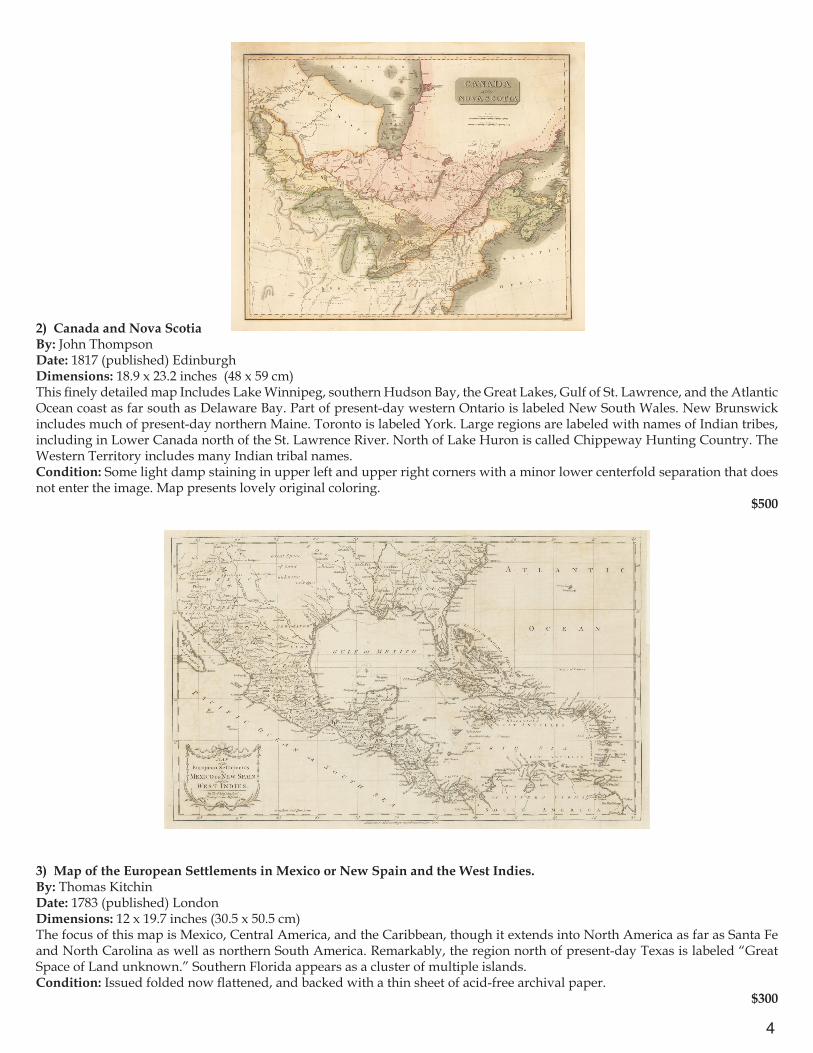
2) Canada and Nova ScotiaBy: John Thompson Date: 1817 (published) EdinburghDimensions: 18.9 x 23.2 inches (48 x 59 cm)This finely detailed map Includes Lake Winnipeg, southern Hudson Bay, the Great Lakes, Gulf of St. Lawrence, and the Atlantic Ocean coast as far south as Delaware Bay. Part of present-day western Ontario is labeled New South Wales. New Brunswick includes much of present-day northern Maine. Toronto is labeled York. Large regions are labeled with names of Indian tribes, including in Lower Canada north of the St. Lawrence River. North of Lake Huron is called Chippeway Hunting Country. The Western Territory includes many Indian tribal names.Condition: Some light damp staining in upper left and upper right corners with a minor lower centerfold separation that does not enter the image. Map presents lovely original coloring.
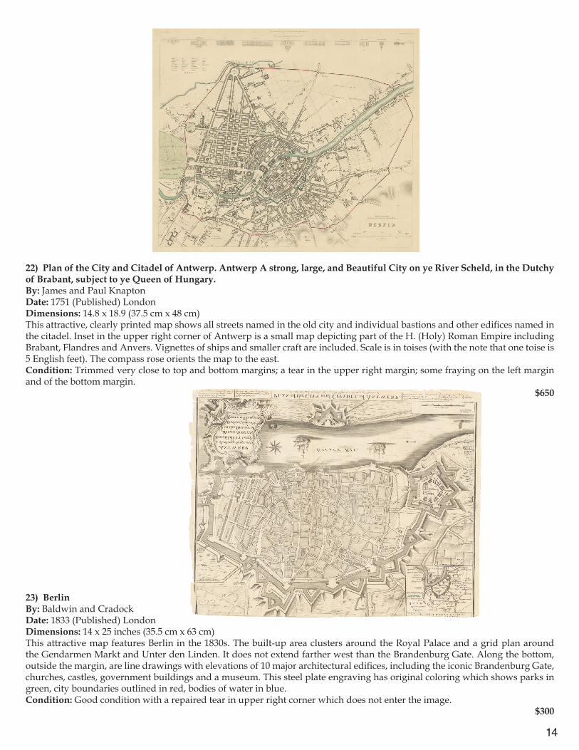
$500
3) Map of the European Settlements in Mexico or New Spain and the West Indies.By: Thomas KitchinDate: 1783 (published) LondonDimensions: 12 x 19.7 inches (30.5 x 50.5 cm)The focus of this map is Mexico, Central America, and the Caribbean, though it extends into North America as far as Santa Fe and North Carolina as well as northern South America. Remarkably, the region north of present-day Texas is labeled “Great Space of Land unknown.” Southern Florida appears as a cluster of multiple islands.Condition: Issued folded now flattened, and backed with a thin sheet of acid-free archival paper.
$300
5
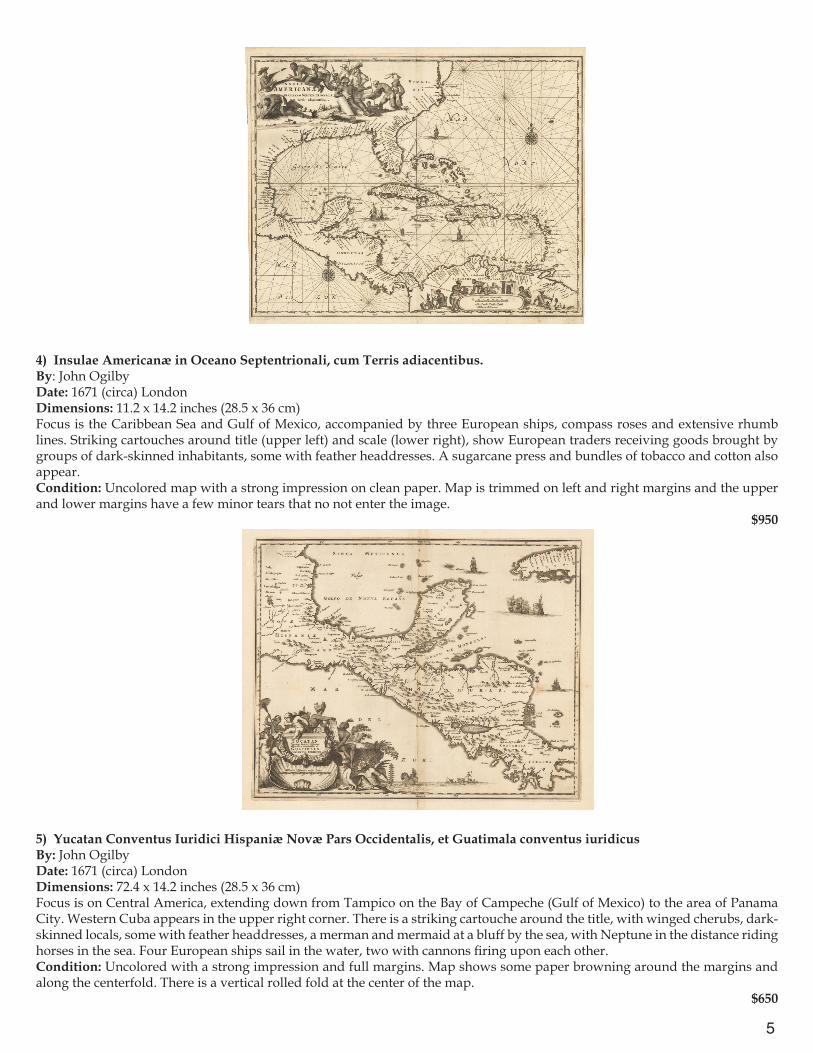
4) Insulae Americanæ in Oceano Septentrionali, cum Terris adiacentibus. By: John OgilbyDate: 1671 (circa) LondonDimensions: 11.2 x 14.2 inches (28.5 x 36 cm)Focus is the Caribbean Sea and Gulf of Mexico, accompanied by three European ships, compass roses and extensive rhumb lines. Striking cartouches around title (upper left) and scale (lower right), show European traders receiving goods brought by groups of dark-skinned inhabitants, some with feather headdresses. A sugarcane press and bundles of tobacco and cotton also appear. Condition: Uncolored map with a strong impression on clean paper. Map is trimmed on left and right margins and the upper and lower margins have a few minor tears that no not enter the image.
$950
5) Yucatan Conventus Iuridici Hispaniæ Novæ Pars Occidentalis, et Guatimala conventus iuridicusBy: John OgilbyDate: 1671 (circa) LondonDimensions: 72.4 x 14.2 inches (28.5 x 36 cm)Focus is on Central America, extending down from Tampico on the Bay of Campeche (Gulf of Mexico) to the area of Panama City. Western Cuba appears in the upper right corner. There is a striking cartouche around the title, with winged cherubs, dark-skinned locals, some with feather headdresses, a merman and mermaid at a bluff by the sea, with Neptune in the distance riding horses in the sea. Four European ships sail in the water, two with cannons firing upon each other.Condition: Uncolored with a strong impression and full margins. Map shows some paper browning around the margins and along the centerfold. There is a vertical rolled fold at the center of the map.
$650
6
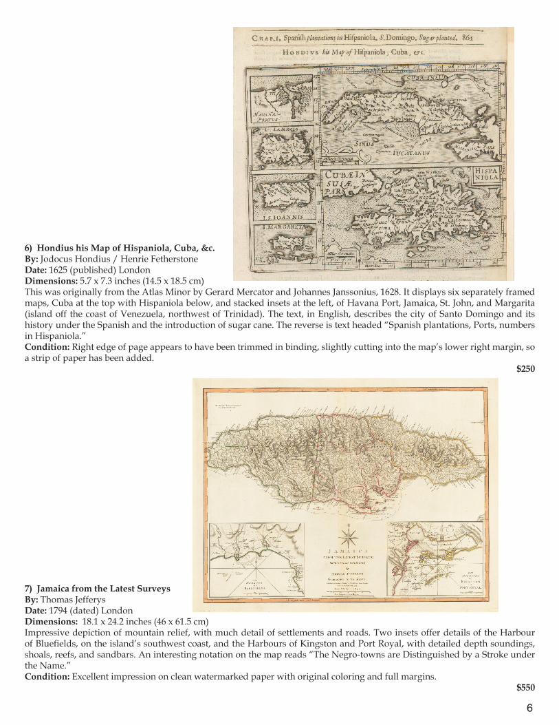
6) Hondius his Map of Hispaniola, Cuba, &c.By: Jodocus Hondius / Henrie FetherstoneDate: 1625 (published) LondonDimensions: 5.7 x 7.3 inches (14.5 x 18.5 cm)This was originally from the Atlas Minor by Gerard Mercator and Johannes Janssonius, 1628. It displays six separately framed maps, Cuba at the top with Hispaniola below, and stacked insets at the left, of Havana Port, Jamaica, St. John, and Margarita (island off the coast of Venezuela, northwest of Trinidad). The text, in English, describes the city of Santo Domingo and its history under the Spanish and the introduction of sugar cane. The reverse is text headed “Spanish plantations, Ports, numbers in Hispaniola.”Condition: Right edge of page appears to have been trimmed in binding, slightly cutting into the map’s lower right margin, so a strip of paper has been added.
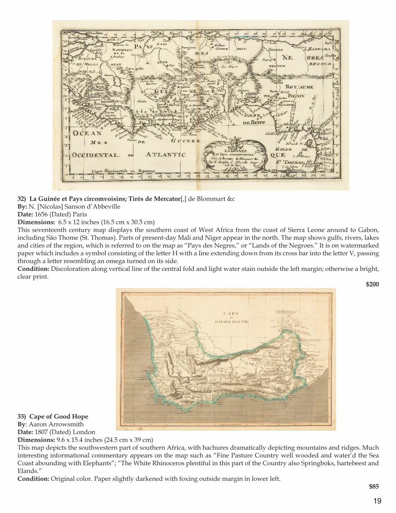
$250
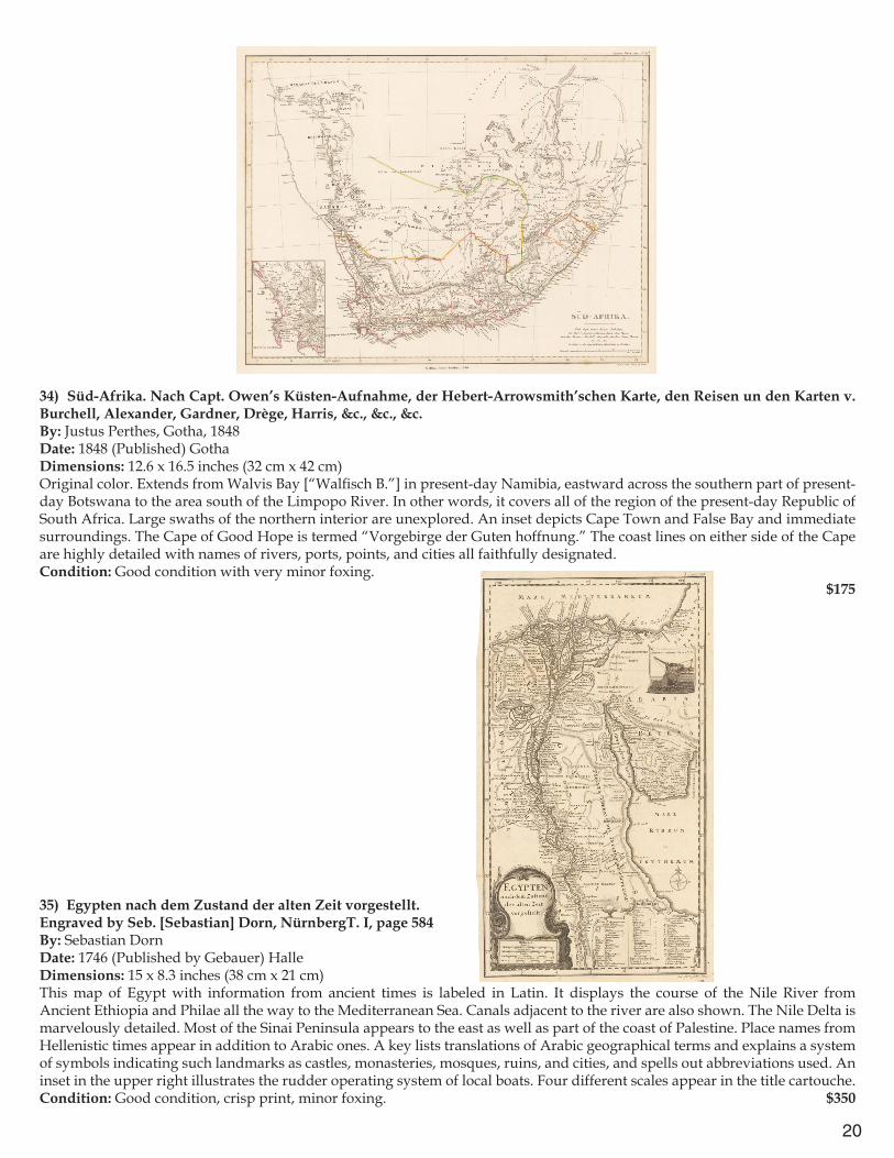
7) Jamaica from the Latest SurveysBy: Thomas JefferysDate: 1794 (dated) LondonDimensions: 18.1 x 24.2 inches (46 x 61.5 cm)Impressive depiction of mountain relief, with much detail of settlements and roads. Two insets offer details of the Harbour of Bluefields, on the island’s southwest coast, and the Harbours of Kingston and Port Royal, with detailed depth soundings, shoals, reefs, and sandbars. An interesting notation on the map reads “The Negro-towns are Distinguished by a Stroke under the Name.” Condition: Excellent impression on clean watermarked paper with original coloring and full margins.
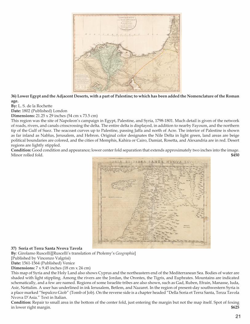
$550
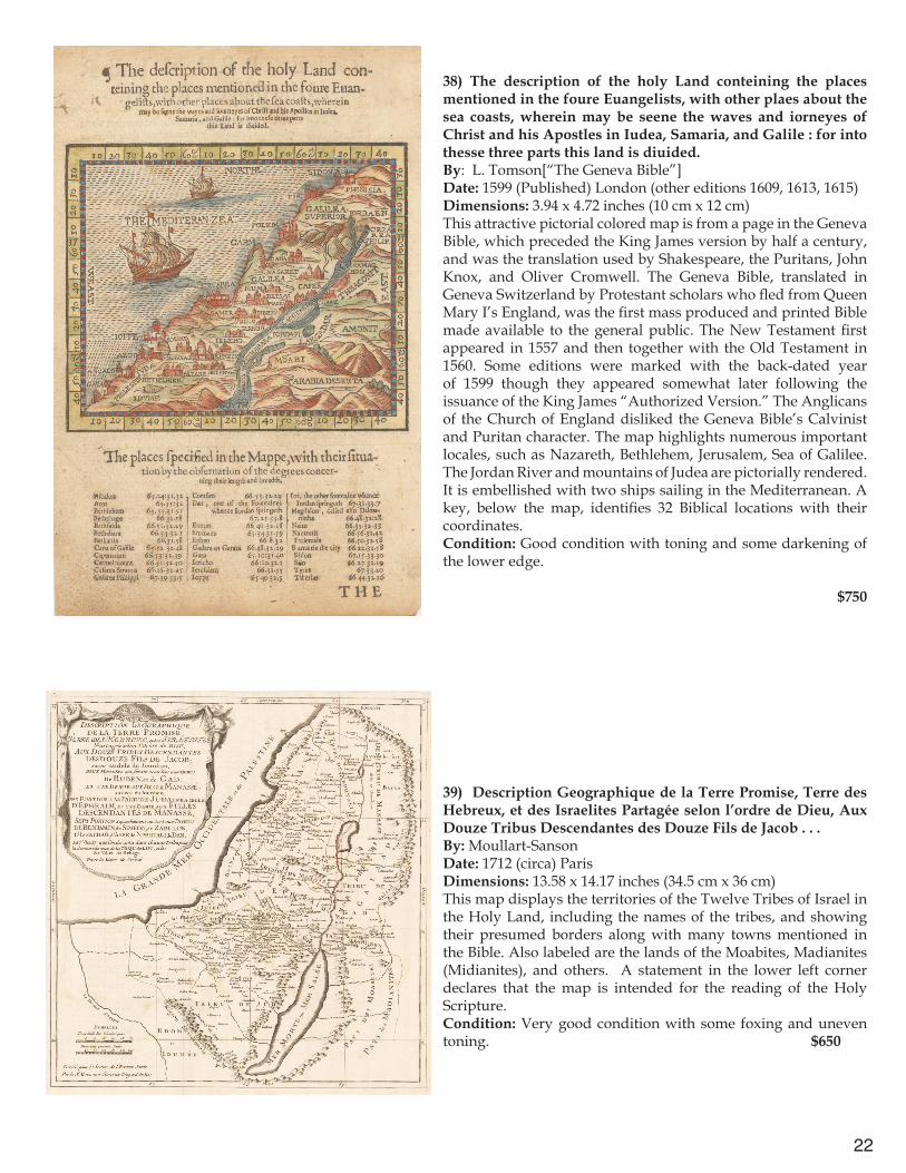
7
Europe
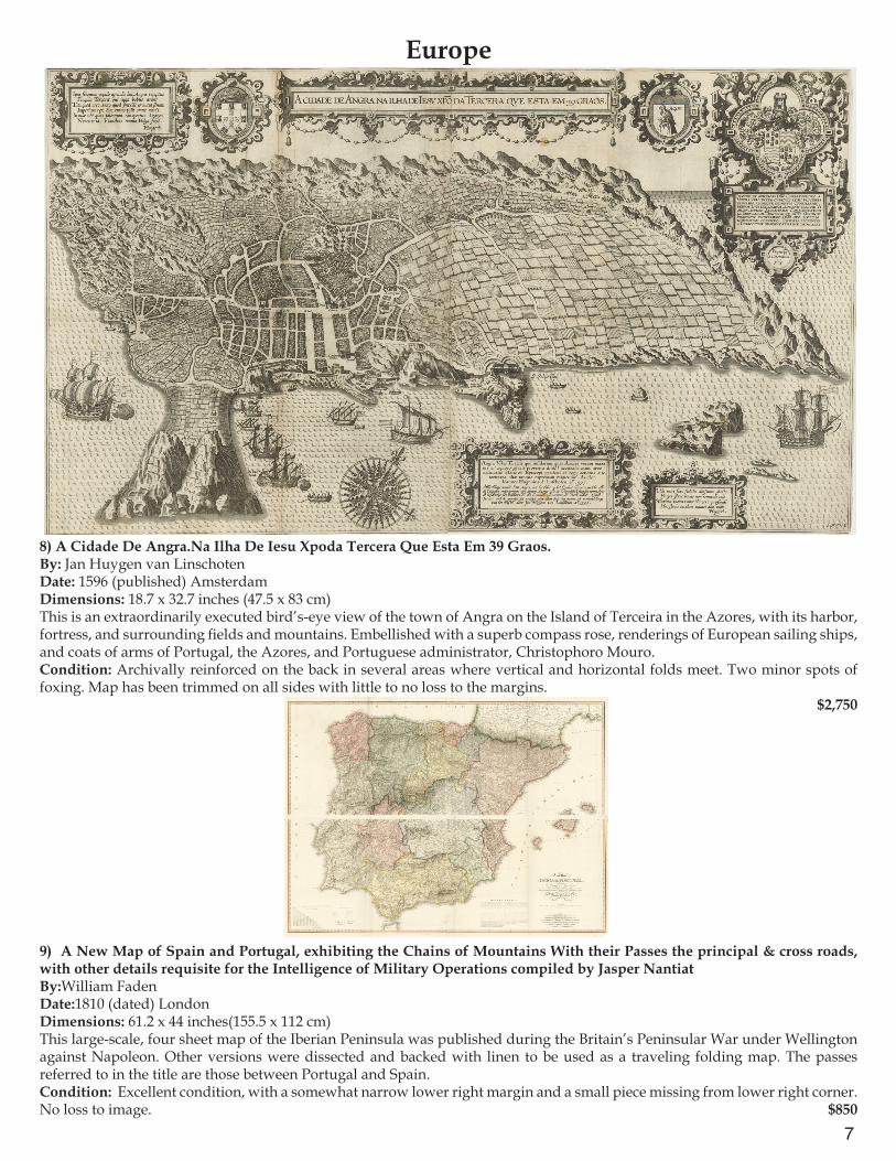
8) A Cidade De Angra.Na Ilha De Iesu Xpoda Tercera Que Esta Em 39 Graos.By: Jan Huygen van LinschotenDate: 1596 (published) AmsterdamDimensions: 18.7 x 32.7 inches (47.5 x 83 cm)This is an extraordinarily executed bird’s-eye view of the town of Angra on the Island of Terceira in the Azores, with its harbor, fortress, and surrounding fields and mountains. Embellished with a superb compass rose, renderings of European sailing ships, and coats of arms of Portugal, the Azores, and Portuguese administrator, Christophoro Mouro.Condition: Archivally reinforced on the back in several areas where vertical and horizontal folds meet. Two minor spots of foxing. Map has been trimmed on all sides with little to no loss to the margins.
$2,750
9) A New Map of Spain and Portugal, exhibiting the Chains of Mountains With their Passes the principal & cross roads, with other details requisite for the Intelligence of Military Operations compiled by Jasper NantiatBy:William FadenDate:1810 (dated) LondonDimensions: 61.2 x 44 inches(155.5 x 112 cm)This large-scale, four sheet map of the Iberian Peninsula was published during the Britain’s Peninsular War under Wellington against Napoleon. Other versions were dissected and backed with linen to be used as a traveling folding map. The passes referred to in the title are those between Portugal and Spain.Condition: Excellent condition, with a somewhat narrow lower right margin and a small piece missing from lower right corner. No loss to image. $850
8
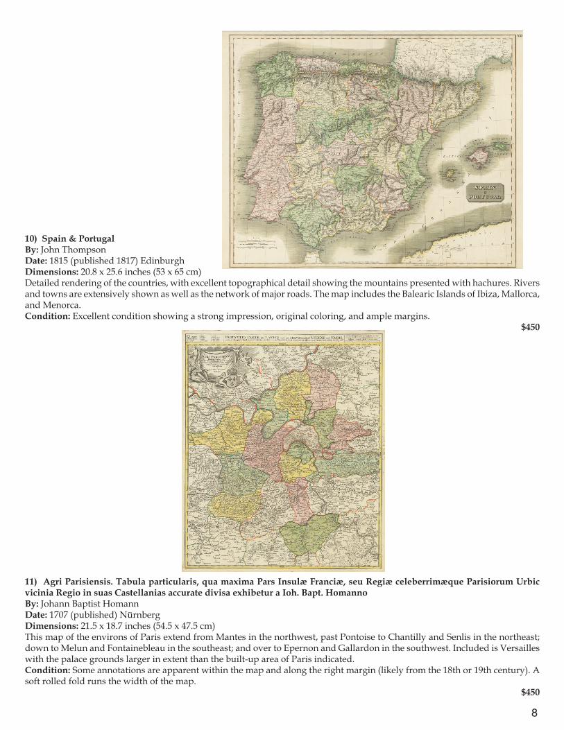
10) Spain & PortugalBy: John ThompsonDate: 1815 (published 1817) EdinburghDimensions: 20.8 x 25.6 inches (53 x 65 cm)Detailed rendering of the countries, with excellent topographical detail showing the mountains presented with hachures. Rivers and towns are extensively shown as well as the network of major roads. The map includes the Balearic Islands of Ibiza, Mallorca, and Menorca.Condition: Excellent condition showing a strong impression, original coloring, and ample margins.
$450
11) Agri Parisiensis. Tabula particularis, qua maxima Pars Insulæ Franciæ, seu Regiæ celeberrimæque Parisiorum Urbic vicinia Regio in suas Castellanias accurate divisa exhibetur a Ioh. Bapt. HomannoBy: Johann Baptist HomannDate: 1707 (published) NürnbergDimensions: 21.5 x 18.7 inches (54.5 x 47.5 cm)This map of the environs of Paris extend from Mantes in the northwest, past Pontoise to Chantilly and Senlis in the northeast; down to Melun and Fontainebleau in the southeast; and over to Epernon and Gallardon in the southwest. Included is Versailles with the palace grounds larger in extent than the built-up area of Paris indicated.Condition: Some annotations are apparent within the map and along the right margin (likely from the 18th or 19th century). A soft rolled fold runs the width of the map.
$450
9
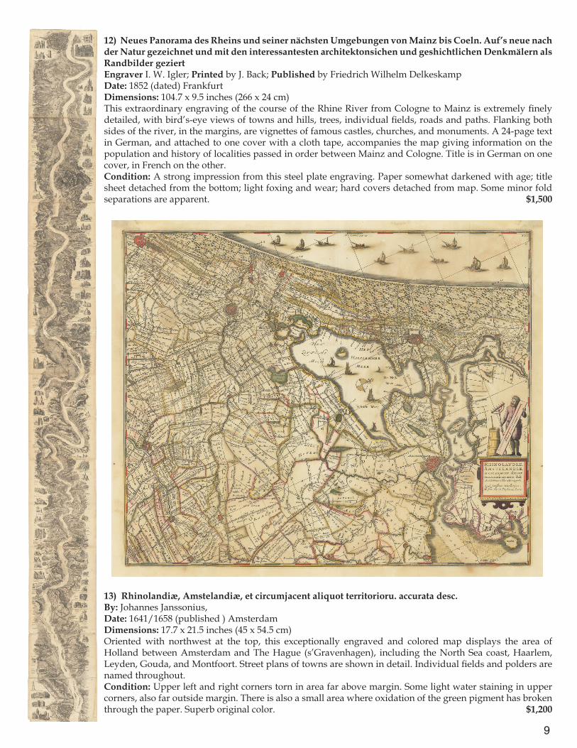
12) Neues Panorama des Rheins und seiner nächsten Umgebungen von Mainz bis Coeln. Auf’s neue nach der Natur gezeichnet und mit den interessantesten architektonsichen und geshichtlichen Denkmälern als Randbilder geziertEngraver I. W. Igler; Printed by J. Back; Published by Friedrich Wilhelm DelkeskampDate: 1852 (dated) FrankfurtDimensions: 104.7 x 9.5 inches (266 x 24 cm)This extraordinary engraving of the course of the Rhine River from Cologne to Mainz is extremely finely detailed, with bird’s-eye views of towns and hills, trees, individual fields, roads and paths. Flanking both sides of the river, in the margins, are vignettes of famous castles, churches, and monuments. A 24-page text in German, and attached to one cover with a cloth tape, accompanies the map giving information on the population and history of localities passed in order between Mainz and Cologne. Title is in German on one cover, in French on the other.Condition: A strong impression from this steel plate engraving. Paper somewhat darkened with age; title sheet detached from the bottom; light foxing and wear; hard covers detached from map. Some minor fold separations are apparent. $1,500
13) Rhinolandiæ, Amstelandiæ, et circumjacent aliquot territorioru. accurata desc.By: Johannes Janssonius, Date: 1641/1658 (published ) AmsterdamDimensions: 17.7 x 21.5 inches (45 x 54.5 cm)Oriented with northwest at the top, this exceptionally engraved and colored map displays the area of Holland between Amsterdam and The Hague (s’Gravenhagen), including the North Sea coast, Haarlem, Leyden, Gouda, and Montfoort. Street plans of towns are shown in detail. Individual fields and polders are named throughout.Condition: Upper left and right corners torn in area far above margin. Some light water staining in upper corners, also far outside margin. There is also a small area where oxidation of the green pigment has broken through the paper. Superb original color. $1,200
10
14) Die Gegend um Prag oder der alte Prager Kreys nebst den angranzenden Landschafften des Rakonizer, Boleslawer u. Kaurzimmer Cr. Aus dem Müllerischen un ans Tagslicht gestellt von Hom.Erb. C.PS.C.M.A. 1742By: Homann heirsDate: 1742 (dated) NürnbergDimensions: 19.3 x 23inches (49 x 58.5 cm)This map offers a strikingly detailed view of the surroundings of the city of Prague and its suburbs, with the Vltava River flowing up the center and joining with the Elbe River at Melnik in the north. Slaný (Schlan) and Beroun (Beraun) lie to the west, Český Brod (Böhmisch Brod) to the east, and Slapy (Slap) to the south.Condition: A sharp print with bright original color. A small piece is missing from the lower left margin (1 cm x 2 cm), outside the inner margin line. Trimmed very close along the top, with some loss to the title, above the margin.
$450
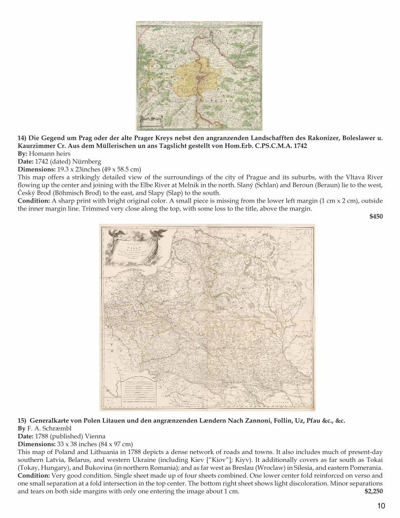
15) Generalkarte von Polen Litauen und den angrænzenden Lændern Nach Zannoni, Follin, Uz, Pfau &c., &c.By F. A. SchræmblDate: 1788 (published) ViennaDimensions: 33 x 38 inches (84 x 97 cm)This map of Poland and Lithuania in 1788 depicts a dense network of roads and towns. It also includes much of present-day southern Latvia, Belarus, and western Ukraine (including Kiev [“Kiov”]; Kiyv). It additionally covers as far south as Tokai (Tokay, Hungary), and Bukovina (in northern Romania); and as far west as Breslau (Wroclaw) in Silesia, and eastern Pomerania.Condition: Very good condition. Single sheet made up of four sheets combined. One lower center fold reinforced on verso and one small separation at a fold intersection in the top center. The bottom right sheet shows light discoloration. Minor separations and tears on both side margins with only one entering the image about 1 cm. $2,250

11
16) Neue militairische Situations und Post-Carte von Polen und Preussen von I.E. Knittel/Nouvelle Carte militaire et routière de la Pologne et de la Prusse par I.E. KnittelBy: Friedrich CampeDate: 1812 (published) NürnbergDimensions: 20.7 x 32.5 inches (52.5 x 82.5 cm)This highly detailed map presents military and post routes centering on the region of present-day Poland in the era of Napoleon’s campaign against Russia in 1812. Numerous small towns and roadways are represented in detail. Warsaw is in the center of the map, which follows the entire course of the Vistula River via Krakau (Kraków), Warsaw, and Torún (Thorn), to Danzig (Gdansk). Included regions are Lower and Upper Silesia, eastern Pomerania, East Prussia south of Königsberg, present-day western Belarus (including Minsk) and Ukraine (including Brody and Lemberg [Lviv]), and northern Austrian Galicia (including Krakau). Other important towns included are Breslau, Lublin, Zamosc, Przemysl, Brzesc, Bialystok, and Grodno.Condition: Very good condition with some light browning along vertical folds, original color, and ample margins.
$750
17) Poland as DividedBy: John ThomsonDate: 1814 (Published) EdinburghDimensions: 17.13 x 19.3 inches (43.5 cm x 49 cm)A detailed map showing areas annexed by Prussia in green, Austria in pink and Russia in yellow. The map accurately demonstrates the result of the Third Partition of Poland in 1795. Detailed depictions of rivers, towns, forests, and marshes are shown throughout. Condition: Excellent condition with original color and wide margins all around.
$450
12
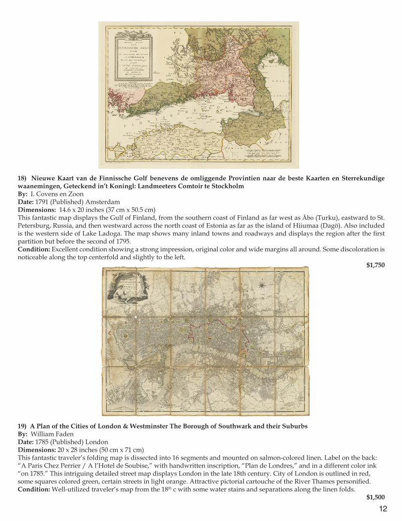
18) Nieuwe Kaart van de Finnissche Golf benevens de omliggende Provintien naar de beste Kaarten en Sterrekundige waanemingen, Geteckend in’t Koningl: Landmeeters Comtoir te StockholmBy: I. Covens en ZoonDate: 1791 (Published) AmsterdamDimensions: 14.6 x 20 inches (37 cm x 50.5 cm)This fantastic map displays the Gulf of Finland, from the southern coast of Finland as far west as Åbo (Turku), eastward to St. Petersburg, Russia, and then westward across the north coast of Estonia as far as the island of Hiiumaa (Dagö). Also included is the western side of Lake Ladoga. The map shows many inland towns and roadways and displays the region after the first partition but before the second of 1795.Condition: Excellent condition showing a strong impression, original color and wide margins all around. Some discoloration is noticeable along the top centerfold and slightly to the left.
$1,750
Europe: City Plans
19) A Plan of the Cities of London & Westminster The Borough of Southwark and their Suburbs By: William FadenDate: 1785 (Published) LondonDimensions: 20 x 28 inches (50 cm x 71 cm)This fantastic traveler’s folding map is dissected into 16 segments and mounted on salmon-colored linen. Label on the back: “A Paris Chez Perrier / A l’Hotel de Soubise,” with handwritten inscription, “Plan de Londres,” and in a different color ink “on 1785.” This intriguing detailed street map displays London in the late 18th century. City of London is outlined in red, some squares colored green, certain streets in light orange. Attractive pictorial cartouche of the River Thames personified.Condition: Well-utilized traveler’s map from the 18th c with some water stains and separations along the linen folds. $1,500
13
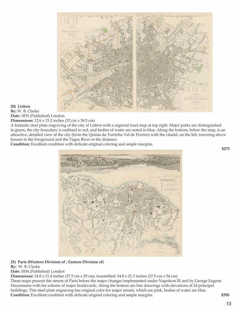
20) LisbonBy: W. B. ClarkeDate: 1833 (Published) LondonDimensions: 12.6 x 15.2 inches (32 cm x 38.5 cm)A fantastic steel plate engraving of the city of Lisbon with a regional inset map at top right. Major parks are distinguished in green, the city boundary is outlined in red, and bodies of water are noted in blue. Along the bottom, below the map, is an attractive, detailed view of the city (from the Quinta da Torrinha Val de Pereiro) with the citadel, on the left, towering above houses in the foreground and the Tagus River in the distance. Condition: Excellent condition with delicate original coloring and ample margins. $275
21) Paris (Western Division of ; Eastern Division of)By: W. B. ClarkeDate: 1834 (Published) LondonDimensions: 14.8 x 11.4 inches (37.5 cm x 29 cm) Assembled: 14.8 x 21.3 inches (37.5 cm x 54 cm)These maps present the streets of Paris before the major changes implemented under Napoleon III and by George Eugene Haussmann with his scheme of major boulevards. Along the bottom are line drawings with elevations of 24 principal buildings. This steel plate engraving has original color for major streets, which are pink, bodies of water are blue.Condition: Excellent condition with delicate original coloring and ample margins. $350
14
22) Plan of the City and Citadel of Antwerp. Antwerp A strong, large, and Beautiful City on ye River Scheld, in the Dutchy of Brabant, subject to ye Queen of Hungary.By: James and Paul KnaptonDate: 1751 (Published) LondonDimensions: 14.8 x 18.9 (37.5 cm x 48 cm)This attractive, clearly printed map shows all streets named in the old city and individual bastions and other edifices named in the citadel. Inset in the upper right corner of Antwerp is a small map depicting part of the H. (Holy) Roman Empire including Brabant, Flandres and Anvers. Vignettes of ships and smaller craft are included. Scale is in toises (with the note that one toise is 5 English feet). The compass rose orients the map to the east.Condition: Trimmed very close to top and bottom margins; a tear in the upper right margin; some fraying on the left margin and of the bottom margin. $650
23) BerlinBy: Baldwin and CradockDate: 1833 (Published) LondonDimensions: 14 x 25 inches (35.5 cm x 63 cm)This attractive map features Berlin in the 1830s. The built-up area clusters around the Royal Palace and a grid plan around the Gendarmen Markt and Unter den Linden. It does not extend farther west than the Brandenburg Gate. Along the bottom, outside the margin, are line drawings with elevations of 10 major architectural edifices, including the iconic Brandenburg Gate, churches, castles, government buildings and a museum. This steel plate engraving has original coloring which shows parks in green, city boundaries outlined in red, bodies of water in blue.Condition: Good condition with a repaired tear in upper right corner which does not enter the image. $300
15
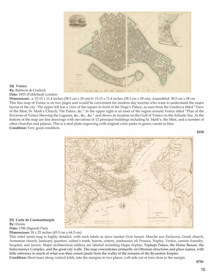
24) VeniceBy: Baldwin & Cradock Date: 1833 (Published) LondonDimensions: a: 15.15 x 11.4 inches (38.5 cm x 29 cm) b: 15.15 x 11.4 inches (38.5 cm x 29 cm); Assembled: 38.5 cm x 58 cm This fine map of Venice is on two pages and would be convenient for modern day tourists who want to understand the major layout of the city. The upper left has a view of the square in front of the Doge’s Palace, as seen from the Giudecca titled “View of the Mint, St. Mark’s Church, The Palace, &c.” In the upper right is an inset of the region around Venice titled “Plan of the Environs of Venice Shewing the Lagunes, &c., &c., &c.” and shows its location on the Gulf of Venice on the Adriatic Sea. At the bottom of the map are line drawings with elevations of 12 principal buildings including St. Mark’s, the Mint, and a number of other churches and palaces. This is a steel plate engraving with original color parks in green, canals in blue.Condition: Very good condition.
$550
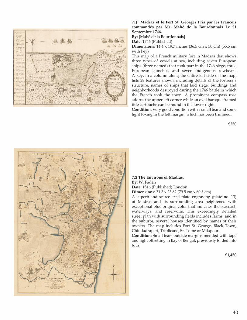
25) Carte de ConstantinopleBy: DentuDate: 1786 (Signed) ParisDimensions: 18 x 25 inches (45.5 cm x 64.5 cm)This relief street map is highly detailed, with such labels as slave market (Ysir basuri, Marché aux Esclaves), Greek church, Armenian church, Janissary quarters, sultan’s tomb, harem, cistern, (embassies of) Prussia, Naples, Venice, cannon foundry, hospital, and tavern. Major architectural edifices are labeled including Hagia Sophia, Topkapı Palace, the Horse Bazaar, the Suleymaniye Complex, and the great city walls. The map concentrates primarily on Ottoman structures and place names, with little reference to much of what was then extant (aside from the walls) of the remains of the Byzantine Empire.Condition: Short tears along vertical folds, into the margins in two places. Left side cut or torn close to the margin. $750
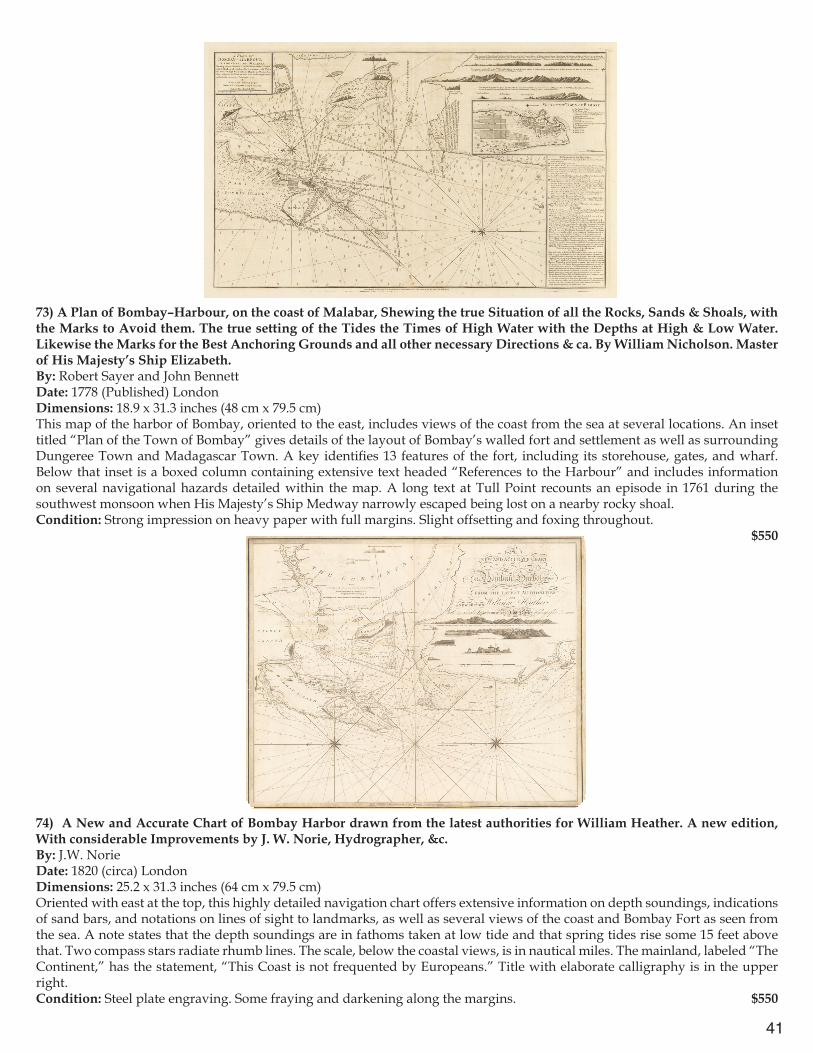
16
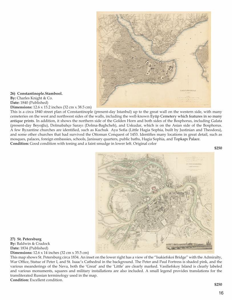
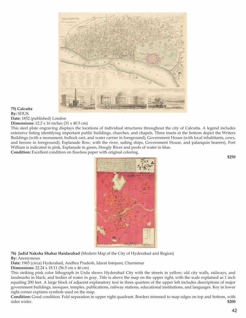
26) Constantinople.Stambool.By: Charles Knight & Co.Date: 1840 (Published) Dimensions: 12.6 x 15.2 inches (32 cm x 38.5 cm)This is a circa 1840 street plan of Constantinople (present-day Istanbul) up to the great wall on the western side, with many cemeteries on the west and northwest sides of the walls, including the well-known Eyüp Cemetery which features in so many antique prints. In addition, it shows the northern side of the Golden Horn and both sides of the Bosphorus, including Galata (present-day Beyoğlu), Dolmabahçe Sarayı (Dolma-Baghcheh), and Uskudar, which is on the Asian side of the Bosphorus. A few Byzantine churches are identified, such as Kuchuk Aya Sofia (Little Hagia Sophia, built by Justinian and Theodora), and some other churches that had survived the Ottoman Conquest of 1453. Identifies many locations in great detail, such as mosques, palaces, foreign embassies, schools, Janissary quarters, public baths, Hagia Sophia, and Topkapı Palace.Condition: Good condition with toning and a faint smudge in lower left. Original color $250
27) St. PetersburgBy: Baldwin & Cradock Date: 1834 (Published) Dimensions: 12.6 x 14 inches (32 cm x 35.5 cm)This map shows St. Petersburg circa 1834. An inset on the lower right has a view of the “Isakiefskoi Bridge” with the Admiralty, War Office, Statue of Peter I, and St. Isaac’s Cathedral in the background. The Peter and Paul Fortress is shaded pink, and the various meanderings of the Neva, both the ‘Great’ and the ‘Little’ are clearly marked. Vasiliefskoy Island is clearly labeled and various monuments, squares and military installations are also included. A small legend provides translations for the transliterated Russian terminology used in the map.Condition: Excellent condition. $250
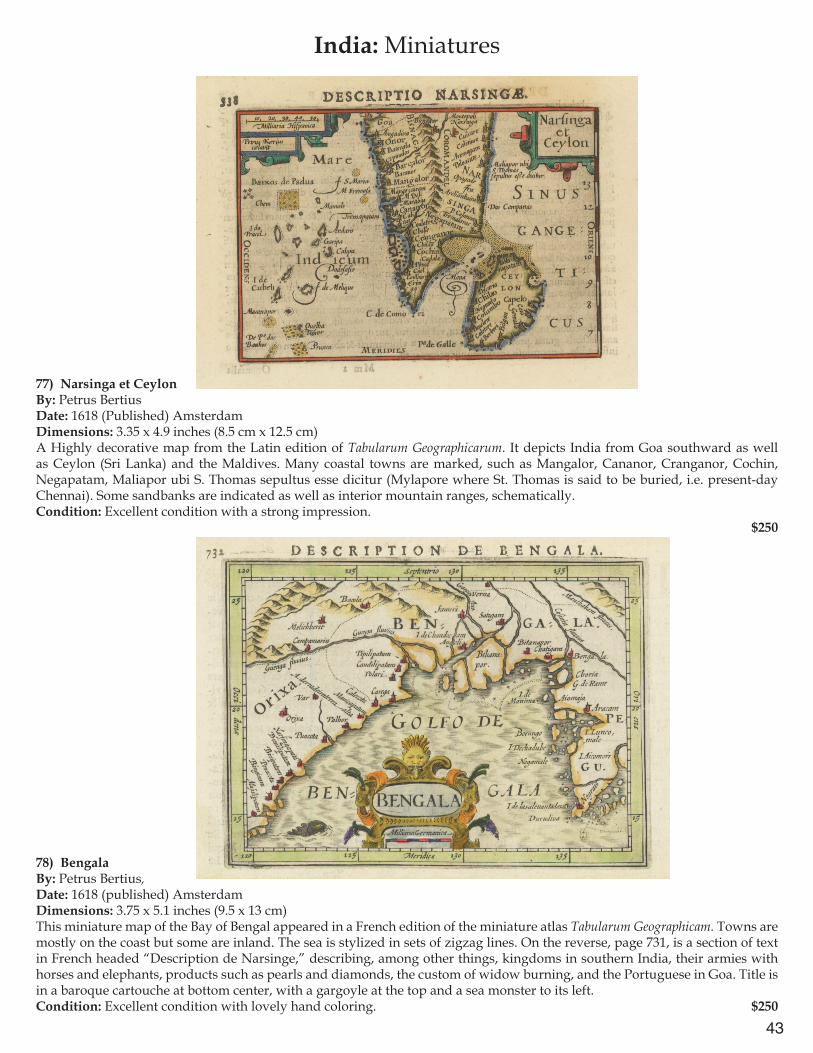
17
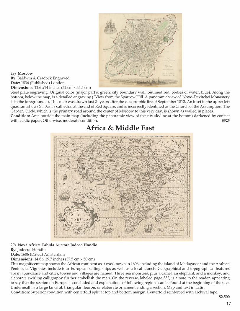
28) MoscowBy: Baldwin & Cradock Engraved Date: 1836 (Published) LondonDimensions: 12.6 x14 inches (32 cm x 35.5 cm)Steel plate engraving. Original color (major parks, green; city boundary wall, outlined red; bodies of water, blue). Along the bottom, below the map, is a detailed engraving (“View from the Sparrow Hill. A panoramic view of Novo-Devitchei Monastery is in the foreground.”). This map was drawn just 24 years after the catastrophic fire of September 1812. An inset in the upper left quadrant shows St. Basil’s cathedral at the end of Red Square, and is incorrectly identified as the Church of the Assumption. The Garden Circle, which is the primary road around the center of Moscow to this very day, is shown as walled in places.Condition: Area outside the main map (including the panoramic view of the city skyline at the bottom) darkened by contact with acidic paper. Otherwise, moderate condition. $325
Africa & Middle East
29) Nova Africæ Tabula Auctore Jodoco HondioBy: Jodocus HondiusDate: 1606 (Dated) AmsterdamDimensions: 14.8 x 19.7 inches (37.5 cm x 50 cm)This magnificent map shows the African continent as it was known in 1606, including the island of Madagascar and the Arabian Peninsula. Vignettes include four European sailing ships as well as a local launch. Geographical and topographical features are in abundance and cities, towns and villages are named. Three sea monsters, plus a camel, an elephant, and a monkey, and elaborate swirling calligraphy further embellish the map. On the reverse, labeled page 332, is a note to the reader, appearing to say that the section on Europe is concluded and explanations of following regions can be found at the beginning of the text. Underneath is a large fanciful, triangular fleuron, or elaborate ornament ending a section. Map and text in Latin.Condition: Superior condition with centerfold split at top and bottom margin. Centerfold reinforced with archival tape. $2,500

18
30) Guinea (under heading: Descriptio Gvineæ.)By: Petrus Kerius [Pieter van der Keere][For atlas of Petrus Bertius (Pieter de Bert)Date: 1618 (Published) AmsterdamDimensions: 3.5 x 5.1 inches (9 cm x 13 cm)This intriguing small map is a highly decorative calligraphied page from a Latin edition of a miniature atlas, probably Tabularum Geographicarum, published in 1618. Depicts West Africa from Senegal to the Bight of Biafra. Lovely title cartouche surrounds the word “Guinea.” On the reverse, page 651, is a section of text in Latin headed by Descriptio Regni Tvnetani (Description of the Kingdom of Tunisia). Condition: Very good condition with a small faded ink stain on left margin and in Sierra Leone. $250
31) Hondius his Map of Guinea.By: Jodocus Hondius (Joost de Hondt) Printed by William Stansby for Henrie Fetherstone; In Purchas His Pilgrimes in Five Bookes, part 3, p. 715Date: 1625 (Published) LondonDimensions: 5.7 x 7.08 inches (14.5 cm x 18 cm)This lovely Hondius map of Guinea is from a book page headed “Chap. 14. Africa. The sixt Booke. 715,” and was originally from the Atlas Minor by Gerard Mercator and Johannes Janssonius of 1607. It displays the southern coast of West Africa from the area of Senegal to Nigeria at the Bight of Biafra. An inset shows an enlarged detail of the island of “I.S. Thomae” (St. Thomas). A marvelous sea creature embellishes the “Aethiopicus Oce.” The text, in English, describes European traders in the region, the reverence shown by locals to the King of Benin, and the goods obtained (“Gold, Graines, and Elephants teeth”). The reverse, page 716, is a text headed “Description of Benin and Guinea,” elaborating on the people and remarkable customs of the area.Condition: Good condition. $350
19
32) La Guinée et Pays circomvoisins; Tirés de Mercator[,] de Blommart &cBy: N. [Nicolas] Sanson d’AbbevilleDate: 1656 (Dated) ParisDimensions: 6.5 x 12 inches (16.5 cm x 30.5 cm)This seventeenth century map displays the southern coast of West Africa from the coast of Sierra Leone around to Gabon, including São Thome (St. Thomas). Parts of present-day Mali and Niger appear in the north. The map shows gulfs, rivers, lakes and cities of the region, which is referred to on the map as “Pays des Negres,” or “Lands of the Negroes.” It is on watermarked paper which includes a symbol consisting of the letter H with a line extending down from its cross bar into the letter V, passing through a letter resembling an omega turned on its side.Condition: Discoloration along vertical line of the central fold and light water stain outside the left margin; otherwise a bright, clear print. $200
33) Cape of Good HopeBy: Aaron ArrowsmithDate: 1807 (Dated) LondonDimensions: 9.6 x 15.4 inches (24.5 cm x 39 cm)This map depicts the southwestern part of southern Africa, with hachures dramatically depicting mountains and ridges. Much interesting informational commentary appears on the map such as “Fine Pasture Country well wooded and water’d the Sea Coast abounding with Elephants”; “The White Rhinoceros plentiful in this part of the Country also Springboks, hartebeest and Elands.” Condition: Original color. Paper slightly darkened with foxing outside margin in lower left. $85
20
34) Süd-Afrika. Nach Capt. Owen’s Küsten-Aufnahme, der Hebert-Arrowsmith’schen Karte, den Reisen un den Karten v. Burchell, Alexander, Gardner, Drège, Harris, &c., &c., &c.By: Justus Perthes, Gotha, 1848Date: 1848 (Published) GothaDimensions: 12.6 x 16.5 inches (32 cm x 42 cm)Original color. Extends from Walvis Bay [“Walfisch B.”] in present-day Namibia, eastward across the southern part of present-day Botswana to the area south of the Limpopo River. In other words, it covers all of the region of the present-day Republic of South Africa. Large swaths of the northern interior are unexplored. An inset depicts Cape Town and False Bay and immediate surroundings. The Cape of Good Hope is termed “Vorgebirge der Guten hoffnung.” The coast lines on either side of the Cape are highly detailed with names of rivers, ports, points, and cities all faithfully designated.Condition: Good condition with very minor foxing. $175
35) Egypten nach dem Zustand der alten Zeit vorgestellt.Engraved by Seb. [Sebastian] Dorn, NürnbergT. I, page 584By: Sebastian DornDate: 1746 (Published by Gebauer) HalleDimensions: 15 x 8.3 inches (38 cm x 21 cm)This map of Egypt with information from ancient times is labeled in Latin. It displays the course of the Nile River from Ancient Ethiopia and Philae all the way to the Mediterranean Sea. Canals adjacent to the river are also shown. The Nile Delta is marvelously detailed. Most of the Sinai Peninsula appears to the east as well as part of the coast of Palestine. Place names from Hellenistic times appear in addition to Arabic ones. A key lists translations of Arabic geographical terms and explains a system of symbols indicating such landmarks as castles, monasteries, mosques, ruins, and cities, and spells out abbreviations used. An inset in the upper right illustrates the rudder operating system of local boats. Four different scales appear in the title cartouche.Condition: Good condition, crisp print, minor foxing. $350
21
36) Lower Egypt and the Adjacent Deserts, with a part of Palestine; to which has been added the Nomenclature of the Roman age. By: L. S. de la RochetteDate: 1802 (Published) LondonDimensions: 21.25 x 29 inches (54 cm x 73.5 cm)This region was the site of Napoleon’s campaign in Egypt, Palestine, and Syria, 1798-1801. Much detail is given of the network of roads, rivers, and canals crisscrossing the delta. The entire delta is displayed, in addition to nearby Fayoum, and the northern tip of the Gulf of Suez. The seacoast curves up to Palestine, passing Jaffa and north of Acre. The interior of Palestine is shown as far inland as Nablus, Jerusalem, and Hebron. Original color designates the Nile Delta in light green, land areas are beige political boundaries are colored, and the cities of Memphis, Kahira or Cairo, Damiat, Rosetta, and Alexandria are in red. Desert regions are lightly stippled.Condition: Good condition and appearance; lower center fold separation that extends approximately two inches into the image. Minor rolled fold. $450
37) Soria et Terra Santa Nvova TavolaBy: Girolamo Ruscelli][Ruscelli’s translation of Ptolemy’s Geographia][Published by Vincenzo Valgrisi)Date: 1561-1564 (Published) VeniceDimensions: 7 x 9.45 inches (18 cm x 24 cm)This map of Syria and the Holy Land also shows Cyprus and the northeastern end of the Mediterranean Sea. Bodies of water are shaded with light stippling. Among the rivers are the Jordan, the Orontes, the Tigris, and Euphrates. Mountains are indicated schematically, and a few are named. Regions of some Israelite tribes are also shown, such as Gad, Ruben, Efrain, Manasse, Iuda, Asir, Nettalim. A user has underlined in ink Ierusalem, Betlem, and Nazaret. In the region of present-day southwestern Syria is a place marked “Sepulcro Giob” (Tomb of Job). On the reverse side is a chapter headed “Della Soria et Terra Santa, Terza Tavola Nvova D’Asia.” Text in Italian.Condition: Repair to small area in the bottom of the center fold, just entering the margin but not the map itself. Spot of foxing in lower right margin. $625
22
38) The description of the holy Land conteining the places mentioned in the foure Euangelists, with other plaes about the sea coasts, wherein may be seene the waves and iorneyes of Christ and his Apostles in Iudea, Samaria, and Galile : for into thesse three parts this land is diuided.By: L. Tomson[“The Geneva Bible”]Date: 1599 (Published) London (other editions 1609, 1613, 1615)Dimensions: 3.94 x 4.72 inches (10 cm x 12 cm)This attractive pictorial colored map is from a page in the Geneva Bible, which preceded the King James version by half a century, and was the translation used by Shakespeare, the Puritans, John Knox, and Oliver Cromwell. The Geneva Bible, translated in Geneva Switzerland by Protestant scholars who fled from Queen Mary I’s England, was the first mass produced and printed Bible made available to the general public. The New Testament first appeared in 1557 and then together with the Old Testament in 1560. Some editions were marked with the back-dated year of 1599 though they appeared somewhat later following the issuance of the King James “Authorized Version.” The Anglicans of the Church of England disliked the Geneva Bible’s Calvinist and Puritan character. The map highlights numerous important locales, such as Nazareth, Bethlehem, Jerusalem, Sea of Galilee. The Jordan River and mountains of Judea are pictorially rendered. It is embellished with two ships sailing in the Mediterranean. A key, below the map, identifies 32 Biblical locations with their coordinates.Condition: Good condition with toning and some darkening of the lower edge. $750
39) Description Geographique de la Terre Promise, Terre des Hebreux, et des Israelites Partagée selon l’ordre de Dieu, Aux Douze Tribus Descendantes des Douze Fils de Jacob . . . By: Moullart-SansonDate: 1712 (circa) ParisDimensions: 13.58 x 14.17 inches (34.5 cm x 36 cm)This map displays the territories of the Twelve Tribes of Israel in the Holy Land, including the names of the tribes, and showing their presumed borders along with many towns mentioned in the Bible. Also labeled are the lands of the Moabites, Madianites (Midianites), and others. A statement in the lower left corner declares that the map is intended for the reading of the Holy Scripture.Condition: Very good condition with some foxing and uneven toning. $650
23
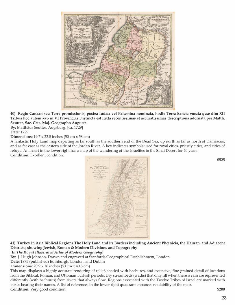
40) Regio Canaan seu Terra promissionis, postea Iudæa vel Palæstina nominata, hodie Terra Sancta vocata quæ dim XII Tribus hoc autem ævo in VI Provincias Distincta est iuxta recentissimas et accuratissimas descriptions adornata per Matth. Seutter, Sac. Cæs. Maj. Geographo AugustaBy: Matthäus Seutter, Augsburg, [ca. 1729]Date: 1729 Dimensions: 19.7 x 22.8 inches (50 cm x 58 cm) A fantastic Holy Land map depicting as far south as the southern end of the Dead Sea; up north as far as north of Damascus; and as far east as the eastern side of the Jordan River. A key indicates symbols used for royal cities, priestly cities, and cities of refuge. An insert in the lower right has a map of the wandering of the Israelites in the Sinai Desert for 40 years.Condition: Excellent condition.
$525
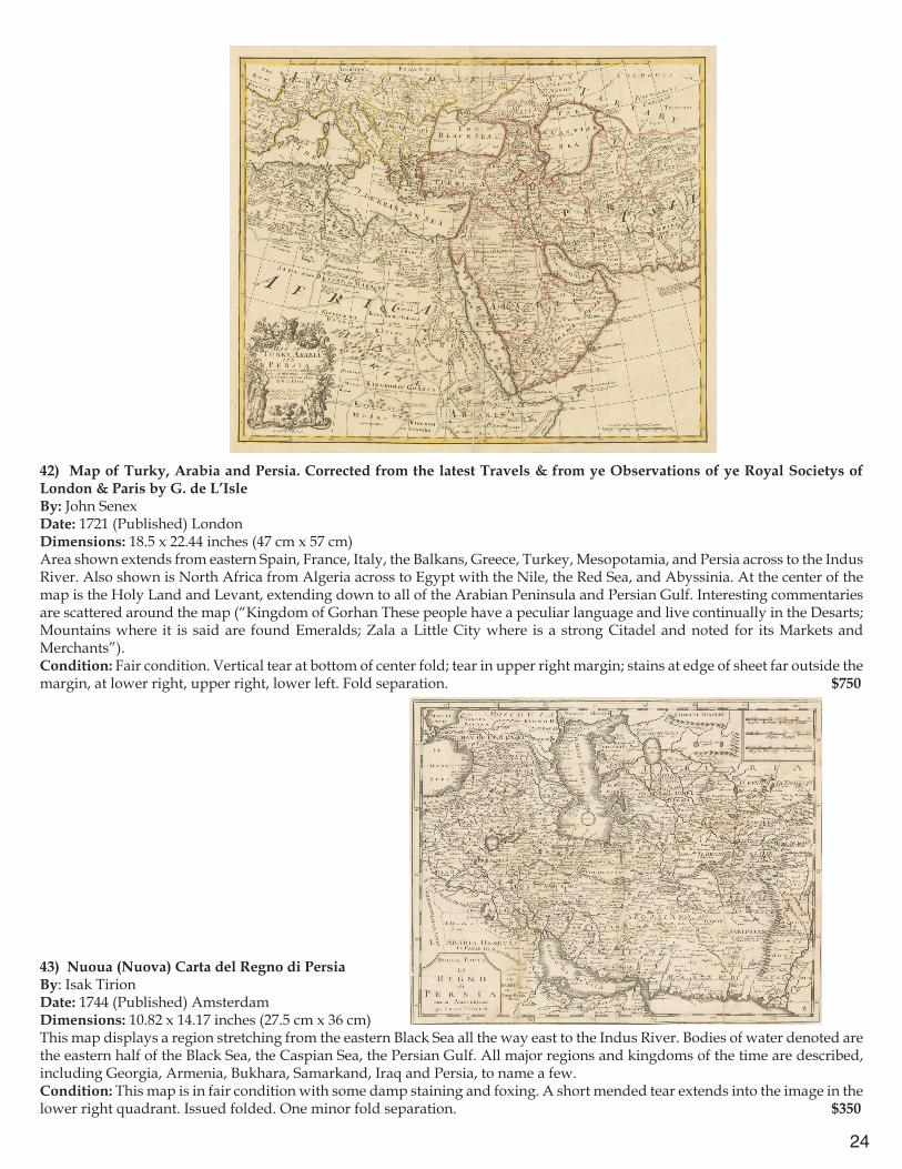
41) Turkey in Asia Biblical Regions The Holy Land and its Borders including Ancient Phœnicia, the Hauran, and Adjacent Districts; showing Jewish, Roman & Modern Divisions and Topography[In The Royal Illustrated Atlas of Modern Geography]By: J. Hugh Johnson, Drawn and engraved at Stanfords Geographical Establishment, LondonDate: 1875 (published) Edinburgh, London, and DublinDimensions: 20.9 x 16 inches (53 cm x 40.5 cm)This map displays a highly accurate rendering of relief, shaded with hachures, and extensive, fine-grained detail of locations from the Biblical, Roman, and Ottoman Turkish periods. Dry streambeds (wadis) that only fill when there is rain are represented differently (with hachures) from rivers that always flow. Regions associated with the Twelve Tribes of Israel are marked with boxes bearing their names. A list of references in the lower right quadrant enhances readability of the map.Condition: Very good condition. $200
24
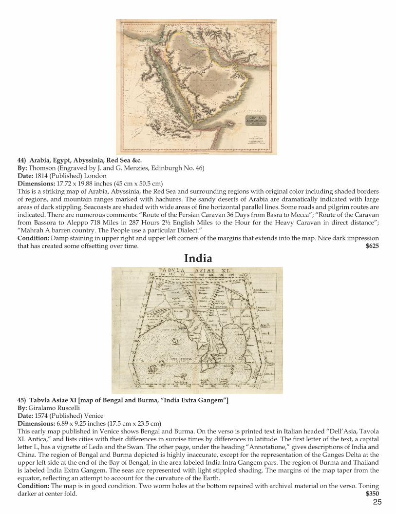
42) Map of Turky, Arabia and Persia. Corrected from the latest Travels & from ye Observations of ye Royal Societys of London & Paris by G. de L’IsleBy: John SenexDate: 1721 (Published) LondonDimensions: 18.5 x 22.44 inches (47 cm x 57 cm)Area shown extends from eastern Spain, France, Italy, the Balkans, Greece, Turkey, Mesopotamia, and Persia across to the Indus River. Also shown is North Africa from Algeria across to Egypt with the Nile, the Red Sea, and Abyssinia. At the center of the map is the Holy Land and Levant, extending down to all of the Arabian Peninsula and Persian Gulf. Interesting commentaries are scattered around the map (“Kingdom of Gorhan These people have a peculiar language and live continually in the Desarts; Mountains where it is said are found Emeralds; Zala a Little City where is a strong Citadel and noted for its Markets and Merchants”).Condition: Fair condition. Vertical tear at bottom of center fold; tear in upper right margin; stains at edge of sheet far outside the margin, at lower right, upper right, lower left. Fold separation. $750
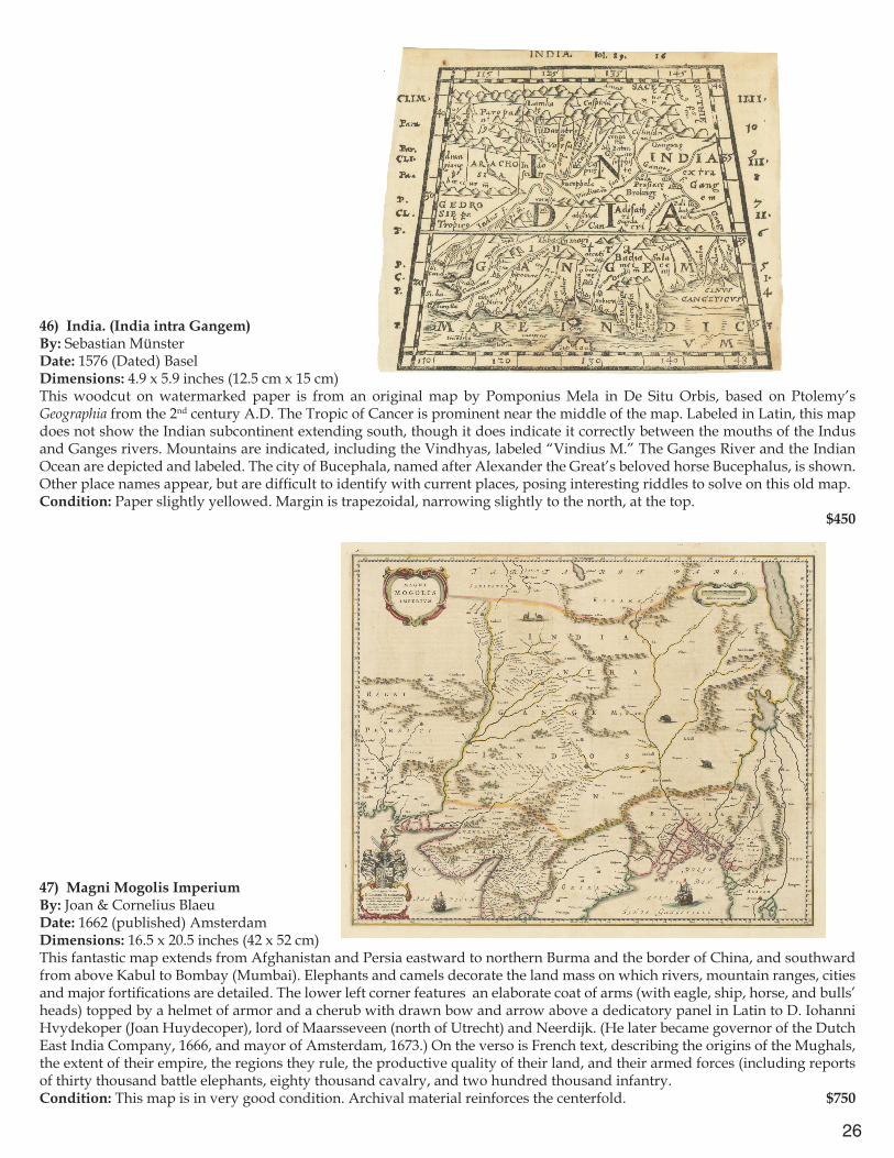
43) Nuoua (Nuova) Carta del Regno di PersiaBy: Isak TirionDate: 1744 (Published) AmsterdamDimensions: 10.82 x 14.17 inches (27.5 cm x 36 cm)This map displays a region stretching from the eastern Black Sea all the way east to the Indus River. Bodies of water denoted are the eastern half of the Black Sea, the Caspian Sea, the Persian Gulf. All major regions and kingdoms of the time are described, including Georgia, Armenia, Bukhara, Samarkand, Iraq and Persia, to name a few.Condition: This map is in fair condition with some damp staining and foxing. A short mended tear extends into the image in the lower right quadrant. Issued folded. One minor fold separation. $350
25
44) Arabia, Egypt, Abyssinia, Red Sea &c.By: Thomson (Engraved by J. and G. Menzies, Edinburgh No. 46)Date: 1814 (Published) London Dimensions: 17.72 x 19.88 inches (45 cm x 50.5 cm)This is a striking map of Arabia, Abyssinia, the Red Sea and surrounding regions with original color including shaded borders of regions, and mountain ranges marked with hachures. The sandy deserts of Arabia are dramatically indicated with large areas of dark stippling. Seacoasts are shaded with wide areas of fine horizontal parallel lines. Some roads and pilgrim routes are indicated. There are numerous comments: “Route of the Persian Caravan 36 Days from Basra to Mecca”; “Route of the Caravan from Bassora to Aleppo 718 Miles in 287 Hours 2½ English Miles to the Hour for the Heavy Caravan in direct distance”; “Mahrah A barren country. The People use a particular Dialect.”Condition: Damp staining in upper right and upper left corners of the margins that extends into the map. Nice dark impression that has created some offsetting over time. $625
India
45) Tabvla Asiae XI [map of Bengal and Burma, “India Extra Gangem”]By: Giralamo RuscelliDate: 1574 (Published) Venice Dimensions: 6.89 x 9.25 inches (17.5 cm x 23.5 cm)This early map published in Venice shows Bengal and Burma. On the verso is printed text in Italian headed “Dell’Asia, Tavola XI. Antica,” and lists cities with their differences in sunrise times by differences in latitude. The first letter of the text, a capital letter L, has a vignette of Leda and the Swan. The other page, under the heading “Annotatione,” gives descriptions of India and China. The region of Bengal and Burma depicted is highly inaccurate, except for the representation of the Ganges Delta at the upper left side at the end of the Bay of Bengal, in the area labeled India Intra Gangem pars. The region of Burma and Thailand is labeled India Extra Gangem. The seas are represented with light stippled shading. The margins of the map taper from the equator, reflecting an attempt to account for the curvature of the Earth.Condition: The map is in good condition. Two worm holes at the bottom repaired with archival material on the verso. Toning darker at center fold. $350
26
46) India. (India intra Gangem)By: Sebastian MünsterDate: 1576 (Dated) BaselDimensions: 4.9 x 5.9 inches (12.5 cm x 15 cm) This woodcut on watermarked paper is from an original map by Pomponius Mela in De Situ Orbis, based on Ptolemy’s Geographia from the 2nd century A.D. The Tropic of Cancer is prominent near the middle of the map. Labeled in Latin, this map does not show the Indian subcontinent extending south, though it does indicate it correctly between the mouths of the Indus and Ganges rivers. Mountains are indicated, including the Vindhyas, labeled “Vindius M.” The Ganges River and the Indian Ocean are depicted and labeled. The city of Bucephala, named after Alexander the Great’s beloved horse Bucephalus, is shown. Other place names appear, but are difficult to identify with current places, posing interesting riddles to solve on this old map.Condition: Paper slightly yellowed. Margin is trapezoidal, narrowing slightly to the north, at the top. $450
47) Magni Mogolis ImperiumBy: Joan & Cornelius Blaeu Date: 1662 (published) AmsterdamDimensions: 16.5 x 20.5 inches (42 x 52 cm) This fantastic map extends from Afghanistan and Persia eastward to northern Burma and the border of China, and southward from above Kabul to Bombay (Mumbai). Elephants and camels decorate the land mass on which rivers, mountain ranges, cities and major fortifications are detailed. The lower left corner features an elaborate coat of arms (with eagle, ship, horse, and bulls’ heads) topped by a helmet of armor and a cherub with drawn bow and arrow above a dedicatory panel in Latin to D. Iohanni Hvydekoper (Joan Huydecoper), lord of Maarsseveen (north of Utrecht) and Neerdijk. (He later became governor of the Dutch East India Company, 1666, and mayor of Amsterdam, 1673.) On the verso is French text, describing the origins of the Mughals, the extent of their empire, the regions they rule, the productive quality of their land, and their armed forces (including reports of thirty thousand battle elephants, eighty thousand cavalry, and two hundred thousand infantry. Condition: This map is in very good condition. Archival material reinforces the centerfold. $750
27
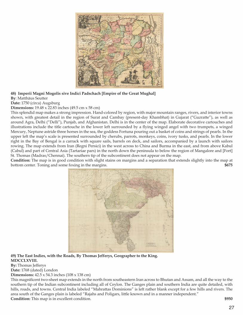
48) Imperii Magni Mogolis sive Indici Padschach [Empire of the Great Mughal]By: Matthäus SeutterDate: 1750 (circa) AugsburgDimensions: 19.48 x 22.83 inches (49.5 cm x 58 cm)This splendid map makes a strong impression. Hand-colored by region, with major mountain ranges, rivers, and interior towns shown, with greatest detail in the region of Surat and Cambay (present-day Khambhat) in Gujarat (“Guzratte”), as well as around Agra, Delhi (“Delli”), Punjab, and Afghanistan. Delhi is in the center of the map. Elaborate decorative cartouches and illustrations include the title cartouche in the lower left surrounded by a flying winged angel with two trumpets, a winged Mercury, Neptune astride three horses in the sea, the goddess Fortuna pouring out a basket of coins and strings of pearls. In the upper left the map’s scale is presented surrounded by cherubs, parrots, monkeys, coins, ivory tusks, and pearls. In the lower right in the Bay of Bengal is a carrack with square sails, barrels on deck, and sailors, accompanied by a launch with sailors rowing. The map extends from Iran (Regni Persici) in the west across to China and Burma in the east, and from above Kabul (Cabul) and part of Central Asia (Tartariae pars) in the north down the peninsula to below the region of Mangalore and [Fort] St. Thomas (Madras/Chennai). The southern tip of the subcontinent does not appear on the map.Condition: The map is in good condition with slight stains on margins and a separation that extends slightly into the map at bottom center. Toning and some foxing in the margins. $675
49) The East Indies, with the Roads, By Thomas Jefferys, Geographer to the King.MDCCLXVIII.By: Thomas Jefferys Date: 1768 (dated) LondonDimensions: 42.5 x 54.3 inches (108 x 138 cm)This magnificent two-sheet map extends in the north from southeastern Iran across to Bhutan and Assam, and all the way to the southern tip of the Indian subcontinent including all of Ceylon. The Ganges plain and southern India are quite detailed, with hills, roads, and towns. Central India labeled “Mahrattas Dominions” is left rather blank except for a few hills and rivers. The area south of the Ganges plain is labeled “Rajahs and Poligars, little known and in a manner independent.”Condition: This map is in excellent condition. $950

28
50) To Mark Wood Esqr M.P. Colonel of the Army in India, Late Chief Engineer and Surveyor General, Bengal, This Map of India, Compiled from various Interesting and Valuable Materials Is Inscribed in grateful Testimony of His Liberal Communications, By his obedient and most humble Servant, A. ArrowsmithBy: Aaron Arrowsmith Engraved by: George AllenDate: 1804 (dated) LondonDimensions: 73.8 x 63 inches (187.5 x 160 cm)This is a very important and scarce map of India during a time of very active British colonization. Large six sheet wall map of India combined into three sections; an excellent impression with original color. Elaborate calligraphy title in upper right corner of top sheet. The map exhibits attractive shading of mountain ranges and extremely detailed rendering of interior roads and towns. The map extends eastward from Kandahar in Afghanistan across Kashmir and Nepal to the Ganges Delta and south as far as all of Ceylon (Sri Lanka). In a few places, there are commentaries on the navigability of certain rivers, such as: “The River Ganges is at the lowest in April, it is fordable in some places above the confluence with the Jumna, but the Navigation is never interrupted. At 500 miles from the Sea, the Channel is 30 feet deep and continues at that depth at least to the Sea. Principal Channel varies from 400 yards to 1¼ mile but is commonly about ¾ of a mile in width the mean rate of motion is nearly 3 miles an hour in the dry months, in the wet season the current is from 5 to 6 miles an hour, the fall is about 4 Inches in one mile through the plains.” Condition: Light offsetting throughout. Minor separations at the top and bottom of the centerfold of each section.
$15,000

29
51) Hind, Hindoostan, or IndiaBy: Louis Stanislas D’Arcy de la Rochette Published by: Jas. WyldDate: 1835 (dated) LondonDimensions: 27.2 x 20.9 inches (69 x 53 cm) This highly detailed map extends from the Indus Delta eastward to the west coast of Burma, and from Kabul to south of Ceylon (Sri Lanka) and the Maldive Islands. Colored borders indicate British and neighboring territories. Elaborate pictorial cartouche in lower right, has title in a shaded oval surrounded by an elephant, tropical foliage, and palm trees, with an inscription in a ribbon at the bottom. Another cartouche with scales of distance is in the upper right corner. Condition: Very attractive map in excellent condition with original color . $650
52) A Map of Bengal, Bahar, Oude & Allahabad with Part of Agra and Delhi Exhibiting the Course of the Ganges from Hurdwar to the SeaBy: William FadenDate: 1786 (dated) LondonDimensions: 28.4 x 42 inches (72 x 106.5 cm)This bright example shows the territories in five colors (blue, green, pink, yellow, plus orange margins). It records interior settlements and connecting roads and includes some political commentary (“Country of the Dilzat Roy Tributary to Abjid Sing”). The map extends from Delhi in the west to the borders of Burma in the east, Nepal and Tibet in the north to the borders of Odisha (Orissa) in the south. The title in the upper right is in a large pictorial cartouche, with palm and banana trees, a panther, local inhabitants include an Indian militiaman with rifle, a woman, a Hindu kneeling in worship, and a turbaned nawab, and a Neptune-like personification of the River Ganges, followed by a calligraphic dedication and description of the map.Condition: Clean watermarked paper with original color. Small tears at the center fold. Rolled folds in bottom section.
$850
30
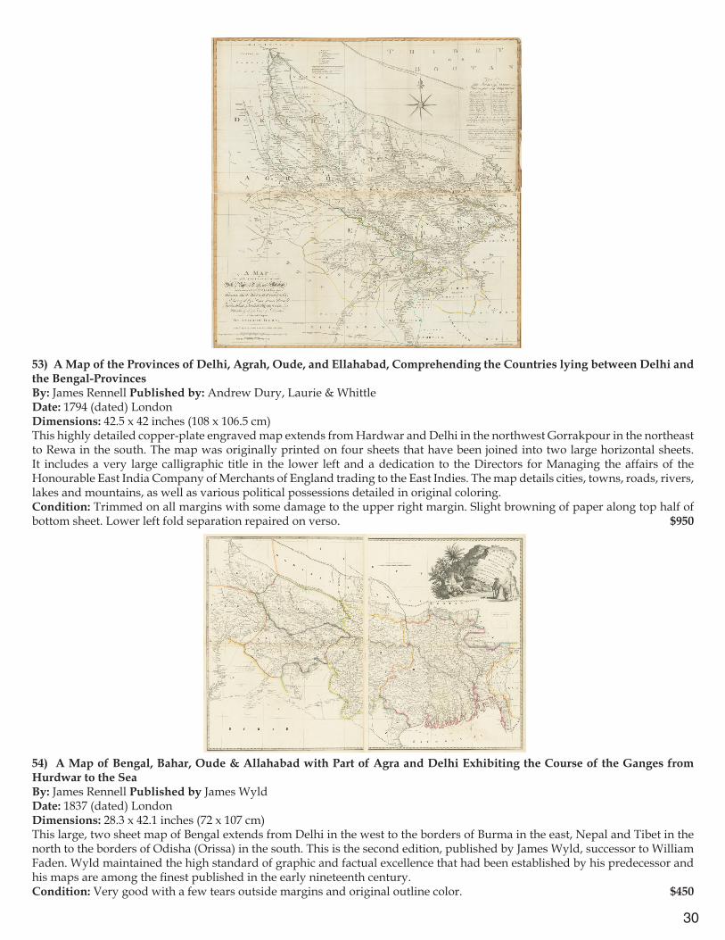
53) A Map of the Provinces of Delhi, Agrah, Oude, and Ellahabad, Comprehending the Countries lying between Delhi and the Bengal-ProvincesBy: James Rennell Published by: Andrew Dury, Laurie & WhittleDate: 1794 (dated) LondonDimensions: 42.5 x 42 inches (108 x 106.5 cm)This highly detailed copper-plate engraved map extends from Hardwar and Delhi in the northwest Gorrakpour in the northeast to Rewa in the south. The map was originally printed on four sheets that have been joined into two large horizontal sheets. It includes a very large calligraphic title in the lower left and a dedication to the Directors for Managing the affairs of the Honourable East India Company of Merchants of England trading to the East Indies. The map details cities, towns, roads, rivers, lakes and mountains, as well as various political possessions detailed in original coloring. Condition: Trimmed on all margins with some damage to the upper right margin. Slight browning of paper along top half of bottom sheet. Lower left fold separation repaired on verso. $950
54) A Map of Bengal, Bahar, Oude & Allahabad with Part of Agra and Delhi Exhibiting the Course of the Ganges from Hurdwar to the SeaBy: James Rennell Published by James Wyld Date: 1837 (dated) LondonDimensions: 28.3 x 42.1 inches (72 x 107 cm) This large, two sheet map of Bengal extends from Delhi in the west to the borders of Burma in the east, Nepal and Tibet in the north to the borders of Odisha (Orissa) in the south. This is the second edition, published by James Wyld, successor to William Faden. Wyld maintained the high standard of graphic and factual excellence that had been established by his predecessor and his maps are among the finest published in the early nineteenth century.Condition: Very good with a few tears outside margins and original outline color. $450

31
55) Calecut Nuova Tavola.By: Girolamo Ruscelli Published by: Girolamo ZilattiDate: 1564 (Published) VeniceDimensions: 7 x 9.5 inches (18 x 24 cm)This fine copperplate engraving is an expanded edition from Giacomo Gastaldi’s atlas of 1548. The map extends from west of the Gujarat peninsula eastward to Bengal and south as far as northern Ceylon (“Ceilam”). The shape of the Indian peninsula is exaggeratedly narrow. Towns on the west coast are more extensively identified. The sea is shaded with black dots; hills and rivers are schematic. On the verso, Latin text describes local kingdoms, spices such as ginger and pepper, and aspects of society, including Brahmins and Christians.Condition: Very good condition with slight discoloration at the centerfold.
$450
56) Carte des Côtes de Malabar et de Coromandel, presentée au Roy, par son trés humble trés obeisssant et trés fidèle sujet, G. DelisleBy: Guillaume De L’IsleDate: 1722 (dated) ParisDimensions: 17.3 x 22.6 inches (44 x 57.5 cm)This interesting map in French extends in the north from the northern portion of Indian to Sri Lanka and includes the Maldives in the west. It details coastal towns, internal settlements, hills, and roads. The title cartouche includes decorative architecture and vegetation with the French royal coat of arms. Two compass roses flank the subcontinent. Condition: This map is in very good condition. $500

32
57) Nieuwe Kaart van Choromandel ende MalabarBy: François ValentynDate: 1724 (published) AmsterdamDimensions: 20 x 23.2 inches (51 cm x 59 cm)This map is a crisp impression which extends from Dabul and Bhimilipatnam in the north to the southern tip of India as well as the northern part of Ceylon as far south as Batticaloa (“Baticalo”). Mountains are prominently indicated as well as regional political designations such a “’t Ryk van Mangaloor,” and “’t Ryk van Tansjouwer.” Coastal towns are detailed and interior roads are shown along the Coromandel Coast and up to Golconda (Hyderabad). Condition: The map is in excellent condition displaying a strong impression on clean paper. Toning around edges.
$750
58) Carte réduite de la Presque Isle de l’Inde.Contenant les Costes depuis Cambaye jusqu’aux Bouches du Gange. Dressée au Dépost des Cartes Plans et Journaux de la Marine. Pour le Service des Vaisseaux Français. Par ordre de Monsieur de Praslin Ministre de la Marine en 1766. Par le S. Bellin Ingénieur de la Marine.By: Jacques-Nicolas Bellin Date: 1795 (dated) Paris Dimensions: 23.6 x 33.7 inches (60 x 85.5 cm) This map was produced for French vessels by the Ministry of the Marine (Navy) with symbol of the Royal French Navy (“Dépôt de la Marine” over an anchor surrounded by the initials “R.” and “F.”) and has an oval red stamp with the British Lion and Unicorn arms with crown over which is “Military Depot,” possibly as the result of having been captured. It presents mountains, rivers, and towns, as well as noting foreign trade settlements (French, English, Dutch, Portuguese, and Danish). Some interior roads are shown on the southeast coast as far south as Tiruchirapalli and from the Krishna Delta via Golconda (Hyderabad) up northwest to Surat and Berhampur. Condition: An exceptional impression with a very small piece of lower right corner missing, far outside the map margin.
$650

33
59) Carte du Golfe de Bengale, Mer des Indes et Riviere du Gange, Avec les Païs et Iles d’alentour. Savoir les Côtes de Malabar, Cormandel, Ile de Ceylon, les Maldives, les Roiaumes de Visiapour, Golconda, Guzaratte, etc.By: Pierre Vander Aa, Date: 1729 (published) LeidenDimensions: 11 x 13.6 inches (28 x 34.5 cm)This marvelous map details the southern part of India, Ceylon, and the Maldives. A rectangular picture frame cartouche can be found in the lower right. Depth soundings are given along the east coast. The map indicates a few internal towns, but focuses more on ports and regional boundaries.Condition: Very good condition with no major problems. Map appears evenly darkened with age.
$350
60) A Map of the Peninsula of India, from the 19th degree north latitude to Cape Comorin MDCCXCIIBy: William Faden Date: 1795 (dated) LondonDimensions: 38.6 x 31.9 inches (98 x 81 cm)This splendid two sheet map is one of the most detailed maps of the southern portion of India of its time. It extends from Bombay (Mumbai), across to Ahmednagar, Nanded, and Nirmal, and the south side of the Godavari River to its delta, south to Kanyakumari and the northern third of Ceylon. Shading of mountains and seacoast resembles the acquatint process. The title cartouche in the lower left of bottom section has notes stating sources of information including “Compiled chiefly from Papers commissioned by the late Sir Archd Campbell , the Surveys of Col. Kelly, Capt. Pringle, Captain Allan &c.”Condition: Excellent $500
34
61) The East Indies, including more particularly the British Dominions on the Continent of IndiaBy: John BlairDate: 1814 (published) LondonDimensions: 16.7 x 22.5 inches (42.5 x 57 cm)This map extends from eastern Iran (Persia) in the west eastward across to Assam and northern Burma. The Irawaddy Delta further south is labeled part of the “Kingdom of Pegu.” It also covers regions from far north of Delhi to the southern tip of Ceylon (Sri Lanka). Many seaports, interior mountains, rivers, and towns are noted, but no roads.Condition: Excellent example with a strong impression on clean paper.
$400
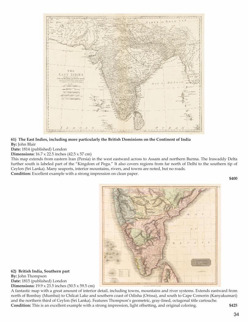
62) British India, Southern partBy: John ThompsonDate: 1815 (published) LondonDimensions: 19.9 x 23.5 inches (50.5 x 59.5 cm)A fantastic map with a great amount of interior detail, including towns, mountains and river systems. Extends eastward from north of Bombay (Mumbai) to Chilcat Lake and southern coast of Odisha (Orissa), and south to Cape Comorin (Kanyakumari) and the northern third of Ceylon (Sri Lanka). Features Thompson’s geometric, gray-lined, octagonal title cartouche.Condition: This is an excellent example with a strong impression, light offsetting, and original coloring. $425
35
63) Tabula Asiae XII (Taprobana)By: Girolamo Ruscelli, Date: 1599 (Published) Venice, 1599Dimensions: 6.89 x 9.45 inches (17.5 cm x 24 cm) This antique map, while small is powerful in its simplicity. The text is in Latin and Italian. The sea is indicated by stippling. A small spouting sea monster is in the lower left quadrant. There is an inset on the left with a pictorial vignette of an elephant standing in front of a tall tree. Underneath is text explaining that the Taprobana of Ptolemy is the modern island of Sumatra, a source of taller and better elephants than anywhere else, as well as being the homeland of superior pepper. On the verso is text in Italian.Condition: Archival repairs to vertical center fold as well as a few bookworm holes at very edge of lower right margin corner. $450
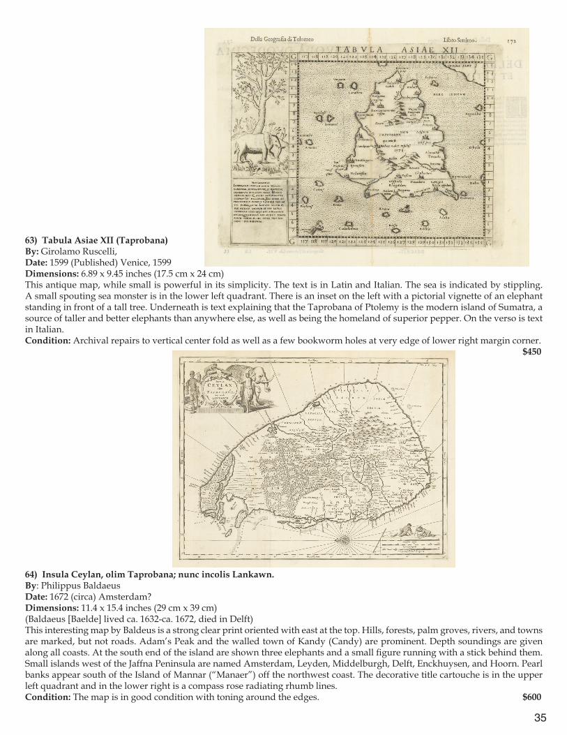
64) Insula Ceylan, olim Taprobana; nunc incolis Lankawn.By: Philippus BaldaeusDate: 1672 (circa) Amsterdam?Dimensions: 11.4 x 15.4 inches (29 cm x 39 cm) (Baldaeus [Baelde] lived ca. 1632-ca. 1672, died in Delft)This interesting map by Baldeus is a strong clear print oriented with east at the top. Hills, forests, palm groves, rivers, and towns are marked, but not roads. Adam’s Peak and the walled town of Kandy (Candy) are prominent. Depth soundings are given along all coasts. At the south end of the island are shown three elephants and a small figure running with a stick behind them. Small islands west of the Jaffna Peninsula are named Amsterdam, Leyden, Middelburgh, Delft, Enckhuysen, and Hoorn. Pearl banks appear south of the Island of Mannar (“Manaer”) off the northwest coast. The decorative title cartouche is in the upper left quadrant and in the lower right is a compass rose radiating rhumb lines.Condition: The map is in good condition with toning around the edges. $600
36
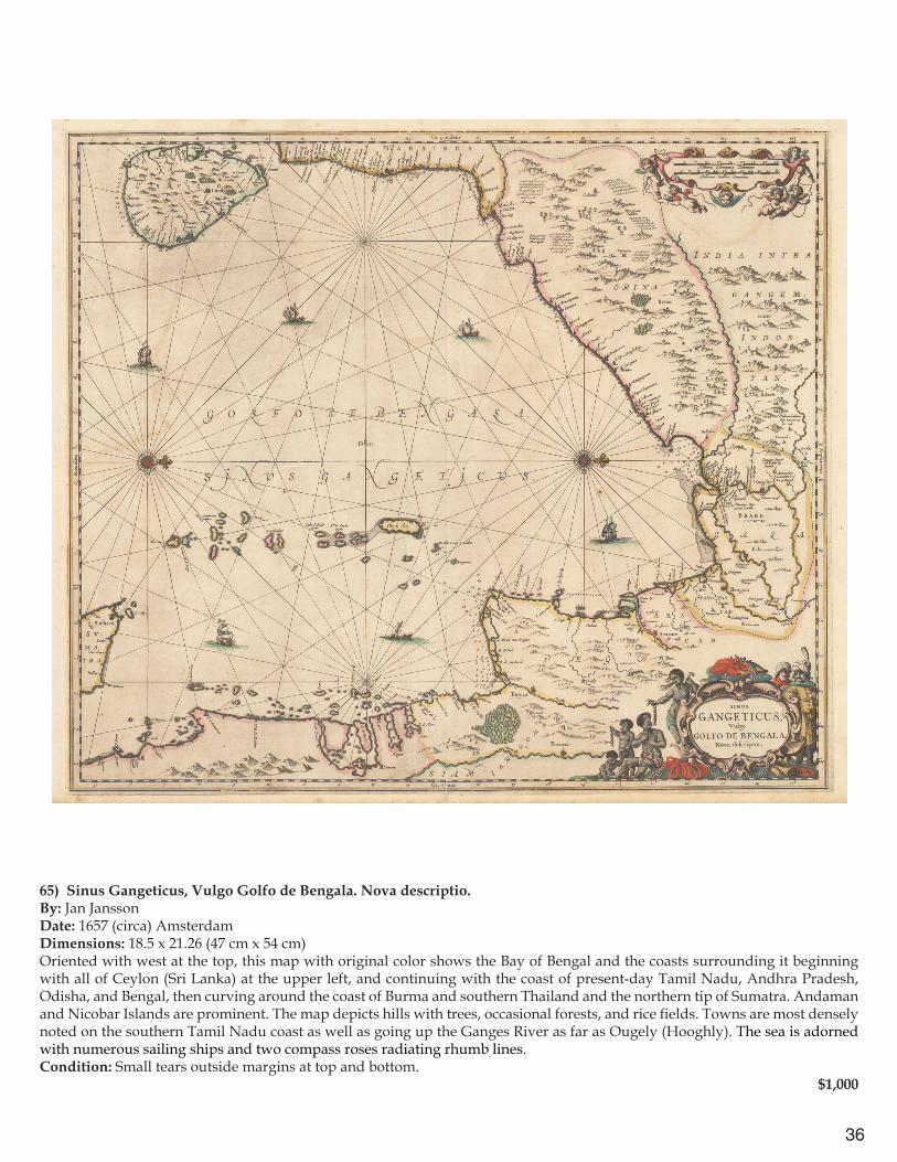
65) Sinus Gangeticus, Vulgo Golfo de Bengala. Nova descriptio.By: Jan JanssonDate: 1657 (circa) AmsterdamDimensions: 18.5 x 21.26 (47 cm x 54 cm) Oriented with west at the top, this map with original color shows the Bay of Bengal and the coasts surrounding it beginning with all of Ceylon (Sri Lanka) at the upper left, and continuing with the coast of present-day Tamil Nadu, Andhra Pradesh, Odisha, and Bengal, then curving around the coast of Burma and southern Thailand and the northern tip of Sumatra. Andaman and Nicobar Islands are prominent. The map depicts hills with trees, occasional forests, and rice fields. Towns are most densely noted on the southern Tamil Nadu coast as well as going up the Ganges River as far as Ougely (Hooghly). The sea is adorned with numerous sailing ships and two compass roses radiating rhumb lines.Condition: Small tears outside margins at top and bottom. $1,000
37
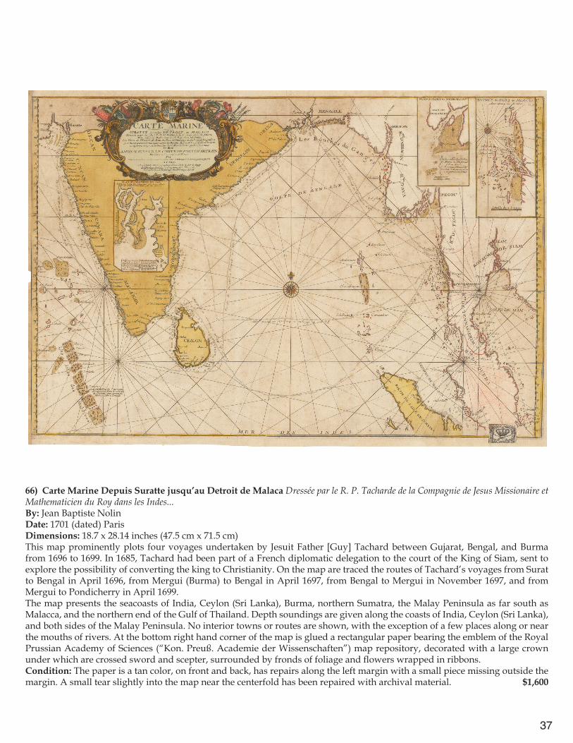
66) Carte Marine Depuis Suratte jusqu’au Detroit de Malaca Dressée par le R. P. Tacharde de la Compagnie de Jesus Missionaire et Mathematicien du Roy dans les Indes...By: Jean Baptiste NolinDate: 1701 (dated) ParisDimensions: 18.7 x 28.14 inches (47.5 cm x 71.5 cm) This map prominently plots four voyages undertaken by Jesuit Father [Guy] Tachard between Gujarat, Bengal, and Burma from 1696 to 1699. In 1685, Tachard had been part of a French diplomatic delegation to the court of the King of Siam, sent to explore the possibility of converting the king to Christianity. On the map are traced the routes of Tachard’s voyages from Surat to Bengal in April 1696, from Mergui (Burma) to Bengal in April 1697, from Bengal to Mergui in November 1697, and from Mergui to Pondicherry in April 1699. The map presents the seacoasts of India, Ceylon (Sri Lanka), Burma, northern Sumatra, the Malay Peninsula as far south as Malacca, and the northern end of the Gulf of Thailand. Depth soundings are given along the coasts of India, Ceylon (Sri Lanka), and both sides of the Malay Peninsula. No interior towns or routes are shown, with the exception of a few places along or near the mouths of rivers. At the bottom right hand corner of the map is glued a rectangular paper bearing the emblem of the Royal Prussian Academy of Sciences (“Kon. Preuß. Academie der Wissenschaften”) map repository, decorated with a large crown under which are crossed sword and scepter, surrounded by fronds of foliage and flowers wrapped in ribbons. Condition: The paper is a tan color, on front and back, has repairs along the left margin with a small piece missing outside the margin. A small tear slightly into the map near the centerfold has been repaired with archival material. $1,600
38
67) Route exacte de Gamron à Batavia et de Batavia à GamronBy: Cornelius de Bruyn (de Bruijn; Corneille le Bruin)Date: 1714 (circa) DelftDimensions: 9.25 x 11.8 inches (23.5 cm x 30 cm)This attractive map extends from the entrance to the Persian Gulf in the northwest, across the equator to the tip of Java. The map illustrates the round-trip route of a voyage to Batavia, Java, from Gamron in the Persian Gulf. Gamron is the name of present-day Bandar Abbas, Iran. (It is derived from the Portuguese Cambarão and Porto Comorão; also known as Gombroon to English traders and Gamrun or Gumrun to Dutch traders.) The outward voyage takes a more northerly route via Cochin and Galle; the return voyage goes westward a long distance south of the equator, then veers northward to the coast of Oman. It provides an attractive conjectural depiction of mountain ranges in India, Ceylon (Sri Lanka), the Malay Peninsula, Sumatra, Thailand, and Cambodia. Some major seaports, rivers, and inland towns are marked.Condition: Excellent condition, clear dark impression $250
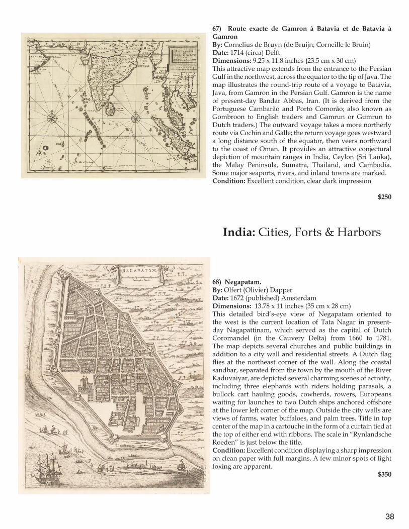
India: Cities, Forts & Harbors
68) Negapatam.By: Olfert (Olivier) DapperDate: 1672 (published) AmsterdamDimensions: 13.78 x 11 inches (35 cm x 28 cm)This detailed bird’s-eye view of Negapatam oriented to the west is the current location of Tata Nagar in present-day Nagapattinam, which served as the capital of Dutch Coromandel (in the Cauvery Delta) from 1660 to 1781. The map depicts several churches and public buildings in addition to a city wall and residential streets. A Dutch flag flies at the northeast corner of the wall. Along the coastal sandbar, separated from the town by the mouth of the River Kaduvaiyar, are depicted several charming scenes of activity, including three elephants with riders holding parasols, a bullock cart hauling goods, cowherds, rowers, Europeans waiting for launches to two Dutch ships anchored offshore at the lower left corner of the map. Outside the city walls are views of farms, water buffaloes, and palm trees. Title in top center of the map in a cartouche in the form of a curtain tied at the top of either end with ribbons. The scale in “Rynlandsche Roeden” is just below the title.Condition: Excellent condition displaying a sharp impression on clean paper with full margins. A few minor spots of light foxing are apparent. $350
39
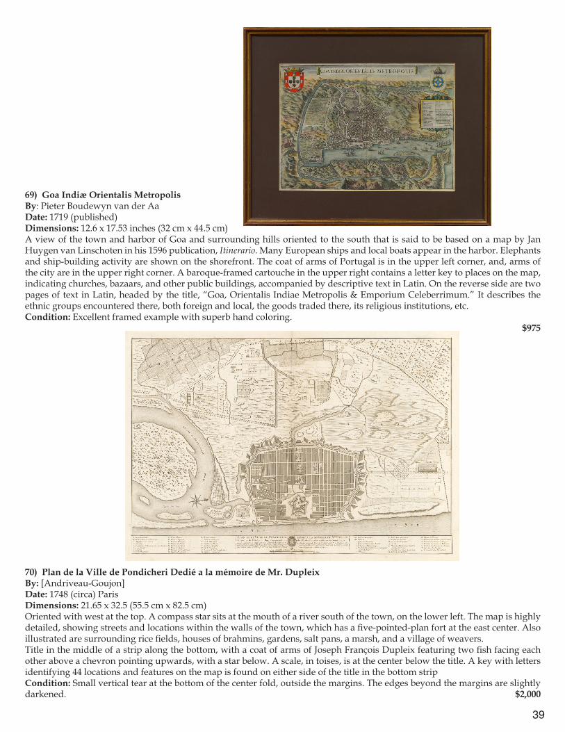
69) Goa Indiæ Orientalis MetropolisBy: Pieter Boudewyn van der AaDate: 1719 (published)Dimensions: 12.6 x 17.53 inches (32 cm x 44.5 cm) A view of the town and harbor of Goa and surrounding hills oriented to the south that is said to be based on a map by Jan Huygen van Linschoten in his 1596 publication, Itinerario. Many European ships and local boats appear in the harbor. Elephants and ship-building activity are shown on the shorefront. The coat of arms of Portugal is in the upper left corner, and, arms of the city are in the upper right corner. A baroque-framed cartouche in the upper right contains a letter key to places on the map, indicating churches, bazaars, and other public buildings, accompanied by descriptive text in Latin. On the reverse side are two pages of text in Latin, headed by the title, “Goa, Orientalis Indiae Metropolis & Emporium Celeberrimum.” It describes the ethnic groups encountered there, both foreign and local, the goods traded there, its religious institutions, etc.Condition: Excellent framed example with superb hand coloring. $975
70) Plan de la Ville de Pondicheri Dedié a la mémoire de Mr. Dupleix By: [Andriveau-Goujon]Date: 1748 (circa) ParisDimensions: 21.65 x 32.5 (55.5 cm x 82.5 cm) Oriented with west at the top. A compass star sits at the mouth of a river south of the town, on the lower left. The map is highly detailed, showing streets and locations within the walls of the town, which has a five-pointed-plan fort at the east center. Also illustrated are surrounding rice fields, houses of brahmins, gardens, salt pans, a marsh, and a village of weavers.Title in the middle of a strip along the bottom, with a coat of arms of Joseph François Dupleix featuring two fish facing each other above a chevron pointing upwards, with a star below. A scale, in toises, is at the center below the title. A key with letters identifying 44 locations and features on the map is found on either side of the title in the bottom stripCondition: Small vertical tear at the bottom of the center fold, outside the margins. The edges beyond the margins are slightly darkened. $2,000
40
71) Madraz et le Fort St. Georges Pris par les François commandés par Mr. Mahé de la Bourdonnais Le 21 Septembre 1746.By: [Mahé de la Bourdonnais]Date: 1746 (Published)Dimensions: 14.4 x 19.7 inches (36.5 cm x 50 cm) (55.5 cm with key)This map of a French military fort in Madras that shows three types of vessels at sea, including seven European ships (three named) that took part in the 1746 siege, three European launches, and seven indigenous rowboats. A key, in a column along the entire left side of the map, lists 28 features shown, including details of the fortress’s structure, names of ships that laid siege, buildings and neighborhoods destroyed during the 1746 battle in which the French took the town. A prominent compass rose adorns the upper left corner while an oval baroque framed title cartouche can be found in the lower right. Condition: Very good condition with a small tear and some light foxing in the left margin, which has been trimmed. $350
72) The Environs of Madras.By: W. FadenDate: 1816 (Published) LondonDimensions: 31.3 x 23.82 (79.5 cm x 60.5 cm) A superb and scarce steel plate engraving (plate no. 13) of Madras and its surrounding area heightened with exceptional blue original color that indicates the seacoast, waterways, and reservoirs. This exceedingly detailed street plan with surrounding fields includes farms, and in the suburbs, several houses identified by names of their owners. The map includes Fort St. George, Black Town, Chindadrapett, Triplicane, St. Tome or Milapoor.Condition: Small tears outside margins mended with tape and light offsetting in Bay of Bengal; previously folded into four. $1,450
41
73) A Plan of Bombay–Harbour, on the coast of Malabar, Shewing the true Situation of all the Rocks, Sands & Shoals, with the Marks to Avoid them. The true setting of the Tides the Times of High Water with the Depths at High & Low Water. Likewise the Marks for the Best Anchoring Grounds and all other necessary Directions & ca. By William Nicholson. Master of His Majesty’s Ship Elizabeth.By: Robert Sayer and John BennettDate: 1778 (Published) LondonDimensions: 18.9 x 31.3 inches (48 cm x 79.5 cm) This map of the harbor of Bombay, oriented to the east, includes views of the coast from the sea at several locations. An inset titled “Plan of the Town of Bombay” gives details of the layout of Bombay’s walled fort and settlement as well as surrounding Dungeree Town and Madagascar Town. A key identifies 13 features of the fort, including its storehouse, gates, and wharf. Below that inset is a boxed column containing extensive text headed “References to the Harbour” and includes information on several navigational hazards detailed within the map. A long text at Tull Point recounts an episode in 1761 during the southwest monsoon when His Majesty’s Ship Medway narrowly escaped being lost on a nearby rocky shoal. Condition: Strong impression on heavy paper with full margins. Slight offsetting and foxing throughout. $550
74) A New and Accurate Chart of Bombay Harbor drawn from the latest authorities for William Heather. A new edition, With considerable Improvements by J. W. Norie, Hydrographer, &c.By: J.W. NorieDate: 1820 (circa) LondonDimensions: 25.2 x 31.3 inches (64 cm x 79.5 cm) Oriented with east at the top, this highly detailed navigation chart offers extensive information on depth soundings, indications of sand bars, and notations on lines of sight to landmarks, as well as several views of the coast and Bombay Fort as seen from the sea. A note states that the depth soundings are in fathoms taken at low tide and that spring tides rise some 15 feet above that. Two compass stars radiate rhumb lines. The scale, below the coastal views, is in nautical miles. The mainland, labeled “The Continent,” has the statement, “This Coast is not frequented by Europeans.” Title with elaborate calligraphy is in the upper right.Condition: Steel plate engraving. Some fraying and darkening along the margins. $550
42
75) CalcuttaBy: SDUKDate: 1852 (published) London Dimensions: 12.2 x 16 inches (31 x 40.5 cm) This steel plate engraving displays the locations of individual structures throughout the city of Calcutta. A legend includes extensive listing identifying important public buildings, churches, and chapels. Three insets at the bottom depict the Writers Buildings (with a monument, bullock cart, and water carrier in foreground); Government House (with local inhabitants, cows, and herons in foreground); Esplanade Row, with the river, sailing ships, Government House, and palanquin bearers). Fort William is indicated in pink, Esplanade in green, Hoogly River and pools of water in blue.Condition: Excellent condition on flawless paper with original coloring.
$250
76) Jadid Naksha Shahar Haidarabad (Modern Map of the City of Hyderabad and Region)By: AnonymousDate: 1965 (circa) Hyderabad, Andhra Pradesh, Idarat Intejami, CharminarDimensions: 22.24 x 18.11 (56.5 cm x 46 cm) This striking pink color lithograph in Urdu shows Hyderabad City with the streets in yellow; old city walls, railways, and landmarks in black; and bodies of water in gray. Title is above the map on the upper right, with the scale explained as 1 inch equaling 200 feet. A large block of adjacent explanatory text in three quarters of the upper left includes descriptions of major government buildings, mosques, temples, publications, railway stations, educational institutions, and languages. Key in lower right corner explains symbols used on the map.Condition: Good condition. Fold separation in upper right quadrant. Borders trimmed to map edges on top and bottom, with sides wider. $200
43
India: Miniatures
77) Narsinga et Ceylon By: Petrus BertiusDate: 1618 (Published) AmsterdamDimensions: 3.35 x 4.9 inches (8.5 cm x 12.5 cm) A Highly decorative map from the Latin edition of Tabularum Geographicarum. It depicts India from Goa southward as well as Ceylon (Sri Lanka) and the Maldives. Many coastal towns are marked, such as Mangalor, Cananor, Cranganor, Cochin, Negapatam, Maliapor ubi S. Thomas sepultus esse dicitur (Mylapore where St. Thomas is said to be buried, i.e. present-day Chennai). Some sandbanks are indicated as well as interior mountain ranges, schematically.Condition: Excellent condition with a strong impression. $250
78) Bengala By: Petrus Bertius,Date: 1618 (published) AmsterdamDimensions: 3.75 x 5.1 inches (9.5 x 13 cm)This miniature map of the Bay of Bengal appeared in a French edition of the miniature atlas Tabularum Geographicam. Towns are mostly on the coast but some are inland. The sea is stylized in sets of zigzag lines. On the reverse, page 731, is a section of text in French headed “Description de Narsinge,” describing, among other things, kingdoms in southern India, their armies with horses and elephants, products such as pearls and diamonds, the custom of widow burning, and the Portuguese in Goa. Title is in a baroque cartouche at bottom center, with a gargoyle at the top and a sea monster to its left.Condition: Excellent condition with lovely hand coloring. $250
44
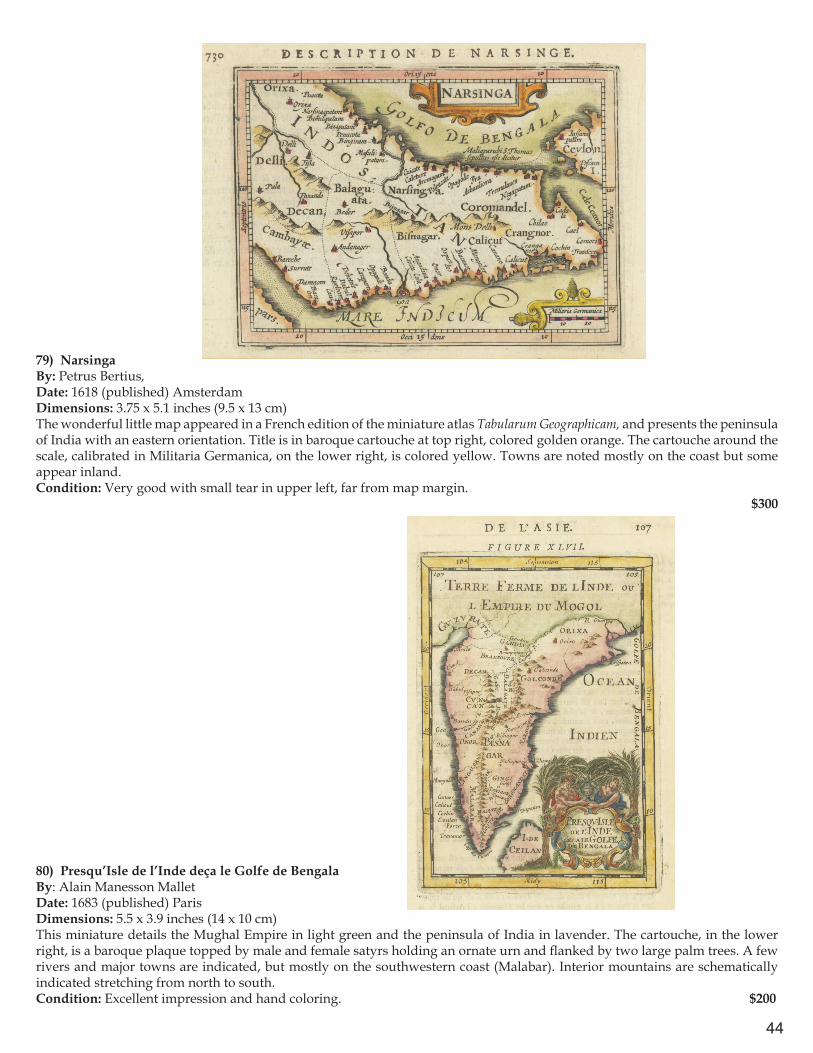
79) Narsinga By: Petrus Bertius,Date: 1618 (published) AmsterdamDimensions: 3.75 x 5.1 inches (9.5 x 13 cm)The wonderful little map appeared in a French edition of the miniature atlas Tabularum Geographicam, and presents the peninsula of India with an eastern orientation. Title is in baroque cartouche at top right, colored golden orange. The cartouche around the scale, calibrated in Militaria Germanica, on the lower right, is colored yellow. Towns are noted mostly on the coast but some appear inland. Condition: Very good with small tear in upper left, far from map margin.
$300
80) Presqu’Isle de l’Inde deça le Golfe de Bengala By: Alain Manesson MalletDate: 1683 (published) ParisDimensions: 5.5 x 3.9 inches (14 x 10 cm)This miniature details the Mughal Empire in light green and the peninsula of India in lavender. The cartouche, in the lower right, is a baroque plaque topped by male and female satyrs holding an ornate urn and flanked by two large palm trees. A few rivers and major towns are indicated, but mostly on the southwestern coast (Malabar). Interior mountains are schematically indicated stretching from north to south. Condition: Excellent impression and hand coloring. $200
45
Asia & Oceania
81) Asiæ Descriptio Nova Impensis Annæ Seile, 1663By: Anna SeileDate: 1663 (Published) Paris (Engraved by Johan Goddard)Dimensions: 13.19 x 17.12 inches (33.5 cm x 43.5) This attractive and colorful map of Asia stretches from Moscow in Russia across to Korea and Japan, including Turkey, Arabia, Persia, Afghanistan, India, Ceylon (Sri Lanka), mainland Southeast Asia, Sumatra, Borneo, the Celebes, and the western tip of New Guinea. The map shows large regions and islands color coded and presents a small title cartouche in a baroque frame in the upper right corner. Labeling is in Latin. The map is embellished with two European sailing ships, one in the Indian Ocean and the other in the Pacific east of Formosa (Taiwan) and the Philippines. The Great Wall of China is prominently marked with a schematic wall. An elephant is shown north of Bengal above a fictitious lake that was believed to be the source of the massive river delta. Condition: Trimmed to its margins, the map has additional paper added on all four sides $500
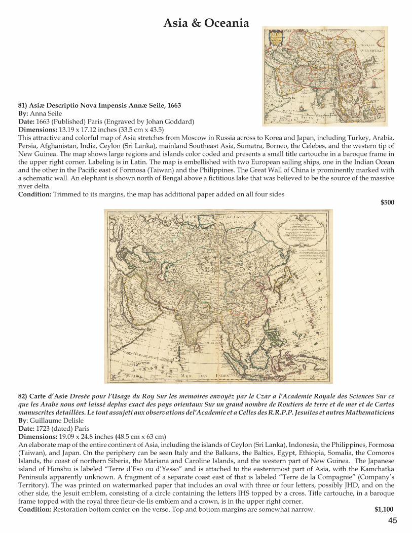
82) Carte d’Asie Dresée pour l’Usage du Roy Sur les memoires envoyéz par le Czar a l’Academie Royale des Sciences Sur ce que les Arabe nous ont laissé deplus exact des pays orientaux Sur un grand nombre de Routiers de terre et de mer et de Cartes manuscrites detaillées. Le tout assujeti aux observations del’Academie et a Celles des R.R.P.P. Jesuites et autres Mathematiciens By: Guillaume Delisle Date: 1723 (dated) ParisDimensions: 19.09 x 24.8 inches (48.5 cm x 63 cm) An elaborate map of the entire continent of Asia, including the islands of Ceylon (Sri Lanka), Indonesia, the Philippines, Formosa (Taiwan), and Japan. On the periphery can be seen Italy and the Balkans, the Baltics, Egypt, Ethiopia, Somalia, the Comoros Islands, the coast of northern Siberia, the Mariana and Caroline Islands, and the western part of New Guinea. The Japanese island of Honshu is labeled “Terre d’Eso ou d’Yesso” and is attached to the easternmost part of Asia, with the Kamchatka Peninsula apparently unknown. A fragment of a separate coast east of that is labeled “Terre de la Compagnie” (Company’s Territory). The was printed on watermarked paper that includes an oval with three or four letters, possibly JHD, and on the other side, the Jesuit emblem, consisting of a circle containing the letters IHS topped by a cross. Title cartouche, in a baroque frame topped with the royal three fleur-de-lis emblem and a crown, is in the upper right corner.Condition: Restoration bottom center on the verso. Top and bottom margins are somewhat narrow. $1,100
46
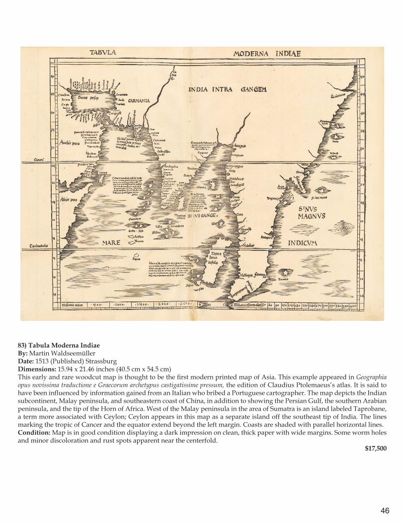
83) Tabula Moderna IndiaeBy: Martin WaldseemüllerDate: 1513 (Published) StrassburgDimensions: 15.94 x 21.46 inches (40.5 cm x 54.5 cm) This early and rare woodcut map is thought to be the first modern printed map of Asia. This example appeared in Geographia opus novissima traductione e Graecorum archetypus castigatissime pressum, the edition of Claudius Ptolemaeus’s atlas. It is said to have been influenced by information gained from an Italian who bribed a Portuguese cartographer. The map depicts the Indian subcontinent, Malay peninsula, and southeastern coast of China, in addition to showing the Persian Gulf, the southern Arabian peninsula, and the tip of the Horn of Africa. West of the Malay peninsula in the area of Sumatra is an island labeled Taprobane, a term more associated with Ceylon; Ceylon appears in this map as a separate island off the southeast tip of India. The lines marking the tropic of Cancer and the equator extend beyond the left margin. Coasts are shaded with parallel horizontal lines.Condition: Map is in good condition displaying a dark impression on clean, thick paper with wide margins. Some worm holes and minor discoloration and rust spots apparent near the centerfold. $17,500
47
84) Deliniantur in hac tabula, Orae maritimae Abexiae, freti Mecani: al. Maris Rubri: Arabiae Freti Mecani: al Maris Rubri: Arabiae, Ormi, Persiae, Supra Sindam usque . . .By: Jan Huygen van LinschotenDate: 1596 (Published) AmsterdamDimensions: 15 x 21 inches (38 cm x 53.5 cm)This attractive map was derived from earlier Portuguese portolan charts of the 16th century. Not only does the lavish style with the inclusion of sea monsters, sailing ships, terrestrial animals, and an intricately detailed compass rose resemble that of such charts, but the geographical information obtained undoubtedly came from early Portuguese sources. The map depicts several areas with incredible accuracy for its era. One such area worth noting is the shape of the Persian Gulf and Arabian Peninsula which far more closely resembles the shape and size of modern maps than other examples from the same time period.
While working as a personal secretary to the Portuguese Archbishop of Goa (1583–1589), Linschoten obtained numerous maps and documents from various Portuguese sources. In 1589, while traveling back to Portugal from Goa, Linschoten’s ship was pursued by an English fleet and lost its cargo during a storm while anchored off the Azores. Linschoten spent two years in Terceira (Tercera) after being persuaded to help recover the cargo and prepare notes from his time in Goa. A few years after his return home to the Netherlands, he published his maps in Itinerario, which would aid the Dutch and the English in discovering trade routes to Asia. The discovery of these routes would ultimately break the century-long trade monopoly controlled by the Portuguese. Linschoten’s experiences and the publication of maps that followed would ultimately become one of the most important travel works of the era.Condition: Facsimile restoration along the top margin; expertly mounted; small paper pull in the lower left corner. Map displays an excellent dark impression. $6,500

48
85) India OrientalisBy: Jodocus Hondius Date: 1606 / 1613 (published) AmsterdamDimensions: 16.5 x 20.5 inches (42 x 52 cm) This elegant map by Hondius depicts India, Southeast Asia, China (south of Fujian), and the Philippines, as well as Ceylon (Sri Lanka), the Maldives, Andamans, northern Sumatra, and northern Borneo. Seaport towns are most densely noted along the coasts of India. The Singapore Strait appears to be misunderstood as a narrow channel cutting through the southern tip of the Malay Peninsula. Several false lakes are included in Chinae and India Extra Gangem. This fantastic work is embellished with two strapwork cartouches, a decorative distance scale, and vignettes of an oriental junk, a European sailing vessel and a ferocious sea monster in the Bay of Bengal. This map is from an edition of 1613 with Latin text on the verso, pages 346-347.Condition: Map is in very good condition with full margins and superb hand coloring.
$3,250
86) [Untitled map of southern Asia and the Indian Ocean]By: William HoleDate: 1614 (Published) LondonDimensions: 9.8 x 14.96 inches (25 cm x 38 cm) This lovely map extends from Anatolia eastward all the way to China, including Arabia, Persia, India, Malaya, and Sumatra. The shape of the Indian peninsula is shown as roughly triangular, not reflecting more accurate knowledge of the region. Also shown are Egypt and the horn of Africa with the northern end of Madagascar. An extended mountain chain is identified as Ararat and Noah’s Ark (“The Arck”) is shown in Central Asia. Numerous major cities are marked in red, combine contemporary ports such as Aden, Goa, and Calecut with historical Babilon and Bactria. Five cities named Alexandria are shown. In two places long lines of marching soldiers with spears are labeled, “The Passage of Nimrod” (a reference to the Biblical ruler of Babel who built Nineveh), and “The passage of Ophir & Hauilah into India” (also figures in the Bible).Condition: Small area of foxing in the area of the Euphrates River and a minor hole in northwest Turkey. $750

49
87) Carte Particuliere d’une Partie d’Asie ou sont les Isles d’Andemaon, Ceylan, les Maldives.Dressé sur les Memoires le Plus Nouveaux.By: Pierre MortierDate: 1700 (Dated) AmsterdamDimensions: 23.42 x 34.64 inches (59.5 cm x 88 cm) Fantastic example of Mortier’s map of the Asian Subcontinent, Arabian Peninsula, and Horn of Africa. This map has two titles of apparently equal weight. Each cartouche includes scales of French, Spanish, and German leagues. There are two compass roses, one in the Arabian Sea off the coast of the Horn of Africa and the other south of the Bay of Bengal. While much interior detail is provided, the map’s focus is on sea navigation. Multiple rhumb lines crisscross the waters, and great detail is offered on island chains, such as the Maldives, Andamans, Nicobars, Seychelles (Amirante), and Socotra. Sandbars and shallow seas are indicated with stippling in such coastal areas as the Indus Delta, the Persian Gulf, and the Red Sea.Condition: Excellent condition with minor fold separations at the top and bottom that do not enter image. Map presents itself with bright original coloring on clean paper. $2,500
88) A General Mapp of the East Indies Comprehending the Estats or Kingdoms of the Great Mogol, the Kingdoms & Estats of Decan, Golconde, Bisnagar, Malabar & in the Peninsula of India without the Ganges.& the Kingdoms Isles of Pegu, Sian, Malacca, Cochinchina & in the Peninsula of India within the Ganges with the Isles of Maldives.By: Ric: BlomeDate: 1667 / 1670 (published) LondonDimensions: 13.8 x 13.2 inches (35 x 33.5 cm) This map extends from above Kabul in the northwest to below the equator, and from the eastern border of Persia to the western end of Borneo, including all of Indochina, the Malay Peninsula, and a large part of Sumatra. The title cartouche in the upper right corner is surrounded by a decorative rectangular frame. Under the map proper is a large dedication “To the Honorable the Governer Deputy and Court of Committies of the Company of Marchants tradeing in to the East Indies.” The map displays conjectural courses of rivers and interior mountain ranges and towns. In the seas are three European sailing ships and two sea monsters. Condition: Restoration along left side, just beyond margin and some offsetting in the lower half. Original color. $750
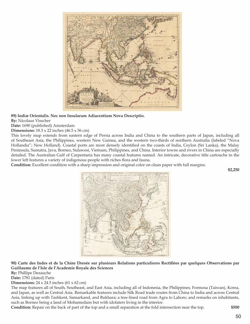
50
89) Indiæ Orientalis. Nec non Insularum Adiacentium Nova Descriptio.By: Nicolaus VisscherDate: 1690 (published) AmsterdamDimensions: 18.3 x 22 inches (46.5 x 56 cm) This lovely map extends from eastern edge of Persia across India and China to the southern parts of Japan, including all of Southeast Asia, the Philippines, western New Guinea, and the western two-thirds of northern Australia (labeled “Nova Hollandia”; New Holland). Coastal ports are most densely identified on the coasts of India, Ceylon (Sri Lanka), the Malay Peninsula, Sumatra, Java, Borneo, Sulawesi, Vietnam, Philippines, and China. Interior towns and rivers in China are especially detailed. The Australian Gulf of Carpentaria has many coastal features named. An intricate, decorative title cartouche in the lower left features a variety of indigenous people with riches flora and fauna. Condition: Excellent condition with a sharp impression and original color on clean paper with full margins.
$2,250
90) Carte des Indes et de la Chine Dresée sur plusieurs Relations particulieres Rectifiées par quelques Observations par Guillaume de l’Isle de l’Academie Royale des SciencesBy: Phillipe DezaucheDate: 1781 (dated) ParisDimensions: 24 x 24.5 inches (61 x 62 cm) The map features all of South, Southeast, and East Asia, including all of Indonesia, the Philippines, Formosa (Taiwan), Korea, and Japan, as well as Central Asia. Remarkable features include Silk Road trade routes from China to India and across Central Asia, linking up with Tashkent, Samarkand, and Bukhara; a tree-lined road from Agra to Lahore; and remarks on inhabitants, such as Borneo being a land of Mohamedans but with idolaters living in the interior.Condition: Repair on the back of part of the top and a small separation at the fold intersection near the top. $500

51
91) A New General Map of the East Indies. Exhibiting in the Peninsula on this side of the Ganges or Hindoostan the Several partitions of the Mogul’s Empire…By: Thomas Jefferys Published by: Laurie & WhittleDate: 1794 (dated) LondonDimensions: 22.5 x 23.2 inches (57 x 69 cm)This map extends from southeastern Persia eastward across Afghanistan, Kashmir, Tibet and southern China and Hainan Island, and all of the Indian Peninsula, Ceylon (Sri Lanka), mainland Southeast Asia to south of the Straits of Singapore, including the northern end of Sumatra and a western corner of Borneo. Many interior mountains, rivers, towns, and roads are detailed. In a few places there are comments, such as (along coast of Cambodia) “Cancar or Ponthiamas a Little Kingdom founded about 50 years ago by Kiang-tse a Chinese Mercht”; (inland central Vietnam) Mountains inhabited by the Wild Nation called Ke-moy”; (Sambalpur, Odisha) “Sumbulpour a Diamond Mine.”Condition: Paper in moderate condition with original color. There are several small tears on edges of paper outside margins, centerfold repairs on the verso.
$2,500

52
92) Dai Nihon hayabiki saiken ezu. Bunkyū 3 (Quick Reference Detailed Illustrated Map of Great Japan Distance to important temples in Yamato)By: Ezuya Shōhachi Engraved by: Nakazawa Hachibē in OsakaDate: 1863 (published) NaraDimensions: 14 x 69.5 inches (35.5 x 176.5 cm)This folding map of routes in Japan extends from the island of Honshu, past the Inland Sea and Shikoku, to Kyushu. Ships and waves are shown on the water, as well as mountains and several ferry routes. A key explains that salmon-colored circles contain the names of famous temples and palaces; yellow rectangles contain names of daimyo near their castles plus their stipend in rice from the shogun; black ovals surround names of provinces; rounded cartouche-shaped boxes indicate names of places for travelers to stop; small black triangles mark the sites of provincial borders; and gate-shaped hatch-marks indicate check points. In addition, a salmon-colored route is a pilgrimage way along the Bando Road; double-lined routes indicate seven roads in the Kenai region; dark black roads are the Yamato route. On Shikoku, tall salmon colored rectangles contain the names of pilgrimage spots. The map is presented with a westward orientation. Condition: Woodcut on mulberry paper with original color. Map exhibits wear from use.
$3,500

53
93) A General Map Comprizing China, Chinese-Tartary & Tibet: drawn from the Particular Maps of the Jesuits together with the Countries between Kashgar and the Caspian Sea laid down according to the Oriental Geographers & Historians By the Sieur d’Anville, Geographer in ordinary to the King of France 1734By: Jean Baptiste Bourguignon d’AnvilleDate: 1734 (dated) LondonDimensions: 18.5 x 27 inches (47 x 68.5 cm)An important 18th century map compiled from extensive Jesuit surveys carried out for the Emperor Kangxi between 1708 and 1718. The map depicts the whole of China and Korea, as well as Central Asia adjacent to the Caspian Sea. It extends as far northeast as Manchuria and the Amur River, including Korea, and southwest across Tibet as far as Ladakh. The entire course of the Great Wall is plotted. Explanatory text attests to the great care taken in checking the latitude and longitude of places represented, indicating various methods by a system of underlining. Decorative title and scale of miles cartouches with several textual tables of information fill in the empty spaces of the map.Condition: Very good condition, issued folded with evidence of wear to the paper at lower fold intersection. A subtle rolled center fold is apparent.
$17,500
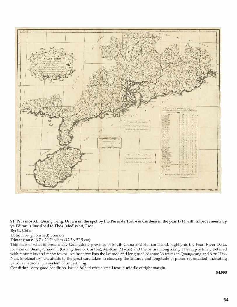
54
94) Province XII. Quang Tong. Drawn on the spot by the Peres de Tartre & Cordoso in the year 1714 with Improvements by ye Editor, is inscribed to Thos. Medlycott, Esqr.By: G. ChildDate: 1738 (published) LondonDimensions: 16.7 x 20.7 inches (42.5 x 52.5 cm)This map of what is present-day Guangdong province of South China and Hainan Island, highlights the Pearl River Delta, location of Quang-Chew-Fu (Guangzhou or Canton), Ma-Kau (Macao) and the future Hong Kong. The map is finely detailed with mountains and many towns. An inset box lists the latitude and longitude of some 36 towns in Quang-tong and 6 on Hay-Nan. Explanatory text attests to the great care taken in checking the latitude and longitude of places represented, indicating various methods by a system of underlining. Condition: Very good condition, issued folded with a small tear in middle of right margin.
$4,500
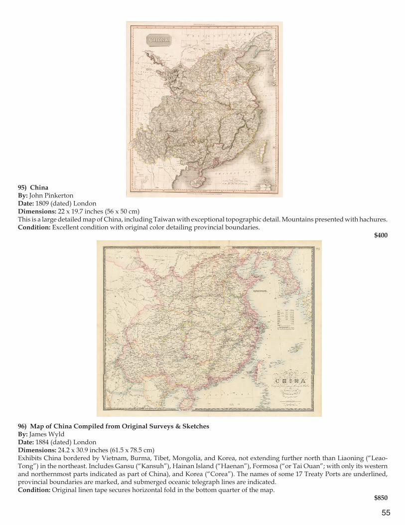
55
95) ChinaBy: John PinkertonDate: 1809 (dated) LondonDimensions: 22 x 19.7 inches (56 x 50 cm)This is a large detailed map of China, including Taiwan with exceptional topographic detail. Mountains presented with hachures.Condition: Excellent condition with original color detailing provincial boundaries.
$400
96) Map of China Compiled from Original Surveys & Sketches By: James Wyld Date: 1884 (dated) London Dimensions: 24.2 x 30.9 inches (61.5 x 78.5 cm)Exhibits China bordered by Vietnam, Burma, Tibet, Mongolia, and Korea, not extending further north than Liaoning (“Leao-Tong”) in the northeast. Includes Gansu (“Kansuh”), Hainan Island (“Haenan”), Formosa (“or Tai Ouan”; with only its western and northernmost parts indicated as part of China), and Korea (“Corea”). The names of some 17 Treaty Ports are underlined, provincial boundaries are marked, and submerged oceanic telegraph lines are indicated.Condition: Original linen tape secures horizontal fold in the bottom quarter of the map.
$850
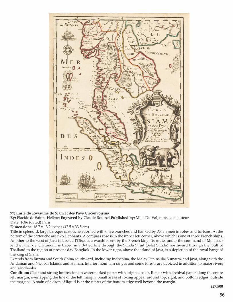
56
97) Carte du Royaume de Siam et des Pays CirconvoisinsBy: Placide de Sainte-Hélène; Engraved by Claude Roussel Published by: Mlle. Du Val, niesse de l’auteurDate: 1686 (dated) ParisDimensions: 18.7 x 13.2 inches (47.5 x 33.5 cm)Title in splendid, large baroque cartouche adorned with olive branches and flanked by Asian men in robes and turbans. At the bottom of the cartouche are two elephants. A compass rose is in the upper left corner, above which is one of three French ships. Another to the west of Java is labeled l’Oiseau, a warship sent by the French king. Its route, under the command of Monsieur le Chevalier de Chaumont, is traced in a dotted line through the Sunda Strait (Selat Sunda) northward through the Gulf of Thailand to the region of present-day Bangkok. In the lower right, above the island of Java, is a depiction of the royal barge of the king of Siam.Extends from Burma and South China southward, including Indochina, the Malay Peninsula, Sumatra, and Java, along with the Andaman and Nicobar Islands and Hainan. Interior mountain ranges and some forests are depicted in addition to major rivers and sandbanks.Condition: Clear and strong impression on watermarked paper with original color. Repair with archival paper along the entire left margin, overlapping the line of the left margin. Small areas of foxing appear around top, right, and bottom edges, outside the margins. A stain of a drop of liquid is at the center of the bottom edge well beyond the margin.
$27,500

57
98) Carte de l’Ile de Java: partie Occidentale, partie Orientale, dressée tout nouvellement sur les mémoires les plus exacts[,] Avec une Table des principales ville de cette Ile, La situations des comptoirs & autres places qu’y possedent les Hollandois, et des Remarques très curieuses sur la maniere don’t ils se sont établis dans la Ville de BataviaBy: Henri Abraham ChatelainDate: 1719 (published) AmsterdamDimensions: 14 x 30.7 inches (35.5 x 78 cm)The map is richly illustrated with representations of roaming elephants and deer, pointed mountains, rice fields, and forests. Four European vessels are seen in the water, as well as three local sailboats. The map extends from the southeastern end of Sumatra, the entire length of the island of Java, with Madura Island at its northeast and the westernmost tip of Bali at the far right. An inset in the lower left corner, “Le Port de Batavia,” depicts the town of Batavia with its walls as well as the adjacent bay with its small islands and sandbanks. The inset is framed by a decorative border topped with a local inhabitant eating a piece of fruit next to various metal vessels, a tea-pot , and a parrot. At the bottom right corner of the frame is a local man with a pole leading an elephant, with a palm tree in the background.Condition: Watermarked paper with a small vertical separation along the center fold. $950
99) Karte vom Fünften Erdtheil oder Polynesien oder Australien od. Südindien entworfen von Friedrich Gottlieb CanzlerBy: Homanns Erben Date: 1806 (dated) NürnbergDimensions: (17.5 x 22.25 inches) 44.5 cm x 56.5 cm The coverage of the map is broad, reaching from southeastern and eastern Asia down to Australia, New Zealand, the Marquesas and Pitcairn Island, as well as the Hawaiian Islands (“Sandwich Inseln”). Interestingly, the coast of present-day South Australia is labeled unknown (“unbekante Küste”) as are parts of the southern and eastern coasts of New Guinea. The Indonesian archipelago and Philippine Islands are particularly densely labeled.Condition: Watermarked paper with some creases and original color. One repaired tear on left side; darkened vertical strip down the middle fold from repair or binding. $1,000
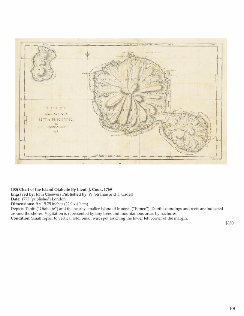
58
100) Chart of the Island Otaheite By Lieut. J. Cook, 1769Engraved by: John Cheevers Published by: W. Strahan and T. CadellDate: 1773 (published) LondonDimensions: 9 x 15.75 inches (22.9 x 40 cm)Depicts Tahiti (“Otaheite”) and the nearby smaller island of Moorea (“Eimeo”). Depth soundings and reefs are indicated around the shores. Vegitation is represented by tiny trees and mountainous areas by hachures.Condition: Small repair to vertical fold. Small wax spot touching the lower left corner of the margin.
$350
59
Atlases
101) A General Atlas For the Use of Schools Shewing the Principal Empires, Kingdoms & States, And all the recent Discoveries, With a Short Introduction to Geography; by John Adams, Teacher of the mathematics, Edmonton.By: Harvey & DartonDate: 1829 (Published) LondonDimensions: 40 pages of text, 27 map plates; page size 8.6 x 5 inches (22 cm x 13 cm); map size 7.4 x 9 inches (19 cm x 23 cm) [except for plate 1, Western and Eastern Hemispheres, 15.3 x 8 inches (39 x 20.5)]Maps are of Europe, England, Scotland, Ireland, Sweden, Denmark, Netherlands northern part, Netherlands southern part, France, Spain, Switzerland, Italy, Germany, Russia, Prussia, Turkey & Greece, Poland, Asia, Hindoostan, China, North America, United States, West Indies, South America, Africa, Geographical terms and figures exemplified. The map of North America includes Alaska as “Russian America.” The map of the United States shows the regions of present-day Texas, the Southwest, and California as part of Mexico and present-day Washington State (labeled “New Albion and New Georgia”) stretching above the 49th parallel.Condition: Slightly darkened paper, light offsetting. The map of Poland has an ink stain. The frontispiece map of Western and Eastern Hemispheres is separated on one vertical fold. Original binding, marbled paper covers, leather spine. Maps are in original color. $950
102) An Atlas of the Southern Part of India, including Plans of all the principal Towns & Cantonments, reduced from the Grand Trigonometrical Survey of India, shewing also the Tenasserim Provinces.Engraved by: J. & C. Walker, London Published by: Pharoah & CompanyDate: 1854 (dated) Madras Dimensions: approx. 9.4 x 7.8 inches (24 cm x 20 cm), some folding out to 9.4 x 18 inches (24 cm x 46 cm); 18.9 x 12.2 inches (48 cm x 31 cm); 13.5 x 21.4 inches (34.5 cm x 54.5 cm); etc.The atlas includes maps of 27 districts; 13 maps of Dominions of His Highness the Nizam, Ramisseram Island, 4 maps of Tenasserim provinces, Singapore, and 20 maps of towns and cantonments (including Bangalore, Madras, Hyderabad, Secunderabad, and Trichinopoly. The maps are highly detailed, with accurate placement of many small villages and main roads, hills, and rivers. Maps of towns and military cantonments indicate such local sites as forts, parade grounds, wells, lime kilns, burial grounds, churches, mosques, temples, bazaars, etc. The spelling of place names is somewhat idiosyncratic, as transliterated by English speakers not familiar with local languages.The district maps are all on the scale of 16 miles to 1 inch, or approximately 10 km to 1 cm (1:100,000).Condition: Good condition with original boards still bound. The top portion of the spine has been separated, but saved within the atlas. Maps are in original color. $1,400
Harlan J. Berk Ltd. 31 North Clark Street, Chicago, IL. 60602 | 312-609-0018 | www.hjbltd.com
Dealers in ancient coins, antiquities, U.S. coins, paper money, autographs, and bullion
`
Harlan J. Berk Ltd. 31 North Clark Street, Chicago, IL. 60602 | 312-609-0016 | www.hjbltd.comDealers in Antique Maps, U.S. & world coins, paper money, bullion, ancient coins and antiquities