Embed Size (px)
Citation preview
The importance of graphic representation in monastic hydraulics: Saint-Gall, Christchurch and Vallbona de les Monges
J. M. López López1, M. I. Pérez Millán2 & A. B. González Avilés2 1Department of Civil Engineering, University of Alicante, Spain 2Department of Building Constructions, University of Alicante, Spain
Abstract
In the fourth century Christian monasticism left the anchoritic lifestyle to begin a new monastic organization. These religious communities not only show us an architecture ruled by a monastic life, but also reveals some impressive hydraulic systems occasionally reflected in valuable drawings. From the first graphic document of Saint-Gall abbey, until the parchment of the Corb River (exclusively photographed at the scriptorium of Vallbona monastery), this work demonstrates that graphic representation of water supply systems has played a very important role throughout time. Thanks to these graphic documents we can currently know about other important aspects such as irrigation rights, water supply channels, hydraulic systems to pump water, etc. All these elements have become the only witnesses of an invisible architecture located under the ground, which has almost disappeared nowadays. Keywords: history, construction, hydraulic, cartography, Cistercian, monastery, abbey.
1 Introduction: the hydraulic need
At the end of the 11th century, rural society was under the power of a feudal class whose instability would be increased by the structural violence of its own economic, political and social organization. Meanwhile, the great ecclesiastic excesses would trigger the appearance of new monastic orders and groups of
www.witpress.com, ISSN 1743-3541 (on-line) WIT Transactions on Ecology and The Environment, Vol 200, © 2015 WIT Press
Water and Society III 377
doi:10.2495/WS150321
hermits calling back to the origins of Christianity in order to set up a climate of spiritual renovation. It is into this context when many orders such as the Benedictines and Cistercians initially, and later on the Trappists and Carthusians, retook the guidelines established in the Rule of Saint Benedict, looking for isolation and autarky to build their abbeys (the beginning of the western monasticism has to be located circa 500 A.D. when Saint Benedict of Nursia promoted austere monasticism. From that moment on, the famous Rule of Saint Benedict was the model to follow for most of the monastic orders because, from the beginning, it was not a strict regulation suitable for a particular order, but it could be fitted to different kinds of communities). Originally the Rule of Saint Benedict inserted an important concept trying to link the abbey to its environment. We can see an example of that in the Subiaco miracle described in the book II from the Dialogues of Grégoire le Grand circa 590–604 A.D: among all the monasteries built by Saint Benedict, three of them were placed on hills, and the monks who were living next to the Subiaco Lake had to descend there to bring up water, causing complaints from the whole community. Then Saint Benedict climbed the hill, prayed all night and finally placed three stones. The next day a natural spring emerged from the mountain and the fresh water started to flow down the slope. This event can be understood as a metaphor in which the three stones speak about the architecture implanted in the environment, and confirms the strong belief that with effort and prayers, water will always be attracted. When a new monastery was raised, this “effort” was the result of a long period of adaptation to the natural environment that could last about 20 years. Just after this period of time, the monks began the construction of the monastery using the solid stones that we can see nowadays. During those years, architecture was something secondary that could only be carried out once this first stage of adaptation and economic self-sufficiency were overcome. The main element to analyze during that time was the water. More than quantity, it was necessary to assure its regularity and caudal just to prevent floods and drought seasons. The importance of water supply could even affect the location of the monastery, its organization scheme or constructive system. Pressouyre et al. [2] suggest the existence of certain constructive models based on the location of the monastery and, it’s well known that, in some cases before the construction it was necessary to study the pipelines path, their slope and place the irrigation dams. Frequently a framework of stone crates filled with mortar and rubble was executed between the pipelines to raise the foundation of the monastery. One of the most interesting parts in the study of monastic hydraulics, is the way they needed to represent the hydraulic systems using parchments and drawings. As it can be seen throughout the examples analyzed, sometimes these plans were drawn in order to organize and distribute the different elements that conformed the hydraulic network. Some other times drawings were used to legally regulate the hours of irrigation or just to indicate where to build dams and
www.witpress.com, ISSN 1743-3541 (on-line) WIT Transactions on Ecology and The Environment, Vol 200, © 2015 WIT Press
378 Water and Society III
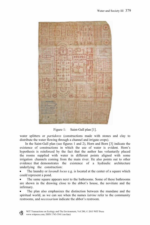
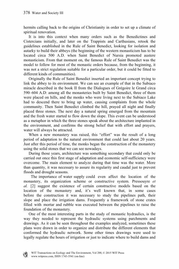
Figure 1: Saint-Gall plan [1].
water splitters or partidores (constructions made with stones and clay to distribute the water flowing through a channel and irrigate crops). In the Saint-Gall plan (see figures 1 and 2), Horn and Born [3] indicate the existence of constructions in which the use of water is evident. Horn’s hypothesis is reinforced by the fact that the author has voluntarily placed the rooms supplied with water in different points aligned with some irrigation channels coming from the main river. He also points out to other evidence that demonstrates the existence of a hydraulic architecture underlying the construction: The laundry or lavandi locus e.g. is located at the center of a square whichcould represent a pond. The same square appears next to the bathrooms. Some of these bathroomsare shown in the drawing close to the abbot’s house, the novitiate and the infirmary. The plan also emphasizes the distinction between the mundane and thespiritual world, as we can see when the names latrine refer to the community restrooms, and necessarium indicate the abbot’s restroom.
www.witpress.com, ISSN 1743-3541 (on-line) WIT Transactions on Ecology and The Environment, Vol 200, © 2015 WIT Press
Water and Society III 379
Walter Horn’s hypothesis was supported by several researchers, revealing in the parchment a range of items that could be understood as hydraulic resources and water supply systems.
Figure 2: Diagram made by researcher Horn and Born [3].
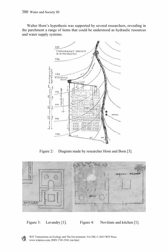
Figure 3: Lavandry [1]. Figure 4: Novitiate and kitchen [1].
www.witpress.com, ISSN 1743-3541 (on-line) WIT Transactions on Ecology and The Environment, Vol 200, © 2015 WIT Press
380 Water and Society III
2 Christchurch
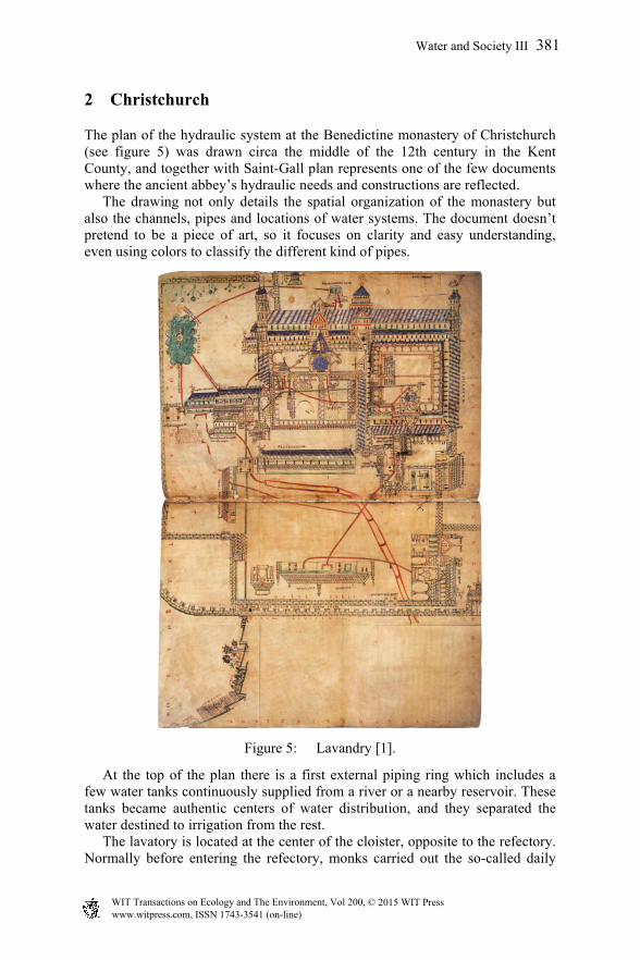
The plan of the hydraulic system at the Benedictine monastery of Christchurch (see figure 5) was drawn circa the middle of the 12th century in the Kent County, and together with Saint-Gall plan represents one of the few documents where the ancient abbey’s hydraulic needs and constructions are reflected. The drawing not only details the spatial organization of the monastery but also the channels, pipes and locations of water systems. The document doesn’t pretend to be a piece of art, so it focuses on clarity and easy understanding, even using colors to classify the different kind of pipes.
Figure 5: Lavandry [1].
At the top of the plan there is a first external piping ring which includes a few water tanks continuously supplied from a river or a nearby reservoir. These tanks became authentic centers of water distribution, and they separated the water destined to irrigation from the rest. The lavatory is located at the center of the cloister, opposite to the refectory. Normally before entering the refectory, monks carried out the so-called daily
www.witpress.com, ISSN 1743-3541 (on-line) WIT Transactions on Ecology and The Environment, Vol 200, © 2015 WIT Press
Water and Society III 381
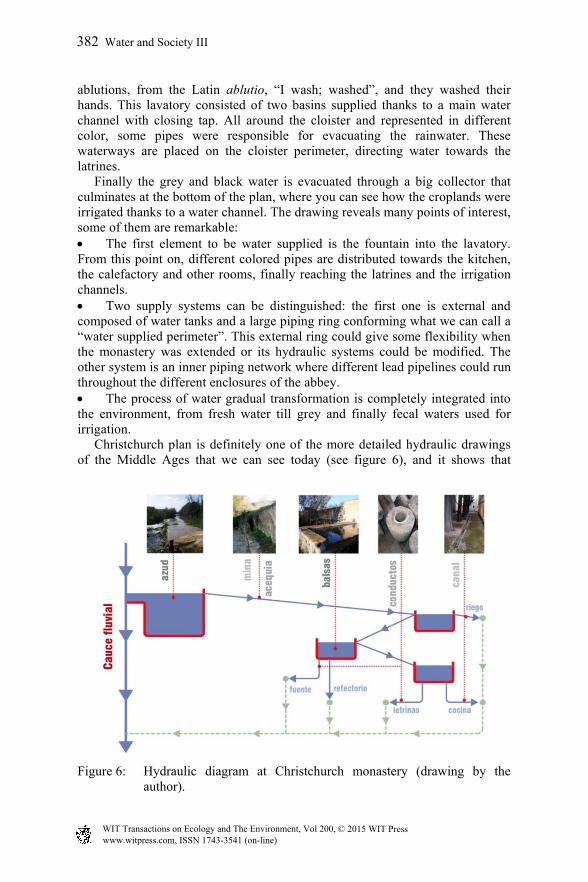
ablutions, from the Latin ablutio, “I wash; washed”, and they washed their hands. This lavatory consisted of two basins supplied thanks to a main water channel with closing tap. All around the cloister and represented in different color, some pipes were responsible for evacuating the rainwater. These waterways are placed on the cloister perimeter, directing water towards the latrines. Finally the grey and black water is evacuated through a big collector that culminates at the bottom of the plan, where you can see how the croplands were irrigated thanks to a water channel. The drawing reveals many points of interest, some of them are remarkable: The first element to be water supplied is the fountain into the lavatory. From this point on, different colored pipes are distributed towards the kitchen, the calefactory and other rooms, finally reaching the latrines and the irrigation channels. Two supply systems can be distinguished: the first one is external and composed of water tanks and a large piping ring conforming what we can call a “water supplied perimeter”. This external ring could give some flexibility when the monastery was extended or its hydraulic systems could be modified. The other system is an inner piping network where different lead pipelines could run throughout the different enclosures of the abbey. The process of water gradual transformation is completely integrated into the environment, from fresh water till grey and finally fecal waters used for irrigation. Christchurch plan is definitely one of the more detailed hydraulic drawings of the Middle Ages that we can see today (see figure 6), and it shows that
Figure 6: Hydraulic diagram at Christchurch monastery (drawing by the author).
www.witpress.com, ISSN 1743-3541 (on-line) WIT Transactions on Ecology and The Environment, Vol 200, © 2015 WIT Press
382 Water and Society III
parallel to the construction of architectural spaces, there was an early concern about hydraulic constructions.
3 Vallbona de les Monges Monastery
Located into the village with the same name, at the Urgell region (Lérida), Vallbona de les Monges monastery was raised by a female hermit community that moved to the northern part of the Sierra del Tallat, where circa 1173 A.D. they were assigned to the Cistercian order. By the 16th century, the Trent Council will take the decision of banning the existence of isolated female monasteries to prevent looting. Thereby the abbess Estefania Piquer was forced to attract the population of the nearby village of Montesquiu close to the abbey, donating for free land and water. It is in this transformation atmosphere where the current village of Vallbona de les Monges was shaped, developing an urban framework with different houses that eventually could occupy some of the ancient rooms of the monastery. From then on, the distribution of water supply systems has taken special importance, and has brought up difficulties and conflicts between the village and the monastery until our days. According to the hydraulic diagram (see figure 7), we can detect a first external system consisting of channels directing water towards two tanks located at different heights, in order to separate uses and water pressures. From one of these tanks, some pipes drove the water to the fountain into the cloister, which was located close to the peristyle of the southern gallery. From there, another minor piping network supplied the kitchen, calefactory and latrines. Therefore, the water is again being gradually transformed from fresh and drinking water to fecal or grey water, taking the fountain in the lavatory as a starting point of supply. Once the water reached the latrines, the grey water were added to the rainwater to finally get the Maldanell River at a lower level. Time later from the same water tank, other pipes were responsible of supplying water to the 15th century flour mills, located beyond the monastery. By the 16th century, when the monastery and the village of Vallbona were fused together, it was constructed a peixera into the water supply network. This very common name given during the 12th and 13th centuries at the Corb river area, was used to designate little dams that diverted waters. This peixera was constructed using rocks, trunks and chopped stone, and it was raised and placed into the water channel that linked both tanks of water distribution. Therefore after its construction some water was diverted to the village of Vallbona, reducing the supply to the old monastery and causing conflicts between the two sides. Sometimes the drawings were necessary not only to understand the hydraulic organization of the monastery, but to determine rights of water irrigation.
www.witpress.com, ISSN 1743-3541 (on-line) WIT Transactions on Ecology and The Environment, Vol 200, © 2015 WIT Press
Water and Society III 383
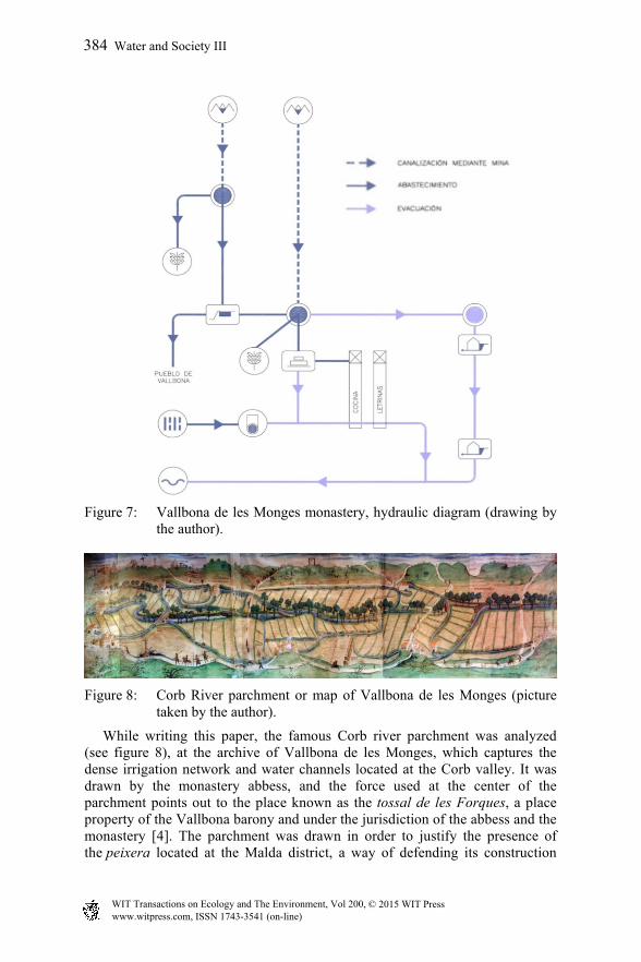
Figure 7: Vallbona de les Monges monastery, hydraulic diagram (drawing by
the author).
Figure 8: Corb River parchment or map of Vallbona de les Monges (picture
taken by the author).
While writing this paper, the famous Corb river parchment was analyzed (see figure 8), at the archive of Vallbona de les Monges, which captures the dense irrigation network and water channels located at the Corb valley. It was drawn by the monastery abbess, and the force used at the center of the parchment points out to the place known as the tossal de les Forques, a place property of the Vallbona barony and under the jurisdiction of the abbess and the monastery [4]. The parchment was drawn in order to justify the presence of the peixera located at the Malda district, a way of defending its construction
www.witpress.com, ISSN 1743-3541 (on-line) WIT Transactions on Ecology and The Environment, Vol 200, © 2015 WIT Press
384 Water and Society III
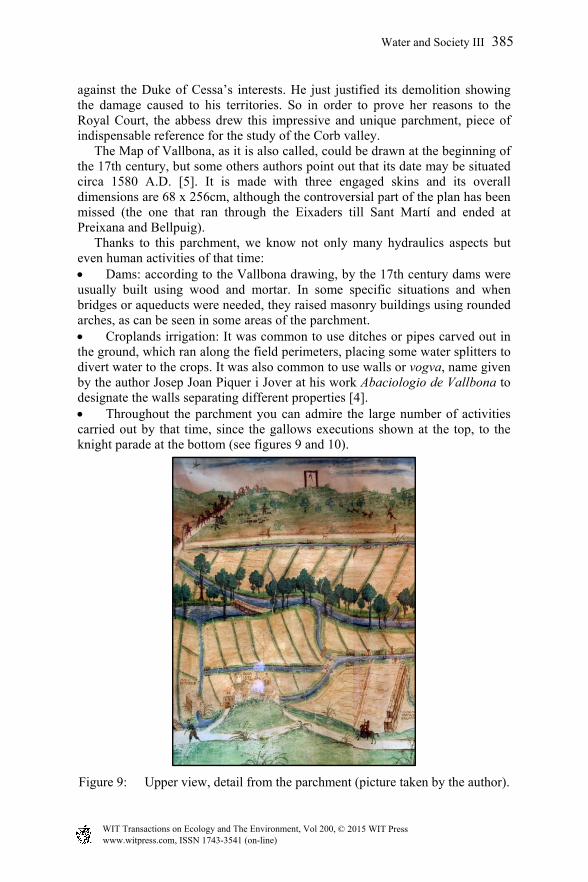
against the Duke of Cessa’s interests. He just justified its demolition showing the damage caused to his territories. So in order to prove her reasons to the Royal Court, the abbess drew this impressive and unique parchment, piece of indispensable reference for the study of the Corb valley. The Map of Vallbona, as it is also called, could be drawn at the beginning of the 17th century, but some others authors point out that its date may be situated circa 1580 A.D. [5]. It is made with three engaged skins and its overall dimensions are 68 x 256cm, although the controversial part of the plan has been missed (the one that ran through the Eixaders till Sant Martí and ended at Preixana and Bellpuig). Thanks to this parchment, we know not only many hydraulics aspects but even human activities of that time: Dams: according to the Vallbona drawing, by the 17th century dams were usually built using wood and mortar. In some specific situations and when bridges or aqueducts were needed, they raised masonry buildings using rounded arches, as can be seen in some areas of the parchment. Croplands irrigation: It was common to use ditches or pipes carved out in the ground, which ran along the field perimeters, placing some water splitters to divert water to the crops. It was also common to use walls or vogva, name given by the author Josep Joan Piquer i Jover at his work Abaciologio de Vallbona to designate the walls separating different properties [4]. Throughout the parchment you can admire the large number of activities carried out by that time, since the gallows executions shown at the top, to the knight parade at the bottom (see figures 9 and 10).
Figure 9: Upper view, detail from the parchment (picture taken by the author).
www.witpress.com, ISSN 1743-3541 (on-line) WIT Transactions on Ecology and The Environment, Vol 200, © 2015 WIT Press
Water and Society III 385
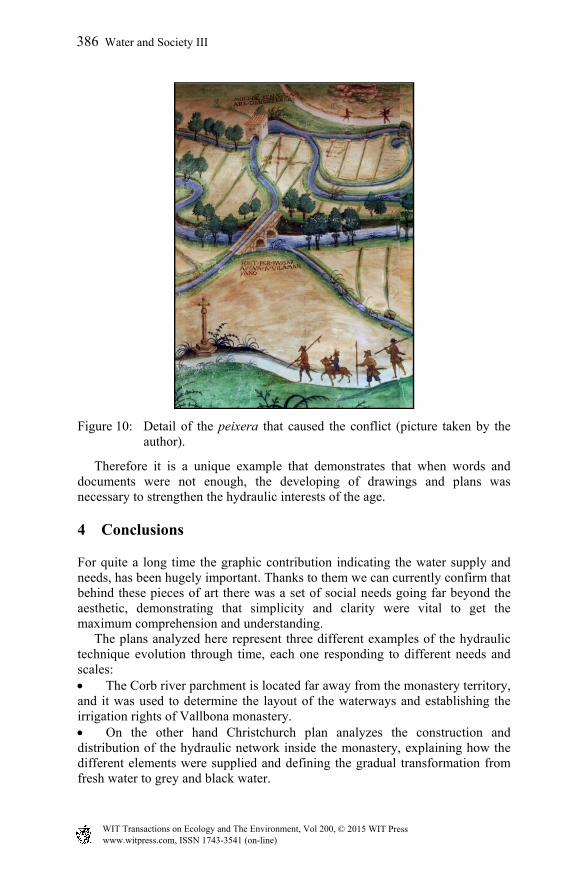
Figure 10: Detail of the peixera that caused the conflict (picture taken by the
author).
Therefore it is a unique example that demonstrates that when words and documents were not enough, the developing of drawings and plans was necessary to strengthen the hydraulic interests of the age.
4 Conclusions
For quite a long time the graphic contribution indicating the water supply and needs, has been hugely important. Thanks to them we can currently confirm that behind these pieces of art there was a set of social needs going far beyond the aesthetic, demonstrating that simplicity and clarity were vital to get the maximum comprehension and understanding. The plans analyzed here represent three different examples of the hydraulic technique evolution through time, each one responding to different needs and scales: The Corb river parchment is located far away from the monastery territory, and it was used to determine the layout of the waterways and establishing the irrigation rights of Vallbona monastery. On the other hand Christchurch plan analyzes the construction and distribution of the hydraulic network inside the monastery, explaining how the different elements were supplied and defining the gradual transformation from fresh water to grey and black water.
www.witpress.com, ISSN 1743-3541 (on-line) WIT Transactions on Ecology and The Environment, Vol 200, © 2015 WIT Press
386 Water and Society III
Finally the Saint-Gall plan studies the close relationship between the spatial organization in the monastery and the environment and water sources. However, despite the fact that they respond to different needs and they also belong to different ages and places, the three plans have something in common that makes the difference from our current hydraulic reality. All of them were able to incorporate water into the environment where they were located, understanding the monastery as an integrated element in the surrounding ecosystem. Currently supply systems insert water into our cities as something alien to the urban ecosystem, so with such a premise the only solution we can apply is simply to reduce the water consumption. The more our cities tend to expand, the more complex and unsustainable they get, so maybe the most important lesson we can learn from the monastic hydraulics lies in its simple and complete solutions.
References
[1] Rollier, G. 2010, Implantation et hydraulique monastiques: le cas de Cluny (thesis), in Langues, historie et civilisations des mondesanciens, Lumière Lyon 2: Lyon. p. 457.
[2] Pressouyre, L., Benoît, P., Bonis, A. and Wabont, M. 1996. L’Hydraulique monastique: milieux, réseaux, usages (colloque international réuni à l’abbaye de Royaumont), Grâne, Créaphis.
[3] Horn, W. W. and Born, E. 1979. The plan of St Gall a study of the architecture and economy of, and life in a paradigmatic Carolingian monastery, Berkeley, University of California press.
[4] Piquer i Jover, J.J., Pont i Gol, J and Fundació d’Història i Art Roger de Belfort1990, Abaciologi de Vallbona: 1153-1990, Vallbona de les Monges: Fundació d’Història i Art Roger de Belfort. 482 pp.
[5] Burgueño, J. 2010, [CARTO]GRAFIA. Testimoni visual de les terres de Lleida a travésdel temps (segles XIII-XIX), In: ILERDENCS, I. D. E. (ed.). Lleida: Institut d’estudis ilerdencs.
[6] Heitz, C. 1980, L’Architecture religieuse caorolingienne: les forms et leurs fonctions, Paris, Picard. 287 pp.
[7] Lluc Torcal, m.d.P. 2007, L’aigua al Monastir de Poblet: passat, present i futur (conference paper). Vimbodí-Poblet, Tarragona.
www.witpress.com, ISSN 1743-3541 (on-line) WIT Transactions on Ecology and The Environment, Vol 200, © 2015 WIT Press
Water and Society III 387