Embed Size (px)
Citation preview
1 S. Hamade, C. Tabet / Journal of Water Sustainability 1 (2013) 45-59
*Corresponding to: [email protected]
The Impacts of Climate Change and Human Activities on Water
Resources Availability in the Orontes Watershed: Case of the Ghab
Region in Syria
Sara Hamade*, Charles Tabet National Council for Scientific Research-CNRS-L
Beirut, B.P.: 11-8281, Riad El Solh 1107 2260, Lebanon
ABSTRACT The Ghab region in Syria is considered as the most fertile region in the Orontes watershed. However, the land fertil-
ity and the increase of population, as well as the climatic variations, urged the farmers in this region to intensify the
agricultural development. The geology and tectonics of the Ghab Region dominated by the Dead Sea Transform
Fault (DSTF) have an important impact on the water resources of the Orontes Basin. From the analysis of climate
change and the evaluation of uncontrollable behavior of human activities (drilling illegal water wells at random), as
well as the hydrographic variations of Orontes river in the study area, the authors have insisted on the fact that
groundwater aquifers are over-exploited along the Ghab region to satisfy the needs of irrigation and agricultural
development. The scarcity of water and the decrease in springs discharge is well noticed during the autumn, when
the precipitation is almost absent, which reduces the discharge of the Orontes River in the Ghab region, especially
downstream at Jesr al Shoghour.
Keywords: Orontes watershed; Ghab Region; tectonics; overexploitation of groundwater
1. INTRODUCTION The overexploitation of ground and surface water along the Orontes River in the Ghab Region in Syria became a concern at the national and regional level. The increasing water consumption worldwide is obviously determined notably by the agricultural devel-opment (Margat, 2003). Moreover, in arid and semi-arid countries, the need for water resources is more accentuated, especially for agricultural needs. In Syria, the real water requirements in the agriculture plan increased from 8.29 billion m3 in 1990 to 14.6 billion m3 in 2004 (NAPC, 2007), with 87 % of the available water resources in this country are
used for agricultural purposes, whereas only 9 % and 4 % are used in the industries and the domestic use respectively (FAO/ MAAR, 2001).
The main sources of water supply for irriga-tion are the rainwater and the reserves, essen-tially constituted by streams, rivers, lakes, dams, and underground water (Huntington, 2006). Actually, the water resources in the country are insufficient (Molle, 2003). At the same time, several societies, especially in developing and underdeveloped countries, the response to water scarcity is balanced by the overexploitation of groundwater resources from the phreatic zone of the aquifers (FAO, 1993). Sometimes, when surface water is of poor quality, the combined use of subterrane-
Journal of Water Sustainability, Volume 3, Issue 1, March 2013, 45–59
© University of Technology Sydney & Xi’an University of Architecture and Technology
46 S. Hamade, C. Tabet / Journal of Water Sustainability 1 (2013) 45-59
an water can be a way to improve the water quality and quantity (Kuper et al., 2003).
The overexploitation of groundwater by pumping from water wells induces the decrease of the static level in the aquifers. Subterranean and surface water used are over-exploited in certain countries notably in Syria to reach sometimes 100 % of the yield on the irrigated lands (FAO, 2004) of summer crops such as cotton and other industrial crops (NAPC, 2007). The overexploitation of water for agricultural purposes answers in fact the increasing demand of water by the population which is in perpetual increase due especially to climate change (Huntington, 2006; IGCE, 2008).
Where the population in the study area, which is theorized for economic growth is strong (Rostow, 1962), and the irrigated lands are increasing, some trans-boundary basins are threatened by the decrease in water levels in rivers, which is also due to the increase in the rate of evaporation due to climate change. The successive increase of the irrigated land and the overexploitation of subterranean water have direct impacts on the groundwater depletion. This decrease of groundwater level provoke the reduction in the discharge of rivers and their springs, in other words the closure of their basin (Molle, 2003) as detect-ed in the Orontes watershed in the Ghab Region where the groundwater is over-exploited.
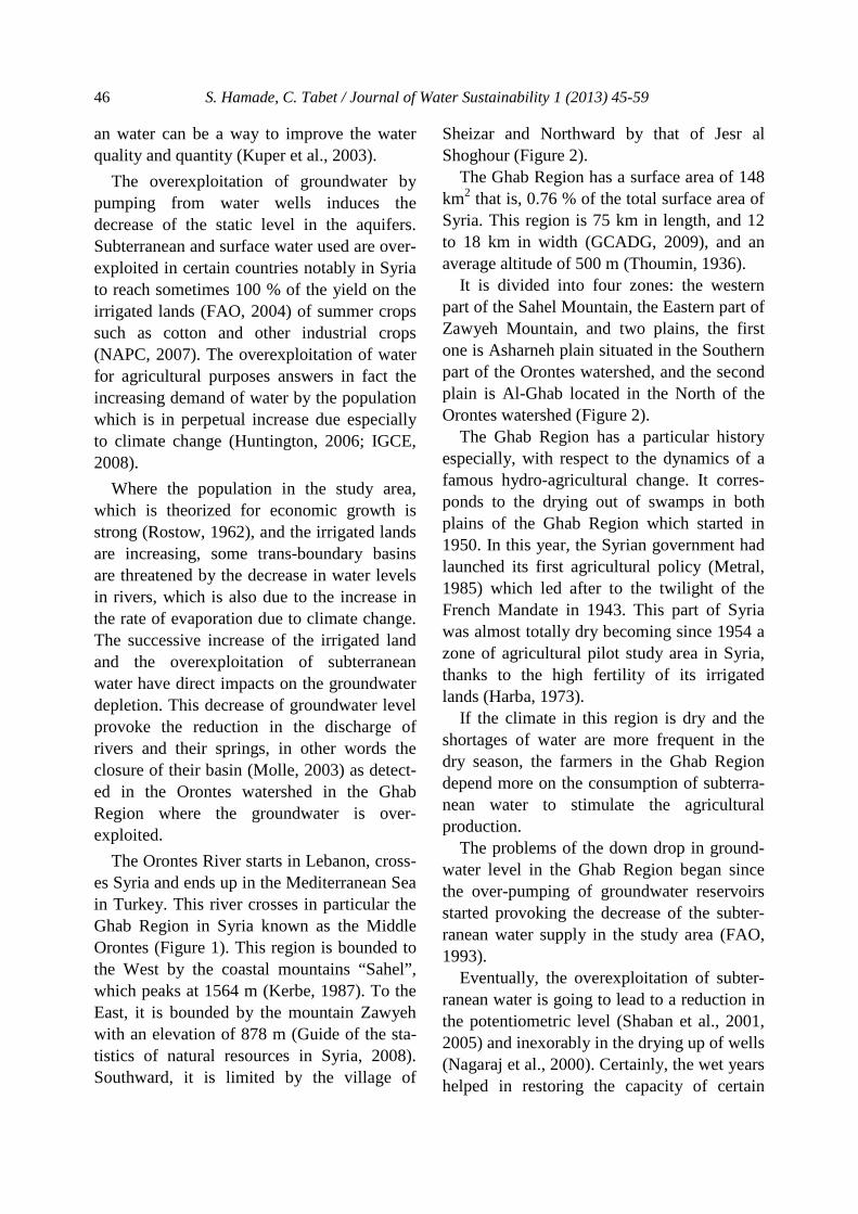
The Orontes River starts in Lebanon, cross-es Syria and ends up in the Mediterranean Sea in Turkey. This river crosses in particular the Ghab Region in Syria known as the Middle Orontes (Figure 1). This region is bounded to the West by the coastal mountains “Sahel”, which peaks at 1564 m (Kerbe, 1987). To the East, it is bounded by the mountain Zawyeh with an elevation of 878 m (Guide of the sta-tistics of natural resources in Syria, 2008). Southward, it is limited by the village of
Sheizar and Northward by that of Jesr al Shoghour (Figure 2).
The Ghab Region has a surface area of 148 km2 that is, 0.76 % of the total surface area of Syria. This region is 75 km in length, and 12 to 18 km in width (GCADG, 2009), and an average altitude of 500 m (Thoumin, 1936).
It is divided into four zones: the western part of the Sahel Mountain, the Eastern part of Zawyeh Mountain, and two plains, the first one is Asharneh plain situated in the Southern part of the Orontes watershed, and the second plain is Al-Ghab located in the North of the Orontes watershed (Figure 2).
The Ghab Region has a particular history especially, with respect to the dynamics of a famous hydro-agricultural change. It corres-ponds to the drying out of swamps in both plains of the Ghab Region which started in 1950. In this year, the Syrian government had launched its first agricultural policy (Metral, 1985) which led after to the twilight of the French Mandate in 1943. This part of Syria was almost totally dry becoming since 1954 a zone of agricultural pilot study area in Syria, thanks to the high fertility of its irrigated lands (Harba, 1973).
If the climate in this region is dry and the shortages of water are more frequent in the dry season, the farmers in the Ghab Region depend more on the consumption of subterra-nean water to stimulate the agricultural production.
The problems of the down drop in ground-water level in the Ghab Region began since the over-pumping of groundwater reservoirs started provoking the decrease of the subter-ranean water supply in the study area (FAO, 1993).
Eventually, the overexploitation of subter-ranean water is going to lead to a reduction in the potentiometric level (Shaban et al., 2001, 2005) and inexorably in the drying up of wells (Nagaraj et al., 2000). Certainly, the wet years helped in restoring the capacity of certain

S. Hamade, C. Tabet / Journal of Water Sustainability 1 (2013) 45-59 47
groundwater reservoirs, but it is necessary to control the irreversible phenomena of deple-tion if the tapped water is from fossil aquifers and this will lead to an alarming situation due to irresponsible human activities along the Ghab watershed. The Ghab watershed repre-sents the agricultural and the strategic water reservoir of Syria.
To analyze the causes and the effects of this overexploitation of water resources, we have to look at the factors influencing this high need in water such as: the population growth,
the human activities such as the agricultural development in the region, and the effect of climate change reducing the amount of precipitation and increasing the rate of evapo-ration.
The main objective of this article thus is to estimate impacts of the climate change, the population growth and the human activities and analyze the water problems in the Ghab Region and how to plan for a better use of the water resources in the future.
Figure 1 Emplacement of the Ghab Region within the Orontes watershed
Figure 2 Digital elevation model of the Orontes watershed
48 S. Hamade, C. Tabet / Journal of Water Sustainability 1 (2013) 45-59
The purpose to stress the historic path of the Ghab Region as a determining factor in this article is essential and reflects three major facts: the population increase in the study area, the access to natural resources, and pub-lic intervention causing a radical change in the natural resources, mainly water, in the Ghab Region. A major question should be answered in this article having to do with the following: in front of the agricultural intensi-fication and of the public intervention, what are the impacts of the traditional and modern practices of water consumption and agricul-ture on the functioning of the hydrologic cycle and water budget affecting the environ-ment and the social life in the Ghab fertile basin?.
The purpose of this article is to try and answer these questions. The first question tackled is the importance of land use and its history in the study region. The second ques-tion concerns the effect of the public interven-tion in the management of water resources and how it was distributed and used in the past and present. Finally, the third question concerns the relations between the inhabitants in the Ghab basin and, between the farmers and the Government through the years.
2. GEOLOGY AND TECTONICS OF THE GHAB REGION
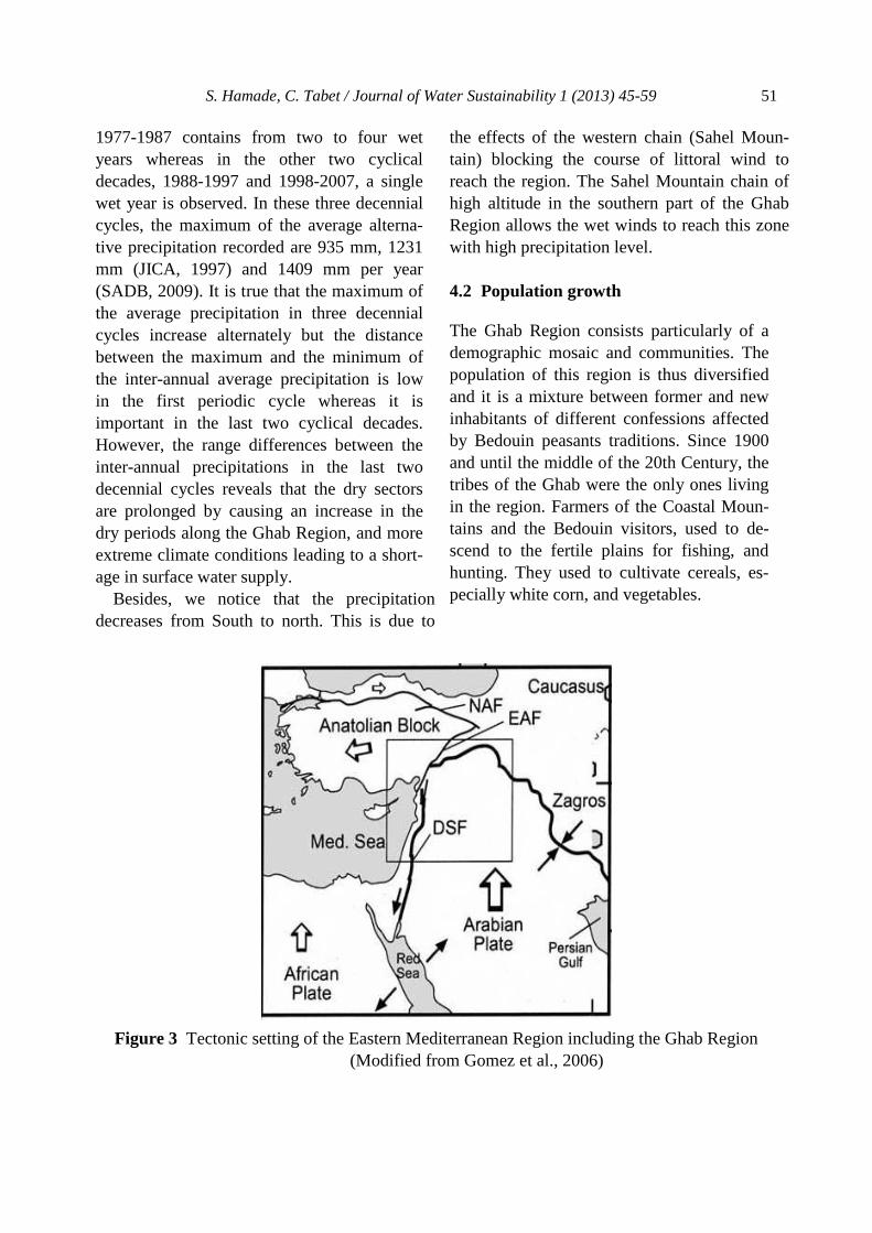
The Dead Sea Transform Fault (DSTF) is a major tectonic feature along the Eastern Mediterranean Region and it is a left lateral strike-slip fault, resembling the San Andrea’s Fault in California. It forms the boundary between the African plate and the Arabian plate. It reached Northwestern Syria in the Miocene and it extends from the Red Sea, Gulf of Aqaba, to Southern Turkey where it joins the East Anatolian fault forming a complex tectonic feature (Figure 3).
From the structural point of view, the coastal ranges in Syria were the results of Late Cretaceous and Cenozoic compressional movement and it resulted in the Ghab Basin formation which is characterized by the Ghab Fault considered as the spreading northward of the DSTF.
Surface observations indicate that the Ghab Basin is filled with Neogene − Quaternary lacustrine and alluvial deposits, with finer sediments in the central part of the basin (Brew, 2001).
The stratigraphy and the tectonic setting of the Orontes Watershed, mainly in the Ghab depression, have given this region the quali-ties (porosity and permeability) of a ground water aquifer that is replenished by the good precipitation level especially in the southern part of the region.
3. METHODOLOGY
This article is about managing and protect-ing water resources in the Ghab region form-ing part of the International project of the Middle East Water and Livelihoods Initiative (WLI).
Our study involves the analysis of the water problems in the Ghab Region. This will enrich our research, by offering us the opportunity to deal with an acute situation heading towards desertification due to an increase in the scarci-ty of water resources considered at a time as a fertile basin. WLI has focused mainly on the Orontes watershed in Syria, and partially on the Ghab Region. This is basically due to the overexploitation of subterranean waters, and the decrease of the Orontes discharge with time. Not to mention the climatic variations, the increase of the population and human activities especially, over-pumping of the ground water aquifers.
This situation can affect as well the other parts of the Orontes River especially down-
S. Hamade, C. Tabet / Journal of Water Sustainability 1 (2013) 45-59 49
stream (in Turkey). It has bad consequences on the overall situation, in particular the decrease of the Orontes flow in Turkey. For that purpose, it is necessary to analyze effec-tively, in a socioeconomic and agricultural context, the water problem in the Ghab Region which is part of the Orontes Water-shed, adding to this, the efficiency of its hydrographic system. These analyses indeed facilitate the tasks to synthesize the water problems, in the totality of the Orontes water-shed (within the framework of the project WLI).
This project aims particularly at improving the standard of living of the household in the region against the notably resolution of the water problem. In this context, we investigat-ed the problems which confront the Orontes watershed in the Ghab Region connected with the overexploitation of the groundwater. The context of these problems is very complex. The overexploitation of the groundwater dete-riorates with the existence of the illegal takings of this water. However, it is necessary to solve this problem by an integrated way. To analyze effectively the problem of the water in the Ghab Region we had to take into consideration the functioning of the hydrolog-ical cycle particularly upstream of the Orontes River (exactly in Hermel in Lebanon, in Homs and Hama in Syria) and its intercon-nectedness with the downstream region with respect to surface and groundwater situation. Therefore, the members of the WLI were distributed in these three upstream regions to analyze the hydrological cycle of this portion of the Orontes watershed in its socioeconomic and hydraulic context to synthesize the prob-lem of the water in the Orontes watershed in Lebanon and Syria.
To emphasize in this article the situation of the water resources in the Ghab Region, we had to strongly depend on hydrographic, anthropological and climatic data (Molle,
2003) representing accurately the current situ-ation of the overexploitation of subterranean water in the region. Although there are gaps in the data available, we were able to illustrate the real situation of the overexploitation prob-lems in the past years, and we planned to find solutions to confront these problems in the near future.
In our study, we aim at surrounding the current scale of the hydro-agricultural and economic problems in the study area, by favoring other factors, more precisely, the historical analysis of the climatic, hydro-graphic, anthropological and agricultural data. These factors will shed the light on the water resources of the Ghab Region, aiming at analyzing it and clarifying its future develop-ment.
From bibliographical search, the intensive site visits, and the collection of the several data from the General Corporation for Admin-istration and Development of the Ghab Region (GCADG), we were able to split this study into two distinctive approaches. The first one is an integrated approach, it gathers the characteristics of water resources and their variations connected with the climatic fluctuation and the human intervention (depletion of groundwater reservoirs).
Citizens in the Ghab Region can deplete the available water resources by the overexploita-tion of subterranean water, increase the water pollution (Margat, 2008) and modify the land cover (deforestation, urbanization, etc.). The second approach will have to do with the role played by engineers, hydrologists, hydro-geologists, to design and plan the water use by studying the spatiotemporal variability of the spring discharges, surface water, ground-water assessment and make future projections for the water budget of the region. In this case, a historic approach will be necessary to achieve the objectives of this study. In this second historic approach, we depended on
50 S. Hamade, C. Tabet / Journal of Water Sustainability 1 (2013) 45-59
historical and geographical observations and we have interpreted different maps and collected ancient data on the climate, the pop-ulation change and the hydraulic system of the Ghab Region from the old literature and the public centers of the region.
4. DATA ANALYSES
4.1 Climate change
The scientific simulations propose that the sustainable climate change in a given area is mitigated by the biodiversity modifications and the climate parameters evolutions (IGCE, 2008). Therefore, the global average tempera-ture increase, the precipitation inter-annual fluctuations, as well as the loss of certain an-imal species generate debates since the end of the twentieth century. These debates did not aim to find a solution to reduce these global changes and to limit the consequences and impact of these modifications. To maintain measures of adaptation to this change requires indeed a public and institutional collaboration (De Perthuis et al., 2010). In this context, the residents of the Ghab Region are worried about the current climatic perturbation in the region affecting their everyday’s life. This area that was characterized by a Mediterrane-an climate is becoming in the summer season similar to that of a semi-dry or semi-arid envi-ronment with temperatures varying between 42 °C and -2 °C (GCADG, 2009). 4.1.1 Temperature Certain concepts of the climatic variations coincide with what is known as global warm-ing. This is translated by the increasing tem-peratures noticed on our planet which enhanc-es notably the melting of glaciers in both hemispheres and leading to the scarcity of drinking water all over the Globe. In addition, this climate change engenders the extinction
of some plant and animal species and the destruction of their biota and the appearance of new species adapting themselves to new ecosystems (IGCE, 1995). To estimate the increase of temperature in the Ghab Region, we need to have data spreading out over at least a century. However, the absence of reliable archives makes the task difficult. We limited ourselves to assert this increase of temperatures in the Ghab Region by compar-ing the biodiversity in the region between the past and the present. Indeed, we noticed that since 2009 the appearance of the plant "papyrus" in the region which usually grow in a warm climate (Egypt, Kenya, Uganda, Tanzania and Sudan). This floating aquatic wild plant which consumes high quantity of water (3 million liters of water by plant during six months of its reproduction) contributes regrettably to the eutrophication of the aquatic environment, resulting in the loss of biodiver-sity (GCADG, 2009). 4.1.2 Precipitation The annual average rainfall over the Ghab Region varies between 1400 mm in the western sector and 350 mm in the eastern one. The average number of rainy days is 65 days a year with only one snowy day a year (GCADG, 2009). Thunderstorms that happen in the spring and autumn seasons are general-ly weak. Sandstorms can occur though scarce, and they are often caused by the khamasin strong winds.
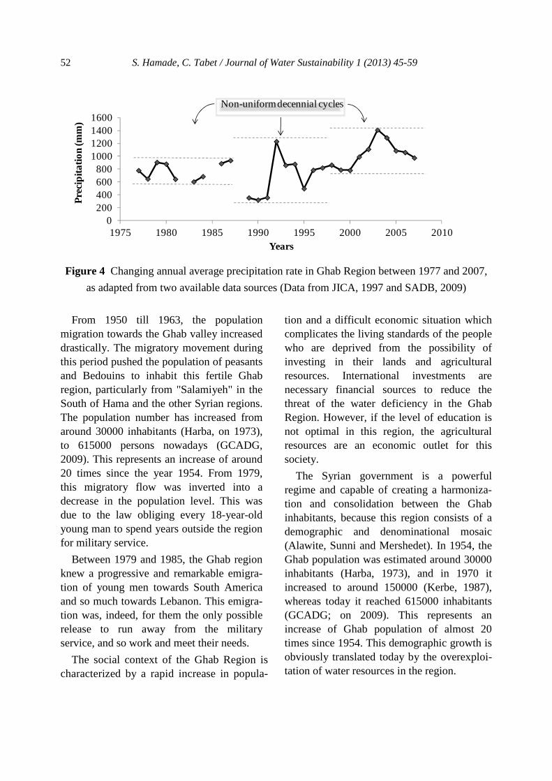
The only meteorological station built to measure the average precipitation of the Ghab Region is situated in Skylbeaye (Figure 2).
From the analysis of the precipitation measurements over a period of 40 years, 1977- 2007, we noticed the existence of three asymmetric and irregular cyclical decades (Figure 3). The comparison of the precipita-tion measurements between the periodic decennial cycles reveals that the first period
S. Hamade, C. Tabet / Journal of Water Sustainability 1 (2013) 45-59 51
1977-1987 contains from two to four wet years whereas in the other two cyclical decades, 1988-1997 and 1998-2007, a single wet year is observed. In these three decennial cycles, the maximum of the average alterna-tive precipitation recorded are 935 mm, 1231 mm (JICA, 1997) and 1409 mm per year (SADB, 2009). It is true that the maximum of the average precipitation in three decennial cycles increase alternately but the distance between the maximum and the minimum of the inter-annual average precipitation is low in the first periodic cycle whereas it is important in the last two cyclical decades. However, the range differences between the inter-annual precipitations in the last two decennial cycles reveals that the dry sectors are prolonged by causing an increase in the dry periods along the Ghab Region, and more extreme climate conditions leading to a short-age in surface water supply.
Besides, we notice that the precipitation decreases from South to north. This is due to
the effects of the western chain (Sahel Moun-tain) blocking the course of littoral wind to reach the region. The Sahel Mountain chain of high altitude in the southern part of the Ghab Region allows the wet winds to reach this zone with high precipitation level.
4.2 Population growth The Ghab Region consists particularly of a demographic mosaic and communities. The population of this region is thus diversified and it is a mixture between former and new inhabitants of different confessions affected by Bedouin peasants traditions. Since 1900 and until the middle of the 20th Century, the tribes of the Ghab were the only ones living in the region. Farmers of the Coastal Moun-tains and the Bedouin visitors, used to de-scend to the fertile plains for fishing, and hunting. They used to cultivate cereals, es-pecially white corn, and vegetables.
Figure 3 Tectonic setting of the Eastern Mediterranean Region including the Ghab Region
(Modified from Gomez et al., 2006)
52 S. Hamade, C. Tabet / Journal of Water Sustainability 1 (2013) 45-59
Figure 4 Changing annual average precipitation rate in Ghab Region between 1977 and 2007,
as adapted from two available data sources (Data from JICA, 1997 and SADB, 2009)
From 1950 till 1963, the population migration towards the Ghab valley increased drastically. The migratory movement during this period pushed the population of peasants and Bedouins to inhabit this fertile Ghab region, particularly from "Salamiyeh" in the South of Hama and the other Syrian regions. The population number has increased from around 30000 inhabitants (Harba, on 1973), to 615000 persons nowadays (GCADG, 2009). This represents an increase of around 20 times since the year 1954. From 1979, this migratory flow was inverted into a decrease in the population level. This was due to the law obliging every 18-year-old young man to spend years outside the region for military service.
Between 1979 and 1985, the Ghab region knew a progressive and remarkable emigra-tion of young men towards South America and so much towards Lebanon. This emigra-tion was, indeed, for them the only possible release to run away from the military service, and so work and meet their needs.
The social context of the Ghab Region is characterized by a rapid increase in popula-
tion and a difficult economic situation which complicates the living standards of the people who are deprived from the possibility of investing in their lands and agricultural resources. International investments are necessary financial sources to reduce the threat of the water deficiency in the Ghab Region. However, if the level of education is not optimal in this region, the agricultural resources are an economic outlet for this society.
The Syrian government is a powerful regime and capable of creating a harmoniza-tion and consolidation between the Ghab inhabitants, because this region consists of a demographic and denominational mosaic (Alawite, Sunni and Mershedet). In 1954, the Ghab population was estimated around 30000 inhabitants (Harba, 1973), and in 1970 it increased to around 150000 (Kerbe, 1987), whereas today it reached 615000 inhabitants (GCADG; on 2009). This represents an increase of Ghab population of almost 20 times since 1954. This demographic growth is obviously translated today by the overexploi-tation of water resources in the region.
0200400600800
1000120014001600
1975 1980 1985 1990 1995 2000 2005 2010
Prec
ipita
tion
(mm
)
Years
Non-uniform decennial cycles
S. Hamade, C. Tabet / Journal of Water Sustainability 1 (2013) 45-59 53
4.3 Water availability 4.3.1 Surface water The Orontes River crossing the Ghab Region is not a simple stream but it has three tributar-ies A, B and C (Figure 2), and six big dams built along the river with a storage capacity reaching 193 million m³ per year. Stored wa-ter is distributed in two irrigation schemes (i) Asharneh and (ii) Al-Ghab. Lands that do not profit out of such irrigation programs are sup-plied by water pumped from drilled boreholes and from springs bursting out from the eastern and western sides of the region. Surface water has decreased during this last decade due to weather change reflected by the decrease in rainfall and higher rates of evaporation due to higher temperatures especially in the summer season. The situation of upstream villages with respect to the irrigation schemes, are favored more than those downstream. The channeled water does not reach the down-stream villages either because of the low wa-ter quantity in canals and/or because certain destructions of secondary and tertiary irriga-tion networks have been noticed.
With this irrigation program, a group of farmers make use of pumped water directly from the three main drains A, B and C to irri-gate their lands and do not depend on the irri-gation schemes available. Also, another group of farmers have already drilled their own groundwater wells. The distribution of surface water in the Ghab by channels and irrigation canals is randomly operated there. This bad distribution of irrigation water is then justified by the big distance existing between the water intakes reaching sometimes 200 m and by the unfair length of the tertiary units of irrigation (1500 m). It induces consequently an increas-ing evaporation rates and an important water loss (Metral, 1979).
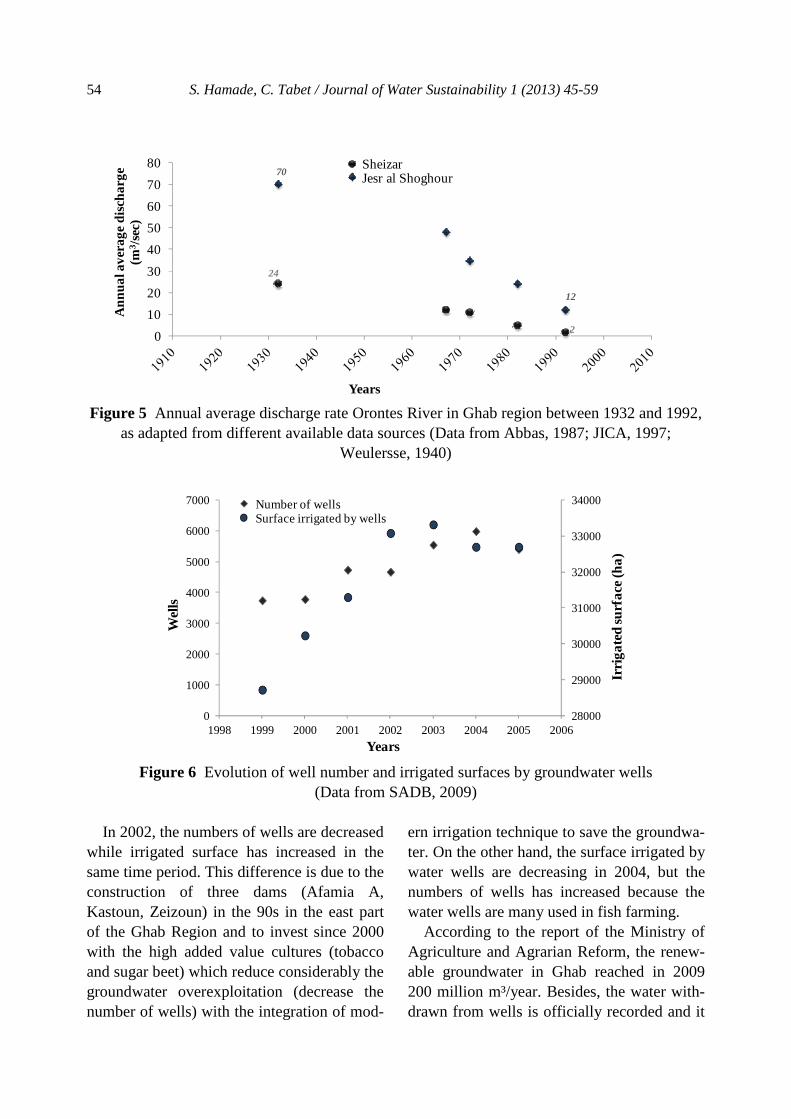
In Figure 4, we notice that the annual aver-age discharge in Sheizar decreases alternately
for the period 1932-1992. The discharge of this river records 24 m3/sec in 1932, (Weulersse, 1940) whereas it is estimated at 2 m3/sec in 1992 (JICA, 1997), decreasing con-sequently twelve times during sixty years. This considerable shortage of Orontes dis-charge in Sheizar means, one among several reasons, that the increasing demand in groundwater in Ghab is one of the conse-quences of climate change and water overex-ploitation of Orontes upstream in Hermel, in Lebanon, Homs and Hama, in Syria. Concern-ing the evolution of the Orontes discharge in Jesr al Shoghour, it will be investigated later on.
4.3.2 Groundwater resources Thirteen years ago, the Syrian government authorized the drilling of groundwater wells based on a drilling license (GCADG, 2009). This elementary procedure applied by the government was implemented to make sure that the water use does not exceed the sustain-able water levels and that the available water resources are allocated correctly through the region. Unfortunately, all residents, especially farmers and land owners, abused the govern-mental approach and this led to an immeasur-able increase in the number of illegal drilled water wells in the region, most of them were illegally drilled and were estimated at 3100 wells in 2009.
Figure 5 represents a well documented sta-tistical approach for a period spreading from 1999 till 2005. In 1999, there were 3731 wells irrigating mainly 28715 hectares (ha). In 2005, the number of wells increased to be-come 5397 irrigating 82687 ha. In six years, the wells were thus increased by 1.4 times and irrigated lands by wells increased by 35 %. Let us quote that the number of wells was estimated at 165 wells in 1969 (FAO, 1969). This increase in well number and in irrigated lands, concern only the legal wells.
54 S. Hamade, C. Tabet / Journal of Water Sustainability 1 (2013) 45-59
Figure 5 Annual average discharge rate Orontes River in Ghab region between 1932 and 1992,
as adapted from different available data sources (Data from Abbas, 1987; JICA, 1997; Weulersse, 1940)
Figure 6 Evolution of well number and irrigated surfaces by groundwater wells (Data from SADB, 2009)
In 2002, the numbers of wells are decreased
while irrigated surface has increased in the same time period. This difference is due to the construction of three dams (Afamia A, Kastoun, Zeizoun) in the 90s in the east part of the Ghab Region and to invest since 2000 with the high added value cultures (tobacco and sugar beet) which reduce considerably the groundwater overexploitation (decrease the number of wells) with the integration of mod-
ern irrigation technique to save the groundwa-ter. On the other hand, the surface irrigated by water wells are decreasing in 2004, but the numbers of wells has increased because the water wells are many used in fish farming.
According to the report of the Ministry of Agriculture and Agrarian Reform, the renew-able groundwater in Ghab reached in 2009 200 million m³/year. Besides, the water with-drawn from wells is officially recorded and it
24
2
70
12
0
10
20
30
40
50
60
70
80
Ann
ual a
vera
ge d
isch
arge
(m
3 /se
c)
Years
SheizarJesr al Shoghour
28000
29000
30000
31000
32000
33000
34000
0
1000
2000
3000
4000
5000
6000
7000
1998 1999 2000 2001 2002 2003 2004 2005 2006
Irri
gate
d su
rfac
e (h
a)
Wel
ls
Years
Number of wellsSurface irrigated by wells
S. Hamade, C. Tabet / Journal of Water Sustainability 1 (2013) 45-59 55
reached 190 million m³/year. Therefore, about 125 million m3/year, are used for irrigation, 11 million m³/years are taken for domestic use and drinking water supply, and 55 million m³/year are used in the fish farming and they are reused for irrigation purposes (GCADG, 2009). However, if 190 million m³/year, are added to water taken from approximately 3100 illegal wells existing in 2009, global subterranean water removed legally and ille-gally exceeds the 250 million m³/year, which involves an overexploitation of groundwater reaching more than 50 million m³/year. In this context and according to Turner (1993), to have a sustainable management of water, it is of high importance to assure for the future generations the same quality and quantity of water available today.
The overexploitation of groundwater which is at the base of the increasing of well num-bers today is the repercussion of the increase of the water demand and the deficit of its sup-ply (Turton and Ohlsson, 1999). This increas-ing water demand is depicted by the intensifi-cation of the irrigated lands. In such circum-stances, to irrigate 80 million hectares per year in the Ghab Region (GCADG, 2009), it is necessary to supply the region with 500 million m3 of water for irrigation purposes per year. In that case, the stored water in dams in Ghab is estimated at 183 million m3 per year and the water from ground water wells do not suffice the entire irrigation water requirement. In front of these deficits in water and its bad distribution, the farmers began over-exploiting subterranean water and using west-ern and eastern springs which were previously dedicated rather in the supplies of villages with drinking water.
5. DISCUSSION AND RESULTS
With the population growth, the climatic fluc-tuations and the decrease of surface water, the
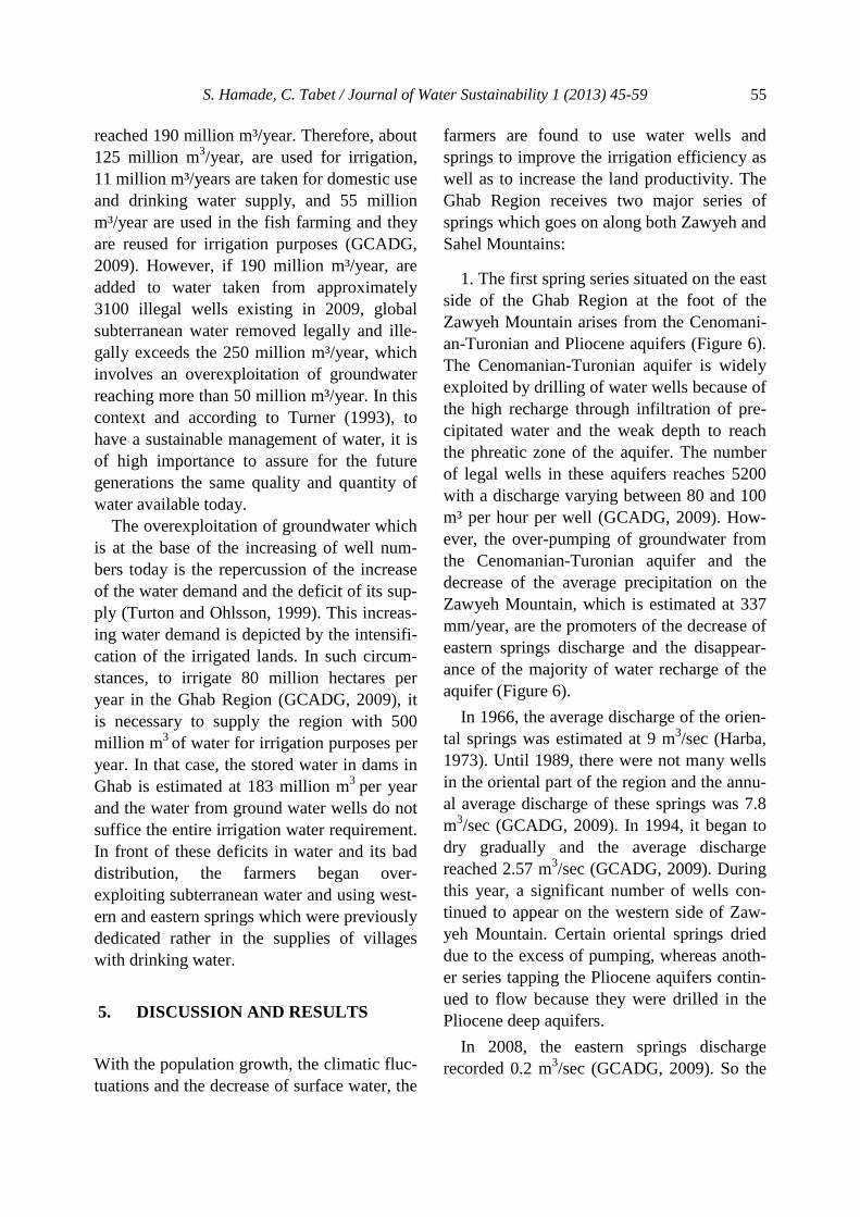
farmers are found to use water wells and springs to improve the irrigation efficiency as well as to increase the land productivity. The Ghab Region receives two major series of springs which goes on along both Zawyeh and Sahel Mountains:
1. The first spring series situated on the east side of the Ghab Region at the foot of the Zawyeh Mountain arises from the Cenomani-an-Turonian and Pliocene aquifers (Figure 6). The Cenomanian-Turonian aquifer is widely exploited by drilling of water wells because of the high recharge through infiltration of pre-cipitated water and the weak depth to reach the phreatic zone of the aquifer. The number of legal wells in these aquifers reaches 5200 with a discharge varying between 80 and 100 m³ per hour per well (GCADG, 2009). How-ever, the over-pumping of groundwater from the Cenomanian-Turonian aquifer and the decrease of the average precipitation on the Zawyeh Mountain, which is estimated at 337 mm/year, are the promoters of the decrease of eastern springs discharge and the disappear-ance of the majority of water recharge of the aquifer (Figure 6).
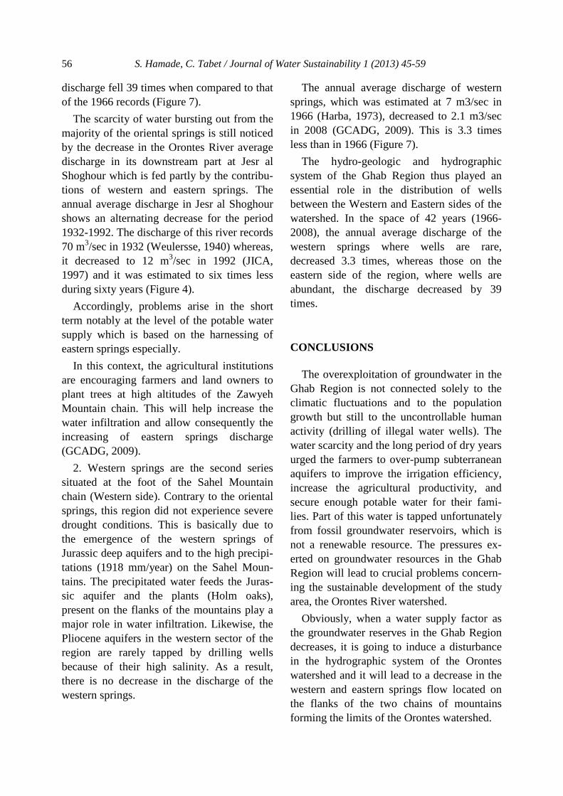
In 1966, the average discharge of the orien-tal springs was estimated at 9 m3/sec (Harba, 1973). Until 1989, there were not many wells in the oriental part of the region and the annu-al average discharge of these springs was 7.8 m3/sec (GCADG, 2009). In 1994, it began to dry gradually and the average discharge reached 2.57 m3/sec (GCADG, 2009). During this year, a significant number of wells con-tinued to appear on the western side of Zaw-yeh Mountain. Certain oriental springs dried due to the excess of pumping, whereas anoth-er series tapping the Pliocene aquifers contin-ued to flow because they were drilled in the Pliocene deep aquifers.
In 2008, the eastern springs discharge recorded 0.2 m3/sec (GCADG, 2009). So the
56 S. Hamade, C. Tabet / Journal of Water Sustainability 1 (2013) 45-59
discharge fell 39 times when compared to that of the 1966 records (Figure 7).
The scarcity of water bursting out from the majority of the oriental springs is still noticed by the decrease in the Orontes River average discharge in its downstream part at Jesr al Shoghour which is fed partly by the contribu-tions of western and eastern springs. The annual average discharge in Jesr al Shoghour shows an alternating decrease for the period 1932-1992. The discharge of this river records 70 m3/sec in 1932 (Weulersse, 1940) whereas, it decreased to 12 m3/sec in 1992 (JICA, 1997) and it was estimated to six times less during sixty years (Figure 4).
Accordingly, problems arise in the short term notably at the level of the potable water supply which is based on the harnessing of eastern springs especially.
In this context, the agricultural institutions are encouraging farmers and land owners to plant trees at high altitudes of the Zawyeh Mountain chain. This will help increase the water infiltration and allow consequently the increasing of eastern springs discharge (GCADG, 2009).
2. Western springs are the second series situated at the foot of the Sahel Mountain chain (Western side). Contrary to the oriental springs, this region did not experience severe drought conditions. This is basically due to the emergence of the western springs of Jurassic deep aquifers and to the high precipi-tations (1918 mm/year) on the Sahel Moun-tains. The precipitated water feeds the Juras-sic aquifer and the plants (Holm oaks), present on the flanks of the mountains play a major role in water infiltration. Likewise, the Pliocene aquifers in the western sector of the region are rarely tapped by drilling wells because of their high salinity. As a result, there is no decrease in the discharge of the western springs.
The annual average discharge of western springs, which was estimated at 7 m3/sec in 1966 (Harba, 1973), decreased to 2.1 m3/sec in 2008 (GCADG, 2009). This is 3.3 times less than in 1966 (Figure 7).
The hydro-geologic and hydrographic system of the Ghab Region thus played an essential role in the distribution of wells between the Western and Eastern sides of the watershed. In the space of 42 years (1966-2008), the annual average discharge of the western springs where wells are rare, decreased 3.3 times, whereas those on the eastern side of the region, where wells are abundant, the discharge decreased by 39 times.
CONCLUSIONS
The overexploitation of groundwater in the Ghab Region is not connected solely to the climatic fluctuations and to the population growth but still to the uncontrollable human activity (drilling of illegal water wells). The water scarcity and the long period of dry years urged the farmers to over-pump subterranean aquifers to improve the irrigation efficiency, increase the agricultural productivity, and secure enough potable water for their fami-lies. Part of this water is tapped unfortunately from fossil groundwater reservoirs, which is not a renewable resource. The pressures ex-erted on groundwater resources in the Ghab Region will lead to crucial problems concern-ing the sustainable development of the study area, the Orontes River watershed.
Obviously, when a water supply factor as the groundwater reserves in the Ghab Region decreases, it is going to induce a disturbance in the hydrographic system of the Orontes watershed and it will lead to a decrease in the western and eastern springs flow located on the flanks of the two chains of mountains forming the limits of the Orontes watershed.
S. Hamade, C. Tabet / Journal of Water Sustainability 1 (2013) 45-59 57
Since the government became aware of this acute problem, it started at the beginning of 2000, to apply a hydro-agricultural politics based on improving surface water supply to slow down the overexploitation of groundwa-
ter resources. For that purpose the Govern-ment improved the hydraulic infrastructures, built new irrigation channels and drainage systems, adopted modern irrigation systems (dripping method), and required from farmers
Ghab region
Sahelmountain
Zawyehmountain
Western springs Eastern springs
1960
Western springsEastern springs
Wells
2009
Cenomanian-Turonian aquifers Pliocene aquifers Jurassic aquifers
®
Figure 7 Schematic figures for geo-hydrological section of the Ghab Region and changing of discharge of springs with increasing well number (adapted from Abbas, 1987)
Figure 8 Annual average discharge of springs in the Ghab Region between 1966 and 2008, as
adapted from different available data sources (Data from GCADG, 2009; Harba, 1973; Kerbe,
1987)
0
2
4
6
8
10
12
14
Ann
ual a
vera
ge d
isch
arge
(m3 /
sec)
Years
Western springsEastern springs

58 S. Hamade, C. Tabet / Journal of Water Sustainability 1 (2013) 45-60
and land owners to pay annual taxes on the use of water resources to control its depletion. However the application of these taxes turned out ineffective because of the abstention of the majority of the farmers to pay their taxes, helped by high officials in public centers.
This last example shows a failure in the in-tegrated water management plan in the Ghab Region because there is really a lack of con-sciousness and the lack of awareness of the danger resulting from the overexploitation of water resources and the corruption at the level of the farmers and partially within the gov-ernmental staff and institutions. The Syrian Government thus was helpless in solving this problem. Indeed, certain inter-national organizations intervene today under the aegis of the State to restore the hydro-graphic situations of the Orontes watershed in the Ghab Region. However, we wonder if the international experts within the project WLI can succeed and can create a bargaining pow-er in the new established hydro-agricultural program designed for the Ghab Region.
REFERENCES Abbas, J. (1987). Hydrological dynamics of the
Middle-East basin (Ghab Syria). Thesis, Tou-louse II University. 419.
Brew, G. (2001). Tectonic Evolution Of Syria Interpreted From Integrated Geophysical And Geological Analysis. PhD dissertation at Cor-nell University, USA. 322.
De Perthuis, C., Hallegate, S. and Lecocq, F. (2010). Economy of the adaptation to the cli-mate change. Report for the Economic Council for the Sustainable development. Ministry of Ecology, Energy, of the Sustainable develop-ment and the Sea. France. 90.
Food and Agriculture Organization of the United Nations -FAO-. (1969). Pedological survey and related programs of irrigation. Lebanon. Final report, Volume II. Pedology. 375.
FAO. (1993). Water resources. Economy and policy. The world situation of the food and the agriculture. Archives of the FAO. Rome.
FAO/MAAR. (2001). The utilization of Water Resources for Agriculture in Syria. FAO. Re-port GCP/SYR/006/TTA.
FAO. (2004). Water charging in irrigated agricul-ture: an analysis of internal experience. FAO Water Reports. N° 27. Rome.
French Republic. (2009). Estimate of the impact cost of the change climatic and the adaptation in France. Report of the second phase, part II – Reports of the transverse groups. 214.
General Corporation for Administrating and De-veloping Al-Ghab -GCADG-. (2009). Al-Ghab plain: The Status Quo and Horizons of devel-opment. Syrian Arab Republic. Ministry of Ag-riculture and Land Reform. 51.
Gomez, F., Khawlie, M., Tabet,C., Darkal, A.N., Khair, K., Barazangi, M., (2006). Late Cenozo-ic uplift along the northern Dead Sea transform in Lebanon and Syria. Earth and Planetary Science Letters, 241, 913– 931.
Harba, M. (1973). The Ghab region (Syria): study of regional geography. Thesis. Paul Valery's, Montpelier III University, France. 238.
Huntington, J.T. (2006). Evidence of intensifica-tion manipulation of at least 350 cube metres per of the Global Water Cycle. Review and synthesis. Second anywhere in the catchment. Dysnesus Journal of Hydrology, 319 (14), 83-95.
Intergovernmental Group of Experts on the Cli-mate Evolution (IGCE), (2008). http://translate. google.fr/translate?hl=fr&langpair=en|fr&u=http://en.wikipedia.org/wiki/Scientific_opinion_on_climate_change.
Japan International Cooperation Agency -JICA-. (1997). The study on Water resources devel-opment in the Northwestern and central basins in the Syrian Arab Republic. Phase 1 (Execu-tive summary; Main report; Supporting report; Data book and Annex 7).
S. Hamade, C. Tabet / Journal of Water Sustainability 1 (2013) 45-59 59
Kerbe, J. (1987). Climate, hydrology and hydro-agricultural developments of Syria. Lille III University and Bordeaux III University. 1228.
Kuper, M., Hammani, A., Zemzam, S., Bouarfa, S. and Thomas, V. (2003). Strategies of com-bined use of surface and subterranean water for the irrigation. The case of the irrigated perime-ter by Tadla in Morocco. CIRAD-TERA, Av-Hassan II, Cemagref.Acts of the PCSI work-shop, Montpellier, France.
Margat, J. (2003). Water resources and uses in the world: preconceived ideas and realities. Acts of the International Festival of Geography on the Water, Source of Life, Source of Conflicts, Link between the People, Saint-Dié of Vosges, France. 18.
Margat, J. (2008). Mediterranean water. Situtation and perspectives. Harmattan. Paris. 288.
Métral, F. (1979).Water control and the society in the Ghab plain. Magazine of Geography of Lyon. num 3. 305-325.
Métral, F. (1985). State and farmers in Ghab in Syria: local approach of a project of State. Arab world: Maghreb-Machrek. 1985/07-09, 109, 43-64.
Molle, F. (2003).The ‘closure’ of river basins; trajectories and societal responses. Paper pre-pared for the 3rd Conference of the Interna-tional Water history Association Alexandria, Egypt(Colombo, Sri Lanka: International Wa-ter Management Institute).
Molle, F. (2003). Development Trajectories of River Basins: A Conceptual Framework Com-prehensive Assessment of water management in agriculture, Comprehensive Assessment Re-search Report 72, (Colombo, Sri Lanka: Inter-national Water Management Institute).
Nagaraj, N., Frasier, W.M., and Sampath, R.K. (2000). A Comparative Study of Groundwater. Institutions in the Western United States and Peninsular India for Sustainable and Equitable Resource Use. In: Eighth Conference of the In-ternational Association for the Study of Com-
mon property(IASCP), Bloomington, Indiana, USA.
National Agricultural Policy Centre -NAPC-. (2007). Water use efficiency in Syrian agricul-ture. Project GPC (Syria) in collaboration with the FAO, Cooperazions ITALIANA and Minis-try of Agriculture and Agrarian Reform in Syr-ia. Working paper No 26.13.
Rostow, W.W. (1962). The Process of Economic Growth. Paperback. W. W. Norton & Compa-ny.
Shaban, A., Khawlie, M. and Abdallah, C. (2001). New Water Resources For Southern Lebanon: Thermal InfraRed Remote Sensing of Subma-rine Springs, South Lebanon Conference, Bei-rut, 181-189.
Shaban, A., Khawlie, M., Abdallah, C. and Faour, G. (2005). Geologic control of submarine groundwater discharge: application of remote sensing to north Lebanon. Environmental Ge-ology, 47, 512-522.
Statistical guide of natural resource in Syria. (2008) .22 p. http://www.cbssyr.org/ year-book/2008/chapter1.pdf.
Syrian Agriculture Database -SADB-. (2009). Land and Water: Development of wells by governorate, Type and Licence. http://www.napcsyr.org//sadb.htm.
Thoumin, R. (1936). The Ghab. Magazine of al-pine geography, 3 (24).p. 467-538.
Turner, R.K. (1993). Sustainable environmental economics and management: principles and practice. Belhaven Press, London.
Turton, A.R. and Ohlsson, L. (1999). Water Scar-city and Social Adaptive Capacity, Towards an Understanding of the Social Dynamics of Man-aging Water Scarcity in Developing Countries, MEWREW Occasional Paper n° 9, SOAS Wa-ter Issues Study Group.
Weulersse, J. (1940). Orontes River study. Arrault Editions, Tours. 88.