Embed Size (px)
Citation preview

Ernst Moritz Arndt University of Greifswald
The Impact of Land Administration and
Common-Pool Resource Management on
Wetland Utilisation along the Eastern Shore of
Lake Tana, Ethiopia
Alteration of Wetlands –
Risk or Chance for Rural Livelihoods?
Diploma thesis
Maxi Springsguth
4th January 2013
Landscape Ecology and Nature Convervation
Matriculation number 115518
Supervisor: Dr. Anne Cristina de la Vega-Leinert, Sustainability Science and
Applied Geography, Institute of Geography and Geology
Co-supervisor: Prof. Dr. Susanne Stoll-Kleemann, Chair of Sustainability Science
and Applied Geography, Institute of Geography and Geology


Acknowledgements
I want to thank Dr. Anne Cristina de la Vega-Leinert and Prof. Dr. Susanne
Stoll-Kleemann for the supervision of my thesis. I am very grateful to Dr. Anne
Cristina de la Vega-Leinert for her comments and the discussion on my work.
I want to thank all the people who took part in Participatory Rural Appraisal
and the interview respondents for their willingness to share their knowledge, for
the discussions and their time.
Very special thanks goes to my counterpart and friend, Babiyew Sibhat.
Thanks to your open mind, your endeavours, critique and experience our work
was successfully accomplished.
I am very happy to have spent my stay in Ethiopia together with Christian
Sefrin, Fanny Mundt, Friedrich zur Heide, Renee Moreaux, Johannes Poetzsch,
the ‘fun-raising group’ and all the other wonderful people we met. Thanks for
sharing a great time and for exchanging ideas.
I further appreciate the assistance of Dr. Ayalew Wondie, Getasew Abebaw of
the Fogera woreda administration, Tigistu Tilahun, the Michael Succow Founda-
tion for the Protection of Nature, the Amhara Bureau of Culture, Tourism and
Parks Development, Woinshet Sibhat as well as captain Gebrie and captain Maru
in my research. Only with your crucial input, the financial support, the transport
facilitation and your care this work became possible.
I am very grateful to Thomas Lotze, Telsche Piechottka, Renee Moreaux and
Stephan Kuberski for the revision of my thesis, their constructive comments and
technical advice.
I am thankful to Jorg Bachmann for his technical support and his patience to
endure my impatience.
I also want to thank my little son, Levi Springsguth, for successfully diverting
my thoughts of the remaining work and for the wonderful, unique time we spend
together.
Last but not least, I want to express my honest gratitude to my family, my
sister Gabi Springsguth, Birgit Springsguth, Dagmar and Conny Springsguth as
well as Christa and Gerhard Kunzel and Karl-Heinz Springsguth (†), who supported
me throughout this work and my life.


Contents
Abbreviations ix
Abstract 1
Zusammenfassung 3
1 Introduction 5
1.1 Rationale and Research Objective . . . . . . . . . . . . . . . . . 6
1.2 Structure . . . . . . . . . . . . . . . . . . . . . . . . . . . . . . 8
2 The Study Area 9
2.1 Ethiopia: Social-Economic Background . . . . . . . . . . . . . . 9
2.2 The Amhara Region . . . . . . . . . . . . . . . . . . . . . . . . 9
2.3 The Research Site . . . . . . . . . . . . . . . . . . . . . . . . . 11
2.4 Wetlands between Conservation and Growth . . . . . . . . . . . 16
2.5 Land Policy in Ethiopia . . . . . . . . . . . . . . . . . . . . . . 17
3 Theoretical Background and Framework 21
3.1 Common-Property Theory . . . . . . . . . . . . . . . . . . . . . 21
3.2 Resilience Thinking . . . . . . . . . . . . . . . . . . . . . . . . 22
3.3 Political Ecology . . . . . . . . . . . . . . . . . . . . . . . . . . 23
3.4 Theoretical Assumptions . . . . . . . . . . . . . . . . . . . . . . 23
3.5 Theoretical Framework . . . . . . . . . . . . . . . . . . . . . . . 24
4 Methodology and Methods 31
4.1 Research Approach . . . . . . . . . . . . . . . . . . . . . . . . . 31
i
ii CONTENTS
4.2 Data Collection . . . . . . . . . . . . . . . . . . . . . . . . . . 32
4.2.1 Participatory Rural Appraisal and Group Discussions . . . 32
4.2.2 Problem-Centred Expert Interviews . . . . . . . . . . . . 40
4.3 Data Preparation and Analysis . . . . . . . . . . . . . . . . . . . 42
5 Results 45
5.1 Values of Wetlands . . . . . . . . . . . . . . . . . . . . . . . . . 45
5.2 Perceptions on Well-being and People’s Objectives . . . . . . . . 47
5.3 Environmental and Land Use Changes . . . . . . . . . . . . . . . 48
5.3.1 Flooding and Sedimentation . . . . . . . . . . . . . . . . 48
5.3.2 Rice Cultivation . . . . . . . . . . . . . . . . . . . . . . 49
5.3.3 Conversion of Wetlands . . . . . . . . . . . . . . . . . . 51
5.3.4 Fishery . . . . . . . . . . . . . . . . . . . . . . . . . . . 51
5.4 Impact on Rural Livelihoods . . . . . . . . . . . . . . . . . . . . 52
5.4.1 Impact on Crop Production and Livestock Rearing . . . . 53
5.4.2 Impact on Social Life . . . . . . . . . . . . . . . . . . . 54
5.4.3 Impact on Food Security and Income Generation . . . . . 55
5.5 Conflicts over Wetlands and Associated Resources . . . . . . . . 56
5.5.1 Conflicts Related to Encroachment . . . . . . . . . . . . 56
5.5.2 Conflicts over Grazing Land . . . . . . . . . . . . . . . . 57
5.5.3 Cropland Boundary Conflicts . . . . . . . . . . . . . . . 57
5.5.4 Conflicts between Tana Kirkos Monasteries and the Com-
munity . . . . . . . . . . . . . . . . . . . . . . . . . . . 58
5.5.5 Conflicts between Wetland Conservation and Use in Agid
Kirigna . . . . . . . . . . . . . . . . . . . . . . . . . . . 58
5.5.6 Conflicts Related to Fishing . . . . . . . . . . . . . . . . 59
5.5.7 Conflicts Arising from Stakeholders’ Perceptions on Gov-
ernment Plans . . . . . . . . . . . . . . . . . . . . . . . 59
5.5.8 The Consequences of Conflicts for Communal Life . . . . 60
5.6 Land Administration . . . . . . . . . . . . . . . . . . . . . . . . 61
5.6.1 Land Registration and Certification . . . . . . . . . . . . 61
5.6.2 Constraints to the Land Registration and Certification
Process . . . . . . . . . . . . . . . . . . . . . . . . . . . 63

CONTENTS iii
5.6.3 Land Use Planning . . . . . . . . . . . . . . . . . . . . . 65
5.7 Common-Pool Resource Management . . . . . . . . . . . . . . . 65
5.7.1 Local Resource Management Systems . . . . . . . . . . . 66
5.7.2 Conflict Resolution Mechanisms . . . . . . . . . . . . . . 68
5.7.3 Federal and Regional Policies with Implications for Wetland
Management . . . . . . . . . . . . . . . . . . . . . . . . 69
5.7.4 Constraints to and Recommendations for Common-Pool
Resource Management . . . . . . . . . . . . . . . . . . . 70
5.8 Summary . . . . . . . . . . . . . . . . . . . . . . . . . . . . . . 74
6 Analysis 77
6.1 The Cyclical Process of Environmental Entitlements . . . . . . . 77
6.2 Mapping Endowments: Access to Wetlands . . . . . . . . . . . . 78
6.2.1 Rights-Based Access to Wetland Resources . . . . . . . . 79
6.2.2 Structural and Relational Mechanisms of Access . . . . . 81
6.2.3 Property Rights to Wetlands . . . . . . . . . . . . . . . 84
6.3 Power Relations and the Question of Who Benefits . . . . . . . . 86
6.4 The Complexity of Conflicts . . . . . . . . . . . . . . . . . . . . 92
6.5 Institutions Shaping Wetland Use and Management . . . . . . . 93
6.5.1 Land Administration . . . . . . . . . . . . . . . . . . . . 93
6.5.2 Common-Pool Resource Management . . . . . . . . . . . 95
6.6 Summary . . . . . . . . . . . . . . . . . . . . . . . . . . . . . . 107
7 Discussion 111
7.1 The Institutional Framework . . . . . . . . . . . . . . . . . . . . 111
7.1.1 A National Wetland Policy? . . . . . . . . . . . . . . . . 112
7.1.2 Signing the Ramsar Convention? . . . . . . . . . . . . . 113
7.1.3 Property Rights to Wetlands – A Critical Issue . . . . . . 114
7.1.4 Land Administration and Conservation . . . . . . . . . . 115
7.1.5 Land Use Planning and Conservation . . . . . . . . . . . 117
7.1.6 Environmental Impact Assessment . . . . . . . . . . . . . 117
7.2 Governance of Wetlands . . . . . . . . . . . . . . . . . . . . . . 119
7.2.1 The Role of Social Actors in Wetland Management . . . . 119

iv CONTENTS
7.2.2 Drawing on Conditions Facilitating the Governance of
Wetlands . . . . . . . . . . . . . . . . . . . . . . . . . . 122
7.2.3 Unequal Power Relations and Empowerment . . . . . . . 122
7.2.4 Building Trust and Assurance . . . . . . . . . . . . . . . 123
7.2.5 Ensuring Participation . . . . . . . . . . . . . . . . . . . 124
7.2.6 Collaboration and Coordination . . . . . . . . . . . . . . 124
7.2.7 Recognising Legal Rights . . . . . . . . . . . . . . . . . 125
7.2.8 Establishing, Implementing and Enforcing Regulations . . 125
7.2.9 Monitoring User Behaviour and Ecological Conditions . . 126
7.2.10 Resolving Conflicts . . . . . . . . . . . . . . . . . . . . . 126
7.2.11 Integrating Knowledge Pluralism and Ensuring Information
Exchange . . . . . . . . . . . . . . . . . . . . . . . . . . 127
7.2.12 Understanding Heterogeneity . . . . . . . . . . . . . . . 128
7.2.13 Large or Small? . . . . . . . . . . . . . . . . . . . . . . 129
7.2.14 Delineating Wetland Boundaries: Remarks on a Zonation
Proposition . . . . . . . . . . . . . . . . . . . . . . . . . 130
7.2.15 Providing Incentives and Livelihood Opportunities . . . . 132
7.3 Alteration of Wetlands – Risk or Chance? . . . . . . . . . . . . . 134
References 137
Appendices I
Appendix 1: Methods of Participatory Rural Appraisal . . . . . . . . . I
Appendix 2: Interview Catalogue of Questions . . . . . . . . . . . . . XI
Appendix 3: Codes . . . . . . . . . . . . . . . . . . . . . . . . . . . . XVIII
Appendix 4: Well-Being Ranking . . . . . . . . . . . . . . . . . . . . XVIII
Appendix 5: Responses to Livelihood Insecurity . . . . . . . . . . . . . XIX
Appendix 6: Land Use/Cover Changes in the Research Area . . . . . . XXIV
Appendix 7: Overview of the Impact of Anthropogenic Activities on
Wetland Ecosystems . . . . . . . . . . . . . . . . . . . . . . . . XXVIII
Appendix 8: Biosphere Reserves . . . . . . . . . . . . . . . . . . . . . XXIX
Glossary . . . . . . . . . . . . . . . . . . . . . . . . . . . . . . . . . XXX

List of Tables
2.1 Research sites . . . . . . . . . . . . . . . . . . . . . . . . . . . 12
3.1 Bundles of property rights associated with positions . . . . . . . 28
4.1 Methods of PRA and group discussions . . . . . . . . . . . . . . 36
4.2 Overview of Interviews . . . . . . . . . . . . . . . . . . . . . . . 41
5.1 Advantages and disadvantages of rice production . . . . . . . . . 55
5.2 Social actors involved in conflicts . . . . . . . . . . . . . . . . . 57
5.3 Recommendations for the governance of wetlands . . . . . . . . 73
6.1 Property rights to wetlands associated with positions . . . . . . . 86
6.2 Beneficiaries, social actors and access mechanisms . . . . . . . . 89
8.1 List of codes . . . . . . . . . . . . . . . . . . . . . . . . . . . . XVIII
8.2 Responses of social actors to livelihood insecurity . . . . . . . . . XXI
v

vi LIST OF TABLES

List of Figures
2.1 Regions of Ethiopia . . . . . . . . . . . . . . . . . . . . . . . . 10
2.2 Map of the research site . . . . . . . . . . . . . . . . . . . . . . 13
2.3 Wetlands around Lake Tana . . . . . . . . . . . . . . . . . . . . 14
2.4 Mean annual isohyets in the Lake Tana watershed . . . . . . . . 15
2.5 Altitudinal range in the Lake Tana watershed . . . . . . . . . . . 15
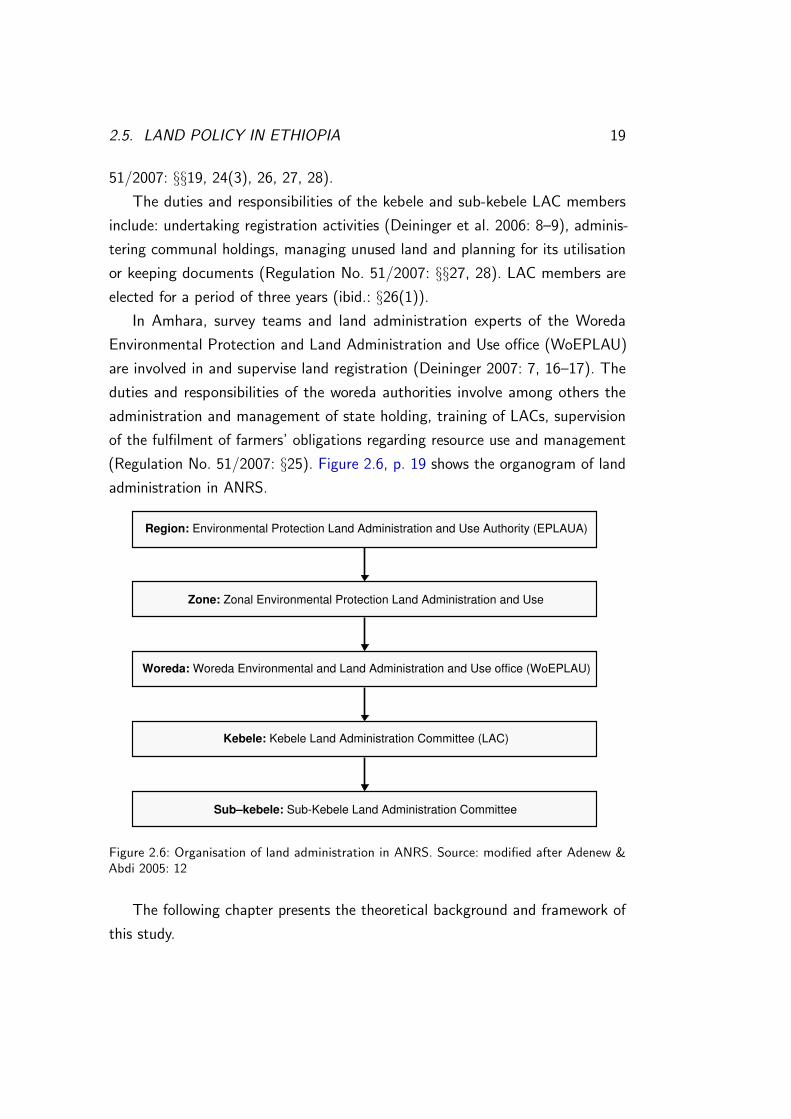
2.6 Organogram of land administration in ANRS . . . . . . . . . . . 19
3.1 Three complementary bodies of scholarship . . . . . . . . . . . . 24
3.2 Environmental entitlements framework . . . . . . . . . . . . . . 28
3.3 Integrating theory and research questions . . . . . . . . . . . . . 30
4.1 Trend analysis . . . . . . . . . . . . . . . . . . . . . . . . . . . 38
4.2 Cause-effect diagram . . . . . . . . . . . . . . . . . . . . . . . . 38
4.3 Impact diagram . . . . . . . . . . . . . . . . . . . . . . . . . . 39
4.4 Well-being ranking with youth . . . . . . . . . . . . . . . . . . . 39
4.5 Well-being ranking with women . . . . . . . . . . . . . . . . . . 39
4.6 Pair-wise ranking . . . . . . . . . . . . . . . . . . . . . . . . . . 39
5.1 Ecosystem services of wetlands . . . . . . . . . . . . . . . . . . 46
5.2 Rice cultivation in Agid Kirigna . . . . . . . . . . . . . . . . . . 50
5.3 Cattle grazing in a wetland . . . . . . . . . . . . . . . . . . . . 50
5.4 Wetland conversion . . . . . . . . . . . . . . . . . . . . . . . . 52
5.5 Fishing . . . . . . . . . . . . . . . . . . . . . . . . . . . . . . . 52
5.6 Drivers of environmental and land use change . . . . . . . . . . . 53
5.7 Flooded rice field in Wagetera . . . . . . . . . . . . . . . . . . . 54
vii

viii LIST OF FIGURES
5.8 Flooded settlements . . . . . . . . . . . . . . . . . . . . . . . . 54
5.9 Tana Kirkos Island . . . . . . . . . . . . . . . . . . . . . . . . . 58
5.10 Wetland of Tana Kirkos Island . . . . . . . . . . . . . . . . . . . 58
5.11 Land Registry Book . . . . . . . . . . . . . . . . . . . . . . . . 62
5.12 Land administration, land use changes and wetland system . . . . 66
5.13 Cut and carry system . . . . . . . . . . . . . . . . . . . . . . . 67
5.14 Fishermen’s association . . . . . . . . . . . . . . . . . . . . . . 68
5.15 Fishermen in the morning . . . . . . . . . . . . . . . . . . . . . 68
5.16 Main causal chains of wetland alteration . . . . . . . . . . . . . 75
6.1 ‘Entitlement chains’ . . . . . . . . . . . . . . . . . . . . . . . . 79
6.2 Mapping endowments . . . . . . . . . . . . . . . . . . . . . . . 91
6.3 Conflicts over wetlands . . . . . . . . . . . . . . . . . . . . . . . 92
6.4 Institutions conditioning resource subtraction . . . . . . . . . . . 103
6.5 Conditions facilitating wetland management . . . . . . . . . . . 107
6.6 Conditions constraining wetland management . . . . . . . . . . . 108
6.7 Environmental entitlements analysis . . . . . . . . . . . . . . . . 109
7.1 Institutional framework for wetland conservation . . . . . . . . . 118
7.2 Zonation proposal for a Lake Tana Biosphere Reserve . . . . . . 131
7.3 Features and conditions for a successful common-pool resource
management . . . . . . . . . . . . . . . . . . . . . . . . . . . . 134
8.1 Matrix of a well-being ranking (1) . . . . . . . . . . . . . . . . . XIX
8.2 Matrix of a well-being ranking (2) . . . . . . . . . . . . . . . . . XX
8.3 Land use/cover in 1986 . . . . . . . . . . . . . . . . . . . . . . XXV
8.4 Land use/cover in 2001 . . . . . . . . . . . . . . . . . . . . . . XXVI
8.5 Land use/cover in 2011 . . . . . . . . . . . . . . . . . . . . . . XXVII

Abbreviations
ADLI Agriculture Development-Led Industrialisation
AECID Spanish International Development Cooperation
Agency
ANRS Amhara National Regional State
ARARI Amhara Regional Agricultural Research Institute
BDU Bahir Dar University
BoARD Bureau of Agricultural and Rural Development
BoCTPD Bureau of Culture, Tourism and Parks Development
BR Biosphere reserve
CBD Convention on Biological Diversity
CBINReMP Community-based Integrated Natural Resource Man-
agement Programme
DA Development agent
EIA Environmental impact assessment
EPA Environmental Protection Authority
EPLAUA Environmental Protection Land Administration and
Use Authority
ETB Ethiopian Birr
EWNRA Ethio Wetlands and Natural Resources Association
EWRDM Early warning and risk disaster management processes
coordinator
EWRP Ethiopian Wetlands Research Programme
FDRE Federal Democratic Republic of Ethiopia
GDP Gross Domestic Product
ix

x ABBREVIATIONS
GEF Global Environment Facility
GTP Growth and Transformation Plan
IFAD International Fund for Agricultural Development
LAC Kebele land administration (and use) committee
MoARD Ministry of Agricultural and Rural Development
MoWE Ministry of Water and Energy
MSF Michael Succow Foundation for the Protection of
Nature
PIF Agricultural Sector Policy and Investment Framework
PRA Participatory Rural Appraisal
TaSBO Tana Sub-Basin Organisation
UNESCO United Nations Educational, Scientific and Cultural
Organization
WoARD Woreda Agricultural and Rural Development office
WoEPLAU Woreda Environmental Protection Land Administra-
tion and Use office
WoWE Woreda Water and Energy office

Abstract
The wetlands of Lake Tana, Ethiopia, harbour a rich biodiversity and provide
various ecosystem services to humans. However they have been subject to resource
overuse and degradation. The continuous conversion of these ecosystems is driven
by an ever increasing population, targeted agricultural development and the open
unregulated access to wetland resources. Attempts to conserve the biodiversity and
the cultural landscape have resulted in a feasibility study for a Lake Tana biosphere
reserve and baseline surveys on wetlands for the establishment of a Community-
Based Integrated Natural Resource Management Project (CBINReMP).
Against this background, the present work aims at analysing the decisive condi-
tions that determine an effective management and a sustainable resource utilisation
of the wetlands east of Lake Tana. For analytical purposes, the environmental
entitlements framework by Leach et al. (1999), as the theoretical framework, is
chosen incorporating insights from common-property theory, resilience thinking
and political ecology.
Research findings show that local institutions tackling urgent problems of mis-
management and overexploitation of wetland resources were recently established.
The management systems vary in regard to the elaboration of their institutional
arrangements. Their ability to conserve the resource system is often restricted
due to a complex of internal and external factors. These include among others
the not manageable size of wetlands and user groups, the heterogeneity of social
actors concerning their objectives and resource use priorities, and the unequal
power realtions that influence the distribution of benefits obtained from wetland
resources. Furthermore, the lack of participation in decision-making over wetland
utilisation and management render management efforts ineffective. Flooding
events increase pressures on resources through an increased utilisation an impede
1

2 ABSTRACT
a sustainable resource subtraction. A plurality of rights and regulations pertaining
to wetland utilisation, overlapping management jurisdictions and an ambiguous
property rights system complicate wetland management.
Based on these findings, recommendations are provided and objections raised
regarding the establishment and functioning of the planned CBINReMP and the
Lake Tana biosphere reserve.

Zusammenfassung
Die Feuchtgebiete am Tana See Athiopiens beherbergen eine hohe Biodiversitat
und erbringen verschiedene Okosystemdientsleistungen. Sie unterliegen jedoch der
Ressourcenubernutzung und Degradierung. Eine stets wachsende Bevolkerung,
die angestrebte landwirtschaftliche Entwicklung und der freie unregulierte Zugang
zu den Ressourcen sind treibende Krafte fur die fortlaufende Konvertierung dieser
Okosysteme. Bestrebungen, die Biodiversitat und Kulturlandschaft zu schutzen,
mundeten in einer Machbarkeitsstudie zum Tana See Biospharenreservat und in
Grundlagenstudien uber die Feuchtgebiete, die dem Aufbau eines gemeinschafts-
gestutzen integrierten Projekts zum Management der naturlichen Ressourcen
dienen sollen.
Vor diesem Hintergrund ist es Ziel dieser Forschungsarbeit, die Bedingun-
gen zu untersuchen, die ein erfolgreiches Management und eine nachhaltige
Ressourcennutzung der Feuchtgebiete am Ostufer des Tana Sees bestimmen. Zu
Analysezwecken wird der Environmental Entitlements Framework von Leach et al.
(1999) als theoretischer Rahmen gewahlt und Erkenntnisse aus der Theorie uber
Gemeinguter, dem Resilienzansatz und der Politischen Okologie eingebunden.
Die Forschungsergebnisse zeigen, dass lokale Institutionen, die sich den Prob-
lemen des Missmanagements und der Ubernutzung der Feuchtgebietsressourcen
widmen, unlangst etabliert wurden. Die Managementsysteme unterscheiden sich
hinsichtlich der Ausgestaltung ihrer institutionellen Regelungen. Ihre Fahigkeit,
das Ressourcensystem zu schutzen, wird oft durch einen Komplex an inter-
nen und externen Faktoren eingeschrankt. Diese Faktoren umfassen u. a. die
unuberschaubare Große der Feuchtgebiete und der Nutzergruppen, die Hetero-
genitat der Akteure bezuglich ihrer Ziele und Ressourcennutzungsprioritaten sowie
3

4 ZUSAMMENFASSUNG
ungleiche Machtverhaltnisse, die die Nutzenverteilung der Ressourcen beeinflussen.
Desweiteren machen eine mangelnde Partizipation in Entscheidungsprozessen zur
Nutzung und der Bewirtschaftung von Feuchtgebieten Managementbestrebungen
unwirksam. Uberflutungsereignisse erhohen den Nutzungsdruck auf Ressourcen
und behindern eine nachhaltige Ressourcennutzung. Eine Vielzahl von Rechten und
Regulierungen bezuglich der Feuchtgebietsnutzung, sich uberschneidende Man-
agementkompetenzen und das uneindeutige System der Besitzrechte erschweren
das Feuchtgebietsmanagement.
Auf Grundlage dieser Ergebnisse werden Empfehlungen und Bedenken
bezuglich des Aufbaus und der Arbeitsweise des angedachten gemeinschafts-
gestutzen Ressourcenmanagementprojekts und des Tana See Biospharenreservats
ausgesprochen.

Chapter 1
Introduction
Wetland ecosystems are essential in conserving wetland-dependent biodiversity
and in delivering important and vital services for human well-being. The wetlands
of Lake Tana in the northern highlands of Ethiopia in the Amhara National
Regional State (ANRS) (figure 2.2, p. 13) critically contribute to local people’s
livelihoods, e. g. through the provision of food and building materials, water supply
or flood control (Amsalu 2006: 17; IFAD 2007: 15). The continuous conversion of
wetlands into crop and grazing land, overfishing, drainage, eutrophication, sand
mining or siltation due to erosion in the upper watersheds threaten biodiversity,
impair environmental functions of the lake and its wetlands and affect people’s
livelihoods (Gebrekidan 2006 b: 47; IFAD 2007: 30–31).
The alteration of wetlands is driven by a complex of interacting factors. These
include population growth, unsustainable use practices and intensification of
agriculture (Amsalu 2006: 19), ambiguous property-rights regimes of and open
access to wetlands that are communally used but state-owned (Gebrekidan 2006
b: 38), missing appropriate legal frameworks and strategic management plans for
the protection of wetlands (Abunie 2003: 16; Wood 2000: 20) and sectoral policy
thinking (Abbot et al. 2000: 20).
To tackle the problems of mismanagement and overuse, several attempts
have been made and projects initiated, aiming at conserving wetlands in the
Lake Tana region (see e. g. IFAD 2007; Hailu & Gebrekidan 2006; Gebrekidan &
Teka 2006 a, 2006 b). After discussing various options for the most appropriate
5

6 CHAPTER 1. INTRODUCTION
management approach to conserve biodiversity and the resource base for local
people simultaneously, the establishment of a biosphere reserve (BR) has proven
most feasible and suitable (e. g. Gebrekidan & Teka 2006 b: 23–24; IFAD 2007:
15). BRs are protected areas seeking to harmonise nature conservation and human
development (UNESCO 1996). Until recently, the further initiation of the BR
designation has been reluctant due to lack of awareness, cooperation, and political
commitment (IFAD/EPLAUA 2007 b; zur Heide 2012: 10).
In 2011, a feasibility study for a Lake Tana BR was conducted by the Michael
Succow Foundation for the Protection of Nature (MSF), Germany, supported
by the ANRS Bureau of Culture, Tourism and Parks Development (BoCTPD),
reviving the attempt of conserving the important and unique biodiversity and the
cultural landscape (zur Heide 2012). Based on existing research and expertise,
the feasibility study has identified wetlands along the lake shore as important
ecosystems in terms of biodiversity conservation (zur Heide 2012: 27–30, 39–41;
see Gebrekidan 2006 b: 40–46). They therefore constitute an important pillar for
planning and management in the Lake Tana BR (zur Heide 2012: 128).
This research work was conducted as part of the feasibility study for a Lake
Tana BR. Preliminary results of this work have already been integrated into and
complemented the feasibility study (zur Heide 2012).
1.1 Rationale and Research Objective
The main objective of this research study is to identify the contextual conditions
that facilitate or constrain an effective management and a wise use of wetlands
along the eastern shore of Lake Tana. Effectiveness in this regard refers to the
degree to which management systems are capable of sustaining wetland resources
and human livelihoods. To sustain wetland resources, further research on the
contextual conditions could “provide answers for future management action”
(Abunie 2003: 16).
Being motivated to fill some of the existent research gaps, this work seeks to
distinguish the incentives and perceptions of wetland users on resource use and
management as well as the values they ascribe to wetlands. This is important
since the interests of different social actors shape wetland use and management

1.1. RATIONALE AND RESEARCH OBJECTIVE 7
in various ways (see Abbot et al. 2000; Wood 2003). Second, changes in wetland
use and their implications for local wetland users should be assessed. Thirdly, this
work seeks to better comprehend the effect of land administration on wetlands.
Therefore the impact of the land registration and certification process in Amhara
(see Adenew & Abdi 2005: supra note 23, 25) and land use planning on wetland
management are reconstructed. Property rights and property regimes of wetlands
are analysed. Fourthly, conflicts over wetlands (see Hailu & Gebrekidan 2006;
Taffa 2005; Wood 2003) should be addressed. Fifthly, local management systems
should be analysed in terms of their effectiveness to sustain human-wetland
systems.
The outcomes can then be harnessed to contribute to discussions on the
designation of the Lake Tana BR by providing useful insights on the management
of wetlands along the eastern lake shore. The results can be integrated into further
BR planning processes.
Besides, recommendations and objections deduced from the findings substan-
tiate socio-economic baseline surveys on wetlands around Lake Tana that have
been undertaken by an expert team of various ANRS authorities and research
institutes1. These baseline surveys are part of the Community-Based Integrated
Natural Resource Management Project (CBINReMP) of the Amhara regional
government that aims at establishing a participatory integrated wetland ecosystem
management (personal communication: BDU).
In line with the objective and deduced from the outcomes that should be
achieved, the main research question is the following: What are the decisive
structural and relational conditions that determine an effective management and
a sustainable resource utilisation of the wetlands along the eastern shore of Lake
Tana? The following subquestions help answering the main question:
1. In what way do land use changes and land administration affect wetland
use and management?
2. Which conflicts over wetlands and associated resources arise between the
1Bureau of Agricultural and Rural Development (BoARD), Environmental Protection LandAdministration and Use Authority (EPLAUA), Bureau of Water and Energy (BoWE), BoCTPA,Bahir Dar/Gondar University, Amhara Regional Agricultural Research Institute (personal com-munication: BoARD)

8 CHAPTER 1. INTRODUCTION
various social actors, what are their causes and consequences?
3. What are the mechanisms and means local actors draw on to benefit from
the utilisation and management of wetlands?
4. Which specific factors positively or negatively influence the ability of local
management institutions to effectively conserve wetland resources?
1.2 Structure
Before answering these questions, the study area is introduced in chapter 2. The
theoretical background and framework that underlie analysis is outlined in chapter
3. Chapter 4 sets out the research methodology and the applied methods. The
research findings are then presented in chapter 5 (Results) and analysed in chapter
6 (Analysis). They form the basis of discussion in chapter 7.

Chapter 2
The Study Area
This chapter provides a description of the study area, background information
on the status of wetlands in the broader political, economic context and an
introduction to the national and regional land tenure policy.
2.1 Ethiopia: Social-Economic Background
Ethiopia is one of the poorest countries worldwide. Even though a continuously
high economic growth has been achieved in the past years, poverty and food
insecurity are still serious problems. Most of the almost 84.8 million Ethiopians
live in rural areas (MoARD 2010: 2; UNEP 2011). 85% of the rural population
is engaged in small-holder agriculture that significantly contributes to the gross
domestic product (GDP) (MoARD 2010: 3). Consequently, agriculture is seen
to be the mainstay of economic growth and development as proclaimed by the
Agriculture Development-Led Industrialisation (ADLI) strategy that has been
implemented since 1991 and which is a central pillar for Ethiopia’s development
policies (MoARD 2010: 5).
2.2 The Amhara Region
The Amhara region (figure 2.1, p. 10, see also figure 2.2, p. 13) in which research
was conducted lies in the northern part of Ethiopia. With a total of 17,214,056
9

10 CHAPTER 2. THE STUDY AREA
inhabitants and a size of approximately 156,960 km2, the Amhara region is the
second most populous regional state in Ethiopia (Population Census Commission
2008: 10).
Figure 2.1: Regions of Ethiopia. Source: USAID/MoARD 2010: 2
Most people are employed in agricultural activities. The high agricultural po-
tential (resulting from suitable climatic conditions) and the availability of water re-
sources are important preconditions for agricultural development (IFAD/EPLAUA
2007 c: 4–5). Located in the region and being the country’s largest freshwater
reservoir, Lake Tana significantly contributes to national economic growth through
the generation of hydropower and the supply of irrigation water (Amsalu 2006:
16). The four major permanent inflowing rivers, Gilgel Abay, Gumara, Ribb and
Megech are part of planned large-scale irrigation schemes (MoWE 2010: 6-8;
figure 7.2, p. 131).
Amhara is mainly characterised by a mountainous terrain. The major land
cover/land use types that occur in ANRS are: cultivated land (35%), grazing land
(18%) and woodlands (7%). Forests cover only 1.4% of the surface, marshland less
than 0.2% and water bodies 2% (DSA/SCI 2006: 71–74, percentages are rounded

2.3. THE RESEARCH SITE 11
by the author). During seasonal flooding extensive wetlands1 form in the plains
around Lake Tana, e. g. Kunzila in the southwest, Fogera in the east and Dembia in
the north (figure 2.3, p. 14) (Amsalu 2006: 16). Seasonal flooding is an important
feature of Lake Tana and its associated wetlands creating diverse wetland habitats
(Gebrekidan 2006 b: 51). These harbour a rich flora and fauna, including endemic
fish species of Labeobarbus and Barbus, endemic amphibians, globally threatened
waterfowl, (ibid.: 40–41), large mammals such as Hippopotamus amphibius or
critically endangered papyrus populations (ibid.: 45–46).
2.3 The Research Site
Field research was undertaken along the eastern shore of Lake Tana in three
woredas (districts) of the South Gondar Zone in ANRS: Dera, Fogera and Libo
Kemkem. According to the 2007 population census, 246,351, 226,595 and 198,374
people lived in Dera, Fogera and Libo Kemkem woredas, respectively (Population
Census Commission 2008: 60). In the three woredas, population densities with
189.9 persons/km2 in Dera, 246.8 persons/km2 in Fogera and 205 persons/km2
in Libo Kemkem are higher than the regional average of 109.7 persons/km2
(Demographic data).
The kebeles2 and villages/communities which were part of the investigation
are listed in table 2.1, p. 12.
1 The large literature in Ethiopia defines wetlands in accordance with the Convention onWetlands of International Importance (shortly Ramsar Convention, 1987): “wetlands are areasof marsh, fen, peatland or water, whether natural or artificial, permanent or temporary, withwater that is static or flowing, fresh, brackish or salt, including areas of marine water the depthof which at low tide does not exceed six metres” (Article 1(1)).
2The kebele is a lower administrative unit, comparable to a municipality, followed by thelowest unit, the sub-kebele.

12 CHAPTER 2. THE STUDY AREA
Table 2.1: Research sites
Woreda Kebele Village/Community
Dera Tanametsele Ahun Wota, Gulash, Sedechila Maryam, Sewtiye
Fogera Nabega Bobatie, Luhawit, Tigremender
Shina Angurbad, Girbisha
Wagetera Amana, Barye, Sela, Sindeye, Wagetera
Libo Kemkem Agid Kirigna/Kirnya Bahir Mender, Fota Mender, Guwala, Qurtbahir
Kab Lamgie, Koker
Tez Amba Daga
All of the kebeles, apart from Shina, border Lake Tana (figure 2.2, p. 13).
A significant share of this border is made up of permanently or seasonally
flooded wetlands (Gebrekidan 2006 b: 45; figure 2.3, p. 14)3. People living
along the shores and in the fertile plains have used the lake’s resources and
the associated wetlands for several hundreds of years (ibid.: 38) as (recession)
farmlands4, grazing lands, for fishing, handicraft making, the construction of small
fishing boats (tanquas), or as building materials (Amsalu 2006: 17; Gebrekidan
2006 b: 47). These wetlands are held under different property regimes and are
often subject to an open access (Gebrekidan 2006 b: 38).
Local communities mainly depend on small-holder crop production for their
subsistence (Mulatu 2006: 26). Cattle rearing (traditionally, the Fogera breed
(IFAD 2007: 16)), fishing and apiculture significantly contribute to rural livelihoods
(Mulatu 2006: 27).
The woredas lie within the tepid moist agro-ecological zone (Woina Dega,
traditional classification) (DSA/SCI 2006: 13, 41–51). This corresponds to a
mean annual temperature of 18.5◦C in Lake Tana watershed (IFAD/EPLAUA
2007 a: 3) and one main rainy season (kiremt) between June to September,
contributing to more than 70% of the mean annual rainfall (Ayalew et al. 2012:
3Two out of five main wetland types recognised by the Ramsar Convention occur along theeastern shore of Lake Tana, i. e. lacustrine and palustrine wetlands (Gebrekidan 2006 b: 45).Lacustrine wetlands are areas of permanent water with little flow (wetlands associated withlakes). Palustrine wetlands have more or less permanent water (papyrus swamps, marshes, fens,bogs) (Barbier et al. 1997: 2; Ramsar Convention Secretariat 2011: 7).
4Recession farmland is land of the lake shore zone cultivated during the dry season with theretreating water (recession cropping).

2.3. THE RESEARCH SITE 13
WageteraNabega
Tez AmbaKab
Agid Kirigna
Shina
Tanametsele
Tana KirkosIsland
Figure 2.2: Right: Geographic location of the research area. Source: modified after Busse, MSF(2011, design, in zur Heide 2012: 152). Left: Administrative boundaries of woredas in the LakeTana watershed. Highlighted are the three woredas (black rectangles) and the seven kebeles(black circles) included in the research study. Source: GIS Team of ANRS BoFED, modifiedafter Busse, MSF (2011, design, in zur Heide 2012: 152)
1480; IFPRI/CSA/EDRI 2006: 20). The average annual rainfall is about 1,200 mm
(SMEC 2008: 7; figure 2.4, p. 15). The study sites are located at an elevation
between 1,781 m to 1,850 m a. s. l. (MoWE 2010: 4-5; figure 2.5, p. 15). The
Woina Dega zone is very suitable for the cultivation of different crops, e. g. teff
(Eragrostis teff ), maize (Zea mays), wheat (Triticum spp.) or pulses (DSA/SCI
2006: 108). The area is moderately to intensely cultivated (ibid.: 67–82).
Vertisols (black, heavy clay soils) are the dominant soil types in the research
sites. The development of wide and deep cracks during the dry season and swelling
during rainy season make Vertisols difficult to plough and susceptible to erosion

14 CHAPTER 2. THE STUDY AREA
AKK
TA
N
WS
TM
Figure 2.3: Wetlands around Lake Tana. Kebeles within the research site are indicated withblack circles. TM Tanametsele, W Wagetera, N Nabega, TA Tez Amba, K Kab, AK AgidKirigna, S Shina. Source: modified after Busse, MSF (2011, design, in zur Heide 2012: 32)
(MoWE 2010: 4-13) and water logging. Traditionally, Vertisols were used for
teff production, as pastures or hay meadows. Nowadays, the cultivation of water
logging tolerant rice (Oryza spp.) and residual moisture crops such as grass pea
(Lathyrus sativus) and chickpea (Cicer arietinum) are important (IFAD/EPLAUA
2007 a: 5; Mulatu 2006: 26).
Droughts triggered by sporadic fluctuations of dry and wet years occur fre-
quently (Ayalew 2012: 1481), as well as flooding of the kebeles. Flooding is
caused by persistent rainfalls in combination with the Vertisols and poor water
infiltration rates. Another causal factor is bank overflow from the Gumara and
Ribb rivers (which mark the borders between Dera and Fogera, and Fogera and
Libo Kemkem, respectively, figure 2.2, p. 13). Sediment depositions at the outlets
of the rivers accelerate the overflow by reducing the rivers’ conveyance capacities.

2.3. THE RESEARCH SITE 15
Figure 2.4: Mean annual isohyets in theLake Tana watershed in mm. Kebeles inthe research site are indicated with blackcircles. Source: ANRS BoARD (2011 in zurHeide 2012: 22)
Figure 2.5: Altitudinal range in the LakeTana watershed in m. Kebeles in the re-search site are indicated with black circles.Source: MoWE (2009 in zur Heide 2012:22)
Flooding is further triggered by the runoff from other local rivers and high water
levels of Lake Tana with backwater effects inland (MoWE 2010: 4-9; SMEC 2008:
30–31). Annual lake level fluctuations in the range of 3.55 m (1,784.26 m a. s. l.
to 1,787.81 m a. s. l.) have occurred historically (MoWE 2010: 4-9) but have been
influenced due to the artificial regulation for hydropower generation (SMEC 2008;
Tessema 2006: 12–14).

16 CHAPTER 2. THE STUDY AREA
2.4 Wetlands between Conservation and
Development for Growth
Development projects such as the planned irrigation schemes and hydropower
plants often sharply contrast with biodiversity conservation goals (see e. g. MoWE
2010). Federal policies and development strategies critically and indirectly impact
on wetland ecosystems (Wood 2000). As a result, conservation efforts are often
discounted in the light of attempts to ensure economic growth and food security
(Mesfin 2003: 84).
The Ethiopian Water Sector Strategy (2001) states that by using appropriate
mechanisms such as drainage, existing wetlands should be reclaimed and the
formation of new ones should be prevented (MoWR 2001: 4). The Water Sector
strategy translates the Water Resources Management Policy into action (MoWE:
2010: 3-7). By contrast, the Water Resource Management Policy, only indirectly
referring to wetlands, calls for the conservation, protection and enhancement of
water resources and the aquatic environment to assure sustainability (Fisseha
2003: 77; MoWR 1999).
The federal Growth and Transformation Plan (GTP) and Ethiopia’s Agri-
cultural Sector Policy and Investment Framework (PIF) aim at transforming
subsistence agriculture to a more market-led, commercialised production (MoARD
2010: 18–19; MoFED 2010: 45). A high GDP growth of at least 10% per annum
is envisaged by the GTP (MoARD 2010: 2). With the agricultural sector being
the main source of growth, a shift to and an intensification of the production of
marketable crops such as rice is essential (MoFED 2010: 22–23, 46).
The Ministry of Agriculture and Rural Development (MoARD, undated)
announced the area east of Lake Tana as suitable for rain-fed rice production.
Rice is considered to be the “millenium crop” (BoARD 2011 b: 1), valued for its
high potential of securing food, generating income and provisioning employment
(BoARD 2011 b: 2; MoARD undated: 22–23).
In order to increase productivity in areas where moisture is adequate, modern
drainage methods are required to gain maximal benefit from Vertisol soils (MoARD
2010: 50). The need for an increased productivity is justified by a rising demand

2.5. LAND POLICY IN ETHIOPIA 17
for products due to population and GDP growth5, and the growing demand of
international markets (MoARD 2010: 45).
The Environmental Policy states that “wetlands [. . . ] are fundamental in
regulating water quality and quantity” (EPA/MoEDC 1997: 11) and “their
rehabilitation and protection [are essential for] the conservation, development and
management of water resources” (ibid.: 11). Wetland conservation constitutes
an integral part of water resource development and management (Fisseha 2003:
77). But similar to the Water Resource Management Policy, the Environmental
Policy is rather functionalist in its approach to wetland conservation, disregarding
the broad spectrum of environmental services that wetlands provide (Wood 2000:
10).
Ethiopia ratified the Convention on Biological Diversity (CBD) in 1994 and
prepared a National Biodiversity Strategy and Action Plan in 2005 (IFAD 2007:
8) indicating the importance of wetlands for biodiversity conservation and the
threats for their preservation (Institute of Biodiversity Conservation 2005: 16–18).
The Convention on Wetlands of International Importance has not yet been signed
(zur Heide 2012: 121).
So far, agricultural development often remains the antagonist of wetland
protection. After outlining the status of wetlands in the political, economic
context, a short introduction to the land administration system in Ethiopia and
ANRS follows, providing information to allow for a better understanding of the
effect of land administration on wetland management.
2.5 Land Policy in Ethiopia
“The right to ownership of rural and urban land, as well as of all natural resources,
is exclusively vested in the State and in the peoples of Ethiopia. Land is a
common property of the Nations, Nationalities and peoples of Ethiopia and shall
not be subject to sale or to other means of exchange” (Federal Constitution
1994: Article 40(3)). Article 40(3) of the Federal Constitution announced the
continuation of state ownership of land after the fall of the socialist regime (1975–
5Hence agricultural growth becomes an itself accelerating process.
18 CHAPTER 2. THE STUDY AREA
1991). The nationalisation of land has not been discussed without controversies.
The government builds its arguments for nationalisation on the principles of
egalitarianism and equity: Any farmer should have an equal right to access of land.
Tenure security should be accomplished by preventing land grabbing. Landholders
are granted only usufruct rights excluding the rights to sell or mortgage land. The
advocates of the privatisation of land ownership stress the increased efficiency
of production on privatised land through encouraging land investments and
sustainable land use practices that are lacking under state ownership (Crewett et
al. 2008: 1–2; Crewett & Korf 2008: 203–207; Miller & Tolina 2008: 367–369).
To ensure that each farmer had access to land, land redistribution during the
socialist regime and under the current government became frequent. Redistribution
resulted in the continuous fragmentation of land and an increased tenure insecurity
since land could be taken from the farmers at any time for the purpose of allocation
(Miller & Tolina 2008: 363–366; see Pausewang (undated); Rahmato 1993). In
ANRS, the last major legally permitted land redistribution was carried out in 1997
(Deininger et al. 2007: 5). Land redistribution has yet not completely been banned
(Miller & Tolina 2008: 365). The legislation allows for a local redistribution
procedure that requires the consent of the majority of landholders (Regulation
No. 51/2007: §6).
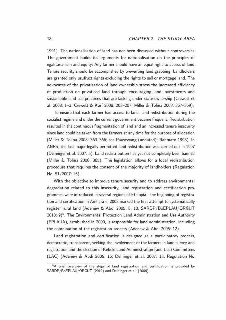
With the objective to improve tenure security and to address environmental
degradation related to this insecurity, land registration and certification pro-
grammes were introduced in several regions of Ethiopia. The beginning of registra-
tion and certification in Amhara in 2003 marked the first attempt to systematically
register rural land (Adenew & Abdi 2005: 8, 10; SARDP/BoEPLAU/ORGUT
2010: 9)6. The Environmental Protection Land Administration and Use Authority
(EPLAUA), established in 2000, is responsible for land administration, including
the coordination of the registration process (Adenew & Abdi 2005: 12).
Land registration and certification is designed as a participatory process,
democratic, transparent, seeking the involvement of the farmers in land survey and
registration and the election of Kebele Land Administration (and Use) Committees
(LAC) (Adenew & Abdi 2005: 16; Deininger et al. 2007: 13; Regulation No.
6A brief overview of the steps of land registration and certification is provided bySARDP/BoEPLAU/ORGUT (2010) and Deininger et al. (2006).
2.5. LAND POLICY IN ETHIOPIA 19
51/2007: §§19, 24(3), 26, 27, 28).
The duties and responsibilities of the kebele and sub-kebele LAC members
include: undertaking registration activities (Deininger et al. 2006: 8–9), adminis-
tering communal holdings, managing unused land and planning for its utilisation
or keeping documents (Regulation No. 51/2007: §§27, 28). LAC members are
elected for a period of three years (ibid.: §26(1)).
In Amhara, survey teams and land administration experts of the Woreda
Environmental Protection and Land Administration and Use office (WoEPLAU)
are involved in and supervise land registration (Deininger 2007: 7, 16–17). The
duties and responsibilities of the woreda authorities involve among others the
administration and management of state holding, training of LACs, supervision
of the fulfilment of farmers’ obligations regarding resource use and management
(Regulation No. 51/2007: §25). Figure 2.6, p. 19 shows the organogram of land
administration in ANRS.
Region: Environmental Protection Land Administration and Use Authority (EPLAUA)
Zone: Zonal Environmental Protection Land Administration and Use
Woreda: Woreda Environmental and Land Administration and Use office (WoEPLAU)
Kebele: Kebele Land Administration Committee (LAC)
Sub–kebele: Sub-Kebele Land Administration Committee
Figure 2.6: Organisation of land administration in ANRS. Source: modified after Adenew &Abdi 2005: 12
The following chapter presents the theoretical background and framework of
this study.

20 CHAPTER 2. THE STUDY AREA
Chapter 3
Theoretical Background and
Framework
Wetlands are open linked human-nature systems. In order to get a thorough
understanding of how system interlinkages influence the effectiveness of wetland
management, this work seeks to “integrate insights from three bodies of schol-
arship” (Armitage 2008: 8): common property theory, resilience and political
ecology.
Wetland resources are common-property resources owned by the state but
used by local people as well as non-residents. Common-property theory provides
useful insights into the problems but likewise opportunities of common-pool
resource governance. Resilience thinking then contributes significant implications
for an adaptive and multi-level governance of wetlands (Armitage 2008: 15; Folke
2006: 262). Political ecology unveils the socio-political processes that underlie
wetland utilisation and management. The theoretical framework, which guides the
present work’s analysis and will be presented later on, incorporates these three
complementary bodies of scholarship (figure 3.1, p. 24).
3.1 Common-Property Theory
Common-pool or common-property resources are characterised by the difficulty
of exclusion and the subtractability of benefits (Becker & Ostrom 1995: 115). To
21

22 CHAPTER 3. THEORETICAL BACKGROUND AND FRAMEWORK
manage common-pool resources sustainably, users must solve a collective action
problem. A collective action problem arises out of a social dilemma in which the
outcomes of individual rationality of resource appropriation (overuse, degradation)
conflict with optimal outcomes for a group (Agrawal 2001: note 6, 1666; Ostrom
2009 b: 30). In the 1990s, Ostrom identified design principles of robust property
rights institutions1 (Becker & Ostrom 1995: 118–122; Ostrom 2009 b) “that help
to account for the success of these institutions in sustaining the [common-pool
resources]” (Ostrom 1990: 90 in Agrawal 2001: 1652) and to overcome collective
action problems. “Robustness [. . . ] focuses on adaptability to disturbance: ‘the
maintenance of some desired system characteristics despite fluctuations in the
behaviour of its component parts or its environment’”(Carlson and Doyle 2002 in
Ostrom 2009 b: 31).
3.2 Resilience Thinking
Resilience thinking enriches this concept of robust institutions. As an important
component of social-ecological systems, robust institutions (Folke 2006) may not
only be characterised by the capacity to sustain the system and adapt to change,
but also to develop and transform the system (ibid.: 254, 262). Social-ecological
resilience includes “(1) the ability of a system to absorb or buffer disturbances and
still maintain its core attributes; (2) the ability of the system to self-organise; and
(3) the capacity of learning and adaptation in the context of change” (Armitage
2008: 15; see Folke 2006: 259–260). Uncertainty and system change require an
understanding of both the ecological and social dimensions of resilience (Folke
2006: 260). A comprehension of the role of social capital and conflicts and a
recognition of the flexibility of organisations and institutions are important to
understand social system features (ibid.: 261).
Resilience thinking provides four essential norms for multi-level governance2
(also termed adaptive co-management) of common-property resources: (1) to
1For a definition of institutions, see p. 29.2In general, governance of natural resources can be defined as “[. . . ] the whole of public as
well as private interactions taken to solve societal problems and create societal opportunities”and includes “[. . . ] the formulation and application of principles guiding those interactions andcare for institutions that enable them” (Kooiman & Bavinck 2007: 17 in Armitage 2008: 9).

3.3. POLITICAL ECOLOGY 23
“learn to live which change and uncertainty” (Armitage 2008: 16) (2) by integrating
different knowledge systems, (3) to cherish diversity to allow for the re-organisation
and renewal of the system and (4) to facilitate self-organisation to enhance the
sustainability of the social-ecological system (ibid.: 16).
3.3 Political Ecology
Political ecology can help to understand the social processes and values shaping
commons governance (Armitage 2008: 8, 19). With Bryant (1991), political
ecology “may be defined as an inquiry into the political sources, conditions,
and ramifications of environmental change” (p. 165). In political ecology (1)
the context of environmental change, i. e. the impact of state and policies on
changes, is approached, (2) location-specific aspects of environmental change are
investigated, e. g. the conflict over access, and (3) the effects such changes have
on social, economic and political relationships are assessed (Bryant 1991: 165). A
core theme is the role of power that conditions relationships between social actors
as well as human-environment links (Armitage 2008: 21; Bryant 1997: 10). The
concept of power can be understood as “the capacity of some actors to affect
the practices and ideas of others” (Weber 1978: 53; Lukas 1986: 3 both in Ribot
& Peluso 2003: 155–156) or as the control actors exercise over the environment
of other actors (Bryant 1997: 11). Armitage (2008) points to the intersections of
political ecology and resilience thinking, e. g. nested hierarchies, multiple scales,
and the self-organisation of complex systems.
3.4 Theoretical Assumptions
Based on these insights, the following theoretical assumptions which are of
relevance to this work can be made. (1) The alteration of wetlands is driven by
social, economic, political and ecological factors, at the same time influences
these contextual factors, and is shaped by various social actors, organisations and
institutions. (2) Wetland use changes involve conflicts over access to and use of
common-pool resources. (3) Conflicts affect people’s livelihoods and the resource

24 CHAPTER 3. THEORETICAL BACKGROUND AND FRAMEWORK
POLITICALECOLOGY
COMMON PROPERTY
THEORY
RESILIENCE
Property rights
InstitutionsCollective action
Change
Adaptabtability
Transformability
Self-organisation
Influence of policies
Power relations
Conflicts
Social processes
Figure 3.1: Three complementary bodies of scholarship. Source: modified after Armitage 2008:10
base. (4) The access to and use of common-property resources is mediated by
social relations and underlying power relations. (5) The unregulated utilisation of
common-property resources often entails degradation and overexploitation of these
resources (e. g. Ostrom 2009 b: 30). (6) The resilience of the social-ecological
system depends, inter alia, upon the robustness and effectiveness of resource
management institutions.
“Governance of the commons is a complex systems problem [drawing] attention
to social and ecological system properties” (Armitage 2008: 8). The theoretical
framework, as described below, helps to unravel, structure and deconstruct the
complexity of the social-ecological system under consideration.
3.5 Theoretical Framework
The environmental entitlements approach (Leach et al. 1999) provides a useful
entree into the analysis of complex human-wetland systems by focusing on the role
of institutions and their cross-scale interactions in shaping system components.
The entitlements analysis emphasises the structural and relational mechanisms

3.5. THEORETICAL FRAMEWORK 25
social actors draw on to benefit from wetland resources that likely influence
system properties. Furthermore, the social-ecological, political and economic
ramifications of wetland use changes, including conflicts over wetland resources,
can be adequately depicted.
To understand which actors use what wetland resources with what intention
and to subsequently address the social implications of wetland alteration, this
section commences with a basic introduction to environmental entitlements. In
their approach, Leach et al. (1999) refer to endowments as the rights and resources
(i. e. capitals or assets, see DFID 1999 a) social actors3 have. Endowments can
be obtained from environmental goods and services, e. g. wetland resources and
provided ecosystem services. Environmental entitlements are “alternative sets of
utilities derived from environmental goods and services over which social actors
have legitimate effective command4 and which are instrumental in achieving
well-being” (Leach et al. 1999: 233), i. e. what people can have (de Haan and
Zoomers 2005: 35). Capabilities are seen with Sen as what people can do or be
with their entitlements (Leach et al. 1999: 233) including non-material aspects
(Scoones 1998: 6) such as information and knowledge, relationships, reputation
or acquisition of skills (see the ‘endowment-entitlements-capabilities chains’ in
figure 3.2, p. 28).
In a cyclical process, the practices of wetland users, directed towards the
maintenance or enhancement of capabilities, are able to transform wetland compo-
nents in various ways (see Leach et al. 1999: 239). These practices are performed
within an institutional setting and a broader context5 (see the arrows emanating
from the ‘capabilities/well-being’ box and the ‘context’ in figure 3.2, p. 28).
Thereby ‘endowment-entitlements-capabilities chains’ of resource users are altered
to their advantage or disadvantage. Importantly, in social-ecological systems, the
sustainability of livelihoods is closely tied to the ecological resilience of the system
3Following Leach et al. 1999, ‘social actor’ refers to (1) individuals and (2) a group havingcommon characteristics, like social status or ethnicity.
4A ‘legitimate command’ is a command that is socially sanctioned either by formal orinformal rights. (Leach et al. 1999: 233).
5Environmental entitlements are embedded in a social, political, economic and ecologicalcontext which shapes livelihoods, defined as people’s “capabilities, assets (material and socialresources) and activities required for a means of living” (Chambers & Conway 1992 in DFID1999 b).
26 CHAPTER 3. THEORETICAL BACKGROUND AND FRAMEWORK
(Folke 2006)6.
How people gain endowments from wetlands and how these are transformed
into entitlements are questions addressed through endowment and entitlement
mapping, respectively (Leach et al. 1999: 232–233). The mapping processes
are essential to an entitlements analysis, for this is where underlying aspects
concerning power within social relations and access to resources emerge (ibid.:
233). Here, the environmental entitlements approach is complemented with the
theory of access by Ribot & Peluso (2003). Unlike in property theory, Ribot &
Peluso (2003) define access “as the ability to benefit from things” (p. 153), e. g.
from wetland resources. Access is more related to a “bundle of powers” than
a “bundle of rights” (Ribot & Peluso 2003: 153; see Ostrom 2009 b: 27–29),
and “focusing on ability, rather than rights [. . . ] brings attention to a wider
range of social relationships that can constrain or enable people to benefit from
resources without focusing on property relations alone” (Ribot & Peluso 2003:
154). Ribot & Peluso (2003) define access control as “the ability to mediate
others’ access” (p. 158), and access maintenance as keeping access. Actors
mediate (or determine) and keep access through means of power and resource
expenditure. Gaining access refers to a “more general process by which access is
established” (ibid.: p. 159). Access analysis comprises the identification (1) of a
particular benefit flow of interest to social actors (comparable to the identification
of endowments, entitlements, capabilities), (2) the mechanisms through which
people gain, control and maintain access to benefits, and (3) an analysis of power
relations which determine whether, how and to which extent social actors gain
access to resources (ibid.: 160–161). Mechanisms of access can be categorised into
(1) rights-based mechanisms, and (2) structural and relational access mechanisms
(Leach et al. 1999: 233; Ribot & Peluso 2003: 161–172; see horizontal arrows in
figure 3.2, p. 28).
“When the ability to benefit from [wetland resources and services] derives
6“A livelihood is sustainable when it can cope with and recover from stresses and shocksand maintain or enhance its capabilities and assets both now and in the future, while notundermining the natural resource base” (Chambers & Conway 1992 in DFID 1999 b). Livelihoodsustainability comprises social and ecological resilience. Ecological or ecosystem resilience meansthe “capacity of a system to absorb disturbance and re-organise while undergoing change so asto still retain [. . . ] function, structure, identity and feedbacks” (Walker et al. 2004 in Folke2006: 259).

3.5. THEORETICAL FRAMEWORK 27
from rights attributed by law, custom, or convention” (Ribot & Peluso 2003:
162), the benefited person may then have a property right, i. e. an endowment,
to benefit from these resources and services (ibid.: 162). At this junction, the
theory of access encounters the concept of property rights (Schlager & Ostrom
1992 in Ostrom 2003: 249–252 and Ostrom 2009 b: 27–29). The supplement of
a property rights perspective to the theoretical framework is useful for identifying
the differently positioned social actors and their property rights over wetlands,
and for understanding the way different bundles of property rights affect wetland
management.
Schlager & Ostrom 1992 (in Ostrom 2009 b: 27–29) proposed thinking of
property rights systems not as a single right but rather in terms of bundles of
rights. They defined the following five rights which are “most relevant for the use
of common-pool resources” (Ostrom 2003: 249):
1. Access: the right to enter a defined area and enjoy non-subtractive benefits,
2. Withdrawal: the right to obtain resource units or products of a resource
system,
3. Management: the right to regulate internal use patterns and transform the
resource by making improvements,
4. Exclusion: the right to determine who will have an access right, and how
that right may be transferred,
5. Alienation: the right to sell or lease exclusion, management or withdrawal
rights
(Ostrom 2003: 249–250). In a later work Ostrom & Schlager (1996 in Ostrom
2003: 250–252) associate bundles of rights with positions, i. e. property-rights
holders (table 3.1, p. 28).

28 CHAPTER 3. THEORETICAL BACKGROUND AND FRAMEWORK
Table 3.1: Bundles of property rights associated with positions. Source:
Ostrom & Schlager (1996) in Ostrom 2003: 251
Full
owner
Proprietor Authorised
claimant
Authorised
user
Authorised
entrant
Access + + + + +
Withdrawal + + + + –
Management + + + – –
Exclusion + + – – –
Alienation + – – – –
The way people gain endowments and entitlements is mediated by various
interacting institutions that manage wetland resources and work on different
scales (micro, meso, macro; see the blue boxes appearing to the right in figure
3.2, p. 28).
Context(social, ecological, political, economic)
MacroMeso
MicroInstitutions
MacroMeso
MicroInstitutions
MECHANISMSOF ACCESS
*
Endowment mapping
Entitlement mapping
SOCIAL & POWERRELATIONS
Endowments(capital & rights)
Entitlements
Social actors
Capabilities/well-being
Environmental goods & services
MacroMeso
MicroInstitutions
Figure 3.2: Environmental entitlements framework. * It was not part of this investigation toanalyse according to which concrete mechanisms and arrangements entitlements are transformedinto capabilities at the household level. Source: modified after Leach et al. 1999: 234

3.5. THEORETICAL FRAMEWORK 29
The focus of this work is on local management systems but considers local
institutions as being nested inside and interacting with larger ones. The large
literature defines institutions as sets of formal and informal rules and conventions,
shaping behaviour and interactions (e. g. Agrawal & Gibson 1999: 637, note
46, 644; but cf. Leach et al. 1999: 237). Rules are made and remade through
regularised practices and patterns of behaviour and may be challenged in the
course of institutional change (Leach et al. 1999: 237, 238). Institutions impinge
on access to resources, influence the use and management of resources, shape
and transform wetland ecosystems (Leach et al. 1999: 234, see also 238–240),
and by so doing affect the resilience of social-ecological systems. The analysis of
institutions pertaining to wetland management further draws on insights from
the research on governance of common-property resources and community-based
natural resource management by Agrawal (2001), Agrawal & Gibson (1999),
Becker & Ostrom (1995), Ostrom (2003, 2009 a, 2009 b), Ostrom et al. (1999)
and others. Comprehensive studies on these topics provide useful knowledge of
the conditions that strengthen or weaken local wetland management institutions.
To conclude this chapter, figure 3.3, p. 30 simplistically depicts how common-
property theory, resilience thinking and political ecology as well as the research
questions (p. 7) fit in the theoretical framework.
The methodology and methods applied for the present research work are
elaborated in the next chapter.

30 CHAPTER 3. THEORETICAL BACKGROUND AND FRAMEWORK
ContextWhat are the decisive structural and relationalconditions that determinean effective wetland management and a sustainable resource utilisation?
MacroMeso
MicroInstitutions
Endowment mapping
Entitlement mapping
PE: SOCIAL & POWERRELATIONS
In what way does land administration affect wetland useand management?
What are the mechanismsand means local actorsdraw on to benefit from wetlands?
SER
CPT PE
Which conflicts over wetlands arise?
Which factors influence the ability of local management institutions to effectively conservewetland resources?
In what way do land use changes affect wetland use and management?
Endowments(capital & rights)
Entitlements
Social actors
Capabilities/well-being
Wetland resources &
services
Figure 3.3: Integrating theory and research questions. The emergence of the three complementarybodies of scholarship and research questions within the theoretical framework. CPT common-property theory, PE political ecology, SER social-ecological resilience (the focus here is on thequestion of why social-ecological resilience is or is not achieved). Source: modified after Leachet al. 1999: 234

Chapter 4
Methodology and Methods
This chapter provides a short introduction to the research approach of this study
and further describes the methods applied and procedures for data collection. An
outline on data preparation and analysis adjoins.
4.1 Research Approach
This research study follows a qualitative research approach. Qualitative research
seeks to describe social realities through an internal perspective of the actor(s)
(Flick et al. 2009: 14). People act according to their subjective intentions and the
meanings they ascribe to phenomena within a historical and situational context
(Flick et al. 2009: 20; Mayring 2002: 22–23). To understand these actions and
their outcomes, subjective perspectives and intentions need to be reconstructed
and interpreted (Flick et al. 2009: 20; Mayring 2002: 22).
Qualitative research concentrates on theory generation on the basis of em-
pirical data and employs an inductive approach (without questioning deductive
approaches per se) (Lamnek 2010: 222). Theories are generated in the course
of the entire research process rather than verified by means of the research
entity (Mayring 2002: 36–37). The inductive approach allows the researcher to
continuously develop, verify, reject, modify and integrate hypotheses forming
the basis of the theoretical framework (Lamnek 2010: 98). Theory generation is
not a linear but a cyclical process. Data collection and data analysis thus take
31
32 CHAPTER 4. METHODOLOGY AND METHODS
place simultaneously and are mutually supportive (ibid.: 97). Grounded theory,
developed by B. G. Glaser and A. L. Strauss in the 1950s and 60s (Mayring 2002:
103), is a methodology to generate theories which was applied for data collection
and analysis of the present research study. Grounded means anchored in empirical
evidence (Lamnek 2010: 90, 91).
A qualitative approach is considered suitable for this study. In order to gain
insights on the decisive conditions for an effective wetland management, it was
indispensable to understand actors’ perceptions and incentives on wetland use
and management and their attitudes towards conservation. Further on, though
the kebeles do not extend over a large geographical area (figure 2.2, p. 13) it
could neither be assumed that local conditions are the same everywhere, nor that
they are distinct. Developing a definite theory before visiting the kebeles was
therefore unfeasible. Likewise, it was unreasonable to create fixed hypotheses,
given the assumed heterogeneity of local communities and even more importantly
the lack of information on local management systems and influencing factors. The
methods for collecting empirical data on the research topic are elaborated below.
4.2 Data Collection
This section presents the research designs of the applied data collection methods,
namely Participatory Rural Appraisal (PRA) and problem-centred interview meth-
ods. All PRA discussions and interviews were held and conducted from September
to November 2011.
4.2.1 Participatory Rural Appraisal and Group Discussions
In order to get an understanding of the complex structural and relational conditions
that determine the effectiveness of wetland management, the participation of
relevant actors is crucial. Since dialogues with responsible stakeholders and
communication with local communities on wetland resource management have
been rare (Gebrekidan 2006 b: 38), this work is especially motivated to ask
and involve relevant social actors to understand their internal perspectives. PRA
comprises suitable methods motivating people to become involved, and can be

4.2. DATA COLLECTION 33
defined as “a family of approaches and methods to enable rural people to share,
enhance, and analyse their knowledge of life and conditions, to plan and to act”
(Chambers 1994 b: 953). “PRA is thus designed to empower” (Chambers 1994 a:
1266) local people1.
4.2.1.1 Selection of the Research Sites
Wetlands of the study area were considered to be potentially relevant to both the
Lake Tana biosphere reserve and the CPINReMP (personal communication: BDU;
BoCTPD; zur Heide) due to their importance for biodiversity conservation and
concurrent critical linkages with exploitative human activities. The insufficiency in
available social-ecological data motivated the site selection. Rather pragmatical
criteria were the proximity to the regional capital, Bahir Dar which was the base
camp (figure 2.2, p. 13), and the accessibility of the villages. Due to flooding,
the kebeles along the shore of Lake Tana could only be accessed by boat or car
using ‘rocky’ roads. Travelling was costly in terms of money and time.
4.2.1.2 Group Size, Composition and Selection of the Participants
PRA is a group activity. The group size ranged from two to many, usually five to
eight participants. Occasionally, interested persons joined the discussions during
the process. Discussions were thus generally open to all, except during discussions
with women and fishermen of the Woito tribe when explicitly unwelcome.
Local participants should live close to a wetland or use the wetland resources
(theoretical relevance, Glaser & Strauss 2010: 65–66). The persons should have
time and interest in discussing the relevant topic. Locally and especially on working
and conference days, it was difficult to find people who had enough time to take
part in PRA (timing bias, see Kumar 2002: 37). Thus the few ones present were
asked to participate. (Due to the lack of people’s time some PRA processes were
rushed and interrupted.) At central locations (e. g. village centres where many
people gathered), there was a possibility to ‘pick out’ PRA participants which
1Note that the objective of this research work and the expected outcomes justify a rather‘extractive’ data mining, i. e. local people were asked to share their knowledge about thehuman-wetland system.

34 CHAPTER 4. METHODOLOGY AND METHODS
were otherwise difficult to reach (e. g. development agents, kebele leaders, LAC
members or people trained in wetland management).
PRA sessions were also held with woreda officials. Their official duties or their
expertise in the relevant topic were seen to be of interest for this study.
PRA groups were either homogeneous (e. g. women, Woito fishermen, young-
sters) or heterogeneous (e. g. landless and livestock farmers, farmers and kebele
leaders) (see Glaser & Strauss 2010: 70–71). Group composition, important to
make people feel easy during the discussions, was mainly chosen intentionally and
sometimes randomly depending on the situation. In very heterogeneous groups,
marginalised people (e. g. poor and young) were at times incapable of freely
expressing their views (elite bias, see Kumar 2002: 35). Efforts were made to
address them directly and provide them a chance to talk. Women and Woito
fishermen felt easier and were more open when discussions were held separate
from men or members of other communities, respectively. Generally, women
infrequently participated in PRA. Their perceptions and knowledge is therefore
inadequately represented (male bias, see Kumar 2002: 36).
4.2.1.3 General Procedure
After selecting the PRA participants a suitable, often shadowy location was
chosen. Each PRA session began with an introduction of the research team. The
purpose of the discussion and the procedure was explained. Mostly, the names,
age, occupation, official duties and partly endowments of the participants were
registered.
The process was initiated by a general question, e. g.: ‘Which services does the
wetland provide to you?’ or ‘Have you perceived any changes in your environment
or the way the land is used?’. Further questions went along with the visualisation
of the answers (maps, diagrams, matrices etc.) using paper and pen. Some
participants were unfamiliar utilising pens and paper, and felt shy or uneasy
drawing. Utilisation of other (natural) materials would have been a solution but
was often unfeasible. Due to the lack of time or spontaneously arising opportunities
of conducting discussions, visualisation was occasionally omitted.
Subsequent to visualisation, the discussion, i. e. the interview about the visual

4.2. DATA COLLECTION 35
output, helped clarifying questions and understanding complex issues and problems
that emerged (see Chambers 1994 a: 1263; Kumar 2002: 44). Very often, the
discussion itself revealed additional interesting facts. Occasionally, participants
were highly suspicious when asked sensitive questions, e. g. about land tenure and
conflicts (diplomatic bias; see Kumar 2002: 37), and the discussion had to be
shifted into ‘calm water’. At the end of the PRA session, participants were asked
whether they wanted to give additional comments and recommendations or to
make some statements. Each session took approximately one to two and a half
hours.
With the help of my colleague, Babiyew Sibhat, the PRA sessions were directly
translated from Amharic to English and vice versa. Of course, research that is not
conducted in the researcher’s mother tongue makes an entire understanding of
social realities even more difficult. Subsequent reflections on the processes helped
to adequately understand people’s ‘words between the lines’ and the hidden social
relations.
During the PRA sessions, participants’ contributions to discussions were noted
as precisely as possible. Sketches of the maps, diagrams etc. were made to add
personal comments and memos. These scripts, sketches and photographs of the
maps, diagrams etc. form the basis of data analysis (see p. 42).
The sampling of further data on the research subject usually terminated when,
apparently, no additional information and issues emerged (theoretical saturation,
see Glaser & Strauss 2010: 77). Due to the inaccessibility of Agid Kirigna kebele,
sampling did not reach its theoretical saturation, making further research necessary.
Despite constraints to data collection, most of the participants vigilantly
observed the gradual development of maps and diagrams and vitally discussed
the emerging issues. PRA was a welcome variation of everyday life and a method
perceived as positive to ask people about their views and ideas (personal commu-
nication: farmers in Agid Kirigna). Appendix 1, p. I lists the concrete application
procedure of each PRA method.

36 CHAPTER 4. METHODOLOGY AND METHODS
4.2.1.4 Methods of Participatory Rural Appraisal
Table 4.1, p. 36 provides an overview of the applied PRA methods and their
intended use. For a general description of the PRA methods and their application
see Kumar (2002).
Table 4.1: Methods of PRA and group discussions. The identification
numbers (ID No.) follow the numbering used in the field. Group
discussions indicated with the abbreviation ‘BS’ were held by Babiyew
Sibhat. Numbers in brackets indicate primary document (P) numbering
in ATLAS.ti. * Discussions without visualisation
Purpose ID No. Participants Location2
Resource map
Depiction of wetland uses and
management, land tenure, re-
source use conflicts; get an idea
about the broader landscape,
locate relevant communities for
further PRA sessions
2 (P2) Farmers, landless,
priest
Sedechila
Mariam,
Sewtiye
6 (P6) Farmers, priest, DA,
health extension expert
Wagetera
14 (P15) Landless, farmers Luhawit
18 (P21) Farmers, kebele leader,
WoEPLAU representa-
tive, health extension
expert
Guwala
Trend Analysis
Get a historical perspective of
change of land/wetland use, how
it is perceived and influences
livelihoods (figure 4.1, p. 38)
1 (P1) Farmers, nuns Ahun Wota
7 (P7) Farmers, nun Amana
13 (P14) Farmers Tigremender
19 (P22)* WoEPLAU (environ-
mental impact assess-
ment expert, envi-
ronmental education
expert, land use expert,
environmental impact
assessment expert)
Addis Zemen
2See p. 12

4.2. DATA COLLECTION 37
Purpose ID No. Participants Location
Cause-effect diagram
Analyse environmental/land
use changes, drivers and social-
ecological ramifications (figure
4.2, p. 38)
3 (P3) Farmers Sedechila
Mariam
4 (P4) Male and female farm-
ers
Woreta (par-
ticipants are
from Angur-
bad)
10 (P10,
P11)
DAs (natural resource
management, animal
science)
Wagetera
Impact diagram
(1) Perceptions on wetland con-
servation, management scenarios,
possible effects of these scenarios
on livelihoods; (2) livelihood
strategies, land use change (fig-
ure 4.3, p. 39)
5 (P5) Farmers and three nuns Woreta (par-
ticipants are
from Gir-
basha)
11 (P12) Farmers, two priests Sela
22 (P25) N/A (farmers) Fota Mender
23 (P26) Farmers Gulash
Well-being ranking
Identify well-being groups3; study
conceptions of well-being, de-
velopment, livelihood strategies
(figure 4.4, p. 39, figure 4.5,
p. 39)
8 (P8) Women Sindeye
15 (P16) Landless, youngsters Bobatie
Venn diagram
Study the importance of services,
administrative bodies, other or-
ganisations for local people, and
their cooperation
12 (P13)* Farmers, priest Barye
21 (P24)* Farmers Bahir
Mender
28 (P27) WoARD, WoEPLAU,
WoWE
Woreta
3The identification of well-being groups by local people includes the mapping of in-/tangible
assets and their accessibility to different well-being groups.

38 CHAPTER 4. METHODOLOGY AND METHODS
Purpose ID No. Participants Location
Pair-wise ranking
Detect resource use conflicts,
conflicts between wetland con-
servation and use; causes and
consequences of these conflicts
(figure 4.6, p. 39)
9 (P9) Farmers Sindeye
16 (P18) Farmers, LAC/elder
court, model farmer,
police man, wetland
trainee
Daga
20 (P23) Fishermen of the Woito
tribe
Qurtbahir
Group discussions
Fishery management and conser-
vation
17 (P20)* Members of the fisher-
men’s association
Daga
Land/wetland use change; impli-
cations on livelihoods
BS4
(P54)*
Kebele leaders Addis Zemen
(participants
are from
Lamgie and
Koker)
BS5
(P56)*
Kebele leaders Addis Zemen
(participants
are from
Daga)
Figure 4.1: Trend analysis in Amana,Wagetera. Photograph: Springsguth, M.
Figure 4.2: Cause-effect diagram drawn bydevelopment agents in Wagetera. Photo-graph: Springsguth, M.
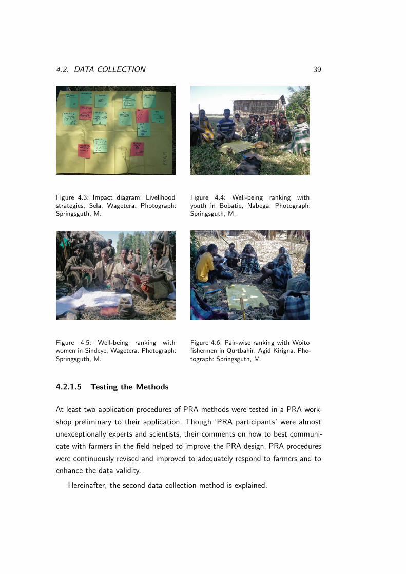
4.2. DATA COLLECTION 39
Figure 4.3: Impact diagram: Livelihoodstrategies, Sela, Wagetera. Photograph:Springsguth, M.
Figure 4.4: Well-being ranking withyouth in Bobatie, Nabega. Photograph:Springsguth, M.
Figure 4.5: Well-being ranking withwomen in Sindeye, Wagetera. Photograph:Springsguth, M.
Figure 4.6: Pair-wise ranking with Woitofishermen in Qurtbahir, Agid Kirigna. Pho-tograph: Springsguth, M.
4.2.1.5 Testing the Methods
At least two application procedures of PRA methods were tested in a PRA work-
shop preliminary to their application. Though ‘PRA participants’ were almost
unexceptionally experts and scientists, their comments on how to best communi-
cate with farmers in the field helped to improve the PRA design. PRA procedures
were continuously revised and improved to adequately respond to farmers and to
enhance the data validity.
Hereinafter, the second data collection method is explained.

40 CHAPTER 4. METHODOLOGY AND METHODS
4.2.2 Problem-Centred Expert Interviews
Experts, woreda and regional officials and key informants were interviewed using
the problem-centred interview method. The interviews were semi-structured, the
questions open. A catalogue of research question was compiled and used as an
interview guideline (see Appendix 2, p. XI).
This method was applied to (1) verify hypotheses which were developed in the
field (theory-driven method, see Mayring 2002: 70), (2) validate information and
resolve questions, (3) apprehend complex human-wetland linkages by drawing on
expertise and (4) arrive at the subject perspectives, interpretations and opinions
of the respondent.
4.2.2.1 Selection of the Respondents
Respondents were selected according to their specialised knowledge or their official
mandates which were seen to be associated with the research subject. Fairly
frequently, potential further informants were filtered from previous interviews.
4.2.2.2 Interview Procedure
Each interview commenced with a personal introduction and explanation of the
interview purpose. Subsequently, the respondent was asked to introduce himself
(educational background, field of research, project work etc.). This intended
short warm-up phase helped to choose pertinent questions from the catalogue.
Introductory questions were asked followed by an open interview conversation.
Spontaneously emerging issues of concern were addressed. The interviews were
mainly conducted in English, a familiar language to me, and were noted in
manuscript form.
4.2.2.3 Overview of the Interviews
Table 4.2, p. 41 provides an overview of the interviews conducted.

4.2. DATA COLLECTION 41
Table 4.2: Overview of Interviews. The identification numbers (ID
No.) follow the numbering used in the field. Interviews marked ‘BS’
were held by Babiyew Sibhat. Numbers in brackets indicate primary
document (P) numbering in ATLAS.ti.
Subject area ID No. Respondent Location
Wetland
management
institutions;
human-
wetland
system
1 (P28) EWNRA Addis Ababa
2 (P29) EWNRA Addis Ababa
5 (P32) BoARD Bahir Dar
6 (P33) EPLAUA (Department of Environmental Pro-
tection)
Bahir Dar
13 (P40) BDU Bahir Dar
Human-
wetland
system
4 (P31) BoWE Bahir Dar
7 (P34) BoWE Bahir Dar
8 (P35) WoARD (water harvesting expert, irrigation
expert, rural road construction)
Addis Zemen
9 (P36) ARARI Bahir Dar
11 (P38) TaSBO Bahir Dar
12 (P39) Ethiopian Nile Irrigation and Drainage Project Bahir Dar
BS2
(P55)
Early warning and risk disaster management
processes coordinator (EWRDM)
Addis Zemen
BS3
(P52)
Kebele leader Wagetera
Land adminis-
tration
3 (P30) Institute of Land Administration BDU (ILA) Bahir Dar
10 (P37) EPLAUA Bahir Dar
17 (P42) WoEPLAU Woreta
18 (P43) WoEPLAU Addis Zemen
Fisheries 14 (P41) Bahir Dar Fisheries and other Aquatic Life
Research Centre (ARARI)
Bahir Dar
BS1
(P53)
WoARD (fish resources development expert) Addis Zemen

42 CHAPTER 4. METHODOLOGY AND METHODS
4.3 Data Preparation and Analysis
Primary data (PRA, group discussions, interviews, own observations) were available
in manuscript notes. The preparation of primary data before analysis comprised
summarising and selecting the relevant data material (see Mayring 2002: 94–99).
The analysis of the processed primary data and secondary data (two group
discussions and three interviews conducted by Babiyew Sibhat) was done us-
ing ATLAS.ti, a qualitative data analysis software that helps organising data
and facilitates the conceptualisation and categorisation of research data and
the development of hypotheses (see Friese 2012: 9–10). In grounded theory,
coding/conceptualisation is a fundamental method which aims at developing
categories (Glaser & Strauss 2010: 119–120). Concepts can be defined as con-
cise designations which can be attributed to events, phenomena, occurrences
etc. (Muckel 2007: 216–217), and are “relevant theoretical abstractions of what
happens in the analysed field” (Glaser & Strauss 2010: 41). Categories can be
created by classifying concepts which refer to similar phenomena. Hypotheses
are generalised relations between categories (Glaser & Strauss 2010: 56–57).
Conceptualisation and categorisation already take place during data collection.
The processed primary and secondary data material was stored as primary
documents in one hermeneutic unit of ATLAS.ti, i. e. the “container” for each
project that includes all primary documents (Friese 2012: 13–14). Open coding in
ATLAS.ti marked the beginning of data analysis. The data material was freely
associated with codes (see Appendix 3, p. XVIII) and accurately analysed for
already assigned or new codes. Questions and memos were written (see Muckel
2007: 221; Strauss 1994: 57–62). The writing of memos is a central element of
Grounded Theory and aims at clarifying, combining and differentiating aspects
and concepts to finally integrate them to form a theoretical construct. Memos
are essential during data collection and analysis (see Friese 2012: 18; Mayring
2002: 105). PRA sessions, group discussions and interviews were screened for the
same codes. In this way, the different data sets could be analysed for conformity
and consistency and for variety and differences to make them comparable.
Axial and selective coding in ATLAS.ti was mainly done with the help of the
query tool and the co-occurrence table explorer (see Friese 2012: 251–267, 285–

4.3. DATA PREPARATION AND ANALYSIS 43
287), by linking of quotations and drawing networks on paper (since it was not
possible to create ‘sub-networks’ in ATLAS.ti). Axial coding aims at developing
and consolidating categories and helps to structure a theory. A provisional concept
is analysed according to the coding paradigm, i. e. a code is tested for its conditions,
interactions, strategies and consequences (Muckel 2007: 224). Selective coding
means to systematically relate various categories to key categories. The further
analysis of this relation according to the coding paradigm, and writing of focused
memos can finally be integrated into a grounded theory (Strauss 1994: 63–64).
The output of each query result was stored as a super code (see Friese 2012:
267–271).
Analysis itself was a gradual and cyclical process: codes and memos were
developed according to the material, completed, complemented, revised, compared
and linked (see Mayring 2002: 106, 145–146). ATLAS.ti very well supported this
open, flexible, dynamic and reflective analytical process.
Data was validated by triangulation. Triangulation offsets the weaknesses of
one way to access data with the strengths of another (Lamnek 2010: 141–142).
Sources of primary, secondary and tertiary data (e. g. paper, legal documents) were
combined to validate information and findings, and to clarify uncertainties (data
triangulation). PRA sessions and interviews were discussed and analysed with
my research colleague so that misconceptions could be resolved and subjective
influences could be corrected (investigator triangulation). Different PRA methods,
and PRA with problem-centred interviews were combined for methodological
triangulation (see Denzin 1978, in Lamnek 2002: 142).
In order to allow for the comparison of research data, the following comparison
groups were identified and categorised:
• Social actors in different research sites: Distinctions and similarities between
comparison groups are determined by the locality, local conditions, ecological
conditions or social processes.
• Social actors of different well-being groups, social status, ethnicity: Distinc-
tions and similarities between comparison groups are determined by their
membership of well-being groups (landless, lower, middle, upper), social
status (kebele leaders/administration, LAC members, rich people, nuns,

44 CHAPTER 4. METHODOLOGY AND METHODS
priests) and ethnicity (Woito tribe).
• Social actors distinguished by their values, objectives and priorities. (This
category is often linked to the former.)
The manuscript notes of primary and secondary data sources are quoted
using the quotations assigned to the notes in ATLAS.ti. A quotation, e. g. 2:34,
indicates the number of the primary document (2) and the consecutive quotation
number within the primary document (34). Names of the institutes of interview
respondents are indicated.
The results that were obtained by the above mentioned methods are presented
in the following chapter.

Chapter 5
Results
The results presented in this chapter provide insights into environmental and land
use changes, and the consequences of these changes on rural livelihoods. Further
on, the conflicts over wetlands and their associated resources, and the effects of
land administration on wetland utilisation are addressed. Finally, common-pool
resource management institutions and the conditions that constrain an effective
management are presented. But first of all, this chapter provides an introduction to
the values of wetlands, perceptions of well-being and people’s objectives regarding
their lives. These are fundamental in understanding wetland utilisation.
5.1 Values of Wetlands
Wetlands provide various tangible assets to local people:
• fodder and hay for livestock (e. g. 6:1; 7:25; 9:4; 14:13; 24:17)
• crops (due to high wetland soil fertility) (e. g. 6:1; 9:4; 14:11; 25:3; 26:4)
• water for domestic supply, animal drinking (e. g. 7:25; 9:4; 14:13)
• irrigation water (using water pumps, canisters, by wetland drainage) (e. g.
6:1; 9:4; 21:7)
• fish (especially valued by the Woito tribe, whose livelihoods depend upon
fishery) (e. g. 7:25; 9:4; 23:3)
45

46 CHAPTER 5. RESULTS
• plant species for roof thatching, handicraft making, protection against flood,
ornamental purposes or tanqua building (e. g. 8:16; 9:4; 21:10; 52:19).
Wetlands are further valued for their social and cultural importance (15:13;
25:15). Rather seldom the regulating (2:17; 7:25; 9:4; 15:3; 24:31) and the habitat
function of wetlands are acknowledged (e. g. 7:25; 14:13; 18:10). The instrumental
(direct use) value of wetlands for humans is given high priority.
The socio-economic contribution of wetlands is recognised by officials (crop
production, irrigation water supply, addressing landlessness) (BoWE: 31:5; BoWE:
34:1; TaSBO: 38:1; WoARD: 35:1). The Ethiopian government recognises the
ability of wetlands to store carbon as a contribution to mitigate climate change
(EWNRA: 29:1; see MoARD 2010: 15). Scientists and conservationists generally
emphasise the ecological functions of wetlands (ARARI: 36:26; EPLAUA: 33:1;
figure 5.1, p. 46).
Provisioning
Animal feed,productive arable land,domestic water supply,irrigation water supply,fish,plants for handicrafts, roof thatching etc.,habitats for fauna and flora
Regulating
Sediment trapping,temperature regulation,ground water retention,flood control,buffer zone
Cultural
Recreation (refreshment),ornamental purposes,ceremonies,distribution as a solution tosocio-economic problems
Supporting
Carbon sequestration
Figure 5.1: Ecosystem services of wetlands as perceived by various stakeholders. Ecosystemservices, providing benefits to humans, can be classified into: provisioning, regulating, supportingand cultural (MA 2005: v-vi). Source: compiled from own results
The values people ascribe to wetlands are reflected in personal objectives set
to enhance well-being and shaping wetland use.

5.2. PERCEPTIONS ON WELL-BEING AND PEOPLE’S OBJECTIVES 47
5.2 Perceptions on Well-being and People’s
Objectives
Though wetlands fulfil important functions, local people perceive them to be
unproductive, useless wastelands (4:38; 5:8; 7:25; 25:6; EWNRA: 32:3). One
official formulated this exaggeratedly: “Wetlands are like the flesh of a monkey,
people do not eat it so they do not use it” (BoWE: 31:10).
Intrinsically unimportant, wetlands instrumentally contribute to people’s well-
being (4:24; cf. 15:34). The natural resource endowments of the kebeles (soil
fertility, water availability) are seen to be sufficient to secure and support livelihoods
(8:11; 12:40; 15:10, 23:38, 56:17). “Around Lake Tana in central Amhara, [. . . ]
landholdings are limited, but good rainfall, high fertility and the sales value of
the abundant mix of crops (including some paddy rice) and livestock and butter
make this one of the country’s wealthiest areas” (USAID/MoARD 2010: 67, see
also 63–75).
However, well-being ranking (see p. 37) revealed a varied picture of wealth.
Local people identified four well-being groups (8:5; 16:1) which were classified on
the basis of landholding size and livestock numbers as indicators of wealth1: (1)
landless people: no land, (2) lower well-being group: 0.25 ha to 0.5 ha land, no or
1 ox and a few cows, (3) middle well-being group: 0.75 ha to 1.0 ha land, 1 ox and
a few cows, (4) upper well-being group: more than 1.25 ha land, 2 oxen, a few to
many cows, 1 horse or donkey. The four well-being groups are differently endowed
with tangible and intangible assets such as health, education, authority, social
status, food or clothes (see Appendix 4, p. XVIII). The application of livelihood
strategies to respond to insecurities and enhance well-being varies between these
groups (see 8; 16; see Appendix 5, p. XIX).
For the participants (landless and members of the lower and middle well-being
groups; see 8; 16), ‘development’ aims at attaining prosperity and establishing
1This classification was verified by indications of farmers’ assets (6:23; 8:35; 9:1; 15:29;16:2; 52:2). Though de Haan and Zoomers (2005) suggest “characterising [farmers] in terms oftheir objectives and priorities” (p. 40), it seemed to be appropriate to classify well-being groupsin terms of tangible assets due to the importance people ascribe to them (see 8:27). Woitopeople whose livelihoods depend rather on fish resources than on agriculture are not classifieddue to insufficient data.

48 CHAPTER 5. RESULTS
social status. A good life encompasses education, employment, health, reputation,
respect, reduced workload and material goods such as quality and balanced
food, clothing, household items, farm inputs, livestock or landholding (8:24; 16:7,
16:9). By hard work a good life can be achieved (8:22; 16:4). Giving birth to
many children earns respect, helps to better represent own interests within the
community and reduces workload for household individuals (8:17). Whereas poor
peasants strive to accumulate wealth for a good life, richer peasants are interested
in the consolidation of wealth (see p. 56).
The values actors ascribe to wetlands, people’s perceptions on well-being
and their objectives shape wetland resource appropriation. Different well-being
groups utilise and manage wetland resources in different ways (e. g. 7:48; 8:20;
23:24; 43:16; see p. 56). The next section addresses changes in wetland resource
utilisation and use regimes, which is necessary to understand the effects of land
use changes on wetland management.
5.3 Environmental and Land Use Changes
Land use changes in the wetlands around Lake Tana have significantly increased
and become a threat to the integrity of the ecological system (Amsalu 2006: 19).
The major environmental and land use changes in the wetlands east of the lake
as perceived by local people are: unusual flooding events, sedimentation, changes
in the cropping pattern (including the conversion of wetlands especially for rice
cultivation, resulting in a continuous loss of wetlands) and increasing fishing
activities (e. g. 1:18; 3:6; 4:30; 7:52; 14:23; 23:10; 54:8, 54:12; ARARI: 36:3;
EWNRA: 29:4). These changes and their drivers are shortly described below. Other
changes detected by farmers are the increase in area of settlements (Appendix 6,
p. XXIV) and Eucalyptus plantations (1:38; 4:30).
5.3.1 Flooding and Sedimentation
The “flooding era” began around 1996 (9:9). Despite the natural occurrence of
flooding events, it is stressed that the floods in 2010 and 2011 have been more
severe than in the past, with inundations lasting until the dry season (April/May)

5.3. ENVIRONMENTAL AND LAND USE CHANGES 49
and lake levels exceeding the annual average (52:4; ARARI: 36:8; BDU: 40:7;
WoEPLAU Addis Zemen: 22:1).
Assumptions are made that flooding might be caused by the artificial regulation
of the lake level for hydropower generation (e. g. 3:4; 6:13; 11:3; WoEPLAU Addis
Zemen: 22:4). Due to inconclusive correlations between water level and rainfall
(3:3) as well as the artificial regulation, it is difficult for farmers to forecast the
severity of flooding (1:22; 18:13; ARARI: 36:8; EWRDM: 55:6). A few farmers
in Tanametsele kebele related flooding to catchment degradation in the upper
watershed resulting in depositions of sediment at the river mouth of Gumara
(3:4). Officials argued that flooding was also caused by the degradation of
wetlands through farmers ‘capturing’ the lake shore and thereby impairing the
flood regulating function of wetlands (TaSBO: 38:3; cf. BoWE: 34:3; Bakema &
Mafabi 2003: 101).
Sedimentation is recognised by farmers (3:4; 4:3; 14:3; personal communi-
cation: farmers in Daga). Sediment depositions are seen to improve soil fertility,
increase crop production at least for a short period and make the application of
fertilisers dispensable (15:10; 52:33; 56:4; personal communication: farmers in
Sedechila Mariam). According to SMEC (2008) the total annual sediment load
from the upper catchments into Lake Tana is estimated to be 9.6 million tons.
Thereof 8.6 million tons (equivalent to 1 to 2 mm of sediment per year) settle in
the lake basin, mainly near the outlets of the rivers.
5.3.2 Rice Cultivation
Rice cultivation was promoted by the Derg (socialist regime) (7:3) and introduced
by North Korea in 1978 (BoARD 2011 b: 1; cf. 52:9). Initially, rice cultivation was
less accepted and its expansion failed due to difficulties regarding the threshing
and pealing of rice grains (lack of dehiscent mills), and the absence of markets
during the communist regime (1:39; ARARI: 36:2; Gebrekidan & Teka 2006 a: 45).
Since the reintroduction of rice in the 1990s by the former Bureau of Agriculture
(today BoARD), rice cultivation has kept expanding (1:39; 7:3; 14:23; ARARI:
36:2; Gebrekidan & Teka 2006 a: 45; figure 5.2, p. 50).
When asked about the trends of rice cultivation, farmers argued that rice

50 CHAPTER 5. RESULTS
cultivation would further increase but rice productivity would decrease. Thus the
application of fertilisers and additional crop land would be necessary to maintain
high yields (7:39). BoARD (2011 b) projects an increasing demand for rice seeds
in the Amhara region and will further on promote rice production and research
(see p. 16).
Figure 5.2: Vast rice fields in Agid Kirigna.Photograph: Springsguth, M.
Figure 5.3: Cattle grazing in a wetland. Pho-tograph: Springsguth, M.
Rice tolerates water logging (1:18; 4:7; 7:3) and is a very productive crop.
Rice yields are around five to seven times higher than teff2 yields (12:51; cf. 4:7;
Teshome et al. 2009: 24). Besides, harvesting teff was tiresome (4:34). Rice is a
multi-purpose crop used for food production (bread, injera, the traditional pita)
and the brewing of beer. Its straw serves as fodder for livestock and thatching
(1:18; 12:27; 52:44).
Due to the introduction of rice, crops such as teff, maize, finger millet (Eleusine
coracana), safflower (Carthamus tinctorius) and pulses were continually replaced
in all kebeles (1:25; 7:1; 56:3). Whereas formerly three to four harvests per year
could be obtained (7:53; 8:9), one to two are common today with the second
harvest being maize, pulses or marketable horticulture crops, e. g. potatoes and
tomatoes (1:24; 5:17; 6: 4; 7:3; 12:13; 21:8; Teshome et al. 2009: 18). Fallowing
was abandoned due to land scarcity and the changed cropping pattern resulting
from the introduction of rice cultivation (5:4; 5:19; 7:1; 12:5, 12:10; 52:30).
2Teff is an old cereal crop, traditionally cultivated in Ethiopia.

5.3. ENVIRONMENTAL AND LAND USE CHANGES 51
5.3.3 Conversion of Wetlands
The encroachment of crop and grazing land into wetlands (figure 5.3, p. 50)
is one of the most critical land use changes (see p. 56). Whereas before 1990
wetlands were almost exclusively used as pastures and small-scale cultivation
of pulses, the conversion of these wetlands has tremendously increased (7:52;
WoEPLAU Woreta: 42:39), particularly during the last five to six years (ARARI:
36:3). In Wagetera, Nabega and Tanametsele, wetlands have been converted for
rice production (e. g. 2:18; 7:12; 14:10; WoEPLAU Woreta: 42:24). Increasingly,
wetlands have been changed to recession farmlands (15:17; 24:23; 26:13; ARARI:
36:7) for the cultivation of maize, teff, barley, oats, finger millet, potato, pepper
lentils, grass pea or chickpea, using residual moisture (15:13; 52:8). It was stated
that in 1982 around 85% of the Fogera floodplain had been covered by grass. In
2003 an estimated 80% of these grasslands were already converted into crop land
(ARARI: 36:6; see Appendix 6, p. XXIV). Wetlands in Agid Kirigna kebele were
less encroached than elsewhere in the research area (40:6; own observation).
The high population growth in the kebeles entailing an increased need for
land results in the encroachment of non-cultivated, fertile wetlands (e. g. 2:18;
3:19; 4:14; 7:12; 14:10; figure 5.4, p. 52).
Since lack of land entails food insecurity, the enhancement of food security
is a fundamental aspect involving conversion (2:18; see table 5.1, p. 55). In a
study on sustainable wetland management in Illubabor (southwestern Ethiopia),
Dixon & Wood (2001) found that “wetland drainage and cultivation was originally
initiated in response to food shortages” (p. 7).
5.3.4 Fishery
“Fishing has never been an important activity historically” (Dejen 2005: 41).
Commercial gillnet fishery of Lake Tana was introduced in 1986 (cf. 52:40; 54:7)
to meet the increasing demand from the capital, Addis Ababa (Dejen 2005: 41)
and today also from the regional capital Bahir Dar (9:13; ARARI: 41:10). Only
the Woito fishermen have been completely dependent on the lake’s resources
(23:3, 23:4; Gebrekidan & Teka 2006: 45).
Nowadays fishing has become an increasingly important practice (12:37; 15:45;

52 CHAPTER 5. RESULTS
23:35; figure 5.5, p. 52). This phenomenon can be explained with (1) population
growth, land scarcity and unemployment, urging young and landless3 to search
for alternative livelihood options (e. g. 2:6; 8:38; 16:12; 20:2; 23:10; 26:8) and
(2) the occurrence of flooding in the last years, leading to crop losses and urging
affected people to draw on fish resources (e. g. 9:6; 12:46; 26:8). During flooding,
fishing activities take place in the wetlands and rice fields (9:6; 52:12).
Figure 5.4: Wetland conversion. Photo-graph: Moreaux, R.
Figure 5.5: Children and their catch:African Catfish, locally called Ambaza(Clarias gariepinus). At present, this speciesis being increasingly consumed (23:18;52:41). Photograph: Springsguth, M.
Figure 5.6, p. 53 depicts the drivers of change. The next section addresses
the impact of environmental and land use changes on rural livelihoods which is
useful to apprehend the broader context of wetland management.
5.4 Impact of Environmental and Land Use
Changes on Rural Livelihoods
Environmental and land use changes do often have two faces and the potential
to positively or adversely affect people’s livelihoods.
3The category of landless mainly comprises young adults and families. They are often moreformally educated than their parents (MoARD 2009: 19.)

5.4. IMPACT ON RURAL LIVELIHOODS 53
Conversion of wetlands
Structural and functional changes*
Loss of genetic and species diversity*
Increasing overexploitation
WETLAND
Economic growth
Economic incentives
Degradation of theupper watershed
Population growth
External shocks(e.g. flooding)
Land scarcity
Unemployment
attenuating effect
amplifying effect
Vulnerability/livelihood insecurity
?
Figure 5.6: Drivers of environmental and land use change. Simplified scheme. For a definitionof vulnerability, see supra note 9, p. 134. * See Appendix 7, p. XXVIII. Source: compiled fromown results
5.4.1 Impact on Crop Production and Livestock Rearing
Due to the unusually high flooding, crop production and productivity has decreased,
in some villages drastically (e. g. 6:21; 12:10; 14:6; EWRDM: 55:19; figure 5.7,
p. 54). Mango, coffee and gesho (Rhamnus prinoides, ‘local hop’) production,
formerly an additional income source to buy clothes, salt or oil, has ceased (1:25;
7:19; 12:15). Rice production is said to have declined, partially because of declining
soil fertility (12:51). Useful trees such as eucalyptus (Eucalyptus spp.) and wanza
(Cordia africana) have died due to water stress (12:15). Recession farming is
impossible or delayed (e. g. 6:12; 12:51; 15:15; EWRDM: 55:3, 55:7).
Flooding and encroachment, exacerbating overgrazing (Mulatu 2006: 27)
and degradation of wetlands (Amsalu 2006: 19), engender fodder shortages for

54 CHAPTER 5. RESULTS
Figure 5.7: Flooded rice field in Wagetera.Photograph: Sibhat, B.
Figure 5.8: Flooded settlements in AhunWota at the Gumara river mouth: Photo-graph: Springsguth, M.
livestock (e. g. 3:4; 14:9, 14:14; 18:40; 24:8) and a reduction in quantity and
quality of animal produce as a consequence (7:6; 11:6; 24:14; 26:20). “Water fire
burns the grass”, one farmer said (14:9). Cattle suffer from diseases, and medical
treatment requires additional expenses (11:6; 12:26; 14:7;).
5.4.2 Impact on Social Life
Most evidently, flooding puts people’s lives at risk by destroying their settlements
(figure 5.8, p. 54) and in the worst case claiming victims among humans and
animals (3:4; 4:11; cf. EWRDM: 55:5). Severe flooding is an obstacle to devel-
opment and reduces well-being (8:23; 12:40; 15:34; 16:4). Malaria, water-born
diseases and diarrhoeal disorder spread (15:20; EWRDM: 55:6). Physical and
thus communication barriers during flooding adversely affect social networks, the
access to social services (e. g. health centres, family planning trainings), schools,
churches and markets (8:18; 13:7; 15:20; 52:6; EWRDM: 55:12; 55:13). Searching
for additional sources of fodder due to shortages increases workload (18:39).
Flooding and encroachment of cultivated land into wetlands involve land and
resource use conflicts (e. g. 9:20; 18:22: EWNRA: 28:6) which are dealt with in
detail below (see p. 56).

5.4. IMPACT ON RURAL LIVELIHOODS 55
5.4.3 Impact on Food Security and Income Generation
During flooding, residents of the lakeside communities are subject to an insecure
food situation (3:4; 6:9; 15:23). To ensure food security wetlands are cultivated
in compensation for as yet flooded recession farmland which is important for dry
season food production (14:18; 52:8; see Dixon & Wood 2001: 9).
Rice production has an ambivalent impact on food and income security (table
5.1, p. 55).
Table 5.1: Advantages and disadvantages of rice production for local
people
Advantages Disadvantages
• Staple food (food security) (4:14;
5:2; 12:29)
• Income generation (4:14; 12:29)
• Investments, e. g. house thatching
with corrugated iron roofs (4:10;
52:44)
• Sold in exchange for other crops,
fuel, cloths, berbere, oil or medicine
(6:11; 8:3; 12:29)
• Losses of income for livestock farm-
ers (4:14; 4:19; 12:48; 52:44)
• Loss of variation in cultivated crops
(4:18; 7:2; 56:3) and a healthy and
balanced nutrition (7:29; cf. 12:30)
• Unsustainability of long-term wet-
land cultivation: nutrient depletion,
loss of soil quality and productiv-
ity (EWNRA: 28:8; Tegene & Hunt
2000: 25; Wood 2000: 10)
By tendency, and especially during flooding, fishing serves as a source of
food and income (12:36; 15:30; 20:2; 26:8; ARARI: 41:37), but often leads to an
overexploitation of fish resources (e. g. 9:11; 15:30; 23:10). Due to increasing prices
(25:22; but cf. 9:37; ARARI: 41:12), the fish market has become very attractive
(ARARI: 41:7, 41:13; Getahun et al. 2008: 51). However, the transportation of
fresh fish to the market (Woreta, Yifag, Hamusit) is no option due to long travel
times (24:12; 41:10; see IFPRI/CSA/EDRI 2006: 27) and the absence of portable
cooling boxes (23:18). Generally, prices for fresh fish are higher than for dried
ones (41:12). For the Woito, though flooding is perceived as positive (23:30), the

56 CHAPTER 5. RESULTS
fishing activities of the other communities led to a reduction of their income and
contribute to poverty (23:31, 23:36).
It must be noted that both the advantages land use changes entail for local
people (rice cultivation) and the disadvantages evoked by flooding, encroachment
and overfishing involve the degradation of wetland resources (see Appendix 7,
p. XXVIII).
As mentioned earlier, changes in wetland use are accompanied by conflicts
over wetland resources. The life objectives (see p. 47) and priorities of the different
wetland users underlying resource appropriation are a crucial source of conflict,
as will be shown in the next section.
5.5 Conflicts over Wetlands and Associated
Resources
To better understand the conditions that determine the effectiveness of wetland
management, this section addresses the conflicts that arise over wetlands and
their resources, the social actors involved, and the consequences of conflicts for
local communities.
5.5.1 Conflicts Related to Encroachment
The conversion of wetland pastures into cultivated land engenders conflicts
between livestock and crop farmers expanding their private landholding (e. g. 1:37;
18:27; 21:16). Encroachment dynamics do not simply follow a certain principle.
The cultivation at the edges of wetlands by farmers with plots adjacent to the
wetland (e. g. 2:28; 3:13; 15:17) seems to be a more silent form of continuous
encroachment. The conversion may be more obvious when “jumpers” (18:23)
encroach parts of formerly uncultivated wetland. Due to land scarcity, all eyes
focus on the redistribution of wetlands for cultivation (e. g. 2:10; WoARD: 35:5)4.
Consequently, conflicts occur between various parties (table 5.2, p. 57).
The conflicts are reinforced when herds of cattle browse the rice fields (9:20).
4Redistribution is expected with fear due to decreasing landholding sizes (5:3; 7:59; 22:9;ILA: 30:3; WoEPLAU Addis Zemen: 43:31), and perceived to be unjust (2:8).

5.5. CONFLICTS OVER WETLANDS AND ASSOCIATED RESOURCES 57
Table 5.2: Parties of actors involved in conflicts related to encroachment
Party A Party B
Landless interested in wetland cultivation
(inter alia collective cultivation in groups
(54:13)) and
Livestock farmers, kebele administration
(mostly elderly of the upper well-being
group): preserve pastures for livestock
rearing (2:21, 2:23, 2:28, 2:29; 14:14; cf.
DSA/SCI 2006: 98)
Landless interested in wetland cultivation
and
Other community residents interested in
wetland cultivation (7:56; 24:22)
Landless claiming wetlands and recession
farmland for fishing during the rainy sea-
son (2:30) and cultivation during the dry
season and
Farmers unwilling to allot their recession
land and waive customary rights (24:22;
see EPLAUA 37:15)
Community interested in redistribution
and
Kebele administration interested in wet-
land preservation for livestock rearing
(14:14; WoEPLAU Addis Zemen: 43:10)
Rich farmers interested in wetland cultiva-
tion and
Poorer community members interested in
wetland cultivation (8:34)
Households with young people (lower,
middle well-being group) interested in re-
distribution and less/no land to bequeath
to their offspring and
Households of the upper well-being group
with no interest in redistribution and
enough land to bequeath to their offspring
(5:3; 7:31; 15:37; 25:14; see 8:34)
5.5.2 Conflicts over Grazing Land
Traditionally, the number of livestock owned by one person is not limited (IFAD
2007: 17). Along with an increase in livestock numbers (ibid.: 17; cf. 24:8)
and encroachment, this entails overstocking of communal pastures which aggra-
vates overgrazing. Consequently, competition over fodder sources arises between
livestock farmers (9:20; 18:26).
5.5.3 Cropland Boundary Conflicts
Boundary conflicts, though rarely noted (DSA/SCI 2006: 98–99), occur among
rice farmers and among farmers practising recession agriculture (9:23; 18:32).
The reasons for such boundary conflicts are elaborated below (p. 61).

58 CHAPTER 5. RESULTS
5.5.4 Conflicts between Tana Kirkos Monasteries and the
Community
A near-natural wetland with patches of remnant populations of Cyperus papyrus
lies at the foot of the rocky Tana Kirkos Island, inhabited by orthodox monks
(figure 2.2, p. 13, figure 5.9, p. 58, figure 5.10, p. 58). The Derg regime promoted
coffee production in farmers’ cooperatives on one of the four islands. After the
subversion of the socialist regime, land use rights were transferred back to the
monasteries. Farmers complained, land was redistributed in favour of the already
rich monastery (2:31; personal communication: 1:23, expert, institute unknown).
The boundary between the community and monastic land is questioned by local
people. Today the conflict is latent, but becomes manifest with the encroachment
into this near-natural wetland (personal communication: expert BDU; but cf.
26:19), and more overt by the theft of coffee from monastic plantations (personal
communication: 1:23, monk, Tana Kirkos).
Figure 5.9: Tana Kirkos Island. Photograph:Moreaux, R.
Figure 5.10: Papyrus swamp, Tana Kirkos.Background: Settlements and the Gumarariver mouth. Photograph: Springsguth, M.
5.5.5 Conflicts between Wetland Conservation and Use in
Agid Kirigna
In Agid Kirigna, the conservation efforts of local people (25:14; see p. 67) conflict
with the need of others to raise crops and to feed their cattle. Farmers whose

5.5. CONFLICTS OVER WETLANDS AND ASSOCIATED RESOURCES 59
landholding does not have the capacity to feed their livestock herd it into the
wetlands (25:17, 25:23).
Besides, there is a conflict between sand mining activities at the lake shore and
agriculture. Vehicles extracting the sand partly destroy wetland pastures resulting
in a loss of livestock fodder and arable land (21:15).
5.5.6 Conflicts Related to Fishing
In Tanametsele, conflicts arise over the use of wetlands as fishing and grazing
grounds: Whereas mostly elderly people prioritise grazing, the youth association
of Aheyasat support young people to make a living of fishery. Youths of Sedechila
Mariam and Sewtiye compete over fishing grounds (2:30). The increasing fishing
practices of communities in Agid Kirigna conflict with the activities of the fisheries-
dependant Woito (23:36; 24:21; but cf. 21:16).
Stealing of fisher nets is a general problem and causes conflicts between the
fishermen (9:14; 18:43; WoARD: 53:7), particularly in the months of August to
October (9:39). Nets were even stolen by people from Dembia woreda, north of
Lake Tana (23:36). Due to thieving and cutting of nets by motorised boats, small-
scale fishery becomes economically unviable (12:32; 20:6). Fishermen who manage
fishery resources more sustainably conflict with fishermen whose fishing practices
are unsustainable and aggravate overfishing (18:30; 24:21; ARARI: 41:17). Stealing
of fisher nets favours these unsustainable but more effective practices (41:16).
Conflicts further arise over the amount of fish caught by individual persons (8:31;
20:9; 23:24).
5.5.7 Conflicts Arising from Stakeholders’ Perceptions on
Government Plans
Statements on government plans for the use and management of wetland resources
are diverse.
At the local level, the government is said to have an interest in (1) distributing
wetlands to landless (without a legal basis) (2:29; 7:37), (2) promoting drainage
of wetlands (9:30) and (3) encroachment through community members (25:24)

60 CHAPTER 5. RESULTS
as well as (4) supporting youth using wetland resources as an alternative income
source (e. g. collecting plants) (22:15). It is further said to (5) not consider
wetland management at all (2:20; 9:29) and (6) support the conservation of
wetlands and ecotourism in Tana Kirkos (2:5).
Woreda and regional officials stated BoARD advocated wetland cultivation
and recession farming (WoARD: 35:3; BoWE: 31:5). By contrast, EPLAUA
(33:4) pointed out the woreda government falsely associated the government’s
promotion of agricultural modernisation and technological progress with the
conversion of wetlands. Recession agriculture is generally prohibited (ARARI:
36:11). The conflicting interests of wetland use between BoARD and EPLAUA5
become most evident during the implementation of regulations at the woreda and
kebele levels (33:4).
The variety of these statements reflects the conflicting opinions about and
interests in wetland use and management across levels and sectors and their partly
incompatible strategies or plans (cf. EWNRA: 28:6)6.
5.5.8 The Consequences of Conflicts for Communal Life
Land and resource use conflicts divide the local society. Distrust and resentments
prevail and compromise communal life. Cases of corruption and suppression by
powerful people create fear (16:16; 18:34). Richer households argue with poorer
ones about the legitimacy of their actions, kebele leaders with the community and
lobby groups (2:21), fisherman with fisherman. Even among relatives there are
disputes, dividing the family unit. Enemies within the community stir up hostility
(9:28). But more often than open disputes, there is silence. And distrust and
resentments are hidden (EWNRA: 29:8; cf. 18:34; own observations).
The next section draws to a distinct but related topic: the land administration
system.
5The Department of Land Use had been under BoARD and later was assigned to EPLAUA(EPLAUA: 37:12; WoEPLAU Addis Zemen: 43:32).
6See Wondefrash (2003) for a very provocative short overview of the conflicting sectoralinterests.
5.6. LAND ADMINISTRATION 61
5.6 Land Administration
This section generally introduces the land titling process (see p. 17) and land use
planning in the study sites and draws to the constraints to land registration. This
contributes to an understanding of the effects of the land administration system
on wetland use and management.
5.6.1 Land Registration and Certification
In Fogera and Libo Kemkem7 the land registration process began in 2003/2004
using traditional ways of measurement (45:15; WoEPLAU Addis Zemen: 43:3;
WoEPLAU Woreta: 42:43). The land border demarcation of the last land re-
distribution which took place in 1997 (January/February) in the two woredas
(7:59; WoEPLAU Woreta: 42:30, 42:31; WoEPLAU Addis Zemen: 43:1) is set
as a benchmark for the land registration and certification programme (54:16;
WoEPLAU Woreta: 42:31). In 1997 boundaries were inadequately documented
and pertinent documents got lost (18:37, 18:38; ILA: 30:6; WoEPLAU Addis Ze-
men: 43:3, 43:15). Not surprisingly the disputed land records and the subsequent
certification process are less accepted (Deininger et al. 2006: 9; Deininger et al.
2007: supra note 16, 11; see p. 64).
Since 2003/2004 private landholdings8 and communal lands9 have been reg-
istered (WoEPLAU Woreta: 42:47). Wetlands and recession farmlands, often
held and used according to customary right (EPLAUA: 37:5), tend to have
been registered as (1) communal or (2) private landholding (26:15; EPLAUA:
37:16; WoEPLAU Addis Zemen: 43:17; WoEPLAU Woreta: 42:1, 42:22, 42:52).
Commonly, wetlands are subsumed under communal lands (EPLAUA: 37:17;
WoEPLAU Addis Zemen: 43:8). In Libo Kemkem, the attempt to demarcate
wetlands from communal lands failed (WoEPLAU Addis Zemen: 43:7). Occasion-
ally, wetlands have not been registered, e. g. in Agid Kirigna (24:27; WoEPLAU
7Data for Dera is not available.8Private holding is defined as a land which is in the possession of a farmer (or other body)
having a withdrawal right and a certificate (Proclamation No. 133/2006: §2(9)).9Communal holding is defined as rural land which is neither owned by the government nor
individually, but rather commonly used by local people, e. g. for grazing (Proclamation No.133/2006: §2(5)).

62 CHAPTER 5. RESULTS
Woreta: 42:1, 42:12). Deficiencies in registering wetlands and recession farmlands
are seen to result in a continuous open access situation (24:19).
Both Fogera and Libo Kemkem have not yet completed registration (WoE-
PLAU Addis Zemen: 43:22; WoEPLAU Woreta: 42:44) and missed the ambitious
target to finalise this process by mid-2006 (see Adenew & Abdi 2005: 15, 18). The
certification process includes the issuance of a temporary certificate to the farmer
ensuring tenure rights at an early stage of registration. After a verification and
entry of the contained data into the Land Registry Book (figure 5.11, p. 62) the
temporary certificate is upgraded to an official primary certificate (Green Book of
Holding). The secondary certificates are the permanent documents that contain
the exact geographical coordinates of the parcel (SARDEP/EPLAUA/ORGUT
2010: 14). So far, no secondary certificates have been issued ( WoEPLAU Woreta:
42:10 and Addis Zemen: 43:14). The registration of communal lands is mainly
undertaken by kebele chairmen (members of the kebele administration committee)
(WoEPLAU Woreta: 42:13). Certificates for communal lands are partially issued
and kept with the kebele leaders (3:9; 9:32; WoEPLAU Addis Zemen: 43:4).
Figure 5.11: The Land Registry Book. Photograph: Springsguth, M.
It is assumed that land titling ensures tenure security and results in land
resource protection (3:9; cf. WoEPLAU Addis Zemen: 43:26). Being issued a
certificate, farmers would feel to be the owners of their holding (ILA: 30:4).

5.6. LAND ADMINISTRATION 63
5.6.2 Constraints to the Land Registration and
Certification Process
Shortcomings in land registration and certification occurred at all stages and
levels.
Lack of Good Governance LAC elections could have been corrupted (WoE-
PLAU Woreta: 42:2) and biased towards an election of the elite. Deininger et al.
(2007) found that many studied LACs “included at least one person in a leadership
position” (p. 10; cf. 18:10). Criteria perceived to be most important for the LAC
election are: being educated, being a member of the kebele administration, being
rich and having knowledge about land registration (Adenew and Abdi 2007: 22).
During registration, farmers tried to register encroached communal land as
private holding (WoEPLAU Addis Zemen: 43:10; WoEPLAU Woreta: 42:6). People
also tried to hide illegal land occupations and leave them unregistered (WoEPLAU:
42:5).
LAC members, often elders knowing the community (personal communication:
WoEPLAU Woreta), might have “turned a blind eye” (Adenew & Abdi 2005: 24)
on this and other issues to the benefit of their relatives or friends (27:8; WoEPLAU
Woreta: 42:4). Besides, working on a voluntary basis and with considerable
workload (Deininger et al. 2006: 4, 9), LAC members “compensated themselves”
(ibid.: 11) or were seen “sitting in the shadow” (54:15) under a tree instead of
registering fields on-farm. Moreover, double counting of land occurred (27:8).
Lack of capacity LAC members have poor access to additional written materi-
als, e. g. the proclamation (Deininger et al. 2007: 10). Misinformation of the public
could therefore be unintentional, though it is often intentional (27:8). Woreda
and regional land administration departments face lack of staff, trained personnel
and financial resources for trainings, awareness-raising, upgrading certificates10,
equipment and vehicles (EPLAUA: 37:3). Authorities thus lack the capacity to
10Cadastral surveys with modern surveying techniques for the issuance of secondary certificateshave been accomplished in the priority kebeles of Fogera and Libo Kemkem which are part ofthe Ribb Irrigation and Drainage Project (WoEPLAU Addis Zemen: 43:18; WoEPLAU Woreta:42:27; see MoWE 2010).

64 CHAPTER 5. RESULTS
adequately administer the responsibilities which have been imposed on them with
the land administration decentralisation process (Miller & Tolina 2008: 372).
Landholders complained that the support by the woreda administration depart-
ment was insufficient and the upgrade of certificates dragging (13:6). Cases were
reported where land was redistributed by communities without the acceptance
of WoEPLAU which may retard the certification process (WoEPLAU Woreta:
42:25).
Documentation and Boundary Disputes Problems concerning the registra-
tion of transferred land occur when the transaction was inadequately documented,
e. g. when landless claim inherited wetland parcels (WoEPLAU Woreta: 42:5,
42:6). Loss of landholding documents from 1997 leads to disputes over hold-
ing and use rights (see 18:37). Counterfeiting documents even exacerbates the
conflicts (WoEPLAU Addis Zemen: 43:11). Only about one third of plots have
again been measured after 1997 (Deininger et al. 2007: supra note 16, 11). Thus
unresolved disputes related to boundary demarcation and encroachment further
retard the registration process (54:15; WoEPLAU Addis Zemen: 43:13; 43:37;
WoEPLAU Woreta: 42:5). The inaccessibility of land holding due to flooding
makes registration impossible (WoEPLAU Woreta: 42:5).
Lack of a Guideline for Wetland Registration Land administration desks
have neither agreed whether wetlands and recession farmlands are to be subsumed
under state, communal or perhaps even private holding, nor is there a clear
definition for ‘wetland’ (see 9:2; 14:2; 24:19; EPLAUA: 37:5; WoEPLAU: 42:1,
42:21, 42:22, 42:45; WoEPLAU Addis Zemen: 43:8). Mandates between the
department of environmental protection and the department of land administration
within WoEPLAU concerning the registration and utilisation of wetlands often
remain ill-defined (EPLAUA: 37:4; WoEPLAU Woreta: 42:53, 42:54). A guideline
for wetlands, whether and how they are to be registered is missing or inadequately
considered.

5.7. COMMON-POOL RESOURCE MANAGEMENT 65
5.6.3 Land Use Planning
“The outcome of certification should be used as a base for land use planning
and sustainable land management” (Deininger et al. 2006: 12). Land use plans,
stipulated by Proclamation No. 133/2006: §13(1) and Regulation No.51/2007:
§16(1)A, have not been formulated yet as certification processes have not been
accomplished (WoEPLAU Addis Zemen: 43:40; WoEPLAU Woreta: 42:27). Ac-
cordingly, landholders can use their land as needed and wanted (EPLAUA: 37:9;
Proclamation No. 133/2006: §13 (5); Regulation No. 51/2007: §9(1)). Farmers
related land use changes to inadequate land use planning (21:12). To tackle
urgent problems of mismanagement, land degradation and illegal settlement, land
use plans based on simple physical observations, incorporating existing regulations,
should be designed at kebele level in 2012 (EPLAUA: 37:10). Land use plans
would increase tenure security and consequently investments in landholdings
(WoEPLAU Addis Zemen: 43:31).
Figure 5.12, p. 66 depicts the relation between the land administration system,
land use changes, occurring conflicts and the wetland system. To avoid the
overuse and mismanagement of wetland resources, management systems have
been established.
5.7 Common-Pool Resource Management
The management of common-pool resources (wetlands, communal lands, fishery)
is generally perceived to be difficult if not impossible due to the large number
and size of user groups, the unlimited appropriation of open access resources and
open boundaries of the resource system (e. g. 9:50; 11:1; 23:23; 26:7; BoWE:
31:3; WoEPLAU Woreta: 42:15). Even though non-residents may sometimes
be excluded from accessing and using wetlands (4:32), their management still
often remains ineffectively regulated, entailing resentment and dissatisfaction
among local people and officials (own observations; see p. 60). The following
sections provide an overview of existent local management systems and the
broader political context affecting wetland management, and draws on the factors
that influence the ability of local institutions to manage wetlands.

66 CHAPTER 5. RESULTS
WETLANDLand use change
Land administration system
Conflicts
FloodingSedimentationRice cultivationEncroachmentFishery
Disputed land records of 1997Inadequate documentationLack of good governanceLack of government capacityCorruptionMissing guideline for the registration of wetlandsMissing land use plan
Reg
istra
tion
of w
etla
nds?
HUMAN SYSTEM
Ope
n ac
cess
Figure 5.12: Land administration and land use changes often adversely affect the wetlandsystem. Source: compiled from own results
5.7.1 Local Resource Management Systems
Management systems target a restricted use of wetland resources, allowing for
hay-making (figure 5.13, p. 67), grazing and other sound uses but prohibiting
cultivation (25:12; 26:9). Wetland closure, i. e. conservation without any use, is
infeasible (18:21; 25:13; 26:9).
Most communities recently enacted by-laws to manage encroachment (2:34; cf.
15:18). Commonly, wetland cultivation is punished by grazing cattle destroying the
yield (e. g. 2:35; 3:11; 14:19). In Agid Kirigna, trees planted on communal lands
are cut (24:8). In Wagetera, the income from the crop yield of an encroached plot
is used for undertaking communal investments (school construction, repair works)
(15:18). At least locally, regulations resulted in improved resource management
and decreasing incidences of encroachment (2:14, 2:35).
More sophisticated management systems which are not only based on sanctions
were established in Gulash (Wagetera), Tana Kirkos (Tanametsele) and Agid

5.7. COMMON-POOL RESOURCE MANAGEMENT 67
Figure 5.13: Sustainable harvesting of wetland grasses: cut-and-carry system, Wagetera. Photo-graph: Springsguth, M.
Kirigna. To regulate encroachment in Gulash five trustworthy persons were elected
consensually by the community. They oversee communal land management,
denounce those who do not comply to the consensus and create awareness of the
problem. Illegal encroachment is fined 50 ETB. The five monitors are paid from
the fines (26:9).
Monks of the Tana Kirkos Island harvest and sell matured papyrus, e. g. to the
neighbouring communities (2:31). The wetland is used in cut-and-carry system
(1:28). Grazing is allowed during the dry season. To prevent wetland degradation,
monks monitor the borders (personal communication: monk, Tana Kirkos Island).
In Agid Kirigna, after public discussions an agreement on wetland management
was signed. Grazing in the wetland is merely allowed during the dry season. The
cut-and-carry system allows plant regeneration during the rainy season. Moreover,
livestock should be fed with rice residuals and graze on private fallowed land to
reduce pressure on the wetland. Landless people were asked to buy residuals or to
rent land. A reduction of the number of cattle is envisaged. Guards were elected
who oversee wetland use (25:12).
In Amana village, Wagetera, no by-laws have been enacted, but PRA partici-
pants see the need to regulate wetland use (7:34).
Fish resource use has been mostly unregulated (9:44) with two exceptions. In
Tez Amba, an informal fishermen’s association (figure 5.14, p. 68) was established
in 2007 aiming at supporting and advising fishermen, creating awareness of
sustainable fishing practices, to better control the stealing of fisher nets and to

68 CHAPTER 5. RESULTS
reduce attacks by hippopotamus (20:3). Regulations include the prohibition of
fishery from June to September and stipulate using nets with a mesh width of
more than eight centimetres to allow regeneration of fish stocks, entering to
and returning from the lake at the same time to prevent thieving, and fishing of
maximum three kilogramme per day and capita (20:4; WoARD: 53:3; figure 5.15,
p. 68).
Figure 5.14: Fishermen of the association inDaga, Tez Amba. Photograph: Springsguth,M.
Figure 5.15: Fishermen in Tez Amba en-ter Lake Tana in the morning with theirtanquas. Photograph: Springsguth, M.
In Agid Kirigna, an informal joint fishermen’s association was established in
2011 between the Woito and fishermen of other communities (21:22; 23:37).
Regulations are similar. Non-compliance with the rules is fined 100 ETB. Besides,
it was proposed punishing offences in church and to reduce the number of fisher
nets owned by richer persons (23:24; 23:27). The effectiveness of these fishing
management regulations appears to be dubious (23:28).
Conflicting wetland uses and non-compliance to regulations are dealt with
drawing on existing multi-level conflict resolution mechanisms.
5.7.2 Conflict Resolution Mechanisms
The first instances in resolving land and resource use and management conflicts
are the kebele administration, the elder court and the LAC (5:13; 13:10; 18:33;
27:5 WoEPLAU Woreta: 42:8; Regulation No. 51/2007: §§19(5), 35). Discussions
with the concerned parties are held and finally an agreement is negotiated and

5.7. COMMON-POOL RESOURCE MANAGEMENT 69
formulated (Regulation No. 51/2007: §35(1)). But many cases of conflicts over
common-pool resources cannot be resolved locally and go beyond the kebele’s
capabilities (7:44; 13:10; 24:8).
Traditionally, discussions are also held at church (3:11; 13:12, 13:31; 18:18),
a respected institution with the power to influence people. Where kebele adminis-
trations were incapable to resolve disputes, public assemblies take place in church
and priests act as counsellors (27:3). The confidence in God’s judgement of sins
occasionally serves as a punishment of offences (20:4; 23:27).
Higher-level instances comprise government bodies (e. g. woreda experts)
(13:6) and woreda courts (Regulation No. 51/2007: §35(4)) that receive reports
of law cases from kebele administrations (2:13; 5:13; WoEPLAU Woreta: 42:8).
Recently, the Book of Holding serves as a basis for neutral judicial decisions
shifting the burden of proof from young people to the powerful elders (WoEPLAU
Addis Zemen: 43:27; Deininger et al. 2006: 13). Policemen also intervene in
disputes (13:11).
By tendency, problems are preferably resolved by the community without
the involvement of third instances (13:13). Trustworthy persons are elected by
the community, said to be unbiased, respected, morally good and able to take
just decisions (13:12; see Regulation No. 51/2007 §35, selection of arbitrators).
Occasionally, local people have asked for appropriate government support to settle
yet unsolved conflicts (13:6).
The next section shifts the focus from local to regional and federal institutions
pertaining to wetland management.
5.7.3 Federal and Regional Policies with Implications for
Wetland Management
With the aim to better represent wetlands in the national law, clarify property
rights and management responsibilities, a National Wetland Policy has been
developed by the Ethio Wetlands and Natural Resources Association (EWNRA)
in cooperation with the Environmental Protection Authority (EPA) since 2003
(EWNRA: 28:3, 28:4). The wetland policy has yet not been ratified, but has been
submitted to EPA for clarification and needs to be forwarded to the parliament

70 CHAPTER 5. RESULTS
for final approval (personal communication: zur Heide).
The broader policy context has mainly a negative impact on sustainable
wetland management. Responsibilities for wetland management within land tenure
policies are ill-defined (EWNRA: 28:4). The Water Resource Management Policy
(see p. 16) and agricultural development policies (see p. 16) rather discourage
a functioning wetland management by promoting the drainage and conversion
of wetlands for agricultural production, hereby preventing the formation of new
wetlands (EWNRA: 28:5, 29:3). EWNRA (29:8) predicated government policies
were constructed as if the respective authorities had a mandate to access and
manage wetland resources.
To complement the section on common-property resource management, the
conditions that influence the effectiveness of local management systems are
outlined.
5.7.4 Constraints to and Recommendations for
Common-Pool Resource Management
Constraints to common-pool resource management are diverse and identified at
different management levels.
Attitudes Cultural attitudes towards the adoption of new farming techniques
(11:7; BoARD: 32:7) and farmers’ short-term views (EPLAUA: 33:1) constrain a
sustainable wetland management.
Participation and Knowledge Exchange People complain about insufficient
participation in decision-making procedures of the kebele administration (13:23).
Elders are not invited to conferences (13:18). Information and knowledge of
wetland management is rarely disseminated by participants of wetland management
workshops11 which leads to the assumption that they are only interested in the per
diems received for participation (24:6). The kebele administration is appointed
11 Proving the opposite a kebele leader of Wagetera exchanged knowledge of common-poolresource management with the public at church (52:15).

5.7. COMMON-POOL RESOURCE MANAGEMENT 71
by the woreda authority rather than by the community, as were participants of
wetland workshops (13:18; 24:6).
Arrangements and Conflict Resolution Sanctions and regulations are en-
forced inconsistently and lack implementation (15:18). Fraudulent or unlawful
conducts are not (adequately) prosecuted by kebele administrations or woreda
authorities and courts (7:32; WoEPLAU Woreta: 42:26). Police support to settle
conflicts is inadequate due to understaffing (13:11). Legal decisions of court cases
are pending (7:32; 52:29). Wetland management is thus nearly impossible con-
sidering all the unresolved cases of conflicts (56:14). Withal, cases of corruption
(bribery, intimidation, drawing on beneficial relations) impede conflict resolution
processes (7:32; 15:19; 18:34) and complicate wetland management (2:22; 13:14).
Kebeles are too large to be governed efficiently and the kebele administration
office is too far away (2:2; 13:21).
Who holds the Stick? To local people it remains unclear whether solutions
to wetland management should be worked out by themselves or government
authorities (13:24). A feeling of powerlessness to tackle the mismanagement of
common-pool resources makes local actors hand over the stick to government
bodies who ‘should do something about it’ (7:36, 13:26; 23:23, 23:25).
Monitoring The responsible bodies have not evaluated the effectiveness of
management trainings and awareness creation campaigns (22:14; 52:16)12. They
have also failed to monitor the performance of land users’ obligations of land
management (EPLAUA: 37:11; WoEPLAU Addis Zemen: 43:26; Adenew & Abdi
2005: supra note 8, 7; see Regulation No. 51/2007: §16) 13.
Recognition Government bodies do not favour local by-laws (37:7) and have
a limited perspective of wetland conservation (EWNRA: 29:5).
12A few farmers have already been trained in wetland management and resource conservationand participated in awareness creation workshops (22:21; 53:12; but cf. 24:6).
13According to §25(5, 7) of the Regulation No. 51/2007, the woreda department of landadministration is responsible to “follow up whether or not landholders and users discharge theobligation legally entrusted upon them”, and to administer and manage state holding.

72 CHAPTER 5. RESULTS
Fish Resource Management The implementation of the national and regional
Fisheries Proclamation, developed in 2003 and providing guidelines on resource
conservation (Gebrekidan 2006 b: 49), lacks substantiation (11:1; ARARI: 41:3,
41:17). Profit-oriented fishermen use illegal fishing equipment such as non-selective
mono-filament gill nets with narrow mesh widths and unsustainable fishing prac-
tices (e. g. fishing in spawning sites, fish poisoning) and thereby violate regional
and local regulations (11:1; ARARI: 41:1). A gap between people’s and scientists’
understanding of fish resource management and conservation widens the problem.
As long as disputes over fishing are not resolved, overuse continues (ARARI: 41:3).
Fishing licences have not been issued so far and local fishermen’s associations
are not legally recognised (ARARI: 41:20; BoARD: 53:3). More efficient fish
production techniques and storage (e. g. more hygienic and faster drying methods
and cooling boxes) add value to the fish produce and possibly reduce catches but
are also costly (ARARI: 41:10).
In Agid Kirigna, Woito fishermen expressed their preference for a separate
association (23:27). Communication between the Woito and other communities
was limited due to negative attitudes of the groups towards each other (cf. 21:18;
23:39). Discussions on fish resource management are sporadic (23:24).
To counter the constraints of commons governance, local people, officials
and experts expressed their ideas about a more sustainable and functioning
wetland management. Their recommendations are summarised in table 5.3, p. 73.
Remarkable are the similarities of recommendations across the scales with reference
to stakeholders’ involvement in wetland management, the delineation of wetlands,
or the monitoring and evaluation measures.

5.7. COMMON-POOL RESOURCE MANAGEMENT 73
Table 5.3: Measures recommended by local people, officials and experts
for a sustainable wetland management
Governance
of wetlands
Recommendations of local
people
Recommendations of govern-
ment officials and experts
Stakeholder
involvement
Participation of all kebele resi-
dents in all kebele issues (13:25)
Community-based management
(ARARI: 41:18; BDU: 40:11)
and elaboration of rules and
regulations by the government
(ARARI: 36:27)
Wetland delin-
eation
Register and demarcate commu-
nal lands so as to reduce conflicts
(15:38; 18:35)
Designation of a buffer zone
(BoARD: 32:5; EPLAUA: 37:4),
including wetlands along rivers
(Gumara, Ribb, Gilgel, Megech)
to reduce sedimentation of the
lake basin (ARARI: 36:18)
Contextual
Factors
• Decentralisation of the ad-
ministration of large kebele
sizes, administration left with
sub-kebeles (see Regulation No.
51/2007: §28), or division of ke-
beles (13:21) • Better adjustment
of market prices to fish resource
scarcity and the quality of the
fish produce (23:19)
• Reduce pressure on wetlands
through agricultural modernisa-
tion (BoWE: 31:9) and increase
in productivity (EWNRA: 29:6) •Integrate options for alternative
wetland uses, livelihood diver-
sification (e. g. fishing, forage
production using the cut-and-
carry system, collecting plants,
tourism) and agricultural speciali-
sation (e. g. 22:13; BoARD: 32:2;
EWNRA: 29:6).
Regulations Equitable but possibly unequal
distribution of resources, e. g. fish-
ing restriction for richer farmers
(23:24)
Seasonal area closure to allow
for regeneration of fish species
(ARARI: 41:3)
Landscape
approach
Consider wetlands as a section of
the larger watershed (EWNRA:
28:9)

74 CHAPTER 5. RESULTS
Governance
of wetlands
Recommendations of local
people
Recommendations of govern-
ment officials and experts
Measures to be
taken
• Advocacy for the rights of
landless people by the kebele ad-
ministration (2:22) • Ensure that
information on relevant subjects,
such as wetland management,
is adequately disseminated by
selecting people who participate
in trainings and workshops on
wetland management through the
community itself (24:6)
• Present and transfer the ac-
quired knowledge during kebele
conferences held at church (24:6)
• Create management plans
(BDU: 40:14; BoWE: 31:4)
• Overcome constraints to
change through additional train-
ing, awareness creation and
model farming (22:13)
• Adopt improved techniques
(e. g. for high-quality fish produc-
tion) (ARARI: 41:10)
• Assist farmers financially
(ARARI: 41:11)
• Monitoring and evaluation of
outcomes, assessment of and
research on wetlands (22:13)
• Draw on traditional knowledge
to develop tourism in wetlands
(BoARD: 32:6)
5.8 Summary
Social actors mainly value wetlands for their instrumental purposes. These values
as well as perceptions on living conditions and natural capital influence the way
wetlands are used and managed.
Wetland use changes (e. g. rice cultivation, fishery) are driven by internal
but likewise external factors (e. g. population growth, unemployment, livelihood
insecurity, economic incentives, flooding, sedimentation) and involve conflicts over
the utilisation of wetland resources (figure 5.16, p. 75). The different priorities of
social actors on wetland resource appropriation become manifest in these conflicts,
adversely affecting communal life.
The land administration system of the Amhara region contributes to the
alteration of wetlands. Failures to register and clarify boundaries of landholding
and lack of land use planning result in a continuous open access situation and
mismanagement of wetlands.

5.8. SUMMARY 75
To tackle the unregulated resource utilisation, local management institutions
were established in varying degrees of sophistication. Their functioning is con-
strained by multi-level factors, such as the attitude of wetland users and a lack of
participation in decision-making, further by failures to implement and enforce rules,
and to monitor management outcomes. Local conflict resolution mechanisms
should support an effective management but often remain ineffective.
Government bodies are said to dislike local by-laws. Besides, their policies often
negatively affect the sustainable use of wetlands and provide multiple authorities
with a mandate to manage wetland resources (figure 5.16, p. 75).
Conversion of wetlands
Structural and functional changes*
Loss of genetic and species diversity*
Increasing overexploitation
WETLAND
Economic growth
Economic incentives
Vulnerability/livelihood insecurity
Degradation of theupper watershed
Population growth
Policies
Local institutions
External shocks(e.g. flooding)
Land scarcity
Unemployment
Conflicts
attenuating effect
amplifying effect
?
?
?
Figure 5.16: Main causal chains of wetland alteration and the effects of institutions on wetlandmanagement. * See Appendix 7, p. XXVIII. Source: compiled from own results
The research findings provide a basic insight on the distinct research topics
(land use changes, conflicts over wetlands and associated resources, land adminis-
tration and common-pool resource management). The subsequent analysis seeks
to comprehensively combine the findings to illustrate the decisive conditions that
determine an effective management and a sustainable resource utilisation of the

76 CHAPTER 5. RESULTS
wetlands.
Chapter 6
Analysis
Assessing the conditions that facilitate or constrain an effective wetland manage-
ment involves several analytical steps (see p. 24): To put wetland management
in a broader context, environmental entitlements and their feedback to wetland
systems are analysed first. Subsequently, the mechanisms of access to wetland
resources and services, and the institutions that impinge on these mechanisms
are identified. These determine who can benefit from wetland management. Prop-
erty rights to wetlands as essential endowments for common-property resource
management are addressed. Further on, the power relations that underlie the
mechanisms of access and wetland management as well as conflicts over wetlands
are dissected. An institutional analysis on land administration and its effect on
wetland management then follows. The chapter is closed by a comprehensive
integration of the conditions that determine the effectiveness of common-pool
resource management systems to conserve wetland resources.
6.1 The Cyclical Process of Environmental
Entitlements
Wetlands provide various assets to local people. The set of entitlements directly
derived from these endowments includes food for own consumption, income from
selling produce to markets, construction materials, flood protection and recreation.
77

78 CHAPTER 6. ANALYSIS
These utilities enhance people’s capabilities, e. g. by contributing to food and
income security particularly at the end of the dry season when food and income
become otherwise scarce. The income can be deployed to purchase other cash-
dependent items and farm inputs, for children’s education or medical treatment.
Benefits gained from wetland resources and services thus contribute to well-being,
may increase social status and improve advocacy within the community. Enhanced
capabilities may then be utilised to harness wetland resources more efficiently, draw
on more advanced and unexploited assets, or access new opportunities regarding
livelihood diversification, social relations, rights etc. (“the transformative role and
potential of new capital”, Agrawal 2001: 1565; see the two shorter, curved arrows
in figure 6.1, p. 79).
Livelihood outcomes (e. g. capabilities, well-being) of people’s actions feed
back to the ecological conditions and natural capital provided by wetlands (see
Scoones 1998: 4–7; figure 6.1, p. 79). The activities of local actors (see p. 48)
often involve the overuse and degradation of wetland resources, thereby eroding
the resource base and the resilience of the ecosystem (see Appendix 7, p. XXVIII).
It was shown (see p. 56) that local communities are not “homogeneous entities”
(Leach et al. 1999: 229). Instead, social actors have different and often conflicting
objectives and priorities regarding resource use and management. This implies
that the configurations of the ‘endowments-entitlements-capabilities chains’ of
social actors are quite diverse and that trade-offs between such ‘chains’ occur
(for an example see figure 6.1, p. 79).
In order to maintain or enhance capabilities and well-being, access to benefit
from wetlands is essential. But how do people gain access to wetland resources
and services in the first place?
6.2 Mapping Endowments: Access to Wetlands
Wetlands are communally used but state-owned (see p. 84). Exclusion of local
communities or strangers is difficult and subtractability of benefits high, i. e.
resources which are extracted by one person cannot be used by another person.
These characteristics mostly lead to open access situations since wetlands are
“owned by no one or paradoxically by ‘everyone’, [. . . ] used [. . . ] by whomever can

6.2. MAPPING ENDOWMENTS: ACCESS TO WETLANDS 79
Context(social, ecological, political, economic)
Trade-offs, conflicts
Res
ilien
ce?
Res
ilien
ce?
Pasture, hay
Food, cash income from selling meat
Livestock farmer
Livelihood secu-rity, accumula-tion of wealth
Wetlandresources &
services
Arable land
Food, (income)
Poor/Mid-richfarmer
Livelihood security
Wetland resources &
services
Figure 6.1: Exemplary ‘entitlement chains’. Source: modified after Leach et al. 1999: 234
gain access” (Ostrom 2003: 249). This creates common-pool resource dilemmas
in which people’s “short-term interests produce outcomes that are not in anyone’s
long-term interest” (Ostrom et al. 1999: 279). The following sections describe
the mechanisms of access and the institutions that mediate access to wetland
resources.
6.2.1 Rights-Based Access to Wetland Resources
Rights-based access to resources and services includes (1) legal and (2) illegal
mechanisms (Ribot & Peluso 2003: 162–164). Legal mechanisms refer to rights
attributed by law and socially accepted customs or conventions (ibid.: 162). Illegal
access means access that is not socially sanctioned by society or state (ibid.: 164).

80 CHAPTER 6. ANALYSIS
6.2.1.1 Legal Mechanisms
In accordance with customary rights of access, wetlands have been used as
communal pastures (see Taffa 2005: 61). Pastoralists particularly of the upper
well-being group and members of the kebele administration rely on customary and
statutory rights to preserve communal grazing lands. §16(1)F of the Regulation
No. 51/2007 on rural land administration and use states that landholders or those
being granted land use rights shall “not [. . . ] cross the borderlines of communal
land”. By referring to these rights, livestock farmers and kebele leaders control
the access of other users to wetland resources and maintain their own access.
To gain or maintain access to wetland resources for agricultural production,
poorer persons also draw on the land administration and use legislation. Landless
who wish to engage in agricultural activities appeal to their right to acquire
landholding (Proclamation No. 133/2006: §6(1)). Young people as the eligible
heirs claim their fathers’ land (Regulation No. 51/2007: §11, bequeath land
holding rights). Questions of inheritance may be hard to comprehend being
exacerbated by inheritance disputes (Adenew & Abdi 2005: 25, 26). In some cases
the Land Registry Book, indicating children’s names, may help mediating disputes
(personal communication: WoEPLAU Addis Zemen). Conversion of communal
lands, i. e. land (re)distribution to landless or poor, which “at least 80% of the
kebele inhabitants have consented on” (Regulation No. 51/2007: §6(1)) complies
with the law, provided that the request for land (re)distribution is accepted by
WoEPLAU (ibid.: §6(1, 4)) and plot size is larger than the defined minimum
(ibid.: §7). (See the right of figure 6.2, p. 91 for the institutions that mediate
access.)
6.2.1.2 Illegal Mechanisms
Though wetlands might have been converted to cultivated land in the course of
history (see p. 51), encroachment as a means to gain access to and use the fertile
land is deemed illegal. This applies to anybody who converts communal land
whether rich or poor. Illegal mechanisms to which mostly richer persons revert in
order to gain, control and maintain access to wetlands include corruption, bribery
at local and woreda levels, counterfeit of documents, suppression and intimidation.
6.2. MAPPING ENDOWMENTS: ACCESS TO WETLANDS 81
Farmers also illegally gain access to communal lands either by registering this land
as their private holding or by trying to leave this land unregistered to continue
tilling it silently.
Allocation of land to landless without the consent of WoEPLAU is in breach
of the statutory regulations (see p. 64). Grazing in Agid Kirigna’s wetlands during
the rainy season contravenes local by-laws.
Concerning fishery, stealing of nets is a way to prevent other fishermen from
pursuing their activities, i. e. controlling access to the thieves’ benefit.
6.2.2 Structural and Relational Mechanisms of Access
Political-economic and cultural aspects may “influence who has resource access
priority” (Ribot & Peluso 2003: 164–165) and mediate the ability to benefit from
resources and services (ibid.: 164).
Access to capital influences who is able to benefit from resources and services
(Ribot & Peluso 2003: 165–166). A farmer who has the financial means to draw
on labour, farm equipment and farm inputs may decide to encroach into wetland
(Wood 2003: 59). Fishermen who are better off have the means to invest in a
number of fisher nets and thereby increase their catch. Propertied social actors
may also use their money to bribe courts, governmental bodies and other people
into silence.
Access to knowledge can be another crucial factor to benefit from resources
and services (Ribot & Peluso 2003: 168–169). Non-transfer of knowledge of
wetland management may influence whether or how others are able to gain access
to wetland resources and services. Further, education can be a criterion for the
election of kebele administration and LAC members (Adenew & Abdi 2005: 22).
Political elections can have implications for communal land administration.
Lack of access to knowledge and misinformation similarly shapes resource
access. If legal documents and other materials are unknown or inaccessible to
an ordinary person or a LAC member, then access to wetlands may be gained,
controlled or maintained by actors who then benefit from this lack of knowledge
82 CHAPTER 6. ANALYSIS
or misinformation.
Access to participation is important to benefit from resources and services
through negotiation and decision-making processes. §34 of Regulation No. 51/2007
calls for the involvement of the public to deliberate and decide on issues concerning
communal land use. Where participation is not promoted, the kebele administration
overrides community interests, preferences and concerns related to access, use
and management of common-pool resources and in so doing controls access.
Access to authority shapes a person’s ability to benefit from wetland resources
and services (see Ribot & Peluso 2003: 170). Ribot & Peluso (2003) emphasise
the role of authority as “an important juncture in the web of powers [where]
multiple access mechanisms or strands are bundled together in one person or
institution” (p. 170). Through those juncture, people are able to access beneficial
wetland resources.
“With the authority to [. . . ] implement laws” (ibid.: 170), the LAC in con-
sultation with the kebele administration and the woreda land administration
department can decide upon the administration and development of communal
lands (Regulation No.51/2007: §27(6)). “With the authority to make [. . . ] laws”
(Ribot & Peluso 2003: 170), the kebele administration can establish rules and
regulations concerning the management of communal lands (Taffa 2005: 61) and
hence influence the ability to gain access and benefit. Together with the authority
to resolve disputes (Agrawal & Gibson 1999: 638), the LAC, elders and the kebele
administration hold a powerful instrument in their hands which can be used to
shape the ability of others to access and use common-pool resources (see figure
6.2, p. 91).
Failure to exercise legal authority to enforce regulations and impose sanctions
upon delinquents favours illegal resource access. For example, the incapacity of
WoEPLAU offices to monitor landholders’ compliance with land use obligations
may result in continuous encroachment.
Access to authority is also vested in community members through the ‘80%
rule’ (see p. 80) which enables people, especially landless and young, to benefit
from access to distributed land.

6.2. MAPPING ENDOWMENTS: ACCESS TO WETLANDS 83
“Overlapping systems of legitimacy” (Ribot & Peluso 2003: 163), where claims
are made on the basis of a plurality of formal and informal rights, encourage people
to acquire resources “using different notions of legitimate or authoritative access”
(ibid.: 170). There is a plurality of federal and regional policies and strategies (see
p. 69; figure 6.2, p. 91) formulated as if related government bodies had legitimate
command over wetland resources. This plurality is reflected in the diversity of
people’s perceptions on and reactions to government plans and policies pertaining
to wetland management (see p. 59). Resource use claims are further asserted
through local by-laws and customary rights regulating and granting access to
wetlands. The different institutional settings can essentially influence people’s
decisions on resource utilisation (Henrich 2003: 320).
Access through social identity “profoundly affects the distribution of benefits
from things” (Ribot & Peluso 2003: 170). The membership in a group or organi-
sation mediates the ability to benefit from resources and services. Identity-based
access conditions many other forms of access (ibid.: 172).
Wealth is associated with reputation and respect. Members of the upper
well-being group can more easily advocate their interests within the community
and gain access to wetlands. LAC members being in a special position and kebele
leaders enjoying a high regard can allocate and control access to land and other
resources, and in so doing selectively give people advantages.
Complaints of the Woito about the unlimited access of community members
to fish resources imply a claim to access to fishing grounds, a traditional claim
which can be hardly asserted today.
The young landless gain access to wetlands and other communal lands by
joining a youth association which advocates the interests of their members or
by forming groups willing to jointly manage and use land then distributed to
them (see Proclamation No. 133/2006: §2(19), §10). Established fishermen’s
associations ensure that each member maintains access to fish resources.
Scientists and conservationists focusing on wetland protection may wittingly
or unwittingly control the ability of local people to benefit from resources and
services, e. g. by prohibiting use or prescribing use regimes (see zur Heide: 136).
The institutions which social actors draw on to gain, control or maintain

84 CHAPTER 6. ANALYSIS
access to wetland resources and services are indicated in figure 6.2, p. 91.
6.2.3 Property Rights to Wetlands
The ability to access benefits from wetland resources and services can be derived
from a statutory, customary or conventional right to access (see p. 80). The
right to access, i. e. a property right (Ostrom 2003: 249), constitutes a person’s
endowment which cannot directly be derived from wetland goods and services
(figure 6.2, p. 91). Ribot & Peluso (2003) remark that “the distinction between
rights-based ‘property’ approaches and illegal forms of access [. . . ] is predicated
on notions of morality and legitimacy” (supra note 20, p. 164). Hence, what
one considers to be a legal right may be questioned by another on moral and
legitimate grounds (ibid.: supra note 20, 164). Moral claims such as basic need
claims by landless or poor may often conflict with legal claims, e. g. preventing
wetland encroachment. Legitimacy may often be challenged considering the partly
incompatible rules of land administration and use policies and between customary
and statutory law, e. g. where wetland and recession agriculture is allowed by the
former but not by the latter.
Property rights to wetlands are more complex than they appear at a first
glance. This is due to the fact that practically, no distinction is made between
state and common property (Pausewang undated; see p. 17), i. e. the property
regime (Ostrom 2003: 249; see p. 93) and holding rights for wetlands are vague.
The bundles of rights approach by Schlager & Ostrom (1992, 1996 in Ostrom
2003: 249–252 and Ostrom 2009 b: 28–29; see p. 26) helps analysing the complex
property rights system of wetlands.
Local people subtracting wetland resources are the authorised users. Since
property regimes of wetlands are often ill-defined, it remains unclear whether these
rights are de jure rights (compliant with customary or statutory law) or de facto
property rights (see Ostrom 2003: 253). Social actors deciding on management
regulations become authorised claimants (e. g. fishermen’s associations). They
are then authorised to limit the withdrawal of resources by other users (ibid.:
250–251). If communities develop a management system determining access and
harvesting conditions, proprietorship is established. The prohibition to cultivating
6.2. MAPPING ENDOWMENTS: ACCESS TO WETLANDS 85
wetlands is an example. In contrast to de jure owners of wetland plots, de facto
owners illegally cultivate wetland parcels when their claims to those parcels are
not sanctioned by community members or government authorities (see p. 80).
LAC members may be regarded as proprietors in their double role: They are
attributed de jure rights to manage, administer and develop communal lands
(see p. 82) and, as members of the community, also have access and withdrawal
rights.
The woreda land administration and use authorities can influence the man-
agement of communal lands. In cases of non-performance of land use obligations,
the woreda authorities have the right to exclude users through deprivation of a
holder’s right to use communal land ( Proclamation No. 133/2006: §21(3, 4);
Regulation No. 51/2007: §§ 17(3, 4), 25(5), 27(6)). The departments are not
the proprietors of wetlands anyway, since they lack the rights to withdrawal and
access.
The state, represented by the kebele administration at the lowest administrative
level, is the owner of all land in Ethiopia (Constitution 1994: Article 40(3); see
p. 17), holding all five property rights. Land can be expropriated for public use by
paying compensation (Proclamation No. 133/2006: §28; Regulation No. 51/2007:
§29; see also Proclamation No. 455/2005).
Table 6.1, p. 86 summarises the property rights to wetlands associated with
different social actors and indicates actors’ holding positions.

86 CHAPTER 6. ANALYSIS
Table 6.1: Bundles of property rights to wetland resources associated
with various social actors and positions (de facto and de jure situation).
S State; KA Kebele administration; WoA Woreda land and use admin-
istration authorities; LAC Land Administration and Use Committee;
WeC Wetland cultivators; U1 Wetland users managing resource access;
U2 Wetland users managing resource withdrawal; U3 Wetland users:
no management. Source: modified after Ostrom & Schlager (1996) in
Ostrom 2003: 251
S/KA WoA LAC WeC U1 U2 U3
Access + – + + + + +
Withdrawal + – + + + + +
Managem. + + + + + + –
Exclusion + + + + + – –
Alienation + – – (+)1 – – –
Position owner – proprietor owner2 proprietor authorised
claimants
authorised
users
The institutions that ascribe property rights to social actors are also indicated
in figure 6.2, p. 91. The next section identifies the power relations that underlie
both the mechanisms of access and the way wetlands are used and managed.
6.3 Power Relations and the Question of Who
Benefits
Power, conditioning social relationships (Bryant 1997: 10), is a crucial element
of access (de Haan & Zoomers 2005: 44). Power is often distributed unequally
among different social actors whereas the more powerful have better capabilities
to control the environment of others (Bryant 1997: 10–11). People can “exert
different claims to power” (Armitage 2008: 23).
1Rights holders are allowed to bequeath (Regulation No. 51/2007: §11), rent (§12) and
exchange landholding (§8).2In the Ethiopian context, the term ‘holder’ may be more appropriate (see Proclamation No.
133/2005).

6.3. POWER RELATIONS AND THE QUESTION OF WHO BENEFITS 87
Powers of the Wealthier In many cases, the elite, i. e. richer farmers and
people holding a public office, dominates and controls local resources. Richer
livestock farmers try to control and maintain their access to traditional communal
grazing lands, hereby preventing cultivation, and to condition resource withdrawal.
More frequently than richer farmers, peasants of the middle and lower well-being
groups may be involved in the conversion of wetlands (see Wood 2003: 62) for
asset stabilisation and maintaining or enhancing well-being. Kebele leaders having
the authority to administer and decide upon development of communal lands
and to sanction or not sanction non-conformance to regulations, may suppress
different opinions on and opposition to (Pausewang undated) the management of
wetlands to the detriment of poor and landless.
Powers of Weaker Actors Though poor and landless may often be incapable
of “making claims ‘stick’ against those of more powerful actors in the context
of resource struggles” (Leach et al. 1999: 241), they are not entirely powerless.
De Haan and Zoomers (2005) stress “the active or even proactive role played
by the poor” (p. 28) to make a living and Bryant (1997) recognises the capabil-
ity of weaker actors to resist the powerful. Legal mechanisms and drawing on
social identity to gain access to and use wetland resources can become forceful
instruments for poor. For example, land titling possibly redirects power from
richer persons to younger and poor involved in land and resource related disputes.
However, where middle-rich or poor farmers feel powerless to assert their claims,
illegal mechanisms to exploit wetland resources (Bryant 1997: 13), e. g. illegal
encroachment or fishing practices, may be deployed. Weaker actors employ a
rather subtle way of protest which has certain advantages such as the avoidance
of direct confrontation with the more powerful as well as the provision and bene-
fit of endowments. Acts of illegal resource appropriation are a form of implicit
resistance, mainly motivated by securing and stabilising livelihoods (see Holmes
2007: 185–186, 189, 193).
Woito fishermen, belonging to an ethnic minority group and often negatively
perceived by other communities, find it difficult to claim power in decision-making
processes. Small-sized groups may be incapable to defend resources when external
pressures increase (Agrawal & Gibson 1999: 636). In this regard, the Woito are

88 CHAPTER 6. ANALYSIS
often unable to defend fish resources given such pressures as flooding, land scarcity
and unemployment that affect other communities.
Top-Down versus Bottom-Up Usually, policy formulation, development and
implementation are top-down (Abbot et al. 2000: 20) and government bodies
dislike local by-laws. By-laws emanate from the power to make decisions at
local levels. Where local people feel incapable of tackling the mismanagement of
common-pool resources, they surrender power to state agencies.
Power Relations between Governance Bodies Power relations also condi-
tion interactions between various government sectors and levels. These claim
power by appealing to their mandates and the “common good” (Bryant 1997:
12) of their interests. Mandates, often not clearly set, compete, for example
between woreda land administration departments and LACs (Adenew & Abdi
2005: 18, 24) or between BoARD and EPLAUA. Arguing and convincing with
the common good is a powerful strategy to “win the battle of ideas” (Bryant
1997: 12) over utilisation of common-pool resources. Growth as targeted by the
GTP and PIF should eradicate poverty (MoFED 2010: 32; MoARD 2010), a goal
to which the Food Security Strategy substantially contributes (MoARD 2009).
The Environmental Policy underlines the ecological function value of wetlands
(EPA/MoEDC 1997: 11) upon which basic-needs or health arguments could be
predicated (see p. 16). All of these policies certainly have their justification and
their stake in arguing for or against wetland conservation.
The Power of Knowledge Knowledge is a powerful instrument to influence
access to and use of resources. Scientific understanding is not always approved
by local people, possibly resulting in the continuation of access and use practices.
Similarly, scientific resource management approaches are less accepted by local
people but more accepted by official bodies.
Beneficiaries of Land Registration Since 2001, the decentralisation policy
of land administration (Adenew & Abdi 2005: 12) has transferred the govern-
ment’s administrative power to the regions (Miller & Tolina 2008: 372). The
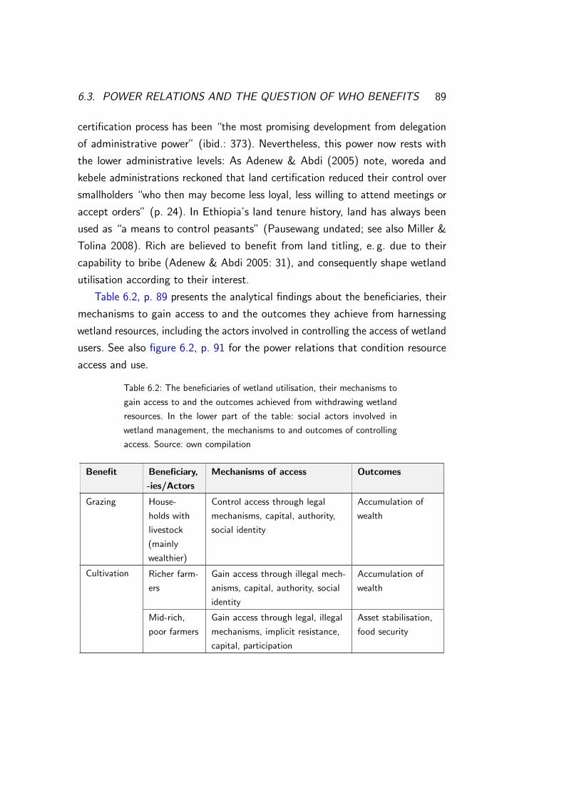
6.3. POWER RELATIONS AND THE QUESTION OF WHO BENEFITS 89
certification process has been “the most promising development from delegation
of administrative power” (ibid.: 373). Nevertheless, this power now rests with
the lower administrative levels: As Adenew & Abdi (2005) note, woreda and
kebele administrations reckoned that land certification reduced their control over
smallholders “who then may become less loyal, less willing to attend meetings or
accept orders” (p. 24). In Ethiopia’s land tenure history, land has always been
used as “a means to control peasants” (Pausewang undated; see also Miller &
Tolina 2008). Rich are believed to benefit from land titling, e. g. due to their
capability to bribe (Adenew & Abdi 2005: 31), and consequently shape wetland
utilisation according to their interest.
Table 6.2, p. 89 presents the analytical findings about the beneficiaries, their
mechanisms to gain access to and the outcomes they achieve from harnessing
wetland resources, including the actors involved in controlling the access of wetland
users. See also figure 6.2, p. 91 for the power relations that condition resource
access and use.
Table 6.2: The beneficiaries of wetland utilisation, their mechanisms to
gain access to and the outcomes achieved from withdrawing wetland
resources. In the lower part of the table: social actors involved in
wetland management, the mechanisms to and outcomes of controlling
access. Source: own compilation
Benefit Beneficiary,
-ies/Actors
Mechanisms of access Outcomes
Grazing House-
holds with
livestock
(mainly
wealthier)
Control access through legal
mechanisms, capital, authority,
social identity
Accumulation of
wealth
Cultivation Richer farm-
ers
Gain access through illegal mech-
anisms, capital, authority, social
identity
Accumulation of
wealth
Mid-rich,
poor farmers
Gain access through legal, illegal
mechanisms, implicit resistance,
capital, participation
Asset stabilisation,
food security

90 CHAPTER 6. ANALYSIS
Benefit Beneficiary,
-ies/Actors
Mechanisms of access Outcomes
Cultivation Landless Gain access through legal, illegal
mechanisms, implicit resistance,
social identity, capital, participa-
tion
Livelihood security
Fishing Richer fisher-
men
Gain access through capital, use
of illegal means (?)
Food secu-
rity, accumula-
tion/stabilisation
of wealth
Middle-
rich, poor
fishermen
Gain access through capital, use
of illegal means, implicit resis-
tance (?)
Food security, em-
ployment
Landless Gain access through capital, use
of illegal means, implicit resis-
tance (?)
Livelihood security,
employment
Woito Gain access through capital, so-
cial identity, use of illegal means,
implicit resistance (?)
Asset stabilisation
and accumulation
Grazing, cut-
and-carry,
papyrus
harvesting
Monks of
Tana Kirkos
Control access through legal
mechanisms, social identity
Asset stabilisation
and accumulation
Depending
on actor’s
priorities
Farmers
trained in
wetland
management
Control access through knowl-
edge
?
LAC mem-
bers
Control access through legal
mechanisms, authority, knowledge
Personal or commu-
nal well-being
Kebele Ad-
ministration
Control access through legal
mechanisms, authority, knowledge
Personal or com-
munal well-being,
keeping control over
kebele residents
Elders Control access through legal
mechanisms, identity, authority
(disciplinary power3?)
(Personal or) com-
munal well-being
3The unquestioningly accepted power by elders that makes people accept their situation,

6.3. POWER RELATIONS AND THE QUESTION OF WHO BENEFITS 91
Benefit Beneficiary,
-ies/Actors
Mechanisms of access Outcomes
Public pur-
poses/agric.
development
Government
agencies
Control access and use through
legal mechanisms and authority
‘Common good’
Wetland
conservation
Scientific
community
Control access through authority,
knowledge, identity
(Social-) ecological
resilience enhanced
Context(social, ecological, political, economic)
Land administration & use proclamation & regulation; regional
policies; conflict resolution mechanisms
Meso
Customary rights; by-laws & regulations; conflict resolution mechanisms
Micro
Constitution; federal policiesMacro
Endowment mapping
Entitlement mapping
Res
ilien
ce?
Endowments(capital & property
rights)
Entitlements
Social actors
Capabilities/well-being
Legal, illegal, structural & relational
mechanisms of access
Social status, political office, mandates, cultural
identity, organisations,resistance, corruption…
Wetlandresources &
services
Trade-offs, conflicts
Figure 6.2: Mapping endowments: the mechanisms of access, power and social relations andthe institutions mediating access to wetlands. (Federal and regional policies include water andagricultural development policies.) Source: modified after Leach et al. 1999: 234
As shown, the different mechanisms and means social actors draw on to
benefit from wetland resources are not all considered legitimate, implying conflicts
over wetlands.
subservience and powerlessness (de Haan & Zoomers 2005: 36–37; Ribot & Peluso 2003: 156).
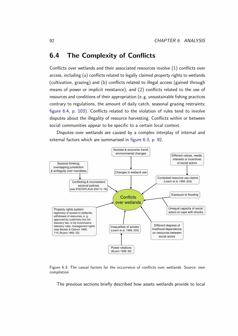
92 CHAPTER 6. ANALYSIS
6.4 The Complexity of Conflicts
Conflicts over wetlands and their associated resources involve (1) conflicts over
access, including (a) conflicts related to legally claimed property rights to wetlands
(cultivation, grazing) and (b) conflicts related to illegal access (gained through
means of power or implicit resistance), and (2) conflicts related to the use of
resources and conditions of their appropriation (e. g. unsustainable fishing practices
contrary to regulations, the amount of daily catch, seasonal grazing restraints;
figure 6.4, p. 103). Conflicts related to the violation of rules tend to involve
disputes about the illegality of resource harvesting. Conflicts within or between
social communities appear to be specific to a certain local context.
Disputes over wetlands are caused by a complex interplay of internal and
external factors which are summarised in figure 6.3, p. 92.
Conflicts over wetlands
Different values, needs, interests or incentives
of social actors
Contested resource use claims(Leach et al. 1999: 233)
Power relations (Bryant 1998: 85)
Inequalities of access(Leach et al. 1999: 233)
Property rights system:legitimacy of access to wetlands,withdrawal of resources, e. g. approved by customary but not statutory law, or by inconclusive statutory rules, management rights(see Becker & Ostrom 1995:115; Bryant 1992: 22)
Changes in wetland use
Societal & economic trend; environmental changes
Conflicting & inconsistentsectoral policies
(see IFAD/EPLAUA 2007 b: 76)
Sectoral thinking,overlapping jurisdiction
& ambiguity over mandates
Different degrees oflivelihood dependence on resources between
social actors
Exposure to flooding
Unequal capacity of social actors to cope with shocks
Figure 6.3: The casual factors for the occurrence of conflicts over wetlands. Source: owncompilation
The previous sections briefly described how assets wetlands provide to local
6.5. INSTITUTIONS SHAPING WETLAND USE AND MANAGEMENT 93
people are deployed to enhance well-being and capabilities and the mechanisms
of access. An attempt was made to unravel property rights to wetlands. A section
was dedicated to the power relations that condition the way endowments and
entitlements are gained. The complexity of conflicts which often emerge when
gaining endowments and entitlements was addressed. Hereafter an analysis on the
institutions which impinge on the way utilities are derived from wetland resources
follows.
6.5 Institutions Shaping Wetland Use and
Management
Relevant institutions have already been analysed in relation to their function
of impinging on resource access and local interactions (figure 6.2, p. 91). The
institutional analysis in this section concentrates on the influence of rules and
regulations on wetland use and management, i. e. on how endowments can be
transformed into entitlements.
6.5.1 Land Administration
This section refers to the property regimes of wetlands and the effects of land
titling and land use planning on the governance of wetland resources.
6.5.1.1 Property Regimes of Wetlands
Ostrom (2003) distinguishes between the type of good (property) and the property
regime4. “Common-pool resources [cannot] automatically [be] associated with
common-property regimes” (Ostrom 2003: 249). As mentioned above, peasants
make no difference between state property and common-property regimes as long
as land is administered by the state (Pausewang undated) and in a decentralised
manner by lower level authorities. The problem is that de jure state property is
often treated as de facto open access (see Berkes et al. 1989: 92). Since land is
4Berkes et al. (1989) distinguish between four basic property regimes under which common-pool resources are held: (1) open access, (2) private property, (3) communal property and (4)state property.

94 CHAPTER 6. ANALYSIS
the property of the state, incentives to invest in (communal) holdings (Miller &
Tolina 2008: 367–368) and the sense of responsibility to these lands are often low
(Abbot et al. 2000: 21).
Wetlands lie in a legal grey area between state holding “for [. . . ] area devel-
opment and growth” (Proclamation No. 133/2005: §2(7)), communal holding
“used [emphasis of the author] by local people in common for grazing [. . . ] and
other social services” (ibid.: §2(5)), and private holding. This grey area in the land
administration and use legislation leads to confusion and discrepancies regarding
wetland registration (see p. 61), and impinges on wetland use and management
(see p. 95; figure 6.4, p. 103).
6.5.1.2 The Impact of Land Registration and Certification, and Land
Use Planning on Wetland Management
In general, land registration and certification processes were “focused on mapping
of agricultural holdings to the detriment of common property resources” (Deininger
et al. 2007: 10). Failures to register common property resources result in a
continuous crossing of communal borders and leave property issues unclear. Local
registration processes have occasionally fostered and have at the same time been
delayed by cases of encroachment and conflicts. Wetland management efforts
are easily frustrated due to intransparencies during registration but likewise legal
redistribution of communal lands if communally agreed.
Registration activities are usually undertaken in the dry season when the area
is accessible for woreda survey and administration teams and agricultural activities
do not compete with registration activities for LACs (Deininger et al. 2007: 7).
Being grazing or crop lands in the dry season, seasonal wetlands are difficult to
identify, are consequently not demarcated and registered with respect to their
actual use5.
These shortcomings and power relations underlying the registration and certifi-
cation process complicate local management attempts. On the other hand, studies
(Adenew & Abdi 2005; Deininger et al. 2006, 2007; SARDP/EPLAUA/ORGUT
2010) and own findings show that certification is perceived to have a positive
5For example, in their land cover and use survey, DSA/SCI (2006) partially mappedmarshlands together with intensively cultivated land.

6.5. INSTITUTIONS SHAPING WETLAND USE AND MANAGEMENT 95
effect on resource management and conservation if registration was undertaken
properly. For example, communal investments are said to increase (Deininger
et al. 2006: 13), common property resources to be managed more sustainably
and encroachments on communal lands to be reduced (Deininger et al. 2007:
15, 27). These positive effects on resource management and conservation can
be associated with an increased “subjective tenure security” (Crewett & Korf
2008: 209, 212–213) through certification. The clarification of boundaries through
registration reduces conflicts (Deininger et al. 2006: 13; Deininger et al. 2007:
27) and may result in more sustainable wetland management.
Unlike farmers stressing the importance of land use planning to avoid the
mismanagement of natural resources, Mesfin (2003) points out that land use
planning often fosters conversion of and sacrifices wetlands for other use purposes.
The land administration system may thus have a double-edged effect on natural
resource management (figure 6.4, p. 103).
The further institutional analysis comprehensively addresses the conditions de-
termining an effective wetland management. Attributes of common-pool resources
(Becker & Ostrom 1995; Ostrom 2003) are identified and local management insti-
tutions analysed regarding the design principles of robust common-pool resource
management systems (Becker & Ostrom 1995; Ostrom 2009 b). The chapter
concludes with an analysis of the effectiveness of institutions to conserve wetlands.
6.5.2 Common-Pool Resource Management
A collective action problem of the common-pool resource type is characterised
by costly exclusion and subtractive consumption (Ostrom 2003: 241–243, 248).
Generally, the probability that users organise is higher when expected benefits
of collective resource management exceed the costs for investing in establishing
institutional arrangements (Ostrom 2009 a: 420). Attributes of (1) the resource,
(2) users, (3) the structure of the situation, i. e. contextual factors, and (4) the
institutional arrangements (Agrawal 2001: 1653; Ostrom: 2003: 252–259) affect
the likelihood of self-organisation of people (Ostrom 2009 a: 240–241) and a
successful collective action as well as the feasibility of establishing a communal
property regime for wetlands (Ostrom 2003: 243). These variables facilitate the

96 CHAPTER 6. ANALYSIS
emergence and the functioning of institutions to effectively manage wetlands
(Agrawal 2001: 1658).
6.5.2.1 Attributes of Wetlands and Associated Resources
Characteristics of wetlands may determine the effectiveness of institutional ar-
rangements to sustain associated resources (Agrawal 2001: 1655). The size of a
wetland can be a challenge to devising workable rules for its management (Ostrom
et al. 1999: 279). The large wetland extending over the two Fogera kebeles may
be more difficult to managed by a collective than the smaller ones in Tana Kirkos
and Agid Kirigna (figure 2.3, p. 14).
Low levels of resource mobility have been identified as enabling conditions
for an effective community-based management (Agrawal 2001: 1655). Wetlands
themselves are stationary resource systems, except some fish species, e. g. migra-
tory fishes. The possibility to store endowments obtained from wetland resources
(pastures, fish) for direct use is relatively low. Especially fish resource manage-
ment is associated with higher costs of gaining reliable information on mobile fish
species and constrained by an increasing pressure on the resource due to lower
storage degrees.
Besides, when harvesting biological resources, users need to preconceive various
ecological aspects including the type of resource appropriated (e. g. only matured
fish species or papyrus plants), the time (e. g. rejuvenation), or the extent of
harvest (e. g. a certain amount of fish daily, restricted grazing). Considering
these aspects is important in terms of possible ecological trade-offs and related
economic ramifications (Becker & Ostrom 1995: 118, 124).
Carrying capacity and time required for a resource to regenerate are further
important attributes that need to be considered in common-property resource
management (Ostrom et al. 1999: 279). Wetlands may not be able to sustain a
continuously increasing livestock population, or may more easily re-organise from
seasonal grazing than from cultivation (see Appendix 7, p. XXVIII).
Netting (1976, 1981 in Ostrom 2003: 254) found that a low production value
per unit area is conducive to the development of common-property rights. Initial
high production values of wetlands provide incentives (high returns) to peasants

6.5. INSTITUTIONS SHAPING WETLAND USE AND MANAGEMENT 97
to individually cultivate plots.
6.5.2.2 Attributes of Wetland Users
Whether wetland users successfully solve collective action problems is determined
by the size and heterogeneity of groups (Ostrom 2003: 257). The large size
of resource user groups and the heterogeneity between and within groups may
obstruct organisation for communal resource management.
Given this heterogeneity, reaching a common understanding of the most
beneficial, suitable land use regime (considering the objections and risks associated
with different use regimes), and the institutional setting of a use regime (ibid.:
257) is awkward. Inaccurate information (ibid.: 257) and incomplete knowledge
about sustainable wetland use and management as well as the importance of
wetlands in terms of their regulating and supporting ecosystem functions hamper
the creation of such a common understanding.
The variation of interests in wetland use involve conflicts over the resources.
Fabricius & Collins (2007) stress the negative effect conflicts have on community-
based resource management. Reciprocity and trust in social relations “can be
used as initial social capital” (Ostrom 2003: 257) to enhance the performance
of common-pool resource management systems, the capacity of social-ecological
systems and the ability to adapt to and shape system change (Folke 2006: 261).
Conflicts over land issues, unequal power distributions, illegal acts and experiences
related to Ethiopia’s tenure system are unconducive to building trust in local
communities.
The way wetland users are linked is important to consider when promoting
collective action (Ostrom 2009 b: 30). Accentuating vertical linkages of authority
between wetland users at community level may avert participation and display
manifestations of power rather than equality. Where leadership and knowledge are
actively invested in discussions on management they might positively influence
the establishment of organisation (Ostrom 2009 a: 421). Inasmuch as local
elites are powerful, they might also encourage collective wetland management
by teaching people, strengthening institutional implementation or facilitating
traditional conflict resolution (IFAD/EPLAUA 2007 b: 62; see supra note 11,

98 CHAPTER 6. ANALYSIS
p. 70). Power relations can significantly influence the emergence and sustenance
of institutional settings.
Since natural endowments of the research area facilitate livelihoods, most
peasants may seek to permanently live and work in their village6. Management
thus has a stable component (Ostrom 2003: 257). Ostrom (2003) states that
permanent residence and employment in one area reduced discounting the future.
But due to historical experiences, e. g. frequent land redistribution or land sale
to foreigners (personal communication: farmers in Tanametsele), and livelihood
insecurity, farmers may still discount future resource use, consequently exacerbating
degradation.
People’s lack of confidence in their capabilities and powers to build their own
future constrains collective action by inhibiting self-organisation and initiatives at
the local level (see Fabricius & Collins 2007: 92).
When resource users value solving common-pool resource dilemmas (Ostrom
2009 b: 30–31) and when the resource is of importance to them (Ostrom 2009 a:
421), collective action can be successful. All in all, there are many indications
that people value solving problems of wetland degradation. The appreciation of
the instrumental functions of wetlands to people’s livelihoods is further a good
basis for self-organisation.
6.5.2.3 Structural Attributes – The Social, Political, Economic and
Ecological Context
Collective action can stem from increasing pressures on common-pool resources
(Abbot et al. 2000: 8; Ostrom 2003: 253; Wood 2000: 8), such as land scarcity,
driven by demographic growth. Where livestock farmers see wetland pastures being
converted into arable land, more or less sophisticated management systems have
been developed to protect wetlands. Likewise, overexploitation of fish resources
has locally been tackled by stipulating the amount and time of harvest.
Large kebele sizes can be associated with increased transaction costs of
communal wetland management. With the incorporation of kebeles into larger
government units, the number of stakeholders and administrative expenses in-
6Moreover, absence from the residing locality and engagement in non-agricultural activitiesis otherwise prosecuted with the deprivation of landholding (Regulation No. 51/2007: §14).

6.5. INSTITUTIONS SHAPING WETLAND USE AND MANAGEMENT 99
crease, and conflict resolution consumes more time and costs. Besides, the
enlargement of kebeles complicates overseeing resources. Moreover the capacity
of kebele leaders to govern such a large area is exhausted (Abbot et al. 2000: 22).
Local communities are nested into governance and other organisational struc-
tures (Ostrom 2003: 256). Being the “guarantor of property rights arrangements”
(Agrawal 2001: 1656), the state has a central stake in the management of
wetlands (see p. 84 and p. 93). Governance structures, i. e. sectoral approaches,
decentralised land administration, organisation across levels and top-down decision-
making affect local management. Government bodies and other organisations
create awareness on and complement local knowledge about sustainable wetland
use and management through workshops, trainings etc. On the other hand, gaps
between different knowledge systems are unconducive to joint action across various
levels.
Economic incentives such as the cultivation of cash crops stimulate wetland
agriculture (see Wood 2000: 13), encouraged by the initial high productivity,
and wetland alteration. Consequently, the (short-term) benefits obtained through
individual decision-making outweigh the alternative benefits gained through making
collective choices. Lower fish prices increase pressure on fish stocks and “reduce
the incentive to organise and assure future availability” (Ostrom et al. 1999: 281).
Markets and new technologies may affect resource management regimes (Agrawal
2001: 1656). New incentives for production, created by market demands and
technical innovations (e. g. mono-filament gill net, dehiscent mills), have resulted
in a change of cropping patterns and resource harvesting methods in the research
sites.
Flooding, as a natural characteristic of the resource system but also human-
induced (see p. 11), hampers an organisation for collective action due to the
inaccessibility of infrastructure and by rendering management ineffective in times
of increased risks. Responses to severe flooding events include the cultivation of
wetlands and fishing to cope with livelihood insecurities (see Appendix 5, p. XIX).
The unpredictability of social-ecological system dynamics (e. g. occurrence of
flooding) may complicate arriving at use and management agreements (Agrawal
2001: 1655; Ostrom 2009 a: 421).
Structural attributes (appearing as the ‘context’ in figure 6.4, p. 103) are

100 CHAPTER 6. ANALYSIS
rather incompletely listed, yet sufficiently for the present work. Although an
attempt is made to list the different attributes separately, they cannot be clearly
distinguished from one another due to interlinkages and intersections.
6.5.2.4 Institutional Arrangements and Design Principles for
Governing Wetland Resources
Becker & Ostrom (1995) “stress the importance of design principles rather than
institutional solutions to common-pool resource problems” (p. 122), i. e. the
design principles should be considered when establishing specific institutional
arrangements. Robust institutions tend to incorporate most design principles
(Becker & Ostrom 1995: 118; see p. 21).
The first of Ostrom’s design principles is that of clearly defined boundaries of a
resource system, and the individuals and households with property rights (Ostrom
2009 b: 32–33). There are several aspects here which obstruct the clarification of
boundaries: (1) ill-defined property rights to wetlands and property regimes, (2)
continuing conflicts over resource access and use, (3) boundary conflicts, (4) lack
of communal land registration and (5) seasonal changes of wetland boundaries.
Two implications can be made: both the boundaries of who is authorised to use
the resource and the physical boundaries are fuzzy and changing. Despite this,
concepts of wetland boundary demarcation exist where access to the resources is
managed, e. g. in Agid Kirigna or where sanctions are imposed on illegal wetland
cultivators. The definition of a boundary inevitably asks for a definition of wetland.
Defining ‘seasonal wetland’ may raise many questions, e. g. on seasonal changes
in land use and cover, the definition of ‘seasonal’, how to deal with dynamics and
uncertainties (prolonged flooding, drought).
The second principle says that benefits need to be allocated proportional to
costs of management system operation (ibid.: 33–34). In Agid Kirigna and Tez
Amba, rules regulate use conditions, i. e. the amount of resources harvested, the
time of their utilisation, and harvesting practices. Inequities in the allocation of
benefits and costs occur when users, including non-residents, subtract resources
without contributing to resource management, e. g. using unsustainable fishing
practices or ignoring seasonal closure of wetlands for grazing. The fairness of

6.5. INSTITUTIONS SHAPING WETLAND USE AND MANAGEMENT 101
the allocation of benefits is also relevant (Agrawal 2001: 1660). Evidence shows
that in some cases the allocation is not fair, e. g. where wealthier fishermen gain
proportionally higher catches. A subpart of this principle includes the congruence
of resource appropriation and local ecology (Ostrom 2009 b: 40), i. e. the resilience
of social-ecological systems. In the two cases mentioned above, this congruence
is partly considered (seasonal closure for resource regeneration).
The third design principle is that of a collective choice arrangement. Collective
choices are made through the participation of most resource users in establishing
and modifying rules which may then be considered fair (ibid.: 34). Such arrange-
ments should include simple and easily understandable rules about access to and
management of wetlands (Agrawal 2001: 1659). With the authority to make and
implement laws, the power to suppress opinions and participation, primarily local
elites can be expected to benefit from institutional settings. For example, wetlands
are preferably managed as pastures rather than cultivated by landless and poor.
Regulations on grazing regimes in Agid Kirigna do not sufficiently enough con-
sider the dependence of poorer livestock farmers on communal feeding resources.
Apparently, collective choice arrangements made by fishing resource management
organisations are perceived to be more fair. The voluntary membership in such an
organisation is important in this respect. In the case of involuntary membership
of the Woito in Agid Kirigna, agreements are rather perceived to be unjust.
The principle of monitoring resource conditions, and more often, user be-
haviour to enforce rules (Ostrom 2009 b: 34–35) is one of the more elaborated
principles at the local level. In Gulash, Tana Kirkos and Agid Kirigna, guards
were selected to oversee resource appropriation (see p. 66). Most of the simpler
management systems may rely on a mutual monitoring system: everyone in the
community monitors the behaviour of other users. Fishermen mutually monitor
their practices by entering and returning from Lake Tana at the same time. As
opposed to this, responsible woreda government bodies fail to evaluate resource
conditions and patterns of appropriation.
Monitoring is related to the fifth design principle, using graduated sanctions.
Graduated sanctions range from informing people about an offence to more
stringent punishments (ibid.: 35). Whereas Regulation No. 51/2007 at least men-
tions graduated punishments in cases of non-performance of land use obligations

102 CHAPTER 6. ANALYSIS
(§§17, 18), locally graduated sanctions are less well stipulated. When the costs
of breaking regulations are still low compared to the benefits achieved when not
being caught, it is difficult to achieve collective action (see Ostrom 2009 b: 35).
This is the case in the study sites. For example, the possibly obtained yields
on encroached land are still lucrative enough to risk the destruction of those
yields or a moderate fine when encroachment is discovered. The same is true for
using resources in times of seasonal closure or illicit fishing practices. The ease
with which sanctions are enforced is crucial for a joint management (Agrawal
2001: 1659). In the research sites, the enforcement of sanctions and rules is often
difficult.
The existence of rapid, low cost and local conflict resolution mechanisms is the
sixth principle (Ostrom 2009 b: 35). People’s preference to solve conflicts locally
is to be considered positive in this regard. Resolution mechanisms are known by
community members and can be applied according to customary law (Regulation
No. 51/2007: §§35, 37). But especially communal land conflicts cannot be solved
at the local level. The arbitration of disputes by “distant government agencies”
(Agrawal & Gibson 1999: 638) such as woreda courts and administrations then
involves an increase in costs of and time for resolution. Structural attributes of
the specific situation likewise influence conflict resolution.
The socio-political context is crucial to the seventh principle of minimal
recognition of rights to organise by external authorities (Ostrom 2009 b: 36).
Local self-organisation is undermined if government authorities do not recognise
that principle.
Various management tasks and activities, e. g. monitoring, conflict resolution,
enforcement of rules or resource appropriation, are organised in a decentralised
manner with smaller institutions being nested in larger systems (ibid.: 36, 43).
Problematic are the interrelations between those nested hierarchies determined by
differences in levels of legal recognition, in priorities across layers, or by the lack
of interest and capabilities at state levels to govern resource use and management
and to deal with local problems.
The pertinent institutional arrangements setting the conditions of wetland
resource subtraction and governance and accounting for the functioning of man-
agement are outlined in figure 6.4, p. 103.

6.5. INSTITUTIONS SHAPING WETLAND USE AND MANAGEMENT 103
Land administration & use proclamation & regulation; fishery
proclamation; regional policies; conflict resolution mechanisms
Meso
Customary rights; by-laws & regulations, incl. regulations on fishery;
conflict resolution mechanisms
Micro
Federal policiesMacro
Resource use conditions& sanctions
Context(demographic growth, governance structure& unit, economicincentives, ecologicalsystem dynamics,risk, uncertainty…)
Res
ilien
ce?
Constitution; federal policies
Land administration & use proclamation & regulation; regional
policies; conflict resolution mechanisms
Meso
Customary rights; by-laws & regulations; conflict resolution mechanisms
Micro
Macro
Trade-offs, conflicts
Endowment mapping
Entitlement mapping
Entitlements
Social actors
Capabilities/well-being
Legal, illegal, structural & relational
mechanisms of access
Social status, political office, mandates, cultural
identity, organisations,resistance, corruption…
Wetlandresources &
services
Endowments(capital & property
rights)
Figure 6.4: The multi-level institutions conditioning wetland resource subtraction. Source:modified after Leach et al. 1999: 234
The following remarks combine the insights from the previous sections to
provide a comprehensive picture of the conditions that determine an effective
wetland management and sustainable resource utilisation.
6.5.2.5 Robustness and Effectiveness of Wetland Management
Institutions
Rural livelihoods maintain and enhance their capabilities and well-being by har-
nessing wetland resources. Institutions are essential to manage wetland utilisation
and to maintain ecosystem resilience. The sustainability of the social-ecological
system is thus dependent on the robustness and effectiveness of established rules
and regulations, their congruence with local conditions, their interaction with the
ecosystem and their fit with the resilience of wetlands (Agrawal 2001: 1659; Folke
2006: 262; Ostrom 2009 a: 421).

104 CHAPTER 6. ANALYSIS
The current institutional wetland management systems evolved just recently as
a response to multi-level policies, socio-economic and related ecological processes
and changes. Local communities can be seen as being in the process of developing
adapted institutions which may be contested, tested and transformed over time
(see Agrawal & Gibson 1999: 639). Yet, their management systems must be
considered less robust and only partially effective in sustainably utilising and
conserving wetlands.
In most study sites, including Wagetera and Nabega and partly Tanametsele
and Tez Amba, wetlands are poorly managed. The large size of the main wetland
spanning four kebeles (figure 2.3, p. 14) and the high efforts that need to be
undertaken for its management are probable explanations for this. The (seasonal)
inaccessibility of administration offices, churches, services and organisations due
to flooding, large distances or the remoteness of villages increase transaction
costs of collective action. Deficiencies of stakeholder participation narrow the
collective choice arrangements to arrangements made by elites and thus possibly
make regulations and benefit allocations unacceptable. Inadequate information
and knowledge of wetland management and conservation obstruct the evolution
of a common understanding of wetland-related issues and contribute to wetland
degradation. Management regulations through which proprietorship is established
are restricted to mostly non-graduated sanctions against illegal access to wetlands
without considering the specific characteristics of biological and physical resources.
Mutual monitoring is not necessarily per se ineffective. Yet power relations may
distort the mutuality.
In Gulash village, wetlands are monitored by trustworthy and independent
persons. Moderate sanctions are imposed on delinquents. Since the kebele admin-
istration office of Wagetera is just nearby, transaction costs for village residents
are presumably low.
Wetlands of good management and better conservation status are those
in Agid Kirigna and Tana Kirkos. They are much smaller in size. The monks,
exercising the rights of proprietors over the wetland, are a relatively homogeneous
group with common ideas on wetland use and management. In Agid Kirigna, intra-
community differences (as in most study sites) exist, but also inter-community
heterogeneity, i. e. between the Woito tribe and the other communities. According

6.5. INSTITUTIONS SHAPING WETLAND USE AND MANAGEMENT 105
to personal information, a total of 69 families of the Woito are supposed to
live in one village and one sub-kebele (personal communication: Sibhat). Their
presence might influence the degree of pressure on the wetland since they are
rarely engaged in agricultural activities and livestock rearing. The office of the
kebele administration is located around the centre of Agid Kirigna, in the vicinity
of the villages with shares of wetland. A joint agreement on wetland management
was reached through discussion. Ostrom (2003, 2009 b) stresses the importance
of communication to develop effective management rules and to build assurance
of wetland users about the behaviour of other users. The institutional setting
considers biological and physical resource properties, different use regimes and
alternatives to compensate for the use of wetland resources. A monitoring system
is established.
The management of mobile resources is often complicated and requires
information that is mostly difficult to obtain (e. g. pregnancy of female fishes,
regeneration rates; see p. 96). In most cases, fisheries are not organised and
fishermen are the authorised users of a resource withdrawn by all. Livelihood
insecurity due to flooding that requires seasonally and temporally limited rapid
action, unemployment and lack of land has recently led to both commercial and
non-commercial fishery. Potentially, more time and dedication are required to
establish effective management systems.
The two fishermen’s associations established in Tez Amba and Agid Kirigna
share the rights of authorised claimants. The established collective choice ar-
rangements, incorporating aspects of a sustainable fish resource utilisation on the
basis of fish resource attributes, and monitoring systems are promising. So far,
the exclusion of fishermen is unfeasible which, despite regulations, still entails
overexploitation. The effectiveness of institutions is further eroded by inequities
in the allocation of benefits and costs and a high tolerance of breaking rules due
to the absence or the relative low severity of sanctions. Ethnic differences are a
challenge to fish resource management in Agid Kirigna.
Bundles of property rights play a key role in the management and use of
wetlands. Ostrom (2003, 2009) points out that proprietorship, i. e. exercising
collective-choice rights of management and exclusion, can be effective enough
to manage common-property resources (see table 6.1, p. 86). Yet, communal

106 CHAPTER 6. ANALYSIS
proprietorship to wetlands is often questioned, lacks recognition and endorsement
by local community members as well as government bodies. Frequently, the
establishment of rights of proprietors or even authorised claimants is impaired by
prevailing contextual conditions, characteristics of the resource system and its
users. Power relations (see p. 86) shape communal property rights in two ways:
First, power and resistance to power can be exercised to actively counteract rules
of access and management. Second, wielding of power and resistance can ensure
claims to bundles of rights (right to manage or exclude) for one or more user
groups.
The incapability of institutions to “structure the interactions that take place
around [wetland] resources” (Agrawal & Gibson 1999: 637) ensues from failure
to consider the design principles in making institutional arrangements. Common-
property resource dilemmas probably persist and depletion continues. Institutional
effectiveness depends upon the involvement and consideration of all relevant
stakeholders, including landless, poor or Woito people whose interests and needs
are currently mainly underrepresented. In many cases of encroachment and
boundary disputes the “solution was leaving things for later” (Deininger et al.
2007: 23), rendering institutional settings ineffective. Ineffectiveness of institutions
results from a lack of assurance that participants comply with the rules and that
sanctions are consistently enforced. Though rules are compiled in a relatively
simple way and appear to be comprehensible to many users, their enforcement
proves rather difficult. Further on, external authorities who fail to monitor and
enforce the implementation of regulations (e. g. on land administration and use
or fisheries) insufficiently support and complement local management systems.
Being nested in larger units, local institutions must consider conditions per-
taining to wetland resource use and management, prescribed by federal policies,
to work effectively (Ostrom et al. 1999: 281). In some cases, government plans
for land development (e. g. cash crop cultivation) conflict with the interests of
local communities in using common-pool resources more sustainably (cf. Abbot
et al. 2000: 23). Overlapping management responsibilities of government bodies,
emanating from various policies (see p. 16), are quite counterproductive to an
effective local management. By claiming their mandates, external authorities
allocate different rights to the same resource and shape the face of wetlands

6.6. SUMMARY 107
through different utilisation concepts, development and management approaches.
Besides, sectoral top-down policy formulation and implementation with “a narrow
technocratic perspective” (Abbot et al. 2000: 20) impede local initiatives for a
more appropriate wetland management (ibid.: 20–21).
Figure 6.5, p. 107 and figure 6.6, p. 108 summarise the structural and relational
conditions that facilitate and constrain an effective wetland management.
Attributes of wetlands & associated resources
– Small size of the wetland (Agid Kirigna, Tana Kirkos)
Attributes of wetland users
– Small-sized and homogeneous wetland user group in Tana Kirkos– Less dependence of the Woito people on the cultivation of wetlands in Agid Kirigna
Structural attributes (external environment)
– External bodies create awareness and complement local knowledge on wetlands
Institutional arrangements
– Communication and discussions on wetland management– Rules and regulations appear to be easily understandable– Consideration of wetland resource properties– Alternative solutions to wetland use are provided– Mutual monitoring of user behaviour and selection of guards to oversee resource appropriation
Figure 6.5: Conditions facilitating an effective wetland management. Arrows indicate theinteractions between the different management variables. Source: own compilation
6.6 Summary
Wetland resources and services contribute to the maintenance and enhancement
of people’s capabilities and well-being. Access to these resources and services
determines whether resources can become endowments. Whereas legal and illegal
mechanisms of access are applied by all people, richer mainly draw on capital,
knowledge or authority and poorer on social identity (structural and relational
mechanisms) to gain, maintain or control access.
The conditions for resource subtraction (e. g. harvesting time, amount, method,

108 CHAPTER 6. ANALYSIS
Attributes of wetlands & associated resources
– Large size of the wetland (esp. Wagetera and Nabega)– Fuzzy and changing wetland boundaries– Initial high production value of wetlands– Fish resource mobility & low degrees of storage
Attributes of wetland users
– Large size of wetland user groups (often undefined boundary, non-exclusion)– Intra- and inter-community heterogeneity– Inaccurate information and incomplete knowledge about the resource system– Lack of trust and assurance– Livelihood dependence on resource system– Lack of confidence in own powers– Unequal power distribution and implicit resistance – Unpredictability of social-ecological system dynamics and risk Structural attributes (external environment)
– Increasing pressure on common-pool resources (demographic growth, unemployment)– Large government units (kebele size)– Economic incentives– Failure of exteral authorities to monitor user behaviour and the implementation of regulations– Local management systems lack legal recognition by government authorities– Ill-defined property rights and regimes– Lack of land registration and missing land use planning– Overlapping management responsibilities– Sectoral top-down policy-making– Flooding
Institutional arrangements
– Inequities in the allocation of benefits and costs of wetland management– Lack of participation in collective choice arrangements– Inconsistently enforced and implemented rules– Lack of graduated sanctions– Increased efforts and costs in solving communal conflicts, lack of effective resolution mechanisms– Problematic interactions between nested systems (e.g. different resoure use priorities, gap between knowledge systems)
Figure 6.6: Conditions constraining an effective wetland management. Arrows indicate theinteractions between the different management variables. Source: own compilation
prescribed practices) regulate whether and how endowments can be transformed
into entitlements. These resource use conditions and likewise the access to
wetlands is mediated by various customary, statutory and conventional rights and
regulations. The plurality of and the inconsistency between these rights often
raise questions about their legitimacy and consequently about the legitimacy of
wetland management attempts. Power relations within and between communities,
manifested in corruption, resistance, advocacy etc., influence endowment and
entitlement mapping, and in so doing structure most of the efforts undertaken to
manage wetland resources.
A complex of interlinked internal and external factors affects the ability of local
resource management systems to conserve wetlands (figure 6.5, p. 107; figure 6.6,
p. 108). Internal factors comprise the characteristics of the resource system, the

6.6. SUMMARY 109
user group and the institutional arrangements. Contextual external factors include
the higher-level institutions that interact with the resource system and local
management institutions (figure 6.7, p. 109). The size of the resource system and
wetland users is often not manageable and boundaries are fuzzy. The management
is made more complicated by the heterogeneity of social actors and unequally
distributed powers, benefits and costs of wetland management. Many of the design
principles that most likely determine the success of institutions to conserve wetland
resources are not sufficiently considered or cannot be implemented adequately.
Grey areas of the property rights system which are reflected in failures to register
wetlands and ill-defined management responsibilities render wetland management
ineffective. Further on, economic incentives for the conversion of wetlands and
external shocks often constrain a functioning wetland management.
These findings are discussed in the following chapter.
Customary rights; by-laws & regulations, incl. regulations on fishery;
conflict resolution mechanisms
Micro
Land administration & use proclamation & regulation; fishery proclamation; regional policies; conflict resolution mechanisms
Meso
Federal policiesMacro
Resource use conditions& sanctions
Context(demographic growth, governance structure& unit, economicincentives, ecologicalsystem dynamics,risk, uncertainty…)
Res
ilien
ce?
Customary rights; by-laws & regulations; conflict resolution mechanisms
Micro
Land administration & use proclamation & regulation; regional
policies; conflict resolution mechanisms
Meso
Constitution; federal policiesMacro
Trade-offs, conflicts
Endowment mapping
Entitlement mapping
Entitlements
Social actors
Capabilities/well-being
Legal, illegal, structural & relational
mechanisms of access
Social status, political office, mandates, cultural
identity, organisations,resistance, corruption…
Wetlandresources &
services
Endowments(capital & property
rights)
Figure 6.7: Environmental entitlements analysis: Institutions mediating access to wetlands,conditioning resource subtraction, and institutional interactions. Source: modified after Leachet al. 1999: 234

110 CHAPTER 6. ANALYSIS

Chapter 7
Discussion
This section seeks to provide recommendations and raise objections regarding a
sustainable wetland management, and the establishment and functioning of the
CBINReMP and Lake Tana biosphere reserve (BR)1, particularly. In this regard,
the institutional framework for the conservation of wetlands as well as governance
features and conditions facilitating the effective and sound management of
common-pool resources are discussed. Concluding remarks on social-ecological
resilience are made.
7.1 The Institutional Framework for the
Conservation of Wetlands
Zur Heide (2012) states that “the general policy framework in the Amhara Region
is conducive to the establishment of a biosphere reserve” (p. 119). Scaling up to
wetlands as a landscape section of the BR, it is debatable whether institutional
conditions enable the conservation of wetland ecosystems.
1See Appendix 8, p. XXIX for a description of the concept of BRs.
111

112 CHAPTER 7. DISCUSSION
7.1.1 A National Wetland Policy?
There has been controversy about the adequate representation and consideration
of wetlands in existing policy documents (Abbot et al. 2000; Fisseha 2003; Mesfin
2003; Wood 2000). Whereas Mesfin (2003) argues that wetlands are sufficiently
represented in national policies and legislation (see p. 69), and that only synergies
between those have to be better exploited, Fisseha (2003) calls for a National
Wetland Policy. With their technical approach and sectoral thinking, the existing
policies fail to adequately consider the role of wetlands for biodiversity conservation
and people’s livelihoods. Thus, a rather holistic understanding of wetlands is
required that emphasises the multiple functions of and benefits obtained from
wetlands (Abbot et al. 2000: 20; Fisseha 2003: 79; Wood 2000: 10) or that even
acknowledges their intrinsic value (Wood 2000: 10). It can be assumed and hoped
that the as yet unratified Ethiopian National Wetland Policy comprises such a
holistic approach.
A National Wetland Policy as an overarching document should provide objec-
tives, guidelines and orientation for management and conservation. In the case
of Uganda, the Wetland Policy is not a legally binding document but wetland
clauses are incorporated into legislation (Bakema & Mafabi 2003: 104). Fisseha
(2003) proposes integrating the Ethiopian Wetland Policy into the land admin-
istration and use proclamation and regulation. Likewise, other legislation such
as the Environmental Policy, the National Biodiversity Strategy and Action Plan
or the Water Resource Management Policy as well as development plans could
be amended by clauses specifically related to wetlands. In this way it could be
ensured that wetlands are concordantly represented within different policy sectors.
At the regional level, provisions and goals need to be specified. Mesfin (2003)
suggests the formulation of regional wetland policies to better address the specific
local conditions and problems (see also Abbot 2000: 21; Wood 2000: 8). As part
of the CBINReMP2 a policy document for Amhara is planned including strategies
2The CBINReMP is financed and technically supported by the International Fund for Agricul-tural Development (IFAD), the Global Environment Facility (GEF) and the Spanish InternationalDevelopment Cooperation Agency (AECID) (see BoARD 2011 a: 7). The programme includesthe establishment of wetland user associations as well as local by-laws and management plansfor single wetlands. It also envisages trainings and wetland policy awareness creation workshops,the provision of alternative diversified livelihood options and the integration of traditional knowl-

7.1. THE INSTITUTIONAL FRAMEWORK 113
and regulations on wetland use and management (personal communication: BDU).
At the woreda and local level, wetland management strategies have to be
drafted in accordance to the social-ecological conditions and requirements together
with all identified stakeholders and community representatives. Already existing
management institutions need to be integrated. National and regional wetland
policies have to be flexible and have to relinquish responsibility to allow local
management systems to adequately adapt their management criteria to the
peculiarities of the environment as well as to appropriately respond to changes
and uncertainties. This research study and insights from wetland management
in the Illubabor zone show that local people are capable of self-organising and
adjusting to changes (see Abbot et al. 2000: 21). Hence, flexibility and learning
from variation should not be undermined by another rigid or rigidly interpreted
top-down policy.
7.1.2 Signing the Ramsar Convention?
For several years there have been cooperative efforts that have targeted the signing
of the Ramsar Convention by Ethiopia (e. g. Abebe 2004; MoWE 2010: 3-17; zur
Heide 2012). This convention urges its contracting parties to develop national
wetland policies to better address the utilisation and management of wetlands
(Ramsar Convention Secretariat 2010 a: 7). After the ratification of Ethiopia’s
National Wetland Policy, a joining of the Ramsar Convention is envisaged (personal
communication: EWNRA). Wetlands south and east of Lake Tana, including the
Fogera plains, that fulfil the Ramsar selection criteria for wetland sites have
already been identified (Abebe 2004). Signing the Ramsar Convention could
possibly increase the success of wetland conservation (see zur Heide 2012: 121).
Besides, the zonation concept for Ramsar sites is compatible with the zonation
concept of BRs (Ramsar Convention Secretariat 2010 b: 30–31).
Returning to the national level, the next section discusses property rights
issues of wetlands.
edge. Financial constraints hamper the programme’s implementation (personal communication:BDU).

114 CHAPTER 7. DISCUSSION
7.1.3 Property Rights to Wetlands – A Critical Issue
Property Rights to common-pool resources are a critical issue. Failures to address
them comprehensively will render any conservation effort ineffective. A with-
drawal of the property rights of local people may give rise to severe community
resentments and resistance, e. g. if recession farming and wetland cultivation are
prohibited for conservation purposes (cf. zur Heide 2012: 136). On the other
hand, the conservation of wetland resources may be bound to management and
exclusion rights exercised by local people. Where the government does not recog-
nise these rights, the protection of wetlands cannot be guaranteed. Discrepancies
between customary and statutory regulations on access to and management of
wetlands (and recession farmlands) as well as between local and government
interests on wetland use have to be resolved. In this way conflicts arising during
the establishment of conservation projects and resistance to conservation can be
averted.
Gebrekidan (2009 b) argues that the state ownership of wetlands and the use
rights of local people provide an “ideal case” (p. 49) for the establishment of
protected areas. But the mere right to withdraw resources from the lake and its as-
sociated wetlands is not sufficient and does not encourage users to self-organise for
community-based management, but rather stimulates continuous overexploitation
and keeps wetlands exposed to open access. Consequently, communal propri-
etorship of wetlands (and of defined boundaries of fishing grounds3) has to be
more explicitly legally recognised and approved. Case studies on common-property
management in the highlands of Ethiopia show that communal proprietorship of
pastures has effectively been established under state ownership. These manage-
ment systems have been legally recognised and characterised by most of Ostrom’s
design principles (see Adenew & Abdi 2005: 18–20; Ashenafi & Leader-Williams
2005).
But there have been more forceful voices calling for an alternative to state
ownership or the privatisation of land (see p. 17). Rahmato (1994, 2004 in Crewett
& Korf 2008: 206) and Pausewang (undated), for example, stress the importance
3Defining fishing zones and exclusion of non-registered fishermen within these zones areprobably very ambitious and difficult tasks.
7.1. THE INSTITUTIONAL FRAMEWORK 115
of associative collective ownership rights of communities as a third way. Granting
of community ownership rights involves the transfer of control over land use and
management to the community. This is supposed to establish democracy at the
local level and to have a positive effect on resource conservation and livelihood
security.
Though the third alternative looks very attractive in terms of biodiversity and
resource conservation, it is actually not viable. Instead, a combination of property
regimes may be very convenient to wetland conservation (Berkes et al. 1989: 93).
The UNESCO (1996) acknowledges a broad spectrum of property regimes within
a BR. This is very suitable for the wetlands east of Lake Tana which are held under
several property regimes constituted of varying bundles of rights. Proclamation
No. 133/2006 grants landholding rights to groups (common holding, §2(10))
and communities (communal holding, §2(5)). Drawing on these rights is crucial
to the establishment of common or communal proprietorship. A combination of
property regimes could lead to common-pool resource co-management systems,
provided that powers between government bodies and local communities are
shared, property rights of various social actors are non-ambiguously assigned and
responsibilities clarified to avert further resource mismanagement.
Which further conditions does the existing land administration and use legis-
lation provide to enable a sound and effective wetland management?
7.1.4 Land Administration and Conservation
With the decentralisation of land administration local people have gained power
in an area which affects their livelihoods most: land and resources (Miller &
Tolina 2008: 372). Regulation No. 51/2007 provides enabling conditions for the
involvement of the public in communal resource management, for the application
of local conflict resolution measures and customary rules. Currently, more emphasis
needs to be put on public participation and horizontal decision-making in the
administration of communal lands.
An “ownership mentality” (Regulation No. 51/2007, preamble) of farmers
regarding their landholding has been partly created by land titling. Still, communal
lands have to be registered in order to reduce conflicts. Certificates need to be

116 CHAPTER 7. DISCUSSION
upgraded and safely kept with the LAC. Interestingly, Crewett & Korf (2008) in
their study on land administration in Oromia and Adenew & Abdi (2005) in their
report on land registration in Amhara found that lack of tenure security is not
the major concern, at least for those peasants possessing land. Land scarcity and
poverty are probably the more important constraints to people’s livelihoods and a
sustainable natural resource management.
The regulation stipulates land use obligations. If properly implemented and
enforced, these obligations represent a good starting point for sustainable wetland
management. But being kept very general, they need to be specified through by-
laws and locally appropriate wetland management plans. Rights and obligations of
wetland users and seasonally changing wetland utilisation could be indicated in the
certificate issued for communal landholdings (see Regulation No. 51/2007: §21).
In so doing local institutional settings could be legally approved and recognised
by the woreda authority.
Whereas conservationists are familiar with the definition and classification of
wetlands (see supra note 1, p. 11), the land administration staff faces difficulties in
identifying wetlands. Therefore, it is a challenge to register or explicitly not register
wetlands. Wetlands are most often simply subsumed under communal lands but
should possibly be considered a specific sub-division due to their distinct ecological
characteristics. This could contribute to a more adequate protection of the resource
system. A guideline for the delineation of wetlands is required, including practical
definitions and easily recognisable dry and rainy season wetland indicators in the
field4. When registering wetlands, the survey and land administration teams need
to be accompanied by an environmental protection expert. Registration should
possibly be undertaken twice, during both the dry and the rainy season, to avoid
boundary conflicts.
The legislation considers integrating environmental protection into land use
practices. Though generally welcome, the mixing of environmental issues and land
administration has been criticised (Adenew & Abdi 2005: 12; Miller & Tolina 2008:
372). Land administration should rather focus strictly on land registration and
certification (Adenew & Abdi 2005: 12). At regional and woreda levels, EPLAUA
4Indicators can be identified drawing on local knowledge about wetland plant species (seeDixon & Wood 2001: 8).
7.1. THE INSTITUTIONAL FRAMEWORK 117
and WoEPLAU are sectioned into the department of environmental protection,
the department of land administration and the department of land use. The
mandates of these sections need to be clarified and cooperation enhanced to
ensure the protection of resources and biodiversity. In terms of the conservation
of (wetland-dependant) biodiversity, the role of the environmental protection
department in assessing environmental impacts, evaluating land use practices and
co-deciding on land use planning needs to be strengthened.
The next two sections address the importance of land use planning and
environmental impact assessments for wetland conservation.
7.1.5 Land Use Planning and Conservation
Rural land should be managed according to a land use plan. The Environmental
Policy states that a strategic land use plan should “define broad land use and land
user categories together with generalised resource management recommendations”
(EPA/MoEDC 1997: 20) at the federal, regional and community level. Based on
these plans, individuals and communities will be able to formulate detailed local
resource use and management plans. Besides, strategic land use plans should
integrate aspects of biodiversity conservation (ibid.: 10, 20).
Plans and strategies are required to effectively manage a BR. The UNESCO
(1996) underlines that BRs are to be included in regional development and
land use planning projects. Community level land use planning approaches are
flexible and allow for adequate considerations of and adaptations to local social-
ecological conditions (Abbot et al. 2000: 22, 26). Further land distributions should
be undertaken in compliance with land use and management plans. Land use
planning is an important instrument to avoid mismanagement and to conserve
wetlands. It possibly results in a reduction of conflicts over wetlands and therefore
positively contributes to a resilient community-based management. However, land
use plans have yet to be prepared urgently.
7.1.6 Environmental Impact Assessment
Sectoral policy approaches often fail to integrate aspects of wetland conservation.
Policies pertaining to wetland management and development projects thus need

118 CHAPTER 7. DISCUSSION
to be reviewed and their impact on wetland use and management evaluated (e. g.
Fisseha 2003: 79; Tekaligne 2003: 90; see also Ramsar Convention Secretariat
2010 a). The Environmental Policy conceives environmental impact assessments
(EIAs) holistically by addressing biological and physical as well as social, economic,
political and cultural conditions (EPA/MoEDC 1997: 23). Proclamation No.
299/2002 provides an instrument to assess environmental impacts involving public
consultations (§15). An EIA is a suitable mechanism to identify incompatibilities
between conservation, sustainable resource appropriation and projects or policies
at different levels. It may be very useful to effectively incorporate the conservation,
development and logistic support functions of a biosphere reserve (see p. XXVIII)
in the context of change and ongoing development. Furthermore, Wood (2003)
suggests undertaking community-level EIAs to identify the impact of various
wetland management options on the social-ecological system, taking into account
the heterogeneity of social actors.
Figure 7.1, p. 118 illustrates the aspects of the discussion on the institutional
framework for the conservation of wetlands.
WETLAND
Ramsar Convention, CBD
(Community-level)environmental impact
assessments
Regional wetland policy Meso
Local wetland management strategies & plans
Micro
National Wetland PolicyMacro
Multi-sectoral policies
Incorporate policy clauses of
Enabling conditions:– Public participation in communal resource management– Application of local conflict resolution mechanisms & customary rules– Land use obligations expanded by local by-laws and management plans– Registration & certification of wetlands, considering seasonality of wetland use Clarify: – Property rights and regimesProvide: – Guideline for the registration of wetlands– Land use plans
Land administration & use legislation
Figure 7.1: The institutional framework for the conservation of wetlands. Source: own compilation

7.2. GOVERNANCE OF WETLANDS 119
7.2 Governance of Wetlands
The sustainable management of wetlands requires a governance system that
is adaptive, flexible and multi-level. This section lists and discusses some of
the features of adaptive, multi-level governance (see Armitage 2008) and the
conditions that enable successful common-property resource management (see
Agrawal 2001; Ostrom 2009 a) and reverts to the design principles of robust
management institutions (see Ostrom 2009 b) with regard to the establishment
and functioning of the CBINReMP and Lake Tana BR.
7.2.1 The Role of Social Actors in Wetland Management
The establishment and functioning of the CBINReMP and BR requires networking
across scales, ranging from international to local, and the cooperation of very
different stakeholders (UNESCO, 1996, 2008). Zur Heide (2012) has already
identified relevant stakeholders and their potential participation in and contribution
to the Lake Tana BR. This section adds to the list of local stakeholders5 which
have to be involved in wetland management and whose management roles need
to be explored.
7.2.1.1 Kebele Administration and Elders
Since kebele leaders perform official duties and are often in a privileged position,
they play an important role for networking actors across scales, e. g. local users
with woreda and regional administrations or organisations. By following the formal
procedures, external instances and organisations often contact local leaders first
to grant permission for their projects. Leaders are in the position to express
views, create awareness, propagate ideas and deliver useful input to matters
of communal interest. Elders are respected people and, just like the kebele
administration, involved in local settling of conflicts.
5Since gender issues were not included in the research, the role of women in community-basedmanagement is not mentioned specifically. But refer to Sibhat (2012).

120 CHAPTER 7. DISCUSSION
7.2.1.2 Kebele Land Administration and Use Committee
At the local level, LACs are the highest legal decision-making instances concern-
ing land administration and resource appropriation. Thus decisions on wetland
conservation are taken at this hierarchical level (IFAD/EPLAUA 2007 b: 64). The
influence of kebele and sub-kebele LACs on wetland management and resource
utilisation is high. Consequently, these administrative bodies need to be involved
in the establishment of a BR and the CBINReMP.
7.2.1.3 Development Agents
Four development agents (DAs) are assigned to every kebele by the woreda
Agricultural and Rural Development office with responsibilities for crop production,
livestock production, natural resource management and home economics (Abbot
et al. 2000: 16; MoARD 2010: 8). They are the link between woreda authorities
and local communities as well as ex-officio members of the kebele administrative
committee. Being responsible for the implementation of agricultural policies, DAs
communicate higher-level objectives down to the farmers (Abbot et al. 2000: 16,
19).
In Illubabor zone, woreda experts who were granted responsibilities for wetlands
have been trained in wetland management by the staff of the Ethiopian Wetlands
Research Programme (EWRP). Information and extension materials on wetland
management have been disseminated to DAs who have used them to train farmers
(Hailu & Wood 2000: 19). Annually, DAs have also recorded data on wetlands,
such as size (Hailu et al. 2000: 4). DAs could therefore play a key role in the
management of wetlands within the BR.
7.2.1.4 Fishermen and Fishermen’s Associations
Fishermen have been identified as the most important stakeholders for a sus-
tainable management and utilisation of fish resources (IFAD/EPLAUA 2007 b:
66; Gebrekidan & Teka 2006 a: 53). With the formulation of regulations and
local by-laws, fishermen’s associations in Tez Amba and Agid Kirigna showed ac-
countability for a joint management. This is a good basis for further conservation
action.

7.2. GOVERNANCE OF WETLANDS 121
Woito Tribe Though being a rather under-represented group, the Woito could
have a strong stake in the conservation of fish stocks. The Woito, traditionally tied
to the lake and its fish resources, have acquired knowledge and fishing skills that
need to be considered and possibly integrated into management and monitoring
plans.
7.2.1.5 Poor and Landless
Very often unheeded, the interests of poor and landless should not be ignored
though they might often conflict with conservation interests. Instead, increased
attention has to be paid to the issues of more constrained groups.
Youth associations are important stakeholders in so far as they advocate
the interests of landless youth and assert claims to the utilisation of wetlands.
7.2.1.6 Community-Based Organisations
Local organisations are described to be the foundation for local development, for
the enactment of institutions for wetland management, and controlling natural
resource use (IFAD/EPLAUA 2007 b: 70). Conservationists should refer to the
community-based institutional organisations found in the research area with an
open mind and from a critical perspective. Conservation initiatives should draw on
existing organisational structures by involving arbitrators for conflict settling, as
well as wetland monitors. Both of these are selected using commonly shared and
approved criteria. Persons have to be identified that are perceived to be neutral,
unbiased, morally good and just. Their role as mediators and facilitators in the
establishment of wetland management institutions needs to be strengthened.
7.2.1.7 Religious Leaders
Zur Heide (2012) and IFAD/EPLAUA (2007 b) underline the importance of
respected and influential religious leaders for community-based resource man-
agement. Churches offer a public arena for discussions and open expressions of
concerns.

122 CHAPTER 7. DISCUSSION
7.2.2 Drawing on Conditions Facilitating the Governance
of Wetlands
The capability of local communities to respond to and self-organise in the face of
changes depends upon the characteristics of the resource system, the communities
themselves and external contextual factors. Taking into account the abilities of
some local groups to self-organise, to develop rules and to adapt in the context of
change, it can be assumed that established institutions can have a considerable
potential to contribute to a resilient social-ecological system. These abilities can
have important implications for the development and successful functioning of the
CBINReMP and the BR. Conservationists can build on positive examples of wetland
and fishery resource management in the region. In addition, local people who
ascribe meaning and values to wetland resources in terms of livelihood security
are motivated to preserve the resource base. Their strong ties to customary
mechanisms and procedures provide a good basis for local management and
conservation efforts. Charismatic leaders and thoughtful, knowledgeable persons
could facilitate collective action as well as the establishment and management of
a BR. They are vocal persons for two-way communication and networking.
7.2.3 Unequal Power Relations and Empowerment
Institutions are a reflection of the prevailing power relations within or between
communities (Agrawal & Gibson 1999: 637). Since powers are distributed un-
equally, the powerless often remain under-represented. Therefore, collective choice
arrangements need not necessarily be congruent with the local context and possi-
bly disregard critical conditions which eventually render management ineffective.
Unequal power distribution fosters implicit resistance of the more constrained
groups, which can in fact weaken and undo conservation efforts (see Holmes
2007).
Community-based management is all about empowerment. People sometimes
lack confidence in their capabilities and the “power within” them, i. e. a kind of
people’s self-understanding to shape their livelihoods. But “power within” is the
precondition for the “power to” actively transform and improve lives. Collective

7.2. GOVERNANCE OF WETLANDS 123
action, i. e. the power exercised with other actors, potentially contributes to
the maintenance and enhancement of well-being ensuing from the utilisation
of wetlands. Collective action thus can lead to “power over” a resource and its
management (Rowlands 1997 in de Haan & Zoomers 2005: 37). Considering
these layers of power is essential for the empowerment of local people to manage
resources.
Power relations across and within different levels may often remain obscure in
their complexity. Efforts need to be undertaken to untangle this web of power.
Conservationists and political decision-makers need to respond to unequal power
distributions by facilitating the empowerment of (1) the weaker and under-
represented actors within communities and (2) local communities when asserting
claims against government agencies and other external actors. Challenging the
inequality of powers involves a willingness to share powers. Corruption which
erodes empowerment and joint action has to be curtailed.
7.2.4 Building Trust and Assurance
Trust is the cornerstone for collective action, partnership and collaborative manage-
ment. Groups and individuals who do not trust each other often fail to effectively
communicate and develop agreements (Agrawal 2001: note 14, 1666; Armitage
2008: 17). Thus community-based management and conservation projects require
trust-building. Confidence is based on people’s initial willingness to reinforce posi-
tive attitudes towards each other. It further originates from reciprocity, honesty
and the accountability of social actors, including project managers and conserva-
tionists. Trust-building involves open discourse and deliberation about equality,
equity, social issues and power distribution as well as the recognition of the value
of all actors and their perspectives.
Communication builds assurance about the willingness of wetland users to
contribute to the public good (Ostrom 2003: 247). Once this contribution is
warranted, accountability can be increased through joint and fair agreements.

124 CHAPTER 7. DISCUSSION
7.2.5 Ensuring Participation
Arriving at collective choice arrangements requires the participation or repre-
sentation of all relevant stakeholders. The UNESCO (1996, 2008) calls for a
participatory management approach to involve local communities in the planning
and implementation of management procedures of BRs. Where participation is not
promoted internally, thoughtful external mediation is necessary, bringing actors
together to sit at one table. Participation should seek an active involvement of the
concerned stakeholders and a “self-initiated mobilisation” (Kumar 2002: 25) of
local people. It should emphasise the dialogue, the concertation of management
objectives and actions as well as negotiation (zur Heide 2012: 111).
7.2.6 Collaboration and Coordination
An integration of sectoral thinking through legislation, binding commitments for
cooperation and the signing of memoranda of understanding between various polit-
ical levels is essential to adopting standard guidelines for the use and management
of wetlands. Mandates for the management of and development interventions
in wetlands need to be clearly set. An overall responsibility should possibly be
assigned to EPA (Mesfin 2003: 84), EPLAUA and WoEPLAU, respectively.
An integration of the local and the external broader perspective on wetland
use and management could generate important synergies in terms of a successfully
functioning governance of wetland resources (see table 5.3, p. 73). Appropriate
mechanisms and methods (e. g. PRA, focus group discussions) have to be de-
veloped to identify and consider local people’s interests and needs concerning
wetland use and management, and to enhance the exchange between internal
and external management systems. An equal cooperation accrues from a full
recognition of local people as competent partners, as capable analysts of their
own situation and as agents of change.
Fabricius & Collins (2007) stress the importance of a “trialogue” (p. 94)
between local communities, scientists and government to the promotion of good
common-pool resource governance. The knowledge bridges between government
agencies and local people built by scientists could help to overcome the existing
knowledge gaps.

7.2. GOVERNANCE OF WETLANDS 125
7.2.7 Recognising Legal Rights
Biosphere reserve vocal persons, project initiators and environmentalists need to
focus on and promote the legal recognition of local people’s rights to self-organise.
The legal recognition of collectively established local institutions should involve
the recognition of communal proprietorship to wetlands to ensure an effective
wetland management (especially within the BR buffer zone).
Berkes et al. (1989) and IFAD/EPLAUA (2007 b) state that customary reg-
ulations and local by-laws are often more effective to conserve common–pool
resources than governmental laws. Government agencies should acknowledge
the effectiveness of local regulations as well as their suitability and flexibility
to adapt to local conditions and changes. Occasionally, informal institutional
mechanisms reflect social actors’ interests better and thus need to be consid-
ered and incorporated into cross-scale management attempts (IFAD/EPLAUA
2007 b: 76). The importance of local institutions in controlling resource harvest
and management within the BR buffer zone has already been recognised by
conservationists (Gebrekidan & Teka 2006 a: 55).
Licencing of fishermen’s associations and the legal organisation into fishermen’s
cooperatives is believed to improve the control over illegal fishing and facilitates
the implementation of regulations and by-laws on fish resource conservation
(Gebrekidan & Teka 2006 a: 53).
7.2.8 Establishing, Implementing and Enforcing
Regulations
There are problems at various levels concerning the implementation and enforce-
ment of regulations. The top-down national and regional legislation is often not
properly implemented and enforced at the local level (IFAD/EPLAUA 2007 b:
77). The formulation, implementation and enforcement of policies pertaining to
wetlands should therefore embrace bottom-up and top-down approaches and an
evaluation of the compatibility between government and community regulations.
Besides, national and regional policies with implications for the use and preser-
vation of wetlands need to be clearly communicated to woreda officials, kebele

126 CHAPTER 7. DISCUSSION
leaders and local people to avoid misunderstandings and misinterpretations.
At the local level, by-laws and regulations need to be consistently implemented
and enforced. To this end, prevailing unequal power relations must be denoted
and more transparent and neutral decision-making structures introduced.
7.2.9 Monitoring User Behaviour and Ecological
Conditions
Failures and the incapability of WoEPLAU to monitor landholders’ compliance
with the land use obligations need to be addressed. In this regard, an increase in
trained personnel, financial means and equipment is necessary.
The more elaborated monitoring systems in Agid Kirigna and Gulash can
serve as examples for an organised community-based wetland management. Their
potentials regarding the management of the BR as well as the applicability and
transferability of their operating principles need to be explored.
In the future, more emphasis should possibly be placed on the monitoring
of biological and physical wetland conditions undertaken by scientists in co-
operation with local communities within the community-managed area or the
buffer zone. This could support the identification of sustainability indicators for
wetland management in the BR (see UNESCO 1996: 9–10). Local monitors
could also safeguard the core zone or seasonal area closures from illegal resource
appropriation.
7.2.10 Resolving Conflicts
Existing conflicts should be of particular concern and specifically managed. Other-
wise conservation attempts may be frustrated at their initial stages. The resolution
of conflicts becomes especially important when approaching the zonation of the
Lake Tana BR (p. 130). Adenew & Abdi (2005) recommend a clear guideline for
dispute resolution. Such a guideline could help to prevent and resolve conflicts over
access to and use of wetland resources. Given that local resolution mechanisms
are often ineffective, adequate (external) support needs to be provided. Capacity
building of local mediators and arbitrators could nip emergent conflicts in the
7.2. GOVERNANCE OF WETLANDS 127
bud and improve the effectiveness of dispute resolution (Adenew & Abdi 2005:
27; Fabricius & Collins: 2007: 93). Besides, accurate information and provision of
legal documents and additional materials to arbitrators could help to adjudicate
on conflicts on a legal and transparent basis.
Conflicting interests between various sectors are to be addressed by enhancing
cooperation to harmonise objectives and strategies as well as by reducing overlaps
in jurisdiction.
7.2.11 Integrating Knowledge Pluralism and Ensuring
Information Exchange
Wetland management profits from innovation and dissemination of wetland
knowledge (Dixon & Wood 2001: 10–11). Knowledge that is collectively and
mutually developed and shared encourages an iterative learning process (Armitage
2008: 17) and therefore a management that is flexible and adaptive. Multi-level
governance of wetlands thus requires an integration of formal science and local
or traditional knowledge.
Mechanisms to better communicate acquired knowledge and to reach many
people need to be developed (see p. 74 in table 5.3, p. 73). The UNESCO
(1996) explicitly calls for on-site trainings and seminars for local people and
other stakeholders to allow for full participation in the planning, management
and monitoring of the processes that take place within the BR. Workshops and
trainings with mixed or individual wetland user groups could be undertaken
on-site to enhance understanding and raise awareness of the human-wetland
interdependence, to analyse different resource use regimes and to combine different
knowledge systems.
In the Illubabor zone, three methods of information exchange on wetland
management have been proven suitable by the staff of EWRP: First, PRA methods
have been applied, empowering local people to critically analyse their situation
and develop solutions to their wetland management problems. Information flow
has been three-directional: from farmers-to-farmers, from farmers to scientists and
from scientists to farmers. Second, farmer to farmer facilitated demonstrations of
sustainable wetland management have promoted the sharing of knowledge, the

128 CHAPTER 7. DISCUSSION
exchange of information on project findings, the demonstration of appropriate
management techniques and the adoption of management recommendations.
Thirdly, the training-of-trainers method has enabled officials and experts to better
understand the ecology of wetlands, to identify proper use and management
practices and to prepare (draft) management plans (Hailu & Wood 2000: 14–17).
The training-of-trainers method has already been applied in the woredas under
investigation (personal communication: Sibhat). But it could be extended, even to
the regional governance level, thereby drawing on experiences from EWNRA and
EWRP. In order to continuously promote wise wetland management, follow-up
workshops and trainings need to be carried out.
With the provision of adequate support, concepts for environmental education
on wetlands for local school children, interested persons and other actors could be
created. Wetland days, excursions or workshops (on medicinal and useful plants,
birds etc.) could be accomplished by knowledgeable local people (see UNESCO
1996: 10).
7.2.12 Understanding Heterogeneity
Understanding “patterns of difference within communities [and] that actors within
communities seek their own interests in conservation programmes” (Agrawal &
Gibson 1999: 637) is demanding but immensely important and can decide over
the functioning of community-based management plans. Differences between
communities or ethnic groups determine the likelihood of collective action and
the establishment of effective institutions. However, the “concept of community
as shared norms and common interests” (Agrawal & Gibson 1999: 635) is still
present in the relevant literature (see IFAD/EPLAUA 2007 b: 51)6.
In the case of Agid Kirigna, rather than integrating the Woito people in
collective fishery management, disintegration may be the more satisfactory solution.
The self-determination of the Woito fishermen and the confidence in their powers
6IFAD/EPLAUA (2007 b) define their concept of community as follows: “[A] community[. . . ] has common interests and pays unreserved efforts mutually to meet [its] communalneeds (p. 51).” Compared with the interests of other stakeholders, e. g. government bodies orconservationists, a community may appear as a homogeneous entity. At the intra-communitylevel, communities are rather heterogeneous (Ramsar Convention Secretariat 2010 c: 6).

7.2. GOVERNANCE OF WETLANDS 129
could be enhanced by establishing an autonomous association. Collaboration,
negotiation and agreements about management between the Woito’s and the
community’s associations would still remain indispensable and fishery activities
would need to be coordinated. As can be seen here, wetland management requires
approaches that take account of the specific socio-cultural context.
7.2.13 Large or Small?
There is no straightforward answer whether a larger or smaller group of wetland
users is more conducive to successful collective action. The relationship between
group size and collective action likely depends upon many variables such as
the degree of excludibility, the interdependence among a wetland user group
or the heterogeneity of the group (Agrawal 2001: 1657–1658). Small groups
that are probably more homogeneous are often considered to be more successful
in natural resource management (IFAD/EPLAUA 2007 b: 71). Given the large
extent of connected wetlands along the eastern lake side, a management approach
integrating a nested system of wetland user groups may be the most functional,
with the smallest units (village user groups or even sub-groups within villages)
being embedded in ever larger units (sub-kebeles, kebeles, possibly woredas).
Cross-level interactions and an efficient information system then have to be
developed to ensure collaboration.
The Ramsar Convention Secretariat (2010 b) suggests dividing large wetlands
into contiguous zones. Each zone is managed according to a separate management
plan that complies with the overall plan. The concept of nested systems is
applicable to this zoning approach. Ostrom (2009 a) proposes that a “moderate
territorial size is most conducive to self-organisation” (p. 420) since large territories
increase management costs and smaller ones do not produce substantial resource
flows. The most appropriate size of user groups and wetland zones is likely found
through trial and error and further social-ecological research.

130 CHAPTER 7. DISCUSSION
7.2.14 Delineating Wetland Boundaries: Remarks on a
Zonation Proposition
A first draft of a zonation concept for the Lake Tana BR was proposed based
on the expertise of scientists and the opinions of other relevant stakeholders
(zur Heide 2012: 130). This concept suggests including primary wetlands and
river mouths into the core zone and secondary wetlands (i. e. seasonally flooded
agricultural land and wetlands of the Fogera floodplain) into the buffer zone
(figure 7.2, p. 131). River mouths must be closed during the spawning season
(July to October) to allow for the reproduction of fish species (ibid.: 134–135).
Declaring the primary wetland in Tana Kirkos, the Gumara and Ribb river
mouths a core zone will require strenuous efforts to strictly protect these areas
(see EPLAUA 2007: 60 in zur Heide 2012: 130) given the high external pressure,
unsolved boundary disputes and unregulated resource access. Besides, the river
mouths, being the entry to the lake, serve as an infrastructural connection.
It is proposed that the whole periphery of Lake Tana, i. e. 500 m from the
lake shore outwards, should be protected. “To the minimum farming practices
within this [zone] must be prohibited” (zur Heide 2012: 136). Since recession
farming and wetland cultivation in the lake’s periphery contribute to food security
and small-holders’ well-being, resistance to conservation can be anticipated. This
prohibition may further raise discussions between various stakeholders about the
question of where the ‘shore’ of the lake begins. Given that resentments and
resistance are likely, a deliberate and prudent proceeding by conservationists
and officials is highly important. Furthermore, agricultural growth and water
development projects in the region (see figure 7.2, p. 131), market developments
and related land use and environmental changes increase pressure on wetland
ecosystems. Multi-sectoral and cross-scale cooperation is significant to reducing
adverse ecological ramifications. Likewise, alternative livelihood options which
are compatible with the management objectives of the buffer zone have to be
provided for local communities (see p. 132).
Ideally, the registered wetland boundary matches with the outer border of
the buffer zone. This would reduce confusion about different zones. Besides,
communal land boundaries may be more clearly identifiable by local people (cf.

7.2. GOVERNANCE OF WETLANDS 131
FogeraFloodplains
Figure 7.2: Zonation Proposal for a Lake Tana Biosphere Reserve. Primary wetlands and rivermouths within the research area are indicated with red circles and kebeles included in theresearch study with black circles. Source: modified after zur Heide 2012: 133

132 CHAPTER 7. DISCUSSION
Ramsar Convention Secretariat 2010 b: 33). During registration of wetlands and
demarcation of the buffer zone, the participation of local stakeholders should be
sought to reduce conflicts.
7.2.15 Providing Incentives and Livelihood Opportunities
Creating incentives for continuous sustainable wetland management and con-
servation is essential (Fabricius & Collins 2007: 90; UNESCO 1996: 8). This
includes incentives to act in favour of an optimal collective outcome of resource
appropriation rather than to maximise individual benefits.
Sustainably managed and conserved, wetland ecosystems contribute to the
protection of ecosystem services, locally and globally, and thus to biodiversity
conservation (and hereby to the objectives of the CBD), retention of water
resources or mitigation of climate change (and hereby to the objectives of the
United Nations Framework Convention on Climate Change). Lasting incentives
for the conservation of the wetlands east of Lake Tana could be provided through
the payment for ecosystem services (see Ramsar Convention Secretariat 2010 d:
39; UNESCO 2008: 26), notably for increased carbon sequestration (see Fabricius
& Collins 2007: 86–87), but also sediment and nutrient retention (Barbier et
al.: 1997). Long-term attempts to register these wetlands as recognised carbon
offsetting projects should also be taken into consideration. A condition is that
benefits be equitably shared among local people.
Furthermore, potentials for the regional or international certification of organic
agriculture, fisheries or organic honey production should be explored (see IFAD
2007: 42, 45). Developing a regional certificate label for the Lake Tana BR could
serve as an identification mark, support product marketing and raise the degree
of public recognition. Organic produce could be sold to the tourist destination
centres like Bahir Dar at the southern tip of Lake Tana or Gonder in the north
(see figure 7.2, p. 131).
The land administration and use legislation speaks about “granting encourag-
ing reward[s]” (Regulation No. 51/2007: §38) and a “motivating prize for the
landholders and users who perform exemplary activities in land conservation and
environmental protection” (Proclamation No. 133/2006: 20(4)). The lack of the

7.2. GOVERNANCE OF WETLANDS 133
capacity of the respective woreda administration offices might not have permitted
awarding good agricultural and best practices. It could be very encouraging for
farmers to reinforce this mechanism in future.
To raise commitment of LAC members to their voluntary work and to en-
sure that land registration is undertaken properly, rewards should be introduced
(IFAD/EPLAUA 2007 b: 65).
The restriction or prohibition of resource utilisation within the BR needs to
be compensated by developing alternative means of livelihood for local people
(see UNESCO 1996: 8). Options and opportunities have to be created, addressing
the various stakeholder groups individually (e. g. women, young, landless, poorer
households). Generally, the diversification of livelihoods as well as the modernisa-
tion and specialisation of agriculture is hoped to result in declining pressures on
wetland ecosystems (see p. 73). Sound tourism along the eastern lake side (see
zur Heide 2012: 88–89), combined with the marketing of traditional handicrafts
and organic food production can provide lasting livelihood opportunities for local
people7.
Compensation payments should at least be taken into consideration by woreda
authorities and the conservation community in case wetland protection requires
the expropriation of farmland (see Proclamation No. 455/2005). This of course
may involve controversies about the legitimacy of customary laws on access to
wetlands and recession farmlands.
Figure 7.3, p. 134 provides an overview of the important features and enabling
conditions of an effective common-pool resource management. Though listed
separately, the features and conditions are mutually dependent.
The last section of this chapter makes concluding remarks on the resilience of
human-wetland systems.
7Tourism is already an important sector in Amhara. Most of the tourist destinations arecultural attractions. Wetlands are identified as potential natural tourists attractions (zur Heide2012: 88–89). Through an integration of natural sites, local communities could benefit fromthe existing tourism.

134 CHAPTER 7. DISCUSSION
Networking across scales
Ensure local participationCommunity-
based wetland & buffer zone
management
Untangle the web of powers
Recognise & enhance the abilities of local people to self-organise
Empowerment
Building trust and assurance
Merge sectoral thinking
Combine local and external perspectives and knowledge
of wetland management
Cooperative monitoring of BR zones and outcomes of
the CBINReMP
Clear guideline forconflict resolution
Vertical & horizontal information exchange
Consider group heterogeneity
Manageable wetland anduser group size
Provide incentives &livelihood opportunities
Integrate all relevant stakeholders in management
Take account of the interests of the more constrained groups
Explore the applicability of existing monitoring systems
to BR management
Willingness to share power
Figure 7.3: Features of adaptive, multi-level governance, conditions enabling a successfulcommon-property resource management and recommendations that should be considered whenestablishing the BR and the CBINReMP. Source: own compilation
7.3 Alteration of Wetlands – Risk or Chance for
Rural Livelihoods?
Resource overuse and continuous degradation have often curtailed the abilities
of wetlands to absorb disturbances and to retain their structure and functions.
This has entailed severe implications for biodiversity (see Appendix 6, p. XXIV)
and human livelihoods. Degraded wetlands are no longer capable of providing
ecosystem services. On the other hand, these services are instrumental to achieve
well-being and to maintain and enhance the capabilities of local communities.
The loss of resilience increases people’s vulnerability8 to external shocks and
trends such as flooding, land scarcity or unemployment by reducing their ability
8 With Chambers (1989 in Devereux 2001: 508–509) “vulnerability [. . . ] refers to exposureto contingencies and stress, and difficulty in coping with them. Vulnerability has thus two sides:an external side of risks, shocks and stress to which an individual or household is subject; andan internal side which is defencelessness, meaning a lack of means to cope without damagingloss”.

7.3. ALTERATION OF WETLANDS – RISK OR CHANCE? 135
to cope with or adapt to these changes, shocks or stress. Vulnerability can be
reduced by preserving wetlands to maintain people’s capabilities to mitigate, cope
with or adapt to adverse impact. These capabilities include the cultivation of
wetlands in times of risk, dry season wetland grazing, the water availability during
drought years, income generation or the prevention and mitigation of flooding
damage.
To ensure benefits in the future, wetland resources need to be used and
managed wisely. Sustainable wetland management involves an assessment of the
carrying capacity of the respective wetland and an examination of the current
institutional systems for their compatibility with the resource system characteristics
(Abbot et al. 2000: 28–29).
What has to be kept in mind is that different use regimes and approaches of
conservation management may sustain the livelihoods of the different wetland
users for different time periods. The question whether the alteration of wetlands
poses a risk to rural livelihoods or rather enhances well-being can likewise be
transformed into the question: Is the conservation of wetlands a risk to or a
chance for local people?
Dixon & Wood (2001) and Wood (2003) raise concerns that the conservation
and designation of wetlands as protected areas result in increased food insecurity
and poverty. The promotion of sustainable wetland use practices and restrictions
on access to wetlands may benefit the privileged and better-off community
members. Inasmuch as wetland users are unequally susceptible to changes, they
might also be unequally susceptible to use restrictions and prohibitions. I. e. the
heterogeneous users differ in their ability to buffer shifts in use regimes and to
re-organise themselves in accordance with conservation objectives. Landless and
poorer people are the most vulnerable stakeholders and less capable of a flexible
response to conservation measures and use restraints.
It becomes an indispensable prerequisite for any conservation attempt to re-
spond to poverty, marginalisation and unequal power distribution as components
of the social and political dimensions of sustainability. Inescapable questions per-
taining to the equality and equity of conservation measures have to be addressed,
e. g.: Who can assert which claims based on what legal and moral grounds? How to
allocate benefits? How to distribute costs and risks associated with conservation?

136 CHAPTER 7. DISCUSSION
An integrated, multi-level, adaptive and flexible wetland management approach
can help answering these questions and pave the road to successful wetland
management. If the CBINReMP and the Lake Tana BR embrace such an approach,
they can become a chance for the local people whose livelihoods depend upon
wetland resources.

References
Abebe, Y. D. (2004): Potential Ramsar Sites of Ethiopia. A pa-
per presented at the National Stakeholder Consultative Work-
shop on Ramsar Convention. http://www.scribd.com/doc/48793598/
Potential-Ramsar-Sites-of-Ethiopia-Paper [4th December 2012]
Abbot, P.; Hailu, A.; Wood, A. P. (2000): Sustainable Wetland Management in
Illubabor Zone, South-west Ethiopia. Report 2 for Objective 3 (Report 6 of 9).
Community Organisation for Natural Resource Management: the Potential
for Community-based Wetlands Management and Planning. EWRP, Project
B7-6200/96-05/VIII/ENV
Abunie, L. (2003): The distribution and status of Ethiopian wetlands: an overview.
In: Abebe, E. D.; Geheb, K. (eds.), Wetlands of Ethiopia: Proceedings of a
seminar on the resources and status of Ethiopia’s wetlands. IUCN, 12–17
Adenew, B.; Abdi, F. (2005): Research Report 3: Land Registration in Amhara
Region, Ethiopia. Nottingham: Russell Press
Agrawal, A. (2001): Common Property Institutions and Sustainable Governance
of Resources, World Development (vol. 29, no. 10), 1649–1672
Agrawal, A.; Gibson, C.C. (1999): Enchantment and Disenchantment: The Role
of Community in Natural Resource Conservation, World Development (vol.
27, no. 4), 629–649
Amsalu, T. (2006): Current Land Management in Lake Tana watersheds: Future
challenges and opportunities for Sustainable Land Management. In: Hailu,
137

138 REFERENCES
Z.; Gebrekidan, W. (eds.), Proceedings of the National Consultative and
Promotional Workshop on: Lake Tana and its Environs: Conservation,
Utilization, Development and Threats. EPLAUA, Bahir Dar, 14–23
Armitage, D. (2008): Governance of the commons in a multi-level world, Inter-
national Journal of the Commons (vol. 2, no. 1), 7–32
Ashenafi, Z. T.; Leader-Williams, N. (2005): Indigenous Common Property
Resource Management in the Central Highlands of Ethiopia, Human Ecology
(vol. 33, no. 4), 539–563
Ayalew, D.; Tesfaye, K.; Mamo, G.; Yitaferu, B.; Bayu, W. (2012): Variability
of rainfall and its current trend in Amhara region, Ethiopia, African Journal
of Agricultural Research (vol. 7, no. 10), 1475–1486
Bakema, R. J.; Mafabi, P. G. (2003): Towards Sustainable Wetlands Management:
The Ugandan Experience. In: Abebe, E. D.; Geheb, K. (eds.), Wetlands of
Ethiopia: Proceedings of a seminar on the resources and status of Ethiopia’s
wetlands. IUCN, 97–107
Barbier, E. B.; Acreman, M.; Knowler, D. (1997): Economic valuation of wetlands:
A guide for policy makers and planners. Ramsar Convention Bureau, Gland,
Switzerland
Becker, C. D.; Ostrom E. (1995): Human Ecology and Resource Sustainability:
The Importance of Institutional Diversity, Annual Review of Ecology and
Systematics (vol. 26, no. 1), 113–133
Berkes, F.; Feeny, D.; McCay, B. J.; Acheson, J. M. (1989): The benefits of the
commons, Nature (vol. 340), 91–93
BoARD (Bureau of Agricultural and Rural Development) (2011 a): Community-
Based Integrated Natural Resources Management Project (CBINReMP).
Work Plan and Budget (March 2011–June 2012)
BoARD (Bureau of Agricultural and Rural Development) (2011 b): Rice Research
and Development Strategy (ANRS RRDS): Implementation Plan (2011–
2014). Bahir Dar

REFERENCES 139
Bryant, R. L. (1991): Putting politics first: the political ecology of sustainable
development, Global Ecology and Biogeography Letters (vol. 1, no. 6),
164–166
Bryant, R. L. (1992): Political ecology: An emerging research agenda in Third-
World studies, Political Geography (vol. 11, no. 1), 12–36
Bryant, R. L. (1997): Beyond the impasse: the power of political ecology in
Third World environmental research, Area (vol. 29, no. 1), 5–19
Bryant, R. L. (1998): Power, knowledge and political ecology in the third world:
a review, Progress in Physical Geography (vol. 22, no. 1), 79–94
Chambers, R. (1994 a): Participatory Rural Appraisal (PRA): Analysis of Experi-
ence, World Development (vol. 22, no. 9), 1253–1268
Chambers, R. (1994 b): The Origins and Practice of Participatory Rural Appraisal,
World Development (vol. 22, no. 7), 953–969
Constitution of the Federal Democratic Republic of Ethiopia (1994), Addis
Ababa
Convention on Wetlands of International Importance especially as Water-
fowl Habitat (1971, amended 1982 and 1987). Ramsar. http://www.
ramsar.org/cda/en/ramsar-documents-texts-convention-on/
main/ramsar/1-31-38%5E20671_4000_0__ [3rd December 2012]
Crewett, W.; Bogale, A.; Korf, B. (2008): Land Tenure in Ethiopia: Continuity and
Change, Shifting Rulers, and the Quest for State Control, CAPRi Working
Paper 91. International Food Policy Research Institute, Washington, DC.
Crewett, W.; Korf, B. (2008): Ethiopia: Reforming Land Tenure, Review of
African Political Economy (no. 116), 203–220
de Haan, L.; Zoomers, A. (2005): Exploring the Frontier of Livelihoods Research,
Development and Change (vol. 16, no. 1), 27–47

140 REFERENCES
Deininger, K.; Ali, D. A.; Holden, S.; Zevenbergen, J. (2007): Rural land
certification in Ethiopia: Process, initial impact, and implications for other
African countries. World Bank Policy Research Working Paper 4218
Deininger, K.; Zevenbergen, J.; Alf, D. A. (2006): Assessing the Certification
Process of Ethiopia’s rural Lands. Colloque international “Les frontieres de
la question fonciere – At the frontier of land issues, Montepellier
Dejen, E. (2005): Biodiversity of Lake Tana and Threats for Sustainability. In:
EWNRA: Proceedings of the Second Awareness Creation Workshop on
Wetlands in the Amhara Region. 37–47
Devereux, S. (2001): Livelihood Insecurity and Social Protection: A Re-emerging
Issue in Rural Development, Development Policy Review (vol. 19, no. 4),
507–519
DFID (Department for International Development) (1999 a): Sustainable Liveli-
hoods Guidance Sheets: Framework
DFID (Department for International Development) (1999 b): Sustainable Liveli-
hoods Guidance Sheets: Introduction
Dixon, A.; Wood, A (2001): Sustainable Wetland Management for Food Security
and Rural Livelihoods in South-west Ethiopia: the interaction of local
knowledge and institutions, government policies and globalisation. Paper
prepared for presentation at the “Seminaire sur l’amenagement des zones
marecageuses du Rwanda”, 5–8th June 2001, at the National University of
Rwanda.
DSA (Development Studies Associates); SCI (Shawel Consult International)
(2006): Potential Survey, Identification of Opportunities and Preparation
of Project Profiles and Feasibility Studies. Part One: Potential Assessment
Survey. Land Cover and Land Use Report. Bahir Dar
EPA (Environmental Protection Authority); MoEDC (Ministry of Economic
Development and Cooperation) (1997): Environmental Policy. Addis Ababa

REFERENCES 141
Fabricius, C. ; Collins, S. (2007): Community-based natural resource management:
governing the commons, Water Policy (vol. 9, supplement 2), 83–97
Fisseha, M. (2003): Water resources policy and river basin development as
related to wetlands. In: Abebe, E. D.; Geheb, K. (eds.), Wetlands of
Ethiopia: Proceedings of a seminar on the resources and status of Ethiopia’s
wetlands. IUCN, 76–80
Flick, U.; von Kardorff, E.; Steinke, I. (2009): Was ist qualitative Sozialforschung?
Einleitung und Uberblick. In: Flick, U.; von Kardorff, E.; Steinke, I. (eds.),
Qualitative Forschung. Ein Handbuch. Reinbek bei Hamburg: Rowohlt
Taschebuch Verlag. 7th edition, 13–29
Folke, C. (2006): Resilience: The emergence of a perspective for social-ecological
systems analyses, Global Environmental Change (vol. 16), 253–267
Friese, S. (2012): ATLAS.ti 7 User Manual. Berlin. http://www.atlasti.com/
manual.html [13th December 2012]
Gebrekidan, W. (2006 a): Current water utilization level of Lake Tana and future
trends: the case for conflicting interest. In: Hailu, Z.; Gebrekidan, W. (eds.),
Proceedings of the National Consultative and Promotional Workshop on:
Lake Tana and its Environs: Conservation, Utilization, Development and
Threats. EPLAUA, Bahir Dar, 96–117
Gebrekidan, W. (2006 b): Wetlands and Biodiversity within and around Lake
Tana Watershed: management options. In: Hailu, Z.; Gebrekidan, W. (eds.),
Proceedings of the National Consultative and Promotional Workshop on:
Lake Tana and its Environs: Conservation, Utilization, Development and
Threats. EPLAUA, Bahir Dar, 37–66
Gebrekidan, W.; Teka, S. (2006 a): Ecological Significances, Threats and Man-
agement Options of Lake Tana-Associated Wetlands. Part I: Analysis of the
Biophysical and Cultural Resources, and Socio-economic Factors. EPLAUA,
Bahir Dar

142 REFERENCES
Gebrekidan, W.; Teka, S. (2006 b): Ecological Significances, Threats and Man-
agement Options of Lake Tana-Associated Wetlands. Part II: Alternative
Strategic Management Options. EPLAUA, Bahir Dar
Getahun, A.; Dejen, E.; Anteneh, W. (2008): Fishery Studies of Ribb River, Lake
Tana Basin, Ethiopia. Final Report. Addis Ababa
Glaser, B. G.; Strauss, A. L. (2010): Grounded Theory: Strategien qualitativer
Sozialforschung. Bern: Verlag Hans Huber. 3rd edition
Hailu, A. (2003): Wetlands research in south-western Ethiopia: the experience
of the Ethiopian Wetlands Research Programme. In: Abebe, E. D.; Geheb,
K. (eds.), Wetlands of Ethiopia: Proceedings of a seminar on the resources
and status of Ethiopia’s wetlands. IUCN, 37–48
Hailu, A.; Wood, A. (2000): Sustainable Wetland Management in Illubabor Zone,
South-west Ethiopia. Report for Objective 5 (Report 8 of 9). Training and
Dissemination of Technologies to Develop Management and Monitoring
Capacity for Sustainable Wetland Management. EWRP, Project B7-6200/96-
05/VIII/ENV
Hailu, A.; Wood, A.; Abbot, P.; Dixon, A. (2000): Sustainable Wetland Man-
agement in Illubabor Zone, South-west Ethiopia. Understanding Wetlands
and their Management. EWRP, Project B7-6200/96-05/VIII/ENV
Hailu, Z.; Gebrekidan, W. (eds.) (2006): Proceedings of the National Consultative
and Promotional Workshop on: Lake Tana and its Environs: Conservation,
Utilization, Development and Threats. EPLAUA, Bahir Dar
Henrich, K. (2003): Biodiversitatsvernichtung: Okologisch-okonomische Ur-
sachenanalysen, kausalitatstheoretische Grundlagen und evolutorische Es-
kalationsdynamik. Okologie und Wirtschaftsforschung Band 50. Marburg:
Metropolis-Verlag
Holmes, G. (2007): Protection, Politics and Protest: Understanding Resistance
to Conservation, Conservation and Society (vol. 5, no. 2), 184–201

REFERENCES 143
IFAD (International Fund for Agricultural Development) (2007): Project Doc-
ument (Third Draft): Community-Based Integrated Natural Resources
Management Project in Lake Tana Watershed-Ethiopia.
IFAD (International Fund for Agricultural Development); EPLAUA (Environmen-
tal Protection Land Administration and Use Authority) (2007 a): Amhara
National Regional State Community-based Integrated Natural Resources
Management In Lake Tana Watershed. Baseline Information: On Agron-
omy/Crop Production (Final). Bahir Dar
IFAD (International Fund for Agricultural Development); EPLAUA (Environmen-
tal Protection Land Administration and Use Authority) (2007 b): Amhara
National Regional State Community-based Integrated Natural Resources
Management In Lake Tana Watershed. Baseline Information: On Policies,
Institutional and Legal Aspects (Final). Bahir Dar
IFAD (International Fund for Agricultural Development); EPLAUA (Environmen-
tal Protection Land Administration and Use Authority) (2007 c): Amhara
National Regional State Community-based Integrated Natural Resources
Management In Lake Tana Watershed. Baseline Information: On Water
Resource, Watershed, Water Harvesting and Land Use (Final). Bahir Dar
IFPRI (International Food Policy Research Institute); CSA (Central Statistical
Agency); EDRI (Ethiopian Development Research Institute) (2006): Atlas
of the Ethiopian Rural Economy. Addis Ababa, Washington D.C.
Institute of Biodiversity Conservation (2005): National Biodiversity Strategy and
Action Plan. Addis Ababa
Kumar, S. (2002): Methods for Community Participation: A Complete Guide for
Practitioners. Practical Action Publishing
Lamnek, S. (2010): Qualitative Sozialforschung. Weinheim, Basel: Beltz Verlag.
5th edition

144 REFERENCES
Leach, M.; Mearns, R.; Scoones, I. (1999): Environmental Entitlements: Dynam-
ics and Institutions in Community-Based Natural Resources Management,
World Development (vol. 27, no. 2), 225–247
Mayring, P. (2002): Einfuhrung in die Qualitative Sozialforschung: Eine Anleitung
zu qualitativem Denken. Weinheim, Basel: Beltz Verlag. 5th edition
MA (Millennium Ecosystem Assessment) (2005): Ecosystems and Human Well-
being: Synthesis. Washington, DC: Island Press
Mesfin, D. (2003): Wetlands policy development in Ethiopia. In: Abebe, E. D.;
Geheb, K. (eds.), Wetlands of Ethiopia: Proceedings of a seminar on the
resources and status of Ethiopia’s wetlands. IUCN, 81–85
Miller, D.; Tolina, E. T. (2008): Land to the Tiller Redux: Unlocking Ethiopia’s
Land Potential, Drake Journal of African Law (vol. 13), 347–376
MoARD (Ministry of Agricultural and Rural Development) (2009): Food Security
Programme 2010–2014
MoARD (Ministry of Agricultural and Rural Development) (2010): Ethiopia’s
Agricultural Sector Policy and Investment Framework (PIF) 2010–2020
MoARD (Ministry of Agricultural and Rural Development) (undated): National
Rice Research and Development Strategy of Ethiopia
MoFED (Ministry of Finance and Economic Development) (2010): Growth and
Transformation Plan 2010/11-2014/15. Volume I: Main Text. Addis Ababa
MoWE (Ministry of Water and Energy) (2010): Environmental and Social Impact
Assessment of the Ribb Irrigation and Drainage Project. Volume 1/2: Main
Report (Final Version)
MoWR (Ministry of Water Resources) (1999): Ethiopian Water Resources
Management Policy
MoWR (Ministry of Water Resources) (2001): Ethiopian Water Sector Strategy
REFERENCES 145
Muckel, P. (2007), Die Entwicklung von Kategorien mit der Methode der
Grounded Theory, Historical Social Research, Supplement (no. 19), 211–
231
Mulatu, E. (2006): Socio-economic issues in Lake Tana Watershed: future chal-
lenges & opportunities for sustainable development. In: Hailu, Z.; Gebrekidan,
W. (eds.), Proceedings of the National Consultative and Promotional Work-
shop on: Lake Tana and its Environs: Conservation, Utilization, Development
and Threats. EPLAUA, Bahir Dar, 24–36
Ostrom, E. (2003): How Types of Goods and Property Rights Jointly Affect
Collective Action, Journal of Theoretical Politics (vol. 15, no. 3), 239–270
Ostrom, E. (2009 a): A General Framework for Analyzing Sustainability of
Social-Ecological Systems, Science (vol. 325), 419–422
Ostrom, E. (2009 b): Design Principles of Robust Institutions: What Have We
Learned? In: Ingrim, G. K.; Hong, Y–H. (eds.), Property Rights and Land
Policies. Lincoln Institute of Land Policy, Cambridge, Massachusetts, 25–51
Ostrom, E.; Burger, J.; Field, C. B.; Norgaard, R. B.; Policansky, D. (1999):
Revisiting the Commons: Local Lessons, Global Challenges, Science (vol.
248), 278–282
Pausewang, S. (undated): The Need for a Third Alternative: The Amputated
Debate on Land Tenure in Ethiopia. www.irsa-world.org/prior/XI/
papers/4-8.pdf [17th September 2012]
Population Census Commission (2008): Summary and Statistical Report of the
2007 Population and Housing Consensus. Population Sized by Age and Sex.
Addis Ababa
Proclamation No. 133/2006: The Revised Amhara National Regional State Rural
Land Administration and Use Proclamation. Bahir Dar
Proclamation No. 299/2002: Environmental Impact Assessment Proclamation.
Addis Ababa

146 REFERENCES
Proclamation No. 455/2005: Expropriation of Landholdings for Public Purposes
and Payment of Compensation Proclamation. Addis Ababa
Rahmato, D. (1993): Agrarian Change and Agrarian Crisis: State and Peasantry
in Post-Revolution Ethiopia, Journal of the International African Institute
(vol. 63, no. 1), 36–55
Ramsar Convention Secretariat (2010 a): Laws and institutions: Reviewing laws
and institutions to promote the conservation and wise use of wetlands.
Ramsar handbooks for the wise use of wetlands. 4th edition, vol. 3. Ramsar
Convention Secretariat, Gland, Switzerland.
Ramsar Convention Secretariat (2010 b): Managing wetlands: Frameworks for
managing Wetlands of International Importance and other wetland sites.
Ramsar handbooks for the wise use of wetlands. 4th edition, vol. 18. Ramsar
Convention Secretariat, Gland, Switzerland.
Ramsar Convention Secretariat (2010 c): Participatory skills: Establishing and
strengthening local communities’ and indigenous people’s participation in the
management of wetlands. Ramsar handbooks for the wise use of wetlands.
4th edition, vol. 7. Ramsar Convention Secretariat, Gland, Switzerland.
Ramsar Convention Secretariat (2010 d): Wise use of wetlands: Concepts and
approaches for the wise use of wetlands. Ramsar handbooks for the wise
use of wetlands. 4th edition, vol. 1. Ramsar Convention Secretariat, Gland,
Switzerland.
Ramsar Convention Secretariat (2011): The Ramsar Convention Manual: a guide
to the Convention on Wetlands (Ramsar, Iran, 1971). 5th edition. Ramsar
Convention Secretariat, Gland, Switzerland.
Regulation No. 51/2007: The Amhara National Regional State Rural Land Admin-
istration and Use System Implementation, Council of Regional Government
Regulations. Bahir Dar
Ribot, J. C.; Peluso, N. L. (2003): A Theory of Access, Rural Sociology (vol.
68, no. 2), 153–181
REFERENCES 147
SARDP (Sida-Amhara Rural Development Program); EPLAUA (Bureau of
Environment Protection, Land Administration and Use); ORGUT Consulting
AB (2010): Land Registration and Certification: Experiences from the
Amhara National Regional State in Ethiopia
Scoones, I. (1998): Sustainable Rural Livelihoods: A Framework for Analysis.
IDS Working Paper 72. Institute of Development Studies, Brighton
Sibhat, B. (2012, unpublished): Impact of land use dynamics on farmers liveli-
hoods on the periphery of Eastern Lake Tana, Northwest Ethiopia. Bahir
Dar
SMEC International Pty Ltd (2008): Hydrological Study of the Tana-Beles
Sub-basins: Surface Water Investigation. Project Number: 5089018
Strauss, A. L. (1994): Grundlagen qualitativer Sozialforschung: Datenanalyse
und Theoriebildung in der empirischen soziologischen Forschung. Munchen:
Fink
Taffa, L. (2005): Findings of Participatory Field Studies in Fogera, Bahar Dar
Zuria and Dangela wereda for Community and Catchment Based Pilot
Demonstration Project. In: EWNRA, Proceedings of the Second Awareness
Creation Workshop on Wetlands in the Amhara Region, 56–63
Tekaligne, B. (2003): Environmental impact assessment and the wise use of
wetlands. In: Abebe, E. D.; Geheb, K. (eds.), Wetlands of Ethiopia: Pro-
ceedings of a seminar on the resources and status of Ethiopia’s wetlands.
IUCN, 86–96
Tegene, B.; Hunt, C. (2000): Sustainable Wetland Management in Illubabor
Zone, South-west Ethiopia. Report 2 for Objective 2 (Report 3 of 9) on:
The Characteristics and Management of Wetland Soils of Metu Wereda,
Illubabor Zone of Oromia Region. EWRP, Project B7-6200/96-05/VIII/ENV
Teshome, A.; Wale, M.; Mengistu, F.; Yitaferu, B. (eds.) (2009): Agricultural
potentials, constraints and opportunities in the Megech and Ribb rivers

148 REFERENCES
irrigation project areas in the Lake Tana Basin of Ethiopia. ARARI, Bahir
Dar
Tessema, S. M. (2006): Assemssment of Temporal Hydrological Variations due
to Land Use Changes Using Remote Sensing/GIS: A Case Study of Lake
Tana Basin
UNESCO (United Nations Educational, Scientific and Cultural Organization)
(1996): Biosphere Reserves: The Seville Strategy and the Statutory Frame-
work of the World Network. UNESCO, Paris
UNESCO (United Nations Educational, Scientific and Cultural Organization)
(2008): Madrid Action Plan for Biosphere Reserves (2008–2013). UNESCO,
Paris
USAID (United States Agency for International Development); MoARD (Ministry
of Agricultural and Rural Development) (2010): An Atlas of Ethiopian
Livelihoods. The Livelihoods Integration Unit
Wondefrash, M. (2003): Wetlands, birds and Important Bird Areas in Ethiopia.
In: Abebe, E. D.; Geheb, K. (eds.), Wetlands of Ethiopia: Proceedings of a
seminar on the resources and status of Ethiopia’s wetlands. IUCN, 25–36
Wood, A. (2000): Sustainable Wetland Management in Illubabor Zone, South-
west Ethiopia. Report for Objective 6 (Report 9 of 9) on: Policy Issues in Sus-
tainable Wetland Management. EWRP, Project B7-6200/96-05/VIII/ENV
Wood, A. (2003): Wetlands, gender and poverty: some elements in the develop-
ment of sustainable and equitable wetland management. In: Abebe, E. D.;
Geheb, K. (eds.), Wetlands of Ethiopia: Proceedings of a seminar on the
resources and status of Ethiopia’s wetlands. IUCN, 58–66
zur Heide, F. (2012): Feasibility Study for a Lake Tana Biosphere Reserve,
Ethiopia. Bonn: BfN–Skripten 317

REFERENCES 149
Online References
Demographic data: http://www.ethiodemographyandhealth.org/Amhara.
html [23rd August 2012]
UNEP 2011: http://hdrstats.undp.org/en/countries/profiles/ETH.
html [9th December 2012]

REFERENCES

Appendices
Appendix 1: Methods of Participatory Rural
Appraisal, Group Discussions
The following overview presents the application purposes of the PRA methods, the
relevant PRA participants and the application procedure. These procedures are a
manual to the application of the PRA methods. Changes of the implementation as
well as omissions of single steps and questions were occasionally made in adaption
to the situation in the field. Additional questions arising during the discussions
are not part of the manual. Action guidelines, instructions or personal leaflets are
indicated in italics.
Resource Map
Purpose Land/wetland use/cover, wetland use change, wetland management,
food security, constraints to resource use, land tenure, resource use conflicts
Participants Men, women, kebele leaders, DAs
Procedure
1. Could you please show/draw your village and the surrounding? [Drawing of
the map]
2. What are the major resources and where are they to be found? [Show major
resources in the map]
I

II APPENDICES
3. Can you show me: soil type and fertility, vegetation, wetlands, water, water
bodies, rivers, irrigation sources, irrigation and drainage channels, cropping
pattern (fallowing, crop rotation, kinds of crop), productivity, land uses and
ownership, seasonal changes in land use, agricultural development measures
(soil and water conservation), markets, towns, bigger villages
4. Discussion
(a) How did you make use of the land in the past?
(b) How will you probably make use of the land in future? Will there be
significant changes? What will these changes be?
(c) Do you think you use the resources of your land efficiently?
(d) What hinders you from using the resources efficiently?
(e) Do you think that the resources of this land will last for a long time?
(f) What could be done to enhance food production?
(g) Are there any conflicts in the way you make use of the land?
Trend Analysis
Purpose Land/wetland use change/history, impact on livelihoods, perception
of change
Participants Community members, kebele leaders, woreda officials
Procedure
1. Have you perceived any changes of your environment?/Has the land on/in
which you live changed over time?
2. What has changed? [Initial discussion, followed by detailed mapping. Write
the landmarks and aspects on cards and arrange them in a matrix on the
ground]
3. What are the major changes? [Scoring/scaling using numbers or seeds
placed below the table rows]

APPENDIX 1 III
4. Which change has the greatest/least, a positive/negative impact on your
livelihood? [Scoring/scaling using numbers or different seeds placed below
the table rows]
5. Discussion
(a) What are the causes for the major changes?
(b) Who will be affected by wetland use changes?
(c) Who benefits from these changes?
(d) Why do some people benefit? Why do others not benefit?
(e) Will your children benefit from the land use changes?
(f) Do you see the future trend positive or negative? Why?
(g) What do you think, which impact does the changes have on wetlands?
(ecology: plants, animals, soil moisture)
Cause Effect Diagram
Purpose Land/wetland use change and its drivers, effects of wetland alteration
Participants Male/female groups
Procedure
1. Have you perceived any changes of your environment during the last
years?/You are living near this wetland. Have you perceived any changes in
the way the wetland looks like?/ In what way did you make use of the land
in the past and how do you make use of it today?
2. What has changed? [Listing changes on cards. Interview relevant cards
specifically]
(a) Is the land use change a positive or negative change? [Listing land
use changes on cards using different colours]

IV APPENDICES
(b) What are major/minor land use changes? [Ranking of land use
changes]
3. What are the causes for the land use change? [ Choose the two or three
major changes. Write the causes for the major changes on cards. Ask par-
ticipants to show linkages and interplay of drivers]
(a) Which cause is the most/least serious? [Scoring/scaling with numbers
or seeds etc.]
(b) Why is this cause the most/least serious one?
4. Which effects do these land use changes have on
(a) your livelihood? [Write the effects on cards]
(b) wetlands/communal land (ecology: plants, animals, soil moisture. . . )
[Write the effects on cards. Ask the participants to link the effects]
(c) Which effect is the most/least serious one? [Scoring/scaling with
numbers or seeds etc.]
(d) Why is this effect the most/least serious one? [Impact chain]
5. Discussion
(a) Who benefits from the changes?
(b) Why do some people benefit? Why do others not benefit?
(c) Will the causes in future become more or less severe? What are the
reasons for this?
(d) Will your children benefit from the (land use) changes?
(e) Do you think that the resources of this land will sufficient in the
future?
(f) How could negative land use changes be prevented?
(g) How could positive land use changes be promoted?
(h) How could negative impacts of land use change on your livelihood
more adequately be addressed?

APPENDIX 1 V
(i) What do you do in order to cope with changes? [Livelihood strategies]
(j) What do think about wetland conservation? How could it affect your
life? Which effect could it have on the wetland ecosystem?
Impact Diagram
Purpose 1 Perception of wetland conservation and management, values of
wetlands, impact of wetland conservation and management on livelihoods
Participants community members
Procedure
1. Which services does the wetland provide to you? [List services/uses on
cards]
2. Now imagine, the wetland would be closed or the use restricted. Would it
still provide services to you? Would you still value the wetland? [Draw a
card with ‘area closure’ and ‘restricted use’]
3. How would the way the wetland is used today change? Which activities
would be restricted and prohibited? [Link the cards ‘area closure’ and
‘restricted use’ to the cards ‘services/uses’ if services can still be provided
and activities undertaken]
4. Which impact would area closure or restricted use of wetland resources
have on
(a) your livelihood?
(b) the wetland ecosystem?
5. Discussion
(a) Would a life be possible without using wetland resources?
(b) Which assets wetlands provide to you could not be obtained any
longer?

VI APPENDICES
(c) For the sake of wetland conservation, could you imagine to use the
resources in a restricted manner and according to agreed rules and
regulations (e. g. seasonal area closure, restricted harvest of resources,
using only certain wetland species)?
Purpose 2 Livelihood strategies, land use change
Participants Women, men separately, woreda officials, DAs
Procedure
1. Have you perceived any changes of your environment during the last years?
2. What has changed? [List changes]
3. In what way did you make use of the land in the past and how do make
use of it today?
(a) Is the land use change a positive or a negative one? [Listing land use
changes on cards using different colours]
(b) Do the changes of your environment have any impact on the way you
make use of the land today? [Linking changes adding + or – above
the arrows]
4. What impact do the (land use/environmental) changes have on your life?
[Listing impacts]
(a) Is it a positive or negative impact? [Write the impacts on cards of dif-
ferent colour. Put the cards on the floor. Ask the participants whether
they see any connections or linkages. Ask for impact chains if the par-
ticipants do not come up with it]
(b) Which impact on your life is the most serious one? [Ranking the
impacts on livelihood]
5. How do you cope with this change? [Put the most serious changes in the
middle. List the strategies on cards]

APPENDIX 1 VII
(a) What is the most/least important/effective livelihood strategy that
you apply? [Arrange the cards around the card ‘change’ and rank the
strategies according to their importance]
6. Discussion
(a) Why do you apply the mentioned strategies?
(b) Why is strategy x the most/least important/effective one?
(c) What happens if people in the community cannot afford the means
necessary for adaptation/coping?
(d) Is it easy for you to cope with these changes in your life?
(e) Why is it (not) easy?
(f) Do you think that environmental and land use changes will occur in
future?
(g) Considering future trends of environmental change, will it be easy for
you to cope with these changes? Why or why not?
Well-Being Ranking
Purpose Identification of well-being groups, conceptions of well-being, good
life and development, visions, livelihood strategies
Participants community members, young people separately
Procedure
1. Do you think, you live a ‘good life’?
2. If you say, you live a good life, then what is good in your life?/ If you say,
you do not live such a good life, then what is not good? [List]
3. Think about a life which is good for you. How does a good life look like?
[List]

VIII APPENDICES
4. Are there people within your village that use smaller or larger sizes of land?
How huge is their land? [Name the well-being categories (groups) in terms
of landholding size]
5. On which assets and strategies does the well-being of all groups depend?
(E.g. land holding, quality of land, availability of water for irrigation, livestock
ownership, quality of food, availability of labour, dependence on other
income sources, kinds of the produced crops, production of cash crops,
quality of house (roof, floor, construction material), children attending
school, quality of clothes, health status, social status, reputation within the
community) [List the assets and strategies (criteria). Ask the participants
whether they want to add other criteria]
6. To which assets/capitals do the different well-being groups have access
and upon which strategies do they depend most/least? [Circles of different
shapes. The larger the circle, the better the well-being group has access
to an asset or the more the livelihood of a well-being group depends upon
the strategy.]
7. Discussion
(a) How do you wish to live?
(b) Do you believe that your wishes and visions become true?
(c) What are the constraints which hinder you from fulfilling your wishes
and visions?
(d) What does ‘development’ mean to you?
(e) What should be developed?
(f) Which livelihood strategies do you apply?
Venn Diagram
Purpose Perception of organisations, programmes, projects, government bodies
etc.

APPENDIX 1 IX
Participants Community members (women and men), kebele leaders, woreda
officials
Procedure
1. Are there organisations, programmes, projects etc. which you perceive as
positive?
2. What are they? [List them on cards]
(a) Can you put the organisations etc. in an order? Those perceived as
positive on top and those perceived as less positive below. [Arrange
the cards in an order (the organisations perceived as most positive
on top). Write the organisations etc. on circular papers (the bigger
the circle, the higher the rank, i. e. the more positive the experience).
Place them around a centre (community/village/office)]
3. What are the positive/negative experiences you made with the organisations
etc.?
4. Is the cooperation between you and the organisations etc. good/successful?
[Rank according to the success of the cooperation. Place the organisations
with that a more fruitful cooperation exists closer to the centre circle and
the ones with a less successful cooperation further away from the centre]
(a) Why is the cooperation between you and the organisations etc. (not)
good/successful?
5. Which organisations etc. do closely work together? [Place these organi-
sations etc. that work closely together near to each other. The degree of
overlap indicates the degree of interaction]
6. Discussion
(a) How could cooperation between you and organisations and among
organisations etc. be improved?
(b) What do you think about self-organising community issues?

X APPENDICES
(c) Do local organisations exist which manage wetland resources?
(d) Which regulations (by-laws, prohibition, permission, restriction. . . ) for
the management of wetlands do exist?
Pair-Wise Ranking and Seasonal Diagram9
Purpose Values of wetlands, conflict (wetland conservation vs. use), causes
and consequences of these conflicts, livelihood options
Participants Community members, young people separately, kebele leaders,
DAs, woreda officials
Procedure
1. Which services do wetlands/communal land provide to you/the people?/How
do you/people make use of the land? [List services/uses on cards (2x).
Arrange them in a matrix]
2. Which service is the most beneficial to you? [Discussion on this is-
sue/ranking possible with heterogeneous group?]
3. Do the ways you make use of the land conflict with each other? [Compare
the various aspects in the matrix with one another]
4. During which months of the year do the conflicts arise? [Prepare a time
line with 13 months. Depict the conflicts and their durations]
(a) What are the causes of the conflicts?
(b) Will the particular cause x continue to exist in the future?
5. Discussion
(a) Do the conflicts influence your life?
(b) How do you respond to the conflicts?
9The seasonal diagram was applied only once and was then omitted due to the enormousexpenditure of time. It is not listed under the PRA methods in chapter 4.

APPENDIX 2 XI
(c) Do you try to solve the conflicts? How?
(d) What do think about wetland conservation (e. g. area closure, restricted
use of resources)? Would conflicts arise? How would it affect your
life? Which effect would it have on the wetland ecosystem?
Group Discussion with the Fishermen’s Association in Daga
1. Why do you fish?
2. When and for what purpose was the fishermen’s association established?
Who can become a member of the association?
3. Which fishery rules and regulations have been established?
4. Which fishing practices/techniques do you apply?
5. Which problems occur related to fishing?
Appendix 2: Catalogue of Interview Questions
The following catalogue of interview questions was used as a guideline through
various interviews. The catalogue was subdivided in several topics of research
interest. The respondents that were considered to be of relevance are listed.
Questions which spontaneously emerged during the conversations are not included.
Land Administration
Respondents BDU, EPLAUA, WoEPLAU (Dera, Fogera, Libo Kemkem),
EWNRA
1. Could you provide me with a short overview of Ethiopia’s land tenure
history?
2. Land (re)distribution:
(a) Which effect does (re)distribution of land have on (1) rural livelihoods
and (2) the use and management of natural resources?

XII APPENDICES
(b) How do people perceive frequent land (re)distribution?
(c) Is the (re)distribution a potential source of conflict within the com-
munity, between different resource user groups?
3. Land registration and certification:
(a) Have registration and certification been accomplished in ANRS and
the research sites, specifically?
(b) Have temporary/primary/secondary certificates been issued? How
many?
(c) When was registration undertaken?
(d) Which land surveying techniques were applied?
(e) Have communal lands/wetlands/recession farmland been registered
and certificates been issued?
(f) Who keeps the certificates of communal land?
(g) Have wetlands/recession farmlands been registered as communal or
private holding?
(h) Is there any difference between wetlands and communal lands?
(i) Which problems occurred during registration?
(j) Which factors constrain the registration and certification of wetlands?
(k) Which effects does certification have on (1) tenure security, (2) natural
resource conservation, (3) communal lands, (4) wetlands?
(l) How do farmers perceive land titling?
4. Conflicts:
(a) What are the conflicts about? (Land and resources use, access con-
flicts)
(b) Who are the social actors involved in these conflicts? Who is affected?
(c) What are the consequences of the conflicts for the social-ecological
system?
APPENDIX 2 XIII
(d) How to manage these conflicts? What has been done to settle the
conflicts?
5. Land use obligations:
(a) Are landholders aware of land use obligations?
(b) Have land use obligations been effectively implemented?
(c) Has the implementation been enforced and evaluated by responsible
administrative bodies?
6. Does the government permit recession agriculture?
7. Have land use plans been developed? If not, what constrains the development
of land use plans?
8. Buffer zone:
(a) Have buffer zones been designated along the lake side?
(b) Who is responsible for the designation of buffer zones?
(c) For what purpose are buffer zones delineated?
(d) Which habitats/ecosystems/areas of high conservation value should
be part of the buffer zone?
9. Landless:
(a) In which way do woreda/regional governments address the problem of
landless people?
(b) Which role do group rights play?
(c) Which role do youth associations play?
10. Has there been a discussion on community or associative ownership of land?
11. “Reclaim existing wetlands” (Water Sector Strategy, MoWR 2001: 4).
“From an environmental point of view, it is interesting that the Strategy in-
cluded a call to ‘reclaim existing wetlands’ by drainage and other means, but
not for their conservation or the protection of wetland values” (MoWE 2010:
3-8). Are wetlands considered a source of productive land for distribution?

XIV APPENDICES
12. How much tax is paid for landholding (annual rural land use payment)?
Wetland Management Institutions
Respondents Wetland experts (BDU), youth association members, DAs, re-
gional/woreda officials (WoEPLAU), fishery expert, EWNRA
1. Are there any local institutions (especially east of the lake) that regulate
wetland resource use and management around Lake Tana?
(a) Which specific regulations and by-laws have been enacted locally?
(b) Do these local institutions effectively conserve wetland resources?
(c) What can be done to strengthen local institutions?
(d) What can be done to facilitate the establishment of local institutions?
(e) Are there any plans to facilitate the establishment of local institutions?
2. National/regional policies with implications for wetland management:
(a) Which national/regional policies affect wetland use and management?
(b) In what way do they affect wetland management?
(c) Is there any wetland policy?
3. Wetland management plan:
(a) Is there any wetland management plan?
(b) How is/will the management plan (be) designed? (plans for specific
wetlands, by-laws enacted, community-based, alternative livelihood
options. . . )
(c) Should local/traditional knowledge be integrated into wetland man-
agement projects?
(d) Which steps have to be taken to create wetland management plans?
(e) How to deal with cultural and behavioural constraints to change when
adopting a wetland management plan?

APPENDIX 2 XV
Human-Wetland System: Changes, Drivers, Ramifications
Respondents Wetland experts (BDU), fishery experts, EPLAUA, WoEPLAU,
ARARI, BoCTPD, BoARD, WoARD, BoWE, WoWE, EWNRA, Rural Road Office
Libo Kemkem, TaSBO
1. [Generally: ask for social-ecological information about wetlands in the re-
search sites.]
2. Which land use changes have been detected around Lake Tana, specifically
along the eastern lakeside?
3. Which implications does wetland conservation have for the livelihoods of
local people?
4. Which role do wetlands and recession farmlands play for food security?
5. Have wetlands and recession farmlands been managed according to custom-
ary law?
6. Conflicts:
(a) Which conflicts arise over wetland resources, their appropriation and
management?
(b) Who are the actors involved in these conflicts?
(c) Which stakeholders assert claims to wetland resources and manage-
ment?
(d) Which consequences do these conflicts have for (1) people’s livelihoods,
(2) wetland ecosystems, (3) future management options?
(e) How could conflicts be resolved?
7. Which are the wetland species indicating different use regimes and anthro-
pogenic influences?
8. Are wetlands used as a source of water for irrigation?

XVI APPENDICES
9. Does sedimentation encourage recession farming and wetland conversion
more than wetland grazing?
10. “From an environmental point of view, it is interesting that the Strategy
included a call to ‘reclaim existing wetlands’ by drainage and other means,
but not for their conservation or the protection of wetland values” (MoWE
2010: 3-8). Does the government promote the cultivation of wetlands?
What are the governments’ perceptions on wetlands?
11. Impact of human activities on wetlands:
(a) Flooding:
i. Which impact does flooding have on wetlands?
ii. What are the causes of flooding?
iii. In which way does hydropower generation influence the flooding
regime of Lake Tana?
(b) Which impact do grazing and wetland cultivation have on the ecosys-
tem?
(c) Water development projects:
i. Which impact do the large-scale irrigation and drainage projects
(Megech, Jamma, especially Ribb and Gumara) and other water
development projects have on wetlands?
ii. Which projects have been accomplished/are under plan-
ning/construction?
(d) Rice cultivation:
i. When was rice introduced in the kebeles of the research site?
ii. Which impact does rice cultivation have on wetlands?
iii. Which factors have constrained rice cultivation?
(e) Which impact does sand mining in Agid Kirigna have on wetlands?
i. Is sand mining legal (licensed) or illegal in Agid Kirigna?
ii. In how far is the rural roads office engaged in these activities?

APPENDIX 2 XVII
Fisheries
Respondents Fishery experts (ARARI, woreda officials)
1. Bahir Dar Number One Fishermen’s Association:
(a) What is the Bahir Dar Number One Fishermen’s Association?
(b) How is the association organised?
2. Have local fishermen’s associations been licensed, legally recognised or
supported by the government?
3. Do you know something about the joint fishermen’s association in Agid
Kirigna (between the Woito and other communities)?
4. Fisheries regulation:
(a) Are there legal/local regulations for the utilisation and conservation
of fish resources?
(b) What are the instructions, restrictions, prohibitions etc. of these rules
and regulations?
(c) Are local people aware of the regulations?
(d) Which factors constrain an effective implementation and enforcement
of the regulations?
(e) Is fishing prohibited during the spawning season?
5. Fish species:
(a) Which species are most commonly caught?
(b) What are their characteristics (habitat, feed, spawning time etc.)?
6. Are market conditions favourable for fishermen?
7. Which measures need to be taken to enhance the conservation of fishes?
8. Is there any correlation between the intensity of fishing and flooding?

XVIII APPENDICES
Appendix 3: Codes
The codes that were used for analysis in ATLAS.ti are presented in table 8.1,
p. XVIII.
Table 8.1: List of codes used for analysis
General codes
“Numbers”; Access; Cause; Constraints; Definition; Government; Location; Perception;
Policy; Power; Trends; Values
Wetland use/land use and environmental change
Crop production; Encroachment; Fishing; Flood; Land use/ environmental change; Recession
Farming; Rice cultivation
Land administration
Land (re)distribution; Land registration and certification; Land tenure; Land use planning;
Tenure security
Conflict
Conflict; Conflict Resolution
Management and conservation
Conservation; Management; WL/CL10 conservation; WL/CL management
Impact on livelihood
Adverse impact on livelihood; Positive impact on livelihood
Livelihood
Endowment; Food security; Livelihood strategies; Income source; Vision
Actors
Landless; Social actors
Recommendation
Recommendation; Recommendation deduced; Recommendation from expert; Recommenda-
tion from within
Appendix 4: Well-Being Ranking
Figure 8.1, p. XIX and figure 8.2, p. XX depict the matrices of two well-being
ranking sessions. The sizes of the circles indicate (1) the well-being groups (large
10WL wetland, CL communal land

APPENDIX 5 XIX
circle: upper well-being group, medium circle: middle well-being group, small
circle: lower well-being group, smallest circle or cross: landless) and (2) the degree
to which well-being groups have access to capitals or depend upon livelihood
strategies (larger circles indicate better access to capitals or greater dependence
on livelihood strategies).
Assets/LivelihoodStrategies
Soi
l fer
tility
Cro
p va
rietie
s
Clo
ths
Hea
lth
Qua
lity/
quan
titly
of
hou
ses
Chi
ldre
n at
tend
ing
scho
ol
Mig
ratio
n
Inco
me
from
Euc
alyp
tus
Dep
enda
nce
on o
ther
in
com
e so
urce
s
No.
of c
hild
ren
Siz
e of
land
hold
ing
Well-being groups
Upper
Middle
Lower
Landless
Figure 8.1: The matrix drawn during a well-being ranking with women of the lower and middlewell-being group. Photograph: Springsguth, M.
Appendix 5: Responses to Livelihood Insecurity
Devereux (2001) makes a distinction between the following responses to livelihood
insecurity: (1) ex-ante risk mitigation and (2) ex-post coping strategies including

XX APPENDICES
Upper
Middle
Lower
Landless
Well-being groups
Assets/Livelihood Strategies C
loth
s
Hea
lth
Mig
ratio
n
No.
of c
hild
ren
Qua
lity
food
Fish
ing
Res
pect
& re
puta
tion
with
in th
e co
mm
unity
Figure 8.2: The matrix drawn during a well-being ranking with (landless) youth. Photograph:Springsguth, M.
coping with and adaption to risk. Mitigation aims at reducing risks in advance,
e. g. through choosing certain agricultural techniques or crop varieties. Coping
strategies are short-term responses to a risk. Adaptation refers to strategies which
have been incorporated into the normal behaviour (Devereux 2001: 511–512). He
further points to the importance of social networks “for assistance in times of
need” (Devereux 2003: 513).
Zoomers (1999, in de Haan & Zoomers 2005: 39–40) distinguishes four
categories of livelihood strategies11: (1) Accumulation strategies involve the
11Zoomers (1999, in de Haan & Zoomers 2005: 39–40) does not simply call these strategiesintentional or unintentional. Rather she found that the success of farmers is not so muchdetermined by strategic actions than by structural components, such as location, seasonality or

APPENDIX 5 XXI
establishment of “a minimum resource base” (p. 39) and a preparation for the
expansion in future. (2) Consolidation strategies are applied to stabilise well-being
and for short-term quality improvement. (3) Compensatory strategies serve the
survival in cases of sudden shocks. (4) Security strategies include e. g. livelihood
diversification and off-farm employment.
Table 8.2, p. XXI below provides an overview of the responses to livelihood
insecurity, tries to categorise the strategies and social groups as far as possible and
indicates the outcomes for rural livelihoods. Strategies are classified according to
(1) Devereux (2001) and (2) Zoomers (1999, in de Haan & Zoomers 2005). This
has pragmatic reasons: The literature on vulnerability, resilience and sustainable
livelihoods is more often familiar with the terms used by Devereux. However,
Zoomers’ approach is very well applicable to this research work.
Table 8.2: The responses of different social actors to livelihood insecurity
Response Strategies Social Actors12 Outcome
Rice cultivation Adaptation; accu-
mulation, consoli-
dation
All well-being
groups (8:8)
Food security, in-
come (also when
faced with flooding)
increased
Apply fertiliser, com-
post, herbicides, irriga-
tion (4:42)
Adaptation; con-
solidation
N/A Increase productivity,
food security
Fishing Adaptation; se-
curity, accumula-
tion
Landless, Woito
(26:17; 53:9;
54:9)
Food security, in-
come maintained or
increased
Coping; compen-
satory, security
All local residents
(8:38; 12:46;
15:45)
Food security, in-
come during flood-
ing ensured
Bying fodder (18:54) Coping, adap-
tation; compen-
satory, consolida-
tion
N/A Investment to keep
livestock (also dur-
ing flood)
household characteristics. Her categorisation comprises both intentional and structural elements.12For the classification of well-being groups, see p. 47.

XXII APPENDICES
Response Strategies Social Actors Outcome
Leaving livestock with
relatives for payment
(6:16; 15:26)
Coping, adap-
tation; compen-
satory
Livestock farm-
ers with social
networks
Secure household
savings (during
flooding)
Selling of cattle (15:26) Coping; compen-
satory
Livestock farmers Reduce expenses
for fodder, income
obtained
Change cattle breed
(56:12)
Adaptation; accu-
mulation
Livestock farmers Reduce expenses for
fodder
Protect settlement
(house construction on
hills, elevating house-
hold items with poles,
pile leaves) (12:34;
EWRDM: 55:21)
Coping, adap-
tation; compen-
satory
All flood-prone
households
Securing tangible
goods during flood-
ing
Food rationing (12:39) Coping; compen-
satory
All local residents Survival in times of
flooding and during
the dry season
Displacement Coping; compen-
satory
Flood-prone
households,
woreda officials
(12:18; 18:19;
EWRDM: 55:9)
Maintaining liveli-
hood, survival
Using Tanqua, con-
tainer, swimming
(12:34; EWRDM:
55:21)
Coping; compen-
satory
All flood-prone
households
Movement during
flooding ensured
Using a boat (15:31;
EWRDM: 55:21)
Coping; compen-
satory
Upper well-being
group
Movement during
flooding ensured,
receive payments
from people without
a boat, e. g. for the
transportation of
sick persons
Wooden bridge con-
struction (EWRDM:
55:21)
Coping; compen-
satory
Communities Movement during
flooding ensured

APPENDIX 5 XXIII
Response Strategies Social Actors Outcome
Informing regional level
(EWRDM: 55:8)
Coping; compen-
satory, security
Woreda officials Disaster risk man-
agement
[Supporting measures
(e. g. granting contin-
gency funds)]
Coping; compen-
satory
Woreda officials Disaster risk man-
agement (55:11)
Children living with rel-
atives to attend nearby
school (13:19)
Adaptation; con-
solidation
Middle to upper
well-being groups
with social net-
works
Education ensured
Alternative income
sources (beer brewing,
handicrafts, cloth de-
signing)
adaptation; se-
curity, accumula-
tion
Landless
(women), lower
well-being group
(women) (8:15)
Income ensured,
maintained or in-
creased
Rent land from rich
(upper well-being group,
Woito)/sharecropping
(23:6) 13
Coping, adap-
tation; security,
accumulation
Landless, lower
well-being group
(8:8)
Crop production,
food security en-
sured
Lend money from rich Coping, adap-
tation; security,
accumulation
Landless, lower
well-being group
(8:15; 16:8)
Investments
Migration (Bahir Dar,
Hamusit, Humera in
Tigray) (2:7)
Adaptation; se-
curity, accumula-
tion
Landless, lower
well-being groups
(8:6), youth
(15:26, 15:46),
Woito (23:31)
Income and food
security ensured,
increased
Day labour/employed
by richer farmers (2:7;
7:33)
Adaptation; se-
curity, accumula-
tion
Landless, lower
well-being group
(16:8)
Income ensured
Sand mining Adaptation; se-
curity, accumula-
tion
People in Agid
Kirigna, church
(21:13)
Income during the
dry season ensured
13According to IFPRI/CSA/EDRI (2006), the proportion of small-holder landholdings that is
rented in the kebeles of the research area is one of the highest in Ethiopia, ranging from 16%
to more than 20%.

XXIV APPENDICES
Response Strategies Social Actors Outcome
Assigning group rights
for land use 14
Adaptation; accu-
mulation
Groups of land-
less and young
(> 18 years)
(54:13)
Food security and
income ensured
Association/group
membership
Adaptation;
accumulation,
consolidation
Fishermen in
Tez Amba, Agid
Kirigna
Resource manage-
ment
Farmers Purchase of costly
goods such as water
pumps (6:22)
Adaptation; se-
curity, accumula-
tion
Landless Representation in
land issues and ac-
cess to resources
Appendix 6: Land Use/Cover Changes in the
Research Area
The land use/cover maps are based on satellite images of February 1986 and
2001, and January 2011 (dry season). Remarkable are the decline in wetland and
grassland in favour of cultivated land/settlements, and the land use dynamics
along the littoral zone.
14According to Proclamation No. 133/2006 §2(19) and §10 landholders can be groups. In
Kab kebele, for example, communal lands were distributed to groups of landless and young
older than 18 years with the consent of the communities. These groups comprise 30 to 73
members, and collectively cultivate rice (54:13). Assigning groups rights is a strategy reducing
land fragmentation and resource degradation (Deininger et al. 2007: 20).

APPENDIX 6 XXV
TM
W
N
TA
K
Figure 8.3: Land use/cover in 1986 in the research area. TM Tanametsele, W Wagetera, NNabega, TA Tez Amba, K Kab. Source: modified after Sibhat, B. (2012)

XXVI APPENDICES
TM
W
N
TA
K
Figure 8.4: Land use/cover in 2001 in the research area. TM Tanametsele, W Wagetera, NNabega, TA Tez Amba, K Kab. Source: modified after Sibhat, B. (2012)

APPENDIX 6 XXVII
TM
W
N
TA
K
Figure 8.5: Land use/cover in 2011 in the research area. TM Tanametsele, W Wagetera, NNabega, TA Tez Amba, K Kab. Source: modified after Sibhat, B. (2012)

XXVIII APPENDICES
Appendix 7: Overview of the Impact of
Anthropogenic Activities on Wetland Ecosystems
According to Gebrekidan (2006 b), “major threats to the long-term ecological
integrity of Lake Tana and its associated wetlands [can be] summarised into
four main categories” (p. 47): (1) alteration of ecosystems leading to habitat
fragmentation and loss, (2) species loss, (3) loss of genetic diversity and (4) intro-
duction/invasion of exotic species. Anthropogenic activities immensely contribute
to these processes.
The conversion and long-term cultivation of wetlands is seen to be the most
destructive interference with the ecosystem. It results in a complete destruction
of vegetation (ARARI: 41:24), in biodiversity and habitat loss as well as habitat
fragmentation (see Institute of Biodiversity Conservation 2005: 18). Drained
wetland soils lose their capacity to reabsorb water (Tekaligne 2003: 8). They are
exposed to rapid decomposition and mineralisation (Tegene & Hunt 2000: 25).
The increase in numbers of fishermen, more efficient methods and fishing
in times of reproduction and migration result in a decline of fish populations
(11:1; 52:10; ARARI: 41:7, 41:17, 41:29; BoARD: 32:4; Getahun et al. 2008:
3). Flooding events, in part human-induced, increase pressures on fish stocks
and wetlands (9:11; 18:12; ARARI: 41:33), inhibit vegetation growth and lead to
habitat loss (Tekaligne 2003: 87).
Livestock grazing is associated with the destruction of vegetation, a shift
in species composition, soil compaction and erosion (Hailu 2003: 46). Wetland
vegetation is also cut and trampled by cattle in order to disturb breeding grounds
for disease vectors and pathogenic agents (6:17; Wondefrash 2003: 28).
Sand mining activities in Agid Kirigna result in the degradation of the lake shore
(Gebrekidan & Teka 2006 a: 26–27). Local people mentioned that larger-scale
sand mining activities destroyed arable land and wetland pastures (21:15).
An increased sediment load of wetlands “reduces the penetration of light and
hence primary productivity [and] can have abrasive effects on aquatic organisms,
especially fish” (Tekaligne 2003: 88).
The release of chemicals and fertiliser into Lake Tana may result in eutroph-

APPENDIX 8 XXIX
ication and, consequently, in algal bloom and loss of biodiversity (ibid.: 88).
Development projects in the “Growth Corridor” (MoARD 2010: 7) of Amhara
such as the Ribb Irrigation and Drainage Project aim at an intensification of
agriculture. The targeted growth of the agricultural sector involves the application
of fertilisers, pesticides and other chemicals and may adversely affect water quality
(ibid.: 10, 17; MoWE 2010: 5-37) and wetland ecosystems (BDU: 40:10; EWNRA:
28:8; cf. 22:10). It is further assumed that water development measures (e. g.
dam construction, hydropwer generation) alter the water balance of Lake Tana
(MoWE 2010: 6-23–6-24) and thereby of wetland ecosystems.
Appendix 8: Biosphere Reserves
The Sevilla Strategy states that a BR should include areas in which human-
environment interactions are critical, e. g. (degraded) wetlands (UNESCO 1996:
7). BRs are established within and recognised by the UNESCO Man and the
Biosphere Programme (ibid.: 16). The Statutory Framework of the World Network
of Biosphere Reserves defines BRs as areas of terrestrial and/or coastal/marine
ecosystems (ibid.: 16, Article 1), designed as places for the reconciliation of
social and economic development with the conservation of natural and cultural
landscapes.
This reconciliation is achieved by combining the three functions BRs should
meet, i. e. the conservation of biodiversity, sustainable development and logistic
support (learning, research and demonstration) (ibid.: 16, Article 3). An integrated
zoning approach tends to link the three functions to each of the three zones
that a BR should contain (UNESCO 2008: 16). The core zone(s) of a BR
serves protecting biodiversity, non-destructive research and indirect uses (such as
education). The clearly defined buffer zone(s) is contiguous to or surrounds the
core zone. Within the buffer zone only those human practices are allowed which are
in line with conservation objectives (like environmental education or ecotourism).
The transition zone is characterised by sustainable resource appropriation and
management (e.g. agriculture, industry, settlement) (ibid.: 4, 17, Article 4(5)).

XXX GLOSSARY
Glossary
Berbere Mixed spices traditionally used in the Ethiopian
cuisine
Cut-and-carry system The making of hay by cutting (wetland) plant
species and carrying the hay to the homestead
Derg The military socialist regime in Ethiopia ruling from
1975 to 1991
ETB e 1 = 24.09 ETB (Ethiopian Birr), as of 29th De-
cember 2012
Gesho Rhamnus prinoides, a kind of “local hop” used to
brew beer
(Green) Book of Hold-
ing or Land Holding
Certificate Book
Certificate issued to the farmer indicating his/her
landholding, fertility, present use of the parcels
and the responsibilities of the land holder(s)
(SARDP/EPLAUA/ORGUT 2010: 6–7; Regula-
tion No. 51/2007: §21)
Injera The traditional pita, originally produced from teff
flour
Kebele/sub-kebele The lowest administrative units. The kebele admin-
istrative committee consists of a chairman, vice
chairman, economic head, judicial head and a sec-
retary (Abbot et al. 2000: 14).
Kiremt The main rainy season between June to September
Land Registry Book Contains all the data of a landholding and is kept
with the woreda land administration and LAC of-
fices
Recession agriculture The cultivation of the shore zone of Lake Tana
during the dry season
Tanqua Small fishing boat made from papyrus
Woito An ethnicity that has traditionally been living from
the lake’s resources

GLOSSARY XXXI
Woreda A lower administrative unit, comparable to a dis-
trict

Selbststandigkeitserklarung
Ich versichere an Eides statt, dass ich die anliegende Diplomarbeit mit dem Thema:
“The Impact of Land Administration and Common-Pool Resource Management on
Wetland Utilisation along the Eastern Shore of Lake Tana, Ethiopia. Alteration of
Wetlands – Risk or Chance for Rural Livelihoods?” selbststandig verfasst habe und
keine anderen Hilfsmittel als die angegebenen verwendet habe. Die Stellen, die
anderen Werken dem Wortlaut oder dem Sinne nach entnommen sind, habe ich in
jedem Fall durch Angabe der Quelle, auch der Sekundarliteratur, als Entlehnung
kenntlich gemacht.
Berlin, den Maxi Springsguth