Embed Size (px)
Citation preview
Santos, S.; Pinho, P., The impact of closed condominiums in the urban form and structure of metropolitan areas, 44th ISOCARP Congress 2008
1
PLEASE DO NOT QUOTE WITHOUT AUTHORS’ PERMISSION
The impact of closed condominiums in the urban form and structure of metropolitan areas 1 Introduction New types of housing developments have been spreading worldwide, influencing the evolution of metropolitan areas in terms of their forms and structures. In many countries, (for example, the United States, South Africa and some countries of Latin America), these new developments take the form of gated communities – private residential developments with quite large dimensions, with a set of facilities and equipments, ruled by a private entity (generally a homeowner association) and usually with high security systems. Different versions of these gated communities have been emerging worldwide (Atkinson & Blandy, 2005). In Portugal, the phenomenon dates from the late 1980s. The first developments appeared in Algarve and around Cascais, especially as resorts and villas for tourist activities, but soon, private residential developments begin to emerge in the two main metropolitan areas – Lisbon and Oporto. The Portuguese terminology for these housing developments is closed condominiums (CCs), following the same designation of Brazil and some other countries. Closed condominiums are smaller developments in comparison to gated communities, but have similar characteristics in what concerns the security, the provision of services and facilities and the private management of the inner spaces. The literature review on gated communities points out some topics of discussion that correspond to those we find in the postmodern discourse (Dear & Flusty, 1998; Ellin, 1999; Soja, 2001). Actually, gated communities, as well as other forms of private residential developments, shopping malls or thematic parks, are usually called postmodern urban products. One of the most important topics of discussion related to gated communities refers to the social problems arising with the emergence of these new urban developments. Gates, walls and other explicit boundaries clearly define a private and exclusive territory within the city only accessible for a certain group of residents. These housing developments can contribute to the reinforcement of social segregation and social imbalances keeping out of the private spaces the excluded and unwanted, and producing a city of contrasts. Physical boundaries are usually complemented by sophisticated security systems, providing the residents the guarantee of a secure place to live in an urban scenario that is often characterized by increasing levels of criminality (Marcuse, 1997, Sandercock, 2005)). The type of management of the inner spaces, through a sort of private governance of neighbourhoods is also an important theme of discussion (Foldvary, 1994; Webster, 2003). The collective facilities and the services provided for the residents of a gated community require an intermediate level of governance at the neighbourhood scale, between the private and public spheres of action. The literature on gated communities, or closed condominiums, has revealed, however, a significant lack of research on the physical characteristics of the developments and their relationship with the overall urban form. This paper intends to contribute to filling this gap by analysing the impact of closed condominiums on the urban form and structure of metropolitan areas. Based on an empirical study of Greater Oporto, it aims to trace to which extent closed condominiums favour or contribute to recent patterns of urban form and to the changing structure of this metropolitan area. The study is part of a three year research project, financed by the Portuguese Foundation for Science and Technology (FCT). The project

Santos, S.; Pinho, P., The impact of closed condominiums in the urban form and structure of metropolitan areas, 44th ISOCARP Congress 2008
2
includes two levels of analysis: macro and micro analysis. The macro scale analysis comprises the study of the whole area of Greater Oporto, including Oporto and five other municipalities around the city, and is the focus of this paper. The micro scale is based on a spatial statistical analysis and refers to the study of the typo-morphological aspects of these developments and to the associated impact on the immediate surroundings, as well as on the existing urban and suburban fabric. 2 Closed condominiums in Portugal 2.1 The phenomenon in Portugal – causes and evolution The contextual causes for the phenomenon of closed condominiums (CCs) in Portugal, throughout the early 90s, are approximately the same found in other countries: a relatively favourable economic situation, more entrepreneurial dynamism, the introduction of marketing techniques in urban planning, an increase in urban insecurity, increasing financial restrictions applied to local authorities, the consideration of other forms of horizontal property, and a more demanding attitude towards housing (assessed not just as a building product but actually as a more complex real estate product including a variety of services and facilities). In all, these reasons are common to both the international scenario as well as to the Portuguese scenario. Nevertheless, in Portugal the strongest reasons for the emergence of these private residential developments are mainly three (Santos, 2004). The first reason refers to the beneficial economic situation in the 1990s especially due to the then decrease in the interest rates and the more attractive mortgage conditions. CCs, as a particular type of housing, followed the boom in the Portuguese real estate market, and became more and more popular. The second reason is related to the increasing importance of urban marketing. New strategies in urban marketing were applied to the housing sector, some of which particularly suited to this new urban product. Selling a house in a CC is more than just selling a house. The product comprises the house and a set of facilities and services. In addition, the marketing refers to the green spaces, the security systems, the facilities and services, and to the possibility of living with a particular lifestyle. The image associated with the CC is an image of an exclusive and secure place to live in. The last reason is related to the Portuguese legal planning system. At that time, development control procedures favoured CCs in detriment of the more traditional land subdivision projects. One single planning permit for all buildings included in a CC, instead of multiple individual building permits in the case of land subdivision projects, meant lower costs in the planning process and lower municipal taxes. During the last two decades, CCs have been spreading over the Portuguese urban landscape. The phenomenon of CCs accompanied a general turn in urban production from the traditional developer, usually a small and family-based company, to larger corporations involving large amounts of investments, as it is often the case with CCs. Nevertheless, CCs are smaller than gated communities and have less facilities and services. Instead of almost a city within the city, as it is the case of gated communities, CCs are a set of residential buildings with some common services and facilities like a swimming-pool, tennis, playground, sometimes health-club or a condominium room, and security systems installed through a set of control systems (CCTV, gates and even a safeguard). However, CCs represent an important turn in city making, with inevitable impacts on the overall structure and form of urban areas. These large developments are turned to the inside, encouraging, at least in principle, more collective ways of living. The physical characteristics of these developments reinforce the barriers between the inner private spaces and the outer public spaces. In other words, CCs seem to turn their back to the city. 2.2 Definition of Closed Condominium In Portugal, as well as in other countries, CCs do not have a legal definition. This is one of the reasons why it is quite difficult to trace the evolution of the phenomenon and to have an approximate number of CCs in a particular area. In our research project we used the

Santos, S.; Pinho, P., The impact of closed condominiums in the urban form and structure of metropolitan areas, 44th ISOCARP Congress 2008
3
following definition of closed condominium (CC): one or more buildings, mostly residential, forming a housing development limited by a wall, or any other type of fence, with restricted access through a security control system, administered under a condominium agreement and usually (but not necessarily) approved through a single planning permit. Our definition of CC has some obvious similarities to the ones presented for gated communities by other authors, e.g. Atkinson at al. (2005). 3 Research Methodology 3.1 Empirical objectives The analysis of the impact of CCs on the urban form in Greater Oporto involved an empirical study structured in two parts. The first part included the CCs’ identification and data collection. The identification was based on a systematic survey of newspapers (particularly adverts from the real estate sections), on data from real estate agencies (either through a direct contact or through the internet), on statistical data from local authorities and on in loco visits. CCs’ characterization involved the collection of information from different sources, namely, town plans, aerial photographs, housing development data from real estate agencies and, most importantly, individual planning applications. All information was gathered and organized in individual files for each and every CC development. In the second part, data was analyzed at the micro and macro scale. As referred to before, in this paper we will only focus on the macro analysis, i.e. on general location preferences and location trends. The analysis is mostly statistical and spatial, supported by a Geographic Information System (GIS). 3.2 Study area The study area includes the municipality of Oporto and the five surrounding municipalities: Matosinhos, Maia, Gondomar, Valongo and Vila Nova de Gaia (Figure 1). Greater Oporto is about 562 km2 and has a population of around 1 million inhabitants. The city of Oporto stands out as the leader in a region distinguished by a heterogeneous territory. However, its capacity for attracting and maintaining population and jobs has been losing strength steadily. Our analysis will, ultimately, try to evaluate how CCs have been contributing to the decentralization and fragmentation of this territory.
Figure 1. Municipalities of Greater Oporto
3.3 CCs in Greater Oporto
1
2
3
4
5
1 - Matosinhos
2 - Maia
3 - Oporto
4 - V. N. de Gaia
5 - Gondomar
‾100 Km
1 – Matosinhos 2 – Maia 3 – Valongo 4 – Gondomar 5 – Oporto 6 – Vila Nova de Gaia
6
4
2
31
5
0 2 4 km±

Santos, S.; Pinho, P., The impact of closed condominiums in the urban form and structure of metropolitan areas, 44th ISOCARP Congress 2008
4
We were able to identify 367 CCs in the study area. Due to some difficulties in approaching the different local planning departments, and the fact that some CCs were still in construction or the building permits were not available for consultation, the number of CCs with a fully completed file came to 136 (Figure 2). Bearing in mind the nature of the difficulties we faced, evenly distributed across the whole spectrum of the CCs universe, we do not find reasons to question the representativeness of this smaller sample.
Figure 2. Sample of CCs initially identified (on the left) and fully characterized (on the right) in Greater Oporto
An individual file was filled for the 136 CCs, with information on: general data (location, planning application data), plot characteristics (total plot area, frontage dimension, plant shape, number of frontages, enclosure index, material used in the outer fence), morphology of buildings (built-up area, total floor space, number of buildings, building height, number of floors, buildings position in relation to plot frontage and continuity of the plot frontage), typologies of buildings (building uses, residential types, type of services and equipments, type of access to the buildings), common spaces (green areas, spaces of circulation, closed spaces for collective uses), and private spaces (private garages and private backyards). A deeper analysis of these characteristics will take place at the micro scale. Having in mind these characteristics of the developments, we were able to define the profile of a typical CC in Greater Oporto, as follows, see Figure 3.
Number of dwellings 50 Function Residential Typology Multifamily
Typology
Services Minimum common lounge and playground
Plot area 6500 m2 Total floor space 7500 m2 Building height 2 – 3 storeys
Morphology
Overall shape Diverse
Figure 3. Characteristics of a typical CC The typical CC is a multifamily development (almost 70%) with an average of 50 dwellings, mostly residential, and with the basic facilities – condominium lounge and playground. On average, the buildings are 2 or 3 storey height and the built-up index is 1,2 (total floor space / plot area), indicating relatively low densities by local current standards. Building shapes

Santos, S.; Pinho, P., The impact of closed condominiums in the urban form and structure of metropolitan areas, 44th ISOCARP Congress 2008
5
within the plot vary significantly (Figure 4 and Figure 5) but, usually, are the result of the combination of four simple forms: parallel buildings, in L, in U or O (totally closed).
0%
5%
10%
15%
20%
25%
30%
35%
40%
| | L U O Mix Other forms
Figure 4. Building shapes within the plot
Figure 5. Examples of CCs in the study area
CCs often present a common basement between the buildings. This characteristic is important, and usually used by the Portuguese developers, in order to guarantee that these urban developments are considered by the Local Planning Departments as single units for planning purposes. In other words, when the buildings that constitute a development are physically interconnected by the common basement, they are still able to respect the Portuguese legal definition of horizontal property, under the notion of horizontal property of contiguous buildings. This constitutes an advantage in the planning application process because in this way only one single permit is required. In comparison to traditional land subdivision projects, CCs are, thus, more beneficial in financial terms. It should be emphasized, however, that, recently, the planning legislation has changed, in order to make the development control processes of both CCs and land subdivision projects more alike. 4 The Macro Analysis The macro analysis focuses on the study of the relationships between the location of CCs and several variables characterizing, from a spatial perspective, the territory of Greater Oporto – the evolution of the study area, urban areas, green structure, transport systems, population, and attractiveness to the centre of Greater Oporto or to the coastline. 4.1 The evolution of urban form in Greater Oporto The territory of Greater Oporto evolved from a traditional rural pattern with some scattered urban agglomerations throughout the region to present day metropolitan region. Some decades ago Oporto, as the political and economic core of this area, had a significant attractive capacity. Suburbanization caused the growth of the city and of the principal centers
N

Santos, S.; Pinho, P., The impact of closed condominiums in the urban form and structure of metropolitan areas, 44th ISOCARP Congress 2008
6
around it. The process of suburbanization strengthened, from an economic and demographic point of view, some existing towns in the periphery (Pinho, 2005, Pinho, et al., 1999, Vazquez, 1992). The Metropolitan Area of Oporto followed a very particular evolution based on a late industrial development distinguished by two components, as follows: a diffused industry made of a large number of small and medium size units on traditional sectors, and a number of larger industrial units on more specialized sectors located on the outer ring of the metropolitan area. In recent decades, these industries have been progressively replaced by services. Nowadays, the attractiveness of Oporto has been restrained by the economic development of the outer ring which includes the larger peripheral municipalities referred to before. In this territorial context, the competitive advantages of the city of Oporto rely on a restricted number of capacities far from being totally fulfilled, in some innovative sectors and niches of diversified services and qualified employment. More recently, throughout the 1980s and 1990s, urban decentralization trends have been reinforced by massive investments in the metropolitan trunk road network, made of new radial and concentric axes and major junctions, creating new centralities and new mobility patterns. Residential decentralization was accompanied by employment decentralization leading to the emergence of a new edge city on the outer ring of the metropolitan area. The superposition of these new patterns of territorial occupation on the traditional rural landscape, characterized by a dispersed type of settlement, slightly linear along the road network, end up generating a truly fragmented territory.
(a) (b) (c)
Figure 6. Evolution of urban form of Greater Oporto: in the 1950s (a), 70s (b) and 90s (c) From Figures 6.a and 6.b, it is possible to identify the pattern of territorial dynamics from the 1950s to the 1970s. On one hand, the reinforcement of the centre of Greater Oporto, especially, in the city of Oporto, in Matosinhos and in Vila Nova de Gaia. On the other hand, in the outer ring, the linear growth along the main axis clearly shows the beginning of the decentralization process. In the following two decades, from the 1970s till the 1990s (Figures 6.b and 6.c), the dispersion of this territory and the growth of the outer ring on peripheral municipalities are evident, contrasting with the city centre decline. In all, this is the urban landscape in which our CCs have been emerging. 4.2 CCs and Land Uses Figure 7 represents the urban areas and the urban expansion areas as defined in all the Municipal Master Plans included in our study area. By overlaying a spatial representation of the CCs on those same areas we can conclude that CCs tend to be located in existing urban areas (around 60%) and, especially, on the Western part of Greater Oporto. Only 30% of the CCs appear in urban expansion areas, mainly in the outer ring and following the growth trends of the metropolitan area. There are approximately 8,5% CCs located in other areas, not classified as urban or urban expansions, probably due to subsequent updates of the plans, or to misrepresentations of some of our CCs. There are no reasons to believe that

Santos, S.; Pinho, P., The impact of closed condominiums in the urban form and structure of metropolitan areas, 44th ISOCARP Congress 2008
7
CCs are being built illegally, given the fact that they constitute important investments sold in the open market. In fact, CCs appear much in line with the global trend of the housing sector, preferring consolidated urban areas (Figure 7), and the most dynamic areas as far as real estate investment is concerned (Figure 8).
Figure 7. CCs and Urban areas
Figure 8. Map of dwellings’ growth rates (1991 – 2001) and CC’s location

Santos, S.; Pinho, P., The impact of closed condominiums in the urban form and structure of metropolitan areas, 44th ISOCARP Congress 2008
8
Figure 9. CCs and green areas
The real estate marketing strategies of CCs often refer to the importance of green areas within the developments, but also in the surroundings. With the purpose of studying the influence of the green structure of Greater Oporto in the CCs’ location preferences, different types of green areas were considered and represented in the map of Figure 9 – forest and agricultural areas, National Ecological Reserve, National Agricultural Reserve and public green areas (parks and gardens). To evaluate the proximity of the CCs to green areas, we considered buffers of 500m. We identified 94% of CCs located within a distance of less than 500m from any type of green structure. The same process was then applied only to public green areas and, in this case, the value decreased to 70%. In both cases, CCs seem to clearly prefer locations close to green areas, either in the form of surrounding green landscapes and nature conservation areas, or in the form of the more traditional urban parks or public urban gardens. 4.3 CCs and the transport systems The transport system in Greater Oporto has received in the last decades considerable amounts of investment from central government in the road network and the light rail system. The new road network is mainly structured between radial and ring roads, around the city of Oporto. Urban expansion has been filling the spaces in-between these infrastructures showing a clear preference for good accessibility locations. However, these new urban areas emerge, most of the cases, disconnected from the existing urban fabrics. As regards to the investment in the light rail system, it was divided in two phases. The first phase, already concluded, is mainly radial in shape and corresponded, to a large extent, to the individual vision of the more central municipalities of Oporto, Maia, Matosinhos and Vila Nova de Gaia. The second phase of the metro project, under consideration at present, is supposed to integrate a strategic vision of Greater Oporto, contributing to metropolitan cohesion and competitiveness (Pinho, 2005; Pinho et al, 2007).

Santos, S.; Pinho, P., The impact of closed condominiums in the urban form and structure of metropolitan areas, 44th ISOCARP Congress 2008
9
Figure 10. CCs and transport system
Accessibility represents an important aspect in the search for a place to live. In Greater Oporto, as in many other urban regions, good accessibility means proximity to the main motorway junctions and public transports in order to reach central areas and workplaces more easily. In the case of CCs, residents do not seem too much concerned about accessibility. Actually, from a spatial representation (Figure 10) of the main transport system of Greater Oporto, we have defined buffers of 1000m to the motorway junctions and buffers of 500m to railway and metro stations. The results point out that in terms of the private transport there is a significant number of CCs near a motorway junction (68%), but, on the contrary, the proximity to public transport is only of 16%. It looks like accessibility is slightly neglected, perhaps, because the resident’s mobility may be taken for granted. 4.4 CCs and population The spatial distribution of population is in line with the representation of urban areas, with obvious higher densities in the central areas. Nevertheless, as we have referred to before, the urban core of the city of Oporto has been loosing population to the outer ring of the metropolitan area. Matosinhos, Maia and Vila Nova de Gaia have shown the capacity to attract population over the last decade. One of the main reasons lies in the real estate market, with the price in the housing sector decreasing as we move towards the periphery. Another reason is associated with the transport system. The overlay of Figure 11 with Figure 10 (main transport infrastructures) also shows the importance of the transport systems on the patterns of occupation. Lastly, we can point out some smaller areas subject to urban regeneration, for example on the coastline of Matosinhos or in some parts of Oporto, which have recently gained population. The most affluent residential areas from upper-middle classes are mainly located on the Western part of the city of Oporto. On the contrary, on the Central and Eastern parts, we can find some pockets of seriously deprived areas within residential areas from the middle–lower classes and also some industrial areas. In fact, this duality between the Western and the Eastern parts reflects two different realities that may well explain the higher number of CCs in the Western part of the city.

Santos, S.; Pinho, P., The impact of closed condominiums in the urban form and structure of metropolitan areas, 44th ISOCARP Congress 2008
10
Figure 11. CCs and population densities
From the graphic below we can see that the majority of CCs appear in relatively low density areas (1000 to 3000inhab/km2). In fact, 57% of the CCs are located in areas of less than 3000inhab/km2 (Figure 12). These results were somehow expected because, as we could notice before, these low density areas tend to occupy the urban expansion areas of the outskirts of Greater Oporto. Indeed, the typical CC is a housing development with a moderate build-up index adequate to low densities.
0%
2%
4%
6%
8%
10%
12%
14%
16%
18%
20%
0-500
500-1000
1001-2000
2001-3000
3001-4000
4001-5000
5001-6000
6001-7000
7001-8000
8001-9000
9001-10000
10001-11000
11001-12000
+12001
Figure 12. Percentage of CCs per population densities
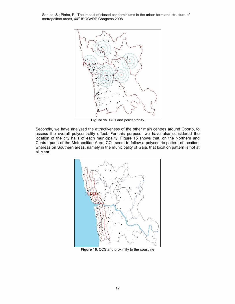
4.5 CCs and the territorial structure of the Metropolitan Area of Oporto Lastly, we are going to look in more detail at the CCs’ location pattern in relation to dominant influences such as metropolitan centrality and polycentrality, and proximity to the coastline. In this first representation we have considered the Oporto city hall as the epicentre of this territory, and we have drawn a series of concentric circles, distant from each other of 1000m (Figure 13).

Santos, S.; Pinho, P., The impact of closed condominiums in the urban form and structure of metropolitan areas, 44th ISOCARP Congress 2008
11
Figure 13. CCs and metropolitan centrality
0,00
0,20
0,40
0,60
0,80
1,00
1,20
1,40
1,60
1,80
[0, 1000]
]2000, 3000]
]4000, 5000]
]6000, 7000]
]8000, 9000]
]10000, 11000]
]12000, 13000]
]14000, 15000]
]16000, 17000]
]18000, 19000]
]20000, 21000]
]22000, 23000]
0
1000
2000
3000
4000
5000
6000
7000
8000
9000
10000
Closed condominiums
Urban Areas
Urban expansions
Population density
Figure 14. Distribution of CCs, urban areas, expansion areas, and population densities in relation to
the city centre From both the map (Figure 13) and the graph (Figure 14), we can see that CCs prefer locations on the outer areas of Oporto and on the inner rings of the suburban periphery, on distances ranging, approximately, from 2 to 10 km from the city centre. Indeed, the influence of the metropolitan centrality is still quite evident when we analyze the different variables, such as the occurrence of urban areas, of expansion areas and the distribution of population densities.
Santos, S.; Pinho, P., The impact of closed condominiums in the urban form and structure of metropolitan areas, 44th ISOCARP Congress 2008
12
Figure 15. CCs and policentricity
Secondly, we have analyzed the attractiveness of the other main centres around Oporto, to assess the overall polycentrality effect. For this purpose, we have also considered the location of the city halls of each municipality. Figure 15 shows that, on the Northern and Central parts of the Metropolitan Area, CCs seem to follow a polycentric pattern of location, whereas on Southern areas, namely in the municipality of Gaia, that location pattern is not at all clear.
Figure 16. CCS and proximity to the coastline

Santos, S.; Pinho, P., The impact of closed condominiums in the urban form and structure of metropolitan areas, 44th ISOCARP Congress 2008
13
0,00
0,50
1,00
1,50
2,00
2,50
[0, 1000]
]1000, 2000]
]2000, 3000]
]3000, 4000]
]4000, 5000]
]5000, 6000]
]6000, 7000]
]7000, 8000]
]8000, 9000]
]9000, 10000]
]10000, 11000]
]11000, 12000]
]12000, 13000]
]13000, 14000]
]14000, 15000]
]15000, 16000]
]16000, 17000]
]17000, 18000]
]18000, 19000]
]19000, 20000]
]20000, 21000]
]21000, 22000]
]22000, 23000]
0
500
1000
1500
2000
2500
Closed condominiums
Urban areas
Expansion Areas
Population density
Figure 17. Distribution of CCs, urban areas, expansion areas, and population densities
in relation to the coastline The same procedure was applied regarding the proximity to the coastline. Here, the results show a clear preference for coastal locations, particularly in Oporto and Vila Nova de Gaia. Looking at Figure 16, it is evident that the coastline represents an important attractiveness factor in the territory of Greater Oporto. Its effects are reflected on a strip of 6 km with higher concentrations of urban areas, expansion areas, population densities and, also, of the number of CCs (Figure 17). Indeed, the spatial duality identified in the city of Oporto is also most evident considering the whole metropolitan area, certainly due to the attractiveness of the coastline. 5 Conclusions CCs are a relatively recent urban product, but increasingly popular in Portugal and elsewhere. Our study made evident the coexistence of flexible and diversified CC models. Anyway, we attempted to define a typical CC model in Greater Oporto in terms of qualitative and quantitative parameters, such as built-up areas, average number of dwellings, building types, facilities and uses, etc however, we did not manage to identify prevailing urban forms. In fact, the overall plant shapes of the CCs are quite diverse. The presence of a common basement to guarantee the unity of the whole development is one of the most frequent morphological characteristic seen in almost every CC in our study area. Regarding the shapes of the buildings, they vary significantly, but are usually designed with the purpose to create an interior collective space with facilities and equipments. Concave shapes promote the existence of inner spaces to allocate collective activities. From the empirical study in Greater Oporto we can conclude that CCs prefer low density urban and suburban areas, filling, in many cases, existing gap sites. CCs tend to follow the global trends of the local housing market, preferring the most dynamic territories on the outer ring of Greater Oporto and on the coastal areas, where housing pressures have been higher. At the same time there seems to be a preference for areas offering better urban environmental quality. CCs marketing usually refer to the quality and availability of the natural resources around the developments, mentioning either, the green, the blue or both these structures. In addition, CCs don’t seem to depend on general accessibility patterns relying, instead, on the expected mobility of their residents. However, in our case study, the contribution of CCs to sprawl and to coastal development has to be classified as modest and very much in line with current urban development trends.

Santos, S.; Pinho, P., The impact of closed condominiums in the urban form and structure of metropolitan areas, 44th ISOCARP Congress 2008
14
In synthesis, the wide range of the CCs’ characteristics reveals an extraordinary capacity of these urban products to adapt to different conditions and locations. This versatility is also one of the reasons, and an important one, for the apparent success of this model. References Atkinson, R. and Blandy, S. (2005) ‘Introduction: International Perspectives on the New
Enclavism and the Rise of Gated Communities’, Housing Studies, 20(2), 177-186. Dear, M.; and Flusty, S. (1998) ‘Postmodern Urbanism’, Annals of the Association of
American Geographers, 88(1), 50-72. Ellin, N. (1999) Postmodern Urbanism, Princeton architectural press, New York. Foldvary, F. (1994) Public Goods and Private Communities - The Market Provision of Social
Services. Hants, Edward Elgar Publishing. Marcuse, P. (1997) ‘Walls of fear and walls of support’, in Architecture of Fear, Nan Ellin
(Ed), Princeton Architectural Press, 101- 114. Pinho, P. (2005) ‘Pontes e Espaços – Tempo: da alta velocidade à circulação pedonal’,
Comunicação à Conferência Porto Cidade Região, Universidade do Porto. Pinho, P., Morais, G., Moura e Sá, F., Torres, M. (2007) Programa Estratégico de
Desenvolvimento do Metro do Porto, FEUP. Pinho, P, Vázquez, I., Santos, P., Galego, I. (1999). Regeneração Urbana na Área
Metropolitana do Porto – Relatório Final, PRAXIS XXI, FEUP/SPTA. Sandercock, L. (2005) ‘Difference, Fear and Habitus: A political Economy of Urban Fears’,
Habitus: A Sense of Place, Hillier, J & E. Rooksby (Eds), Ashgate, 219-234. Santos, S. (2004) Fragmentos Utópicos na Cidade Caótica: os Condomínios Fechados no
Grande Porto, unpublished PhD Thesis, Faculdade de Engenharia, Universidade do Porto.
Soja, E. (2001) Postmetropolis: Critical Studies of Cities and Regions, Blackwell. Vazquez, I. (1992). O Processo de Suburbanização no Grande Porto: A evolução da cidade
do Porto e a estruturação territorial dos concelhos periféricos, Tese de Doutoramento, Faculdade de Engenharia da Universidade do Porto.
Webster, C. (2003) ‘The global emergence of private planning and governance’, AESOP conference, Leuven, Belgium.
Acknowledgements The authors would like to acknowledge and thank the contribution of Fernanda Sousa, Benedita Corte-Real, Mafalda Ferreira and Vitor Oliveira, as part of the research group working in this project. Santos, Sara (Assistant Professor) Pinho, Paulo (Full Professor)
CITTA – Research Centre for Territory, Transports and Environment FEUP – Faculdade de Engenharia da Universidade do Porto PORTUGAL