Embed Size (px)
Citation preview
PROCEEDINGS, 44th Workshop on Geothermal Reservoir Engineering
Stanford University, Stanford, California, February 11-13, 2019
SGP-TR-214
1
The Iceland Deep Drilling Project at Reykjanes - 4.5 km Deep Drilling into Supercritical
Conditions
Tobias B. Weisenberger1, Björn S. Harðarson1, Kiflom G. Mesfin2, Gunnlaugur M. Einarsson1, Steinþór Níelsson1, Robert
A. Zierenberg3 and Guðmundur Ó. Friðleifsson2
1ÍSOR, Iceland GeoSurvey, Grensásvegur 9, 108 Reykjavik, Iceland; 2HS Orka, Svartsengi, 240 Grindavík, Iceland; 3Department of
Earth and Planetary Sciences, University of California, Davis, CA 95616, USA
Keywords: Iceland, Reykjanes, Drilling, IDDP, supercritical
ABSTRACT
In 2016 and 2017 the geothermal well RN-15/IDDP-2 was drilled in the Reykjanes geothermal field, in southwest Iceland. With a total
measured depth of 4650 m the well RN-15/IDDP-2 marks the deepest well drilled in Iceland to date and the hottest geothermal well (more
than 426°C) reaching supercritical fluid conditions. Drilling was completed in 168 days by deepening the pre-existing production well
RN-15, which was drilled in 2004 to a depth of 2507 m. In total 13 core runs were conducted during drilling of phase 4 and 5. Nine core
runs retrieved core material with a total core length of 27.31 m and a core recovery of 63%. The high-temperature conditions of the
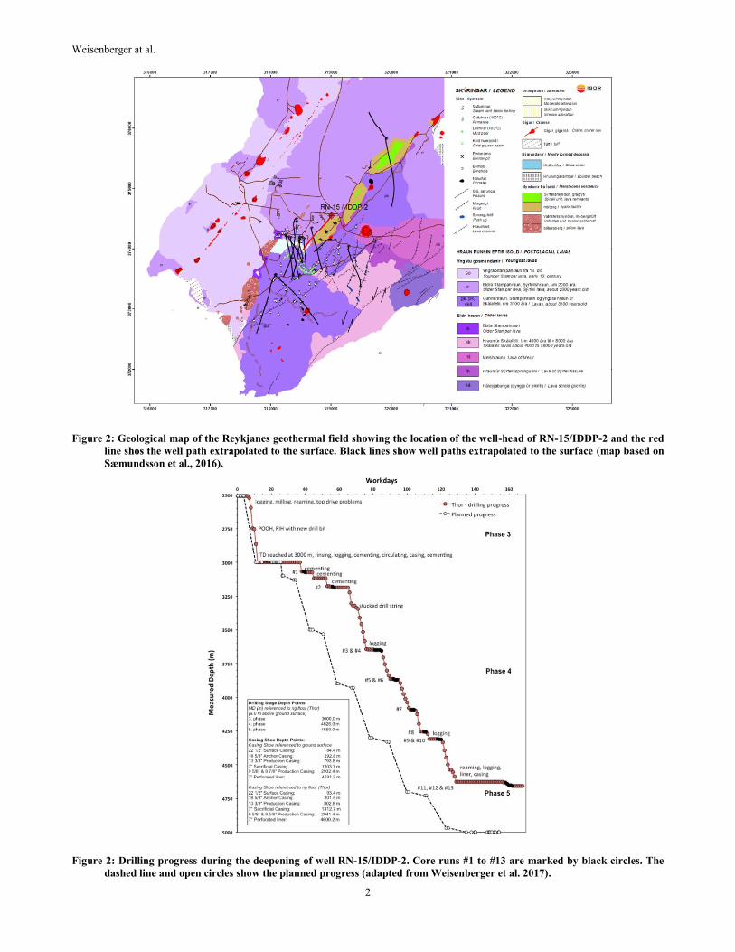
predicted amphibolite facies was confirmed by a temperature and pressure log that was carried out on January 3rd, 2017, yielding a
minimum temperature of 426°C at a pressure of 340 bar, but the well had not recovered from cooling during drilling.
1. INTRODUCTION
The drilling scheme is part of the Iceland Deep Drilling Project (IDDP), which aims to drill deep wells down to 4–5 km depth into
geothermal systems in Iceland (Friðleifsson and Albertsson, 2000; Friðleifsson et al., 2014a, b). The IDDP consortium was established in
2000 (Friðleifsson and Albertsson, 2000) to investigate the feasibility and economics of deep, high-enthalpy geothermal resources, and
especially supercritical hydrothermal fluids, as possible energy sources. The first well in the series, IDDP-1, was drilled in 2008–2009
within the Krafla geothermal field in NE Iceland (Hólmgeirsson et al., 2010; Pálsson et al., 2014). However, the drilling of the IDDP-1
well had to be terminated at a depth of 2104 m when it intersected >900°C magma (Hólmgeirsson et al., 2010; Pálsson et al., 2014).
It was decided to drill the second well in the series, IDDP-2, in the Reykjanes geothermal field, which is exploited by HS Orka for power
producation. The chief motivation of HS Orka to undertake such a challenging drilling operation was to address several basic questions
for commercially viable reasons (Friðleifsson et al., 2014b): (i) Where is, and what is the nature of the base of, the Reykjanes hydrothermal
reservoir? Is it possibly heated by superheated steam from below? (ii) Can the deep heat sources be exploited by injecting fluid into the
hot rocks beneath the most productive part of the well field? (iii) Will productive permeability be found at such great depths within the
approximate center of the fault-related up-flow zone? (iv) Does a supercritical reservoir exist at 4–5 km depth under the Reykjanes
reservoir or does it lie deeper still? (v) What is the nature of the ultimate heat source of this saline seawater recharged hydrothermal
system; is it a sheeted dike complex or a major gabbroic intrusion? Individual dikes may cool to ambient temperatures in a few years,
depending on thickness, while large gabbro intrusions may act as a heat source for thousands of years.
Well RN-15 was selected as target well for the IDDP-2 project, as it had already been drilled to a depth of 2507 m. Well RN-15 is located
on the northeast side of the Reykjanes production field (Figure 1) and was drilled vertically in the year of 2004 down to its final depth of
2507 m (reference level rig-floor; 6.86 m above ground level, Table 1).
Table 1: Drilling and casing depths of well RN-15 and RN-15/IDDP-2. The drilling depths are measured from the rig floor (RF)
of each drill rig. Þór: 9.0 m above ground level, Jötunn: 6.86 m above ground level, Saga: 2.0 m above ground level.
Drill rig Phase Depth (m) Depth reference Bit size Casing type Casing depth (m) Casing depth reference
Saga Pre-drilling 86.5 Saga RF 26" 22½" 84.4 Ground surface Jötunn 1. phase 300 Jötunn RF 21" 18⅝" 292.8 Ground surface
Jötunn 2. phase 804 Jötunn RF 17½" 13⅜" 793.8 Ground surface
Jötunn 3. phase 2507 Jötunn RF 12¼" No casing Þór 3. phase 3000 Þór RF 12¼" 9⅞"
9⅝"
445
445-2932.4
Ground surface Ground
surface Þór 4. phase 4626 Þór RF 8½" 7" liner
7" sacrificial casing
2871.2-4591.2
1303.7
Ground surface
Ground surface
Þór 5. phase 4659 Þór RF 6"
Weisenberger at al.
2
Figure 2: Geological map of the Reykjanes geothermal field showing the location of the well-head of RN-15/IDDP-2 and the red
line shos the well path extrapolated to the surface. Black lines show well paths extrapolated to the surface (map based on
Sæmundsson et al., 2016).
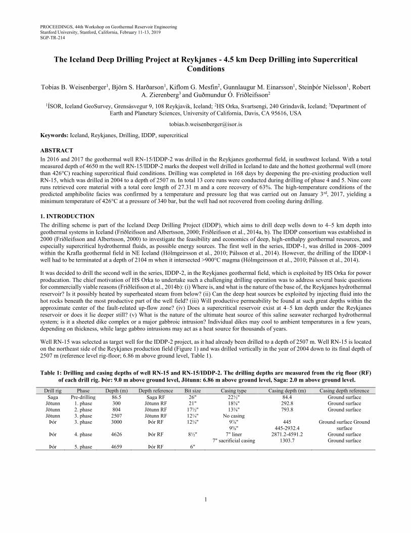
Figure 2: Drilling progress during the deepening of well RN-15/IDDP-2. Core runs #1 to #13 are marked by black circles. The
dashed line and open circles show the planned progress (adapted from Weisenberger et al. 2017).
Weisenberger et al.
3
2. DRILLING OPERATION
On August 11th, 2016, the deepening of well RN-15 was initiated in the Reykjanes geothermal field (Figure 1), now known as well RN-
15/IDDP-2. The well was drilled by Iceland Drilling (Jarðboranir) using the rig Þór, which is a Bentec 350-ton drill rig with an electric
top drive (MH PTD-500-AC). After 29 workdays, drilling phase 3 (Figure 2) was completed at a depth of 3000 m on September 8th, 2016
(Weisenberger et al., 2016). Due to total loss of circulation during the deepening to 3000 m, no cutting samples were retrieved and
therefore, no direct information about the lithological and the mineralogical inventory is available. The kick-off point is located at a depth
of 2750 m, and the aim was to build up an inclination of about 16° with an azimuth of about 210°. Well RN-15 had an existing production
casing of 13⅜" cemented from 0–793.8 m. During continuation of phase 3 in August 2016 an additional production casing (anchor casing)
of 9⅞" (0–445 m) and 9⅝" (445–2932.4 m) was run into hole and cemented.
Drilling activity of phase 4 started on September 8th (workday 29) and partial circulation loss was almost immediately encountered.at the
beginning drilling of phase 4. Drilling was very challenging and although 12 successive attempts to seal the loss zone with cement were
carried out, total loss of circulation below about 3200 m could not be avoided. One side tracking was necessary at a depth of about 3040
m (measured depth). Direct information on the nature of the drilled formation is restricted to the depth interval between 3000 and 3200
m, the only area were cuttings were retrieved. Drilling into formation commenced again on workday 66 with a total loss of circulation
and continued with variable progress during the next weeks (Figure 2), but on December 17th phase 4 reached its total depth at 4626 m.
During phase 4, 10 spot core runs were carried out (see below). Drilling phase 4 was followed by “logging while drilling”, carried out by
Weatherford logging engineers. Subsequently a 7" perforated liner was run into hole on December 29th and 30th (2880.2–4600.2 m,
reference to rig floor of Þór). On January 3rd, 2017, a temperature and pressure log was carried out after five days of heating-up, which
resulted in a maximum temperature of 426°C and a pressure of 340 bar (Figure 3) about 30 m above the liner shoe (4591.2 m from the
ground level). Subsequently a sacrificial 7" casing (0–1303.7 m, referenced to the ground level) was inserted and cemented and with that
phase 4 was completed on workday 152 (Figure 2).
Drilling of phase 5 with a 6" tricone drill bit commenced on workday 157. In total 8 meters were drilled as pilot hole for core run #11,
which was followed by core runs #12 and #13. On January 19th core run 13 was completed at a measured depth of 4659 m (referenced to
the rig floor) and marked the total depth of RN-15/IDDP-2. The final depth of RN-15/IDDP-2 is 4650 m (measured depth, referenced to
ground level) or about 4469 m total vertical depth. The horizontal displacement is about 730 m with an azimuth of about 220° (Figure 1).
After stimulation of the well, drilling activity was terminated on January 25th, 2017 (workday 168, see figure 2) and the string was left in
the well for stimulation.
Figure 3: Temperature and pressure logged inside the 7" liner on January 3rd, 2017.
Weisenberger at al.
4
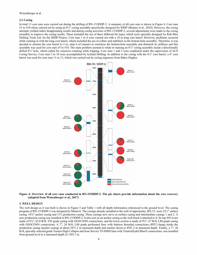
2.1 Coring
In total 13 core runs were carried out during the drilling of RN-15/IDDP-2. A summary of all core runs is shown in Figure 4. Core runs
#1 to #10 where carried out by using an 8½" coring assembly specifically designed for IDDP (Skinner et al., 2010). However, the coring
attempts yielded rather disappointing results and during coring activities of RN-15/IDDP-2, several adjustments were made to the coring
assembly to improve the coring results. These included the use of three different bit types, which were specially designed by Rok-Max
Drilling Tools Ltd. for the IDDP Project. Core runs 1 to 4 were carried out with a 10 m long core barrel. However, problems occurred
while running in with the long core barrel, which included the use of collars and stabilizer in the bottom-hole assembly. Therefore, it was
decided to shorten the core barrel to 5 m, strip it of reamers to minimize the bottom-hole assembly and diminish its stiffness and this
assembly was used for core runs #5 to #10. The main problem seemed to relate to running an 8½" coring assembly inside a directionally
drilled 8½" hole, which called for extensive reaming while tripping. Core runs 1 and 2 were conducted under the supervision of ACS
Coring Service. Core runs 3 to 10 were accomplished by Iceland Drilling. In addition to the coring with the 8½" core barrel, a 6" core
barrel was used for core runs 11 to 13, which was carried out by coring engineers from Baker Hughes.
Figure 4: Overview of all core runs conducted in RN-15/IDDP-2. The pie charts provide information about the core recovery
(adapted from Weisenberger et al., 2017)
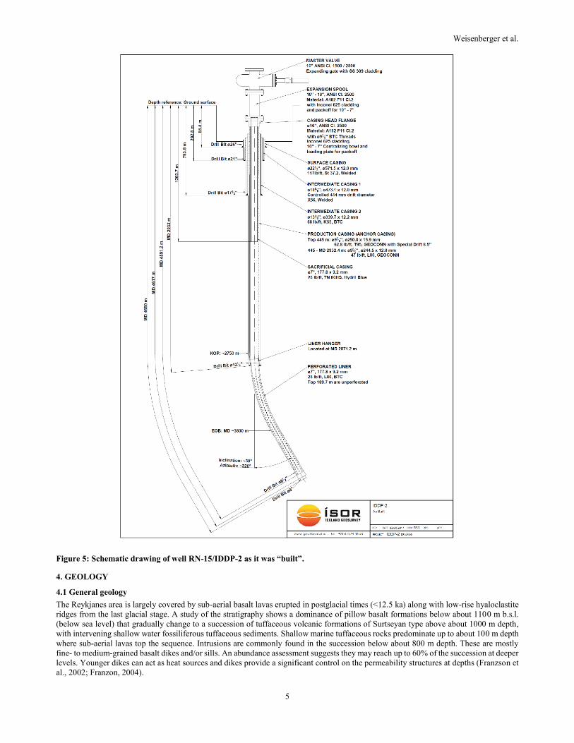
3. WELL DESIGN
The well design as it was built is shown in Figure 5 and Table 1 with all depth information referenced to the ground level. The casing
program of RN-15/IDDP-2 was designed by Mannvit. The casings already installed in the well of opportunity, RN-15, were 22½" surface
casing, 18⅝" anchor casing and 13⅜ production casing. These casings now serve as surface casing and intermediate casings 1 and 2. A
new production casing was installed in RN-15/IDDP-2. It also acts as an anchor casing as the well-head is attached to it. Its top 445 m are
made of 9⅞", 62.8 lb/ft, T95 grade casing with GEOCONN connections, and the lower section is made of 9⅝", 47 lb/ft, L80 grade casing
with GEOCONN connections. A 7", 26 lb/ft, L80 grade perforated liner with buttress threaded connections (BTC) hangs inside the
production casing (anchor casing) at about 2871.2 m measured depth and reaches down to 4591.2 m measured depth. Finally, a 7", 26
lb/ft, specially selected grade Tenaris High Collapse and Sour Service TN 80HS liner with TenarisHydril Blue® connections, was installed
from ground level to a measured depth of 1303.7 m.
Weisenberger et al.
5
Figure 5: Schematic drawing of well RN-15/IDDP-2 as it was “built”.
4. GEOLOGY
4.1 General geology
The Reykjanes area is largely covered by sub-aerial basalt lavas erupted in postglacial times (<12.5 ka) along with low-rise hyaloclastite
ridges from the last glacial stage. A study of the stratigraphy shows a dominance of pillow basalt formations below about 1100 m b.s.l.
(below sea level) that gradually change to a succession of tuffaceous volcanic formations of Surtseyan type above about 1000 m depth,
with intervening shallow water fossiliferous tuffaceous sediments. Shallow marine tuffaceous rocks predominate up to about 100 m depth
where sub-aerial lavas top the sequence. Intrusions are commonly found in the succession below about 800 m depth. These are mostly
fine- to medium-grained basalt dikes and/or sills. An abundance assessment suggests they may reach up to 60% of the succession at deeper
levels. Younger dikes can act as heat sources and dikes provide a significant control on the permeability structures at depths (Franzson et
al., 2002; Franzon, 2004).
Weisenberger at al.
6
4.2 Lithologies
4.2.1 Cutting analysis
Due to the total loss of circulation within the entire drilling phase 3 and below a measure depth of 3200 m within drilling phase 4 cuttings
were only retrieved within the depth interval between 3000 and 3200 m.
The lithological descriptions for the well before side tracking (from 3000 to 3069 m) indicate the presence of dense medium-grained,
grayish basaltic intrusions that are intercalated with fine- to medium-grained dense basaltic rocks which are, in contrast, black in color. A
large quantity of secondary minerals, including epidote, quartz and pyrite/chalcopyrite, are found, which also appear as fracture fills. At
3021 m a garnet-filled fracture was observed. Formation after side tracking from 3040 to 3200 m consists exclusively of an alternating
sequence of crystalline basaltic rocks which most likely represent a sheeted dike complex. Fresh, grayish to reddish medium- to coarse-
grained plutonic rocks that are lighter color due to the abundance of plagioclase are the dominate the lithology, and are intercalated with
finer-grained dark (more mafic) fresh dolerite.
The high content of epidote and quartz and lesser amount of actinolite, garnet and sulfides (pyrite and chalcopyrite) indicates significant
porosity and permeability. The intrusive rocks are quite dense and the secondary minerals are most likely related to pore-space, associated
with fractures. Mono-mineralic fragments of secondary phases can reach up to several millimeters in size. However, the grains are
anhedral. The lack of euhedral secondary minerals, characteristic of open space veins, indicates that most of the fractures are totally sealed
with secondary minerals. The intrusive rocks are in general fresh. Nevertheless, minor amounts of altered igneous grains are present. This
implies that the alteration is not pervasive. It is most likely related to the fracture and selvage zones adjacent to the fracture pore space.
The occurrence of epidote, actinolite (amphibole) and garnet indicates high temperature conditions characteristic of upper greenschist
facies alteration.
4.2.2 Core observation
Because of the total loss of circulation in RN-15/IDDP-2 below 3200 m depth, spot cores are the only rock samples available from the
deeper section of the well. Coring was difficult, and in total only 27.3 m were recovered (Weisenberger et al., 2017). The IDDP-2 cores
include a series of dolerite dikes with chilled margins interpreted to originate from a sheeted dike complex (Friðleifsson et al., 2018;
Zierenberg et al., 2017). Many of the rocks were found as “rollers” on top of cores from unknown depths above coring intervals. These
include dolerites, basalts, and a few hyaloclastite and volcanic sandstone/siltstones with alteration similar to the RN-17B and RN-30 cores
(Friðleifsson et al., 2018; Zierenberg et al., 2017). The lowermost cores of altered dolerites, contain thin felsic veins that are the first
identification of evolved rocks within the volcanic rock series within the Reykjanes geothermal field. Cross cutting veins are relatively
uncommon and open space filling veins are nearly absent, although the rocks appear to be pervasively altered (Friðleifsson et al., 2018;
Zierenberg et al., 2017).
4.2.3 Drilling parameters
Drilling parameters show only minor variations and are indicative for drilling into relative hard formations. However, small variations did
occur, which may reflect changes in lithology or penetration into soft formations, and could be related to fracture zones. Within the
shallower part (3000–3185 m), which was cemented multiple times due to the high fluid loss, the drilling crew reported a large variation
in the fluid circulation as well as in the stand-pipe pressure, which may indicate the penetration of narrow fracture zones. However, no
indications are observed on the temperature logs which were carried out during drilling, of any major feed points within this depth interval.
While drilling from 3305 to 3312 m a drop in the stand-pipe pressure (95–80 bar) was observed, which may indicate the penetration of a
permeable zone. While drilling from 3373 to 3375 m, the weight on bit decreased while the rate of penetration increased. This is at a
similar depth where a larger fracture zone was detected. Drilling parameters indicate that in general the formation from 3400 to about
3750 m consists of a relative uniform, hard formation, which is most likely represented by the core retrieved during core run 3. The peak
in rate of penetration at a depth of 3710 m indicates a thin soft layer, or possibly a fault zone. A thicker soft zone occurs between 3751
and 3754 m, as indicated by the drastic change in drilling parameters (e.g. rate of penetration). From 3755 to 3816 m the drilling parameters
show significant fluctuations which may indicate the penetration of a heterogeneous units, where hard and soft layers intercalate. Below
3816 m, drilling parameters show only minor variations except for a significant increase in the rate of penetration between 3884 and 3887
m. This may reflect a formation boundary. Another sharp peak in the rate of penetration is observed at a depth of 3990 m. The spike in
torque just below 4000 m indicates the penetration of an open structure. In addition, at 4000 the MWD showed a drop in the inclination
of about 2.5°. Between 4118 and 4160 m the rate of penetration is quite high (8–15 m/h), which indicates a rather soft formation in
comparison to the unit above and below. Within this interval, the well inclination built up, which may indicate the penetration of a
fault/fracture zone. Subsequently, the rate of penetration declined, but at about 4210 m, the rate of penetration increased again with an
outstanding spike at about 4240 m indicating again a weak/softer formation. Below about 4250 m the rate of penetration dropped back to
lower numbers and does not indicate any major variations in lithology. It should be mentioned that the temperature log carried out on
December 6th shows a similar undulating pattern as the rate of penetration pattern between 4100 and 4250 m and may reflect the different
cooling behavior of the formations (Weisenberger et al., 2017).
4.3 Alteration
A regular progression in hydrothermal alteration with increasing depth was noticed from the alteration mineral assemblage in well RN-
15 . Such depth and temperature controlled mineral alteration zoning is well known in Icelandic hydrothermal systems (e.g.
Kristmannsdóttir and Tómasson, 1978; Weisenberger and Selbekk, 2009). Low-temperature minerals, like fine-grained clay (smectite)
and zeolites occur at shallower levels (Gautason et al., 2004). High-temperature minerals, like epidote and coarse-grained chlorite appear
at deeper levels in the well. Epidote was first observed at a depth of 716 m (Gautason et al., 2004; Jónsson et al., 2010). The 13⅜"
Weisenberger et al.
7
production casing of well RN-15 was set at 793.8 m (reference to ground level) and based on the mineral assemblage, the production
casing of RN-15 extends well into the geothermal reservoir, where abundance of epidote (>230–250°C) was noticed in cutting samples.
Furthermore, garnet and actinolite (>280°C) were first observed at 1378 m and 1560 m respectively.
Based on cutting analysis in the depth range from 3000 to 3200 m in RN-15/IDDP-2, high-temperature minerals, like epidote, garnet and
actinolite, could be identified, but epidote was the dominant secondary mineral. Visual core inspection, accompanied by initial thin section
observations of the retrieved cores reveals that epidote is common in a sample of core 3 (3648.0–3648.52 m), locally accompanied by
minor amounts of chlorite. Epidote and chlorite are absent in core run 5 and below (Friðleifsson et al., 2018; Zierenberg et al., 2017). In
contrast, calcic-plagioclase and hornblende were identified by microscopic observation. Biotite was observed as minor mineral phase in
core 8 (4254.6–4254.88 m) as well as in core 11 (4634.20–4641.78 m).
The mineral assemble plagioclase-hornblende is a characteristic mineral assemblage found in meta-basaltic rocks of amphibolite facies
rocks. The presence of hydrothermal biotite is consistent with this high temperature alteration of intermediate to felsic rocks, but biotite
alteration is unusual in low K tholeiitic basalts. Pryroxenes are a common part of the alteration assemblage in the deepest part of hole.
However, a detailed pressure-temperature estimation requires a more thorough mineralogical and petrological study, as well as
considerations of the effects of mass transport and metasomatic alteration.
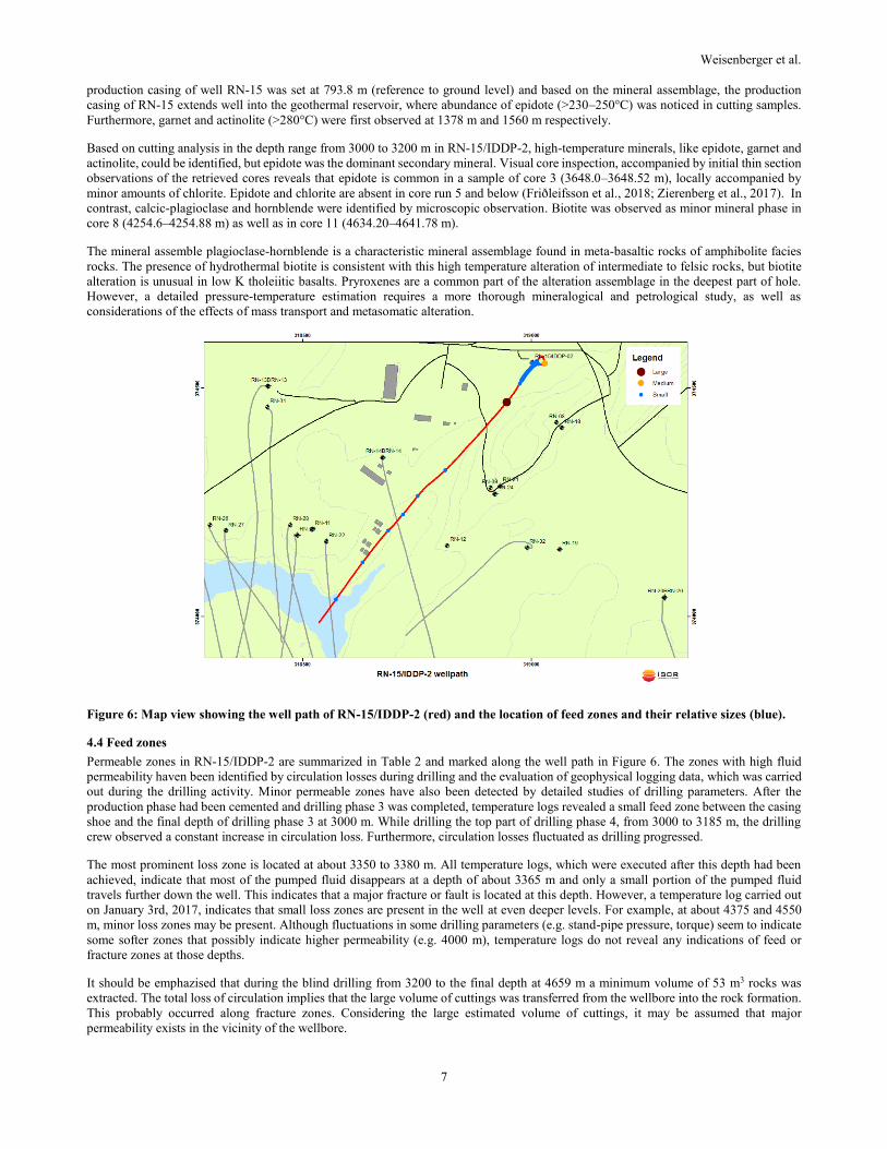
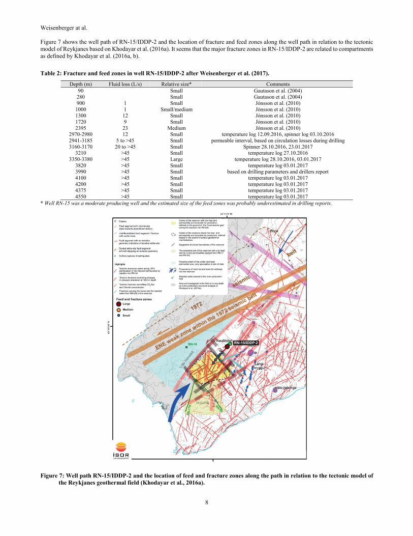
Figure 6: Map view showing the well path of RN-15/IDDP-2 (red) and the location of feed zones and their relative sizes (blue).
4.4 Feed zones
Permeable zones in RN-15/IDDP-2 are summarized in Table 2 and marked along the well path in Figure 6. The zones with high fluid
permeability haven been identified by circulation losses during drilling and the evaluation of geophysical logging data, which was carried
out during the drilling activity. Minor permeable zones have also been detected by detailed studies of drilling parameters. After the
production phase had been cemented and drilling phase 3 was completed, temperature logs revealed a small feed zone between the casing
shoe and the final depth of drilling phase 3 at 3000 m. While drilling the top part of drilling phase 4, from 3000 to 3185 m, the drilling
crew observed a constant increase in circulation loss. Furthermore, circulation losses fluctuated as drilling progressed.
The most prominent loss zone is located at about 3350 to 3380 m. All temperature logs, which were executed after this depth had been
achieved, indicate that most of the pumped fluid disappears at a depth of about 3365 m and only a small portion of the pumped fluid
travels further down the well. This indicates that a major fracture or fault is located at this depth. However, a temperature log carried out
on January 3rd, 2017, indicates that small loss zones are present in the well at even deeper levels. For example, at about 4375 and 4550
m, minor loss zones may be present. Although fluctuations in some drilling parameters (e.g. stand-pipe pressure, torque) seem to indicate
some softer zones that possibly indicate higher permeability (e.g. 4000 m), temperature logs do not reveal any indications of feed or
fracture zones at those depths.
It should be emphazised that during the blind drilling from 3200 to the final depth at 4659 m a minimum volume of 53 m3 rocks was
extracted. The total loss of circulation implies that the large volume of cuttings was transferred from the wellbore into the rock formation.
This probably occurred along fracture zones. Considering the large estimated volume of cuttings, it may be assumed that major
permeability exists in the vicinity of the wellbore.
Weisenberger at al.
8
Figure 7 shows the well path of RN-15/IDDP-2 and the location of fracture and feed zones along the well path in relation to the tectonic
model of Reykjanes based on Khodayar et al. (2016a). It seems that the major fracture zones in RN-15/IDDP-2 are related to compartments
as defined by Khodayar et al. (2016a, b).
Table 2: Fracture and feed zones in well RN-15/IDDP-2 after Weisenberger et al. (2017).
Depth (m) Fluid loss (L/s) Relative size* Comments
90 Small Gautason et al. (2004) 280 Small Gautason et al. (2004)
900 1 Small Jónsson et al. (2010)
1000 1 Small/medium Jónsson et al. (2010) 1300 12 Small Jónsson et al. (2010)
1720 9 Small Jónsson et al. (2010)
2395 23 Medium Jónsson et al. (2010) 2970-2980 12 Small temperature log 12.09.2016, spinner log 03.10.2016
2941-3185 5 to >45 Small permeable interval, based on circulation losses during drilling
3160-3170 20 to >45 Small Spinner 28.10.2016, 23.01.2017 3210 >45 Small temperature log 27.10.2016
3350-3380 >45 Large temperature log 28.10.2016, 03.01.2017
3820 >45 Small temperature log 03.01.2017
3990 >45 Small based on drilling parameters and drillers report
4100 >45 Small temperature log 03.01.2017
4200 >45 Small temperature log 03.01.2017 4375 >45 Small temperature log 03.01.2017
4550 >45 Small temperature log 03.01.2017
* Well RN-15 was a moderate producing well and the estimated size of the feed zones was probably underestimated in drilling reports.
Figure 7: Well path RN-15/IDDP-2 and the location of feed and fracture zones along the path in relation to the tectonic model of
the Reykjanes geothermal field (Khodayar et al., 2016a).
Weisenberger et al.
9
5. SUMMARY
Drilling of well RN-15/IDDP-2 was commissioned by HS Orka in 2016. Drilling was performed by the drill rig Þór (Iceland Drilling,
Jarðboranir) and drilling was completed in 168 days (August 11th, 2016 to January 25th, 2017). The well represents the second well of the
Iceland Deep Drilling Project (IDDP). It is the deepest (4659 m measured depth, referenced to the rig floor Þór) and hottest (>426°C)
geothermal well drilled in Iceland. For this purpose, well RN-15 was deepened, but it had previously been drilled in 2004 down to 2507
m (reference rig floor Jötunn). Drilling of RN-15/IDDP-2 commenced with continuation of drilling phase 3 using a 12¼" drill bit from
2509 to 3000 m (reference rig floor of Þór). Subsequently, phase 4 was drilled with an 8½" drill bit from 3000 to 4626 m and finally,
phase 5 was drilled with a 6" drill bit from 4626 to 4659 m. All depth information of RN-15/IDDP-2 refer to the rig floor of Þór. Drilling
of phase 3 commenced with a total loss of circulation. After completion of phase 3, a production casing (anchor casing) (9⅞" down to
454 m and a 9⅝" down to 2941.4 m) was installed. Minor circulation losses were encountered when drilling of phase 4 started. The loss
increased and a total circulation loss was encountered at about 3185 m. Several cement jobs were carried out in attempt to plug the
circulation losses. However, the cement jobs did not limit the circulation losses and therefore, drilling was blind (total loss of the
circulation) below 3200 m until the end of drilling. Phase 4 was completed with the installation of a 7" liner (2880.2 to 4600.2 m, reference
to rig floor of Þór) and a 7" sacrificial casing (from the surface to 1312.7 m, reference to rig floor of Þór). Subsequently, the well was
completed at a final depth of 4659 m in phase 5, drilled with a 6" drill bit. The well was drilled vertical down to 2750 m where the kick-
off point is located. The well was deviated in a southwest direction (220°), and an inclination angle of about 40° was eventually built up,
which is higher than originally planned (16°).
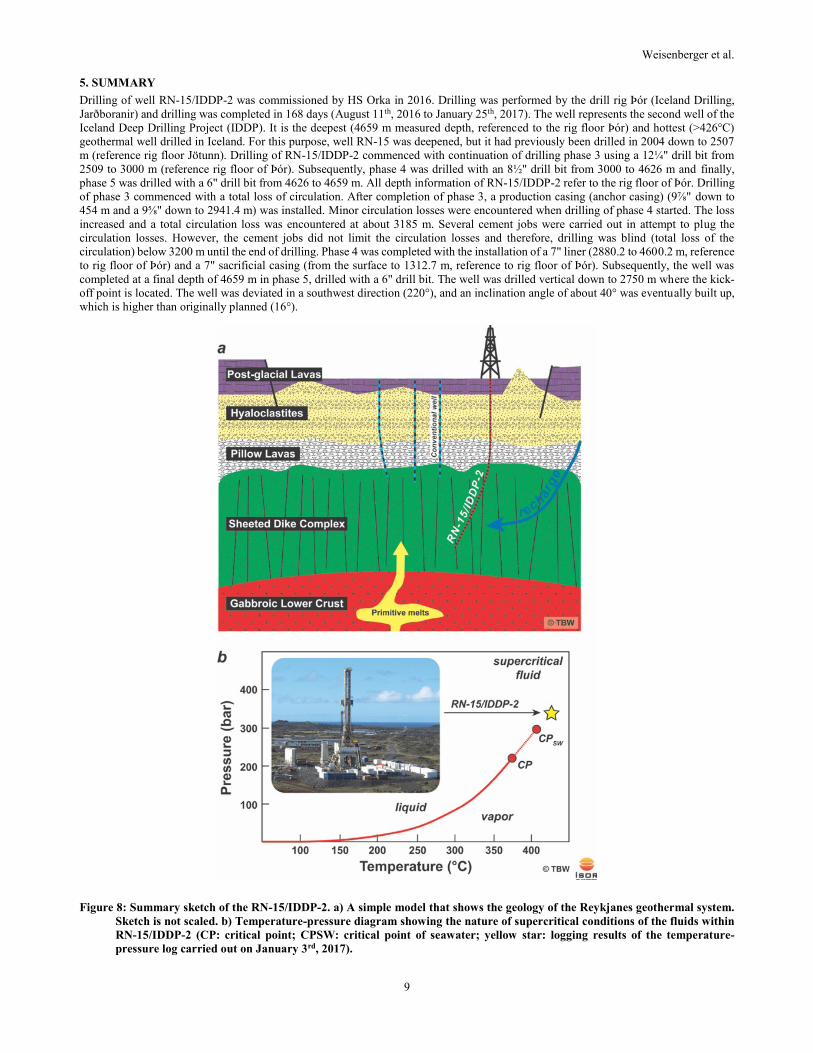
Figure 8: Summary sketch of the RN-15/IDDP-2. a) A simple model that shows the geology of the Reykjanes geothermal system.
Sketch is not scaled. b) Temperature-pressure diagram showing the nature of supercritical conditions of the fluids within
RN-15/IDDP-2 (CP: critical point; CPSW: critical point of seawater; yellow star: logging results of the temperature-
pressure log carried out on January 3rd, 2017).
Weisenberger at al.
10
During drilling, a total of 13 core runs were conducted. Nine core runs retrieved core material; in total 27.31 m of core was recovered.
The core recovery was 63%.
During most of the drilling, a total loss of circulation was persistent and no cuttings were retrieved at the surface apart from the beginning
of phase 4. Therefore, the information about the lithology is very limited and needs to be constrained from the limited cuttings (3000–
3200 m) and from the retrieved core material. Mineralogical and petrographic observations yield that the rocks of the deeper parts in the
well are equilibrated at amphibolite facies conditions. The high-temperature conditions of amphibolite facies conditions are confirmed by
the temperature and pressure logs that indicates the presence of a supercritical fluid (Figure 8).
Lithological and textural observations, in particular the occurrence of chilled margins and the grain-size of the rocks indicate that the
lithology is consistent with the existence of a sheeted-dike complex (e.g. Friðleifsson and Elders, 2005; Khodayar et al., 2016b;
Weisenberger et al., 2016b). Figure 8a shows a simple geological sketch of the Reykjanes geothermal field, which is equivalent to an
ophiolite model (Friðleifsson and Elders, 2005). The heat is most likely transferred by primitive magma that is emplaced in the lower
oceanic crust by dike injections within the sheeted-dike complex, and by dike and sills injections within the shallower volcano-sedimentary
sequence.
Textural observations of core 3 and interpretation of the cutting analysis suggests that the lithology at the top most part in drilling phase
4 (3000 to 3650 m) experienced high brittle deformation, which can be deducted by the high fracture density. Detected circulation losses
at this depth are evidence for the brittle behavior, which results in a significant permeability.
Based on circulation losses and temperature logs, several permeability zones are identified. A minor permeable zone is located just below
the casing shoe. Increased circulation losses below that zone, finally resulting in a total loss of circulation at about 3200 m, indicate the
high permeability at this depth. The most prominent permeable zone is found at 3350 to 3380 m and most likely reflects a major fracture
zone into which most of the injected pumped fluid disappear. Smaller feed zones or permeable zones are identified at 4375 m and 4550
m.
6. ACKNOWLEDGMENTS
The preparation of this report was carried out as part of the DEEPEGS Project, which received funding from the European Union
“HORIZON 2020 Research and Innovation Programme” (grant agreement No. 690771). The paper benefited from contributions by several
colleagues including people from Iceland Drilling, HS Orka, the IDDP science team, STATOIL and ÍSOR.
REFERENCES
Franzson, H.: The Reykjanes high-temperature geothermal system. Geological and geothermal model (in Icelandic), Iceland GeoSurvey,
report, ÍSOR-2004/012, (2004).
Franzson, H., Thordarson, S., Bjornsson, G., Gudlaugsson, S.Th., Richter, B., Fridleifsson, G.O., and Thorhallsson, S.: Reykjanes high-
temperature field, SW-Iceland. Geology and hydrothermal alteration of well RN-10, Proceedings, 27th workshop on geothermal
reservoir engineering, Stanford University, Stanford, CA (2002).
Friðleifsson, G.Ó., and Albertsson, A.: Deep geothermal drilling at Reykjanes Ridge: opportunity for an international collaboration,
Proceedings, World Geothermal Congress, Kyushu-Tohoku, Japan, May 28–June 10 (2000), 3701–3706.
Friðleifsson, G.Ó., and Elders, W.A.: The Iceland Deep Drilling Project: a search for deep unconventional geothermal resources,
Geothermics, 34, (2005).269–285.
Friðleifsson, G. Ó., Elders, W.A.. and Albertsson, A.: The concept of the Iceland deep drilling project, Geothermics, 49, (2014a), 2–8.
Friðleifsson, G.Ó., Sigurdsson, Ó., Þorbjörnsson, D., Karlsdóttir, R., Gíslason, Þ., Albertsson, A. and Elders, W.A.: Preparation for drilling
well IDDP-2 at Reykjanes, Geothermics, 49, (2014b), 119–126.
Friðleifsson, G.Ó.., Elders, W.A., Zierenberg, R.A., Fowler, A.P.G., Weisenberger, T.B., Mesfin, K.G., Sigurðsson, Ó., Níelsson, S.,
Einarsson, G., Óskarsson, F., Guðnaso,n E.G., Tulinius, H., Hokstad, K., Benoit, G., Nonog, F., Loggia, D., Parat, F., Cichy, S.B.,
Escobedo, D., and Mainprice, D.: The Iceland Deep Drilling Project at Reykjanes: Drilling into the root zone of a black smoker
analog, Journal of Volcanology and Geothermal Research, (2018), (https://doi.org/10.1016/j.jvolgeores.2018.08.013)
Gautason, B., Jónsson, S.S., Thordarson, S., Egilson, Þ., Sigurðsson, Ó., Hermannsson, G., Ásmundsson, R.K., and Skarphéðinsson, K.:
Reykjanes – Hola RMN-15 - 1. áfangi: Borun fyrir 18⅝" öryggisfóðringu frá 94 m í 300 m dýpi. 2. áfangi: Borun fyrir 13⅜" vinnslu-
fóðringu frá 300 m í 804 m dýpi, Iceland GeoSurvey, report, ÍSOR-2004/010 (in Icelandic), (2004).
Hólmgeirsson, S., Pálsson, B., Þórhallson, S., Bóasson, H.A., and Ingason, K.: Iceland Deep Drilling Project: the challenge of drilling
into a supercritical geothermal reservoir, Proceedings, World Geothermal Congress, Bali, Indonesia (2010).
Jónsson, S.S., Sigurgeirsson, M.Á, Sigurðsson, Ó., and Ingólfsson, H.: Reykjanes – Hola RN-15. 3. áfangi: Borun vinnsluhluta frá 804 m
í 2507 m dýpi, Iceland GeoSurvey, report, ÍSOR-2010/050 (in Icelandic), (2010).
Khodayar, M., Guðnason, E.Á., Weisenberger, T.B., Björnsson, S., and Níelsson, S.: Continued tectonic analysis of rift and transform
zones in the Reykjanes geothermal field for the 2016 conceptual model, SW Iceland, Iceland GeoSurvey, report, ÍSOR-2016/031,
(2016a).
Weisenberger et al.
11
Khodayar, M., Níelsson, S., Hickson, C., Guðnason, E.Á., Harðarson, B.S., Guðmundsdóttir, V., Halldórsdóttir, S., Óskarsson, S.,
Weisenberger, T.B., and Björnsson, S.: The 2016 Conceptual Model of Reykjanes Geothermal System, SW Iceland, Iceland
GeoSurvey, report, ÍSOR-2016/072, (2016b).
Kristmannsdóttir, H., and Tómasson, J.: Zeolites zones in geothermal areas in Iceland, In: Sand LB, Mumpton, F.A. (eds.) Natural zeolites;
occurrence, properties, use. Pergamon Press, New York, (1978), 277–284.
Pálsson, B., Hólmgeirsson S., Guðmundsson, Á., Bóasson, H.Á., Ingason, K., Sverrisson, H., and Thórhallsson, S.: Drilling of the well
IDDP-1, Geothermics, 49, (2014), 23–30.
Skinner, A., Bower, P.; Þórhallsson, S., Friðleifsson, G.Ó., and Guðmundsson, H.: Coring at Extreme Temperatures, Design and Operation
of a Core barrel for the Iceland Deep Drilling Project (IDDP), Proceedings, World Geothermal Congress, Bali, Indonesia, (2010).
Sæmundsson, K., Sigurgeirsson, M.Á., Hjartarson, Á., Kaldal I., and Kristinsson, S.G.: Geological Map of Southwest Iceland (2nd ed.).
Iceland GeoSurvey, (2016).
Weisenberger, T., and Selbekk, R.S.: Multi-stage zeolite facies mineralization in the Hvalfjördur area, Iceland, International Journal of
Earth Sciences, 98, (2009), 985–999.
Weisenberger, T.B., Kästner, F., Níelsson, S., Harðarson, B.S., Kristinsson, B., Ingólfsson, H., Stefánsson, H.Ö., Jónasson, H., and
Vilhjálmsson, S.: Well Report – RN-15/IDDP-2. Drilling of Well RN-15/IDDP-2 in Reykjanes – Continuation of Phase 3 from 2509
m down to 3000 m, Iceland GeoSurvey, report, ÍSOR-2016/053, (2016).
Weisenberger, T.B., Harðarson, B.S., Kästner, F., Gunnarsdóttir, S.H., Tulinius, H., Guðmundsdóttir, V., Einarsson, G.M., Pétursson, F.,
Vilhjálmsson, S., Stefánsson, H.Ö., and Níelsson, S.; Well report – RN-15/IDDP-2. Drilling in Reykjanes – Phase 4 and 5 from 3000
to 4659. Iceland GeoSurvey, report, ISOR-2017/016, (2017).
Zierenberg R.A., Fowler, A.P.G., Friðleifsson G.Ó., Elders, W.A., and Weisenberger, T.B.: Preliminary Description of Rocks and
Alteration in IDDP-2 Drill Core Samples Recovered from the Reykjanes Geothermal System, Iceland, GRC Transactions, 41, (2017).