Embed Size (px)
Citation preview

UNITED STATES
DEPARTMENT OF THE INTERIOR
GEOLOGICAL SURVEY
THE HYDROLOGIC LA BORA TORY
HYDROLOGIC LA BORA TORY
Denver, Colorado
U:S. GIOloefCAL SURVEY WRD, UBRARY 505 MARQUETTE NW, RM 720 ALBUQUERQUE, N.M. 87102
UNITED STATES DEPARTMENT OF THE INTERIOR
GEOLOGICAL SURVEY
THE HYDROLOGIC LABORATORY
By A. I. Johnson
Open-File Report
Hydrologic Laboratory Denver, Colorado
1963
U:S. GEOLOGICAL SURVEY WRD, UBRARY
. 505 MARQlJ.ETTE NY, RM 720 ALBVQUERQU&, N.M.87102

CONTENTS
Page
H.i story· --- ------ --- -- --- ----- --- --------------------------- 1 Activities -------------------------- -----·--·--------------- 2
Methods ---------------------------------------------------- 3 Sample preparation ------------------------------------ 4 Geoiogic examination ----------------·----~------------- 6 Specific gravity of'solids, unit weight, and porosity- 6 Mo·isture equivalent ------------------------------------ 6 ·specific retention and specific yield ----------------- 7 Permeabllity and capillarity -------------------------- 7 Particle-size analyses -------------------------------- 9 Moisture-content and soil-moistur1e tests -------------- 12 Collection of samples --------------------------------- 13
Reports· •--------------------------------------------------- 17 Summary ---------------------------------------------------- 18 References ------------------------------------------------- 19 Appendixes ------------------------------------------------- 20
Figure 1.
2.
3.
4. 5.
6.
ILLUSTRATIONS
Model study of infiltration of waste fluids· in layered porous media ---------------------·---- 2
Consolidometers determine engineering properties
of soils -----------------------------~-------- 4 Drill press with diamond core drill for cutting
cores from chunk samples ---------------------- 5 Rock saw with diamond blade --------------------- 5 Geological examination of samples by petrographic
or binocular microscopes ------------------~--- 6 Controlled-temperature centrifuges are used for
d·et-ermination of the centrifuge moisture equivalent ----- ... --· -----------------.---------- 7
7. Compaction table used for controlled pa~king of distur.bed samples for tests of permeability --- 8
B. Apparatus for permeability tests -•-------------- 9 9. Sieves and mechanical shakers used for analyses - 10
· 10. Hydrometer equipment in constant-temperature
water bath •----------------------------------- 10 11. Graph showing particle'-size distribution of four
samples --------------------------------------- 11
ii
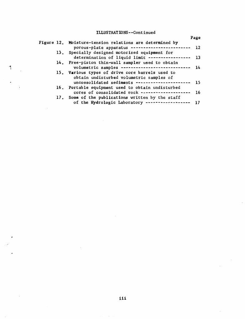
Figure 12.
1).
14. ~
l 15.
16.
17.
ILLUSTRATIONS--Continued Page
MO'isture-tension relations are determined by porous-plate apparatus -------------~---------- 12
Specially designed motorized equipment for determination of liquid limit ----------------- 13
Free-piston thin-wall sampler used to obtain volumetric samples ---------------------------- 14
Various types of drive core barrels used to obtain undisturbed v9lumetric samples of unconsolidated sediments ---------------------- 15
Portable equipment used to obtain undisturbed cores of CQnsolidated rock -------------------- 16
Some of the publications written by the staff of the Hydtolagic Laboratory ------------------ 17
iii

THE HYDROLOGIC LABORATORY
By A. I. Johnson
HISTORY
To ass{st with ground-water investigations being made under the program of the Interior Department for development of the Missouri River basin, the Hydrologic Laboratory was established at Lincoln, Nebr., in 1948 at the request of G. H. Taylor, Regional Engineer (GW), and with the approval of A. N. Sayre, Chief of the Ground Water Branch. The writer was assigned the task of setting up the laboratory for the determination of physical and hydrologic properties of water bearing and of allied non-water bearing soil and rock materials. Space at the University of Nebraska was provided for the laboratory by the Conservation and Survey Division of the State of Nebraska.
Early in 1952, the facilities of the Laboratory were expanded and its services made available to all field offices of the Geological Survey throughout the country. All field offices were advised by the Chief, Ground Water Branch, that henceforth all laboratory work should be done at the Hydrologic Laborato:l:-y.
In July 1953, the Laboratory was made organizationally responsible to the Chief, Ground Water Branch, Washington, D.C.J and hydrologic research was added to the scope of its activities. In order to further expand its facilities and services, the llaboratory was moved to Denver, Colo., in June 1954. Supervision of a pool of specialized equipment for surface and subsurface exploration was added as a responsibility in 1955.
In July 1963, the Hydrologic Laboratory was relieved of the responsibility for the special-purpose equipment pool, and the pool was organized as a separate unit. Because basic and applied research is necessary for the improvement of ,laboratory and field techniques and for the clarification and understanding of hydrologic concepts, hydrologic research now has been given increased emphasis in the laboratory.

ACTIVITIES
Laboratory and field research of the Hydrologic Laboratory is ~oncentrating at present on detailed study of the specific yield and permeability of rock and soil materials, and on the techniques for sampling of such materials. In addition, the Laboratory and its staff have been engaged in a variety of other activities. A number of model studies (fig. 1) have been completed as phases of
Figure 1.--Model study of infiltration of waste fluids in layered porous media.
research on infiltration, waste disposal, and salt-water encroachment.
The Laboratory has been active in the training of hydrologists, with the staff providing instruction for field personnel of the Survey and for many foreign participants from all over the world. In cooperation with the Foreign Hydrology Program of the Water Resources Division, the Laboratory has provided up to 12 weeks training for .over 100 participants from about 40 countries, including: Afghanistan, Argentina, Australia, Bolivia, Brazil, British Guiana, Canada, Canary Islands, Ceylon, Chile, Columbia, England, Egypt, Ethiopia, Guatemala, Greece, India, Indonesia, Iran, Iraq, Israel, Japan, Jordan, Kenya, Korea, Libya, New Zealand, Pakistan, Philippines, Rhodesia, Saudi Arabia, Spain, Sudan, Taiwan, Tanganyika, Thailand, Togo, and Turkey. In addition, instructional material, reports, copies of test methods, and research results have been provided to these and many other countries.
2

The staff is active in many prominent technical and scientific societies of national and international scope such as the American Society for Testing and Materials, American Society of Civil Engineers, Association of Engineering Geologists, International Society for Soil Mechanics and Foundation Engineering, American Society for Agronomy, Soil Science Society of America, American Society for Phptogrammetry, American Institute of Mining, Metallurgical and Petroleum Engineers, International Society for Soil Science, and the American Geophysical Union. Names from our staff can be found on important committee assignments and officerships from these organizations. Close cooperation with research committees of technical societies--as well as with laboratories of other government agencies, industry and universities--in research on new or improved methods of analysis or sampling is considered as one of the important and valuable contributions of the Hydrologic Laboratory.
Personnel of the laboratory maintain active liaison between Laboratory and field operations, thus insuring that analysis methods and interpretation of data are more closely related to the problems of the man in the field. The training and experience of the staff hme~been extensive in a variety of disciplines (especially in soil mechanics and soil physics), and technical consultation within our fields of competence is readily available to any field office upon request. Technical assistance on a wide variety of problems now has been provided to about 20 state and project offices.
METHODS
Although the laboratory procedures briefly described in this paper have been standardized to produce uniform, consistent, and accurate results, it should be recognized that they may be subject to modification and that new techniques may be developed as a result of continuing research. Centralized laboratory work, with its attendant standardization of analyses, is an absolute necessity to permit comparison of results between widely separated areas, but the laboratory methods remain flexible so they may be changed under the guidance of experienced professional personnel to meet the need~ of individual samples or field conditions. Upon request, specifications for analyses can be varied within reasonable limits or special tests may be devised to suit the special requirements of different field projects. In general, the analyses are adopted or modified from the fields of soil mechanics, soil physics, geology and hydrology.
3

The Laboratory is equipped with the latest types of field and laboratory equipment. Facilities include a constant-temperature constant-humidity room, and a wide variety of specialized testing equipment (fig. 2).
----Figure 2.--Consolidometers determine engineering proper
ties of soils.
The principal analyses currently available are described briefly on the following paragraphs. Additional information on theory and methods of analysis may be obtained by referring to publications by Meinzer (1923, 1949), Krumbein and Pettijohn (1938), Wenzel (1942), Baver (1956), Taylor (1948), the American Society for Testing Materials (1958), and Johnson and Morris (1962).
Sample Preparation
Equipment is available for the crushing, disaggregating, sawing, and coring of various types of samples. Diamond core drills are used to obtain cores from chunk samples of consolidated rocks (fig. 3) and a diamond-blade rock saw is used for cutting large chunk samples to usable size and for trimming core samples (fig. 4).
4
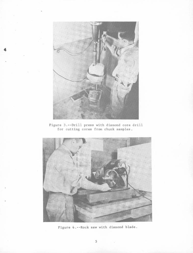
Figure 3.--Drill press with diamond core drill for cutting cores from chunk samples.
Figure 4.--Rock saw with diamond blade.
5
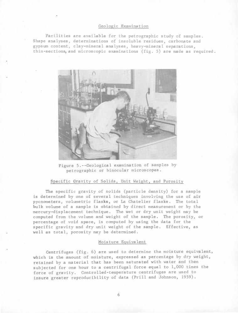
Geologic Examination
Facilities are available for the petrographic study of samples. Shape analyses, determinations of insoluble residues, carbonate and gypsum content, clay-mineral analyses, heavy-mineral separations, thin-sections, and microscopic examinations (fig. 5) are made as required.
Figure 5.--Geological examination of samples by petrographic or binocular microscopes.
Specific Gravity of Solids, Unit Weight, and Porosity
The specific gravity of solids (particle density) for a sample is determined by one of several techniques involving the use of air pycnometers, volumetric flasks, or La Chatelier flasks. The total bulk volume of a sample is obtained by direct measurement or by the mercury-displacement technique. The wet or dry unit weight may be computed from the volume and weight of the sample. The porosity, or percentage of void space, is computed by using the data for the specific gravity and dry unit weight of the sample. Effective, as well as total, porosity may be determined.
Moisture Equivalent
Centrifuges (fig. 6) are used to determine the moisture equivalent, which is the amount of moisture, expressed as percentage by dry weight, retained by a material that has been saturated with water and then subjected for one hour to a centrifugal force equal to 1,000 times the force of gravity. Controlled-temperature centrifuges are used to insure greater reproducibility of data (Prill and Johnson, 1959).
6
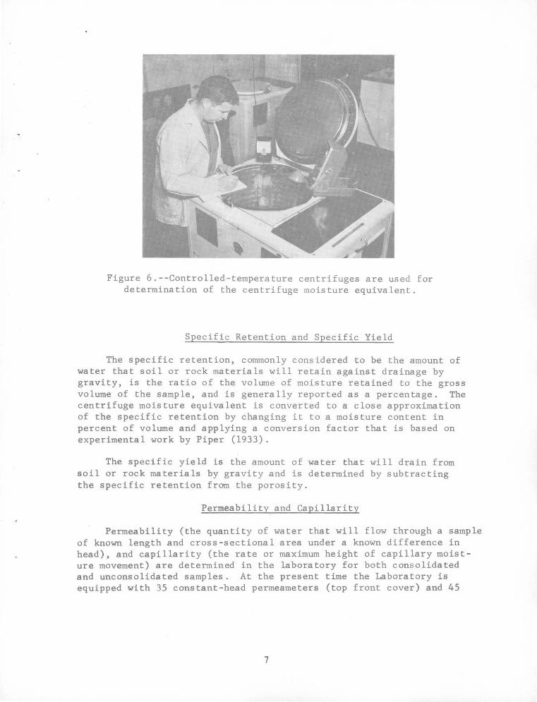
Figure 6.--Controlled-temperature centrifuges are used for determination of the centrifuge moisture equivalent.
Specific Retention and Specific Yield
The specific retention, commonly considered to be the amount of water that soil or rock materials will retain against drainage by gravity, is the ratio of the volume of moisture retained to the gross volume of the sample, and is generally reported as a percentage. The centrifuge moisture equivalent is converted to a close approximation of the specific retention by changing it to a moisture content in percent of volume and applying a conversion factor that is based on experimental work by Piper (1933).
The specific yield is the amount of water that will drain from soil or rock materials by gravity and is determined by subtracting the specific retention from the porosity.
Permeability and Capillarity
Permeability (the quantity of water that will flow through a sample of known length and cross-sectional area under a known difference in head), and capillarity (the rate or maximum height of capillary moisture movement) are determined in the laboratory for both consolidated and unconsolidated samples. At the present time the Laboratory is equipped with 35 constant-head permeameters (top front cover) and 45
7
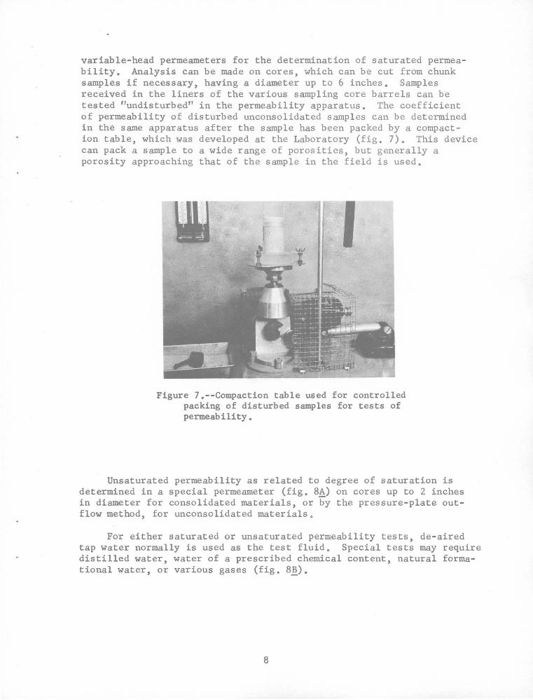
variable-head permeameters for the determination of saturated permeability. Analysis can be made on cores, which can be cut from chunk samples if necessary, having a diameter up to 6 inches. Samples received in the liners of the various sampling core barrels can be tested "undisturbed" in the permeability apparatus. The coefficient of permeability of disturbed unconsolidated samples can be determined in the same apparatus after the sample has been packed by a compaction table, which was developed at the Laboratory (fig. 7). This device can pack a sample to a wide range of porosities, but generally a porosity approaching that of the sample in the field is used.
Figure 7.--Compaction table used for controlled packing of disturbed samples for tests of permeability •
Unsaturated permeability as related to degree of saturation is determined in a special permeameter (fig. 8~) on cores up to 2 inches in diameter for consolidated materials, or by the pressure-plate outflow method, for unconsolidated materials.
For either saturated or unsaturated permeability tests, de-aired tap water normally is used as the test fluid. Special tests may require distilled water, water of a prescribed chemical content, natural formational water, or various gases (fig. 8~).
8

~. Determining unsaturated permeability of consolidated core.
~. Determining permeability to gases or special fluids.
Figure B.--Apparatus for permeability tests.
Permeability tests also can be made with the sample under any desired load. Usually loads equivalent to the overburden pressure are used. Tests on samples with orientation both parallel and vertical to bedding planes can be made and are encouraged for most hydrologic problems.
Particle-Size Analyses
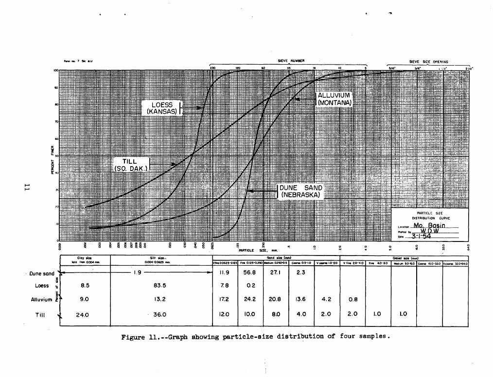
The distribution of particle sizes larger than 0.0625 millimeters (sand and gravel) is determined by sifting the sample through a nest of standard sieves by means of a mechanical shaker (fig. 9). The distribution of particle sizes smaller than 0.06?.5 mm (silt and clay) is determined by the hydrometer method (fig. 10), which is based on Stoke's Law. Completed particle-size analyses are shown as a cumulative curve on semilogarithmic graph paper (fig. 11). The particlesize classification is essentially the same as that recommended by the sediment section of the National Research Council (1947). A wide variety of statistical measures are determined when needed.
9

Figure 9.--Sieves and mechanical shakers used for analyses of the distribution of particle sizes larger than 0.0625 millimeter.
Figure 10.--Hydrometer equipment in constanttemperature water bath for determining silt and clay content.
10
........
........
,_ 1W1- 7 !lie AIJ
; iL:50~
~ ~4C·tttL~~
§ Clay tin
'"''"""0-~-.
Dune sand ...
i' .§
Loess -o 8.5
Alluvium j ~ 9.0
Till "'""
24.0
Slit lize •. Q004-Q.0625 """·
1.9
83.5
13.2
36.0
... N
~~.m.o.0625-QI25
11.9
7.8
17.2
12.0
"! PARTICLE SIZE, mm.
Sand lin (mm)
Fi"' 0.125-Q.250 ~- Q250-Q.5
56.8 27.1
0.2.
24.2 20.8
10.0 8.0
-~
9
e-M 0.5-1.0 Y.c.riii.0·2D v. fi ... 2.0-4.0 Fi"' 40·8.0
2.3
13.6 4.2 0.8
4.0 2.0 2.0 1.0
-- ~-- ----
Figure 11.--Graph showing particle-size distribution of four samples.
SIEVE SIZE OPEII!ING
PARTICLE SIZE
DISTRIBUTiON CURVE
lOCOhon ~_Basin __ Plollodby wow Dolo 3-1-54
0 !I
Gfavll sin (mm}
0 ::l
0
l
Modi"" ao-~&o Cocna 16.0-32.0 v.c_.. 32.0-64.0
I
LO I I
Moisture-Content and Soil-Moisture Tests
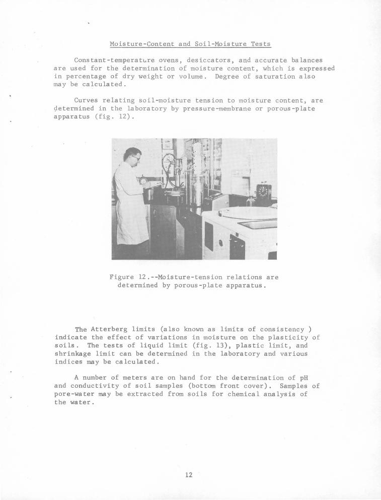
Constant-temperature ovens, desiccators, and accurate balances are used for the determination of moisture content, which is expressed in percentage of dry weight or volume. Degree of saturation also may be calculated.
Curves relating soil-moisture tension to moisture content, are ~etermined in the laboratory by pressure-membrane or porous-plate apparatus (fig. 12).
Figure 12.--Moisture-tension relations are determined by porous-plate apparatus.
The Atterberg limits (also known as limits of consistency ) indicate the effect of variations in moisture on the plasticity of soils. The tests of liquid limit (fig. 13), plastic limit, and shrinkage limit can be determined in the laboratory and various indices may be calculated.
A number of meters are on hand for the determination of pH and conductivity of soil samples (bottom front cover). Samples of pore-water may be extracted from soils for chemical analysis of the water.
12

Figure 13.--Specially designed motorized equipment for determination of liquid limit.
Soil-moisture blocks, tensiometers, nuclear meters, and specialized sampling equipment are part of the laboratory's equipment for the field study of soil-moisture movement. Considerable research has been completed on the field measurement of soil moisture, especially as measured by nuclear meters.
Collection of Samples
A wide selection of equipment is available for the collection of both consolidated and unconsolidated materials. The equipment varies from hand augers, which obtain disturbed samples, to hand driven (figures 14 and 15) or power driven core barrels (fig. 16) for obtaining "undisturbed" samples. When warranted by the scope of a project, a mobile laboratory is available with our trained personnel to carry out some analyses in the field.
The Laboratory has experienced personnel who should be used to provide technical advise and assistance in the sampling programs of field projects, but the actual sampling work is done by contract or by the Division~ Equipment Pool. Field offices may submit samples for analysis if a sampling program is not large enough or of an accuracy to warrant the assistance of laboratory personnel.
The Laboratory's sample-analysis request forms should accompany the samples to the Laboratory. Direct all inquiries and ship samples to: Chief, Hydrologic Laboratory, Bldg. 25, Room 1748, Federal Center, Denver, Colo. (Telephone 233-3611, ext. 8136).
13

...... .j::-
A. Two-inch-diameter sampler.
"
B. Sampler being used to obtain samples for moisture-content determinations at an evapotranspiration research project.
Figure 14.--Free-piston thin-wall sampler used to obtain volumetric samples. (Designed and constructed at the Hydrologic Laboratory)

A. Veihmeyer l-inch-diameter soil tube, 25-pound drive hammer, and jack for extracting soil tube from soil.
C. "Pomona" 2-inch core barrel containing brass liners.
B. Two-inch-diameter core barrel designed and used by the U.S. Geological Survey to obtain sample of surficial materials.
D. "Pomona" core barrel being driven by use of 25-pound slip hammer.
Figure 15.--Various types of drive core barrels used to obtain undisturbed volumetric samples of unconsolidated sediments.
15

...... (j\
A. Diamond core barrel being driven into vertical wall of rock by portable electric drill. Air or water is forced through water swivel to flush cuttings out of kerf.
B. Air compressor and electric generator.
Figure 16.--Portable equipment used to obtain undisturbed cores of consolidated rock. (Method developed by Hydrologic Laboratory)

REPORTS
To have practical importance, routine analysis or research data must be made readily available to the scientists working on field studies. In the Hydrologic Laboratory, data are maintained on file for all analyses made on all samples and can be made available in printed copy, microfilm roll or aperture card, punched cards, or edge-notched ("keysort") cards. In addition, most data are available in published reports or papers (fig. 17)--in most cases accompanied by discussions and interpretations.
Figure 17.--Some of the publications written by the staff of the Hydrologic Laboratory.
The publications written by the staff members of the Laboratory range from internal or administrative data or information releases to papers published in technical and scientific journals or detailed reports published in the book-report series of the U.S. Geological Survey (app. A). In addition, analysis data and interpretive dis• cussions from the Laboratory have been published in many papers and reports authored by scientists from other offices of the Survey (app. B).
17

SUMMARY
The knowledge of soil and rock testing, including the application of the test or analysis data to field problems, is still in its infancy. By learning more about the basic laws and principles of nature we can more accurately predict hydrologic phenomena of the future, as well as· solve more efficiently the hydrologic problems of the presento Our reservoir of fundamental facts and basic knowledge has been, and can be even more fully, increased by the analysis and research work of the Hydrologic Laboratory.
Although tests and analyses are performed using our own standards, or the standards of the American Society for Testing and Materials where these have been established, the standards are not established so rigidly that the Laboratory becomes merely a group of technicians cranking information out of a laboratory-data factoryo Because no two field geologic settings are exactly the same, or each hydrologic problem identical, each soil or rock testing job almost becomes a research project within itself and a "judgment factor" (ASTM, 1958, Po 1-~) therefore must always be applied to both the testing method and the evaluation of the resultant datao Thus, the amount of training and experience of the Laboratory's staff is an important factor in providing optimum results to field projects.
Although the Laboratory has the most advanced equipment and facilities, the experienced staff is the main asset in giving the field the analyses they need for their ~articular problemso An attempt is always made to complete the analyses and interpretations expeditiously, but with accuracy and efficiency. To solve the·more complex problems, the Laboratory's studies are done with a team approach, using the disciplines and the application of techniques from many sciences. The personnel &ain, or have had, a wide experience in application of laboratory methods to field problems by alternating their time between laboratory and field operationso Laboratory data or research must be tied to field problems if they are to be of maximum value and this is the basic reason for the Lab~ratory's philos0phy for maintaining close contact and cooperati®n between the Laboratory and field operations •. Only through such experience can one assure that the "judgment factor" will be developed in the personnel and be applied to the analyses and interpretations.
18
REFERENCES
American Society for Testing Materials, 1958, Procedures for testing soils: Philadelphia, Pa., Am. Soc. Testing Materials, 544 p.
Baver, L. D., 1956, Soil physics: 3d ed., New York, John Wiley & Sons, 489 p.
Johnson, A. I., and Morris, D. A., 1962, Physical and hydrologic properties of water-bearing deposits from core holes in the Los Banos-Kettleman City area, California: U.S. Geol. Survey open-file rept., 182 p.
Krumbein, W. C., and Pettijohn, F. J., 1938, Manual of sedimenta.ry petrography: New York, Appleton-Century-Crofts, Inc., 549 p.
Meinzer, 0. E., 1923, The, occurrence of ground water in the United States: U.S. Geol. Survey Water-Supply Paper 489, 321 p.
______ e.d, 1949, Hydrology, v. 9 2f Physics of the earth: 1st ed., 3d impression, New York, Dover Pubs., 712 p.
National Research Council, ~947, Report of the subcommittee on sediment terminology: Am. Geophys. Union Trans., v. 28, no. 6, p. 936-938.
Piper, A. M., 1933, Notes on the relation between the moistureequivalent and the specific retention of water-bearing materials: Am. Geophys. Union Trans., p. 481-487.
Pri 11, R. C., and Johnson, A. I.,· 1960, Effect of temperature on \
moisture contents as determined by centrifuge and tension techniques: Am. Soc. Tes·ting Materials, Spec. Tech. Pub. 254, p. 340-349.
Taylor, D. W., 1948, Fundamentals of soil mechanics: New York, John Wiley & Sons, 700 p.
Wenzel, L. K., 1942, Methods for determining permeability of water-bearing materials: U.S. Geol. Survey Water-Supply Paper 887, 192 p.
19

APPENDIXES
20
APPENDIX A
Reports by the Laboratory Staff
Johnson, A. I., 1955a, Discussion of Measurement of permeabilities in ground-water investigations, in Symposium on permeability of soils: Am. Soc. Testing Materials Spec. Tech. Pub. 163, p. 115-116.
______ 1955b, Selected references on permeability, in Symposium on permeability of soils: Am. Soc. Testing Materials Spec. Tech. Pub. 163, p. 131-136.
______ 1958, The hydrologic cycle, script of movie Photointerpretation as applied to hydrology: Pan Am. Inst. Geography and History; also u.s. Geol. Survey open-file rept.
______ 1962a, Hydrologic properties of the aquifer, in Bedinger, M. s., Tanaka, H. HL, and others, Report on ground water hydrology and geology of the Lower Arkansas and Verd.igris River Valleys: U.S. Geol. Survey open-file rept., v. 1, p. 60-70.
______ 1962b, Methods of measuring soil moisture in the field: u.s. Geol. Survey Water-Supply Paper 1619-U, 25 p.; also open-file rept.
______ 1963a, A field method for measurement of infiltration: u.s. Geol. Survey Water-Supply Paper 1544-F, 27 p.; also open-file rept.
_______ 1963b, Application of laboratory permeability data: u.s. Geol. Su!vey open-file rept., 33 p.
______ 1963c, Compilation of specific yield for various materials: u.s. Geol. Survey open-file rept., 31 p.
______ 1963d, Design of well screen and filter pack: u.s. Geol. Survey open-file rept., 10 p.
______ 1963e, Geophysical logging of bore-holes for hydrologic studies: u.s. Geol. Survey open-file rept., 10 p.
______ 1963f, The Hydrologic Laboratory: u.s. Geol. Survey open-file rept., 16 p.
------1963g, Modified Parshall flume: u.s. Geol. Survey open-file rept., 6 p.
______ 1963h, An outline of equipment useful for hydrologic studies: u.s. Geol. Survey open-file rept., 32 p.
21

Johnson, A. I., 1963i, Portable equ-ipment for borehole exploration: U.s. __ Geol. Survey open-file rept., 34 p.
___ 1963j, Symbols and definitions from soil mechanics and soil physics: u.s. Geol. Survey open-file rept., 4i p.
____ 1963k, Typical coefficients of permeability: u.s. Geol. Survey open-file rept., 1 p.
J~hnson, A. I., and Kunkel, Fred, 1963, Some research related to ground-water recharge--A progress report from the U.S. Geological Survey: Ground-Water Recharge and Ground-Water Basin Management, Bienn. Con£., Berkeley, Calif., 1963, Proc.; also u.s. Geol. Survey open-file rept., 17 p.
J~hnson, A. I., and Morris, D. A., 1961, Researeh on specific yield [abs.J: California Assoc. Eng. Geol~gists, 4th Ann. Mtg., Sacramento •
____ 1962a, Physical and hydrologic properties of water-bearing deposits from core holes in the Los Banos-Kettleman City area, California: U.S. Geol. Survey open-file rept., 182 p.
______ 1962b, Relation of·v~lumetric shrinkage to clay content for sediments from subsidenc~ areas in San Joaquin Valley, California: U.S. Geol. Survey Prof. Paper 450-B, p. B43-B44.
Johnson, A. I., MOrris, D. A., and Prill, R. c., 1961, Specific yield and related properties--An annotated bibliography: u.s. Geol. Survey open-file rept., 245 p.
Johnson, A. I., Prill, R. c., and MOrris, D. A., 1963, Specific yield-Column drainage and centrifuge moisture content: u.s. Geol. Survey Water-Supply Paper 1662-A, 60 p.; also open-file rept.
Koopman, F. c., 1963, An improved water-stage recorder for hydraulic drill holes,_ in Eleventh symposium on exploration drilling: ColGrado School Mines Quart., v. 58, no. 4, p. 105-112.
KoQpman, F. c., Irwin, J. H., and Jenkins, E. D., 1962, Use of inflatable packers in multiple-zone testing of water wells: u.s. Geol. Survey Prof. Paper 450-B, p. Bl08-Bl09.
Kulp, W. K., 1961, Dispersion with oscillating flow in a granular material: u.s. Geol. Survey Prof. Paper 424-D, p. D26-D28.
MOrris, D. A., and Johnson, A. I., 1959, Correlation of Atterberg limits with geology of deep cGres from subsidence areas in California: Am. Soc. Testing Materials Spec. Tech. Pub. 254, p. 183-187.
22

Morris, o·. A., and Kulp, Wo K., 1961, Mechanical uniform packing of porous media: UoSo Geol. Survey Profo Paper 424-D, p. D31-D32o
Maston, R. P., and Johnson, Ao Ia, 1961, Geophysical exploration of wells as an aid in location of salt-water leakage, Alameda Plain, California: U.So Geol. Survey Prof. Paper 424-D, Po D262-D263.
Palmquist, W. N., Jro, and Johnson, A. I., 1960, Model study of infiltration into layered materials: Am. Soc. Civil Engineers Anno Convention, Boston, Mass.; also u.s. Geolo Survey open-file rept., 5 p.
___ 196.2, Vadose flow in layered and nonlayered materials: U.s. Geol. Survey Prof. Paper 450-C, p. Cl42-Cl43.
Prill, R. c., 1962, CGmparison of drainage data obtained by the centrifuge and column drainage methods: u.s. Geol. Survey Prof. Paper 424-D, p. D399-D401.
Prill, R. c., and Johnson, A. I., 1959, Effect of temperature on moisture contents determined by centrifuge and moisture tension techniques, in Soils 1959: Am. Soco Testing Materials Speco Tech. Pub. 254, Po 340-349.
______ 1963, Centrifuge technique for determining time-drainage relations for a natural sand: u.s. Geol. Survey Prof. Paper 450-E, p. El77-El78.
Robinson, T. w., and Johnson, Ao I., 1961, Selected bibliography on evaporation and transpiration: u.s. Geol. Survey Water-Supply Paper 1539-R, 25 p.
Shuter, Eugene, and Johnson, A. Io, 1961, Evaluation of equipment for measurement of water level in wells of small diameter: UoSo Geol. Survey Circ. 453, 12 p.
Stallman, R. W., and Moston, R. P., 1961, New equipment for measurements in the unsaturated zone: u.s. Geol. Survey Prof. Paper 424-C, p. C363-C365.
23

APPENDIX B
Reports Contaj~ing Data and Discussions From the Hydrologic Laboratory
Allen, W. B., Hahn, G. w., and Tuttle, C. R., 1963, Geohydrological data for the upper Pawcatuck River Basin, Rhode Island: Rhode Isla~d Geol. Bull. 13, 68 p.
Back, William, 1957, Geology and .ground-water features of the Smith ·River Plain, Del Norte County, California: U.S. Geol. Survey WaterSupply Paper 12541 76 p.
Baker, J. A., Healy, H. G., and Hackett, 0. M., 1964, Geology and groundwater conditions in the Wi1mington-Reading area, Massachusetts: u.s. Geol. Survey Water-Supply Paper 1694, 80 p.
Bedinger, M. s., 19611 Relation between median grain size and permeability in the Arkansas River Valley, Arkansas, Art. 157 ~ Geological S.urvey Research 1961: u.s. Geol. Survey Prof. Paper 424-c, p. cJ.l--CJ2.
Bedinger, M. s., Emmett, L. F,, and Jeffery, H. G., 19631 Ground-water potential of the Alluvium of the Arkansas River between Little Rock and Fort Smith, Arkansas: u.s. Geol. Survey Water-Supply Paper 1669-L, 29 Po
Bradley, Edward, 1956, Geology and ground-water resources of the upper Niobrara River basin, Nebraska and Wyoming: U.S, Geol. Survey Water-Supply Paper 1368, 7U p.
___ 1964, Geology and ground-water resources of southeastern New Hampshire: U.S. Geol. Survey Water-Supply Paper 1695, 80 p.
Brown, R. F., and Lambert, T. w., 1963 1 Reconnaissance of ground-water resources in the Mississippian Plateau ~egion, Kentucky: U.S. Geol. Survey Water-Supply Paper 16031 58 p.
Brown, s. G., and Newcomb, R. c., 1956, Ground-water resources of the coastal sand-dune area north of Coos Bay, Oregon: U.S. Geol. Survey Water-Supply Paper 1619-D, 32 p.
Cardwell, W. D. E., and Jenkins, E. D., 1963, Ground-water geology and pump irrigation in Frenchman Creek basin above Palisade, Nebraska: u.s. Geol. Survey Water-Supply Paper 1577, 472 p.
Cohen, Philip, 1961, Specific yield of sediments of the Humboldt River Valley, Humboldt County, Nevada, Art. 164 in Geological Survey Research 1961: U.S .. Geol. Survey Prof. Paper 424-C, p. C43-C45.
24
•
Cohen, Philip, 1962, Estimating porosity from specific gravity, Art. 15 in Geological Survey Research 1962: U.S. Geol. Survey Prof. Paper 450-B, p. B41-B43.
_____ 1963, Speeific-yield and particle-size relations of Quaternary alluvium, Humboldt River Valley, Nevada: U.S. Geol. Survey WaterSupply Paper 1669-M, 24 p •
Counts, H. B., and Donsky, Ellis, 1963, Salt-water encroachment, geology, and ground-water resources of Savannah Area, Georgia and South Carolina: u.s. Geol. Survey Water-Supply Paper 1611, 100 p.
Crandell, H. c., 19621 Geology Suffolk Couftty, New York: 1539-X, 35 p.
and wround-water resources of Plum Island, U.S. Geol. Survey Water-Supply Paper
_____ 1963, Geol0gy and ground-water resources of the town of Southold, Suffolk County, New York: u.s. Geol. Survey Water-Supply Paper 1619-GG, 36 p.
Dutcher, L. c., and Bader, J. s., 1963, Geology and hydrology of Aqua Caliente Spring, Palm Springs, California: u.s. Geol. Survey WaterSupply Paper 1605,_ 41 p.
Hampton, E. R., 1961, Ground water from Coastal Dune and Beach Sands, Art. 85 ~Geological Survey Research 1961: u.s. Geol. Survey Prof. Paper 424-B, p. 1204~B%O'~
Johnson, A. I., and Morris, D. A., 1962, Physical and hydrologic properties of water-bearing deposits from core holes in the Los BanosKettleman City area, California: U.S. Geol. Survey open-file rept., 182 p.
Johnson, A. I., and MOston, R. P., 1962, Relation of volumetric shrinkage to clay content of sediments from the San Joaquin Valley, California, Art. 16 in Geological Survey Research 1962: u.s. Geol. Survey Prof. Paper 450-B, p. B43-B44.
Johnson, A. I., Prill, R. c., and MOrris, D. A., 1963, Specific yield-Column drainage and centrifuge moisture content: UoS. Geol. Survey Water-Supply Paper 1662-A, 69 p.
25
·. .t
,.
Keech, C. F., 1964, Ground-water conditions in the proposed waterfowl refuge area near Chapman, Nebraska, with a section on Chemical quality of the water, by P. G. Rosene: u.s. Geol. Survey WaterSupply Paper 1779-E, 55 p.
Koopman, F. c., 1957, Ground water in the Crow Creek-Sand Lake area, Brown and Marshall Counties, South Dakota:· u.s. Geol. Survey Water-Supply Paper 1425, 125 p.
MacCary, L. M., and Lambert, T. w., 1962, Reconnaissance of ground-water resources of the Jackson Purchase region, Kentucky: U.S._ Geol. Survey Hydrol. ·Inv. Atlas HA-13.
Manger, G. E., 1963, Porosity and bulk density of sedimentary rocks: u.s. Geol. Survey Bull. 1144-E, 55 p.
Masursky, Harold, 1962, Uranium-bearing coal in the eastern part of the ~ed Desert are~ Wyoming: u.s. Geol. Survey Bull. 1099-B, 152 p.
McGovern, H. E., 1964, Geology and ground-water resources of Was£ington County, C0lorado: u.s. Geol. Survey Water-Supply Paper 1777, 46 p.
Moulder, E. A., and Kohout, F. A., 1958, Ground-water factors affecting drainage in the First Division, Buffalo Rapids Irrigation Project, Prairie and Dawson Counties, Montana: u.s. Geol. Survey WaterSupply Paper 1424, 198 p.
Moulder, E. A., and others, 1953, Ground-water factors affecting the drainage of Area IV, First Division, Buffalo Rapids Irrigation Project, Montana: U.S. Ge0l. Survey Circ. 198, 4' p.
_____ 1960, Geology and ground-water resources of the Lower Little Bighorn River Valley, Big Horn County, Montana: u.s. Geol. Survey Water-Supply Paper 1487, 223 p.
Nace, R. L., and others, 1959, Hydrology and.water resources, Pt. 3 of Nace, R. L., and others, Geography, geology and water resources of the National Reactor Testing Station, Idaho: U.s. Geol. s·urvey open-file rept., 253 p.
Newport, T. G., 1959, Ground-water resources of the lower Niobrara River and Ponca Creek basins, Nebraska and South Dakota: u.s. Geol. Survey Water-Supply Paper 1460-G, p. G273-G323.
Norris, s. E., 1962, Permeability of glacial till, Art. 224 in Geological Survey Research 1962: u.s. Geol. Survey Prof. Paper 450-E, p. El50-El51.
26
)
Pree, H. L., Jr., Walker, w. H., and MacCary, L. M., 1957, Geology and ground-water reaources of the Puducah area, Kentucky: U.S. Geol. Survey Water-Supply Paper 1417 1 214 p.
Price, W. E., Jr., Mull, D. s., and Kilburn, Chabot, 1962, Raeonaaissance of ground-water resources in the eastern coal field region, Kentucky: u.s. Geol. Survey Water-Supply Paper 1607.
Rapp, J. R., 1953, Reconnaissance of the geology and ground-water resources of the LaPrele area, Converse County, Wyoming: u.s. Gaol. Survey Circ. 243, 33 p.
Rapp, J. R., and others, 1957, Geology and ground-water resources of Goshen 6$unty, Wyoming: u.s. Geol. Survey Water-Supply Paper 1377, 145 p.
Sniegocki, R. T., 1955, Ground~water resources of the Prairie Creek Unit of the Lower Platte River Basin, Nebraska: u.s. Geol. Survey Water-Supply Paper 1327, 133 p.
_____ 1962, Hydrogeology of a part of the Grand Prairie region, Arkansas: u.s. Geol. Survey Water-Supply Paper 1615-B.
Stewart, ·J. w., Callahan, J. T., Carter, R. F., and others, 1964, Geologic and hydrologic investigation at the site of the Georgia Nuclear Laboratory, Dawson County, GeGrgia: u.s. Geol. Survey lull. 1133-F 90 p.
Stuart, W. T., and others, 1954, Ground water investigations of the Marquette Iron-Mining District: Lansing, Michigan Dept. Conserv. Tech. Rept. 3 1 91 p.
Swartz, J. H., 1962, Some physical constants for the Marshall Islands area: u.s. Geol. Survey Prof. Paper 260-AA, p. AA953-AA989.
Visher, F. N., 1952, Reconnaissance of the geology. and ground-water resources of the Pass Creek Flats area, Carbon County, Wyeming: u.s. Geol. Survey Circ. 1881 19 p.
Visher, F. N., and Babcock; H. M., 1953, Ground-water conditions in the soil and moisture conservation demonstration area, near Torrington, Goshen County, Wyoming: u.s. Geol. Survey Circ. 238, 51 p.
Whitcomb, H. A., and Morris, D. A., 1964, Ground-water resources and geology of northern"and western Crook County, Wyoming, with a section on The chemical quality of the ground water, by R. H. Langford: u.s. Geol. Survey Water-Supply Paper 1698, 92 p.
27 GPO 850- 587