Embed Size (px)
Citation preview

Romanian Journal of Earth Sciences, vol. 86 (2012), issue 2, p. 91-109 journal homepage: http://rjes.igr.ro
The hydrocarbon potential of the Romanian Black Sea continental plateau
Ion MOROŞANUF
1
Oil-Geo Moroşanu Consulting, Bucharest
Abstract: The article deals with the petroleum systems in the North-Western Black Sea Basin covering Ukrainian, Romanian and Bulgarian shelves, with a focus on the traps, reservoirs and source rocks from the Romanian Shelf. A large variety of traps have been evidenced in the study area: fault anticlines in syn-extensional formations, not-faulted anticlines, pinch-outs, drape anticlines on older relief, traps in prograding formations at shelf margin, depositional fans, gravitational slide etc. The most important reservoirs are developed in the Albian, Upper Cretaceous (Turonian, Coniacian-Santonian) and Eocene successions of clastic (sandy) and carbonate types. Beside the Oligocene, older source rocks (Jurassic, Neocomian, Paleozoic?) are considered. Several petroleum systems are presented, with the specification of the traps, nature of the accumulated hydrocarbon, source rocks and reservoirs. Keywords: oil field, trap, reservoir, source rock, petroleum systems
1 e-mail: [email protected]
1. Introduction
The western part of the Blak Sea Basin is one of the most promising hydrocarbon-bearing areas in the SE Europe. Its hydrocarbon potential has been proved by the oil and gas fields discovered on the Romanian shelf (Fig. 1). The most recent (2012) discovery is a huge gas field in deep water (Domino), estimated to 40-80 Bcf. The Romanian Continental Plateau of the Black Sea comprises the following geotectonic units, from the north to the south (Figs. 2 and 3): - Krilov-Karkinit Depression (Moroşanu, 2004); - Scythian Block (Moroşanu, 2002); - North Dobrogea-Histria Depression; - Greenschist Block-Midia Crest; - Southern Dobrogea (Moesian Platform). So far, Histria Depression is the most important by its hydrocarbon potential. Although the exploration for hydrocarbon accumulations in the Romanian Black Sea shelf started at the
beginning of the 1970s, the number of investigated oil fields is still reduced. This fact is due to the structural complexities and to the concentration of the exploration works mainly on the northern flank of the Histria Depression, where the first oil accumulations were discovered. In the other areas, corresponding to the Moesian Platform and Scythian Block, the drilling exploration is deficitary.
The paper has been carried out using the seismic acquisition, gravimetry-magnetometry and wells data, in additional data from the published papers related to Ukrainian and Bulgarian offshore were used. Until now, the following oil fields were evidenced: - Pescăruş, with oil in Albian; - East Lebăda with oil in Albian and Upper Cretaceous, and gas in Eocene; - West Lebăda with oil in Albian, Upper Cretaceous and Eocene;

I. Moroşanu
92
Fig. 1 - Location map of the Romanian Black Sea Shelf showing the Euxin Threshold, Histria Depression and
the main plays and leads.
- Sinoe with oil in Eocene; - Portiţa with oil in Upper Cretaceous and Oligocene. - Muridava (Olimpyska) with oil in Eocene. - Eugenia with gas in Cretaceous and Eocene All these fields are situated on the northern flank of Histria Depression, except Muridava and
Eugenia, which are situated on the Scythian Block. Gas shows or commercial accumulations were frequently signalised, especially in the Lower Pontian and Dacian, practically in all the wells drilled, the most important of them being Doina and Doina Sister, Ana, Cobălcescu and Domino fields (Fig. 1).

Hydrocarbon potential of the Romanian Black Sea continental plateau
93
Fig. 3. Tectonic units of the Romanian Black Sea Shelf showing the location of the cross-sections
and wells.
Fig. 2. Tectonic map of the Western Black Sea Shelf

I. Moroşanu
94
These data prove with certitude the favourable perspectives for the Romanian continental plateau but, in the same time, they show that there does not exist a unique law regarding the distribution of hydrocarbon traps, this fact being influenced, not only by the structural complexity, but also by the source rocks (the existence of one or several levels of source rocks, their burial conditions, etc.) but also by the migration paths and existence of the carrier rocks of hydrocarbon.
This paper presents the regional image of the hydrocarbon systems of the West Black Sea Basin correlated with the main tectonic features from this area. Although a large volume of data has been obtained from wells and seismic prospections, the petroleum systems have not been drawn and correlated with these data up to now. The purpose of this paper is to describe the petroleum systems from Western Black Sea Basin, focusing on the traps, reservoirs and source rocks from the Romanian Shelf. 2. Main structural and lithologic features The existence of the oil and gas fields on the Romanian continental plateau as well as in its vicinity, at the south, in Bulgaria and at the north, in Ukraine, lead to the conclusion of the existence within the West-Black Sea basin of the entire chain of hydrocarbon genesis, migration and accumulation. In this manner, the deciphering of all elements that condition this chain becomes necessary exactly for the discovery of the hydrocarbon accumulations in a short period of time and with small costs. 2.1 Traps Due to the depositional and structural complexity, a multitude of types of structures were formed on the Romanian continental plateau; some of these already proved to be traps for hydrocarbon, while others are considered as potential traps.
In general, in the Pre-Oligocene formations, the compressive structures predominate, caused by the inversion tectonics (Moroşanu, 1990; 1994a,b; 1996a,b; 1997; 1999; 2000; 2002;
2007). This tectonics causes fault anticlines in syn-extensional formations and anticlines, usually non-faulted, in the post-extensional formations. This type of structure occurs on the northern flank of Histria Depression, being represented by the Egreta, Lebăda-Portiţa and Sinoe trends as well as by the group of structures Pelican-Sacalin, belonging to the Scythian block (Figs. 4, 5 and 6). In the Moesian Platform there are a few structures of this type, among which the most important are East Neptun and Delfin (Fig. 7). In the areas that were not affected by the inversional tectonics or were affected in an insignificant manner, the traps are of stratigraphic type, represented by pinch-outs, drape anticlines on older relief or traps in prograding formations at the shelf margin. These types are mainly characteristic to the southern flank of the Histria Depression.
In the Oligocene formations traps can be found especially at the lower part, being of pinch-out type. In the post-Oligocene formations, the traps are of stratigraphic type, represented by depositional fans, especially in the Sarmatian formations, anticlines of differential setting, specific to the Pontian formations, spread on wide areas and being affected by gravity faults and growth faults.
A last type of structures, some of which became traps, are those caused by gravitational slide such as those from the Cobălcescu area (Fig. 8), where the roll-over anticlines, horsts, overthrusts from the front of the sliding blocks can become favourable traps for hydrocarbon (Moroşanu, 1994).
2.2 Reservoirs The wells drilled on the Romanian
continental plateau, especially on the Lebăda-Portiţa trend, showed that the most important reservoirs are developed in Albian, Upper Cretaceous (Turonian, Coniacian-Santonian) and Eocene (Ionescu, 2002). In Portiţa area, a reservoir has been outlined at the base of Oligocene (Ionescu, 2002). From the lithologic point of view, the reservoirs are represented by clastic rocks (especially sandy) and carbonate rocks.

Hydrocarbon potential of the Romanian Black Sea continental plateau
95
Fig. 4. Seismo-geologic cross-section A-B (see Fig. 3) showing the tectonic units of the Romanian Black Sea Shelf. CbF = Corbu Fault; HF = Heracleea Fault; LR F = Lacu Roşu Fault; P-C F = Peceneaga-Camena Fault; PF = Pelican Fault; Po F = Portiţa Fault; SF = Sacalin Fault; Si-L = Sinoe-Lebăda Fault; RF = Razelm fault; SfG F = Saint George Fault.
Fig. 5. Seismo-geologic cross-section C-D (see Fig. 3) showing the predominant extensional style of the Romanian
Black Sea Shelf. C-O F = Capidava-Ovidiu Fault; LF = Lebăda Fault; LR F = Lacu Roşu Fault; P-C F = Peceneaga-Camena Fault; Po F = Portiţa Fault;.
Legend of Figs. 4, 5, 6 and 7

I. Moroşanu
96
Fig. 6. Seismo-geologic cross-section E-F (see Fig. 3) showing the extensional and reverse features of the Histria Depression (for Legend, see Figs. 4 and 5). C-O F = Capidava-Ovidiu Fault; CF = Constanţa Fault; NA F = North-Agigea Fault; P-C F = Peceneaga-Camena Fault; Po F = Portiţa Fault; Si-L = Sinoe-Lebăda Fault. ES = Erosional surface at the top of the Eocene.
Fig. 7. East-west seismo-geologic cross-section G-H (see Fig. 3) showing a positive flower structure to east of the Mangalia town (for Legend, see Figs. 4 and 5). D = Delfin Fault; EN-NA = East Neptun – North Agigea Fault; ER = East Razelm Fault; LR = Lacu Roşu Fault; M = Mangalia Fault; ND = North Delfin Fault; R = Razelm Fault; VM = West Midia Fault.
Fig. 8. Seismo-geologic cross-section I-J (see Fig. 3) showing the gravitational tectonics in Cobălcescu area.

Hydrocarbon potential of the Romanian Black Sea continental plateau
97
The Albian reservoir is the most important for the accumulations of oil discovered until now. Lithologically it is composed of quartz sandstone with carbonate cement, lithic sandstone, micro-conglomerate and sandy limestone. The depositional geometries of wedge type and the variations of the thickness (maximum until 790 m in 13 Heraclea well), as well as its lithology, prove that this reservoir was formed under structural control, being formed concomitantly with extensional motions, that led to the opening of Histria Depression.
The Albian reservoir is characterised by the presence of an alternation between porous-permeable zones with compact zones. The values of porosity vary between 3 and 30% and the permeability between 1 and 200 mD (Ionescu, 2002).
The Upper Cretaceous reservoir is formed of micritic limestone, sandy limestone and chalky limestone with thin intercalations of sandstone, microconglomerate, marl and shale. The thickness of the reservoir varies between 30 m and 190 m. The porosity, average of 17%, is mixed, micro-fissural, vacuolar and intergranulary, with a non-uniform distribution. The average permeability is of 0.48 Md.
The Eocene reservoir is of carbonate facies: shaly limestone, sandy limestone, microcrystalline limestone and marl. The total thickness exceeds 350 m. The porosity is mixed, intergranulary, fissural and vacuolar having an average of 21%. The permeability is of 2 Md. In the western part of the West Lebăda field, the Eocene is represented by clastic rocks: sandstone, microconglomerate and conglomerate. These have an average porosity of 15% and an average permeability of 170 Md.
The Oligocene reservoir is less studied. It was reported only from the Portiţa field. This reservoir is formed of coarse quartz sandstone passing to microconglomerate. In 11 Portiţa well, this reservoir is placed at the lower part of the Oligocene black shale. Due to this reason, part of the geologists placed it at the top of the Upper Cretaceous that is developed immediately bellow. The 11 Portiţa well intercepted another layer, 5-10 m thick, of the same type, situated at
the lower part of the Oligocene shales but shallower, which places it undoubtedly in the Oligocene. 2.3 Source rocks The study of the Black Sea began much later than in the surrounding areas. Therefore, the first phase of interpretation was that the onshore structure was continued in the offshore (Figs. 2 and 3). In this manner, knowing from the southeastern area (Georgia) that the Oligocene is represented by the Maikop schists (resembling with dysodilic facies from the Eastern Carpathians) it was considered that this formation represents also the Oligocene of the Black Sea. Also, that here being developed on wider areas and having better conditions for generation, this will produce oil that will be found in the adjacent areas. On the Romanian continental plateau the seismic study and later drilling wells in the Histria Depression lead to the discovery of the oil accumulations on the north-eastern flank of this depression. These discoveries have in common two important features: first – the structures that appear on this flank are of the same type (fault anticline at the northern flank, which took birth during the inversion process and belong to pre-Oligocene formations) (Figs. 4 and 5) and the second – the Oligocene formations enter successively in contact through onlap (pinch-outs) with each of the older formations, beginning from the axle of the depression towards its flanks. This placement led to the conclusion that the Oligocene is the only source rock responsible for the existent deposits. The existence of rocks older than the Oligocene (such as the Dogger) as source rocks has been considered (Baltes, 1988, 1989, 1991) but subsequent research, including geochemical analyses (Şaramet et al., 2005; 2008; 2010; Cranganu et al., 2009; 2011), certified the Oligocene as generator, at least for the accumulations discovered until now in Histria basin; the origin of the oil and gas from Olimpyska (Muridava) and Eugenia, situated on the Scythian Block remains yet unclear.

I. Moroşanu
98
Passing at the research with wells in other areas (especially the southwestern flank of the Histria Depression) with the same structural-stratigraphic characteristics, the results obtained were negative. This fact gives us to think at the “oneness” of Oligocene as source rock. After 1990, the companies that operated on the Romanian Black Sea shelf (Petrom, Enterprise, Paladin, Hemco, Elf, Sterling, Exxon) made also some geochemical studies in order to determine the source rocks and their parameters. The results obtained are quite contradictory and could not lead to a clear conclusion, allowing the possibility that source rocks older than the Oligocene produced the oil. 3. Discussions 3.1 Problems related to source rocks 3.1.1 Oligocene as source rock For these formations there were analysed over 30 tests taken from the Albatros, Minerva, East Lebăda, West Lebăda, Sinoe, Portiţa, Midia, Ovidiu and Cobălcescu fields. The results of the analyses are presented in Table 1 (Ionescu et al., 2002) and they only test if the Oligocene is or not the source responsible for the oil discovered until now. Our interpretation of the results led to the following conclusions: - TOC is uniformly distributed, with frequent values over 1. Hence, the possibility of the Oligocene to be a source rock is good. - EOM – all values (except for two) go over 500 ppm, in the Ovidiu-Minerva-Cobălcescu area the values being the biggest. Therefore, the Oligocene can be considered as a source rock. - HC – in the Histria Depression area, the predominant values are under 300 ppm with few exceptions. In Ovidiu-Minerva-Cobălcescu area, the values frequently go over 500 ppm, reaching even over 1000 ppm. So the potential of generation is moderated towards small, only in the last mentioned area (Cobalcescu), the potential is good towards really good.
- EOM/TOC – 2/3 of the tests are within 3-10%, being considered immature or weakly matured, 1/3 have percentages of 10-15% and only 2 tests pass 15%. This means a medium or low maturity degree and implicitly a low generation degree. - HC/EOM – in the area of Histria Depression is frequently under 50%. In Ovidiu-Minerva-Cobălcescu area most values are over 50% and the smallest are close to 50%. - HE/TOC – more than 3/4 of the tests produced values below 5%, while ca. ¼ of them are between 5% and 8% (4 of them being very close to 5%). Therefore, from the organic matter point of view, Oligocene has a quite low oil generation potential (in this area). Hence, we can say that Oligocene can be considered as source rock, but its potential of hydrocarbon generation becomes obvious only in the Ovidiu-Cobălcescu area (and probably gets developed southeastward, in the area of the deeper basin). Similar conclusions appear in other reports (Geochem, 1993, 1994): the investigated Oligocene sediments are immature or very close to the maturity limit, but are not in the oil window. For the Cobălcescu area, there are greater possibilities that the Oligocene is a source rock that might have generated oil. Nevertheless, the research published by Şaramet (2004), Şaramet et al. (2005), Cranganu and Şaramet (2011), based on isotopic and molecular analyses of the oils and bitumen extracted from the source rocks, indicated the Oligocene pelites as the source rocks of the hydrocarbon accumulations from the north-eastern flank of the Histria depression. 3.1.2 Pre-Oligocene formations as source rocks Because the analyses on the tests from the well 13 Heraclea (3874 m – Middle Jurassic and 4100 m – Lower Jurassic) and 12 Midia well (3257-3884 m –Neocomian) are few, we do not believe that they can be taken as fully representative for these formations but the results can be integrated within a valid general frame. So, the results of the analyses for the well 13 Heraclea show that

Hydrocarbon potential of the Romanian Black Sea continental plateau
99
Table 1 Source rock parameters (Ionescu et al., 2002)
Location Well Depth TOC EOM HC HC/EOM EOM/TOC HC/TOC (m) (%) (ppm) (ppm) (%) (%) (%)
1 Albatros 40 3017-3019 0.42 530 323 60.94 12.62 7.692 3083-3084 0. 0.87 1025 441 43.02 11.78 5.07
3 Minerva 22 1852.5-1853.5 1.19 1281 333 25.99 10.76 2.8
4 East 8 1162-1164 1.53 885 329 37.17 5.78 2.15 5 Lebăda 1300-1303 1.78 936 296 31.62 5.26 1.66 6 1380-1381 1.65 568 130 22.89 3.34 0.78 7 82 1442-2445 1.5 1312 356 27.13 8.75 2.37 8 83 1675-1676.5 0.6 649 201 30.97 10.81 3.35 9 85 1753-1755 1.88 1210 372 30.74 6.43 1.97
10 89 1855-1859 3.12 984 504 51.22 3.15 1.61
11 West 25 1816-1821 1.04 497 230 46.28 4.78 2.21 12 Lebăda 1936-1941 1.3 427 251 58.78 3.28 1.93 13 817 1908-1912 1.37 1003 328 32.7 7.32 2.39 14 818 2144-2147.5 1.03 1196 558 46.65 11.61 5.41 15 2322-2328.5 0.68 1385 713 51.48 20.36 10.48 16 2328.5-2338 1.12 1289 626 48.56 11.5 5.58
17 Sinoe 33 1939.3-1939.4 0.62 312 84
18 Portiţa 11 1384.1-1384.8 0.61 730 227 31.09 11.96 3.72
19 Midia 12 2574-2575.5 1.37 589 161 27.33 4.29 1.1720 2817.5 0.58 580 204 35.17 10 3.51
21 Ovidiu 1 3941-3946 0.98 1224 242 19.77 12.49 2.46 22 K28 L-1 4406-4410.5 1.49 1380 740 53.62 9.26 4.97 23 K28 L-2 1.31 1374 648 54.43 10 4.94 24 K30 L-1 4562-4567 1.83 1818 918 50.49 10 5.02 25 K30 L-2 2.39 1756 880 50.1 7.34 3.64 26 K31 X 4820-4824.5 2.34 1536 626 40.79 6.56 2.67 27 K31 Y 1.12 2098 902 42.99 18.73 8.05 28 5001-5006 1.95 1664 822 49.39 8.53 4.21
29 Cobălcescu 75 3496.2-3496.4 1.92 2147 1917 89.29 11.18 9.89 30 3597.4-3597.6 0.91 488 236 48.36 5.36 2.59 31 3601.7-3601.8 1.49 3070 2308 17.18 20.6 15.48 32 3714-3714.6 0.93 326 176 53.98 3.5 1.89 33 3996.7-3997 1.91 1812 684 37.75 9.49 3.58
the Jurassic formations are mature, but still not in the oil window, while the tests from the well 12 Midia prove that the Neocomian formations are weak producers of gas. While analysing 4 oil tests (one from Sinoe, another from Portiţa and two from West Lebăda), Geochem (1994) reached the following conclusions: - the oils are quite similar and seem to have the same type of source rock and maturity; - all tested oils are unaffected by bacterial alteration and were not washed by water;
- it is possible that oils were generated by Tertiary sources or Upper Cretaceous ones, rich in algal organic matter deposited in an anoxic environment; - the generation of oils appears at the upper limit of the oil window; - the similarities between the distribution of biomarkers from these oils suggest that none of these oils migrated long distances; - the small differences of the ratio between biomarkers and carbon isotopes suggest that the oil from the Eocene reservoirs (test from Sinoe

I. Moroşanu
100
and from West Lebăda) is a little less mature than those from the Albian (West Lebăda) and Oligocene (Portiţa) reservoirs.
Hence, according to the data given above, a paradoxical situation appears: clearly established oil accumulations exist, but the Oligocene does not seem to have generated all of them because its source rocks are quite poor and also the generation conditions are not reached. It has to be mentioned that for the formations older than the Oligocene, there are no data published until now. Therefore, the problems of the rocks that generated the hydrocarbon and the processes of hydrocarbon accumulation are not entirely solved. 3.2 Petroleum systems
If we consider that the oil did not migrate a long distance, according to one of the conclusions mentioned above, this would mean that the Oligocene could not be the source of all deposits but older formations, belonging to Neocomian, Jurassic or even Paleozoic have to be investigated as source rocks. If we consider that Oligocene is the source rock, then we have to accept also a migration on a longer distance, from the deeper parts of the basin. Chişcan et al. (1998), referring to the structures Portiţa (e.g. Portiţa 11 well), Sinoe and Lebăda, presumed that hydrocarbon migration from the deep zones to the shallower traps took place along porous channels from the base of the Oligocene formations. However, it is of note that the discovered oil accumulations are preferentially located on the northeastern flank of the Histria Depression and that a migration of the oil from east to west can be inferred, as an upward trend towards west, as well as the successive filling, towards the west, of progressively younger reservoirs, reaching the Oligocene in the Portiţa field. This fact might reinforce the idea of source rocks older than Oligocene.
In this sense, there can be noticed that the structures with oil are placed on an area with Neocomian formations (black shale) and Middle Jurassic formations that are also argillaceous-limy. These were deposited syn-extensional, in
long and narrow troughs spread on the northwest-southeast direction and which, through permanent subsidence during the extensional period, followed by the cover of post-extensional formations, could have reached the oil window. Moreover, after the inversion period that has lifted them up together with the entire structure, part of these formations are still in the oil window, in the conditions of a thermal flux with a medium value of 60mW/m2 (Veliciu, 2002). The same situation could have existed on the southwestern flank of Histria Depression, where the thermal conditions were similar. The gas shows from 18 Lotus and 10 Tomis wells plead for further investigation of this flank. The oil generation from a Middle Neocomian-Jurassic local system might very well explain the distribution (until now) of the structures with commercial oil accumulations only on the northeastern flank of the Histria Depression. Another commercial oil accumulation was discovered in 2001 – Muridava (Olimpiska) field to the north of Histria Depression, in the Scythian Block. The oil and gas are trapped in fracturated and cavernous limestone of Middle Eocene. In our opinion, the source rocks belong to the Lower Cretaceous, developed below, especially to the Barremian, with black shales. If this is the case, the Muridava (Olimpiska) field can be considered to belong to the same system as the northeastern flank of the Histria Depression. Similar conditions could be met by the Neocomian and even the Paleozoic formations (Silurian) situated in the Corbu-Constanţa depression. Taking this into account and also the different maturity of the oil from several structures, there is clearly outlined the idea that at least part of the oil was generated by rocks older than Oligocene, from the Eocene to Paleozoic, that could locally generate in conditions of high heat flow.
The heat flow could bring some clarifications on the condition under which the hydrocarbon accumulations have formed. In the Black Sea, more than 500 determinations of heat flow have been made (Veliciu, 2002). Although the number is impressive, it is not satisfying, if we take into consideration that most of these

Hydrocarbon potential of the Romanian Black Sea continental plateau
101
measurements are concentrated on areas with exploration wells for hydrocarbon. The map resulted from the measurements presents two areas with relatively high heat flow, around 72mW/m2. One is northeast of the Romanian
shelf and continues to the area in front of the Danube Delta, covering the Karkinit Depression; another one is in the southwestern extremity of the Romanian shelf, partially placed onshore, partially offshore, in the Mangalia area (Fig. 9).
Between these areas, a lower heat flow (32-
46 mW/m2) is superposed on the central area, respectively Histria Depression-North Dobrogea, fact which is quite curious if we consider that Histria Depression has a riftogene character and only in this area there are oil fields. We also have to mention that this is the present heat flow. We do not have yet values of paleoheatflow that are really interesting for the pre-Oligocene period. However, it is possible that the present values were somehow higher in the two extreme areas of the Romanian shelf, reaching almost 90 mW/m 2 if we apply the corrections for the reduction of thermal gradient as a result of
sedimentation ratio and of thermal refraction (Veliciu, 2000). The heat flow values presented above for the Romanian shelf are quite low. This fact, correlated with depths until 3500 m where is included a part of the formations which are possible source rocks, from the Oligocene to the Middle Jurassic, leads to the conclusion that they did not beneficiate of optimum conditions of generation. An exception is represented by the Ovidiu area, where the Oligocene is developed from 3992 m downwards and where it might generate oil and gas condensate, which is confirmed also by the burial and maturation history diagram from this area (Figs. 10 and 11).
Fig. 9. Heat flow map on the north-western shelf of the Black Sea (Veliciu, 2002).

I. Moroşanu
102
Fig. 10 - Burial and maturation history in Lebăda area.
Fig. 11 - Burial and maturation history in Ovidiu area.

Hydrocarbon potential of the Romanian Black Sea continental plateau
103
According to the data from these diagrams, the Oligocene together with the Eocene and, partially, Miocene would have entered in the upper part of the oil window, the generation beginning from the Pliocene. Also, in the area of the well 12 Midia, the Neocomian black shale and the Jurassic limestone might generate oil and gas condensate. For the source rocks from Paleozoic, in the absence of thermal paleoflux data, we cannot make any remarks but related to their burial depth, which, during their evolution, at least for part of them, crossed the oil window, these being able to generate hydrocarbon.
The problem of the source rocks is put actually
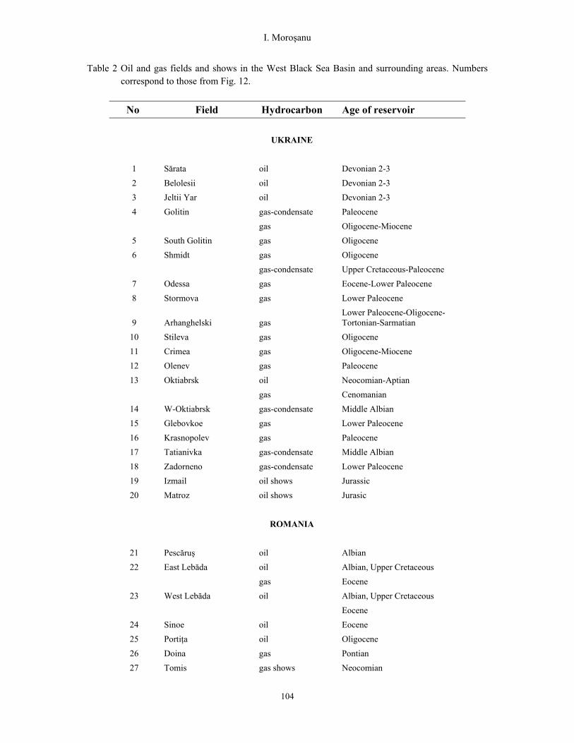
for the entire western shelf of the Black Sea. The hydrocarbon discoveries from this part are presented in Table 2.
In Ukraine – area of the Odessa Gulf and surrounding onshore – around 40 leads with possible hydrocarbon accumulations were identified, 20 of them being localised in the Karkinit Depression, part of these proving to have gas accumulations (Fig. 12). The leads contain from one to four reservoirs included in the depth interval 500-2190 m. Eleven of these belong to Maikop formation (Oligocene), 4 to the Lower Paleocene, 1 to the Eocene and 1 to the Miocene. Within the shelf structures, only gas accumulations were discovered, excepting the Goliţin field, with gas condensate. On the onshore, oil was discovered even in older rocks. In Crimea, in reservoirs belonging to the Lower Cretaceous, there was discovered oil (Oktiabriskoe West), oil and gas (Oktiabriskoe) and gas-condensate (Tatyanivka).
Fig. 12. The petroleum systems and directions of hydrocarbon migration (from ligher shades to darker
ones) on the northwestern shelf of the Black Sea (see Table 2). Red = gas, green = oil. Circles = hydrocarbon accumulations identified but not outlined, yet.
I. Moroşanu
104
Table 2 Oil and gas fields and shows in the West Black Sea Basin and surrounding areas. Numbers correspond to those from Fig. 12.
No Field Hydrocarbon Age of reservoir
UKRAINE
1 Sărata oil Devonian 2-3
2 Belolesii oil Devonian 2-3
3 Jeltii Yar oil Devonian 2-3
4 Golitin gas-condensate Paleocene
gas Oligocene-Miocene
5 South Golitin gas Oligocene
6 Shmidt gas Oligocene
gas-condensate Upper Cretaceous-Paleocene
7 Odessa gas Eocene-Lower Paleocene
8 Stormova gas Lower Paleocene
9 Arhanghelski gas Lower Paleocene-Oligocene-Tortonian-Sarmatian
10 Stileva gas Oligocene
11 Crimea gas Oligocene-Miocene
12 Olenev gas Paleocene
13 Oktiabrsk oil Neocomian-Aptian
gas Cenomanian
14 W-Oktiabrsk gas-condensate Middle Albian
15 Glebovkoe gas Lower Paleocene
16 Krasnopolev gas Paleocene
17 Tatianivka gas-condensate Middle Albian
18 Zadorneno gas-condensate Lower Paleocene
19 Izmail oil shows Jurassic
20 Matroz oil shows Jurasic
ROMANIA
21 Pescăruş oil Albian
22 East Lebăda oil Albian, Upper Cretaceous
gas Eocene
23 West Lebăda oil Albian, Upper Cretaceous
Eocene
24 Sinoe oil Eocene
25 Portiţa oil Oligocene
26 Doina gas Pontian
27 Tomis gas shows Neocomian

Hydrocarbon potential of the Romanian Black Sea continental plateau
105
28 Lotus gas shows Neocomian
29 Vadu gas shows Neocomian
30 Cobălcescu gas Pontian
31 Ovidiu gas shows Pontian
32 Midia gas shows Pontian
33 Comana oil shows Middle-Upper Devonian
34 Lacu Roşu gas shows Middle Jurassic
35 Obretin gas shows Middle Jurassic
44 Ana gas Pontian
45 Olimpiska (Muridava) oil Eocene
46
49
Domino
Eugenia
gas
gas
Pliocene
Cretaceous, Eocene
BULGARIA
36 Tiulenovo oil & gas Valanginian
37 Galata gas Upper Cretaceous-Paleocene
38 Epsilon oil shows Lower Cretaceous
39 Elisabetino gas shows Cretaceous
40 North Sabla gas shows Eocene
41 Krapez gas & oil shows Oligocene
42 Bulgarevo gas shows Paleocene
43 Blyznatzy gas shows Paleocene
47 Samotino More gas condensate Middle Eocene
48 LA-1 gas condensate Valanginian
These fields, like those from the shelf, are in their majority of fault anticlines, the faults being reversed. On the western shore, in Devonian formations, 3 fields with oil were identified: East Sărata, Belolesii and Jeltii Yar. In the same area, oil shows also appear in Jurassic formations (Izmail, Matroz) (Fig. 12).
The pelitic sequences of the Upper Eocene could considered as possible source rocks of many gas fields from the shelf. Nevertheless, the presence of gas condensate (Goliţin) diminishes this possibility because the Eocene is not mature enough even to produce oil (Robinson et al., 1997). Also, the Aptian-Albian pelitic rocks might represent source rocks. They contain small quantities of carbon and kerogen of III type, favourable to the production of dry gas and might generate hydrocarbon if there were
deposited in deep zones of the extensional basins (Robinson et al., 1997).
The discovery of oil accumulations in Devonian formations, on the west shore of the Odessa Gulf (Table-2) might suggest also the presence of the Paleozoic source rocks.
At the south, on the Bulgarian shelf, the single one oil field discovered is at Tiulenovo and contains oil and gas in the fissured carbonates of Valanginian. Also in the Galata field there was evidenced gas in calcareous sand of Paleocene, in Samotino More field gas condensate in Mid Eocene and in LA-1 gas condensate in Valanginian (Georgiev, 2012). Gas shows were identifies in few small structures from the onshore, at the border between Romania and Bulgaria. In this southern area, as well, the source rock is not known but

I. Moroşanu
106
only supposed. For the Tiulenovo field, Bottomley et al. (1998), consider, based on the analysis of the biomarkers, that the source has to be Tertiary and localised at a distance of no less than 50 km south-east of the field, in the Kamcia Depression because in its vicinity these sediments are immature. Nevertheless, in the Kamcia Depression, from the burial depths point of view (Sinclair et al., 1997), only partially the Lower Cretaceous and partially the Jurassic might be considered as potential generating source rocks. In this case, the position of the Tiulenovo field is correlative with the position of the source rock from the Kamcia Depression.
Georgiev (2012), according with data from Rock-Eval analyses, log records and biomarker correlations on the Galata-1 well, drilled in 1993, consider that the primary source rocks in East Varna Trough are Lower-Middle Jurassic argillaceous sequences: Provadia and Etropole formations. For Samotino More and LA-1 fields, the author considers possible source rocks belon-ging to the Eocene and Paleocene-Upper Cretaceous. The latter two fields are situated in Kamcia Depression (Fig. 12). Hence, it can be stated that the most difficult problem for the hydrocarbon investigation in the western part of the Black Sea is the identification of the source rock.
Regarding the Romanian shelf, the hydrocarbon potential seems to be distributed to four termogenic petroleum systems and one biogenic gas system (Fig. 12):
Krîlov-Karkinit system presents a high heat
flow favourable to the transformations of the organic matter. The active source rocks might be placed in the interval Eocene-Jurassic and possibly Paleozoic. The migration paths could be on the Nistru fault southward, in this manner the hydrocarbon being able to enter in contact mainly with the Scythian Block and the northeastern flank of the Histria Depression. This direction would be confirmed also by the position of the oil fields discovered until now, Eugenia and Muridava (Olimpyska) (Fig. 12). The Paleozoic could have encountered the burial-generation conditions, especially that on the
onshore, immediately west of Olimpyska and Eugenia fields, there are a few oil fields and numerous oil shows in this type of formations (Fig. 12). The hydrocarbon in these discoveries, considering their location at depth, cannot come but from Paleozoic source rocks.
The West Black Sea deep basin system,
which, even if does not present a high heat flow, might gather favourable burial-generation conditions for the formations of the basal Oligocene situated at more than 3000 m depth. The most probable migration path could be represented by the disconformity Oligocene/Pre-Oligocene. The role of the Oligocene formations in this system might be especially of seal. The area favourable for the accumulation within this system, is represented by the eastern flank of Midia-Tiulenovo Block situated in the immediate vicinity, west of the generation area (Figs. 3 and 12). The hydrocarbon migration from the West Black Sea deep basin system to the traps of the Histria Depression would have covered quite a long distance (100-150 km), which is unlikely.
Corbu-Constanţa depression system is placed
between the Razelm and Lacu Roşu faults and is continued southward, in Bulgaria with Varna Trough, the Tiulenovo field being tributary to this system (Fig. 12). Here, the burial depths and the proximity to the area of higher heat flow from Mangalia, creates good conditions of generation, especially for the Paleozoic (Silurian) and Neocomian formations. The plans with northern vergence and east-west direction of the normal or reverse faults can represent good paths of migration towards traps of fault anticline type. The degraded oil put into evidence in the Devonian formations from 1 Comana well, on onshore, 10 km west of the shore line, pleads for this migration. Also, the complex of Razelm and Lacu Roşu faults might represent paths migration. Moreover, along these faults, there might exist different traps represented by uplifted blocks of “positive flower” structure type; this seem to be the case of the Tiulenovo field and of the structure from

Hydrocarbon potential of the Romanian Black Sea continental plateau
107
the front of Mangalia town, towards offshore, the latter being shown in Fig. 7.
The north-eastern flank of the Histria
Depression system is a system more or less local, developed on semi-grabens created through extensional and then reversed dynamics where the Neocomian formations represent the main generating source rock. These formations had good generation conditions by burial and presently they are not uplifted, through inversion, to more than 3000 m depth. From the correlation of the seismic lines with the well data, it results that these formations, together with those from the Middle Jurassic, which have possibilities of generating hydrocarbon, are quite well developed on this flank.
The coincidence of the development of some Neocomian-Middle Jurassic source rocks, in favourable conditions of burial-generation, beginning from the extensional period and until
the present, with the existence here of the East Lebăda – Portiţa and West Lebăda – Sinoe fields, with oil and gas accumulations, make us believe that we are in presence of a hydrocarbon system.
The migration paths towards traps can be represented by the reverse faults with northwest-southeast direction as probably is the case of the Lacu Roşu fault that seems to divide the system in two areas: an eastern area, with Albatros, East Lebăda and West Lebăda fields, and a western area, with Sinoe and Portiţa fields.
The situation could be repeated for the opposite flank of the depression, where it also might exist a petroleum system that only needs to be put into evidence. Anyway, we do not exclude the possibility that the Oligocene sedimentary was a source rock, with the active source rock being situated in the deep basin. The migration path could have been the erosional surface from the base of the Oligocene.
Fig. 13 - The biogenic gas system (red) on the Romanian Continental Plateau

I. Moroşanu
108
The biogenic gas system is placed on the Western Black Sea depth basin being represented by Midia, Ovidiu, Cobălcescu, Doina and Doina Sister, Ana and Domino gas fields (Figs. 12 and 13). The gas is traped in Lower Pontian-Dacian sandstones and the source rock is considered to be the pelitic formations from the Lower Pontian (and Sarmatian?). Seals can be all pelitic sequences from the Pliocene. The type of traps are represented by large drape anticline (Ovidiu, Midia), roll-over anticline or horsts and monocline beds affected by lystric faults (Cobălcescu –Fig. 8). Also, there are many stratigraphic types of traps (pinch-out, depositional fans, etc) not drilled until now. Gas migration can be considered on vertical direction or along lystric faults. This system could be extended towards west north-west and north, numerous gas shows being reported from the Lower Pontian in all wells drilled on the Romanian shelf. 4 Conclusions
The continental plateau of the western Black Sea is characterised by a variety of traps and reservoirs. So far, the north-eastern part of Histria depression comprises most hydrocarbon accumulations on the western Black Sea shelf. Beside the Oligocene, proved as source rock for the petroleum system in the north-eastern flank of Histria depression, older rocks could have generated hydrocarbon, as well.
In our opinion, on the Romanian Continental
Plateau, only a small part of the hydrocarbon
reserves have been discovered, huge reserves
being undiscovered yet.
Acknowledgements
The author benefited from the constructive
remarks made by Mihai Şaramet (University
"Alexandru Ioan Cuza" Iaşi) and by an
anonymous reviewer on an earlier version of the
manuscript.
References Bottomley S., Pritchard G., 1998, Tulenovo field
holds key to new drilling in Bulgaria. OIL & GAS JOURNAL, 96/9, 110-114.
Cranganu, C., Villa, M. A., Şaramet, M., Zacharova,
N., 2009. Petrophysical characteristics of
source and reservoir rocks in the Histria Basin,
Western Black Sea. Journal of Petroleum Geology, 32, 357-372.
Cranganu, C., Şaramet, M., 2011, Hydrocarbon generation and accumulation in the Histria
Basin of the Western Black Sea. In: A. L.
Ryann and N. J. Perkins (Eds), The Black Sea: Dynamics, Ecology and Conservation, Nova
Publishers, 243-263.
Georgiev G., 2012, Geology and Hydrocarbon
Systems in the Western Black Sea. In Turkish Journal of Earth Sciences, 21, 723-754.
Ionescu G., 2002, Facies architecture and sequence
stratigraphy of the Black Sea offshore Romania. In Dinu C. and Mocanu V. (Eds. ),
Geology and tectonics of the romanian Black
Sea shelf and its hydrocarbon potential. BGF -
Special volume no. 2. 43-51. Ionescu G., Sisman M., Cataraiani R., 2002, Source
and reservoir rocks and traping mechanism on
the romanian Black Sea shelf. In Dinu C. and Mocanu V. (Eds.), Geology and tectonics of
the Romanian Black Sea shelf and its
hydrocarbon potential. BGF - Special volume
no. 2, 67-83.
Moroşanu I., 1990, The Tectonic of Preoligocene Formations as Identified by Means of Seismic Data in Portiţa- Lebăda Area ( Romanian Continental Shelf of the Black Sea). Revue Roumaine de Geophysique, 34, 71-87.
Moroşanu I., 1994. The Contact Between North Dobrogea Orogene and Scythian Platform and its Seismically Expresion. Bull. Prospecţiuni S. A., 24/2, 5-11.
Moroşanu I., 1994, New Targets for oil in the Black Sea Tertiary, Symposium of the Petroleum Geology and Hydrocarbon Potential of the Black Sea Area. Special Publication, 39. Varna, Bulgaria.
Moroşanu I., 1996, Tectonic Setting of the Romanian Offshore at the Pre-Albian Level. In Oil and Gas in Thrustbelts and Basins, Alpidic Regions-Central and Eastern Europe.

Hydrocarbon potential of the Romanian Black Sea continental plateau
109
Geological Society of London, Special Publication No. 5, 315-323.
Moroşanu I., 1996, Geological Framework of the Romanian Black Sea Shelf and the Position, Contouring and Evolution of the Histria Depression. 2nd International Symposium on the Petroleum Geology and Petroleum Potential of the Black Sea Area. Special Publication, 105-118, Istanbul (Sile), Turkey.
Moroşanu I., 1997, The Geological Framework of the Romanian Black Sea Shelf and its Position in the South-East Europe. AAPG Conference, Viena, Austria, Special publication, 39.
Moroşanu I., 1999, The Inversion of the Histria Basin-Romanian Black Sea Shelf. Europrobe TESZ, Pancardi and GeoRift Conference, Tulcea, Special publication, 82-83.
Moroşanu I., 2000, Inverted Structure Types of the Romanian Offshore-Black Sea. International Geophysical Conference & Exhibition, Bucharest, Special publication of the Bulletin of the Romanian Society of Geophysics, 374-377.
Moroşanu I., 2002, Post-Jurassic Tectonic History and Geodinamics of the Black Sea Region. EAGE 64th Conference & Exhibition, Florence, Italy. Special publication.
Moroşanu I., 2007, Romanian Continental Pateau of the BLACK SEA, Tectonic – Sedimentary Evolution and Hydrocarbon Potential. Ed. I. Moroşanu, Oscar Print, Bucharest.
Robinson A., G., Kerusov E., 1997, Stratigraphic and Structural Development of the Gulf of Odessa, Ukrainian Black Sea: Implications for Petroleum Exploration. In Regional and
Petroleum Geology of the Black Sea and Surrounding Region, Ed. A. G. Robinson. AAPG Memoir 68, 369-380.
Şaramet, M., Gavrilescu, Gh., Cranganu, C., 2005. The role of Oligocene formations in hidrocarbon generation and accumulation in the Histria petroleum system of the Romanian shelf of the Black Sea. 27, 295 – 301.
Şaramet M., Gavrilescu G., Cranganu C., 2008. Quantitative estimation of expelled fluids from Oligocene rocks, Histria Basin, Western Black Sea, Marine and Petroleum Geology, 25, 544-552.
Şaramet, M., Catuneanu, O., Răducanu, R., Chirilă, G., 2010. Genetic potential of the Histria Petroliferous Basin. In: E. D. Schmitter and Nikos Mastorakis(Eds.), Water and Geoscience, Proceedings of the 5th IASME / WSEAS International Conference on Water Resources, Hydraulics & Hydrology (WHH '10), Proceedings of the 4th IASME / WSEAS International Conference on Geology and Seismology (GES '10), p. 68-72. WSEAS Press.
Sinclair H. D., Juranov S. G., Georgiev G., Byrne P., Mountney N. P., 1997. The Balkan Thrust Wedge and Foreland Basin of Eastern Bulgaria: Structural and Stratigraphic Development. In Regional and Petroleum Geology of the Black Sea and Surrounding Region, Ed. A. G. Robinson. AAPG Memoir 68, 91-114.
Veliciu Ş., 2002, Heat flow of the north – western Black Sea region. In Dinu C. and Mocanu V. (Eds. ), Geology and tectonics of the romanian Black Sea shelf and its hydrocarbon potential. BGF - Special volume no. 2, 53-58.