Embed Size (px)
Citation preview
Hollow ways are deep cuttings through which roads andfootpaths run. They occur in many places in the UpperGreensand of Wiltshire. They are not associated with anysprings or streams.
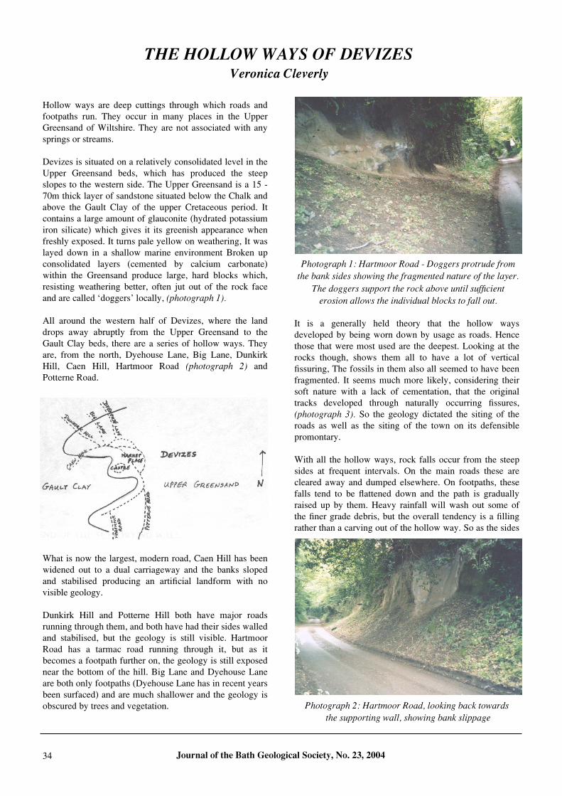
Devizes is situated on a relatively consolidated level in theUpper Greensand beds, which has produced the steepslopes to the western side. The Upper Greensand is a 15 -70m thick layer of sandstone situated below the Chalk andabove the Gault Clay of the upper Cretaceous period. Itcontains a large amount of glauconite (hydrated potassiumiron silicate) which gives it its greenish appearance whenfreshly exposed. It turns pale yellow on weathering, It waslayed down in a shallow marine environment Broken upconsolidated layers (cemented by calcium carbonate)within the Greensand produce large, hard blocks which,resisting weathering better, often jut out of the rock faceand are called ‘doggers’ locally, (photograph 1).
All around the western half of Devizes, where the landdrops away abruptly from the Upper Greensand to theGault Clay beds, there are a series of hollow ways. Theyare, from the north, Dyehouse Lane, Big Lane, DunkirkHill, Caen Hill, Hartmoor Road (photograph 2) andPotterne Road.
What is now the largest, modern road, Caen Hill has beenwidened out to a dual carriageway and the banks slopedand stabilised producing an artificial landform with novisible geology.
Dunkirk Hill and Potterne Hill both have major roadsrunning through them, and both have had their sides walledand stabilised, but the geology is still visible. HartmoorRoad has a tarmac road running through it, but as itbecomes a footpath further on, the geology is still exposednear the bottom of the hill. Big Lane and Dyehouse Laneare both only footpaths (Dyehouse Lane has in recent yearsbeen surfaced) and are much shallower and the geology isobscured by trees and vegetation.
It is a generally held theory that the hollow waysdeveloped by being worn down by usage as roads. Hencethose that were most used are the deepest. Looking at therocks though, shows them all to have a lot of verticalfissuring, The fossils in them also all seemed to have beenfragmented. It seems much more likely, considering theirsoft nature with a lack of cementation, that the originaltracks developed through naturally occurring fissures,(photograph 3). So the geology dictated the siting of theroads as well as the siting of the town on its defensiblepromontary.
With all the hollow ways, rock falls occur from the steepsides at frequent intervals. On the main roads these arecleared away and dumped elsewhere. On footpaths, thesefalls tend to be flattened down and the path is graduallyraised up by them. Heavy rainfall will wash out some ofthe finer grade debris, but the overall tendency is a fillingrather than a carving out of the hollow way. So as the sides
Journal of the Bath Geological Society, No. 23, 200434
THE HOLLOW WAYS OF DEVIZES Veronica Cleverly
Photograph 2: Hartmoor Road, looking back towards
the supporting wall, showing bank slippage
Photograph 1: Hartmoor Road - Doggers protrude from
the bank sides showing the fragmented nature of the layer.
The doggers support the rock above until sufficient
erosion allows the individual blocks to fall out.
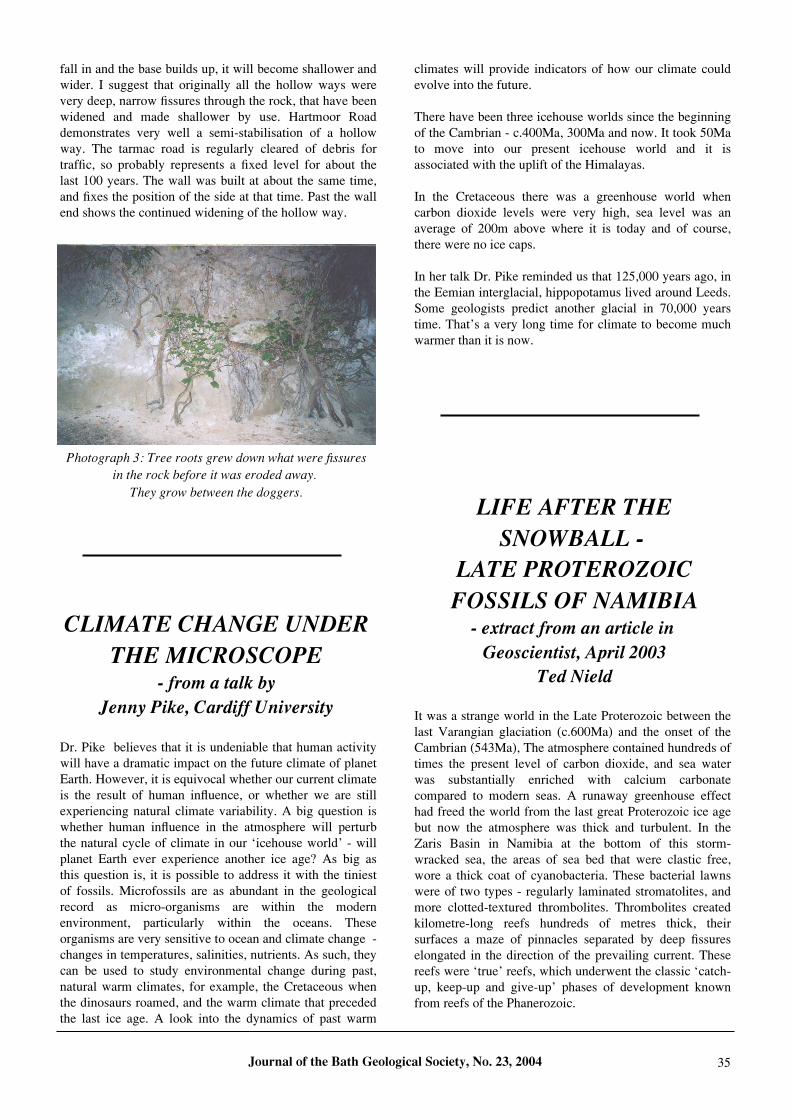
fall in and the base builds up, it will become shallower andwider. I suggest that originally all the hollow ways werevery deep, narrow fissures through the rock, that have beenwidened and made shallower by use. Hartmoor Roaddemonstrates very well a semi-stabilisation of a hollowway. The tarmac road is regularly cleared of debris fortraffic, so probably represents a fixed level for about thelast 100 years. The wall was built at about the same time,and fixes the position of the side at that time. Past the wallend shows the continued widening of the hollow way.
Dr. Pike believes that it is undeniable that human activitywill have a dramatic impact on the future climate of planetEarth. However, it is equivocal whether our current climateis the result of human influence, or whether we are stillexperiencing natural climate variability. A big question iswhether human influence in the atmosphere will perturbthe natural cycle of climate in our ‘icehouse world’ - willplanet Earth ever experience another ice age? As big asthis question is, it is possible to address it with the tiniestof fossils. Microfossils are as abundant in the geologicalrecord as micro-organisms are within the modernenvironment, particularly within the oceans. Theseorganisms are very sensitive to ocean and climate change -changes in temperatures, salinities, nutrients. As such, theycan be used to study environmental change during past,natural warm climates, for example, the Cretaceous whenthe dinosaurs roamed, and the warm climate that precededthe last ice age. A look into the dynamics of past warm
climates will provide indicators of how our climate couldevolve into the future.
There have been three icehouse worlds since the beginningof the Cambrian - c.400Ma, 300Ma and now. It took 50Mato move into our present icehouse world and it isassociated with the uplift of the Himalayas.
In the Cretaceous there was a greenhouse world whencarbon dioxide levels were very high, sea level was anaverage of 200m above where it is today and of course,there were no ice caps.
In her talk Dr. Pike reminded us that 125,000 years ago, inthe Eemian interglacial, hippopotamus lived around Leeds.Some geologists predict another glacial in 70,000 yearstime. That’s a very long time for climate to become muchwarmer than it is now.
It was a strange world in the Late Proterozoic between thelast Varangian glaciation (c.600Ma) and the onset of theCambrian (543Ma), The atmosphere contained hundreds oftimes the present level of carbon dioxide, and sea waterwas substantially enriched with calcium carbonatecompared to modern seas. A runaway greenhouse effecthad freed the world from the last great Proterozoic ice agebut now the atmosphere was thick and turbulent. In theZaris Basin in Namibia at the bottom of this storm-wracked sea, the areas of sea bed that were clastic free,wore a thick coat of cyanobacteria. These bacterial lawnswere of two types - regularly laminated stromatolites, andmore clotted-textured thrombolites. Thrombolites createdkilometre-long reefs hundreds of metres thick, theirsurfaces a maze of pinnacles separated by deep fissureselongated in the direction of the prevailing current. Thesereefs were ‘true’ reefs, which underwent the classic ‘catch-up, keep-up and give-up’ phases of development knownfrom reefs of the Phanerozoic.
Journal of the Bath Geological Society, No. 23, 2004 35
Photograph 3: Tree roots grew down what were fissures
in the rock before it was eroded away.
They grow between the doggers.
CLIMATE CHANGE UNDER
THE MICROSCOPE- from a talk by
Jenny Pike, Cardiff University
LIFE AFTER THE
SNOWBALL -
LATE PROTEROZOIC
FOSSILS OF NAMIBIA- extract from an article in
Geoscientist, April 2003
Ted Nield