Embed Size (px)
Citation preview
1
THE HISTORY OF MINING IN THE BARBERTON
GREENSTONE BELT, SOUTH AFRICA, WITH AN
EMPHASIS ON GOLD (1868 – 2012)
By
Carl R. Anhaeusser
Economic Geology Research Institute
School of Geoscienecs University of the Witwatersrand,
Johannesburg
Abstract
Although gold was known in various parts of southern Africa prior to 1868 it was only after
the De Kaap Goldfields were discovered around 1882 that South Africa became a significant
destination for gold prospectors from around the world. Alluvial gold was first found in
streams draining the eastern escarpment regions and this was followed eastwards into the
malarial- and sleeping sickness-infested Lowveld. Lode gold discoveries in the Makonjwa
Mountains led to the founding of the town of Barberton in 1884 and the recognition of the
Barberton Goldfields as an important source of the precious metal. The colourful early
history of the gold discoveries in the Archaean volcano-sedimentary successions of the
Barberton greenstone belt, which straddles South Africa and northwest Swaziland, is outlined
with reference to historic photographs depicting early mining activities in the district. The
resourcefulness of the intrepid pioneers who prospected this hostile region and who
subsequently set the stage for the discovery and development of the Witwatersrand
Goldfields from 1886 onwards is recounted. Despite gold being the principal target of the
early pioneers, other mineral discoveries were made that contributed to the Barberton
greenstone belt being regarded as a favourable mineral exploration region. These included the
discoveries of significant chrysotile asbestos, iron ore, magnesite, talc and barite deposits as
well as some occurrences of unusual semi-precious commodities such as verdite and
buddstone. Gold mining has continued almost uninterruptedly up to the present day – a
period of close on 130 years. New discoveries are still being made and old deposits are being
re-investigated as techniques of mining and extraction improve. These developments and the
recent discovery of a nickel-sulphide deposit associated with an old talc mine suggest that
mining activities in the Barberton greenstone belt are set to continue well into the foreseeable
future.
2
Introduction
The early history of gold prospecting and mining in South Africa has received attention from
numerous authors dating back to the early 19th
century, but many who have written about the
early days of adventure and discovery have produced mainly entertaining stories that are at
times distorted by hearsay and embellished by fabrication and conjecture. No accounts exists
that can be regarded as entirely factually reliable. The first mining of gold was undertaken by
the „ancients‟, but just who these people were can only be speculated upon. There have been
suggestions that the early miners came to southern Africa from about the 3rd century A.D.,
some coming from India and others from biblical or Arab regions with obscure links to the
Queen of Sheba and King Solomon (Summers, 1969). By the time the first European
explorers arrived in southern Africa during the 19th
century many ancient gold workings had
been abandoned and largely forgotten. In 1886, Carl Mauch, a German geologist, confirmed
that the old diggings seen a year earlier by the elephant hunter Henry Hartley, were indeed
ancient gold workings. Between 1868 and 1870 further gold discoveries were made by
Mauch and Messrs. Button, Pigg and Sutherland in the Olifants River area, as well as in the
Murchison greenstone belt, and in the Pietersburg greenstone (schist) belt at Eersteling and
Marabastad.
Other reports of gold in South Africa, principally in alluvial geological settings, had
been made prior to the exploits of Mauch and his contemporaries, but none of these resulted
in any serious mining activities. Gold discoveries dating back as early as 1834 are listed by
Handley (2004), many of them being in the vicinity of the Witwatersrand Goldfield, which
was reputedly discovered in 1886 by George Harrison and George Walker who found the
Main Reef on the farm Langlaagte. The Witwatersrand discovery has also been the topic of
much debate as there are those who vehemently support the discoverer as being Fred Struben
in 1884 (see “Pretorius‟s list” of gold discoveries in South Africa - in Handley, 2004).
The Pietersburg and Pilgrim’s Rest Goldfields and Other Early Discoveries
Along the Transvaal Drakensberg Escarpment
The first gold mined in the then northern Transvaal (now the Limpopo Province)
came from Eersteling in 1871 (Baines, 1877; Hall, 1908; Willemse, 1938). Saager and Muff
(1986) described the gold ore as consisting of (1) quartz veins with disseminated gold or
enrichments at the contacts between veins and wall rocks; (2) impregnated gold-bearing
schists in extensive shear zones within the mafic lavas; (3) gold occurring in sulphidic banded
iron formations and as supergene enrichments in the weathered zones of these rock types; (4)
gold associated with thin quartz stringers and veinlets in structurally deformed banded iron
formation (as at Marabastad); and (5) alluvial diggings that yielded gold nuggets, one
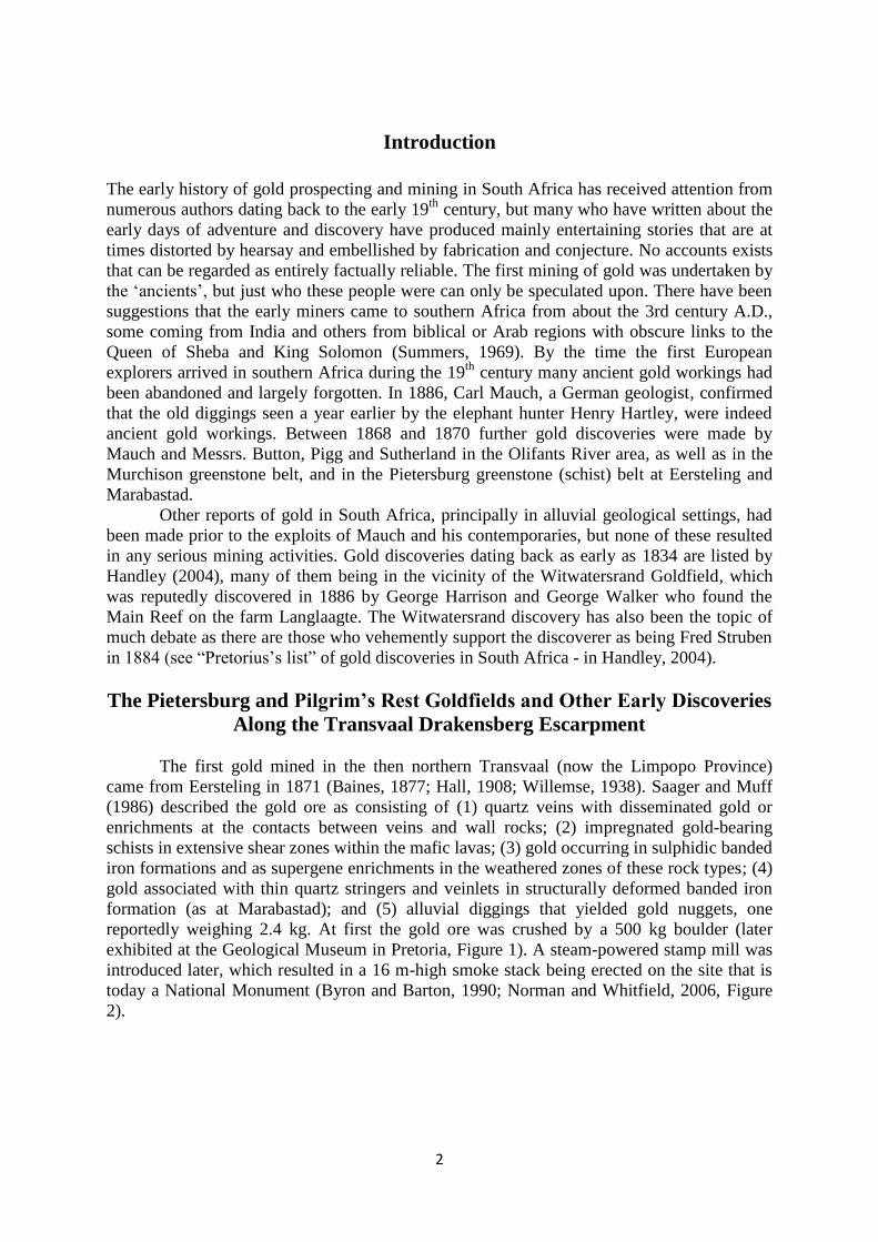
reportedly weighing 2.4 kg. At first the gold ore was crushed by a 500 kg boulder (later
exhibited at the Geological Museum in Pretoria, Figure 1). A steam-powered stamp mill was
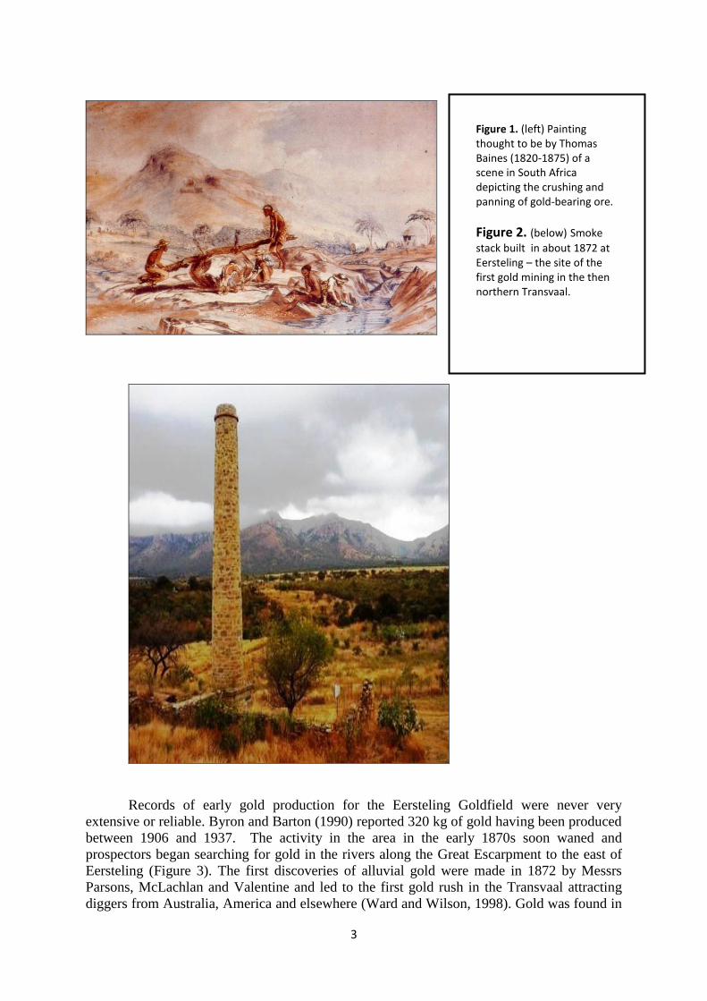
introduced later, which resulted in a 16 m-high smoke stack being erected on the site that is
today a National Monument (Byron and Barton, 1990; Norman and Whitfield, 2006, Figure
2).
3
Records of early gold production for the Eersteling Goldfield were never very
extensive or reliable. Byron and Barton (1990) reported 320 kg of gold having been produced
between 1906 and 1937. The activity in the area in the early 1870s soon waned and
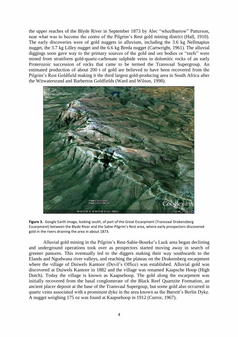
prospectors began searching for gold in the rivers along the Great Escarpment to the east of
Eersteling (Figure 3). The first discoveries of alluvial gold were made in 1872 by Messrs
Parsons, McLachlan and Valentine and led to the first gold rush in the Transvaal attracting
diggers from Australia, America and elsewhere (Ward and Wilson, 1998). Gold was found in
Figure 1. (left) Painting thought to be by Thomas Baines (1820-1875) of a scene in South Africa depicting the crushing and panning of gold-bearing ore.
Figure 2. (below) Smoke
stack built in about 1872 at Eersteling – the site of the first gold mining in the then northern Transvaal.
4
the upper reaches of the Blyde River in September 1873 by Alec “wheelbarrow” Patterson,
near what was to become the centre of the Pilgrim‟s Rest gold mining district (Hall, 1910).
The early discoveries were of gold nuggets in alluvium, including the 3.6 kg Nellmapius
nugget, the 3.7 kg Lilley nugget and the 6.6 kg Breda nugget (Cartwright, 1961). The alluvial
diggings soon gave way to the primary sources of the gold and ore bodies or “reefs” were
mined from stratiform gold-quartz-carbonate sulphide veins in dolomitic rocks of an early
Proterozoic succession of rocks that came to be termed the Transvaal Supergroup. An
estimated production of about 200 t of gold are believed to have been recovered from the
Pilgrim‟s Rest Goldfield making it the third largest gold-producing area in South Africa after
the Witwatersrand and Barberton Goldfields (Ward and Wilson, 1998).
Figure 3. Google Earth image, looking south, of part of the Great Escarpment (Transvaal Drakensberg Escarpment) between the Blyde River and the Sabie-Pilgrim’s Rest area, where early prospectors discovered gold in the rivers draining the area in about 1873.
Alluvial gold mining in the Pilgrim‟s Rest-Sabie-Bourke‟s Luck area began declining
and underground operations took over as prospectors started moving away in search of
greener pastures. This eventually led to the diggers making their way southwards to the
Elands and Ngodwana river valleys, and reaching the plateau on the Drakensberg escarpment
where the village of Duiwels Kantoor (Devil‟s Office) was established. Alluvial gold was
discovered at Duiwels Kantoor in 1882 and the village was renamed Kaapsche Hoop (High
Dutch). Today the village is known as Kaapsehoop. The gold along the escarpment was
initially recovered from the basal conglomerate of the Black Reef Quartzite Formation, an
ancient placer deposit at the base of the Transvaal Supergoup, but some gold also occurred in
quartz veins associated with a prominent dyke in the area known as the Barrett‟s Berlin Dyke.
A nugget weighing 175 oz was found at Kaapsehoop in 1912 (Curror, 1967).
5
The Barberton Goldfield
As with the earlier-mentioned gold discoveries, the gold at Kaapsehoop soon declined and
people again began moving on in search of new places to seek their fortunes. Early in 1982,
alluvial gold was discovered in the valley below the escarpment by Jim Murray and Ingram
James. These diggers and a few others, including Harry Culverwell and Auguste Robert
(French Bob) pegged claims in the area along the Noordkaap river valley and a diggers town
with tents and shacks, known as Jamestown (named after Ingram James and James Murray),
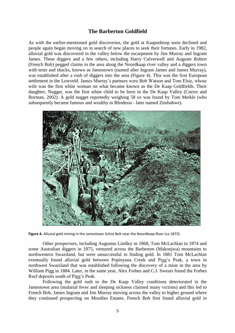
was established after a rush of diggers into the area (Figure 4). This was the first European
settlement in the Lowveld. James Murray‟s partners were Bob Watson and Tom Elsie, whose
wife was the first white woman on what became known as the De Kaap Goldfields. Their
daughter, Nugget, was the first white child to be born in the De Kaap Valley (Curror and
Borman, 2002). A gold nugget reportedly weighing 58 oz was found by Tom Meikle (who
subsequently became famous and wealthy in Rhodesia - later named Zimbabwe).
Figure 4. Alluvial gold mining in the Jamestown Schist Belt near the Noordkaap River (ca 1873).
Other prospectors, including Augustus Lindley in 1868, Tom McLachlan in 1874 and
some Australian diggers in 1875, ventured across the Barberton (Makonjwa) mountains to
northwestern Swaziland, but were unsuccessful in finding gold. In 1881 Tom McLachlan
eventually found alluvial gold between Popinyana Creek and Pigg‟s Peak, a town in
northwest Swaziland that was established following the discovery of a mine in the area by
William Pigg in 1884. Later, in the same year, Alex Forbes and C.J. Swears found the Forbes
Reef deposits south of Pigg‟s Peak.
Following the gold rush to the De Kaap Valley conditions deteriorated in the
Jamestown area (malarial fever and sleeping sickness claimed many victims) and this led to
French Bob, James Ingram and Jim Murray moving across the valley to higher ground where
they continued prospecting on Moodies Estates. French Bob first found alluvial gold in
6
Concession Creek in May 1883, and on 3rd
June of the same year discovered the Pioneer
Reef, on the farm Oorschot (part of Moodies Estates) - the first payable reef gold in the
mountain land (Figures 5 and 6). Once again a large number of prospectors were attracted to
the Moodies area and Curror and Bornman (2002) describe some of the phrenetic activity that
took place in the area as new deposits were located. A small mining settlement grew in the
area known as Blandtown, after Benjamin Adam Bland (this settlement was later absorbed
into Barberton as the township expanded westwards).
Further to the east prospectors, including the Barber and Rimer brothers found reef
gold in creeks leading out of the mountains to the south and their discoveries led ultimately to
the proclamation of the town named Barberton in June 1984 (the name derives from the
brothers Fred and Harry Barber and their cousin Graham). The colourful early history of the
town is recorded in several publications, principally those of Curror (1967), Meiring (1976),
Curror and Bornman (2002) and the Staff of the Barberton Museum and Hans Bornman
(1984). Some old photographs of the town are shown in Figure 7.
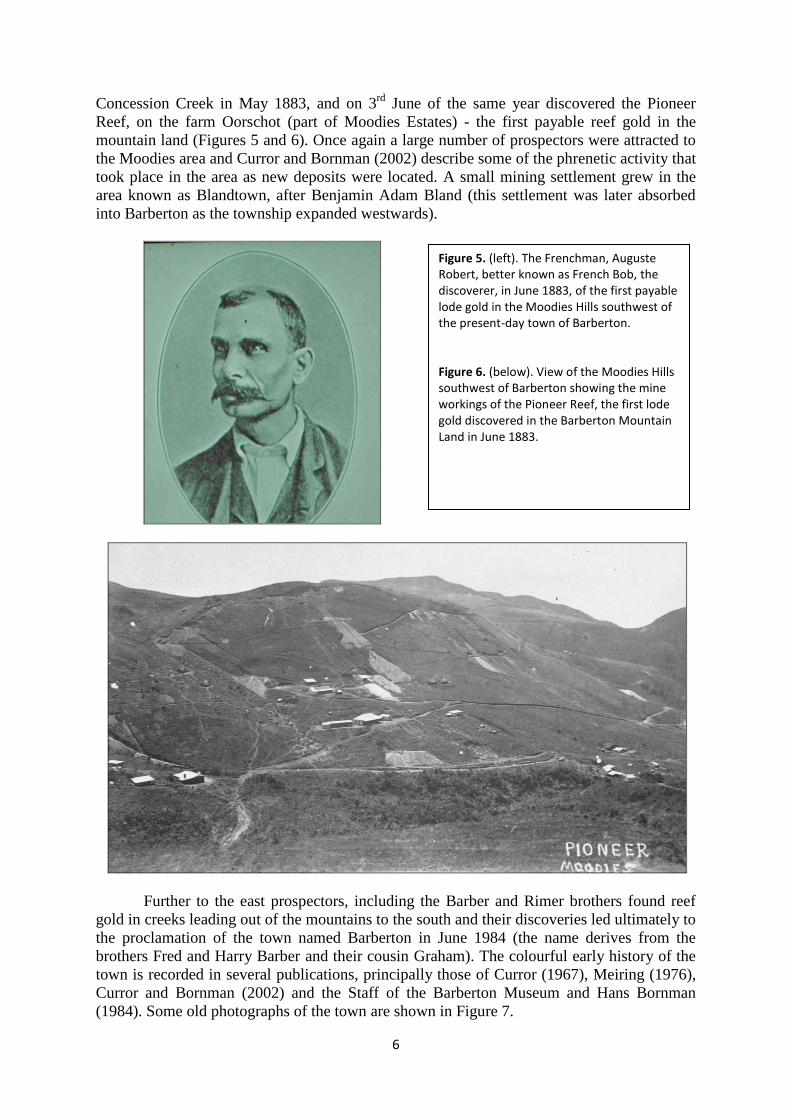
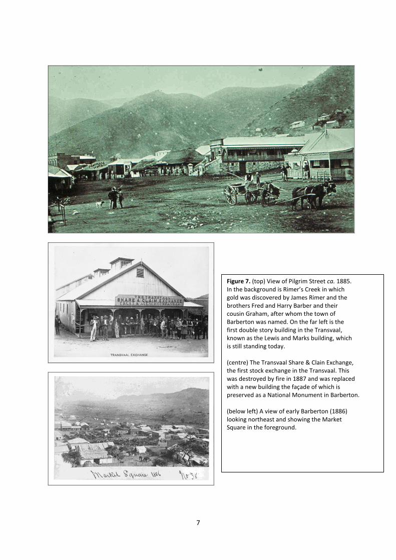
Figure 5. (left). The Frenchman, Auguste Robert, better known as French Bob, the discoverer, in June 1883, of the first payable lode gold in the Moodies Hills southwest of the present-day town of Barberton. Figure 6. (below). View of the Moodies Hills southwest of Barberton showing the mine workings of the Pioneer Reef, the first lode gold discovered in the Barberton Mountain Land in June 1883.
7
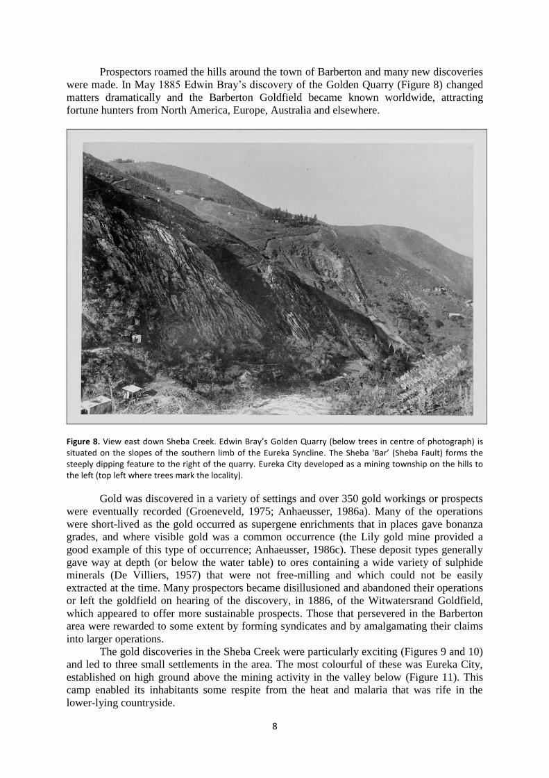
Figure 7. (top) View of Pilgrim Street ca. 1885. In the background is Rimer’s Creek in which gold was discovered by James Rimer and the brothers Fred and Harry Barber and their cousin Graham, after whom the town of Barberton was named. On the far left is the first double story building in the Transvaal, known as the Lewis and Marks building, which is still standing today. (centre) The Transvaal Share & Clain Exchange, the first stock exchange in the Transvaal. This was destroyed by fire in 1887 and was replaced with a new building the façade of which is preserved as a National Monument in Barberton. (below left) A view of early Barberton (1886) looking northeast and showing the Market Square in the foreground.
8
Prospectors roamed the hills around the town of Barberton and many new discoveries
were made. In May 1885 Edwin Bray‟s discovery of the Golden Quarry (Figure 8) changed
matters dramatically and the Barberton Goldfield became known worldwide, attracting
fortune hunters from North America, Europe, Australia and elsewhere.
Figure 8. View east down Sheba Creek. Edwin Bray’s Golden Quarry (below trees in centre of photograph) is situated on the slopes of the southern limb of the Eureka Syncline. The Sheba ‘Bar’ (Sheba Fault) forms the steeply dipping feature to the right of the quarry. Eureka City developed as a mining township on the hills to the left (top left where trees mark the locality).
Gold was discovered in a variety of settings and over 350 gold workings or prospects
were eventually recorded (Groeneveld, 1975; Anhaeusser, 1986a). Many of the operations
were short-lived as the gold occurred as supergene enrichments that in places gave bonanza
grades, and where visible gold was a common occurrence (the Lily gold mine provided a
good example of this type of occurrence; Anhaeusser, 1986c). These deposit types generally
gave way at depth (or below the water table) to ores containing a wide variety of sulphide
minerals (De Villiers, 1957) that were not free-milling and which could not be easily
extracted at the time. Many prospectors became disillusioned and abandoned their operations
or left the goldfield on hearing of the discovery, in 1886, of the Witwatersrand Goldfield,
which appeared to offer more sustainable prospects. Those that persevered in the Barberton
area were rewarded to some extent by forming syndicates and by amalgamating their claims
into larger operations.
The gold discoveries in the Sheba Creek were particularly exciting (Figures 9 and 10)
and led to three small settlements in the area. The most colourful of these was Eureka City,
established on high ground above the mining activity in the valley below (Figure 11). This
camp enabled its inhabitants some respite from the heat and malaria that was rife in the
lower-lying countryside.
9
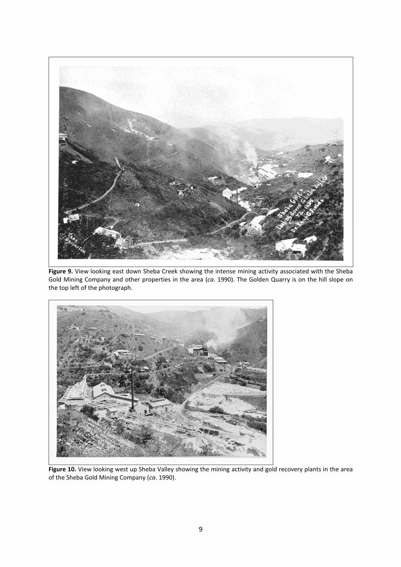
Figure 9. View looking east down Sheba Creek showing the intense mining activity associated with the Sheba Gold Mining Company and other properties in the area (ca. 1990). The Golden Quarry is on the hill slope on the top left of the photograph.
Figure 10. View looking west up Sheba Valley showing the mining activity and gold recovery plants in the area of the Sheba Gold Mining Company (ca. 1990).
10
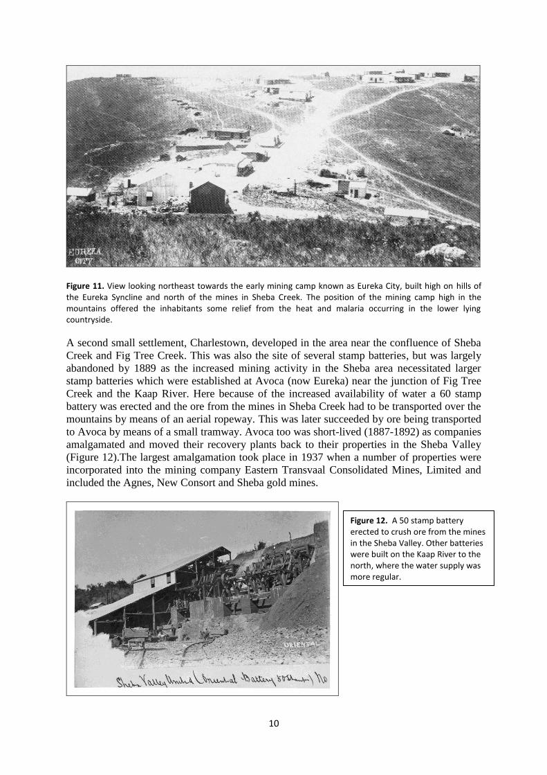
Figure 11. View looking northeast towards the early mining camp known as Eureka City, built high on hills of the Eureka Syncline and north of the mines in Sheba Creek. The position of the mining camp high in the mountains offered the inhabitants some relief from the heat and malaria occurring in the lower lying countryside.
A second small settlement, Charlestown, developed in the area near the confluence of Sheba
Creek and Fig Tree Creek. This was also the site of several stamp batteries, but was largely
abandoned by 1889 as the increased mining activity in the Sheba area necessitated larger
stamp batteries which were established at Avoca (now Eureka) near the junction of Fig Tree
Creek and the Kaap River. Here because of the increased availability of water a 60 stamp
battery was erected and the ore from the mines in Sheba Creek had to be transported over the
mountains by means of an aerial ropeway. This was later succeeded by ore being transported
to Avoca by means of a small tramway. Avoca too was short-lived (1887-1892) as companies
amalgamated and moved their recovery plants back to their properties in the Sheba Valley
(Figure 12).The largest amalgamation took place in 1937 when a number of properties were
incorporated into the mining company Eastern Transvaal Consolidated Mines, Limited and
included the Agnes, New Consort and Sheba gold mines.
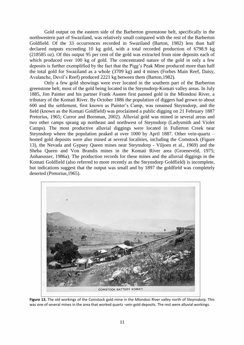
Figure 12. A 50 stamp battery erected to crush ore from the mines in the Sheba Valley. Other batteries were built on the Kaap River to the north, where the water supply was more regular.
11
Gold output on the eastern side of the Barberton greenstone belt, specifically in the
northwestern part of Swaziland, was relatively small compared with the rest of the Barberton
Goldfield. Of the 33 occurrences recorded in Swaziland (Barton, 1982) less than half
declared outputs exceeding 10 kg gold, with a total recorded production of 6798.9 kg
(218585 oz). Of this output 95 per cent of the gold was extracted from nine deposits each of
which produced over 100 kg of gold. The concentrated nature of the gold in only a few
deposits is further exemplified by the fact that the Pigg‟s Peak Mine produced more than half
the total gold for Swaziland as a whole (3709 kg) and 4 mines (Forbes Main Reef, Daisy,
Avalanche, Devil‟s Reef) produced 2221 kg between them (Barton,1982).
Only a few gold showings were ever located in the southern part of the Barberton
greenstone belt, most of the gold being located in the Steynsdorp-Komati valley areas. In July
1885, Jim Painter and his partner Frank Austen first panned gold in the Mlondosi River, a
tributary of the Komati River. By October 1886 the population of diggers had grown to about
600 and the settlement, first known as Painter‟s Camp, was renamed Steynsdorp, and the
field (known as the Komati Goldfield) was proclaimed a public digging on 21 February 1887
Pretorius, 1965; Curror and Bornman, 2002). Alluvial gold was mined in several areas and
two other camps sprang up northeast and northwest of Steynsdorp (Ladysmith and Violet
Camps). The most productive alluvial diggings were located in Fullerton Creek near
Steynsdorp where the population peaked at over 1000 by April 1887. Other vein-quartz –
hosted gold deposits were also mined at several localities, including the Comstock (Figure
13), the Nevada and Gypsey Queen mines near Steynsdorp - Viljoen et al., 1969) and the
Sheba Queen and Von Brandis mines in the Komati River area (Groeneveld, 1975;
Anhaeusser, 1986a). The production records for these mines and the alluvial diggings in the
Komati Goldfield (also referred to more recently as the Steynsdorp Goldfield) is incomplete,
but indications suggest that the output was small and by 1897 the goldfield was completely
deserted (Pretorius,1965).
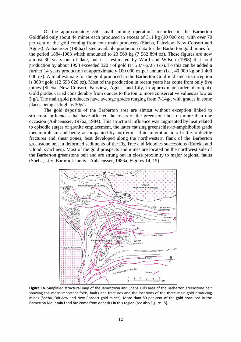
Figure 13. The old workings of the Comstock gold mine in the Mlondosi River valley north of Steynsdorp. This was one of several mines in the area that worked quartz -vein gold deposits. The rest were alluvial workings.
12
Of the approximately 350 small mining operations recorded in the Barberton
Goldfield only about 44 mines each produced in excess of 311 kg (10 000 oz), with over 70
per cent of the gold coming from four main producers (Sheba, Fairview, New Consort and
Agnes). Anhaeusser (1986a) listed available production data for the Barberton gold mines for
the period 1884-1983 which amounted to 23 560 kg (7 582 894 oz). These figures are now
almost 30 years out of date, but it is estimated by Ward and Wilson (1998) that total
production by about 1998 exceeded 320 t of gold (11 287 667.873 oz). To this can be added a
further 14 years production at approximately 100 000 oz per annum (i.e., 40 000 kg or 1 400
000 oz). A total estimate for the gold produced in the Barberton Goldfield since its inception
is 360 t gold (12 698 626 oz). Most of the production in recent years has come from only five
mines (Sheba, New Consort, Fairview, Agnes, and Lily, in approximate order of output).
Gold grades varied considerably from ounces to the ton to more conservative values as low as
5 g/t. The main gold producers have average grades ranging from 7-14g/t with grades in some
places being as high as 30g/t.
The gold deposits of the Barberton area are almost without exception linked to
structural influences that have affected the rocks of the greenstone belt on more than one
occasion (Anhaeusser, 1976a, 1984). This structural influence was augmented by heat related
to episodic stages of granite emplacement, the latter causing greenschist-to-amphibolite grade
metamorphism and being accompanied by auriferous fluid migration into brittle-to-ductile
fractures and shear zones, best developed along the northwestern flank of the Barberton
greenstone belt in deformed sediments of the Fig Tree and Moodies successions (Eureka and
Ulundi synclines). Most of the gold prospects and mines are located on the northwest side of
the Barberton greenstone belt and are strung out in close proximity to major regional faults
(Sheba, Lily, Barbrook faults - Anhaeusser, 1986a, Figures 14, 15).
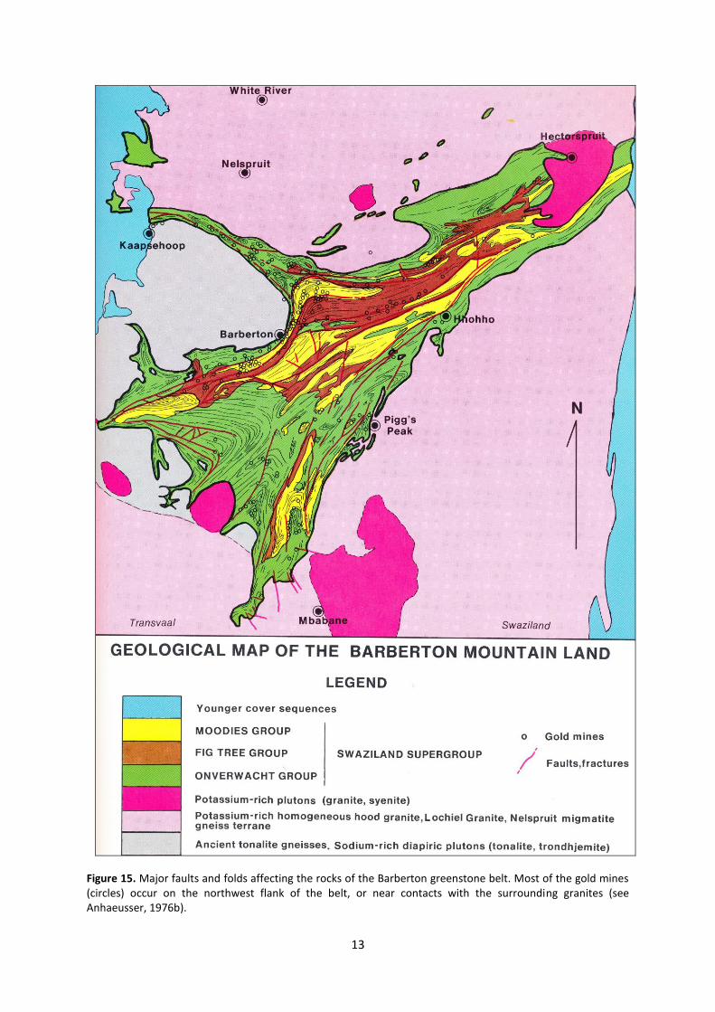
Figure 14. Simplified structural map of the Jamestown and Sheba Hills area of the Barberton greenstone belt showing the more important folds, faults and fractures and the locations of the three main gold producing mines (Sheba, Fairview and New Consort gold mines). More than 80 per cent of the gold produced in the Barberton Mountain Land has come from deposits in this region (see also Figure 15).
13
Figure 15. Major faults and folds affecting the rocks of the Barberton greenstone belt. Most of the gold mines (circles) occur on the northwest flank of the belt, or near contacts with the surrounding granites (see Anhaeusser, 1976b).
14
In the Sheba-Fairview mine areas isoclinally folded brittle chert layers in rocks of the
upper part of the Onverwacht Group of rocks (Swartkoppie Formation) were also deformed
to produce favourable host structures for gold and sulphide mineralization. The central parts
of the Barberton greenstone belt, on the other hand, whilst experiencing similar deformation
histories to those in the northwest have no known gold deposits of note suggesting that the
gold mineralization in the district as a whole was spatially and temporally linked to the
episodic emplacement of granitic rocks into the region between approximately 3500 to 2750
million years ago.
The Barberton gold ores are sub-divisible into three main ore types: (1) unoxidized,
complex sulphide ore that is the main ore type mined thus far in the district and which has
produced the most gold; (2) gold-bearing quartz veins and shears containing only negligible
amounts of sulphide minerals, but which are common throughout the area; and (3) weathered
ore, occurring in oxidized zones that represents the main gold source in the historical past (De
Villiers, 1957; Schweigart and Liebenberg, 1966; Anhaeusser, 1986a).
The sulphide ores have presented particular recovery problems as this ore-type is
refractory and contains mostly pyrite, pyrrhotite or arsenopyrite in various combinations. A
wide range of other sulphide minerals occur in the Barberton gold ores, including mainly
sphalerite, chalcopyrite, galena, tetrahedrite and stibnite (De Villiers, 1957). In the early
stages of treatment of refractory ores recoveries were as low as 27 per cent with conventional
cyanide treatment. This was increased to 80-85 per cent if the ores were roasted. A roasting
plant was first built at the New Consort gold mine to treat ore from this mine as well as ore
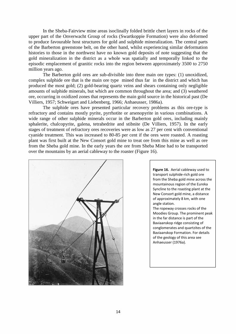
from the Sheba gold mine. In the early years the ore from Sheba Mine had to be transported
over the mountains by an aerial cableway to the roaster (Figure 16).
Figure 16. Aerial cableway used to transport sulphide-rich gold ore from the Sheba gold mine across the mountainous region of the Eureka Syncline to the roasting plant at the New Consort gold mine, a distance of approximately 8 km, with one angle station. The ropeway crosses rocks of the Moodies Group. The prominent peak in the far distance is part of the Baviaanskop ridge consisting of conglomerates and quartzites of the Baviaanskop Formation. For details of the geology of this area see Anhaeusser (1976a).
15
Later a second roasting plant was established to treat the refractory ores of the
Fairview gold mine. In more recent times a BIOX® process, which has been in existence
since the late 1970s, pre-treats refractory sulphide gold ores such as those containing pyrite,
arsenopyrite and pyrrhotite. The BIOX® process, involves bacterial action which destroys
the sulphide minerals and exposes the gold for leaching (the process was pioneered at the
Fairview Mine by Gencor Process Research - now Billiton Process Research). The gold in the
sulphide ores is encapsulated in sulphide minerals, which prevent the gold from being
leached by cyanide. The bacterial process results in accelerated oxidation. The process is
noted for its robustness, simplicity of operation, environmental friendliness and cost-
effectiveness, and offers real advantages over conventional refractory processes such as
roasting and pressure oxidation (Van Aswegen et al., 2007).
Gold has been mined in the Barberton-Swaziland areas for close on 130 years and the
predictions are that it will still be a viable goldfield for many years to come. Gold deposits in
Archaean greenstone belts are notoriously difficult to locate and evaluate as the gold is
patchy and variable in grade. Factors such as the price of gold and a good understanding of
the geological controls of mineralization will play a significant role in determining whether
exploration will continue into the future. Re-investigation of some of the old deposits and
prospects may be warranted as these localities at least indicated the presence of gold. Modern
exploration techniques and improvements in the gold price might herald a resurgence of
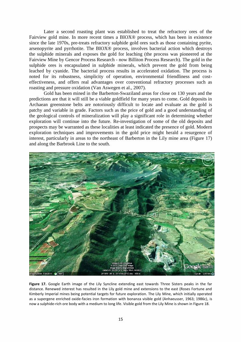
interest, particularly in areas to the northeast of Barberton in the Lily mine area (Figure 17)
and along the Barbrook Line to the south.
Figure 17. Google Earth image of the Lily Syncline extending east towards Three Sisters peaks in the far distance. Renewed interest has resulted in the Lily gold mine and extensions to the east (Roses Fortune and Kimberly Imperial mines being potential targets for future exploration. The Lily Mine, which initially operated as a supergene enriched oxide-facies iron formation with bonanza visible gold (Anhaeusser, 1963; 1986c), is now a sulphide-rich ore body with a medium to long life. Visible gold from the Lily Mine is shown in Figure 18.
16
Geologically, the Barberton greenstone belt has probably received more attention than
any other region in South Africa since it was first mapped by Hall (1918). Later, another
Geological Survey of South Africa publication provided an explanation of a 1 50 000 scale
map of the area (Visser, compiler, 1956). In the period that followed, the Barberton region
became world renowned as a classical Archaean geological terrane in which to study virtually
all aspects of the evolution of the early Earth. Hundreds of papers have been published in
local and international journals and books describing the ancient volcano-sedimentary
stratigraphy, the komatiitic and other volcanic rocks, the plutonic layered ultramafic
complexes, the wide variety and ages of granites, gneisses and migmatites surrounding and
intruding the greenstone belt, the structural and metamorphic history, evidence for primitive
life organisms and the chemistry of the early atmosphere and oceans, and the various types of
mineralization to be found in the area. Summaries of these findings appear in various review
articles (including those of Anhaeusser, 1976b,c, 1981, 1986a,b, 1999, 2006; Anhaeusser and
Viljoen, 1986; Barton, 1982; Brandl et al., 2006; Cairncross and Anhaeusser, 1992;
Groeneveld, 1975; Lowe and Byerly, 1999; Robb et al., 2006; Ward, 1999).
Other Mineral Occurrences in the Barberton Greenstone Belt
Although gold was the main attraction in the Barberton greenstone belt for many years the
early prospectors who combed the hills also drew attention to the presence of other
mineralization types in the region. These included occurrences of chrysotile asbestos, iron,
barite, magnesite, talc, tin, antimony, mercury, nickel-copper, zinc, and verdite-buddstone. In
later years some of these commodities yielded important deposits and were significant
producers particularly of chrysotile asbestos, magnesite, talc, barite and iron ore. Minor
occurrences of stibnite, cinnabar, cassiterite and verdite were mined in places and the
presence of nickel-copper and zinc-silver-lead was noted, but never exploited.
Chrysotile Asbestos
Chrysotile asbestos was first noted in the Kaapsehoop area in 1905, but was only exploited
from 1915 onwards (Hall, 1921, 1930). Four deposits were mined in the western extension of
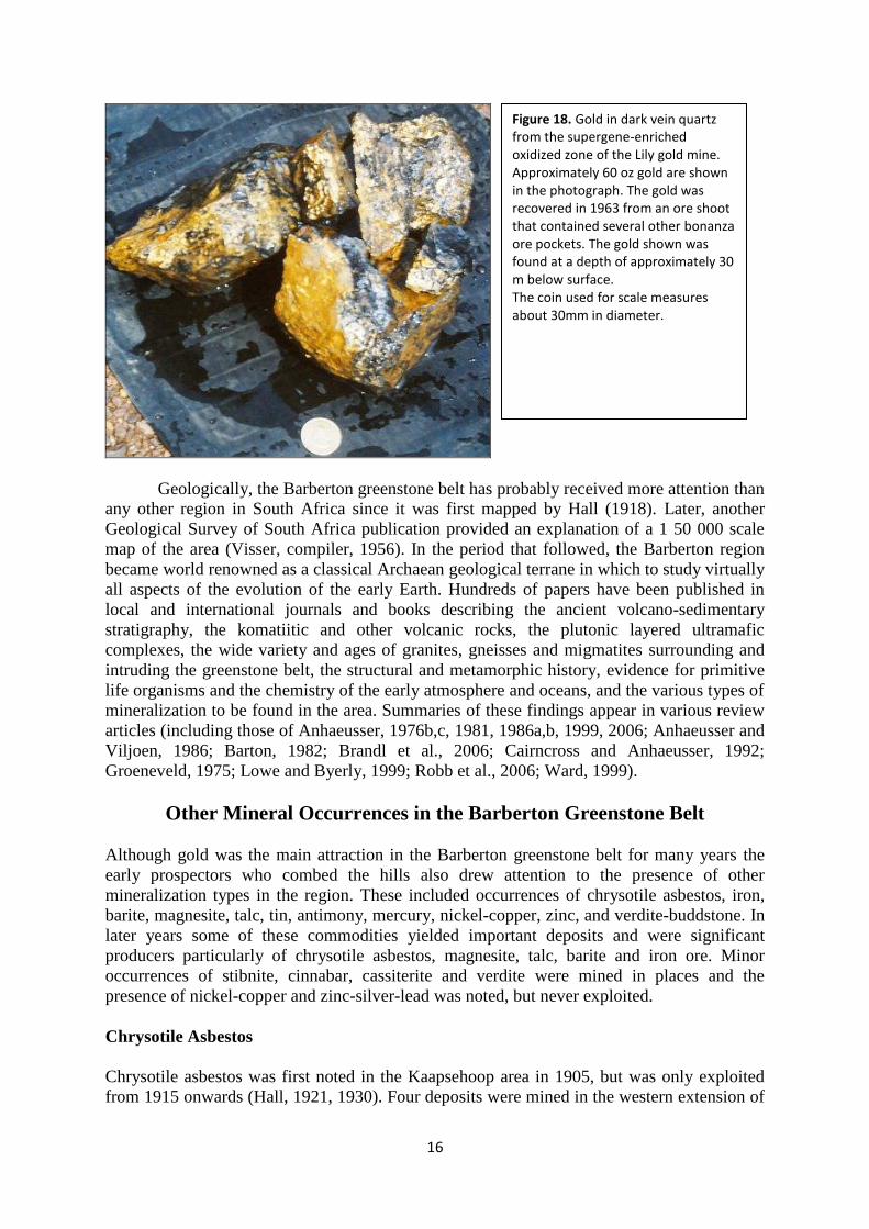
Figure 18. Gold in dark vein quartz from the supergene-enriched oxidized zone of the Lily gold mine. Approximately 60 oz gold are shown in the photograph. The gold was recovered in 1963 from an ore shoot that contained several other bonanza ore pockets. The gold shown was found at a depth of approximately 30 m below surface. The coin used for scale measures about 30mm in diameter.
17
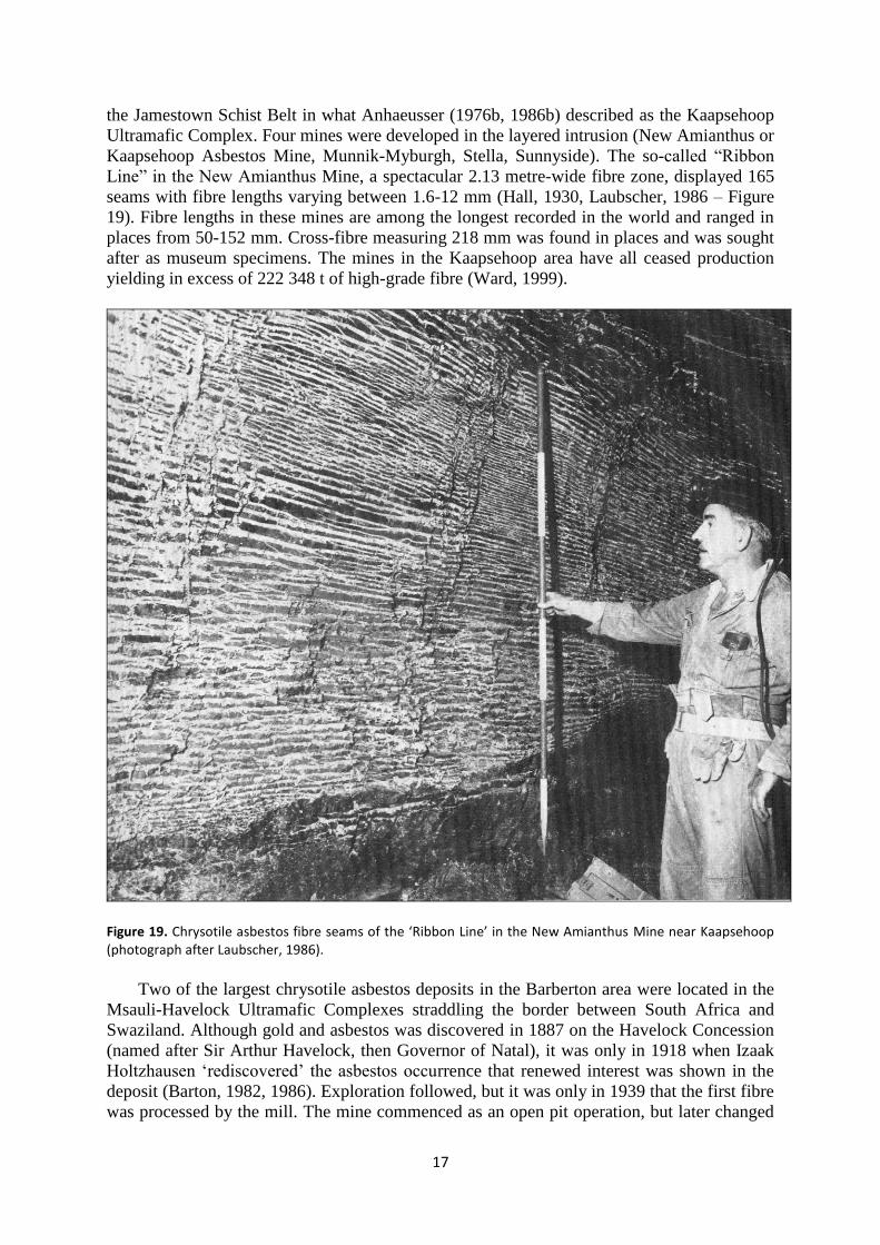
the Jamestown Schist Belt in what Anhaeusser (1976b, 1986b) described as the Kaapsehoop
Ultramafic Complex. Four mines were developed in the layered intrusion (New Amianthus or
Kaapsehoop Asbestos Mine, Munnik-Myburgh, Stella, Sunnyside). The so-called “Ribbon
Line” in the New Amianthus Mine, a spectacular 2.13 metre-wide fibre zone, displayed 165
seams with fibre lengths varying between 1.6-12 mm (Hall, 1930, Laubscher, 1986 – Figure
19). Fibre lengths in these mines are among the longest recorded in the world and ranged in
places from 50-152 mm. Cross-fibre measuring 218 mm was found in places and was sought
after as museum specimens. The mines in the Kaapsehoop area have all ceased production
yielding in excess of 222 348 t of high-grade fibre (Ward, 1999).
Figure 19. Chrysotile asbestos fibre seams of the ‘Ribbon Line’ in the New Amianthus Mine near Kaapsehoop (photograph after Laubscher, 1986).
Two of the largest chrysotile asbestos deposits in the Barberton area were located in the
Msauli-Havelock Ultramafic Complexes straddling the border between South Africa and
Swaziland. Although gold and asbestos was discovered in 1887 on the Havelock Concession
(named after Sir Arthur Havelock, then Governor of Natal), it was only in 1918 when Izaak
Holtzhausen „rediscovered‟ the asbestos occurrence that renewed interest was shown in the
deposit (Barton, 1982, 1986). Exploration followed, but it was only in 1939 that the first fibre
was processed by the mill. The mine commenced as an open pit operation, but later changed
18
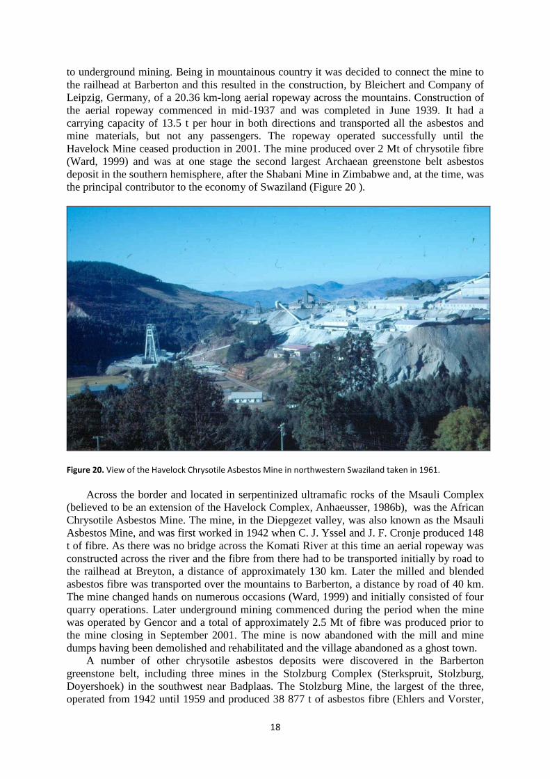
to underground mining. Being in mountainous country it was decided to connect the mine to
the railhead at Barberton and this resulted in the construction, by Bleichert and Company of
Leipzig, Germany, of a 20.36 km-long aerial ropeway across the mountains. Construction of
the aerial ropeway commenced in mid-1937 and was completed in June 1939. It had a
carrying capacity of 13.5 t per hour in both directions and transported all the asbestos and
mine materials, but not any passengers. The ropeway operated successfully until the
Havelock Mine ceased production in 2001. The mine produced over 2 Mt of chrysotile fibre
(Ward, 1999) and was at one stage the second largest Archaean greenstone belt asbestos
deposit in the southern hemisphere, after the Shabani Mine in Zimbabwe and, at the time, was
the principal contributor to the economy of Swaziland (Figure 20 ).
Figure 20. View of the Havelock Chrysotile Asbestos Mine in northwestern Swaziland taken in 1961.
Across the border and located in serpentinized ultramafic rocks of the Msauli Complex
(believed to be an extension of the Havelock Complex, Anhaeusser, 1986b), was the African
Chrysotile Asbestos Mine. The mine, in the Diepgezet valley, was also known as the Msauli
Asbestos Mine, and was first worked in 1942 when C. J. Yssel and J. F. Cronje produced 148
t of fibre. As there was no bridge across the Komati River at this time an aerial ropeway was
constructed across the river and the fibre from there had to be transported initially by road to
the railhead at Breyton, a distance of approximately 130 km. Later the milled and blended
asbestos fibre was transported over the mountains to Barberton, a distance by road of 40 km.
The mine changed hands on numerous occasions (Ward, 1999) and initially consisted of four
quarry operations. Later underground mining commenced during the period when the mine
was operated by Gencor and a total of approximately 2.5 Mt of fibre was produced prior to
the mine closing in September 2001. The mine is now abandoned with the mill and mine
dumps having been demolished and rehabilitated and the village abandoned as a ghost town.
A number of other chrysotile asbestos deposits were discovered in the Barberton
greenstone belt, including three mines in the Stolzburg Complex (Sterkspruit, Stolzburg,
Doyershoek) in the southwest near Badplaas. The Stolzburg Mine, the largest of the three,
operated from 1942 until 1959 and produced 38 877 t of asbestos fibre (Ehlers and Vorster,
19
1998). The Sterkspruit Mine produced 10 769 t of quality asbestos fibre from 1951 to 1963.
Mining continued for a number of years afterwards, but eventually closed, and was
abandoned and rehabilitated. The production in the later years is not known. The Doyershoek
Mine operated from 1943-1946 and again later from 1950-1955 and produced 4 190 t of
fibre.
The Kalkkloof Mine, north of Badplaas, is located in the Kalkkloof layered ultramafic
complex and commenced mining in 1928 and worked sporadically until 1970 when the mine
closed. It produced more than 45 000 t of asbestos fibre (Ehlers and Vorster, 1998). A
number of other chrysotile asbestos deposits were exploited in the Barberton greenstone belt
at various times, but were relatively small and production data is not known.
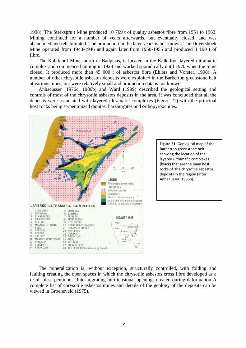
Anhaeusser (1976c, 1986b) and Ward (1999) described the geological setting and
controls of most of the chrysotile asbestos deposits in the area. It was concluded that all the
deposits were associated with layered ultramafic complexes (Figure 21) with the principal
host rocks being serpentinized dunites, harzburgites and orthopyroxenites.
The mineralization is, without exception, structurally controlled, with folding and
faulting creating the open spaces in which the chrysotile asbestos cross fibre developed as a
result of serpentinous fluid migrating into tensional openings created during deformation A
complete list of chrysotile asbestos mines and details of the geology of the deposits can be
viewed in Groeneveld (1975).
Figure 21. Geological map of the Barberton greenstone belt showing the location of the layered ultramafic complexes (black) that are the main host rocks of the chrysotile asbestos deposits in the region (after Anhaeusser, 1986b).
20
Iron
The earliest records of iron being mined in the Barberton greenstone belt date back thousands
of years. The first record of ancient mining anywhere on Earth occurred in northwestern
Swaziland. Deposits at Ngwenya were worked at least 42 000 years BP (Before Present) for
the extraction of red haematite and specularite (sparkling ores). The peoples concerned
belonged to the Middle Stone Age, which flourished in southern Africa for about 100 000
years, until almost 20 000 years ago. The red ochre was also used by later peoples as a
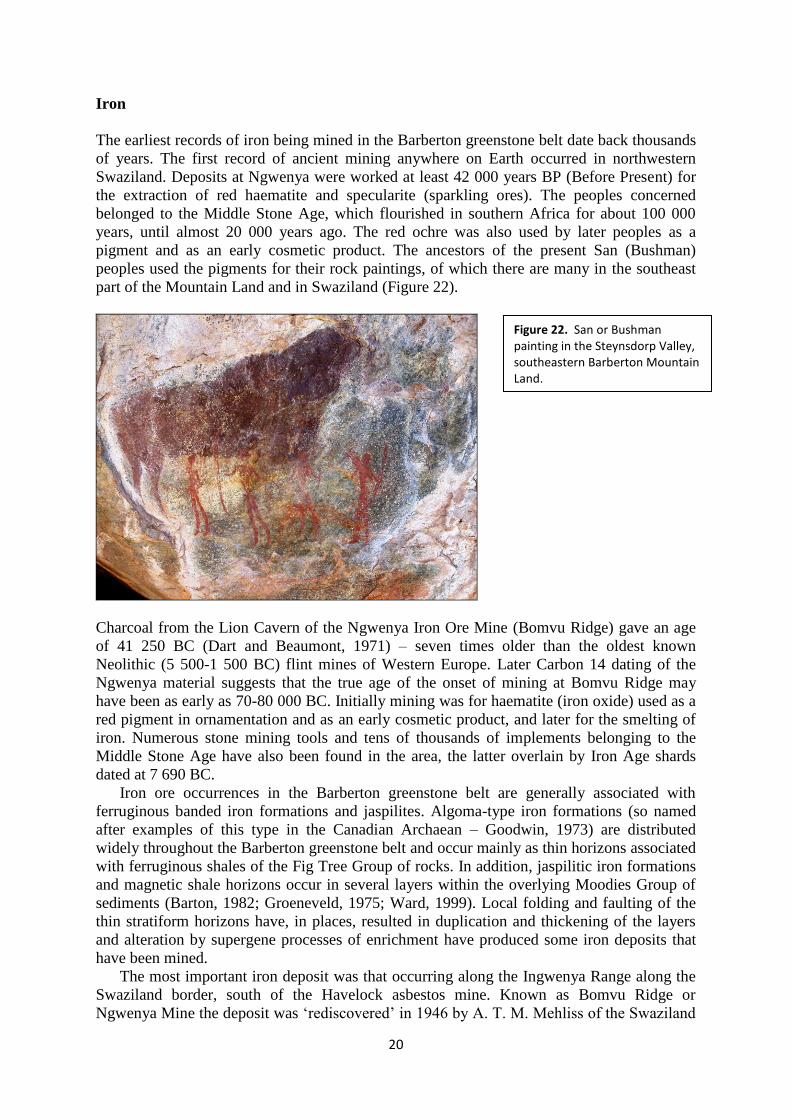
pigment and as an early cosmetic product. The ancestors of the present San (Bushman)
peoples used the pigments for their rock paintings, of which there are many in the southeast
part of the Mountain Land and in Swaziland (Figure 22).
Charcoal from the Lion Cavern of the Ngwenya Iron Ore Mine (Bomvu Ridge) gave an age
of 41 250 BC (Dart and Beaumont, 1971) – seven times older than the oldest known
Neolithic (5 500-1 500 BC) flint mines of Western Europe. Later Carbon 14 dating of the
Ngwenya material suggests that the true age of the onset of mining at Bomvu Ridge may
have been as early as 70-80 000 BC. Initially mining was for haematite (iron oxide) used as a
red pigment in ornamentation and as an early cosmetic product, and later for the smelting of
iron. Numerous stone mining tools and tens of thousands of implements belonging to the
Middle Stone Age have also been found in the area, the latter overlain by Iron Age shards
dated at 7 690 BC.
Iron ore occurrences in the Barberton greenstone belt are generally associated with
ferruginous banded iron formations and jaspilites. Algoma-type iron formations (so named
after examples of this type in the Canadian Archaean – Goodwin, 1973) are distributed
widely throughout the Barberton greenstone belt and occur mainly as thin horizons associated
with ferruginous shales of the Fig Tree Group of rocks. In addition, jaspilitic iron formations
and magnetic shale horizons occur in several layers within the overlying Moodies Group of
sediments (Barton, 1982; Groeneveld, 1975; Ward, 1999). Local folding and faulting of the
thin stratiform horizons have, in places, resulted in duplication and thickening of the layers
and alteration by supergene processes of enrichment have produced some iron deposits that
have been mined.
The most important iron deposit was that occurring along the Ingwenya Range along the
Swaziland border, south of the Havelock asbestos mine. Known as Bomvu Ridge or
Ngwenya Mine the deposit was „rediscovered‟ in 1946 by A. T. M. Mehliss of the Swaziland
Figure 22. San or Bushman painting in the Steynsdorp Valley, southeastern Barberton Mountain Land.
21
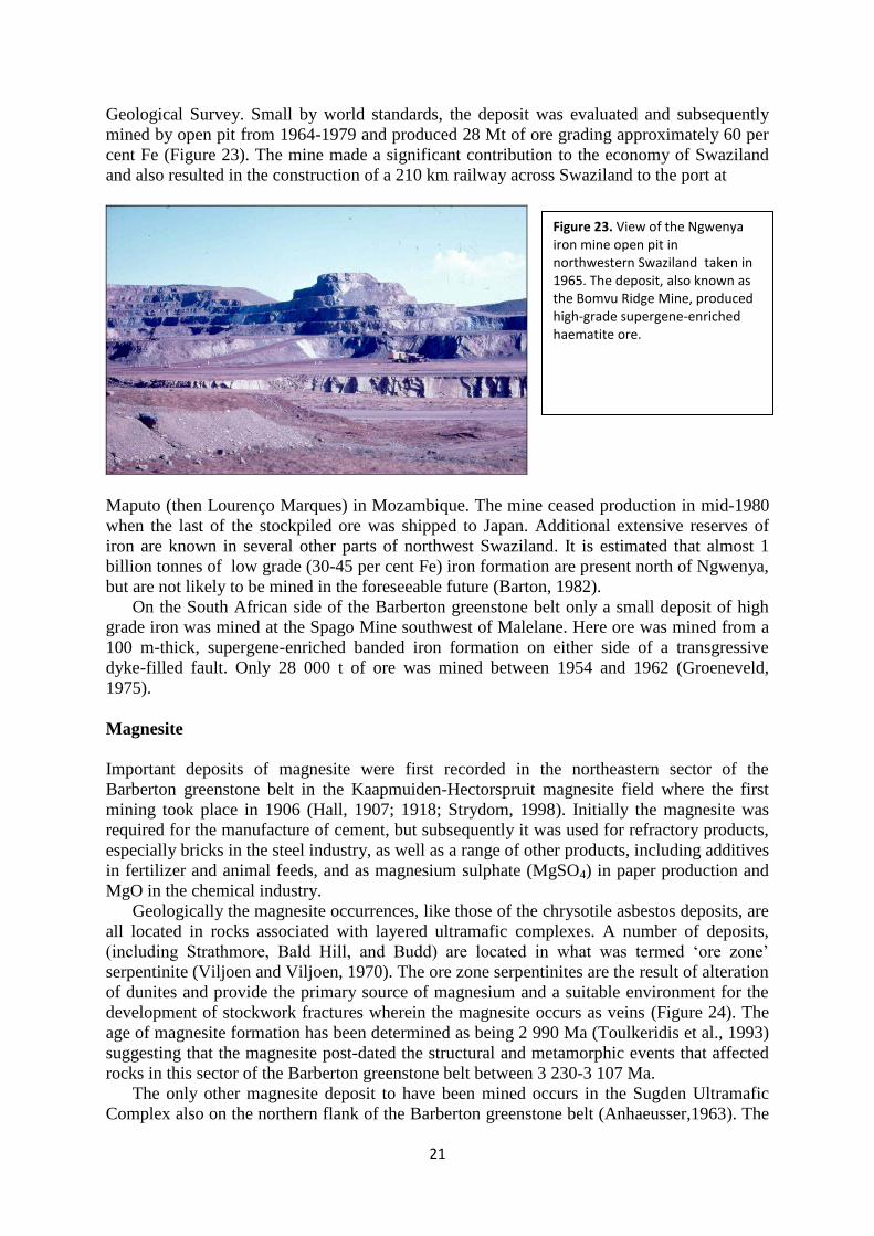
Geological Survey. Small by world standards, the deposit was evaluated and subsequently
mined by open pit from 1964-1979 and produced 28 Mt of ore grading approximately 60 per
cent Fe (Figure 23). The mine made a significant contribution to the economy of Swaziland
and also resulted in the construction of a 210 km railway across Swaziland to the port at
Maputo (then Lourenço Marques) in Mozambique. The mine ceased production in mid-1980
when the last of the stockpiled ore was shipped to Japan. Additional extensive reserves of
iron are known in several other parts of northwest Swaziland. It is estimated that almost 1
billion tonnes of low grade (30-45 per cent Fe) iron formation are present north of Ngwenya,
but are not likely to be mined in the foreseeable future (Barton, 1982).
On the South African side of the Barberton greenstone belt only a small deposit of high
grade iron was mined at the Spago Mine southwest of Malelane. Here ore was mined from a
100 m-thick, supergene-enriched banded iron formation on either side of a transgressive
dyke-filled fault. Only 28 000 t of ore was mined between 1954 and 1962 (Groeneveld,
1975).
Magnesite
Important deposits of magnesite were first recorded in the northeastern sector of the
Barberton greenstone belt in the Kaapmuiden-Hectorspruit magnesite field where the first
mining took place in 1906 (Hall, 1907; 1918; Strydom, 1998). Initially the magnesite was
required for the manufacture of cement, but subsequently it was used for refractory products,
especially bricks in the steel industry, as well as a range of other products, including additives
in fertilizer and animal feeds, and as magnesium sulphate (MgSO4) in paper production and
MgO in the chemical industry.
Geologically the magnesite occurrences, like those of the chrysotile asbestos deposits, are
all located in rocks associated with layered ultramafic complexes. A number of deposits,
(including Strathmore, Bald Hill, and Budd) are located in what was termed „ore zone‟
serpentinite (Viljoen and Viljoen, 1970). The ore zone serpentinites are the result of alteration
of dunites and provide the primary source of magnesium and a suitable environment for the
development of stockwork fractures wherein the magnesite occurs as veins (Figure 24). The
age of magnesite formation has been determined as being 2 990 Ma (Toulkeridis et al., 1993)
suggesting that the magnesite post-dated the structural and metamorphic events that affected
rocks in this sector of the Barberton greenstone belt between 3 230-3 107 Ma.
The only other magnesite deposit to have been mined occurs in the Sugden Ultramafic
Complex also on the northern flank of the Barberton greenstone belt (Anhaeusser,1963). The
Figure 23. View of the Ngwenya iron mine open pit in northwestern Swaziland taken in 1965. The deposit, also known as the Bomvu Ridge Mine, produced high-grade supergene-enriched haematite ore.
22
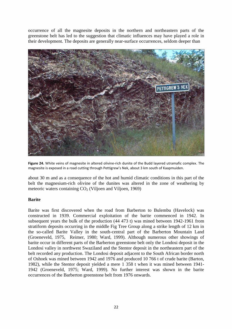
occurrence of all the magnesite deposits in the northern and northeastern parts of the
greenstone belt has led to the suggestion that climatic influences may have played a role in
their development. The deposits are generally near-surface occurrences, seldom deeper than
Figure 24. White veins of magnesite in altered olivine-rich dunite of the Budd layered utramafic complex. The magnesite is exposed in a road cutting through Pettigrew’s Nek, about 3 km south of Kaapmuiden.
about 30 m and as a consequence of the hot and humid climatic conditions in this part of the
belt the magnesium-rich olivine of the dunites was altered in the zone of weathering by
meteoric waters containing CO2 (Viljoen and Viljoen, 1969)
Barite
Barite was first discovered when the road from Barberton to Bulembu (Havelock) was
constructed in 1939. Commercial exploitation of the barite commenced in 1942. In
subsequent years the bulk of the production (44 473 t) was mined between 1942-1961 from
stratiform deposits occurring in the middle Fig Tree Group along a strike length of 12 km in
the so-called Barite Valley in the south-central part of the Barberton Mountain Land
(Groeneveld, 1975, Reimer, 1980; Ward, 1999). Although numerous other showings of
barite occur in different parts of the Barberton greenstone belt only the Londosi deposit in the
Londosi valley in northwest Swaziland and the Stentor deposit in the northeastern part of the
belt recorded any production. The Londosi deposit adjacent to the South African border north
of Oshoek was mined between 1942 and 1976 and produced 10 766 t of crude barite (Barton,
1982), while the Stentor deposit yielded a mere 1 358 t when it was mined between 1941-
1942 (Groeneveld, 1975; Ward, 1999). No further interest was shown in the barite
occurrences of the Barberton greenstone belt from 1976 onwards.
23
Nickel-Copper
Signs of ancient mining activity, in this case for copper and/or nickel, in the Nelshoogte
Schist Belt, northeast of Badplaas were first noted in 1971 by the writer while undertaking
regional geological mapping of the Stolzburg-Nelshoogte area. A gossan containing
malachite and azurite led to the area being prospected by African Selection Trust Exploration
(Pty) Limited who recorded, in 1976, sporadic, disseminated and low-grade copper-nickel
mineralization (Ward, 1999). Other early reports of nickel mineralization in the Barberton
greenstone belt were made by Hall (1924) who described nickel sulphide (millerite)
associated with chrysotile asbestos in the New Aminathus chrysotile asbestos mine near
Kaapsehoop. An occurrence of nickeliferous magnetite (trevorite) was discovered in
serpentinites on the farm Bon Accord near Sheba Siding, which occurred in a small lens
where about 25 t of ore grading 36 per cent nickel were mined (Trevor, 1920). The unusual
occurrence was described later by De Waal (1986), who also recognized several new and rare
nickel minerals in the deposit. He offered two suggestions as to the origin of the trevorite
body, the one speculating that it was an oxidized and subsequently metamorphosed nickel-
rich meteorite or, secondly, that it was an oxidized and subsequently metamorphosed
segregation of nickel-rich sulphide. The origin of the trevorite occurrence still remains
unanswered.
In the 1970s Eland Exploration (Pty) Limited investigated a nickel-sulphide prospect
in the vicinity of the Scotia Talc Mine, also at Bon Accord, and this later led to the discovery
of massive and disseminated pyrite-pyrrhotite-pentlandite-gersdorfite mineralization
(Keenan, 1986). Recent exploration by African Nickel Limited has led to the development of
a possible new mine in the area (Hornsey and Chunnet, 2009). Despite numerous other nickel
showings in ultramafic rocks found throughout the Barberton greenstone belt no nickel mine
has yet been established (Barton, 1982; Ward, 1999).
Talc
Talc was first mined in the Barberton greenstone belt in 1915 and from then until about 1942
annual production never exceeded 1 000 t. Output rose rapidly and peaked in 1953 dropping
off again in the years that followed. The most important deposits are situated along the
northern margin of the greenstone belt and are associated with ultramafic rocks found
between Malelane in the northeast and the Jamestown Schist Belt in the west. The first talc
mine in this area was the Verdite Mine, which originally began as a gold mine. More than
8000 t of talc were produced from 1915 to 1944. Talc was also mined from underground
workings in the New Albion Mine, which was also a gold mine, between 1945 and 1954.
Other talc workings in the Jamestown Schist Belt were mostly small pits and quarries from
which about 16 000 t of talc were recovered between 1948 and 1963. Details of these
operations and those further to the east in the Kaapmuiden-Malelane area are outlined in
various publications (Hall, 1918; Anhaeusser, 1969, 1972; Groeneveld, 1975; Ward, 1999).
The largest deposit, the Scotia Talc Mine north of Sheba Siding, has operated since 1918 and
has produced more than 100 000 t of industrial grade talc from altered serpentinites in which,
recently, nickel mineralization has also been located in the underground workings. Some
2000 t of pharmaceutical-grade talc and about 5 000 t of industrial-grade talc was also
produced from deposits in steatized serpentinite in dunites of the layered ultramafic
complexes in the Kaapmuiden area.
24
Verdite and Buddstone
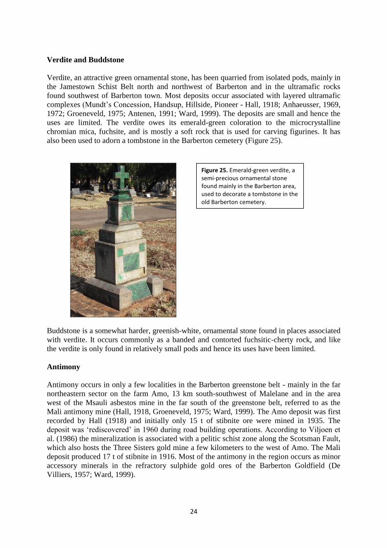
Verdite, an attractive green ornamental stone, has been quarried from isolated pods, mainly in
the Jamestown Schist Belt north and northwest of Barberton and in the ultramafic rocks
found southwest of Barberton town. Most deposits occur associated with layered ultramafic
complexes (Mundt‟s Concession, Handsup, Hillside, Pioneer - Hall, 1918; Anhaeusser, 1969,
1972; Groeneveld, 1975; Antenen, 1991; Ward, 1999). The deposits are small and hence the
uses are limited. The verdite owes its emerald-green coloration to the microcrystalline
chromian mica, fuchsite, and is mostly a soft rock that is used for carving figurines. It has
also been used to adorn a tombstone in the Barberton cemetery (Figure 25).
Buddstone is a somewhat harder, greenish-white, ornamental stone found in places associated
with verdite. It occurs commonly as a banded and contorted fuchsitic-cherty rock, and like
the verdite is only found in relatively small pods and hence its uses have been limited.
Antimony
Antimony occurs in only a few localities in the Barberton greenstone belt - mainly in the far
northeastern sector on the farm Amo, 13 km south-southwest of Malelane and in the area
west of the Msauli asbestos mine in the far south of the greenstone belt, referred to as the
Mali antimony mine (Hall, 1918, Groeneveld, 1975; Ward, 1999). The Amo deposit was first
recorded by Hall (1918) and initially only 15 t of stibnite ore were mined in 1935. The
deposit was „rediscovered‟ in 1960 during road building operations. According to Viljoen et
al. (1986) the mineralization is associated with a pelitic schist zone along the Scotsman Fault,
which also hosts the Three Sisters gold mine a few kilometers to the west of Amo. The Mali
deposit produced 17 t of stibnite in 1916. Most of the antimony in the region occurs as minor
accessory minerals in the refractory sulphide gold ores of the Barberton Goldfield (De
Villiers, 1957; Ward, 1999).
Figure 25. Emerald-green verdite, a semi-precious ornamental stone found mainly in the Barberton area, used to decorate a tombstone in the old Barberton cemetery.
25
Mercury
Very few mercury deposits are found in the Barberton greenstone belt. Those that do occur
are mainly in northwestern Swaziland and in the far northeastern part of the belt in the
Kaalrug area. This latter deposit occurs along a brecciated fault zone along the Inyoka Fault
and consisted of cinnabar, together with pyrite, native sulphur and tourmaline. About 50 t of
cinnabar were recovered in 1906. Cinnabar has also been reported from five separate
localities in northwestern Swaziland, but the showings are very erratic and little ore has been
produced (Barton, 1982). All the occurrences are thought to be of epigenetic origin formed at
shallow depth and relatively low temperature (Ward, 1999).
Tin-Tungsten
Small alluvial and eluvial tin occurrences occur only in the Oshoek-Forbes Reef areas of
northwestern Swaziland. Primary tin mineralization occurs in talc-carbonate schist near the
contact with the Mpuluzi batholith. The hosts to most of the alluvial and eluvial deposits are
pegmatite veins carrying disseminated cassiterite (Barton, 1982; Ward, 1999). A small
tungsten deposit (scheelite) associated with lode gold occurs in the same area near Forbes
Reef.
Zinc
Despite the presence of abundant felsic volcanic and plutonic rocks, which in other
greenstone belts, like those in Canada, are hosts to important copper-zinc ores, these rocks in
the Barberton greenstone belt are largely devoid of this type of mineralization. Only one
deposit showing some potential occurs in the Three Sisters area approximately 35 km
northeast of Barberton. Referred to as the Bien Venue zinc deposit this pyritic zinc-silver-
gold-copper-lead-arsenic-barium-antimony occurrence was investigated by Anglo American
Prospecting Services during the period 1978-1986 and again later by Gencor in 1990-1991. A
drill indicated resource of 1.6 million tonnes grading 3.88 per cent zinc was reported with
minor accessory mineralization (Ward, 1999).No mining of the deposit has taken place.
SUMMARY
The Barberton greenstone belt, an early Archaean granite-greenstone terrane extending from
South Africa across the border into northwestern Swaziland, has had a colourful mining
history largely centred around gold mineralization. Additional mines of significance that
came on stream in later years included mainly the large deposits of chrysotile asbestos, iron
and magnesite. The remaining mineralization types described earlier were of small scale and
more of curiosity value than economically important producers. They nevertheless
contributed to the development of the region as a whole, but the deposits are now largely
worked out. Gold clearly provided the main impetus for the sustained development of the
region and may continue to contribute into the foreseeable future.
REFERENCES
Anhaeusser, C. R. (1963). The geology of the Lily syncline and portion of the Eureka syncline
between Sheba Siding and Louw’s Creek Station, Barberton Mountain Land. M.Sc thesis (unpublished), University of the Witwatersrand, Johannesburg, 138 pp.
26
Anhaeusser, C. R. (1969). The stratigraphy, structure and gold mineralization of the Jamestown and Sheba Hills area of the Barberton Mountain Land. Ph.D. thesis (unpublished), University of the Witwatersrand, Johannesburg, 332 pp.
Anhaeusser, C. R. (1972). The geology of the Jamestown Hills area of the Barberton Mountain Land, South Africa. Transactions of the Geological Society of South Africa, 75, 225-263.
Anhaeusser, C. R. (l976a). The geology of the Sheba Hills area of the Barberton Mountain Land, South Africa, with particular reference to the Eureka Syncline. Transactions of the Geological Society of South Africa, 79 (2), 253-280.
Anhaeusser, C. R. (l976b). The nature and distribution of Archaean gold mineralization in southern Africa. Minerals Science and Engineering, 8 (l), 46-84.
Anhaeusser, C. R. (l976c). The nature of chrysotile asbestos occurrences in southern Africa: a review. Economic Geology, 7l (l), 96-ll6.
Anhaeusser, C. R. (l98l). The relation of mineral deposits to early crustal evolution. Economic Geology, 75th Anniversary Volume, p. 42-62.
Anhaeusser, C. R. (l984). Structural elements of Archaean granite-greenstone terranes as exemplified by the Barberton Mountain Land, southern Africa, 57-78. In: Kröner, A. and Greiling, R. eds. Precambrian Tectonics Illustrated. E. Schweizerbart’sche Verlagsbuchhandlung (Nagele u. Obermiller, Stuttgart, 419 pp.
Anhaeusser, C. R. (l986a). Archaean gold mineralization in the Barberton Mountain Land, 113-154. In: Anhaeusser, C. R. and Maske, S. eds. Mineral Deposits of Southern Africa, I. Geological Society of South Africa, 1020 pp.
Anhaeusser, C. R. (l986b). The geological setting of chrysotile asbestos occurrences in Southern Africa, 359-375. In: Anhaeusser, C. R. and Maske, S. eds. Mineral Deposits of Southern Africa, I. Geological Society of South Africa, 1020 pp.
Anhaeusser, C. R. (1986c). The Lily Gold Mine, Barberton greenstone belt: geology, mineralogy and supergene gold enrichment, 187-196. In: Anhaeusser, C. R. and Maske, S. eds. Mineral Deposits of Southern Africa, I. Geological Society of South Africa, 1020 pp.
Anhaeusser, C. R. (1999). Barberton greenstone belt, 92-104. In: Viljoen M. J. and Reimold, W. U. eds. An Introduction to South Africa’s Geological and Mining Heritage, Mintek Publishers, Randburg, 193 pp.
Anhaeusser, C. R. (2006). Mafic and ultramafic intrusions of the Kaapvaal Craton. In: Johnson, M. R., Anhaeusser, C. R. and Thomas, R. J. eds. (2006). The Geology of South Africa. Geological Society of South Africa, Johannesburg and Council for Geoscience, Pretoria, p. 95- 134.
Anhaeusser, C. R. and Viljoen, M. J. (1986). Archaean metallogeny of South Africa, 33-42. In: Anhaeusser, C. R. and Maske, S. eds. Mineral Deposits of Southern Africa, I. Geological Society of South Africa, 1020 pp.
Antenen, D. (1991). A review of southern African verdites. Report (unpublished), Geological Survey of South Africa, 23 pp.
Baines, T. (1877). The gold regions of south east Africa. London, Edward Staford, 240 pp.
Facsimile reproduction by Books of Rhodesia Pub. Co., Bulawayo, 1968, 240 pp. Barton, C. M. (1982). Geology and mineral resources of northwestern Swaziland (Barberton
greenstone belt). Bulletin, Geological Survey and Mines Department, Mbabane, Swaziland. 97 pp.
Barton, C. M. (1986). The Havelock asbestos deposit in Swaziland, Barberton greenstone belt, 395-407. In: Anhaeusser, C. R. and Maske, S. eds. Mineral Deposits of Southern Africa, I.
27
Geological Society of South Africa, 1020 pp. Brandl, G, Cloete, M. and Anhaeusser, C. R. (2006). Archaean greenstone belts, 9-56. In:
Johnson, M. R., Anhaeusser, C. R. and Thomas, R. J. eds. The Geology of South Africa. Geological Society of South Africa, Johannesburg/Council for Geoscience, Pretoria, 691 pp
Byron, C. L. and Barton, J. M. (1990). The setting of mineralization in a portion of the Eersteling goldfield, Pietersburg granite-greenstone terrane, South Africa. South African Journal of Geology, 93, 463-472.
Cairncross, B. and Anhaeusser, C. R. (1992). Gold in South Africa. Mineralogical Record, 23, 209-228.
Cartwright, A. P. (1961). Valley of Gold. Howard Timmins, Cape Town, 187 pp. Curror, W. D. (1967). Golden Memories of Barberton. The Barberton and District Publicity
Association, Barberton. 85 pp. Curror, W. D. and Bornman, H., (2002). Golden Memories of Barberton. African Pioneer
Mining, 275 pp. Dart, R. A. and Beaumont, P. (1971). On a further radiocarbon date for ancient mining in
southern Africa. South African Journal of Science, 67, 10-11. De Villiers, J. E. (1957). The mineralogy of the Barberton gold deposits. Bulletin, Geological
Survey of South Africa, 24, 60 pp. De Waal, S. A. (1986). The Bon Accord nickel occurrence at Barberton, 287-291. In:
Anhaeusser, C. R. and Maske, S. eds. Mineral Deposits of Southern Africa, I. Geological Society of South Africa, 1020 pp.
Ehlers, D. L. and Vorster, C. J. (1998). Asbestos, 68-75. In: Wilson, M. G. C. and Anhaeusser, C. R. eds. The Mineral Resources of South Africa. Handbook, Council for Geosciences, 16, 740 pp.
Goodwin, A. M. (1973). Archaean iron formations and tectonic basins of the Canadian Shield. Economic Geology, 68, 915-933.
Groeneveld, D. Comp. (1975). The economic mineral deposits in the Archaean Complex of the Barberton area. Unpublished Internal Report, Geological Survey of South Africa, 1975-0106, 360 pp.
Hall, A. L. (1907). The magnesite deposits of Malelane. Annual Report, Geological Survey of the Transvaal, 1906, 127-132.
Hall, A. L. (1908). The geology of the country east of Potgietersrust, including the Marabastad Goldfield. Report Geological Survey of South Africa., 61-102.
Hall, A. L. (1910). The geology of the Pilgrims Rest Gold Mining District. Memoir, Geological Survey of South Africa, 5, 158 pp.
Hall, A. L. (1918). The geology of the Barberton gold mining district, including adjoining portions of Northern Swaziland. Memoir, Geological Survey of South Africa, 9, 347 pp.
Hall, A. L. (1921). On the asbestos occurrences near Kaapsche Hoop in the Barberton district. Transactions of the Geological Society of South Africa, 24, 168-181.
Hall, A. L. (1924). Note on oval lumps of nickel sulphide in asbestos from Kaapsche Hoop, in the Barberton district. Transactions of the Geological Society of South Africa, 27, 57-61.
Hall, A. L. (1930). Asbestos in the Union of South Africa. Memoir, Geological Survey of South Africa, 12, 324 pp.
Handley, J. R. F. (2004). Historic Overview of the Witwatersrand Goldfields. Handley, Howick, 224 pp.
28
Hornsey, R. and Chunnet, I. (2009). The Bon Accord Ni-sulphide deposit – Ni-sulphide mineralisation within the 3.4-3.5Ga Barberton Greenstone Belt, South Africa Abstract, (African Nickel Limited). Cu-Ni Symposium, Xian, China.
Keenan, J. (1986). The Bon Accord nickel sulphide deposit, Barberton greenstone belt, 281-285. In: Anhaeusser, C. R. and Maske, S. eds. Mineral Deposits of Southern Africa, I. Geological Society of South Africa, 1020 pp.
Laubscher, D. H. (1986). The New Amianthus chrysotile asbestos deposit, Kaapsehoop, Barberton greenstone belt, 421-426. In: Anhaeusser, C. R. and Maske, S. eds. Mineral Deposits of Southern Africa, I. Geological Society of South Africa, 1020 pp.
Lowe, D. R. and Byerly, G. R. eds. (1999). Geologic evolution of the Barberton greenstone belt and vicinity. Geologic Evolution of the Barberton Greenstone Belt, South Africa. Special Paper, Geological Society of America, 329, 319 pp.
Meiring, P. (1976). Dynamite and Daisies - The Story of Barberton. Purnell, Cape Town, 177 pp. Norman, N. and Whitfield, G. (2006). Geological Journeys: A Traveller's Guide to South
Africa's Rocks and Landforms. Struik Publishers, Cape Town, 323 pp. Pretorius, D. A., (1965). Fragments of History. Post-Congress Excursion, Barberton Mountain
Land. Economic Geology Research Unit, University of the Witwatersrand, Johannesburg, 57 pp.
Reimer, T. O. (1980). Archaean sedimentary baryte deposits of the Swaziland Supergroup (Barberton Mountain Land, South Africa). Precambrian Research, 12, 393-410.
Robb, L. J., Brandl, G., Anhaeusser, C. R. and Poujol, M. (2006). Archaean granitoid intrusions, 57-94. In: Johnson, M. R., Anhaeusser, C. R. and Thomas, R. J. eds. The Geology of South Africa. Geological Society of South Africa, Johannesburg/Council for Geoscience, Pretoria, 691 pp
Saager, R. and Muff, R. (1986). The gold occurrences of the Eersteling Goldfield, Pietersburg greenstone belt, 205-211. In: Anhaeusser, C. R. and Maske, S. eds. Mineral Deposits of Southern Africa, I. Geological Society of South Africa, 1020 pp.
Schweigart, H. and Liebenberg, W. R. (1966). Mineralogy and chemical behaviour of some refractory gold ores from the Barberton Mountain Land, South Africa. Report, National Institute for Metallurgy, Johannesburg, 8, 97 pp.
Staff of Barberton Museum and Bornman, H., Compilers (1984). Photo History of Barberton 1884-1984. Town Council of Barberton, 72 pp.
Strydom, J. H. (1998). Magnesite. In: Wilson, M. G. C. and Anhaeusser, C. R., eds. The Mineral Resources of South Africa. Handbook, Council for Geosciences, 16, p. 444-449.
Summers, R. (1969). Ancient mining in Rhodesia. Memoir, National Museum of Southern Rhodesia, 3, 236 pp.
Toulkeridis, T., Peucker-Ehrenbring, B., Kröner, A. and Schidlowski, M. (1993). Geochemistry and timing of magnesite formation in the Barberton greenstone belt. 16th International Colloquium of African Geology, Mbabane, Swaziland, 2, 345-347.
Trevor, T. G. (1920). Nickel. Notes on the occurrence in the Barberton district. South African Journal of Industries, 3, 532-533.
Van Aswegen, P. C., Van Niekerk, J. and Olivier, W. (2007). The BOIX TM process for the treatment of refractory gold concentrates, 1-5. In: Rawlings, D. E. and Johnson, D. B., eds. Biomining, Springer-Verlag Berlin, 314 pp.
Visser, D. J. L. compiler (1956). The geology of the Barberton area. Special Publication, Geological Survey of South Africa, 15, 253 pp.
Viljoen, R. P. and Viljoen, M. J. (1969). The relationship between mafic and ultramafic magma
29
derived from the upper mantle and the ore deposits of the Barberton region. Special Publication, Geological Society of South Africa, 2, 221- 244.
Viljoen, R. P. and Viljoen, M. J. (1970). The geology and geochemistry of the layered ultramafic bodies of the Kaapmuiden area, Barberton Mountain Land. Special Publication, Geological Society of South Africa, 1, 661-688.
Viljoen, M. J., Muff, R. and Paizes, P. (1986). The Amo antimony deposit, Barberton greenstone belt, 349-358. In: Anhaeusser, C. R. and Maske, S. eds. Mineral Deposits of Southern Africa, I. Geological Society of South Africa, 1020 pp.
Viljoen, R. P., Saager, R. and Viljoen, M. J. (1969). Metallogenesis and ore control in the Steynsdorp Goldfield, Barberton Mountain Land, South Africa. Economic Geology, 64, 778-797
Ward, J. H. W. (1999). The metallogeny of the Barberton greenstone belt, South Africa and Swaziland. Memoir, Council for Geosciences, 86, 108 pp.
Ward, J. H. W. and Wilson, M. G. C. (1998). Gold outside the Witwatersrand Basin, 350-386. In: Wilson, M.G.C. and Anhaeusser, C. R., eds. The Mineral Resources of South Africa. Handbook, Council for Geosciences, 16, 740 pp.
Watts, B. H. Comp. (1954). Gold-mining in the Eastern Transvaal – a Bibliography. School of Librarianship, University of Cape Town, 21 pp.
Willemse, J. (1938). The gold occurrences south-west of Pietersburg. Bulletin, Geological Survey of South Africa, 12, 38 pp.
____________ooOoo____________


![li Work performed by: Juma Mining 6 Exploration Ltd. Footage · 2017. 1. 17. · r r ;en. tone greenstone re.n-t^r* n" '^ Q^! rt? "t ring.] rfl^nstnna greenstone nerro? quartz stringer;](https://img.pdfslide.us/doc/110x75/60feaf4edc834a7c7c4783c8/li-work-performed-by-juma-mining-6-exploration-ltd-2017-1-17-r-r-en-tone.jpg)