Embed Size (px)
Citation preview

THE HISTORY OF FORMING AND STUDY OF THE CARTOGRAPHIC COLLECTIONS OF THE RUSSIAN
STATE LIBRARY
Liudmila N. Zinchuk Head of the Map Department
Russian State Library Vozdvizhenka, 3/5, Moscow, 119019, RUSSIA
Fax: 7-095-913-69-33 Phone: 7-095-202-61-09
e-mail: [email protected]
ABSTRACT. The Russian State Library's Cartographic Collections hold numerous maps, atlases, and geographies relating to all branches of the History of Cartography. The Collections include manuscript and printed cartographic documents from the early time up today. The Cartographic Collections are stored at different departments and divisions of the Library - that is their specific feature. The history of the forming of the Collections corresponds to the history of the whole Library. The distinguished private collections of the Count Rumyantsev composed its initial base. Later more then fifty private collections had been gifted to the Library. From the end of the nineteenth century the Library began to receive the obligatory copy off all printing documents. The volume of cartographic foundation increased considerable. Nevertheless purposeful research of cartographic collections began only in the end of twentieth century after the Map Department had been created in the Library. Key words: Russian State Library -- Cartographic Collections THE HISTORY OF THE FORMING AND STUDY OF THE CARTOGRAPHIC COLLECTIONS OF THE RUSSIAN STATE LIBRARY The Russian State Library's Cartographic Collections constitute an extremely valuable scientific resources for historians of cartography. The Collections hold numerous maps, atlases, and geographies relating to all branches of the History of Cartography. The Collections include cartographic masterpieces of the most famous mapmakers of the world from Ptolemy's Geographia to manuscript Russian charts and atlases and documents of the modern cartography. The Russian State Library's Cartographic Collections are stored at different department and divisions of the Library - that is their specific feature. The history of the forming of the Collections corresponds to the history of the whole Library. The distinguished private collections of the famous Russian Chancellor of State Count Rumyantsev composed its initial base. Later more then fifty private collections of Russian statesmen, diplomats, people of science and art had been gifted to the Library "for the Benefit of Enlightenment". Nearly all the Collections included cartographic materials but they were hidden in a body of collections. Brief descriptions of some collections and separate cartographic documents had been carried out but they had been irregular and unsystematic. The philologist Alexander Vostokov (1781 - 1864) was one of the first researchers of Rumyantsev's collections. In 1842 after Rumyantsev's death A. Vostokov completed "Description of Russian and Slavic Manuscripts of the Rumyantsev Museum" (St. Petersburg, 1842). The first detailed bibliographic description of the "The Drawing book of Siberia" by S. Remesov (Fig.3) had been carried out in that study. In 1846 Russian historian, philologist and bibliographer Feodor Adelung (1768 - 1843) compiled bibliographic catalogue of foreign maps of Russia. Another Russian bibliographer and bibliophile Nicholai Bokachov (1846 - 1915) compiled and published the following studies: "Descriptions of the Russian libraries and bibliographic items of Bokachov's historic and archeological library" (1890) and "The catalogue of works which consist Russian historical and archeological library of N. Bokachov" (1892). The first part of the last edition deals with geographic maps of Russia. So it is known that Nicholai Rumyantsev's collection contained more then 500 printed and manuscript maps and atlases. The most famous of them are: manuscript "The Drawing book of Siberia" by S. Remesov (1701), Atlas of Silesia (Nuremberg: Homanni, 1750), Atlas Minor by G. Mercator (175.). There were Cosmography by Claudius Ptolemy (Ulm, 1486) in Rumyantsev's collection (Fig.1). It was published by German printer Johann Holl, with translation by a Florentine scientist, Jacob Angeli, with 32 wood engraved maps.
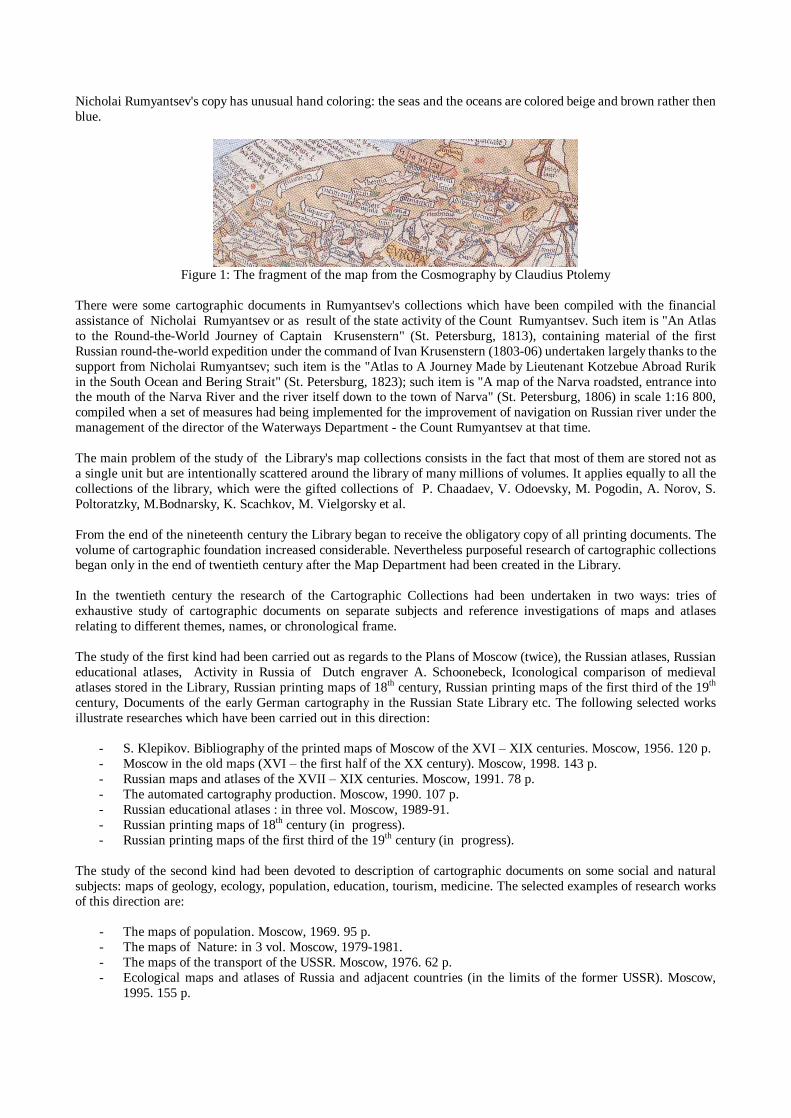
Nicholai Rumyantsev's copy has unusual hand coloring: the seas and the oceans are colored beige and brown rather then blue.
Figure 1: The fragment of the map from the Cosmography by Claudius Ptolemy
There were some cartographic documents in Rumyantsev's collections which have been compiled with the financial assistance of Nicholai Rumyantsev or as result of the state activity of the Count Rumyantsev. Such item is "An Atlas to the Round-the-World Journey of Captain Krusenstern" (St. Petersburg, 1813), containing material of the first Russian round-the-world expedition under the command of Ivan Krusenstern (1803-06) undertaken largely thanks to the support from Nicholai Rumyantsev; such item is the "Atlas to A Journey Made by Lieutenant Kotzebue Abroad Rurik in the South Ocean and Bering Strait" (St. Petersburg, 1823); such item is "A map of the Narva roadsted, entrance into the mouth of the Narva River and the river itself down to the town of Narva" (St. Petersburg, 1806) in scale 1:16 800, compiled when a set of measures had being implemented for the improvement of navigation on Russian river under the management of the director of the Waterways Department - the Count Rumyantsev at that time. The main problem of the study of the Library's map collections consists in the fact that most of them are stored not as a single unit but are intentionally scattered around the library of many millions of volumes. It applies equally to all the collections of the library, which were the gifted collections of P. Chaadaev, V. Odoevsky, M. Pogodin, A. Norov, S. Poltoratzky, M.Bodnarsky, K. Scachkov, M. Vielgorsky et al. From the end of the nineteenth century the Library began to receive the obligatory copy of all printing documents. The volume of cartographic foundation increased considerable. Nevertheless purposeful research of cartographic collections began only in the end of twentieth century after the Map Department had been created in the Library. In the twentieth century the research of the Cartographic Collections had been undertaken in two ways: tries of exhaustive study of cartographic documents on separate subjects and reference investigations of maps and atlases relating to different themes, names, or chronological frame. The study of the first kind had been carried out as regards to the Plans of Moscow (twice), the Russian atlases, Russian educational atlases, Activity in Russia of Dutch engraver A. Schoonebeck, Iconological comparison of medieval atlases stored in the Library, Russian printing maps of 18th century, Russian printing maps of the first third of the 19th century, Documents of the early German cartography in the Russian State Library etc. The following selected works illustrate researches which have been carried out in this direction:
- S. Klepikov. Bibliography of the printed maps of Moscow of the XVI � XIX centuries. Moscow, 1956. 120 p. - Moscow in the old maps (XVI � the first half of the XX century). Moscow, 1998. 143 p. - Russian maps and atlases of the XVII � XIX centuries. Moscow, 1991. 78 p. - The automated cartography production. Moscow, 1990. 107 p. - Russian educational atlases : in three vol. Moscow, 1989-91. - Russian printing maps of 18th century (in progress). - Russian printing maps of the first third of the 19th century (in progress).
The study of the second kind had been devoted to description of cartographic documents on some social and natural subjects: maps of geology, ecology, population, education, tourism, medicine. The selected examples of research works of this direction are:
- The maps of population. Moscow, 1969. 95 p. - The maps of Nature: in 3 vol. Moscow, 1979-1981. - The maps of the transport of the USSR. Moscow, 1976. 62 p. - Ecological maps and atlases of Russia and adjacent countries (in the limits of the former USSR). Moscow,
1995. 155 p.

The tries of the study of cartographic documents from the different private collections stored in the Russian State Library have been undertaken last years. But there are some difficulties in this way of research of cartographic materials because many attributive signs are lost and researchers have to determine the former owner of the cartographic document by indirect means. For example, for the items from the Rumyantsev's collections such indirect signs are: specific light brown color of the binding; pink color of edge; distinctive drawing of fly-leaf. A bookplate of the Rumyantsev's collections (Fig.2) with words �Non solum armis� from the Rumyantsev�s motto in oval round the Rumyantsev's heraldic emblem is direct evidence of the former belonging of any document to Rumyantsev's collection.
Figure 2: A bookplate of Rumyantsev's collection
The study of cartographic documents stored in different private collections is in progress now. During two last years in Map Department of the Russian State Library researchers succeeded in finding of 6 map from Chaadaev�s collection, 8 cartographic documents from the collection of Odoevsky, 10 documents from the Pogodin�s collection, 18 items belonging to Veltman� collection, about twenty documents from the collection of the Count Chernyshov, several dozen items from the collections of Romanov dynasty. The study of the Russian State Library's Cartographic Collections is in the very beginning and will be continued.
Figure 3: The title page of the "The Drawing book of Siberia" by S. Remesov.