Embed Size (px)
Citation preview

1
The Hamilton region of south-western
Victoria
An historical perspective of landscape, settlement and
impacts on Aborigine occupants, flora and fauna
Rod Bird
2011

2
Cover photo:
Aboriginal rock art in Burrunj (Western Black Range), Victoria (Rod
Bird 1974).
Other photographs are also by the author.
This report contains some material prepared for RMIT University student
tours to SW Victoria in 1998-2002 and for a Public Forum “Managing
our waterways – past, present and future” held by the Glenelg-Hopkins
CMA on 30 May 1999.
A series of 7 articles on this theme were published in the Hamilton
Spectator, from 10 July to 19 Aug 1999.
A version of ‘Currewurt spirits in stone’ (Rod Bird, 2009) was set to
music by Vaughan McAlley (University of Melbourne), commissioned by
the Southern Grampians Promenade of Sacred Music Committee. It was
performed in the ‘Promenade Prom’ concert in St Andrew’s Presbyterian
Church, Hamilton, on 17 April 2010. The conductor was Douglas
Lawrence OAM and the soprano was Deborah Kayser.
Publisher:
PR Bird
21 Collins St
Hamilton, Vic 3300.
Author:
Rod Bird (Patrick Rodney Bird, PhD, OAM), 1942-
The Hamilton region of south-western Victoria:
an historical perspective of landscape, settlement and impacts on
Aborigine occupants, flora and fauna
ISBN: 978-0-9870791-5-2
Disclaimer:
Every effort has been made to ensure that the information in this report is
accurate but the author and publisher do not guarantee that it is without flaw of
any kind and therefore disclaims all liability for any error, loss or other
consequence that may arise from you relying on any information in it.

3
Prologue Currewurt spirits in stone
High on the eastern face of Burrunj
on ledges mottled with moss and Micromyrtus
a shaft of morning sunlight surprises
a lone hand stencil,
crafted from red ochre blown
on a sandstone wall.
Through ten thousand long summers,
over five hundred generations of man,
that fiery image proclaims
‘I have lived,
this is a symbol of my life,
set in stone’.
Along the western flank of Billawin
Wab Manja thrusts through Stringy-bark heath;
lightning flares and slinks to shadows,
as rain spears to sandstone walls
where stick-figures watch,
and whisper on the wind.
A throng of faded Jardwadjali hands
reach out over ten thousand winters;
a glow of campfires in the gloom,
lingering echoes of lament
and children laughing,
spirits in stone.
Wab Manja in Grampians/Gariwerd National Park – pictographs photographed in 1994.
Notes: Currewurt ("Cur.re.wurt") or Gariewerd – now known as the Grampian Range
Burrunj – now known as the western Black Range
Micromyrtus – Fringed Heath-myrtle, a small pink-flowered shrub
Billawin – now known as the Victoria Range of the Grampians
Wab Manja ("Wep Man.ya") – a sandstone outcrop known locally as ‘The Cave of Hands’
Jardwadjali ("Yard.wa.djali") – the tribal language group of the Aboriginal clans who lived west of
Currewurt (Gariwerd).

4
Photo 6 (Sept. 2009). River Red Gum (Eucalyptus camaldulensis) woodland at ‘Kenilworth’ on the banks of the
Wannon River, west of Cavendish. Squatters appropriated the land for a pastoral run in 1839. The laterised,
sedimentary Dundas Tableland was open ‘Red Gum country’ when, in the spring of 1836, Major Mitchell’s party toiled
with heavy carts through the land he called “Australia Felix”. The land was soon invaded by squatters.
Photo 7 (June 1974). The scene below is a view from Mt Sturgeon (Grampian Range) across the basaltic plains to Mt
Napier, a scoria cone formed 30,000 years ago. Note the River Red Gums on the sandy outwash slope from the
Grampians and the Lakes Linlithgow and Kennedy in the mid-ground. The Great Swamp (Buckley Swamp) lies
beyond and Mitchell had to negotiate a plethora of wetlands on his way from Portland north east to the Grampians.

5
Contents
Prologue .................................................................................................................................... 3
Introduction .......................................................... .................................................................. 6
Landscapes
Volcanic Plains, Rolling Hills & Wetlands ............................................................ 6
Laterised Tablelands ............................................................................................... 6
Casterton Rolling Hills ........................................................................................... 6
Grampians Ranges & Plains ................................................................................... 6
Sedimentary Rises & Plains ................................................................................... 7
Exploration – the first contact
Major Thomas Mitchell .......................................................................................... 7
Grenville Chetwynd Stapylton ................................................................................ 7
John Bryan ............................................................................................................. 7
Captain Foster Fyans .............................................................................................. 7
Surveyor CJ Tyers .................................................................................................. 8
David Alexander Beath .......................................................................................... 9
James Bonwick ...................................................................................................... 9
George Augustus Robinson .................................................................................... 9
Settlement
The Squatters (1838-1850) ................................................................................... 11
Early impacts of sheep on the land ....................................................... 12
Dispossession of Aborigine occupants .................................................. 12
Frontier resistance war .......................................................................... 14
Miners & timber cutters (1850-1860) ................................................................... 15
Selectors (1860-1900)
1860s Land Acts ................................................................................... 15
1869 land Act ....................................................................................... 16
1881 Land Act ...................................................................................... 16
1884 Land Act ...................................................................................... 16
Fencing of pastoral runs ........................................................................ 16
Liver fluke & foot rot ........................................................................... 16
Tree clearance ....................................................................................... 16
Sugar Gum belts ................................................................................... 17
Rabbits .................................................................................................. 17
Closer Settlement (1900-1960) ............................................................................ 17
Closer Settlement Acts .......................................................................... 17
Soldier Settlement ................................................................................. 17
Superphosphate & Subterranean Clover ............................................... 17
Sawmills & the forest industry .............................................................. 17
Fauna ............................................................................................................................ 18
Flora .............................................................................................................................. 19
Rivers, soil erosion & salinity
Dams & river ‘improvement’ works .................................................................. 21
Soil conservation works ..................................................................................... 22
Salinity .............................................................................................................. 22
Wetlands & drainage ................................................................................................... 23
Restoration of wetlands in south-west Victoria ................................................. 24
Buckley Swamp ................................................................................................. 24
Lake Condah ...................................................................................................... 24
References ..................................................................................................................... 25
Appendix (photographs)................................................................................................. 27

6
The natural history of the Hamilton region of south-western
Victoria: an historical perspective of landscape, settlement and
impacts on Aborigine occupants, flora and fauna
Rod Bird
Introduction
One objective of this article is to provide a glimpse of the history of the SW region of Victoria as it was
before European settlement – the landscape, Aborigine people, fauna and flora – largely through selected
quotations from the writings of the first European explorers, settlers and Government officials.
A brief attempt will also be made to satisfy curiosity on questions such as:
- What are the broad geological features of the local landscapes?
- What did some of the catchments (local rivers, lakes and landscape) once look like?
- What people lived in the SW area prior to European settlement there?
- What plants grew in the catchment before settlement?
- What fauna lived in the SW area before and after settlement?
- What were the processes and results of change in landuse? (This will be considered in relation to 5
major phases of settlement: exploration, squatters, gold miners, selectors & closer settlement).
- What should we do to restore biodiversity associated with our drained wetlands?
Landscapes
The landscapes of the region around Hamilton in SW Victoria – the Grange Burn Catchment and areas
beyond – are broadly represented by 5 geological land-zones. A summary is presented below:
Volcanic Plains, Rolling Hills & Wetlands - Older basaltic plains, with a crust of basic lava from 4-40 m thick resulting from Phase 1 lava flows
4.6 million years BP, overlying Tertiary sediments (limestone, sandstone and shales), and Phase 1
basaltic hills (e.g. Al.low.ween, Mt Pierrepoint). Laterised clayey soils developed.
- Young soils of the stony rises and scoria cones (e.g. Tappoc, Mt Napier), arising from eruptions from
~30,000 years BP (Mt Napier) to ~330,000 years BP (Mt Rouse) (Bennetts et al. 2003).
- Lakes formed by Phase 2 basalt 2 million years BP (e.g. Lake Repose volcanoes) flowing over Phase
1 basalt and blocking streams (e.g. Jenawarra, Lake Linlithgow), or peat swamps formed from a
Phase 3 flow damming a valley (e.g. Mt Napier lava and Ko.nung.i.yoke, Buckley Swamp).
- Erosion of Phase 1basalt by the Grange Burn and Muddy Creek revealing marine fossils (shells and
teeth) and plant fossils (e.g. Celery-top Pine) in limestone/mudstone sediments (Photos 8-11).
Laterised Tablelands (e.g. Dundas Tableland – the characteristic ‘Red Gum’ landscape)
- Laterised Tertiary sediments – acid, shallow sandy loam over clay (old duplex soils);
- The plateau is dissected below the laterite by erosion, forming U & V-shaped, salt-prone valleys;
- Rhyolite outcrops (acid lava cooled above ground) such as the 400 million-year-old Mt Cavendish
Casterton Rolling Hills (e.g. Coleraine)
- Steep grasslands dissected below the Dundas Tableland;
- Alkaline, brown, sandy clay loams or dark cracking clays in the valleys, arising from soft Mesozoic
sediments or Permian glacial deposits. Land-slip and gully erosion is common.
Grampians Ranges & Plains (Currewurt, Dundas Ra., Western Black Ra. & Eastern Black Ra.)
- Quartzose sandstone mountains ranging 350 m above the plains;
- Granite outcrops (acid lava cooled below ground) near Mirranatwa, Zumsteins, Eastern Black Ra.;
- Infertile, deep, acidic, sandy soils on outwash slopes;
- Alluvial silty-loam flats along the creeks;
- Infertile sandy-loam over dense clay on the plains.
Sedimentary Rises & Plains (sandy soils of Glenthompson-Wickliffe-Mortlake)
- Ordovician sediments on hills (sandstone, shales, metamorphic rocks) & Silurian sandstone plains
- Old, laterised, infertile soils prone to erosion by wind and water, with saline gullies.

7
Exploration – the first contact
The first travellers in the region provide valuable, if narrow, windows through which we may see
something of the Grange Burn catchment area at Hamilton, and its surrounds. [Comments in square
brackets are interspersed among the quotations: these are mine].
Major Thomas Mitchell His party of 24 convicts, one soldier, an Aborigine from NSW and a second in command, Granville
Stapylton, struggled across these landscapes (Photos 6 & 7) in the wet spring of 1836 (Mitchell 1838).
"The land is...open and available in its present state for all purposes of civilised man. We traversed it in
two directions with heavy carts, meeting no other obstruction than the softness of the rich soil; and, in
returning over flowery plains and green hills fanned by the breeze of early spring, I named this region
Australia Felix, the better to distinguish it from the parched deserts of the interior country...flocks might be
put out upon its hills or the plough at once set to work in the plains".
Grenville Chetwynd Stapylton The Assistant Surveyor did not wax so eloquent – to him fell the task of coping with this soft,
exceedingly swampy country. He had to see to the extrication of bogged wagons and boat carriages
and manage unruly convicts (Douglas & O'Brien 1971). His journal reveals frustration and paranoia:
August 16th, 1836. “At 1 pm the Surveyor General proceeding with the light carts, gave over to me the
pleasant office of seeing the bullock drivers through their difficulties. Remained with them until sunset, all
bogged and bedevilled...damn the bullock drivers, bullocks, drays, wagons and all..."
September 2nd
, 1836. "Wet weather, another infernal halt. Of all the detestable tempers I ever heard of, or
could imagine, this man [the Surveyor General] has the most hellish...when the Devil is hard at work within
him his smile is the most sinister I ever beheld. Good Lord deliver us...."
September 5th, 1836. "We are cursedly hobbled with our drays...there is a spy on me in every corner..."
September 8th 1836. “A vast plain with a great lake in the centre to the north east of Mt Napier... the
swampy low ground...to the north is appalling...God knows how we will get through it with the drays...”
John Bryan Samuel Pratt Winter (Anon. 1989) reported that early in 1837 John Bryan, with an old whaler, travelled up
the Glenelg to the Wannon, and thence up the Wannon where he marked out a station run, carving his
initials on 2 large gum trees (Bryant's Creek, at Coleraine, was later named after his brother, Samuel Bryan).
He followed the Wannon to the Grange Burn and thence to the Muddy Creek, where he veered south,
travelling through the stones to the mouth of the Surrey River. There he met Samuel Pratt Winter, who had
given them up as starved or killed by the natives. The two men had travelled unarmed and the whaler
reported that John Bryan was fearless:
"He often walked to a natives camp and, with courteous gestures, begged permission to take a fire stick
...the natives never made any attempt to injure them" (Anon. 1989).
Winter and Stephen Henty rode to the Wannon later in 1837, when Winter selected his run. The Winters,
Hentys and Bryans occupied most of the Wannon Valley by 1838.
Captain Foster Fyans In June 1839, under instruction from Governor Latrobe, Fyans with surveyor Smythe and 2 troopers,
travelled to Portland Bay from Geelong (Brown 1986). His was:
"...the first party of crossing direct from Port Phillip and the country quite unknown...and it was a great
trial and hardship, being in the midst of savages and cannibals...a considerable enemy in pursuit,
bellowing and screaming, flourishing their leanguils [clubs]...towards Port Fairy the natives are numerous
and to all appearances in great agitation at our appearance, which to me fully proves of bad acts being
committed on them... a year ago a large herd of cattle was shipped near this place I mention and I have
reason to believe most nefarious conduct went on".

8
Fyans went to Merino Downs, Henty's station, and thence to Winter's on the Wannon:
"The only Europeans in the country, these gentlemen had a difference regarding boundary lines, although
not a living soul was to oppose their voracious wishes in taking and holding whatever they
wished...millions of acres of the finest pasture lay around in waste and idleness".
Crossing the Wannon and Wando rivers, Fyan's party took an inland route to the NE, travelling
"through one of the most magnificent arable and pasture countries in the world...kangaroo and emu
running before us...quails, parrots and cockatoos...meeting a creek with steep banks and dangerous bottom
[Wannon]...the magnificent hill now called Mt Napier appeared in our front, another on our left, now
called Mt Abrupt [or Mt Sturgeon?]...passing through a country rich and fertile, abounding with
kangaroos, we met another river or chain of ponds, now known as the Grange".
Fyans ascended Mt Rouse after having tried to pass to the south and finding no water, but failed then to find
the spring that he found a few years later "...one of the largest and finest springs pours from the rock". This
"eternal spring" is a feature of present-day Penshurst (Anon. 1997).
Surveyor CJ Tyers From Mt Rouse to the Grange on 7 Nov 1839 – "resumed our journey in hopes of finding a passage
between the Great Swamp (mentioned by Sir Thomas Mitchell) and Mount Napier [Tappoc]...having
discovered we were hemmed in on all sides by swamps and stony ranges we reluctantly returned to our old
encampment...the only opening appeared to be between N and NE...we skirted lake Linlithgow and avoided
the swamps...encamped near Messrs. Wedge's station. November 8th, after crossing an arm of the Grange
Burn [Muddy Creek] we proceeded SW, and afterwards west, through a thick forest intersected by
numerous swamps, and arrived at Mr Henty's road (leading from his station on the Wannon to Portland
Bay) on the 11th. We followed this road, crossing the Rivers Crawford, Fitzroy..."
“Between Mounts Rouse and Napier is some fine country but the greater portion consists of swamps...an
open forest of stunted banksia extends 6 miles to the northward of Mt Rouse. Open downs, for 2 or 3 miles
in width, divide this from an open forest (chiefly of eucalypti) extending some distance east and west of
Mount Sturgeon…” E. camaldulensis (River Red Gum) are present there today (Photo 7); Photos 13, 14
&15 show Lake Linlithgow, Buckley Swamp and a remnant of stunted Plains Silver Banksia.
The Grange Burn
“...the country about this river [Grange Burn] has a park-like appearance: the soil is black and rich...the
pasturage is of the finest description...one acre here is capable of feeding a sheep, whereas in NSW, the
average is said to be 3 acres..”
"The most eligible situations for townships in the Portland Bay district, I conceive to be on the banks of the
Grange Burn [Hamilton]...on the River Crawford [Hotspur]...and on the River Fitzroy [Heywood]. On the
banks of the Grange Burn the soil is excellent, the pasture good, with abundance of timber for fuel, and of
water in all seasons. Besides which, it is in the general route to Portland Bay and Adelaide...it being also
the general route for runaway convicts from Melbourne and Adelaide, would be a good position for a
police station"!
“Between Grange Burn and Portland Bay are thick forests of eucalypti [Swamp Gum, River Red
Gum, Manna Gum, Messmate Stringybark], casuarinae strictae [Drooping Sheoak], casuarinae
torulosae, mimosae [probably Black Wattle], exocarpi cupressiformes [Cherry Ballart], light wood
[probably Blackwood, A. melanoxylon] and here and there a Myrtus australis" (see Photos 16-22).
Casuarina torulosa is found in NSW and Queensland – Tyers probably saw the smaller Allocasuarina
paludosa, which grows in damp areas and has somewhat similar coloured foliage. The name Myrtus
australis is unknown today, although it was once applied to a Pittosporum that does not occur in SW
Victoria. However, Erica Nathan (pers. comm. 1996) found reports in the Hamilton Spectator (1859-
60) by Marmaduke Fisher (a school teacher from Dunkeld) in which he referred to ‘Myrtus australis
(vulgarly called ‘Box’)’ and she notes that Fisher corresponded with von Mueller, who ‘records that
the box was Bursaria spinosa’ [Sweet Bursaria]. Incidentally, Fisher was possibly the first person to
protest against indiscriminate clearing in proximity to Hamilton, and its consequences.

9
David Alexander Beath The Grange Burn
Beath settled at ‘Craigevar’ on the south side of the Grange [Digby Road] in 1849 and opened a store,
which served as the post office. The Grange Burn and its vegetation was described in a letter from a visitor,
Mary Broughton, in 1854 as “...a chain of waterholes, some deep, plentiful gums along it [probably Swamp
Gum, E. ovata] and kangaroo grass [Themeda triandra] waving like a crop. The Grange side of the creek
[south] was where the principal business was done" (Anon. 1997b).
James Bonwick The Grange Burn
The Inspector of Schools visited Hamilton in 1857. He noted "One drawback to the district is the bad
water of the Grange Burn in summer. Good water has been obtained by sinking forty feet through the
basalt on the hill". The shortage of water on the basalt plains in summer was to be a major problem for
squatters. Bonwick continues..."There are 3 hotels, 3 bakers, 6 butchers, 6 stores, 3 saddlers, 10
shoemakers and 1 watchmaker...the geographical position of Hamilton must make it one of the leading
places in the colony". The town contained a few thousand people at this time, some 13 years after the first
inn was established (Grange). The Grange Burn was obviously suffering from pollution at this time.
The Branxholme swamps
James Bonwick (1858) wrote: "The Smokey River rises from the Branxholme swamps...Great numbers of
native companions, cranes, ducks and geese [Magpie Geese] frequent these swamps” (Photos 24 & 25).
George Augustus Robinson Robinson was Chief Protector of Aborigines from 1839-1849 (Presland 1977). He had been instructed by
Governor Latrobe to meet with the Aborigines, in order to contain the disputes with the settlers.
The Great Swamp (Ko.nung.i.yoke) – May 1841
"I rode along the swamp and on the top of the highest ground the swamp extended further than I could see
and I observed many large arms or inlets branching off...I scarcely think Mitchell saw this swamp". The
Great Swamp (Photo 12) was drained after 1890 by making a cutting through a rise to Muddy Ck. Mitchell
and Stapylton saw the swamp from Tappoc, the volcanic peak Mitchell named Mt Napier but recorded as
Murroa (without reference to local Aborigines – news of his shooting natives near the Murray preceded him
and Aborigines avoided him thereafter). The party passed west of Mt Napier [Photo 23], and then
floundered on with heavy drays and light carts to the Grange Burn and Mt Abrupt.
Robinson continued: "In the swamp, several copses of tea-tree. Saw a fine large double hut, 10 feet in
diameter with two entrances and 4 ft high in centre...those like a cupola, when seen at a distance, have the
appearance of mounds of earth. They are built of large sticks closely packed together and covered with
turf, grass side inwards...some [others] made of boughs and grass" (Presland 1977).
"The great swamp abounds in rushes, the roots of which are edible and afford the natives an ample supply
and is one of their chief supports. When roasted in the fire is mealy and white, like flour. There is another
root...called tar.roke...The face of the whole country had been burnt and the rushes of the swamp and the
young grass, anthistiria [Kangaroo Grass]...a most verdant appearance...land around the swamp is
elevated...and lightly timbered…very fine country and the scenery beautiful...wattle trees are large, some 2
feet through, and the eucalyptus of much closer growth than generally met with...turkey frequent...a party
of women and children collecting food, myrnong [Yam Daisy] and grubs...".
That Robinson was able to meet the Aborigines here, and elsewhere, was an extraordinary achievement. He
distributed “calling cards” among them, and they would pass these along to other groups, much as they
would use a message stick, relating his message that he was anxious to meet with them, on behalf of the
Governor. "It was an interesting sight to see all these people [Tappoc conedeet natives] grouped around
me, under the umbrageous branches of 2 fine banksia...such a meeting had never before been held with
these people, either within or out of their district...arranged for them to send way.gar.er.ers, messengers
[the Governor's letter and Robinson's cards] to the Grampian natives...these reported to be so savage and
terrible a people, and so fierce in their hatred to the white inhabitants...Preparing to depart...I saw the
affectionate embrace of the men towards each other and of the women towards their own sex, more forcible
than the cold shake of the hand of the white man..." (Presland 1977).

10
Lake Condah – March 1842
Robinson journal: "visited Mr Hunter's station [on Eumeralla River], situated about 6 miles south of Cox's
[station managed by Brock, a few miles south of Mt Napier, watered by a spring [Byaduk?]...crossed a
swamp to some stony rises and conferred with the blacks; they had a sort of village, and some of their
habitations were of stone. I passed several stone and wooded weirs for taking fish, also places for snaring
birds; their dwellings are among rocky fragments and loose crags, thickly wooded and bounded by
swamps" (Clark 1988). The Condah Swamp is near Budjbim (Mt Eccles) and the clans associated with the
lake were Kerupmar, water people (Clark 1990.). Yereroc (stone fish traps) were built across channels and
natural drainage lines (Photos 26 & 27) – a ngarraban (eel basket), made from bark strips or plaited rushes,
was placed at the apex. Some channels were dug with kunnaks (digging sticks). The stone houses (Photo
28), roofed with branches and bark, were occupied on a permanent or semi-permanent basis, with food
being assured from the fish traps (Clark 1990).
The Grange – May 1841
Robinson described a trip on 7 May 1841 to the Grange from Collorrer (= Carlorrer, Calorer, Calorrer,
Caloorar, Colour [or Kolor, see Clark et al. 1987] – Robinson's phonetic spelling varies within his journal;
the volcanic cone is now known as Mount Rouse:
"Took a route over the beautiful undulating downs to Forlonge's station, formerly Wedge's... through a
beautiful undulating country covered with dwarf banksias, gums, cherry tree and well grassed...but without
one drop of water...the absence rendering it useless for grazing purposes".
"A short distance before reaching the lake, barbarously named Lake Linlithgow [by Mitchell in 1838], we
passed over an elevation from which we had a magnificent view: Abrupt and Sturgeon...the vast downs to
the NW and NE, thinly studded with dwarf trees, was truly grand...a vast champagne country".
On 30 June 1841, Robinson described the country between the Grange and Mt Abrupt as:
"open downs, thinly studded with lightwood [Blackwood], banksia, cherry tree and well
grassed...Mitchell's lakes [Linlithgow] covered with thick and fine grass with upwards of 100 turkeys
[Photo 28] feeding on it...saw a great number of turkeys on our way...rich soil and well grassed" (Presland
1980).
"The dry hollow called by Mitchell a very extensive lake...we found without the least drop of water...the bed
white marl...slightly moist and the imprint of white man's shoes and black men's naked feet and dogs feet
were numerous...To the south of this lake, separated by elevated land 3 or 400 yards across, and along
which were old camping places of the natives where they baked roots, etc., there was a reedy swamp [Lake
Bullrush? – now bereft of reeds]. According to Robinson, the aborigines called Linlithgow Tar.re.are.re,
but he expressed some doubt because his informants were not local natives.
"From Tar.re.are.re proceeded to what Mitchell calls Mt. Pierepoint [Al.low.ween], another uncouth name
[Robinson was inclined to ridicule Mitchell] and the land declines from this hill to the Grange Burn. An
elevated ridge runs from it. Saw Forlonge's, late Wedge's, station on the Grange. A spot celebrated for the
maltreatment of the natives. First crossed the Grange at a place where the water was not higher than the
horses fetlock, and at half a mile from where I crossed arrived at the home station".
Grange near the Wannon
Robinson set off towards the Wannon from the Dairy Station: "In my way from Arren.doo.rong...came
upon extensive open downs on the banks of the Grange Burn. The land was undulating and thinly covered
with dwarf trees, the banksia, eucalyptus and lightwood prevailed and cherry also...crossed the Grange
Burn, a pretty little stream of good water which I am informed runs all year...came to Tulloh's head station
[15,000 acres, first occupied by Barton]...Tulloh said the men [white station workers] were a great set of
scoundrels and there was no managing them...Wol.lore.rer natives said ‘plenty all gone – this tribe plenty
shoot him, white man’" (Presland 1980).
"The Grange is called Mardong, from the circumstances of a quantity of this pipe clay being found here,
on its banks...the Grange at Tulloh's, as well above as below the end at the stations, has a bed with
scarcely any margin. The height at the top of the bank is at least 200 feet. The soil is good. The banks in
some places steep and well covered with grass and lightly timbered" (Presland 1980).

11
Wannon – June 1841 – "The water of the Wannon is good and fresh...although the water was not
running...the country around the Falls (Photo 30) consists of open forest and dry, firm land well grassed
...I measured the fall with a line and found it to be 96 feet...the basin is 30 feet deep, so the entire depth
would be 126 feet... numerous places where the natives had their fires. Several odoriferous plants, mint
[no longer present]. A fine romantic view down the ravine...one of the finest natural curiosities I have seen
and would be a fine object for the pencil of Glover" [an English artist, then in Tasmania – Clark, Buvelot
and Chevalier painted the scene later]. "Mitgil's cave...Mitgil is a big man and chief of the Bung Bungle
tribe [area now ‘Brung Brungle’]...from this fall the Wannon is formed into a deep dell [Photo 31], the bank
well grassed and thinly studded with dwarf trees...native companions also frequent the plain...this morning
a flock of 23 turkeys flew across the Wannon" (Presland 1980).
"Deep furrows made by rats [either the Swamp Rat, R. lutreolus, or the now extinct Plains Rat, Pseudomys
australis] 3 inches deep on the heights N of Winter's [15 miles below the confluence of Grange and
Wannon]...alluvial flats extend the whole way from the sheep station to the home station [8 miles], the river
taking a serpentine course...the north side of the river had scarcely any margin...the country about the
Grange and Wannon, as far as Winter's, is broken, intersected by gullies, some hills bare and the most part
adjacent to the river thinly timbered" (Presland 1980).
Settlement
The settlement of Victoria's pastoral lands can be conveniently divided into 4 phases – squatters, gold
miners, selectors and closer settlement (Bird 1986). On recent evidence from Lake Mungo, the Aborigine
had occupied Australia for at least 60,000 years. The squatters did not move their sheep into an empty land,
as they often professed. The invasion became an undeclared frontier war.
The Squatters (1838-1850) The Squatting phase was fairly simple and did not greatly alter the landscape. Squatters roofed their sheds,
stables and houses with sheets of bark: one account was that a shed required the bark from 500 trees! That
would make a considerable local impact. Land clearing for pasture development was not required in the
early days – most of the grazing lands were open, although Robinson and others reveal that the plains were
not treeless. There was, of course some clearing, beginning with Mitchell. From Stapylton’s diary,
September 7-8, 1836 (Douglas & O'Brien 1971): "...trees totally excluding all view north, east and
south...Five men employed today clearing the top of Mount Napier of timber”. The top was bereft of trees
(Photo 32) until planted in 1984-94 by the Hamilton Field Naturalists Club.
Fences were virtually absent in the first years, except for small enclosures for horses and milking cows.
Shepherds tended the flocks, living in outstations on the pastoral runs.
An indication of the open nature of the landscape near Coleraine can be seen in Thomas Clark’s 1865
painting of Bryans Creek (McOwan 1995). Mitchell (1839) described a scene near Casterton as “A river
winding among meadows which were fully a mile broad, and green as an emerald. Above them rose
swelling hills of fantastic shapes, but all smooth and thickly covered with rich verdure. Behind these were
higher hills, all having grass on their sides and trees on their summits, and extending east and west,
throughout the landscape as far as I could see”. Near Pigeon Ponds, Mitchell described “hills of the finest
forms all clothed with grass to their summits, and many entirely clear of timber”.
The valleys near Coleraine were once “dotted with large river red gums”, according to E.R. Trangmar of
Coleraine (Anon. 1956). “They were fine old trees. There were many sheoaks, honeysuckles, banksia,
wattles and blackwoods and plenty of patches of tall bracken fern. These gum trees have now all
disappeared except a few old gnarled specimens along the creek bed ... Kangaroo grass grew luxuriantly
in the valleys ... stock thrived on it and were very fond of it, so much so that in a decade or so they ate it
out. It survives now only along railway lines and in cemeteries where stock cannot get at it”.
The first 8 inland stations in Western Victoria were in the Casterton Land System that was virtually treeless
(except for the drainage lines and scattered individuals on the slopes and plateaus) – ‘Merino Downs’,
‘Muntham’, ‘Sandford’, ‘Connells Run’, ‘Murndal’, ‘Tahara’, ‘Hillgay’ and ‘Wando Vale’. The next 5 –
‘Dunrobin’, ‘Nangeela’, ‘Warrock’, ‘Cashmere’ and ‘Wannon Falls’ – included parts of adjacent land
systems. After 1840 all new settlers occupied the rest of the Glenelg and Dundas land-systems (Austin &
Bishop 1976) and Volcanic Plains. By 1850 all of the land in SW Vic was taken up.

12
The Wedge brothers established the ‘Grange Station’, on the Grange Burn, in 1838. They were followed
quickly by Port fairy whaler and storekeeper John Cox (Calorer or Mount Rouse), overlander Dr Robert
Martin (‘Mount Sturgeon’), the Whyte brothers (‘Co.nong.we.tong’), Aylward and Barton (near Mt Rouse)
and Norris (‘Kenilworth’, near Cavendish). Samuel Winter had formed a station at Merino and the Henty's
likewise had settled in the Wannon valley. The entire area was rapidly occupied by 1840 (Bride 1853) with
Acheson French taking up 17,280 acres at ‘Monivae’, 4 miles south of Hamilton in 1841 (Presland 1980).
Squatters at first paid an annual license fee for “their” land; later, a lease.
In 1839, the Wedge brothers left ‘The Grange’ (25,000 acres at Strathkellar), selling to Andrew and William
Forlonge. A Scot, David Edgar, managed the station from 1840-41. They sold out in 1842, after financial
difficulties, drought, bushfires and conflict with the natives. They ran fine wool merino sheep brought from
Saxony by their mother, the redoubtable Eliza Forlonge (Anon. 1999b). A cattle run was established at the
southern end in 1841 (‘Lyne Run’).
Early impacts of sheep on the land
John Robertson settled at ‘Wando Vale’ in the April 1840, with 1,000 sheep on 11,800 acres, the first
squatter to push beyond Henty's ‘Merino Downs’ run. A fire in December had swept the region, leaving
scarcely a blade of dry grass. However, heavy rain in January had left the open downs covered with
"grasses about four inches high, of that lovely dark green" (Bride 1897). The country is in the sparsely
wooded grassland described by Mitchell. The grass must have been predominantly Themeda, described by
Robinson in 1841 (Presland 1980), a C4 grass that, in contrast with Phalaris, is summer-active and capable
of exploiting incidental rain. Robertson (see Bride 1897) provides other details of the landscape:
"…beautiful blackwood trees studded the hills in every sheltered nook – some of them really noble...all the
landscape looked like a park, with shade for sheep and cattle...The few sheep at first made little impression
on the face of the country for three or four years…many of our herbaceous plants began to disappear from
the pasture land…grasses gave way for the silk grass [sp. unknown] and the little annuals…which die in
our deep clay soil with a few hot days in spring and nothing returns to supply their places until late in the
following winter…the long, deep-rooted grasses that held our strong clay hills together have died out…the
ground is exposed to the sun and it has cracked in all directions, and the clay hills are slipping…taking
trees and all with them…hundreds [of land-slips] found within the last three years…now that the soil is
getting trodden hard with stock, springs of salt water are bursting out in every hollow or
watercourse…now mostly every little gully has a deep rut…ruts seven, eight and ten feet deep, and as wide,
are found for miles, where two years ago it was covered with tussocky grass like a land marsh….[in future]
this part of the country will not carry [the] stock in it at present [Robertson's flock had increased to 7,300
sheep after 5 years]...from 8,000 to 10,000 sheep is the number I keep on it when fully stocked…There was
little, if any, change to the tree vegetation in this period, except for the effects of a severe frost in Nov 1844
that killed or "burned off" all the blackwood and A. glutinosa shrubs [probably A. verniciflua, Varnish
Wattle, that still grows on roadsides in the area] – (Photo 33).
Another settler also wrote of the impact of grazing livestock on the soil in western Victoria. Lloyd
noted in 1862 (Conley 1986):
“Great difficulty was experienced in riding at any pace exceeding…a jog-trot. The untrodden
sward…was literally comparable to a bed of sponge; our horses sank to the fetlocks at every step. No
sooner had the rich native pastures been well fed down and, as a consequence, every square inch of
land continually impressed with…little hoofs of sheep, then the whole of the occupied country began
to assume a totally different aspect. A two years occupation in most instances rendered a station so
‘firm’ that horse racing, kangaroo, emu and dingo hunting…formed one of the principal sources of
amusement to the light-hearted settlers”.
Dispossession of Aborigine occupants
Cary and Barr (1992) noted that the grasslands created [perhaps?] by Aborigine burning was particularly
inviting to European colonisers and was the undoing of their society. Mitchell (1838) claimed that the
Aborigine inhabitants had created and maintained grasslands by their careful use of fire, yet he was able to
indulge in the fiction that the country was uninhabited and waiting for ‘civilised man’ to use it!
Atrocities committed by the settlers in the frontier regions were seldom officially recorded, beyond oblique
references, and perpetrators rarely prosecuted. Robinson noted on that day that a shepherd had incited the
station men to prepare to fire upon his party of approaching Aborigines, having concocted a story of a

13
fellow shepherd being attacked: "What the fate of these natives would have been if I had not been there may
be guessed".
In June 1841, at Wando Vale, Robinson noted "It is distressing to see the arms and ammunition at the
different stations, and appalling to see the double barrels placed in the hands of the white savages. It is an
authority to shoot the unfortunate black. The sheep are a curse to the land...old indications of the natives
were abundant all over the plains where they had been digging...but now they were driven away; no
natives were now seen nor had they been in those parts for a great length of time" (Presland 1980).
"Mr Pilleau [on the Wannon 5 miles SW of Coleraine] said the settlers encourage the men to shoot the
natives because, thereby, they would sooner get rid of them...they did not kill them when there were many
together, lest they should be known, but singly. He said it could not but be expected that the natives would
retaliate" (Presland 1980). Robinson reported (Presland 1980) that Henty's man, Connell, had poisoned 7
natives on the Wannon (Presland 1980). He had no kind words to say about Edward Henty and magistrate
Mr Blair of Portland Bay, the least damning being "The prejudices against the natives at Portland Bay by
Messrs Henty, Blair and Tyers is very considerable" (Presland 1980).
The squatters occupied the waterholes, often forcing whole villages to shift from their only source of water,
as at Forlonges ‘Dairy Station’ on Arren.doo.rong creek near Branxholme (Presland 1977a). This was to
secure a good supply for their homestead and stock, but sometimes it was intended to keep future settlers
out. Thus, Robinson (Presland 1980) reported that “J.H. at first adopted the practice of securing all the
water to keep out other settlers...". Robinson records an Aborigine telling Allen, who squatted near To.ol
(Mt William), that "he must not stop there, it was their country and the water belonged to them, and they
could not go to another black fellows country for they would be killed" (Clark 1988). Robinson (Presland
1980) wrote that, meeting a group on the Wannon, one man "...with emotion he struck the ground...and said
that this is my country, I am a Dar.ko.gang.conedeet..."
In 1853, Charles Wedge mentioned Aborigines attacking the shepherds, driving the sheep into the Victoria
Range (breaking their legs to immobilise them) and driving off the cattle. "These depravations did not
cease until many lives had been sacrificed..." (Bride 1853). Robinson (Presland 1977a) was aware of
Wedge's reputation. In May 1841 he noted in his diary "In front of the hut at the dairy station is a swivel
gun to shoot blacks, probably the one that had been at Wedge's" and "Mr Edgar [Forlonge's overseer] said
that they have never been troubled with the blacks since they have been there. I could not learn anything of
Wedge's transaction" (Presland 1977). Later, "...Mr F showed me a place near Wedge's where Wedge's
people had an affray with blacks...Mr Tulloh [from Wannon Falls] spoke of the Bainbridge natives and
Tappoc natives as being very bad..." (Presland 1980).
The settlers, of course, saw no alternative but slaughter of the Aborigine, if they were to continue to occupy
the land. Tom Browne, a squatter at the 32,000 acre ‘Squattlesea Mere’ station on the Eumeralla in 1844,
wrote: "We had reached the point where `something must be done'. We could not permit our cattle to be
harried, our servants to be killed and ourselves to be hunted out of the good land we had occupied by a few
savages" (Boldrewood 1894). The British behaved here with the same arrogance as they, and the Dutch
and Germans, did in Southern Africa. They believed that they were superior beings.
In one attack in 1844, Aborigines at a village in the Stones near Condah were massacred by squatters, led by
a native guide (Boldrewood 1884). Bonwick (1958) noted later, from an informant who was present, that
"They resolved to make an onslaught upon them at the early dawn....without a word of warning the bullets
were poured in...the Christians were too quick and too formidably armed for their heathen
antagonists...mothers, husbands, babes lay about...shrieking in maddening pain, moaning in dying
struggle...more than thirty are said to have been thus laid low...when the battle was over, and our valorous
countrymen were smoking their pipes, this wretch [the ‘civilised’ native guide]...ripped up the dying and the
dead". According to Boldrewood, many escaped across the lake. Being interrogated as to the outcome of
the attack, the only reply was "really there was such a smoke that they could see nothing" (Bonwick 1858).
The squatters kept a conspiracy of silence, defending their actions as vengeance for sheep and cattle stolen,
and a shepherd killed – but they murdered to hold the land to themselves.
From Mt Abrupt, Mitchell (in 1838) saw plains yellow with Yam Daisies (Photo 34) and he, and Robinson
(in 1841-42), noted that aboriginal women collected the abundant Murnong (Microseris lanceolata), from
the plains – yet the squatters denied them this basic food from the earliest days, lest they frighten the sheep

14
or deprive them of grass when they burned an area to reveal the tubers (Clark 1988). They also discouraged
hunting on the plains, where small fires were often employed by the natives in the hunt. The sheep dug up
the Yam Daisy tubers and the plant soon vanished from the plains. Aborigine women had ‘cultivated’ this
species for thousands of years, leaving tubers for following years, often in the mounds of disturbed soil that
later made travel across the plains by cart so uncomfortable.
Robinson asked: "Where are the natives to go? The squatters do not allow the natives to stop at their home
or out stations...they claim 2, 3 and 400 square miles of country, securing all the water, and the sheep and
cattle graze the intermediate space. Where are they to procure food? Or are they to live? Are they to
throw themselves on the mercy of other tribes because no British humanity exists in the hearts of the British
Australian squatters towards the original occupants of the soil"? (Presland 1980).
The banning of hunting and gathering, and the dislocation of aboriginal society was a form of dispossession
that led to starvation and desperate choices, such as the "Eumeralla War" of mid 1840's (Clark 1988, Brown
1986, Boldrewood 1884, Bonwick 1858). Bonwick (1858) noted that 42 natives had been massacred at
Bryans Creek near Coleraine in the 1840s. He also wrote of the Glenelg tribes near Casterton in 1857: "The
tribe is now nearly extinct...the miserable remnant I saw suffering, with the whites, from the effects of wild
intemperance". Reports in 1842 suggested that on Sundays the Western District settlers hunted Aborigines
for sport (Garden (1984). Together with the effects of smallpox, influenza and poison, the result was the
virtual extinction of the local Aborigine by 1870. Critchett (1983 & 1992) has documented much of the
history of dispossession.
“Black Robinson" – who gathered up the natives in Tasmania and transported them to Flinders Island in the
1830s – was a remarkable man, even if he was also, at other times and places, a self-serving scoundrel. He
learned Aborigine languages and documented place names. He reported on customs, vegetation, fauna,
dispossession of the Aborigines, and atrocities committed against them. His crude diaries are probably
truthful accounts, since he did not rewrite the record for publication, where he would certainly have edited
out examples of the foul language taught to the natives by the hut keepers.
Robinson noted that squatters regarded the Aborigines as savages who hindered their occupation of the
country. "The settlers say they don't like emigrants...they prefer the emancipated convict...the conscience of
the latter are seared and they will meet their wishes in destroying the blacks" (Presland 1980). "It is a farce
to talk about justice to the natives...their evidence is not admissible and the white men are not required to
accuse themselves...the white man with impunity deny his black victim, provided any white man implicated
does not give evidence" (Presland 1980).
Robinson noted that whites provoked the natives, to justify shooting them (Presland 1977a). "One cause of
aggression on the part of the blacks has been the interference of the white men with the black women"
(Presland 1977a). Robinson's indignation is oft revealed. "There are persons who have no more humanity
about them than their shape" (Clark 1988). Robinson noted one native's (Eurodap) comment that "white
shepherd too much no good talk to black fellow", with milder examples being "goddamn, you bloody liar,
you old bugger, be off, damn you" and commented that "this was the kind of civilisation the natives
acquired from the depraved white servants" (Presland 1977a, Presland 1980).
Robinson remarked "It is surprising how little the settlers know of the real character of the blacks or of
their habits, customs and language. I have not yet met one that properly understood these matters...the
past and present state of the aborigines is one of annihilation...the chief class of the labouring men
employed in the province have been convicts and for the 16 years that I have been in these colonies I have
never met with a more lawless and infamous a set. They acknowledge no authority...it may be guessed
what the fate of the poor aborigines will be that fall into their hands" (Presland 1977a).
Frontier resistance war
From 1841-1845 Aborigine warriors waged a short but bloody war against the invaders. Fyans, who was
charged with dealing with the insurrection (Brown 1986), and the settlers, saw the action as criminal. They
regarded the conflict, which also resulted in the deaths of several whites, as an "intolerable annoyance" and
they made no connection between the conflict and the dispossession and brutal treatment of the Aborigine
by many squatters and itinerants. Understandably, they looked with loathing on the Aborigines tactic of
breaking the legs of the sheep, spearing the cattle and eating the horses. This was a feature of the war

15
against the settlers in the Mt Rouse, Mt Napier, Eumeralla and Portland area (Brown 1986). That alone
justified the settlers, in their eyes, in killing the natives at any opportunity.
The Aborigine leaders were Tar.rare.rer (Jupiter) and Ty.koo.hee (Cocknose) of Nillan conedeet,
Purt.ke.un (Mr Murray) and Yi.er.war.rer.min (Billy), of Yowen conedeet. Other notable fighters were
Cal.ki.par.ee.te (Roger), Cold Morning, Doctor, Bumbletoe and Jackey (Clark 1988; Brown 1986). When
Dana and his native police from near Geelong entered the fray in 1842 the tribe was eventually “dispersed”
by 1846 (Brown 1986). Captain Foster Fyans gives a one-sided account of the “black wars” in the
Hamilton area. See Wettenhall (2010) for another account. Thus ended at least 8,000 years of Aborigine
use of the swamps and stony rises in the Mt Eccles-Mt Napier locality (see Phillips 2003).
The Condah Swamp and lakes that so impeded early European settlement provided an eel harvest that
enabled the clans to trade the smoked product hundreds of miles away, and resulted in the construction of
semi-permanent stone and bough huts (see Wettenhall 2010). Several thousand people may have lived there
before disease and murder removed them. There is little written historical record of their culture. The
remnants of the clans survived as workers on the stations and, in 1866 they were placed on the Condah
Mission (827 ha). A further 692 ha was added in 1885. Some traditional hunting was practiced. In 1886
part-Aborigines were evicted. In 1951 the reserve was revoked and the land allocated to Returned Soldiers
(Clark 1990), but excluding Aborigine soldiers, who had no lawful right.
The Aborigine resistance warriors of the 1840s were "freedom fighters" (Clark 1988), for they were
engaging in a war against the invaders of their lands who thought little of murdering “heathens”.
Miners & timber cutters (1850-60) When gold was discovered in the 1850s, many shepherds and farm workers left their occupation and
flocked to the diggings, leaving the squatters without labour to make improvements. This provided a spur
for squatters to fence the boundaries of their holdings, in order to secure their flocks.
The population in Victoria increased from 77,000 in 1851 to 540,000 in 1861, at the end of the gold rush.
Gold seekers from America, Europe and China poured into Victoria. The Chinese mostly walked overland
from Robe, since the Victorian administration had imposed a landing tax of ₤10 per head. Ship owners
were not willing to pay that tax. The influx of people, concentrated in small areas, led to depletion of
forests around mining towns, to supply housing, fuel and mine props. The impact of this activity is evident
today, in the depleted box-ironbark forests of central Victoria.
Locally, Digby was a thriving forestry town in 1857 (Bonwick 1858), supplying sawn Stringy-bark timber.
Hamilton, Dunkeld, Milltown, Heywood and Dartmoor had mills operating until recent times.
Harvesting of Black Wattle bark (A. mearnsii) began from Portland in 1840, with bark harvested from
nearby and as far away as the Grampians and Dergholm – the first major export! – this continued into the
next century (Searle 1991, Bird 1997) – (Photos 35 & 38).
With the exhaustion of easily-won alluvial gold, and the need for the miners to find other means of support
(there were no social security benefits), came pressure to open up the land for agriculture. How else was a
digger to make a living and support a family? Other industries were small. The employment crisis also
resulted in a return to the land for those previously employed there. Hundreds of thousands of new settlers
also joined the rush for land. How could this be accomplished? The large runs held by the squatters had to
be broken up. The swamps were also about to be drained to get more arable land.
Selectors (1860-1900) 1860s Land Acts – the 1960 Act allowed selections of up to 260 ha. Squatters bought up strategic water
areas and used “dummy” selectors to prevent their runs being broken up. The terms of the Acts were also
not enforced (Garden 1984). The 1865 Act at first did little to stop speculation and legitimate selectors
were often blocked. The squatters could hold or buy back land but were then prey to debt.
1869 Land Act – limited the selected area to 130 ha. After 1870, pastoral leases were no longer issued and
land for settlement could be bought from the State (Austin & Bishop 1981). The new legislation was the

16
means of opening up land, including forests, which had not attracted squatters. From 1860 to 1880, land
under cultivation increased from 175,000 ha to 702,000 ha (Anon. 1981).
1881 Act – most significant rivers, streams, lakes and frontages were reserved for public purposes.
1884 Land Act – required trees to be cleared to obtain freehold. This was the beginning of large-scale tree
loss in Victoria. The blocks were so small that the selector, even had he been able to, could not leave any
part uncleared. All the available “agricultural” land (~10 million ha) had been alienated (Anon. 1976).
Selectors took up patches of land along valleys. The act prevented State forest reserves from being cleared,
but this did not prevent their alienation. Thus, forest reserves from which timber had been cut could be
cleared. Forest reserves and other types of reserves were also revoked to allow selection. After 1875,
clearing of the forest proceeded apace in many parts of the State, including South Gippsland, Wimmera and
Mallee. Fire and the axe were used. Much of the country was cleared by ring-barking and between 1885
and 1900 about 3 million ha of Crown land was alienated for agriculture (Austin & Bishop 1981).
The destruction of the great forests of the Otways gathered momentum in the 1880s (LCC 1976), with
Mountain Ash, Blue Gum, Beech, Blackwood and Satin Box of size unknown in Victoria today felled and
burned. By 1900 “on scores of selections, immense numbers of young trees…without a branch for 120 to
200 feet, have been ringed in a face” (Anon. 1976).
The Act prohibited alienation of swamps held by the Crown but the Government allowed many, including
Koo-wee-rup, to be drained and free-holded. Buckley Swamp was also targeted and co-operatively drained
by selectors who reclaimed up to 3,500 ha for farms in 1873-74 (Garden 1984).
Fencing of pastoral runs – with timber, stone or wire – displacing shepherding. "The property [‘Bassett’]
was subdivided into 15 paddocks, using wire fencing" (Anon. 1886). This was used as early as 1850 at
Merino; hitherto it was all brush and log. Fences were needed to control the spread of sheep scab (Garden
1984). Many fences in the lava areas were constructed of stone. These can be seen in the Mt Napier SP at
Byaduk Caves and near Lake Condah (Photo 38), but the best are near Camperdown.
On the Dundas Tableland, clearing associated with the construction of 'brush fences' (trees of all species
were piled up to form boundary fences five feet wide at the base), many of which had to be replaced many
times after being destroyed by fire (Nathan 1997). Trees were also cut for many other purposes and this
may also have offset sporadic, successful regeneration events.
Liver fluke & foot rot – these diseases of livestock led to drainage of the land and the beginning of gully
erosion in many areas. James Bonwick (1858) wrote: "The Smokey River rises from the Branxholme
swamps ...Great numbers of native companions, cranes, ducks and geese [Magpie Geese] frequent these
swamps”. These "grassy undrained flats" were "the very hot-bed of disease. Fluke and footrot in wet
seasons caused heavy losses... the drainage of the property [‘Bassett’] was an enormous effort, a great
portion was performed with the spade ...drains being a foot wide and 9 inches deep (Anon. 1997c). These
drains were fed into leaders and thence into a channel some 4 miles in length (Anon. 1886). At that period
"the use of a draining plough was not so much appreciated. Diseases such as fluke and footrot
disappeared and the pasture improved, with ryegrass doing very well on the flats; the native grasses
returned to the slopes and displaced the sown grass". The return of the native grasses was due to the basic
infertility of the soil, in which introduced pasture species did not thrive.
Tree clearance – by 1900, GA Browne (Bruni 1903) described the country as "becoming so open that ere
long the landholders will have to set about establishing shelter plantations". ‘Bassett’, an estate of 8,000
acres carrying 14,000 merino sheep near Branxholme, is traversed by the Smokey (Crawford) River, and
was first occupied by Munro (Anon. 1886). "The change that has taken place...during the last 15 or 16
years could not possibly be imagined by any person unacquainted with its original characteristics...The
whole area was heavily timbered with gum and honeysuckle [Silver Banksia], with a large proportion of
splendidly grown wattle trees [Black Wattle] growing on the river slopes...the privilege of stripping the
whole of these trees on the run, numbering thousands, was given to a family residing in the vicinity, on the
condition that they should ring an adjacent gum or honeysuckle...the price obtained for bark was about 50
shillings per ton, and the strippers only utilised the heavy bark from the butts...the forests have almost
disappeared and, with the exception of the bleached weather boats in trunks of the larger gum trees, there
is nothing to indicate that they ever existed...the honeysuckles have vanished...the native grasses [Kangaroo

17
Grass, Weeping Grass, Spear Grass and Wallaby Grass] are thick and flourish close to the butts of the
running timber, and a complete absence of tussocks [Poa labillardiera] which were so prevalent in former
days".
Sugar gum belts – established by direct-seeding on the Lismore plains from 1873 (Bird 1986).
Rabbits – the infestation began in the 1870s from Austen’s ‘Barwon Park’, became a serious plague in
Hamilton by 1890 and were to create havoc throughout southern and central Australia by 1910.
Closer Settlement (1900-1960) Paradoxically, there is much less pressure on the land resource now than there was 130 years ago, with
the mass of people leaving the goldfields, with no other means of supporting themselves except
agriculture. There are certainly fewer farmers/graziers now and the land is more productive but the low
prices for agricultural produce, the increasing size of properties and the greater demands on a farmer’s
time make this occupation increasingly less attractive to young people and their families.
Closer Settlement Acts – the first Act was passed in 1898. By 1920, 46 estates in Victoria were
subdivided. In the 1920s, "Hundreds of thousands of hectares of timber was ring-barked or milled by the
settlers, or the agents of the Closer Settlement Board, to allow mixed farming” (Lomas 1978). In the
1920s, Australian Farms Limited set up graziers on 1,000-acre lots on sub-divided estates at 'Leslie Manor'
(18,000 acres), 'Wootong Vale', 'Melville Forest', 'Glendinning', 'Kongbool' and 'Englefield' (100,000 acres).
This scheme was described as "The daydream of creating a land of yeomen in Australia, and the
nightmare of its inevitable failure" (Lomas 1978). The British ex-Indian army officers could survive only
by becoming farmers. Many sold out. The Closer Settlement Board promoted mixed farming on the
Dundas Tableland where timber was milled and the tops burned, or the trees ring-barked.
In 1956, the Heytsbury Settlement Scheme allowed a forest to be cleared to establish 450 dairy farms (LCC
1976). The Little Desert controversy erupted in the 1960s, when AMP applied to the State to develop
Crown land for wheat farms. Privately-financed uneconomic development of marginal land was
encouraged by tax concessions to clear the land, while the developed land could be sold exempt from
capital gains (Watson & Lloyd 1973). Public pressure succeeded in halting that short-sighted project.
Soldier Settlement – schemes were introduced after both wars, with the biggest development occurring
after World War 2. A great many large estates on the basalt plains were then forced to sell portions of their
properties to the State, for the purpose of establishing Soldier Settlement farms.
Superphosphate & Subterranean Clover – phosphatic fertiliser was first used in dairy farms in the early
1870s and on wheat farms in SA in the 1880s (Peel 1973). From 1890, sub clover from Mount Barker, SA,
was beginning to be used in pastures. The 'sub and super revolution' was underway by 1910 (Peel 1973) but
widespread adoption did not occur until after World War 2. This dramatically improved production,
particularly on lower rainfall areas, and encouraged farmers to clear more land and to cultivate and sow
native pasture to introduced grasses and sub clover. Higher wool prices in the 1950s, coinciding with the
Korean War, promoted this objective.
Fire – The most extensive and severe fires have been in 1901, 1939, 1944 and 1983. In each case
thousands of acres of pasture and bush were burned and houses and stock lost (Garden 1984).
Sawmills & the forest industry – from around 1890, and with gathered momentum after 1900, sawmills
begin to strip the Dundas Tableland of its River Red Gums for sleepers and pavers. This drastically reduced
the numbers of trees in the Dundas Tableland (Lomas 1978). Nathan (1998, 1999) provides evidence that
tree clearance on the Dundas Tableland of SW Victoria was substantial only in the years from 1880-1960.
Less convincing is her argument that there was actually a prolific growth of River Red Gums in the period
after settlement, with an increase of tree cover from an average of around 5 trees/ha to 25 trees/ha. Nathan
also contends, on the dubious assumption that the diameter growth of the trees might equal the 14 mm/year
observed at the Barmah forest, that trees of around 90 cm diameter milled in the period after 1920 were 50-
100 years old, and therefore were derived from the post-settlement era.

18
Nathan’s claim that trees milled in 1880 arose post-settlement is contested, since the diameter growth of
trees that grew at Woohlpooer State Forest after 1910, when the grazing run reverted to the Crown, is 3.5
mm per year over the last 25 years (Roger Edwards, DSE, pers. comm.). In 1962, Lionel Elmore measured
the girth of 3 large, old River Red Gums at Bryant’s Swamp and Dwyers Creek (Photos 37 & 38) in the
Victoria Valley, and I re-measured these trees 40 years later (Bird 2011); the results were annual diameter
growth of 4.1, 6.0 & 6.6 mm. Taking 3.5 mm for the Woohlpooer trees as a comparable case, that would
put Nathan's trees of then lowest millable size (60-90 cm diameter) into an age class of 170-260 years, and
these would have arisen pre-settlement. Using Bryans Swamp data (mean 5.5 mm/year) gives 110 or 165
years, respectively. Growth on a fertile, open farm site at Mooralla is faster – two 10-m tall, 40-year-old
trees shown to me by Ian Luhrs in 2001 had grown at 16 mm/year.
The Forests Department was formed in 1907 to manage the remaining forests, but massive overcutting of
timber depleted the resource in the Otways by 1940 (LCC 1976) and in the Grampians by 1970 (LCC
1979). The Messmate (E. obliqua) forest in the Heywood area was also overcut. The Regional Forest
Agreement process in 2000 recommended a cut of 30% in logging, and further assessment by
environmentalists and the State government showed forestry to be unsustainable. Mill licences were bought
back. Blue Gum (E. globulus) plantations in the SW began in the mid 1990s and over 100,000 ha were
planted by 2008; woodlots of other species began in the 1980s (Bird 2000) (Photos 83 & 84).
In the 1960s, perhaps 100,000 ha of forest and botanically-rich coastal heath in the Portland-Nelson-
Dartmoor-Casterton areas were alienated to establish plantations of Radiata Pine (P. radiata). This resource
largely replaced the use of hardwood in the building industry. Some areas of Crown land not allocated at
that time were subsequently retained in conservation reserves, but much was alienated.
Fauna
Robinson frequently mentioned "turkeys" on his travels, particularly in the Grange country (Presland 1980),
with a flock of 100 birds at Lake Linlithgow in 1841. That species (Photo 29) is now extremely rare in
Victoria. A few birds survive in the Wimmera and a couple were seen near Bryans Swamp in 2001 and one
at the swamp by Hamilton FNC in Nov. 2002. Robinson also mentioned Native Cats: "The natives killed 2
cuppong or native cats on the banks of the Grange" [at Tulloh's, 5 miles from Wannon R]. The Eastern
Quoll (Dasyurus viverrinus), a small marsupial omnivore, was common at the Wannon in the early days but
has now vanished from eastern Australia. The animals were particularly fond of stone fences and could
often be dislodged from the crevices by grasping a protruding tail.
Bonwick (1857) and others pointed out the wealth of waterbirds that frequented the lakes and swamps of
the region in the early days. The wildlife of Buckley Swamp (Ko.nung.i.yoke) – "The Great Swamp"
(Photo 12) – has been alluded to by Bruni (1903), alias GA Brown (see Anon. 1993b):
"The most remarkable feature in the district around Hamilton is the great morass some miles to the south
of the town...thick border of reeds that fringed it round...it was the home of myriads of waterfowl...snipe
[Photo 39] were in countless numbers...a days shooting was then a very risky affair, for the edge of the
morass was, I might almost say, carpeted with snakes of many varieties".
Wilhelm Habel (Anon. 1999b; Bird et al. 2011) took up land at Lake Linlithgow in 1861, along with a
number of German settlers who had moved across from South Australia to farm the rich black earth as early
as 1843. In 1861 only a few Aborigines remained in the area. The fringes of the lake were almost devoid
of trees and Habel began planting to beautiful the surrounds. Linlithgow was fresh and Kennedy was salty –
the farmers bagged the salt for home and stock use. In 1882, as in 1841, a drought left the lake almost dry.
A history of the lakes water regime, fauna and flora is given by Bird et al. (2008).
"There are myriads of ducks, hundreds of swan, geese, plover, pelicans and, during the morning and
evening, native companions in great number. Unfortunately no shooter can get near enough to them to
shoot...During the last few weeks farmers in the Lake Linlithgow district have been busily engaged in
burning stubble, and the burnt fields are now the haunt on native companions and plover. These can be
counted by the thousand and can easily be brought in range by the sportsman creeping up to the bank of
the lake. As the much talked of turkeys are conspicuous by their absence, and native companions [Brolga]
if properly bled, buried etc. are not bad eating, a profitable hour's sport can be obtained...in one flock of
native companions...there could not have been fewer than a thousand birds" (Anon. 1882).

19
Locally, the most significant mammal is the Eastern Barred Bandicoot (Perameles gunnii). This species
(Photo 40) once extended across the basalt plains from Melbourne to near the SA border. The naturalist
Lionel Elmore, late of Hamilton, thought that this decline was primarily due to seven factors:
· loss of swamplands in the region – this removed cover and feeding opportunities, particularly along
the wet margins in summer, where insects and arthropods were more prolific;
· loss of tussock grasslands, which provided essential cover from predators and breeding sites;
· compaction of soil due to intensive grazing – this reduced access to invertebrates, their main food;
· use of lindane super and DDT spray by aerial and ground application to control pasture scarabs and
army worms in the early 1950s-1960s – this poisoned the bandicoots;
· effects of rabbits – the accidental trapping of bandicoots and fumigation in rabbit burrows, plus the
increased predation by foxes once rabbit numbers declined after myxomatosis was introduced;
· increased tidiness in the town – bandicoots need shelter from predators (fox, cat, harriers, owls) and
cannot safely exploit large unsheltered areas for food;
· toxoplasmosis, which is carried by cats, may have also contributed to the decline of the bandicoot.
Seebeck (1979) noted that C.J. Milligan first saw foxes in the Penshurst area about 1906-14, and that the
event was associated with the death of many bandicoots. Today the bandicoot is in a precarious position,
despite a captive breeding program and re-introduction efforts, with intensive predator control. They need
large areas of grassland, including wet areas dominated by tussocks, as well as predator control.
Curious omissions in the writings of the settlers and explorers of the region are of Barred Bandicoot and
Platypus. Bonwick (1858) mentions Koala in the Otways and Dawson (1881) cites ‘bears’ in SW Victoria
being a “substantial article of food”. Dawson also mentions wallaby, possums, eels, reptiles and birds.
Corney of ‘Warrock’ (1859-73) recorded Native Cats in great number, as also noted at Port Fairy (Honan
2009). Robinson mentioned many large birds (Emu, Bustard, Brolga, Magpie Geese, Magpie, and Plover)
and other fauna, including Rat Kangaroo (Potoroo, Dundas Range), Possum, Native Cat, Dingo, Kangaroo
and Wombat (at Port Fairy). There is no record of other herbivores, including Bettongs and Paddymelons.
Were these absent? A naturalist, such as John Gilbert who collected for John Gould, would have been more
observant, but perhaps some species were rare then. Also, with time, some animals can move into areas not
previously known to contain them. Thus, the Black Wallaby (Photos 41 & 42) was not recorded in the
Grampians before 1979 (Bird 1981), or near Hamilton before 1987 (Bird 1992). The Red-necked Wallaby
(Photo 43) was seen by me for the first time at Mt Rouse in 2007 and Mt Napier in Jan. 2011.
Flora
The trees and other plants encountered by the explorers and travellers have been mentioned above. In
addition, Mitchell saw Dillwynia hispida [Red Parrot pea], at Camp Ck and several species of orchids in the
genus Caladenia (blue, yellow, pink and brown) on the "flowery plains" between the Grange Burn and Mt
Sturgeon (Willis 1964). Stapylton saw the “Yellow Buttercup” (Ranunculus lappaceus? – Photo 46) only
in the Grange area. Pultenea pedunculata on a road cutting east of Tarrington was planted.
The dominant grasses in better-drained parts of the Grange catchment were Kangaroo Grass (Themeda
triandra), Spear Grass (Austrostipa spp.), Wallaby Grass (Austrodanthonia spp.), Red-leg Grass
(Bothriochloa macra), Common Wheatgrass (Elymus scabrum), and Weeping Grass (Microlena stipoides);
White Tussock (Poa labillardiera) and Blown Grass (Agrostis avenaceae) in wetter areas.
Today, there is an abundance of White Tussock only in wet areas that have not been cultivated or heavily
supered. These "unimproved" paddocks may still be seen in the Hamilton area but the tussocks are sparse, a
shadow of their former luxuriance (Photos 47 & 48). A healthy remnant may be seen in the south-east part
of the Wannon Reserve, on a wet slope above the Wannon River. The advent of Serrated Tussock (a
declared noxious weed from South America) has complicated matters, since landholders can confuse the
two. Many of the swampy areas have been invaded by Spiny Rush (Juncus acutus).
The great expanse of Kangaroo Grass is gone, although remnants may still be seen on roadsides where the
verge has not been cultivated or sprayed with herbicide (Photos 49 & 50). Kangaroo Grass and some other
natives flourish when burned periodically for fire control purposes. This practice reduces the competition
from weedy annuals. Wind erosion on bare, sandy paddocks in summer after a dry spring, as in 1983, can
dump fertile topsoil and seed on road verges. The native species then give way to vigorous Perennial Rye-
grass, Phalaris, Cocksfoot and Bent Grass (a comparatively new arrival).

20
Bill Gammage (2011) has described in detail how Aborigine burning practices moulded the Australian
grasslands and woodlands to their purposes. Their fires were small-scale and carefully controlled. Our use
of fire over many years on roadsides has produced a fairly stable, although simple, array of native grassland
species. This is very evident on the roadside west of Back Creek (near Wickliffe) on the Glenelg Highway
(Glenthompson Rolling Hills – Ordovician soils derived from sandstone, slates and metamorphic rock).
Here, except for the strips that have been cultivated or sprayed with herbicide (creating a fire hazard later),
there is a remarkable array of wildflowers in early summer (Photos 51-53). These include Featherheads
(Ptilotus macrocephalus), Hoary Sunray (Leucochrysum albicans ssp. albicans), Blue Pincushions
(Brunonia australis), Common Everlasting (Chrysocephalum apiculatum), Blue Grass-lily (Caesia
calliantha), Milkmaids (Burchardia umbellata), Showy Parrot-peas (Dilwynnia hispida), Chocolate Lily
(Arthropodium strictum), Blue Devils (Eryngium ovinum), Bulbine Lily (Bulbine bulbosa), Mat Pea
(Pultenea pedunculata), Curved Rice-flower (Pimelea curviflora), Blue Sun-orchid (Thelymitra
pauciflora), Salmon Sun-orchid (T. rubra) among 40 species noted in Oct 1985.
Regrettably, little of the original vegetation of any sort is preserved on the basalt plains. In terms of
grasslands, the grassland complex has only 0.4% of the pre-European level in Victoria. For Plains Grassy
Woodlands, the figure is 3% (Poussard et al. 1997). Locally, the 100 ha Hamilton Community Parklands
has a native grassland area, although heavily invaded by alien species including Bent Grass. This area
urgently needs a restoration program. Apart from that, roadside and railway verges (e.g. Kanawalla Rail
Reserve) are the chief source of grassland species. Parts of the Victoria Point Rd and Forest Lane – areas
that have not been cultivated or sprayed with herbicide – are excellent.
It is often stated that no trees grew on the basalt plains. It is true that some of the grassland areas, such as
Cressy, contained few trees (Willis 1964). Even so, we must be careful to define what was meant be "tree".
Many of the early writers appear to have considered a tree to be a eucalypt. This would have excluded
Blackwood, Black Wattle, Silver Banksia, etc. Stuwe (1986) provides an interesting document on the
extent of tree cover in Victoria, from a map by Arrowsmith (1853), based on surveys by Surveyor General
Hoddle and by Everett (1869). This was based on ‘records maps in the office of the Surveyor General, and
other authentic sources’. In the Hamilton area the old maps may show no trees where there are now trees or
large stumps of great age. This includes areas at Mooralla and Woohlpooer (some of this forest has
appeared since 1850, but there are trees and stumps of vast age in that area), around Tarrington, Yatchaw,
Linlithgow, Tabor and Penshurst, and west and south of Dunkeld (Photo 16). The Karabeal Plains are not
shown as being treeless, yet most probably were treeless, with the exception of Drooping Sheoaks and
Banksias, since a few still occur on sandy or stony rises.
The Penshurst-Hamilton route via Lake Linlithgow was not described as treeless, either (see quotes from
Robinson and Fyan's journals). The caption ‘lightly timbered with banksia’ appears on the map for a big
ellipse between Caramut and Hexham, which matches the early travellers description of that area, but not
their description of similar areas between Penshurst-Hamilton-Dunkeld. On the contrary, ‘thick
honeysuckle scrub’ is shown on the map for areas east and north of Penshurst only. There has probably
been, in some places, a displacement of the true positions on the maps, e.g. ‘open downs’ are shown for an
ellipse of land from Dunkeld through Moutajup to Strathkellar, whereas this should probably have been
positioned rather further north to take in more of the Karabeal Plains.
Stuwe (1986) comments also that entries denoted ‘woodland’ had, in 19th century parlance, a connotation of
discrete, dense patches of trees, whereas we now think of this as scattered trees in grassland. Cary and Barr
(1992) remind us that early surveyors, such as Everett, mapped vegetation in a number of categories (e.g. 11
wooded categories and one of ‘open country’) and that what is now mapped as ‘forest’ is an amalgamation
of categories (including open woodland) other than ‘open country’.
Consistent with the views of Cary and Barr (1992), Hamilton (1923) and others, Erica Nathan (1998, 1999)
presents some evidence that much of the changes in vegetation of the Dundas Tableland area was due to
abandonment of Aborigine burning of the country [or settlers suppressing lightning fires?]. Until recently,
most of the blame for salinity on the valleys in the Dundas Tableland has been attributed to loss of the River
Red Gums (E. camaldulensis) but Nathan believes that other factors were more relevant.
Surveyor Henry Wade mapped the Glenelg and Wannon river systems from 1848-1852, noting the
vegetation present then. This work formed the basis of the 1854 Dundas County map. The common
element in his description was of “banksia” (B. marginata), listed in association with “blackwood”,

21
“eucalypti”, “casuarina”, “cherry”, “red gum” and “box”. Variations of “eucalypt, casuarina, banksia and
cherry” is the most common annotation. Silver Banksia was obviously much more common then than now.
Of the eucalypts, “stringy-bark”, “red gum” and “box” are specifically cited in some cases. Of Red Gum
(E. camaldulensis), ‘open, never dense’ is the prime descriptor. With regard to ‘box’, this would now be
interpreted as a eucalypt (e.g. E. melliodora) but that term was then also given to Bursaria spinosa (see
passage on Tyers). Wade did not include ‘box’ in the map area of the Black Range, where Yellow Box (E.
melliodora) is common; instead, he noted “stringybark, casuarina, banksia and heath”.
Where Wade referred elsewhere to ‘eucalypti’ he may have been referring to a complex of species other
than Stringy-bark (E. baxteri), including the smooth-barked River Red Gum (E. camaldulensis) and
somewhat similar Yellow Gum (E. leucoxylon), or Rough-barked Manna Gum (E. viminalis), Scent-bark
(E. aromaphloia), Yellow Box (E. melliodora) or Grey Box (E. microcarpa). The latter appears in the
Black Range-Cherrypool area. E. baxteri tree tends to dominant an area in which they occur. Examples of
these species, and also Snow Gum and Slender Cypress, are shown in Photos 54-62.
Lionel Elmore (2002) discusses factors determining tree distribution on the basalt plains – and the
importance of windblown sand in the present-day occurrence of E. camaldulensis. Honan (2009) deals in
detail with the original extent, clearing and use of native trees in the Port Fairy-Tower Hill area.
The original trees on the agricultural lands, particularly the basaltic plains, have mostly disappeared, an
inevitable consequence of the exploitive pioneering days. Economic necessity, the spur of wealth,
ignorance of the fragility of our ecosystems and of the value of trees in a harsh country were factors in tree
loss. Apart from clearing and ring-barking, other trees were affected by fire, cultivation, insects, disease,
damage from stock, browsing from possums, rising water tables, salinity and old age. Hamilton (1923)
noted that when fences were installed, burning the land stopped and Cary and Barr (1992) suggest soil
insect populations exploded, the leaf-eaters then killing the trees weakened by soil compaction.
There is, of course, no natural recruitment where grazing occurs and, perhaps within 50-100 years the
original trees will have all disappeared. The annual attrition is around 0.5-1%. A few local woodland areas
exist – the best example is that of the Lutheran Cemetery Trust on Chatsworth Road. This is a priceless
relic of the vegetation that occurred on the higher grounds near Hamilton (Photo 63). It contains River Red
Gum, Manna Gum and Swamp Gum, and hybrids of all (Elmore 2002).
East from Tarrington are the remnants of Swamp Gum-Manna Gum woodlands (Photo 16). There remain
some healthy trees but most are scarecrows or stumps. At Twomby's Bridge Rd, Yatchaw, is a remnant of
the plains form of Silver Banksia that was common in the early days (Photo 28). This source was used in
2003 in the revegetation of the north bank of Lake Linlithgow by Parks Victoria and HFNC.
Other species include Sweet Bursaria (Bursaria spinosa), Drooping Sheoak (Allocasuarina verticillata),
Black Wattle (A. mearnsii) and Blackwood (A. melanoxylon), which are represented in the Community
Parklands, and a few others such as Woolly Tea-tree (Leptospermum lanigerum). All have declined greatly
in the region (Bird 1986). The odd Tea-tree occurs on Muddy Ck (Photo 64) and on the Grange at the
Robson’s Rd crossing east of Hamilton. Thickets also survive in swampy areas in the Condah-Wallacedale-
Branxholme-Hotspur district (Photo 65), with some Tree Everlasting (Ozothamnus ferrugineus) and
Melaleuca squarrosa, and on streams on the Dundas Tableland.
Bruni (1903) remarked of the district south of Hamilton: "...the Monivae and Murroa estates were lightly
timbered country, where of old I recollect a thick forest, mostly composed of honeysuckle [Banksia]...of
which scarcely one remains...the country is becoming so open that ere long the landholders will have to set
about establishing shelter plantations...since the squatting days fully three quarters of the timber has
disappeared". In the Lismore area, direct-seeding of Sugar Gum belts began in the 1870s. In the 1920s
more extensive shelter belts of Sugar Gum, Cypress and Pine were established(Bird 1986, Bird et al. 2007)
(Photos 66-68); a wider range of native species have been planted more recently (Bird et al. 1996).
Rivers, soil erosion & salinity
Dams & river ‘improvement’ works Early efforts were made to dam the Glenelg River, agitation beginning in the 1860s (Rogers 2002). One
suggested site was Rifle Butts (just upstream from Balmoral) and the other at Pine Hut, Fulham. Both

22
would have collected saline water and inundated an enormous tract of land. In the 1930s the Rocklands site
was selected and work began to build the wall in 1939 but was suspended until 1947, finishing in 1953.
The water was diverted through a tunnel half a mile long through a ridge and into the Wimmera Channel
system. One consequence has been diminished biodiversity in the Glenelg River, due to lack of flushing of
salt. Environmental flows were poor, and not occurring in years of low rainfall. In recent years of low
rainfall, water storage in the Rocklands Dam dropped to below 1% capacity.
In 1963 the State Rivers and Water Supply Commission planned to divert the upper Wannon Water
northwards into the Wimmera System. They proposed dams at Jimmys Creek, a site north of Mirrantwa
Gap, at Cavendish and upstream of Nigretta Falls. A ‘Save The Wannon Committee’ fought this
development and were partly successful. The Dundas Shire engineer subsequently proposed up to 5 dams
on the Wannon, and cleaning out the silted-up Wannon, to prevent flooding. One of the largest dams was to
be built at Four Posts. Fortunately nothing came of the scheme.
A ‘River Improvement Scheme’ flourished in the 1970s. This was an engineering solution that acted on one
part of the catchment, ignoring the rest. The impact of removing logs and trees from the rivers and
straightening the watercourse was to speed up the flow of water, drastically increasing river bank erosion
and causing thousands of previously stable trees to either slump into the bed or require cutting down to
prevent clogging of the river. Photos 69-76 show features of the works on the Wannon below Sandford
Bridge and on the Glenelg River. ‘River Improvement’ works also caused slugs of sand to move, filling
waterholes. The costly objective was to prevent flooding but Mitchell observed in 1836, prior to
disturbance by agricultural development, that the Wannon in that area overflowed its banks to a great extent
in the winter, to occupy the flood plain. Another account (Anon. 2000) of the Wannon River near 'Murndal'
in 1870 indicate that the floods from the river were commonplace, covering adjacent fences.
De-snagging has, inevitably, caused untold damage to the biodiversity values of the river itself,
including the huge loss of mature trees on the banks. Snags are essential for river health (Anon. 1996;
Thomas 2000; Whittington 2000), and for endangered species such as Glenelg Spiny Crayfish.
Soil conservation works The former Soil Conservation Authority (SCA) established a program of works on the Dundas Tableland in
1961 and Nanapundah area (Glenthompson) thereafter. The aim was to treat the whole catchment, to
prevent soil erosion and deposition of sand into the drainage systems. The SCA planted the eroding heads
of creeks, although the species planted were often not indigenous to the area. That program lapsed when the
functions of the Soil Conservation Authority were taken over by an enlarged Dept. of Conservation Forests
& Lands, and in 1997 by the Glenelg-Hopkins Catchment Management Authority.
Salinity Robinson reported that "A large part of the waters of the western district is saline…the rivers mapped are in
reality but a chain of waterholes" (Clark 1988). For example, he wrote in 1841 “...the creek at J. Henty's is
salt...the small lake between Mt Abrupt and Victoria Range is a salt lake...” (Presland 1980). Mitchell
(1839) also reported saline lakes on the plains and Robertson from Wando Vale found saline seepages
breaking out a few years after settlement (Bride 1897). A surveyor’s map drawn in 1842 of the Koroit
Creek, which drains the Melville Forest area, shows mostly saline water holes along its length (Nathan
1998). This indicates saline discharge was present before white settlement. Lakes, almost all on the basalt
plains, have relatively high salinity levels (Poussard et al. 1997).
The destruction of the perennial grasses may have been the major cause of salting in areas then mainly
grassland/woodland (Jones 2000). Nathan (1997), among others, has thrown some doubt on the claims that
clearing of the River Red Gums has been the cause of salinity on the Dundas Tableland. In the east Dundas
Tableland, at least, the groundwater appears to be influenced by a regional watertable. Land clearance in the
region has aggravated the problem – the precarious balance that was there at settlement has been tipped and
the groundwater containing salt has risen to a point where saline discharge occurs in many valleys.
However, salinity mainly affects valley floors and currently accounts for less than 30,000 ha in the region.
Whilst there are a few indigenous trees and shrubs that are salt tolerant and can be planted, the best solution
is to fence off affected areas and allow regeneration of native grasses and trees (Jackson and Bird 2008).
Planting trees on these discharge sites will not markedly reduce salinity; that must be done by planting in the
higher recharge areas, to prevent recharge of the watertable.
23
Wetlands & drainage
Mitchell (1839 travelled through this region in a wet spring and commented at length on the swamps
and lakes encountered. Thus, some 20 km north of Portland “swamps, entirely clear of timber,
appeared in so many places that I could scarcely hope to get through”. Boldrewood (1884) wrote of
“large marshes, with heathy flats and more thickly timbered forests” at 'Squattlesea Mere', on the
Eumeralla River, 16 km from Portland. James Bonwick (1858) wrote: "The Smokey River rises from the
Branxholme swamps ...Great numbers of native companions, cranes, ducks and geese frequent these
swamps”. As noted earlier, Staplyton (see Douglas & O’Brien 1971) had to organise the transport and
was not impressed by this landscape through which they struggled! They saw vast swamps from Mt.
Napier, and had to pass west (near North Byaduk) on their way to the Grampians.
Victoria is a signatory to the international Ramsar convention on migratory birds and has 10 sites of
international significance. It is also a party to Japan-Australia (JAMBA) and China-Australia
(CAMBA) migratory bird agreements to protect the habitat of migrating birds. Many migratory
waders use these wetlands, 7 of the 30 most important sites in Australia being in Victoria.
Wetlands are naturally occurring depressions or floodplains covered temporarily or permanently by fresh,
brackish or saline water, and they occupy 2% of the State (DNRE 1997). These include:
1. Freshwater meadows – shallow depressions flooded for <4 months each year;
2. Shallow freshwater marshes – wetlands that dry out in mid-summer;
3. Deep freshwater marshes – usually flooded throughout the year;
4. Permanent open freshwater wetlands – deep wetlands that do not dry out;
5. Semi-permanent saline wetlands – wetlands flooded for <8 months, incl. salt pans/salt meadows;
6. Permanent saline wetlands – tidal areas or inland saline lakes that rarely dry out.
The Glenelg-Hopkins Region has 44% of the State's wetlands, 90% on private land. There are many
freshwater meadows (1), some shallow freshwater marshes such as Krause’s Swamp (2), and deep
freshwater marshes such as Lake Linlithgow and Lake Bolac (3). These lakes dry out periodically; e.g.
Linlithgow was dry in 1882 (Anon 1999a), 1983 and most years from 2000-08. Allen Lehmann of
Lake Linlithgow notes that the lake was dry in summer for most years from 1903-46 (there was some
water in the summer of 1918). Robinson recorded Lake Boloke (now Bolac) and Linlithgow being dry
in 1843 (Clark 1988). Saline wetlands also occur frequently, as at Lake Kennedy.
In total, 37% of Victoria’s wetlands have been drained, 90% from private land. Large swamps such as
Koo-wee-rup account for most of the loss from Crown lands. Statewide, some 43% of freshwater
meadows have been drained, 60% of shallow freshwater marsh and 70% of deep freshwater marsh. In
western Victoria, 78% of the shallow freshwater meadows and 66% of deep freshwater meadows have been
lost though drainage (Anon. 1999c). From Mt Rouse in late winter it is possible to appreciate the former
extent of the wetlands in the area, and the drains to remove the water. On the volcanic plains, over 75% of
the shallow freshwater wetlands have been lost or severely modified by drainage works (DNRE 1997).
These wetlands were breeding and feeding places of Brolga and other waterbirds. In Victoria, Brolga
numbers now are less than 600. Most artificial wetlands are farm dams less than 1 ha extent and of low
value, with unnatural water regimes and poor habitat diversity or security.
Some 40 years ago, incentives were given to farmers to drain land whilst, at the same time, neighbours were
given incentives to restore wetlands! It has been noted earlier that careless drainage caused considerable
erosion in some catchments, particularly the Dundas Tableland area.
After the gold rush era there was intense pressure on agricultural land and drainage of swamps was one way
to acquire rich soil. In 1888, after several uncoordinated efforts in the 1870s, farmers in the Buckley
Swamp area had the Yatchaw Drainage Trust gazetted, on 2,428 ha of land (Anon. 1993a). Since that time,
the major part of the maintenance costs of draining Buckley Swamp has been paid for by the general
taxpayer. This Trust was transferred to the former Dundas Shire in 1993 (Anon. 1993a). Water feeds this
swamp from McIntyre’s Ck and Coxs Ck, which arises near Penshurst. The aim was to drain the water into
the Muddy Ck by digging a channel at the NW end (Photos 77 & 78), and providing a drain along the
centre of the swamp to the SE end (Photo 12). This has enabled the land to be grazed, although the peat soil
can cause a molybdenum-induced copper deficiency in cattle.

24
Restoration of wetlands in south-west Victoria Wetland management and restoration can be addressed by Catchment Management Authorities via
salinity plans, wetland management plans and watering strategies (DNRE 1997). Victoria’s
Biodiversity Strategy has several Statewide key directions, including the following:
· Finalising management plans for significant wetlands
· Identifying sites of biological significance , incorporating these in local planning schemes
· Focus revegetation and rehabilitation efforts on the riparian environments
· Maintain appropriate water regimes for freshwater wetlands.
Foremost of the wetland areas on the basaltic plains near Hamilton is that of Lakes Linlithgow and Kennedy
(see Bird et al. 2008). Work was needed to restore Boonawah Ck and the fringes of the lakes. These were
once major Eastern Barred Bandicoot and Brolga habitat areas. Parks Victoria made an impressive start in
2002 with the resolution of boundaries, fencing of the Crown land and tree planting at Lake Kennedy.
Work at Lake Linlithgow commenced in 2003 and concluded in 2008.
Restoration of wetlands is the most urgent need. The most effective option to restore biodiversity of the
wetlands is to dramatically increase the area of pristine wetlands. Prime candidates for restoration are
Buckleys Swamp, Lake Condah, Mount William Swamp, Lake Muirhead and Bradys Swamp. Without this
there can be no return of the Brolga, Magpie Geese and other waterbirds in the numbers reported before
drainage of the wetlands. This should be in a few very large schemes. The same total from dozens of small
areas would achieve much less, and would be uneconomic to acquire, fence and manage.
Buckley Swamp (Ko.nung.i.yoke)
This 3,000-ha drained swamp could be restored to "The Great Swamp" of the 1800s. The land is presently
only used for grazing at times in the year when it is sufficiently dry. A weir could easily be constructed on
the channel to regulate the water level. The land would probably have to be acquired (some 10% is already
Crown land). The wildfowl spectacle – including brolga and magpie geese as the key feature – would be a
major attraction for visitors on the "Volcanic Trail". It would be a rival to Bool Lagoon in South Australia
as a tourist spectacle and complementary to it in terms of habitat for feeding and breeding. The swamp also
has enormous Aborigine heritage significance. In the 1960s, Lionel Elmore recorded 65 midden areas
along its shores and deposited artefacts with the Museum of Victoria. In 1841, Robinson noted substantial
houses along the banks and a thriving community.
The tourist potential of a restored and properly interpreted Buckley Swamp would be more significant to the
local economy than the current agricultural return from the area. It is time to review our priorities.
A decision made 100 years ago to commit land to agriculture should not be binding today, when
circumstances and understanding have changed. Already 100,000 ha of Blue Gums (Bird 2004) and
200,000 ha of cropping (Petheram et al. 2000) has changed this country in the space of 10 years. A flooded
Buckley Swamp is also a change in landuse, to improve biodiversity and regional tourism.
The scheme would require land purchase from current owners – on generous terms, so that they could
purchase land elsewhere. The cost of the purchase might be paid for by the following means:
· Federal funding for heritage-listed projects, or projects of relevance to international conventions.
· State Government funding through CMAs for major biodiversity initiatives.
· Private funding through bodies such as Birds Australia and Australian Nature Conservancy.
Lake Condah
Lake Condah was small compared to the adjacent Condah Swamp that extended almost to Branxholme.
The lake was described in 1843 as ‘a splendid freshwater lake...about a mile and a half long and three
quarters of a mile wide and contains almost every variety of fish in abundance, with swans, ducks etc...’
(Anon. 1843). This 250-ha lake was drained from 1886 to 1954. It supported the Kerupgundidjmar clans,
who modified the landscape and used stone traps to harvest eels (Clark 1990). Heather Builth’s studies
showed that their society was based on eel culture (see Phillips 2003). In Feb. 2002 the Lake Condah
Sustainable Development Project was launched, to restore the lake and cultural connections. In July 2004,
the Budj Bim National Heritage Landscape was the first listed in Australia. In March 2008 the lake was
returned to the Gundidjmara and plans, permits and funding for the weir had been obtained. The weir on
the Condah Swamp drain was installed in autumn 2010 and the lake filled that winter.

25
References
Anon. (1843) report in the Portland Mercury, 11 January.
Anon. (1882) ‘Native companions and plover’. The Western Agriculturalist, 1 April.
Anon. (1956) ‘Historian traces changes in trees and grasses of district’, Hamilton Spectator, 2 June.
Anon. (1976) ‘Victoria at the time of settlement’, Victorian Year Book No. 90, and 'Settlement of
Victoria', Vic. Year Book No 95. Aust. Bureau of Statistics, Vic. Office (Publ. Govt. Printer).
Anon. (1981) ‘Geography’. Vic. Year Book No. 95, Aust. Bureau of Statistics, Victoria Office.
Anon. (1986) ‘Around Branxholme’. Hamilton Spectator, 26 November.
Anon. (1989) ‘History was challenged in early "Spec" letter’. Hamilton Spectator, 20 July.
Anon. (1993a) ‘Trust turned swamp into productive land’. Hamilton Spectator, 9 September.
Anon. (1993b) ‘The Buckley Swamp bunyip’. Hamilton Spectator, 14 September.
Anon. (1996) ‘A good word for snags’. Australian Farm J. Sustainable Agric., Dec. issue, pp.17-18.
Anon. (1997a) ‘Spring could be emergency supply’. Hamilton Spectator, 27 March.
Anon. (1997b) ‘David Alexander Beath – Pioneer of the Grange’. Hamilton Spectator, 27 March.
Anon. (1997c) ‘Bassett, Branxholme’. Hamilton Spectator, 11 December.
Anon. (1999a) ‘Lake Linlithgow’. Hamilton Spectator, 18 February.
Anon. (1999b) ‘The brave shepherdess and the reluctant husband’. Hamilton Spectator, 13 May.
Anon. (1999c) ‘Field day at Darlington encourages landowners to preserve wetlands’. Western District
Farmer, p 10, June.
Anon. (2000) ‘Hamilton’. Green Triangle Holiday News (winter 2000), p. 11.
Anon. (2000a) ‘Ada’s seven years of fire and flood’. Hamilton Spectator, 4 March.
Austin C and Bishop H (1981) ‘Grazing in the Victorian environment’. Victorian Year Book No. 95, Aust.
Bureau of Statistics, Vic. Office (Publ. Govt. Printer).
Bennetts DA, Webb JA, Gray CM (2003) ‘Distribution of Plio-Pleistocene basalts and regolith around
Hamilton, western Victoria, and their relationship to groundwater recharge and discharge’. In
Advances in Regolith (ed. IC Roach), pp. 11-15 CRC LEME.
Bird PR (1986) ‘Trees in western Victoria – an historical perspective’. Trees & Natural Res. 28: 8-11.
Bird PR (1992) ‘Expansion of the range of the Black Wallaby in western Victoria’. The Victorian
Naturalist 109:89-91.
Bird PR, Kearney GA, Jowett DW (1996) ‘Trees and shrubs for south west Victoria’. ( Agriculture
Victoria), 172 pp.
Bird PR (1997) ‘Mammals and birds of the Mount Napier State Park’. The Vic. Naturalist 114:52-67.
Bird R (1997) ‘Wattles for farm forestry’. Hamilton Spectator, p. 27, 29 November.
Bird PR (2000) ‘Farm forestry in southern Australia’. (Dept. Natural Res. & Environment) pp.264.
Bird R (2004) ‘Plantation and farm forestry developments in SW Victoria’. Stockowners, Hamilton
Spectator, 24 January
Bird PR, Jackson TT, Kearney GA, Roache A (2007) ‘Effects of windbreak structure on shelter
characteristics’. Australian Journal of Experimental Agriculture 47: 727-737.
Bird Rod, Steve Clark, Murray Gunn (2011) ‘History, fauna and flora of Lake Linlithgow (Jenawarra) and
associated wetlands in south-west Victoria’. (Publ. PR Bird, Hamilton, Vic 3300), 56 pp.
Bird, Rod (2011) ‘River Red Gums at Bryans Swamp and other sites in south-west Victoria and South
Australia’. (Publ. PR Bird, Hamilton, Vic 3300), 50 pp.
Boldrewood R (1884) ‘Old Melbourne Memories’ (ed. CE Sayers). (Publ. 1969, William Heinemann).
Bonwick J (1858) ‘Western Victoria; its geography, geology and social condition’(ed. CE Sayers). (Publ.
1970 by William Heinemann).
Bride TF (1897) ‘Charles Wedge’. p. 83 In ‘Letters from Victorian Pioneers - a series of papers on the
early occupation of the colony, the Aborigines, etc., addressed by Victorian pioneers to his Excellency
Charles Joseph Latrobe, Lieutenant Governor of the Colony of Victoria [T.F. Bride’s collection, edited
by C.E. Sayers, 1983]. (Publ. Lloyd O'Neil).
Brown PL (1986)(ed.) ‘Memoirs recorded at Geelong, Victoria, Australia by Captain Foster Fyans (1790-
1870). Transcribed from his holograph manuscript given by his descendants to the State Library
Melbourne 1962’. (Publ. Geelong Advertiser Pty Ltd).
Bruni (1903) ‘The Hamilton District’. The Australasian, 25 April.
Carey J, Barr N (1992) ‘The semantics of ‘Forest’ cover: How green was Australia?’ In ‘Agriculture,
Environment and Society – contemporary issues for Australia’. (eds G Lawrence, F Vanclay, B Furze).
(Publ. The Macmillan Company of Australia Pty Ltd).
Clark ID (1990) ‘People of the lake – the story of the Condah mission’. (Koori Tourism Unit, Victoria).

26
Clark ID (1988)(ed.) ‘The Port Phillip Journals of George Augustus Robertson’: 8 March-7 April 1842 and
18 March-29 April 1943’. Monash Publications in Geography No. 34. (Publ. Monash Univ.).
Clark M, Clarke I, Critchett J, Gott B, Gunn B, Poynter JR (1987) ‘Australia Felix: The Chap Wurrung and
Major Mitchell’. (Publ. Dunkeld and District Historical Museum Inc.).
Corney RL (1859-1873) ‘The diary of Robert William Corney of Warrock’. Special Collection,
Deakin Univ. Woolstores Campus, Geelong.
Conley DN (1983) ‘Patterns of agriculture’. In ‘The western plains – a natural and social history’. (eds D
Conley, C Dennis). (Publ. Aust. Institute of Agricultural Science, Victoria).
Critchett J (1983) ‘Our land ’til we die: a history of the Framlingham Aboriginals’. (Deakin Univ.).
Critchett J (1992) ‘A distant field of murder. Western District Frontiers 1834-1848’. (Deakin Univ.)
Dawson J (1881) ‘Australian Aborigines: the languages and customs of several tribes of Aborigimes in the
Western District of Victoria, Australia’. Publ. Cambridge University Press (2009).
DNRE (1997) ‘Victoria’s biodiversity – directions in management’. (Publ. DNRE, Vic.), pp. 149.
Douglas MH, O'Brien L (1971)(Eds) ‘The journal of Granville William Chetwynd Stapylton from 10 Jul-6
Oct 1836’ – In ‘The Natural History of Western Victoria’. (Publ. AIAS).
Elmore L (2002) ‘Trees and the basalt plains’. (ed. C Elmore). (Basalt Publishing).
Gammage B (2011) ‘The biggest estate on earth: How Aborigines made Australia’ (Publ. Allen & Unwin).
Garden D (1984) ‘Hamilton – a western district history’. (Publ. Hargreen Publishing Company).
Hamilton, James Charles (1923) ‘Pioneering days in Western Victoria’.
Honan Jodie (2009) ‘Natural history of Port Fairy and district’. (Publ. Pt. Fairy Historical Society).
Jackson, Tim & Rod Bird (2008) ‘Trees and shrubs for saline land: research in SW Victoria’. (DPI).
Jones C (2000) ‘The Great Salinity Debate Part 1. Controlling the salinisation process’. Grass Clippings;
native grasslands and grassy woodlands newsletter, Number 12, pp. 3-5.
LCC (1976) Land Conservation Council Report on the Corangamite Study (State Govt. of Victoria).
LCC (1979) Land Conservation Council Report on the SW Area, District No. 2 (State Govt. of Victoria)
Lomas LG (1978) ‘Graziers not farmers: Australian Farm Ltd. in the Western District’. The Victorian
Historical Journal, pp. 188-220.
McOwan D (1995) ‘Painting returns to its original frame’. Hamilton Spectator, 25 November, p. 18.
Mitchell TL (1838) ‘Three expeditions into the interior of eastern Australia’. (Publ. T&W Boone, London)
Nathan E (1998) ‘Dundas landscapes and dryland salinity’. M. Applied Sci. thesis, Univ. Ballarat, Vic.
Nathan E (1999) 'Dryland salinity on the Dundas Tableland: a historical appraisal'. Australian
Geographer 30: 295-310.
Peel LJ (1973) History of the Australian pastoral industries to 1960. In 'The Pastoral Industries of
Australia' (eds. G Alexander and OB Williams).
Petheram RJ, Patterson A, Williams K, Jenkin B, Nettle R (2000) ‘Socio-economic impact of changing
land Use in south west Victoria’. Institute of Land & Food Resources, Univ. of Melbourne.
Phillips G (2003) ‘Villagers, not nomads’. The West Australian, Weekend Extra, 24 May, p.3.
Poussard H, Lumb M, Holloway R , Parr-Smith G (1997) ‘Glenelg Regional vegetation Plan’ Stage 1.
Glenelg-Hopkins Catchment Management Authority.
Presland G (1980)(ed.) ‘Journals of G.A. Robinson, May to August 1841’. Records of the Victorian
Archaeological Survey No. 11. (Ministry for Conservation Publication).
Presland G (1977)(ed.) ‘Journals of G.A. Robinson, March-May 1841’. Records of the Victorian
Archaeological Survey No. 6. ( Ministry for Conservation Publication).
Presland G (1977)(ed) ‘Journals of G.A. Robinson, Jan-March 1840’. Records of the Victorian
Archaeological Survey No. 5. (Ministry for Conservation Publication).
Rogers, Jack (2002) ‘The decline of a river’. Hamilton Spectator, 7 March.
Searle S (1991) ‘The rise and demise of the black wattle bark industry in Australia’. (CSIRO, Div. of
Forestry Tech.). Paper No. 1, ACT.
Stuwe J (1986) ‘An assessment of the conservation status of native grasslands on the western plains,
Victoria and sites of botanical significance’. Arthur Rylah Inst. for Envir. Res. Tech. Rep. No. 48.
Thomas M (2000) ‘Big is beautiful’. Trees and Natural Resources, 42, No. 2, pp. 26-27.
Tyers CJ (1840) ‘Report of an expedition to ascertain the position of the 141st degree of east longitude
being the boundary line between New South Wales & South Australia’. 1976 edition (Publ.
Queensberry Hill Press, Carlton, Victoria).
Watson AS, Lloyd AG (1973) ‘Economic and marketing policies of the pastoral industries’. In 'The
Pastoral Industries of Australia' (eds. G Alexander and OB Williams).
Wettenhall, Gib and Gunditjmara people (2010) ‘The people of Budj Bim’ (Publ. em Press)
Willis JH (1964) ‘Vegetation of the basalt plains in western Victoria’. Proc. Roy. Soc. Vic. 77: 397-419.
Whittington J (2000) ‘Snags – a valuable but scarce resource’. Trees & Natural Res., 42, No. 2.

27
Photo 8 (left) – Muddy Ck at
Yulecart, dissected below Phase 1
basalt soil (Photo Apr. 2003).
Photo 9 (right) – Muddy Ck, basalt
soil, Tuff layer, Otway sediments &
fossils (Photo Feb. 2003).
Photo 10 (below left) – Grange
Burn, dissected below Phase 1
basaltic soil (Photo Mar. 2003).
Photo 11 (below right) – Grange
Burn, basalt soil over Otway
sediments, overlying rhyolite lava
(Photo Mar. 2003).
Photo 12 (below) – the drained Great Swamp (Buckley Swamp) in a wet period, with central drain and Mt Rouse in
the distance (right, corner). (Photo Aug. 2004).
Photo 14 (above) – Black-winged Stilts on Lake
Linlithgow (Photo Dec. 2007).
Photo 13 (above) – Lake Linlithgow & Mt Sturgeon
(Photo Dec. 2007).

28
Photo 15 (above) – remnant basalt plains form of Silver
Banksia (B. marginata) at Yatchaw (Photo Nov. 2000).
Photo 16 (above) – remnant of Swamp Gum woodland,
Chatsworth Rd near Tarrington (Photo May 1986).
Photo 17 (above) – Manna Gum (E.
viminalis) at Mt Napier SP (Photo
1986).
Photo 18 (above) – Drooping Sheoak
(Allocasuarina verticillata) &
Kangaroo Grass on the Wannon.
Photo 19 (above) – Messmate Stringy-
bark (E. obliqua), Cobboboonee NP
(Photo 1996).
Photo 20 (above) – Blackwood (Acacia melanoxylon) on the
basalt plains Kanawalla Railway Flora Reserve on the Hensley Pk
Rd, Hamilton (Photo Aug. 2006).
Photo 21 (above) – Cherry Ballart
(Exocarpos cuppressiformis), Chatsworth
Rd near Hamilton (Photo Jan. 2011).

29
Photo 22 – Sweet Bursaria (Bursaria spinosa) on
Hensley Pk Rd, near Hamilton (Photo Jan. 2011).
Photo 23 – Mt Napier scoria cone in the Mt Napier State
Park, from the forest in the west (Photo May 1975).
Photo 24 (above) – Magpie Geese on Soldiers Swamp,
West Boundary Rd, Tabor area (Photo Jan. 2008). Photo 25 (above) – Brolga on Krauses Swamp, near
Lake Linlithgow (Photo Feb. 2008).
Photo 26 (above) – Eel trap area of local swamps at
‘Alambie’, near Lake Condah (Photo Sept. 2008).
Photo 28 (above) – Stone hut wall remnants at
‘Alambie’, near Lake Condah (Photo June 2008).
Photo 27 (above) – waterways on wetlands at‘Alambie’
where Aborigines once set eel traps (Photo June 2008).
Photo 29 (above) – Australian Bustard (“Turkey”), once
common in SW Victoria, now rare or locally extinct.

30
Photo 30 (above) – Wannon Falls in full flood following
unseasonal rain. In 1841 Robinson found the Fall to be 96
ft and the basin a further 30 ft deep (Photo Jan. 2011).
Photo 34 (above) – Yam Daisy or Murnong (Microseris
spp.), once common on the volcanic plains but destroyed by
sheep. The basal leaves are long and narrow, unlike other
look-alike species such as Flatweed (Hypocheris).
Photo 31 (above) – the gorge below Wannon Falls. The
river has eroded away the sheet of lava that had flowed up
this valley. The Falls gradually retreats upstream as the
sediments under the lava are eroded (Photo Sept. 2009).
Photo 32 (above) – the bare summit and crater of Mt
Napier; a legacy of clearing by Mitchell in 1836 and
subsequent fires and grazing following settlement
(Photo Sept. 1973).
Photo 33 (above) – Varnish Wattle (A. verniciflua).
Found on roadsides in the Casterton-Wando Vale -
Coleraine area. This ssp. has broad, waxy phylodes.
Photo 35 (left) – Black Wattle (A. mearnsii), a common
relatively short-lived tree in the region. The bark was
once stripped for the extraction of tannin. The species is
important for shelter and biodiversity.

31
Photo 37 (left) – a giant old River Red Gum (E.
camaldulensis) on Dwyers Ck in the Victoria Valley.
Lionel Elmore measured this tree in 1962 and it was also
remeasured, in 2006, to estimate its annual growth rate
(average 6.6 mm diameter growth). (Photo Oct. 2006).
Photo 36 (above) – an ancient River Red Gum (E.
camaldulensis) at Bryans Swamp near the outlet in 1962.
Elmore measured this tree and it was re-measured in 2002 to
estimate its annual growth (average 6.0 mm annual diameter
growth). (Photo 1962, LK Elmore).
Photo 38 (above) – a drystone fence built in the volcanic
landscape north of Lake Condah. Black Wattles have
colonized the cleared area in this scene (Photo Dec. 2008).
Photo (above) – Lathams Snipe, a migratory wader,
frequents wetlands during summer. Large numbers may
occur at Powling St wetland, Port Fairy (Photo Oct. 2009).
Photo 40 (above) – Eastern Barred Bandicoot (Peramales
gunnii) once widespread across the plains, now virtually
extinct in the wild. Captive now in the Hamilton Parklands
Wildlife enclosure (Photo 1982).
Photo 41 (above) – Black Wallaby (Wallabia bicolor)
at Griffiths Is, Port Fairy, wading in a pool to reach the
leaves of the pest plant Shiny Leaf (Coprosma repens)
(Photo Dec. 2007).

32
Photo 46 (above) – Austral Buttercup (Ranunculus
lappaceus), on basalt plains at Kanawalla (Photo 2008).
Photo 42 (above) – Black Wallaby (Wallabia bicolor),
at home now in the bush, roadsides and town fringes
(Photo Nov. 1998, Mt Sturgeon).
Photo 43 (above) – Red-necked Wallaby (Macropus
rufogriseus) in the Grampians NP The species frequents
dense woodlands and forest edges (Photo Nov. 2003).
Photo 44 (above) – Eastern Grey Kangaroo (Macropus
giganteus) in the Grampians NP (Photo 1975).
Photo 45 (above) – Koala (Phascolarctos cinereus) at Mt
Eccles NP. The population in recent times has boomed,
resulting in deaths of Manna Gums (Photo Aug. 2008).
Photo 47 (above, right) – White Tussock (Poa
labillardierei) near Buckley Swamp (Photo 1978).
Photo 48 (right) – White Tussock (Poa labillardierei),
Boonawah Ck flat, Lake Linlithgow (Photo Apr. 2005).

33
Photo 49 (above) – Kangaroo Grass (Themeda triandra),
Blue Devils (Eryngium ovina) and other wildflowers – a
riot of colour on Forest La. in summer (Photo Jan. 2004)
Photo 50 (above) – Forest La. native grassland ploughed
and sprayed with herbicide. Pasture weeds invade the
affected area, creating a fire hazard (Photo Oct. 2006).
Photo 51 (above) – Hoary Sunray (Leucochrysum
albicans) on Glenelg Highway road reserve near Wickliffe
(Photo Oct. 2006).
Photo 52 (above) – Featherheads (Ptilotus macrocephalus)
and Common Everlasting (Chrysocephalum apiculatum)
Glenelg Highway near Wickliffe (Photo Dec. 1991).
Photo 53 (above) – Golden Moth orchid (Diuris
chryseopsis) on Old Ararat Rd (Photo Oct. 2008).
Photo 54 (above, right) – Giant Yellow Gums (E.
leucoxylon) NW of Digby, looking like River Red Gums
(Photo Sept. 1989).
Photo 55 (right) – Yellow Gums (E. leucoxylon) in the
Dergholm SP, a more characteristic form in SW Victoria
(Photo Aug.1990).

34
Photo 56 (left, top) – an old Brown
Stringy-bark (E. baxteri) near the
Brimboal SF (Photo Jan. 2007).
Photo 57 (above) – a more typical
dense stand of Brown Stringy-bark
(E. baxteri) at Beear SF (1999).
Photo 58 (right, top) – Yellow Box
(E. melliodora) at Claude Austen SF.
Photo 59 (left) – Snow Gum (E.
pauciflora), plains form, at Satimer Rd,
Wando Heights (Photo Oct. 1986).
Photo 60 (right) – Slender Cypress
(Callitris gracillis) at Fulham
Streamside Reserve, Glenelg River
(Photo Oct. 1986).
Photo 61 (above) – Silver Banksia (Banksia marginata)
at Wannon Falls Flora Res. This variable species was
once widespread on all land systems in SW Victoria.
Photo 62 (above) – Blackwood (Acacia melanoxylon)
on Mt Napier Rd reserve (Photo Jan.1985).

35
Photo 63 (above) – Hybrids of Manna Gum (E. viminalis)
& Swamp Gum (E. ovata) in the Lutheran Cemetery
Reserve, Chatsworth Rd, Hamilton (Photo Jan. 2011).
Photo 66 (above) – Shelterbelts of Sugar Gum (E.
cladocalyx) were direct-seeded from the 1920s in SW
Victoria (‘Glenwood’, Hawkesdale) (Photo 1986).
Photo 68 (above) – Monterey Pine (Pinus radiata), the
third exotic species most commonly planted as a wind-
break in early days of SW Victoria (‘Kooringal’,
Hawkesdale) (Photo 1986).
Photo 67 (above) – Monterey Cypress (Cupressus
macrocarpa) was much planted in SW Victoria for
shelter (‘Glenwood’, Hawkesdale) (Photo 1986).
Photo 65 (above) – Woolly Tea-tree (Leptospermum
lanigerum) grows as small trees on Boundary Rd,
across the drained Condah Swamp (Photo Feb. 2010).
Photo 64 (above) – Woolly Tea-tree (Leptospermum
lanigerum) grows in or close to water, here as shrubs
on Muddy Ck, Yulecart (Photo June 1974).

36
Photo 71 (below, left) –
‘improved’ Wannon River
below Sandford Bridge –
trees cut (Photo Feb. 1977).
Photo 73 (above) – ‘improved’ Wannon, 2 miles below
Sandford Bridge – bank erosion and trees cut (Feb. 1977)
Photo 70 (right) –
Unimproved Glenelg River,
Dergholm Youpayang SP.
Note debris in river bed, no
bank erosion and stable trees
on banks (Photo Apr. 2010).
Photo 69 (left) –
Unimproved Wannon River
200 m upstream from the
Sandford Bridge. Note the
stable trees and lack of bank
erosion (Photo Feb. 1977).
Photo 72 (below, right) –
‘improved’ Glenelg River –
bank collapse (Feb. 1977)
Photo 74 (above) – ‘improved’ Glenelg with eroded
banks and trees about to fall into the stream (Feb. 1977).
Photo 75 (above) – ‘improved’ Wannon, 2 miles
below Sandford Bridge - eroded banks (Feb. 1977)
Photo 76 (above) – ‘improved’ Wannon/Glenelg jn
with eroded banks and trees cut (Photo Feb. 1977).
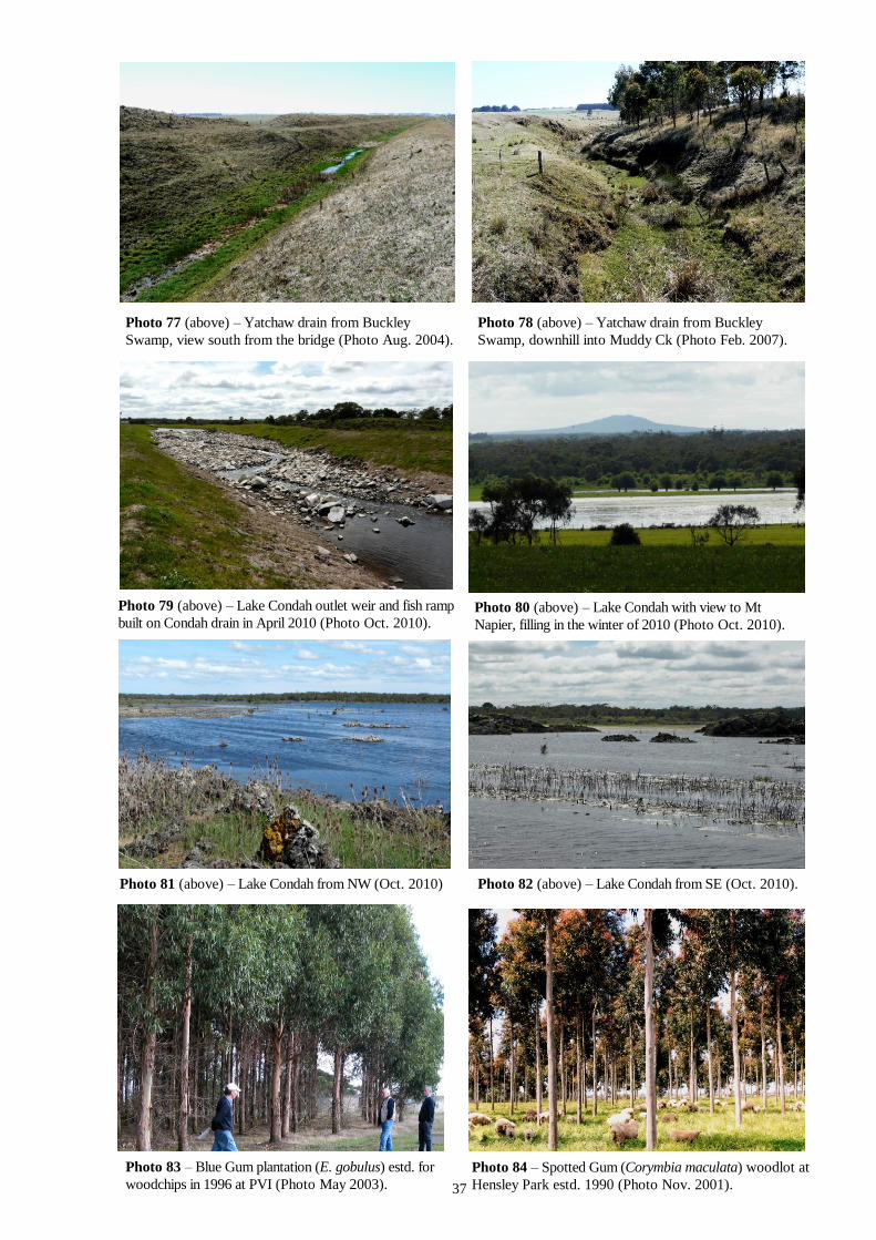
37
Photo 77 (above) – Yatchaw drain from Buckley
Swamp, view south from the bridge (Photo Aug. 2004).
Photo 78 (above) – Yatchaw drain from Buckley
Swamp, downhill into Muddy Ck (Photo Feb. 2007).
Photo 79 (above) – Lake Condah outlet weir and fish ramp
built on Condah drain in April 2010 (Photo Oct. 2010). Photo 80 (above) – Lake Condah with view to Mt
Napier, filling in the winter of 2010 (Photo Oct. 2010).
Photo 81 (above) – Lake Condah from NW (Oct. 2010) Photo 82 (above) – Lake Condah from SE (Oct. 2010).
Photo 83 – Blue Gum plantation (E. gobulus) estd. for
woodchips in 1996 at PVI (Photo May 2003).
Photo 84 – Spotted Gum (Corymbia maculata) woodlot at
Hensley Park estd. 1990 (Photo Nov. 2001).