Embed Size (px)
Citation preview

The GOES-R GLM Lightning Jump Algorithm
Principles and Applications toward Severe Weather Warning and Impacts-Based Decision Support
Lawrence Carey, University of Alabama in Huntsville (UAH)* With contributions from Kristin Calhoun (OU CIMMS and NOAA NSSL), Chris Schultz (NASA MSFC and UAH), Sarah Stough (UAH),
Brett Williams (UAH) and Alex Young (UAH)
* Funded by the NOAA GOES-R Risk Reduction Research (R3) Program via NOAA CICS in collaboration with NASA MSFC
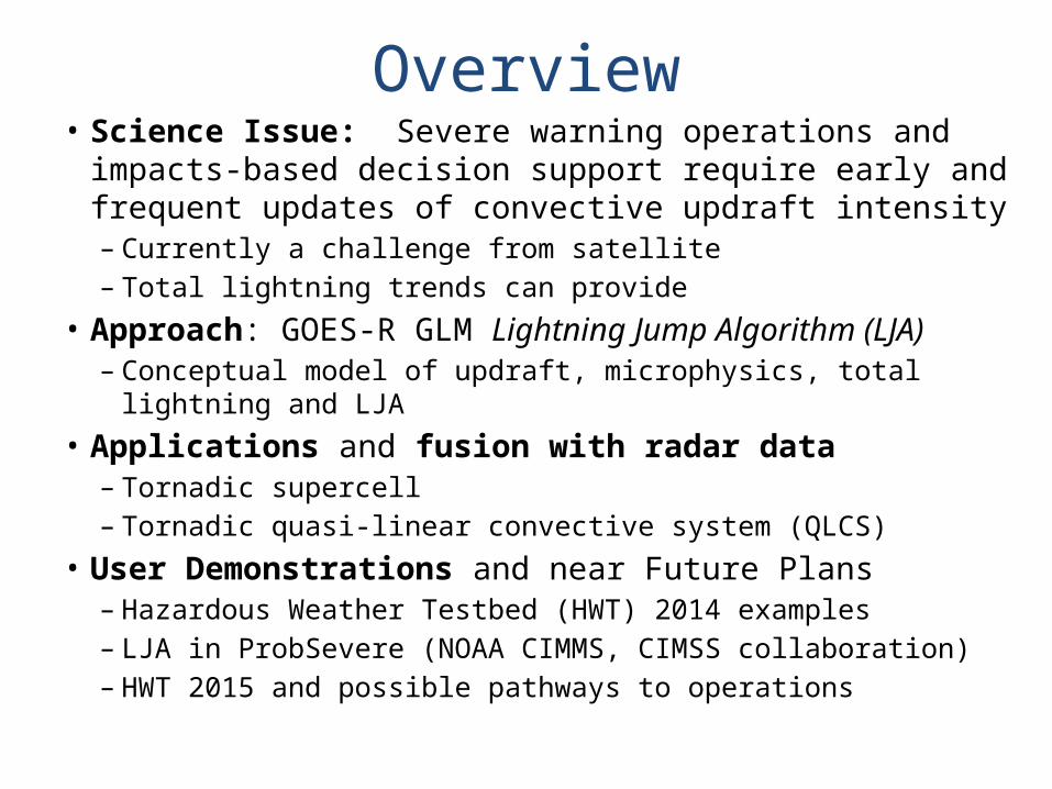
Overview• Science Issue: Severe warning operations and impacts-based
decision support require early and frequent updates of convective updraft intensity– Currently a challenge from satellite– Total lightning trends can provide
• Approach: GOES-R GLM Lightning Jump Algorithm (LJA)– Conceptual model of updraft, microphysics, total lightning and LJA
• Applications and fusion with radar data– Tornadic supercell– Tornadic quasi-linear convective system (QLCS)
• User Demonstrations and near Future Plans– Hazardous Weather Testbed (HWT) 2014 examples– LJA in ProbSevere (NOAA CIMMS, CIMSS collaboration)– HWT 2015 and possible pathways to operations

GOES-R Geostationary Lightning Mapper (GLM)Goodman et al. (2013)
GOES-R
GLM
GOES-W GOES-E
GLM
LMA

The Lightning Jump
Figure credit : Williams et al. 1999, Atmos. Res.
1) The flash rate increases rapidly (t0)
2) A peak flash rate (i.e., intensity) is reached (t1)
3) Severe weather occurs a short time later (t2)
(Williams et al. 1999, Schultz et al. 2009; 2011, Gatlin and Goodman 2010, Rudlosky and Fuelberg 2013, Metzger and Nuss 2013).
Assumed physical basis: “The updraft appears to be causal to both the extraordinary intracloud lightning rates and the physical origin aloft of the severe weather at the surface” (Williams et al. 1999)
• Updraft properties were not directly measured in early jump studies• Not specific which updraft properties govern the jump
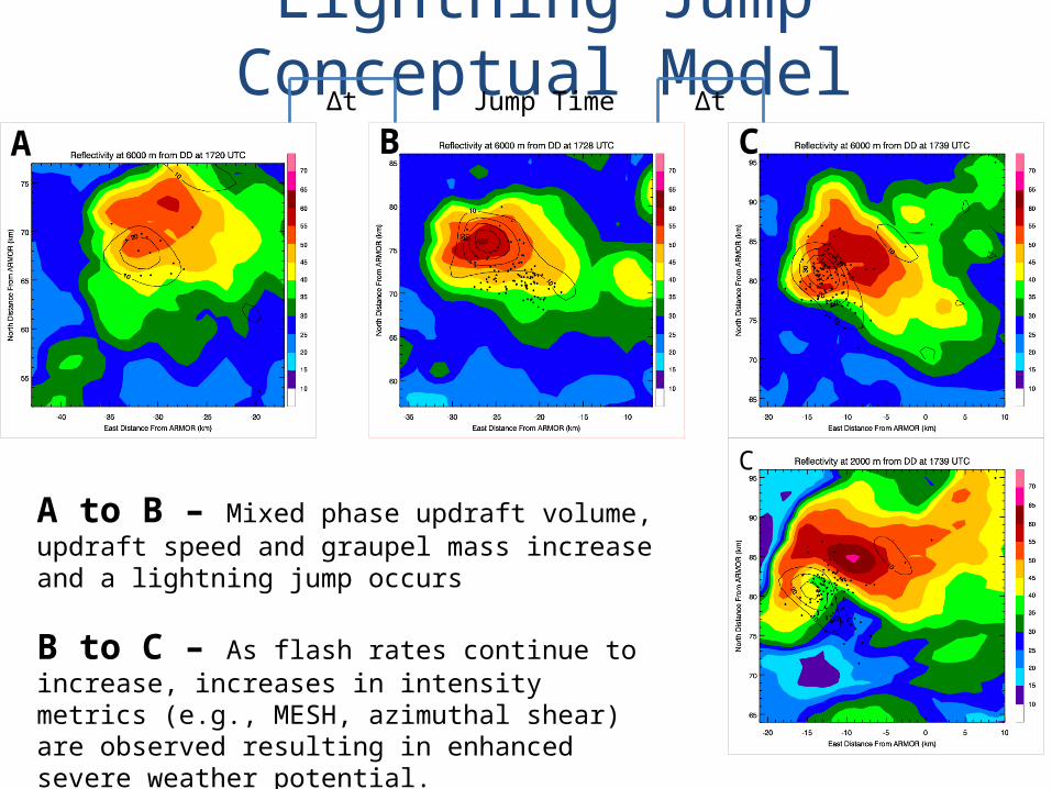
Lightning Jump Conceptual ModelJump Time
A B C
A to B – Mixed phase updraft volume, updraft speed and graupel mass increase and a lightning jump occurs
B to C – As flash rates continue to increase, increases in intensity metrics (e.g., MESH, azimuthal shear) are observed resulting in enhanced severe weather potential.
C
Δt Δt

Kinematic and Microphysical Origins
10 m s-1 updraft volume change (%)
Mixed phase graupel mass change (%)During the time leading up to a lightning jump, kinematic and microphysical observations of storms display the following characteristics:
1) There is a substantial increase in 10 m s-1 updraft volume (below) and peak updraft speed (not shown).
2) Mixed phase graupel mass also increases during this period (above).
Z Score P_Level (one tailed)0 and 1 σL 1 and 2 σL 0 and 2 σL 0 and 1 σL 1 and 2 σL 0 and 2 σL
Norm 10 m/s vol 0.05 1.60 1.99 0.48 0.06 0.03
Rank sum Testing
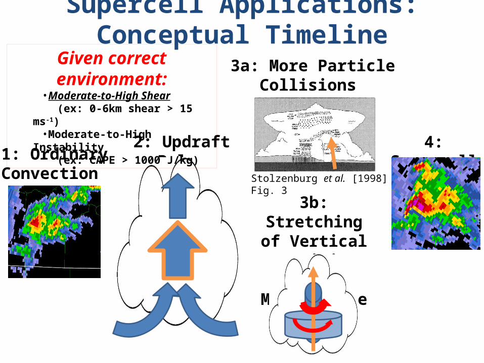
Supercell Applications: Conceptual Timeline
1: Ordinary Convection
2: Updraft Pulse
3a: More Particle Collisions → Increased Lightning
3b: Stretching of Vertical Vorticity→ Mesocyclone
4: Supercell
Stolzenburg et al. [1998] , Fig. 3
Given correct environment:•Moderate-to-High Shear
(ex: 0-6km shear > 15 ms-1)•Moderate-to-High Instability
(ex: CAPE > 1000 J/kg)
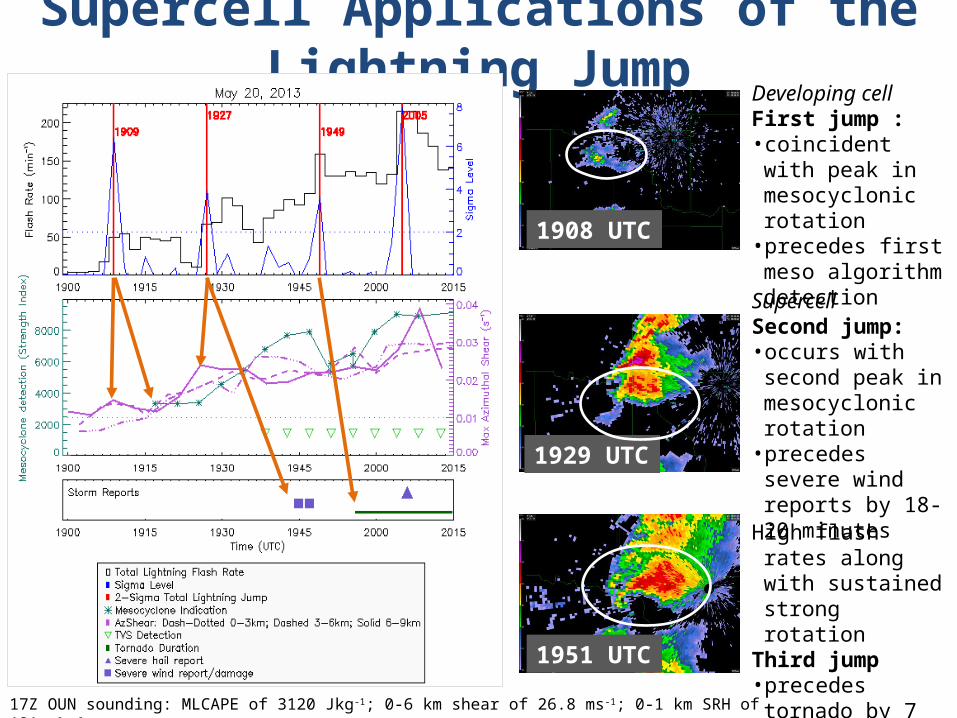
Supercell Applications of the Lightning Jump
1908 UTC
1929 UTC
1951 UTC
17Z OUN sounding: MLCAPE of 3120 Jkg-1; 0-6 km shear of 26.8 ms-1; 0-1 km SRH of 131 m2s-2
Developing cell First jump :• coincident with peak
in mesocyclonic rotation
• precedes first meso algorithm detection
Supercell Second jump: • occurs with second
peak in mesocyclonic rotation
• precedes severe wind reports by 18-20 minutes
High flash rates along with sustained strong rotation
Third jump • precedes tornado by
7 minutes
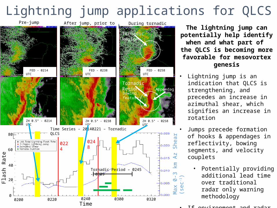
Lightning jump applications for QLCS tornadoesDuring tornadic periodAfter jump, prior to tornadoPre-jump
ZH 0.5° - 0214 UTC
FED - 0214 UTC FED - 0238 UTC
ZH 0.5° - 0238 UTC
FED - 0258 UTC
ZH 0.5° - 0258 UTC
0224 0248
Tornadic Region
Tornadic RegionAppendage
Bowing feature
Time (UTC)0300 0320024002200200
Flas
h Ra
te (m
in-1
)
Time Series – 20140221 – Tornadic QLCS
Max
0-3
km
Az
Shea
r (se
c-1)
Tornadic Period – 0245 - 0309
0
20
40
80
60
The lightning jump can potentially help identify when and what part of the QLCS is becoming more favorable
for mesovortex genesis
• Lightning jump is an indication that QLCS is strengthening, and precedes an increase in azimuthal shear, which signifies an increase in rotation
• Jumps precede formation of hooks & appendages in reflectivity, bowing segments, and velocity couplets
• Potentially providing additional lead time over traditional radar only warning methodology
• If environment and radar characteristics suggest tornadic potential, the occurrence (or absence) of a lightning jump can add additional information to tip-the-scales in the warning decision process

2014 EWP: Lightning Jump Algorithm
“I really think this could be one of the most valuable tools in WFO operations. Once a jump - or more precisely a series of jumps occurred - there seem to be excellent correlation to an increase in storm intensity.”
-NWS Forecaster, Post Event Survey, 2014 HWT
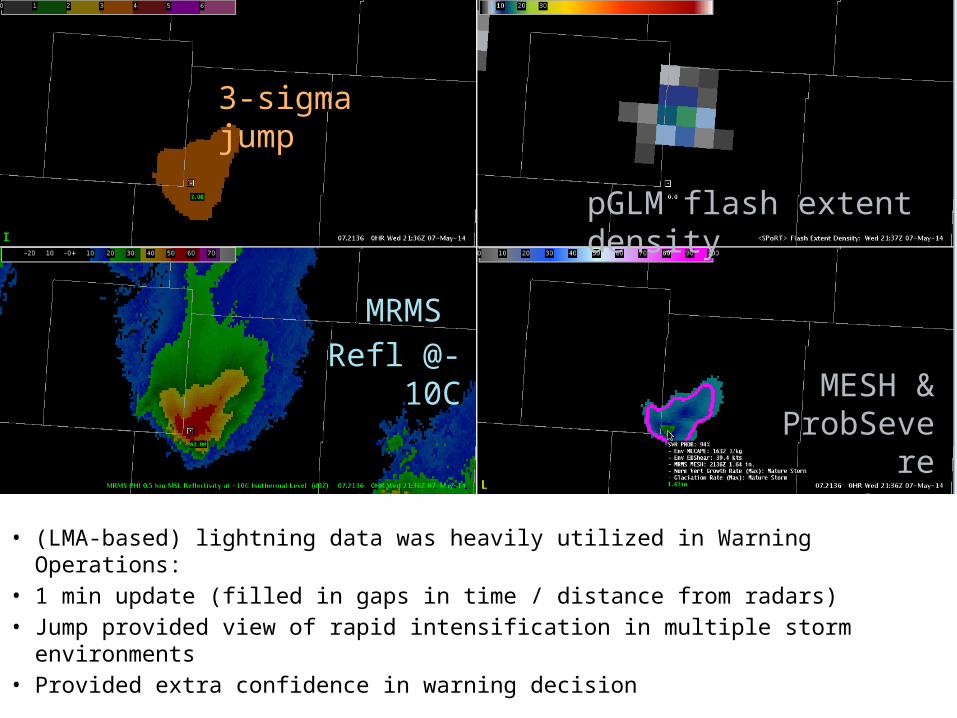
• (LMA-based) lightning data was heavily utilized in Warning Operations:• 1 min update (filled in gaps in time / distance from radars)• Jump provided view of rapid intensification in multiple storm environments• Provided extra confidence in warning decision
3-sigma jump
pGLM flash extent density
MESH & ProbSevere
MRMS Refl @-10C

“When I saw the jump and maybe a couple scans in a row, I was confident to issue a severe thunderstorm warning….”-NWS Forecaster, Live Blog“This information is a high temporal resolution (1-2 minutes) and provides additional data points that can fill gaps between radar volume times.” -NWS Forecasters (HWT blog)“The jumps were very helpful in identifying quickly intensifying storms. … it provided valuable information that, to my knowledge, is not displayed elsewhere.” -NWS Forecaster, Post Event Survey

NSSL Lab Review Feb 25–27, 2015 13
In this case, ProbSevere and LJA both displayed the rapid intensification of the updraft, and could be especially useful in identifying the first severe storm of the day, and the maintenance of the ProbSevere and additional lightning jumps continued to highlight the threat of severe weather as the storm continued eastward as the storm propagated eastward.
Future work will include the integration of the LJA into ProbSevere as an additional input to the probability calculations (NOAA CIMMS working with NOAA CIMSS)

Summary• GOES-R GLM total lightning and LJA provide early and frequent updates
on updraft intensity and hence severe potential– Pre-GLM: LMA, pGLM (LMA based), ENTLN
• Application of LJA in tornadic supercell and QLCS– Fusion with radar (e.g., MESH, azimuthal shear, mesocyclone, TVS)– maximum situational awareness and/or confidence to tip scale toward warning
• HWT 2014 (LMA-based) Demonstration – LJA color coded “sigma jump” (i.e., jump intensity) easiest to visualize along with
pGLM, MESH, MRMS, Doppler velocity etc– Positive forecaster feedback on operational utility
• Future Plans– Integration of the LJA (flash rate, sigma-level) into CIMSS ProbSevere– HWT 2015: CONUS-wide demonstration of LJA using ENTLN
• Possible Pathway to Operations (pending HWT 2015)– LJA could go into NWS AWIPS2 operations via multi-radar/multi-sensor
processing at NCEP – in summer of 2016 following GOES-R launch
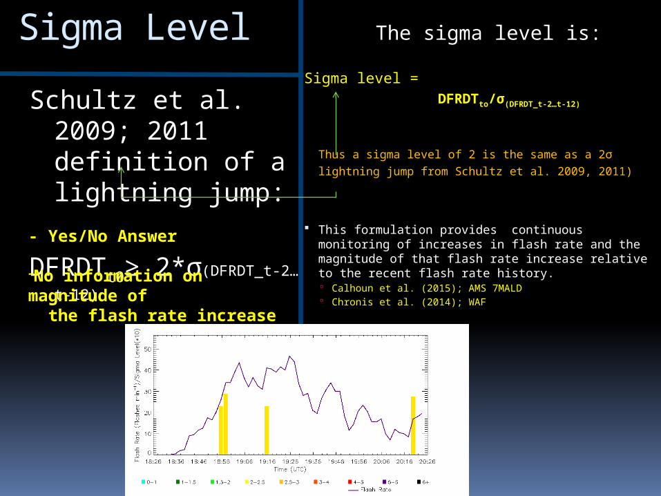
Sigma Level The sigma level is:
Sigma level = DFRDTto/σ(DFRDT_t-2…t-12)
Thus a sigma level of 2 is the same as a 2σ
lightning jump from Schultz et al. 2009, 2011)
This formulation provides continuous monitoring of increases in flash rate and the magnitude of that flash rate increase relative to the recent flash rate history. Calhoun et al. (2015); AMS 7MALD Chronis et al. (2014); WAF
Schultz et al. 2009; 2011 definition of a lightning jump:
DFRDTt0≥ 2*σ(DFRDT_t-
2…t-12)
- Yes/No Answer
-No information on magnitude of the flash rate increase