Embed Size (px)
Citation preview
CHAPTE~ II
THE GODAVARI BASIN
THE GODAVARI BASIN 31
The Godavari river, also ~10wn as Dakshin Ganga,
is th e second largest in Indian river ba sins after Ganga
with 12 per cent of drainage basin area of the country
(Table- 4)., The river is identified with many
historical, cultural and I:1ytholoc,;icQ.1 events of southern
and Central India. Many temples are located on the banks
of Godavari. Some of these temples such as Nasik,
Kaleshwaram, Bhadrachalam, Rajahamundry are very prominent
'pilgrinQge centres.
The river originates near Nasik (Maharastra) and
travels 1,465 kilometers(km)through the states of
Ivlaharastra; Hadhya Pradesh, Andhra Pradesh, K::::.rnataka and
Orissa to enter the Bay of Bengal. The total drainage
basin area in t:les0 states is 49.42; 29.40; 23.57; 1.45
and 5.20 percent respectively ('.Co.ble - 51\). The
Gcxiavari rfver has basin area of 313, 147 sq.krn. ex"tenLmg
between Latti tude 160 .0 'N to i8°.0 I N 3nd
to 83°.30E Godavari river, apart from many small streams, "
has four main tributaries mamely the Pranahi ta, Hanjeera)
Indravati and Sabari with 32.1 10.0 ; 13.36 ; and 6.4
percentages of catchment area, rGspectively(Table - 5 _"l
and 5 B ) ') The Pranahi ta has t\'fO big tributaries namely
WaingarCga and Penganga with 17.3 and 1405 percen'"'cage of
total Godavari basin area.
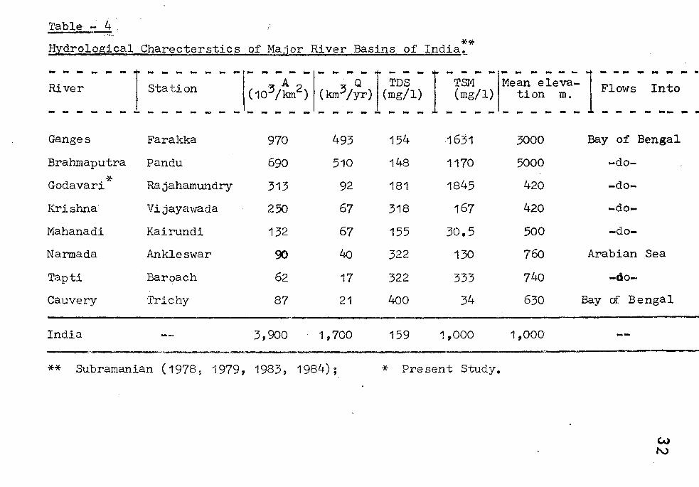
Table 7'~,
** Hydrological Charecterstics of Ma,ior River Basins of India,,_
- - ----r station ... - - ...
River
......... -Ganges Farakka
Brahmaputra Pandu -)Eo
Godavari Rajahamundry
Krishna Vijayawada
Mahanadi Kairundi
Narmada Ankleswar
Tapti Baroach
Cauvery Trichy
India
970
690
313
250
132
90
62
87
3 11 900
493
510
92
67
67
40
17
21
1,700
154
148
181
318
155
322
322
400
159
1631
1170
1845
167
30.5
130
333
34
1,000
3000
5000
420
420
500
760
740
630
1,000
Bay of Bengal
-do-
-do-
-do-
-do-
Arabian Sea
-do-
Bay of Bengal
_____ .d _______________________________________________________________ _
** Subramanian (1978 9 1979, 1983, 1984); * Present Study.
W N
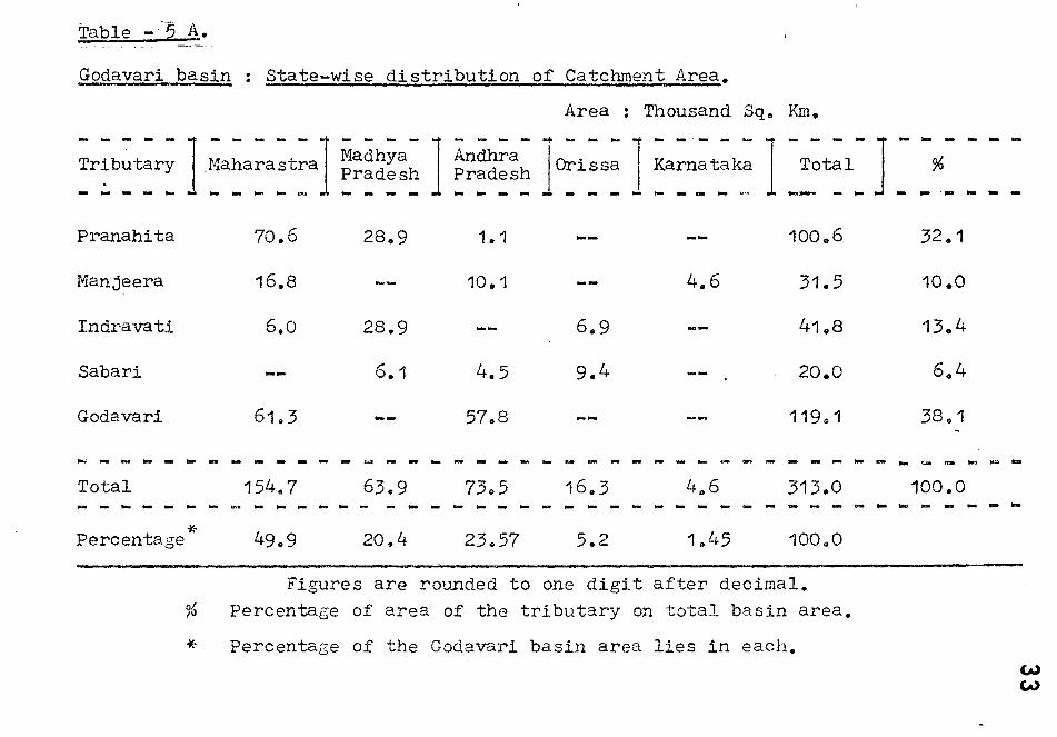
Table -·'5 A.
Godavari basin : State-wise distribution of Catchment Area.
Area : Thousand Sq" Km.
- - - - - ] ~a~a:a~t:al - - - - 1 - - - - .. - - - ... - -.- - -J -T:~l- ] -Tributary Madhya Andhra Orissa Karnataka Pradesh Pradesh . - -- - - - - - - .J. - - - - - - - - - - - - - .. , --- - - -
Pranahita 70.6 28.9 1.1 100 0 6
Manjeera 16 .. 8 10.1 4.6 31.5
Indravati 6.0 28.9 6.9 41.8
Sabari 6.1 4.5 9.4 20.0
Godavari 61.3 5708 119,,1
- - - - - - - - - - - - - - - - - - - - - - - .. - - - - - -Total 154 .. 7 63 .. 9 7305 16.3 4,.6 313.0 - - - - - .~ - - - - - - - - - - - - - - - - - - - - - -- - .... - -Percentage * 49.9 20.4 23,,57 5.2 1045 100.0
Figures are rounded to one digit after decimal. % Percentage of area of the tributary on total basin area.
* Percentage of the Godavari basin area lies in each.
- -% - .-32.1
10.0
13.4
6 .. 4
38 0 1
... -100.0 - ...
- - ---
.., ""
- -
-
--
W eN
Table -5 B. - -Godavari Basin : Distribution of Rock types.
~:e~ - - - rG;a~ite~ ;nct Sedi;e~t: 1 De~c~n- _' IHard Rocks ary rocks Traps I - - ~ - ~ - - - ~ - - ~ ~ - - - ~ -- - - - -Pranahita
Manjeera
Indravati
Sabari
* Godavari
Total Basin 96
39.0 (38.8)
1.1 (23.5)
33.5 (80.0)
23.8 (20.1)
122.2 (38.7)
2.6 (2.6)
--
2.5 (13.6)
22.9 (19.2)
36.4 (11.0)
59.0 (58.6)
24.1 (76.5)
--
149,,4 (47.7)
Area : Thousand SqoKm.
Recent
6.1 (5.1 )
6 .. 1 (2.0)
Total basin .area
100.6 (32.1)
31.5 (10.0)
41.8 (13.4).
20.0 ( 6.4)
119.1 (38.0)
313.0 (100.0)
Notes: The figures are in thousand sq.km. except the elevation.
443
562
490
580
420
The figures given in brackets percentage each rock type of the tributary 0
* Main Godavari not covered by tributaries"
35
The Godavari river discharr.:;es 2923 m3(92 '1~n3 /yr)
of water into the Bay of Bengal(Table-Lj.). This equaJs to
one fourth of Ganges(Rao, 1975) and 1.7 percent of world's
largest river, A,':Jazon(Gibbs 1 1967). The hydrological
aspects of the Godavari river basin has been discussicn in
the followine chapters, based on the hydrological data e
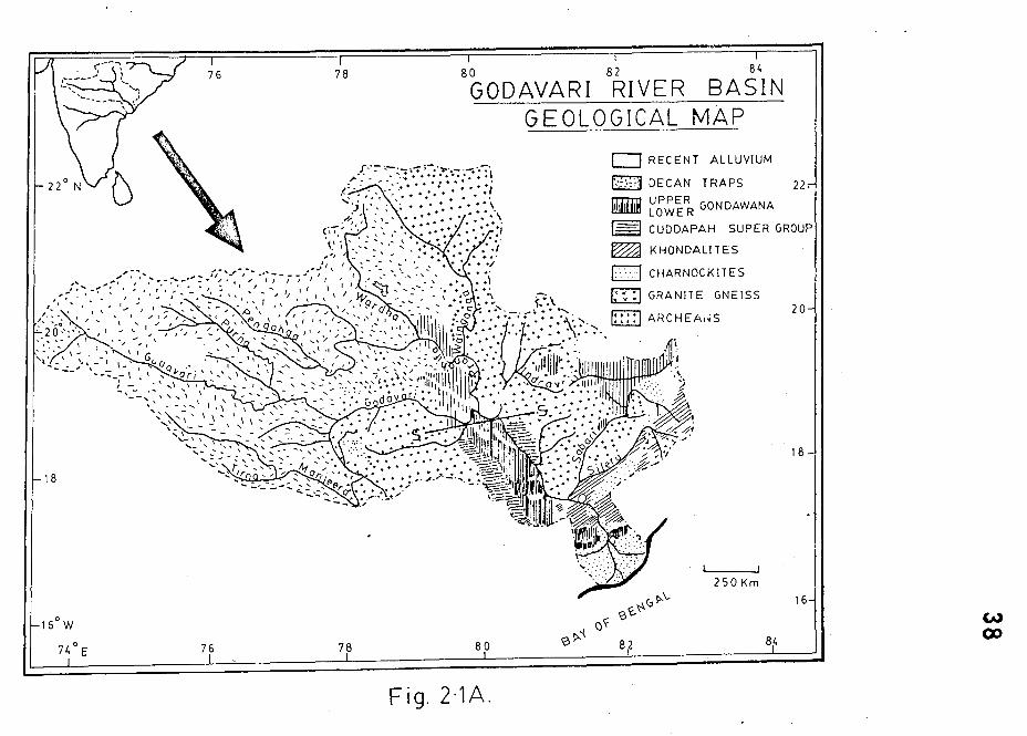
GEOLCG-Y OF THE Gr)DAVARI BASIN : - (fhe GC.)lo 'y of· the -,.. .... - --
Godavari river basin area was first studied anJ reported by
King( 1881). Aftervrards a team of officers fro:l! erst'.'rhile
Hyderabad Geolo~ical Survey of India have studi0s soge parts
of the basin. This work I'las sUITll.1C1rtscd by IIcron(·10l~9).
La ter, many workers frolil the Geological Survey of India
carried out detailed geolo~tc31 studies on c0veral Dart of
Srinivas Rao, 1975; Srinivas Rao (~t .0.1., 1?7:J; SaJ:1bs.siva
sllarr.m, 1979; Nandil{esh2.va Rao, 1976 etc.).
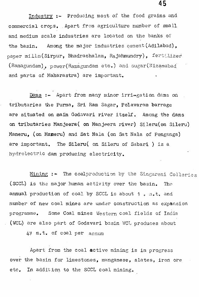
The Geoloc;y of the Godavari basin can broac.ly be
indentified in three super groups namely Archaeans,
Cuddapahs(Pal{hals)and the Gondv!anas ,,,hich are overlain by
the Deccan traps. The alluvial deposits and soil covers
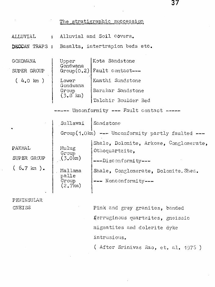
ar~ qui te comr;1On t~roughout the basin. The stratigraphic
succession of different rock uni ts ex~)osed along the section
line indicated in Fig 2.1 is given below:
This section covers all important rock types except some
rock tyPes such as l{hondali tes which are insigniflcant
36
in terms of the present study ( Fig. 2.1 ).
Since, the present study on the Godavari basin
is of '. broad nature the minor g0010gical deta;Lls of
the above mentioned vlOrks have not been strictly taken
into consideration o Therefore~ a very generalised picture
of basin geology has been presented in Fig. 2.1):
Brief description of each geological group and its rock
tyPes have also been given.
ARCP.AEANS : - The archenns are the basemen ~ for
the entire Godavari valley and are represented by
Peninsular geisses. The litilOlo~W com~)rises p.tnk and
grey granites, banded ferruc;inous qU.:J.rtzi tes, r;nei.SE:i,::S,
migmati teJ
crystalline me13neti te quar~-zite nncl
intruded by doleri t.e dytes. The i:!1~orta~'lt r:1inerc.~s.
are quartz, feldslJar and biotite \lit~: '::;2.rnct, a:.~:Dhibo~es,
chlorite and epidote as minor minerals. These gneissic
cO:!1plex are intruded by dolerite dYKes, quartz, quartz-e:;:Ldote
and pegMatite veins. The biotite gneiSS have N~ - SE
are massive with no toliatiaDs.
ALLUVIAL
DECCAN TRAP S
SUPER GROUP
( 4.0 1\111 )
•
PAKH.~L
SUPER GROUP
( 6.7 km ).
PENINSULAR
GNEISS
37
The stratigraphic .. succession
: Alluvial and Soil covers.
Basalts, intertrapion beds etc.
Upper Kota Sandstone Gondwana Group(0.2) Fault contact---
Lower Gondwana Group (3.8 h:m)
Kamthi Sandstone
Barakar Sandstone
Talchir ~oulder Bed
----- Unconformity --- Fault contact -----
Sullavai Sandstone
Group ( 1.0km) --- Unconformity partly faulted ---
Hulug Group ,( 3. Olan)
Hallama palle Group (2.7km)
Shale~ Dolomite, Arkose, Conglomerate, Othoquartzitc,
---Disconformi ty---
Shale, Conzlomerate, Dolomite. Shes.
Nonconformity---
Pink and grey granites g banded
~erruginous quartzites, gneissic
migmatites and dolerite dyke
intrusious.
( After Srinivas Rao, et. ale 1975 )
78 80 82 84
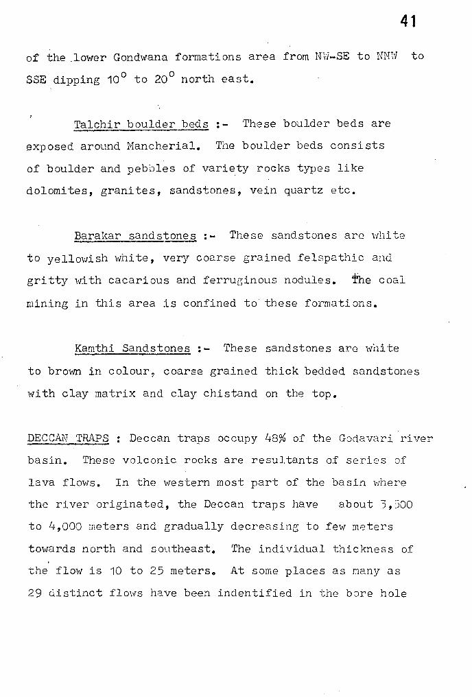
GODAVARI RIVER BASIN GEOLOGICAL MAP
0 RECENT ALLUVIUM
BJ DECAN TRAPS 22
lliil1iB UPPER GONDAWANA LOWER
~ CUDDAPAH SUPER GROUP
~ KHONDALITES
0 " . CHARNOCKlTES
m .. GRANITE GNEISS
~ ...... , .. ARCHEA,'S 20
18
250 Km
16
84
Fig.2·1A.
w ('X)
39 pAKP~L SUPER GROUP:- The pakhal series named by
King(1981) which has been later considered as P~khal Super
Group(Subba Raju and Srinivas Rae, 1974)col'\.Slstsrofr-Iallampalli,
lVIulugu and Sullavari groups. The n;."'l.mes of these 6roups vary
from pJ.a ce to place. A brief description of the important
rock types of this super group are given belm-, :-
The Pakhal Su~er group has been correlated with
Cuddapah is underlain by the .A.rchnean granites and gneisses.
These forma ti ons consi st of ba~~nl c onc;lomora tr.:s ::l.ncl c~.~loni tes in
lower part, dolomites, orthoquartzites and shales in middle
and sandstones on the top. Total thickness of these three
groups is about 6.5 km. in the centre of the re sin.
The r1ulu group i.$ correlated to the Pengang
group conSisting of quartzites,shales and limestones, in the
north western part of the basino
Q..oNDWANA SuPER GROUP: 'rhe Gondwana Super Group
rocks occup~ a major part of the Godavari valley sedimentary
rock formation with a width of about 70 km. near Nancherial.
In the Godavari river the upper Gondwana is represented by
Talchi~ Boulder Bed, Barakar sandstones and Kamthi sandstones
~nd upper Gondwana comprising Maleri formation, Kota sandstones
and Chikiala sandstone. The total thickness of Gondwana sand
stones in the basin -is around 3.5 to it.O 1-;:)":;.
40 The regional strike of the Gondwana rocks is N'Y'I-SE
with north easterly dips between 8 0 - 12 0. Two set of
vertical joints trending Nvl-SE and NE-SVl and t,,·!O sets of faults
(along and across the strike of the velley are noticed~
A bri:::,f discriptionv
of each rock formation of Gond\'lana super
group is as follows :-
UPPER '~OND':1ANA Gii.OUP : - The upper Gond"Jana group consists
of Maleri formations, Kota sandstones and Chlakila sandstones.
General strike of upper Gond,vana are NW - SEo
The I'IIaleri formation:- These formation. comprises
predominantly red clays and subordinate white, green,
yello"l clayso The calcareous pellets and pieces of calcified \
fossil wood are also common in these formation~o
li£ta Sand~stones :- Kota sandstones conprises thick
sequence of sandstone with number of inter beds of conglomerate
and silty clay and a single prominent inter bed of lirr.estone.
£hikiala sandstones:- The Chikiala formation is
represented by white, brown and maroon coloured, medium to
coarse grained matrix rich friable sand stones. The typical
maroon colour is the distin:ctcharact~risticof these sand
stones 0
LOltlER GCNUdAi"JA GROUP : _ This group includes Talchir
boulder beds, barkar sand stones,Kamthi sandstones. Strike
41
of the .10i'ler Gondwana formations area from N'Y'i-SE to NNl'l to
SSE dipping 10 0 to 20 0 north east.
Talchir boulder beds:- These boulder beds are
exposed around Mancherial. The boulder beds consists
of boulder and pebbles of variety rocks types like
dolomites, granites, sandstones, vein quartz etc.
Barakar sandstone.9 : - These sandstones are \·,11i te
to yellowish vl11i te, very coarse grained felspathic and
gritty \V.ith cacarious and ferruginous nodules. fhe coal
mining in this area is confined to these formations.
Kamthi Sandst~ : - These sandstones are w:nite
to bro1tffi in colour, coarse grained thick bedded sandstones
\",i th clay matrix and clay chistand on the top.
DECCAN TRAP;;:> : Deccan traps occupy 48% of the Godavari river
basin. These volconic rocks are resultants of series of
lava flows. In the western most part of the basin "where
the river originated, the Deccan traps have about 3, ~')OO
to 4,000 meters and gradually decreasing to few meters
towards north and southeast. The individual thickness of
the flow is '10 to 25 meterso At some places as many as
29 distinct flows have been indentified in the bore hole
42
inter sections. These fIovlS have maintained the perfect
horizontality throughout their wide areal distribution.
The most common rock of the deccan traps is augite basalt.
The rock is often vesicular with secondary fillings of
calcite, quartz and zeolites o Olivin :, Plagioclase
feldspars and a·ngi te are important minerals and calci te,
quartz, g~lconi te , zeolites and apa ti te as acces sory minerals
A unique columnar joint pattern is seen in these basalts.
The ~eccan traps have distinct spheroidal weathering pattern.
The vesicular texture joint pattern etc. are
favourable for physical &. chemical weathering.
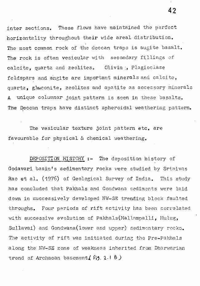
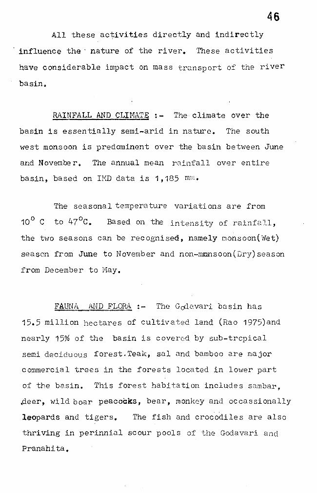
PEPOSITION HISTORY:- The deposition history of
Godavari basin's sedimentary rocks \'lere studied by Srini vas
Rao et ale (1976) of Geological Survey of India. This study
has concluded that pakhals and Gondwana sediments were laid
dovm in succes si vely developed NW-SE trending block faulted
throughs. Four periods of rift activity has been correlated
with successive evolution of palmals(IViallampalli, r-Iulug,
Sullavai) and Gondwana(lmver and upper) sedimentary !'ocks.
The activity of rift was initiated dur:Ln0 the Pre-pakhals
along the N~'l-SE zone of weakn.ess inherited from Dllarwarian
trend of Archaean basement.{ ~i'. 2. Ie,)
TECTONIC EVOLUTION OF THE GODAVARI GRABEN A SCHEMATIC REPRESENTATION
Ul'pelt K4 0 I'/oWANA<j , 1iI1I£IN
I+' LowEl\/OolU) wANm eo A S II-I
~ .5VL'-AVlll (lIlJIN -,.t
---'NE
------------------------------------------~ Fig. 2'18 1 Fro m Sri n i vas a Roo . e t. a l., (1916)
43
44 The evidences for presuming such rift activities are :-
(a) Parallelism between regional trends of major
geological units.
(b) repi ti ti ve OCcurrence- of geological units on
eighter side of the basin.
(c) faulted nature of ~eological contacts, and
(d) presence of four conspicous lineaments(indentified
from land sat imagery).
Therefore', the distribution pattern of sedimentary
rocks over the basin are net re suIt of the four different
episodes of sedimentation in block faulted troughs modified
by sub-sequent deformations,uplifts and erosion.
HUIvlAN ACTIVITI : - The Godavari basin is one of the
thickly popula tedr! ver basins l'ii th intense human acti vi ty.
population The exact populatl' nvn ; ,.-l'lQbl' t· .Loll. a. _ lnt::;.
in the basin area is not known. Apart from thousands of
small villages, minor town some . important ci ties/big t·own
ship such as Nagpur, Karimnagar, Warangal, Khammam, Nasik,
Nanded, Adilabad, Chandrapur etc. are part of the basin.
Agriculture : - The basin consists of 15.5 million
hectares of culi:!ivable ! land(Rao, 1975).
45 ~p'dustry:- Producing most of the food grains and
commercial crops. Apart from agriculture number of small
and medium scale industries are located on the banks of
the basin. Among the major industries cement (Adilabad),
paper mills.( Sirpur, Bhadrachalam, Rajahmundry), fertilizer
(Ramagundam)" power(Ramagundam etc.) and sugar (tJizamabad
and parts of Maharastra) are important.
~:- Apart from many minor irri!'O!gation dams on
tributaries the Puma, Sri Ram Sagar, Polavaram barrage
are situated on main Godavari river itselfQ Among the dams
on tributaries l1anjeera( on Manjp.era river) Sileru(on Sileru)
Maneru, (on Maneru) and Sat Nala (on Sat Nala of Penganga)
are important. The Sileru( on Sileru of Sabari ) is a
hydrolectric dam producing electrici t-y.
Mining : - The coalproducti on by -I..:11e Sincareni Colleri·;: s
(SeCL) is the major hwnan activity over the basin. The
annual production of coal by seCL is about 1 0 ::1. t. and
number of new coal mines are under construction as expansion
programme. Some Coal mines Western coal fields of India
(\VCL) are also part of Godavari basin ',vCL produces about
iff m. t. of coal per annum
Apart from the coal active mining is in progress
over the basin for limestones, manganese, slates, iron ore
etc. In addit ion to the SeCL coal mining o
46 All these activities directly and indirectly
influence the' nature of the river. These activities
have considerable impact on mass transport of the river
basin o
RAINFALL AND CLIMATE:- The climate over the
basin is essentially semi-arid in nature. The south
west monsoon is predominent over the basin between June
and Novembe r. The annual mean rainfall over entire
baSin, base~ on IMD data is 1,185 mm.
The seasonal temperature variations are from
10 0 C to 47°C. Based on the intensity of rainfa 11,
the two seasons can be recognised, namely r.lOnsoon('\l/et)
season from June to November and non-mmnsoon(Dry)season
from December to I'1ay.
FAUNA Al\JD FLOR.~ : - The Gc4avari basin has
15.5 million hectares of cultivated land (Rao 1975)and
nearly 15% of the basin is cover0d by sub-trcpical
semi deciduous forest. Teak, sal and bamboo are major
commercial trees in the forests located in lower part
of the basin.. This forest habitation includes sambar,
.deer, wild boar peacocks, bear, monkey and occassionally
~eopards and tigers. The fish and crocodiles are also
thriving in perinnial scour pools of the Godavari and
Pranahita.
47
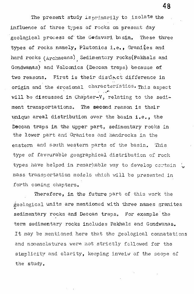
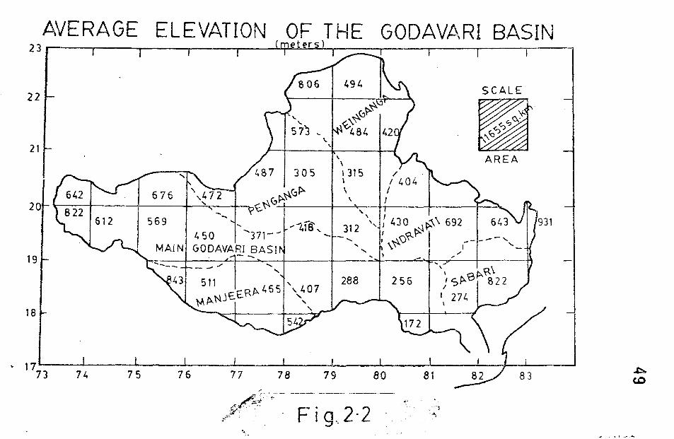
Mean Elevation: The Godavari riv8r catchment area
i~ divided into 38 division, each one as an intersectiona~
area bet'""een two longitudes and lati tudes~ EDch of
this 38 divisions were further divided into sixteen
sub divisions. The mean elevation of the each
sub division is calculated based on a formula, takinG
into consid(;,ra ti.on of minirnur:1-mi:l.ximum contour lines
passing through its area(Rainson, 1976). T11e mean
elevations of the sub-divisions are shown in Fig. 2.2.
The entire: b.:J.sin mean elevation ba;:;ed on computations
of 38 divisions usinG the formula has come to 420 meters.
The tributaries mean elevat.ions are:.;iven in Table 5 B.
48 The present study isprimarily to isolate the
influence of three types of rocks on present day
geological process of the Godavari 00. sin. The se three
types of rocks namely, Plutonics i.e., Grani~es and
hard rocks (Archaeans) , Sedimentary rocks(pakhals and
Gondwanas) and Volconics (Deccan traps) because of
two reasons. First is their dist·j".ct difference in
origin and the ~r?sional characteristics. This aspect ,. . ....... "
will be discussed in Chapter~Vp relating to the sedi
ment transportations o The second reason is their
unique areal distribution over the basin i.ee, the
Deccan traps in the upper part~ sedimentary rocks in
the lower part and Granites and handrocks in the
eastern and south western parts of the basin. This
type of favourable geographical distribution of rocl\.
types have helped in remar}mble ",ay to develop certain
mass transportation models \',hlch will be presented in
forth coming chapters.
Therefore, in the future part of this work the
geological units are mentioned \'/i th three names granites
sedimentary rocks and Deccan trapso For example the
term sedimentary rocks includes Pakhals and Gondwanas.
It may be mentioned here that the geological connatations
and nomenclatures ",erA aot strictly fo110\'Ied for the
simplicity and clarity, keeping inveiw of the scope of
the study &
AVERAGE ELEVATION OF THE GODAVt\RI BASIN 23 -,---.----~--__ _r----_r--~(~m~e~te~r2sL)~_=~r_--~r_--~----~--~ r- I I
22
21 "
305
\ \ 1315 \ \
SCALE
•
'f' Sf?
~~ o AREA
I ~(,f>. \ 20~~--+_----r---~~~_+~r~(,~~~--_4--~_+r_--_+----_r~ ?~ I '
19
18
569 .... .... " \ ... ... 418'\, 312 ',,430 \~ 692
450 "371-- ..... -" : ... \()~~ I ----, .... \\~ t '-MAIN GODAVARI BAS! . .... ,--~ .... l ;'
"\~ ~\ I, Sp..ep.. 822 I
288 256 I 271., \
931
~ 17L---~----~----~1----~----~----~----~----~----~-7~~--~ 73 74 75 76
"-