Embed Size (px)
Citation preview
The geology of the Paymaster and OlivetteMining areas, Pima County, Arizona
Item Type text; Thesis-Reproduction (electronic)
Authors Waller, Harold Everett, 1933-
Publisher The University of Arizona.
Rights Copyright © is held by the author. Digital access to this materialis made possible by the University Libraries, University of Arizona.Further transmission, reproduction or presentation (such aspublic display or performance) of protected items is prohibitedexcept with permission of the author.
Download date 29/05/2018 17:08:45
Link to Item http://hdl.handle.net/10150/553952
THE GEOLOGY OF THE PAYMASTER AND OLIVETTE3
MINING AREAS, PIMA COUNTY, ARIZONA
by
Harold E. Waller Jr.
A Thesis Submitted to the Faculty of the
DEPARTMENT OF GEOLOGY
In Partial Fulfillment of the Requirements. For the Degree of
MASTER OF SCIENCE
In the Graduate College
UNIVERSITY OF ARIZONA
1960
STATEMENT BY AUTHOR
This thesis has been submitted in partial fulfillment of requirements for an advanced degree at the University of Arizona and is deposited in the University Library to be made available to borrowers under rules of the Library.
Brief quotations from this thesis are allowable without special permission, provided that accurate acknowledgment of source is made. Requests for permission for extended quotation from or reproduction of this manuscript in whole or in part may be granted by the head of the major department or the Dean of the Graduate College when in their judgment the proposed use of the material is in the interests of scholarship. In all other instances, however, permission must be obtained from the author.
SIGNED:
APPROVAL BY THESIS DIRECTOR
This thesis has been approved on the date shown below:
W. CTLjCY Professor of Geology
7 Date
THE GEOLOGY OF THE PAYMASTER AND OLIVETTE MINING AREAS, PIMA COUNTY, ARIZONA
by
Harold E. Waller Jr.
ABSTRACT
The Paymaster and Olivette Mining areas are located approx
imately 25 m iles southwest of Tucson, Arizona in the Pima Mining
district.
Elevations range from 3,950 feet on the west, to 3, 500 feet on
the east, and drainage is generally to the east.
Paleozoic and Cretaceous sediments and Tertiary intrusives
have been thrust over the Precambrian Sierrita granite. Pegmatite
dike swarms are found in the granite but apparently carry no minerals
of present economic importance.
High-angle reverse and normal faults are found in the San
Xavier thrust sheet paralleling its margins. Left lateral tear faults
which cut and offset the thrust sheet acted as couples which opened the
high-angle faults. These were then mineralized with sulfides of copper,
lead, and zinc.ii
Later intrusive rocks and an intrusive breccia pipe are present
in the area. Limonite staining and mineralization and alteration as
sociated with vein deposits in the thrust sheet appear to form a halo
around the breccia pipe.
The presence of the widespread halo affects, the complexly
fractured rock adjacent to the thrust, the breccia pipe, and the type of
mineralization indicate the possible presence of a disseminated type
deposit at depth within the area.
iii
ACKNOWLEDGMENTS
The author wishes to thank Dr. W. C. Lacy for suggesting the
problem, and for advice and criticism of this thesis, and also Mr. T.
S. Nye, Mr. G. W. Irvin, and Mr. A. M. Durazo for their assistance
and advice at the Paymaster property.
The author also wishes to thank the College of Mines Scholar
ship Committee for the M. N. Short Memorial Scholarship for 1959-60,
which helped to finance the project.
iv
TABLE OF CONTENTS
Page
1. INTRODUCTION............................... 1
(1.1) Statement of Problem and Techniques U s e d ............... 1(1.2) Previous Work in the A rea ................. ............ ................ 2
2. GEOGRAPHY AND TOPOGRAPHY................................................. 3
f2 .1) Location and Size of A rea ................................................. 3(2.2) Topography ....................................................................... 3
3. GEOLOGY OF THE PAYMASTER AND OLIVETTEMINING AREAS .................. 4
(3.1) Precambrian Rock Units ................... ............................... 4
(3 .1 .1) Sierrita G ran ite.................(3 .1 .2) Pegmatite and Aplite Dikes(3 .1 .3) Quartz Dikes and M asses .
(3.2) Paleozoic Rock U n its ......................................................... 6(3.3) Cretaceous(?) Rock U n its .............................................. 8(3.4) Tertiary Rock U n its ........................................................... 10
(3 .4 .1) Andesite ...................................................... 10(3 .4 .2) Quartz M onzonite................................................. 12(3 .4 .3) Monzonite Porphyry ........................................... 12(3 .4 .4) Basalt Porphyry................................................... 13(3 .4 .5) Helmet Fanglom erate................................... 14
4. STRUCTURE OF THE PAYMASTER AND OLIVETTEMINING AREAS ................................................................................... 15
(4.1) Dikes in the Precambrian Granite ................................ 15(4.2) Structures Related to M ineralization................. 15(4.3) Unmineralized Structures ................................................. 18(4.4) Structural Breccias ...................................... 19
v
m CD
Page
5. GEOLOGIC HISTORY OF THE AREA..................................... 21
6. RELATIONSHIP BETWEEN MINERALIZATION, ALTERATION, AND STRUCTURE ................................................................... 24
(6.1) Paymaster Mining A rea .......................................... 24(6.2) Olivette Mining Area ............................................... .. 26(6.3) Other Mines in the A r e a ....................... ................ .. 27
7. MINERAL ZONING PATTERN............................... 29
(7.1) Trends of Mineralization ................................................... 29
8. POTENTIAL OF THE AREA .................................................. 31
9. SUMMARY AND CONCLUSIONS ............ 33
10. DISCUSSION ................................... 35
11. A P P E N D IX ...................................... 38
(11.1) Par agenesis of Ore Minerals with Photomicrographs ................................. 38
(11.2) Photomicrographs of Polished S ectio n s...................... 38
12. BIBLIOGRAPHY........................................................................... 48
LIST OF FIGURES
Figure Page
1. Paragenesis ch art.......................................................................... 39
LIST OF PLATES
Plate Page
1. Specimen No. 1, Water Shaft, Paymaster p ro p er ty ........... 41
2. Specimen Nos. 5 and 11, Water Shaft, Paymasterproperty ....................................................................................... 42
vi
Plate Page
3. Specimen Nos. 11 and 12, Water Shaft, Paymasterproperty .................................. ............................................. 43
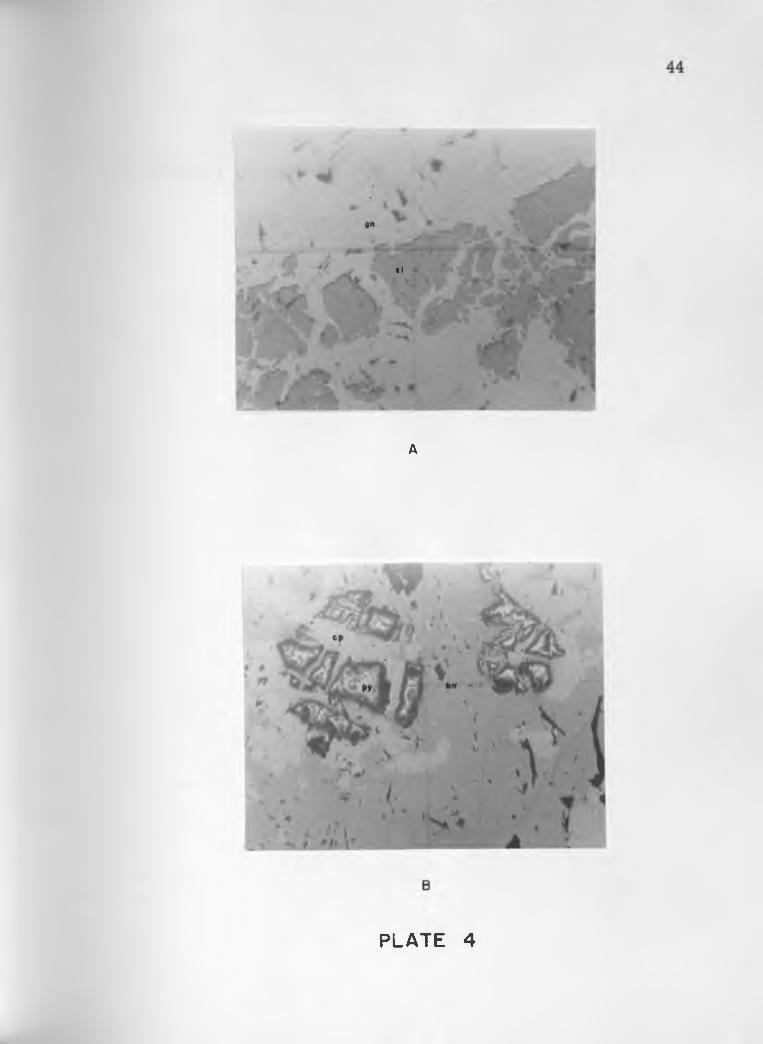
4. Specimen Nos. 2 and 3, Inclined Shaft, Paymasterproperty ..................................................... ................... 44
5. Specimen No. 1, Vertical Shaft, Paymaster propertyand specimen No. 1, mine No. 1 3 ...................................... 45
6. Dump specimens, mine No. 9 and mine No. 8 ............... ... 46
7. Dump specimens, mine No. 8 ................................................. 47
8. Geologic map of the Paymaster and Olivette Miningareas ........................................ in pocket
9. Structure map of the Paymaster and Olivette Miningareas ............................................................................................. in pocket
10. Cross sections. Paymaster and Olivette Mining areas . . . in pocket
11. Geologic map of mines in the Paymaster and Olivettearea ............................................................................................... in pocket
12. Geologic map of mine No. 3, ’’Vertical Shaft, ”P aym aster............... ................................................ .................. in pocket
13. Geologic map of mine No. 4, "Inclined Shaft, ”P aym aster.................................................................................... in pocket
14. Geologic map of mine No. 5, "Powder Shaft,"P aym aster................. ................................................................. in pocket
15. Geologic map of mine No. 6, "Water Shaft, ’’Paym aster......... .......................................................................... in pocket
16. Geologic map of mine No. 9, "Tit for T a t" ............................. in pocket
1. INTRODUCTION
(1.1) Statement of Problem and Techniques Used
This thesis presents a study of the geology and structure of the
Paymaster and Olivette Mining areas, with emphasis on the par agenesis
of ore minerals, the relationship between structural features, ore
mineralization and alteration, and variations in mineralization which
may relate to a mineral zoning pattern.
Fieldwork consisted of mapping the geology on the surface,
and in those mines accessible to the author at the time of the study.
Aerial photographs, obtained from Blanton and Cole architectural firm,
were used as base maps, supplemented by tape and Brunton compass
mapping. The scale of the photographs was 8.34 inches = 1 mile, and
a scale of 1 inch = 20 feet was used in mapping mines.
Fieldwork was begun in September 1959 and continued inter
mittently through March 1960.
Laboratory work, consisting of mineral identification and re
lationships, was accomplished with the use of petrographic and metal-
lographic microscopes during April and May of 1960.
Specimens for polished-section study were collected at the
various mines from dumps, or, where possible from underground
workings. Materials for thin-section study were collected from out
crops throughout the area.
(1.2) Previous Work in the Area
The Paymaster and Olivette Mining areas were mentioned
briefly by Ransome (1921) in a survey of the ore deposits of the Sierrita
Mountains. The paper briefly describes a few of the mines in the area,
but is mainly a reconnaissance study.
Mayuga (1942) wrote a doctoral dissertation on the Helmet
Peak area, which encompasses the present area. It is an extensive
study and parts of his work are referred to in this paper.
Lacy (1959) presented a paper on the structure and ore de
posits of the area in the Southern Arizona Guidebook H of the Arizona
Geological Society (1959),
Cooper (1960) also discusses the geology of the Pima Mining
district in a recent Geological Survey bulletin.
Other articles concerned with areas adjacent to the author's
field area are by Irvin (1959), Studebaker (1959), and Thacpaw (1960).
2
2. GEOGRAPHY AND TOPOGRAPHY
(2.1) Location and Size of Area
The Paymaster and Olivette Mining areas in the Pima Mining
district, are located on the east side of the Sierrita Mountains, ap
proximately 25 m iles southwest of Tucson on the Twin Buttes Road.
The total area studied is 7. 25 m iles square and is nearly rec
tangular in shape, with the northeast corner of the area being bounded
by the Twin Buttes Road. Sections covered are: 9, 10, 11, 14, 15,
16, 21, 22, and 23 in T. 17 S ., R. 12 E ., of the Twin Buttes quadrangle,
Pima County, Arizona,
(2.2) Topography
The elevation of the area ranges from 3,950 feet on the west
to 3,500 feet on the east, with maximum local relief of approximately
100 feet. Drainage ranges from a northeast direction in the northern
half to nearly due east in the southern half of the area.
The western part of the area is a pediment surface cut in the
granite with pegmatite dikes forming the crests of low hills, and to the
east sedimentary and intrusive rocks are exposed as isolated outcrops
in the alluvium.3
3. GEOLOGY OF THE PAYMASTER AND OLIVETTE MINING AREAS
(3.1) Precambrian Rock Units
(3 .1 .1) Sierrita Granite
The Sierrita granite, the oldest rock in the area, has been
designated as Precambrian in age by Lacy (1959). The granite varies
in texture from medium to coarse grained, and crops out almost con
tinuously throughout the western and north-central parts of the area.
A small area of the granite also crops out in the south-central part of
the area in section 22.
The granite ranges in color from buff to pink on both fresh and
weathered surfaces, the pink color being due to the presence of hematite.
The coarse-grained variety of granite contains miarolitic cavities lined
with muscovite and feldspar crystals.
As observed in thin section, the granite is a holocrystalline,
equigranular, phaneritic rock, deficient in mafic minerals. Oligoclase
is the common plagioclase feldspar, and microcline the most abundant
potash feldspar. Accessory minerals include apatite, ilmenite, sphene,
and zircon. Feldspar grains have been fractured, and altered to sericite
along breaks. Specimens collected near the western lim it of the thrust
4
5
exhibited brecciation and complete alteration of the feldspars to sericite.
Chalcedony was found enclosing the brecciated and altered fragments of
granite.
(3 .1 .2) Pegmatite and Aplite Dikes
Numerous pegmatite and aplite dikes are found transecting the
granite. Mayuga (1942) reports these dikes to be numerous near the
contact of the granite and the andesite breccia at the Paymaster prop
erty, but the main dike swarm is located approximately a half a mile
to the west of and one m ile north of the Paymaster property. These
dikes range in thickness from a few inches to 5 feet, and some individ
ual dikes can be traced for as much as 1,000 feet. The trend of the
dikes in the main dike swarm is approximately westward, with a few
exceptions which strike northeast and northwest. Near the Paymaster
property the dikes strike northeast. They are restricted to the granite
and do not cut the Paleozoic and Cretaceous sediments or the Tertiary
intrusives in the over thrust sheet.
Study of thin sections indicate that the dikes are similar in
composition to the granite. The dikes exhibit a graphic texture in
many instances, and contain muscovite in greater abundance than the
granite. The aplite dikes contain minor amounts of mafic minerals and
are composed primarily of quartz and potash feldspar.
No minerals of present economic importance were found in the
pegmatites, but approximately one m ile to the north of the area, in
sections 4 and 5, there are beryl-bearing pegmatites which have a
similar strike to the main dike swarm.
(3 .1 .3) Quartz Dikes and M asses
Quartz dikes and m asses are found in the granite in the west
ern part of the area, and a quartz m ass is also present in the central
part of section 10. The quartz dikes and m asses, like the pegmatite
and aplite dikes do not cut the Paleozoic, Cretaceous, and Tertiary
rocks.
The quartz is white in color, translucent, and contains iso
lated feldspar crystals and pyrite cubes. Thin section studies of the
contact of the quartz dikes and the granite showed an increase in the
sericite content near the quartz dikes. The sericite appears to have
been derived from the alteration of the feldspar grains. Pyrite cubes
were present in both the quartz and the altered granite adjacent to the
dikes.
6
(3.2) Paleozoic Rock Units
Paleozoic rocks in the area consist of limestones which have
been designated as Permian in age by Mayuga (1942) and Studebaker
(1959).
Mayuga (1942) describes the Permian rocks in the Paymaster
7
and Olivette Mining areas as being Manzano group and Snyder Hill for
mation. The Manzano group appears to be correlative with the Scherrer
formation described by Gilluly, Cooper, and'Williams in 1954 in the
Gunnison Hills, Arizona. The Scherrer formation is described as a
basal red silts tone overlain by two white sandstones that are separated by
a dolomitic limestone (Bryant, 1959).
The Snyder Hill formation, originally described by Stoyanow
in 1936 at the type area on Snyder Hill near Tucson, Arizona, has been
termed obsolete (Pye, 1959), and has been replaced by the Concha for
mation of the upper Permian Naco group. Gilluly, Cooper, and 'Williams
described the Concha formation at the type locality in the Gunnison Hills,
Arizona in 1954. It has been described as consisting of limestone and
sandy limestone, overlain by cherty limestone.
Mayuga (1942) describes the quartzite cropping out in section
11 as being part of the Permian Manzano group, but the absence of
fossils , bedding, and the overlying Concha formation in the vicinity
lead the author to believe that the quartzite is not Permian in age, but
perhaps Cretaceous. In section 15 on "Breccia H ill," angular frag
ments of arkose and quartzite make up the breccia and no limestone
fragments are present. Here also one would expect to find some trace
of the overlying Permian Concha formation if the quartzite were Permian
in age.
In the northern part of section 10 and in the southeast corner
8
of the area in section 23 there are outcrops of Paleozoic limestone. The
limestone in the southeast corner of the area is a gray limestone con
taining brown chert inclusions and fossil gastropods. Bedding has been
destroyed and white calcite stringers cement fractures in the limestone.
This limestone resem bles the Concha formation as mapped on Helmet
Peak by Studebaker (1959).
The limestone cropping out in the northern part of section 10
was described by Mayuga (1942) as the Snyder Hill formation (Concha
formation). No fossils were found by the author, and the typical chert
inclusions were also lacking. This is a gray limestone that has been
recrystallized in part and bedding has been obliterated.
Evidence for determining the exact position of these limestone
units was not conclusive in the area studied, and consequently they have
been mapped as Paleozoic limestone, with (pal) as a map symbol.
(3.3) Cretaceous(?) Rock Units
The Cretaceous rocks in the area consist of a series of wide
spread arkoses, quartzites, and thin limestone beds. The quartzite
and limestone beds crop out in section 11, and as previously mentioned
there is quartzite and arkose breccia in section 15.
The arkose in the area varies in texture, grain size, and degree
of silicification. In the western and southern portions where the arkose
is near the western lim its of the thrust sheet, or adjacent to windows in

9
the sheet, the arkose is highly silicified and it is difficult to distinguish
individual grains in hand specimen. Grain size generally appears to
decrease from west to east, and in section 11 the change from a rela
tively coarse-grained arkose to a medium-grained quartzite seem s to
be gradational. The quartzites are not completely free of feldspars
and in many cases can be termed arkosic quartzites.
The degree of silicification and the widespread fracturing of
the arkose have obliterated bedding planes over most of the area. There
are a few outcrops in section 11 where bedding is present and the general
strike is N. 45 TV., dipping 75° to the west.
The Cretaceous limestones are found in section 11 and they
are thin beds only a few feet thick. Mayuga (1942) identified mactroid
lamellabranchs which were characteristic Upper Cretaceous pelecypods.
" Thin-section examination of the arkose showed that the feldspar
grains were oligoclase, microcline, and orthoclase. Brecciation and
silicification were pronounced in specimens collected near the margin
of the thrust sheet, and adjacent to windows in the thrust sheet. Silicifi
cation was similar to that found in the granite near the margins of the
thrust. Near intrusives in the area the feldspars were altered to sericite
and clay minerals, and epidote was also developed. The sericitic and
argillie alteration of the feldspars is present in most of the area, but it
is more intense near intrusives. Some biotite, hornblende, and chlorite
fragments were present in the arkose, but these were restricted
10
primarily to the coarser grained arkose to the west.
The quartzite and the arkosic quartzite are apparently the ,
finer grained equivalents of the arkose. The composition is similar
but the feldspar content is not sufficient to term the rock an arkose.
(3.4) Tertiary Rock Units
Tertiary units in the area are predominantly intrusive and ex
trusive igneous rocks. In the eastern part of the area there is a unit
which has been called the "Helmet fanglomerate" by Cooper (1960),
and it is extremely variable in texture and composition.
(3 .4 .1) Andesite
Andesite forms the bulk of the exposed Tertiary igneous rocks
in the area, and it is found mainly in the central portion along a N. 65
E. trend. The andesite appears, from field relationships shown on the
map, to be partially intrusive and in part extrusive. In sections 10 and
11 the andesite intrudes the arkose, and near the contact the arkose has
been highly silicified. Small windows in the arkose expose the andesite.
In sections 15 and 16 the andesite may be extrusive, though it does not
exhibit any of the features commonly found in extrusive rocks such as
flow structures, vesicles, or amygdules.
Along the western edge of the thrust sheet the andesite has been
highly fractured and brecelated, but the brecelation decreases away from
11
the edge of the thrust sheet, and only complex fracturing is observed.
The intensity of brecciation apparently reflects the proximity of the ex
posed andesite to the sole of the thrust.
Most of the andesite is porphyritic, although some appears to
be nearly aphanitic. In the eastern part of the area the andesite con
tains large phenocrysts of plagioclase feldspar, and it is finer grained
to the west. Some cognate inclusions and xenoliths of arkose were found
in the outcrops in the western part of the area.
Microscopic study of the andesite shows a holocrystalline,
porphyritic texture with no evident structural features. Andesine (An^g)
and hornblende are the common phenocrysts and the matrix consists of■ • " ■ • I ' ‘ >
fine-grained feldspars and mafics. Accessory minerals include apatite
and hypersthene. The mafic minerals have been altered to iron oxides
and chlorite, and some of the feldspars have been altered to sericite.f - "
In the eastern part of the area the andesite does not have the dark-gray-
brown color of that found in the west, but rather a light-green color.
The green andesite has larger phenocrysts of feldspar and hornblende,
and the matrix contains a lesser amount of hornblende. Some epidote
and clinozoisite alteration of the andesite is present, but it is not wide
spread and was found only in the central part of section 22.
12
(3.4 .2) Quartz Monzonite
In the northern part of section 10 and in the western part of
section 11 are outcrops of quartz monzonite which are apparently
Tertiary in age. The quartz monzonite is exposed in small outcrops
in the arkose, and the degree of silicification and alteration of the
arkose would indicate an intrusive relationship. The texture ranges
from porphyritic to holocrystalline equigranular. Microscopic study■ . - - - .
shows andesine (An<jg) and orthoclase to be present in approximately
equal amounts. Biotite and hornblende are the common mafic minerals,
and quartz makes up about 20 percent of the rock. Accessory minerals
include sphene, apatite, and magnetite. In the porphyritic variety,
andesine, biotite, and hornblende are the common phenocrysts, and in
the equi granular variety the above mentioned minerals are nearly
euhedral. In the Olivette Mining area pyrite is present in the quartz. . ■
monzonite and the feldspars have partially altered to sericite and clay
minerals.
(3 .4 .3) Monzonite Porphyry
In the northeast corner of section 15, monzonite porphyry,
which appears to intrude the andesite, crops out. It is a fine-grained
porphyry and its composition is not apparent in megascopic examination.
Microscopic study indicates that the porphyry consists of approximately
13
55 percent andesine (An^) and 35 percent orthoclase, with minor amounts
of epidote, pennine, and hornblende. Andesine and hornblende occur as
phenocrysts in a matrix of andesine and orthoclase. The andesine has
been altered to clay minerals, and the hornblende has altered in part to
Pennine.
(3.4.4) Basalt Porphyry
In sections 14 and 23 are several outcrops of basalt porphyry
which are apparently part of the same unit. The porphyry crops out
along a N. 70 E. trend, and may represent either a shallow intrusive,
or lava flows. Cooper (1960) considers the porphyry to be a series of
flows in the lower middle part of the Helmet fanglomerate because of
their consistent lithology and the presence of porphyry boulders in the
overlying fanglomerate beds. The relatively narrow, linear outcrop
pattern might however indicate a shallow intrusive body.
Microscopic study of the basalt indicates that approximately
55 percent of the rock is composed of labradorite (An^) phenocrysts
in a matrix of nearly opaque glass. Coroded augite comprises the only
other distinguishable mineral. Labradorite phenocrysts are euhedral
and contain inclusions of glass and augite. V esicles and amygdules are
prominent but exhibit random orientation. Amygdules are composed of
quartz and calcite.
14
(3.4. 5) Helmet Fanglomerate
The Helmet fanglomerate is an extremely variable unit com
posed of fragments of granite, andesite, arkose, and quartzite in a
silty matrix rich in iron. A crude bedding is present, but it is not con
tinuous. Thacpaw (1960) suggests that the unit is mudflow material
derived from the west and north. Cooper (1960) found the Helmet fan
glomerate to have an apparent thickness of 10,500 feet, and suggests
a westerly source area.
4. STRUCTURE OF THE PAYMASTER AND OLIVETTE MINING AREAS
(4.1) Dikes in the Precambrian Granite
The pegmatite, aplite, and quartz dikes in the granite have a
pronounced easterly trend in section 9 and a northeasterly trend in
section 16. Near the mutual corner of sections 8, 9, 16, and 17 the
dikes form a crudely concentric pattern. The dikes apparently repre
sent tension fractures in the granite, but as they represent only a small
part of the total swarm, evidence is not conclusive as to their origin. In
any case the dike pattern in the granite and the structures found in the
thrust sheet bear no similarity and the dikes cannot be traced into the
thrust sheet.
(4.2) Structures Related to Mineralization
The principal geologic structure in the area is the San Xavier
thrust fault. The western lim its of the thrust are found in sections 10,
16, and 21. Nearly everywhere the edge of the thrust is concealed by
alluvium, but its presence is reflected by abrupt changes in lithology
and topography. In sections 16 and 21 the edge of the thrust is exposed
on several small hills. This is a gradational zone which ranges from
fractured and altered granite at the base, through mixed granite and
15
16
andesite, to brecciated and altered andesite. The zone has been silic i-
fied and is probably some 50 feet or more wide. The upper part of the
zone in the andesite is sheeted, and the attitude of the sheeting appears
to reflect the attitude of the thrust.
In sections 16 and 21, the thrust appears to dip steeply to the
east, perhaps around 60°, but the dip decreases rapidly. Granite was
reportedly encountered in a shaft on the Paymaster property at a depth
of about 300 feet, some 1,200 feet east of the exposed granite-andesite
contact. In section 10 the thrust is concealed by alluvium but in a few
places it is delineated by the contrast in lithology.
; The sole of the thrust apparently has very irregular relief, as
the granite crops out in windows in the relatively thin thrust sheet. In
section 22 there are several outcrops of granite exposed, and in the
central part of section 10 there is an outcrop of m assive white quartz
which is similar to the white quartz m asses found in the granite in sec
tion 9.
Superimposed on the thrust sheet is a well-developed pattern
of N. 20 E. trending faults. These are present primarily in the andes
ite, but they also transect the arkose. These N. 20 E. faults may rep
resent fracture directions initially developed in the thrust sheet as a
result of the thrusting movement from the southeast. These fractures
dip primarily to the east, but some dip to the west. The angle of dip
varies from vertical to 60°, but the dip is extremely variable on any
17
one fracture.
Cutting the thrust sheet in a N. 70 E. direction are tear faults
that appear to have considerable displacement. Movement along the
tear faults has been left lateral, and there has been some dip-slip move
ment. In section 11 the Cretaceous limestone beds and arkosic quartz
ites exhibit some 2, 000 feet of apparent left lateral displacement. The
dip of the limestone beds on the northern block is approximately 10°
le ss than the dip of the limestones on the southern block. As the lim e
stone beds dip to the west, it would appear that the northern block has
moved upward in relation to the southern block. The steepening of the
dip of the thrust in the northern block and the eastward retreat of the
thrust front also reflect the dip-slip movement.
The left lateral faults appear to have formed a couple which
served to open the previously formed, high-angle, N. 20 E. fractures.
There also has been normal movement along these N. 20 E. fractures,
and mineralization apparently entered the fractures during or after the
normal movement.
Near the central part of section 10 there are several arcuate
faults immediately south of the quartz m ass. These faults dip to the
north, and may have developed as fractures related to the thrusting
movement. The concentration of faults here and in the northern part
of section 22 may reflect the proximity of the sole of the thrust.
In the western part of section 15 there are mineralized faults
18
which strike northwest. Relationships are obscure in this area? as the
mines were caved and inaccessible, but these northwest-trending faults
may represent subsidiary tear faults formed at the time of thrusting
which were later mineralized. Similar mineralized northwest-trending
faults are present in the Olivette Mining area in section 11. These may
also be related to the thrusting.
In the northern part of section 10 the San Xavier thrust strikes
to the north. East-trending faults which dip to the south extend into the
Paleozoic limestone. These may represent reverse faults in the thrust
sheet.
(4.3) Unmineralized Structures
In section 16 there are two N. 30 W. trending structures that
are apparently unmineralized and which seem to offset the mineralized
veins at the Paymaster property with apparent right lateral movement.
Post-mineral cross faults are present in all of the mines, but
for the most part they are small structures; the apparent offset is on
the order of a few feet.
In section 23 a north-trending faulty called the Ruby Star Ranch
fault by Cooper (1960), with dip-slip movement, is suspected because of
the abrupt change in lithology. The Ruby Star Ranch fault dips to the
east approximately 65° and the east side has moved downward in rela
tion to the west side (Cooper, 1960). The relative movement of the
19
fault may have formed a basin of deposition for the Helmet fanglomer-
ate. ' -
M There are several flat faults in the Paymaster mines which
strike roughly parallel to the mineralized faults, but dip 10° to 20? to
the east. The flat faults offset and truncate the mineralized veins.
(4.4) Structural Breccias
Structural breccias occur near the margins of the thrust sheet
as well as in areas where the sole of the thrust is exposed or close to
the surface. The breccias are silicified and form relatively high hills
in the area. The western lim it of the thrust sheet is outlined in part by
the abrupt change in topography which is due to the presence of the
silicified breccia.
In the southern part of the area, extending into sections 15,
21, 22, and 23, is an irregular halo of brecciated arkose surrounding
a window of granite which crops out in section 22. The westernmost
outcrop of breccia in section 21 consists of highly brecciated arkose
with some fragments of andesite. The breccia fragments range in size
from a few m illim eters to several inches, and the intensity of breccia-
tion suggests that the granite is fairly near the surface.
In the eastern part of section 15 there is a sm all hill composed
of arkose and arkosic quartzite breccia. Andesite is exposed in a pros
pect pit in the middle of the outcrop. The shape of the outcrop, the
20
absence of granite in the immediate vicinity, and the drill-hole report
of the persistence of brecciated andesite with associated pyrite and
limonite to a depth of 198 feet, below which altered material with pyrite
veinlets was present to a depth of 874 feet, support the idea that this is
a breccia pipe, associated with some unexposed intrusive body.
5. GEOLOGIC HISTORY OF THE AREA
The oldest unit in the area is the Precambrian granite which
forms the core of the Sierrita Mountains to the west. Cutting through
the granite are pegmatite and aplite dikes that have a pronounced east
erly trend. The dikes apparently represent tension fractures in the
granite, and their age is unknown. The possibility exists that they may
be Cretaceous-Tertiary in age, formed as tension fractures when the
Sierrita Mountains were uplifted and eroded giving r ise to the thick
accumulations of Cretaceous(?) arkose.
The next oldest units exposed are Paleozoic limestones which
are apparently Permian in age. The absence of the greater part of the
Paleozoic section is due to erosion, concealment by faulting, or some
combination of the above, since nearly a complete section is present in
the adjacent Mineral Hill area.
After deposition of the Paleozoic limestones there was a period
of nondeposition, or uplift and erosion, as Triassic and Jurassic units
are not present.
During Cretaceous time the Sierrita Mountains may have been
uplifted and eroded, giving rise to the thick accumulation of arkose and
arkosic quartzite. The gradation from west to east of coarse arkose to
21
22
finer arkosic quartzite, and the presence of thin limestone units con
taining fresh-water ostracods (Cooper, 1960) indicate the presence of
associated bodies of fresh water.
During Tertiary time a thrusting movement apparently started
in a northwest direction. At some time, perhaps simultaneously with
the thrusting movement, the andesite was intruded, perhaps along the
sole of the thrust. The shape of the andesite body suggests either a
dike or a sill, and the change in grain size of the andesite from coarse
grain in the east to finer grain on the west suggests slower cooling of
the andesite to the east.
After the andesite crystallized the steeply dipping N. 20 E0
fractures may have been formed by continued movement of the thrust
sheet. N. 70 "E. left lateral tear faults may then have been formed
cutting the thrust sheet, with displacement on the northernmost tear
fault amounting to some 2, 000 feet. The tear faults, acting as couples,
may have caused movement and opening of the N. 20 E. faults, which
correspond to the tension direction. Some of the movement may have
been in the form of normal faulting which opened the more steeply dipping
parts of the veins for mineralization.
The quartz monzonite and monzonite porphyry intrusives in the
eastern part of the area appear to have intruded the thrust sheet and are
perhaps younger than some of the thrusting movement. The intrusive
breccia in section 15 may also be in part younger than the thrusting as
23
brecciated andesite is also present, but a definite age is not apparent.
Northwest and north-trending faults are more recently devel
oped structures. The northwest-trending faults offset the mineralized
veins at the Paymaster property, and in the southeastern part of the
area the north-trending Ruby Star Ranch fault has apparent dip-slip
movement with the eastern block moving downward in relation to the
western block, developing a basin of deposition for the post-thrusting
Helmet fanglomerate.
The basalt porphyry in the southeast part of the area apparently
represents one of the last phases of igneous activity in the area. Erosion
and deposition of alluvium are the final phase and are continuing at pres
ent.
6. RELATIONSHIP BETWEEN MINERALIZATION, ALTERATION,AND STRUCTURE
(6.1) Paymaster Mining Area
Mineralization at the Paymaster property consists of sulfides
of iron, copper, lead, and zinc. Silver is present in most of the ore,
and some gold has been reported in assays. The common ore minerals
are sphalerite, galena, chalcopyrite, and tetrahedrite. There are mi
nor amounts of bornite, covellite, and anglesite, and cerussite. Silver
values are apparently associated with the galena, and occur in the
tetrahedrite.
Mineralization occurs in narrow veins that alternately pinch
and swell. The fault zone varies in width from a few inches to as much
as 6 feet in some of the mines, but mineralization within the zone does
not vary in direct proportion to the width. Some of the widest fault
zones contain sm all beads of mineralization, not over a foot in diam
eter, and some of the narrow zones perhaps a foot wide are nearly
completely mineralized. In some places it appears that the extent of
mineralization is controlled by the dip of the fault zone, with ore in the
more steeply inclined parts, but in others ore prefers lateral deviations
in the vein wall. In general, however, mineralization tends to prefer
the more steeply dipping parts of the veins, which indicates that there24
25
was normal movement along the fault at the time of mineralization that
opened the veins along the more steeply dipping parts. Small miner
alized tension fractures adjacent to the vein support this idea. The
normal faulting may have resulted from the relaxing of the compres
sion that formed the high-angle reverse faults^ or may have resulted
from the tension forces related to the couple formed by the left lateral
tear faults.
Alteration associated with the mineralization at the Paymaster
property decreases in intensity away from the vein. The gouge sur
rounding the mineralization is composed of pulverized andesite that has
been altered to sericite and clay minerals. There is some finely dis
seminated pyrite in the gouge, and there are some quartz stringers
cutting through the gouge parallel to the mineralization. The wall rock
adjacent to the vein has been altered to sericite and clay minerals, but
the outline of feldspar phenocrysts is still visible. Pyrite is found dis
seminated through the andesite in the vicinity of the vein, and the rock
is bleached to a gray color due to sulfidation of the iron in the mafics.
All mineralization in the veins is enveloped in a thin layer of
quartz, or silicified andesite, and remnants of pre-ore quartz are found
being replaced by sulfides.
Small calcite stringers present in some of the workings ap
parently represent a later phase than the sulfide mineralization, as
they cut through the mineralized veins. Some of the gouge in the
26
western part of the "Inclined” shaft on the 136-foot level was a light-
green color which may indicate the presence of chlorite. This expo
sure is limited in extent and is not typical of the area.
(6.2) Olivette Mining Area
The workings in the Olivette Mining area were not accessible^
so consequently descriptions are interpreted from surface features and
dump specimens.
Mineralization is similar to that of the Paymaster property.
Dump specimens contain pyrite, chalcopyrite, and sphalerite.
The major structures in the mine area strike northeast and
northwest, and sulfide mineralization is presumed to be present along
these breaks. The arkose has been highly silicified, and adjacent to
the veins disseminated pyrite is present. Some of the arkose is con
glomeratic.
Underlying the arkose, and cropping out on the surface, is a
highly altered quartz monzonite porphyry. The feldspars have been
altered to sericite, and the rock has been silicified. Pyrite is found
disseminated through the porphyry where it is silicified and altered.
Mafic minerals in the porphyry have been altered to sericite and the
released iron has been sulfidized, giving the rock a bleached appearance.
Approximately 1,000 feet south of the Olivette shafts is a vein
of barite cutting the arkose. The vein strikes N. 20 E. and dips 70° to
27
the west. The vein is approximately one foot thick and contains no sul
fide mineralization. The barite may be associated with the porphyry
found in the Olivette Mining area.
(6. 3) Other Mines in the Area
Midway between the Paymaster property and the Olivette area,
in the northern part of section 15 is the "Tit for Tat" mine (mine No. 9).
This mine is in the andesite and the alteration is the same as at the
Paymaster; however, it is unusual because the mineralization contains
almost no copper. Mineralization consists primarily of galena and
sphalerite, with minor amounts of pyrite and chalcopyrite. The vein
strikes N. 70 E. and dips from 60° to the north to vertical.
Mine No. 13 is located in the northeast corner of section 22,
in the arkose. The arkose is highly fractured and brecciated, and the
feldspars are altered to sericite and clay minerals. There has been
considerable silicification and manganese is apparent in the vein out
crops. Mineralization in the accessible portion of the mine is restrict
ed to small pods in the brecciated arkose. Pyrite, chalcopyrite, galena,
and sphalerite are the most common sulfides, and there are minor
amounts of chalcocite, covellite, and anglesite.
In the northern part of section 10 is the deposit exposed by the
San Xavier No. 6 shaft. This is a pyrometasomatic deposit in limestone,
with the most prominent sulfides being galena, sphalerite, and
28
chalcopyrite. Chalcocite and covellite are present in minor amounts
as are anglesite* cerussite, and malachite. Alteration is present in
the form of grossularite garnet and altered hedenbergite. Ore occurs
in pipe-like bodies in conjunction with garnet and altered hedenbergite.
Although the mineralization is apparently sim ilar to that found in the
Paymaster and Olivette Mining areas, conditions of formation are so
different that there appears to be no correlation. The San Xavier de
posit has been designated as pre-thrusting in age (Cooper, 1960).
7. MINERAL ZONING PATTERN
. (7.1) Trends of Mineralization
Sulfide mineralization is most prominent in the central part of
the area mapped along a N. 70 E. trend, but it is also present in the
north-central and south-central parts of the area. The alluvium and
the Helmet fanglomerate may conceal mineralized structures in the
southern and eastern parts of the area.
Mineralization is relatively consistent in the area. Pyrite,
sphalerite, galena, chalcopyrite, and tetrahedrite are the most com
mon sulfides, with pyrite, sphalerite, and galena being the most abun
dant.
A megascopic examination of the ore minerals collected over
the area suggests a decrease in the iron content of the sphalerite from
west to east, but microscopic examination showed that the iron content,
and consequently the color of the sphalerite, appeared to be regulated
in part by the proximity of the sphalerite to pyrite. The color in a single
crystal of sphalerite became noticeably lighter away from pyrite.
Sphalerite is present in at least two stages, and the second stage is a
lighter color than the first.
A zoning pattern may exist, but it is not readily apparent.
29
30
None of the accessible mines in the area are more than 150 feet deep;
consequently a vertical zoning pattern in any one mine was not apparent.
If there is leakage of mineralization out from the thrust into permeable
fractures, such as the N. 20 E. high-angle faults, then the sulfide min
eralogy may reflect the distance from the sole of the thrust. This may
in part explain the presence of bornite, and the relatively large quan
tities of chalcopyrite and black sphalerite at the Paymaster property,
as these mines are nearer the sole of the thrust than others in the area.
8. POTENTIAL OF THE AREA
The Paymaster and Olivette Mining areas are well mineralized,
but the exposed portions of the veins do not seem to have yielded large
quantities of ore. Examination of several of the mines in the area in
dicates that mineralization is relatively persistent in any one vein, but
seldom reaches a thickness greater than two feet.
There seem s to be a good possibility that mineralization per
sists at depth, and occurs along the sole of the thrust. Where the thrust
sheet has encountered positive areas in the granite and there has been
brecciation and silicification of the rocks in the vicinity, interesting
mineralization may exist. These areas might be expected on the north
west side of the quartz m ass located near the center of section 10, and
on the northwest side of the granite window in the northern part of sec
tion 22 on or near the sole of the thrust.
The possibility also exists that Breccia Hill, in the eastern
part of section 15, reflects the presence of an intrusive at depth, to
which the mineralization in the area is related. The presence of shal
low intrusives, a breccia pipe cluster in the area, accompanied by wide
spread alteration, and a complexity of structures which have opened
the ground are favorable indications of interesting mineralization. Lead,
31
zinc, and silver deposits with associated copper and some gold seem to
occur as a crude halo around the breccia pipe.
32
9. SUMMARY AND CONCLUSIONS
The Paymaster and Olivette Mining areas are located on a
thrust sheet that has overridden the Sierrita granite. Numerous high-
angle, reverse faults parallel the margins of the thrustfault and ap
parently formed during the thrusting movement. Later, left lateral
movement opened these high-angle reverse faults for the deposition of
ore minerals. Later faulting has offset some of the mineralized veins.
The sole of the thrust is very irregular, and in two places it
is exposed through windows in the thrust sheet. In the vicinity of these
exposures the structures become complex and brecciation of the thrust
sheet is apparent.
Mineralization is predominantly lead, zinc, and silver, with
associated copper. No zoning pattern was discernible, but this may be
due to partial destruction by erosion.
In the central part of the area a breccia pipe is exposed which
may reflect a concealed intrusive. The mineralization in the area forms
a halo around the breccia pipe. An intrusive associated with the breccia
pipe might be responsible for the mineralization in the area.
The crude halo of sulfide mineralization consisting mainly of
galena and sphalerite, with associated pyrite, chalcopyrite, and some
gold and silver, the breccia pipe, the extensive alteration and33
34
silicification, and the associated shallow intrusive rocks in the area
suggest the presence of an area of extensive disseminated sulfide min-
eralization.
10. DISCUSSION
Cooper (1960) suggests the following sequence of events in the
Pima Mining district.
Emplacement of mineralization, followed by erosion, and dep
osition of 10,500 feet of Helmet fanglomerate, followed by a displace
ment of the San Xavier thrust plate approximately 6-1/2 m iles to the
north-northwest. He suggests that mineralization in the thrust zone
was either, dragged into place or is of post-Helmet fanglomerate origin.
Cooper's interpretation of thrust displacement is based on
fracture patterns found in the Helmet fanglomerate, and the apparent
matching of geologic features in the Twin Buttes area with those in the
San Xavier area.
In order to accumulate 10,500 feet of Helmet fanglomerate, a
basin of deposition nearly 2 m iles deep is required, and evidence for
such a structure is not present.
If the Helmet fanglomerate was pre-thrusting, it is unlikely
that the entire 10, 500 feet of fanglomerate would be carried in the thrust
plate, yet there are no visible remnants of the fanglomerate in the Twin
Buttes ar ea.
In the Paymaster and Olivette Mining areas, the writer's
35
36
observations as to the sequence of events are as follows.
Thrusting from the south or southeast accompanied by an in
trusion of andesite. This was followed by continued thrusting which
developed high-angle reverse faults in the thrust plate. The high-angle
reverse faults, which strike N. 20 E. were later opened by the tension
forces related to left lateral tear faults which strike N. 70 E. Miner
alization was then emplaced in the open portions of the N. 20 E ., high-
angle faults. Ensuing erosion resulted in the deposition of the Helmet
fanglomerate.
The andesite intrusive is earlier than part of the thrusting, as
high-angle reverse faults, which parallel the margins of the thrust were
developed in the andesite.
Left lateral movement amounting to at least 2,000 feet is re
flected in the displacement of Cretaceous(?) limestone beds.
The left lateral tear faults were accompanied by normal move
ment along the N. 20 E. faults. Mineralization is concentrated in the
steeper portions of these veins which were opened by the normal move
ment.
Mineralization in the Paymaster and Olivette Mining areas does
not appear to have been dragged into place as Cooper suggests. Vein
structures generally parallel and are most abundant adjacent to the San
Xavier thrust, indicating a genetic relationship to the thrust.
The presence of mineralized fragments in the Helmet fanglomerate
37
also indicates that the mineralization in the thrust zone is probably
pre-Helmet fanglomerate.
The above evidence suggests that the mineralization in the
Paymaster and Olivette Mining areas, was derived from a source in
the vicinity, and not displaced some 6-1/2 m iles north-northwest to its
present location, as is proposed for the Pima and Mission ore bodies.
The presence of a breccia pipe in the area, surrounded in part
by a halo of mineralized structures, may reflect the source of miner
alization at depth.
11. APPENDIX
(11.1) Par agenesis of Ore Minerals with Photomicrographs
The par agenesis of the ore minerals is almost without exception
consistent throughout the area. Quartz and pyrite were introduced first
with overlap in the duration of their deposition. Sphalerite was the next
mineral to be deposited and it is a black color where adjacent to pyrite.
Som ite, found only at the Paymaster property, and chalcopyrite were
the next to be deposited and have an apparent mutual relationship. Chal
copyrite replaces pyrite and sphalerite. Tetrahedrite was the next min
eral to be introduced, and for the most part replaces chalcopyrite,
bornite, and sphalerite, but in some instances it is apparently mutual
with chalcopyrite. Galena is the latest hypogene mineral to be deposited
and it replaces all of the above. Small stringers of calcite are found
filling fractures in the sulfide minerals.
Supergene chalcocite and covellite, and anglesite are found re
placing chalcopyrite and galena.
(11.2) Photomicrographs of Polished Sections
All photomicrographs are magnified 275 tim es. Q = quartz,
s i = sphalerite, bn = bornite, gn = galena, cp - chalcopyrite, td -
38
39
PARAGENESIS CHART
QUARTZ
PYRITE
SPHALERITE
BORNITE
CHALCOPYRITE
TETRAHEDRITE
GALENA
CALCITE —
GENERALIZED PARAGENESIS OF ORE MINERALS IN THE PAYMASTER AND
OLIVETTE MINING AREAS, PIMA COUNTY, ARIZONA
Figure I
tetrahedrite, cv - covellite, py = pyrite.
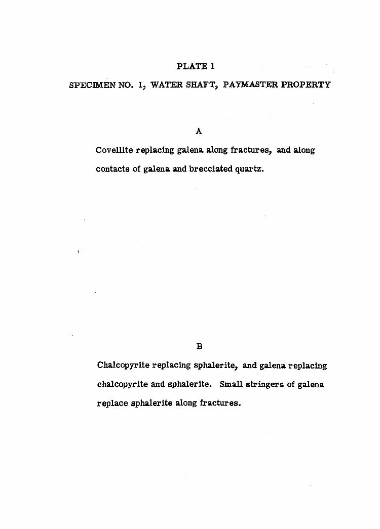
PLATE 1
A
Covellite replacing galena along fractures, and along
contacts of galena and brecciated quartz.
SPECIMEN NO. 1, WATER SHAFT, PAYMASTER PROPERTY
B
Chalcopyrite replacing sphalerite, and galena replacing
chalcopyrite and sphalerite. Small stringers of galena
replace sphalerite along fractures.
41
PLATE I
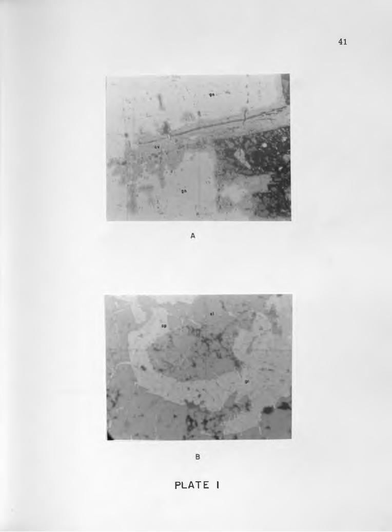
PLATE 2
SPECIMEN NOS. 5 AND 11, WATER SHAFT, PAYMASTERPROPERTY
A
Chalcopyrite replacing sphalerite, and stringers of
calcite replacing both chalcopyrite and sphalerite.
B
Chalcopyrite replacing sphalerite. Apparently some
zones in the sphalerite are more resistant to replace
ment than others.
*1
B
PLATE 2
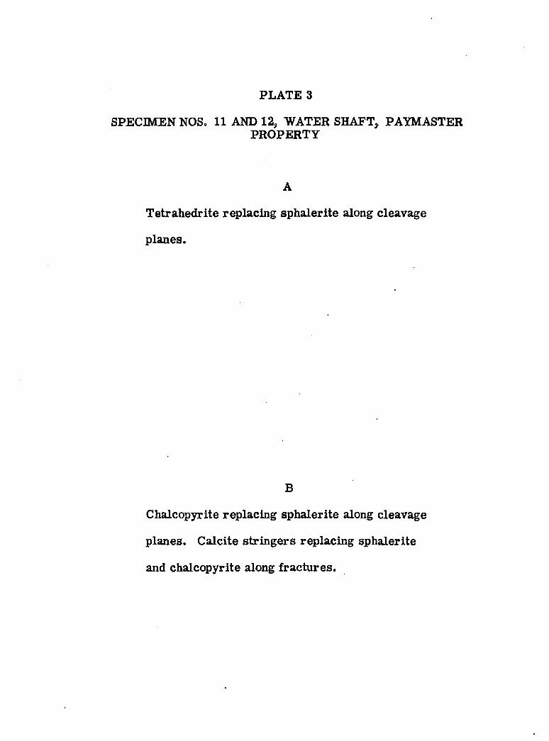
PLATE 3
A
Tetrahedrite replacing sphalerite along cleavage
planes.
SPECIMEN NOS. 11 AND 12, WATER SHAFT, PAYMASTERPROPERTY
B
Chalcopyrite replacing sphalerite along cleavage
planes. Calcite stringers replacing sphalerite
and chalcopyrite along fractures.
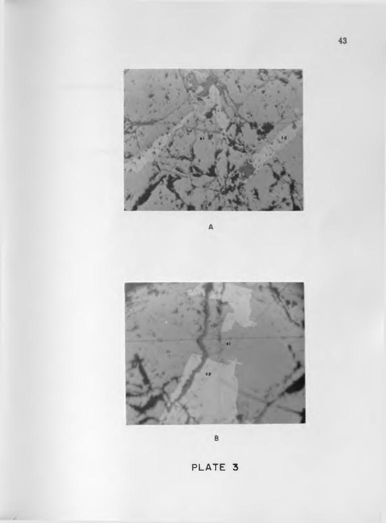
PLATE 3
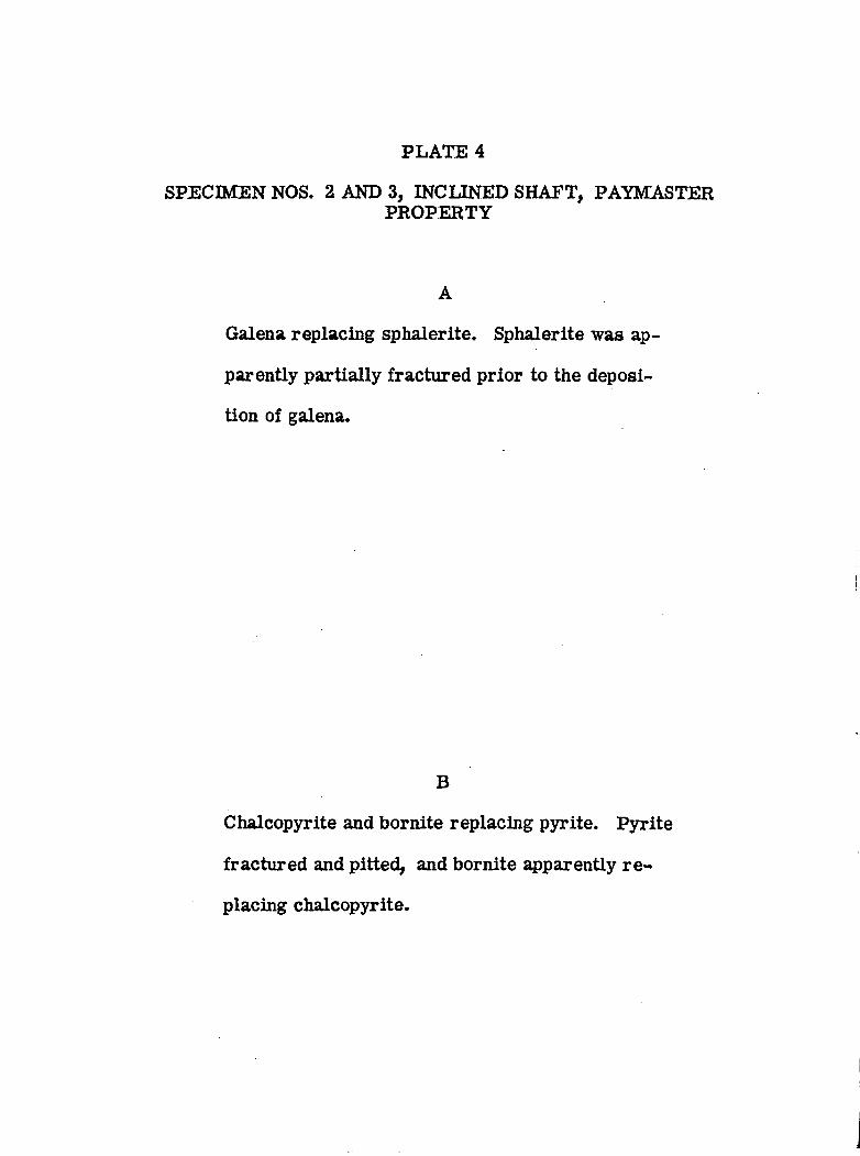
PLATE 4
A
Galena replacing sphalerite. Sphalerite was ap
parently partially fractured prior to the deposi
tion of galena.
SPECIMEN NOS. 2 AND 3, INCLINED SHAFT, PAYMASTERPROPERTY
B
Chalcopyrite and bornite replacing pyrite. Pyrite
fractured and pitted, and bornite apparently re
placing chalcopyrite.
• I
A
PLATE 4
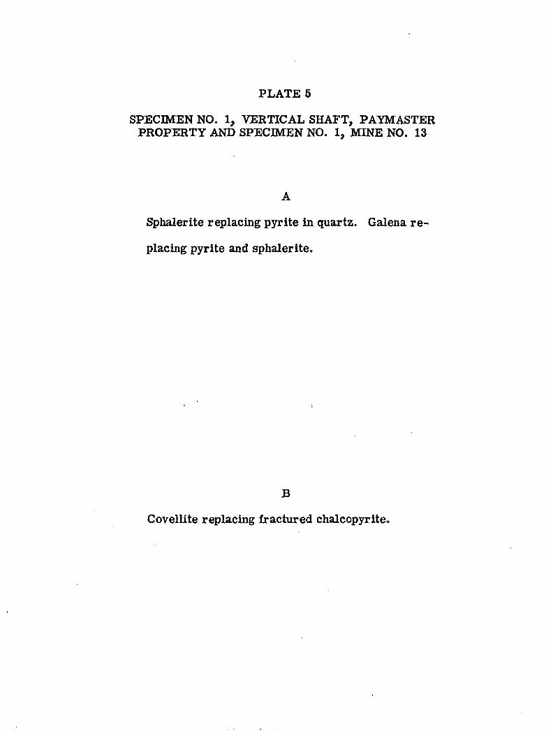
PLATE 5
SPECIMEN NO. 1, VERTICAL SHAFT, PAYMASTERPROPERTY AND SPECIMEN NO. 1, MINE NO. 13
A
Sphalerite replacing pyrite in quartz. Galena re
placing pyrite and sphalerite.
B
Covellite replacing fractured chalcopyrite,
45
B
PLATE 5
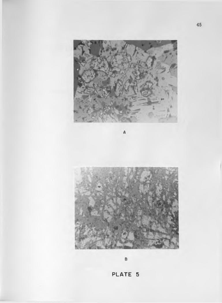
PLATE 6
DUMP SPECIMENS, MINE NO. 9 AND MINE NO. 8
A
Tetrahedrite replacing sphalerite. Portions of
the sphalerite are apparently resistant to re
placement, Small stringer of tetrahedrite along
cleavage plane in sphalerite.
B
Sphalerite replacing pyrite^ and galena replacing
sphalerite.
46
B
PLATE 6
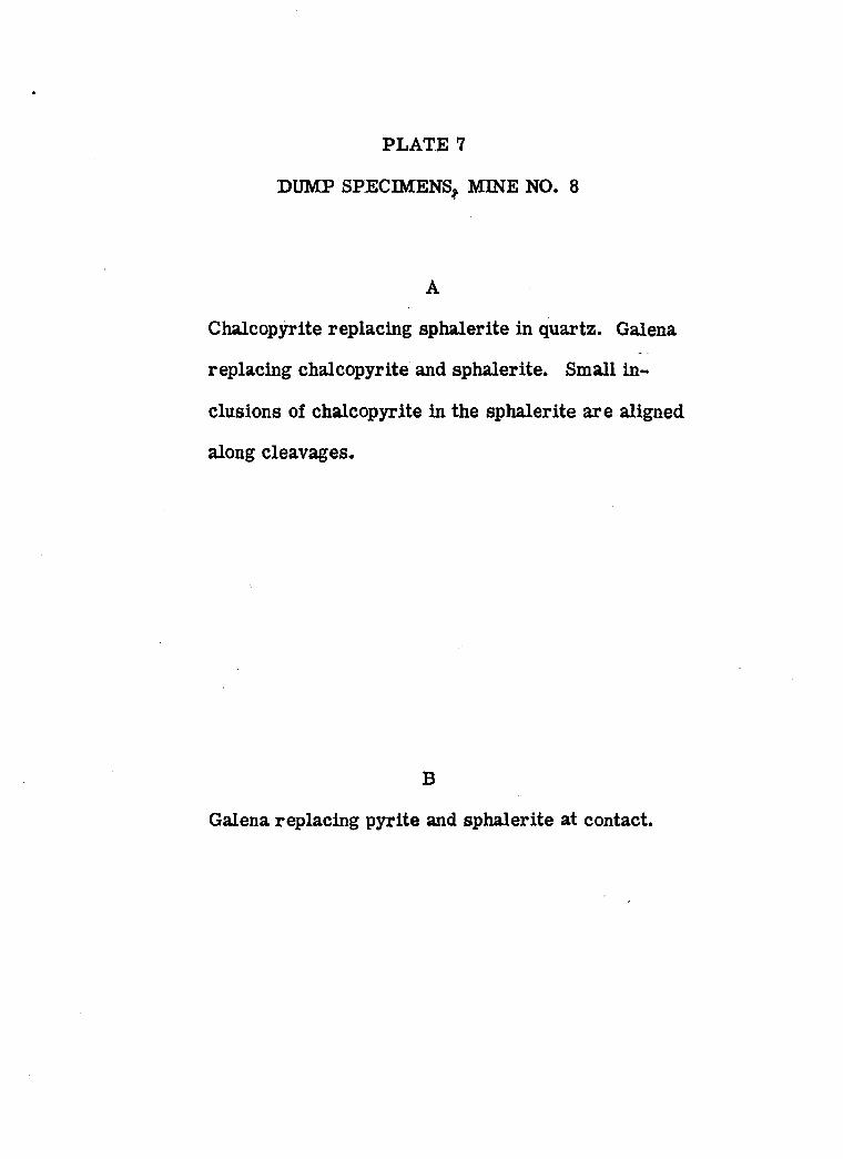
PLATE 7
DUMP SPECIMENS, MINE NO. 8
A
Chalcopyrite replacing sphalerite in quartz. Galena
replacing chalcopyrite and sphalerite. Small in
clusions of chalcopyrite in the sphalerite are aligned
along cleavages.
B
Galena replacing pyrite and sphalerite at contact.
47
PLATE 7
12. BIBLIOGRAPHY
Bryanty D. L. y 1959, Marker Zones in the Permian Formations of Southern Arizona, Southern Arizona Guidebook n, Arizona Geological Society,
Cooper, J. R ., 1960, Some Geologic Features of the Pima Mining D istrict, Pima County, Arizona, U. S. Geol. Survey Bull. 1112-C, p. 63-103.
Irvin, G. "W., 1959, Pyrometasomatic Deposits at San Xavier Mine, Southern Arizona Guidebook D, Arizona Geological Society.
Lacy, "W, C ., 1959, Structure and Ore Deposits of the East Sierrita Area, Southern Arizona Guidebook H, Arizona Geological Society.
Mayuga, M. N ., 1942, The Geology and Ore Deposits of the HelmetPeak Area, Pima County, Arizona, Univ. Arizona unpublished doctoral thesis, 124 p.
Pye, IV. D ., 1959, Catalog of Principal Sedimentary Formation Names in Southern Arizona, Southern Arizona Guidebook H, Arizona Geological Society,
Ransome, F. L ., 1922, Ore Deposits of the Sierrita Mountains, Pima County, Arizona, U. S. Geol. Survey, Contribution to Economic Geology, pt. 1, p. 407-488.
Studebaker, I. G ., 1959, Structure and Stratigraphy of the Helmet Peak Area, Pima County, Arizona, Univ. Arizona unpublished masterrs thesis, 26 p.
Thacpaw, S, C„, 1960, Geology of the Ruby Star Ranch Twin Butte Mining District, Pima County, Arizona, Univ. Arizona unpublished m a sters thesis, 59 p.
48
^/Vx^cs
j'
ARIZONALlhRARVBINDING
COMPANYP h o en ix : Amoox
Certified LibraryBinders
F i ' I I //ft>o
R. I 2 E
T. 17 S.
STRUCTURE MAP OF THE PAYMASTER AND OLIVETTE
MINING AREAS
P I MA C O U N T Y , A R I Z O N A
SCALE IN MILES
1 / 2
E X P L A N A T I O N
& ^
BRE CCI A
MINERALIZATION
C O P P E R
LEAD - Z INC
IRON
OBS ERVED FAULT S
INFERRED F A U L T S
OBSCURED F A U L T S
THRUST F A UL T S
TEAR F A U L T S
4A C C E S S I B L E S H A F T S D
I N A C C E S S I B L E S H A FT S
H. E. WALLER JR.
I 9 6 0
P L A T E 9
t 77?/ tf&o?<r
E X P L A N A T I O N
Qal
ALLUVIUM
T E R T I A R Y C R E T A C E O U S
0 4 0 V A < ? V | > V £> A A £». <J V |
:> V .y > K I K a
BRECCIA ARKOSE
w V 7 '"7 A ! y ' c,, 1 1 f e - X - M
447
B"
CROSS SECTIONS
BASALT PORPHYRY QUARTZITE
, .°.c°T h f o c «°n „ 0 6 0
C? C
HELMET FANGLOME R AT EP R E C A M B R I A N
r ; : / ! 0 WQUARTZ MONZONITE
I EQUARTZ MASSES
A r. ^ v
7 4 T o < ^T 4- ^ 4.+ + P - G g r ^
— < 7 >
ANDESITE GRANI TE
PAYMASTER AND OLIVETTE MINING AREAS
P I M A C O U N T Y , A R I Z O N A
S C A L E
I N M I L E S
INFERRED INTRUSIVE CONTACTS
FAULTS
H. E. WALLER JR I 9 6 0
P L A T E 1 0
f 7 7 7 /
7 f 6 d
f r / O
A'
G E O L O G I C M A P O F M I N E No.
CROSS SECTION
G E O L O G I C M A P O F MIN E No. 2
CROSS SECTION
G E O L O G I C M A P O F M I N E No. I I
CROSS SECTION
L-r a > v
A'
G E O L O G I C M A P O F M I N E No. 7
" e .... ..
FLOODED
G E O L O G I C M A P OF M I N E No. 13
CROSS SECTION
LEGEND
Ko
• ARKOSE
A 7X “
C <fTo> ^ U7 U V
ANDESITE
ALTERATION
WORKINGS
S C A L E I N F E E T
MINES IN THE PAYMASTER-OLIVETTE AREAH E WALLER Jr
P L A T E I I 960
f f V f /
# - / /
CROSS SECTIONS LEVEL MAPS
FAULTS
WORKINGS
SPECIMENS
LEGEND
x 4 < •' iV TO
ANDESITE
ALTERATION
• 2
H E WALLER J r
I 9 6 0
G E O L O G I C M A P O F M I N E No. 3
"VERTICAL SHAFT" PAYMASTER
P L A T E 1 2
£<771/
?r& / &

CROSS SECTIONS LEVELS ON THE INCLINED SHAFT 126 FOOT L E VEL L EGEND
A A >
7 V
. i /„
"POWDER SHAFT" 52 ' L eve l
A H jr ^
C > 1 '.V' i _A sj ' ^
115' L E VE L
LEVEL
G E O L O G I C MAP O F M I N E No. 4
"i n c l i n e d s h a f t " p a y m a s t e r
PLAie 13
jt rrr/
CROSS S E C T I O N S 3 8 F O O T L E V E L 52 F O O T L E V E L LEGEND
SCALE IN FEET
4 0 5 0
H. E. WALLER Jr .
I 9 6 0
G E O L O G I C MAP O F M I N E No. 5
"POWDER SHAFT," PAYMASTER
P L A T E 1 4
I
£ f? ? /f f l ’O
9 f
# ' 4 -
—
FAULTS
WORKINGS
SPECIMENS
LEGEND
1/ x/ / \ V
-Ar To v
L- 4A V
ANDESITE
ALTERATION
MINERALIZATION
SCALE IN FEET
O 5 10
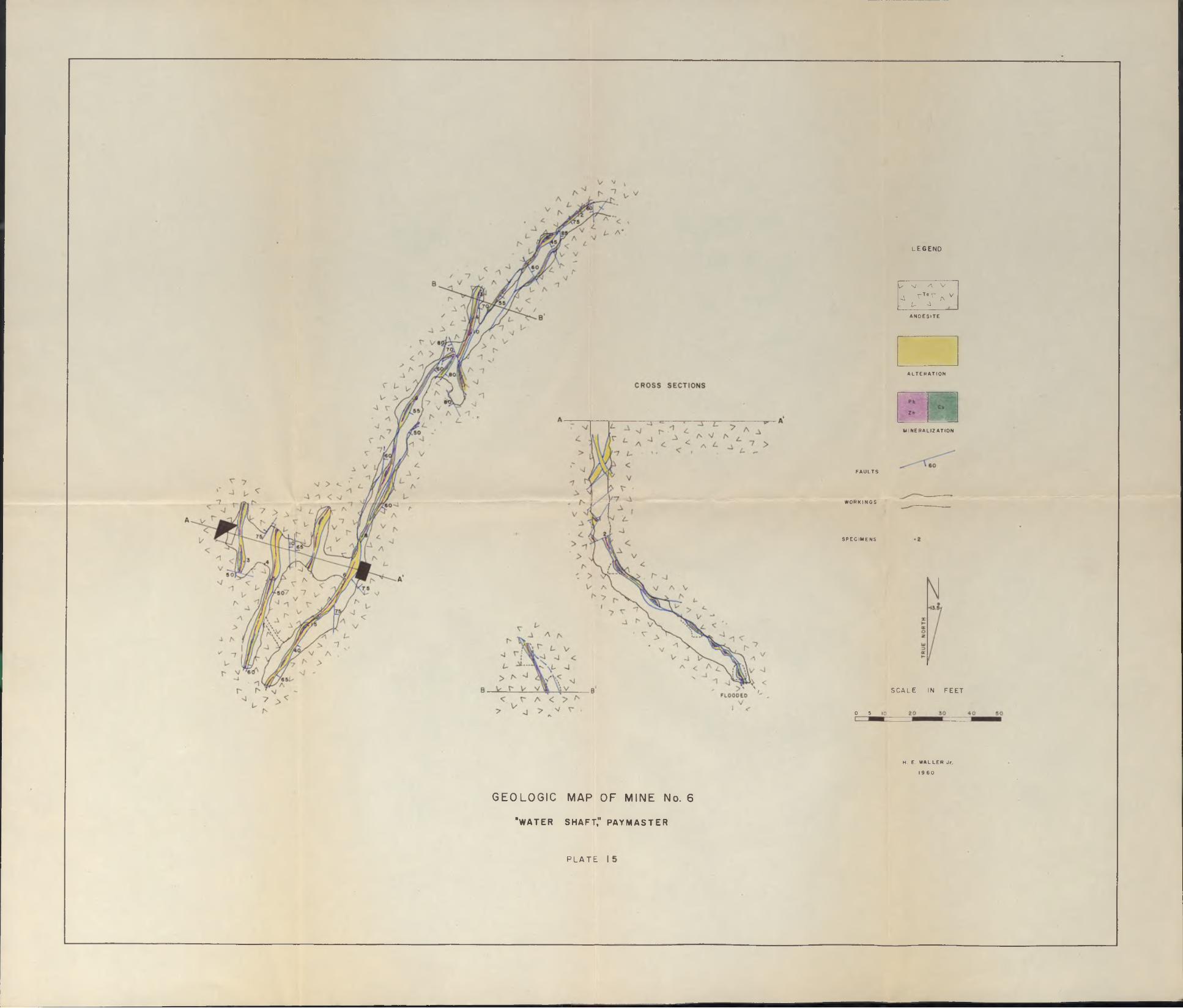
G E O L O G I C M A P O F M I N E No. 6
‘ w a t e r s h a f t ," p a y m a s t e r
H. E. WALLER Jr.
I 9 6 0
P L A T E