Embed Size (px)
Citation preview
The Geology of TexasFerring
Texas
Phot
o Cr
edit
The Pacific Northwest has a dramatic geologic history. It is still a dynamic part ofthe Earth as both modern volcanic eruptions and earthquakes demonstrate. Thisspecial booklet discusses the historical events that shaped the current geologicphenomena of this unique region, as well as the seismic hazards that will continueto shape its future.
Coverage spans the Coast Ranges and the Klamath Mountains, the Puget Sound-Willamette lowland, the Cascades from northern Washington to northernCalifornia, the Columbia Plateau, the Blue Mountains, the Idaho Batholith region,and the Snake River Plain.
Written at a level appropriate for non-majors, this booklet was designed tocomplement any introductory earth science, environmental, geologic, or geographiccourse where discussion of the Pacific Northwest can add relevant context to theregular coursework. Incorporate this content with any Thomson Earth Science text,including Physical Geology: Exploring the Earth, 6th edition, by Monroe, Wicanderand Hazlett. To learn more please visit: www.thomsonedu.com/earthscience.
Also AvailablePeople often decide on their residence or business location based on a desire to liveor work in scenic environments without understanding the hazards around them.Thus, a series of reprinted chapters from Donald and David Hyndman’s NaturalHazards and Disasters has been carefully selected to provide students with theopportunity to see how specific natural hazards are relevant to their regional area.
Each volume has been reprinted in its entirety, including end-of-chapter problemsand “Case In Point” case studies, for easy integration into a variety of introductorycourses where discussion of natural hazards can add relevant context to the regularcoursework.
Available volumes, with select case studies and examples:
Visit Thomson Custom Solutions online at www.thomsoncustom.com
For your lifelong learning needs:www.thomsonedu.com
Hurricanes and Nor’Easter:The Big Winds ISBN 0495153214
90737_Geo_Texas_Cover.qxd 7/31/06 10:33 PM Page 1
Sample
Cop
y
Not for
Rep
roduc
tion
90737_Geo_Texas_Cover2.qxd 7/31/06 10:26 PM Page ii
Sample
Cop
y
Not for
Rep
roduc
tion
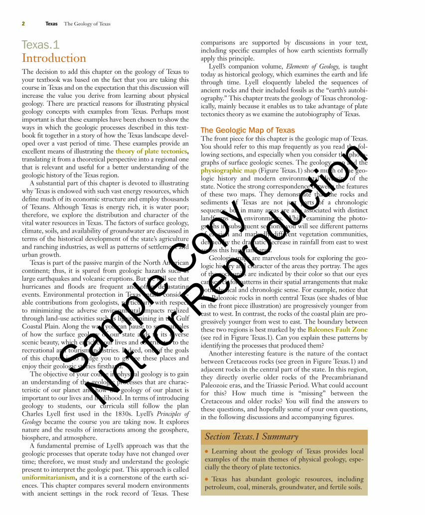
ESSENTIAL QUESTIONS TO ASKTexas.1 Introduction
� Why is the geology of Texas important to students of physical geology and to all the inhabitantsof the state today?
Texas.2 Precambrian Texas� What tectonic events shaped the Proterozoic geologic record of Texas?� When and how were the metamorphic and igneous rocks of the Llano region accreted to the
ancient continent Laurentia?
Texas.3 The Paleozoic Tectonic Cycle� What kinds of sediment were deposited during the Lower Paleozoic?� What is the economic significance of these rocks today?
Texas.4 The Ouachita Orogeny and Pangaea� What were the geologic results in Texas of the collision of Gondwana with Laurasia?� How do the sedimentary rocks and structural styles of the Marathon area illustrate the collision?
Texas.5 The Fort Worth Basin in the Late Paleozoic Era� What sedimentary environments characterized the Fort Worth Basin during and after the
Ouachita orogeny?� Why is this basin rich in oil and gas resources?
Texas.6 Permian Red Beds and Evaporites� Why are red beds and evaporites characteristic of the Permian basins of central and west Texas?� How does the geology of that region affect present-day land-use patterns?
Texas.7 Breakup of Pangaea and Cretaceous Transgressions� What happened in Texas during and after the breakup of Pangaea?� What were the results of the Cretaceous transgressions?
Texas.8 Basin and Range Texas� What types of tectonic activity are indicated by the volcanic rocks in trans-Pecos Texas?� How did the basin and range structural features form in that region?
Texas.9 Llano Estacado� Which geologic processes led to the formation of the Llano Estacado?� What is the Ogallala aquifer, and how is it recharged?
Texas.10 Edwards Plateau and Balcones Fault Zone� When and how did the Edwards Plateau and Balcones Fault Zone form?� How were these geologic features important to the initial settlement of Texas, and how are they
important to Texans today?
Texas.11 The Gulf Coastal Plain� How have transgressions and regressions shaped the geologic evolution of the Gulf Coastal Plain?� What are the economic and environmental implications of using lignite to generate electricity?� How did salt domes form, and why are economic resources concentrated around them?
Texas.12 The Texas Gulf Coast� What are the principal features of the Texas Gulf Coast, and how did they form?� How do hurricanes affect the coastal areas of Texas?
Geology MattersGEOLOGY IN YOUR LIFE:The Legacy of Mining PNW.6
GEOLOGY IN FOCUS:The Link Between Gold and Mercury PNW.8
© 2007 Thomson Brooks/Cole, a part of the Thomson Corporation. Thomson, the Star logo, and Brooks/Cole are trademarks used herein under license. ALL RIGHTS RESERVED. No part of this work covered by thecopyright hereon may be reproduced or used in any form or by any means — graphic, electronic, or mechanical, including photocopying, recording, taping, Web distribution or information storage and retrieval systems— without the written permission of the publisher. The Adaptable Courseware Program consists of products and additions to existing Brooks/Cole products that are produced from camera-ready copy. Peer review, classtesting, and accuracy are primarily the responsibility of the author(s). The Geology of the Pacific Northwest / Elsa Kirsten Peters - First Edition ISBN 0-759-36496-6. Printed in the United States of America.
FPO
90737_Geo_Texas.qxd 7/31/06 9:33 PM Page 1
Sample
Cop
y
Not for
Rep
roduc
tion
Texas.1IntroductionThe decision to add this chapter on the geology of Texas toyour textbook was based on the fact that you are taking thiscourse in Texas and on the expectation that this discussion willincrease the value you derive from learning about physicalgeology. There are practical reasons for illustrating physicalgeology concepts with examples from Texas. Perhaps mostimportant is that these examples have been chosen to show theways in which the geologic processes described in this text-book fit together in a story of how the Texas landscape devel-oped over a vast period of time. These examples provide anexcellent means of illustrating the theory of plate tectonics,translating it from a theoretical perspective into a regional onethat is relevant and useful for a better understanding of thegeologic history of the Texas region.
A substantial part of this chapter is devoted to illustratingwhy Texas is endowed with such vast energy resources, whichdefine much of its economic structure and employ thousandsof Texans. Although Texas is energy rich, it is water poor;therefore, we explore the distribution and character of thevital water resources in Texas. The factors of surface geology,climate, soils, and availability of groundwater are discussed interms of the historical development of the state’s agricultureand ranching industries, as well as patterns of settlement andurban growth.
Texas is part of the passive margin of the North Americancontinent; thus, it is spared from geologic hazards such aslarge earthquakes and volcanic eruptions. But we will see thathurricanes and floods are frequent and often devastatingevents. Environmental protection in Texas entails consider-able contributions from geologists, particularly with respectto minimizing the adverse environmental impacts realizedthrough land-use activities such as lignite mining in the GulfCoastal Plain. Along the way, you can pause to see examplesof how the surface geology of our state adds to its diversescenic beauty, which enriches our lives and contributes to therecreational and tourism industries. Indeed, one of the goalsof this chapter is to nudge you to go see these places andenjoy their geologic stories firsthand.
The objective of your course in physical geology is to gainan understanding of the geologic processes that are charac-teristic of our planet and how the geology of our planet isimportant to our lives and livelihood. In terms of introducinggeology to students, our curricula still follow the planCharles Lyell first used in the 1830s. Lyell’s Principles ofGeology became the course you are taking now. It exploresnature and the results of interactions among the geosphere,biosphere, and atmosphere.
A fundamental premise of Lyell’s approach was that thegeologic processes that operate today have not changed overtime; therefore, we must study and understand the geologicpresent to interpret the geologic past. This approach is calleduniformitarianism, and it is a cornerstone of the earth sci-ences. This chapter compares several modern environmentswith ancient settings in the rock record of Texas. These
comparisons are supported by discussions in your text,including specific examples of how earth scientists formallyapply this principle.
Lyell’s companion volume, Elements of Geology, is taughttoday as historical geology, which examines the earth and lifethrough time. Lyell eloquently labeled the sequences ofancient rocks and their included fossils as the “earth’s autobi-ography.” This chapter treats the geology of Texas chronolog-ically, mainly because it enables us to take advantage of platetectonics theory as we examine the autobiography of Texas.
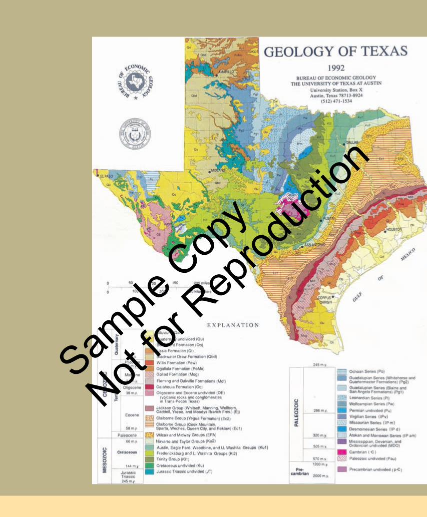
The Geologic Map of TexasThe front piece for this chapter is the geologic map of Texas.You should refer to this map frequently as you read the fol-lowing sections, and especially when you consider the photo-graphs of surface geologic scenes. The geology map and thephysiographic map (Figure Texas.1) show much of the geo-logic history and modern environmental diversity of thestate. Notice the strong correspondence between the featuresof these two maps. They demonstrate that the rocks andsediments of Texas are not just parts of a chronologicsequence, but in many areas are also associated with distinctlandforms and environments. While examining the photo-graphs in subsequent sections, you will see different patternsof erosion and markedly different vegetation communities,defined by the dramatic decrease in rainfall from east to westacross this huge land area.
Geologic maps are marvelous tools for exploring the geo-logic history and character of the areas they portray. The agesof the rock units are indicated by their color so that our eyescan search for patterns in their spatial arrangements that makeboth physical and chronologic sense. For example, notice thatthe Paleozoic rocks in north central Texas (see shades of bluein the front piece illustration) are progressively younger fromeast to west. In contrast, the rocks of the coastal plain are pro-gressively younger from west to east. The boundary betweenthese two regions is best marked by the Balcones Fault Zone(see red in Figure Texas.1). Can you explain these patterns byidentifying the processes that produced them?
Another interesting feature is the nature of the contactbetween Cretaceous rocks (see green in Figure Texas.1) andadjacent rocks in the central part of the state. In this region,they directly overlie older rocks of the PrecambrianandPaleozoic eras, and the Triassic Period. What could accountfor this? How much time is “missing” between theCretaceous and older rocks? You will find the answers tothese questions, and hopefully some of your own questions,in the following discussions and accompanying figures.
2 Texas The Geology of Texas
Section Texas.1 Summary● Learning about the geology of Texas provides localexamples of the main themes of physical geology, espe-cially the theory of plate tectonics.
● Texas has abundant geologic resources, includingpetroleum, coal, minerals, groundwater, and fertile soils.
90737_Geo_Texas.qxd 7/31/06 9:33 PM Page 2
Sample
Cop
y
Not for
Rep
roduc
tion
Texas.2 Precambrian Texas 3
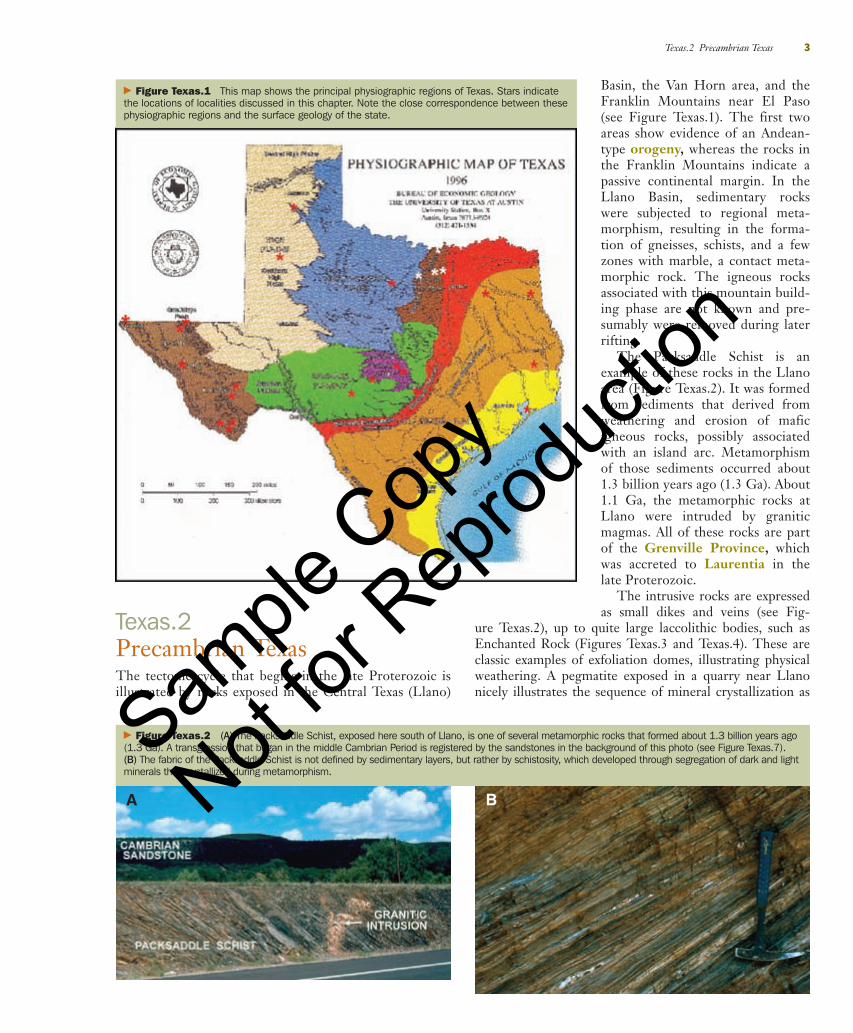
Basin, the Van Horn area, and theFranklin Mountains near El Paso(see Figure Texas.1). The first twoareas show evidence of an Andean-type orogeny, whereas the rocks inthe Franklin Mountains indicate apassive continental margin. In theLlano Basin, sedimentary rockswere subjected to regional meta-morphism, resulting in the forma-tion of gneisses, schists, and a fewzones with marble, a contact meta-morphic rock. The igneous rocksassociated with this mountain build-ing phase are not known and pre-sumably were removed during laterrifting.
The Packsaddle Schist is anexample of these rocks in the Llanoarea (Figure Texas.2). It was formedfrom sediments that derived fromweathering and erosion of maficigneous rocks, possibly associatedwith an island arc. Metamorphismof those sediments occurred about1.3 billion years ago (1.3 Ga). About1.1 Ga, the metamorphic rocks atLlano were intruded by graniticmagmas. All of these rocks are partof the Grenville Province, whichwas accreted to Laurentia in thelate Proterozoic.
The intrusive rocks are expressedas small dikes and veins (see Fig-
ure Texas.2), up to quite large laccolithic bodies, such asEnchanted Rock (Figures Texas.3 and Texas.4). These areclassic examples of exfoliation domes, illustrating physicalweathering. A pegmatite exposed in a quarry near Llanonicely illustrates the sequence of mineral crystallization as
� Figure Texas.2 (A) The Packsaddle Schist, exposed here south of Llano, is one of several metamorphic rocks that formed about 1.3 billion years ago(1.3 Ga). A transgression that began in the middle Cambrian Period is registered by the sandstones in the background of this photo (see Figure Texas.7).(B) The fabric of the Packsaddle Schist is not defined by sedimentary layers, but rather by schistosity, which developed through segregation of dark and lightminerals that crystallized during metamorphism.
A B
� Figure Texas.1 This map shows the principal physiographic regions of Texas. Stars indicatethe locations of localities discussed in this chapter. Note the close correspondence between thesephysiographic regions and the surface geology of the state.
Texas.2Precambrian TexasThe tectonic cycle that begins in the late Proterozoic isillustrated by rocks exposed in the Central Texas (Llano)
90737_Geo_Texas.qxd 7/31/06 9:33 PM Page 3
Sample
Cop
y
Not for
Rep
roduc
tion
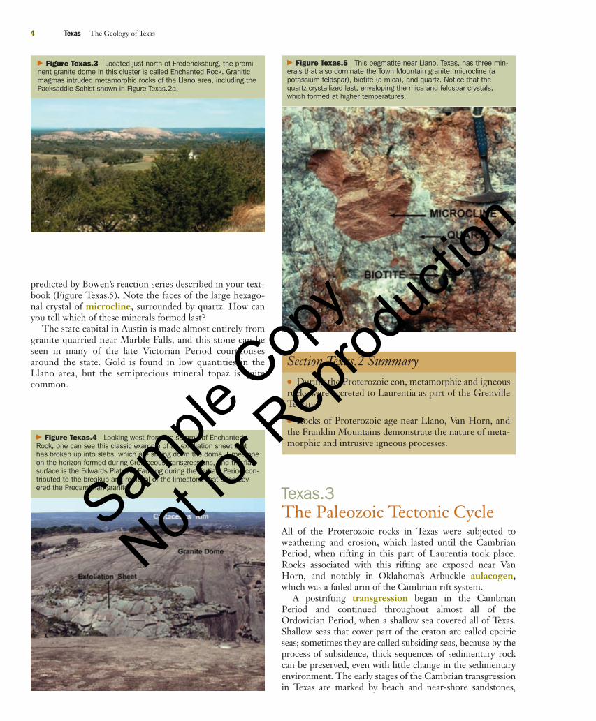
predicted by Bowen’s reaction series described in your text-book (Figure Texas.5). Note the faces of the large hexago-nal crystal of microcline, surrounded by quartz. How canyou tell which of these minerals formed last?
The state capital in Austin is made almost entirely fromgranite quarried near Marble Falls, and this stone can beseen in many of the late Victorian Period courthousesaround the state. Gold is found in low quantities in theLlano area, but the semiprecious mineral topaz is quitecommon.
4 Texas The Geology of Texas
� Figure Texas.3 Located just north of Fredericksburg, the promi-nent granite dome in this cluster is called Enchanted Rock. Graniticmagmas intruded metamorphic rocks of the Llano area, including thePacksaddle Schist shown in Figure Texas.2a.
� Figure Texas.4 Looking west from the summit of EnchantedRock, one can see this classic example of an exfoliation sheet thathas broken up into slabs, which are sliding down the dome. Limestoneon the horizon formed during Cretaceous transgressions, and the flatsurface is the Edwards Plateau. Faulting during the Tertiary Period con-tributed to the breakup and removal of the limestone that once cov-ered the Precambrian granite.
� Figure Texas.5 This pegmatite near Llano, Texas, has three min-erals that also dominate the Town Mountain granite: microcline (apotassium feldspar), biotite (a mica), and quartz. Notice that thequartz crystallized last, enveloping the mica and feldspar crystals,which formed at higher temperatures.
Section Texas.2 Summary● During the Proterozoic eon, metamorphic and igneousrocks were accreted to Laurentia as part of the GrenvilleTerrane.
● Rocks of Proterozoic age near Llano, Van Horn, andthe Franklin Mountains demonstrate the nature of meta-morphic and intrusive igneous processes.
Texas.3The Paleozoic Tectonic CycleAll of the Proterozoic rocks in Texas were subjected toweathering and erosion, which lasted until the CambrianPeriod, when rifting in this part of Laurentia took place.Rocks associated with this rifting are exposed near VanHorn, and notably in Oklahoma’s Arbuckle aulacogen,which was a failed arm of the Cambrian rift system.
A postrifting transgression began in the CambrianPeriod and continued throughout almost all of theOrdovician Period, when a shallow sea covered all of Texas.Shallow seas that cover part of the craton are called epeiricseas; sometimes they are called subsiding seas, because by theprocess of subsidence, thick sequences of sedimentary rockcan be preserved, even with little change in the sedimentaryenvironment. The early stages of the Cambrian transgressionin Texas are marked by beach and near-shore sandstones,
90737_Geo_Texas.qxd 7/31/06 9:33 PM Page 4
Sample
Cop
y
Not for
Rep
roduc
tion
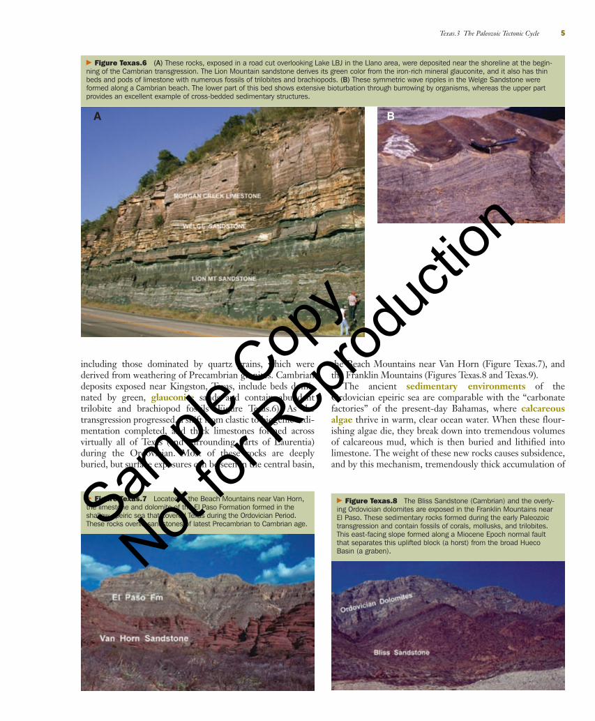
including those dominated by quartz grains, which werederived from weathering of Precambrian granites. Cambriandeposits exposed near Kingston, Texas, include beds domi-nated by green, glauconite sands and contain abundanttrilobite and brachiopod fossils (Figure Texas.6). As thetransgression progressed, a shift from clastic to biogenic sedi-mentation completed, and thick limestones formed acrossvirtually all of Texas (and surrounding parts of Laurentia)during the Ordovician. Most of these rocks are deeplyburied, but surface exposures can be seen in the central basin,
the Beach Mountains near Van Horn (Figure Texas.7), andthe Franklin Mountains (Figures Texas.8 and Texas.9).
The ancient sedimentary environments of theOrdovician epeiric sea are comparable with the “carbonatefactories” of the present-day Bahamas, where calcareousalgae thrive in warm, clear ocean water. When these flour-ishing algae die, they break down into tremendous volumesof calcareous mud, which is then buried and lithified intolimestone. The weight of these new rocks causes subsidence,and by this mechanism, tremendously thick accumulation of
Texas.3 The Paleozoic Tectonic Cycle 5
� Figure Texas.6 (A) These rocks, exposed in a road cut overlooking Lake LBJ in the Llano area, were deposited near the shoreline at the begin-ning of the Cambrian transgression. The Lion Mountain sandstone derives its green color from the iron-rich mineral glauconite, and it also has thinbeds and pods of limestone with numerous fossils of trilobites and brachiopods. (B) These symmetric wave ripples in the Welge Sandstone wereformed along a Cambrian beach. The lower part of this bed shows extensive bioturbation through burrowing by organisms, whereas the upper partprovides an excellent example of cross-bedded sedimentary structures.
A B
� Figure Texas.7 Located in the Beach Mountains near Van Horn,the limestone and dolomite of the El Paso Formation formed in theshallow epeiric sea that covered Texas during the Ordovician Period.These rocks overlie sandstones of latest Precambrian to Cambrian age.
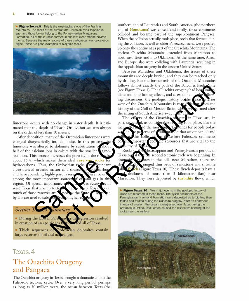
� Figure Texas.8 The Bliss Sandstone (Cambrian) and the overly-ing Ordovician dolomites are exposed in the Franklin Mountains nearEl Paso. These sedimentary rocks formed during the early Paleozoictransgression and contain fossils of corals, mollusks, and trilobites.This east-facing slope formed along a Miocene Epoch normal faultthat separates this uplifted block (a horst) from the broad HuecoBasin (a graben).
90737_Geo_Texas.qxd 7/31/06 9:33 PM Page 5
Sample
Cop
y
Not for
Rep
roduc
tion
6 Texas The Geology of Texas
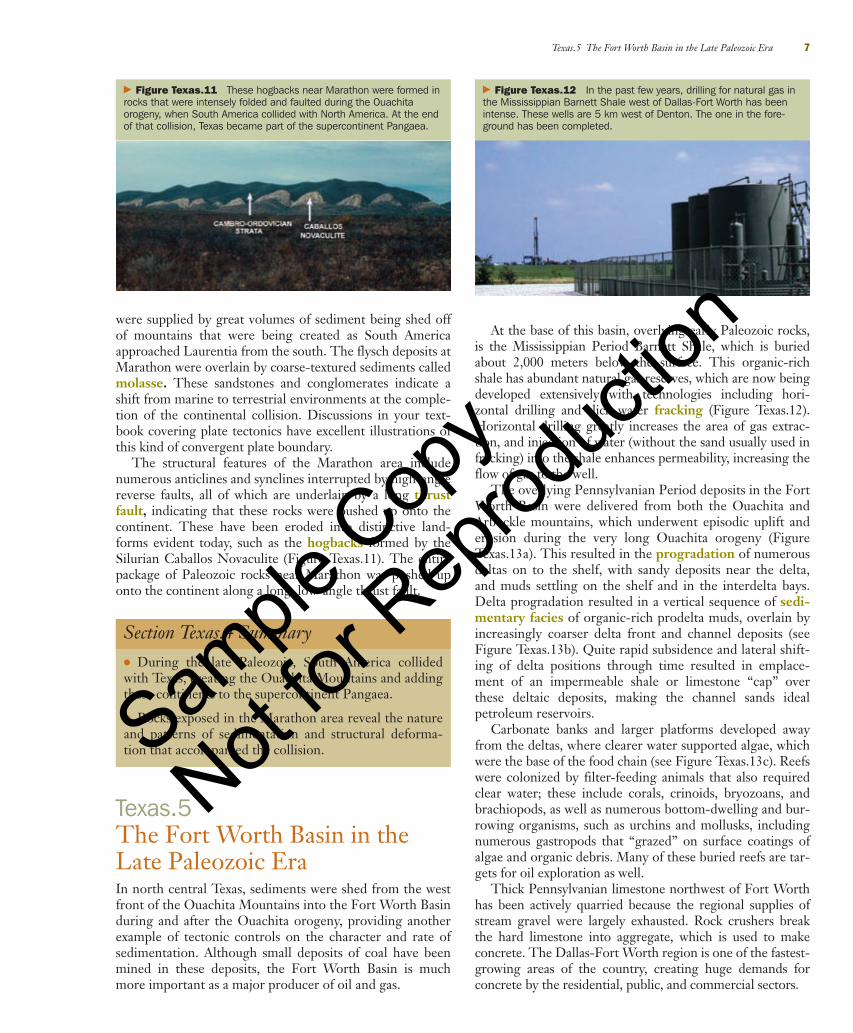
� Figure Texas.9 This is the west-facing slope of the FranklinMountains. The rocks at the summit are Devonian-Mississippian inage, and those below belong to the Pennsylvanian MagdalenaFormation. All of these rocks formed in shallow, clear marine environ-ments. Because the major source of these carbonates was calcareousalgae, these are good examples of biogenic rocks.
limestone occurs with no change in water depth. It is esti-mated that the depth of Texas’s Ordovician sea was alwayson the order of less than 10 meters.
After deposition, many of the Ordovician limestones werechanged diagenetically into dolomite. In this process, thelimestone was altered to dolomite by substitution of abouthalf of the calcium ions in calcite with the smaller magne-sium ion. This process increases the porosity of the rocks byabout 15%, which makes them ideal reservoir rocks forhydrocarbons. Thus, the Ordovician rocks have abundantalgae-derived organic matter as a source for hydrocarbonsand have abundant, highly porous reservoirs. These rocks areamong the most important sources of oil and gas in thisregion. Of special importance are natural gas reservoirs inwest Texas that are up to 6,000 meters deep. Royalties onmuch of those reserves are owned by the State of Texas andby law are used to subsidize (your) higher education!
Section Texas.3 Summary● During the Lower Paleozoic, a transgression resultedin creation of an epeiric sea that covered all of Texas.
● Thick sequences of Ordovician dolomites containlarge reserves of oil and natural gas.
Texas.4The Ouachita Orogenyand PangaeaThe Ouachita orogeny in Texas brought a dramatic end to thePaleozoic tectonic cycle. Over a very long period, perhapsas long as 50 million years, the ocean between Texas (the
� Figure Texas.10 Two major events in the geologic history ofTexas are recorded in these rocks. The flysch sediments of thePennsylvanian Haymond Formation were deposited as turbidites, thenfolded and faulted during the Ouachita orogeny. After an enormousinterval of erosion, the ocean transgressed over Texas during theCretaceous Period. Rock creep caused the distinctive bending of therocks near the surface.
southern end of Laurentia) and South America (the northernend of Gondwana) was closed, and finally, those continentscollided and became part of the supercontinent Pangaea.When the collision actually took place, rocks that formed dur-ing the collision, as well as older Paleozoic rocks, were pushedup onto the continent as part of the Ouachita Mountains. Theancient Ouachita Mountains extended from Marathon tonortheast Texas and into Oklahoma. At the same time, Africaand Europe also were colliding with Laurentia, resulting inthe Appalachian orogeny in the eastern United States.
Between Marathon and Oklahoma, the traces of thesemountains are deeply buried, and they can be reached onlyby drilling. But the former axis of the Ouachita Mountainsfollows almost exactly the path of the Balcones Fault Zone(see Figure Texas.1). The Ouachita orogeny had both imme-diate and long-lasting effects, and as explained in the follow-ing discussions, the geologic history of the Texas interiorwest of the Ouachita Mountains is very different from thehistory of the Gulf of Mexico Basin, which was formed afterthe rifting of South America away from Texas.
The effects of the Ouachita orogeny in Texas are, inpart, structural, as considerable faulting took place. But themain effects, and the most important ones for people today,were in the patterns of sedimentation that accompanied andfollowed this collision, for those late Paleozoic sedimentscontain important geologic resources that are vital to theeconomy of Texas.
Rocks of the Mississippian and Pennsylvanian periods inTexas reveal that the second tectonic cycle was beginning. Indramatic exposures in the hills near Marathon, there arerhythmically arranged thin beds of sandstone and siltstonecalled flysch (Figure Texas.10). These flysch deposits have atotal thickness of more than 3 kilometers (km) nearMarathon. They were deposited by turbidite flows, which
90737_Geo_Texas.qxd 7/31/06 9:33 PM Page 6
Sample
Cop
y
Not for
Rep
roduc
tion
were supplied by great volumes of sediment being shed offof mountains that were being created as South Americaapproached Laurentia from the south. The flysch deposits atMarathon were overlain by coarse-textured sediments calledmolasse. These sandstones and conglomerates indicate ashift from marine to terrestrial environments at the comple-tion of the continental collision. Discussions in your text-book covering plate tectonics have excellent illustrations ofthis kind of convergent plate boundary.
The structural features of the Marathon area includenumerous anticlines and synclines interrupted by high-anglereverse faults, all of which are underlain by a long thrustfault, indicating that these rocks were pushed up onto thecontinent. These have been eroded into distinctive land-forms evident today, such as the hogbacks formed by theSilurian Caballos Novaculite (Figure Texas.11). The entirepackage of Paleozoic rocks near Marathon was pushed uponto the continent along a long, low-angle thrust fault.
At the base of this basin, overlying early Paleozoic rocks,is the Mississippian Period Barnett Shale, which is buriedabout 2,000 meters below the surface. This organic-richshale has abundant natural gas reserves, which are now beingdeveloped extensively with technologies including hori-zontal drilling and slick water fracking (Figure Texas.12).Horizontal drilling greatly increases the area of gas extrac-tion, and injection of water (without the sand usually used infracking) into the shale enhances permeability, increasing theflow of gas to the well.
The overlying Pennsylvanian Period deposits in the FortWorth Basin were delivered from both the Ouachita andArbuckle mountains, which underwent episodic uplift anderosion during the very long Ouachita orogeny (FigureTexas.13a). This resulted in the progradation of numerousdeltas on to the shelf, with sandy deposits near the delta,and muds settling on the shelf and in the interdelta bays.Delta progradation resulted in a vertical sequence of sedi-mentary facies of organic-rich prodelta muds, overlain byincreasingly coarser delta front and channel deposits (seeFigure Texas.13b). Quite rapid subsidence and lateral shift-ing of delta positions through time resulted in emplace-ment of an impermeable shale or limestone “cap” overthese deltaic deposits, making the channel sands idealpetroleum reservoirs.
Carbonate banks and larger platforms developed awayfrom the deltas, where clearer water supported algae, whichwere the base of the food chain (see Figure Texas.13c). Reefswere colonized by filter-feeding animals that also requiredclear water; these include corals, crinoids, bryozoans, andbrachiopods, as well as numerous bottom-dwelling and bur-rowing organisms, such as urchins and mollusks, includingnumerous gastropods that “grazed” on surface coatings ofalgae and organic debris. Many of these buried reefs are tar-gets for oil exploration as well.
Thick Pennsylvanian limestone northwest of Fort Worthhas been actively quarried because the regional supplies ofstream gravel were largely exhausted. Rock crushers breakthe hard limestone into aggregate, which is used to makeconcrete. The Dallas-Fort Worth region is one of the fastest-growing areas of the country, creating huge demands forconcrete by the residential, public, and commercial sectors.
Texas.5 The Fort Worth Basin in the Late Paleozoic Era 7
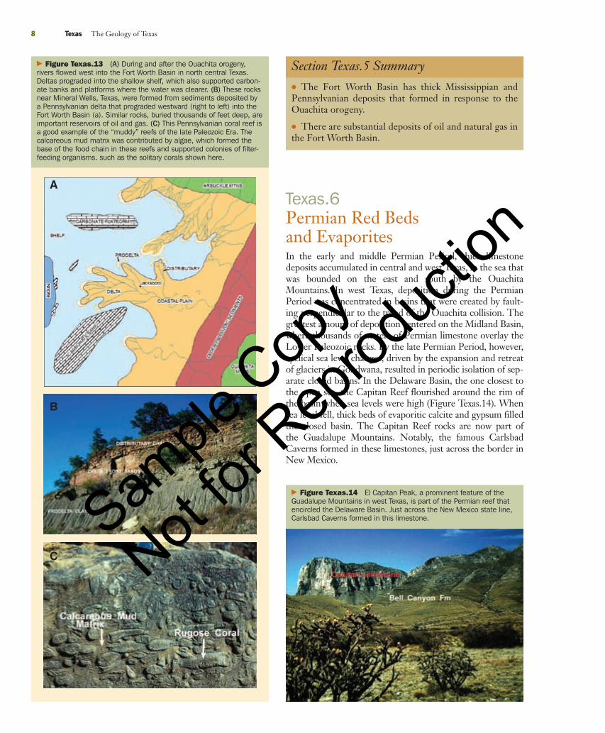
� Figure Texas.11 These hogbacks near Marathon were formed inrocks that were intensely folded and faulted during the Ouachitaorogeny, when South America collided with North America. At the endof that collision, Texas became part of the supercontinent Pangaea.
Section Texas.4 Summary● During the late Paleozoic, South America collidedwith Texas, creating the Ouachita Mountains and addingthese continents to the supercontinent Pangaea.
● Rocks exposed in the Marathon area reveal the natureand patterns of sedimentation and structural deforma-tion that accompanied the collision.
Texas.5The Fort Worth Basin in theLate Paleozoic EraIn north central Texas, sediments were shed from the westfront of the Ouachita Mountains into the Fort Worth Basinduring and after the Ouachita orogeny, providing anotherexample of tectonic controls on the character and rate ofsedimentation. Although small deposits of coal have beenmined in these deposits, the Fort Worth Basin is muchmore important as a major producer of oil and gas.
� Figure Texas.12 In the past few years, drilling for natural gas inthe Mississippian Barnett Shale west of Dallas-Fort Worth has beenintense. These wells are 5 km west of Denton. The one in the fore-ground has been completed.
90737_Geo_Texas.qxd 7/31/06 9:33 PM Page 7
Sample
Cop
y
Not for
Rep
roduc
tion
8 Texas The Geology of Texas
� Figure Texas.13 (A) During and after the Ouachita orogeny,rivers flowed west into the Fort Worth Basin in north central Texas.Deltas prograded into the shallow shelf, which also supported carbon-ate banks and platforms where the water was clearer. (B) These rocksnear Mineral Wells, Texas, were formed from sediments deposited bya Pennsylvanian delta that prograded westward (right to left) into theFort Worth Basin (a). Similar rocks, buried thousands of feet deep, areimportant reservoirs of oil and gas. (C) This Pennsylvanian coral reef isa good example of the “muddy” reefs of the late Paleozoic Era. Thecalcareous mud matrix was contributed by algae, which formed thebase of the food chain in these reefs and supported colonies of filter-feeding organisms. such as the solitary corals shown here.
Section Texas.5 Summary● The Fort Worth Basin has thick Mississippian andPennsylvanian deposits that formed in response to theOuachita orogeny.
● There are substantial deposits of oil and natural gas inthe Fort Worth Basin.
Texas.6Permian Red Bedsand EvaporitesIn the early and middle Permian Period, thick limestonedeposits accumulated in central and west Texas, in the sea thatwas bounded on the east and south by the OuachitaMountains. In west Texas, deposition during the PermianPeriod was concentrated in basins that were created by fault-ing perpendicular to the trend of the Ouachita collision. Thegreatest amount of deposition centered on the Midland Basin,where thousands of meters of Permian limestone overlay theLower Paleozoic rocks. By the late Permian Period, however,cyclical sea level changes, driven by the expansion and retreatof glaciers in Gondwana, resulted in periodic isolation of sep-arate closed basins. In the Delaware Basin, the one closest tothe open sea, the Capitan Reef flourished around the rim ofthe basin when sea levels were high (Figure Texas.14). Whensea level fell, thick beds of evaporitic calcite and gypsum filledthe closed basin. The Capitan Reef rocks are now part ofthe Guadalupe Mountains. Notably, the famous CarlsbadCaverns formed in these limestones, just across the border inNew Mexico.
� Figure Texas.14 El Capitan Peak, a prominent feature of theGuadalupe Mountains in west Texas, is part of the Permian reef thatencircled the Delaware Basin. Just across the New Mexico state line,Carlsbad Caverns formed in this limestone.
A
B
C
90737_Geo_Texas.qxd 7/31/06 9:34 PM Page 8
Sample
Cop
y
Not for
Rep
roduc
tion
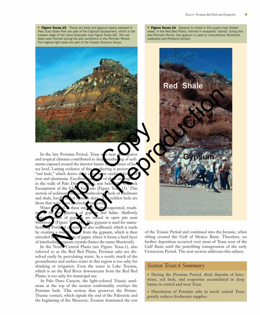
In the late Permian Period, Texas was near the equatorand tropical climates contributed to deep weathering of sedi-ments exposed around the interior basins during times of lowsea level. Lasting evidence of this weathering is preserved as“red beds,” which derive their color from oxidized forms ofiron and aluminum. Excellent examples of these are exposedin the walls of Palo Duro Canyon, just below the CaprockEscarpment of the Llano Estacado (Figure Texas.15). Thissection of sediments includes multicolored beds of sandstoneand shale, locally called Spanish skirts. The reddest beds arethose that were most intensely weathered.
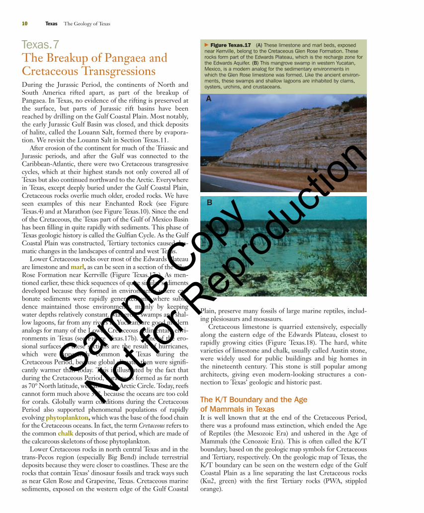
Water trapped in these interior basins evaporated, result-ing in the precipitation of gypsum and halite. Shallowlyburied deposits of gypsum are mined in open pits nearSweetwater (Figure Texas.16). The gypsum is used for manu-facturing Portland cement and also wallboard, which is madeby creating a muddy slurry from the gypsum, which is thenextruded between sheets of paper, where it forms a hard layerof interlocking gypsum crystals (hence the name Sheetrock).
In the North Central Plains (see Figure Texas.1), alsoreferred to as the Red Bed Plains, Permian salts are dis-solved easily by percolating water. As a result, much of thegroundwater and surface water in this region is too salty fordrinking or irrigation. Even the water in Lake Texoma,which is on the Red River downstream from the Red BedPlains, is too salty for municipal use.
At Palo Duro Canyon, the light-colored Triassic sand-stone at the top of the section conformably overlays thePermian beds. This section thus preserves the Permo-Triassic contact, which signals the end of the Paleozoic andthe beginning of the Mesozoic. Erosion dominated the rest
of the Triassic Period and continued into the Jurassic, whenrifting created the Gulf of Mexico Basin. Therefore, nofurther deposition occurred over most of Texas west of theGulf Basin until the postrifting transgression of the earlyCretaceous Period. The next section addresses this subject.
Texas.6 Permian Red Beds and Evaporites 9
� Figure Texas.15 These red beds and gypsum layers exposed inPalo Duro State Park are part of the Caprock Escarpment, which is theeastern edge of the Llano Estacado (see Figure Texas.26). The redbeds were formed during the arid conditions in the Permian Period.The highest light beds are part of the Triassic Dockum Group.
� Figure Texas.16 Gypsum is mined in this quarry near Sweet-water, in the Red Bed Plains. Formed in evaporitic “ponds” during thearid Permian Period, this gypsum is used to manufacture Sheetrockwallboard and Portland cement.
Section Texas.6 Summary● During the Permian Period, thick deposits of lime-stone, red beds, and evaporites accumulated in deepbasins in central and west Texas.
● Dissolution of Permian salts in north central Texasgreatly reduces freshwater supplies.
90737_Geo_Texas.qxd 7/31/06 9:34 PM Page 9
Sample
Cop
y
Not for
Rep
roduc
tion
Texas.7The Breakup of Pangaea andCretaceous TransgressionsDuring the Jurassic Period, the continents of North andSouth America rifted apart, as part of the breakup ofPangaea. In Texas, no evidence of the rifting is preserved atthe surface, but parts of Jurassic rift basins have beenreached by drilling on the Gulf Coastal Plain. Most notably,the early Jurassic Gulf Basin was closed, and thick depositsof halite, called the Louann Salt, formed there by evapora-tion. We revisit the Louann Salt in Section Texas.11.
After erosion of the continent for much of the Triassic andJurassic periods, and after the Gulf was connected to theCaribbean-Atlantic, there were two Cretaceous transgressivecycles, which at their highest stands not only covered all ofTexas but also continued northward to the Arctic. Everywherein Texas, except deeply buried under the Gulf Coastal Plain,Cretaceous rocks overlie much older, eroded rocks. We haveseen examples of this near Enchanted Rock (see FigureTexas.4) and at Marathon (see Figure Texas.10). Since the endof the Cretaceous, the Texas part of the Gulf of Mexico Basinhas been filling in quite rapidly with sediments. This phase ofTexas geologic history is called the Gulfian Cycle. As the GulfCoastal Plain was constructed, Tertiary tectonics caused dra-matic changes in the landscapes of central and west Texas.
Lower Cretaceous rocks over most of the Edwards Plateauare limestone and marl, as can be seen in a section of the GlenRose Formation near Kerrville (Figure Texas.17a). As men-tioned earlier, these thick sequences of quite similar sedimentsdeveloped because they formed in environments where car-bonate sediments were rapidly generated and where subsi-dence maintained those environments, mainly by keepingwater depths relatively constant. Mangrove swamps and shal-low lagoons, far from any rivers in Yucatan, are good modernanalogs for many of the Lower Cretaceous sedimentary envi-ronments in Texas (see Figure Texas.17b). Some of the ero-sional surfaces in these sections are the result of hurricanes,which were apparently common in Texas during theCretaceous Period, because global climates then were signifi-cantly warmer than today. This is illustrated by the fact thatduring the Cretaceous Period, coral reefs formed as far northas 70° North latitude, well above the Arctic Circle. Today, reefscannot form much above 35°, because the oceans are too coldfor corals. Globally warm conditions during the CretaceousPeriod also supported phenomenal populations of rapidlyevolving phytoplankton, which was the base of the food chainfor the Cretaceous oceans. In fact, the term Cretaceous refers tothe common chalk deposits of that period, which are made ofthe calcareous skeletons of those phytoplankton.
Lower Cretaceous rocks in north central Texas and in thetrans-Pecos region (especially Big Bend) include terrestrialdeposits because they were closer to coastlines. These are therocks that contain Texas’ dinosaur fossils and track ways suchas near Glen Rose and Grapevine, Texas. Cretaceous marinesediments, exposed on the western edge of the Gulf Coastal
Plain, preserve many fossils of large marine reptiles, includ-ing plesiosaurs and mosasaurs.
Cretaceous limestone is quarried extensively, especiallyalong the eastern edge of the Edwards Plateau, closest torapidly growing cities (Figure Texas.18). The hard, whitevarieties of limestone and chalk, usually called Austin stone,were widely used for public buildings and big homes inthe nineteenth century. This stone is still popular amongarchitects, giving even modern-looking structures a con-nection to Texas’ geologic and historic past.
The K/T Boundary and the Age of Mammals in TexasIt is well known that at the end of the Cretaceous Period,there was a profound mass extinction, which ended the Ageof Reptiles (the Mesozoic Era) and ushered in the Age ofMammals (the Cenozoic Era). This is often called the K/Tboundary, based on the geologic map symbols for Cretaceousand Tertiary, respectively. On the geologic map of Texas, theK/T boundary can be seen on the western edge of the GulfCoastal Plain as a line separating the last Cretaceous rocks(Ku2, green) with the first Tertiary rocks (PWA, stippledorange).
10 Texas The Geology of Texas
� Figure Texas.17 (A) These limestone and marl beds, exposednear Kerrville, belong to the Cretaceous Glen Rose Formation. Theserocks form part of the Edwards Plateau, which is the recharge zone forthe Edwards Aquifer. (B) This mangrove swamp in western Yucatan,Mexico, is a modern analog for the sedimentary environments inwhich the Glen Rose limestone was formed. Like the ancient environ-ments, these swamps and shallow lagoons are inhabited by clams,oysters, urchins, and crustaceans.
A
B
90737_Geo_Texas.qxd 7/31/06 9:34 PM Page 10
Sample
Cop
y
Not for
Rep
roduc
tion
During the Cenozoic Era, mammals diversified rapidlyon all the continents and in the oceans as well. Texas has anexcellent fossil record of mammalian evolution, but it is con-tained mainly in sediments in the western part of the state.There the Tertiary landscape evolved in quite dramaticways, in response to a sequence of compressional and thenextensional intraplate tectonics. These tectonic changesappear to be related to an eastward extension of the zone ofsubduction of the Pacific Plate under the western edge ofNorth America, which resulted in compressional uplift andvolcanism. A further lowering of the subduction angle mayhave contributed to the subsequent extensional regimen,when basin and range features developed not only in trans-Pecos Texas but also over most of the western United States.The regional manifestations of this phase of intraplate tec-tonism are discussed in the following sections.
Texas.8 Basin and Range Texas 11
� Figure Texas.18 This quarry in Cretaceous rocks near Austin isone of many that are used to produce crushed stone aggregate, limefor cement, and dimension stone for construction and landscaping.
Section Texas.7 Summary● In the Jurassic Period, South America rifted awayform Texas, forming the Gulf of Mexico Basin.
● In the Cretaceous Period, marine transgressions cov-ered Texas, leaving thick limestone deposits.
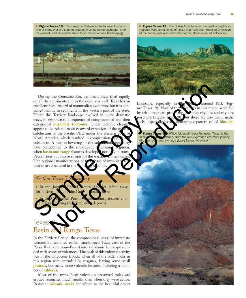
landscape, especially in Big Bend National Park (Fig-ure Texas.19). Most of the volcanoes in this region were fedby felsic magmas, producing common rhyolite and rhyoliteporphyry (Figure Texas.20). But there are also many maficrocks, especially basalt, indicating a pattern called bimodal
� Figure Texas.19 The Chisos Mountains, in the heart of Big BendNational Park, are a series of necks that have been exposed by erosionof the softer lavas and ashes that formed these once tall volcanoes.
Texas.8Basin and Range TexasIn the Tertiary Period, the compressional phase of intraplatetectonism mentioned earlier transformed Texas west of thePecos River (the trans-Pecos) into a dynamic landscape stud-ded with scores of volcanoes. The peak of this volcanic activitywas in the Oligocene Epoch, when all of the older rocks inthis region were intruded by magmas, leaving some smallplutons, but many more volcanic features, including a num-ber of calderas.
Most of the trans-Pecos volcanoes preserved today areeroded remnants, much smaller than when they were active.Resistant volcanic necks contribute to the beautiful desert
� Figure Texas.20 Willow Mountain, near Terlingua, Texas, is theneck of a rhyolitic volcano. Note the well-expressed columnar jointingof these rocks and the talus slopes formed by erosion.
90737_Geo_Texas.qxd 7/31/06 9:34 PM Page 11
Sample
Cop
y
Not for
Rep
roduc
tion
volcanism; that is, the chemical composition of the magmasthat fed different volcanoes ranges from felsic to mafic.Bimodal volcanism is characteristic of intraplate tectonism,where deep magmatic sources had mafic, mantle-like compo-sitions, whereas nearby volcanoes werefed by shallower, continental sourceswith felsic composition. Formation ofthe Tertiary Rio Grande Rift in nearbyNew Mexico was accompanied bybimodal volcanism, as can be seen inthe juxtaposition of andesitic andbasaltic rocks near Santa Fe.
The high silica content of the felsicmagmas caused extremely violenteruptions that produced huge volumesof pyroclastic ash. Winds carried thoseashes to the east, where they becameburied within the Ogallala Formationunder the present-day High Plains(see Section Texas.9). Ash beds arealso preserved in a number of theTertiary formations of the GulfCoastal Plain. Ash weathers quicklyinto fertile soils, and the extensivegrasslands of that period nourishedthe rapidly evolving communities ofgrazing animals, including horses,which populated the ancestral GreatPlains environments.
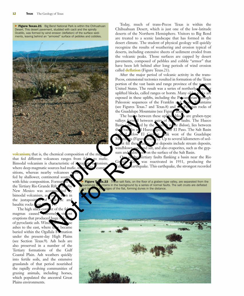
Today, much of trans-Pecos Texas is within theChihuahuan Desert, which is just one of the low-latitudedeserts of the Northern Hemisphere. Visitors to Big Bendare treated to a scenic landscape that has formed in thedesert climate. The student of physical geology will quicklyrecognize the results of weathering and erosion typical ofdeserts, including extensive sheets of sediment eroded fromthe volcanic peaks. Those surfaces are capped by desertpavements, composed of pebbles and cobble “armor” thathave been left behind after long periods of wind erosioncalled deflation (Figure Texas.21).
After the major period of volcanic activity in the trans-Pecos, extensional tectonics resulted in formation of the Texasportion of the vast basin and range province of the westernUnited States. The result was a series of northerly trendinguplifted blocks, called ranges or horsts. Many older rocks areexposed in these uplifts, including the Precambrian throughPaleozoic sequences of the Franklin and Beach Mountains(see Figures Texas.7 and Texas.8) and the Permian rocks ofthe Guadalupe Mountains (see Figure Texas.14).
The basins between these uplifted blocks are graben-typevalleys formed between pairs of normal faults. The HuecoBasin (also called by the Spanish name Bolson), lies betweenthe Franklin and Hueco uplifts near El Paso. The Salt Basinformed below El Capitan Peak west of the GuadalupeMountains (Figure Texas.22). Up to several kilometers of sed-iment fill these basins. The deposits include stream deposits,windblown sand and silt, and also evaporites, such as the gyp-sum and halite seen on the surface of the Salt Basin.
One of the Tertiary faults flanking a basin near the RioGrande River was reactivated in 1931, producing theValentine earthquake. This earthquake, the strongest recorded
12 Texas The Geology of Texas
� Figure Texas.21 Big Bend National Park is within the ChihuahuanDesert. This desert pavement, studded with cacti and the spindlyOcatillo, was formed by wind erosion (deflation) of the surface sedi-ments, leaving behind an “armored” surface of pebbles and cobbles.
� Figure Texas.22 These salt flats, on the floor of a graben-type valley, are separated from theGuadalupe Mountains in the background by a series of normal faults. The salt crusts are deflatedand blown to the edges of the flat, forming dunes in the distance.
90737_Geo_Texas.qxd 7/31/06 9:34 PM Page 12
Sample
Cop
y
Not for
Rep
roduc
tion
in Texas, registered 6.0 on the Richter scale. Buildings weredamaged near the epicenter, and the earthquake was felt overmuch of Texas. Since then, Texas has experienced a numberof smaller earthquakes, rarely above Richter 4.0.
Texas.9The Llano EstacadoIn the Tertiary Period, uplift of the southern RockyMountains increased rates of erosion. As a result, a ramp ofsediment called the High Plains was deposited on the east-ern front of the Rockies, from Texas to Canada. The part of
Texas.9 The Llano Estacado 13
Section Texas.8 Summary● Intraplate tectonics resulted in volcanism and creation ofbasin and range features in the trans-Pecos region of Texas.
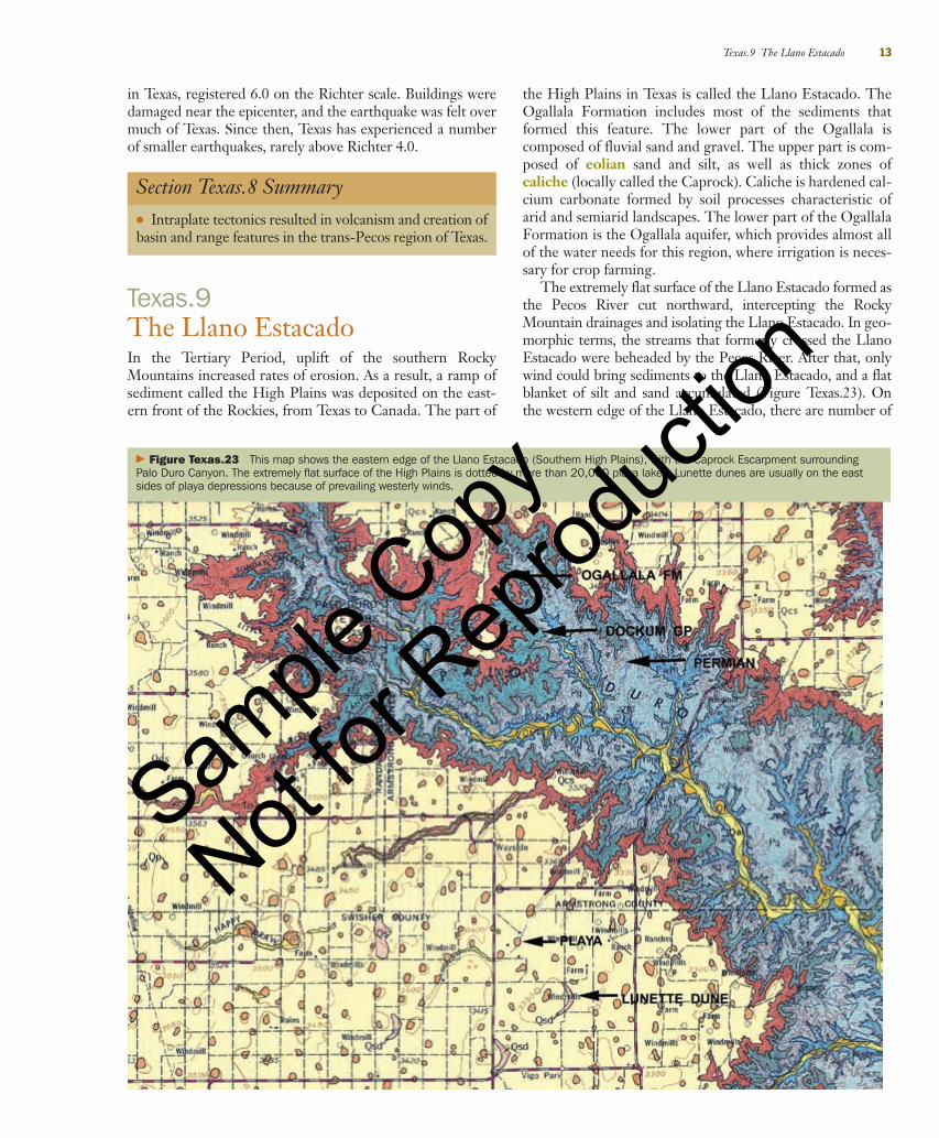
� Figure Texas.23 This map shows the eastern edge of the Llano Estacado (Southern High Plains), with the Caprock Escarpment surroundingPalo Duro Canyon. The extremely flat surface of the High Plains is dotted by more than 20,000 playa lakes. Lunette dunes are usually on the eastsides of playa depressions because of prevailing westerly winds.
the High Plains in Texas is called the Llano Estacado. TheOgallala Formation includes most of the sediments thatformed this feature. The lower part of the Ogallala iscomposed of fluvial sand and gravel. The upper part is com-posed of eolian sand and silt, as well as thick zones ofcaliche (locally called the Caprock). Caliche is hardened cal-cium carbonate formed by soil processes characteristic ofarid and semiarid landscapes. The lower part of the OgallalaFormation is the Ogallala aquifer, which provides almost allof the water needs for this region, where irrigation is neces-sary for crop farming.
The extremely flat surface of the Llano Estacado formed asthe Pecos River cut northward, intercepting the RockyMountain drainages and isolating the Llano Estacado. In geo-morphic terms, the streams that formerly crossed the LlanoEstacado were beheaded by the Pecos River. After that, onlywind could bring sediments to the Llano Estacado, and a flatblanket of silt and sand accumulated (Figure Texas.23). Onthe western edge of the Llano Estacado, there are number of
90737_Geo_Texas.qxd 7/31/06 9:34 PM Page 13
Sample
Cop
y
Not for
Rep
roduc
tion
periodically active sand dune fields, and at its southern end isMonahans State Park, which contains a large dune complexthat began accumulating in the late Pleistocene.
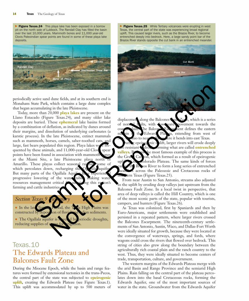
Today, more than 20,000 playa lakes are present on theLlano Estacado (Figure Texas.24), and many older lakedeposits are buried. These ephemeral lake basins formedby a combination of deflation, as indicated by dunes aroundtheir margins, and dissolution of underlying carbonates (akarstic process). In the late Pleistocene, extinct mammalssuch as mammoth, horses, camels, saber-toothed cats, andlarge, fast bears populated this region. Playa lakes were fre-quented by these animals, and 11,000-year-old Clovis spearpoints have been found in association with mammoth bonesat the Miami Site, a late Pleistocene playa north ofAmarillo. These playas collect seasonal rainfall, some ofwhich percolates down, recharging the Ogallala aquifer.But many parts of the Ogallala Aquifer have experiencedprogressive lowering of the water table, making waterresources management critical for sustaining this region’sfarming and cattle industries.
14 Texas The Geology of Texas
� Figure Texas.24 This playa lake has been exposed in a borrowpit on the north side of Lubbock. The Randall Clay has filled the basinover the last 10,000 years. Mammoth bones and 11,000 year-oldClovis Paleoindian spear points are found in some of these playa lakedeposits.
Section Texas.9 Summary● In the late Tertiary Period, the Texas High Plains wasconstructed by deposition of fluvial and eolian sediments.
● The Ogallala aquifer is lowered by periodic droughts,reducing supplies of water for irrigation.
Texas.10The Edwards Plateau andBalcones Fault ZoneDuring the Miocene Epoch, while the basin and range fea-tures were formed by extensional tectonics in the trans-Pecos,the central part of the state was subjected to epeirogenicuplift, creating the Edwards Plateau (see Figure Texas.1).This uplift was accommodated by up to 500 meters of
displacement along the Balcones Fault Zone, which is a seriesof normal faults, with downward movement towards thecoastal plain. The Balcones Escarpment defines the easternmargin of the Edwards Plateau, extending from west ofSan Antonio to near Dallas, where it bends into east Texas.
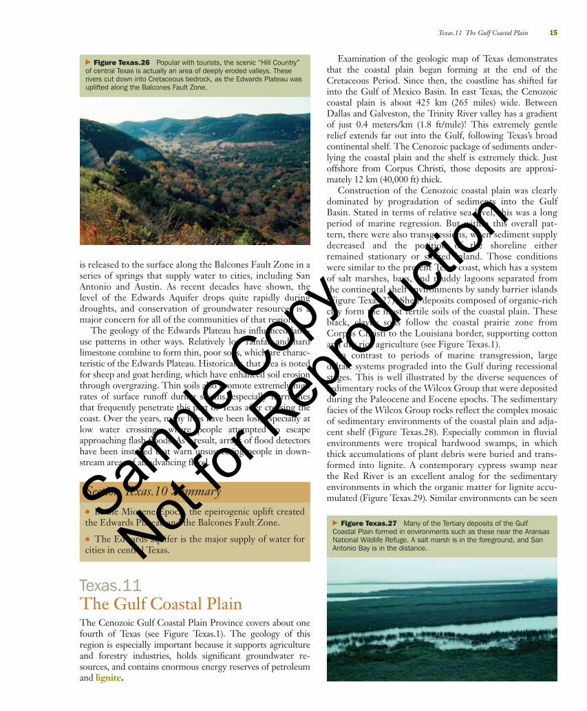
During epeirogenic uplift, larger rivers will erode deeplyinto resistant bedrock, forming what are called entrenchedvalleys. Perhaps the most famous example of this process isthe Grand Canyon, which formed as a result of epeirogenicuplift of the Colorado Plateau. The same kinds of forcescaused the Brazos River to form a long series of entrenchedmeanders across the Paleozoic and Cretaceous rocks ofnorthern Texas (Figure Texas.25).
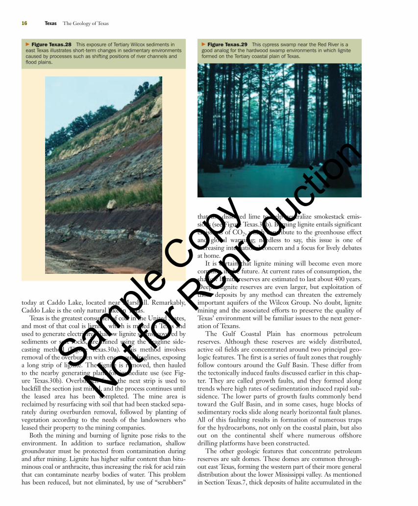
From near Austin to San Antonio, streams also adjustedto the uplift by eroding deep valleys just upstream from theBalcones Fault Zone. In a local twist in perspective, thatarea of deep valleys is called the Hill Country, which is oneof the most scenic parts of the state, popular with tourists,campers, and hunters (Figure Texas.26).
As Texas was colonized, first by Spaniards and then byEuro-Americans, major settlements were established andpersisted in a repeated pattern, where larger rivers crossedthe Balcones Escarpment. The nineteenth-century settle-ments of San Antonio, Austin, Waco, and Dallas-Fort Worthwere ideally situated for growth, because they were located atthe convergence of waterways, springs, and fords, wherewagons could cross the rivers that flowed over bedrock. Thisstring of cities also grew along the boundary between theagriculturally rich coastal plain and the ranch country to thewest. Thus, they were ideally situated to become centers oftrade, transportation, culture, and government.
The western margins of the Edwards Plateau merge withthe arid Basin and Range Province and the semiarid HighPlains. Rain falling on the central part of the plateau perco-lates down into the basal Cretaceous rocks, forming theEdwards Aquifer, one of the most important sources ofwater in the state. Groundwater from the Edwards Aquifer
� Figure Texas.25 While Tertiary volcanoes were erupting in westTexas, the central part of the state was experiencing broad regionaluplift. This caused larger rivers, such as the Brazos River, to becomeentrenched deeply into bedrock. Here, a large sandy point bar of theBrazos River stands opposite the cut bank in an entrenched meander.
90737_Geo_Texas.qxd 7/31/06 9:34 PM Page 14
Sample
Cop
y
Not for
Rep
roduc
tion
Texas.11 The Gulf Coastal Plain 15
� Figure Texas.26 Popular with tourists, the scenic “Hill Country”of central Texas is actually an area of deeply eroded valleys. Theserivers cut down into Cretaceous bedrock, as the Edwards Plateau wasuplifted along the Balcones Fault Zone.
is released to the surface along the Balcones Fault Zone in aseries of springs that supply water to cities, including SanAntonio and Austin. As recent decades have shown, thelevel of the Edwards Aquifer drops quite rapidly duringdroughts, and conservation of groundwater resources is amajor concern for all of the communities of that region.
The geology of the Edwards Plateau has influenced land-use patterns in other ways. Relatively low rainfall and hardlimestone combine to form thin, poor soils, which are charac-teristic of the Edwards Plateau. Historically, that area is notedfor sheep and goat herding, which have enhanced soil erosionthrough overgrazing. Thin soils also promote extremely highrates of surface runoff during storms, especially hurricanesthat frequently penetrate this part of Texas after crossing thecoast. Over the years, many lives have been lost, especially atlow water crossings, where people attempted to escapeapproaching flash floods. As a result, arrays of flood detectorshave been installed that warn unsuspecting people in down-stream areas of an advancing flood.
Section Texas.10 Summary● In the Miocene Epoch, the epeirogenic uplift createdthe Edwards Plateau and the Balcones Fault Zone.
● The Edwards aquifer is the major supply of water forcities in central Texas.
Texas.11The Gulf Coastal PlainThe Cenozoic Gulf Coastal Plain Province covers about onefourth of Texas (see Figure Texas.1). The geology of thisregion is especially important because it supports agricultureand forestry industries, holds significant groundwater re-sources, and contains enormous energy reserves of petroleumand lignite.
Examination of the geologic map of Texas demonstratesthat the coastal plain began forming at the end of theCretaceous Period. Since then, the coastline has shifted farinto the Gulf of Mexico Basin. In east Texas, the Cenozoiccoastal plain is about 425 km (265 miles) wide. BetweenDallas and Galveston, the Trinity River valley has a gradientof just 0.4 meters/km (1.8 ft/mile)! This extremely gentlerelief extends far out into the Gulf, following Texas’s broadcontinental shelf. The Cenozoic package of sediments under-lying the coastal plain and the shelf is extremely thick. Justoffshore from Corpus Christi, those deposits are approxi-mately 12 km (40,000 ft) thick.
Construction of the Cenozoic coastal plain was clearlydominated by progradation of sediments into the GulfBasin. Stated in terms of relative sea level, this was a longperiod of marine regression. But within this overall pat-tern, there were also transgressions, when sediment supplydecreased and the position of the shoreline eitherremained stationary or shifted inland. Those conditionswere similar to the present Texas coast, which has a systemof salt marshes, bays, and muddy lagoons separated fromthe continental shelf environments by sandy barrier islands(Figure Texas.27). Shelf deposits composed of organic-richclay form the most fertile soils of the coastal plain. Theseblack, clayey soils follow the coastal prairie zone fromCorpus Christi to the Louisiana border, supporting cottonand dry rice agriculture (see Figure Texas.1).
In contrast to periods of marine transgression, largedeltaic systems prograded into the Gulf during recessionalstages. This is well illustrated by the diverse sequences ofsedimentary rocks of the Wilcox Group that were depositedduring the Paleocene and Eocene epochs. The sedimentaryfacies of the Wilcox Group rocks reflect the complex mosaicof sedimentary environments of the coastal plain and adja-cent shelf (Figure Texas.28). Especially common in fluvialenvironments were tropical hardwood swamps, in whichthick accumulations of plant debris were buried and trans-formed into lignite. A contemporary cypress swamp nearthe Red River is an excellent analog for the sedimentaryenvironments in which the organic matter for lignite accu-mulated (Figure Texas.29). Similar environments can be seen
� Figure Texas.27 Many of the Tertiary deposits of the GulfCoastal Plain formed in environments such as these near the AransasNational Wildlife Refuge. A salt marsh is in the foreground, and SanAntonio Bay is in the distance.
90737_Geo_Texas.qxd 7/31/06 9:34 PM Page 15
Sample
Cop
y
Not for
Rep
roduc
tion
16 Texas The Geology of Texas
� Figure Texas.28 This exposure of Tertiary Wilcox sediments ineast Texas illustrates short-term changes in sedimentary environmentscaused by processes such as shifting positions of river channels andflood plains.
� Figure Texas.29 This cypress swamp near the Red River is agood analog for the hardwood swamp environments in which ligniteformed on the Tertiary coastal plain of Texas.
that use dissolved lime to help neutralize smokestack emis-sions (see Figure Texas.30b). Burning lignite entails significantemissions of CO2, which contribute to the greenhouse effectand global warming; needless to say, this issue is one ofincreasing international concern and a focus for lively debatesat home.
It is certain that lignite mining will become even morecommon in the future. At current rates of consumption, theshallow lignite reserves are estimated to last about 400 years.Deeper lignite reserves are even larger, but exploitation ofthose deposits by any method can threaten the extremelyimportant aquifers of the Wilcox Group. No doubt, lignitemining and the associated efforts to preserve the quality ofTexas’ environment will be familiar issues to the next gener-ation of Texans.
The Gulf Coastal Plain has enormous petroleumreserves. Although these reserves are widely distributed,active oil fields are concentrated around two principal geo-logic features. The first is a series of fault zones that roughlyfollow contours around the Gulf Basin. These differ fromthe tectonically induced faults discussed earlier in this chap-ter. They are called growth faults, and they formed alongtrends where high rates of sedimentation induced rapid sub-sidence. The lower parts of growth faults commonly bendtoward the Gulf Basin, and in some cases, huge blocks ofsedimentary rocks slide along nearly horizontal fault planes.All of this faulting results in formation of numerous trapsfor the hydrocarbons, not only on the coastal plain, but alsoout on the continental shelf where numerous offshoredrilling platforms have been constructed.
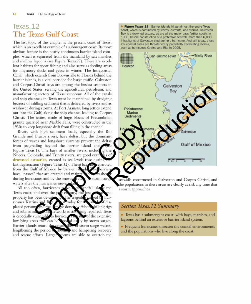
The other geologic features that concentrate petroleumreserves are salt domes. These domes are common through-out east Texas, forming the western part of their more generaldistribution about the lower Mississippi valley. As mentionedin Section Texas.7, thick deposits of halite accumulated in the
today at Caddo Lake, located near Marshall. Remarkably,Caddo Lake is the only natural lake in Texas.
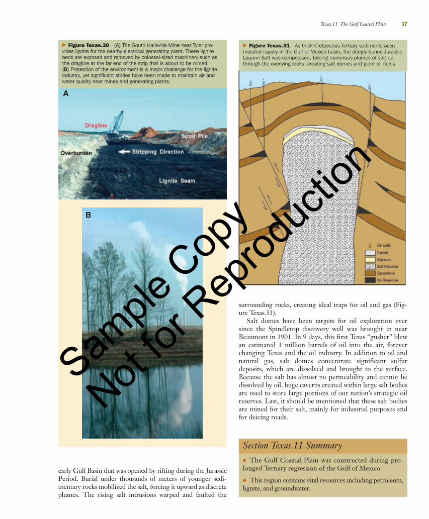
Texas is the greatest consumer of coal in the United States,and most of that coal is lignite, which is mined in Texas andused to generate electricity. Shallow lignite seams, covered bysediments or soft rocks, are mined using the dragline side-casting method (Figure Texas.30a). This method involvesremoval of the overburden with enormous draglines, exposinga long strip of lignite. The lignite is removed, then hauledto the nearby generating plant for immediate use (see Fig-ure Texas.30b). Overburden from the next strip is used tobackfill the section just mined, and the process continues untilthe leased area has been completed. The mine area isreclaimed by resurfacing with soil that had been stacked sepa-rately during overburden removal, followed by planting ofvegetation according to the needs of the landowners wholeased their property to the mining companies.
Both the mining and burning of lignite pose risks to theenvironment. In addition to surface reclamation, shallowgroundwater must be protected from contamination duringand after mining. Lignite has higher sulfur content than bitu-minous coal or anthracite, thus increasing the risk for acid rainthat can contaminate nearby bodies of water. This problemhas been reduced, but not eliminated, by use of “scrubbers”
90737_Geo_Texas.qxd 7/31/06 9:34 PM Page 16
Sample
Cop
y
Not for
Rep
roduc
tion
surrounding rocks, creating ideal traps for oil and gas (Fig-ure Texas.31).
Salt domes have been targets for oil exploration eversince the Spindletop discovery well was brought in nearBeaumont in 1901. In 9 days, this first Texas “gusher” blewan estimated 1 million barrels of oil into the air, foreverchanging Texas and the oil industry. In addition to oil andnatural gas, salt domes concentrate significant sulfurdeposits, which are dissolved and brought to the surface.Because the salt has almost no permeability and cannot bedissolved by oil, huge caverns created within large salt bodiesare used to store large portions of our nation’s strategic oilreserves. Last, it should be mentioned that these salt bodiesare mined for their salt, mainly for industrial purposes andfor deicing roads.
Texas.11 The Gulf Coastal Plain 17
� Figure Texas.30 (A) The South Hallsville Mine near Tyler pro-vides lignite for the nearby electrical generating plant. These lignitebeds are exposed and removed by colossal-sized machinery such asthe dragline at the far end of the strip that is about to be mined.(B) Protection of the environment is a major challenge for the ligniteindustry, yet significant strides have been made to maintain air andwater quality near mines and generating plants.
early Gulf Basin that was opened by rifting during the JurassicPeriod. Burial under thousands of meters of younger sedi-mentary rocks mobilized the salt, forcing it upward as discreteplumes. The rising salt intrusions warped and faulted the
� Figure Texas.31 As thick Cretaceous-Tertiary sediments accu-mulated rapidly in the Gulf of Mexico basin, the deeply buried JurassicLouann Salt was compressed, forcing numerous plumes of salt upthrough the overlying rocks, creating salt domes and giant oil fields.
Section Texas.11 Summary● The Gulf Coastal Plain was constructed during pro-longed Tertiary regression of the Gulf of Mexico.
● This region contains vital resources including petroleum,lignite, and groundwater.
A
B
90737_Geo_Texas.qxd 7/31/06 9:34 PM Page 17
Sample
Cop
y
Not for
Rep
roduc
tion
Texas.12The Texas Gulf CoastThe last topic of this chapter is the present coast of Texas,which is an excellent example of a submergent coast. Its mostobvious feature is the nearly continuous barrier island com-plex, which is separated from the mainland by salt marshesand shallow lagoons (see Figure Texas.27). These are excel-lent habitats for sport fishing and also serve as feeding areasfor migratory ducks and geese in winter. The IntracoastalCanal, which extends from Brownsville to Florida behind thebarrier islands, is a vital corridor for barge traffic. Galvestonand Corpus Christi bays are among the busiest seaports inthe United States, serving the agricultural, petroleum, andmanufacturing sectors of Texas’ economy. All of the canalsand ship channels in Texas must be maintained by dredgingbecause of infilling sediment that is delivered by rivers and aswashover during storms. At Port Aransas, long jetties extendout into the Gulf, along the ship channel leading to CorpusChristi. The jetties, made of huge blocks of Precambriangranite quarried near Marble Falls, were constructed in the1930s to keep longshore drift from filling in the channel.
Rivers with high sediment loads, especially the RioGrande and Brazos rivers, have deltas, but the dominantforces of waves and longshore currents prevent the deltasfrom prograding beyond the barrier island chain (seeFigure Texas.1). The bays of smaller rivers, including theNueces, Colorado, and Trinity rivers, are good examples ofdrowned estuaries, created as sea levels rose during thelast deglaciation (Figure Texas.32). These bays are separatedfrom the Gulf of Mexico by barrier islands. The barriershave “passes” that are created and maintained by washoverduring hurricanes and by the seaward return of storm surgewaters after the hurricanes move inland.
All too often, hurricanes make their landfall along theTexas coast, and over the past century, the loss of lives andproperty has been devastating. The tragedies caused by hur-ricanes Katrina and Rita persist today for thousands of dis-placed persons, and the damage done to offshore drilling rigsand submarine pipeline networks is still being repaired. Texasis especially vulnerable to hurricanes because of the extensivelow-lying areas that can be flooded easily by storm surges.Barrier islands retard the return flow of storm surge waters,lengthening the period of flooding and hampering recoveryand rescue efforts. Larger storms are able to overtop the
18 Texas The Geology of Texas
� Figure Texas.32 Barrier islands fringe almost the entire Texascoast, which is dominated by waves, currents, and storms. GalvestonBay is a drowned estuary, as are all the major bays farther south. In1900, before construction of a protective seawall, more than 6,000inhabitants of Galveston died during a hurricane. And still today, theselow coastal areas are threatened by potentially devastating storms,such as hurricanes Katrina and Rita in 2005.
Section Texas.12 Summary● Texas has a submergent coast, with bays, marshes, andlagoons behind an extensive barrier island system.
● Frequent hurricanes threaten the coastal environmentsand the populations who live along the coast.
seawalls constructed in Galveston and Corpus Christi, andthe populations in these areas are clearly at risk any time thata storm approaches.
90737_Geo_Texas.qxd 7/31/06 9:34 PM Page 18
Sample
Cop
y
Not for
Rep
roduc
tion
Review Workbook 19
Review WorkbookSummaryTexas.1 Introduction� Why is the geology of Texas important to students of physical geologyand to all the inhabitants of the state today?Learning about the geology of their state helps Texas studentsbetter understand the principles of physical geology and makesthem more aware of how the state’s geologic past is related to theways in which its residents interact with its landscape and exploitits resources today.
Texas.2 Precambrian Texas� What tectonic events shaped the Proterozoic geologic record of Texas?The genesis of Proterozoic rocks in Texas is indicated by processsequences such as erosion, sedimentation, regional metamor-phism, and postorogenic igneous intrusion.
� When and how were the metamorphic and igneous rocks of the Llanoregion accreted to the ancient continent Laurentia?The metamorphic suite of Proterozoic rocks in Texas was accret-ed to Laurentia and became part of the much larger accretionaryGrenville Terrane because of the highly compressional tectonicregimen about 1.3 billion years ago (Ga). The intrusive suite wasaccreted about 0.2 billion years later.
Texas.3 The Paleozoic Tectonic Cycle� What kinds of sediment were deposited during the Lower Paleozoic?Sandstone overlain by thicker deposits of limestone, muchdolomitized, were deposited in the Cambrian and Ordovicianperiods.
� What is the economic significance of these rocks today?These rocks hold tremendous petroleum reserves.
Texas.4 The Ouachita Orogeny and Pangaea� What were the geologic results in Texas of the collision of Gondwanawith Laurasia?The collision caused prolonged orogeny and proportionate struc-tural and sedimentary responses.
� How do the sedimentary rocks and structural styles of the Marathonarea illustrate the collision?The rocks at Marathon show a sequence from rapid preorogenicmarine sedimentation to intense thrust faulting and lastly toterrestrial sedimentation.
Texas.5 The Fort Worth Basin in the Late Paleozoic Era� What sedimentary environments characterized the Fort Worth Basinduring and after the Ouachita orogeny?The Fort Worth Basin was flanked on the east by the OuachitaMountains, from which active deltas prograded onto a shelf thathad carbonate banks and platforms.
� Why is this basin rich in oil and gas resources?Those environments produced abundant hydrocarbons, as well asideal reservoirs and traps.
Texas.6 Permian Red Beds and Evaporites� Why are red beds and evaporites characteristic of the Permian basinsof central and west Texas?Periodic isolation of evaporitic basins surrounded by weatheredand eroded landforms were the depositional environments forthose rocks.
� How does the geology of that region affect present-day land-use patterns?Today, those salts make their way into the surface and ground-water systems, dramatically reducing water quality and water usepotentials.
Texas.7 Breakup of Pangaea and Cretaceous Transgressions� What happened in Texas during and after the breakup of Pangaea?Rifting in the Jurassic Period created the Gulf of Mexico Basin,which became an open ocean just before Cretaceous transgressions.
� What were the results of the Cretaceous transgressions?The transgressions left thick packages of sedimentary rocks overmost of the state and deeply buried below the Gulf Coastal Plain.
Texas.8 Basin and Range Texas� What types of tectonic activity are indicated by the volcanic rocks intrans-Pecos Texas?Extensive bimodal volcanism is indicated by mainly OligoceneEpoch lava, and ash resulting from a compressional phase ofintraplate tectonics.
� How did the basin and range structural features form in that region?The basin and range features primarily formed during the MioceneEpoch when tensional conditions promoted normal faulting.
Texas.9 The Llano Estacado� Which geologic processes led to the formation of the Llano Estacado?The Llano Estacado was constructed by accumulating fluvial sedi-ments from the Rocky Mountains, followed by finer sedimentsthat were deposited by wind.
� What is the Ogallala aquifer, and how is it recharged?The fluvial deposits in the lower part of the Ogallala Formationare the Ogallala aquifer. Abundant playa lake basins promotesome recharge of the aquifer, which still falls during droughts.
Texas.10 The Edwards Plateau and Balcones Fault Zone� When and how did the Edwards Plateau and Balcones Fault Zoneform?The Edwards Plateau formed in the Miocene Epoch byepeirogenic uplift, which was accommodated along theBalcones Fault Zone, separating the plateau from the GulfCoastal Plain.
� How were these geologic features important to the initial settlement ofTexas, and how are they important to Texans today?Locations where springs fed by the Edwards aquifer were nearrivers crossing the fault zone were chosen by early settlers of citiesfrom San Antonio to Dallas. The Edwards aquifer is a majorsource of water today.
90737_Geo_Texas.qxd 7/31/06 9:34 PM Page 19
Sample
Cop
y
Not for
Rep
roduc
tion
Texas.11 The Gulf Coastal Plain� How have transgressions and regressions shaped the geologic evolutionof the Gulf Coastal Plain?Those different sedimentary cycles promoted varied accumula-tions of organic matter that were sources for rich accumulationsof petroleum and lignite.
� What are the economic and environmental implications of usinglignite to generate electricity?Lignite can be used to fire generating plants almost indefinitely,and at a reasonable cost; but both the mining and burning oflignite are, without any remediation, harmful to the environment.This threat is the source of considerable efforts to minimize thoseproblems.
� How did salt domes form, and why are economic resources concentratedaround them?Salt domes formed when halite was compressed under thick sedi-ments in the Gulf Basin, forcing it to rise through the overlying
deposits. As the salt column rose, it created numerous traps byfaulting.
Texas.12 The Texas Gulf Coast� What are the principal features of the Texas Gulf Coast, and how didthey form?The Gulf Coast of Texas is marked by its low-gradient and high-wave energy. It exhibits bays, salt marshes, and lagoons behind anextensive series of barrier islands.
� How do hurricanes affect the coastal areas of Texas?Hurricanes attack the fragile landforms along the coast, deliveringlarge volumes of both sediment and saltwater, together with mas-sive erosion potential. Their threats to the lives and homes ofpeople who live in low coastal areas are realized too often, asshown by the devastation of hurricanes Katrina and Rita.
20 Texas The Geology of Texas
Essential Terms to KnowAulacogen The failed arm of a triple-junction rift, left behindon the edge of the continent after the new ocean opens.
Balcones Fault Zone The zone of normal faults that definesthe eastern edge of the Edwards Plateau and the Coastal Plain ofTexas.
Basin and range Low mountain forms that consist of upraisedblocks bounded by normal faults and separated by graben-typevalleys.
Bimodal volcanism Volcanism in a region usually subjected toextensional tectonics, characterized by magmatic compositionsranging from felsic to mafic.
Calcareous algae Algae that produce large amounts of carbon-ate mud composed of minute calcite crystals that help support thealgal organism during life.
Caldera A large volcano with a central crater that formed whencollapse was induced by evacuation of the magma chamber below.
Caliche A hard, thick zone of calcium carbonate that formed bysoil activity, usually in regions with arid to semiarid climates.
Chalk A rock composed of the calcareous skeletons (tests) ofmarine phytoplankton.
Deflation Removal of fine-grained sediments by wind.
Drowned estuary The mouth of a river valley that has beeninundated by ocean waters during the sea level increase accompa-nying deglaciation.
Entrenched valley A valley that has been incised into bedrockin response to regional uplift.
Eolian Adjective applied to sedimentary processes and depositsassociated with wind.
Epeirogenic uplift More or less uniform uplift of large areasin the absence of compressional mountain building.
Ephemeral Adjective applied to streams or bodies of standingwater that carry or contain water only after rains or rainy seasons.
Flysch Thick accumulations of thinly bedded sandstones, shales,and marls that were rapidly deposited in basins in advance of acontinental convergence.
Fracking Fracturing of rocks that surround a gas or oil well,induced by injecting water and sand into the rocks under highpressure to increase the porosity of the reservoir and the flow ofhydrocarbons to the well.
Glauconite A green silicate mineral that commonly occurs asgranular clasts in marine sandstones.
Gondwana The continent that formerly included Africa, SouthAmerica, Antarctica, India, Australia, and Madagascar.
Grenville Province Huge masses of rocks that were added tothe eastern and Texan edges of Laurentia in the middleProterozoic Era.
Hogback A sharp, steep ridge created by erosion of steeply dip-ping rocks.
Intraplate tectonics Tectonic activity that occurs usually with-in continents, well away from plate margins.
Laurentia Name given to the North American continent as itappeared until its collision with Baltica in the Silurian Period.
Lignite A low-grade coal formed of plant remains that wereconcentrated, buried, and altered more than peat but less thanhigher grades of coal.
Marl A calcareous shale.
Microcline A low-temperature potassium feldspar, commonlyfound as pink to red crystals in granites and especially in pegmatites.
Molasse Terrigenous sediments deposited as a continental colli-sion neared completion.
Orogeny A mountain building event.
Physiographic map A map divided into provinces that reflecta similar geologic history of deposition and erosion; it usually hasdistinctive soils, vegetation, and climate.
90737_Geo_Texas.qxd 7/31/06 9:34 PM Page 20
Sample
Cop
y
Not for
Rep
roduc
tion
Phytoplankton Floating plants, many of which produceminute skeletons made of silca or carbonate material.
Playa lake A shallow, usually circular, and usually ephemerallake.
Pluton A body of intrusive igneous rock.
Progradation The seaward growth of a landform by activesedimentation, such as a delta.
Reservoir rocks Porous rocks that can contain liquids, includ-ing water and petroleum, as well as natural gas.
Sedimentary environment A depositional setting with dis-tinctive physical, chemical, and organic agents that impart distinc-tive properties to the sedimentary deposits that form there.
Sedimentary facies A horizontally and vertically distinct bodyof sediments that is different from adjacent sediments on the basisof physical, chemical, or organic properties.
Theory of plate tectonics A theory that integrates the scien-tific understanding of the causes, processes, and geologic resultsof the movement of lithospheric plates relative to each other.
Thrust fault A low-angle reverse fault.
Transgression A rise in sea level relative to the adjacent land.
Turbidite A gravity-induced flow of sediment down a submarineslope.
Uniformitarianism The premise that geologic processes hap-pening today have operated in similar ways in the past.
Volcanic neck A standing mass of material that solidified in avolcanic pipe that usually has been exposed by erosion.
Review Workbook 21
More on Texas GeologyFollowing is a list of some ways that you can explore the geologyof Texas:
The single best source for information about the geology of Texasis the Bureau of Economic Geology, affiliated with the Universityof Texas at Austin. The bureau sells maps, guidebooks, resourcesfor amateur geologists, and many scientific publications that covervirtually all aspects of the subject. Look for them online athttp://www.beg.utexas.edu.
The best way to enjoy and learn about the geology of Texas is tosee it. A good way to do that is to visit state and national parks.Many of the photographs in this chapter depict scenes in parks.
Contact or visit the Texas Cooperative Extension Office of yourcounty, located in the County Seat. They can provide you withinformation and literature about the soils, vegetation, and land-use practices in your county.
If you are taking this course in a geology department, you havethe opportunity to take additional courses in geology. Look atyour university course catalog, or better yet, visit the departmentto get information on their geology curriculum. If there is not a
geology department on your campus, talk to your instructor aboutlocal options, or visit the websites of local universities to learnabout the geology courses they offer. Almost all geology coursesoffered at colleges and universities in Texas are uniformly coded,and credits transfer virtually automatically.
If you are really interested in geology, you should considerbecoming a student member of The Geologic Society of America.For a low membership fee (and some other optional costs), youcan attend regional and national meetings, all of which encouragestudent papers and offer outstanding field trip opportunities.More information is available online at:http://www.geosociety.org.
Many museums around the state have geologic exhibits. Checkyour local listings.
When you travel in Texas, be sure to take a copy of the RoadsideGeology of Texas, written by Darwin Spearing and published byMountain Press Publishing Company, Missoula, Montana. Youwill also want a copy of the state highway geology map, which isavailable from the Bureau of Economic Geology.
90737_Geo_Texas.qxd 7/31/06 9:34 PM Page 21
Sample
Cop
y
Not for
Rep
roduc
tion