Embed Size (px)
Citation preview
The Geography of Witchcraft Accusationsin 1692 Salem Village
Benjamin C. Ray
The alleged witches and those who accused them resided onopposite sides of the Village.1
PAUL Boyer and Stephen Nissenbaum’s influential study, SalemPossessed, appeared a little more than one hundred years after thepublication of Charles W. Upham’s classic two-volume work,
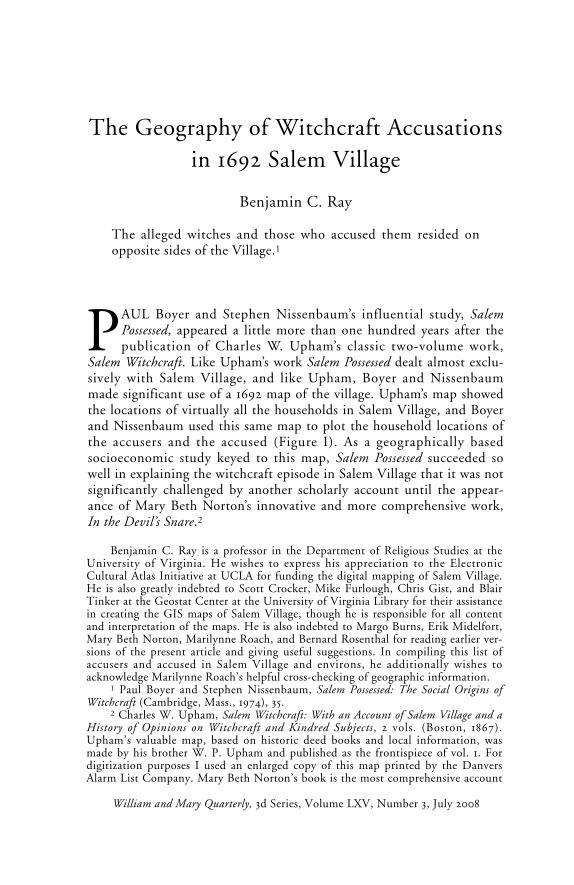
Salem Witchcraft. Like Upham’s work Salem Possessed dealt almost exclu-sively with Salem Village, and like Upham, Boyer and Nissenbaummade significant use of a 1692 map of the village. Upham’s map showedthe locations of virtually all the households in Salem Village, and Boyerand Nissenbaum used this same map to plot the household locations ofthe accusers and the accused (Figure I). As a geographically basedsocioeconomic study keyed to this map, Salem Possessed succeeded sowell in explaining the witchcraft episode in Salem Village that it was notsignificantly challenged by another scholarly account until the appear-ance of Mary Beth Norton’s innovative and more comprehensive work,In the Devil’s Snare.2
Benjamin C. Ray is a professor in the Department of Religious Studies at theUniversity of Virginia. He wishes to express his appreciation to the ElectronicCultural Atlas Initiative at UCLA for funding the digital mapping of Salem Village.He is also greatly indebted to Scott Crocker, Mike Furlough, Chris Gist, and BlairTinker at the Geostat Center at the University of Virginia Library for their assistancein creating the GIS maps of Salem Village, though he is responsible for all contentand interpretation of the maps. He is also indebted to Margo Burns, Erik Midelfort,Mary Beth Norton, Marilynne Roach, and Bernard Rosenthal for reading earlier ver-sions of the present article and giving useful suggestions. In compiling this list ofaccusers and accused in Salem Village and environs, he additionally wishes toacknowledge Marilynne Roach’s helpful cross-checking of geographic information.
1 Paul Boyer and Stephen Nissenbaum, Salem Possessed: The Social Origins ofWitchcraft (Cambridge, Mass., 1974), 35.
2 Charles W. Upham, Salem Witchcraft: With an Account of Salem Village and aHistory of Opinions on Witchcraft and Kindred Subjects, 2 vols. (Boston, 1867).Upham’s valuable map, based on historic deed books and local information, wasmade by his brother W. P. Upham and published as the frontispiece of vol. 1. Fordigitization purposes I used an enlarged copy of this map printed by the DanversAlarm List Company. Mary Beth Norton’s book is the most comprehensive account
William and Mary Quarterly, 3d Series, Volume LXV, Number 3, July 2008
Q-7-08 front 6/30/08 11:00 AM Page 449
450 WILLIAM AND MARY QUARTERLY
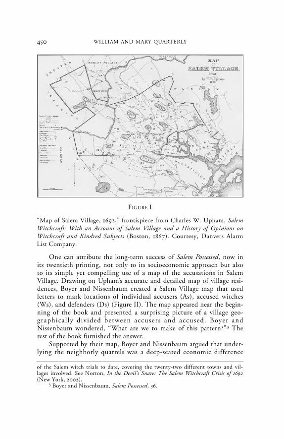
One can attribute the long-term success of Salem Possessed, now inits twentieth printing, not only to its socioeconomic approach but alsoto its simple yet compelling use of a map of the accusations in SalemVillage. Drawing on Upham’s accurate and detailed map of village resi-dences, Boyer and Nissenbaum created a Salem Village map that usedletters to mark locations of individual accusers (As), accused witches(Ws), and defenders (Ds) (Figure II). The map appeared near the begin-ning of the book and presented a surprising picture of a village geo-graphica l ly d iv ided between accusers and accused. Boyer andNissenbaum wondered, “What are we to make of this pattern?”3 Therest of the book furnished the answer.
Supported by their map, Boyer and Nissenbaum argued that under-lying the neighborly quarrels was a deep-seated economic difference
of the Salem witch trials to date, covering the twenty-two different towns and vil-lages involved. See Norton, In the Devil’s Snare: The Salem Witchcraft Crisis of 1692(New York, 2002).
3 Boyer and Nissenbaum, Salem Possessed, 36.
FIGURE I
“Map of Salem Village, 1692,” frontispiece from Charles W. Upham, SalemWitchcraft: With an Account of Salem Village and a History of Opinions onWitchcraft and Kindred Subjects (Boston, 1867). Courtesy, Danvers AlarmList Company.
Q-7-08 front 6/30/08 11:00 AM Page 450
451GEOGRAPHY OF WITCHCRAFT ACCUSATIONS IN SALEM
between the village and the neighboring commercial Salem Town (ofwhich Salem Village was a separate parish). And it was an economic dif-ference that eventually divided the village geographically into two con-flicting groups. Boyer and Nissenbaum suggested that the pooreragrarian householders who lived on the western side of the village settheir hearts and fears against their more prosperous and commerciallyminded neighbors who lived in the eastern part of the village, nearer thetown, and economically benefited from it. Ultimately, according toBoyer and Nissenbaum, the conflict between the two groups wasbetween differing visions of community: an agrarian-based, olderPuritan sense of the public goodwill contrasted with a later emergentcapitalist sense of private interest. This clash led the frustrated western-ers to respond by charging the easterners with witchcraft. One summaryof Salem Possessed put it this way: “The Salem trials can be seen as anindirect yet anguished protest of a group of villagers whose agrarian way
FIGURE II
“The Geography of Witchcraft: Salem Village, 1692,” in Paul Boyer andStephen Nissenbaum, Salem Possessed: The Social Origins of Witchcraft(Cambridge, Mass., 1974), 34. Courtesy, President and Fellows of HarvardCollege.
Q-7-08 front 6/30/08 11:00 AM Page 451

452 WILLIAM AND MARY QUARTERLY
of life was being threatened by the rising commercialism of SalemTown.”4 Several other maps in Salem Possessed reinforced this argument.They depicted the geography of the conflict in Salem Village over thenew minister, the Reverend Samuel Parris, and showed the locations ofthe landholdings of the influential Putnam and Porter families as evi-dence that the village was divided into eastern and western economicfactions. But it was the striking witchcraft accusations map that appearsto have been the most effective device in supporting Boyer andNissenbaum’s economic interpretation of the witchcraft episode. Thismap reduced the whole complex event to a single graphic image: As onone side of the village, Ws on the other. Finally, it seemed, scholars hadsolved the mystery of the Salem Village witchcraft accusations by meansof an objective historical method.
Several American history textbooks employ Boyer and Nissenbaum’sinterpretation and some also reproduce the map, which is now part ofthe Salem story in many classrooms. At the more popular level, a currentSalem visitor’s guidebook recommends Salem Possessed as “a seminal workthat established the socioeconomic and political factors that broughtabout the witch hunt” in a divided village. Versions of this map have alsoappeared in television productions to show that the village was geographi-cally “divided into two angry factions.” But, as Mark Monmonier pointsout in How to Lie with Maps, the general public seldom questions a map-maker’s work and often fails to realize that “cartographic license is enor-mously broad.”5 Perhaps it is not surprising that scholars have also neverthoroughly examined the Boyer and Nissenbaum map.
A review of the court records shows that the Boyer and Nissenbaummap is, in fact, highly interpretive and considerably incomplete.6
4 James West Davidson and Mark Hamilton Lytle, After the Fact: The Art ofHistorical Detection , 3d ed. (New York, 1992) , 41 (quotat ion) ; Boyer andNissenbaum, Salem Possessed, 103–9.
5 Frances Hill, Hunting for Witches: A Visitor’s Guide to the Salem Witch Trials(Beverly, Mass., 2002), 136 (“seminal work”); Witch Hunt, DVD, directed by LisaWolfinger (New York, 2004) (“divided”); Mark Monmonier, How to Lie with Maps(Chicago, 1991), 2 (“cartographic license”). For American history textbooks, see forexample Alan Brinkley et al., American History: A Survey, vol. 1, 8th ed. (New York,1991); Paul S. Boyer et al., The Enduring Vision: A History of the American People, 2ded. (Lexington, Mass., 1993); Ronald P. Dufour, Colonial America (Minneapolis,Minn., 1994); Carol Berkin et al., Making America: A History of the United States,Brief Edition (Boston, 1997); John Mack Faragher et al., Out of Many: A History ofthe American People, 4th ed. (Upper Saddle River, N.J., 2005). The accusations maphas also received attention in television programs, including Three Sovereigns forSarah, DVD, directed by Philip Leacock (1985; Alexandria, Va., 2005), and WitchHunt, DVD.
6 Paul Boyer and Stephen Nissenbaum, eds., The Salem Witchcraft Papers:Verbatim Transcripts of the Legal Documents of the Salem Witchcraft Outbreak of 1692,
Q-7-08 front 6/30/08 11:00 AM Page 452
Contrary to Boyer and Nissenbaum’s conclusions in Salem Possessed, geo-graphic analysis of the accusations in the village shows there was no sig-nificant villagewide east-west division between accusers and accused in1692. Nor was there an east-west divide between households of differenteconomic status. Equally important, eastern village leaders were notopposed to the village’s attempts to gain independence from SalemTown. Though Salem Village suffered from years of internal conflictover its ministers and replaced them at an unusually frequent rate, theseconflicts did not have an east-west geographic or economic character.The village was remarkably homogeneous in its geographic distributionof wealth at almost all economic levels during this period. The same dis-tribution holds true of the village’s religious and social demographics.
Though it may appear that the Salem Possessed map carries the bur-den of the argument about the socioeconomic and geographic founda-tion of the witchcraft accusations, the map does not supply all theevidence. A note to the map in Salem Possessed explains that for differentreasons a total of thirteen accusers were omitted, thus indicating thatthe map is incomplete and does not represent all the accusers. The mapis more properly understood as an illustration of the socioeconomicargument; it is not its proof. Indeed the authors introduce the map tothe reader as a kind of geographic clue to the rest of the book’s findings.Nevertheless Boyer and Nissenbaum’s use of the map confuses these twopurposes, clue and proof. On the one hand, the quantitative comparisonof the numbers of As, Ws, and Ds that appear on the eastern and westernsides of the map suggests that it presents objective evidence of a geo-graphically divided village and that it reveals a straightforward numericalpattern. On the other hand, the explanatory note states that the mapdeliberately omits a number of well-known accusers, some because oftheir youth and others because of their support for some of the accused.These omissions indicate that the map involves an important interpretivecomponent, in this case concerning the accusers’ ages and motivations.The note also implies that the map is complete except for the specifiedomissions, which is not the case. Thus the map’s relationship to theinformation contained in the court records is unclear: it is interpretiveand incomplete yet seemingly offered as objective and exhaustive.
It is necessary to create a map as objective and complete as possiblebased on the court records before presenting any extrapolations about
453GEOGRAPHY OF WITCHCRAFT ACCUSATIONS IN SALEM
3 vols. (New York, 1977). As one of the editors of the new edition of the Salem courtdocuments, I have had the benefit of examining the fifty-odd Salem court recordsthat were overlooked or unknown when Boyer and Nissenbaum published SalemWitchcraft Papers. See Bernard Rosenthal et al., eds., The Records of the Salem Witch-Hunt (Cambridge, forthcoming).
Q-7-08 front 6/30/08 11:00 AM Page 453

454 WILLIAM AND MARY QUARTERLY
the Salem Village accusations. All maps involve some interpretation, butthere is a difference between necessary selection and adaptation of a dataset and interpretations built into the map that already present a perspectiveon the data the map represents. The selection of data and methodologyshould be as transparent as possible. Working with databases makes trans-parency easier because of the explicit database requirement to documentevery data point that appears on the map. With a comprehensive map,scholars can then ask some questions about the data presented. By examin-ing the locations of the most frequent accusers, for example, one may won-der what they have in common, geographically or otherwise, and then posethe same question about the accused. The basis for any such geographicquestions, however, must be an accurate map of accusers and accused.
Explaining the errors and assumptions involved in Paul Boyer andStephen Nissenbaum’s map of the village accusations requires under-standing how the map was made. Boyer and Nissenbaum tell the readerthat they used the Salem Village map from Charles W. Upham’s book, adetailed and fairly accurate rendering of the house locations and geo-graphic boundaries of Salem Village and its immediate environs in 1692(Figure III). Upham placed numbers and symbols on the map to desig-nate the locations of 150 houses and structures in Salem Village andneighboring townships. Each square marker on the map stood for thelocation of a house and each number correlated with Upham’s 1692 listof property owners, which was based on Salem deed books and localknowledge. Number twenty-four, for example, designated the locationof Thomas Putnam’s house, which was the home of two adult accusers:Putnam and his wife, Ann. Boyer and Nissenbaum placed two As at thislocation on their map to represent these two accusers.7
7 A close-up of Thomas Putnam’s house (number twenty-four) on Upham’smap with Boyer and Nissenbaum’s super imposed As i s ava i lable onhttp://oieahc.wm.edu/wmq/Jul08/ray.html. In the process of digitizing and georefer-encing Upham’s map using geographic information systems (GIS) software, I gaveeach of Upham’s numbered house locations a black dot (see Figure III). The dotsindicate geographic points with coordinates in real geographic space. Some of theextant 1692 houses represented by numbers on Upham’s map are still standing ontheir original foundations. I used a geographic positioning system device to deter-mine the latitude and longitude of these houses on site. These known coordinatesserved as control points that linked the digital version of Upham’s map to real geo-graphic space for purposes of georegistering the map and rectifying its errors as bestas can be done using GIS software. The process resulted in a slight warping andstretching of the digital version of Upham’s map. The consequent offset betweenUpham’s paper map and geographic accuracy averages approximately five hundredfeet, which is sufficiently accurate for these purposes. See Mike Furlough, “TheSalem Witchcraf t GIS: A Visual Re-Creat ion of Sa lem Vi l lage in 1692,”http://fisher.lib.virginia.edu/libsites/salem.
Q-7-08 front 6/30/08 11:00 AM Page 454

Placing the Boyer and Nissenbaum map, with its As, Ws, and Ds,over the georegistered Upham map offered a useful means for checkingthe Salem Possessed map’s accuracy and also served to correlate its other-wise anonymous As, Ws, and Ds with Upham’s household markers andnumbers, thus identifying the people represented by letters on Boyerand Nissenbaum’s map (Figure IV). The correlation between the letters,markers, and house numbers turned out to be fairly close in most areas,except near the center of the map where the correspondence was inexact.Never the les s , by us ing the cour t documents and Boyer andNissenbaum’s census of the Salem Village households, it is possible toidentify the people in those households and their roles in the witch trialsas accusers, accused, and defenders and to locate them with sufficientaccuracy on the map.8
455GEOGRAPHY OF WITCHCRAFT ACCUSATIONS IN SALEM
8 Paul Boyer and Stephen Nissenbaum, eds., Salem-Village Witchcraft: ADocumentary Record of Local Conflict in Colonial New England (Belmont, Calif., 1972),383–93. I follow Boyer and Nissenbaum’s use of the term “accuser” to refer to anyone
FIGURE III
Georegistered version of Upham’s map with geographic information sys-tems data points.
Q-7-08 front 6/30/08 11:00 AM Page 455
456 WILLIAM AND MARY QUARTERLY
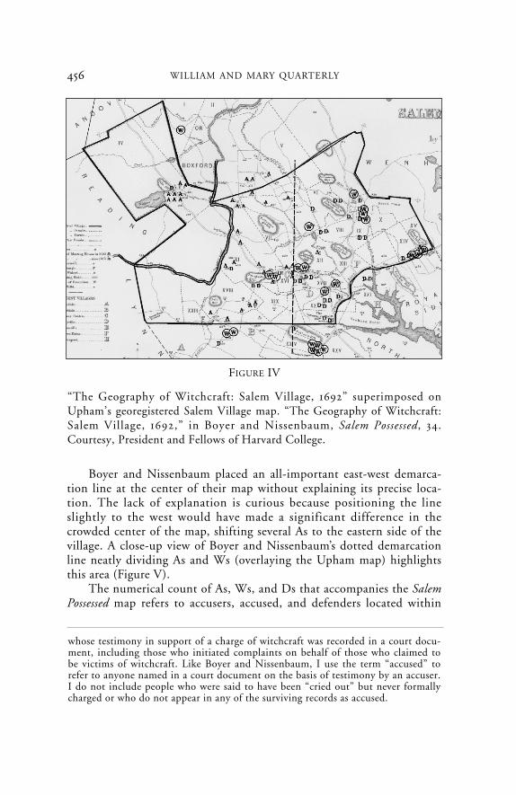
Boyer and Nissenbaum placed an all-important east-west demarca-tion line at the center of their map without explaining its precise loca-tion. The lack of explanation is curious because positioning the lineslightly to the west would have made a significant difference in thecrowded center of the map, shifting several As to the eastern side of thevillage. A close-up view of Boyer and Nissenbaum’s dotted demarcationline neatly dividing As and Ws (overlaying the Upham map) highlightsthis area (Figure V).
The numerical count of As, Ws, and Ds that accompanies the SalemPossessed map refers to accusers, accused, and defenders located within
FIGURE IV
“The Geography of Witchcraft: Salem Village, 1692” superimposed onUpham’s georegistered Salem Village map. “The Geography of Witchcraft:Salem Village, 1692,” in Boyer and Nissenbaum, Salem Possessed, 34.Courtesy, President and Fellows of Harvard College.
whose testimony in support of a charge of witchcraft was recorded in a court docu-ment, including those who initiated complaints on behalf of those who claimed tobe victims of witchcraft. Like Boyer and Nissenbaum, I use the term “accused” torefer to anyone named in a court document on the basis of testimony by an accuser.I do not include people who were said to have been “cried out” but never formallycharged or who do not appear in any of the surviving records as accused.
Q-7-08 front 6/30/08 11:00 AM Page 456

457GEOGRAPHY OF WITCHCRAFT ACCUSATIONS IN SALEM
the Salem Village boundaries, though the map itself shows a number ofpeople in these roles outside the village in neighboring settlements. Themap indicates that there were fourteen accused witches, thirty-twoaccusers, and twenty-nine defenders in Salem Village. Elsewhere Boyerand Nissenbaum give different tallies of accusers and accused in the vil-lage. For example their documentary source book Salem-Village Witchcraftlists twenty-six accused witches as village residents. Included in this listare eight people shown on the map in Salem Possessed as living outsidethe village boundaries. A subsequent map, published in Boyer’s cowrit-ten Enduring Vision, shows only eleven accused witches within the vil-lage borders.9 There is a similar problem with the number of accusers inthe village. The Salem Possessed map displays twenty-nine As in SalemVillage, whereas the numerical count that accompanies the map saysthere are thirty-two accusers. This number includes three As located justacross the village’s northern boundary in Topsfield.
For the sake of completeness, corrections to the As and Ws onrevised maps presented here include those located both inside and out-side Salem Village boundaries within the same geographic area as Boyer
FIGURE V
Enlarged center section of “The Geography of Witchcraft: Salem Village,1692” superimposed on Upham’s map. “The Geography of Witchcraft:Salem Village, 1692,” in Boyer and Nissenbaum, Salem Possessed, 34.Courtesy, President and Fellows of Harvard College.
9 Ibid., 376–78; Boyer et al., Enduring Vision, 49.
Q-7-08 front 6/30/08 11:00 AM Page 457

458 WILLIAM AND MARY QUARTERLY
and Nissenbaum’s map. Though it is evident that the village accusers’social network reached far beyond the village’s borders, making localgeographic boundaries largely irrelevant to understanding all but the ini-tial stage of the episode, the revised map retains Boyer and Nissenbaum’sfocus on Salem Village and its immediate environs, including adjacentareas of Rowley, Topsfield, and Salem Farms. Extending the map’s geo-graphic coverage would introduce issues that go beyond Boyer andNissenbaum’s interpretation of the outbreak of accusations in the village.The revised map also stays within the same time frame of accusations asthe Salem Possessed map, from the end of February to the end of May1692, the first three months of the nine-month accusation period.
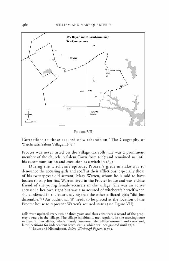
Boyer and Nissenbaum do not identify the accused by name ontheir map. One can infer their identities from the position of the Ws inrelation to Upham’s household markers and numbers and also from anunpublished version of Boyer and Nissenbaum’s map that assigns namesto each of the accused (Figure VI). To rectify errors on the SalemPossessed map, eight large Ws designate corrected, deleted, or addedaccused (Figure VII). The large W to the east represents Bridget Bishop.Scholars have determined that she did not live in Salem Village but inthe Salem Town, and hence this W is incorrectly placed and should bedeleted. The large W near the center of the map is one of an accusedpair identified on the unpublished map as Tituba and John Indian (seeFigure VI). Both were Indian slaves who lived in the Reverend SamuelParris’s house. Two Ws appear in the same location on the publishedmap, positioned in the approximate location of Parris’s house, andclearly represent the same two people. John Indian, however, was neveraccused of witchcraft, though he was an active accuser in some of thepreliminary examinations. Nor is John Indian identified as one of theaccused witches in Boyer and Nissenbaum’s list in Salem-VillageWitchcraft. The W representing him on the Salem Possessed map is there-fore incorrect and should be deleted (see Figure VII). All the other Wslocated within the village boundaries on Boyer and Nissenbaum’s mapare correct according to the court records and Upham’s map.10
10 Figure VI bears the names of Paul S. Boyer and Stephen Nissenbaum in thelower left-hand corner. I found this map in a folder of miscellaneous papers relatingto the Salem witch trials at the Phillips Library, Peabody Essex Museum, Salem,Mass. The map includes the names of two accused witches, George Jacobs Sr. andRebecca Jacobs, located in the Northfields section of Salem to the east of the village.Boyer and Nissenbaum omitted these names from the published map in SalemPossessed, perhaps because they lie somewhat outside the published map’s geographicframe. For Bridget Bishop’s full genealogical and marital history, see David L.Greene, “Salem Witches I: Bridget Bishop,” American Genealogist 57, no. 3 (July1981): 129–38. According to the arrest warrant, Sarah Good and her husband,William, lived in Salem Village, probably in rented rooms. But no records give their
Q-7-08 front 6/30/08 11:00 AM Page 458

459GEOGRAPHY OF WITCHCRAFT ACCUSATIONS IN SALEM
Turning now to the accused outside the village, the cluster of fivelocated to the southeast just below the village boundary represents fivemembers of the Procter family (John Procter; his wife, Elizabeth; andthree of their children, William, Benjamin, and Sarah). The Procterslived in the area called Salem Farms, an inland segment of Salem Townimmediately to the south of the Salem Village boundary.11 Thus John
specific place of residence at the time and therefore I cannot represent Sarah Good orher accused four- or five-year-old daughter, Dorothy, on a revised and corrected map.
11 Salem Village was originally part of Salem Town and often referred to as“Salem Farmes” or simply “the Farmes.” In 1672 the Farms succeeded in petitioningthe town and the General Court for permission to organize a separate parish calledSalem Village for the purpose of hiring a minister and building a meetinghouse ofits own. To support the new ministry via taxation, leaders geographically definedthe Salem Village parish boundaries at this time as represented by Upham’s map.The remaining area of the Farms located south of the village continued to be part ofthe town and came to be known as Salem Farms. The property owners living withinthe boundaries of Salem Village were first listed on the village tax rolls in 1681; the
FIGURE VI
Boyer and Nissenbaum’s unpublished map of the accusations in SalemVillage. Courtesy, Paul Boyer, Stephen Nissenbaum, and the PhillipsLibrary, Peabody Essex Museum, Salem, Mass.
Q-7-08 front 6/30/08 11:00 AM Page 459
460 WILLIAM AND MARY QUARTERLY
Procter was never listed on the village tax rolls. He was a prominentmember of the church in Salem Town from 1667 and remained so untilhis excommunication and execution as a witch in 1692.
During the witchcraft episode, Procter’s great mistake was todenounce the accusing girls and scoff at their afflictions, especially thoseof his twenty-year-old servant, Mary Warren, whom he is said to havebeaten to stop her fits. Warren lived in the Procter house and was a closefriend of the young female accusers in the village. She was an activeaccuser in her own right but was also accused of witchcraft herself whenshe confessed in the court, saying that the other afflicted girls “did butdissemble.”12 An additional W needs to be placed at the location of theProcter house to represent Warren’s accused status (see Figure VII).
rolls were updated every two or three years and thus constitute a record of the prop-erty owners in the village. The village inhabitants met regularly in the meetinghouseto handle their affairs, which mainly concerned the village ministry and taxes and,later, petitions for independent town status, which was not granted until 1752.
12 Boyer and Nissenbaum, Salem Witchcraft Papers, 3: 793.
FIGURE VII
Corrections to those accused of witchcraft on “The Geography ofWitchcraft: Salem Village, 1692.”
Q-7-08 front 6/30/08 11:00 AM Page 460

461GEOGRAPHY OF WITCHCRAFT ACCUSATIONS IN SALEM
The W located to the far northwest just beyond the Salem Villageboundary in the area of Rowley Village (now Boxford) marks JohnWillard’s house, as indicated on Upham’s map. Property deeds show thatsome of Willard’s large holdings lay within the Will’s Hill area of SalemVillage in the northwest corner, and hence Willard’s name regularlyappears on village tax lists. Willard served as a deputy constable at thetime of the witchcraft accusations and was involved in arresting severalvillagers, but he is said to have quit this work out of conscience andmocked the arrests. He was subsequently accused, arrested, and eventu-ally executed. Curiously, Boyer and Nissenbaum did not include Willardin their numerical tally of accused village witches in Salem Possessed,though he is consistently identified as a resident of the village in thecourt documents and tax records.13
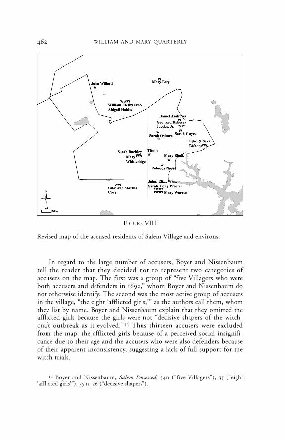
Also curious is their omission of four accused witches who lived justto the north of Salem Village in the neighboring town of Topsfield. Inthis same area, Boyer and Nissenbaum placed three As to representTopsfield accusers Phillip and Margaret Knight and Lydia Nichols, whoaccused their immediate neighbors, William, Deliverance, and AbigailHobbs (who were also accused by several residents in the village). Inresponse to the accusations, Abigail Hobbs freely confessed to being awitch and, in turn, accused the Reverend George Burroughs, a formervillage minister disliked by the Putnam family and who lived in Wells,Maine. In the same week, several village residents, including members ofthe Putnam family, accused Topsfield resident Mary Towne Esty, IsaacEsty’s wife, whose two sisters, Rebecca Towne Nurse and Sarah TowneCloyce, had already been accused in the village. All four Topsfield resi-dents were well known to the accusers in Salem Village and quicklyensnared in the early phase of the village accusations. The four large Wsin Topsfield represent them (see Figure VII). The fully corrected maprepresents the locations of those accused of witchcraft in Salem Villageand the bordering areas of Topsfield and Salem Farms within the samegeographic area as Boyer and Nissenbaum’s map (Figure VIII).
13 Charles W. Upham indicates that the location of John Willard’s house isuncertain. See Upham, Salem Witchcraft, 1: xix. Based on analysis of property deeds,Marilynne Roach has suggested that John and Margaret Willard may have been liv-ing in the Will’s Hill area, perhaps with Margaret’s maternal relatives, near the largeWilkins clan who lived in this part of the village (Roach, e-mail message to author,October 2005). Robert Calef’s book is the only source for Willard’s role as a deputyconstable. See Calef, More Wonders of the Invisible Word, 1700, in George LincolnBurr, ed., Narratives of the Witchcraft Cases, 1648–1706 (New York, 1914), 289–393.Compare with Upham, Salem Witchcraft, 2: 173.
Q-7-08 front 6/30/08 11:00 AM Page 461
462 WILLIAM AND MARY QUARTERLY
In regard to the large number of accusers, Boyer and Nissenbaumtell the reader that they decided not to represent two categories ofaccusers on the map. The first was a group of “five Villagers who wereboth accusers and defenders in 1692,” whom Boyer and Nissenbaum donot otherwise identify. The second was the most active group of accusersin the village, “the eight ‘afflicted girls,’” as the authors call them, whomthey list by name. Boyer and Nissenbaum explain that they omitted theafflicted girls because the girls were not “decisive shapers of the witch-craft outbreak as it evolved.”14 Thus thirteen accusers were excludedfrom the map, the afflicted girls because of a perceived social insignifi-cance due to their age and the accusers who were also defenders becauseof their apparent inconsistency, suggesting a lack of full support for thewitch trials.
FIGURE VIII
Revised map of the accused residents of Salem Village and environs.
14 Boyer and Nissenbaum, Salem Possessed, 34n (“five Villagers”), 35 (“eight‘afflicted girls’”), 35 n. 26 (“decisive shapers”).
Q-7-08 front 6/30/08 11:00 AM Page 462
463GEOGRAPHY OF WITCHCRAFT ACCUSATIONS IN SALEM
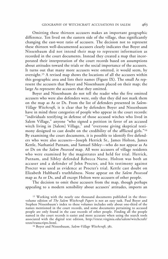
Omitting these thirteen accusers makes an important geographicdifference. Ten lived on the eastern side of the village, thus significantlychanging the east-west ratio of accusers. The decision not to representthese thirteen well-documented accusers clearly indicates that Boyer andNissenbaum did not intend their map to represent information asrecorded in the court documents. Instead they created a map that incor-porated their interpretation of the court records based on assumptionsabout attitudes toward the trials or the social importance of the accusers.It turns out that many more accusers were omitted, it would seem, byoversight.15 A revised map shows the locations of all the accusers withinthis geographic area and lists their names (Figure IX). The small As rep-resent the accusers that Boyer and Nissenbaum placed on their map; thelarge As represent the accusers that they omitted.
Boyer and Nissenbaum do not tell the reader who the five omittedaccusers who were also defenders were, only that they did not mark themon the map as As or Ds. From the list of defenders presented in Salem-Village Witchcraft, it is clear that by defenders Boyer and Nissenbaumhave in mind three categories of people who appear in the court records:“individuals testifying in defense of those accused witches who lived inSalem Village,” anyone “who signed a petition in favor of an accusedwitch living in [Salem] Village,” and “everyone giving skeptical testi-mony designed to cast doubt on the credibility of the afflicted girls.”16
By examining the court documents, it is possible to identify five defend-ers who were also accusers—Joseph Herrick Sr., James Holton, JamesKettle, Nathaniel Putnam, and Samuel Sibley—who do not appear as Asor Ds on the Salem Possessed map. All were accusers of village residentswho were examined by the magistrates and held for trial. Herrick,Putnam, and Sibley defended Rebecca Nurse. Holton was both anaccuser and a defender of John Procter, and his testimony againstProcter was used as evidence at Procter’s trial. Kettle cast doubt onElizabeth Hubbard’s truthfulness. None appear on the Salem Possessedmap as As or Ds, and all except Holton were accusers of other people.
The decision to omit these accusers from the map, though perhapsappealing to a modern sensibility about accusers’ attitudes, imports an
15 Working with the nearly one thousand documents published in the three-volume edition of The Salem Witchcraft Papers is not an easy task. Paul Boyer andStephen Nissenbaum’s index to these volumes includes only about one-third of thenames mentioned in the court records, and some documents pertaining to accusedpeople are only found in the case records of other people. Finding all the peoplenamed in the court records is easier and more accurate when using the search toolsassociated with the digital text edition, http://etext.virginia.edu/salem/witchcraft/texts/transcripts.html.
16 Boyer and Nissenbaum, Salem-Village Witchcraft, 381.
Q-7-08 front 6/30/08 11:00 AM Page 463

464 WILLIAM AND MARY QUARTERLY
interpretation into the otherwise objective purpose of the map. Some ofthe Salem Villagers appear to have genuinely believed certain accusedwere guilty and others were not, and they acted on their convictions.Boyer and Nissenbaum could not visually represent Salem Villagers’state of mind or moral conscience concerning the witch trials per se.Their complaints, depositions, and courtroom testimonies appear in thecourt records, and many of these documents were marked Jurat in Curiaand used as evidence in the trials to convict the accused.
Nanthaniel Putnam was one of the complainants against JohnWillard and Sarah Buckley. He also initiated a complaint againstElizabeth Fosdick and Elizabeth Paine, two women who lived in nearbyMalden. Yet Putnam stood by his old neighbor Nurse; he submitted hisown petition on behalf of her innocence and also signed a testimonial inher favor circulated by the Nurse family, along with thirty-eight othervillagers. Samuel Sibley testified against Sarah Good and John Procter
FIGURE IX
Corrections to the accusers delineated on “The Geography of Witchcraft:Salem Village, 1692.” Numbers after the householders’ names indicate thenumber of accusers in the households (if more than one).
Q-7-08 front 6/30/08 11:00 AM Page 464

465GEOGRAPHY OF WITCHCRAFT ACCUSATIONS IN SALEM
but later signed the Nurse petition. Joseph Herrick Sr. was a constablein Salem Village and apprehended a number of suspected witches. Heaccused Good and Sarah Bishop yet, like Putnam and Sibley, came toNurse’s defense. James Holton contributed testimony supporting MaryWalcott’s and Hubbard’s depositions against John and Elizabeth Procteryet also signed a petition of John Procter’s innocence. Though neither ofHolton’s documents is dated, his testimony against Procter is markedJurat in Curia and was used as evidence at Procter’s trial, indicating thatthe court had no doubt about Holton’s charges and used them to con-vict. James Kettle’s testimonies present a complex situation. He initiateda deposition against his neighbor Sarah Bishop, based on spectral testi-mony from Hubbard, and he contributed evidence in support of theReverend John Hale’s deposition against Bishop. But Kettle also testifiedthat when he spoke with Hubbard she told him “severall untruthes.”17
None of Kettle’s testimonies are dated, so it is difficult to address achange of mind. The case against Bishop, which was not strong, nevercame to trial. Nevertheless Kettle’s testimony, like that of others, becamepart of the record and lent support to the momentum of the accusationsoccurring in the village even if he changed his mind. In all these cases,there is no indication that accusers were skeptical about the trials ingeneral, and only Holton appears to have had doubts about the guilt ofthe person he accused. These five accusers appear as As on a revised mapto reflect the court records (see Figure IX).
In addition to these five omitted accusers, there are six individualswho appear on the Salem Possessed map as Ds who were also accusers ofother people but do not appear on the map as As. They are JonathanPutnam; Joseph Hutchinson Sr. and his wife, Lydia; John Putnam Sr.and his wife, Rebecca; and Joseph Holton Sr. In light of Boyer andNissenbaum’s comment about the omission of individuals who wereaccusers and defenders, it would appear that the reader should assumethat any of the accusations made by these defenders should not be takenseriously (hence their omission as As), though Boyer and Nissenbaumdo not discuss this omission. Each of these accusers was a defender ofNurse, who was a close neighbor. Nevertheless the documents do notgive any reason to ignore the accusations that these same accusers madeagainst others.
Jonathan Putnam accused sisters Mary Esty and Nurse but latersigned the petition in Nurse’s defense, though he did not change his testi-mony against Esty. Joseph and Lydia Hutchinson were among the original
17 Boyer and Nissenbaum, Salem Witchcraft Papers, 1: 57.
Q-7-08 front 6/30/08 11:00 AM Page 465

466 WILLIAM AND MARY QUARTERLY
complainants against Tituba, Sarah Osburn, and Sarah Good, yet bothstood by their neighbor Nurse. Joseph Hutchinson also submitted adeposition that cast doubt on the reliability of Abigail Williams, one ofNurse’s young accusers, pointing out that she told him she could easilyconverse with the devil. John Putnam Sr. and his wife, Rebecca, testifiedin court against former Salem Village minister George Burroughs, butboth came to Nurse’s defense. John Putnam Sr. also complained againstMartha Carrier and contributed testimony against John Willard andSarah Buckley. He accused Nurse of afflicting his son Jonathan but latersigned a petition in Nurse’s defense as did Jonathan. Nevertheless JohnPutnam Sr.’s testimony against Nurse was used in court at her trial.Finally, Joseph Holton Sr., who signed the Nurse petition, was one ofthe chief complainants against William Procter and several Andover peo-ple. There is no indication in any of the documents that these sevenaccusers “publicly showed their skepticism about the trials” in general, asBoyer and Nissenbaum suggest, or that they doubted the accusationsthey made against others.18 These six accusers appear on a revised mapas large As (see Figure IX).
The eight afflicted girls were Sarah Churchill, Elizabeth Hubbard,Mercy Lewis, Elizabeth Parris, Ann Putnam Jr., Mary Warren, AbigailWilliams, and Mary Walcott. The residences of these eight accusers are wellknown. Boyer and Nissenbaum apparently omitted two more, eighteen-year-old Susannah Shelden and ten-year-old Jemima Rea, because they didnot think the young accusers decisively shaped the witchcraft outbreak.Subsequent scholarship, however, has made it clear that this assumption,based on the view that the afflicted girls were merely mouthpieces foradult male villagers, is unsupportable. Bernard Rosenthal’s careful analysisof the court documents in Salem Story illuminates the constant collabora-tion among the young accusers (quite independent of adult control) aswell as their deliberate acts of lying and deception. Mary Beth Norton’silluminating study of these same young women in In the Devil’s Snaredeepens current understanding of their reduced social status and thetraumatized background of some who were the victims of Indian attacksin the 1675–76 King Philip’s War.19 Norton’s and Rosenthal’s accountsmake it abundantly clear that the afflicted girls played key roles in theprogress of the accusations in the village and that they helped to main-tain control of the dynamics of the legal process inside and outside thecourtroom on an almost daily basis. As Norton points out, two or three
18 Boyer and Nissenbaum, Salem Possessed, 35.19 Bernard Rosenthal, Salem Story: Reading the Witch Trials of 1692 (Cambridge,
1993); Norton, In the Devil’s Snare.
Q-7-08 front 6/30/08 11:00 AM Page 466
of the youngest girls were initially prompted by adults to name certainpeople as witches, yet nothing in the record demonstrates that these girlsand their older female friends did not initiate most of the accusations ontheir own, relying on personal confrontations, village gossip, and fre-quent collaboration.
The court records show that the young female accusers played anespecially critical role in the preliminary and grand jury hearings. In allpreliminary hearings, the young accusers were pitted against the accusedin face-to-face encounters, and their eagerness to denounce, often spon-taneously during the hearings, produced hundreds of subsequent writtendepositions and testimonies about the afflictions they suffered duringthese courtroom interrogations. Most depositions and testimonies werelater gathered together, marked Jurat in Curia, and used in the trials tocondemn the accused.
The importance of the young girls does not minimize the role of theadults who were heavily involved in enabling and supporting the accusa-tions. Norton emphasizes that without leading village men (the mostactive being former village clerk Thomas Putnam) who recorded andfiled complaints and depositions on behalf of most of the young femaleaccusers, the legal proceedings would never have occurred.20 SamuelParris, who was responsible for initially raising the subject of demonicactivity in his sermons well before the accusations began, supported theaccusers from the beginning and gave the afflicted girls initial exposurethrough group prayer sessions and fasts. Parris also recorded dozens ofdepositions by his niece Abigail Williams. The records indicate that thegirls and young women took the initiative in naming names and, mostimportantly, in performing their afflictions in numerous preliminaryhearings. The magistrates called on them repeatedly to give dramatictestimony against the accused during the seven months of hearings andtrials, and they obliged the court with ever-escalating effect, namingnew victims in a progressively widening social and geographic circlethrough the spring, summer, and fall of 1692.
The young accusers’ actions also reflected the interests of some ofthe leading adults and families in Salem Village. It is therefore impor-tant to place them on a corrected map to give a geographic location to
467GEOGRAPHY OF WITCHCRAFT ACCUSATIONS IN SALEM
20 Handwriting analysis has revealed that Thomas Putnam recorded most of thedozens of depositions of his active daughter, Ann, as well as those of two otheractive accusers: Mercy Lewis, who was Putnam’s household servant, and MaryWalcott, the stepdaughter of his sister. See Peter Grund, Merja Kytö, and MattiRissanen, “Editing the Salem Witchcraft Records: An Exploration of a LinguisticTreasury,” American Speech 79, no. 2 (Summer 2004): 146–66.
Q-7-08 front 6/30/08 11:00 AM Page 467
468 WILLIAM AND MARY QUARTERLY
the interests they represented. For example two of the most activeaccusers, Ann Putnam Jr. and Mercy Lewis, were members of ThomasPutnam’s household, and Putnam was one of the most active of the vil-lage complainants. Placing all ten junior female accusers on the cor-rected map as As makes a difference in the east-west pattern becauseseven of them lived on the eastern side of the demarcation line: SarahChurchill, Elizabeth Hubbard, Elizabeth Parris, Jemima Rea, SusannahShelden, Mary Warren, and Abigail Williams (see Figure IX).21
Boyer and Nissenbaum also apparently overlooked thirteen mostlyadult accusers, now added as larger As to the revised map (see FigureIX). Their omission is surprising because three of them, Samuel Parris,John Indian, and Tituba, were residents of the prominent Parris house-hold, and all three figure significantly in the court documents. All threeare placed at the Parris house, located just to the east of the Boyer andNissenbaum demarcation line, and grouped with the two As represent-ing Abigail Williams and Elizabeth Parris. In the Parris household, therewas a total of five accusers, more than in any other village household.Ten other As represent Deliverance Hobbs and her daughter, Abigail,who confessed and accused several villagers who had already beenaccused; Lydia Nichols’s two daughters Lydia and Elizabeth, whoaccused Abigail Hobbs, and her son Thomas, who accused John Willard;Sarah Holton, who accused Rebecca Nurse; Bathshua Pope, who becameafflicted at several grand jury hearings and cried out at the accused;Joseph Pope, who testified against John Procter; and Joseph Herrick Sr.and his wife, Mary, who both accused Sarah Good.
In sum the corrected map of the accusations in Salem Village showsan additional thirty-four accusers, most of whom lived on the easternside of the village (Figure X). Putting accusers and accused together onthe same map shows that there is no pronounced east-west division.Twenty-eight accusers appear on the eastern side of the east-west lineand forty on the western side. The east-west distribution of accusedwitches is less even, but there are enough in the west so that the situa-tion is not one sided. Clearly, accusers and accused did not live onopposite sides of the village as Boyer and Nissenbaum stated. Mappingall who made accusations in the same geographic area as Boyer and
21 Sarah Churchill’s location is not indicated on Figure IX because GeorgeJacobs Sr.’s residence, where she lived, was located in Northfields, an area that liesoutside the range of Paul Boyer and Stephen Nissenbaum’s map. There were severaladditional accusers in Salem Farms. For example, in the house of widow AliceSchafflin there were three accusers, Alice’s daughters Alice and Elizabeth Booth anddaughter-in-law Elizabeth Booth. The Schafflin house also lies just outside the frameof the Boyer and Nissenbaum map.
Q-7-08 front 6/30/08 11:00 AM Page 468

Nissenbaum’s map does not reveal a community geographically dividedagainst itself.
The depiction of a geographic division depends in part on the loca-tion of the east-west demarcation line, yet Boyer and Nissenbaum donot explain the placement of that line in Salem Possessed. If it were astrictly geographic demarcation, dividing the village into two equalparts, the authors would have located the line farther to the west toadjust for Will’s Hill, the large geographic appendage in the northwest-ern corner. But a strictly geographic division does not appear to be whatBoyer and Nissenbaum had in mind.
They placed the dividing line nearer to the meetinghouse, which wasthe symbolic center of all Puritan communities. If this position was theirintent, the line should be moved slightly to the east to the actual meet-inghouse location. The meetinghouse site was selected in 1673 by JosephHutchinson Sr., who donated a plot of land from his own property. Thislocation was suitable because it placed the meetinghouse more or less
469GEOGRAPHY OF WITCHCRAFT ACCUSATIONS IN SALEM
FIGURE X
Accusers (A) and accused (W) in Salem Village and environs.
Q-7-08 front 6/30/08 11:00 AM Page 469

470 WILLIAM AND MARY QUARTERLY
equidistant from most of the village residents and thus at the village’sapproximate demographic center. Moving the line closer to the meeting-house would not significantly change the east-west ratio of accusers toaccused as Boyer and Nissenbaum represented it.22
The unpublished version of the accusations map, interestingly,shows a diagonal line instead of a vertical one and divides the village inhalf from northeast to southwest (see Figure VI). This line appears tohave been drawn so that it placed as many Ws as possible on the easternside of the village. This strategy, however, left eight As on the easternside. Comparing the diagonal version to the vertical one, which showsonly two As in the east, suggests that the purpose of the vertical arrange-ment was to keep as many As in the west and as many Ws in the east aspossible. Placing the vertical line so that it almost too neatly separatesthe closely clustered households at the center and thus keeping severalAs to the west of it strengthens this interpretation. It seems, therefore,that the location of the vertical demarcation line on the map wasintended to show as dramatically as possible that Salem Village was geo-graphically divided against itself, with nearly all As in the west and mostWs in the east.
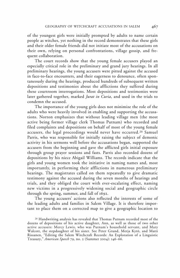
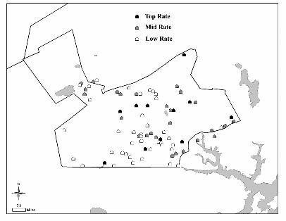
According to Salem Possessed, there was a deep-seated economic divisionbetween the more prosperous and commercially minded “Town-oriented” farmers and “entrepreneurs” on the eastern side of the village andalong the Ipswich Road and the poorer, conservatively minded agrarianfarmers in the more isolated, less fertile land in the west. “In at least twoimportant respects—quality of land and access to market—those farmerson the eastern (or Town) side of the Village had a significant [economic]advantage.” One can use the tax rate information from the Salem VillageRecord Book to show the three different tax levels in a single display forthe year 1689–90, two years before the outbreak of the accusations (FigureXI). At the lowest tax level, there are twenty-six households on the west-ern side and thirteen on the eastern; thus about twice as many of thepoorest families (in terms of landholdings) lived in the western area. Themiddle tax range shows twelve households in the west and fifteen in the
22 The Salem Village map in Boyer et al.’s Enduring Vision appears to locate thedividing line somewhat to the east of the meetinghouse. By contrast historianGeorge Lincoln Burr refers to Ingersoll’s Tavern as the “recognized centre of the‘Village’. The meeting-house [property] adjoined it to the east, to the west the par-sonage, where lived Mr. Parris.” See Burr, Narratives of the Witchcraft Cases, 153 n. 1.If Ingersoll’s Tavern, marked on Upham’s map by the symbol “+” (see Figure V),were the village center, the location of the demarcation line would be farther to theeast, thus shifting a number of the accusers and accused in Samuel Parris’s house tothe west.
Q-7-08 front 6/30/08 11:00 AM Page 470
471GEOGRAPHY OF WITCHCRAFT ACCUSATIONS IN SALEM
east, an almost even distribution. The top level tax range includes sixhouseholds in the west and seven in the east, again, an almost even distri-bution. Except for the lowest economic level, the map reveals a fairlyhomogeneous distribution of wealth across the village. Salem Village wasnot therefore divided into radically different eastern and western eco-nomic groups, and, as Richard Latner has shown, a comparison of the taxrecords over time also does not reveal any significant change in the geo-graphic distribution of wealth over the years.23
23 Boyer and Nissenbaum, Salem Possessed, 93 (“Town-oriented”), 97 (“entre-preneurs”), 94 (“two important respects”). All the residents of Salem Village paidannual taxes toward the minister’s salary, and new tax rates were drawn up every fewyears and entered into the village records. See “Salem-Village Book of Record,1672–1697,” in “A Book of Record of the Severall Publique Transa[c]tions of theInhabitants of Sale[m] Village Vulgarly Called the Farme[s],” Historical Collections ofthe Danvers Historical Society (Salem, Mass., 1925–26, 1928–29), 13: 91–122, 14: 65–99,16: 60–80, 17: 74–103, in Boyer and Nissenbaum, Salem-Village Witchcraft, 353–55;Boyer and Nissenbaum, Salem Possessed, 82. Curiously, Paul Boyer and StephenNissenbaum use the tax rate list for the year 1695, three years after the witch trials
FIGURE XI
Tax rates in Salem Village, 1689–90.
Q-7-08 front 6/30/08 11:00 AM Page 471
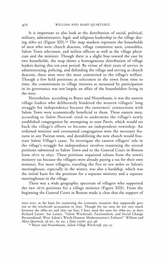
It is important to also look at the distribution of social, political,military, administrative, legal, and religious leadership in the village dur-ing 1680–92 (Figure XII).24 The map markers represent the householdsof men who were church deacons, village committee men, constables,Salem Town selectmen, and militia officers as well as the village physi-cian and the minister. Though there is a slight bias toward the east bytwo households, the map shows a homogeneous distribution of villageleaders during this ten-year period. By virtue of their years of service inadministrating, policing, and defending the village and serving as churchdeacons, these men were the most committed to the village’s welfare.Though a few held positions as selectmen in the town from time totime, the commitment to village interests as measured by participationin its governance was not largely an affair of the householders living inthe west.
Nevertheless, according to Boyer and Nissenbaum, it was the easternvillage leaders who deliberately hindered the western villagers’ longstruggle for independence because the easterners’ connections withSalem Town were economically beneficial to them. These eastern men,according to Salem Possessed, tried to undermine the village’s newlyestablished congregation by attempting to oust Parris, which would setback the village’s efforts to become an independent township. Anordained minister and covenanted congregation were the necessary fea-tures in any Puritan town, and destabilizing the new church would frus-trate Salem Village’s cause. To investigate the eastern villagers’ role inthe village’s struggle for independence involves examining the severalpetitions submitted to Salem Town and to the General Court in Bostonfrom 1670 to 1692. These petitions requested release from the town’sministry tax because the villagers were already paying a tax for their ownminister. For most villagers, traveling the five to ten miles to Salem’smeetinghouse, especially in the winter, was also a hardship, which wasthe initial basis for the petitions for a separate ministry and a separatemeetinghouse in the village.
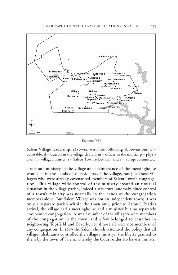
There was a wide geographic spectrum of villagers who supportedthe two 1670 petitions for a village minister (Figure XIII). From thebeginning the General Court in Boston made it clear that the support of
472 WILLIAM AND MARY QUARTERLY
were over, as the basis for examining the economic situation that supposedly gaverise to the witchcraft accusations in 1692. Though the tax rates do not vary muchbetween the 1689–90 and 1695 tax lists, I have used the rates for 1689–90, as doesRichard Latner. See Latner, “Salem Witchcraft, Factionalism, and Social ChangeReconsidered: Were Salem’s Witch-Hunters Modernization’s Failures?” William andMary Quarterly, 3d ser., 65, no. 3 (July 2008): 423–48.
24 Boyer and Nissenbaum, Salem-Village Witchcraft, 319–55.
Q-7-08 front 6/30/08 11:00 AM Page 472
473GEOGRAPHY OF WITCHCRAFT ACCUSATIONS IN SALEM
a separate ministry in the village and maintenance of the meetinghousewould be in the hands of all residents of the village, not just those vil-lagers who were already covenanted members of Salem Town’s congrega-tion. This village-wide control of the ministry created an unusualsituation in the village parish, indeed a structural anomaly, since controlof a town’s ministry was normally in the hands of the congregationmembers alone. But Salem Village was not an independent town; it wasonly a separate parish within the town and, prior to Samuel Parris’sarrival, the village had a meetinghouse and a minister but no separatelycovenanted congregation. A small number of the villagers were membersof the congregation in the town, and a few belonged to churches inneighboring Topsfield and Beverly, yet almost all were not members ofany congregation. In 1679 the Salem church reiterated the policy that allvillage inhabitants controlled the village ministry: “the liberty granted tothem by the town of Salem, whereby the Court order (to have a minister
FIGURE XII
Salem Village leadership, 1680–92, with the following abbreviations: c =constable, d = deacon in the village church, m = officer in the militia, p = physi-cian, r = village minister, s = Salem Town selectman, and v = village committee.
Q-7-08 front 6/30/08 11:00 AM Page 473
474 WILLIAM AND MARY QUARTERLY
amongst themselves within such bounds [of the village]) was not grantedto any of them under the notion of church members, but to the wholenumber of inhabitants there—for their present ease, being so far fromthe meeting-house here [in Salem Town].”25 This ruling set the stage forpossible conflict between future church members in the village, once anindependent congregation was established there, and the rest of the vil-lage residents if they disapproved of the minister.
After repeated conflict and a succession of three ministers in the vil-lage in eighteen years, the last of whom, Deodat Lawson, left in 1687,the town permitted the village to recruit a new minister who would beordained so that the village would be able to establish its own covenantcongregation. The search for a new minister, which led to Parris’srecruitment, was the work of several village men who would become
25 Ibid., 246.
FIGURE XIII
Signers of village ministry petitions of 1670.
Q-7-08 front 6/30/08 11:00 AM Page 474

475
founding members of the new village covenant; and in their householdswould reside the core group of village accusers. After initial negotiationswith Parris concerning salary and benefits, which were not fullyresolved, the village agreed to appoint him in November 1689. As thefirst ordained minister in the village, Parris could establish its firstcovenant congregation, conduct Holy Communion services, and baptizethe congregation’s children. Establishing a village congregation was alsoa major step toward the village’s independence from the town.
Once Parris was selected and installed, village leaders lost no time insubmitting petitions to the General Court in Boston for independenttownship status. The first petition was initiated in August 1689, anotherwas submitted in December 1690, and two more in January 1692.26 Thefinal petition of January 28 requested that the village be granted town-ship status and be freed from those town taxes that did not benefit it,namely, the taxes for Salem’s minister, the town roads, and support ofthe town’s poor. The petition was signed by several prominent residents,all eastern village men, who were chosen to serve as advocates: ThomasFlint, Joseph Hutchinson, Francis Nurse, Joseph Porter, John PutnamJr., and Nathaniel Putnam. Flint and the Putnams were strong support-ers of Parris; Hutchinson, Nurse, and Porter, strong opponents. Despitethe deepening conflict over Parris, it is clear that the anti-Parris leaderssteadfastly backed the independence movement in cooperation withtheir opponents.
The village’s desire for independence was strongly supported by east-ern leaders, as can be seen from the locations of men supporting the fourpetitions (Figure XIV). It is difficult, then, to agree with Boyer andNissenbaum that eastern village leaders had little genuine interest in sepa-ration from the town. Indeed all villagers would economically benefitbecause independence would free the village from paying a sizable portionof the town’s taxes for the support of its ministry, roads, and poor. Loss oftax revenue, however, made the town reluctant to accept the village’s peti-tions. Though there is an obvious connection between establishment ofthe village congregation and the village independence movement, since anindependent church was a requirement for township status, there is noexclusive connection between the geographic location of the men support-ing the village independence movement and the supposedly proindepen-dence western side of the village, as Boyer and Nissenbaum believed.
Finally, it is important to look at the geographic distribution ofchurch membership in Salem Village during Parris’s tenure from the
GEOGRAPHY OF WITCHCRAFT ACCUSATIONS IN SALEM
26 Ibid., 349–57.
Q-7-08 front 6/30/08 11:00 AM Page 475

476 WILLIAM AND MARY QUARTERLY
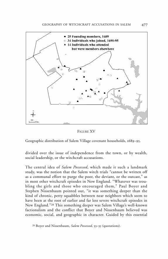
founding of the new covenant in November 1689 to 1695, the year inwhich he was forced to leave (Figure XV). It is revealing to plot the resi-dences of the original twenty-five covenant members, the twenty-ninepeople who joined in January 1690–July 1691, and the five who joinedfrom 1693 to 1695, as listed by Parris in the church record book. Severalof the new members were spouses of and shared the same households asfounding members. In 1695, in connection with petitions for and againsthis removal from the village ministry, Parris identified an additionalfourteen individuals who attended the village church as “Church-Members,” though they formally belonged to other nearby churches.27
There was a nearly uniform distribution of church member householdsacross the village landscape (see Figure XV).
Salem Village, then, was not a community geographically dividedagainst itself in terms of church membership. Nor was it geographically
27 Ibid., 262–63, 309.
FIGURE XIV
Signers of village independence petitions of January 1692.
Q-7-08 front 6/30/08 11:00 AM Page 476
477GEOGRAPHY OF WITCHCRAFT ACCUSATIONS IN SALEM
divided over the issue of independence from the town, or by wealth,social leadership, or the witchcraft accusations.
The central idea of Salem Possessed, which made it such a landmarkstudy, was the notion that the Salem witch trials “cannot be written offas a communal effort to purge the poor, the deviant, or the outcast,” asin most other witchcraft episodes in New England. “Whatever was trou-bling the girls and those who encouraged them,” Paul Boyer andStephen Nissenbaum pointed out, “it was something deeper than thekind of chronic, petty squabbles between near neighbors which seem tohave been at the root of earlier and far less severe witchcraft episodes inNew England.”28 This something deeper was Salem Village’s well-knownfactionalism and the conflict that Boyer and Nissenbaum believed waseconomic, social, and geographic in character. Guided by this essential
FIGURE XV
Geographic distribution of Salem Village covenant households, 1689–95.
28 Boyer and Nissenbaum, Salem Possessed, 33–35 (quotations).
Q-7-08 front 6/30/08 11:00 AM Page 477
thesis, Salem Possessed—unlike accounts of the previous two hundredyears—was the first to analytically examine the historical forces at workin Salem Village instead of merely offering a moral account of theepisode and its many perpetrators and victims. As this article indicates,mapping the accusations needs to be as free of interpretive assumptionsas possible if scholars are to have a solid geographic foundation for fur-ther historical analysis.
478 WILLIAM AND MARY QUARTERLY
Q-7-08 front 6/30/08 11:00 AM Page 478