Embed Size (px)
Citation preview
417
When I took a decision, or adopted an alterna-tive, it was after studying every relevant . . .factor. Geography, tribal structure, religion,social customs, language, appetites, standards –all were at my finger-ends.
T. E. Lawrence, Letter to B. H. Liddell Hart,June 1933 (Collins, 1998: 3)
Introduction
Lawrence of Arabia’s observation is as truetoday as it was in his time. In recent years,our theoretical and empirical understandingof the factors identified by Lawrence asrelated to the onset and duration of civil war
© 2002 Journal of Peace Research,vol. 39, no. 4, 2002, pp. 417–433Sage Publications (London, Thousand Oaks,CA and New Delhi)[0022-3433(200207)39:4; 417–433; 025821]
The Geography of Civil War*
HALVARD BUHAUG
Department of Sociology and Political Science, Norwegian University ofScience & Technology (NTNU) & International Peace Research Institute,Oslo (PRIO)
SCOTT GATES
Department of Political Science, Michigan State University & InternationalPeace Research Institute, Oslo (PRIO)
Geographical factors play a critical role in determining how a civil war is fought and who will prevail.Drawing on the PRIO/Uppsala Armed Conflict dataset covering the period 1946–2000, the authorshave determined the location of all battle-zones for all civil wars in this time period, thereby identify-ing the geographic extent and the center point of each conflict. Using ordinary least squares (OLS) andthree-stage least squares (3SLS) estimation techniques, factors are analyzed that determine the scope ofthe conflict (area of the conflict zone) and the location of the conflict relative to the capital. It is foundthat in addition to geographical factors such as the total land area of the country, scope is stronglyshaped by such factors as the adjacencies of a border of a neighboring country, the incidence of naturalresources in the conflict zone, and the duration of the conflict. The distance of the conflict zone fromthe capital is influenced by the scope of the conflict, the size of the country, whether or not the objec-tive of the rebels is to secede, and whether or not the rebel group has a religious or ethnic identity. Also,evidence is found of an endogenous relationship between scope and location.
* An earlier version of this article was presented at theannual North American meeting of the Peace ScienceSociety (International), Atlanta, GA, 26–28 October2001. We thank the Research Council of Norway, theNorwegian University of Science and Technology(NTNU), and the World Bank for funding various partsof the data collection. The work on locating the conflictswas conducted as part of a cross-disciplinary project atNTNU on geographic diffusion of conflict, where Haakon
Lein and Jan Ketil Rød have made essential contributions.Furthermore, we are grateful to the Department of Peaceand Conflict Research, Uppsala University, for collabor-ation on the conflict data, Anke Hoeffler for providingdata on mountainous terrain, and Nils Petter Gleditsch,Mansoob Murshed, and five anonymous referees forinsightful comments on an earlier draft. The data onwhich the article is based will be posted at http://www.prio.no/cwp/datasets.asp.
03buhaug (ds) 20/6/02 8:36 am Page 417
has progressed tremendously.1 Yet, despiteimportant insights gained from this research,we have very little systematic knowledgeabout the actual fighting of civil wars. Ironi-cally, one reason for the general lack ofunderstanding in this regard is that there islittle or no actual fighting or war in thesemodels of war onset or duration. There areno battles, no deaths, no weapons, no guer-rilla tactics, and no counter-insurgencyactivities. Territory and resources are neverlost or gained. There are no victories andthere are no defeats. Yet, motivations regard-ing peace and war are clearly linked to theprospects of winning or losing a civil war. Inaddition to securing wealth through thecapture of resources, civil wars are oftenfought over a political objective – controlover the apparatus of the state or the creationof a new sovereign state. Clearly, differentobjectives will alter the way a civil war isfought. A war over control of the state willfundamentally differ from a war of secession.Military historians and strategists have longunderstood how geographical factors play acritical role in influencing how a civil war isfought and who will prevail. Taking militaryhistory as a departure point, this paper exam-ines how strategic objectives and geographi-cal factors affect the location, relative to thecapital, and scope (measured conflict area) ofarmed civil conflict.
Geographic Factors and Armed CivilConflict
Physical Geographical FactorsThe earliest military strategists understoodthe role of geography and conflict. In hisDiscoursi, Machiavelli (1517/1988: 52–53)wrote that a soldier must become ‘familiar
with the terrain: how mountains rise, howthe valleys open out and plains spread out,as well as with the characteristics of riversand swamps’. Keegan (1993) in his Historyof Warfare features the role of geographicvariables and distinguishes between ‘perma-nently operating’ and ‘contingent’ factors.Permanent factors include terrain andclimate. These factors have long been thefocus of military tacticians and militaryhistorians.2 And presumably because suchstories are more interesting, the majority ofsuch studies have featured the catastrophicblunders caused by commanders ignoringgeography, including the likes of MajorGeneral George McClellan at Antietem(1862), General Baron Levin Bennigsen atFriedland (1807), General Ludwig Benedekat Könnigratz (1866), and LieutenantGeneral Mark Clark at Rapido in the Battlefor Italy (1944). In contrast, gifted generals,of course, consistently have taken suchfactors into account and, where possible,have used them to their advantage.
Keegan’s second concept, contingentgeographic factors, relates to the constraintson logistics and intelligence. To ignore thesefactors is to ignore Clausewitz’s admonition,‘the end for which a soldier is recruited,clothed, armed and trained, the wholeobject of his sleeping, eating, drinking, andmarching is simply that he should fight at theright place and the right time’ (Murray, 1999:210). Geography is not just important onthe battlefield, but at the operational levelas well. With ruinous results, suchrenowned military minds as Napoleon andthe Oberkommando des Heeres (OKH) ofNazi Germany neglected these factors intheir attempts to conquer Russia and theSoviet Union respectively. It seems thatsocial scientists too, in their analyses of civilwar, also have tended to ignore the role of
j ournal o f PE AC E RE S E A RC H volume 39 / number 4 / july 2002418
1 The other articles included in the special issue serve astestimony to the tremendous strides we have made inunderstanding the onset and nature of civil war in recentyears. See Sambanis (2002) and Gates (2001) for reviewsof the literature.
2 In addition to Keegan (1993), see Collins (1998) andMurray (1999) for discussions regarding the role of geog-raphy in warfare.
03buhaug (ds) 20/6/02 8:36 am Page 418

geographic variables with regard to thefighting of civil war.
Influenced by classical theorists, mostapplications of geography to war have beengeo-political analyses applied to military strat-egy or global security issues. The basic premisethough almost seems too obvious – that thelocation and size of a country affect the designand nature of military strategy. Mackinder(1904) speaks of the pivot area, or heartland,while Ratzel (1896) draws on Darwin’s sur-vival of the fittest when arguing for a ‘law’ ofterritorial growth.3 For the most part, geopo-litical strategic analysis has been global inperspective, applied to explain the inter-national politics of Germany, Great Britain,and the United States. Yet, even for civil war,such factors as the size of a country, itslocation, and the nature of its borders areextremely important, influencing temporaland spatial domain as well as the potentialityfor diffusion.
Empirical studies addressing the geo-graphic aspect of conflicts typically consist ofstatistical, nation/dyadic-level analysesregarding interstate war, and rest on differentmeasures of proximity of states (Bremer,1992; Diehl, 1991; Gleditsch, 1995;Vasquez, 1995). Following Boulding (1962),Sprout & Sprout (1965), and Richardson(1960), geography is treated primarily as aconcept of contiguity and distance, affectinginterstate interaction. These studies havedemonstrated that inter-capital distance andnumber of borders are essential predictors ofconflict proneness. However, such measuresare less interesting when studying internalconflicts.
When it comes to exploring determinants ofthe location of conflicts, little or no systematiceffort has been made. Attributes of the conflict-ridden countries (topography, climate, popu-lation) as well as characteristics of the conflicts(severity, duration, goal of rebel group) have
only to a limited extent been included in quan-titative conflict studies, and always as exogen-ous factors affecting outbreak or duration.Fearon & Laitin (1999) and Collier & Hoeffler(2001) both include crude measures of moun-tainous terrain and forest cover as predictors ofonset of conflict. And in an effort to determinerelevant South American dyads, Lemke (1995)acknowledges the relevance of terrain by con-structing a time–distance measure of interstatetransportation cost.
Natural ResourcesRecent work on the economics of civil warclearly demonstrates that to understand civilwar today we need to understand the roleplayed by natural resources in financing thepurchase of arms. Theoretical studies such asAddison, Le Billon & Murshed (2000) pushour theoretical understanding of the role ofresources with regard to conflict (particularlyas a source of loot to finance a war), whileempirical studies by Auty (1998), Collier &Hoeffler (2001), de Soysa (2000), Ross(2001) and others provide evidence of thewide array of problems associated withresource abundance. Resource extraction isfor the most part spatially fixed. Businessesengaged in such activities cannot choosewhere the natural resources are located, and,unlike enterprises in other types of economicactivity, they cannot relocate. As a business,you must decide not to invest or to disen-gage. To sustain access to the resources andprotect their investments, natural resourceextraction businesses generally rely on paying‘whoever is in power’ (Le Billon, 2001: 569).This makes natural resources extremelyamenable to taxing and to looting.
Natural resources differ a great deal withregard to their concentration.4 Point
Halvard Buhaug & Scot t Gate s GE O G R A PH Y O F CI V I L WA R 419
3 For more modern literature of this nature, see Pepper &Jenkins (1985) and Kliot & Waterman (1991).
4 The distinction between point and diffuse resources inAddison, Le Billon & Murshed (2000), Addison &Murshed (2001), and Auty (2001) lies not in their geo-graphic dispersion, but the fact that point-sourced resourcerents are concentrated and capturable. We, like Le Billon(2001), feature the geographic characteristics.
03buhaug (ds) 20/6/02 8:36 am Page 419
resources tend to characterize oil-drillingoperations and pit mining. Illegal drugs(cocaine, hash, heroin, etc.), timberresources, and alluvial diamond mining aremore widely dispersed and are thereforemore difficult for a government to control.Alluvial diamonds in particular, regarded asthe ultimate loot, have served to finance civilwars in Sierra Leone, Angola, Liberia, andthe Democratic Republic of Congo. Timberand drugs, too, have financed many rebelgroups. Timber has played a big role infinancing the conflicts in Myanmar, Cam-bodia, Liberia, and the Philippines, whiledrugs have financed conflicts in Afghanistan,the Caucasus, Colombia, Kurdistan, andTajikistan (Le Billon, 2001: 573).
Geographical location and the concen-tration of the resources are critical withregard to the opportunities of belligerents toseize or retain control of the resource rev-enues (Addison & Murshed, 2001; Auty,1998; Le Billon, 2001). One crucial aspect oflocation is the proximity to the decision-making center. Natural resources locatedcloser to a country’s capital should be easierfor the state to control (Le Billon, 2001).Poor data on location and significance haveso far prevented scholars from includingnatural resources in cross-national conflictstudies.
The Human Geography of IdentityA substantial number of today’s civil wars arerelated to identity; i.e. they are foughtbetween different ethnic or religious groups.As a consequence, there is a widely held beliefthat ethnic (and religious) diversity causesconflicts. Reality may not be so simple.Ethnic composition may be operationalizedalong two dimensions. The first dimension isfragmentation: the more groups, or thehigher the probability that two individualsdrawn at random are from different groups,the higher the level of fragmentation. Thereis a consensus that this is negatively related
to conflict risk if related at all (Collier &Hoeffler, 2001; Fearon & Laitin, 1999). Theother dimension is polarization or domi-nance. As defined by Collier & Hoeffler,dominance occurs if the largest ethnic groupconstitutes 45–90% of the population.There is a broad consensus that this variableis positively related to conflict (Collier &Hoeffler, 2001; Elbadawi & Sambanis, 2002;Ellingsen, 2000; Hegre et al., 2001; Reynal-Querol, 2002). Also, Collier & Hoefflerargue that ethnic and religious diversitywithin a region reduces the opportunity forrapid rebel recruitment.5 They find thatminorities that have a rural base are far morelikely to see large-scale ethnic violence thanurban and widely dispersed minorities.Accordingly, separatist wars typically emergewhere the ethnic groups are located in clearlydefined regions of the states.
As with geographic factors like topogra-phy and resources, no study of identity andcivil war has been concerned with thephysical attributes of the conflict. Whetherand how identity-related conflicts differ fromnon-identity conflicts with respect tolocation and scope has never been explored.Herein lies a huge challenge.
Hypotheses
Location and scope geographically define thecharacteristics of a war. Indeed, with regardto the capabilities, limitations, and vulnera-bilities of armed forces, ‘it seems safe topredict that the pertinence of spatial relation-ships will remain undiminished indefinitely’(Collins, 1998: 11). As noted by Starr (2001)in his presidential address at the PeaceScience Society (International) meetings,absolute and relative space are relevant to thestudy of conflict.
The objective of this article is to examinefactors that determine location and scope of
j ournal o f PE AC E RE S E A RC H volume 39 / number 4 / july 2002420
5 See Gates (2002) for a related discussion regarding geo-graphical distances, ethnicity, and rebel recruitment.
03buhaug (ds) 20/6/02 8:36 am Page 420
civil wars. This rather unconventional choiceof dependent variables contrasts most conflictstudies’ focus on outbreak, incidence, dura-tion, or ending of war. As a consequence, ourfindings may not be immediately comparablewith other studies on civil war. Having saidthat, most of our research questions doinvolve elements of generality too – ifphysical characteristics of nations, such assize, topography, and natural resources, arefound to influence the spatial domain of civilwars, they probably affect the temporaldimension as well. Moreover, future workmay involve exploring to what extent our geo-graphic data manage to predict outbreak,duration, and recurrence of civil wars.
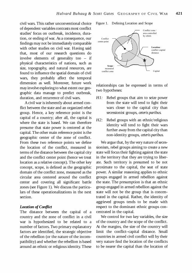
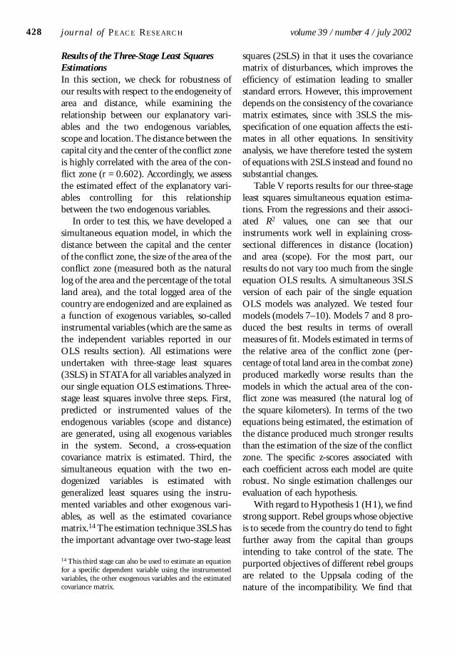
A civil war is inherently about armed con-flict between the state and an organized rebelgroup. Hence, a key reference point is thecapital of a country; after all, the capital iswhere the state is based. We can thereforepresume that state power is centered at thecapital. The other main reference point is thegeographic center of the zone of conflict.From these two reference points we definethe location of the conflict, measured interms of the distance between the capital cityand the conflict center point (hence we treatlocation as a relative concept). The other keyconcept, scope, is defined as the geographicdomain of the conflict zone, measured as thecircular area centered around the conflictcenter and covering all significant battlezones (see Figure 1). We discuss the particu-lars of these operationalizations in the nextsection.
Location of ConflictThe distance between the capital of acountry and the zone of conflict in a civilwar is hypothesized to be related to anumber of factors. Two primary explanatoryfactors are identified, the strategic objectiveof the rebellion (or the nature of the incom-patibility) and whether the rebellion is basedaround an ethnic or religious identity. These
relationships can be expressed in terms oftwo hypotheses:
H1: Rebel groups that aim to seize powerfrom the state will tend to fight theirwars closer to the capital city thansecessionist groups, ceteris paribus.
H2: Rebel groups with an ethnic/religiousidentity will tend to fight their warsfurther away from the capital city thannon-identity groups, ceteris paribus.
We argue that, by the very nature of seces-sionism, rebel groups aiming to create a newstate will focus their fighting against the statein the territory that they are trying to liber-ate. Such territory is presumed to be notproximate to the capital, the seat of statepower. A similar reasoning applies to ethnicgroups engaged in armed rebellion againstthe state. The presumption is that an ethnicgroup engaged in armed rebellion against thestate will not be the group that is concen-trated in the capital. Rather, the identity ofaggrieved groups tends to be made withrespect to the dominant ethnic groups con-centrated in the capital.
We control for two key variables, the sizeof the country and the scope of the conflict.At the margins, the size of the country willlimit the conflict–capital distance. Smallcountries in armed civil conflict will by theirvery nature find the location of the conflictsto be nearer the capital than the location of
Halvard Buhaug & Scot t Gate s GE O G R A PH Y O F CI V I L WA R 421
Figure 1. Defining Location and Scope
Capital
Scope :
measured
conflict zone
Location :
conflictÐcapital
distance
Conflict zone /
area controlled
by rebels
Conflict
center point
03buhaug (ds) 20/6/02 8:36 am Page 421

conflicts in countries with large areas. Thescope is also hypothesized to be associatedwith the location from the capital. After all,the zone of conflict is a measurable area,which is related to the total size of thecountry and the distance between the capitaland the zone of conflict. This relationship,too, at the margins exhibits a certain deter-ministic quality. Though given the irregularshapes of countries and the influence of othergeographical features, the extent of mathe-matical determinism is minimal.6
Scope of ConflictThe scope of conflict is also hypothesized tobe associated with a number of factors.Several explanatory variables are featured, theduration of the conflict, whether the conflictzone abuts an international border, whethera resource is present, as well as the extent ofmountainous and forested terrain. Theserelationships can be expressed in the form ofthe following hypotheses:
H3: The scope of an armed conflict is posi-tively associated with the duration of aconflict, ceteris paribus.
H4: The scope of conflicts that abut aninternational border will be largerthan the scope of those that do not,ceteris paribus.
H5: The scope of conflicts with naturalresources present will be larger thanthe scope of those that are without,ceteris paribus.
H6: The scope of conflicts in mountainousterrain will be larger than the scope ofthose that are not, ceteris paribus.
H7: The scope of conflicts in forested
terrain will be larger than the scope ofthose that are not, ceteris paribus.
Duration is hypothesized to be related towar, given that time increases the possibilitiesfor a rebel army to increase its zone ofactivity. Also short-lived conflicts, such as acoup d’état, are concentrated in the capitalcity. Insurgency movements that endure yearafter year tend to encompass a broad terri-tory.
International borders are hypothesized tobe related to the size of a conflict zonebecause of the value of such borders to a rebelarmy. Rebels will push to gain access to aninternational border because neighboringcountries often provide a safe refuge awayfrom governmental troops, but also becauseweapons and natural resources are traded andtransported across these borders. Control ofinternational borders thus ensures that therebel army will fight another day.
Natural resources, whether point or dis-persed resources, provide revenue for a rebelarmy. A rebel army has an interest in expand-ing its zone of control to capture theseresources and thereby derive financial gainfrom them, regardless of whether secession-ism or state power is the ultimate politicalgoal.
Rough terrain is ideal for guerrilla warfareand difficult for a government army tocontrol. Mountain areas, giving advantage torebel troops, allow the rebels to expand thescope of conflict, whereas forests providecover, particularly against detection or aerialattack. This aids in the freedom of movementand shipment of arms, thereby associatedwith a wider zone of conflict.
We control for two variables to accountfor the scope of conflict, the total size of thecountry and the location of the conflictrelative to the capital. These relationshipsfollow the same pattern as in the locationmodel, except that with scope we areworking in two dimensions rather than in
j ournal o f PE AC E RE S E A RC H volume 39 / number 4 / july 2002422
6 If all countries were circles and if physical geographicalfactors were uniform, then there might be some utility inderiving such a mathematically deterministic relationship.But given the wide distribution of country shapes and geo-graphical features, this relationship can be modeled proba-bilistically.
03buhaug (ds) 20/6/02 8:36 am Page 422
one. At the limit, the relationships are math-ematically deterministic, but given the widevariety of shapes of countries, the relation-ship remains probabilistic and can be esti-mated statistically.
Description of Data
The unit of analysis in our study is armedcivil conflicts, as defined by thePRIO/Uppsala Armed Conflict dataset(Gleditsch et al., 2001). However, in thisdataset, quite a few intrastate conflicts aresubdivided into several separate conflictunits, either reflecting varying severity fromone year to the next (from ‘minor’ to ‘inter-mediate’ to ‘war’, or vice versa) or becauseviolence has temporarily decreased below thethreshold of conflict (i.e. less than 25 battle-deaths per year).7 As our analysis is mostly
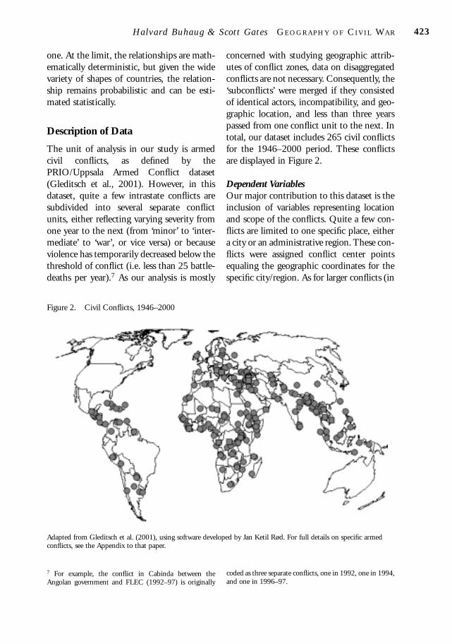
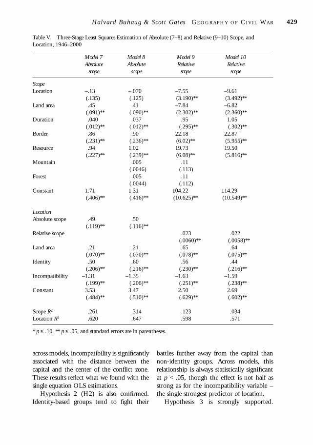
concerned with studying geographic attrib-utes of conflict zones, data on disaggregatedconflicts are not necessary. Consequently, the‘subconflicts’ were merged if they consistedof identical actors, incompatibility, and geo-graphic location, and less than three yearspassed from one conflict unit to the next. Intotal, our dataset includes 265 civil conflictsfor the 1946–2000 period. These conflictsare displayed in Figure 2.
Dependent VariablesOur major contribution to this dataset is theinclusion of variables representing locationand scope of the conflicts. Quite a few con-flicts are limited to one specific place, eithera city or an administrative region. These con-flicts were assigned conflict center pointsequaling the geographic coordinates for thespecific city/region. As for larger conflicts (in
Halvard Buhaug & Scot t Gate s GE O G R A PH Y O F CI V I L WA R 423
Figure 2. Civil Conflicts, 1946–2000
Adapted from Gleditsch et al. (2001), using software developed by Jan Ketil Rød. For full details on specific armedconflicts, see the Appendix to that paper.
7 For example, the conflict in Cabinda between theAngolan government and FLEC (1992–97) is originally
coded as three separate conflicts, one in 1992, one in 1994,and one in 1996–97.
03buhaug (ds) 20/6/02 8:36 am Page 423
geographical terms), we first identified themajor battle zones – i.e. places where thefighting resulted in loss of lives – and areascontrolled by rebel groups.8 The conflictcenter was then defined as the mid-point ofthese locations. Determining the center ofeach conflict is not trivial, since differentsources frequently diverge on the exactwhereabouts (and severity) of the battles.Moreover, as a number of conflicts arelocated along dispersed border zones, someconflict centers actually refer to areas quiteunaffected by the fighting. Future work onthe conflict data will be dedicated to reduc-ing this problem, most likely by utilizingGIS.
Our first dependent variable – the opera-tionalization of location – is measured as thedistance from the conflict center to thecapital city. The values on this variable werecalculated using a geodetic distance calcula-tor, estimating the conflict–capital distanceswith accuracy far superior to our require-ments.9 The conflict–capital distances varybetween 0 km (the capital is the center ofconflict) and 3,360 km (from West Papua toJakarta). The location variable was log-transformed prior to use.
Additionally we constructed two proxiesof scope, the absolute area of the conflictzone (log-transformed) and the conflict areaas a proportion of total land area. For sim-plicity, we defined the conflict zones as beingcircular and centered around the conflictcenter point; the radius of the conflict zoneequals the distance from the center to themost distant battle zone, rounded upwards tothe nearest 50-km interval to ensure that all
significant battle zones were covered. Con-flicts that took place within a single city wereassigned a 50-km radius.10 All estimationsreported below were run with logged andunlogged variables. The models estimatedwith logged variables produced muchstronger results.
Explanatory and Instrumental VariablesTo control for identity-based conflicts, weconstructed a dummy identity variable, giventhe value 1 if the rebels originate fromdifferent ethnic and/or religious groups thanthe government. The main sources for thisvariable were the ‘wartype’ variable of Sambanis (2000)11 and various volumes ofKeesing’s Record of World Events. According toour data, 59% of the conflicts are related toidentity.
Our second explanatory variable is thePRIO/Uppsala dataset’s dichotomous incom-patibility variable, indicating whether terri-tory (secession) or governance (control overthe state) is the incompatibility between thegovernment and the rebels. Some 40% of ourconflicts concern territory. This variable isclosely related to the identity indicator (r = .6),as conflicts over territory almost by definitionare related to identity. However, 35% of theconflicts over state power were also foughtbetween different ethnic/religious groups.
In this dataset, all conflicts have beenascribed a start- and end-year. As we expectconflicts in remote areas – typically provid-ing rebel hideouts in forests, mountains, orbehind international boundaries – to endurelonger than conflicts of a more urban nature,we constructed a variable on conflict dura-tion (end-year minus start-year).
j ournal o f PE AC E RE S E A RC H volume 39 / number 4 / july 2002424
8 Data on the location of battle zones were drawn from thePRIO/Uppsala Armed Conflict Project’s archive at theDepartment of Peace and Conflict Research, Uppsala Uni-versity, and various volumes of Keesing’s Record of WorldEvents.9 This program will be made available on the website of theDepartment of Geomatics at NTNU: http: //www.geomatikk.ntnu.no/prosjektarbeid/geo-hoved98/Applet/b-program.htm.
10 A negative consequence of the assumed circular shape ofthe conflict zones is that the measured scope inevitablycovers some areas not affected by the conflict, thus overes-timating the total area of the civil war. Future work onimproving the geographic data will reduce this problem.11 Sambanis’s (2000) ‘wartype’ variable is again made upfrom several sources, most notably Licklider (1995) and theState Failure Project (Esty et al., 1998).
03buhaug (ds) 20/6/02 8:36 am Page 424

In order to control for rebels hidingbeyond national borders or conflicts that forother reasons frequently involved neighborterritory, we constructed a dummy indicatoron whether or not the conflict zone abuts aborder with another country. Roughly one-half (51%) of the conflicts in our sampleextend to (or across) the national border ofthe conflict-ridden country.
Previous conflict studies seem to confirmthat primary commodities serve as a majorsource of rebel finance (Collier & Hoeffler,2001). Thus we include a dichotomousresource variable, simply indicating whetheror not the conflict zone contains essentialnatural resources such as fossil minerals,metals, or diamonds. This variable was constructed by comparing the scope of theinternal conflicts with maps on resourcedistribution from Kunnskapsforlagets StoreVerdensatlas (1997), Oxford Economic Atlas ofthe World (1972), as well as descriptive datafrom the CIA (2001).
Data on country area (log-transformedprior to use) and forests were drawn fromWorld Bank (2000). The forest variable givesthe proportion of land area covered by forest,varying between 0 and 96%. We also includea measure of mountainous terrain, identicalto Collier & Hoeffler (2001); the values vary
between 0 and 94%.12 Although thesemeasures describe the type of terrain for eachcountry, they do not indicate the extent ofmountains and forests specifically for eachconflict zone. An important improvementwill be to construct these variables fromgridded data on topography through the aidof GIS tools, thus facilitating a comparisonbetween the terrain in the conflict zone andthe terrain in the rest of the country.
Table I summarizes the descriptive statis-tics for each of these variables. Table II is thecorrelation matrix for these variables.
Method of Analysis and Results
OLS Single Equation ModelsIn order to test our three hypotheses regard-ing conflict location, we first specify twomodels to fit the OLS regression of the con-flict–capital distance. As Table III demon-strates, both models yield very similar results,and their explanatory powers are very high.Both conflict area (model 1) and conflict areaas a proportion of land area (model 2) areimportant determinants of the conflictlocation. Accordingly, the more distant the
Halvard Buhaug & Scot t Gate s GE O G R A PH Y O F CI V I L WA R 425
Table I. Descriptive Statistics
Observations Mean Std. dev. Minimum Maximum
Location 258 5.23 1.82 1.6 8.1Absolute scope 258 4.60 1.65 2.3 9.2Relative scope 246 44.41 38.03 0 100Land area 251 6.04 1.64 0.7 9.7Identity 262 0.59 0.49 0 1Incompatibility 265 1.59 0.49 1 2Duration 265 5.45 7.93 1 53Border 258 0.51 0.50 0 1Resource 262 0.21 0.41 0 1Mountain 256 23.19 21.78 0 81Forest 247 30.23 21.56 0 96
12 See Gerrard (2000) for a theoretical discussion of defi-nition and operationalization of the mountainous terrainvariable.
03buhaug (ds) 20/6/02 8:36 am Page 425

conflict centers, the larger the battle-zones –in both relative and absolute terms. Not sur-prisingly, the conflict location is also posi-tively associated with the size of the country.As noted above, all models were estimatedwith logged and unlogged distance and areavariables. Not only did the logged variablesproduce higher levels of statistical signifi-cance, they also performed better with regardto the diagnostic analyses (omitted variabletests, Cooks’ distance, lvr2plots and avplots)that accompanied the OLS estimations (butare not reported here).
According to Hypothesis 1, secessionistconflicts should generally be located furtheraway from the capital city than conflicts overstate power. The findings confirm our pre-diction – the incompatibility variable isstatistically very significant in both models.Supporting our second hypothesis, we seethat identity is positive and significantregardless of model, although the effect is lessimpressive than that of the incompatibilityvariable. This will be more thoroughly dis-cussed in the final section.
Table IV reveals the results from the
second part of the OLS regression section,addressing the hypotheses regarding thescope of conflict. As we have two endogen-ous variables of scope – measuring absoluteand relative conflict area respectively –models 3 and 4 generate estimations ofabsolute scope of conflict, while models 5and 6 consist of the relative scope of conflict.At first glance, we see that most of theexogenous variables generate very robustresults, being significant in all four equa-tions. Moreover, the R2 are quite high(though not in the league of models 1 and 2).
Hypothesis 3 states that the duration ofarmed conflict is positively associated withthe scope of conflict. This is supported in allfour models; the estimate is statisticallysignificant although the coefficient is quitesmall. We are thus led to the rather intuitiveconclusion that longer-lasting conflictsgenerally involve a larger geographic area.In line with Hypothesis 4 (another seem-ingly obvious relationship), internal conflicts that abut – or cross – internationalboundaries are also associated with higher-than-average conflict zones. The impact is
j ournal o f PE AC E RE S E A RC H volume 39 / number 4 / july 2002426
Table II. Correlation Matrix
Absolute scope .60Relative scope .008 .48Land area .54 .44 –.46Identity .54 .27 –.06 .28Incompatibility –.55 –.09 .31 –.31 –.60Duration .15 .25 .20 .04 .19 –.18Border .35 .33 .17 .12 .32 –.30 .27Resource .11 .27 .10 .14 .05 .16 –.06 –.03Mountain –.006 –.01 .02 –.04 .08 –.10 .07 .06 –.32Forest .09 .10 –.002 .10 –.13 .06 .02 –.12 .12 –.12
Loca
tion
Abs
olut
e sc
ope
Rel
ativ
e sc
ope
Land
are
a
Iden
tity
Inco
mpa
tibi
lity
Dur
atio
n
Bor
der
Res
ourc
e
Mou
ntai
n
03buhaug (ds) 20/6/02 8:36 am Page 426
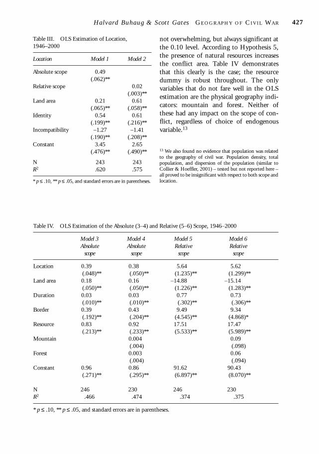
not overwhelming, but always significant atthe 0.10 level. According to Hypothesis 5,the presence of natural resources increasesthe conflict area. Table IV demonstratesthat this clearly is the case; the resourcedummy is robust throughout. The onlyvariables that do not fare well in the OLSestimation are the physical geography indi-cators: mountain and forest. Neither ofthese had any impact on the scope of con-flict, regardless of choice of endogenousvariable.13
Halvard Buhaug & Scot t Gate s GE O G R A PH Y O F CI V I L WA R 427
Table III. OLS Estimation of Location,1946–2000
Location Model 1 Model 2
Absolute scope 0.49(.062)**
Relative scope 0.02(.003)**
Land area 0.21 0.61(.065)** (.058)**
Identity 0.54 0.61(.199)** (.216)**
Incompatibility –1.27 –1.41(.190)** (.208)**
Constant 3.45 2.65(.476)** (.490)**
N 243 243R2 .620 .575
* p ≤ .10, ** p ≤ .05, and standard errors are in parentheses.
Table IV. OLS Estimation of the Absolute (3–4) and Relative (5–6) Scope, 1946–2000
Model 3 Model 4 Model 5 Model 6Absolute Absolute Relative Relative
scope scope scope scope
Location 0.39 0.38 5.64 5.62(.048)** (.050)** (1.235)** (1.299)**
Land area 0.18 0.16 –14.88 –15.14(.050)** (.050)** (1.226)** (1.283)**
Duration 0.03 0.03 0.77 0.73(.010)** (.010)** (.302)** (.306)**
Border 0.39 0.43 9.49 9.34(.192)** (.204)** (4.545)** (4.868)*
Resource 0.83 0.92 17.51 17.47(.213)** (.233)** (5.533)** (5.989)**
Mountain 0.004 0.09(.004) (.098)
Forest 0.003 0.06(.004) (.094)
Constant 0.96 0.86 91.62 90.43(.271)** (.295)** (6.897)** (8.070)**
N 246 230 246 230R2 .466 .474 .374 .375
* p ≤ .10, ** p ≤ .05, and standard errors are in parentheses.
13 We also found no evidence that population was relatedto the geography of civil war. Population density, totalpopulation, and dispersion of the population (similar toCollier & Hoeffler, 2001) – tested but not reported here –all proved to be insignificant with respect to both scope andlocation.
03buhaug (ds) 20/6/02 8:36 am Page 427
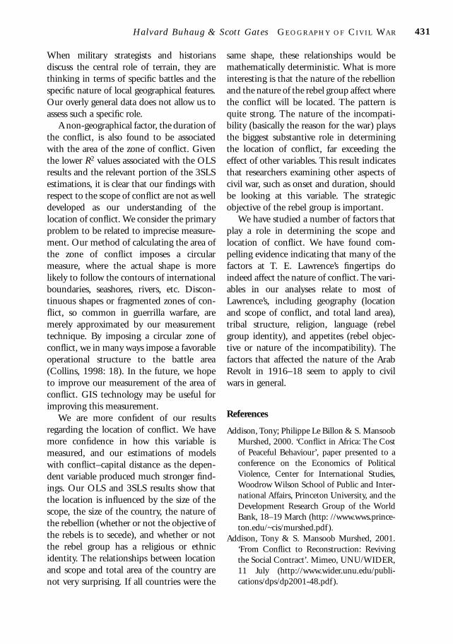
Results of the Three-Stage Least SquaresEstimationsIn this section, we check for robustness ofour results with respect to the endogeneity ofarea and distance, while examining therelationship between our explanatory vari-ables and the two endogenous variables,scope and location. The distance between thecapital city and the center of the conflict zoneis highly correlated with the area of the con-flict zone (r = 0.602). Accordingly, we assessthe estimated effect of the explanatory vari-ables controlling for this relationshipbetween the two endogenous variables.
In order to test this, we have developed asimultaneous equation model, in which thedistance between the capital and the centerof the conflict zone, the size of the area of theconflict zone (measured both as the naturallog of the area and the percentage of the totalland area), and the total logged area of thecountry are endogenized and are explained asa function of exogenous variables, so-calledinstrumental variables (which are the same asthe independent variables reported in ourOLS results section). All estimations wereundertaken with three-stage least squares(3SLS) in STATA for all variables analyzed inour single equation OLS estimations. Three-stage least squares involve three steps. First,predicted or instrumented values of theendogenous variables (scope and distance)are generated, using all exogenous variablesin the system. Second, a cross-equationcovariance matrix is estimated. Third, thesimultaneous equation with the two en-dogenized variables is estimated withgeneralized least squares using the instru-mented variables and other exogenous vari-ables, as well as the estimated covariancematrix.14 The estimation technique 3SLS hasthe important advantage over two-stage least
squares (2SLS) in that it uses the covariancematrix of disturbances, which improves the efficiency of estimation leading to smallerstandard errors. However, this improvementdepends on the consistency of the covariancematrix estimates, since with 3SLS the mis-specification of one equation affects the esti-mates in all other equations. In sensitivityanalysis, we have therefore tested the systemof equations with 2SLS instead and found nosubstantial changes.
Table V reports results for our three-stageleast squares simultaneous equation estima-tions. From the regressions and their associ-ated R2 values, one can see that ourinstruments work well in explaining cross-sectional differences in distance (location)and area (scope). For the most part, ourresults do not vary too much from the singleequation OLS results. A simultaneous 3SLSversion of each pair of the single equationOLS models was analyzed. We tested fourmodels (models 7–10). Models 7 and 8 pro-duced the best results in terms of overallmeasures of fit. Models estimated in terms ofthe relative area of the conflict zone (per-centage of total land area in the combat zone)produced markedly worse results than themodels in which the actual area of the con-flict zone was measured (the natural log ofthe square kilometers). In terms of the twoequations being estimated, the estimation ofthe distance produced much stronger resultsthan the estimation of the size of the conflictzone. The specific z-scores associated witheach coefficient across each model are quiterobust. No single estimation challenges ourevaluation of each hypothesis.
With regard to Hypothesis 1 (H1), we findstrong support. Rebel groups whose objectiveis to secede from the country do tend to fightfurther away from the capital than groupsintending to take control of the state. Thepurported objectives of different rebel groupsare related to the Uppsala coding of thenature of the incompatibility. We find that
j ournal o f PE AC E RE S E A RC H volume 39 / number 4 / july 2002428
14 This third stage can also be used to estimate an equationfor a specific dependent variable using the instrumentedvariables, the other exogenous variables and the estimatedcovariance matrix.
03buhaug (ds) 20/6/02 8:36 am Page 428
across models, incompatibility is significantlyassociated with the distance between thecapital and the center of the conflict zone.These results reflect what we found with thesingle equation OLS estimations.
Hypothesis 2 (H2) is also confirmed.Identity-based groups tend to fight their
battles further away from the capital thannon-identity groups. Across models, thisrelationship is always statistically significantat p < .05, though the effect is not half asstrong as for the incompatibility variable –the single strongest predictor of location.
Hypothesis 3 is strongly supported.
Halvard Buhaug & Scot t Gate s GE O G R A PH Y O F CI V I L WA R 429
Table V. Three-Stage Least Squares Estimation of Absolute (7–8) and Relative (9–10) Scope, andLocation, 1946–2000
Model 7 Model 8 Model 9 Model 10Absolute Absolute Relative Relative
scope scope scope scope
Scope Location –.13 –.070 –7.55 –9.61
(.135) (.125) (3.190)** (3.492)**Land area .45 .41 –7.84 –6.82
(.091)** (.090)** (2.302)** (2.360)**Duration .040 .037 .95 1.05
(.012)** (.012)** (.295)** (.302)**Border .86 .90 22.18 22.87
(.231)** (.236)** (6.02)** (5.955)**Resource .94 1.02 19.73 19.50
(.227)** (.239)** (6.08)** (5.816)**Mountain .005 .11
(.0046) (.113)Forest .005 .11
(.0044) (.112)Constant 1.71 1.31 104.22 114.29
(.406)** (.416)** (10.625)** (10.549)**
LocationAbsolute scope .49 .50
(.119)** (.116)**Relative scope .023 .022
(.0060)** (.0058)**Land area .21 .21 .65 .64
(.070)** (.070)** (.078)** (.075)**Identity .50 .60 .56 .44
(.206)** (.216)** (.230)** (.216)**Incompatibility –1.31 –1.35 –1.63 –1.59
(.199)** (.206)** (.251)** (.238)**Constant 3.53 3.47 2.50 2.69
(.484)** (.510)** (.629)** (.602)**
Scope R2 .261 .314 .123 .034Location R2 .620 .647 .598 .571
* p ≤ .10, ** p ≤ .05, and standard errors are in parentheses.
03buhaug (ds) 20/6/02 8:36 am Page 429

Duration and the size of the conflict zone arepositively and statistically significantlyassociated across models and measurementsof the size of the conflict zone. We can con-clude that longer-lasting conflicts in generalencompass larger areas.
With regard to Hypothesis 4, conflictzones that abut an international border willtend to be larger than conflict zones that donot. This finding is extremely robust.Hypothesis 5 is also strongly supported. Thepresence of natural resources in the conflictzone is positively and strongly statisticallysignificantly related to the size of the conflictzone across all the models. Hypotheses 6 and7 are not supported in any of the models.
As for the endogenous effects, we findthat when the scope of the conflict ismeasured as the natural log of the area, dis-tance is statistically significantly related toabsolute scope, but absolute scope is notrelated to distance. When the models areestimated measuring the conflict area as aproportion of the total area of the country(relative scope), the relationship is com-pletely endogenized with both variablesassociated with one another in the simul-taneous estimation. The total land area ofthe country is also treated endogenouslyand is entered in both equations. It isrobustly statistically significant. Asexpected, the relationship between thescope of the conflict area and the size of thetotal area of the country changes with theway in which the battle-zone is measured. Ifmeasured in absolute terms, the relationshipis positive. The relationship follows fromthe expectation that larger countries simplyhave more room within which to fight. Therelationship is negative when the size of thebattle-zone is measured relatively. Asexpected, smaller countries tend to have ahigher percentage of land involved in con-flict. Despite finding support for theseendogenized relationships, our conclusionsregarding the hypotheses do not change
with respect to the results of the single equation OLS estimations and the 3SLSestimations.
Conclusion
To our knowledge, this is the first systematicinquiry into the scope and location of civilconflict. Drawing on the PRIO/UppsalaArmed Conflict dataset for the 1946–2000period (Gleditsch et al., 2001), we havedetermined the location of all battle-zonesfor all conflicts in this time period, therebyidentifying the geographic extent and thecenter point of each conflict. With this data,we are able to analyze the factors that deter-mine the scope and location of civil conflict.Using ordinary least squares (OLS) andthree-stage least squares (3SLS) estimationtechniques, we have analyzed the factors thatdetermine the scope (measured in terms oflogged square kilometers, and as the propor-tion of a country that is covered by the scope)and the location of the conflict relative to thecapital (measured in terms of logged kilome-ters). Given the interdependence betweenlocation and scope, we modeled theserelationships as simultaneous equations,which were estimated with 3SLS.
Geographical factors are indeed import-ant. From our analysis, we found that thescope of conflict is associated with such geo-graphical factors as the total land area of thecountry, whether or not the conflict zone isadjacent to the border of a neighboringcountry, and whether there are naturalresources in the conflict zone. Interestingly,two geographical factors considered to becritical to combat, mountains and forestcover, were found not to be statistically associ-ated with the scope of conflict. This is mostlikely due to poor data. Our data on moun-tains and forests pertain to the country as awhole. We do not have precise enough infor-mation to inform us as to what extent thezone of conflict is forested or mountainous.
j ournal o f PE AC E RE S E A RC H volume 39 / number 4 / july 2002430
03buhaug (ds) 20/6/02 8:36 am Page 430
When military strategists and historiansdiscuss the central role of terrain, they arethinking in terms of specific battles and thespecific nature of local geographical features.Our overly general data does not allow us toassess such a specific role.
A non-geographical factor, the duration ofthe conflict, is also found to be associatedwith the area of the zone of conflict. Giventhe lower R2 values associated with the OLSresults and the relevant portion of the 3SLSestimations, it is clear that our findings withrespect to the scope of conflict are not as welldeveloped as our understanding of thelocation of conflict. We consider the primaryproblem to be related to imprecise measure-ment. Our method of calculating the area ofthe zone of conflict imposes a circularmeasure, where the actual shape is morelikely to follow the contours of internationalboundaries, seashores, rivers, etc. Discon-tinuous shapes or fragmented zones of con-flict, so common in guerrilla warfare, aremerely approximated by our measurementtechnique. By imposing a circular zone ofconflict, we in many ways impose a favorableoperational structure to the battle area(Collins, 1998: 18). In the future, we hopeto improve our measurement of the area ofconflict. GIS technology may be useful forimproving this measurement.
We are more confident of our resultsregarding the location of conflict. We havemore confidence in how this variable ismeasured, and our estimations of modelswith conflict–capital distance as the depen-dent variable produced much stronger find-ings. Our OLS and 3SLS results show thatthe location is influenced by the size of thescope, the size of the country, the nature ofthe rebellion (whether or not the objective ofthe rebels is to secede), and whether or notthe rebel group has a religious or ethnicidentity. The relationships between locationand scope and total area of the country arenot very surprising. If all countries were the
same shape, these relationships would bemathematically deterministic. What is moreinteresting is that the nature of the rebellionand the nature of the rebel group affect wherethe conflict will be located. The pattern isquite strong. The nature of the incompati-bility (basically the reason for the war) playsthe biggest substantive role in determiningthe location of conflict, far exceeding theeffect of other variables. This result indicatesthat researchers examining other aspects ofcivil war, such as onset and duration, shouldbe looking at this variable. The strategicobjective of the rebel group is important.
We have studied a number of factors thatplay a role in determining the scope andlocation of conflict. We have found com-pelling evidence indicating that many of thefactors at T. E. Lawrence’s fingertips doindeed affect the nature of conflict. The vari-ables in our analyses relate to most ofLawrence’s, including geography (locationand scope of conflict, and total land area),tribal structure, religion, language (rebelgroup identity), and appetites (rebel objec-tive or nature of the incompatibility). Thefactors that affected the nature of the ArabRevolt in 1916–18 seem to apply to civilwars in general.
References
Addison, Tony; Philippe Le Billon & S. MansoobMurshed, 2000. ‘Conflict in Africa: The Costof Peaceful Behaviour’, paper presented to aconference on the Economics of PoliticalViolence, Center for International Studies,Woodrow Wilson School of Public and Inter-national Affairs, Princeton University, and theDevelopment Research Group of the WorldBank, 18–19 March (http: //www.wws.prince-ton.edu/~cis/murshed.pdf ).
Addison, Tony & S. Mansoob Murshed, 2001.‘From Conflict to Reconstruction: Revivingthe Social Contract’. Mimeo, UNU/WIDER,11 July (http://www.wider.unu.edu/publi-cations/dps/dp2001-48.pdf ).
Halvard Buhaug & Scot t Gate s GE O G R A PH Y O F CI V I L WA R 431
03buhaug (ds) 20/6/02 8:36 am Page 431
Auty, Richard M., 1998. ‘Resource Abundanceand Economic Development: Improving thePerformance of Resource-Rich Countries’,Research for Action 44, UNU/WIDER,Helsinki (http://www.wider.unu.edu/publi-cations/rfa44.pdf ).
Auty, Richard M., 2001. Resource Abundance andEconomic Development. Oxford: Oxford Uni-versity Press.
Boulding, Kenneth, 1962. Conflict and Defense.New York: Harper & Row.
Bremer, Stuart A., 1992. ‘Dangerous Dyads:Conditions Affecting the Likelihood of Inter-state War, 1816–1965’, Journal of Conflict Res-olution 36(2): 309–341.
CIA, 2001. The World Factbook 2001(http://www.cia.gov/cia/publications/fact-book/index.html).
Collier, Paul & Anke Hoeffler, 2001. ‘Greed andGrievance in Civil War’, manuscript, WorldBank (http://www.worldbank.org/research/conflict/papers/greedandgrievance.htm).
Collins, John M., 1998. Military Geography forProfessionals and the Public. Washington, DC:Brassey’s.
de Soysa, Indra, 2000. ‘The Resource Curse: AreWars Driven by Rapacity or Paucity?’, in MatsBerdal & David Malone, Greed and Grievance:Economic Agendas in Civil Wars. Boulder, CO:Lynne Rienner (113–135).
Diehl, Paul F., 1991. ‘Geography and War: AReview and Assessment of the Empirical Litera-ture’, International Interactions 17(1): 11–27.
Elbadawi, Ibrahim & Nicholas Sambanis, 2002.‘How Much War Will We See? Estimating thePrevalence of Civil War in 161 Countries,1960–1999’, Journal of Conflict Resolution,forthcoming.
Ellingsen, Tanja, 2000. ‘Colorful Community orEthnic Witches’ Brew? Multiethnicity andDomestic Conflict During and After the ColdWar’, Journal of Conflict Resolution 44(2):228–249.
Esty, Daniel C. et al., 1998. ‘The State FailureProject: Early Warning Research for USForeign Policy Planning’, in John L. Davies &Ted Robert Gurr, eds, Preventive Measures:Building Risk Assessment and Crisis EarlyWarning Systems. Boulder, CO: Rowman &Littlefield (27–38).
Fearon, James D. & Davis D. Laitin, 1999. ‘WeakStates, Rough Terrain, and Large-Scale EthnicViolence Since 1945’, paper presented at the95th Annual Meeting of the AmericanPolitical Science Association, Atlanta, GA,2–5 September.
Gates, Scott, 2001. ‘Empirically Assessing theCauses of Civil War’. Mimeo, InternationalPeace Research Institute, Oslo, 9 December.
Gates, Scott, 2002. ‘Recruitment and Allegiance:The Microfoundations of Rebellion’, Journalof Conflict Resolution 46(1): 111–130.
Gerrard, John, 2000. ‘What is a Mountain?’Mimeo, Development Economics ResearchGroup, World Bank.
Gleditsch, Nils Petter, 1995. ‘Geography,Democracy, and Peace’, International Inter-actions 20(4): 297–323.
Gleditsch, Nils Petter; Peter Wallensteen, MikaelEriksson, Margareta Sollenberg & HåvardStrand, 2001. ‘Armed Conflict 1946–2000: ANew Dataset’, paper presented at the Euro-conference on conflict data, Uppsala, 8–9 June(http://www.pcr.uu.se/pdf/nilspetterpapper.pdf ).
Hegre, Håvard; Tanja Ellingsen, Scott Gates &Nils Petter Gleditsch, 2001. ‘Toward a Demo-cratic Civil Peace? Democracy, PoliticalChange, and Civil War, 1816–1992’, Ameri-can Political Science Review 95(1): 33–48.
Keegan, John, 1993. A History of Warfare. NewYork: Knopf.
Keesing’s Record of World Events 1960–1994,1996. London: Cartermill (http://www.keesings.com).
Kliot, Nurit & Stanley Waterman, eds, 1991. ThePolitical Geography of Conflict and Peace.London: Belhaven.
Kunnskapsforlagets Store Verdensatlas, 1997. Oslo:Kunnskapsforlaget.
Le Billon, Philippe, 2001. ‘The Political Ecologyof War: Natural Resources and Armed Con-flicts’, Political Geography 20(5): 561–584.
Lemke, Douglas, 1995. ‘The Tyranny of Dis-tance: Redefining Relevant Dyads’, Inter-national Interactions 21(1): 23–38.
Licklider, Roy, 1995. ‘The Consequences ofNegotiated Settlements in Civil Wars,1945–1993’, American Political Science Review89(3): 681–690.
j ournal o f PE AC E RE S E A RC H volume 39 / number 4 / july 2002432
03buhaug (ds) 20/6/02 8:36 am Page 432
Machiavelli, Niccolò, 1517/1988. The Prince,edited by Quentin Skinner & Russell Price.Cambridge: Cambridge University Press.
Mackinder, Halford J., 1904. ‘The GeographicalPivot of History’, Geographic Journal 23(April): 421–437.
Murray, Williamson, 1999. ‘Some Thoughts onWar and Geography’, Journal of StrategicStudies 22(2–3): 201–217.
Oxford Economic Atlas of the World, 1972.London: Oxford University Press.
Pepper, David & Alan Jenkins, eds, 1985. TheGeography of Peace and War. Oxford: Black-well.
Ratzel, Friedrich, 1896. ‘The Territorial Growthof States’, Scottish Geographical Magazine 12:351–361.
Reynal-Querol, Marta, 2002. ‘Ethnicity, PoliticalSystems and Civil Wars’, Journal of ConflictResolution 46(1): 29–54.
Richardson, Lewis, 1960. Statistics of DeadlyQuarrels. Pittsburgh, PA: Boxwood.
Ross, Michael Lewin, 2001. ‘Does Oil HinderDemocracy?’, World Politics 53(3): 325–361.
Sambanis, Nicholas, 2000. ‘Partition as a Solutionto Ethnic War’, World Politics 52(4): 437–483.
Sambanis, Nicholas, 2002. ‘A Review of RecentAdvances and Future Directions in the Quan-titative Literature on Civil War’, Defence andPeace Economics, forthcoming.
Sprout, Harold & Margaret Sprout, 1965. TheEcological Perspective on Human Affairs.Princeton, NJ: Princeton University Press.
Starr, Harvey, 2001. ‘The Power of Place and theFuture of Spatial Analysis in the Study of Con-flict’, Presidential Address at the 35th NorthAmerican meeting of the Peace Science Society(International), Atlanta, GA, 26–28 October.
Vasquez, John A., 1995. ‘Why Do NeighborsFight: Proximity, Interaction, or Territoriality’,Journal of Peace Research 32(3): 277–293.
World Bank, 2000. World Development Indicators2000. Washington, DC: World Bank.
HALVARD BUHAUG, b. 1972, Cand. Polit.(NTNU, 2001); PhD candidate in PoliticalScience, NTNU (2002– ). Current maininterest: geography and armed conflict.
SCOTT GATES, b. 1957, PhD in PoliticalScience (University of Michigan, 1989);Associate Professor, Michigan State Uni-versity; Research Professor and ProgrammeLeader, PRIO. Recent articles on civil warhave appeared in Journal of Conflict Resolutionand American Political Science Review.
Halvard Buhaug & Scot t Gate s GE O G R A PH Y O F CI V I L WA R 433
03buhaug (ds) 20/6/02 8:36 am Page 433