Embed Size (px)
Citation preview
The Genesis of Certain Calcareous Floodplain Soils of Virginia1
H. L. MATHEWS, G. W. PRESCOTT, AND S. S. OBENSHAINS
ABSTRACTA study was made to determine the origin of the calcareous
material found in certain floodplain soils of the limestone val-leys of Virginia. The CaCO3 in these soils was derived fromthe highly fractured and faulted limestone underlying the area.Groundwater, high in dissolved CO2, percolated through thecrushed limestone, dissolving an appreciable amount of Ca andMg carbonate. This water issued at the surface in the formof large springs and lost some of the dissolved CO2 whichresulted in a saturated solution with respect to calcium. TheCaCOa deposi t ing alga Oocardium stratum Nag was foundbelow the point of saturation in the streams and was thoughtto be of major importance in the deposition of CaCO3. In a200-foot section of stream channel beginning 450 feet belowa spring having a rate of flow of 104 gallons/min, approxi-mately 2.85 tons of CaCOa were deposited annually as tufa.Algal-deposited tufa is torn from stream channels during heavyrains and redeposited downstream by flood waters. Calcareousmaterial occurs several miles from the source area and is a con-stituent of the flood plain soils along the creeks and rivers ofthe area.
THE PRESENCE of free carbonates in surface horizonsof floodplain soils in a temperate region of high annual
rainfall is uncommon. Some of the alluvial soils occurringin the limestone valleys of Virginia contain a high contentof calcareous material throughout their profiles.
This study was undertaken to determine how certaincalcareous soils develop in a humid climate. Local soilscientists had varying opinions about the origin of thecalcareous material. Some thought it was derived from ero-sion of shallow upland soils with calcareous parent mate-rials. Others thought the carbonates were derived fromcalcareous shales by solution and redeposition. A study ofthe geology of the area revealed that it occurred along afault zone in which the limestones and shales had beencrushed. This fractured limestone exposed to groundwatera surface area much greater than that of massive limestone.Water rich in CO2 percolating through this material dis-solved considerable amounts of calcium and magnesiumcarbonates.
REVIEW OF LITERATUREThe geologic importance of algae has been recognized by a
number of authors (11, 12, 13). An extensive bibliography iscontained in Johnson's (12) paper. He states that algae assist inthe building of calcareous rocks in marine, brackish, and freshwaters and are adapted to waters having a wide range of tem-perature and depth. Bradley (4) describes algal reefs of consid-
1 Contribution of the Agronomy Department, Virginia Polytech-nic Institute, Blacksburg, Va. This material is taken from a thesissubmitted as partial fulfillment of the M.S. degree. Presented be-fore Div. S-5, Soil .Science Society of America, Ithaca, N. Y.,Aug. 21, 1962. Received Aug. 20, 1964. Approved July 7, 1965.
2 Instructor, Department of Agronomy, Virginia PolytechnicInst.; Professor of Botany and Plant Pathology, Michigan StateUniv.; and Professor of Agronomy, Virginia Polytechnic Inst.,respectively.
erable extent and thickness. Such limestone reefs have been foundin nearly every geologic age from the Proterozoic to the present.Calcareous algae are of very ancient origin, their remains fur-nishing some of the oldest fossils known (12).
Precipitation of CaCOa is generally assumed to result from theutilization of CO2 in the photosynthetic process. Johnson and Wil-liamson (14) point out that for limestone precipitated by algaeto persist, the water surrounding them must be saturated withrespect to CaCOs.
There are several reasons why natural waters may increase intheir content of CO2. Falling rain absorbs CO2 in excess of normalatmospheric concentrations and may attain concentration of 21,000ppm. The atmosphere normally contains approximately 300 ppmof CO2 (6). Water in the vadose zone may attain a high COacontent as a result of soil bacterial action (17). Soil air frequentlyhas a CO« pressure of more than 100 times that of theatmosphere (4).
The things which tend to deplete the CO2 content of naturalwaters are photosynthetic action, agitation of the water, and in-creasing temperatures (5) . Tilden (19) indicates that the role ofphotosynthesis is important in the precipitation of CaCOs. Shefound that a precipitation is formed only where plants occur andnot indiscriminately upon every object exposed to the action ofwater. Many authors (11, 12, 13) have reported the precipitationof CaCOs (marl) and the formation of a calcareous encrustationby certain fresh water algae. Fritsch (10) states that, "Althoughmany kinds of plants living in hard waters can become encrustedwith thin layers of carbonate lime, it is among the algae that thespecific faculty of precipitating large quantities is realized".
GEOLOGY AND SOILS OF THE AREAFloodplain soils are composed of different parent materials,
the origin of which is determined by the geologic history of thedrainage system from which they are derived. The geologic for-mations associated with the calcareous noodplain soils of Mont-gomery County, Virginia, have undergone considerable changesince the limestones and shales were deposited. For example, theElbrook formation of Montgomery County and Roanoke Countyas described by Edwards is extremely fractured and crushed as aresult of the numerous faults in the area (Jonathan Edwards, I960.The geology of the upper Roanoke River Valley area of Mont-gomery and Roanoke Counties, Virginia. Unpublished M.S. thesis,V.P.I., Blacksburg, Va.). His description of the Elbrook forma-tion follows:
"Because of the brittle nature of the rocks and their occurrencebetween two thrusts, [the Max Meadows and Salem thrust sheets]the Elbrook formation has been highly fractured and sheared. Itis believed that the entire Elbrook formation is broken up bymany fracture zones and faults and that the determination of thedetailed structure would be extremely difficult."
Cooper and Haff (8) describe similar conditions along the MaxMeadows fault in the Draper Mountain area of Virginia. Theydescribe three types of breccia in association with the MaxMeadows fault. Near the Rome formation, the breccia is composedof sheared fragments of shale and phyllite. Near the Elbrook for-mation, it is composed of crushed and broken fragments of dolo-mite. Located between these two zones is a third zone which hasbeen described as a crush conglomerate. This is the thickest zoneof the fault breccia and is composed chiefly of rounded fragmentsof limestone, dolomite and phyllite, most of which are less than3 inches in diameter. These fragments are derived from the Romeand Elbrook formations and are embedded in a matrix of finelyground rock flour. Dike-like masses of the crush conglomerateare believed to have been squeezed into cracks in the rocks aboveand below the fault. This took place during deformation as aresult of the tremendous pressures involved (7) .
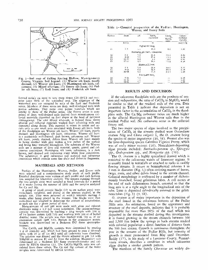
Soils associated with the sample area include Pedlar3, Frederick,and Lodi series of the uplands; Emory and Mixed alluvium of thecolluvial and alluvial lands; and Huntington and Weaver seriesof the flood plains (Fig. 1). Pedlar soils are shallow over faultbreccia, and rock fragments occur throughout their sola. They are
3 Recently recommended for correlation.
729
730 SOIL SCIENCE SOCIETY PROCEEDINGS 1965
Table 1—Chemical properties of the Pedlar , Huntington,Weaver, and Emory Soils
Depth pH
Fig. 1—Soil map of Falling Spring Hollow, MontgomeryCounty, Virginia. Soil Legend: (1) Weaver silt loam, poorlydrained; (2) Weaver silt loam; (3) Huntington silt loam, cal-careous; (4) Mixed alluvium; (5) Emory silt loam; (6) Ped-lar silt loam; (7) Lodi loam; and (8) Frederick silt loam.
formed mainly on steep to very steep slopes (20-60%) and com-prise some 90% of the watershed area. The ridgetops of thewatershed area are occupied by soils of the Lodi and Frederickseries. Members of these series are deep, well-developed soils withporous substrata. They occur over parent materials which aresimilar to those of the Pedlar series. The Emory series is com-prised of deep, well-drained soils derived from noncalcareous col-luvial materials deposited on foot slopes at the head of incipientdrainageways. The unit Mixed alluvium, is formed from recentalluvial and colluvial materials washed from adjoining soils anddeposited along drains. This material is minor in extent and oc-curs only as one small area associated with Emory silt loam. Soilsof the floodplains are Weaver silt loam; Weaver silt loam, poorlydrained; and Huntington silt loam, calcareous. Weaver silt loamis a moderately well-drained, dark brown, calcareous soil. Weaversilt loam, poorly drained, differs from Weaver silt loam mainlyin being mottled with gray within a few inches of the surfaceand being finer textured throughout. The substrata of the Weaversoils are a mixture of limy soil material, quartz, gravel and cal-careous concretions. Huntington silt loam, calcareous, is a darkbrown, well-drained soil containing many white lime concretions.The substratum is gray calcareous soil material and calcareousconcretions which contain some fine shale and dolomite fragments.
MATERIALS AND METHODS
Profiles of the Huntington, Weaver, Pedlar, and Emory soilswere selected and a comprehensive study made of each profile.Detailed descriptions were written of each profile and each horizonwas sampled for laboratory analysis. The streams running throughthe two sample areas were sampled at fixed intervals for a periodof 6 weeks during the summer of I960 and the samples analyzedfor Ca and Alg.
A group of small ceramic blocks (45 sq cm surface area) wereoven-dried, weighted, and placed in the streams studied, at thesample site. They were removed at weekly intervals starting 6weeks after being placed in the streams. The blocks were thenoven-dried and weighed to determine the amount of accumulationat each site for a given period of time.
Measurements of soil pH were made with glass and calomelelectrodes using a 1:2 soil water suspension. The cation-exchangecapacity was determined by leaching a 10-g sample with 100 ccof IN barium acetate (pH 7.0) and washing with 200 cc of boileddistilled water. The sample was then leached with 100 cc of INammonium acetate (pH 7.0). Barium in the ammonium acetateleachate was determined on a Beckman DU flame spectropho-tometer.
The CaCO3 and MgCOB contents were determined by treating1 g of oven-dry soil, which had been ground to pass a 60-meshsieve, with 25 cc of IN HC1 until all carbonates were dissolved.The solution was filtered and the filtrate adjusted to pH 5.6 withNHiOH to remove Fe and Al from the solution. Magnesium wasdetermined on a Beckman DU flame spectrophotometer and cal-cium by EDTA titration (1). The CaCO3/MgCO3 ratio was cal-culated from these values. The Ca and Mg content of the watersamples were determined by EDTA titration.
CaCOjequivalent '
MgCOjratio ,„_
Pedlar silt_loam_
Al
ApClC2C3
ApClC2
ApBlB2
0-8
0-88-22
22-3737-55
0-99-21
21-56
0-1111-1515-31
7.7
Huntington silt loam
7.87.98.08.1
Weaver silt
7.88.28.4
Emorv silt
7.17. 07. 1
10.3
i, calcareous
21.627.44.1
29.1loam
25.672.677.3
loam
--
14:1
181:1171:1
59:1115:1
450:1430:1476:1
_ _----
Cation-exchangecapacity
meq/lOOg
8.658.106.906.40
8.205.104.60
6.804.655.60
RESULTS AND DISCUSSION
If the calcareous floodplain soils are the products of ero-sion and redeposition, the ratio of CaCO3 to MgCO,3 wouldbe similar to that of the residual soils of the area. Datapresented in Table 1 indicate that deposition is not animportant factor in the accumulation of CaCO3 in the flood-plain soils. The Ca/Mg carbonate ratios are much higherin the alluvial Huntington and Weaver soils than in theresidual Pedlar soil. No carbonates occur in the colluvialEmory soil.
The two major species of algae involved in the precipi-tation of CaCO3 in the streams studied were Oocardiumstratum Nag and Char a vulgaris L, the O, stratum beingthe species of major importance (16, 18). Present also wasthe lime-depositing species Calothrix Vigmeri Fremy, whichwas of only minor extent (16). Noncalcium-depositingalgae present included: Bactrachospernum sp., Spirogyrasp p., Oedogonium sp p., and Mougeotia sp p. (16).
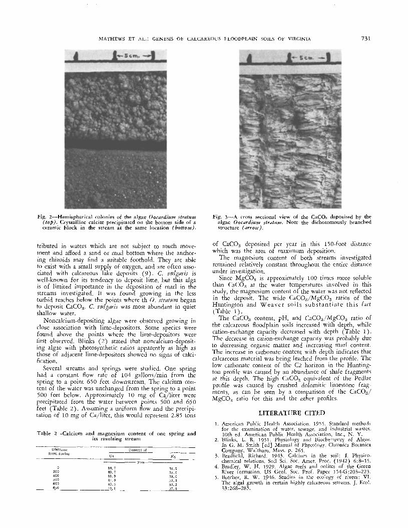
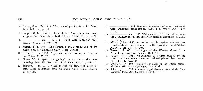
The O. stratum is a highly specialized desmid which isrestricted to the calcareous waters of limestone regions. Itis usually found in waterfalls or attached to rocks in swiftlyflowing streams. It occurs as hemispherical colonies 1 to2 mm in diameter (Fig. 2,) often covering masses of leaves,twigs, roots, and other debris found in the stream channel.Colonial morphology is evidenced by a number of dichoto-mously branched, broad gelatinous tubes. A cell occurs atthe end of each dichotomous branch, oriented so that thelong axis is at a right angle to the longitudinal axis of thetube. Lime is deposited cylindrically external to the gelati-nous tubes (Fig. 3) (9, 18).
O, stratum is of major importance in the deposition ofthe marl found in the calcareous bottoms of the PedlarHills area. An estimation, based on the appearance andstructure of the marl deposits, indicates that it is probablyresponsible for more than 90% of the marl which wasdeposited in the streams studied during this investigation.It is found growing in the stream channels between 500and 2,500 feet below the springs in both streams studiedwith colonial population a direct function of distance fromthe 500 foot station. Growth is continuous throughout theyear in the streams of the Pedlar Hills, but intensity ofgrowth is more pronounced from May until December.Roddy (17), in his study of a Lancaster County, Pennsyl-vania stream, describes a condition in which calcareousalgae display a similar growth pattern.
The members of the family Characeae are widely dis-
MATHEWS ET AL.: GENESIS OF CALCAREOUS FLOODPLAIN SOILS OF VIRGINIA 731
Fig. 2—Hemispherical colonies of the algae Oocardium stratum(top). Crystalline calcite precipitated on the bottom side of aceramic block in the stream at the same location (bottom).
Fig. 3—A cross sectional view of the CaCOa deposited by thealgae Oocardium stratum. Note the dichotomously branchedstructure (arrow).
tributed in waters which are not subject to much move-ment and afford a sand or mud bottom where the anchor-ing rhizoids may find a suitable foothold. They are ableto exist with a small supply of oxygen, and are often asso-ciated with calcareous lake deposits (9)- C. vitlgaris iswell-known for its tendency to deposit lime, but this algais of limited importance in the deposition of marl in thestreams investigated. It was found growing in the lessturbid reaches below the points where th O. stratum beganto deposit CaCO3. C. vulgans was most abundant in quietshallow water.
Noncalcium-depositing algae were observed growing inclose association with lime-depositors. Some species werefound above the points where the lime-depositors werefirst observed. Blinks (2) stated that noncalcium-deposit-ing algae with photosynthetic ratios apparently as high asthose of adjacent lime-depositors showed no signs of calci-fication.
Several streams and springs were studied. One springhad a constant flow rate of 104 gallons/min from thespring to a point 650 feet downstream. The calcium con-tent of the water was unchanged from the spring to a point500 feet below. Approximately 10 mg of Ca/liter wereprecipitated from the water between points 500 and 650feet (Table 2). Assuming a uniform flow and the precipi-tation of 10 mg of Ca/liter, this would represent 2.85 tons
Table 2—Calcium and magnesium content of one spring andits resulting stream
Distance
0 88200 89400 88500 87600 80650 79
Content ofa
779031
Mg
39.538.939.038.338.237.9
of CaCO;j deposited per year in this 150-foot distancewhich was the area of maximum deposition.
The magnesium content of both streams investigatedremained relatively constant throughout the entire distanceunder investigation.
Since MgCOtj is approximately 100 times more solublethan CaCOa at the water temperatures involved in thisstudy, the magnesium content of the water was not reflectedin the deposit. The wide CaCO3/MgCO3 ratios of theHuntington and Weaver soils s u b s t a n t i a t e this fact(Table 1).
The CaCO3 content, pH, and CaCO,s/MgCO3 ratio ofthe calcareous floodplain soils increased with depth, whilecation-exchange capacity decreased with depth (Table 1).The decrease in cation-exchange capacity was probably dueto decreasing organic matter and increasing marl content.The increase in carbonate content with depth indicates thatcalcareous material was being leached from the profile. Thelow carbonate content of the C2 horizon in the Hunting-ton profile was caused by an abundance of shale fragmentsat this depth. The high CaCO3 equivalent of the Pedlarprofile was caused by crushed dolomitic limestone frag-ments, as can be seen by a comparison of the CaCO3/MgCOg ratio for this and the other profiles.
732 SOIL SCIENCE SOCIETY PROCEEDINGS 1965