Embed Size (px)
Citation preview

Inst
itut d
e Ph
ysiq
ue d
u G
lobe
de
Stra
sbou
rg, É
cole
et
Obs
erva
toire
des
Sci
ence
s de
la T
erre
FP7 ITN CHANGES – FORMOSE Post-Graduate Course, Barcelonnette, 24-29 June 2013
The French methodology for natural risk mapping - PPRn
(Plan de Prévision des Risques Naturels)
J.-P. MALETA. REMAITRE
CNRS UMR 7516, School and Observatory of Earth Sciences, Strasbourg, France

Inst
itut d
e Ph
ysiq
ue d
u G
lobe
de
Stra
sbou
rg, É
cole
et
Obs
erva
toire
des
Sci
ence
s de
la T
erre
FP7 ITN CHANGES – FORMOSE Post-Graduate Course, Barcelonnette, 24-29 June 2013
Natural risk mitigation in France

Inst
itut d
e Ph
ysiq
ue d
u G
lobe
de
Stra
sbou
rg, É
cole
et
Obs
erva
toire
des
Sci
ence
s de
la T
erre
FP7 ITN CHANGES – FORMOSE Post-Graduate Course, Barcelonnette, 24-29 June 2013
The PPR methodology: Background and current status on landuse and risk mapping: from PSS (1935) to PPR (1995)
What has been carried out in France since 1935?
1. Land-use mapping
At the local scale, the “Plan d’ Occupation des Sols” (P.O.S) [today the “Plan Locald’Urbanisme” (P.L.U.) ‘Local Planning Plan’ since 2001] is the basic statutorydocument, including a map - at the community scale (usually 1:5,000) and apresentation report.
This land-use map divides the territory in urban zones and natural zones
At the regional scale (1:50.000 to 1:250.000), landuse master maps are embeddedto large development projects. But the community level is the most important for riskmapping.

Inst
itut d
e Ph
ysiq
ue d
u G
lobe
de
Stra
sbou
rg, É
cole
et
Obs
erva
toire
des
Sci
ence
s de
la T
erre
FP7 ITN CHANGES – FORMOSE Post-Graduate Course, Barcelonnette, 24-29 June 2013
2. How are natural risks taken into account in the land use planning
What are the documents/methods used in France?
+ PSS (1935): (“submersible surface maps”, PSS in French) indicates the possibleflooded areas in which any construction is under control, to keep free the running water.This procedure concerns several communities along the rivers and aims to reduceurbanization in these areas.
+ Article R.111-3 of the urban code: mapping of risks areas, at local level, has beenextended to landslides and avalanches, with floods in order to control and, sometimes,to prohibit any construction or urbanization in the risk prone areas. The risk zones areindependent of the municipal boundaries.
The documents drawn up under this procedure are applicable to 3rd parties, but do notaffect exiting constructions. Only the future urban development are concerned by thisregulation.
+ ZERMOS (1970s): first risk mapping document for slope instability.
ZERMOS is the French acronym for ‘Zones Exposed to Risk of Movements of theSurface and Subsurface’.

Inst
itut d
e Ph
ysiq
ue d
u G
lobe
de
Stra
sbou
rg, É
cole
et
Obs
erva
toire
des
Sci
ence
s de
la T
erre
FP7 ITN CHANGES – FORMOSE Post-Graduate Course, Barcelonnette, 24-29 June 2013
At the scale 1:25.000, ZERMOS are informative maps which define potentially unstableareas.
The data concern only the natural phenomena: no stakes are taken into consideration.
Example of the Zermos map of Nantua
Zoning in 5 classes:
- No potential instability (green)
- Low potential instability (yellow)
- Moderate potential instability (brown)
- High potential instability (orange)
- Very high potential instability (red)

Inst
itut d
e Ph
ysiq
ue d
u G
lobe
de
Stra
sbou
rg, É
cole
et
Obs
erva
toire
des
Sci
ence
s de
la T
erre
FP7 ITN CHANGES – FORMOSE Post-Graduate Course, Barcelonnette, 24-29 June 2013
PER (1982): The law of 13th July 1982 set up the “Risks Exposure Plan” (PER, inFrench). This law introduces prevention measures, which have to be carried out byowners as well as by communities or public bodies, not only for future construction,but also for existing construction.
At the same time, the law creates a link between prevention and compensation.
The non respect of the preventive measures can modulate the level of compensation.
PER maps are drawn at scales of 1:5000 to 1:10.000, in order to be compatible withurban-planning documents, and are legally binded at the municipality scale.
PER comprises several documents: (1) the information map of natural event, (2) thehazard map, (3) the vulnerability map, (4) the PER delineation plan, and (5) a reportdescribing the regulation.
The procedure is very slow and ‘complex’: Assessment of vulnerability with ‘complexmethod’ (scale of the document (1.5000) with a lot od details required, the obligation tostudy the whole territory of the commune (also in the ‘zone’ without risk!), rigidity of theprocedure, high cost to prepare the documents, ……
For these reasons, the State has modified the law in 1995

Inst
itut d
e Ph
ysiq
ue d
u G
lobe
de
Stra
sbou
rg, É
cole
et
Obs
erva
toire
des
Sci
ence
s de
la T
erre
FP7 ITN CHANGES – FORMOSE Post-Graduate Course, Barcelonnette, 24-29 June 2013
PPR (1995): a new law that regroups all the risk mapping “tools”, and sets up the“Risk Prevention Map” (PPR). PPR is a basic risk map at the local scale, to beshifted into the statutory land-use map (POS).
These documents have to be prepared at the 1/25.000 scale (generally topographicmap enlarged at the 1:10.000).PPR is an unified and standardised document of prevention.With pragmatism, PPR link together (1) existing knowledge and (2) qualitative studies
The area covered by the documents corresponds to either municipality or to a “riskcatchment” limited by natural boundaries and that may cover several municipalities.
PPR are elaborated for the most exposed municipalities. The priority municipalities arechosen according to the number of observed events [Dossier Départemental desRisques Majeurs -DDRM] and on information provided by inter-ministerial decreesestablishing the state of natural disaster.
The hierarchy of communes is defined assuming the risk basin concept and thetechnical/budget resources that can be mobilised by the State (‘Barnier funding’ until2010).
Documents are mono-risk but sometimes they can be multi-risks and associatelandslides, floods, snow avalanches and earthquakes.
The zoning is established for a reference period of 100 years

Inst
itut d
e Ph
ysiq
ue d
u G
lobe
de
Stra
sbou
rg, É
cole
et
Obs
erva
toire
des
Sci
ence
s de
la T
erre
FP7 ITN CHANGES – FORMOSE Post-Graduate Course, Barcelonnette, 24-29 June 2013
PPR is composed of 3 documents (PPR Guide, 1999, Leroi, 2005):
- A presentation note
- A statutory zoning plan with 3 zones:
- A three-level regulation reports:
A/ The presentation note aggregates:
• The reasons for the PPR prescription
• The map of the known natural phenomena
• The hazards, taking into account the uncertainties
• The major stakes and exposed elements
• The objectives aimed at for risk prevention
• The choice of zoning and the statutory measures

Inst
itut d
e Ph
ysiq
ue d
u G
lobe
de
Stra
sbou
rg, É
cole
et
Obs
erva
toire
des
Sci
ence
s de
la T
erre
FP7 ITN CHANGES – FORMOSE Post-Graduate Course, Barcelonnette, 24-29 June 2013
B/ The statutory zoning plan distinguishes 3 zones:
• the red zone (high exposed zones, with high risk occurrence and high intensity ofhazards) where building is not allowed
• the blue zone, where the risk occurrence and the hazard intensity allow urbanizationand building, but with specific conditions to be respected
• the white zone (unexposed zones with negligible risk) where building are allowed
R1: Area without specific restriction.
R2: Area with low restriction.
R3: Area with specific restrictions.

Inst
itut d
e Ph
ysiq
ue d
u G
lobe
de
Stra
sbou
rg, É
cole
et
Obs
erva
toire
des
Sci
ence
s de
la T
erre
FP7 ITN CHANGES – FORMOSE Post-Graduate Course, Barcelonnette, 24-29 June 2013
C/ A 3-level regulation report which defines:- The limits on the new constructions:- The general prevention and protection measures- The measures applicable to the existing constructions
* Limits on the new constructions:
The basis of the PPR is to stop the development of urbanisation in the zones where therisk is the highest
In the areas where new constructions are allowed and in agreement with the localplanning plan (PLU), these constructions are subject to compulsory provisions.
Planning, building & management regulation must be clearly stated, realistic andproportional to the stakes.

Inst
itut d
e Ph
ysiq
ue d
u G
lobe
de
Stra
sbou
rg, É
cole
et
Obs
erva
toire
des
Sci
ence
s de
la T
erre
FP7 ITN CHANGES – FORMOSE Post-Graduate Course, Barcelonnette, 24-29 June 2013
* General prevention and protection measures:
They include the measures to be taken by the private owners, and the collectivemeasures of the public project managers.
* Measures applicable to existing constructions:
They concern the planning, use or operation related to the existing buildings and to anytype of planning that may have an influence on the risk.
Prevention and protection measures, as well as the measures applicable to the existingconstructions can become compulsory within a maximum deadline of 5 years withautomatic enforcement by the state if they have not been performed in time.
Inst
itut d
e Ph
ysiq
ue d
u G
lobe
de
Stra
sbou
rg, É
cole
et
Obs
erva
toire
des
Sci
ence
s de
la T
erre
FP7 ITN CHANGES – FORMOSE Post-Graduate Course, Barcelonnette, 24-29 June 2013
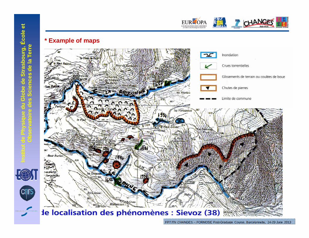
* Example of maps

Inst
itut d
e Ph
ysiq
ue d
u G
lobe
de
Stra
sbou
rg, É
cole
et
Obs
erva
toire
des
Sci
ence
s de
la T
erre
FP7 ITN CHANGES – FORMOSE Post-Graduate Course, Barcelonnette, 24-29 June 2013
* Example of maps

Inst
itut d
e Ph
ysiq
ue d
u G
lobe
de
Stra
sbou
rg, É
cole
et
Obs
erva
toire
des
Sci
ence
s de
la T
erre
FP7 ITN CHANGES – FORMOSE Post-Graduate Course, Barcelonnette, 24-29 June 2013

Inst
itut d
e Ph
ysiq
ue d
u G
lobe
de
Stra
sbou
rg, É
cole
et
Obs
erva
toire
des
Sci
ence
s de
la T
erre
FP7 ITN CHANGES – FORMOSE Post-Graduate Course, Barcelonnette, 24-29 June 2013
* Example of maps

Inst
itut d
e Ph
ysiq
ue d
u G
lobe
de
Stra
sbou
rg, É
cole
et
Obs
erva
toire
des
Sci
ence
s de
la T
erre
FP7 ITN CHANGES – FORMOSE Post-Graduate Course, Barcelonnette, 24-29 June 2013
* Example of maps

Inst
itut d
e Ph
ysiq
ue d
u G
lobe
de
Stra
sbou
rg, É
cole
et
Obs
erva
toire
des
Sci
ence
s de
la T
erre
FP7 ITN CHANGES – FORMOSE Post-Graduate Course, Barcelonnette, 24-29 June 2013
* Example of maps

Inst
itut d
e Ph
ysiq
ue d
u G
lobe
de
Stra
sbou
rg, É
cole
et
Obs
erva
toire
des
Sci
ence
s de
la T
erre
FP7 ITN CHANGES – FORMOSE Post-Graduate Course, Barcelonnette, 24-29 June 2013
* Example of maps
Inst
itut d
e Ph
ysiq
ue d
u G
lobe
de
Stra
sbou
rg, É
cole
et
Obs
erva
toire
des
Sci
ence
s de
la T
erre
FP7 ITN CHANGES – FORMOSE Post-Graduate Course, Barcelonnette, 24-29 June 2013
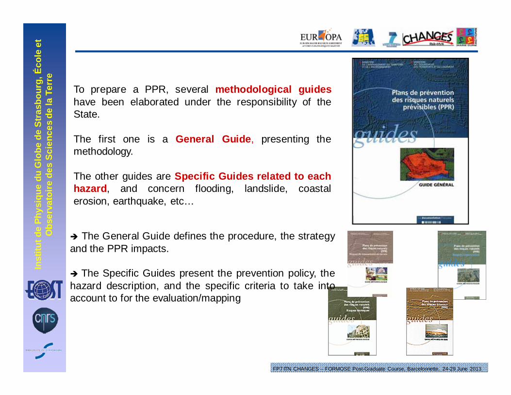
To prepare a PPR, several methodological guideshave been elaborated under the responsibility of theState.
The first one is a General Guide, presenting themethodology.
The other guides are Specific Guides related to eachhazard, and concern flooding, landslide, coastalerosion, earthquake, etc…
The General Guide defines the procedure, the strategyand the PPR impacts.
The Specific Guides present the prevention policy, thehazard description, and the specific criteria to take intoaccount to for the evaluation/mapping

Inst
itut d
e Ph
ysiq
ue d
u G
lobe
de
Stra
sbou
rg, É
cole
et
Obs
erva
toire
des
Sci
ence
s de
la T
erre
FP7 ITN CHANGES – FORMOSE Post-Graduate Course, Barcelonnette, 24-29 June 2013
Statutory legal procedure:
Order of prescription(by Prefect with agreement of the Mayor)
(Starting point for the elaboration of the document)
Consultation of the Municipality Council
Public Enquiry
Approbation of the PPR
Annex to the PLU