Embed Size (px)
Citation preview
2/7/19
1
Chapter 5
1 Concordia University Geog/Sci-381 Chapter 5
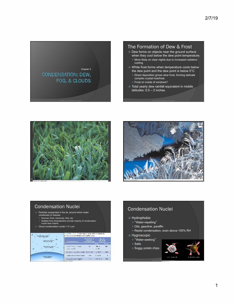
The Formation of Dew & Frost � Dew forms on objects near the ground surface
when they cool below the dew point temperature. � More likely on clear nights due to increased radiative
cooling � White frost forms when temperature cools below
the dew point and the dew point is below 0°C � Direct deposition grows slow frost, forming delicate
complex crystal hoarfrost. � Frost on inside of windows?
� Total yearly dew rainfall equivalent in middle latitudes: 0.5 – 2 inches.
2 Concordia University Geog/Sci-381 Chapter 5
3 Concordia University Geog/Sci-381 Chapter 5 4 Concordia University Geog/Sci-381 Chapter 5
Condensation Nuclei � Particles suspended in the air, around which water
condenses or freezes. � Sources: Dust, volcanoes, fires, etc. � Sulfates from phytoplankton provide majority of condensation
nuclei near oceans. � Cloud condensation nuclei > 0.1 µm
5 Concordia University Geog/Sci-381 Chapter 5
Condensation Nuclei
� Hydrophobic � “Water-repelling” � Oils, gasoline, paraffin � Resist condensation, even above 100% RH
� Hygroscopic � “Water-seeking” � Salts � Soggy potato chips
6 Concordia University Geog/Sci-381 Chapter 5

2/7/19
2
Haze � Dry condensation nuclei (above dew point) reflect
and scatter sunlight creating blueish haze. � Wet condensation nuclei (75% relative humidity)
reflect and scatter sunlight creating grayish or white haze.
7 Concordia University Geog/Sci-381 Chapter 5
Fog � When saturation is reached condensation
forms a cloud near the ground. � Fog visibility: < 1 km � Can be much thicker when formed in dirty city
air. � Tends to fall toward earth when liquid drops
are large. � 25 µm particles fall 5 cm/s
� Two ways to form: � Air cools below dew point � Water evaporates and mixes into dryer air
8 Concordia University Geog/Sci-381 Chapter 5
Fog � Radiation fog: ground cools through
conduction and radiation; ground fog � Forms best on clear nights, more common in
winter when nights are long. � Promoted by light breezes which brings more
moist air in contact with cold ground. � Valley fog created by cold air drainage
� Sunlight usually “burns off” the radiation fog. � High inversion fog: the fog layers lifts above the
warm ground without dissipating.
9 Concordia University Geog/Sci-381 Chapter 5 10 Concordia University Geog/Sci-381 Chapter 5
11 Concordia University Geog/Sci-381 Chapter 5
Fog � Advection Fog: warm moist air moves
horizontally (advects) over a cool surface. � Summer fog on the Pacific coast � Keeps the CA redwoods alive
� Advection-Radiation Fog � Moist air flows over cold ground
12 Concordia University Geog/Sci-381 Chapter 5

2/7/19
3
13 Concordia University Geog/Sci-381 Chapter 5 14 Concordia University Geog/Sci-381 Chapter 5
Fog � Upslope Fog: moist air flows up a
mountain slope � West side of the Rockies
� Evaporation Fog: � Warm moist surface provides enough moisture
to saturate a dry air parcel; short lived ○ Steam fog ○ Heated swimming pools ○ Caribou fog ○ Breath in winter
15 Concordia University Geog/Sci-381 Chapter 5 16 Concordia University Geog/Sci-381 Chapter 5
17 Concordia University Geog/Sci-381 Chapter 5
Foggy Weather � In general fog is not common for most locations in
the US. However several areas do exist with a high frequency of fog. Two causes: � Elevation � Ocean currents
� Environmental Issue: Fog dispersal � Mix air with air craft or fans � Introduce large particle into air to reduce total number of
cloud droplets. � Use dry ice to lower temperature below freezing.
18 Concordia University Geog/Sci-381 Chapter 5

2/7/19
4
19 Concordia University Geog/Sci-381 Chapter 5
Clouds
� Classification of clouds: use Latin words to describe height and appearance. � Lamarck, early 1800s
� Factors described � Height: low, mid, high, vertical � Appearance: shape, density, color
20 Concordia University Geog/Sci-381 Chapter 5
Helpful Latin Stratus = Layer Cirrus = Curl of hair Cumulus = Heap Nimbus = Violent Rain
21 Concordia University Geog/Sci-381 Chapter 5 22 Concordia University Geog/Sci-381 Chapter 5
23 Concordia University Geog/Sci-381 Chapter 5 24 Concordia University Geog/Sci-381 Chapter 5
• Cirrus Clouds • Thin and wispy • Long streamers are called “mares’ tails”
• Usually point to fair, pleasant weather.
High Clouds

2/7/19
5
25 Concordia University Geog/Sci-381 Chapter 5
• Cirrocumulus • High cotton puffs • Rippling appearance
distinguishes from cirrus and cirrostratus
• A “mackerel sky” (scales) High Clouds
26 Concordia University Geog/Sci-381 Chapter 5
• Cirrostratus • Thin sheet of ice crystals • Often forms haloes • Often precede advancing
storms High Clouds
27 Concordia University Geog/Sci-381 Chapter 5
• Altocumulus • Gray, puffy masses • Waves or bands • One part of cloud is darker
than another, distinguishing from cirrostratus
Middle Clouds
28 Concordia University Geog/Sci-381 Chapter 5
• Altostratus • Dimly visible “watery” sun. • Gray color and lower than cirrostratus,
also no halo and the sun doesn’t cast a shadow.
• If rain reaches the ground, it’s a nimbostratus.
Middle Clouds
29 Concordia University Geog/Sci-381 Chapter 5
• Nimbostratus • Dark gray, wet-looking layer
that produces light continuous rain.
• Darker and lower than altostratus.
Low Clouds
30 Concordia University Geog/Sci-381 Chapter 5
• Stratocumulus • Low lump clouds in rows or patches. • Blue sky often visible between clouds. • Sometimes crepuscular rays (bands of light)
shine through the clouds. • Hold up your hand: altocumulus are the size of
your thumbnail, stratocumulus are the size of your fist.
Low Clouds

2/7/19
6
31 Concordia University Geog/Sci-381 Chapter 5
• Stratus • Lower layer, can cover entire sky. • Looks like fog that doesn’t reach the ground. • Fog that “lifts” becomes a stratus cloud. • Common over coastal waters. • Lower and darker than altostratus. • Not a rain cloud like nimbostratus.
Low Clouds
32 Concordia University Geog/Sci-381 Chapter 5
• Cumulus • Familiar-looking cotton puffs • Cumulus humilis = fair weather cumulus • Cumulus fractus = smaller, ragged-edged • Cumulus congestus = grown-up, look like
cauliflower heads, can grow into cumulunimbus Low Clouds with Vertical Development
33 Concordia University Geog/Sci-381 Chapter 5
Cumulus Congestus
34 Concordia University Geog/Sci-381 Chapter 5
• Cumulonimbus • Giant thunderstorm cloud • Anvil top • Chaotic vertical winds: rain, lightning, hail • Top becomes fibrous rather than sharp like
cumulus congestus Low Clouds with Vertical Development
Some Unusual Clouds
� Not all clouds can be placed into the ten basic cloud forms.
� Unique atmospheric processes and environmental conditions create dramatic and exotic clouds.
� Unusual clouds and weather balloons often cause UFO reports.
35 Concordia University Geog/Sci-381 Chapter 5 36 Concordia University Geog/Sci-381 Chapter 5

2/7/19
7
37 Concordia University Geog/Sci-381 Chapter 5
Lenticular Clouds
Fig. 5-26, p. 130
Fig. 5-27, p. 130 Fig. 5-28, p. 130
Fig. 5-30, p. 131 Fig. 5-31, p. 131
2/7/19
8
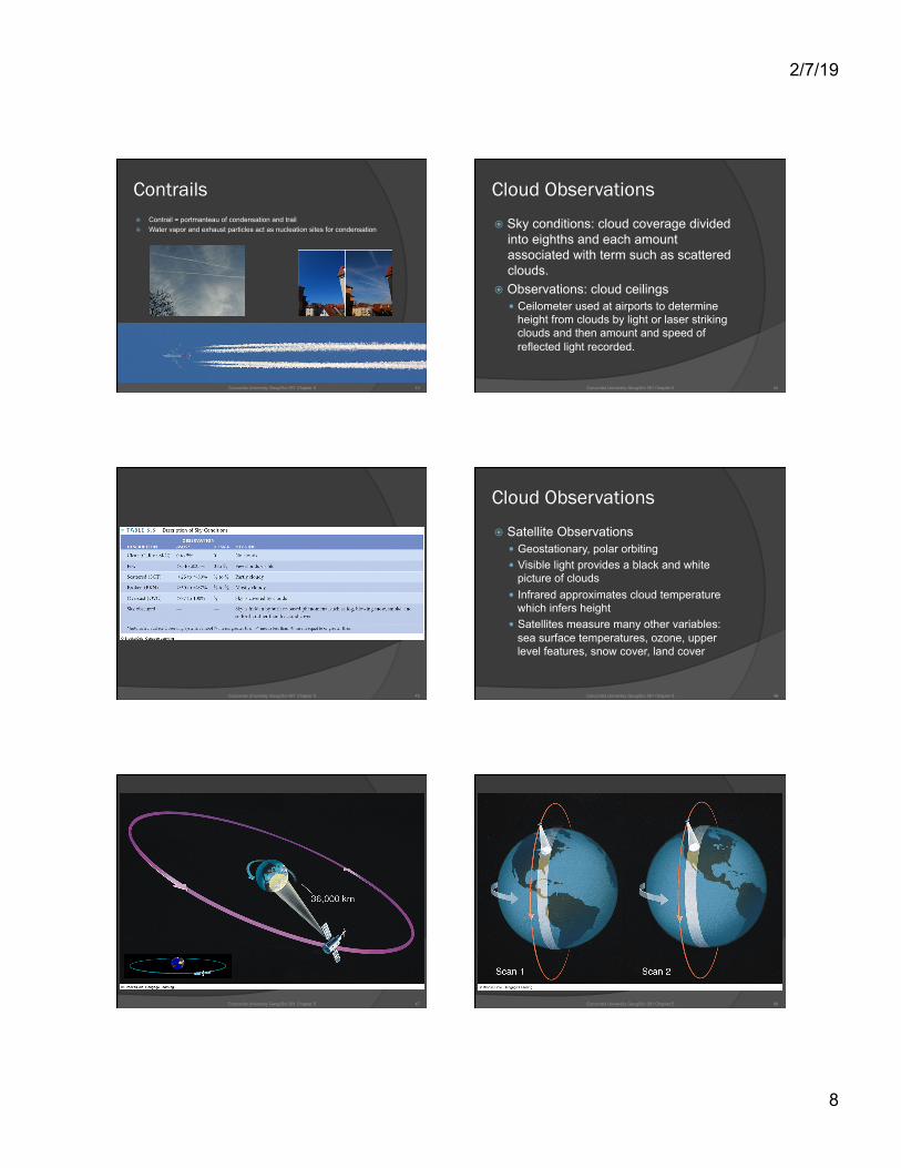
Contrails � Contrail = portmanteau of condensation and trail � Water vapor and exhaust particles act as nucleation sites for condensation
43 Concordia University Geog/Sci-381 Chapter 5
Cloud Observations
� Sky conditions: cloud coverage divided into eighths and each amount associated with term such as scattered clouds.
� Observations: cloud ceilings � Ceilometer used at airports to determine
height from clouds by light or laser striking clouds and then amount and speed of reflected light recorded.
44 Concordia University Geog/Sci-381 Chapter 5
45 Concordia University Geog/Sci-381 Chapter 5
Cloud Observations
� Satellite Observations � Geostationary, polar orbiting � Visible light provides a black and white
picture of clouds � Infrared approximates cloud temperature
which infers height � Satellites measure many other variables:
sea surface temperatures, ozone, upper level features, snow cover, land cover
46 Concordia University Geog/Sci-381 Chapter 5
47 Concordia University Geog/Sci-381 Chapter 5 48 Concordia University Geog/Sci-381 Chapter 5

2/7/19
9
49 Concordia University Geog/Sci-381 Chapter 5 Fig. 5-35b, p. 135
Infrared satellite images: http://www.goes.noaa.gov/ECIR4.html
Homework for Chapter 5 � Chapter 5 Questions for Review, p. 140
� #3, 6, 9, 10, 12, 13, 16
� Chapter 5 Questions for Thought, p. 141 � #1, 15
51 Concordia University Geog/Sci-381 Chapter 5