Embed Size (px)
Citation preview
Engineering Geology, 22 (1986) 209--216 209 Elsevier Science Publishers B.V., Amste rdam -- Pr inted in The Netherlands
THE FORM AND STABILITY OF A DOUBLE UNDERCLIFF: AN EXAMPLE FROM SOUTH-WEST ENGLAND
J O H N PITTS
School of Civil and Structural Engineering, Nanyang Technological Institute, Singapore 2263 (Republic of Singapore)
(Received March 18, 1985; accepted after revision July 24, 1985)
A B S T R A C T
Pitts, J. , 1986. The form and stabili ty of a double undercl i f f : an example f rom southwest England. Eng. Geol., 22: 209--=216.
Details are presented of a double undercl iff , an unusual landform feature on the coast of Southeas t Devon. The double undercl i f f is the result of two separate landslides on argillaceous format ions wi thin the 127 m high cliffs. The upper undercl i f f is probably of great ant iqui ty , whereas the lower undercl i f f formed as recent ly as 1969. The double undercl i f f dies ou t as the lower argillaceous format ion dips below sea level to the east, and is faulted ou t to the west.
The stabil i ty of the slopes in each case depended on the shear strength of bedding laminations, and hence upon very low or zero cohesion. A back analysis suggests a mobil ised angle of shearing resistance as low as 13 ° for the lower undercliff .
The future stabil i ty of the undercl iffs is dependen t mainly upon undrained crown loading, for the upper undercl i f f f rom the degradation of the backscar, and for the lower undercl i f f f rom the landslide above.
INTRODUCTION
An unusual cliff morphology has developed at Charton Bay (Fig.l), between Axmouth and Lyme Regis, in Southeast Devon, England. The cliff form is a double undercliff, two major debris covered benches which have resulted from two major landslips at different levels on the cliff (Fig.2).
Charton Bay is near the middle of the Axmouth- -Lyme Regis Undercliffs National Nature Reserve. The existence of the double undercliff can be related to details of the geological structure and slope stability in the area.
The upper undercliff is about 110 m wide and is backed by sheer cliffs of Middle Chalk and Upper Greensand reaching 127 m O.D. It was formed as a result of a major landslide, which probably occurred towards the end of the Pleistocene period (Pitts, 1981). The lower undercliff is the result of a land- slide which occurred in June 1969.
0013-7952186/$03 .50 © 1986 Elsevier Science Publishers B.V.

210
D o r s e t
\ Lyrne Rel~is Devon
F • / R.Axe Charton I
i2~:t gay ///t Seaton
/
\ Bindon Char ton l~ay / \ / N
\ II t \ Lyme Bay \ / \ // \ / \ / \\ / /
\ 0 k m 1 /
// \ \ // \\ i i
\ I \ // \\ //
',, J / \ i / I
Fig.1. Location of Charton Bay.
GEOLOGICAL AND HYDROGEOLOGICAL SETTING
The geological succession at Charton Bay ranges from the Mercia Mud- stones Group (Blue Anchor Formation) (Warrington, 1980) which forms the sea cliff, to the Middle Chalk which forms much of the backing cliff. In between is a wide variety of lithologies of Penarth Group (Rhaetic), Liassic, and Upper Greensand age. A summary of the geological succession with brief descriptions of strata are shown in Table I. The pre-Cretaceous strata dip eastwards at an average of 11 °. The sea cliff, formed of Mercia Mudstone rocks, decreases in height from about 25 m in the west to disappear completely about 1 km to the east at Humble Point. The downdip of the beds takes the black shales of the Westbury Formation, which overlie the Mercia Mudstones, below sea level at that point, and the failure surface of the Humble Point slip is developed within that Formation. During successive periods of slipping at Humble Point an offshore reef has been formed (Pitts, 1983). This geological situation is very similar to that at the Bindon slip further west, a major landslide which, as a result of a failure in 1839 also produced an offshore reef (Pitts, 1974). The relatively extensive succession of pre-Cretaceous strata (for the area) is due to a fault just to the west of Charton Bay along which the rocks have been upthrown. The Cretaceous beds are relatively flat lying, reaching a maximum dip of about 5 ° seawards (south~southeasterly). The two parts of the succession are therefore separated by a marked angular unconformity.
211
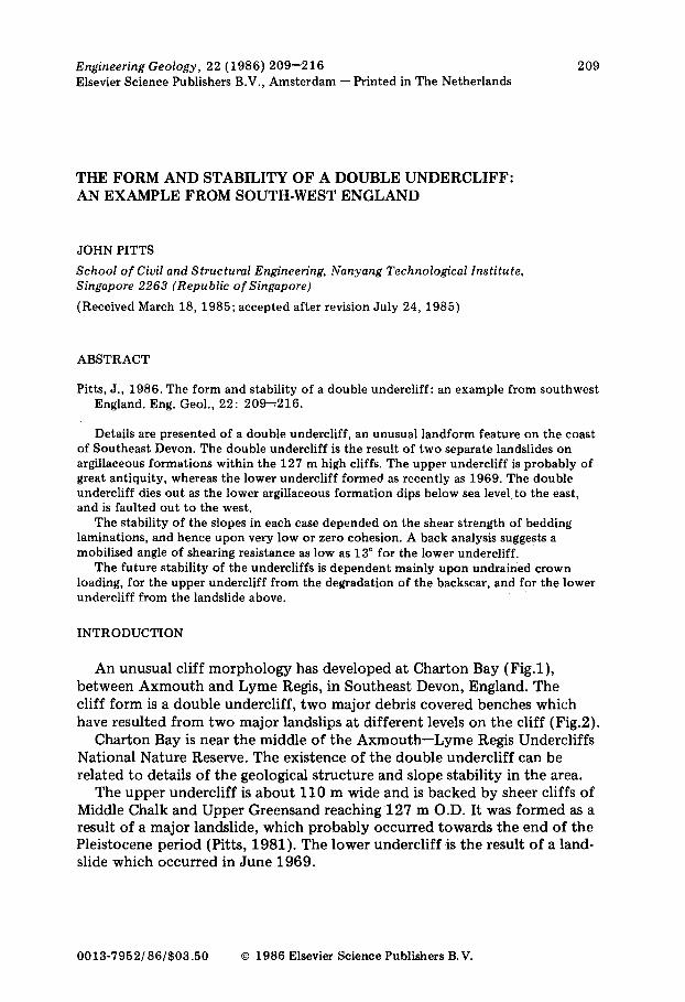
Fig.2. Vertical aerial photograph of the double undercliff at Charton Bay: a = backscar of slip forming upper undercliff; b = upper undercliff; c = backscar of 1969 slip; d = lower undercliff; e = colluvium from 1969 slip. Cambridge University Collection: copyright reserved.
Signif icant lines of seepage occur f r o m the u n c o n f o r m i t y and f r o m near t he j unc t i on o f t he Mercia Muds tones and Penar th Group . A signif icant g r o u n d w a t e r reservoir wi th in the Cre taceous success ion is k n o w n to exist. A well a t Dowlands F a r m ( S Y 2 8 8 9 0 3 ) which is pos i t ioned close to the rear cl i f f o f Cha r t on Bay, had a general ly cons i s ten t wa te r level o f a b o u t + 50 m O.D. fo r several years. The well ran d ry fo r u n a c c o u n t a b l e reasons in the ear ly 1970 ' s . The East D e v o n Water Board has a p u m p i n g s t a t ion a t P inhay Bay jus t t o the east o f C ha r t on Bay. The discharge f r o m the g r o u n d w a t e r reservoir has r e m a i n e d largely stable, even dur ing the d rough t s o f 1975 and 1976.

212
TABLE I
Geological succession at Charton Bay
Tertiary to Recent Clay with flints (discontinuous). Middle Chalk Hard and soft nodular chalk with flints. Lower Chalk Sandy, conglomeratic, glauconitic and phosphatic
limestones (very thin). Upper Greensand Phosphatic and cherty glauconitic sandstones,
glauconitic silty sands (Foxmould). Gault Dark, loamy, glauconitic sandy silt.
. . . . . . . . . . . . . . . . . . . . . . . . . . . . . major unconformity . . . . . . . . . . . . . . . . . . . . . . . . .
Liassic
Penarth Group (Rhaetic)
Mercia Mudstones
Dark pyritiferous calcareous shales with interbedded calcite showing cone-in-cone structure (Shales with Beef) alternating calcareous shales and sandy lime- stones (Blue Lias). Rubbly and porcelaneous limestones, pale clays, shales, mudstones and thin limestones (Lilstock Formation) grey and black selenitic shales (Westbury Formation). Grey and green gypsiferous fissured clays with occasional hard mudstone bands, terminated by black selenitic paper shales (Blue Anchor Formation).
ORIGIN AND MORPHOLOGY OF THE DOUBLE UNDERCLIFF
Two large landslides have been mainly responsible for the development of the double undercliff. These are shown on the cross-section (Fig.3). The present-day form of the slope is shown on the geomorphological map (Fig.4). The upper landslide is of unknown age, but is probably Late Pleistocene. It is a large non-circular rotational slip with a large bedding plane slip component . The Cretaceous strata and uppermost Liassic strata have slipped, the main part of the failure surface being close to the junct ion of the Shales with Beef and Blue Lias. The upper undercliff consists of large slipped blocks of backtil ted Chalk and Upper Greensand, backed by an extensive slope composed of flint-chert scree and a sheer cliff. Some rifting of the ground between the blocks has occurred, although the lack of distress to the vegetation suggests that this did not result from the slip of the lower undercliff.
The lower undercliff was formed by a slip of about 350 m of cliff in June 1969. Approximately half the undercliff failed leaving an irregular sub-vertical scar up to 14 m high, mainly in Lias with a capping of slipped Cretaceous rocks above. The inclusion of the Blue Lias in the backscar, with its stabilising thick sandy limestone units is an unusual feature of sliding in this area. Large blocks of Blue Lias are found in the extensive colluvial slope which developed as material spilled over the old sea cliff during the landslide.

213
~0"
$0"
30"
20-
I0"
Degraded backscar of 1969 slip
HorizontM Lilstod( Formation in $~pped block \
upper undercliff
Formation shales - not metro in Outcrop
. - ' ' l l l l I
~ Col|uvium ~ ~ t l c Greemand ~ Blue L ~
Flmt-Cb~'rt ~ ~ Omerty G r ~ ~ IAlstock Form, t i~
~ m - ~ Clay with Flints ~ Foxm~dd and Gault (thin ,,,ith peWty base) i ~ Keuper Ma~l
~L~c~r~ Middle Chalk ~ ~/mle$ with {~-'ei
Fig.3. Cross-section of the landslides forming the double undercliff.
In the lower parts of the lower undercliff, slipped blocks of limestone of the Lilstock Formation are preserved; a rear one, very steeply backtilted and highly fractured, and a forward one preserved as a virtually horizontally bedded, knife-edged ridge up to about 3 m in height. The distance between the two blocks is 3 to 4 m, the ground in between consisting mainly of rifted and crushed Lilstock Formation Limestone.
The forward portion of the lower undercliff is very disturbed, but clearly related to a particular stratigraphic sequence. The edge of the undercliff is formed of Mercia Mudstones, the topmos t transitional beds of which comprise delicate black paper shales which are preserved intact. The black shales of the Westbury Formation described in detail from an in situ exposure by Richardson (1906) are now totally obscured, but occupied precisely the position of the failure surface of the 1969 slip. The black shales found beneath the white limestone blocks of the Lilstock Formation yield an abundant fauna of the Jurassic brachiopod Calcirhynchia calcaria.
This apparent anomaly in the succession results from the effectively unat tached nature of the white limestone blocks, the blocks being under- thrust at the toe, probably as a result of crumpling. The crumpling is supported by the extreme backtilt of the rearmost limestone block, and the crushing between it and the forward underthrust block.
Much of the sea cliff is now obscured by colluvium, which mainly consists of blocks of shale and sandy limestone. The abundant large lamellibranch Plagiostoma giganteum indicates the Lower Jurassic origin of the debris.

214
K
,K ,<
/ 7 " - 1 "
,~ i I .~ . . . . . . " ~
I . . " " ~c : . . " " ' . " : " , . , " . " . ' • ' . " • " • " • " . " , ' . . . . , . : ' 1
..." x ~ . . ' . . . . ' , . . : " ' . " ' . ' . ' j . : . ............ "' ~J • ." ~ ' T ~ ' " ' . ' . " . ' . ' . . ' . . . ' . . . - - " : ' : " - . ' " - '
. . . . . . . " . . . . . . . . . . Z '
..,....,
%. > y T Y : :-:
N
0
~ Scar ol slip with extent defined. Shear failure
- ~ ' ~ Back scar with extent undefined
==~ Minor s~ips
~ Tensic~ cracks
~ Talus
Scar mvolving shear & C - ~ - - I tension failure
1~----~] Rc~kfall scar
- - ~ Mudllow$
' ~ - ~ K nife-~dsed ridges
~ Rockfall debris
~ Rocklall debris with fines
~ Slipped material
[ ~ ' ] Angle & direction of slop~
~ Sea cliff
Fig.4. Geomorphological map of the double undercliff.
Localised gullying by small springs issuing from the top of the Mercia Mudstones strata represents the major source of erosion of the colluvium. Negligible marine erosion of the toe occurs because of the presence of a multi-tiered cobble beach.
STABILITY OF THE DOUBLE UNDERCLIFF
Aerial photograph cover of the Charton Bay slip of 1969 has enabled the pre-failure profile to be reconstructed (Fig.5). A back analysis of the 1969 slip was undertaken using the method for a planar failure detailed by Hoek and Bray (1981). The black shales of the Westbury Formation have a well developed bedding plane fissility with a very smooth bedding lami- nation. Hence, zero cohesion was assumed, the analysis aiming to indicate

215
50 100 150 200
Fig.5. Reconstructed profile of the lower undercliff prior to the slip of 1969.
120
100
m e t r e s 80 [AO.D]
60
40
20
the angle of shearing resistance mobilized at failure. The groundwater levels used related to the levels in the Dowlands Farm well, and the issue of seepage at the top of the sea cliff (toe of the slip). The analysis produced a value of ~ m o b = 13°.
The stability of the upper undercliff slope is dependent upon the residual strength of the Shales with Beef. This formation is less regularly laminated, but in view of the present landslide morphology, an existing failure surface must exist, along which the residual strength operates. An analysis using the method of Janbu (1973) was undertaken. Shear strength parameters were determined from drained reversed shear box tests. The values obtained were c'r = 2kN/m 2, ~'r = 14.5 °. The factor of safety was very low, at F = 1.06. The present-day processes most likely to affect the stability of the upper under- cliff are two-fold. In the toe area, seepage from close to the sub-Cretaceous unconformity is leading to erosion of the Foxmould and heavily fractured cherty Greensand materials. At the rear, degradation of the Middle Chalk and Upper Greensand backscar is contributing to a large accumulation of scree.
The stability of the lower undercliff depends much on the degradation of the upper undercliff. The profile of the lower slope is now gentle, and the disturbance to the strata by landsliding, has improved the drainage of the mass greatly. The continued stability of the slope therefore depends mainly on the effects of undrained loading at the crown due to the degra- dation of the forward edge of the upper undercliff. However, the high value of the present factor safety (F = 2.6 assuming ~'~ = 10 °) would suggest that a major failure of the upper undercliff would be required to de-stabilise the lower undercliff.

216
CONCLUSION
A double undercliff has developed on the coast of South East Devon as a result of two widely separated (temporally) periods of landslide activity. The main geological features giving rise to this morphology are two separate argillaceous sequences each of which has become the base of failure plane development for the landslides, and also a fault which has upthrown an unusually large sequence of pre-Cretaceous strata in the area.
The stability of the upper undercliff is most likely to depend on seepage erosion near the level of the sub-Cretaceous unconformity. This is close to the toe of the landslide forming the upper undercliff. Loading at the crown from degradation of the Chalk and Upper Greensand backscar is also likely to contr ibute to destabilisation.
The failure of the lower undercliff in 1969 produced a large increase in the stability of the slope. Minor seepage at the top of the seacliff is unlikely to significantly undermine the stability. Only a major and sudden addition of material to the crown of the lower undercliff slope, probably from a failure of the upper undercliff, is likely to cause significant destabilisation of the lower undercliff.
ACKNOWLEDGEMENTS
I am grateful to Professor Denys Brunsden of King's College, London University, for his continued encouragement and assistance. Thanks are also due to Foo Boon Chew and Loo Ching Nong of NTI for assistance with the photogrammetry, C.S. Yeo of NTI for the line drawings, and Rosie Chew and Sherlene Lim for typing the paper.
REFERENCES
Hoek, E. and Bray, J.W., 1981. Rock Slope Engineering, 3rd ed. Insti tute of Mining and Metallurgy, London, 358 pp.
Janbu, N., 1973. Slope stabili ty computations. In: R.C. Hirschfield and S.J. Poulos (Editors), Embankment Dam Engineering. John Wiley, New York, N.Y., pp.47--86.
Pitts, J., 1974. The Bindon landslip of 1839. A survey of historical documents describing this event, its causes and mechanism. Proc. Dorset Nat. Hist. Archaeol. Soc., 95 : 18--29.
Pitts, J., 1981. The Landslides of the Axmouth- -Lyme Regis Undercliffs National Nature Reserve, Devon. Unpublished Ph.D. Thesis, University of London, 711 pp.
Pitts, J., 1983. The temporal and spatial development of landsliding in the Axmouth- - Lyme Regis Undercliffs National Nature Reserve, Devon. Earth Surf. Processes Landf., 8 : 589--603.
Richardson, L., 1906. On the Rhaetic and contiguous deposits of Devon and Dorset. Proc. Geol. Assoc., 19: 401--409.
Warrington, G., 1980. A correlation of Triassic Rocks in the British Isles. Spec. Rep. No. 13, Geol. Soc. London, 78 pp.