Embed Size (px)
Citation preview
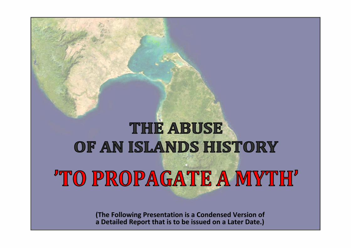
(The Following Presentation is a Condensed Version of a Detailed Report that is to be issued on a Later Date.)
The island has a proud heritage with a continuous written record of human settlement for more than two millennia –the island lays claim to a 2500 year written history that has very few comparables in the world today. This unique history has however been tainted by the violence of a 30 year insurgency, led by an ethno-nationalistic separatist group – the LTTE, to carve out a “Mono Ethnic Homeland” for the Islands Sri Lankan Tamil Minority.
In support of this endeavour, the History of the Island has been deliberately distorted and misused to support a claim for racial segregation.
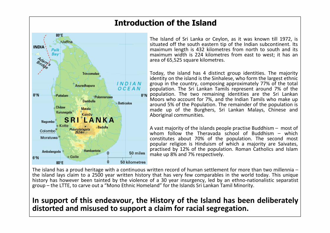
Introduction of the Island
The Island of Sri Lanka or Ceylon, as it was known till 1972, issituated off the south eastern tip of the Indian subcontinent. Its maximum length is 432 kilometres from north to south and its maximum width is 224 kilometres from east to west; it has an area of 65,525 square kilometres.
Today, the island has 4 distinct group identities. The majority identity on the island is the Sinhalese, who form the largest ethnic group in the country, composing approximately 77% of the total population. The Sri Lankan Tamils represent around 7% of the population. The two remaining identities are the Sri Lankan Moors who account for 7%, and the Indian Tamils who make up around 5% of the Population. The remainder of the population is made up of the Burghers, Sri Lankan Malays, Chinese and Aboriginal communities.
A vast majority of the islands people practise Buddhism – most of whom follow the Theravada school of Buddhism – which constitutes about 70% of the population. The second most popular religion is Hinduism of which a majority are Saivates, practised by 12% of the population. Roman Catholics and Islam make up 8% and 7% respectively.

Mr. V. Prabhakaran
leader of the LTTE
Mr. S.J.V. Chelvanayakam
Tamil separatism, and its ultimate goal of a separate Tamil nation carved out of the Sri Lankan entity, was originally articulated as far back as 1947 – a year before Sri Lanka became an independent state. The call for secession was made well before the existence of ‘Tamil grievances’, which are the reasons now being cited as the justification behind the need for a separate Tamil nation.
On November 26th 1947, Mr. S.J.V. Chelvanayakam (Founder and leader of the Ilankai Tamil Trasu Kadchi “Lanka Tamil State Party” or commonly referred to as “the Federal Party”), speaking in the House of Representatives, said:
The use of ancient history to support a claim for an exclusive Tamil Homeland was further emphasized in the Election Manifesto of the Tamil United Liberation Front (TULF) – a descendant of the Federal Party – in 1977. The first resolution states:
Using these distorted ideological concepts of a Mono-Ethnic Tamil principality, the LTTE has embarked on a violent military campaign to physically carve out the area proposed in the first resolution of the TULF election manifesto.
To examine this claim’s integrity and accuracy of a geo centric, mono ethnic, Tamil region, it is important to properly assess the origins of this claim, and the historical evidence used to justify it.
Tamil Separatism Existed “Before” Claims of Discrimination
NOW
THEN
“…If Ceylon is fighting to secede from the British Empire, why should not the Tamil people, if they feel like it, secede from the rest of the country?“
“…The territory from Chilaw through Puttalam to Mannar and thence to the North and from there covering the East stretching to Kumana in the south through Trincomalee and Batticaloa was firmly established as the exclusive homeland of the Tamils. This is the territory of Tamil Eelam.”
A Short History of the Island from (900 BC – 1500 AD)
Early Inhabitants
The island's first human settlers were probably tribes of the proto-Australoid ethnic group, akin to the Pre-Dravidian hill tribes of southern India, and the Munda speaking tribes of the Naga Land in North East India.
Anuradhapura is Unique
Around c. 900 BC, sees the emergence of a city culture at the citadel of the first known metropolis at Anuradhapura. Historical evidence shows that these people who not only knew the use of iron and horse harnessing, but also the use of high-grade pottery.
By around c. 600 BC the settlement at Anuradhapura is already a large town. The first evidence of the use of writing on the Island is discovered on pottery. The symbols appear to be of the Indian Brahmi scrip, written in the Prakritic language. This language is an off-shoot of the North India languages that have been called "Indo-Aryan". The settlement at Anuradhapura c. 600 BC is unique because no other settlements of similar magnitude have been discovered in Peninsular India up to the city of Ujjain in North West India.
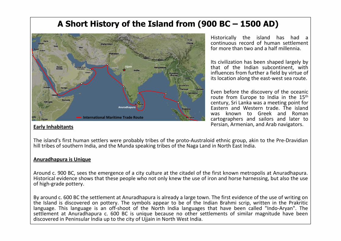
Historically the island has had a continuous record of human settlement for more than two and a half millennia.
Its civilization has been shaped largely by that of the Indian subcontinent, with influences from further a field by virtue of its location along the east-west sea route.
Even before the discovery of the oceanic route from Europe to India in the 15th
century, Sri Lanka was a meeting point for Eastern and Western trade. The island was known to Greek and Roman cartographers and sailors and later to Persian, Armenian, and Arab navigators.
Ujjain
Anuradhapura
International Maritime Trade Route

The time around c. 300 BC saw the introduction to the island, its greatest external influence, namely, the Prakrit civilization with Buddhism running through as its main theme. The numerous lithic records – the substance of over 80% of the Brahmi Prakrit inscriptions found on the island – indicted over cave dwellings and other rock surfaces throughout the country, recorded over one thousand religious donations by an enthusiastic population, consisting more of humdrum artisans and devotees in addition to village chieftains and a few members of the royalty.
Use of a Single Language
This evidence strongly indicates that following the introduction of Buddhism in c. 300 BC, there had been a great people’s movement to be enthusiastic partners of the new religious order, with a single language in use on the island from c. 300 BC to c. 100 AD. The activity points to a great demand for stone masons and manufacturers of iron tools in large numbers.
The Settlement Crescent
The spatial distribution of ancient irrigation structures, the distribution of epigraphical stone inscriptions; the distribution of tribal settlements, capital cities/towns as revealed in the ancient Buddhist Pali chronicles (The Dipavamsa and Mahavamsa) indicates that the densely populated areas were located in the Dry and Intermediate climatic Zones; while the Wet zone and the Arid zone in the north were sparsely populated. (Map 1) indicates this distribution which takes the shape of a Crescent. This region is called the Ancient Settlement Crescent of Sri Lanka. Archaeological excavations reveal that during the period 300 BC to 100 AD, apart from Anuradhapura, the next most populated region on the Island was at Mahagama in the extreme South of the Island. The Pali Chronicles state that in the early Anuradhapura period there were three separate Kingdoms on the island – Rajarata (Anuradhapura), Malaya Rata (Kelaniya) and Ruhuna (Mahagama), and that whenever invaders to the island seized power in Anuradhapura the Kings withdrew inland, regrouped, obtained reinforcements and chased out the enemy (Map 2).
Formation of the Sinhala “Conscience” in ‘Lanka’(Map 1)
(Map 2)

The Island was known to many countries in the medieval times. The Kingdom at Anuradhapura pursued an active foreign policy and established links with many foreign countries. Sri Lanka is mentioned in Greek and Roman writings dating from the third century BC by Kalisthenes, Oneskritus, Megasthenes, Strabo, and Pliny. Sri Lanka was included in the map of Asia, drawn in 150 AD by the famous Greek Cartographer – Claudius Ptolemy.
Ptolemy divided the world into different continents and divided “Asia” into 12 sections of which “Taprobane”comprised the 12th. He gave the co-ordinates of 49 points of interest and described those including Ports, Cities, five major rivers, with co-ordinates of their mouths and sources, important land marks like Adams' Peak etc.
Ptolemy indicated Peninsula Jaffna as "Post que est Boreu Prom" or the northernmost promontory. “Nagadipi” or Nagadipa was indicated as lying between the river Phasis Fluvius (following northwards viz. Mahaweli) and Ganges Fluvius (flowing eastward viz Gal Oya) a region which lay in the Eastern Ruhuna Kingdom.
What is quite striking is the complete absence of any importance given to the present day Jaffna peninsular. Apart from the peninsula being referred to as the "northernmost point“, it is not accorded a specific name or any significance given to its likely inhabitants. Ptolemy’s map thus indicates no independent principality in the North of the Island at the time with any harbours in the vicinity of any international significance. It is interesting to note that most, if not all cartographic renderings in the early periods of the first few centuries, did not indicate Peninsular Jaffna.
The First Map of ‘Lanka’ - Taprobane
With the advent of Buddhism, and with it the widespread use of the Prakritic language as seen by the numerous lithicinscriptions in 300 BC, a “Sinhala” conscience, with a unique Sinhala identity begins to assert itself throughout the island. It is during this period the island begins to see the development of a Proto-Sinhala language based around the Prakrit language. The Island from 300 BC to 1200 AD will witness a colossal transformation to its natural environment, with a vast civilization based on a hydraulic agrarian society colonising every inch of the Island – this will be known as the golden age of the Sinhalese.
The Jaffna peninsula only begins to take significance in the overall spectrum of the Islands history after the 13th
century AD.
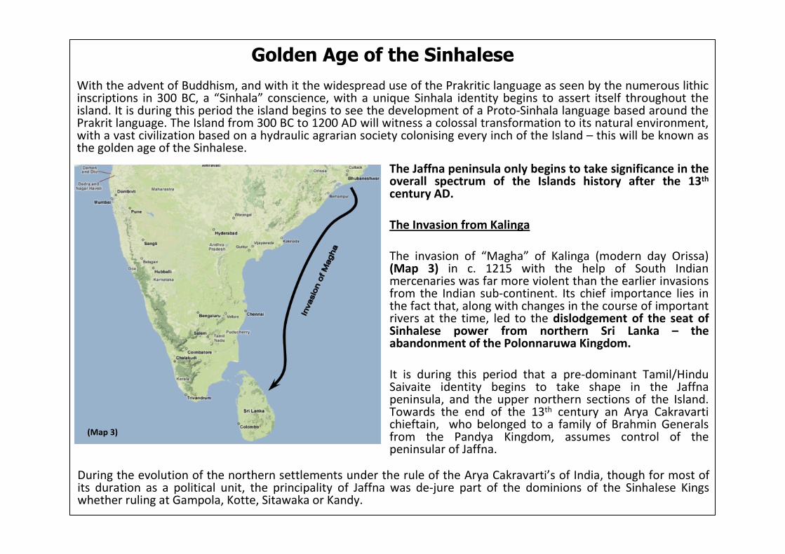
The Invasion from Kalinga
The invasion of “Magha” of Kalinga (modern day Orissa) (Map 3) in c. 1215 with the help of South Indian mercenaries was far more violent than the earlier invasions from the Indian sub-continent. Its chief importance lies in the fact that, along with changes in the course of important rivers at the time, led to the dislodgement of the seat of Sinhalese power from northern Sri Lanka – the abandonment of the Polonnaruwa Kingdom.
It is during this period that a pre-dominant Tamil/Hindu Saivaite identity begins to take shape in the Jaffna peninsula, and the upper northern sections of the Island. Towards the end of the 13th century an Arya Cakravartichieftain, who belonged to a family of Brahmin Generals from the Pandya Kingdom, assumes control of the peninsular of Jaffna.
Golden Age of the Sinhalese
During the evolution of the northern settlements under the rule of the Arya Cakravarti’s of India, though for most of its duration as a political unit, the principality of Jaffna was de-jure part of the dominions of the Sinhalese Kings whether ruling at Gampola, Kotte, Sitawaka or Kandy.
(Map 3)
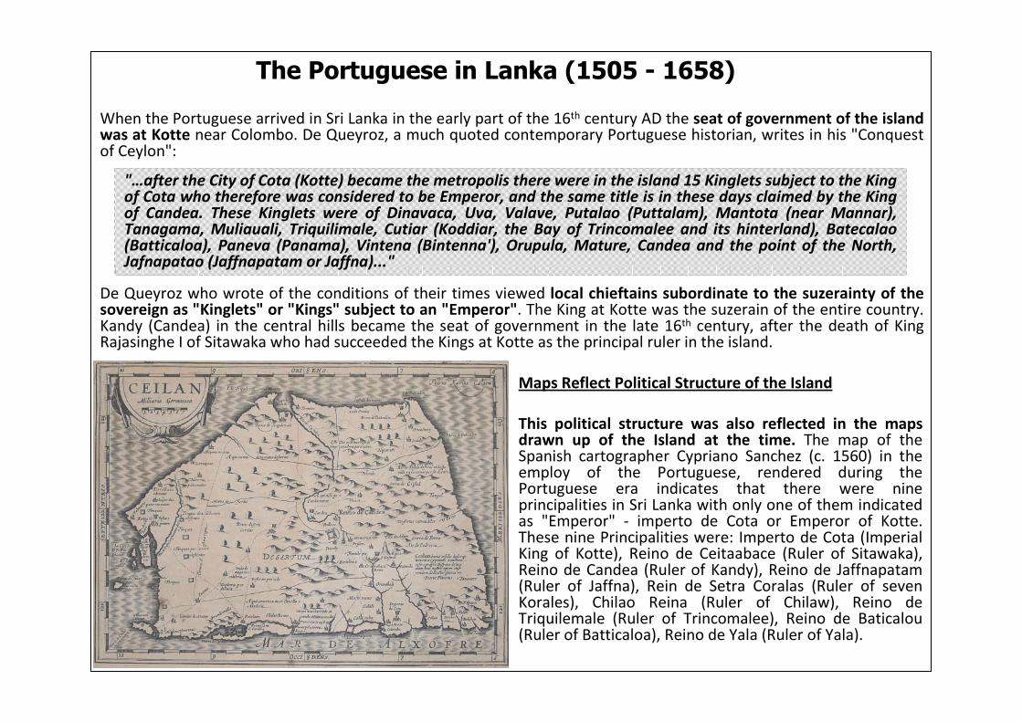
The Portuguese in Lanka (1505 - 1658)
When the Portuguese arrived in Sri Lanka in the early part of the 16th century AD the seat of government of the island was at Kotte near Colombo. De Queyroz, a much quoted contemporary Portuguese historian, writes in his "Conquest of Ceylon":
De Queyroz who wrote of the conditions of their times viewed local chieftains subordinate to the suzerainty of the sovereign as "Kinglets" or "Kings" subject to an "Emperor". The King at Kotte was the suzerain of the entire country. Kandy (Candea) in the central hills became the seat of government in the late 16th century, after the death of King Rajasinghe I of Sitawaka who had succeeded the Kings at Kotte as the principal ruler in the island.
Maps Reflect Political Structure of the Island
This political structure was also reflected in the maps drawn up of the Island at the time. The map of the Spanish cartographer Cypriano Sanchez (c. 1560) in the employ of the Portuguese, rendered during the Portuguese era indicates that there were nine principalities in Sri Lanka with only one of them indicated as "Emperor" - imperto de Cota or Emperor of Kotte. These nine Principalities were: Imperto de Cota (Imperial King of Kotte), Reino de Ceitaabace (Ruler of Sitawaka), Reino de Candea (Ruler of Kandy), Reino de Jaffnapatam(Ruler of Jaffna), Rein de Setra Coralas (Ruler of seven Korales), Chilao Reina (Ruler of Chilaw), Reino de Triquilemale (Ruler of Trincomalee), Reino de Baticalou(Ruler of Batticaloa), Reino de Yala (Ruler of Yala).
"…after the City of Cota (Kotte) became the metropolis there were in the island 15 Kinglets subject to the King of Cota who therefore was considered to be Emperor, and the same title is in these days claimed by the King of Candea. These Kinglets were of Dinavaca, Uva, Valave, Putalao (Puttalam), Mantota (near Mannar), Tanagama, Muliauali, Triquilimale, Cutiar (Koddiar, the Bay of Trincomalee and its hinterland), Batecalao(Batticaloa), Paneva (Panama), Vintena (Bintenna'), Orupula, Mature, Candea and the point of the North, Jafnapatao (Jaffnapatam or Jaffna)..."
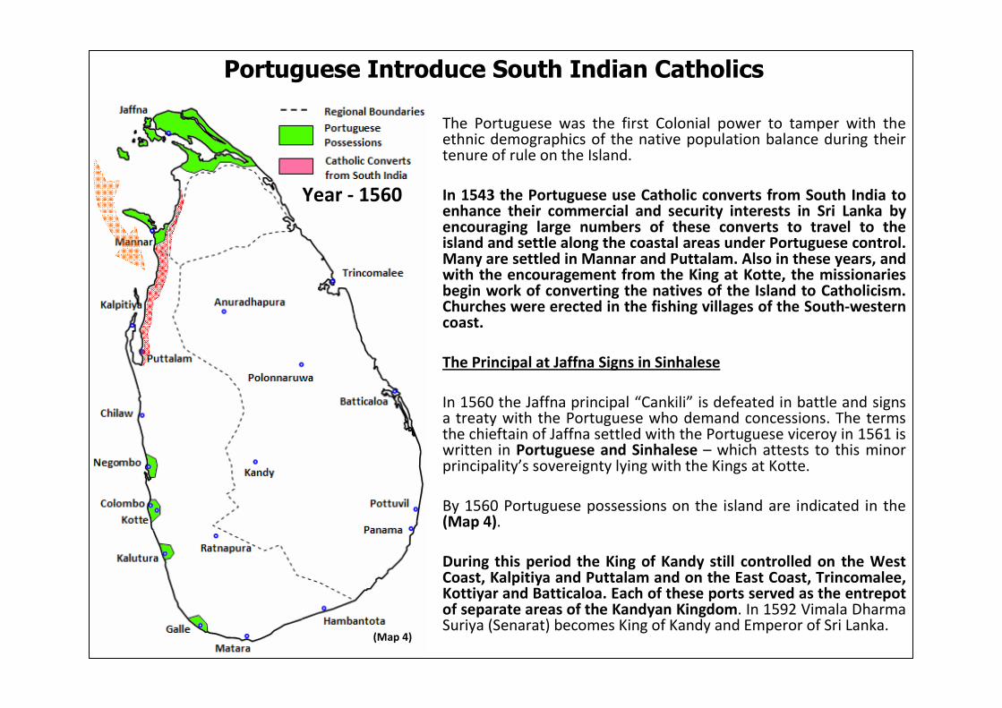
The Portuguese was the first Colonial power to tamper with the ethnic demographics of the native population balance during their tenure of rule on the Island.
In 1543 the Portuguese use Catholic converts from South India toenhance their commercial and security interests in Sri Lanka by encouraging large numbers of these converts to travel to the island and settle along the coastal areas under Portuguese control. Many are settled in Mannar and Puttalam. Also in these years, and with the encouragement from the King at Kotte, the missionaries begin work of converting the natives of the Island to Catholicism. Churches were erected in the fishing villages of the South-western coast.
The Principal at Jaffna Signs in Sinhalese
In 1560 the Jaffna principal “Cankili” is defeated in battle and signs a treaty with the Portuguese who demand concessions. The terms the chieftain of Jaffna settled with the Portuguese viceroy in 1561 is written in Portuguese and Sinhalese – which attests to this minor principality’s sovereignty lying with the Kings at Kotte.
By 1560 Portuguese possessions on the island are indicated in the (Map 4).
During this period the King of Kandy still controlled on the West Coast, Kalpitiya and Puttalam and on the East Coast, Trincomalee, Kottiyar and Batticaloa. Each of these ports served as the entrepotof separate areas of the Kandyan Kingdom. In 1592 Vimala Dharma Suriya (Senarat) becomes King of Kandy and Emperor of Sri Lanka.
Portuguese Introduce South Indian Catholics
(Map 4)
Year - 1560

By c. 1600, the areas under the Kandyan King is the only remaining region of sovereign native power on the Island. The Kingdom acquired a new significance as the custodian and protector of Buddhism, and the seat of Sinhalese Nationalism. The Portuguesepossessions at the time are indicated in (Map 5).
The Portuguese now controlled a considerable part of the island,except the Central Highlands and eastern coast, where King Senerathad established himself and consolidated his authority.
Kandyan King Conspires to Remove the Portuguese
The King realized that without sea power he could not drive the Portuguese out of Sri Lanka. He saw the arrival of the Dutch as an excellent opportunity to gain naval support against his adversaries. The first Dutch envoy, Admiral Jois Van Spilbergen landed in the Kandyan Port of Batticaloa in 1602 and was taken to the Court of King Wimaladharmasuriya in Kandy.
In 1612 a Dutch envoy, Marcelis Boschouwer, concluded a treaty with King Senarat. The King granted the Dutch extensive commercial concessions and a harbour for settlement on the east coast in return for a promise of armed assistance against Portuguese attack.
Kandyan Kingdom Resists Western Rule
Year - 1600
KANDYAN
KINGDOM
(Map 5)
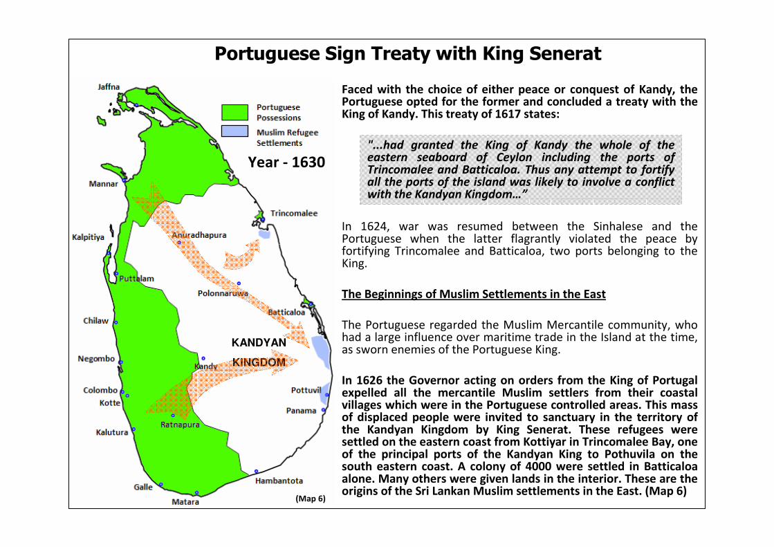
Faced with the choice of either peace or conquest of Kandy, the Portuguese opted for the former and concluded a treaty with the King of Kandy. This treaty of 1617 states:
In 1624, war was resumed between the Sinhalese and the Portuguese when the latter flagrantly violated the peace by fortifying Trincomalee and Batticaloa, two ports belonging to the King.
The Beginnings of Muslim Settlements in the East
The Portuguese regarded the Muslim Mercantile community, who had a large influence over maritime trade in the Island at the time, as sworn enemies of the Portuguese King.
In 1626 the Governor acting on orders from the King of Portugal expelled all the mercantile Muslim settlers from their coastal villages which were in the Portuguese controlled areas. This mass of displaced people were invited to sanctuary in the territory of the Kandyan Kingdom by King Senerat. These refugees were settled on the eastern coast from Kottiyar in Trincomalee Bay, one of the principal ports of the Kandyan King to Pothuvila on the south eastern coast. A colony of 4000 were settled in Batticaloaalone. Many others were given lands in the interior. These are the origins of the Sri Lankan Muslim settlements in the East. (Map 6)
Portuguese Sign Treaty with King Senerat
KANDYAN
KINGDOM
(Map 6)
Year - 1630"...had granted the King of Kandy the whole of the eastern seaboard of Ceylon including the ports of Trincomalee and Batticaloa. Thus any attempt to fortify all the ports of the island was likely to involve a conflict with the Kandyan Kingdom…”
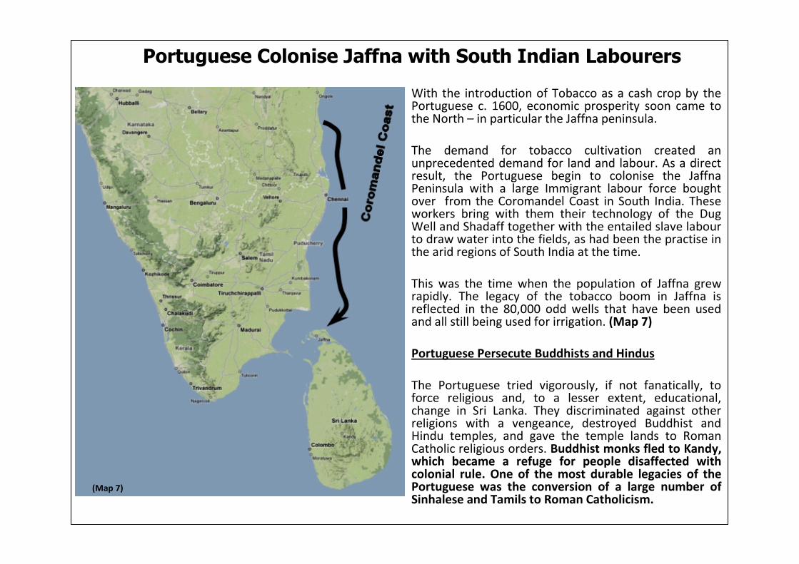
With the introduction of Tobacco as a cash crop by the Portuguese c. 1600, economic prosperity soon came to the North – in particular the Jaffna peninsula.
The demand for tobacco cultivation created an unprecedented demand for land and labour. As a direct result, the Portuguese begin to colonise the Jaffna Peninsula with a large Immigrant labour force bought over from the Coromandel Coast in South India. These workers bring with them their technology of the Dug Well and Shadaff together with the entailed slave labour to draw water into the fields, as had been the practise in the arid regions of South India at the time.
This was the time when the population of Jaffna grew rapidly. The legacy of the tobacco boom in Jaffna is reflected in the 80,000 odd wells that have been used and all still being used for irrigation. (Map 7)
Portuguese Persecute Buddhists and Hindus
The Portuguese tried vigorously, if not fanatically, to force religious and, to a lesser extent, educational, change in Sri Lanka. They discriminated against other religions with a vengeance, destroyed Buddhist and Hindu temples, and gave the temple lands to Roman Catholic religious orders. Buddhist monks fled to Kandy, which became a refuge for people disaffected with colonial rule. One of the most durable legacies of the Portuguese was the conversion of a large number of Sinhalese and Tamils to Roman Catholicism.
Portuguese Colonise Jaffna with South Indian Labourers
(Map 7)

In 1635 King Senarat was succeeded to the throne by his son Rajasinha II. The new King sought the help of the Dutch in ousting the Portuguese from Sri Lanka. The King sent emissaries to meet the admiral of the Dutch fleet, Adam Westerwolt. The Dutch seizing the opportunity to get a foothold in Sri Lanka attacked Batticaloa on behalf of the Sinhalese King.
King of Kandy Signs Treaty with Dutch
Westerwolt and Rajasinha II concluded a treaty on May 23, 1638 giving the Dutch a monopoly on most of Sri Lanka’s cinnamon and a repayment in merchandise for expenses incurred in assisting the King:
In May 1639 the Dutch fleet captured Trincomalee, and in February 1640 the Dutch and the Kandyans combined to take Negombo and Galle. But differences arose over the occupation of captured forts. The Dutch refused to give Trincomalee and Batticaloa to the King until their expenses were paid in full, and Rajasinha II realized that what the Dutch really wanted was to replace the Portuguese as the rulers of the coast.
In 1645 the boundaries between Portuguese and Dutch territory inSri Lanka were demarcated. Jan Thijssen was appointed the first Dutch governor of Sri Lanka. (Map 8)
King of Kandy Brings in the Dutch
KANDYAN
KINGDOM
(Map 8)
Year - 1645
"...we declare sincerely by these (presents) that (we would) rather abandon the work begun in Ceylon (despite the conquest of the forts of Batticaloa and Trincomalee which has been made for the service of Your Imperial Majesty) and hand over the aforesaid forts to Your Imperial Majesty..."
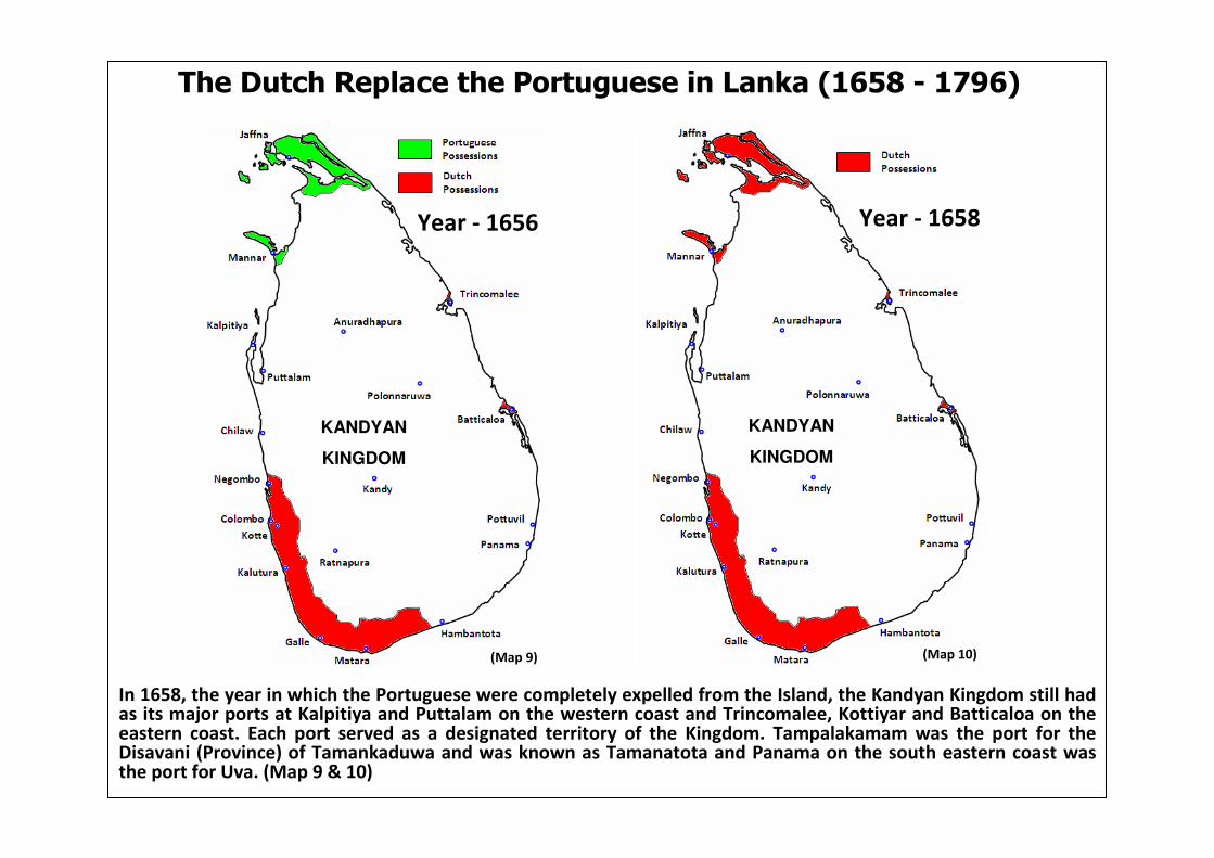
The Dutch Replace the Portuguese in Lanka (1658 - 1796)
In 1658, the year in which the Portuguese were completely expelled from the Island, the Kandyan Kingdom still had as its major ports at Kalpitiya and Puttalam on the western coast and Trincomalee, Kottiyar and Batticaloa on the eastern coast. Each port served as a designated territory of the Kingdom. Tampalakamam was the port for the Disavani (Province) of Tamankaduwa and was known as Tamanatota and Panama on the south eastern coast was the port for Uva. (Map 9 & 10)
KANDYAN
KINGDOM
(Map 9)
Year - 1656
KANDYAN
KINGDOM
(Map 10)
Year - 1658

‘Thesavalami’ - Recent Origin of Jaffna Settlers
To help with this increased drive to cultivate Tobacco, the Dutch bought in slave labour from the Malabar coast in Kerala, India. This increased presence of Malabars in the Jaffna peninsula lead to the Dutch implementing the “Thesavalamai” Law or “The Customary Rules of the Locality” as codified by the Dutch in 1707. The law only applies to the "the Malabars of the Province of Jafnapatam“ who were brought in from India. (Map 11)
Foreigners in Jaffna
This influx of foreign labour had such a dramatic effect on the population in the Peninsular, that in 1803, English officials would observe that:
Cash Crop and the Indian Migration
(Map 11)
“…The inhabitants of Jaffna consist of a collection of various races. The greatest number are of Moorish extraction, and are divided into several tribes… they are distinguished by wearing a little round cap on their close shaven heads. There is also a race of Malabars found here somewhat differing in their appearance from those on the continent. These tribes of foreign settlers greatly exceed in number the native Ceylonese in the district of Jaffna…"
Tobacco production which was introduced during Portuguese rule, having thrived in the Jaffna Peninsula, was expanded further by the new Dutch Administrators. In addition the Dutch introduced another new cash crop to the Island – coffee; the cultivation of which was actively encouraged by the VOC (Dutch East India Company).
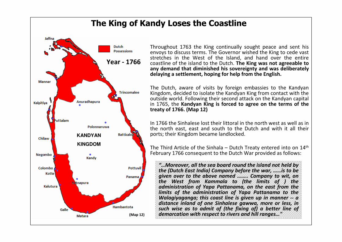
Throughout 1763 the King continually sought peace and sent his envoys to discuss terms. The Governor wished the King to cede vast stretches in the West of the Island, and hand over the entire coastline of the island to the Dutch. The King was not agreeable to any demand that diminished his sovereignty and was deliberately delaying a settlement, hoping for help from the English.
The Dutch, aware of visits by foreign embassies to the KandyanKingdom, decided to isolate the Kandyan King from contact with the outside world. Following their second attack on the Kandyan capital in 1765, the Kandyan King is forced to agree on the terms of the treaty of 1766. (Map 12)
In 1766 the Sinhalese lost their littoral in the north west as well as in the north east, east and south to the Dutch and with it all their ports; their Kingdom became landlocked.
The Third Article of the Sinhala – Dutch Treaty entered into on 14th
February 1766 consequent to the Dutch War provided as follows:
The King of Kandy Loses the Coastline
KANDYAN
KINGDOM
(Map 12)
Year - 1766
“…Moreover, all the sea board round the island not held by the (Dutch East India) Company before the war, ……is to be given over to the above named …….. Company to wit, on the West from Kammala to (the limits of ) the administration of Yapa Pattanama, on the east from the limits of the administration of Yapa Pattanama to the Walagiyaganga; this coast line is given up in manner -- a distance inland of one Sinhalese gawwa, more or less, in such wise as to admit of (the fixing of) a better line of demarcation with respect to rivers and hill ranges…"
After the Dutch took over lands in the east in 1766 they restored and constructed irrigation works close to the coast. Lands benefiting by such works belonged to the government and was made available to the Tamil/Malabar and Mercantile Muslim inhabitants of the coastal areas. These initial irrigation schemes were the early beginnings of Colonial sponsored demographic changes in the East. Further changes in the balance of the communities were bought about when immigrants from South India were bought over by the Dutch and settled in these schemes. The Dutch also developed Trincomalee town for the benefit of their naval establishment, and brought in Tamil settlers from Jaffna to populate the town. More than half the population of a sparsely populated district was soon made up by such settlers.
Van Lier's Map
The territorial boundaries before the 1766 treaty are indicated in the map: "The island of Ceylon at the time of King Senarath Lankadiep". This map was a virtual watershed in the cartography of Sri Lanka as regards to intensity of information within defined territorial and Korale boundaries. This map, published in 1751 under the name of B VanLier, can be found in the Hague archives in the Netherlands. The territorial boundaries depicted in this map are valid from the time of King Senarath of Kandy (1653), to that of King Kirthi Rjasinghe's treaty (1766).
The information in Van Lier's Map is of tremendous importance. The Dutch governed areas (showdotted) all limited to the South West area, Mannar and Jaffna, while the entirety of the rest of the county is shown as Kandyan territory. The dark shaded areas show the Vanni district which changed their fealty alternately to whoever was more powerful (Map 13). The Vanni functioned as a buffer zone between the Dutch territory in the Peninsula and that of the Kandyan Kingdom.
The Vanni and its People
The Vanni and its people represented an interesting subculture at the time; a mix of the Islands indigenous culture and that imported by immigrant groups led by their chieftains. This subculture of the Vanniyas – the amalgam of Sinhalese inhabitants, Veddas and immigrant families of chieftains and their retinues fused into the local population in varying degrees – was superseded in the Northern province by the action of the Dutch who took over the lands of Vanniyas and sold them to rich Jaffna Tamils.
The Dutch Discriminate Against the Sinhalese

Van Lier's Map (1653 – 1766 AD)
(Map 13)
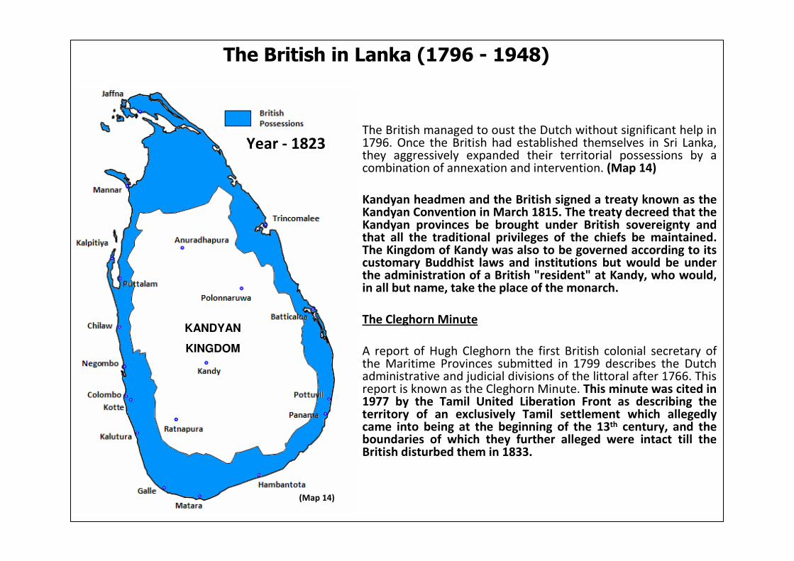
The British in Lanka (1796 - 1948)
The British managed to oust the Dutch without significant help in 1796. Once the British had established themselves in Sri Lanka, they aggressively expanded their territorial possessions by a combination of annexation and intervention. (Map 14)
Kandyan headmen and the British signed a treaty known as the Kandyan Convention in March 1815. The treaty decreed that the Kandyan provinces be brought under British sovereignty and that all the traditional privileges of the chiefs be maintained.The Kingdom of Kandy was also to be governed according to its customary Buddhist laws and institutions but would be under the administration of a British "resident" at Kandy, who would, in all but name, take the place of the monarch.
The Cleghorn Minute
A report of Hugh Cleghorn the first British colonial secretary of the Maritime Provinces submitted in 1799 describes the Dutch administrative and judicial divisions of the littoral after 1766. This report is known as the Cleghorn Minute. This minute was cited in 1977 by the Tamil United Liberation Front as describing the territory of an exclusively Tamil settlement which allegedly came into being at the beginning of the 13th century, and the boundaries of which they further alleged were intact till the British disturbed them in 1833.
KANDYAN
KINGDOM
(Map 14)
Year - 1823
KANDYAN
KINGDOM

Cleghorn was ordered to furnish a report on the "Administration of Justice and Revenue in the Dutch Settlements" as at 1796 when they were surrendered by the Dutch to the British. The result was the celebrated Minute.
The Cleghorn Minute, an accurate account of Dutch administration after 1766, actually describes the administrative divisions of the Dutch territory as at 1796 – not an independent Tamil nation. The administration of territory in the east and how the Dutch acquired that territory from the Sinhalese consequent to the Treaty of 1766 is described by Cleghorn as follows:
The acquisition of the western half of the Sinhala disavani of Puttalama is also described:
The British substantially retained the Dutch district of Trincomalee but added a large area of the Wellassa and Bintenna of the Kandyan Kingdom to the Batticaloa district which they demarcated as part of the Eastern Province which they constituted in 1833 and reconstituted in 1873.
The Minute Does Not Speak of a “Tamil Homeland”
“…Trincomale was under a military commandeur, and till the year 1766 had but a very small territory annexed to its government. At that period the Candians ceded to the (Dutch East India ) Company the countries (i.e. districts) of Coetiar, Tamblegamme, and Koutamcolonpattoe (Kaddukulampattu) These three countries were fertile in grain, and moderately populous, but of late years their agriculture has been mostly ruined, partly from the conduct of the chiefs, and partly from the various changes of government which Trincomale has experienced. A Land Raad has also been established at Trincomale…”
“…Batticaloa, the first possession of the Dutch on the island of Ceylon. was formerly under a military chief, until the peace with Candia in the year 1766 and had no other territory but the small Island of Poeliantivveat the mouth of the river. But at the peace in 1766 the Company obtained in sovereignty from the Candians, the eight provinces of Batticaloa. These countries are now governed by civil servant and a Land Raad…“
“…Calpetty (Kalpitiya) and Putalam were under a civil chief. The island of Calpetty was an ancient possession of the (Dutch East India) Company. The very narrow district of Putalam was ceded to it by the King of Candia (Kandy) at the peace of 1766, together with the territory of Chilow which (now) forms a part of the Dessavene of Colombo… “

In the 19th century the British began restoring and constructing irrigation works in the eastern littoral for the benefit of the coastal population of Muslims and Tamils; a vast many of these settlers were immigrants from Jaffna and South India. The numerous Sinhala farming areas in the interior were deliberately neglected and allowed to go to ruin due to policies adopted to suppress the Sinhalese after the great rebellion of 1817-18.
What happened generally in the east has been recorded in the famous report on Forest Administration of Ceylon by F.D'A Vincent in 1882:
Changing the Demographics of the East
Until independence in 1948, the state of the Eastern Province was that of neglect and decay of the extensive but sparsely populated Sinhala areas, and development of the coastal areas populated byTamils and Muslims. The favourable conditions created in the non-Sinhala areas by the colonial government resulted in the movement of ethnic groups in large numbers to the coastal areas.(Map 15)
The Movement of
Tamil and Muslim
settlers
The Movement of the
Sinhalese
The British Colonise the East with Tamils & Muslims
(Map 15)
“…the gradual spread of the Tamils down the coasts, especially the eastern, and the fact that no where except in the northern province and Tamankaduwa, do they form more than coast settlements, are both striking. Where ever the Tamil or the Mahommedancomes to settle, the Sinhalese is driven back to the forest, where he earns a precarious existence by chena cultivation and by hunting…"

The Colebrooke-Cameron Reforms of (1831-32) was an important phase in the history of the island.
Colebrooke believed that in the past, separate administrative systems had encouraged social and cultural divisions, and that the first step toward the creation of a modern nation was the administrative unification of the country.
Till 1933 the British in essence substantially retained the Dutch divisions within the country. Following the Colebrooke-Cameron reforms, the Island was to be divided into five provinces. Largechunks of the Kandyan Kingdom was included in the newly formed Northern and Eastern Provinces.
It is patently evident that the British provincial demarcation of the Island in the 19th century was not based on ethnic, religious or linguistic criteria or to recognize such differentiations in administrative or political affairs of the country; but, purely for administrative convenience of the colonial government. What is not revealed is that this new administrative demarcation was deliberately implemented to weaken the unity and the social integrity of the Sinhalese, while furthering the British policy of divide and rule. (Map 16)
The British Introduce the Provincial System
(Map 16)

In the mid-1830s, the British began to experiment with a variety of plantation crops in Sri Lanka – initially Coffee then Tea. The coffee plantation system faced a serious labour shortage. To compensate for this scarcity of native workers, an inexpensive and almost inexhaustible supply of labour was found among the Tamils in southern India. They were recruited for the coffee-harvesting season and migrated to and from Sri Lanka. The immigration of these Indian Tamils began as a trickle in the 1830s and became a regular flow a decade later, when the government of India removed all restrictions on the migration of labour to Sri Lanka.
British civilian and military officials resident in Kandyprovided initial capital for coffee cultivation, provoking contemporary observations in the 1840s that the Administrators behaved more like coffee planters than government employees.
This private capitalization led to serious abuses, culminating in an 1840 ordinance that made it virtually impossible for a Kandyan peasant to prove that his land was not truly crown land and thus subject to expropriation and resale to coffee interests.
In this period, more than 80,000 hectares of Kandyanland were appropriated and sold as crown lands.
As a result of falling coffee prices, taxes introduced by the British in order to make up for lost revenue, severely affected the Sinhalese farmers. But the measure that most antagonized the Kandyans (especially those associated with the Buddhist Sangha) was the alienation of temple lands for coffee plantations. This lead to rebellion in 1848.
The British Bring Even More From India
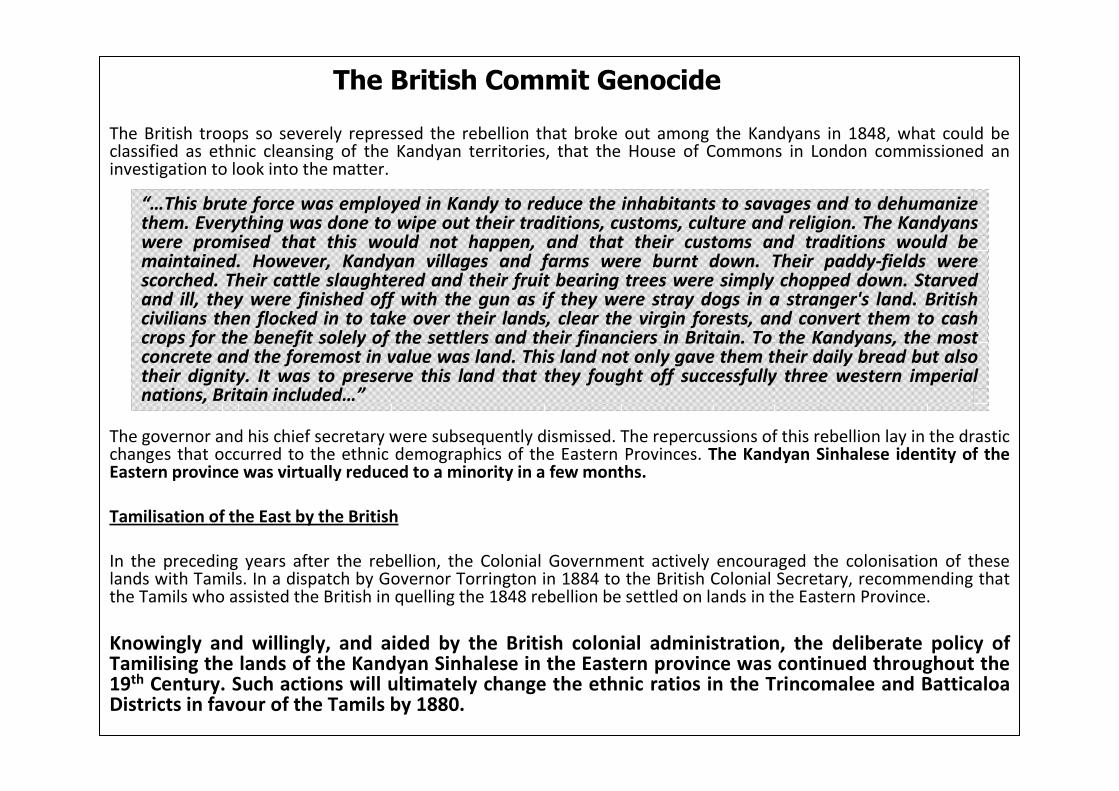
The British troops so severely repressed the rebellion that broke out among the Kandyans in 1848, what could be classified as ethnic cleansing of the Kandyan territories, that the House of Commons in London commissioned an investigation to look into the matter.
The governor and his chief secretary were subsequently dismissed. The repercussions of this rebellion lay in the drastic changes that occurred to the ethnic demographics of the Eastern Provinces. The Kandyan Sinhalese identity of the Eastern province was virtually reduced to a minority in a few months.
Tamilisation of the East by the British
In the preceding years after the rebellion, the Colonial Government actively encouraged the colonisation of these lands with Tamils. In a dispatch by Governor Torrington in 1884 to the British Colonial Secretary, recommending that the Tamils who assisted the British in quelling the 1848 rebellion be settled on lands in the Eastern Province.
Knowingly and willingly, and aided by the British colonial administration, the deliberate policy of Tamilising the lands of the Kandyan Sinhalese in the Eastern province was continued throughout the 19th Century. Such actions will ultimately change the ethnic ratios in the Trincomalee and BatticaloaDistricts in favour of the Tamils by 1880.
The British Commit Genocide
“…This brute force was employed in Kandy to reduce the inhabitants to savages and to dehumanize them. Everything was done to wipe out their traditions, customs, culture and religion. The Kandyanswere promised that this would not happen, and that their customs and traditions would be maintained. However, Kandyan villages and farms were burnt down. Their paddy-fields were scorched. Their cattle slaughtered and their fruit bearing trees were simply chopped down. Starved and ill, they were finished off with the gun as if they were stray dogs in a stranger's land. British civilians then flocked in to take over their lands, clear the virgin forests, and convert them to cash crops for the benefit solely of the settlers and their financiers in Britain. To the Kandyans, the most concrete and the foremost in value was land. This land not only gave them their daily bread but also their dignity. It was to preserve this land that they fought off successfully three western imperial nations, Britain included…”

Subsequent to the collapse of the Coffee industry in Sri Lanka in around 1870, the British Plantation workers experimented with other crops. The result was the beginnings of the vast Tea plantations of today.
The tea estates needed a completely different type of labour force than had been required during the coffee era. Tea was harvested throughout the year and required a permanent labour force. Waves of Indian Tamil immigrants were settled on these estates. (Map 17)
The impact of colonising the Island with South Indian labourers is clearly evident in the census of 1911. Over a short space of 40 years of importing an immigrant labour force, by 1911 the recorded number of Indianlabourers in Sri Lanka was at around 500,000 – about 12% of the island's total population.
This statistic exemplifies the impact of colonisation. Since theadvent of the Portuguese in 1505, the Dutch in 1696, and finallythe British in 1796 – the import of migrant labour from South India definitively changed the ethnic demographics all around the Island. In the Northern and Eastern regions of the Island, the Tamil and Muslim populations swelled to disproportionate levels, and in many instances it was only the Sinhalese that suffered as a result.
The Migration Continues from South India
(Map 17)

The Verdict (2008)
� In the last 50 years, post-colonial historians have amassed a wealth of literature relating to the origins of the Sinhalese and Sri Lankan Tamil identities on the Island. As a result of such works which remained largely within the academic realm, ethno nationalistic politics, and the politicians that practise it have unfortunately abused these findings to stake claim to geographic regions on the Island based on some perceived antiquity.
� One fact that cannot be sidelined or dismissed in any analysis of the history of this Island and its people, is that the most important development in the Island’s history which has come to leave its indelible mark even to this date, is that Sri Lanka has remained over 70% Buddhist with a Sinhalese language majority of over 70% despite intrusions of other religio-cultures not only from India but also from the West for over two millennia. This influential force has to be given due recognition in any history writing of the island.
� The three epochs of European rule on the island lasted roughly 450 years. This period should be collectively seen as a "mighty cantilever of time with the Pax Britannica as the central pillar.” What cannot be refuted – as revealed in archived colonial literature – is the impact of forced colonisation on the Island. Starting from around c. 1550 during the Portuguese era until the 1900’s during British rule, the settlement of foreign migrant workers has had a huge impact on the ethnic distributions of various groups on the Island. These actions have directly led to ethnic minorities becoming majorities at the expense of other community groups in certain geographical localities, and as result, has led to claims of ethnic antiquity and the need for ethnic partitioning.
� The gradual “Tamilisation” of the Island through racial biased colonisation schemes during colonial rule, from the beginning of the 16th Century AD to the 20th Century AD, is a documented fact.
� The Tamil separatist claim for a separate ethnic region covering the North and Eastern Provinces of Sri Lanka is founded on two false premises:
� The entirety of the North and Eastern provinces constitutes the traditional homeland of the Tamils.
� This traditional home land of the Tamils has been colonized by the Sinhalese in recent times (brushing aside the volumes of archaeological, lithic and colonial evidence that debases this theory).

� A case in Point is the Eastern Province:
It is well documented that during Dutch, and early British periods on the island there were isolated Muslim/Tamil settlements confined to regions around the major sea ports in the Eastern coastline – primarily the ports of Kottiyar and Batticaloa. However these reports also document that the vast interior of the Eastern province was dominated by Sinhala Purana (Traditional) villages.
The 1921 Census – well before colonisation schemes of the independent Ceylon Government were introduced –clearly shows that many of the AGA (Assistant Government Agent) Divisions in the Trincomalee and Ampara districts were inhabited in their entirety by the Sinhalese. It has to be noted that this is even after the effects of Colonial sponsored Colonisation schemes which inducted thousands of Tamil/Muslim settlers from outside the region into many divisions in the Eastern Province.
The Census data affords conclusive evidence to show that the large land mass of the interior of the Eastern Province was the domain of the Kandyan Sinhalese, and that a narrow stretch of land in the eastern coast had been inhabited by Tamil and Muslim coastal populations. (Map 18 shows the location of Tamil settlements in the Eastern Province in 1921)
Territories in the Northern Province, especially in the Wanni region, witnessed a similar change in ethnic distributions as a result of Colonial intervention.
(Map 18)

The Inconvenient Truth
� The last 30 years have shown that the LTTE are incapable of compromising to a political solution within the framework of an un-divided Sri Lanka. Unlike the IRA and Sinn Fein where the political wing was in charge of the military wing; within the LTTE, its military agenda is given overwhelming priority over its ineffective political wing. The leader of the LTTE has been quoted on several occasions claiming that: “he should be killed if he drops the Tamil Elam demand”.
� A political solution cannot resolve a terrorist problem, and no military victory can suppress the ethnic grievances claimed to have been inflicted on the Tamil minority. Peace which means law and order for all has to be nurtured in an environment of trust and reconciliation. This cannot be achieved as long as there are non-state actors, not obedient to state authorities, continuing to carry guns, explosives, long range artillery, explosive laden planes and a pirate navy comprised of suicide craft and fast gun boats.
� A good political solution should have the support of the political majority in Sri Lanka devoid of racial divisions, north-south divisions and dry-zone-wet-zone divisions. Such a solution need not be drafted amidst curfews, talked in secrecy and implemented forcibly. People will demand the implementation of such a solution.
� A clear distinction has to be made between addressing Tamil grievances and satisfying separatist Tamil aspirations. It must be accepted by all parties to a future political solution that there can be no political or negotiated solution that can satiate separatist Tamil aspirations. These aspirations are the acceptance of Tamil homeland(s), Tamil nationality and Tamil right of self-determination. The moment these concepts are entertained, Sri Lankan national interests are jeopardised.
� Over 85% of the Sri Lankan population are vehemently against entertaining these separatist Tamil aspirations even in part and hence any political solution that satisfies these aspirations ceases to be political – it would then be an enforced ‘solution’ which will eventually be squashed by the people. There is little sense in breaching the aspirations of over 85% of the population just to satisfy the aspirations of 15% of the population. It is totally against democratic principles.
� A political solution, for it to continue, must encompass aspirations and wishes of most Sri Lankans. Unless the Sinhalese and the Muslims gain anything from a political solution, they will never support it. For them to gain, let alone not to lose anything, the political solution must be within Sri Lankan national interests which in turn is incompatible with separatist Tamil aspirations. This is the unpalatable truth about political solutions.

� Genuine Tamil aspirations are exactly the same as the aspirations of all the communities on the Island: These aspirations are not concerned with state power, but are more about equal opportunities over employment, the ability to practice ones religious and cultural beliefs without persecution, access to free and fair educational opportunities for their children, and leading a life which ensures their physical safety.
� Ethno nationalism, often antiquarian, holds that an older or majority ethnic or ethno religious community has some greater claim over or ownership of a given territory while modern civic (and especially but not exclusively republican) nationalism holds that every citizen has equal rights and equal ownership of that country. (The Sri Lankan state as defined by the Sri Lankan Constitution is a Republic, and the Constitution is the supreme law to which all Sri Lankans owe allegiance).
� A dangerous principle enshrined in the Tamil separatist claim for a separate homeland is the principle of apartheid. It is the doctrine that racial groups must be segregated and must develop independently with out mutual integration or interaction. Therefore the declaration of exclusive homelands whether they are ethnic, religious or linguistic have the potential to inevitably lead to dire consequences.
� Sri Lanka cannot survive as one country unless it forges a single sense of identity a sense of nationhood which shares those values of inclusion, equality, merit and absence of ethnic or ethno religious discrimination.
� When the British first conquered the maritime provinces of Sri Lanka, the indigenous population of the island was estimated at only 800,000. When the British left a century and a half later, the population had grown to more than 7 million. But the most damming legacy of this period of occupation was the simmering racial tension that was left behind as a result of deliberate manipulation of ethnic groups at the expense of others. The subsequent 60 years after Independence has seen the ramifications of this manifest itself in the longest running secessionist war in the Indian Sub-Continent – fought by the “most dangerous and deadly extremist outfit in the world – the LTTE (The Liberation Tigers of Tamil Eelam)” – FBI (2007).

HOW LONG ARE WE GOING TO ABUSE THIS
ISLANDS HISTORY
TO PROPAGATE A MYTH?.. AND AT WHAT COST?
QUESTIONS?
Please Write to:


![Capitalism [A condensed version] - Arthur Seldon](https://img.pdfslide.us/doc/110x75/563dbb4b550346aa9aabee14/capitalism-a-condensed-version-arthur-seldon.jpg)
