Embed Size (px)
Citation preview
The Federal Planfor Meteorological Servicesand Supporting Research
Fiscal Year 2017
OFFICE OF THE FEDERAL COORDINATORFOR METEOROLOGICAL SERVICES AND SUPPORTING RESEARCHOFCM
FCM-P1-2016U.S. DEPARTMENT OF COMMERCE/National Oceanic and Atmospheric Administration
A Half-Century of Multi-Agency Collaboration

THE FEDERAL COMMITTEE FORMETEOROLOGICAL SERVICES AND SUPPORTING RESEARCH (FCMSSR)
DR. KATHRYN SULLIVAN, ChairDepartment of Commerce
DR. TAMARA DICKINSONOffice of Science and Technology Policy
DR. SETH MEYERDepartment of Agriculture
MR. MANSON K. BROWNDepartment of Commerce
MR. EARL WYATTDepartment of Defense
DR. GERALD GEERNAERTDepartment of Energy
DR. REGINALD BROTHERSScience and Technology DirectorateDepartment of Homeland Security
DR. DONALD CLINEDepartment of the Interior
MR. KENNETH HODGKINSDepartment of State
MR. BENJAMIN PAGE (Observer)Office of Management and Budget
MR. JAMES ECKDepartment of Transportation
MR. DAVID L. MILLERFederal Emergency Management AgencyDepartment of Homeland Security
MR. GEOFFREY YODERNational Aeronautics and Space Administration
DR. ROGER WAKIMOTO National Science Foundation
MS. DANA SCHULZENational Transportation Safety Board
MR. GLENN TRACYU.S. Nuclear Regulatory Commission
DR. JENNIFER ORME-ZAVALETAEnvironmental Protection Agency
DR. WILLIAM SCHULZFederal Coordinator for Meteorology
MR. MICHAEL BONADONNA, SecretariatOffice of the Federal Coordinator for
Meteorological Services and Supporting Research
THE INTERDEPARTMENTAL COMMITTEE FORMETEOROLOGICAL SERVICES AND SUPPORTING RESEARCH (ICMSSR)
MR. SCOTT LIVEZEY, ChairUnited States NavyDepartment of Defense
DR. WILLIAM SCHULZ, Vice-ChairFederal Coordinator for Meteorology
MR. MARK BRUSBERGDepartment of Agriculture
DR. LOUIS UCCELLININational Weather ServiceDepartment of Commerce
MS. VANESSA GRIFFINNOAA Satellite and Information ServiceDepartment of Commerce
MR. CRAIG MCLEANOceanic and Atmospheric ResearchDepartment of Commerce
MR. RALPH STOFFLERUnited States Air ForceDepartment of Defense
MR. RICKEY PETTYDepartment of Energy
DR. VAUGHN STANDLEYDepartment of Energy
MR. JOEL WALLScience and Technology DirectorateDepartment of Homeland Security
DR. RAYMOND SAUVAJOTDepartment of the Interior
MR. JOHN VIMONTDepartment of the Interior
MR. PAUL FONTAINEFederal Aviation AdministrationDepartment of Transportation
MR. MARK KEHRLIFederal Highway AdministrationDepartment of Transportation
DR. JONATHAN M. BERKSONUnited States Coast GuardDepartment of Homeland Security
MR. FARHAN AKHTARDepartment of State
MR. KENNETH HODGKINSDepartment of State
DR. ROHIT MATHUREnvironmental Protection Agency
MR. CHRIS VAUGHNFederal Emergency Management AgencyDepartment of Homeland Security
DR. JACK KAYENational Aeronautics and Space Administration
MR. STEVEN CLARKENational Aeronautics and Space Administration
DR. PAUL B. SHEPSONNational Science Foundation
MR. DONALD E. EICKNational Transportation Safety Board
MR. SCOTT FLANDERSU.S. Nuclear Regulatory Commission
MR. DAVID HERMRECKOffice of Science and Technology Policy
MR. MICHAEL CLARK (observer)Office of Management and Budget
MR. MICHAEL BONADONNA, SecretariatOffice of the Federal Coordinator for
Meteorological Services and Supporting Research

The Federal Plan for Meteorological Services and Supporting Research
FISCAL YEAR 2017
FEDERAL COORDINATOR FOR METEOROLOGICAL SERVICES AND SUPPORTING RESEARCH
Silver Spring Metro Center, Building 2 (SSMC 2) 1325 East West Highway, Suite 7130
Silver Spring, MD 20910 301.628.0112
FCM-P1-2016 Editor: Mr. Anthony Ramirez September 2016 Assistant: Ms. Erin McNamara Washington, D.C. Assistant: Mr. Kenneth Barnett


Preface This year has seen several significant changes in OFCM’s approach to interagency coordina-tion. For the first time in over a decade, the Federal Committee for Meteorological Services and Supporting Research (FCMSSR) held both of its expected semiannual meetings and the Inter-departmental Committee for Meteorological Services and Supporting Research (ICMSSR) held all four quarterly meetings. This increased interest and participation in interagency coordination led to progress in several key areas, including:
• Integrating the Executive Steering group of the National Earth Systems Prediction Capability into the Federal meteorological services coordination structure.
• Establishing a team to improve the Federal Plan. • Providing increased support to the Office of Science and Technology Policy in their efforts to
coordinate space weather services and research. • Culminating long term efforts to establish a back-up data pathway among the five Federal
numerical weather and ocean modeling production centers, increasing the resilience of the Federal Weather Enterprise’s capability to provide this critical service.
• Coordinating disaster assessment and measurement efforts, exemplified in efforts following Hurricane Matthew and in executing Civil Air Patrol flights over severe-storm impacted areas and potential glacier dammed lake flood regions.
Regarding improvements to the Federal Plan, this edition of the Plan is likely to be the last in this format. We have begun an evaluation of both the requirement for this plan, and ways to make it more effectively support the coordination of meteorological services among our partner agencies. In the early part of 2017, we expect to have a blueprint for transforming this publica-tion into two smaller, more useful parts. The first will be a strategic document outlining inter-agency goals for the coordination of key meteorological initiatives over the next several years. The second will be an annual report on progress made and planned toward those goals along with the budget information required by Public Law 87-843.
Finally, the interagency partners involved in the Tropical Cyclone Research and Operations Fo-rum (TCORF) executed that event in a new panel-driven format in 2016, which increased stake-holder engagement and produced substantial action items. We continue to refine this new ap-proach, and expect that the spring 2017 TCORF will be even more interactive and productive.
The coordination successes of the Federal Weather Enterprise result from the innovative and willing participation of the fifteen agencies and departments that provide, guide, fund, or rely on the world’s best meteorological services. The OFCM leadership and staff extend sincere thanks to the personnel of those agencies that contributed to this Plan and to our collective successes this year. With the help of the Federal meteorological community, we look forward to building together on our collective accomplishments in 2017.
Dr. William Schulz Federal Coordinator for Meteorological Services and Supporting Research
iv

v

Table of Contents PREFACE………………………………………………………………………………………………..iv SECTION 1 AGENCY FUNDING FOR METEOROLOGICAL OPERATIONS AND SUPPORTING RESEARCH ................................................................................................... 1-1 Agency Budget Summaries .................................................................................................. 1-1 DEPARTMENT OF AGRICULTURE ................................................................................. 1-1
DEPARTMENT OF COMMERCE/NATIONAL OCEANIC AND AMOSPHERIC ADMINISTRATION............................................................................................................ 1-2
National Weather Service ............................................................................................ 1-2 National Environmental Satellite, Data, and Information Services ................................ 1-4 Office of Oceanic and Atmospheric Research ............................................................. 1-5 National Ocean Service ............................................................................................... 1-6 Office of Marine and Aviation Operations .................................................................... 1-7 DEPARTMENT OF DEFENSE .......................................................................................... 1-7 U.S. Air Force .............................................................................................................. 1-7 U.S. Army .................................................................................................................... 1-8 U.S. Navy .................................................................................................................. 1-10 DEPARTMENT OF HOMELAND SECURITY .................................................................. 1-13 U.S. Coast Guard ...................................................................................................... 1-13 DEPARTMENT OF THE INTERIOR ................................................................................ 1-13 Bureau of Land Management .................................................................................... 1-13 National Park Service ................................................................................................ 1-14 U.S. Geological Survey ............................................................................................. 1-14 DEPARTMENT OF TRANSPORTATION ........................................................................ 1-15 Federal Aviation Administration ................................................................................. 1-15 Federal Highway Administration ................................................................................ 1-15 ENVIRONMENTAL PROTECTION AGENCY ................................................................. 1-16 NATIONAL AERONAUTICS AND SPACE ADMINISTRATION ...................................... 1-16 NUCLEAR REGULATORY COMMISSION .................................................................... 1-18 DEPARTMENT OF ENERGY .......................................................................................... 1-19 DEPARTMENT OF STATE ............................................................................................. 1-20 SMITHSONIAN INSTITUTION ........................................................................................ 1-20 NATIONAL SCIENCE FOUNDATION ............................................................................. 1-20
vi

BUDGET TABLES Table 1 Meteorological Operations and Supporting Research Costs by Agency ......... 1-22 Table 2 Operational Costs by Budget Category .......................................................... 1-23 Table 3 Supporting Research and Development Costs by Budget Category .............. 1-24 Service Category Definitions ...................................................................... 1-25 Table 4 Operational Costs by Service Category ......................................................... 1-27 Table 5 Supporting Research and Development Costs by Service Category .............. 1-27 Table 6 Personnel Supporting Meteorological Operations and Research ................... 1-28 Table 7 Interagency Fund Transfers ........................................................................... 1-28 Table 8 Facilities/Locations/Systems Taking Meteorological Observations ................. 1-30 SECTION 2: FEDERAL METEOROLOGICAL SERVICES AND SUPPORTING RESEARCH PROGRAMS ........................................................................................................................ 2-1 FEDERAL COORDINATION AND PLANNING FOR METEOROLOGICAL SERVICES AND SUPPORTING RESEARCH ................................................................................................... 2-3 STATUTORY BASIS FOR THE FEDERAL COORDINATION PROCESS ......................... 2-3 OFCM COORDINATING INFRASTRUCTURE .................................................................. 2-4 OFCM HIGHLIGHTS FOR FISCAL YEAR 2016 AND PLANS FOR FISCAL YEAR 2017 . 2-5 Programs and Mission Areas ............................................................................................ 2-6 Next Generation Weather Radar Program ................................................................... 2-6 Space Weather ............................................................................................................ 2-6 Committees, Working Groups, and Joint Action Groups .................................................... 2-6 Joint Action Group for the Federal Plan Revision ............................................. 2-6 Committee for Operational Processing Centers ........................................................... 2-7 Working Group for Cooperative Support and Backup ....................................... 2-7 Working Group for Observational Data ............................................................ 2-8 Working Group for Centralized Communications Management ........................ 2-8 Committee for Operational Environmental Satellites .................................................... 2-8
Working Group for Hurricane and Winter Storms Operations and Research .... 2-9 Working Group for Disaster Impact Assessments and Plans: Weather and Water Data ................................................................................................................. 2-9
Joint Action Group for the COASTAL Act Post-Storm Analysis ..................... 2-10 Working Group for Volcanic Ash .................................................................... 2-10 Atmospheric Transport and Dispersion .......................................................... 2-11 Aviation Weather............................................................................................ 2-11 Committee for Observing Systems and Services ....................................................... 2-11 Joint Action Group for Unmanned Aerial Systems .......................................... 2-12 Interdepartmental Weather Research Committee (IWRC) ......................................... 2-12
vii

Working Group for Tropical Cyclone Research .............................................. 2-12 Working Group for Meteorological Codes ...................................................... 2-13 Working Group for Multifunction Phased Array Radar .................................... 2-13 Committee for Climate Services ................................................................................ 2-13 OFCM External Coordination .......................................................................................... 2-14 Executive Office of the President ............................................................................... 2-14 Office of Management and Budget (OMB) ..................................................... 2-14 Office of Science and Technology Policy (OSTP) .......................................... 2-14 NAS/NRC Board on Atmospheric Sciences and Climate................................ 2-14 American Meteorological Society ................................................................... 2-14 FY 2015 OFCM PUBLICATIONS .................................................................................... 2-15 BASIC SERVICES ................................................................................................................ 2-17 OPERATIONAL PROGRAMS INCLUDING PRODUCTS AND SERVICES ..................... 2-17 NOAA/National Weather Service ............................................................................... 2-17 NOAA/National Environmental Satellite, Data, and Information Service .................... 2-20 NOAA/Office of Marine and Aviation Operations ....................................................... 2-25 National Aeronautics and Space Administration Basic Meteorological Services ........ 2-26 SUPPORTING RESEARCH PROGRAMS AND PROJECTS .......................................... 2-27 Interagency Collaborative Research Programs and Projects ..................................... 2-27 NOAA/National Weather Service/Environmental Modeling Center ............................. 2-30 NOAA/ National Environmental Satellite, Data, and Information Service ................... 2-31 NOAA/Office of Oceanic and Atmospheric Research ............................................... 2-32 NASA Supporting Research for Basic Meteorological Services ................................. 2-40 National Science Foundation ..................................................................................... 2-42 AGRICULTURAL AND LAND MANAGEMENT METEOROLOGICAL SERVICES .............. 2-43 OPERATIONAL PROGRAMS INCLUDING PRODUCTS AND SERVICES ..................... 2-43 Interagency Programs ............................................................................................... 2-43 U.S. Department of Agriculture .................................................................................. 2-43 Department of Interior ................................................................................................ 2-48 SUPPORTING RESEARCH PROGRAMS AND PROJECTS .......................................... 2-49 U.S. Department of Agriculture .................................................................................. 2-49 AVIATION SERVICES .......................................................................................................... 2-53 OPERATIONAL PROGRAMS INCLUDING PRODUCTS AND SERVICES ..................... 2-53 Interagency Collaborative Operational Products and Services .................................. 2-53 NOAA/National Weather Service ............................................................................... 2-58 Federal Aviation Administration ................................................................................. 2-60 SUPPORTING RESEARCH PROGRAMS AND PROJECTS .......................................... 2-72
viii

The National Airspace System of the Future ............................................................. 2-72 FAA Interagency Planning Office ................................................................... 2-73 FAA NextGen Office ...................................................................................... 2-73 FAA AWG and AWSD Roles in NextGen Transition ....................................... 2-73 The NAS Infrastructure Portfolio .................................................................... 2-74 NOAA/National Weather Service ............................................................................... 2-75 NOAA/Office of Oceanic and Atmospheric Research ................................................ 2-76
Federal Aviation Administration ................................................................................. 2-77 CLIMATE SERVICES ........................................................................................................... 2-85 OPERATIONAL PROGRAMS INCLUDING PRODUCTS AND SERVICES ..................... 2-85 NOAA/National Weather Service ............................................................................... 2-85 NOAA/NESDIS/National Climatic Data Center .......................................................... 2-86 NOAA/Office of Marine and Aviation Operations ....................................................... 2-88 United States Air Force ............................................................................................. 2-89 United States Navy .................................................................................................... 2-89 United States Geological Survey ............................................................................... 2-91 Department of State .................................................................................................. 2-91 SUPPORTING RESEARCH PROGRAMS AND PROJECTS .......................................... 2-93 Interagency Collaborative Research Programs and Projects ..................................... 2-93 NOAA/NESDIS .......................................................................................................... 2-94 National Centers for Environmental Information / Center for Coasts, Oceans, and Geophysics .................................................................................................... 2-95 NOAA/Office of Oceanic and Atmospheric Research ................................................ 2-97 NOAA/OAR Laboratories and Programs ........................................................ 2-98 Department of Agriculture ........................................................................................ 2-104 United States Geological Survey ............................................................................ 2-105 National Aeronautics and Space Administration ...................................................... 2-107 Department of Energy/Office of Science .................................................................. 2-111 National Science Foundation ................................................................................... 2-112 EMERGENCY RESPONSE AND HOMELAND SECURITY SERVICES ............................. 2-113 OPERATIONAL PROGRAMS INCLUDING PRODUCTS AND SERVICES ................... 2-113 Federal Emergency Management Agency ............................................................... 2-113 Interagency Modeling and Atmospheric Assessment Center ................................... 2-115 U.S. Coast Guard .................................................................................................... 2-116 NOAA/National Weather Service ............................................................................. 2-117 NOAA/National Ocean Service ................................................................................ 2-119 NOAA/Office of Marine and Aviation Operations ..................................................... 2-121
ix

United States Air Force ........................................................................................... 2-121 United States Navy .................................................................................................. 2-122 U.S. Marine Corps ................................................................................................... 2-123 U.S. Geological Survey ........................................................................................... 2-124 Department of Energy ............................................................................................. 2-125 Nuclear Regulatory Commission ............................................................................. 2-126 SUPPORTING RESEARCH PROGRAMS AND PROJECTS ........................................ 2-126 NOAA/Office of Oceanic and Atmospheric Research ............................................. 2-126 Department of Energy ............................................................................................. 2-128 Nuclear Regulatory Commission ............................................................................. 2-129 HYDROMETEOROLOGY AND WATER RESOURCES SERVICES .................................. 2-131 OPERATIONAL PROGRAMS INCLUDING PRODUCTS AND SERVICES ................... 2-131 Interagency Collaborative Programs and Products .................................................. 2-131 NOAA/National Weather Service ............................................................................. 2-131 NOAA/Office of Marine and Aviation Operations ..................................................... 2-135 U.S. Department of Agriculture ................................................................................ 2-135 U.S Army Corps of Engineers .................................................................................. 2-137 U.S. Geological Survey ........................................................................................... 2-137 Nuclear Regulatory Commission ............................................................................. 2-138 SUPPORTING RESEARCH PROGRAMS AND PROJECTS ........................................ 2-138 NOAA/Office of Oceanic and Atmospheric Research .............................................. 2-138 Department of Agriculture ........................................................................................ 2-141 Nuclear Regulatory Commission ............................................................................. 2-141 MILITARY SERVICES ........................................................................................................ 2-143 OPERATIONAL PROGRAMS INCLUDING PRODUCTS AND SERVICES ................... 2-143 U.S. Air Force .......................................................................................................... 2-143 U.S. Army ................................................................................................................ 2-148 U.S. Navy ................................................................................................................ 2-151 U.S. Marine Corps ................................................................................................... 2-159 U.S. Coast Guard .................................................................................................... 2-165 SUPPORTING RESEARCH PROGRAMS AND PROJECTS ........................................ 2-165 Interagency Supporting Research Programs and Projects ....................................... 2-165 U.S. Air Force Supporting Research Programs and Projects ................................... 2-165 U.S. Army Supporting Research Programs and Projects ......................................... 2-167 U.S. Navy Supporting Research Programs and Projects ......................................... 2-170 SPACE WEATHER SERVICES .......................................................................................... 2-173 OPERATIONAL PROGRAMS INCLUDING PRODUCTS AND SERVICES ................... 2-173
x
NOAA/National Weather Service ............................................................................. 2-173 U.S. Air Force .......................................................................................................... 2-174 U.S. Geological Survey ........................................................................................... 2-176 Federal Emergency Management Agency ............................................................... 2-177 SUPPORTING RESEARCH PROGRAMS AND PROJECTS ........................................ 2-177 NOAA/National Weather Service ............................................................................. 2-177 U.S. Air Force .......................................................................................................... 2-178 U.S. Geological Survey ........................................................................................... 2-178 National Aeronautics and Space Administration ...................................................... 2-179 Department of Energy ............................................................................................. 2-180 National Science Foundation ................................................................................... 2-180 SURFACE TRANSPORTATION SERVICES ...................................................................... 2-181 OPERATIONAL PROGRAMS INCLUDING PRODUCTS AND SERVICES ................... 2-181 NOAA/National Weather Service ............................................................................. 2-181 NOAA/National Ocean Service ................................................................................ 2-183 U.S. Coast Guard .................................................................................................... 2-185 SUPPORTING RESEARCH PROGRAMS AND PROJECTS ........................................ 2-186 DOT/Federal Highway Administration ...................................................................... 2-186 DOT/Federal Railroad Administration ...................................................................... 2-190 NOAA/National Ocean Service ................................................................................ 2-191 WILDLAND FIRE WEATHER SERVICES .......................................................................... 2-193 OPERATIONAL PROGRAMS INCLUDING PRODUCTS AND SERVICES ................... 2-193 Interagency Collaborative Programs and Products .................................................. 2-193 Fire Weather Services in the National Coordination Structure for Wildland Fire Management ........................................................................................................... 2-193 NOAA/National Weather Service ............................................................................. 2-195 USDA/U.S. Forest Service ....................................................................................... 2-196 U.S. Geological Survey ........................................................................................... 2-197 SUPPORTING RESEARCH PROGRAMS AND PROJECTS ........................................ 2-198 USDA/U.S. Forest Service ....................................................................................... 2-198 National Aeronautics and Space Administration ...................................................... 2-199 OTHER SPECIALIZED SERVICES .................................................................................... 2-203 OPERATIONAL PROGRAMS INCLUDING PRODUCTS AND SERVICES ................... 2-203 National Aeronautics and Space Administration ...................................................... 2-203 U.S. Air Force Space Launch Support ..................................................................... 2-206 U.S. Army Space and Missile Defense Command ................................................... 2-206 National Park Service/Fish and Wildfire Service ...................................................... 2-207
xi

Nuclear Regulatory Commission ............................................................................. 2-208 SUPPORTING RESEARCH PROGRAMS AND PROJECTS ........................................ 2-209 U.S. Army ................................................................................................................ 2-209 National Park Service .............................................................................................. 2-209 National Aeronautics and Space Administration ...................................................... 2-210 Environmental Protection Agency ............................................................................ 2-211 APPENDIX A - ACRONYMS .................................................................................................. A-1 Inside Back Cover – Agency Points of Contact
xii

xiii

SECTION 1
AGENCY FUNDING FOR METEOROLOGICAL OPERATIONS AND
SUPPORTING RESEARCH
AGENCY BUDGET SUMMARIES
DEPARTMENT OF AGRICULTURE
The Department of Agriculture’s (USDA) budget request for FY 2017 is $82.2 million for operations and supporting research, a 0.2% increase from the FY 2016 funding level. The increase in funding is in the area of meteorological operations, offsetting a decline in supporting research and costs. USDA staffing levels dropped slightly, from 101 full-time equivalent (FTE) employees (including 8 contrac-tors) to 99 (including 6 contractors). USDA has requested $61.4 million for research and development programs, a decrease of about $300,000 from 2016. For the National Institute for Food and Agricul-ture (NIFA), funding for Weather and Climate from FY 2016 through FY 2017 President’s Budget re-mains constant at about $39 million in each year, which allowed for the completion of some inter-agency projects and initiation of joint research programs with a Weather and Climate component. A slight decrease is expected for the Agricultural Research Service (ARS), the USDA’s principal in-house scientific research agency. ARS conducts research on how to cope with annual variations of weather on crop and animal production, ecosystem services, and the environmental and economic sustainability of agricultural enterprises. The research and development mission of the Forest Service is to develop and deliver knowledge and innovative technology to improve the health and use of the Nation’s forests and grasslands. Research at the Forest Service includes studies of the long-term ef-fects of air pollution on forests and water resources. The Forest Service is also the world leader in de-veloping emissions factors from fires and modeling its dispersion.
RESOURCE INFORMATION AND AGENCY PROGRAM UPDATES The narratives and tables in this section summarize the budgetary information for the Federal government for fiscal years (FY) 2016 and 2017. A narrative outlook for FY 2018 is also provid-ed where possible. The funds shown are used to provide meteorological services and associat-ed supporting research with service improvements as their immediate objectives. Fiscal data are current as of the end of September 2016 and are subject to later changes. The data for FY 2017 do not have legislative approval and do not constitute a commitment by the United States Government. The budget data are prepared in compliance with Section 304 of Public Law 87-843, in which Congress directed that an annual horizontal budget be prepared for meteorologi-cal programs conducted by the Federal agencies.
1-1
Section 1. Agency Funding for Meteorological Operations and Supporting Research
The FY 2017 amount requested for meteorological operations is $20.8 million, up about 2% from the $20.4 million funding level in FY 2016. Operational activities include specialized weather observing networks such as the SNOTEL (SNOw pack TELemetry) network operated by the Natural Resources Conservation Service (NRCS) Snow Survey and Water Supply Forecasting program (SSWSF) and the Remote Automated Weather Stations (RAWS) network managed by the Forest Service. The SNOTEL and RAWS networks provide cooperative data for NOAA’s river forecast activities, irrigation water supply estimates, and Bureau of Land Management operations. The SSWSF program, man-aged by the NRCS National Water and Climate Center, provides western states and Alaska with in-formation on future water supplies. The Forest Service uses meteorological data and interpretation skills data for decision making regarding wildland fire management. The meteorological staff of the Office of the Chief Economist’s World Agricultural Outlook Board (OCE/WAOB) routinely collects global weather data and agricultural information to assess the impact of growing season weather con-ditions on crops and livestock production prospects, keeping USDA commodity analysts, the Chief Economist, and the Secretary of Agriculture and top staff well informed of weather impacts on crops and livestock worldwide. The Risk Management Agency (RMA) provides administration and oversight of programs authorized under the Federal Crop Insurance Act. RMA’s Strategic Data Acquisition and Analyses (SDAA) unit works with Oregon State University’s Parameter-Elevation Regressions on In-dependent Slopes Model (PRISM) Climate Group to develop and utilize spatial climate data sets to detect potential waste, fraud and abuse in the Federal crop insurance program and to assist under-writing in developing crop suitability mapping.
DEPARTMENT OF COMMERCE/NATIONAL OCEANIC AND ATMOSPHERIC ADMINISTRATION
National Weather Service
The National Weather Service (NWS) funding request for the FY 2017 President’s Budget totals $1.12 billion and 4,549 FTEs. This is a 0.2% funding decease from the FY 2016 Enacted. NWS provides weather, water, and climate forecasts and warnings for the United States, its territories, adjacent wa-ters, and ocean areas for the protection of life and property and the enhancement of the national economy 24 hours every day. NWS is the sole official and authoritative U.S. voice for issuing warn-ings during life-threatening weather situations. In FY 2018, NWS will continue to develop the next generation probabilistic hazard information paradigm, and a fully integrated field structure delivering consistent products and services. NWS will continue to sustain and enhance infrastructure for obser-vations, facilities, and information technology.
Significant requested increases and decreases in funding over the FY 2016 program include the fol-lowing:
• National Mesonet. NOAA requests a decrease of $11.5 million for a total $6.5 million. This re-quest maintains support for the national Mesonet program. NOAA is using congressionally di-rected FY 2016 appropriations to continue to ingest data from mesonets, which can identify small scale features at the surface (such as changes in wind speed/direction, temperature, and pres-sure), each of which can indicate rapidly deteriorating weather conditions not shown by other ob-servations.
• Advanced Weather Interactive Processing System (AWIPS) Cyclical Refreshment. NOAA re-quests an increase of $5.1 million to fully fund the cyclical refreshment of AWIPS Information Technology hardware. This request restores the minimal funding levels for AWIPS IT cyclical re-placement, including servers and workstations.
1-2

Section 1. Agency Funding for Meteorological Operations and Supporting Research
• Establishment of Regional Enterprise Application Development and Integration Teams. NOAA requests a decrease of $10.1 million for a total of $2.5 million to reflect the significant effi-ciencies that can be achieved by transition to a new information technology (IT) service delivery model for the NWS forecast offices. NWS will create regionalized IT collaboration teams enabling higher consistency of service delivery in support of NWS’ mission.
• Integrated Water Prediction (IWP): Driving Decisions for a Water-Prepared Nation. NOAA requests an increase of $9.7 million as part of a cross-line office initiative to improve water intelli-gence services to the Nation. The IWP initiative will result in a new generation of predictive fore-casts that will help citizens prepare for and recover from flooding and drought. This work will result in a river forecast for 100 million Americans who do not currently receive one today. The request also includes computing resources to support the initiative.
• National Tsunami Hazard Mitigation Program Grants. NOAA requests a decrease of $6.0 mil-lion for a total of $8.7 million. This reduction eliminates NOAA’s partner funding for education and awareness grant programs through the National Tsunami Hazard Mitigation Program (NTHMP). NOAA is not seeking to terminate NTHMP with this action. NOAA will continue to fund critical tsu-nami program components in order to ensure timely and accurate tsunami warnings, watches and advisories.
• Elimination of Redundant Regional Telecommunication Circuits. NOAA requests a decrease of $3.0 million to reflect the decommissioning of legacy NWS regional networks.
• NOAA Weather Radio (NWR) Operations and Maintenance. NOAA requests an increase of $2.0 million to fully fund the operation and maintenance of the NWR network at minimum levels to operate all 1,029 current transmitter stations. NWR infrastructure reaches more than 98 percent of the Nation's population providing critical weather and other hazard information to the public.
• Shift R2O Toward An Integrated Approach. NOAA requests a decrease of $3.0 million to slow the development of the Hurricane Forecast Improvement Project (HFIP) and model coupling. NO-AA will refocus its R2O efforts from separate global, regional and application specific modeling and forecast improvements to an integrated approach.
• COASTAL Act. NOAA requests a decrease of $4.6 million, eliminating current efforts for the de-velopment and implementation of the Consumer Option for an Alternative System to Allocate Losses (COASTAL) Act of 2012. NWS will continue to make available its observational and model data related to land falling tropical cyclones in support of the COASTAL Act objectives.
• Automated Surface Observing System (ASOS) Service Life Extension Program (SLEP). NOAA requests an increase of $7.5 million to establish a SLEP for the aging ASOS, which serves as the Nation’s primary surface weather observing network. The ASOS SLEP is a cost effective approach to extending the life of the ASOS infrastructure and improving its reliability. In addition to extending its longevity, the ASOS SLEP will: enable high speed/high resolution data transmissions required for Federal Aviation Administration’s Next Generation Air Traffic System; provide greater safety, data consistency, and accuracy; and allow for remote and cost effective maintenance, lo-gistics, and training. This is a multi-year effort that is planned for completion in 2024. Without this investment, ASOS availability will degrade rapidly beginning in 2017, causing data outages and regional gaps.
• Next Generation Weather Radar (NEXRAD) SLEP. NOAA requests an increase of $8.5 million for a total of $25.3 million to sustain the life of the aging NEXRAD Doppler weather radar infra-structure that underpins NWS severe weather forecasts and warnings. Without this investment, NEXRAD availability will begin degrading by 2020, resulting in radar outages and gaps, negatively impacting tornado and flash flood warnings.
• Reduce Research and Development High Performance Computing (HPC). NOAA requests a decrease of $2.0 million for HPC. At this level, NWS will sustain the dedicated Research and De-velopment HPC resources for HFIP.
1-3

Section 1. Agency Funding for Meteorological Operations and Supporting Research
• Re-architected NWS Telecommunications Gateway. NOAA requests a planned decrease of $7.6 million for a total of $3.2 million. This reduction reflects the completion of a re-architected NWS Telecommunications Gateway (NWSTG) at the dissemination IT infrastructure primary and backup sites in College Park, MD and Boulder, CO.
• Ground Readiness Project. NOAA requests a planned decrease of $3.5 million for a total of $16.1 million. This reduction reflects the completion of the NWS Ground Readiness Project, which will ensure utilization of the substantial increase in environmental satellite, radar, and model data to improve weather warning and forecasts.
National Environmental Satellite, Data, and Information Services
The National Environmental Satellite, Data, and Information Services (NESDIS) funding request for the FY 2017 President’s Budget totals $2.3 billion and 889 FTE. This is a 2.0% decrease from the FY 2016 Enacted. Looking into FY 2018, NESDIS will support key initiatives committed to providing real-time operations and data services as well as working toward developing the next generation of satel-lites to continue meeting its primary mission essential functions without incurring gaps in coverage.
NESDIS is responsible for managing all aspects of remotely gathered environmental data. This in-cludes procurement, launch, operation, product development, and product distribution of the Nation’s civil operational environmental satellites and corresponding data. In addition, NESDIS manages the NOAA environmental data collections, provides assessments that describe climate, and disseminates data and information to meet the needs of users in commerce, industry, agriculture, science, and en-gineering, as well as federal, state, and local governments.
As authorized in the Consolidated Appropriations Act, 2016, the management of the NOAA Central Library, as well as two regional libraries (Miami and Seattle), has shifted out of NESDIS and moved to Oceanic and Atmospheric Research (OAR). OAR is the largest user of the Central Library, and this transition allows the Central Library to continue to provide useful corporate services, and the regional libraries to streamline operations by co-locating management with the facility and customers it serves.
Significant requested increases and decreases in funding over the FY 2016 program include the fol-lowing:
• NESDIS IT Security. NOAA requests an increase of $4.9 million for a total of $10.6 million to im-prove data flow resiliency across NOAA’s critical IT systems and infrastructure. This request is part of a cross line office initiative with NOAA’s Office of Chief Information Officer (OCIO).
• DSCOVR Operations. NOAA requests an increase of $0.8 million for a total of $1.4 million to support operations of the DSCOVR satellite.
• GOES-R. NESDIS requests an adjusted decrease of $85.1 million for a total of $752.8 million to continue satellite engineering development, production, integration, and launch activities for the four-satellite GOES-R Series Program to deliver required operational capabilities through 2036.
• Joint Polar Satellite System (JPSS). NOAA requests a decrease of $21.7 million for a total of $787.2 million for the JPSS. These funds will operate and sustain the Suomi National Polar Part-nership satellite (S-NPP); launch and commission JPSS-1; continue development of the instru-ments and spacecraft for JPSS-2; and continue operations, maintenance and sustainment of the ground system for JPSS.
• Polar Follow On (PFO). NOAA requests an increase of $23.0 million for a total of $393.0 million to continue development activities in support of the PFO/JPSS-3 and PFO/JPSS-4 missions to ensure continuity of polar observations through 2038.
• Deep Space Climate Observatory (DSCOVR). NOAA requests an increase of $1.5 million for a total of $3.7 million to allow NOAA to better manage DSCOVR, which has experienced several
1-4
Section 1. Agency Funding for Meteorological Operations and Supporting Research
anomalies since July 2015, and ensure the satellite can continue to provide SWPC with solar wind data, the sole input for short term warnings of geomagnetic storms.
• Space Weather Follow On. NOAA requests an increase of $1.3 million for a total of $2.5 million to continue development of the Space Weather Follow On program. Based on the results of the FY 2016 Analysis of Alternatives (AoA) for critical space weather observations, FY 2017 funding will be used to select and initiate development of the selected options for solar wind data and the Coronal Mass Ejection (CME) imagery.
• COSMIC-2/Global Navigation Satellite System Radio Occultation (GNSS RO): GNSS RO Ground System. NOAA requests a planned decrease of $2.0 million for a total of $8.1 million to complete all IT security testing and verification in preparation of the Constellation Observing Sys-tem for Meteorology, Ionosphere, and Climate (COSMIC-2) launches. Also, all University Corpora-tion for Atmospheric Research (UCAR) processing functions will be tested and certified for opera-tions by National Centers for Environmental Prediction (NCEP). The level of funding will support the complete operational testing and validation of the Numerical Weather Prediction (NWP) mod-els for COSMIC-2.
• COSMIC-2/GNSS RO: Polar Orbiting RO Data Set. NOAA requests an increase of $8.1 million for a total of $8.1 million to acquire GNSS RO data from the high inclination (polar) orbit. NOAA will continue to explore options to acquire GNSS RO data from the polar orbit. This will include evaluating a purchase of commercially available data as well as investigating launch vehicle op-tions and sustaining the international partnership with Taiwan to support a NOAA-built second set of sensors.
• Satellite Ground Services (SGS). NOAA requests an increase of $4.5 million for a total of $57.3 million for the planning, prototyping, and transitioning of the independent ground services into a unified set of common ground services for NOAA’s environmental satellite systems. Specifically, funds will support the deployment of the Enterprise Configuration Management Tool (ECMT). Funds will also be used to establish a Common Ground Services Requirements tracking system to enable SGS to identify capability gaps and opportunities to improve performance across the Inte-grated Ground Enterprise.
• Projects, Planning and Analysis (PPA). NOAA requests an increase of $8.3 million for a total of $33.5 million to allow NOAA to support the suite of U.S. instruments - Advanced Very High Reso-lution Radiometer (AVHRR), Advanced Microwave Sounding Unit – A (AMSU A) and Space Envi-ronment Monitor (SEM) - for flight on MetOp-C (launching in early 2019). The key activities include the delivery of the Space Environment Monitor (SEM) instrument to Europe for the thermal vacu-um test, the return of SEM to the U.S. for recalibration, and the redelivery of SEM to Europe for re-integration on the MetOp-C spacecraft.
• Commercial Weather Data Pilot (CWDP). NOAA requests an increase of $2.0 million for a total of $5.0 million to continue assessing the potential viability of using commercial data in NOAA’s weather modeling and forecasting through pilot purchases of commercial data.
Office of Oceanic and Atmospheric Research
The Office of Oceanic and Atmospheric Research (OAR) request for funding related to meteorological supporting research in the FY 2017 President’s Budget totals $172.9 million, 416 FTE. This is a 5.9% increase over the FY 2016 Enacted. Looking into FY 2018, OAR will continue to provide the Nation with critical environmental information to support informed decision-making and promote healthy, pro-ductive, and resilient ecosystems, communities, and economies. OAR will continue research focused on improving our understanding and forecasting capabilities for atmospheric events that endanger lives and property and research focused on establishing a greater understanding of, and ability to predict, climate variability and change, and to enhance society’s ability to plan and respond. OAR also will conduct innovative research for the development of the next generation of products and services.
1-5
Section 1. Agency Funding for Meteorological Operations and Supporting Research
• Climate Labs and Cooperative Institutes. NOAA requests a net increase of $ 10.5 million for a total of $70.9 million to support research activities that will help to gain a comprehensive under-standing of the physical, chemical, and dynamical processes that shape our climate. NOAA will maintain and enhance NOAA’s six Atmospheric Baseline Observatories (ABO) in order to deliver policy-relevant data and information on greenhouse gas emissions and other critical atmospheric data. NOAA will improve support of the U.S. Global Change Research Program’s (USGCRP) pri-ority research areas, including providing focused research to understand and predict climate and weather extremes like drought. Finally NOAA will build upon its North American Carbon Observa-tion and Analysis System (COAS) to establish a more robust network of sensors and carbon cycle modeling efforts to improve our understanding of the carbon cycle and the effect on the earth. OAR’s Laboratories and Cooperative Institutes are central to the effort of the climate research community to improve that understanding, to test our understanding through the development of state-of-the-art Earth System Models, and then to use those models to predict the future state of the climate. Observations of the Earth system and their analysis underpin the efforts that form the scientific basis for Climate Research.
• Weather and Air Chemistry Research (W&ACR). This sub-activity includes Laboratories and Cooperative Institutes (CIs) and Weather and Air Chemistry Research Programs. NOAA requests a net decrease of $5.8 million for a total of $101.9 million. This adjusted total funding would go to research and development on improving the detection and understanding of severe weather with a new airborne phased array radar; accelerating operational implementation of forecasting capa-bilities that will improve the accuracy of warnings, extend lead times, and enhance decision sup-port services for high impact weather; and improving accuracy of weather outlooks out to three to four weeks (i.e., in the “mid-range”). OAR’s Weather and Air Chemistry Research supports Re-search and Development (R&D) that provides the Nation with more accurate and timely warnings and forecasts of high impact weather events and their broader impact on issues of societal con-cern such as weather and air quality; and supports research that provides the scientific basis for informed management decisions about weather, water, and air quality.
National Ocean Service
The National Ocean Service (NOS) request for funding related to meteorological supporting research in the FY 2017 President’s Budget totals $32.6 million with 120 FTE. This is a 3.0% increase over the FY 2016 Enacted. These funds allow for continued operation of the National Water Level Observation Network (NWLON), the Physical Oceanographic Real-Time System (PORTS®) program, the data quality control program known as the Continuous Operational Real-time Monitoring System (CORMS), and the Ocean Systems Test and Evaluation Program (OSTEP), which is a development program for bringing new sensor technology into operations. Both the NWLON and PORTS® pro-grams include subsets of operational water level stations with meteorological sensors installed for var-ious partners and users, including the NWS. Looking into FY 2018, NOS will continue to provide me-teorological observations that are critical to navigation activities and the safety of life and property.
Though traditionally an oceanographic observing system, NWLON/PORTS® technology allows multi-ple other sensors to be added, including meteorological sensors such as wind speed/direction/gusts, air temperature, relative humidity and barometric pressure. Additionally, NOS has eleven PORTS® stations with operational visibility sensors, in Mobile Bay, AL, San Francisco Bay, CA, Narragansett, RI, Northern Chesapeake Bay and Jacksonville, FL. Several more are being added on Narragansett Bay and on the northern Chesapeake Bay. These meteorological observations provide important data for improving and verifying marine weather forecasts and warnings. NOS has upgraded and en-hanced the majority of its NWLON stations with new meteorological sensors. This increase in meteor-ological observations has led to a 10% increase in the probability of detection of marine weather
1-6

Section 1. Agency Funding for Meteorological Operations and Supporting Research
events and a ten minute increase in lead times for marine warnings, according to actual verification data for special marine warnings (WFO Sterling).
Navigation data users require a complete picture of their operating environment, which includes local meteorological data, to make safe and cost-effective decisions. Leveraging existing observing infra-structure is a cost-effective alternative to establishing new platforms to collect these data. The addi-tional meteorological data improves the accuracy of NWS forecasts for storm surge, marine wind speed, and marine wave heights, used by both marine navigation and coastal communities when ex-treme weather events occur. The real-time data can be used by emergency responders to make sound decisions based upon the most up to date and accurate information. For example, when coastal areas are flooding, emergency responders must know which evacuation routes are still viable and other related information that most accurately reflects the current state of the physical environ-ment.
Office of Marine and Aviation Operations
The FY 2017 President’s Budget requests $36.1 million and 121 FTE for the Office of Marine and Avi-ation Operations (OMAO) in funding to support meteorological operations and research activities. This is a 5.4% increase over the FY 2016 Enacted. OMAO supports meteorological operations and re-search activities by collection of related data from the aircraft and ship fleet. The fleet supports NO-AA’s science, service, and stewardship mission. The fleet operates throughout the United States and around the world; on and over open oceans, mountains, coastal wetlands, and the Arctic. OMAO pro-vides capable, mission-ready fleet providing professional crews to study global climate change and air quality, assess marine mammal populations, survey coastal erosion, investigate oil spills, conduct coastal mapping, survey snowpack levels for flood prediction, and improve hurricane prediction mod-els. Looking into FY 2018, OMAO will continue to support meteorological observations through its Air-craft Operations PPA ($32.9 million) and Marine Operations and Maintenance PPA ($3.2 million). OMAO’s airplane and ships also help local decision makers respond to real-time meteorological events, including hurricane reconnaissance and research.
DEPARTMENT OF DEFENSE
U.S. Air Force
U.S. Air Force (USAF) resources for meteorological support fall into two primary categories: general operations (includes operations, maintenance, and procurement) and research. The total Air Force weather operations and research funding request for FY 2017 is $131.7 million, a 13.5% decrease from FY 2016, 2866 active duty military, 375 civilian, and 95 contractor personnel authorizations. There are no significant changes planned for FY 2018.
Operations
The USAF funds approximately 4,000 military and civilian weather authorizations across the Total Force, with approximately 3,300 in the active component, at more than 184 locations worldwide. Addi-tional personnel specializing in communications, computer, information technology, program man-agement, program analysis, administrative, and logistics specialists support the weather mission in the Air Force. Many of these weather authorizations are funded by missions and programs outside of weather-specific programs. These resources are dedicated to providing dedicated, tailored weather support to US Air Force/US Army forces and platforms performing contingency and non-contingency operations around the globe.
1-7

Section 1. Agency Funding for Meteorological Operations and Supporting Research
Programs with Research to Operations Efforts
As part of the Air Force Strategic Weather Modernization Plan, the USAF continues investing in mod-ernized environmental prediction and commercial-off-the-shelf technologies that enhance automation and save resources. The USAF plans to invest in the following efforts:
• Weather Data Analysis (WDA). WDA provides a net-centric infrastructure that assimilates world-wide sources of atmospheric and space weather data and produces decision-quality information for warfighters across multiple security enclaves. This information is provided through both ma-chine-to-machine and machine-to-human capabilities. Research, development, teset and evalua-tion activities will enhance the capability to ingest, process, store, access, and disseminate mete-orological data via upgrades to the web services architecture to expand the Open Geospatial Consortium services and upgrade the large-scale data processing to accommodate new environ-mental satellite and numerical weather modeling data.
• Numerical Weather Modeling (NWM). NWM includes numerical weather prediction models; cloud analysis and forecasting models; land surface characterization models; aerosol, atmospher-ic constituent, and point analysis models/applications; and both global and mesoscale ensembles.
• Space Weather Analysis and Forecast System (SWAFS). SWAFS is the primary operational DoD source for space weather data, models, and products. SWAFS ingest and databases ground- and space-based space weather data and employs models and applications to create and dissem-inate specified space weather analysis, warning, and forecast products for weather and space op-erations personnel.
• Weather Services – Live, Virtual, Constructive (WS-LVC). WS-LVC provides Air and Space Natural Environment data for DoD Modeling and Simulation applications, and integrates with Air Force and Army Live, Virtual, Constructive operational training systems to deliver a correlated and realistic natural environment with tailorable scenarios for specific warfighter effects. This program was previously called Environmental Data Cube Support System.
The goals of these efforts are to provide accurate, relevant, and timely meteorological intelligence to operators and warfighters at all levels of operations, within their decision cycle(s), and in a manner that facilitates exploitation of the current and forecasted environmental conditions.
U.S. Army
The U.S. Army (USA) estimates a $23.4 million request for FY 2017 including 45 Civilian, and 24 Con-tractor personnel authorizations. This request consists of $12.6 million for operational support and $10.8 million for research and development, an overall decrease of 1.7% from FY 2016.
Army monies for meteorology are spent on research and development related to the Army mission; the development, production, and maintenance of Army meteorological systems; staff meteorological functions at selected headquarters; and weather-related training at the Training and Doctrine Com-mand (TRADOC) schools and centers.
Headquarters, Department of the Army, Deputy Chief of Staff, G-2, employs two full-time me-teorologists for the coordination of meteorological support within the Department of the Army and with other DoD and Federal Agencies and organizations, and the development of Department of the Army policy concerning weather, environmental services, and oceanographic support to the Army (not to include those environmental services functions assigned to the Corps of Engineers). The United States Air Force provides one full-time staff weather officer to serve as a liaison between the AF and the Army Staff. Forces Command, U.S. Army Europe, Eighth U.S. Army, U.S. Army Pacific, and U.S. Army South have Air Force Active Component, Reserve Component, civilian, or contract meteorolo-gists who conduct meteorological staff services at these locations.
1-8
Section 1. Agency Funding for Meteorological Operations and Supporting Research
TRADOC employs both Army and Air Force personnel to manage its meteorological-related activities.
As part of the TRADOC weather support structure, the U.S. Army Intelligence Center of Excellence (USAICoE) employs one full time meteorologist at TRADOC’s Army Weather Proponent Office (AW-PO) to manage weather capabilities development efforts. Two AF specialists also instruct USAICoE’s combined Army/Air Force Battlefield Weather Course (4 weeks of instruction) held at Ft. Huachuca, AZ. TRADOC employs one meteorologist to oversee the Distributed Common Ground System-Army (DCGS-A) weather initiatives and objectives. DCGS-A is the Army’s intelligence, surveillance, and re-connaissance enterprise for the analysis and processing, exploitation, and dissemination of infor-mation and intelligence data, across all echelons. DCGS-A also leverages Air Force Weather Capabil-ities, integrates tailored weather information and products provided by the Air Force and disseminates to Army mission command.
The Army 2016 procurement funding is applied to the technical refresh of the fielded ruggedized lap-tops for Profiler Virtual Module (PVM) and the training and fielding of PVM version 1.0.0.4 to the Ar-my. The Army 2015/2016 RDT&E funds are required for the development of PVM version 1.0.1 inte-grating changes to the weather model to use the Unified Model (UM) data and Gridded Binary v2 (GRIB2). FY2017 procurement funding covers the training and fielding of PVM 1.0.1.0 and the com-pletion of the ruggedized laptop fielding. The Army 2017 RDT&E funds begin development of PVM v2 migrating to a service on the Command Post Computing Environment (CPCE) architecture within the Common Operating Environment (COE).
In its civil operational activities, the Corps of Engineers (COE) uses a network of approximately 10,850 land-based gages. About 55 percent of these sites collect meteorological data, 35 percent col-lect a combination of hydrologic and meteorological data, and 10 percent collect hydrologic or water quality data. The meteorological gages commonly measure precipitation and temperature. All data are used in the regulation of COE dams and other water projects, for flood control, navigation, hydroelec-tric power, irrigation, water supply, water quality, and recreation. The COE funds or partially funds nearly half of all the gages it uses.
The COE funds NOAA/National Weather Service (NWS) to collect and maintain precipitation infor-mation from 876 meteorological sites. The COE funds the NWS for hydro-meteorological studies and funds the U.S. Geological Survey (USGS) for maintaining hydro-meteorological data collection ser-vices for 2479 sites. The rest of the sites are maintained by the COE. Services performed by USGS vary by site and by year, and can include site visits, maintenance of equipment, replacement of dam-aged equipment, field measurements for verification of data and continuous monitoring of data results. About 90 percent of all COE sites provide real-time data via satellite, microwaves, meterbursts, land-lines, or radio. Data from COE gage sites are available to NWS, and to other federal, state and local agencies.
U.S. Army Europe and U.S. Army Pacific maintain a small budget to fund Army-owned automated weather-sensing systems within their respective areas of responsibility.
Estimated budgets for meteorological research remain relatively unchanged from FY 2016 to FY 2017. Within the Army Materiel Command/Research Development & Engineering Command will con-tinue research and development efforts in basic and applied atmospheric science. The Army Test and Evaluation Command (ATEC) meteorology program budget will continue to provide meteorological support to Army RDT&E ranges in FY 2016 and 2017. This budget increased in FY 2016 to support a single year life cycle replacement of large computer systems to operate the Four-Dimensional Weath-er (4DWX) weather modeling system. In FY 2017, this budget will return to a level required to provide baseline meteorological operations and support.
1-9

Section 1. Agency Funding for Meteorological Operations and Supporting Research
U.S. Navy
The U.S. Navy FY 2017 budget request for meteorological programs is $ 117.1 million, made up of $ 91.5 million for operations and $ 25.6 million to support enabling research. These numbers reflect a combined decrease from FY 2016 of 7.7%. Requested manpower authorizations include 415 Navy active duty, 370 Marine Corps active duty, 75 civilian personnel authorizations, and 18 contractors.
Naval Oceanography Program (NOP)
The Chief of Naval Operations, through the Oceanographer of the Navy, sponsors operational Navy Meteorology and Oceanography (METOC) services and related research and development. The Oceanographer of the Navy serves as the Director of Oceanography, Space, and Maritime Domain Awareness for the Navy, within the Information Warfare Corps. the Chief of Naval Operations estab-lished the Information Dominance Type Command in 2014, renamed the Information Warfare Type Command (IFOR) in 2016. Resource Sponsor (OPNAV), Operational Commander (CNMOC), and IFOR work together to field capabilities.
The Navy sponsors programs in five closely related disciplines: meteorology, oceanography, space, maritime domain awareness, and positioning, navigation, and timing (PNT). All are used to protect ships, aircraft, fighting personnel, other platforms (manned and unmanned), and shore establishments from adverse ocean and weather conditions, and to provide a decisive tactical or strategic edge by exploiting the physical environment to optimize the performance and efficiency of platforms, sensors, and weapons. Navy and Marine Corps METOC personnel provide for safe space, aviation, surface, and submerged movement, maneuver, and navigation in support of naval, joint, and combined forces, operating around the globe. This is done with a cadre of highly trained military and civilian personnel, educated in both sciences and warfighting services. By teaming with and leveraging the efforts of oth-er agencies and activities, the NOP meets these challenges in a cost-effective manner, providing a full spectrum of products and services to provide decision makers in the field with environmental decision superiority while using only a small percentage of the Federal weather budget. Numerical Weather Prediction (NWP) comprising both model development and forecast skill are being pursued through the Earth System Prediction Capability (ESPC), discussed in the subsection of Military Services on Navy Products and Services.
Operations
Naval METOC provides a wide array of essential tactical, operational, and strategic METOC products and global weather prediction services to operating forces afloat and ashore. These services include collecting and processing environmental data using resources such as oceanographic ships, aircraft, satellites, and computing systems. These products and services enhance the performance of active and passive sensor and weapon systems; optimize the effectiveness of the sea control mission for mine counter-measures; and identify the environmental effects that influence the performance of fixed and mobile warfare systems and tactics. General and tailored oceanographic, acoustic, and meteoro-logical forecasts are provided daily to fleet commanders and individual operating units from the Mete-orology and Oceanography Command's numerical modeling and forecasting centers and from fore-casting support activities located worldwide. Funding primarily supports national security interests and also benefits maritime commerce. These on-scene capabilities are key elements for enabling the war-fighters to take advantage of the natural environment as part of battlespace management. In addition to aviation and maritime METOC support, Navy and Marine Corps METOC teams provide a variety of unique services on demand, such as electro-optical, electro-magnetic, and acoustic propagation models and products, METOC-sensitive tactical decision aids, and global sea ice analyses and fore-casts.
1-10
Section 1. Agency Funding for Meteorological Operations and Supporting Research
Systems Acquisition. Naval METOC systems acquisition is accomplished through the Office of Na-val Research (ONR) and Program Executive Office for Command, Control, Communication, Comput-ers and Intelligence and Space (C4I and Space) in San Diego, California. This funds new and re-placement meteorological equipment for all Navy and Marine Corps Air Stations, all Navy ships, USMC Operational Forces units and other activities required to provide weather observations. Pro-gram also funds replacement of Survey Vessel shipboard mission equipment, deep and multibeam SONARs, Side Scan SONARs, Hydrographic Survey Launches, Ship Moving Vessel Profilers, Un-manned Gliders, and Autonomous Underwater Vehicles. The Oceanographer of the Navy also deliv-ered through its SCN, two T-AGOR research vessels, to be operated by civilian research institutions in coordination with the University National Oceanographic Laboratory System (UNOLS). A new Auxil-lary General Survey vessel (T-AGS) USNS MAURY was delivered in 2016.
Navy’s Earth System Prediction Capability (ESPC). The Navy’s Earth System Prediction Capability (ESPC) is a program to develop next generation environmental prediction employing emerging tech-nologies in physical coupled prediction across the air-sea interface as well as to land, near space, sea ice, and other physical interactions. Additionally, ensemble-based probabilistic prediction for informed decision making is being addressed through common technology standards to develop an improved coupled weather, ice, and ocean prediction across multiple time scales from tactical to strategic.
Development of global coupled ensemble technologies will provide increased accuracy for lead times of 1-10 days as well as a new capability for accurate forecasts from the Tropics into the Arctic at tacti-cal, operational, and strategic lead times. It will develop a Navy interface to NOAA’s products for sea-sonal to multi-annual lead times for deliberate planning through integrating atmosphere, ocean, ice, land and near-space forecast models into a seamless prediction system. This effort is the Navy con-tribution to a National ESPC for improved cross-Agency Research to Operations collaboration, for more accurate forecast systems and more efficient computational architectures.
The Navy’s ESPC will deliver capabilities, using advanced technologies to:
• Access predictive weather, EM spectrum and network models that are fully coupled with land, air, ocean, ice, and cyber models and incorporate ensembles, variable resolution, and confidence lev-els to produce 10-day weather and ocean forecasts as accurate as today’s 5-day forecast.
Communicate with Fleet or Joint systems to enable exploitation of the physical environment through the next generation of decision planning tools.
Electomagnetic Maneuver Warfare (EMW) Capabilities. The Navy relies heavily upon electromag-netic (EM) propagation to operate our communications systems and data transfer networks. The fleet’s weapons systems use radar, electro-optical and laser sensing systems. Naval Oceanography will thoroughly understand the atmosphere and its impacts upon all these systems so the U.S. Navy gains and maintains superiority in use of the electromagnetic spectrum. We will pursue three major goals:
• INFLUENCE development of the Navy’s electromagnetic maneuver warfare capabilities. • IMPROVE Naval Oceanography’s environ-mental sensing and prediction capabilities. • INTEGRATE EM environmental impacts into the Navy’s decision-making process.
Supporting Research
The total Navy budget request for meteorological-related research during FY 2017 is $25.6 million. As part of the Navy Information Warfare Strategy, the Navy continues investing in modernized environ-mental prediction and commercial-off-the-shelf technologies that enhance automation and save re-sources. Navy will transfer its meteorological-related research funding to the Office of Naval Research
1-11

Section 1. Agency Funding for Meteorological Operations and Supporting Research
(ONR) and also transfer the Information Technology Milestone Decision Authority to prioritize the funds to the Naval Space and Warfare Systems Command (SPAWAR) PMW 120.
Research and Development (R&D)
Naval METOC R&D is cooperatively sponsored by the Oceanographer/Navigator of the Navy and the Chief of Naval Research. This program enables the warfighter of the future to effectively carry out their mission by transitioning to operational use research performed by the Office of Naval Research. Both ONR and the Space and Naval Warfare Systems Command are responsible for transitioning Naval research to operational use.
Naval R&D efforts have applications to meteorological, oceanographic, and/or tactical systems. The Navy’s tabulation of budget data includes R&D funding for basic research, applied research, demon-stration and validation, and engineering and manufacturing development. Navy projects under spon-sorship of the Oceanographer/Navigator of the Navy, transition from engineering development to op-erational naval systems. These efforts advance Naval METOC forecasting capabilities, communica-tion enhancements, data compression techniques, to improve models and better predict METOC pa-rameters in littoral regions. Our understanding of the impact these parameters have on sensors, weapons systems, and platforms is critical to mission success throughout the world. The Naval METOC community works closely with research developers and operational forces to ensure that na-val and joint force commanders will always have the most accurate, timely, and geo-referenced METOC information available for successful operations.
Research and Development (R&D) FY-17 Outlook
At present we anticipate no significant budget changes in FY 2018. Focus areas have been defined, using annual Sponsor/TYCOM guidance, Science and Technology Objectives (STOs), TYCOM Inte-grated Prioritized Capability List(s) and other references to influence the scope and direction of future R&D projects as well as the Basic and Applied Research that underpins Battlespace Awareness and Information Dominance technological innovation and operational transitions. Three thrust areas for US Navy meteorological R&D through FY 2017 include:
1. Expand or Atmospheric Boundary Layer Sensing Capability/Capacity to fully support Electro-magnetic Maneuver Warfare (EMW). Exploit Through-the-Sensor (TSS) opportunities and devel-op, field and sustain dedicated platforms/sensors capable of sufficiently resolving boundary layer structure.
2. Develop, Field and Sustain an Organic/Afloat Nowcasting Capability to support continuity of op-erations in an A2/AD environment. This ‘Nowcast’ model must be developed and fielded to sup-port multiple computing environments, e.g., shipboard (CANES) and expeditionary.
3. Develop, Field and Sustain the Next-Generation Coupled Global Model and Infrastructure for As-sured and Authoritative Access to Observations, Forecasts, Products, and Services. Refer to this link for Naval Research Laboratory, Monterey, CA http://www.nrlmry.navy.mil/
4. A new focus for Navy METOC R&D is to improve high-resolution and time sensitive ocean/atmosphere prediction capabilities. As noted in ""Winning the Airwaves": Regaining Ameri-ca's Dominance in the Electromagnetic Spectrum," will transition rapid environmental assess-ments capabilities to reinforce Carrier Strike and Amphibious Strike Groups. These tactical fore-casts will combine real-time, on-scene observations with meteorological predictions made from sophisticated models to create a detailed and highly accurate physical battlespace. Higher vertical resolution in the surface and mixed layers will give forward deployed forces an operational and tactical advantage as they employ low power systems to conduct EMW operations.
1-12
Section 1. Agency Funding for Meteorological Operations and Supporting Research
DEPARTMENT OF HOMELAND SECURITY
U.S. Coast Guard
All of the U.S. Coast Guard’s (USCG) funding for meteorological programs is for operations support. For FY 2017, the requested funding level is $30.1 million, a .3% increase from FY 2016, and 108 per-sonnel authorizations (107 military and 1 Federal). The funding level for 2018 is not expected to change significantly. The Coast Guard does not have a specific program and budget for meteorolo-gy—all meteorological activities are accomplished as part of general operations. The USCG does not track meteorological costs at an organizational level, so the funding level is an estimate. The Coast Guard’s activities include the collection and dissemination of meteorological and iceberg warning in-formation for the benefit of the marine community. The Coast Guard also collects coastal and marine observations from its shore stations and cutters and transmits these observations daily to the Navy’s Fleet Numerical Meteorology and Oceanography Center and NOAA’s National Weather Service. These observations are used by both the Navy and NOAA in generating weather forecasts.
The Coast Guard also disseminates a variety of weather forecast products and warnings to the ma-rine community via radio transmissions. Coast Guard shore stations often serve as sites for NWS au-tomated coastal weather stations, and the National Data Buoy Center provides logistics support in deploying and maintaining NOAA offshore weather buoys from Coast Guard cutters. The International Ice Patrol conducts iceberg surveillance operations and provides warnings to mariners on the pres-ence of icebergs in the North Atlantic shipping lanes. Coast Guard efforts in meteorological operations and services have not changed significantly during recent years.
DEPARTMENT OF THE INTERIOR
Bureau of Land Management
The Bureau of Land Management (BLM) requested funding for FY 2017 is $5 million, 41 FTE and 5 contractors, which is a 3% increase in total funding allocated in FY 2016. The BLM funds two principal programs—the soil, water, and air (SWA) program and the fire weather activities of the Office of Fire and Aviation (OFA).
Soil Water and Air Program (SWA). The FY 2017 budget request for SWA meteorological opera-tions is estimated at $1.7 million and includes 12 FTEs, a 9% increase from the 2016 estimate. The reduction accounts for a annual fluctuation in state’s priority-based project submissions. The FY 2017 estimate includes $750,000 for labor and logistics to support climate and weather data collection ef-forts by BLM resource management staff, and approximately $606,000 for project implementation. Projects include 1) collection of meteorological data and operation of RAWS stations equipped with additional instruments to measure soil moisture and winter precipitation not required for fire monitor-ing, 2) maintenance of eight stations in the NRCS SCAN network, 3) operation of nine NADP sites, and 4) continued operation of a meteorological monitoring site at Inigok Station within the National Petroleum Reserve – Alaska. The SWA program initiates efforts to collect additional data through co-operative efforts with other agencies or with resource management staff in state and field offices when existing monitoring networks are not sufficient to meet the needs for air-resource-related information.
Fire and Aviation Directorate (FA). The FY 2017 FA budget request for meteorological operations is estimated at $3.3 million, 29 FTE and 5 contractors, unchanged from FY2016. This represents BLM support for meteorologists at the National Interagency Coordination Center (NICC) and Geographic Area Coordination Centers (GACCs) and BLM support of the Interagency Remote Automatic Weather Station (RAWS) network. An additional $1.1 million is recovered through reimbursable accounts with
1-13

Section 1. Agency Funding for Meteorological Operations and Supporting Research
non-Department of Interior (DOI) agencies for RAWS support. Funded activities related to the RAWS network include maintenance, travel, transportation, services, supplies, and equipment. Some agen-cies incur additional costs in support of the RAWS network through commercially contracted mainte-nance services. No change to the Soil Water and Air Management or Fire and Aviation Directorate program is anticipated in FY2018.
The interagency RAWS network is an important tool for wildland fire management which directly sup-ports the protection of life and property. All affected Federal agencies within DOI participate in its ac-quisition, operation, and support. The BLM, in particular, has a lead role in the maintenance of the RAWS network, providing both data distribution services and equipment support. Participating agen-cies address common issues and coordinate efforts to ensure the collection of accurate and useful fire weather data.
Under the Predictive Services Program, meteorologists who specialize in fire weather services team with intelligence specialists and wildland fire analysts at the GACCs and the NICC to form Predictive Services units. The Predictive Services units act as centers of expertise to produce integrated plan-ning and decision-support tools that enable more proactive, safe, and cost-effective fire management.
National Park Service
The National Park Service (NPS) FY 2017 budget request is approximately $3.2 million, reduced 5.2% from FY 2016, 8 FTE and 3 contractors. The anticipated budget for FY 2018 will be flat or slight-ly reduced from FY 2017. The NPS expends about $0.9 million on atmospheric research with a focus on measurements of all forms of atmospheric reactive nitrogen and on aerosol science. The goal of this research is to identify the sources of air pollution that are affecting park ecosystems and visibility and to quantify their impacts. The NPS also expends approximately $2.3 million in routine air quality, visibility, and meteorological monitoring networks.
U.S. Geological Survey
The U.S. Geological Survey (USGS) requested funding for FY 2017 is estimated at $64.2 million and 15 FTE, an increase of 3.6 percent from FY2016. This reflects funding requirements for the Geomag-netism Program, Hydrometeorological Data Collection and Distribution, and post-wildfire debris flow warning operations. No significant change is anticipated for FY 2018.
Geomagnetism Program. This request includes $3.598 million for magnetic observatory operations and monitoring and for research focused on ground-level hazards associated with variable space-weather conditions. The FY 2017 increase is an increase of $1.7 million from FY2016 and will provide for enhanced monitoring of geomagnetic and electric-field activity at ground level, and establish a na-tional project for mapping time-dependent geomagnetic hazards for assessing national space weather vulnerability and risk.
Hydrometeorological Data Collection and Distribution and Post-wildfire debris flow warning operations. This FY2017 request includes $60.5 million for operation of the national Stream Gage Network, an estimated $500K increase over the FY2016 request, to include upgrades for evapotran-spiration monitoring. Approximately $66K will fund post wildfire debris flow warning operations. The USGS’s Water Mission Area collects streamflow, precipitation, water quality, ground-water level, and other water resources and climatological data as part of a national network and for a number of pro-jects concerning rainfall-runoff, water quality, and hydrologic processes. A number of federal, state, and local agencies contribute to the costs of collection and distribution of these data.
1-14

Section 1. Agency Funding for Meteorological Operations and Supporting Research
DEPARTMENT OF TRANSPORTATION
Federal Aviation Administration (FAA)
For FY 2017, the FAA is requesting a total of $377 million, 331 FTEs and 1367 contractors for Avia-tion Weather related Operations Support, Major Systems Acquisition and Recurring Research and Development Cost. The FY 2017 plan is an approximate 2.4% increase from FY 2016 actual funding received. The actual funding for the Aviation Weather Programs in FY 2016 was $368 million. The changes are comprised of:
• A decrease in reported numbers for Operations Support from an actually received $296 million in FY 2016 to a requested $294 million in FY 2017.
• An increase in reported numbers for Major Systems Acquisitions from an actually received $53 million in FY 2016 to a requested $61 million in FY 2017.
• An increase in reported numbers for recurring Research and Development Costs from an actually received $19 million in FY 2016 to a requested $22 million in FY 2017.
The funding changes reflect major initiatives in the Aviation Weather programs to support the Next Generation (NextGen) National Air Transportation System. These changes will bring enhancements, including the dissemination of weather products and decision-making information.
For FY 2017, we will continue to research and make progress in the weather area to support NextGen weather requirements. Research projects may include weather sensor/radar investment, weather needs in the flight deck and refresh of the weather infrastructure.
FY 2018 budget information is not yet available.
United States (U.S.) Code Title 49 Section 44720 (49 U.S.C. 44720) designates the FAA as the Me-teorological Authority for domestic and international aviation weather services of the U.S. In this ca-pacity, the FAA provides requirements for the administration of aviation weather services to the Na-tional Weather Service (NWS). The FAA is responsible for ensuring compliance with these services and with maintaining International Civil Aviation Organization (ICAO) Standards and Recommended Practices as specified in Annex 3-Meteorological Service for International Air Navigation.
Federal Highway Administration
The current transportation authorization, the Fixing America's Surface Transportation (FAST) Act, al-locates funds for Intelligent Transportation Systems (ITS) and other highway research. Of this, for FY 2017, the Road Weather Management Program (RWMP) has budgeted $0.5 million, 3 FTE, and 3 contractors. All of RWMP’s funding is for applied research, though it is undergoing a shift in focus from applied research to knowledge and technology transfer to aid in the deployment of advanced so-lutions within an operating environment. The RWMP research activities involve the development, test and evaluation of decision support systems that integrate high-resolution road weather and connected vehicle data.
Outlook for Fiscal Year 2018 – it is anticipated that the RWMP will continue its current transition from a program that manages applied research projects to one that works with operating agencies to pro-mote the deployment of the research solutions.
1-15

Section 1. Agency Funding for Meteorological Operations and Supporting Research
ENVIRONMENTAL PROTECTION AGENCY
The anticipated funding level in FY 2017 for directed meteorological research is about $6.4 million and 41 FTE, and 11 contractors, a 5% decrease from FY 2016. All of the Environmental Protection Agen-cy’s (EPA) funding of meteorological and air quality programs is for supporting basic and applied re-search. No significant change is anticipated for FY 2018 at this time.
Continued attention is being paid to the effects of airborne toxins and fine particulate matter on human health, on the effect of climate change on air quality, and the impact of air pollution on human health and sensitive ecosystems. In addition, to promote excellence in environmental science and engineer-ing, the EPA supports a national research grants program for investigator-initiated research. The fund-ing for grants (with reliance on quality science and peer review) and for graduate fellowships (to sup-port the education and careers of future scientists) will provide for a more balanced, long-term capital investment in improved environmental research and development. The funding for the grants program in FY 2017 is anticipated to be comparable to that in FY 2016.
The EPA’s Research Grants Program will fund research in areas, including ecological assessment, air quality, environmental fate and treatment of toxins and hazardous wastes, effects of global climate change on air quality, and exploratory research. The portion of these grants that will be awarded for meteorological research during FY 2017 cannot be foreseen, but it is probable that the grant awards will increase the base amount of $6.4 million listed above for directed meteorological research.
The EPA continues its development and evaluation of air quality models for air pollutants on all tem-poral and spatial scales as mandated by the Clean Air Act as amended in 1990. Research will focus on urban, mesoscale, regional, and multimedia models, which will be used to develop air pollution control policies, human and ecosystem exposure assessments, and air quality forecasts. There will be increased emphasis placed on meteorological research into global-to-regional-to-urban-local for-mation and intercontinental transport of air contaminants in support of the revisions to the National Ambient Air Quality Standards and ecosystem protection strategies. Increased efficiency of computa-tion and interpretation of model results are being made possible by means of supercomputing and scientific visualization techniques.
NATIONAL AERONAUTICS AND SPACE ADMINISTRATION The National Aeronautics and Space Administration’s (NASA) estimated meteorological operations and research budget request for FY 2017 is $661.7 million 9 FTE and 9 Contractor authorizations. This request is an increase of approximately 1.6 percent from the FY 2016 budget of $651.4 million. The budget figures reported are based on relevant missions and programs in the Earth Science Divi-sion1 and the Heliophysics Division2 within the Science Mission Directorate (SMD), and the Human
1 The Earth Science Division (ESD) reported budget includes an estimate of weather observations and research and closely related program activities. Research and satellite mission budgets are estimated proportionally to their overall contributions to activities reported, noting that the objective of ESD’s program is to advance Earth System science.
2 This report includes Heliophysics Division research assets and programs that contribute significantly to the ad-vancement of space weather knowledge and to the transfer of that knowledge into space weather prediction systems.
1-16

Section 1. Agency Funding for Meteorological Operations and Supporting Research
Exploration and Operations Mission Directorate (HEOMD)3. Across the directorates, NASA estimates the extent to which each mission and program contributes and relates to meteorological operations and research activities.
For FY 2018, significant changes planned for NASA’s meteorological operations and research activi-ties concern the Heliophysics Division’s phasing of development of the Solar Probe Plus and Solar Orbiter Collaboration missions, as well as HEOMD determining how to gain yearly efficiencies in In-ternational Space Station (ISS) operations in order to maintain a level budget throughout the remain-ing life of ISS.
NASA Earth Science advances understanding of the Earth system, its components and their interac-tions, its changes, and the consequences of these changes for life. The program pioneers the use of remote sensing data, primarily space-based, in new and innovative ways, and leverages NASA’s unique capabilities in global Earth observation. Earth Science Research sponsors basic disciplinary and interdisciplinary research, Earth system modeling efforts, the Airborne Science program (which provides access to aircraft and unmanned aircraft systems), and supercomputing efforts supporting a variety of research areas. Most of the funds of the Earth Science Research program budget are com-petitively awarded to investigators from NASA centers, academia, other government agencies, and the private sector. The program uses satellite and airborne measurements, coupled with cutting-edge analyses and numerical models, to turn observations into information and understanding.
NASA takes an organized approach to address complex, interdisciplinary Earth science problems, integrating science across the programmatic elements in pursuit of a comprehensive understanding of the Earth system. The resulting programmatic structure comprises six interdisciplinary and interrelated science focus areas. These areas are:
• Climate Variability and Change: Improve the ability to predict climate changes by better under-standing the roles and interactions of oceans, atmosphere, land, and ice in the climate system;
• Atmospheric Composition: Advance the understanding of changes in the Earth’s radiation bal-ance, air quality, and the ozone layer that result from changes in atmospheric composition;
• Carbon Cycle and Ecosystems: Detect and predict changes in Earth's ecological and chemical cycles, including land cover, biodiversity, and the global carbon;
• Water and Energy Cycle: Enable better assessment and management of water quality and quanti-ty to accurately predict how the global water cycle evolves in response to climate change;
• Weather: Improve the capability to predict weather and extreme weather events; and • Earth Surface and Interior: Characterize the dynamics of Earth’s surface and interior, improving
the capability to assess and respond to natural hazards and extreme events.
NASA also supports space weather research through the Heliophysics Division within NASA’s SMD. The objective of the Heliophysics Division is to understand the Sun and its interactions with the Earth and the solar system, including space weather. To that end, the NASA Heliophysics program seeks to perform innovative space research missions to understand:
• What causes the Sun to vary? • How do the geospace, planetary space environments and the heliosphere respond? • What are the impacts on humanity?
3 The Human Exploration and Operations Mission Directorate (HEOMD) reported budget includes an estimate of activities to measure and forecast atmospheric and space weather events that strongly impact all operational phases of the mission, as well as crew radiation exposure.
1-17

Section 1. Agency Funding for Meteorological Operations and Supporting Research
Heliophysics also seeks to enable research based on these missions and other sources to understand the connections among the Sun, Earth, and the solar system for science and to assure human safety and security both on Earth and as we explore beyond it. Heliophysics research provides a foundation to build predictive models of space weather events, mitigate the hazards posed to assets both in space and on the ground, and understand space weather impacts throughout the solar system.
In addition to research, NASA also engages in operations regarding atmospheric and space weather constraints within the HEOMD. The HEOMD objective is the safety of manned spacecraft, crew, satel-lites, scientific instruments, and launch vehicles. The greatest challenge is to accurately measure and forecast atmospheric and space weather events that strongly impact all operational phases of the mission (e.g., design, test, ground operations, launch, landing, and recovery), as well as crew radia-tion exposure at all phases of space flight (extra- and intra-vehicular activity).
NUCLEAR REGULATORY COMMISSION
For FY 2017, the Nuclear Regulatory Commission’s (NRC’s) total planned contract expenditures of approximately $866,000 ($148,000 for operations and $718,000 for supporting research), a 53.7% decrease from FY 2016, and approximately 7 FTE are for meteorological operations and supporting research to continue:
• providing technical assistance for the analysis of atmospheric transport and dispersion for routine and postulated accidental releases from nuclear facilities, including updates to various atmospher-ic transport and dispersion models and codes
• conducting meteorological research in support of licensing activities, including additional consider-ation of site-specific probable maximum precipitation analysis related to hydrometeorology at cer-tain facilities and consideration of winter precipitation analyses, in the case of roof loads for partic-ular structures
• updating and preparing guidance on meteorological subjects pertaining to licensing actions • reviews of proposed sites for possible construction of new nuclear power plants • reviews of proposed meteorological parameters for submitted design certification applications • reviews of meteorological parameters for operating facilities (reactors, production and utilization
facilities, storage facilities)
The meteorological support program at the NRC includes analyzing and employing meteorological data in atmospheric transport and dispersion (ATD) models. These models provide an understanding of atmospheric release pathways near the release point and farther from the release point for building wake and dispersion characteristics. These ATD models are used to perform dose calculations from postulated releases into the environment. Meteorological information is used as input for the probabil-istic safety assessment; the assessment of radiological impacts of routine, and unplanned, releases from normal operations, potential accidents, and actual accidents; the assessment of other (non-radiological) hazards (including rare external events such as extreme storms) that may impact safe operation of the facility; and the assessment of design or operational changes proposed for the facili-ty.
Current and projected research activities include updating the methods used to estimate the effects of extreme precipitation events and developing an integrated approach for probabilistic flood hazard as-sessment (PFHA). Additional research is being initiated to address the influence of orographic fea-tures on extreme precipitation events and review climate science and modeling research to assess potential impacts on nuclear power plants. This work will continue as a priority into the coming fiscal year for those areas of the United States where new nuclear power plants are being proposed or where existing nuclear power plants are utilizing these concepts. The four key regulatory applications
1-18

Section 1. Agency Funding for Meteorological Operations and Supporting Research
to be focused on in research include support of new reactor licensing, operating reactor oversight pro-cess, risk-informed licensing actions, and future regulatory actions.
The nuclear power industry continues to operate existing facilities and pursue approval for new nucle-ar power plants. License amendments for existing plants and early site permit, combined license, and design certification applications for new plants have been received and are currently under review or have been approved by the NRC. These reviews consider safety aspects of each site by reviewing extreme climatic conditions for the site and their impact on plant design and operation. These reviews also consider environmental aspects of the plant’s impact on the surrounding environment. The envi-ronmental reviews for new plants are a part of the development of an environmental impact state-ment, which is required by the National Environmental Policy Act. In addition to its internal activities, the NRC seeks assistance from other Federal agencies to support its safety and environmental licens-ing actions.
In addition, as a result of the March 2011 earthquake and subsequent tsunami accident at the Fuku-shima Dia-ichi nuclear power plant, NRC licensees are updating the flooding hazards at their sites us-ing updated information, methodologies, and regulatory guidance. The NRC staff, along with the sup-port from its consultants, continues to review these flood hazard reevaluations. In some cases, NRC’s licensees chose to use site-specific probable maximum precipitation (PMP) estimates in lieu of the generalized PMP estimates provided in NOAA’s Hydrometeorological Reports (HMRs). As part of the review effort for these site-specific PMP estimates, the NRC is engaging with other federal agencies and experts in this field to observe how these analyses compare to NOAA’s existing HMRs and what acceptance criteria the NRC should apply to determine the acceptability of these methods.
DEPARTMENT OF ENERGY The Department of Energy (DOE) requested funding for FY 2017 is an estimated $4.45 million, an es-timated 29% decrease in total funding allocated in FY 2016. DOE conducts Meteorological Services and Supporting Research activities in several DOE entities: Office of Science/CESD, National Nuclear Security Administration (NNSA) for Emergency and Space Weather operations, and the Office of En-ergy Efficiency and Renewable Energy (EERE) for the Wind Forecasting Improvement Project in Complex Terrain (WFIP 2).
Office of Science/Climate and Environmental Services Division (CESD).
CESD focuses on a predictive, systems-level understanding of the fundamental science associated with climate change and DOE's environmental challenges; both are key to support the DOE science mission. As a basic science funding organization within the DOE Office of Science, CESD does not provide climate services to federal, state, and local agencies nor does it conduct research for the pur-pose of improved operations or climate services. Through its support for basic research, DOE CESD contributes to the fundamental understanding of the climate system. [See Table 1, page 46, Chapter 5 Budget Information, FY 2014 – FY 2016 USGCRP Budget Crosscut by Agency, “The U.S. Global Change Research Program for Fiscal Year 2016”, A Supplement to the President’s Budget, of the “Our Changing Planet”, National Science Foundation Award No. NSFDACS13C1421.]
National Nuclear Security Administration (NNSA)
Office of Emergency Operations. The NNSA request for funding related to coordinating and sup-porting operational meteorological programs at Defense Nuclear Facilities (DNF) in the FY 2017 Pres-ident’s Budget is $350K and one contractor authorization compared to FY 2016 funding of $250K, a
1-19
Section 1. Agency Funding for Meteorological Operations and Supporting Research
40% increase. Requested FY 2017 funds would allow NNSA to continue funding the DOE Meteoro-logical Coordinating Council (DMCC) activities, provide meteorological expertise, and provide Conse-quence Assessment Modeling tools in support of the NNSA Emergency Management and Response Enterprise. Funding for operational meteorological programs at DOE/NNSA Defense Nuclear Facili-ties is being researched and will be included in next year's Federal Plan.
Space Weather Services. The Department of Energy’s National Nuclear Security Administration (DOE/NNSA) budget request for FY17 includes $2.5M supporting Space Weather Services, a de-crease of 11% from FY 2016. The request includes continued support for exploiting space weather data from DOE/NNSA satellite-based particle sensors as well as space weather modeling research and development through DOE/NNSA’s Laboratory Directed Research and Development program. The modeling R&D seeks to expand current magnetospheric models to the realm where they can be used to predict and assess impacts of extreme space weather events on terrestrial power grid infra-structure. The FY 2017 budget also supports university outreach activities fostering undergraduate, graduate, and postdoctoral talent in space weather science.
Office of Energy Efficiency and Renewable Energy (EERE)
Wind Forecasting Improvement Project in Complex Terrain (WFIP 2). The DOE-EERE request for funding related to meteorological supporting research for FY 2017 is $1.6M compared to $3.2M for FY2016, a 50% decrease. Requested FY 2017 funds would allow DOE-EERE to continue to fund the Wind Forecasting Improvement Project in Complex Terrain (WFIP 2). WFIP 2 will focus on improving the physical understanding of atmospheric processes in complex terrain impacting wind industry fore-casts and incorporating the new understanding into the foundational weather forecasting models. No major changes are currently anticipated for FY 2018.
DEPARTMENT OF STATE
The Department of State (DOS) request for funding related to meteorological services and supporting research in the FY 2017 President’s Budget is an estimated $2.8M, consistent with funds dispersed for FY 2016. Requested FY 2017 funds would allow DOS to continue to contribute funding for activi-ties related to Intergovernmental Panel on Climate Change (IPCC), an organization to assess scien-tific, technical, and socioeconomic information relevant for the understanding of climate change, its potential impacts, and options for adaptation and mitigation. This funding also supports DOS contribu-tions to the Group on Earth Observations (GEO) and the Global Climate Observing System (GCOS) programs. No significant funding changes are anticipated for FY 2018 at this time.
SMITHSONIAN INSTITUTION
Global Volcanism Program (GVP). The Smithsonian Institution requested funding for FY 2017 is an estimated $15K and 1 FTE to support the Natural History Museum, Global Volcanism Program. This represents a significant reduction from FY2016 levels, as the 6-year funding cycle that provided ~$70K/year has ended, and the program is waiting to replace a position following a retirement in FY2016. The GVP collects, catalogs, and disseminates information on ~1,540 volcanoes active in the last 10,000 years with a small staff working regular business hours Monday to Friday in the Natural History Museum in Washington, D.C.
1-20

Section 1. Agency Funding for Meteorological Operations and Supporting Research
NATIONAL SCIENCE FOUNDATION
The National Science Foundation (NSF) request for funding related to meteorological supporting re-search in the FY 2017 President’s Budget is $140.4 million, and 10 FTE, a 4.7% increase over FY 2016. Requested FY 2017 funds would allow NSF to continue to fund research related to basic mete-orology, climate, and space weather. NSF proposal requests are community-driven, which allows funding to move to emerging areas of interest. In addition, the funding would ensure that facilities, both observational and computational, are made available for community use. No major changes are currently anticipated for FY 2018.
1-21
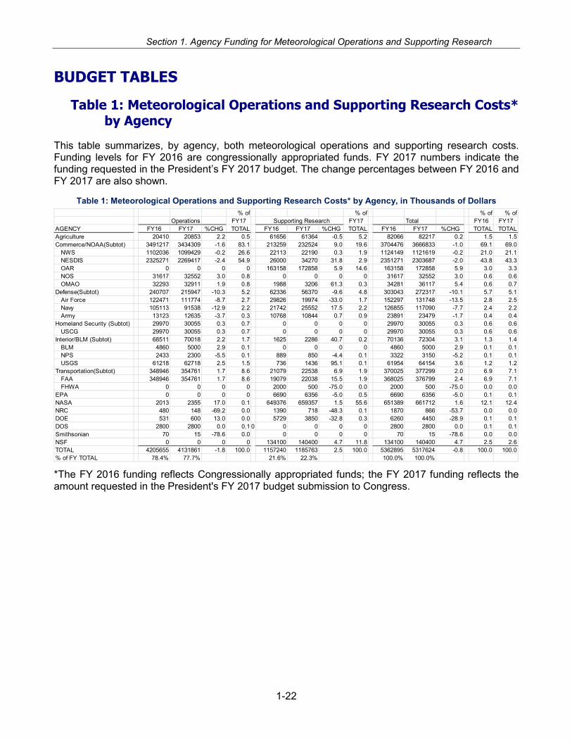
Section 1. Agency Funding for Meteorological Operations and Supporting Research
BUDGET TABLES
Table 1: Meteorological Operations and Supporting Research Costs* by Agency
This table summarizes, by agency, both meteorological operations and supporting research costs. Funding levels for FY 2016 are congressionally appropriated funds. FY 2017 numbers indicate the funding requested in the President’s FY 2017 budget. The change percentages between FY 2016 and FY 2017 are also shown.
Table 1: Meteorological Operations and Supporting Research Costs* by Agency, in Thousands of Dollars
*The FY 2016 funding reflects Congressionally appropriated funds; the FY 2017 funding reflects the amount requested in the President's FY 2017 budget submission to Congress.
% of % of % of % ofOperations FY17 Supporting Research FY17 Total FY16 FY17
AGENCY FY16 FY17 %CHG TOTAL FY16 FY17 %CHG TOTAL FY16 FY17 %CHG TOTAL TOTALAgriculture 20410 20853 2.2 0.5 61656 61364 -0.5 5.2 82066 82217 0.2 1.5 1.5Commerce/NOAA(Subtot) 3491217 3434309 -1.6 83.1 213259 232524 9.0 19.6 3704476 3666833 -1.0 69.1 69.0 NWS 1102036 1099429 -0.2 26.6 22113 22190 0.3 1.9 1124149 1121619 -0.2 21.0 21.1 NESDIS 2325271 2269417 -2.4 54.9 26000 34270 31.8 2.9 2351271 2303687 -2.0 43.8 43.3 OAR 0 0 0 0 163158 172858 5.9 14.6 163158 172858 5.9 3.0 3.3 NOS 31617 32552 3.0 0.8 0 0 0 0 31617 32552 3.0 0.6 0.6 OMAO 32293 32911 1.9 0.8 1988 3206 61.3 0.3 34281 36117 5.4 0.6 0.7Defense(Subtot) 240707 215947 -10.3 5.2 62336 56370 -9.6 4.8 303043 272317 -10.1 5.7 5.1 Air Force 122471 111774 -8.7 2.7 29826 19974 -33.0 1.7 152297 131748 -13.5 2.8 2.5 Navy 105113 91538 -12.9 2.2 21742 25552 17.5 2.2 126855 117090 -7.7 2.4 2.2 Army 13123 12635 -3.7 0.3 10768 10844 0.7 0.9 23891 23479 -1.7 0.4 0.4Homeland Security (Subtot) 29970 30055 0.3 0.7 0 0 0 0 29970 30055 0.3 0.6 0.6 USCG 29970 30055 0.3 0.7 0 0 0 0 29970 30055 0.3 0.6 0.6Interior/BLM (Subtot) 68511 70018 2.2 1.7 1625 2286 40.7 0.2 70136 72304 3.1 1.3 1.4 BLM 4860 5000 2.9 0.1 0 0 0 0 4860 5000 2.9 0.1 0.1 NPS 2433 2300 -5.5 0.1 889 850 -4.4 0.1 3322 3150 -5.2 0.1 0.1 USGS 61218 62718 2.5 1.5 736 1436 95.1 0.1 61954 64154 3.6 1.2 1.2Transportation(Subtot) 348946 354761 1.7 8.6 21079 22538 6.9 1.9 370025 377299 2.0 6.9 7.1 FAA 348946 354761 1.7 8.6 19079 22038 15.5 1.9 368025 376799 2.4 6.9 7.1 FHWA 0 0 0 0 2000 500 -75.0 0.0 2000 500 -75.0 0.0 0.0EPA 0 0 0 0 6690 6356 -5.0 0.5 6690 6356 -5.0 0.1 0.1NASA 2013 2355 17.0 0.1 649376 659357 1.5 55.6 651389 661712 1.6 12.1 12.4NRC 480 148 -69.2 0.0 1390 718 -48.3 0.1 1870 866 -53.7 0.0 0.0DOE 531 600 13.0 0.0 5729 3850 -32.8 0.3 6260 4450 -28.9 0.1 0.1DOS 2800 2800 0.0 0.1 0 0 0 0 0 2800 2800 0.0 0.1 0.1Smithsonian 70 15 -78.6 0.0 0 0 0 0 70 15 -78.6 0.0 0.0NSF 0 0 0 0 134100 140400 4.7 11.8 134100 140400 4.7 2.5 2.6TOTAL 4205655 4131861 -1.8 100.0 1157240 1185763 2.5 100.0 5362895 5317624 -0.8 100.0 100.0% of FY TOTAL 78.4% 77.7% 21.6% 22.3% 100.0% 100.0%
1-22
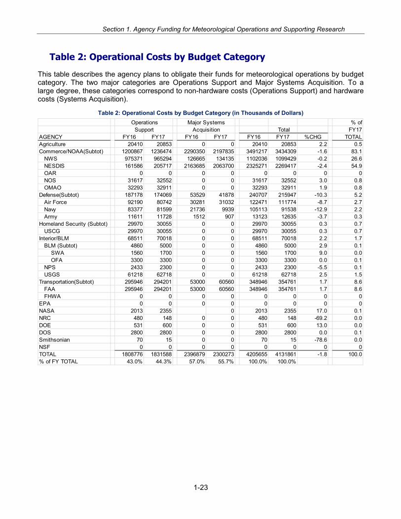
Section 1. Agency Funding for Meteorological Operations and Supporting Research
Table 2: Operational Costs by Budget Category
This table describes the agency plans to obligate their funds for meteorological operations by budget category. The two major categories are Operations Support and Major Systems Acquisition. To a large degree, these categories correspond to non-hardware costs (Operations Support) and hardware costs (Systems Acquisition).
Table 2: Operational Costs by Budget Category (in Thousands of Dollars)
Operations % of Support Total FY17
AGENCY FY16 FY17 FY16 FY17 FY16 FY17 %CHG TOTALAgriculture 20410 20853 0 0 20410 20853 2.2 0.5Commerce/NOAA(Subtot) 1200867 1236474 2290350 2197835 3491217 3434309 -1.6 83.1 NWS 975371 965294 126665 134135 1102036 1099429 -0.2 26.6 NESDIS 161586 205717 2163685 2063700 2325271 2269417 -2.4 54.9 OAR 0 0 0 0 0 0 0 0 NOS 31617 32552 0 0 31617 32552 3.0 0.8 OMAO 32293 32911 0 0 32293 32911 1.9 0.8Defense(Subtot) 187178 174069 53529 41878 240707 215947 -10.3 5.2 Air Force 92190 80742 30281 31032 122471 111774 -8.7 2.7 Navy 83377 81599 21736 9939 105113 91538 -12.9 2.2 Army 11611 11728 1512 907 13123 12635 -3.7 0.3Homeland Security (Subtot) 29970 30055 0 0 29970 30055 0.3 0.7 USCG 29970 30055 0 0 29970 30055 0.3 0.7Interior/BLM 68511 70018 0 0 68511 70018 2.2 1.7 BLM (Subtot) 4860 5000 0 0 4860 5000 2.9 0.1 SWA 1560 1700 0 0 1560 1700 9.0 0.0 OFA 3300 3300 0 0 3300 3300 0.0 0.1 NPS 2433 2300 0 0 2433 2300 -5.5 0.1 USGS 61218 62718 0 0 61218 62718 2.5 1.5Transportation(Subtot) 295946 294201 53000 60560 348946 354761 1.7 8.6 FAA 295946 294201 53000 60560 348946 354761 1.7 8.6 FHWA 0 0 0 0 0 0 0 0EPA 0 0 0 0 0 0 0 0NASA 2013 2355 0 2013 2355 17.0 0.1NRC 480 148 0 0 480 148 -69.2 0.0DOE 531 600 0 0 531 600 13.0 0.0DOS 2800 2800 0 0 2800 2800 0.0 0.1Smithsonian 70 15 0 0 70 15 -78.6 0.0NSF 0 0 0 0 0 0 0 0TOTAL 1808776 1831588 2396879 2300273 4205655 4131861 -1.8 100.0% of FY TOTAL 43.0% 44.3% 57.0% 55.7% 100.0% 100.0%
Major SystemsAcquisition
1-23
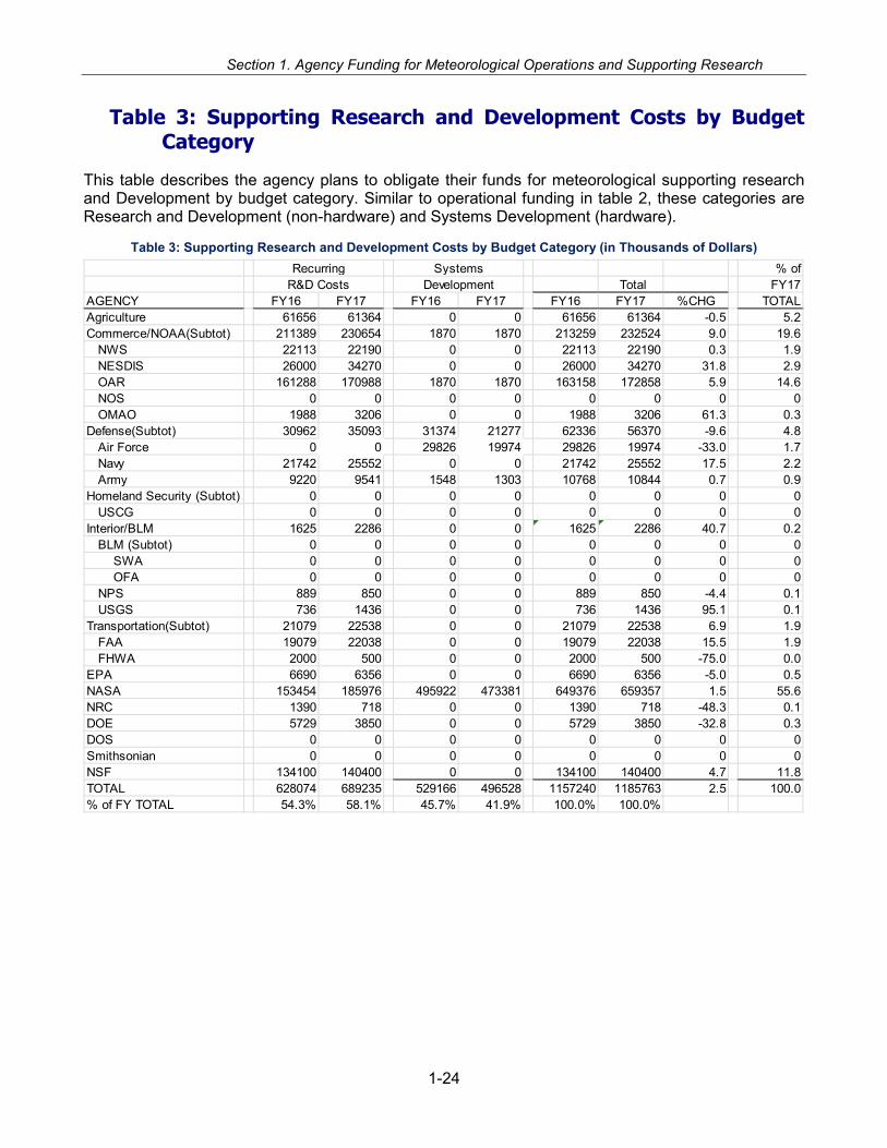
Section 1. Agency Funding for Meteorological Operations and Supporting Research
Table 3: Supporting Research and Development Costs by Budget Category
This table describes the agency plans to obligate their funds for meteorological supporting research and Development by budget category. Similar to operational funding in table 2, these categories are Research and Development (non-hardware) and Systems Development (hardware).
Table 3: Supporting Research and Development Costs by Budget Category (in Thousands of Dollars)
% of Total FY17
AGENCY FY16 FY17 FY16 FY17 FY16 FY17 %CHG TOTALAgriculture 61656 61364 0 0 61656 61364 -0.5 5.2Commerce/NOAA(Subtot) 211389 230654 1870 1870 213259 232524 9.0 19.6 NWS 22113 22190 0 0 22113 22190 0.3 1.9 NESDIS 26000 34270 0 0 26000 34270 31.8 2.9 OAR 161288 170988 1870 1870 163158 172858 5.9 14.6 NOS 0 0 0 0 0 0 0 0 OMAO 1988 3206 0 0 1988 3206 61.3 0.3Defense(Subtot) 30962 35093 31374 21277 62336 56370 -9.6 4.8 Air Force 0 0 29826 19974 29826 19974 -33.0 1.7 Navy 21742 25552 0 0 21742 25552 17.5 2.2 Army 9220 9541 1548 1303 10768 10844 0.7 0.9Homeland Security (Subtot) 0 0 0 0 0 0 0 0 USCG 0 0 0 0 0 0 0 0Interior/BLM 1625 2286 0 0 1625 2286 40.7 0.2 BLM (Subtot) 0 0 0 0 0 0 0 0 SWA 0 0 0 0 0 0 0 0 OFA 0 0 0 0 0 0 0 0 NPS 889 850 0 0 889 850 -4.4 0.1 USGS 736 1436 0 0 736 1436 95.1 0.1Transportation(Subtot) 21079 22538 0 0 21079 22538 6.9 1.9 FAA 19079 22038 0 0 19079 22038 15.5 1.9 FHWA 2000 500 0 0 2000 500 -75.0 0.0EPA 6690 6356 0 0 6690 6356 -5.0 0.5NASA 153454 185976 495922 473381 649376 659357 1.5 55.6NRC 1390 718 0 0 1390 718 -48.3 0.1DOE 5729 3850 0 0 5729 3850 -32.8 0.3DOS 0 0 0 0 0 0 0 0Smithsonian 0 0 0 0 0 0 0 0NSF 134100 140400 0 0 134100 140400 4.7 11.8TOTAL 628074 689235 529166 496528 1157240 1185763 2.5 100.0% of FY TOTAL 54.3% 58.1% 45.7% 41.9% 100.0% 100.0%
RecurringR&D Costs
SystemsDevelopment
1-24

Section 1. Agency Funding for Meteorological Operations and Supporting Research
Tables 4 and 5: Operational Costs and Supporting Research Costs by Service Category
These tables indicate how the funds identified in Tables 2 and 3 are divided among the eleven service categories. Table 4 reflects how the agencies plan to obligate operational funds and Table 5 support-ing research funds. The service categories evolve over time, as applications change with technology and with societal needs. The service category definitions are described below:
Service Category Definitions
Basic Services. Basic services include the basic meteorological service system, to include observa-tions, public weather forecasts, severe weather warnings and advisories, and the meteorological sat-ellite activities of NOAA. Basic services also include the operations and supporting research of other Federal agencies that have been identified as contributing to basic meteorological services.
Agriculture and Land Management Meteorological Services. Agricultural and land management meteorological services are those services and facilities established to meet the requirements of the agricultural industries and Federal, state, and local agencies charged with the protection and mainte-nance of the Nation's land areas. Meteorological services specifically tailored for wildland fire man-agement are reported under the wildland fire weather service category.
Aviation Services. Aviation services are those specialized meteorological services and facilities es-tablished to meet the requirements of general, commercial, and military aviation. Civil programs that are directly related to services solely for aviation and military programs in support of land-based avia-tion and medium- or long-range missile operations are included. Detailed aviation services/products for specific areas include, but are not limited to, ceiling and visibility, convective hazards, en route winds and temperatures, ground de-icing, in-flight icing, terminal winds and temperatures, turbulence, volcanic ash, and other airborne hazardous materials.
Climate Services. Climate services are specialized meteorological and hydrological services estab-lished to meet the requirements of Federal, state, and local agencies for information on the historical, current, and future state of the earth system. Climate services include observations, monitoring, as-sessments, predictions, and projections of the atmosphere, hydrosphere, and land surface systems.
Emergency Response and Homeland Security Services. Emergency response and homeland se-curity services are those specialized meteorological services and facilities established to meet the re-quirements of Federal, state, and local agencies responding to natural disasters and security inci-dents. This category includes the use of atmospheric transport and dispersion (ATD) models for pre-dicting the dispersion of airborne toxic substances; it also includes natural disaster monitoring and prediction services and the transport of water-borne toxic substances not included in basic services.
Hydrometeorology and Water Resources Services. Hydrometeorology and water resources ser-vices are those specialized meteorological services and facilities that combine atmospheric science, hydrology, and water resources in order to meet the requirements of Federal, state, and local agen-cies for information on the effects of precipitation events on infrastructure, water supplies, and water-ways. These products and services also meet the needs of the general public in the conduct of every-day activities and for the protection of lives and property.
Military Services. Military services are those meteorological operations, services, and capabilities established to meet the unique requirements of military user commands and their component ele-ments. Programs and services that are not uniquely military in nature are reported under another ser-vice category (e.g., Basic Services, Aviation Services [civilian], Surface transportation Services, or Emergency Response and Homeland Security Services).
1-25

Section 1. Agency Funding for Meteorological Operations and Supporting Research
Space Weather Services. Space Weather Services are those specialized meteorological services and facilities established to meet the needs of users for information on space weather conditions and space weather storms that can affect terrestrial systems, space systems, Earth’s atmosphere, and the space environment. Space weather services include monitoring and alerting of space weather storms and their effects on technological infrastructure and human safety. Early warning of an approaching space weather storm, so that timely protective response is possible, is an important part of space weather services.
Surface Transportation. Surface transportation services are those specialized meteorological ser-vices and facilities established to meet the weather information needs of the following surface trans-portation sectors: roadways, long-haul railways, the marine transportation system, rural and urban transit, pipeline systems, and airport ground operations. The roadway sector includes state and Fed-eral highways and all state and local roads and streets. The marine transportation system includes coastal and inland waterways, ports and harbors, and the intermodal terminals serving them. Rural and urban transit includes bus and van service on roadways and rail lines for metropolitan subway and surface “light-rail” systems.
Wildland Fire Weather Services. Wildland fire weather services are those specialized meteorologi-cal services and facilities established to meet the requirements of the wildfire management community at the Federal, state, tribal, and local levels. The primary areas of service are to support the reduction of wildfire initiation potential and the mitigation of both human and environmental impacts once initia-tion does occur. Services can include support to first responders and land managers and climate ser-vices tailored to wildland fire management.
Other Specialized Services. Other specialized services include weather and climate information ser-vices and facilities established to meet the special needs of user agencies or constituencies not in-cluded in basic services or the preceding service categories. This service category includes any ef-forts to integrate the social sciences into meteorological operations, applications, and services not al-ready described in the preceding sections.
1-26

Section 1. Agency Funding for Meteorological Operations and Supporting Research
1-27

Section 1. Agency Funding for Meteorological Operations and Supporting Research
Table 6: Personnel Supporting Meteorological Operations and Research
This table includes both current and FY 2017 requested personnel (Federal (FTE), Contractor, Mili-tary) required to perform or support meteorological operations and supporting research. The total fed-eral agency staffing requested for FY 2017 is 14,768.
Table 6: Personnel Supporting Meteorological Operations and Research (Full Time Equivalent Staff Years, Contractors, and Military)
* Active Duty (does not include National Guard or Reserve)
**all research
Table 7: Interagency Fund Transfers
This table summarizes the reimbursement of funds from one agency to another during FY 2016. Agencies routinely enter into reimbursable agreements when they determine an agency can provide a given activity more cost-effectively. While specific activities and amounts may vary from year-to-year, the pattern reflects a significant level of interagency cooperation.
Agency Federal Contractor Military*Current
FY 2016 Federal Contractor Military*Requested FY 2017 %CHG
% of FY 17 TOTAL
Agriculture 93 8 0 101 93 6 0 99 -2.0 0.7Commerce/NOAA Subtotal 6174 2415 0 8589 6095 2332 0 8427 -1.9 57.1 NWS 4638 793 0 5431 4549 801 0 5350 -1.5 36.2 NESDIS 887 1351 0 2238 889 1260 0 2149 -4.0 14.6 OAR** 413 201 0 614 416 201 0 617 0.5 4.2 NOS 115 70 0 185 120 70 0 190 2.7 1.3 OMAO 121 0 0 121 121 0 0 121 0.0 0.8Defense Subtotal 495 133 3707 4335 495 137 3651 4283 -1.2 29.0 Air Force 375 95 2922 3392 375 95 2866 3336 -1.7 22.6 Navy 75 18 415 508 75 18 415 508 0.0 3.4 Marine Corps 0 0 370 370 0 0 370 370 0.0 2.5 Army 45 20 0 65 45 24 0 69 6.2 0.5Homeland Security-USCG 1 0 107 108 1 0 107 108 0.0 0.7Interior/BLM Subtotal 49 8 0 57 49 8 0 57 0.0 0.4 BLM Soil/Water/Air Program 12 0 0 12 12 0 0 12 0.0 0.1 BLM Fire Weather Program 29 5 0 34 29 5 0 34 0.0 0.2 NPS 8 3 0 11 8 3 0 11 0.0 0.1 USGS 12 0 0 12 15 0 0 15 25.0 0.1Transportation Subtotal 334 1366 0 1700 334 1370 0 1704 0.2 11.5 FHWA 3 3 0 6 3 3 0 6 0.0 0.0 FAA 331 1363 0 1694 331 1367 0 1698 0.2 11.5EPA 43 12 0 55 41 11 0 52 -5.5 0.4NASA 9 8 0 17 9 9 0 18 5.9 0.1NRC 7 0 0 7 7 0 0 7 0.0 0.0DOE 0 1 0 1 0 2 0 2 100.0 0.0DOS 0 0 0 0 0 0 0 0 0 0Smithsonian 2 0 0 2 1 0 0 1 -50.0 0.0NSF 10 0 0 10 10 0 0 10 0.0 0.1Totals 14982 14768 -1.4 100.0
1-28

Section 1. Agency Funding for Meteorological Operations and Supporting Research
SupportingTransferred from: To: Operations Research
DOC/NOAANESDIS NIST 0 8NESDIS NSF 206 0NESDIS NASA 611543 2NESDIS DOD 7270 0NESDIS DOI 50 0NESDIS NTIA 5712 0NWS USDA 0 0 NRCS deletedOAR DOE 0 4076 OAR USDA 0 231
DHSUSFA DOI/BLM-FA 42 LightningUSFA DOI/BLM-FA 83 RAWS program supportFEMA DOC/NOAA/NESDIS/NCEI 100
USDAUSDA/USFS DOI/BLM-FA 660 RAWS maintenance contractsUSDA/USFS DOI/BLM 34 LightningUSDA/NRCS USDA/USFS 53 Snow Survey supportUSDA/NRCS DOI 147 Snow Survey supportUSDA/NRCS DOI/NPS 5 Snow Survey support
DODAir Force DOC/NOAA/NWS 7109 804Air Force DOC/OFCM 145Air Force DOI/USGS 432Air Force NASA 380Air Force NSF/UCAR/NCAR 299 1554Air Force USARL 98Air Force NAVSUP 20Navy DOC/NOAA/OAR 0 0Army OFCMUSACE NOAA/NWS 202USACE DOI/USGS 20774USACE USDA NRCS-Snow SurveysUSACE DOC/NOAA/OARDOD DOI/BLM OFA
DOIUSGS DOC/NOAA/NESDIS/NCEI 0 3.5USGS DOC/NOAA/NESDIS 390DOI/BLM DOC/NOAA/NESDIS 15DOI/BLM SWA USDA-NIFA 62DOI/BLM SWA USDA 50 NRCSUSGS DOC/NOAA/OAR 100DOI/NPS USDA 55 NRCSDOI/NPS USDA 391 National Atmospheric Deposition ProgramDOI/NPS EPA 256 CASTNet Filter Pack AnalysisDOI/BOR USDA 19 NRCS
DOI/NPS EPA 288CASTNet Filter Pack Analysis
DOI/BOR USDA NRCSDOI DOC/NOAA/OAR 35DOI/BLM SWA USDA-NIFA 62DOI/BLM SWA USDA 50 NRCS
DOT
FAA Weather DOC/NOAA/NWS 17181IAA-Center Weather Service Unit
FAA Weather DOC/NOAA/NWS 15973 IAANASA
DOD/USAF/45th Space Wing 830 0DOE DOC/NOAA/OAR 800 WFIP
State/Local USDA 102 NRCSDOI/BLM-FA 304 RAWS maintenance contracts
FY2016 Funds ($K) Estimated or Planned
1-29

Section 1. Agency Funding for Meteorological Operations and Supporting Research
Table 8: Facilities/Locations/Systems Taking Meteorological Observations
This table shows the number of facilities/locations/systems at which the Federal agencies carry out or oversee the taking of various types of meteorological observations.
Table 8a: Surface, Land Observations
Agency No. of 2016 Sites Notes Commerce (NOAA/NWS all types) 29012 ASOS, COOP, MESONET
Commerce (NOAA/OAR manned Atmospheric Base-line Observations) 6
Commerce (NOAA/OAR Climate Reference Network) 114
Commerce (NOAA/NWS/INL Mesonet) 35 Idaho National Laboratory (INL) Mesonest used by Pocatello Weather Service Forecast Office. 35 according to the NOSC.
Commerce (NOAA/NWS Weather Monitoring Sta-tions) 16
Commerce (NOAA/OAR/ARL SORD Mesonet) 22 Special Operations And Research Division (SORD)
Energy (DNF Automated NARAC Towers) 97
Air Force (U.S. & Overseas) 219
Navy (U.S. & Overseas) 68
Marine Corps (U.S. & Overseas) 24
Army (U.S. & Overseas) 8
Transportation (FAA Contract Weather Observers (CWO)* 135
Transportation (FAA Auto Wx Obsg Stn - AWOS)** 22
Transportation (FAA Weather Systems - WARP) 21
Transportation (FAA ASOS/ALDARS) 571
Transportation (FAA Flight Service Stations in Alas-ka)*** 18
Transportation (FAA Alaska Weather Cameras) 228
Transportation (FAA Flight Service - OASIS) 3
Transportation (FAA CIWS) 9
Transportation (FAA Weather Systems - ITWS) 34
Transportation (FAA Weather Systems - LIDAR) 2
Transportation (FHWA-Road Wx Obsg Stn) 2473
Homeland Security (USCG Coastal) 50
Interior (NPS Air Program) 32
Interior (BLM Soil/Water/Air Program) 481
Interior (BLM Office of Fire and Aviation) 971
Interior (USGS Geomagnetic Program) 14
1-30

Section 1. Agency Funding for Meteorological Operations and Supporting Research
Agency No. of 2016 Sites Notes Agriculture (NRCS active manual snow courses) 1340
Agriculture (NRCS automated SNOTEL stations) 862
Agriculture (NRCS automated SNOLITE stations) 24
Agriculture (NRCS automated SCAN stations) 220
Agriculture (Agricultural Research Service) 23
Forest Service Smoke Monitors 60
Forest Service RAWS 966
Forest Service (Research) 98
NASA (All Types) 1
Total = 38279
*Note: All 135 FAA Contract Wx Obsg Stations are colocated with a FAA or Commerce (NWS) ASOS **Note: Transportation (FAA oversight Auto Sfc Obsg Sys, non-Fed inspected 1400) ***Note: 17 Flight Service Stations in Alaska since 2007 owned and supported by Harris Corporation
Table 8b: Surface, Marine Observations
Agency No. of 2016 Sites Notes Commerce (NOAA/NOS/SEAS-equipped ships) 622
Commerce (NOAA/NOS/PORTS) 67 stations with met sensors
Commerce (NOAA/NOS/NWLON) 180 stations with met sensors
Commerce (NOAA/NWS Coastal-Marine Autom Net-work) 47
Commerce (NOAA/NWS/NDBC Buoys--moored) 101 does not include TAO and DART
Commerce (NOAA/OAR/AOML Buoys--drifting) 1238
Navy (Ships with met personnel) 29
Navy (Ships without met personnel) 259
Homeland Security (USCG Cutters) 245
Total = 2788
Table 8c: Upper Air, Balloon Observations
Agency No. of 2016 Sites Notes Commerce (NOAA/NWS U.S.) 92
Commerce (NOAA/NWS Foreign, Cooperative) 10
Cooperative Hurricane Upper-Air Sta-tions (CHUAS)
Commerce (NOAA/NWS met/ozone/water vapor) 135
Air Force, Fixed* 1
Army, Fixed (U.S. & Overseas) 19
Army, Mobile (U.S. and Overseas) 17
Navy, Fixed (U.S. & Overseas) 0
1-31
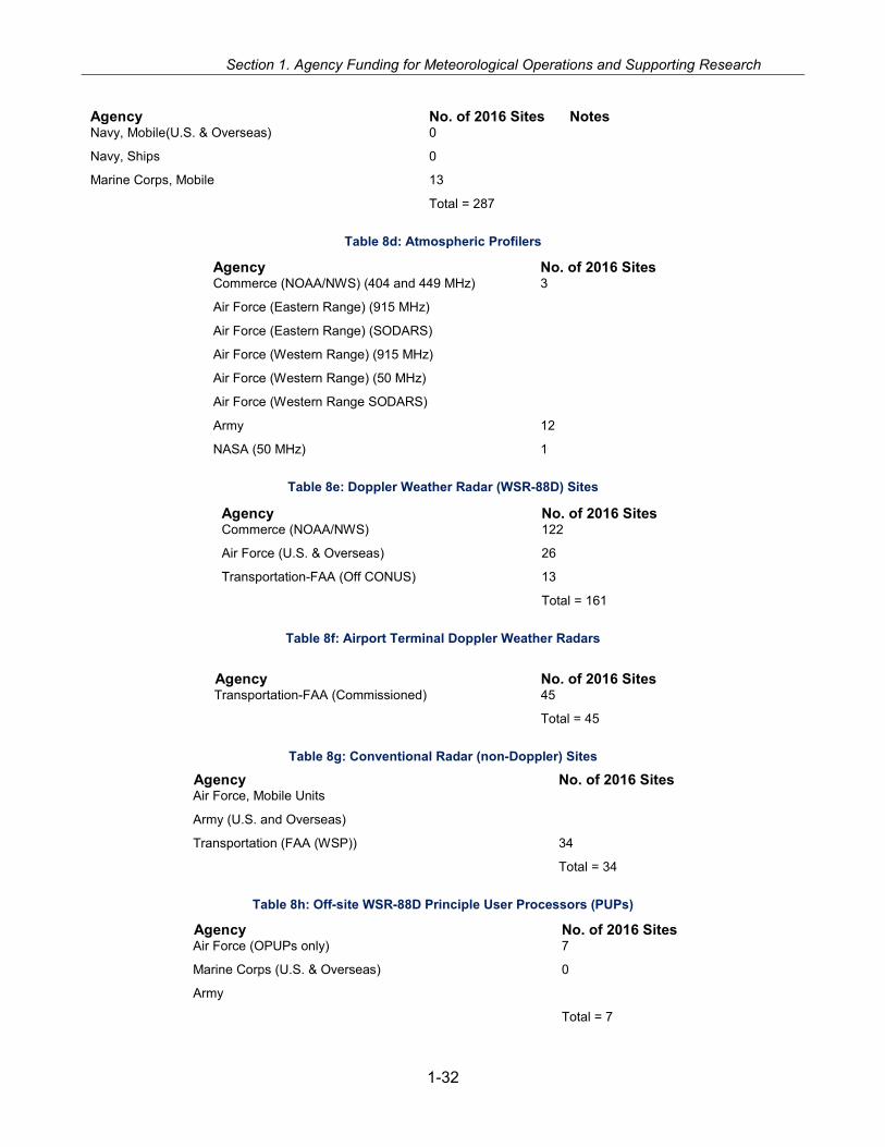
Section 1. Agency Funding for Meteorological Operations and Supporting Research
Agency No. of 2016 Sites Notes Navy, Mobile(U.S. & Overseas) 0
Navy, Ships 0
Marine Corps, Mobile 13
Total = 287
Table 8d: Atmospheric Profilers
Agency No. of 2016 Sites Commerce (NOAA/NWS) (404 and 449 MHz) 3
Air Force (Eastern Range) (915 MHz)
Air Force (Eastern Range) (SODARS)
Air Force (Western Range) (915 MHz)
Air Force (Western Range) (50 MHz)
Air Force (Western Range SODARS)
Army 12
NASA (50 MHz) 1
Table 8e: Doppler Weather Radar (WSR-88D) Sites
Agency No. of 2016 Sites Commerce (NOAA/NWS) 122
Air Force (U.S. & Overseas) 26
Transportation-FAA (Off CONUS) 13
Total = 161
Table 8f: Airport Terminal Doppler Weather Radars
Agency No. of 2016 Sites Transportation-FAA (Commissioned) 45
Total = 45
Table 8g: Conventional Radar (non-Doppler) Sites
Agency No. of 2016 Sites Air Force, Mobile Units
Army (U.S. and Overseas)
Transportation (FAA (WSP)) 34
Total = 34
Table 8h: Off-site WSR-88D Principle User Processors (PUPs)
Agency No. of 2016 Sites Air Force (OPUPs only) 7
Marine Corps (U.S. & Overseas) 0
Army
Total = 7
1-32
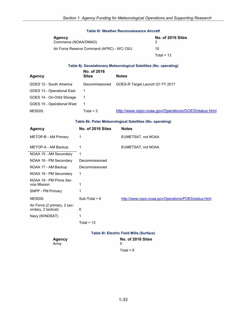
Section 1. Agency Funding for Meteorological Operations and Supporting Research
Table 8i: Weather Reconnaissance Aircraft
Agency No. of 2016 Sites Commerce (NOAA/OMAO) 3
Air Force Reserve Command (AFRC) - WC-130J 10
Total = 13
Table 8j: Geostationary Meteorological Satellites (No. operating)
Agency No. of 2016 Sites Notes
GOES 12 - South America Decommissioned GOES-R Target Launch Q1 FY 2017
GOES 13 - Operational East 1
GOES 14 - On-Orbit Storage 1
GOES 15 - Operational West 1
NESDIS Total = 3 http://www.ospo.noaa.gov/Operations/GOES/status.html
Table 8k: Polar Meteorological Satellites (No. operating)
Agency No. of 2016 Sites Notes
METOP-B - AM Primary 1 EUMETSAT, not NOAA
METOP-A - AM Backup 1 EUMETSAT, not NOAA
NOAA 15 - AM Secondary 1
NOAA 16 - PM Secondary Decommissioned
NOAA 17 - AM Backup Decommissioned
NOAA 18 - PM Secondary 1
NOAA 19 - PM Prime Ser-vice Mission 1
SNPP - PM Primary 1
NESDIS Sub-Total = 6 http://www.ospo.noaa.gov/Operations/POES/status.html
Air Force (2 primary, 2 sec-ondary, 2 tactical) 6
Navy (WINDSAT) 1
Total = 13
Table 8l: Electric Field Mills (Surface)
Agency No. of 2016 Sites Army 5
Total = 6
1-33

Section 1. Agency Funding for Meteorological Operations and Supporting Research
Table 8m: Lightning Detection Systems Agency No. of 2016 Sites
Air Force (Eastern and Western Range Cloud-Ground) 2
Air Force (Eastern and Western Range- NLDN & Total Ltng Sys) 2
Army 6
Total = 10
Table 8n: Rocketsondes Agency No. of 2016 Sites Army Total = 1
1-34
SECTION 2
FEDERAL METEOROLOGICAL SERVICES AND SUPPORTING
RESEARCH PROGRAMS


Federal Coordination and Planning
FEDERAL COORDINATION AND PLANNING FOR METEOROLOGICAL
SERVICES AND SUPPORTING RESEARCH
2-3
The mission of the Office of the Federal Coordinator for Meteorological Services and Sup-porting Research (OFCM) is to foster the effective use of Federal meteorological resources by encouraging and facilitating the systematic coordination of weather services and support-ing research across the Federal Weather Enterprise.
The OFCM operates with policy guidance from the Federal Committee for Meteorological Services and Supporting Research (FCMSSR). The principal work in coordinating meteoro-logical activities and in the preparation and maintenance of OFCM reports, plans, and other documents is accomplished by the OFCM staff with the advice and assistance of the Inter-departmental Committee for Meteorological Services and Supporting Research (ICMSSR) and 27 committees, working groups, and joint action groups. The members who serve on these entities are Federal agency representatives.
STATUTORY BASIS FOR THE FEDERAL COORDINATION PROCESS
In 1963, Congress and the Executive Office of the President expressed concern about the ade-quacy of the coordination of Federal meteorological activities. In response, Congress directed in Section 304 of Public Law 87-843 (the Appropriations Act for State, Justice, Commerce, and Related Agencies) that the Bureau of the Budget prepare an annual horizontal budget for all meteorological programs in the Federal agencies. The Bureau of the Budget (now the Office of Management and Budget, OMB) issued a report in 1963 entitled Survey of Federal Meteorologi-cal Activities. That report described each agency’s program for meteorological services and products and detailed the relationships among the programs of the various agencies. The report revealed close cooperation but little evidence of systematic coordination. Based on its survey, the Bureau of the Budget issued a set of ground rules to be followed in the coordination pro-cess. It established a permanent general philosophy for assignment and assessment of agency roles in the field of meteorology and set certain goals to be achieved by the coordination pro-cess. The Bureau of the Budget tasked the Department of Commerce (DOC) to establish the coordinating mechanism in concert with the other Federal agencies. It also reaffirmed the con-cept of having a central agency—the DOC—responsible for providing common meteorological facilities and services and clarified the responsibilities of other agencies for providing meteoro-logical services specific to their mandated missions.
The implementation of these directives by DOC led to the creation of OFCM and the appoint-ment of the first Federal Coordinator for Meteorological Services and Supporting Research (the Federal Coordinator). The Federal Committee for Meteorological Services and Supporting Re-search (FCMSSR) was established in 1964 to provide policy-level agency representation and
Section 2. Federal Meteorological Services and Supporting Research Programs
guidance to the Federal Coordinator in addressing agency priorities, requirements, and issues related to services, operations, and supporting research. The FCMSSR also resolves agency differences that arise during the coordination of meteorological activities and the preparation of Federal plans.
FCMSSR comprises representatives of the 15 Federal agencies that engage in meteorological activities or supporting research, have a major need for meteorological services, or set policy and direction for such services and research. These 15 agencies are the Departments of Agri-culture (USDA), Commerce (DOC), Defense (DOD), Energy (DOE), Homeland Security (DHS), the Interior (DOI), State (DOS), and Transportation (DOT); the Environmental Protection Agency (EPA), National Aeronautics and Space Administration (NASA), National Science Foundation (NSF), National Transportation Safety Board (NTSB), and Nuclear Regulatory Commission (NRC); and OMB and the Office of Science and Technology Policy (OSTP). The Under Secre-tary of Commerce for Oceans and Atmosphere, who is also the Administrator of the National Oceanic and Atmospheric Administration (NOAA), serves as the FCMSSR Chairperson.
OFCM COORDINATING INFRASTRUCTURE
The OFCM coordinating infrastructure diagram on page 2-5 shows the current committees, working groups (WG), and joint action groups (JAG) through which OFCM carries out its mis-sion of ensuring the effective use of Federal meteorological resources by coordinating opera-tional weather requirements, services, and supporting research among the Federal agencies. FCMSSR is shown at the top of the diagram, as the policy guidance advisor to its subordinate elements and the Federal Coordinator.
• The Interdepartmental Committee for Meteorological Services and Supporting Research (ICMSSR) is the primary Executive-level management body of the Federal coordinating structure. ICMSSR provides advice to OFCM, implements FCMSSR policies, and oversees the committees and working groups that address observing systems, weather operations and services, operational processing centers, and automated weather information systems. The full membership of ICMSSR is shown on the inside cover of this Federal Plan.
• Program Councils can be established under ICMSSR to coordinate key programs or mission areas to ensure they meet interagency needs. Additionally, Program Councils coordinate development and oversee the preparation and implementation of national program plans, which include research and development (R&D), systems development, validation and inte-gration, acquisition strategy, operational concepts, agency roles, and management.
• The committees, working groups, and joint action groups operate at the program and work-ing levels to provide: (1) a forum for each agency to report activities, challenges, and achievements; (2) a mechanism to coordinate change and problem solving; (3) a way to col-lect, document, and consolidate agency requirements and inventories; (4) oversight for co-ordinated system development; (5) a vehicle for coordinating with other groups internal and external to the coordinating infrastructure; and (6) a mechanism for the preparation of stud-ies, agreements, standards, protocols, reports, and national plans. Working groups are in-tended to serve enduring coordination functions. Joint action groups are temporary elements established to address specific, short-term objectives
2-4

Federal Coordination and Planning
Figure 1: The Federal Coordinating Infrastructure.
Using these multiagency groups, OFCM pursues the following objectives as the means to achieve its mission:
• Document agency programs and activities in a series of national plans and reports that ena-ble agencies to adjust their individual ongoing programs, and provide a means for communi-cating new ideas and approaches to fulfill requirements.
• Provide structure and programs to promote continuity in development and coordination of interagency plans and procedures for meteorological services and supporting research.
• Prepare analyses, summaries, or evaluations of agency meteorological programs and plans that provide a factual basis for the executive and legislative branches to make appropriate decisions on the allocation of funds.
• Review federal weather programs and federal requirements for meteorological services and supporting research. This review may suggest additions or revisions to current or proposed programs or identify opportunities for improved efficiency, reliability, or cost avoidance through coordinated actions and integrated programs.
OFCM HIGHLIGHTS FOR FISCAL YEAR 2016 AND PLANS FOR FISCAL YEAR 2017
Federal coordination activities during FY 2016 and plans for FY 2017 are described here, orga-nized by program/mission area and ICMSSR standing committee. The highlights begin with ac-
2-5
Section 2. Federal Meteorological Services and Supporting Research Programs
tivities reporting directly to the Federal Coordinator, followed by the program/mission area and the ICMSSR standing committees.
Programs and Mission Areas
During the OFCM leadership transition in 2015, the OFCM conducted a thorough mission re-view of the Federal Meteorological Coordinating Infrastructure. A clear message was received by the participating agencies that the infrastructure should be streamlined, and toward that end the functions of the existing Program Councils were absorbed by the ICMSSR. Since that time, the NEXRAD Program Council was reactivated at the request of the agencies.
Next Generation Weather Radar Program
The Next Generation Weather Radar (NEXRAD) Program Council met for the first time in 20 years in July 2016. The meeting was convened to address issues that have arisen in recent years regarding the future of the mature program. Action items from the meeting suggest a commitment to improved communication between the participating agencies, revisiting resource needs, and continuing the dialogue in future meetings.
Space Weather
Since 1995, the National Space Weather Program (NSWP) Council sought closer coordination of space weather science, research, and services to the Nation. In October 2014, NSWP Coun-cil and Committee for Space Weather activities were suspended in order for the agencies to support the OSTP Space Weather Operations, Readiness, and Mitigation (SWORM) Task Force.
As a result of reorganization of the Federal Coordinating Infrastructure, the ICMSSR deactivated the NSWP Council and assumed their responsibilities on August 10, 2015. The ICMSSR will continue to plan for and conduct the annual Space Weather Enterprise Forum and other space weather activities in support of the National effort.
In October 2015, OSTP published the National Space Weather Strategy (NSWS) and National Space Weather Action Plan (SWAP) and asked OFCM to provide Executive Secretary services for SWORM Task Force and its six subordinate Working Groups. OFCM will collaborate with OSTP to manage the NSWP and execute space weather elements of the SWAP.
Committees, Working Groups and Joint Action Groups
Joint Action Group for the Federal Plan Revision
In response to an action item issued by the Federal Committee for Meteorological Services and Supporting Research (FCMSSR), the Joint Action Group for the Federal Plan Revision (JAG/FPR) was established to draft concise statements of federal meteorological coordination policy guidance and strategic objectives, to create a proposed outline for an annual report which would potentially replace the current Federal Plan for Meteorological Services and Supporting Research (the FedPlan), and to propose a timeline for implementation.
The annual FedPlan has been produced for the last several decades in response to legislation requiring the Executive Office of the President (EOP) Office of Management and Budget (OMB)’s precursor organization, the Bureau of the Budget, to provide a horizontal view of Fed-
2-6

Federal Coordination and Planning
eral spending on meteorological services. Over time the FedPlan has grown in scope, requiring significant efforts from involved Federal agencies to produce a large report.
At the April 2016 FCMSSR meeting, membership pointed out that the annual timing of the FedPlan publication was not optimal and that the organization of the FedPlan made it difficult for some agencies to provide inputs. The FCMSSR directed a re-evaluation of the process used to create the FedPlan. A follow-on multi-agency exploratory meeting in July, and subsequent meetings between OFCM and the EOP Office of Science and Technology Policy (OSTP), OMB and others revealed that compiling some of the data which the current FedPlan tasks the agen-cies to provide causes internal disruption in those agencies, while the resultant analysis drawn from that data provided little value to the interagency group.
Summary findings from the exploratory meeting and subsequent follow-up discussions included:
• An annual report detailing coordinated interagency efforts would benefit agency leadership in both decision making and program defense.
• An annual report would need to follow from overarching policy and strategic guidance. • The amount of quantitative data in the current FedPlan is excessive, particularly the human
resource figures. Additionally, the categories used in displaying the data are not applicable to many agencies and should be reconsidered.
The current vision is that an overarching document, i.e. a meteorological coordination strategic plan, would be produced every 4 years, while an annual document would be produced to report progress in support of that plan.
Committee for Operational Processing Centers
In FY 2016, Committee for Operational Processing Centers (COPC) continued to facilitate the exchange of information concerning numerical weather and ocean prediction modeling efforts, data resources or problems, and atmospheric, oceanographic, and satellite products for NOAA’s National Centers for Environmental Prediction and Office of Satellite and Product Operations, the Air Force 557 Weather Wing, the U.S. Navy’s Fleet Numerical Meteorology and Oceanogra-phy Center and Naval Oceanographic Office. Semiannual meetings of COPC continued in FY 2016 and are expected to continue in FY 2017.
Working Group for Cooperative Support and Backup
Activities under COPC and its Working Group for Cooperative Support and Backup included:
• Exchange of JMA’s Himawari-8 data for situational awareness, MTSAT replacement, and GOES-R readiness capabilities. NOAA STAR is distributing the 16 channel data to NCEP and the Navy Centers in a non-operational environment. Air Force is distributing 5 channel data via the MARK IVB and sharing that same feed with FNMOC.
• Coordination and planning data exchange using NESDIS’ future enterprise data dissemina-tion service called Product Dissemination and Access (PDA). The group is developing a process to support DoD’s existing legacy data flow purposes and to move new data re-quirements to the PDA as the least disruptive approach forward.
• Developing multiple OPC outage mitigation techniques for critical data sources and prod-ucts. The goal is to increase the understanding of mission essential data exchange, single data sources, and data agency interdependencies, with the intent to mitigate the impacts on the OPCs when significant data outages occur.
2-7

Section 2. Federal Meteorological Services and Supporting Research Programs
Working Group for Observational Data
The Working Group for Observational Data (WG/OD) facilitates interagency acquisition, pro-cessing, and exchange of observational data among the national operational processing centers (OPCs) and other related data centers.
During FY 2016, the working group satisfied a number of interagency satellite data exchange requests, continued to seek new satellite and ocean data sources and products, and continued the development of a new reference document which will contain guidelines and procedures for the interagency management of conventional data similar to the interagency technical reference maintained for satellite data (TR-1).
In FY 2017, the Working Group will continue its efforts to meet interagency observational data issues including:
• Collaborative work among the national operational processing centers (OPC) to resolve crit-ical metadata errors which have the potential to result in significant impacts to numerical models and products. Some of these metadata errors have resulted from the WMO directed transition from Traditional Alphanumeric Code (TAC) forms to Binary Universal Form for the Representation of meteorological information (BUFR)
• Update and maintenance of an OPC-comprehensive observational data inventory reflecting data streams used by all OPCs
• Adding several new members to participate in the development of new interagency data management standards and procedures in line with new WMO global data management di-rectives.
• Participation in the operational test and evaluation of high resolution radiosonde data being implemented across the U.S.
Working Group for Centralized Communications Management
The Working Group for Centralized Communications Management (WG/CCM) coordinates communication issues between the Operational Processing Centers (OPC), monitors the effec-tiveness of those communications, and performs capacity planning of capability needs. Activities include:
• FY 2016 - Developed and implemented an alternate NOAA/DOD OPC data exchange net-work path which has been used multiple times since April 2016 to mitigate network outages.
• FY 2017 - Finalize a Concept of Operations document for implementing planned and un-planned failovers to the alternate NOAA/DOD OPC data exchange network path.
• FY 2017 - Plan the use of the alternate path to meet DOD mandated security testing.
Committee for Operational Environmental Satellites
Responding to stakeholder desire to improve interagency communication and coordination in using environmental satellites the Committee for Operational Environmental Satellites (COES) was re-established in 2014.
COES conducted four meetings in FY2016. It continued to assess the need for interagency sat-ellite requirements and conducted a systematic review of satellite capabilities available to the operational weather community. Among the issues COES addressed were, interagency envi-ronmental satellite coordination, satellite communication radio frequency encroachment, com-
2-8

Federal Coordination and Planning
mercial space-based weather data acquisition and utilization, and emerging GPS radio occulta-tion capabilities from meteorological observations.
Working Group for Hurricane and Winter Storms Operations and Research
In FY 2016, the Working Group for Hurricane and Winter Storms Operations and Research (WG/HWSOR) continued to manage the interagency operations plans for hurricanes and winter storms and address related issues relevant to the Federal meteorological community.
The National Hurricane Operations Plan (NHOP) describes individual agency responsibilities and prescribes operational procedures, common reference points, formats for data exchange, tropical cyclone names and pronunciations, and other information to achieve economy and effi-ciency in the provision of tropical cyclone forecasting and warning services to the Nation. The plan is reviewed and updated annually in advance of the hurricane season to address action items and implement agreements reached at the Tropical Cyclone Operations and Research Conference/Interdepartmental Hurricane Conference (TCORF/IHC). The working group pub-lished the 54th edition of the NHOP in FY 2016, incorporating a variety of updates, including tropical cyclone names and pronunciations, data codes, and air traffic control-related proce-dures.
WG/HWSOR also manages the National Winter Storms Operations Plan (NWSOP) to coordi-nate the activities of the federal agencies providing enhanced observations of severe winter storms that affect the coastal regions of the United States. The plan focuses on the coordination of requirements for DOD and NOAA aircraft reconnaissance observations with the goal of im-proving the accuracy and timeliness of winter storm forecasts and warning services. The current NWSOP was published prior to the 2015 winter season. A new edition of the plan will be pub-lished early in FY 2017.
The WG/HWSOR depends on the annual TCORF/IHC to meet its hurricane-related responsibili-ties. The 2016 TCORF/70th IHC, held March 15-17 at the Rosenstiel School for Marine and At-mospheric Science on Key Biscayne, Florida, marked a departure from past forums, which were focused on tropical cyclone research. Tropical cyclone research was addressed as appropriate in the context of operational imperatives, and the meeting of the Working Group for Hurricane and Winter Storms Operation and Research, supporting the annual update of the NHOP, was re-incorporated into the conference. The new format was well-received by the 127 participants, and the focus on operations will continue in the future. The 2017 TCORF/71st IHC will be held March 14-17 at the same venue.
Working Group for Disaster Impact Assessments and Plans: Weather and Water Data
The Working Group for Disaster Impact Assessments and Plans: Weather and Water Data (WG/DIAP) coordinates the interagency acquisition, dissemination, and exchange of weather and water data, especially highly perishable data, for weather and water related environmental disasters. These data are used for the assessment of impacts to national resources and infra-structure, for scientific and engineering research, and to supplement emergency response op-erations when feasible. Primary responsibilities include the oversight and management of the National Plan for Disaster Impact Assessments: Weather and Water Data (NPDIA) and promo-tion of cooperation among the participating agencies regarding disaster impact assessment re-sponses to events causing significant impact to national resources and infrastructure.
2-9
Section 2. Federal Meteorological Services and Supporting Research Programs
In FY 2016, the working group:
• Began a restructure of the NPDIA to simplify the plan and include data collection protocols for glacier dammed lakes reconnaissance and tsunamis.
• Renewed the annual agreement between OFCM and the U.S. Air Force for reimbursable support funds Civil Air Patrol missions such as Alaska glacial lake damming assessments, tornado damage photos and video, and severe flooding imagery.
• Coordinated four post-storm data acquisition surveys in response to significant tornado out-breaks and four glacier dammed lake assessments.
• Coordinated WG/DIAP responses to two land falling tropical storms: Colin and Hermine.
Joint Action Group for the COASTAL Act Post-Storm Analysis
Congress passed the Consumer Option for an Alternative System to Allocate Losses (COASTAL) Act in June 2012 to lower the cost of the National Flood Insurance Program by dis-cerning better wind versus storm surge damages in cases where little tangible evidence beyond a building’s foundation remains for the proper adjustment of insurance claims after a hurricane or tropical storm. This law requires NOAA to produce detailed post-storm analyses following named storms that affect the coastal zone of the United States. These analyses are to be sub-mitted to the Federal Emergency Management Agency (FEMA) within 90 days. NOAA is re-quired to make all data and post-storm assessments available to the public and to maintain an online database.
The COASTAL Act also requires that NOAA, in consultation with OFCM, provide several interim deliverables to Congress, including an assessment of current capabilities and needs to provide the required post-storm analyses. The Federal Coordinator established the Joint Action Group for the COASTAL Act Post-Storm Analysis (JAG/CAPSA) to develop a COASTAL Act Capabili-ties Development Plan (CACDP) in collaboration with NOAA. The plan, which was submitted to the NOAA Administrator on April 15, 2013 and released to the Department of Commerce on June 7, 2013, provides for the collection of the required observational data to support post-storm assessments.
In 2015, the Joint Action Group for the COASTAL Act Post-Storm Analysis (JAG/CAPSA), was realigned under the Working Group for Disaster Impact Assessments and Plans: Weather and Water (WG/DIAP). The observing protocol to support collection of data for the post-storm anal-yses required by the COASTAL Act was published in December 2013, exercised in 2015 for Hurricane Erika and in 2016 for Hurricane Matthew, and will be included in subsequent editions of the National Plan for Disaster Impact Assessments: Weather and Water Data (Publication FCM-P33).
Working Group for Volcanic Ash
The Working Group for Volcanic Ash (WG/VA) lays the groundwork for national volcanic ash policy and coordinates cooperative interagency efforts regarding volcanic ash products, ser-vices, procedures, and research, and oversees national volcanic ash operations for aviation in support of the ICAO International Airways Volcano Watch. In FY 2017, the Working Group will continue to monitor international progress in the development of the North American Volcanic Ash Contingency Plan for Aviation and prepare to revise the National Volcanic Ash Operations Plan for Aviation (NVAOPA) to ensure consistency with the international plan.
2-10

Federal Coordination and Planning
Atmospheric Transport and Dispersion
On June 14, 2016, OFCM sponsored a special session of the 20th annual George Mason Uni-versity (GMU) Atmospheric Transport and Dispersion Modeling Conference. The theme of the session was Field Experiments and Observational Networks to Support Challenges with High Resolution Dispersion Models and Potential Developments for an ATD Test-bed. Presentations were made by subject matter experts from DOC/NOAA (National Weather Service/National Centers for Environmental Prediction, and Office of Oceanic and Atmospheric Research/Air Re-sources Laboratory and Earth System Research Laboratory), Nuclear Regulatory Commission, Defense Threat Reduction Agency, US Army Research Laboratory, Homeland Security Studies and Analysis Institute, State University of New York at Albany, and the University of Notre Dame.
The session highlighted recent field experiments, current and planned observational infrastruc-ture to support future field experiments, and efforts to make data from past experiments more readily available. The session concluded with a live, real-time survey of participant opinions based on data collected interactively from their cell phones. OFCM will continue its partnership with GMU by sponsoring a session in the 2017 conference, which will be held at GMU in June 2017.
Aviation Weather
OFCM participates in a variety of Next Generation Air Transportation System (NextGen) Inter-agency Planning Office (IPO) activities, including the NextGen Weather Advisor meetings and NextGen Executive Weather Panel (NEWP) meetings. OFCM is also involved in other efforts that dovetail with aviation weather concerns, including supporting groups dealing with wind tur-bine radar interference, the Spectrum Efficient National Surveillance Radar, and meteorological codes and observing practices.
OFCM will continue this collaborative work within the NextGen structure in FY 2017.
Committee for Observing Systems and Serivces
OFCM work related to the Committee on Observing Systems and Services (formerly the Com-mittee for Integrated Observing Systems (CIOS)) in early 2016 focused on collaboration with the American Meteorology Society (AMS) Nationwide Network of Networks Committee on a jointly sponsored a forum on “Observing the Environment from the Ground Up.” The forum was held March 8-9, 2016 at the American Association for the Advancement of Science in Washington, DC. It featured a keynote address by Manson Brown, Assistant Secretary of Commerce for En-vironmental Observation and Prediction. Session topics included past successes and future needs; data providers and data users; data sharing; and big data and the data from the internet of things.
Other activities related to observing involved updates to Federal Meteorological Handbooks (FMHs), including:
• Issues related to surface observing and FMH-1, Surface Weather Observations and Reports were largely resolved in 2016, and a new change was being prepared for agency approval and publication as the fiscal year drew to a close.
• A new change to FMH-11, Doppler Radar Meteorological Observations (WSR-88D) Part A - System Concepts, Responsibilities, and Procedures was completed, approved by ICMSSR and published in January 2016.
2-11

Section 2. Federal Meteorological Services and Supporting Research Programs
Joint Action Group for Unmanned Aerial Systems
OFCM deactivated the Joint Action Group for Unmanned Aerial Systems (UAS) for Environmen-tal Monitoring (JAG/UAS-EM) in 2016 during the infrastructure reorganization. However, the of-fice continues to support other interagency groups working UAS development and utilization issues including the Interagency Coordinating Committee for Airborne Geosciences Research and Applications (ICCAGRA) and the NSTC Subcommittee for Unmanned Systems.
The ICCAGRA meets semiannually to improve cooperation, foster awareness, facilitate com-munication among airborne instrument-sponsoring agencies, and serve as a resource to senior-level management on airborne geosciences issues. The Committee facilitates cooperation on the use of airborne platforms and payloads for individual investigators as well as national and international field campaigns. OFCM supports ICCAGRA through meeting participation and ac-cess to the OFCM federal meteorological coordinating infrastructure.
OFCM continues to support the activities of the CENRS Ocean Science and Technology Sub-committee’s work on unmanned systems. OFCM’s participation provides a connection to mete-orological research and service providers and supports effective coordination of unmanned sys-tem applications across the federal enterprise.
Interdepartmental Weather Research Committee (IWRC)
The Interdepartmental Weather Research Committee, formerly known as the Committee for Cooperative Research, was reactivated by the ICMSSR on Sep 29, 2016. The IWRC will coor-dinate basic and applied US research activities aimed at a better fundamental understanding, and improved prediction of high impact weather with a potential for future socioeconomic and environmental benefits, including applications in support of weather sensitive decision making at Federal, State, and other agencies (i.e., “high impact weather research”). In particular, IWRC will help to (a) map U.S. agency weather research priorities onto the three existing major WMO/WWRP weather research projects; (b) articulate US interests in the execution of WMO/WWRP projects, and (c) explore and engage with new national and international weather research initiatives associated with or pursuant to the current major WMO/WWRP projects. IWRC will provide a forum where agencies can best leverage efforts among themselves and in the international community to achieve agency goals.
Working Group for Tropical Cyclone Research
In 2007, the Joint Action Group for Tropical Cyclone Research (JAG/TCR) completed the Inter-agency Strategic Research Plan for Tropical Cyclones: The Way Ahead. This plan presented a shared set of R&D priorities matched to operational requirements from the tropical cyclone fore-cast and warning centers and served as a baseline for NOAA’s Hurricane Forecast Improve-ment Program (HFIP). In 2008, 2010, and 2012 the Working Group for Tropical Cyclone Re-search (WG/TCR), which succeeded the JAG/TCR, assessed agency research investment mapped against tropical cyclone research needs and operational priorities.
Several efforts were made after 2012 to conduct a mid-course assessment of progress in meet-ing the goals of the 2007 Plan. Due to resource limitations, however, an assessment was never completed. During the 2016 Tropical Cyclone Operations and Research Forum, the consensus of the community was to focus on a final assessment of achievements resulting from 10 years of targeted investment. The final assessment should be completed during 2017.
2-12

Federal Coordination and Planning
For additional information on tropical cyclone research, see the Working Group for Hurricane and Winter Storms Operations and Research and Interdepartmental Hurricane Conference sec-tion above.
Working Group for Meteorological Codes
In FY 2014, OFCM formed the Joint Action Group for IWXXM Implementation (METAR Transi-tion) in response to the International Civil Aviation Organization (ICAO) initiative to transition the METAR family of codes (METAR, SPECI, TAF, and SIGMET) from the current traditional alpha-numeric code (TAC) format to an Extensible Markup Language (XML)-based code. In 2015 the JAG began the process of addressing governance issues, which related closely to OFCM re-sponsibilities for coordinating and documenting interagency agreements on observing practices and codes. In FY 2016 the JAG outlined a plan for transitioning the TAC format to IWXXM within the United States. Changing schedules, issues related to extensibility, and the addition of other aviation-related weather products (e.g., volcanic ash advisories) to those in line for conversion has delayed work on the transition plan. Final decisions at an October 2016 ICAO meeting should clear the way for work on the plan.
Working Group for Multifunction Phased Array Radar
The Multifunction Phased Array Radar (MPAR) initiative seeks to consolidate the radar surveil-lance missions of four agencies: DOD, DHS, DOC/NOAA, and DOT/Federal Aviation Admin-istration (FAA), reducing the number of radars required and consolidating operations and logis-tics. The MPAR initiative experienced dramatic evolution during FY 2006. DOD and DHS be-came active participants as a result of a concrete opportunity to use proceeds from Federal spectrum sales to fund the next generation of surveillance radars. New legislation made funding from previous spectrum sales available to support feasibility studies for future sales. Further, the legislation mandated study of the sale of spectrum associated with some of the radars included in the MPAR concept.
In response to the changes, FAA assumed de facto leadership of the initiative, which was re-named Spectrum Efficient National Surveillance Radar (SENSR). The four participating agen-cies have drafted a plan that serves as the request for about $60M for the first phase of a feasi-bility study. OFCM continues to participate in the effort, contributing background, corporate his-tory, and experience in interagency coordination.
Meanwhile, MPAR as a NOAA program continues in collaboration with FAA. Work on the MPAR Advanced Technology Demonstrator (ATD) advanced through critical design review. The de-monstrator will be a four meter active dual pol array with a backend leveraging the Navy’s Af-fordable Common Radar Architecture. Each panel has 64 transmitting elements. A highly flexi-ble off-the-shelf mounting pedestal will facilitate calibration, and applications software is being adapted from the National Weather Radar Testbed (NWRT), which is also contributing the rotat-ing platform, radome, and other infrastructure resources. The SPY-1A radar, the original NWRT, has been decommissioned and removed from the facility at the National Severe Storms Labora-tory. The ATD antenna, being built by Lincoln Laboratory, will be delivered and installed in FY 2017, and data from the ATD should be available to support key decisions related to SENSR.
Committee for Climate Services
An exploratory meeting of the Committee for Climate Services was held for the first time in near-ly 10 years in May 2016. The meeting was convened to learn what climate services are being
2-13
Section 2. Federal Meteorological Services and Supporting Research Programs
produced by various agencies, see if potential leveraging opportunities exist, and determine if there was a need to re-start the Climate Services Committee. The group recommended the re-start of the committee and a desire to not duplicate the work of USGCRP. The Committee agreed to keep USGCRP informed of its actions and remain cognizant of USGCRP’s plans and efforts. The Interdepartmental Committee for Meteorological Services and Supporting Research has concurred with the recommendation to restart the Committee for Climate Services.
OFCM External Coordination
Executive Office of the President (EOP)
Office of Management and Budget (OMB)
OFCM reinvigorated dialog with OMB regarding the interagency coordination process and the requirement for a cross-agency budgetary view to the meteorological enterprise. The Federal Coordinator established new working relationships with the OMB program analysts for the agencies engaged in the meteorological enterprise.
Office of Science and Technology Policy (OSTP)
OFCM provides Executive Secretary support for the Space Weather Operations, Readiness, and Mitigation (SWORM) Task Force and all six of its subordinate Working Groups.
OFCM also participates in the US Group for Earth Observations (USGEO) managed through OSTP. In 2015, OFCM participated in the USGEO Satellite Framework Task Force to develop a strategy to more leverage current and planned environmental satellite investments across the whole of the Federal government.
Additionally, OFCM supports interagency coordination efforts through the Subcommittee for Unmanned Systems (SUS), the Subcommittee for Disaster Reduction (SDR), and other ele-ments of the National Science and Technology Council (NSTC) Committee for Environment, Natural Resources Sustainability (CENRS).
NAS/NRC Board on Atmospheric Sciences and Climate
OFCM continues its mutually beneficial interactions with the National Research Council (NRC). The Federal Coordinator participates in the NRC Board on Atmospheric Sciences and Climate (BASC) strategic planning workshops and attends regularly scheduled BASC meetings.
NAS/NRC Space Science Board, Committee on Space and Solar Physics
The NSWP Executive Secretary provided program updates to the NRC Space Science Board (SSB) and its Committee on Space and Solar Physics (CSSP). The OFCM anticipates that the CSSP will continue to invite the NSWP members and the Executive Secretary to participate in its semiannual meetings. The OFCM and SSB are seeking ways to leverage each other’s strengths in bringing together the federal and nongovernmental space weather communities.
American Meteorological Society
OFCM supports AMS activities by participating in AMS conferences and workshops and serves on committees, groups, and teams as appropriate. OFCM co-sponsored a forum in March 2016 with the AMS Nationwide Network of Networks Committee (see section on Committee for Ob-
2-14

Federal Coordination and Planning
serving Systems and Services above) and co-authored and presented a paper at the 96th AMS Annual Meeting. In 2017 OFCM will once again co-author and present a paper at the AMS an-nual meeting in January and participate in several committee meetings.
FY 2016 OFCM PUBLICATIONS
The publications listed in table 1 were added to OFCM’s website (http://www.ofcm.gov) during FY 2016.
Table 1: FY16 OFCM Publications
OFCM PUBLICATION DATE NUMBER
Federal Plan for Meteorological Services and Sup-porting Research, Fiscal Year 2016
September 2015 FCM-P1-2015
National Hurricane Operations Plan
• 2016 Build 16.1 Dual Pol WSR-88D Tropical Cyclone Operations Plan (05/27/2016)
o "QUICK CHECK" List
May 2016 FCM-P12-2016
2016 Tropical Cyclone Operations and Research Forum/70th Interdepartmental Hurricane Confer-ence Summary Report
April 2016 n/a
Proceedings of the Special Session, 20th Annual George Mason University (GMU) Atmospheric Transport and Dispersion Modeling Conference
August 2016 n/a
2-15

Section 2. Federal Meteorological Services and Supporting Research Programs
2-16
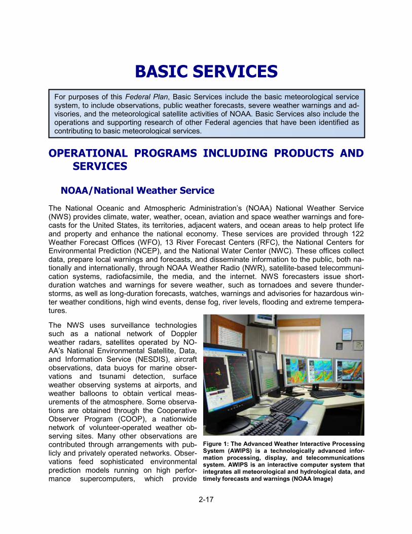
BASIC SERVICES
For purposes of this Federal Plan, Basic Services include the basic meteorological service system, to include observations, public weather forecasts, severe weather warnings and ad-visories, and the meteorological satellite activities of NOAA. Basic Services also include the operations and supporting research of other Federal agencies that have been identified as contributing to basic meteorological services.
OPERATIONAL PROGRAMS INCLUDING PRODUCTS AND SERVICES
NOAA/National Weather Service
The National Oceanic and Atmospheric Administration’s (NOAA) National Weather Service (NWS) provides climate, water, weather, ocean, aviation and space weather warnings and fore-casts for the United States, its territories, adjacent waters, and ocean areas to help protect life and property and enhance the national economy. These services are provided through 122 Weather Forecast Offices (WFO), 13 River Forecast Centers (RFC), the National Centers for Environmental Prediction (NCEP), and the National Water Center (NWC). These offices collect data, prepare local warnings and forecasts, and disseminate information to the public, both na-tionally and internationally, through NOAA Weather Radio (NWR), satellite-based telecommuni-cation systems, radiofacsimile, the media, and the internet. NWS forecasters issue short-duration watches and warnings for severe weather, such as tornadoes and severe thunder-storms, as well as long-duration forecasts, watches, warnings and advisories for hazardous win-ter weather conditions, high wind events, dense fog, river levels, flooding and extreme tempera-tures.
The NWS uses surveillance technologies such as a national network of Doppler weather radars, satellites operated by NO-AA’s National Environmental Satellite, Data, and Information Service (NESDIS), aircraft observations, data buoys for marine obser-vations and tsunami detection, surface weather observing systems at airports, and weather balloons to obtain vertical meas-urements of the atmosphere. Some observa-tions are obtained through the Cooperative Observer Program (COOP), a nationwide network of volunteer-operated weather ob-serving sites. Many other observations are contributed through arrangements with pub-licly and privately operated networks. Obser-vations feed sophisticated environmental prediction models running on high perfor-mance supercomputers, which provide
Figure 1: The Advanced Weather Interactive Processing System (AWIPS) is a technologically advanced infor-mation processing, display, and telecommunications system. AWIPS is an interactive computer system that integrates all meteorological and hydrological data, and timely forecasts and warnings (NOAA Image)
2-17

Section 2. Federal Meteorological Services and Supporting Research Programs
weather, water, climate, ocean, aviation and space weather forecast guidance that is available to users. The NWS’ highly trained and skilled workforce uses powerful workstations to analyze these data to issue forecasts and warnings around the clock. A high-speed communications hub allows for the efficient exchange of these data and products among NWS components, partners, and other users. NWS integrated dissemination infrastructure includes NWR, terrestrial, and satellite broadcasts, while the internet rapidly distributes this information.
The NWS creates forecasts in digital formats and makes them readily available. Forecasters use their expertise to maintain an up-to-date digital forecast database of weather elements. This information is stored in the National Digital Forecast Database (NDFD). Output from the NDFD is publicly available in the form of web graphics on the Internet and in several other digital for-mats. Outreach, education, and feedback are also critical elements in effective public response and improvements to NWS services.
RFCs routinely generate short range (deterministic) through extended range (probabilistic) river forecasts and (deterministic) flash flood guidance. Information from the RFCs and NCEP’s Weather Prediction Center (WPC) serves as the basis for local flood and flash flood warnings, watches and advisories issued by the WFOs. Some RFCs, especially those in mountainous re-gions, also provide water-supply volume and peak-flow forecasts based on snow pack in high elevations.
These water supply forecasts are used by a wide range of decision makers, including those in agriculture, hydroelectric dam operation and electricity generation, and water resources man-agement. A new element of the NWS water resources program infrastructure, NWC, was com-pleted in early 2014 on the campus of the University of Alabama in Tuscaloosa, Alabama. The NWC will enable NOAA, in partnership with other federal agencies, to deliver a new generation of water information and services to the nation. The NWC provides comprehensive snow obser-vations, analyses, data sets and map products for the Nation. NWC products and services are used by RFCs and WFOs to develop a variety of hydrologic products such as spring flood out-looks, water supply outlooks, river and flood forecasts, and reservoir inflow forecasts. Planned for July 2016, the NWC will deliver the National Water Model (NWM). The NWM is a high spatial and temporal resolution, continental-scale model of the nation’s river and stream network. The NWM will augment and expand NOAA’s current water quantity forecasts, delivered for approxi-mately 4000 river locations with stream gages, primarily operated by the USGS, across the country, to streamflow forecasts for 2.7 million streams nationwide, and high-resolution gridded forecasts of soil moisture, evapotranspiration, runoff, and other parameters. Future services, enabled by the NWM, will strengthen the nation’s water forecast capabilities for floods and droughts, improve preparedness for water related disasters, and inform high-value water deci-sions at the local, state and national levels.
NCEP consists of nine national centers that provide a backbone of national expertise for both forecast and numerical guidance. The NCEP Storm Prediction Center (SPC) provides forecasts and watches for severe thunderstorms and tornadoes over the contiguous United States. The National Hurricane Center (NHC) provides forecasts of tropical weather systems and issues watches and warnings for the U.S. and surrounding areas for systems in the tropical North At-lantic, Caribbean, Gulf of Mexico and Eastern Pacific and provides educational outreach and guidance for the international community in the region. The Central Pacific Hurricane Center (Honolulu) and the Joint Typhoon Warning Center (Pearl Harbor) provide additional tropical cy-clone coverage for the central and western Pacific, though not part of NCEP. The WPC provides analyses and forecast products with a focus on precipitation amount and type, winter precipita-tion, model diagnostics, surface pressure, frontal analysis and forecast products for the medium range (days 3-7). The Ocean Prediction Center (OPC), along with NHC, issues marine forecasts
2-18

Basic Services
for the Atlantic and Pacific oceans from the equator to the northern polar regions. The Aviation Weather Center (AWC) provides aviation warnings and forecasts of hazardous flight conditions at all levels within domestic and international air space. The Climate Prediction Center (CPC) provides assessments and forecasts of the impact of short-term climate variability, emphasizing enhanced risks of weather-related extreme events for use in mitigating losses and maximizing economic gain. The Space Weather Prediction Center (SWPC) provides real-time monitoring and forecasting of solar and geophysical events which impact satellites, power grids, communi-cations, navigation, and many other technological systems. The Environmental Modeling Center (EMC) develops and improves numerical weather, climate, hydrological and ocean prediction through applied research in data analysis, modeling and product development. NCEP Central Operations (NCO) sustains and executes the operational suite of numerical environmental anal-ysis and forecast models and prepares NCEP products for dissemination. They also process and manage the flow of data and products to and from the NCEP centers, partners, and cus-tomers. NCO also operates the NWS Telecommunications Operations Center, which provides for central, continuous acquisition, communications and dissemination of NWS and other do-mestic and foreign meteorological data and products.
There are other specialized service centers within the NWS. The Pacific Tsunami Warning Cen-ter (PTWC) and the National Tsunami Warning Center (NTWC) use data from a worldwide seismic network and Deep-ocean Assessment and Reporting of Tsunamis (DART) buoys locat-ed throughout the Pacific Ocean, Atlantic Ocean, and Caribbean Sea to issue tsunami watches and warnings for all U.S. and many international coastal communities. The National Data Buoy Center (NDBC) is responsible for the deployment and maintenance of coastal and ocean buoys and sensors that are used for marine forecasts and analysis of ocean-based storms. The NWS Volcanic Ash Advisory Center (VAAC) located in Anchorage, Alaska, provides worldwide warn-ings and advisories to aviation interests regarding airborne volcanic ash hazards (see further description of the global system of VAACs in the section on volcanic ash in Aviation Services.) The Radar Operations Center (ROC) provides centralized meteorological, software, mainte-nance, and engineering support for all Next-Generation Radar (NEXRAD systems for NWS, Department of Defense (DOD), and Department of Transportation (DOT). The National Recon-ditioning Center and National Logistics Support Center (NRC/NLSC) is the hub that provides mission critical components through which NWS equipment and DOT and DOD equipment pass for repair, quality inspection, warehousing, and distribution
NWS support several health-related programs such as Heat Health, the Ultraviolet Index and Air Quality. Heat Health Watch Warning Systems (HHWWS) have been developed for select cities to provide advance notice of excessive heat events that produce the greatest number of weath-er-related deaths.
NWS’ suite of products and services enable core partners’ decisions when weather, water, or climate has a direct impact on the protection of lives and livelihoods. As NWS works to fulfill the vision of a Weather-Ready Nation (WRN) its diverse portfolio of service capabilities will become more focused on a framework approach that will enable the agency to provide the foundational information and Impact-Based Decision Support Services (IDSS) needed. It is at this juncture where NWS’ highly skilled workforce provides significant value to achieve its mission. IDSS is a foundational concept of NWS’ WRN. Rather than developing and transmitting a suite of prod-ucts at fixed times during the day and expecting stakeholders to fully understand and take ap-propriate action; IDSS changes the paradigm so information users drive the update frequency and value-added meaning of the product. IDSS also provides greater flexibility for forecasters to work with key governmental partners and even embed within their emergency operations cen-ters to give first hand support to enhance decision making and public safety.
2-19
Section 2. Federal Meteorological Services and Supporting Research Programs
In 2015, NOAA completed a restructure of the NWS budget to simplify and align with functions. This restructure has restored budget credibility and transparency by strengthening internal con-trols and customer service while improving coordination and collaboration among activities that serve NWS’ overall mission. Guided by the recent National Academy of Sciences, “Becoming Second to None” (2012), and the National Academy of Public Administration (NAPA), “Forecast for the Future: Assuring the Capacity of the NWS” (2013) reports, NWS implemented the new portfolio-based budget structure and reorganized headquarters in order to better support mis-sion operations; improve prioritization and management of resources; and improve consistency of NWS products and services.
NOAA/National Environmental Satellite, Data, and Information Service
NOAA’s National Environmental Satellite, Data, and Information Service (NESDIS) operates the Nation’s civil operational environmental satellite system, making continuous observations of Earth and its oceans and atmosphere. Satellite observations are collected, processed, and used to develop weather, climate, ocean, and other environmental products, services, and long-term data records that benefit the American public.
Currently, NOAA’s main satellite constellations are the Geostationary Operational Environmen-tal Satellites (GOES) and Polar-orbiting Operational Environmental Satellites (POES). These two systems provide the U.S. component of a joint environmental monitoring system in partner-ship with the European Organization for the Exploitation of Meteorological Satellites (EU-METSAT). NOAA also operates the Suomi National Polar Partnership (S-NPP) satellite, a NO-AA-NASA mission which is the precursor to the future NOAA Joint Polar Satellite System (JPSS). On behalf of the Department of Defense (DoD), NESDIS also operates the Defense Meteorological Satellite Program (DMSP) spacecraft, part of the military’s sixth generation of weather satellites. NOAA also operates the Jason series of joint U.S.-European specialized po-lar-orbiting satellites that measure ocean surface topography. The first U.S. deep space satel-lite, DSCOVR – a partnership between NOAA, NASA and the U.S. Air Force, is also operated by NOAA and provides early warning for energy surges that could cause geomagnetic storms destined for Earth. In addition, on behalf of the Department of Commerce (DOC), NESDIS li-censes the operation of commercial remote-sensing land-imaging satellites. NESDIS also pro-vides long-term stewardship of environmental data, managing the world’s largest collection of climatic, geophysical, and oceanographic data derived from both in situ and space-based sys-tems.
Polar-orbiting Operational Environmental Satellites (POES)
POES circle Earth in a nearly north-south orbit at an altitude of 517 miles, passing close to both poles. These satellites ensure observational data for any region of Earth are no more than six hours old. Data from POES support global weather forecasting models, long-term global climate change research, and hazard detection and mitigation. In addition to S-NPP, NESDIS operates NOAA-15, NOAA-18, and NOAA-19, which continue to transmit data as back-up and secondary satellites. NESDIS also manages the command, control, and communications functions of DoD’s DMSP. MetOp-B, operated by EUMETSAT and launched in 2012, provides operational environmental monitoring in the mid-morning orbit. MetOp-A provides secondary coverage. The MetOp satellites carry three instruments provided by NOAA.
2-20

Basic Services
In addition, NOAA operates Jason-2 and Jason-3. This spacecraft series mission is to provide physical data of the ocean surface, including ocean surface altimetry, sea wave height, sea wave period, surface roughness, and other measurements. This mission, also called the Ocean Surface Topography Mission, is a follow-on to the successful Jason-1 mission developed by the French space agency—Centre National d’Etudes Spatiales (CNES)—and the National Aero-nautics and Space Administration (NASA).
Joint Polar Satellite System (JPSS)
JPSS is the next generation of U.S. civil polar-orbiting satellites, with the launch of JPSS-1 scheduled for FY 2017.
Because weather forecasters rely on data from NOAA’s current on-orbit assets, JPSS platforms focus on ensuring short- and long-term continuity in crucial weather forecasting, environmental monitoring, and climate monitoring data. S-NPP, the bridge mission between POES and JPSS, was successfully launched from Vandenberg Air Force Base, California, on October 28, 2011. In addition to serving as a prototype for the next-generation of NOAA’s polar-orbiting satellites, S-NPP provides continuity for NASA’s Earth Observing System mission. In 2013, operation was transferred to NOAA’s Office of Satellite Product Operations (OSPO), and in 2014 S-NPP was declared NOAA’s primary operational polar-orbiting spacecraft for NOAA’s operational weather forecasting mission. NOAA and EUMETSAT signed the Joint Polar System Agreement in De-cember 2015. This Agreement will continue their long history of cooperation in the polar orbit well into the 2030s. JPSS-1 is scheduled to be launched no later than the second quarter of FY 2017; JPSS continues to enhance the ground segment of the program to support S-NPP opera-tions as well as to prepare for JPSS-1. NOAA-NESDIS maintains a strong partnership with EU-METSAT, which will continue to be a cornerstone of a joint polar-orbiting constellation and will ensure NOAA-NESDIS’ ability to provide continuous measurements. JPSS continues to make progress on JPSS-2 development. The JPSS-2 spacecraft is on contract, and contracts for JPSS-2 instruments have been awarded. NOAA has also entered into agreement with NASA for the provision and accommodation of additional instruments to be flown on JPSS-2. The JPSS-2 instrument contracts will be completed by mid-FY 2016. JPSS-2 is planned for launch in FY 2021. With the FY 2016 funding, JPSS has initiated development of two more satellite missions to follow JPSS-2: the Polar Follow-On (PFO) JPSS-3 and JPSS-4. These spacecraft will provide continuity for observations from the polar orbit well into the 2030s.
Geostationary Operational Environmental Satellites (GOES)
GOES spacecraft orbit Earth in a geostationary position at an altitude of 22,300 miles, which means they orbit the equatorial plane of Earth at a speed matching Earth’s rotation. The GOES system provides continuous observations of environmental conditions of North, Central, and South America and the surrounding oceans. These spacecraft provide data critical for fast, ac-curate weather forecasts and warnings, detection of solar storm activity, and relay of distress signals from emergency beacons. They provide nearly continuous monitoring necessary for ef-fective, detailed, and extensive weather forecasting, prediction, and environmental monitoring.
There are two operational geostationary satellites for the North American region, GOES-East at 75°W and GOES-West, at 135°W, plus an on-orbit spare satellite at 105°W. Each operational satellite continuously views nearly one-third of Earth’s surface. GOES-P was launched on March 4, 2010, and was renamed GOES-15 once it was successfully on orbit. GOES-15 is the third and last in the current series of NOAA geostationary satellites. The current constellation consists of GOES-15 (West), GOES-13 (East), and GOES-14 (on-orbit spare).
2-21

Section 2. Federal Meteorological Services and Supporting Research Programs
GOES Series R
Figure 2: Geostationary Operational Environment Satel-lite–R Series (GOES-R). Image courtesy GOES-R Series Program and Lockheed Martin Space Systems Company
Geostationary satellites remain the weather sentinels for NOAA—tracking hurricanes, severe storms, clouds, and ocean features. The next-generation geo-stationary satellite series is called the Ge-ostationary Operational Environment Sat-ellite – R (GOES-R) series. The advanced spacecraft and instrument technology used on the GOES-R series will result in more timely and accurate weather fore-casts. It will improve support for the de-tection and observations of meteorologi-cal phenomena and directly benefit public safety, protection of property, and, ulti-mately, economic health and develop-ment. The GOES-R Advanced Baseline Imager (ABI) will scan its field of view on Earth nearly five times faster, with more than three times the spectral coverage and four times the spatial resolution of the current GOES imager. The GOES-R se-ries will provide users like meteorologists and government agencies with approxi-
mately 60 times the amount of data currently provided. The Geostationary Lightning Mapper (GLM), in geostationary orbit for the first time, will be capable of measuring total lightning activity continuously day and night with a horizontal resolution on the order of 10 km and detection effi-ciency ranging between 70 and 90%.
To ensure user readiness, forecasters and other users must have access to prototype advanced products within their operational environment well before launch. The GOES-R Proving Ground (http://www.goes-r.gov/users/proving-ground.html) engages the National Weather Service (NWS) forecast, watch, and warning community and other agency users in pre-operational demonstrations of the new and advanced capabilities that will be available from the GOES-R series. Examples of the advanced products include improvements on: volcanic ash detection, lightning detection, dust and aerosol detection, synthetic cloud and moisture imagery, as well as one-minute interval rapid scan imagery. A key component of the GOES-R Proving Ground is the two-way interaction between the researchers who introduce new products and techniques and the forecasters who then provide feedback and ideas for improvements that can best be incor-porated into NOAA’s integrated observing and analysis operations.
The GOES-R series is a collaborative development and acquisition effort between NOAA and NASA. In FY 2017, the GOES-R Series Program is planning for the launch of the GOES-R sat-ellite in the first quarter and associated post-launch testing and on-orbit checkout of the space-craft, ground system, and data-processing and distribution services. Additional FY 2017 activi-ties include continued development and integration activities of the GOES-S spacecraft hard-ware, and continued development of the instruments for GOES-T and GOES-U.
2-22
Basic Services
NOAA/NESDIS Data Centers
National Centers for Environmental Information (NCEI)
The National Centers for Environmental Information (NCEI, www.ncei.noaa.gov) is the official source for historical and near-real-time data and information covering weather, climate, coasts, oceans, geophysics, and space weather.
Access to reliable and accurate long-term records of environmental data and information is criti-cal to satisfying the Nation’s wide range of business, education, and government needs related to national security, the economy, the environment, and public safety. This includes policies and decisions that have an impact on water and energy management, manufacturing, transportation, food production, public health, and many other socio-economic issues that depend on quality data records and information.
The NCEI headquarters are in Asheville, NC, with major presences also in Boulder, CO, Silver Spring, MD, and Stennis Space Center, MS. NCEI is divided into two science centers and a da-ta stewardship division, which provides data preservation and access services.
• NCEI ensures the scientific integrity and usefulness of NCEI products and services through data synthesis, including description, monitoring, modeling, and assessment, data and in-formation preservation, and dissemination.
• NCEI performs quality assurance and reanalysis of historical data, including long-term satel-lite and weather station data records, to establish and update baseline data sets for global and national standards and environmental monitoring using current information technolo-gies.
• NCEI’s authoritative data and information enables today’s events to be put in historical per-spective and allows national decision-makers to make confident, data- and information-driven determinations about trends and extremes, such as how unusual or extreme a drought, snowstorm, or other environmental event is, providing for more appropriate gov-ernment and industry responses, including cost-effective emergency appropriations.
• NCEI products include decadal, annual, monthly, weekly, and daily U.S. and global weather summaries and climate reports, assessments of billion-dollar disasters, the World Ocean At-las, and the World Magnetic Model.
• NCEI works with many partners across the Nation, including other NOAA Line Offices and Cooperative Institutes (CIs), federal agencies, and national and international contributors and users of NCEI data, including industry, academia, and government.
Center for Weather and Climate (also see Climate Services)
The Center for Weather and Climate advances and enables weather and climate science and decision-making through the acquisition, monitoring, analysis, synthesis, and delivery of obser-vations, derived products and assessments, and information and outreach services. The Center uses data from national and international sources and operates observing systems for long-term monitoring (e.g., U.S. Climate Reference Network). It develops, describes, and helps implement operational quality control procedures and statistically analyzes observations and products to improve their value, utility, and homogeneity. The Center actively engages across NOAA and both the private and public sectors to collect and understand user needs. It develops responsive datasets, products, and services that improve environmental literacy, enable decision-making, support scientific advances and assessments, and inform policymaking. It actively engages the public through regional and sectoral services as well as scientific collaborations. In addition, the
2-23
Section 2. Federal Meteorological Services and Supporting Research Programs
Center promotes the scientific integrity and usefulness of its products and services through in-teractions with data providers, users, and the public. It interacts with constituents to promote awareness, understanding, access, and use of its data, information, and capabilities to ensure that all products and services meet user requirements. The Center supports U.S. bilateral and international commitments, principally with the World Meteorological Organization. This includes operating the World Data Systems for Meteorology and Paleoclimatology under the auspices of the International Council for Science, providing expertise for intergovernmental and nongovern-mental scientific programs.
Center for Coasts, Oceans, and Geophysics (also see Climate Services)
Previously NOAA's National Coastal Data Development Center, National Oceanographic Data Center, and National Geophysical Data Center, this center is responsible for preserving, moni-toring, and assessing the Nation's treasure of coastal, geophysical, and oceanographic data and information.
The Center for Coasts, Oceans, and Geophysics (CCOG) is the trusted authority that advances and enables environmental science and related decision-making from resilient coastal commu-nities to space weather. With oceanographic, geophysical, and solar observations that stretch from the surface of the sun to the depths of the oceans, CCOG derives products, develops as-sessments, and delivers information services in support of customer requirements. CCOG’s ca-pabilities support essential services to foster sustainable economic development and support coastal communities to prepare for and respond to emergencies. CCOG conducts integrated scientific analyses of coastal and marine environmental data sets to better understand historical trends, anomalies, and the frequency of occurrences of events in large marine ecosystems over a decadal or longer temporal scale. In support of the National Snow and Ice Data Center, CCOG delivers sea ice extent and concentration products supporting NOAA and Navy opera-tional ice forecasts in the Arctic as well as climatological sea ice trends. These long-term envi-ronmental and marine climatology data records provide NOAA, national and international data centers, researchers, and coastal zone managers information to understand an ecosystem’s historical record and to better enable the decision-making process, to establish status and trends, and to forecast future impacts on the ecosystem. CCOG is a leader in integrating physi-cal, biological, chemical, and living coastal and marine resource data based on the user re-quirements for this purpose. In addition, CCOG promotes the scientific integrity and usefulness of its products and services through interactions with data providers, users, and the public.
• NCEI’s Coastal Data Development (CDD) program, based in Stennis, MS, conducts inte-grated scientific analysis of coastal and marine environmental data sets to better understand historical trends, anomalies, and the frequency of occurrences of events in large marine ecosystems. CDD focuses on the development of products and services that bring together scientists and coastal managers in support of coastal ecological and observational data and information.
Data Stewardship Division
The Data Stewardship Division (DSD) of NCEI provides data preservation and access services that enable the NCEI centers, other government agencies, and the public to exploit NOAA’s multi-billion dollar investment in environmental observations. DSD maintains the nation’s archive of environmental information, as well as international data holdings through the World Data Sys-tem. It maximizes availability of archived information by leveraging data portals such as da-ta.gov and the World Meteorological Organization Information System. DSD leads and partici-
2-24

Basic Services
pates in developing and implementing standard practices in data and information management that facilitate data services and interoperability. DSD’s archive and access capabilities make use of a cost-effective suite of systems including CLASS, the Comprehensive Large Array-data Stewardship System, which supports satellite operations.
To guarantee the integrity and utility of NCEI’s physical and digital holdings, DSD performs es-sential data management functions including:
• Acquisition of real-time and historical data sets from national and international sources; • Automated data ingest, including quality assurance, quality control, and data validation; • Data rescue from limited access sources or deteriorating media; • Secure preservation, including redundant offsite storage and media migration; • Interoperable data sharing through use of national and international standards for metadata,
data formats, and web services; • Data documentation and metadata cataloging; • Information processing, product generation and data reprocessing; and • Data publication and dissemination.
NOAA/Office of Marine and Aviation Operations
The NOAA Office of Marine and Aviation Operations (OMAO) operates a fleet of survey ships and aircraft to support NOAA’s mission goals. NOAA’s ship fleet includes oceanographic and atmospheric research vessels. The NOAA aircraft fleet includes aircraft that collect environmen-tal and geographic data essential to NOAA hurricane and other severe weather and atmospher-ic research and aircraft that conduct aerial surveys to forecast water supply and flooding poten-tial from snow melt.
NOAA vessels make weather and ocean observations in the marine environment. Over 50,000 automated observations are submitted per year through the World Meteorological Organiza-tion’s (WMO) Voluntary Observing Ships scheme. NOAA vessels also support NOAA’s NDBC in recovery of buoys that have been disabled or gone adrift.
NOAA supports a broad range of meteorological activities and projects with its fleet of aircraft, based at MacDill Air Force Base in Tampa, Florida. Three of its nine aircraft are dedicated to this purpose throughout the year, providing valuable information to NOAA and the Nation. The NOAA Gulfstream, G-IV (SP) (N49RF), provides scientists with a platform for the investigation of processes in the upper troposphere and lower stratosphere. With an operating ceiling of 45,000 ft, the G-IV is a critical tool for obtaining the data necessary to improve hurricane track forecasts and for research leading to improvements in hurricane intensity forecasts.
The NOAA G-IV annually supports hurricane synoptic surveillance missions; the aircraft flies in the environment surrounding the storm at a high altitude, releasing Global Positioning System (GPS)–equipped dropsondes at preselected locations. The data from these vertical atmospheric soundings are received, processed, and transmitted from the aircraft to a NOAA NCEP comput-er site, where they are incorporated into computer models of hurricanes to improve hurricane track forecasts. Each dropsonde directly measure temperature, pressure, and humidity at the rate of two samples per second as it falls through the atmosphere to the surface and computes wind speed and wind direction at a rate of four samples per second, using a full-up GPS receiv-er. Recent estimates of the improvement in hurricane track predictions utilizing this technology show an improvement of between 20 and 30 percent, which represents a savings of $10 million or more per hurricane in warning and preparedness costs.
2-25
Section 2. Federal Meteorological Services and Supporting Research Programs
Two NOAA WP-3D Lockheed Orion aircraft (N42RF and N43RF) support NOAA's atmospheric and oceanographic research, as well as its tropical storm and hurricane reconnaissance opera-tions. The aircraft’s research and navigation systems provide detailed spatial and temporal ob-servations of a wide range of atmospheric and oceanic parameters. NOAA’s Aircraft Operations Center (AOC) develops and calibrates specialized instruments, installs and integrates user-supplied instrumentation into the aircraft and data network, and processes data for immediate satellite transmission or future analysis. The NOAA WP-3D aircraft, while executing the complex flight patterns required for hurricane research, also provide storm data to the NHC in real time, transmitting flight level data and GPS dropsonde messages, as well as radar images transmit-ted via their multiple aircraft-satellite data links. The stepped frequency microwave radiometers (SFMR) on the NOAA WP-3D are used to map the surface wind fields in and around hurricanes and tropical storms. Real-time surface wind speed maps are critical to providing more accurate forecasts of the extent of hurricane and tropical storm force winds.
During each hurricane season, the two NOAA WP-3Ds support several major research experi-ments in support of NOAA’s Hurricane Research Division (HRD) of NOAA’s Atlantic Oceano-graphic and Meteorological Laboratories in its Intensity Forecast Experiment (IFEX), an ongoing program studying hurricane genesis, rapid intensification, and other related experiments. A promising part of this research effort is the collaboration with NOAA’s EMC in a program to ob-tain three-dimensional horizontal wind fields in developing tropical systems and hurricanes, uti-lizing the Tail Doppler Radars of the WP-3D aircraft. The objective of this effort is to obtain data that can be assimilated into the Hurricane Weather Research and Forecasting (HWRF) model for the purpose of improving hurricane intensity forecasts. Extensive descriptions of the various hurricane research experiments may be found in the HRD Field Program Plan for 2012.
The NOAA WP-3D aircraft annually participate in both summer and winter operations supporting the NESDIS satellite validation program. Operating in regions of high winds and heavy precipita-tion, one of the WP-3Ds, equipped with microwave scatterometers and radiometers, provides under-flight validation of the ocean surface wind vectors sensed by the European ASCAT and Indian OceanWind2 satellites. Traditional venues for these satellite validation operations are Alaska or Newfoundland in the winter and the Atlantic and Caribbean regions during the sum-mer hurricane season.
These versatile aircraft also support international and interagency projects. Prior to the start of the 2014 Hurricane season, NOAA Aircraft Operations Center, working with the Mexican Navy, Air Force, CONAGUA, the National Hurricane Center (NHC), and the U.S. Embassy, estab-lished an agreement that would allow NOAA Hurricane Hunter aircraft to base out of Mexican Navy and Air Force facilities for hurricane reconnaissance tasking for eastern Pacific storms. In October, 2014, N43RF successfully completed a detachment to La Paz, Mexico, in support of NHC tasked missions on Hurricane Simon. This relationship allows NHC to further investigate these storms and provide watches and warnings for eastern Pacific hurricanes.
National Aeronautics and Space Administration Basic Meteorological Services
The National Aeronautics and Space Administration (NASA) is a long-term partner with the Na-tional Oceanic and Atmospheric Administration (NOAA) for building and launching the U.S. Po-lar Operational Environmental Satellite (POES) and Geostationary Operational Environmental Satellite (GOES) civilian weather satellites, under reimbursable arrangements. Additionally, after the termination of the National Polar-orbiting Operational Environmental Satellite System (NPOESS) Program, NASA took on the role of the acquisition agency for the NOAA-funded
2-26
Basic Services
Joint Polar Satellite System (JPSS) Program. Several missions, including the Ocean Surface Topography Mission (OSTM) and Suomi National Polar-orbiting Partnership (Suomi NPP), are NASA research missions that were developed in partnership with NOAA and are now being op-erated by NOAA as part of the operational weather system. Jason-3 – which was funded by NOAA, implemented by NASA, and launched successfully in January of 2016 – is a follow-on to the TOPEX/Poseidon, Jason-1, and OSTM series. In the President’s FY 2015 budget request, NASA assumed responsibility for the sustained climate measurements such as total solar irradi-ance, vertical ozone profiles, and Earth’s radiation budget in the JPSS-2 (2021) timeframe. Ad-ditionally, the President’s FY 2016 budget request transferred responsibility from NOAA to NASA for the completion and launch of the TSIS-1 instrument to the ISS, as well as the devel-opment and operation of the next mission in the ocean altimetry series, Jason Continuity of Ser-vice (Jason-CS). In FY 2017, NASA will continue to execute its responsibilities regarding the development and launch of reimbursable partnered missions.
SUPPORTING RESEARCH PROGRAMS AND PROJECTS
Interagency Collaborative Research Programs and Projects
The National Earth System Prediction Capability
The National Earth System Prediction Capability (ESPC) is an ongoing collaborative project among the National Oceanic and Atmospheric Administration (NOAA), U.S. Navy, U.S. Air Force, Dept. of Energy (DOE), National Aeronautics and Space Administration (NASA), and the National Science Foundation (NSF).
The National ESPC program (http://espc.oar.noaa.gov/) will provide a more accurate global ocean and atmospheric forecast system with longer skillful forecast times at synoptic, sub-seasonal, seasonal, and inter-annual scales through integrating and coupling global atmos-phere, ocean, ice, land and near-space forecast models into an operational suite of prediction systems that reduce errors relative to current modeling approaches. Additionally, it will continue to develop a national common modeling architecture to improve cross-agency collaboration, emphasizing more efficient computational architectures to allow real-time high-resolution opera-tional prediction at these extended time scales. In FY 2017, predictability demonstration plans will be refined, and science workshops and early benchmark testing will be conducted. The - program goal is to advance skillful forecasts (relative to climatology) from the operational capa-bility, currently 7-10 days, to 30 days and subseasonal. Follow-on program goals include coor-dinated interagency predictions and projections at the subdecadal and decadal time scales.
The United States Weather Research Program
The Hydrometeorological Testbed (HMT). The NOAA USWRP has invested in research and transition of research to applications to improve quantitative precipitation forecasts through NO-AA’s HMT (http://hmt.noaa.gov/), led by the Physical Sciences Division (PSD) of NO-AA/OAR/Earth System Research Laboratory (ESRL). The HMT seeks to improve regional pre-cipitation forecasts, particularly for heavy, flooding rains. This support continued as the HMT moved from the West Coast to set up a pilot field program in the southeast United States. This project was operated in collaboration with OAR’s ESRL, National Severe Storms Laboratory (NSSL), and NWS’s Hydrometeorological Prediction Center. In FY 2014, NASA and NOAA be-gan their initial collaborative phase of the long-term HMT-Southeast Pilot Studies (HMT-SEPS) effort in central and southwestern North Carolina.
2-27
Section 2. Federal Meteorological Services and Supporting Research Programs
The NASA Global Precipitation Measurement Mission (GPM) Ground Validation program re-ceived collaborative efforts from NOAA via measurements and instrumentation to measure the size distribution of precipitation and rain rates for the successful NASA GPM Olympic Mountains Experiment (OLYMPEX) held November 2015-January 2016 in the Olympic Mountains in Wash-ington. OLYMPEX was one of the most comprehensive campaigns for GPM, validating rain and snow measurements in midlatitude frontal systems moving from ocean to coast to mountains. OLYMPEX observations are being used to determine how remotely sensed measurements of precipitation by GPM can be applied to a range of hydrologic, weather forecasting and climate data. During FY 2016, combined science analysis and hydrologic modeling occurred using NASA GPM and NOAA HMT measurements from the Integrated Precipitation and Hydrology Experiment (IPHEX), held May-June 2014 in North Carolina. In addition, GPM ground validation relies heavily upon NOAA’s Multi-Radar Multi-Sensor (MRMS) system developed by the Nation-al Severe Storms Laboratory. MRMS provides fine temporal and spatial scale ground based ra-dar products that can then be averaged over a satellite footprint for the purposes of direct vali-dation of GPM satellite precipitation products. In FY 2017, validation work will continue as GPM approaches its End-of-Prime Mission Review and Senior Review in the spring of 2017. GPM precipitation product algorithm versions will also be updated from Version 04 to Version 05.
Observing System Simulation Experiment (OSSE) infrastructure development. In FY 2015, NASA contributed a high-resolution “nature run” to the Joint Center for Satellite Data As-similation (JCSDA), which became a baseline data set for OSSE systems. In FY 2016 and be-yond, this nature run is continuing to be a fundamental data set for use at OSSE testbed and other OSSE activities including the GPS Radio Occultation (GPSRO) and Constellation Observ-ing System for Meteorology, Ionosphere, and Climate-2 (COSMIC-2) OSSE efforts at the Uni-versity Corporation for Atmospheric Research (UCAR). NASA held an OSSE workshop in June 2016 to identify the gaps and develop a roadmap for an OSSE system that might support in-strument trade studies and mission design decisions. Three types of OSSEs were discussed: (1) OSSE for observation impact on weather forecast skills, (2) OSSE for understanding mission requirements to constrain climate sensitivities, and (3) OSSE for mission designs especially for satellite constellations.
Joint Center for Satellite Data Assimilation
The Joint Center for Satellite Data Assimilation (JCSDA) is a U.S. partnership between NOAA, NASA, the U.S. Navy, and the U.S. Air Force dedicated to developing and improving our ability to exploit satellite data more effectively in environmental analyses and forecast models. The JCSDA is a collaborative effort that allows the development and testing of techniques required to assimilate the billions of satellite observations available daily to be shared by several agen-cies. This effort would otherwise be duplicated across the agencies.
The JCSDA has the following goals: (1) Reduce the average time for operational implementa-tion of data from new satellite sensors to less than one year, (2) Increase the use and impact of current satellite data in numerical weather prediction models, (3) Advance common data assimi-lation infrastructure and methods, and (4) Assess the impacts of data from advanced satellite sensors on environmental predictions. By meeting these goals, the JCSDA achieves its objec-tive of maximizing the nation’s return on its investment in global observing systems and model-ing, and providing improvements to the U.S. forecasting system (civilian and military), which in turn contributes to protecting citizens lives and property and the nation’s global interests. Priori-ties for the JCSDA in FY17 include successful exploitation of new research (Global Precipitation Measurement, Soil Moisture Active Passive, Rapidscat, Cyclone Global Navigation Satellite System, etc.) and operational (Geostationary Operational Environmental Satellite - R Series and
2-28

Basic Services
Joint Polar Satellite System) satellites, improving the use of cloud-affected satellite data and Atmospheric Wind Vector observations, and expanding a standing observation system impact assessment capability.
Wind Forecast Improvement Projects (WFIP 1 and WFIP 2)
The Wind Forecasting Improvement Project in Complex Terrain (WFIP 2) began in FY 2015 and will build on the efforts of the first Wind Forecasting Improvement Project (WFIP 1) which was completed in FY 2014. For WFIP 1, wind energy companies shared meteorological observations collected on tall towers and wind turbines on wind farms with NOAA, who used the data for model verification and validation, as well as assimilation into its advanced, rapidly refreshed weather models. NOAA and DOE have encouraged renewable energy companies to sign data sharing agreements under which NOAA will maintain the proprietary nature of such data, while using them for research and operational weather forecasts to reduce risk for the wind industry.
WFIP 2 will develop further improvements to foundational atmospheric model physics in predict-ing wind ramp and day-ahead events for areas of complex terrain. WFIP 2 is a multi-year DOE and NOAA sponsored project done in conjunction with four DOE National Laboratories and FOA awardee Vaisala, Inc. WFIP 2 will focus on improving the physical understanding of atmospheric processes in complex terrain impacting wind industry forecasts and incorporating the new un-derstanding into the foundational weather forecasting models. The integrated WFIP 2 team be-gan an 18-month field campaign in FY 2016 to gather data using 56 different meteorological in-struments during all four seasons in the Columbia River Gorge region of Washington and Ore-gon. The data will be used to assess how physical processes alter wind speeds in order to im-prove model forecasts at hub heights.
Once the field campaign is completed in FY 2017, the team will work to develop physical model-ing schemes or atmospheric theories that better represent physical processes and increase the
accuracy of 0 to 15 hour wind en-ergy forecasts with positive implica-tions to the day ahead forecast (out to 45 hours) while focusing on the wind plant inflow. NOAA’s 13-km Rapid Refresh (RAP), 3-km High Resolution Rapid Refresh (HRRR), and 750-m HRRR nest use the open-source WRF model at the core and will be the focus of im-provements to model physics at the mesoscale and smaller scales. Im-proved bridging of models across multiple scales is a focus of WFIP 2. Forecast uncertainties will be quantified using both data and en-semble techniques. Decision sup-port tools will be developed that incorporate these uncertainties to better communicate forecast relia-bility to system operators and other users.
Figure 3: WFIP 2 field campaign sites for collecting data with in-strumentation including DOE coastal wind profilers (purple cir-cles), 915-MHz radar wind profilers (yellow circles), sodars (black diamonds), and lidars (red crosses) located near four NWS Weath-er Forecast Offices (red stars) within the Bonneville Power Admin-istration (BPA) Service Area (green line)
2-29

Section 2. Federal Meteorological Services and Supporting Research Programs
WFIP 2 follows the recently completed WFIP 1 as a second large-scale project in a growing number of joint agency efforts under a Memorandum of Understanding (http://www.energy.gov/eere/wind/downloads/memorandum-understanding-weather-dependent-and-oceanic-renewable-energy) on “Weather-dependent and Oceanic Renewable Energy Re-sources” signed by NOAA and DOE in January 2011. The agreement set up a framework for NOAA and DOE to work together on renewable energy modeling and forecasting.
NOAA/National Weather Service/Environmental Modeling Center
Continually improving the accuracy, timeliness, and accessibility to prediction services is a re-sult of research and development (R&D), and research to operations efforts within the NWS, at other NOAA offices such as OAR, and externally from universities and private corporations. As one of the nine NCEP Centers, EMC uses advanced modeling methods developed both inter-nally and cooperatively with universities, the international scientific community, NESDIS, OAR, and other government agencies. EMC is a partner in the JCSDA, which is designed to acceler-ate the use of research and operational satellite data in NCEP operational models. The EMC conducts applied research and technology transfers and publishes results in various media for dissemination to the world meteorological, oceanographic, and climate communities. EMC also participates in ongoing interactive research programs such as the Next Generation Global Pre-diction System (NGGPS), NOAA’s Hurricane Forecast Improvement Project (HFIP) and the WRF community model. Furthermore, EMC efforts in collaborative development resulted in im-provements to mesoscale and global models, as well as advances in hurricane track forecasts, climate forecasts, and air quality forecasts.
Next Generation Global Prediction System (NGGPS)
NWS Office of Science and Technology Integration (STI) manages the Research to Operations (R2O) initiative that expands and accelerates transition of research to operations to address growing service demands and increase the accuracy of weather forecasts through accelerated development and implementation of global weather prediction models, improved data assimila-tion techniques, and improved software architecture and system engineering. The new unified coupled modeling system will have the flexibility and capability to implement model component improvements as they are developed.
The NWS R2O initiative's five year plan is to upgrade the current operational Global Forecast System (GFS) to run as a unified, fully coupled Next Generation Global Prediction System (NGGPS) within NOAA Environmental Modeling System (NEMS) infrastructure. Using advanced high performance computing architectures, the system will incorporate the most recent advanc-es in weather prediction modeling from NOAA, interagency and academic partners. Selection of a new dynamical core for NGGPS started from five dynamical cores that were developed by Navy, NCAR, NOAA/OAR and NOAA/EMC. Evaluations and testing of two remaining dynamical cores are in progress to make the selection in FY 2016 and the initial NGGPS implementation is planned for FY 2019. The main goals of NWS R2O initiative are to:
• Implement a weather-scale, fully-coupled numerical weather prediction (NWP) system • Extend weather forecasting to 30 days • Improve hurricane track and intensity forecast
2-30
Basic Services
NOAA/Hurricane Forecast Improvement Project (HFIP)
HFIP contributes significantly to NOAA's forecast services through improved hurricane forecast science and technology. Managed by NWS/STI as part of the integrated numerical model im-provement program, HFIP provides the unifying organizational infrastructure and funding for NOAA and other agencies to coordinate the hurricane research needed to significantly improve guidance for hurricane track, intensity, and storm surge forecasts and accelerate the transition from research to operations. HFIP is in the sixth year of its mission to reduce track and intensity errors, increase the probability of detection and decrease the false alarm ratio for rapid intensifi-cation and extend the lead-time for hurricane forecasts out to seven days. HFIP developed a high-performance computing system housed at the NOAA Skaggs Building in Boulder, Colorado to support the significant computational demands of such an approach. With the computational infrastructure, HFIP focuses multi-organizational activities to research, develop, demonstrate and implement enhanced operational modeling capabilities, dramatically improving the numeri-cal forecast guidance made available to National Hurricane Center (NHC).
HFIP’s structured approach accelerates bringing promising technologies and techniques from the research community into operations. In particular, HFIP has successfully
• aligned focused research efforts within NOAA and with NOAA’s interagency and academic partners;
• established a process to leverage outside research capabilities in support of project objec-tives (Federally funded grantees working within a community code repository);
• defined and implemented a solution (the seasonal, real-time experimental forecast system) to accelerate research into operational products; and
• established a high performance computing infrastructure and attendant protocols to support research-to-operations activities.
NOAA/National Environmental Satellite, Data, and Information Service
Center for Satellite Applications and Research (STAR)
As the primary science arm of NESDIS, STAR provides leadership for NESDIS research, devel-opment, validation, and maintenance of satellite-derived products and applications from NOAA’s operational geostationary and polar-orbiting satellites and from many non-NOAA research and international satellites. STAR develops new environmental applications, techniques, and algo-rithms for transforming raw satellite observations into scientifically meaningful, quality–assured, and calibrated environmental measurements and products. STAR also develops the pre-operational computer codes to implement these products. STAR supports the calibration and validation of all satellite sensors used in NOAA’s satellite operations and develops methods and maintains systems for inter-calibrating NOAA satellite data with other satellites in the interna-tional constellation of research and operational satellites. STAR collaborates with other NESDIS and NOAA offices, universities, NASA and other U.S. agencies, and international organizations on exchange and evaluation of operational and research satellite data and products. The Joint Center for Satellite Data Assimilation (JCSDA)—collocated with STAR and the NWS Environ-mental Modeling Center (EMC) at the NOAA Center for Weather and Climate Prediction (NCWCP)—is a joint distributed center sponsored by NOAA, NASA, and Departments of the Navy and Air Force. In addition to STAR, the NOAA partners include the Office of Oceanic and Atmospheric Research (OAR) Atlantic Oceanographic and Meteorological Laboratory (AOML)
2-31

Section 2. Federal Meteorological Services and Supporting Research Programs
and the National Weather Service’s National Centers for Environmental Prediction (NCEP). The JCSDA was established in 2001 to accelerate and improve the quantitative use of research and operational satellite data in weather, ocean, climate, and environmental analysis and prediction systems. JCSDA research and development directly supports NOAA and DoD in their opera-tional environmental prediction responsibilities.
NOAA/Office of Oceanic and Atmospheric Research (OAR)
The OAR Research Laboratories and Programs conduct an integrated program of research, technology development, and services to improve the understanding of the Earth’s atmosphere and to describe and predict changes occurring to it. OAR programs, laboratories and their field stations are located across the country. Scientists study, monitor and model atmospheric, oce-anic and other processes that affect weather, air quality, water resources, and climate. By re-searching Earth’s atmospheric system, OAR improves the understanding of weather and in-tense events such as hurricanes, tornadoes, winter storms, extreme precipitation, and severe thunderstorms in addition to seasonal droughts, and the effects of the changing climate on these events. OAR integrates these findings into environmental information products for weath-er support for forecast operations, disaster preparedness, emergency response and manage-ment, transportation safety and efficiency, renewable energy production, and other sectors of the economy affected by weather. These products improve critical weather and climate tools used by the private sector, government agencies, decision-makers, and the public.
OAR Laboratories and Programs
Air Resources Laboratory (ARL)
ARL supports basic meteorological products and services through research and development in atmospheric dispersion, air quality, and boundary layer science. Primary research activities and programs are 1) using the ARL-developed Hybrid Single-Particle Lagrangian Integrated Trajec-tory (HYSPLIT) model to track the transport, dispersion and fate of harmful chemicals and mate-rials; 2) providing the Real-time Environmental Applications and Display sYstem (READY) that allows users to access and display meteorological data and run trajectory and dispersion model products based on the HYSPLIT model on ARL's web server; 3) improving air quality forecast-ing models to address health issues associated with ground-level ozone (O3) and fine particu-late matter (PM2.5) for NOAA and other researchers; and 4) designing, developing, and deploy-ing meteorological and turbulence instrumentation for use on land and in the air.
In FY17, ARL will:
• Continue to develop and apply the HYSPLIT model to track and forecast, the release of ra-dioactive material, volcanic ash, dust, and wildfire smoke, and other hazardous materials. ARL will continue to provide HYSPLIT-Mercury assessments for the Great Lakes Restora-tion Initiative.
• ARL scientists will continue developing the inline meteorology-dispersion approach for com-plex terrain, use ensembles to assess model uncertainty, and utilize source attribution tech-niques for a variety dispersion applications. Deliver to NWS a forecasting system tailored for global chemical transport model coupling capable of tracking smoke and dust plumes origi-nating from outside the continental US.
2-32
Basic Services
• Continue to develop applications using small Unmanned Arial Systems to help understand the formation, intensity, structure and path characteristics of tornadoes as well as to exam-ine additional meteorological phenomena.
• Continue work with NOAA’s Office of Response and Restoration to make needed improve-ments to the integrated HYSPLIT-CAMEO/Aloha modeling system for short- and long-range atmospheric transport applications.
• Continue the development of a five- year re-analysis dataset, generated using the Commu-nity Multi-scale Air Quality model, to address O3 and PM2.5 for the benefit of the air quality and climate research communities. Generate a new forecast product using data from the Joint Polar Satellite System to link ocean isoprene emissions to changes in ozone and aero-sols that affect air quality and climate.
Atlantic Oceanographic and Meteorological Laboratory (AOML)
AOML conducts mission oriented scientific research that seeks to understand the physical, chemical, and biological characteristics and processes of the ocean and atmosphere, both sep-arately and as a coupled system. The Laboratory's research themes (oceans and climate, http://www.aoml.noaa.gov/research/ocean_climate.html; coastal ecosystems, http://www.aoml.noaa.gov/research/coastal_ecosystems.html; and hurricanes and tropical me-teorology, http://www.aoml.noaa.gov/research/hurricanes.html) employ a cross-disciplinary ap-proach, conducted through collaborative interactions with national and international research and environmental forecasting institutions. The work also provides reliable information based on oceanic and atmospheric measurements and analysis.
AOML scientists study atmospheric and oceanic processes that affect tropical cyclones, torna-does, rainfall (drought), and climate impacts on weather. In addition to research, AOML serves as the operational data center for several programs that directly improve weather services through providing in situ observations from Argo profiling floats, surface drifters and the Pirata Northeast Extension. Research includes improved understanding and application development surrounding physical processes like the El Nino-Southern Oscillation (ENSO) phenomena, North Atlantic Oscillation (NAO), tropical Atlantic variability, the Meridional Overturning Cell, wind-driven gyres in the Atlantic, the global carbon cycle, and other climatically-relevant atmos-pheric compounds. Of particular note includes AOML research into tropical Cyclones and ocean observing technologies.
Ocean Observing Technologies
In addition to the many weather-related observing systems, AOML is dedicated to improving the development, deployment, and monitoring of oceanographic-related observing technologies and related data in support of meteorology forecasts. As part of this effort, AOML collaborates with the National Weather Service to gather and transmit in real-time marine weather observations from ship-based observations. The AMVER SEAS 2K is a real-time ship and environmental data acquisition and transmission system (developed and support by AOML), reports atmospheric and oceanographic data from Ship of Opportunity Program. AOML also manages, in partnership with the Climate Program Office, the Global Drifter Program, the Argo profiling float data as-sembly center, and the XBT data assembly center that provide real-time oceanic observations to help improve weather forecast models.
2-33
Section 2. Federal Meteorological Services and Supporting Research Programs
Tropical Cyclone Research
To improve tropical cyclone track and intensity forecast guidance, AOML’s Hurricane Research Division (HRD) uses in situ and remotely sensed data collected by aircraft, satellites, and buoys and computer model simulations of the inner core of tropical cyclones and their surrounding en-vironment. An aircraft field program is used to gather datasets representing all stages of the storm’s lifecycle; these datasets are used to both support operational needs and provide the cornerstone of HRD’s research to advance the understanding and prediction of tropical cy-clones. The observations are primarily collected during the hurricane season using two NOAA turboprop aircraft and a Gulfstream-IV jet operated by NOAA’s AOC.
HRD’s major objectives are the assimilation and evaluation of the new G-IV tail Doppler radar observations to improve forecast guidance, evaluation of the Global Hawk unmanned aircraft systems (UAS) observations to improve forecast guidance in collaboration with the NASA Hurri-cane Severe Storm Sentinel (HS3) program, and collecting observations specifically to evaluate the atmospheric and oceanic boundary layer physical parameterizations used in NOAA’s opera-tional Hurricane Weather Research and Forecasting (HWRF) model. As part of the OAR Sandy Supplemental supported research activities, HRD will evaluate and assess the benefits of using new and emerging observing technologies consisting of aircraft-deployed low altitude UAS and Doppler wind lidar (DWL) profiling systems to improve forecast guidance through evaluation of and improvements to the physical parameterization routines used in HWRF.
HRD is also the principal OAR component of NOAA’s Hurricane Forecast Improvement Project (HFIP). Begun in 2009, the HFIP is a unified 10-year NOAA plan to improve the 1-day to 5-day forecasts for tropical cyclone activity, with a focus on rapid intensity change. Researchers at HRD, together with 2-3 researchers at OAR’s Geophysical Fluid Dynamics Laboratory (GFDL), 5-6 researchers at ESRL, and 5-6 researchers at NCEP/EMC make up the NOAA core capabil-ity for hurricane R&D and play a major role in the HFIP. The objectives of the HFIP are to coor-dinate hurricane-related R&D within the NOAA entities mentioned above and to broaden their interactions with the outside research community in order to address NOAA’s operational hurri-cane forecast needs.
In support of OAR’s Sandy Supplemental supported High Impact Weather Prediction Project (HIWPP), HRD is collaborating with NCEP/EMC to accelerate the development of a fully two-way interactive moving nested, multi scale, non-hydrostatic modeling system based on EMC-developed Nonhydrostatic Multiscale Model on B-grid (NMM-B) in the NOAA Environmental Modeling System (NEMS) framework. Multiple HWRF-like nests will be designed to operate at about 3 km resolution within a basin-scale and global version of NMM-B to capture tropical cy-clone inner core process and interactions with the large-scale environment, critical for improving track, intensity, rainfall and size predictions.
Earth System Research Laboratory (ESRL)
At NOAA’s largest research facility, the Earth System Research Laboratory (ESRL), scientists (from four complementary divisions) study and monitor atmospheric and other processes that affect weather, air quality, water resources, and climate. By researching the dynamic Earth sys-tem, ESRL improves understanding of what causes today’s weather, next month’s hurricanes, next season’s drought, and next century’s climate. ESRL integrates these findings into environ-mental information products ranging from weather support for aviation and emergency man-agement, to methods that improve critical weather and climate tools used by the private sector, government agencies, decision-makers, and the public. ESRL research is so comprehensive
2-34
Basic Services
that it is impossible to give each program or project equal mention. The following description highlights a very small portion of products and services provided by ESRL.
ESRL provides long-term, high quality observations of atmospheric composition that are critical for understanding changes in the Earth system. These observations are used worldwide by sci-entists studying climate, air quality, and ozone-depletion. They form the core of international ob-serving systems and are critical for delivering updates of key products such as CarbonTracker, the NOAA Annual Greenhouse Gas Index (a national climate indicator), methane climatologies, CO2 trends (daily updates; a national climate indicator), the Ozone-Depleting Gas Index, Glob-alView, and other long-term atmospheric composition data sets and products. They are used to set standards for GCOS, GEOSS, and WMO Global Atmosphere Watch. These observations stem from 6 global baseline observatories, ESRL-operated observing networks for stratospheric and tropospheric ozone, aerosols, surface radiation, ozone-depleting gases, and greenhouse gases, and a system of tall towers and aircraft observations across North America.
ESRL carries out process studies which improve understanding of the physics and dynamics associated with weather and other atmospheric phenomena. In FY17, the ESRL Physical Sci-ences Division (PSD) will lead a cross-NOAA El Niño Rapid Response Field Campaign , an un-precedented scientific opportunity to accelerate advances in understanding and predictions of an extreme climate event and its impacts.. In FY16, ESRL scientists will use the unique meas-urements of the initial response of response of the atmosphere to the warm ocean water at the heart of the very strong El Niño collected during the rapid response field campaign to learn more about chain of events which produce, extreme precipitation on the West Coast and many other impacts. Evaluations of the impact of the observations on realtime operational forecasts and how well weather and climate forecast models represent and predict the making of the resulting extreme events will occur. All of this research will result in presentations at international scien-tific meetings, such as those sponsored by AGU and AMS , and peer-reviewed publications. The data gathered will support research over the next 5 to 10 years to improve the weather forecast modeling of extremes, and climate modeling of seasonal and longer forecasts of El Ni-ño impacts.
The ESRL Global Systems Division (GSD) leads the design, development, testing, and delivery of accurate and reliable weather forecast system solutions. GSD’s work supports decision-making in NOAA, NOAA’s National Weather Service (NWS), the Federal Aviation Administra-tion, government emergency managers, and the transportation and renewable energy indus-tries.
GSD is a world leader in numerical weather prediction and developed both the hourly Rapid Re-fresh (RAP) and the High Resolution Rapid Refresh (HRRR) weather prediction models used in NWS operations. These models provide frequent snapshot forecasts of hazardous weather in-cluding flash floods, winter weather, and thunderstorms that could produce a tornado. New ver-sions of the RAP and HRRR weather models with advanced capabilities will be implemented into operations in June 2016. GSD also uses its expertise in physics, data assimilation, model-ing, and verification to support the Next-Generation Global Prediction System initiative to build the foundation for the next NWS global forecast guidance system.
GSD develops, tests, and evaluates forecast and decision support systems to give forecasters, and air traffic and emergency managers, timely and accurate hazard information. The corner-stone of each NWS Forecast Office is the Advanced Weather Interactive Processing System (AWIPS) originally developed by GSD. GSD continues to work with the NWS and the private sector to improve AWIPS. The prototype Integrated Support for Impacted Air Traffic Environ-ments (INSITE) tool uses weather forecasts to identify hazardous weather that could impact air
2-35
Section 2. Federal Meteorological Services and Supporting Research Programs
traffic routes. NWS forecasters can use INSITE to inform FAA Air Traffic managers about poten-tial weather hazards so they can re-route air traffic. INSITE will transition to operations in 2017.
GSD identifies, investigates and develops high-performance computing methods and innovative visualization systems. The Science On a Sphere® (SOS) global display system uses computers and video projectors to display animated earth science datasets on the outside of a six-foot di-ameter sphere. The SOS is an education tool which explains Earth system science in an intui-tive and captivating way to people of all ages. In late FY15, GSD released SOS Explorer™, a downloadable flat screen version to provide teachers and students with visualizations of over 500 Science On a Sphere® datasets and movies for use in their own classrooms (http://www.sos.noaa.gov/SOS_Explorer/). An SOS Explorer exhibit just made its debut at a lo-cal museum where visitors controlled the data display with an iPad. There are plans to produce more SOS Explorer exhibits for expanded outreach.
ESRL/Chemical Sciences Division research provides a scientific basis for efforts to improve air quality, and will continue to monitor long-lived gases in Earth’s changing atmosphere to ad-vance understanding of climate-related effects of short-lived pollutants, atmospheric particles, and their interactions with clouds. Additionally ESRL will continue collaboration with USDA/USFS to identify and quantify emissions of gases and aerosols from burning of different biomass materials for improvement of forecast models that provide air quality information to the public and to responders on-scene at wildland fires. They will continue participation in the Trop-ospheric Ozone Lidar Network (TOLNet) to further understanding of processes in the atmos-pheric boundary layer that affect ozone and aerosols.
Geophysical Fluid Dynamics Laboratory (GFDL)
The Geophysical Fluid Dynamics Laboratory (GFDL) mission is to advance scientific under-standing of climate and its natural and anthropogenic variations and impacts, and improve NO-AA’s predictive capabilities, through the development and use of world-leading computer mod-els of the Earth System. GFDL scientists focus on model-building relevant for society, such as hurricane research, prediction, and seasonal forecasting, and understanding global and regional climate change. GFDL research encompasses the predictability and sensitivity of global and regional climate; the structure, variability, dynamics and interaction of the atmosphere and the ocean; and the ways that the atmosphere and oceans influence, and are influenced by various trace constituents. The scientific work of the Laboratory incorporates a variety of disciplines in-cluding meteorology, oceanography, hydrology, classical physics, fluid dynamics, chemistry, applied mathematics, and numerical analysis.
Research at GFDL improves our understanding of atmospheric circulations, ranging in scale from hurricanes to extratropical storms and the general circulation, with an emphasis on ex-treme weather events and the interplay between weather phenomena and climate variability and change at regional scales. High-resolution atmospheric models with comprehensive treatment of physical processes are central tools in this work.
Ongoing research will continue to explore a potential breakthrough in predicting seasonal hurri-cane activity: atmospheric models forced with observed SST can skillfully predict the interannual variability of the number of hurricanes in the Atlantic, showing that the random part of this annu-al Atlantic hurricane frequency (the part not predictable given the SSTs) is relatively small. Iden-tifying the processes that are key to determining tropical cyclone frequency may allow us to ex-tend dynamical forecast lead-time toward one year. GFDL will also continue to improve statisti-cal methods for using coupled climate models to develop long-lead-time forecasts of seasonal hurricane activity, and experimental forecasts will continue to be updated on GFDL’s website.
2-36

Basic Services
Even longer lead-time predictions are targeted through a vigorous research program on decadal variability, predictability, and predictions. At the heart of that program are efforts to better under-stand physical processes that contribute to decadal variations and predictability in the climate system, particularly in terms of the role of the ocean as a driver of decadal-scale variations. Augmenting this research are decadal hindcast and prediction experiments yielding model-produced “predictions” for each year from 1961 to 2011. The ongoing analysis of these simula-tions seeks to evaluate whether predictive skill for near-term (decadal) climate forecasts is in-creased when starting from the observed state of the climate system, in addition to the predic-tive skill that arises from changing radiative forcing. Preliminary assessments of the predictive skill in these simulations reveal that they have skill that is at least comparable to other interna-tional efforts.
Complementing this effort is research to improve our understanding of the interactive three-dimensional radiative-dynamical-chemical-hydrological structure of the climate system, from the surface and troposphere to the upper stratosphere and mesosphere, on various time and space scales. Continued research in FY16 will focus on a better understanding of the response of global and regional climate to natural and anthropogenic aerosol emissions. GFDL’s world-leading high-resolution models use the very latest numerical techniques to provide extremely energetic, realistic simulations of the climate system. Through their use in FY16, GFDL seeks to further scientific understanding of the role of the ocean and atmospheric constituents in climate variability and change, on regional to global scales. This research continues to exploit NOAA’s high performance computing capability housed at DOE’s Oak Ridge National Laboratory. De-spite the relatively high computational cost, GFDL scientists believe it is critical to move to re-gional-scale high-resolution climate models to better understand the causes and predictability of decadal-scale climate fluctuations, as well as the role of the ocean in critical climate change is-sues, such as oceanic heat uptake.
Great Lakes Environmental Research Laboratory
The Great Lakes Environmental Research Laboratory (GLERL) develops and operates technol-ogy for scientific observations in the Great Lakes ecosystem. GLERL scientists acquire the data and develop information needed to improve our understanding of the Great Lakes ecosystem and support decision-making for improved resource management. Advancements in areas such as remote sensing, the miniaturization of sensors, and other data-gathering technologies have vastly increased the data gathering capacity of the scientific community. Additionally, GLERL tests and applies models for predicting the effects of natural and human-generated changes on the Great Lakes environment. Modeling of the atmosphere, lakes, seasonal changes in ice cov-er, and the ecosystem dynamics of the lakes adds to our understanding of how the Great Lakes basin changes over the course of months and years. GLERL research on regional climate pro-jections is based on atmospheric and coupled hydrodynamics-ice-ecosystem models. Research tools are designed to examine the effects of climate on regional air temperature, precipitation, water levels, lake temperature and thermal structure, ice cover, and ecological changes and trends.
In FY 17, priorities for GLERL include continuing research, development, and transfer of remote sensing products from the Great Lakes CoastWatch Node. GLERL will focus on satellite syn-thetic aperture radar (SAR) and moderate resolution imaging spectroradiometer (MODIS) ice classification and mapping. GLERL will also focus on continued data collection and analysis for the advancement of ice-ocean ecosystem modeling in the Artic. GLERL’s hydrologic modeling program will advance the GLERL hydrometeorological database, improve Great Lakes basin runoff and evaporation estimates, and continue to enhance the Great Lakes hydroclimate dash-
2-37
Section 2. Federal Meteorological Services and Supporting Research Programs
board. GLERL will continue efforts on regional climate projection impact assessment and histor-ic trends analysis. GLERL will assess the similarity and differences between model runs from the Coupled Hydrosphere-Atmosphere Research Model (CHARM) with model runs from other GCMs. GLERL will continue to develop and validate modeling systems that contribute directly to projection of the overall water budget and levels of the Great Lakes, as well as enhances un-derstanding of relevant climate change processes on a regional scale.
National Severe Storms Laboratory (NSSL)
The mission of the National Severe Storms Laboratory (NSSL) consists both of conducting fun-damental research to advance our knowledge and understanding of meteorological processes associated with severe convective storms, as well as applied research and development leading to the transition of new and improved tools and techniques for observation, analysis, and predic-tion to the NWS and other stakeholders. These efforts are aimed at improving the accuracy and lead-time of severe weather forecasts and warnings, lending support to a Weather-Ready Na-tion that is resilient in the face of increasing vulnerability to severe and disruptive weather. In particular, NSSL seeks to improve the accuracy and timeliness of forecasts and warnings of se-vere thunderstorms, tornadoes, hail, flash floods, lightning, mixed precipitation in winter storms, and their societal impacts. Advancements in observing system capabilities and physical under-standing of processes that produce hazardous convective weather are core to NSSL’s funda-mental research. NSSL provides leadership in the understanding of storm structure, processes, and evolution, and the use of polarimetric radar observations to understand the interrelation-ships among microphysics, dynamics, electrification, and lightning activity across a broad spec-trum of convective storms.
NSSL’s research for the next decade is focused around six “grand scientific challenges” repre-senting challenging, yet resolvable and societally-important problems. Specifically, NSSL scien-tists are seeking to attain the goal of the Warn-on-Forecast program in providing NWS forecast-ers with guidance needed to extend lead-times for severe thunderstorm and tornado warnings out to one hour with substantially reduced false alarms. Second, WSR- 88D capabilities will be enhanced by addressing this aging operational radar technology, its current gaps in radar cov-erage, and longstanding limits of tornado lead time with high false alarm rates. A major empha-sis in this challenge is to advance Phased Array Radar technologies for high-impact weather events. Third, NSSL is developing capabilities to reliably predict flash flooding for urban and complex landscapes several hours in advance, and providing probabilistic hydrologic predictions with longer lead times and greater accuracy than current systems. Fourth, NSSL research seeks to demonstrate that useful warnings of lightning activity can be predicted one hour in ad-vance from the very onset of convection to its demise, both in-cloud (as an indicator of storm intensity changes and short-term predictor of severe weather potential) and cloud-to-ground lightning (for public safety and aviation concerns). Fifth, our plans are to develop a reliable now-casting system for convection initiation that goes well beyond the current reliance on surface, radar and satellite detection of low-level boundaries, so as to address fundamental gaps in our understanding of how the pre-convective environment is evolving. Finally, NSSL will provide un-certainty information for high impact weather to reduce tornado and other severe weather warn-ing false alarms significantly and provide the public with probabilistic, risk-based information to replace current “binary” yes/no warning areas. This is needed to greatly improve public deci-sion-making to attain a better-informed Weather-Ready Nation that is resilient to dangerous, high-impact weather events.
2-38
Basic Services
Office of Weather and Air Quality
NOAA’s Office of Weather and Air Quality (OWAQ) improves weather and air chemistry forecast information and products by funding, facilitating, and coordinating research, as well as supports the transition of research results into operations. By working with scientists and academic part-ners, this research is transitioned into useful weather applications, watches and warnings to pro-tect the lives and property of the American public and inform weather-sensitive U.S. industry. OWAQ provides outreach, linkages, and coordination between NOAA, other Government agen-cies, academia, the private sector, and non-profit research partnerships, particularly NOAA’s Cooperative Institutes and Cooperative Science Centers. OWAQ additionally supports social science studies to test research results that improve communication during dangerous weather situations.
In FY17, OWAQ will continue supporting projects through the U.S. Weather Research Program (USWRP) to improve high-impact weather and air quality forecasting and also improve NOAA’s global modeling system from days to months through the National ESPC project. Currently, OWAQ is also funding Research to Operations (R2O) under USWRP Research to Operations (USWRP-R2O) and Joint Technology Transfer Initiative (JTTI) to transition matured weather research from the American weather enterprise into National Weather Service operations. OWAQ will continue to support testbeds, high-resolution numerical model, and National Water Model improvements to enable better high-impact weather forecasts, including tropical cy-clones, extreme precipitation, flash floods and severe thunderstorms. In FY17, OWAQ will com-pete and fund the next round of two-year testbed projects in the Hazardous Weather Testbed, the Hydrometeorology Testbed, and the Joint Hurricane Testbed. This is a continuation of the testbed program funded by USWRP that is currently supporting 18 two-year research-to-operations projects at universities in these three testbeds.
In addition, air quality modeling research will contribute to improving National Weather Service smoke, dust, and volcanic ash predictions. Five new one-to-three year air quality research and forecasting projects were funded in FY16 at universities and private companies that will improve air quality forecasting capabilities in the NWS. OWAQ will also fund social science research that helps to understand how society uses and interprets weather information and how to improve the communication of weather information to the public.
Pacific Marine Environmental Laboratory (PMEL)
Meteorological research at PMEL focuses on air-sea interaction research in the Gulf of Alaska Bering Sea, and Chukchi Sea, as part of PMEL’s Ecosystem-Fisheries Oceanography Coordi-nated Investigations (EcoFOCI) project, conducted jointly with NOAA’s National Marine Fisher-ies Service/Alaska Fisheries Science Center. Financial support for the research is provided by NOAA, NSF, the North Pacific Research Board (NPRB), and the DOI/Bureau of Ocean Energy Management (BOEM).
PMEL’s ocean climate research programs collect surface meteorological data from moored buoys and report in near-real time for ingest into global models. Data from PMEL’s PIRATA and RAMA tropical observing systems in the Atlantic and Indian Oceans, and from PMEL’s ocean climate stations at Ocean Weather Station Papa (Gulf of Alaska) and the Kuroshio Extension Observatory in the Northwest Pacific report surface meteorological data.
PMEL conducts research on atmospheric aerosols and their impact on air quality and climate. In 2016 (November) and 2017 (May), PMEL is participating in NAAMES (North Atlantic Aerosols and Marine Ecosystems) research cruises. NAAMES is a multi-platform, interdisciplinary inves-
2-39

Section 2. Federal Meteorological Services and Supporting Research Programs
tigation focused on marine ecosystems and aerosol properties in the climate sensitive North At-lantic. NAAMES will study the annual life cycle of phytoplankton and the impact small airborne particles derived from marine organisms have on climate in the North Atlantic. PMEL will make shipboard measurements to characterize the emission, properties, and cloud nucleating ability of sea spray aerosol over a range of ocean conditions and seasons.
NASA Supporting Research for Basic Meteorological Services
Research in Basic Meteorology and Atmospheric Science
NASA-sponsored research continues to gain new insight into weather and extreme-weather events by the utilization of data obtained from a variety of NASA and partner satellite platforms and field experiments. In FY 2016, data analysis was conducted for two polar winds airborne campaigns performed during FY 2015 to test the NASA developed wind lidar instruments in support of the European Space Agency (ESA) Atmospheric Dynamics Atmospheric Dynamics Mission Aeolus satellite (ADM-Aeolus). Further calibration/validation collaboration with ESA is being planned for launch of ADM-Aeolus in 2017. Also, the NASA FY 2017 budget will fund the second year of the Precipitation Measurement Missions (PMM) Science Team, which includes 60 research investigations competitively selected in FY 2016 through a ROSES-2016 grant ap-plication solicitation. The new PMM Science Team addresses research in three categories:
1. development, evaluation, and validation of Tropical Rainfall Measuring Mission (TRMM) and GPM retrieval algorithms;
2. development of methodologies for improved applications of satellite measurements; and 3. use of satellite and ground measurements for physical process studies to gain a better un-
derstanding of the global water cycle, climate, and weather and concomitant improvements in numerical models on cloud resolving to climate scales.
Short-term Prediction Research and Transition Center
NASA encourages more rapid use of NASA’s observations in operational weather predictions. The Short-term Prediction Research and Transition (SPoRT) center at NASA Marshall Space Flight Center is chartered to advance this research to operation transition activity. The SPoRT center has become NASA’s primary research and operation transition interface with the National Weather Service for short-term (0 to 48 hours) weather predictions. Many NASA research data products are tested in near real time and disseminated to NOAA’s weather forecast offices. NASA also funds external research proposals to collaborate with the SPoRT center to acceler-ate the transition of research data to at least one operational environment.
NASA continued the investment in SPoRT and the external research projects to accelerate the transition of research data to operational environments. As previously noted, three two-year re-search and development projects funded by the ROSES-13 program element “NASA Data for Operation and Assessment” (NDOA) have ended. In FY 2016, NASA announced another run of the NDOA ROSES element. NASA plans to review the proposals and makes selection in late summer 2016. Awarded projects will start in FY 2017.
2-40

Basic Services
Technology Development
Technology investments are aligned with NASA's Climate Centric Architecture strategic docu-ment. A majority of the investments also are centered on the National Research Council (NRC) Decadal Survey1 activities, many supporting NASA’s foundational and climate continuity mis-sions. Such investments focus on maturation of technologies to enable advanced space-based observations and modeling to improve understanding of the global integrated Earth system, in-cluding global and regional climate change. The Earth Science Technology Office (ESTO) pro-vides funding for instrument, component, and information technologies prior to mission formula-tion. Developing and validating technologies well in advance of a flight project help to improve acceptance and reduce costs. Projects are initiated regularly through the ROSES solicitation and the duration of each project is typically three years. For FY 2016, ongoing investigations are being managed in the Instrument Incubator, Advanced Information Systems Technology (AIST), Advanced Component Technology, and In-space Validation of Earth Science Technology areas. New investments were solicited in FY 2016 under the Instrument Incubator Program and Ad-vanced Information Systems Technology areas through ROSES-2016 solicitations. Of note, in early FY 2015 a new radiance instrument, the HyperSpectral Imager for Climate Science (HyS-ICS), made a successful balloon flight, collecting the most accurate solar radiance measure-ments (calibrated to the Sun to better than 0.2 percent radiometric accuracy) that have ever been made of the Earth. FY 2017 will see the selection of new awards from the AIST-ROSES-2016 solicitations. The launches of three CubeSats with weather-related technologies targeted for the late CY 2016-early CY 2017 time period are planned as follows: 1) HARP (Hyper Angular Rainbow Polarimeter) is a highly accurate and precise wide field of view hyperangular polarime-ter (2-4km resolution) in a three unit CubeSat for characterizing aerosol and cloud properties at 440, 550, 660 and 870nm. 2) IceCube is a three unit CubeSat to validate a new 874-GHz radi-ometer for use in future ice cloud measurement missions. 3) MiRaTA (Microwave Radiometer Technology Acceleration) is a three unit CubeSat that will validate new microwave radiometer and GPS Radio Occultation (GPSRO) technology including an all-weather sounder at three bands: ~55 GHz (temperature), ~183 GHz (humidity), and ~207 GHz (cloud ice), and also, of radiometric accuracy and precision to state-of-the art levels.
NASA Applied Sciences Program
The Applied Sciences Program leverages NASA satellite measurements and new scientific knowledge to enable innovative and practical uses by public and private sector organizations. Projects, which are competitively selected through ROSES, are designed to discover and demonstrate new applications and facilitate adoption by non-NASA organizations. In FY 2016, the Applied Sciences Program’s Health and Air Quality element funded a project to improve the initialization of the NOAA/National Centers for Environmental Prediction (NCEP) operational air quality system, which is based on the Community Multi-scale Air Quality (CMAQ) model, through chemical data assimilation of satellite retrieval products with the Community Gridpoint Statistical Interpolation (GSI) system. Additionally, the element began a project utilizing Moder-ate Resolution Imaging Spectroradiometer (MODIS) and Visible Infrared Imaging Radiometer Suite (VIIRS) observations to improve the detection of K. brevis blooms along the Florida Gulf Coast. The project’s goal is improved daily detection of “red tide” leading to routine rapid fore-
1 NASA and its partners ask the NRC once each decade to look out ten or more years into the future and prioritize research areas, observations, and notional missions to make those observations. The last De-cadal Survey was completed in 2007, entitled Earth Science and Applications from Space: National Im-peratives for the Next Decade and Beyond.
2-41
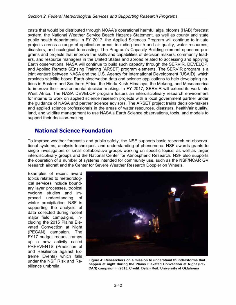
Section 2. Federal Meteorological Services and Supporting Research Programs
casts that would be distributed through NOAA’s operational harmful algal blooms (HAB) forecast system, the National Weather Service Beach Hazards Statement, as well as county and state public health departments. In FY 2017, the Applied Sciences Program will continue to initiate projects across a range of application areas, including health and air quality, water resources, disasters, and ecological forecasting. The Program’s Capacity Building element sponsors pro-grams and projects that improve the skills and capabilities of decision makers, community lead-ers, and resource managers in the United States and abroad related to accessing and applying Earth observations. NASA will continue to build such capacity through the SERVIR, DEVELOP, and Applied Remote SEnsing Training (ARSET) program elements. The SERVIR program is a joint venture between NASA and the U.S. Agency for International Development (USAID), which provides satellite-based Earth observation data and science applications to help developing na-tions in Eastern and Southern Africa, the Hindu Kush-Himalaya, the Mekong, and Mesoamerica to improve their environmental decision-making. In FY 2017, SERVIR will extend its work into West Africa. The NASA DEVELOP program fosters an interdisciplinary research environment for interns to work on applied science research projects with a local government partner under the guidance of NASA and partner science advisors. The ARSET project trains decision-makers and applied science professionals in the areas of water resources, disasters, health/air quality, land, and wildfire management to use NASA’s Earth Science observations, tools, and models to support their decision-making.
National Science Foundation
To improve weather forecasts and public safety, the NSF supports basic research on observa-tional systems, analysis techniques, and understanding of phenomena. NSF awards grants to single investigators or small collaborative groups working on specific topics, as well as larger interdisciplinary groups and the National Center for Atmospheric Research. NSF also supports the operation of a number of systems intended for community use, such as the NSF/NCAR GV research aircraft and the Center for Severe Weather Research Doppler on Wheels.
Examples of recent award topics related to meteorolog-ical services include bound-ary layer processes, tropical cyclone studies and im-proved understanding of winter precipitation. NSF is supporting the analysis of data collected during recent major field campaigns, in-cluding the 2015 Plains Ele-vated Convection at Night (PECAN) campaign. The FY17 budget request ramps up a new activity called PREEVENTS (Prediction of and Resilience against Ex-treme Events) which falls under the NSF Risk and Re-silience umbrella.
Figure 4: Researchers on a mission to understand thunderstorms that happen at night during the Plains Elevated Convection at Night (PE-CAN) campaign in 2015. Credit: Dylan Reif, University of Oklahoma
2-42

AGRICULTURAL AND LAND MANAGEMENT METEOROLOGICAL
SERVICES
For purposes of this Federal Plan, Agricultural and Land Management Meteorological Ser-vices are those services and facilities established to meet the requirements of the agricultur-al industries and Federal, state, and local agencies charged with the protection and mainte-nance of the Nation's land areas. Meteorological services specifically tailored for wildland fire management are reported under the Wildland Fire Weather service category.
2-43
OPERATIONAL PROGRAMS INCLUDING PRODUCTS AND SERVICES
Interagency Programs
Joint Agricultural Weather Facility (JAWF)
In 1978, the World Agricultural Outlook Board (WAOB) and the National Oceanic and Atmos-pheric Administration (NOAA) formed the Joint Agricultural Weather Facility (JAWF). JAWF is as an operational unit, serving as an important link between the respective meteorological com-ponents of the Departments of Agriculture and Commerce. Additional information on the JAWF is included in the U.S. Department of Agriculture narrative below and at http://www.usda.gov/oce/weather/.
U.S. Department of Agriculture
Office of the Chief Economist
The United States Department of Agriculture (USDA) Office of the Chief Economist (OCE) World Agricultural Outlook Board (WAOB) serves as the USDA focal point for economic intelli-gence and commodity outlook for U.S. and world agriculture. The WAOB coordinates, reviews, and approves the World Agricultural Supply and Demand Estimates (WASDE) report. The WASDE report provides USDA’s forecasts of supply and demand for major U.S. and global crops as well as U.S. livestock. The WAOB maintains the integrity of this report by ensuring all information used to prepare the report is consistent, objective, and reliable. Because weather and climate have a significant impact on agricultural production, the WAOB employs meteorolo-gists who specialize in preparing agricultural weather assessments, the group being collectively referred to as OCE/WAOB’s Office of the Chief Meteorologist (OCM).
The primary mission of OCM staff is to routinely collect global weather data and agricultural in-formation to assess the impact of growing season weather conditions on crops and livestock

Section 2. Federal Meteorological Services and Supporting Research Programs
production prospects, keeping USDA commodity analysts, the OCE, and the Secretary of Agri-culture and top staff well informed of weather impacts on crops and livestock worldwide. These assessments are integrated into USDA’s monthly analytical process to develop monthly foreign crop estimates of area, yield, and production published in the monthly WASDE reports. In addi-tion to providing routine agricultural weather assessments, OCM meteorologists prepare special assessments when extreme weather (e.g., droughts, heat waves, freezes, floods, and hurri-canes) has been observed or is imminent. Alerts of anomalous weather conditions impacting agriculture around the globe are also routinely included in a daily report of agricultural develop-ments that is sent to USDA policy makers each afternoon. When integrated with other data, these routine and special crop-weather assessments and analyses provide critical information to USDA decision-makers preparing crop production forecasts, formulating trade policy, and coor-dinating disaster relief.
While many of the group’s core functions are internal, OCM staff routinely disseminates infor-mation to the public. Each morning, a written summary of current weather affecting agriculture in the United States is sent to the Secretary’s office and posted on the OCE website: http://www.usda.gov/oce/weather/pubs/Daily/TODAYSWX.pdf. The meteorologists also routine-ly give public interviews, available not only through USDA’s Information Office but also private sector media outlets. In 2012 and 2013, for example, OCM staff played a key role in providing assessments of the historic drought that impacted much of the Nation’s agriculture by conduct-ing interviews with national and international news outlets and disseminating unique products and assessments via the USDA homepage and blog.
In support of its mission, the OCM receives a full suite of meteorological data and products from the NWS for use in their assessments, including surface weather observations, radar data, sat-ellite imagery, and model output. As part of the aforementioned JAWF agreement, the OCM serves as the focal point for dissemination of meteorological data and products to other USDA agencies, including weather data received from the Global Observing System, a worldwide net-work of nearly 8,000 meteorological reporting stations managed by the World Meteorological Organization (WMO). Additionally, the OCM obtains data from the NWS Cooperative Observer Program (COOP) to support domestic agricultural weather applications. In recent years, the NWS, National Hurricane Center (NHC), CPC, and the Hydrometeorological Prediction Center have supported USDA by providing an increasing number of their operational products in GIS-compatible formats. These NOAA GIS efforts have benefited the OCM significantly by increas-ing the speed and efficiency with which agricultural weather assessments can be prepared and enabling analysts to more accurately assess weather impacts on agriculture.
JAWF’s flagship publication, the Weekly Weather and Crop Bulletin (WWCB), is jointly produced by the OCM, the National Agricultural Statistics Service (NASS), and NOAA/CPC. First pub-lished in 1872 as the Weekly Weather Chronicle, the publication provides a vital source of in-formation on weather, climate, and agricultural developments worldwide. The WWCB highlights weekly meteorological and agricultural developments on national and international scales, via numerous maps, charts, tables, and text products. In total, these products provide a compre-hensive illustration of the weather and climate conditions affecting agriculture, benefiting USDA decision makers and the agricultural community. Crop and weather information provided in the WWCB keeps crop and livestock producers, farm organizations, agribusinesses, state and na-tional farm policy-makers, government agencies, and foreign buyers of agricultural products ap-prised of worldwide weather-related developments and their effects on crops and livestock. The extensive history provides a reference source that is rich in climate and agricultural information, which is essential for episodic-events monitoring and analog-year comparisons.
2-44

Agricultural and Land Management Services
Although the main emphasis of the WWCB is on current growing-season weather conditions and agricultural developments in the United States, real-time agricultural weather assessments are also provided for foreign countries that are either major exporters or importers of agricultural commodities. While providing timely weather and crop information relevant to the monthly Crop Production and WASDE reports (issued by USDA/NASS and USDA/OCE/WAOB, respectively), the WWCB keeps the U.S. agricultural sector apprised of weather conditions impacting agricul-ture in foreign markets, which could possibly influence production decisions at the farm level.
In September 1994, the OCM published Major World Crop Areas and Climatic Profiles (Agricul-tural Handbook No. 664). Knowledge of historical weather and climate patterns and past agricul-tural production in major agricultural regions worldwide is critical to the success of JAWF’s agrometeorological assessments, and this reference handbook provides the framework for as-sessing the weather’s impact on world crop production by providing information on climate and crop data for key producing regions and countries. Coverage includes major agricultural regions and crops, including coarse grains, winter and spring wheat, rice, major oilseeds, sugar, and cotton. World maps show the normal developmental stage of regional crops by month. No long-er issued in a paper format, an electronic version of the handbook was developed to provide periodic updates to the printed version as additional data become available. The Major World Crop Areas and Climatic Profiles book and other publications are available online at http://www.usda.gov/oce/weather/pubs/index.htm.
In the summer of 1999, the U.S. Drought Monitor (USDM) was developed to help improve drought assessments in the United States. The USDM is a collaborative effort between federal and academic partners, including the University of Nebraska-Lincoln National Drought Mitigation Center (NDMC), USDA, CPC, the NOAA/NESDIS/National Climatic Data Center, and the De-sert Research Institute. Approximately 11 lead authors, two of whom work for the OCM, rotate the responsibility of preparing the USDM. Produced weekly, the USDM is a synthesis of multiple indices and impacts depicted on a map and in narrative form. The NDMC hosts the USDM on its Website at http://droughtmonitor.unl.edu. The USDM, released each Thursday at 8:30 a.m. Eastern time, is a key source of information for briefing USDA top staff on U.S. drought devel-opments. In recent years, the USDM has served as a trigger mechanism for several USDA pro-grams and, because the USDM is prepared in a GIS, it is often overlaid on agricultural data to illustrate and quantify the spatial extent of drought affecting various agricultural commodities (Figure 1). In 2013, OCE entered into a cooperative agreement with the NDMC to improve U.S. agricultural drought monitoring capabilities and assessments by integrating USDA agricultural statistics and other relevant data sets into a GIS format to improve author’s ability to incorporate various information types into their analytical process.
Similarly, the North American Drought Monitor (NADM) is a cooperative drought monitoring ef-fort among drought experts in Canada, Mexico, and the United States. The NADM was initiated at a workshop in April 2002 and is part of a larger effort to improve the monitoring of North American climate extremes. Issued monthly since January 2003, the NADM is based on the end-of-month USDM analysis and input from scientists in Canada and Mexico. Major partici-pants in the NADM program include the USDM collaborators – two of whom are OCM staff – as well as Agriculture and Agrifood Canada and the National Meteorological Service of Mexico. The NADM Website is: http://www.ncdc.noaa.gov/temp-and-precip/drought/nadm/index.html.
A U.S. Drought Monitor Forum and a North American Drought Monitor Forum are held in alter-nating years. These meetings provide an opportunity for Drought Monitor authors, stakeholders, and members of the drought community to discuss the latest drought monitoring tools, drought analyses, and requirements. The most recent U.S. Drought Monitor Forum was held on April 13-
2-45

Section 2. Federal Meteorological Services and Supporting Research Programs
17, 2015, in Reno, Nevada, while a North American Drought Monitor Forum was recently held on June 21-23, 2016, in Fort Worth, Texas.
Figure 1. Percent of U.S. corn area in drought, according to the May 24, 2016, U.S. Drought Monitor. OCE is one of several USDA agencies that have taken a lead role in the development of Na-tional Integrated Drought Information System (NIDIS), working closely with lead Federal agency NOAA and the Western Governors Association (WGA) over the years to address the specific needs of the agricultural community. The NIDIS builds upon existing drought monitoring tools and experiences, such as the USDM, to develop an early warning system that aids in drought preparation and mitigation. Recommendations for such an early warning system were outlined in a 2004 report from the WGA entitled “Creating a Drought Early Warning System for the 21st Century: The National Integrated Drought Information System.” One of the early deliverables of NIDIS was the Drought Portal (http://www.drought.gov), which serves as the Government’s mul-ti-agency drought interface. The OCM is working with other USDA agencies to provide relevant drought information to the public via the Drought Portal.
As a result of the aforementioned activities with the NDMC, NOAA, and other agencies and or-ganizations, OCE is a recognized leader within the USDA in the area of drought. In December, 2012, a Memorandum of Understanding was signed between USDA and NOAA to collaborate on projects of mutual interest, with particular emphasis on establishing new partnerships in the area of drought monitoring and mitigation. OCE enjoyed a lead role in developing the agree-
2-46

Agricultural and Land Management Services
ment and is currently working with NOAA to develop a work plan to identify near- and long-term deliverables and opportunities for collaboration. In 2014, USDA announced the creation of sev-en Climate Hub and three Sub-Hub locations. Under the direction of OCE’s Climate Change Program Office, the Climate Hubs will deliver science-based knowledge, practical information and program support to farmers, ranchers, forest landowners, and resource managers to sup-port decision-making related to climate change. Key partners in the networks include the public and land grant universities, Cooperative Extension, USDA researchers, the private sector, state, local and regional governments, the National Oceanic and Atmospheric Administration (NOAA), Department of Interior (DOI) regional climate change experts, and non-profits engaged in providing assistance to landowners.
Throughout its history, WAOB has successfully worked with international groups, including rep-resentatives of foreign governments and of multinational organizations. WAOB remains active in the World Meteorological Organization (WMO) Commission for Agricultural Meteorology (CAgM), and a WAOB meteorologist is currently serving on the Management Group of the WMO CAgM, helping guide Commission efforts to improve support systems for agrometeorolog-ical services. This position helps coordinate Expert Teams responsible for reviewing the opera-tional applications of current agrometeorological data, analytical tools, and information delivery systems and making recommendations on the procedures, methodologies, and resources nec-essary to improve the capability for operational applications. Additionally, WAOB continues to support the World AgroMeteorological Information Service (WAMIS), a dedicated web server that hosts agrometeorological bulletins and advisories issued by WMO Members for the global agricultural community (http://www.wamis.org/). WAOB is collaborating with other WMO Mem-bers to expand WAMIS capabilities, including the development on a web-based GIS capability that will dynamically integrate weather and climate information.
Risk Management Agency
The Risk Management Agency (RMA), Strategic Data Acquisition and Analyses (SDAA) unit works with Oregon State University’s Parameter-Elevation Regressions on Independent Slopes Model (PRISM) Climate Group through the Center for Agribusiness Excellence (CAE), Tarleton State University, to produce and utilize innovative spatial climate data sets to identify and inves-tigate potentially fraudulent crop loss claims. CAE manages RMA’s day to day operations of the Agency’s data mining and data warehouse operations and Oregon State University’s PRISM Climate Group is a leader for spatial climate analysis. It produces the USDA’s official normal (30-year average) data sets of temperature and precipitation for the United States, as well as time series of climatological variables spanning 1895-present.
High-quality weather and climate data is a key fac-tor in improving the integrity and efficiency of the Federal crop insurance program (Figure 2). Pre-cipitation, with its high spatial variability and im-portance in crop production, stands out as a cli-mate variable that, on the one hand is essential to estimate accurately, but on the other suffers from insufficient observations. Existing precipitation networks are not sufficiently dense to capture the spatial variability of precipitation, especially during the growing season, when convective systems with spotty precipitation patterns are the rule. Figure 2: Meteorological Station at South Coal,
WY
2-47

Section 2. Federal Meteorological Services and Supporting Research Programs
Snowfall is not measured accurately by most automated systems, resulting in poor wintertime observations over much of the US.
The program weakness addressed by PRISM is that many crop loss claims involve parcels that are distant from the nearest climate station, requiring that climatic conditions for those parcels be estimated. PRISM data sets are interpolated to a regular grid, and can be queried to provide estimates at any location across the United States. In addition, the PRISM data sets are recog-nized as the most accurate source of spatial climate data available. As such, they are a principal data source in an overall model for synergistically using climate information and local- to region-al-scale ground-truthing to characterize the validity of crop insurance claims. Based on their long history of developing observation-based climate products, PRISM also has a unique capa-bility to provide expert interpretation of the data sets and their quality. This project is designed to utilize and improve the accuracy of PRISM spatial climate data sets, and provide for expert in-terpretation of these data sets for crop loss insurance claims.
PRISM also provides RMA and the Approved Insurance Provider’s (AIP’s) operational support through a web based program that allows the AIP’s to substantiate weather events and produc-ers claims much faster which can expedite the claims process. The precision offered through the web based system offers major improvement over other data the agency has used in the past, because some events can be extremely local.
Department of Interior
Bureau of Land Management, Land Management Services
The Department of Interior’s (DOI) Bureau of Land Management (BLM) utilizes air-resource-related (air quality, weather, and climate) information in order to manage public lands in a man-ner consistent with Congressional direction as expressed in the Federal Land Policy Manage-ment Act (FLPMA). FLPMA directs the BLM to periodically and systematically inventory re-sources through a land-use planning process and to manage public lands in a manner that pro-tects the quality of scientific, scenic, historical, ecological, environmental, air and atmospheric, as well as other natural resources. The BLM also requires air-resource-related information to conduct environmental analyses under the National Environmental Policy Act (NEPA) for agen-cy-initiated activities and land-use authorizations and to ensure compliance with pollution laws
such as the Clean Air Act.
The BLM must therefore obtain, collect, and analyze air-resource-related information to (1) determine baseline conditions of air and atmos-pheric values on the public lands; (2) evaluate changes in baseline conditions (trends); (3) un-derstand the extent to which other natural re-sources (vegetation, hydrology, wildlife, range, minerals, etc.) are influenced by atmospheric conditions so that informed management deci-sions can be made; and (4) to assist in develop-ing models to predict future conditions; such as, atmospheric dispersion models to assess air quality impacts. The BLM obtains information of acceptable quality collected from existing moni-toring networks operated by other agencies and
Figure 3: Portable ozone monitor with high quality PSD level meteorological station in background (Inigok, Alaska).
2-48

Agricultural and Land Management Services
programs whenever possible to promote efficiency and avoid duplication of efforts. Examples of these networks include the National Weather Service Cooperative Observer Network, Natural Resources Conservation Service (NRCS) SNOw pack TELemetry (SNOTEL) and Soil Climate Analysis Network (SCAN) networks, the National Interagency Fire Center Remote Automated Weather Station (RAWS) network, the Bureau of Reclamation Agricultural Weather (AgriMet) networks, the Community Collaborative Rain, Hail, and Snow (CoCoRaHS) network, the Na-tional Atmospheric Deposition Program (NADP), the U.S. Geological Survey National Stream-flow Information Program (NSIP), and individual state climate offices.
SUPPORTING RESEARCH PROGRAMS AND PROJECTS
U.S. Department of Agriculture
Agricultural Research Service
The Agricultural Research Service (ARS) is the principal in-house research agency for USDA and conducts research on all aspects of agriculture including crop and livestock production, nat-ural resources and sustainable agriculture systems, and human nutrition and food safety.
Weather-related research by ARS develops technologies to enable agriculture to cope with, and when possible benefit from, the effects of weather on crop and livestock production and natural resources and ecosystem services. Weather and climate data inputs and an understanding of weather-driven processes are critical to the development of crop growth and yield models, ero-sion models, nutrient cycling models, soil-plant-atmosphere process models, and many other simulation tools needed to provide continual advancements for agriculture. Such simulation tools are the foundations for the development of decision-support systems used for day-to-day decision making by producers and land managers, and policy-related decisions by strategic de-cision-makers. The Agricultural Model Intercomparison and Improvement Project (AgMIP) is a collaborative global effort to develop an ensemble crop yield estimation effort driven by the availability and use of weather data.
The interactions between genetics, environment (heavily focused on weather) and management practices (G x E x M) are under investigation as an approach to meeting the goals of sustaina-ble agriculture as weather affects 1) the quantity and quality of desired yields, 2) the environ-ment needed for agriculture and ecosystem services, 3) the economic viability of agriculture, and 4) the quality of life for rural populations and society as a whole. These goals are ap-proached through a research strategy of: measure and understand, develop process-model prediction capacity, and then develop management technologies. Weather data and forecasting are integral to the research and applications of the research.
It is essential that crops and livestock be able to withstand weather stresses and losses from insect and disease exacerbated by the impacts of weather variations. Thus, the development of new crop and livestock varieties is a foundation of ARS weather and climate research. The in-teraction of water and high temperatures are of special interest.
The interactions of management systems and genetics are tempered by weather. ARS weather research is pursuing the hypothesis that the development of basic understandings and process models of the interacting effects of crop varieties with specific management practices adapted to weather means and extremes offers promise towards meeting the challenges of expanded food production for a growing world population.
2-49

Section 2. Federal Meteorological Services and Supporting Research Programs
The ARS Long Term Agro-ecosystem Research (LTAR) network is distributed geographically to provide a coordinated outdoor laboratory environment encompassing regional and local weather differences. The geographic diversity and the ability to obtain weather data and data on weath-er-driven processes that can be compared over time and space are critically important strengths of the LTAR. Weather data are a foundation of LTAR measurements. ARS collaborates with domestic and international colleagues, including universities, NASA, NOAA, USGS, state and tribal organizations, and industry.
2-50
AVIATION SERVICES
For purposes of this Federal Plan, Aviation Services are those specialized meteorological services and facilities established to meet the requirements of general, commercial, and mili-tary aviation. Civil programs that are directly related to services solely for aviation and mili-tary programs in support of land-based aviation and medium- or long-range missile opera-tions are included. Detailed aviation services/products for specific areas include, but are not limited to, ceiling and visibility, convective hazards, en route winds and temperatures, ground de-icing, in-flight icing, terminal winds and temperatures, turbulence, volcanic ash, and other airborne hazardous materials.
2-53
OPERATIONAL PROGRAMS INCLUDING PRODUCTS AND SERVICES
U.S. Code Title 49 Section 44720 (49 U.S.C. 44720) provides the basis for the Department of Commerce, through National Oceanic and Atmospheric Administration (NOAA)/National Weather Service (NWS), to provide “meteorological services necessary for the safe and efficient movement of aircraft in air commerce” based on recommendations from Federal Aviation Ad-ministration (FAA). Domestically, NWS is designated as the National Meteorological and Hydro-logical Service Provider and FAA is the United States designated Meteorological Authority for aviation weather services for the United States mission to the International Civil Aviation Organ-ization (ICAO). The FAA is implicitly responsible for ensuring compliance with the services as defined and with maintaining ICAO Standards and Recommended Practices as specified in An-nex 3, Meteorological Service for International Air Navigation.
The Department of Defense (DOD) service branches (U.S. Army, Navy, Air Force, and Marine Corps), and the Department of Homeland Security service branch (Coast Guard) provide their own aviation weather support. Each military service has its own meteorological support person-nel except the Army, which is supported by the Air Force. Please refer to the Military Services section for details of military-unique aviation weather services.
Interagency Collaborative Operational Products and Services
National Volcanic Ash Operations Plan for Aviation
Under the auspices of the Office of the Federal Coordinator for Meteorological Services and Supporting Research (OFCM), the following agencies participate in the interagency Working Group for Volcanic Ash (WG/VA) and Committee for Aviation Services and Research (CASR): FAA, National Aeronautics and Space Administration (NASA), NOAA, U.S. Geological Survey (USGS), the U.S. Air Force, and the Smithsonian Institution. The WG/VA maintains the National Volcanic Ash Operations Plan for Aviation. The purpose of the plan is to provide operational guidance by documenting the required procedures and information products of the government agencies responsible for ensuring safety of flight operations when volcanic ash has erupted into the atmosphere. This document also provides information on how the FAA, as the U.S. mete-orological authority with regard to the ICAO, meets its obligations to the International Airways

Section 2. Federal Meteorological Services and Supporting Research Programs
Volcano Watch, which is sponsored by the ICAO. There are several regional plans in addition to the national plan. Regional plans are currently in place for Alaska, the Pacific Northwest (Wash-ington, Oregon), and the Northern Marianas Islands (draft framework). Future plans are being developed for Hawaii, California, and Puerto Rico/Eastern Caribbean. These plans are available on the OFCM website at http://www.ofcm.gov. Regional plans typically also involve State and local agencies.
USGS. Through its five Volcano Observatories (Alaska, California, Cascades, Hawaiian, Yel-lowstone), the USGS is responsible for monitoring volcanoes in the United States and issuing notifications about volcanic activity at individual volcanoes. USGS Volcano Observatories use a combination of ground-based, airborne, and space-based techniques to interpret precursory un-rest and forecast expected volcanic activity (including when eruptions are not expected). Notifi-cations of eruptive activity from USGS monitoring activities are supplied to FAA and DOD to provide warnings for pilots and aircraft operators and to NOAA to aid in its forecasting and track-ing of ash clouds. Because of the proximity of Alaskan volcanoes to busy North Pacific air routes, the USGS’s Alaska Volcano Observatory (AVO) has been and continues to be a world leader in the integration of volcano observatory operations with efforts by other agencies to miti-gate the risk from airborne volcanic ash. USGS notifications and warnings about current volcan-ic activity throughout the United States are available to the public online at http://volcanoes.usgs.gov/ and through a free email subscription service at http://volcanoes.usgs.gov/vns/.
USGS works on a number of fronts with FAA, NOAA, and DOD, as well as with ICAO, to im-prove capabilities detect and warn of the presence of volcanic ash in flight routes, both domestic and international. USGS Volcano Observatory scientists participate in ICAO-led international exercises to practice coordinated response to an ash-producing eruption USGS has developed a display and analysis tool for accessing satellite data from a variety of sensors, which is being used collaboratively with NOAA’s Anchorage and Washington Volcanic Ash Advisory Centers to im-prove ash-cloud detection capabilities. USGS also has developed an ash dispersion and deposition model (called Ash3D) that provides ash fall fore-casts to support the NWS in Alaska in its issuance of ash fall warnings for the public.
Recognizing that many potentially dangerous vol-canoes have inadequate or no ground-based moni-toring, the USGS evaluated volcano-monitoring capabilities and published “An Assessment of Vol-canic Threat and Monitoring Capabilities in the United States: Framework for a National Volcano Early Warning System (NVEWS)” (http://pubs.usgs.gov/of/2005/1164/). Results of the NVEWS volcanic threat and monitoring assess-ment are being used to guide long-term improve-ments to the national volcano-monitoring infra-structure operated by the USGS and affiliated groups. The most threatening volcanoes—those near communities and transportation infrastructure (ground and air) and with a history of frequent and violent eruptions—need to be well monitored in re-al time with an extensive suite of instrument types
Figure 1: Volcanic ash hazards can be cata-strophic to aviation operations.
2-54
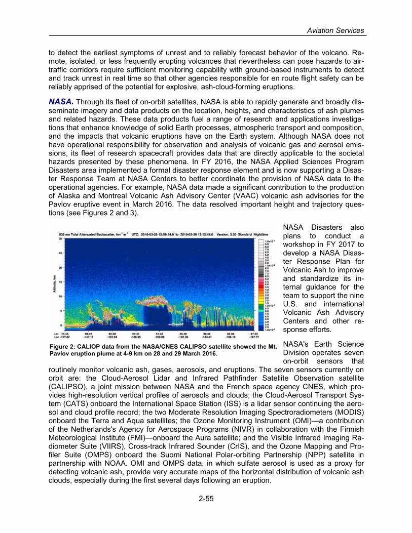
Aviation Services
to detect the earliest symptoms of unrest and to reliably forecast behavior of the volcano. Re-mote, isolated, or less frequently erupting volcanoes that nevertheless can pose hazards to air-traffic corridors require sufficient monitoring capability with ground-based instruments to detect and track unrest in real time so that other agencies responsible for en route flight safety can be reliably apprised of the potential for explosive, ash-cloud-forming eruptions.
NASA. Through its fleet of on-orbit satellites, NASA is able to rapidly generate and broadly dis-seminate imagery and data products on the location, heights, and characteristics of ash plumes and related hazards. These data products fuel a range of research and applications investiga-tions that enhance knowledge of solid Earth processes, atmospheric transport and composition, and the impacts that volcanic eruptions have on the Earth system. Although NASA does not have operational responsibility for observation and analysis of volcanic gas and aerosol emis-sions, its fleet of research spacecraft provides data that are directly applicable to the societal hazards presented by these phenomena. In FY 2016, the NASA Applied Sciences Program Disasters area implemented a formal disaster response element and is now supporting a Disas-ter Response Team at NASA Centers to better coordinate the provision of NASA data to the operational agencies. For example, NASA data made a significant contribution to the production of Alaska and Montreal Volcanic Ash Advisory Center (VAAC) volcanic ash advisories for the Pavlov eruptive event in March 2016. The data resolved important height and trajectory ques-tions (see Figures 2 and 3).
NASA Disasters also plans to conduct a workshop in FY 2017 to develop a NASA Disas-ter Response Plan for Volcanic Ash to improve and standardize its in-ternal guidance for the team to support the nine U.S. and international Volcanic Ash Advisory Centers and other re-sponse efforts.
NASA's Earth Science Division operates seven on-orbit sensors that
routinely monitor volcanic ash, gases, aerosols, and eruptions. The seven sensors currently on orbit are: the Cloud-Aerosol Lidar and Infrared Pathfinder Satellite Observation satellite (CALIPSO), a joint mission between NASA and the French space agency CNES, which pro-vides high-resolution vertical profiles of aerosols and clouds; the Cloud-Aerosol Transport Sys-tem (CATS) onboard the International Space Station (ISS) is a lidar sensor continuing the aero-sol and cloud profile record; the two Moderate Resolution Imaging Spectroradiometers (MODIS) onboard the Terra and Aqua satellites; the Ozone Monitoring Instrument (OMI)—a contribution of the Netherlands's Agency for Aerospace Programs (NIVR) in collaboration with the Finnish Meteorological Institute (FMI)—onboard the Aura satellite; and the Visible Infrared Imaging Ra-diometer Suite (VIIRS), Cross-track Infrared Sounder (CrIS), and the Ozone Mapping and Pro-filer Suite (OMPS) onboard the Suomi National Polar-orbiting Partnership (NPP) satellite in partnership with NOAA. OMI and OMPS data, in which sulfate aerosol is used as a proxy for detecting volcanic ash, provide very accurate maps of the horizontal distribution of volcanic ash clouds, especially during the first several days following an eruption.
Figure 2: CALIOP data from the NASA/CNES CALIPSO satellite showed the Mt. Pavlov eruption plume at 4-9 km on 28 and 29 March 2016.
2-55

Section 2. Federal Meteorological Services and Supporting Research Programs
In collaboration with NOAA, the next National Polar Operational Envi-ronmental Satellites (NPOES) system to launch is the Joint Polar Satellite System (JPSS), which also will deploy the OMPS-Nadir spec-trometer. For more lim-ited applications, NASA also operates the Japa-nese Ministry of Econo-my, Trade and Industry’s (METI) 15-meter (in the visible to near infrared bands) and 90-meter (in
the thermal infrared bands) High-resolution Advanced Spaceborne Thermal Emission and Re-flection (ASTER) instrument onboard the NASA Terra spacecraft which can be scheduled on a limited basis. For post event analysis, the Atmospheric Infrared Sounder (AIRS) instrument on the NASA Aqua satellite has been used effectively to compliment CrIS in locating sulfate aero-sols. NASA Applied Sciences researchers have also contributed to developing volcanic ash al-gorithms used for current NOAA Geostationary Operational Environmental Satellites (GOES) analysis, and which will be integrated onboard GOES-R series satellites. In FY 2013, NASA be-gan making CALIPSO Cloud-Aerosol Lidar with Orthogonal Polarization (CALIOP) data and products available in near-real time for operational use. These data have been demonstrated to be of particular utility for improving trajectory model forecasts of volcanic ash, validating the lo-cation of volcanic ash determined by forecast models, and resolving the vertical structure and layering of ash clouds. The NASA Applied Science Program, through its participation with its OFCM Volcanic Ash Working Group partners (World Meteorological Organization and Interna-tional Civil Aviation Organization), is currently assisting the volcanic ash community to identify the next generation of space-borne sensors, especially lidar, to inform mission planning after CALIPSO, which is an extended mission nearing the end of its service period. Finally, the Multi-angle Imaging SpectroRadiometer (MISR) instrument on the NASA Terra spacecraft has been used retrospectively to study volcanic ash events and could continue to provide some utility in resolving vertical dimensions of ash plumes due to its oblique viewing angle, although it too is close to the end of its service period.
The Applied Sciences Program’s Disaster Area is currently responsible for developing satellite data applications for volcanic ash and remains focused on extending research in which the Agency has employed these satellite measurements to improve the accuracy of trajectory model forecasts to improve aerosol dispersion (ash concentration) model forecasts for the Volcanic Ash Advisory Centers (VAACS). In addition, the NASA Jet Propulsion Lab (JPL) has developed small, dedicated Dragon Eye Unmanned Aerial Systems (UAS), which penetrate volcanic plumes, and has coordinated these measurements with ASTER observations allowing scientists to compare sulfur dioxide concentration derived from the satellite with UAS measurements tak-en from within the plume. Since 2014, NASA scientists also have developed the capability to deploy rapid response balloon teams to measure volcanic aerosol plume characteristics needed to calibrate satellite retrievals such as those taken by CALIPSO to extend forecast capabilities beyond trajectory mapping and to be able to begin to accurately estimate the mass loading of volcanic plumes. In 2015, the NASA Aeronautics Research Mission Directorate (ARMD) com-
Figure 3: The OMPS instrument on the NASA/NOAA Suomi NPP satellite traced the SO2 signature of the Pavlov eruption, and confirmed a northern trajectory path at lower altitudes.
2-56

Aviation Services
pleted its Fundamental Aeronautics Program’s Vehicle-Integrated Propulsion Research (VIPR-3) Project, which is a joint research project among NASA, USAF, USGS, FAA and the three largest engine manufacturers. This research produced data that can now be used to help de-termine propulsion system tolerances and thresholds for ingesting various concentrations of dif-fuse, persistent volcanic ash for increasing exposure periods. The purpose of this research is to improve the understanding of volcanic ash behavior and impacts in modern aircraft propulsion systems, to inform the development of operating procedures for operating in or near volcanic ash environments, and to develop improved aircraft engines and systems. In addition, on May 17-18, 2016, NASA held a Volcano Workshop attended by approximately 30 experts from NASA, NOAA, USGS, and several universities to develop an observation strategy that can be quickly implemented in response to a major volcanic eruption, and to characterize the changes to atmospheric (especially stratospheric) composition following a large volcanic eruption. This strategy will help to understand and project the consequences of a major eruption, an event which can impact weather, climate, and atmospheric chemistry on regional, hemispheric, and global scales over significant time periods.
NOAA. NOAA/NWS is responsible for aviation-related volcanic ash forecasting services in the United States. The program is currently managed under the Aviation and Space Weather Ser-vices Branch at NWS Headquarters in Silver Spring, Maryland. Although the main focus has been and continues to be on the airborne ash hazards (mainly impacting aviation), there has been a move in the past several years to expand into an “all hazards” approach that incorpo-rates both the NWS Public and Marine Services programs. The NWS is a co-lead in the devel-opment of regional volcanic ash response plans in the United States. Plans are currently in place for Alaska, the Pacific Northwest (Washington, Oregon), and the Northern Marianas Is-lands. Future plans are being developed for Hawaii, California, and Puerto Rico/Eastern Carib-bean. These plans are available on the OFCM website at http:/www.ofcm.gov. As noted earlier, NOAA/NWS also operates the Anchorage VAAC and partners with NESDIS, which operates the Washington VAAC—two of the nine such international centers.
NOAA/NESDIS is responsible for providing satellite data used in detecting and tracking volcanic ash in the atmosphere and is dedicated to providing timely access to global environmental data from satellites and other sources to promote, protect, and enhance the Nation's economy, secu-rity, environment, and quality of life. Many of the operational environmental satellites operated by NESDIS (see NOAA/NESDIS in Basic Services section) have channels available to help forecasters detect and track volcanic ash. The GOES-R and JPSS programs are joint NOAA-NASA programs that will provide more frequent, higher resolution imagery for the detection and tracking of volcanic ash beginning in 2015.
NOAA/OAR (Office of Oceanic and Atmospheric Research) Air Resources Laboratory (ARL) also participates to support NOAA’s volcanic ash services. ARL will be conducting research and development to improve the volcanic ash application of the ARL-developed HYSPLIT transport and dispersion model that is used by the NWS/NCEP to support the U.S. VAACs. In particular, ARL will work to (1) improve the quantification of the initial ash mass and its vertical distribution, (2) develop a model evaluation database, and (3) work with other VAACs to promote standardi-zation of volcanic ash dispersion products. ARL will collaborate with scientists at the NESDIS Center for Satellite Applications and Research (STAR) and the U.S. Geological Survey (USGS) Volcano Hazards Program. This work should lead to more globally harmonized dispersion guid-ance products and a better understanding of the dispersion model capabilities.
U.S. Air Force. The Air Force provides volcanic ash surveillance and analysis to support DoD aviation operations worldwide. Analysts continuously monitor active volcanoes. Air Force prod-ucts supplement existing ICAO Volcanic Ash Advisory Center products and include active vol-
2-57

Section 2. Federal Meteorological Services and Supporting Research Programs
cano alerts, tailored satellite imagery, and graphical ash plume forecasts detailing coverage and concentration. The Air Force products ensure availability of information critical to DoD aviation when products from other international centers are not available.
Smithsonian Institution, Natural History Museum, Global Volcanism Program (GVP). GVP collects, catalogs, and disseminates information on ~1,540 volcanoes active in the last 10,000 years with a small staff working regular business hours Monday to Friday in the Nat-ural History Museum in Washington, D.C. The aviation community most depends on GVP for volcano names, locations, summit elevations, and a set of unique volcano numbers (VNUM’s) for precise international communication about the source of eruptive plumes and related haz-ards. For example, Pacaya volcano in Guatemala (along the main approach to the Capital’s air-port) is designated on VAAC reports as “Volcano: Pacaya 342110.” The numbers, or unique portions thereof, also provide a short-hand for labeling closely spaced volcanoes on maps. Each month GVP compiles the Bulletin of the Global Volcanism Network (http://volcano.si.edu/reports_bgvn.cfm) synthesizing information about volcano behavior, moni-toring, and eruptions at variable time scales (months to years). The USGS and GVP jointly re-lease the Weekly Volcano Activity Report summarizing eruptions and hazards during the pre-ceding one-week interval (http://volcano.si.edu/reports_weekly.cfm). Both reports appear on the GVP website (http://www.volcano.si.edu), which also features photos, eruptive histories, and other information, including the current list of data needed by the aviation community.
NOAA/National Weather Service
NOAA/NWS aviation weather projects support increasing and improving observation capabili-ties, forecast products and techniques, outreach and training, operational adaptation of applied research, and verification of forecast products. These projects have the goal of supporting the FAA in the safe and efficient flow of air traffic in the National Airspace System (NAS). In re-sponse to requirements from the FAA and the international community, aviation weather prod-ucts issued by NWS span the globe.
Under an international agreement through the ICAO, the United States meets its weather fore-casting obligations to the aviation community through products and services of the World Area Forecast Center (WAFC) Washington, one of two global services, composed of two components of the National Centers for Environmental Prediction (NCEP): Aviation Weather Center (AWC), located in Kansas City, Missouri, and NCEP Central Operations (NCO) in College Park, Mary-land. AWC prepares forecasts four times a day of globally significant thunderstorms, tropical cyclones, severe squall lines, moderate or severe turbulence and icing, and cumulonimbus clouds associated with these conditions. The forecast charts also include information on volcan-ic activity, radiological releases, jet streams, and tropopause heights. This information is made available by the WAFC Internet File Service (WIFS) to provide World Area Forecast System (WAFS) products and services, as defined by ICAO Annex 3, in an Internet web-based medium.
The AWC, along with the NWS Alaska Region’s Alaska Aviation Weather Unit (AAWU) and the NWS Weather Forecast Office (WFO) in Honolulu, Hawaii, provides wind, temperature, and flight hazard (e.g., icing and turbulence) forecasts for flight planning and en route aircraft opera-tions for the United States, the north Atlantic and north Pacific routes, and some routes in the southern hemisphere. This information is disseminated by AWC via WIFS in support of the WAFS for ICAO aviation data needs and in support of World Meteorological Organization (WMO) Region IV (North America) data exchange requirements.
2-58
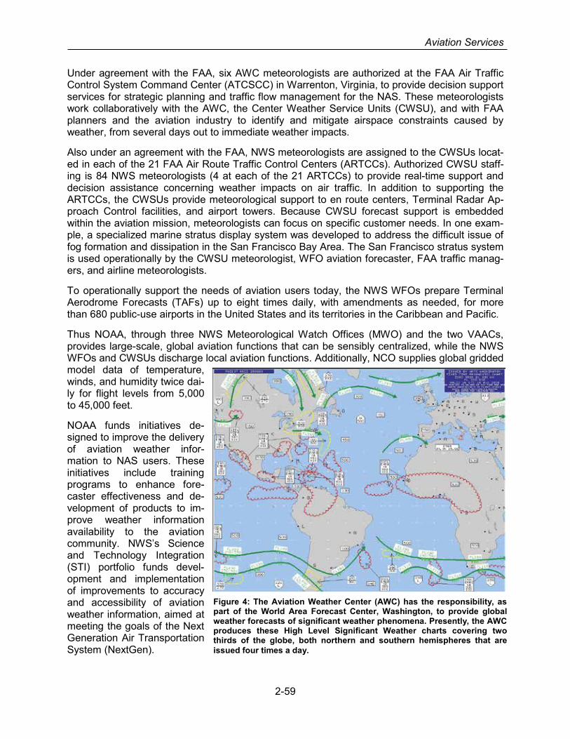
Aviation Services
Under agreement with the FAA, six AWC meteorologists are authorized at the FAA Air Traffic Control System Command Center (ATCSCC) in Warrenton, Virginia, to provide decision support services for strategic planning and traffic flow management for the NAS. These meteorologists work collaboratively with the AWC, the Center Weather Service Units (CWSU), and with FAA planners and the aviation industry to identify and mitigate airspace constraints caused by weather, from several days out to immediate weather impacts.
Also under an agreement with the FAA, NWS meteorologists are assigned to the CWSUs locat-ed in each of the 21 FAA Air Route Traffic Control Centers (ARTCCs). Authorized CWSU staff-ing is 84 NWS meteorologists (4 at each of the 21 ARTCCs) to provide real-time support and decision assistance concerning weather impacts on air traffic. In addition to supporting the ARTCCs, the CWSUs provide meteorological support to en route centers, Terminal Radar Ap-proach Control facilities, and airport towers. Because CWSU forecast support is embedded within the aviation mission, meteorologists can focus on specific customer needs. In one exam-ple, a specialized marine stratus display system was developed to address the difficult issue of fog formation and dissipation in the San Francisco Bay Area. The San Francisco stratus system is used operationally by the CWSU meteorologist, WFO aviation forecaster, FAA traffic manag-ers, and airline meteorologists.
To operationally support the needs of aviation users today, the NWS WFOs prepare Terminal Aerodrome Forecasts (TAFs) up to eight times daily, with amendments as needed, for more than 680 public-use airports in the United States and its territories in the Caribbean and Pacific.
Thus NOAA, through three NWS Meteorological Watch Offices (MWO) and the two VAACs, provides large-scale, global aviation functions that can be sensibly centralized, while the NWS WFOs and CWSUs discharge local aviation functions. Additionally, NCO supplies global gridded model data of temperature, winds, and humidity twice dai-ly for flight levels from 5,000 to 45,000 feet.
NOAA funds initiatives de-signed to improve the delivery of aviation weather infor-mation to NAS users. These initiatives include training programs to enhance fore-caster effectiveness and de-velopment of products to im-prove weather information availability to the aviation community. NWS’s Science and Technology Integration (STI) portfolio funds devel-opment and implementation of improvements to accuracy and accessibility of aviation weather information, aimed at meeting the goals of the Next Generation Air Transportation System (NextGen).
Figure 4: The Aviation Weather Center (AWC) has the responsibility, as part of the World Area Forecast Center, Washington, to provide global weather forecasts of significant weather phenomena. Presently, the AWC produces these High Level Significant Weather charts covering two thirds of the globe, both northern and southern hemispheres that are issued four times a day.
2-59

Section 2. Federal Meteorological Services and Supporting Research Programs
AviationWeather.gov
In addition to satisfying global requirements for aviation weather, AWC hosts AviationWeath-er.gov, which makes available to the aviation community text, digital, and graphical forecasts, analyses, and observations of aviation-related weather variables. AviationWeather.gov also serves as a platform for aviation weather products emerging from the FAA Aviation Weather Research Program and transitioning to operations. It has become an invaluable resource to us-ers, especially in the U.S. general aviation community. The AWC’s website infrastructure pro-vides increased levels of data reliability for users.
Volcanic Ash Advisory Centers (VAAC)
The United States, in agreement with ICAO, operates two VAACs as entities within NOAA. One of these, the Anchorage VAAC, is part of the AAWU located in Anchorage, Alaska, and works closely with the Alaska Volcano Observatory. The second VAAC, which is part of NOAA’s Na-tional Environmental Satellite, Data, and Information Service (NESDIS) and NCEP, is located in College Park, Maryland. The VAACs monitor volcanic activity through satellite remote sensing, provide initial notification of a volcanic eruption upon detection, and forecast volcanic ash plume movement and evolution.
NWS International Obligations
National Weather Service meets international commitments through participation as consultants to FAA in ICAO groups, ad hoc task forces, and project teams. In addition, NWS leads or partic-ipates in a number of WMO teams chartered by the WMO Commission on Aeronautical Meteor-ology. These teams include the Expert Teams (ET) on Information and Services for Aviation (ISA), Aviation, Science, and Climate (ASC), and Education, Training, and Competencies (ETC), which partners with ICAO’s Meteorological Panel (METP) and associated Working Groups; and the ET for Communication, Coordination, and Partnership.
Federal Aviation Administration
The Federal Aviation Administration (FAA) manages the National Airspace System (NAS) and has responsibility to collect and distribute current weather observations to NAS users – particu-larly weather aloft and surface weather that may constrain the free flow of aircraft, as well as known hazardous weather. The purpose is to warn pilots, assist Air Traffic Control, Traffic Flow Management, Flight Services, the Air Traffic Control Systems Command Center (ATCSCC), NAS operations including commercial airline dispatchers, airports, and all controlled-airspace users. Timely and accurate weather observations, predictions, and derived constraints to avia-tion movement are essential to aviation safety and needed to make best use of aviation capacity for efficiency, fuel savings, and to reduce delay. Rapidly refreshed weather observations suita-ble for Air Navigation Service Providers (ANSP) are blended with NOAA forecasts to provide local / regional / national / oceanic aviation weather products of tactical and strategic importance essential to NAS safety and for all phases of flight. Traffic flow managers and pilots use regional weather observations and forecasts to determine when they need to plan alternative routes to avoid severe weather, and air traffic controllers use local weather to regulate approach, landing and departure and warn pilots of immediate weather hazards at air terminals. Aviation weather encompasses every basic meteorological parameter placing them in relation to aeronautical in-formation at the surface and aloft, including precipitation, wind, visibility, pressure, temperature,
2-60

Aviation Services
lightning, derivative products such as storm cells, icing, turbulence, cloud layers, and hydrome-teor classification.
Weather Systems
The FAA employs two categories of weather systems: weather sensors and weather pro-cessing/dissemination systems. FAA weather sensors include weather radars and automated surface observation systems that measure atmospheric parameters, such as surface tempera-ture, prevailing wind speed and direction, relative humidity, cloud bases and tops, as well as wind shear and microbursts. These weather sensors provide real-time information to FAA weather processing/dissemination systems and to NWS centralized weather forecasting mod-els. Weather processing systems organize, process, and distribute the sensor’s observed data, matched with forecasts, and blends National Airspace System (NAS) operations with weather information. Data from multiple sensors feed numerical forecast model ensembles whose output can be disseminated and integrated in national and local processing systems to interpret broad weather trends affecting aviation operations. This information is then sent to air traffic control-lers, traffic flow managers, dispatchers, and pilots in a seamless suite of weather tools that look backwards and forwards in time and along terminals, intended flight paths, flow corridors, sec-tors, and regions.
Weather Sensors
Weather sensors include networks of 1) surface weather observing stations, 2) ground-based sensors that observe weather aloft including long range weather radars, terminal weather ra-dars, weather channels obtained from surveillance radars, lidars, 3) wind shear detection sys-tems, 4) airborne weather sensors, and 5) human observations including pilot reports and weather observers. Weather sensor products from other Agencies, commercial lightning detec-tion, aeronautical information, and satellite images are blended with FAA base weather observa-tions to create derived aviation weather products for NAS users.
Next Generation Weather Radar
Next Generation Weather Radar (NEXRAD) is a long-range weather radar system that detects, analyzes, and transmits weather information for use by the ATCSCC, enroute, termi-nal and flight service facilities. NEXRAD was developed un-der a joint program of the Department of Commerce (DOC)/NWS, Department of Defense (DOD), and the De-partment of Transportation (DOT)/FAA. NEXRAD radars are national critical assets that indirectly support most weather information users in the United States. These 160 systems are long-range, Doppler weather radars that detect and pro-duce long-range and high-altitude weather observation prod-ucts and special products, including three-dimensional areas of precipitation by type, cloud cover by height, storm cells,
winds aloft, turbulence, and icing. NEXRAD products and services are processed by FAA weather processing systems and by NWS Weather Forecast Offices (WFO). NEXRAD feed forecast models at NOAA computation centers, and also the Advanced Weather Interactive Processing System (AWIPS). NWS forecasts and remote AWIPS terminals based on a mosaic of NEXRAD are used by FAA, and integrated with FAA weather observations. NEXRAD mosa-ics are used by enroute and oceanic controllers to aid pilots in avoiding hazardous weather. The
Figure 5: NEXRAD Weather Radar.
2-61
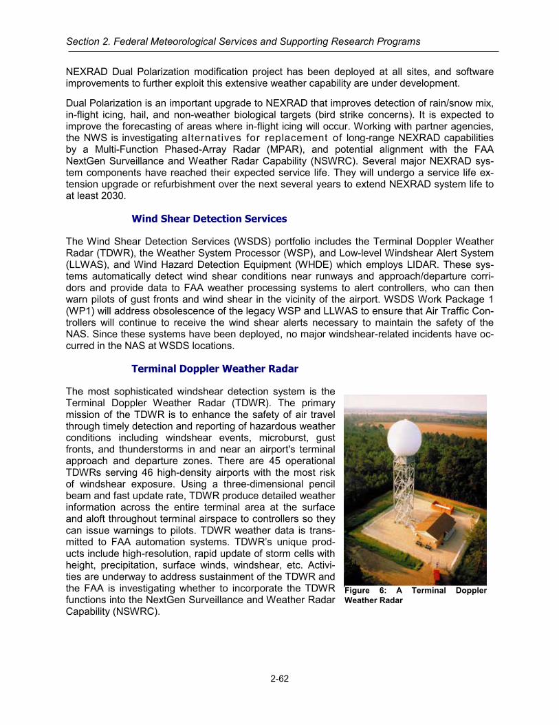
Section 2. Federal Meteorological Services and Supporting Research Programs
NEXRAD Dual Polarization modification project has been deployed at all sites, and software improvements to further exploit this extensive weather capability are under development.
Dual Polarization is an important upgrade to NEXRAD that improves detection of rain/snow mix, in-flight icing, hail, and non-weather biological targets (bird strike concerns). It is expected to improve the forecasting of areas where in-flight icing will occur. Working with partner agencies, the NWS is investigating alternatives for replacement of long-range NEXRAD capabilities by a Multi-Function Phased-Array Radar (MPAR), and potential alignment with the FAA NextGen Surveillance and Weather Radar Capability (NSWRC). Several major NEXRAD sys-tem components have reached their expected service life. They will undergo a service life ex-tension upgrade or refurbishment over the next several years to extend NEXRAD system life to at least 2030.
Wind Shear Detection Services
The Wind Shear Detection Services (WSDS) portfolio includes the Terminal Doppler Weather Radar (TDWR), the Weather System Processor (WSP), and Low-level Windshear Alert System (LLWAS), and Wind Hazard Detection Equipment (WHDE) which employs LIDAR. These sys-tems automatically detect wind shear conditions near runways and approach/departure corri-dors and provide data to FAA weather processing systems to alert controllers, who can then warn pilots of gust fronts and wind shear in the vicinity of the airport. WSDS Work Package 1 (WP1) will address obsolescence of the legacy WSP and LLWAS to ensure that Air Traffic Con-trollers will continue to receive the wind shear alerts necessary to maintain the safety of the NAS. Since these systems have been deployed, no major windshear-related incidents have oc-curred in the NAS at WSDS locations.
Terminal Doppler Weather Radar
The most sophisticated windshear detection system is the Terminal Doppler Weather Radar (TDWR). The primary mission of the TDWR is to enhance the safety of air travel through timely detection and reporting of hazardous weather conditions including windshear events, microburst, gust fronts, and thunderstorms in and near an airport's terminal approach and departure zones. There are 45 operational TDWRs serving 46 high-density airports with the most risk of windshear exposure. Using a three-dimensional pencil beam and fast update rate, TDWR produce detailed weather information across the entire terminal area at the surface and aloft throughout terminal airspace to controllers so they can issue warnings to pilots. TDWR weather data is trans-mitted to FAA automation systems. TDWR’s unique prod-ucts include high-resolution, rapid update of storm cells with height, precipitation, surface winds, windshear, etc. Activi-ties are underway to address sustainment of the TDWR and the FAA is investigating whether to incorporate the TDWR functions into the NextGen Surveillance and Weather Radar Capability (NSWRC).
Figure 6: A Terminal Doppler Weather Radar
2-62

Aviation Services
Weather System Processor
The Weather System Processor (WSP) is an add-on weather processor enhancement to the Airport Surveillance Radar (ASR) Model 9 (ASR-9). The WSP was implemented as a low-cost, high-quality, wind shear de-tection system at medium and higher air traffic density airports not equipped with the TDWR. The WSP provides advanced Doppler weather radar performance with all the functions of the TDWR. The WSP is parti-tioned to the front-end radar (ASR) modification, and the back-end (WSP) development. WSP is deployed at 34 airports throughout the NAS. WSP detects and alerts on microbursts and wind shear, predicts arrival of gust fronts, and shows precipitation intensity on a graphical sit-
uation display for use by ATC without further meteorological interpretation. Activities are under-way to address sustainment of these radars and the FAA is investigating whether to incorporate the WSP into the NSWRC.
Low Level Wind Shear Alert System (LLWAS)
LLWAS uses an array of wind sensors located around the runway thresholds and along ap-proach/departure corridors to measure surface wind direction and velocity. LLWAS compares wind velocity and direction, detected across the airport operations area, to determine whether hazardous wind shear events are occurring at, or near, the runways. LLWAS interfaces with TDWR and WSP at higher density airports where the systems are co-located, or operates as a stand- alone system at other airports that do not have a TDWR or WSP. There are 49 LLWAS systems operational in the NAS today, which are undergoing service life extensions. The FAA is investigating whether to incorporate the functionality of these sensors into the NSWRC.
Automated Surface Weather Observation Network (ASWON)
The ASWON portfolio of automated surface weather sensors is being updated by the FAA into three common types of station configuration including:
• Automated Surface Observing System (ASOS) – ASOS are deployed at large airports with FAA Towers.
• Automated Weather Observing System Model C (AWOS-C) – AWOS-C are deployed at smaller, unmanned airports, where there is no control tower. AWOS-C replaces the legacy AWOS and AWSS to help reduce proliferation of configurations.
• Surface Weather System (SWS) – SWS are secondary systems that back-up ASOS. SWS replaces the legacy WME, WEF, and one configuration of DASI (C&G).
Automated Surface Observing System (ASOS)
ASOS are deployed at large airports with FAA Towers. ASOS have up to 14 individual sensors that measure surface weather data, including temperature, barometric pressure, humidity, type and amount of precipitation, cloud bases and amount of sky cover. These systems feed point observation data directly to local air traffic control facilities and support automated broadcast of weather information to pilots and flight planning. They also provide regular, rapid updates for the NWS forecast models that predict future weather conditions including adverse weather. ASOS are to use new AWOS-C standard software.
Figure 7: Airport Sur-veillance Radar
2-63

Section 2. Federal Meteorological Services and Supporting Research Programs
Automated Weather Observing System (AWOS) Model-C (AWOS-C)
AWOS-C are deployed at a few FAA towers, but mostly at smaller airports where there is no control tower, and at some Federal Contract Towers (FCT). AWOS-C was developed to meet the functional baseline of the legacy AWOS and AWSS subsystems to help reduce proliferation of configurations in the NAS. AWOS-C provides similar weather products as do ASOS including wind, temperature, relative humidity, barometric pressure, sky condition, visibility, present weather, and have a rain gauge.
Surface Weather System (SWS)
SWS are deployed at ASOS airports. SWS generally serve as NAS back-up to ASOS, yet may become the primary provider of surface weather measurements if selected. SWS were devel-oped to meet the functional baseline of the legacy SAWS, WEF, WME, and DASI systems. SWS provide winds, temperature, dew point, and barometric pressure (altimeter setting). SWS provide the primary source of altimeter setting (pressure) through the use of a precise, triple pressure sensor system to terminal automation systems ARTS-IIIE, STARS, and Information Display Systems. SWS provide a second source of Airport Wind to TDWR, ASR-WSP, ITWS and Information Display Systems. SWS provide a second source of temperature and dew point to Information Display Systems.
Digital Altimeter Setting Indicator (DASI)
The Digital Altimeter Setting Indicator (DASI) is a system that measures atmospheric pressure and converts measured pressure into sea level pressure values based on the United States (U.S.) Standard Atmosphere. The value computed is known as the Altimeter Setting Indicator (ASI) value and is presented to the Air Traffic personnel in a digital format, e.g. 29.98, so they can inform pilots of the proper setting so the aircraft’s altimeter will read the correct runway ele-vation at touchdown. The local DASI display panels provide a five-digit display of altimeter set-ting that is viewed on the Light Emitting Diode (LED) readout on the front (DASI DME readout is pictured). A keypad (or other means) on the unit enables the station altitude and a correction factor (if needed) to be entered into the system manually. Up to 10 remote displays may be ac-commodated.
Stand-Alone Weather System (SAWS)
Stand-Alone Airport Weather System (SAWS) are secondary systems deployed at ASOS air-ports as a NAS back-up. SAWS provide a subset of weather measurements of pressure, tem-perature, and wind as do ASOS.
Legacy ASWON systems are still in-service, but are being replaced by AWOS-C (AWSS) and SWS (WEF, and WME).
• Automated Weather Sensors System (AWSS) are deployed at smaller airports, where there is no control tower, and at some Federal Contract Tower (FCT) sites. They perform similar functions as AWOS.
• Wind Equipment F-Series (WEF) [Model F-420] are “wind-only” sensors that display prevail-ing wind which may be chosen as the official “Airport Wind” and time averaged maximum gust. WEF sensors are typically located near the Airport Reference Point (ARP).
• Wind Measuring Equipment WME) provide wind and gust information and may be chosen as the official “Airport Wind.” WME are typically located on LLWAS “tall poles” located near
2-64

Aviation Services
centerfield aside the main runway, and use refitted LLWAS infrastructure with new electronic equipment
Non-Fed AWOS
Similar to AWOS owned by Federal Agencies, the FAA also makes use of data from more than one thousand Non-Federally owned, AWOS operated by state, local, tribal governments, air-ports, and municipalities that follow FAA procedures and meet FAA AWOS certification parame-ters.
AWOS Data Acquisition System (ADAS)
The ADAS is an automation system that collects, processes, generates, disseminates, and ar-chives various surface observation weather products from over 1100 Federal ASOS, AWOS and AWSS locations in the CONUS, Alaska and Hawaii. In addition, under the purview of the FAA's Automated Lightning Detection and Reporting System (ALDARS) contract, ADAS re-ceives cloud-to-ground lightning strike (latitude and longitude) information for the CONUS, Ha-waii and Alaska from a commercial lightning data service provider to disseminate back to the weather observing systems. In addition, this lightning data is also sent to WMSCR for subse-quent dissemination to authorized FAA systems.
ADAS consists of the Sensor Control System (SCS) components located at every ARTCC and primary/secondary centralized management and control (Regional ADAS Service Processor (RASP)) components located at both Network Enterprise Management Center locations, in Salt Lake City and Atlanta. The RASP connects to every SCS over the operational Federal Tele-communications Infrastructure (FTI) network providing centralized network management and control, and it also provides the interface to the (external) commercial lightning data service pro-vider supplying the lightning strike data to the SCS for subsequent processing
The ARTCC-based SCS provides the interface to the various types of weather observing sys-tems in order to receive the binary-formatted One-Minute Observations (OMO), the text based Standard Hydro-meteorological Exchange Format (SHEF) and the Daily, Monthly Summary Re-ports. In addition, most of these systems also provide the key weather product - the Aviation Routine Weather Report (aka METAR). However, since there are over 150 legacy AWOS sys-tems that are unable to generate the METAR, the SCS generates the METAR on their behalf.
The SCS routes these various weather products to WMSCR for dissemination to other NAS and non-NAS users. The SCS also provides network management capabilities to the local ARTCC personnel and also connects to the local Remote Monitoring and Logging System (RMLS) for status reporting. The SCS is also responsible for receiving the lightning strike information from the RASP and generating location-specific lightning activity messages to every locally-connected ASOS, AWOS and AWSS. These weather observing system include this lightning activity information into its OMO and METAR reports as well as making this information availa-ble to other local systems and through its VHF radio broadcasts. Some non-Federal AWOS are connected to WMSCR through FAA approved service providers. Only AWOS-III and IV are eli-gible for connection. They do not use ADAS.
2-65

Section 2. Federal Meteorological Services and Supporting Research Programs
Observations
Liquid Water Equivalent (LWE) Rate Measurement & Reporting-Surface Snow/ Ice
At airports in cold climates, a ground anti-icing/de-icing program is an essential pre-takeoff ser-vice. Decision making in a ground anti-icing/deicing program is the responsibility of the pilot. Pi-lots need to have the most accurate airport weather observation information available to support their ground anti-icing/deicing program decisions. Recent weather research has provided com-pelling evidence that snow precipitation intensity, which is currently determined by a visibility-based method, can be more accurately determined by measuring the LWE rate and providing this information as part of the airport weather observation. Pilots can use this enhanced infor-mation to more accurately determine their hold-over times. To capitalize on the federal govern-ment’s investment in ASOS, a cost effective way to provide this LWE rate capability is to imple-ment it in ASOS. The FAA is currently pursuing ways to provide this capability in ASOS. This improvement will enhance aircraft and passenger safety and support traffic flow management. The FAA is also pursuing development of a commercial LWE Rate System.
Weather Processing Systems
Integrated Terminal Weather System (ITWS)
ITWS integrates many terminal sensors and generates automated weather products such as windshear alerts, gust front position predictions (up to 20 minutes into the future), storm cell intensi-ty, direction of motion, terminal lightning infor-mation, detailed winds in the terminal area, and a one-hour storm forecast. ITWS receives weather observation data from local automated surface observing sensors
(ASOS, LLWAS), networks of sensors (ADAS, NLDN) and surrounding radars, (TDWR, ASR-9, ASR-11, and NEXRAD). ITWS bundles observations with NWS forecasts and runs value-added algorithms such as windshear prediction to provide real-time aviation weather information for pilots. Tower and Terminal Radar Approach Control (TRACON) controllers, who use the infor-mation to make precise estimates of when runways should close and subsequently reopened, as well as for efficient switches in terminal arrival patterns. ITWA helps avoid inefficient maneu-vering on taxi ways and on approach and departure and helps to accommodate runway direc-tion changes as aircraft approach an airport. There are 34 ITWS Product Generators in-service at over one hundred sites including ATCTs, TRACONs, ARTCCs and the ATCSCC. ITWS pro-vides common aviation weather information to 75 major airports and over 1000 airline dispatch-ers. ITWS will be subsumed by the NextGen Weather Processor (NWP) and Common Support Services – Weather (CSS-Wx).
Figure 8: Example of ITWS Weather Products
2-66

Aviation Services
Corridor Integrated Weather System (CIWS)
The Corridor Integrated Weather System (CIWS) is a fully automated real-time weather analysis and forecasting system. It combines data from US and Canadian weather radars with satellite data, surface observations and numerical weather models to dramatically improve the accuracy and timeliness of the storm severity information and to provide accurate, rapidly updating weather information to air traffic flow managers in the 0-2 hour forecast timeframe. The Massa-chusetts Institute of Technology Lincoln Laboratory (MIT LL) demonstrates the CIWS prototype in real-time, 24 hours each day providing continuous CIWS products to Traffic Flow Manage-ment (TFM) via the CIWS Data Distribution Service (CDDS), located at the William J. Hughes Technical Center (WJHTC). MIT LL observes the use of CIWS products in real-time and obtains feedback from users regarding the effectiveness of the concepts being demonstrated on behalf of the FAA, which is a key benefit of ongoing demonstrations. The CIWS system will be sub-sumed by the NWP and CSS-Wx.
CoSPA was developed as a companion program to CIWS. It combines CIWS data with the Na-tional Oceanic and Atmospheric Administration (NOAA) High Resolution Rapid Refresh (HRRR) to provide deterministic radar-forward forecasts out to 8 hours. The CoSPA prototype system is also demonstrated 24 hours each day for the FAA by MIT LL, in conjunction with the National Center for Atmospheric Research (NCAR). The FAA air traffic flow managers and airline dis-patchers rely heavily on CIWS and CoSPA products to provide the highest possible quality weather information to achieve more efficient tactical and strategic use of the airspace, reduce controller workload, and significantly reduce delay. CIWS and CoSPA are helping to shape the development of future FAA Air Traffic Management Systems, and will be subsumed by the NWP and CSS-Wx.
Weather and Radar Processor (WARP)
WARP provides NEXRAD precipitation intensity data to ARTCC controllers’ displays. WARP compiles information from many FAA, NWS, and commercial weather sources for integrated display to ARTCC Traffic Management Unit (TMU) supervisors, sector controller’s briefing ter-minals, NAS operators of Enroute Automation Modernization (ERAM), Advanced Technologies & Oceanic Procedures (ATOP), Dynamic Ocean Tracking System (DOTS), Alaska Flight Data Processor 2000 (FDP2K), and other automation/display systems and web users. WARP serves as a one-stop source for weather interpretation by the CWSU forecasting stations. WARP sus-tainment activities are underway and the WARP mosaic change is targeted to complete in 2015. WARP will be subsumed by CSS-Wx and the NWP.
Aviation Digital Data Service (ADDS)
The Aviation Digital Data Service (ADDS), hosted by NOAA on AviationWeather.gov, makes available to the aviation community text, digital and graphical forecasts, analyses, and observa-tions of aviation-related weather variables. ADDS is a joint effort of the Federal Aviation Admin-istration and the NOAA NCEP Aviation Weather Center (AWC).
The success of ADDS (averaged over 23 million hits a day in 2014) has allowed the FAA to showcase several important research initiatives, including the Current and Forecast Icing Prod-ucts, the Graphical Turbulence Guidance, and the National Ceiling and Visibility Analysis. It is important to note that these products have been through thorough technical reviews and safety risk assessments before release on ADDS as operational products. Operational ADDS runs at the AWC in Kansas City, MO.
2-67

Section 2. Federal Meteorological Services and Supporting Research Programs
Weather Message Switching Center Replacement (WMSCR)
The WMSCR system consists of two redundant virtualized servers located in the Network En-terprise Management Center (NEMC) locations in Atlanta (ATL), Georgia and Salt Lake City (SLC), Utah. These two servers leverage the Integrated Enterprise Services Platform (IESP) infrastructure and operate in a primary/backup mode, where either server can provide weather and NOTAM information to all WMSCR users. These WMSCR servers connect to the NAS op-erational IP network and have the necessary infrastructure to support connectivity to non-NAS users via the NAS Enterprise Security Gateways. WMSCR also has deployed Service-Oriented Architecture (SOA) infrastructure to provide publication and subscription services of Pilot Report (PIREP) and Altimeter Setting reports via SWIM.
WMSCR receives, processes, and stores numerous text-formatted aviation weather products (such as Surface Observations (METARs/SPECIs), PIREPS, AIRMETs, SIGMETs, TAFs, etc.) as well as relaying the binary-formatted OMO and lightning products from ADAS, and dissemi-nates these products to a variety of NAS and non-NAS users. WMSCR is a principal gateway to the National Weather Service (NWS), the military and foreign countries for the exchange of al-phanumeric weather data.
WMSCR is also the FAA collection point for the receipt METARs sent in by authorized Non-Federal AWOS service providers for some 1000+ non-Federal AWOS locations in the CONUS, and oil platforms in the Gulf of Mexico. Note that WMSCR is a major FAA distribution system for NOTAMs from the US NOTAM System (USNS). However this service/capability will be discon-tinued when USNS is replaced by Federal NOTAM System (FNS) in September 2016. WMSCR functionality will be incorporated into a future upgrade of CSS-Wx.
Weather Camera Program
The primary goal of the FAA Aviation Weather Camera (AWC) Program is to improve aviation safety and efficiencies by providing current visual weather information in the form of near real-time video camera images to aviation users in Alaska. The camera images are designated as an FAA supplementary weather product used for enhanced situational awareness and the im-ages are made available free on the public website at http://avcams.faa.gov. The camera imag-es provide pilots, dispatchers and Flight Service Station Specialists with up-to-date weather conditions at airports, mountain passes, and other strategic Visual Flight Rules (VFR) locations and enables them to make better informed decisions about whether or not it is safe to fly before becoming airborne. It provides pilots with the ability to “look before you fly” as opposed to the age-old procedure “fly out to take a look”. New capability increases pilot situational awareness, enhances pilot flight decisions and when combined with other available weather information products, such as METARs, weather camera images become a powerful "go or no-go" aeronau-tical flight decision tool.
With the known benefits of the camera systems and the low costs of its operation there is a high level of interest to expand the service to the remainder of the NAS where shortfalls in weather related aviation safety and efficiencies are known or suspected. Past and ongoing aviation stud-ies have identified additional safety and efficiency shortfalls in areas of the contiguous United States and Hawaii where safety and efficiency shortfalls are identified. Studies conducted by the FAA office of Aviation Safety Information Analysis and Sharing (ASIAS), and other FAA offices support the fact that weather cameras may be beneficial to aviation safety. In August 2013, the NTSB publically recognized the safety benefits of the weather camera system in Alaska and has forwarded a request to the FAA to install and maintain camera systems in Hawaii and the con-
2-68

Aviation Services
tiguous United States where cameras can address identified weather-related aviation accidents and safety shortfalls.
Flight Services
Flight Services collects and disseminates aeronautical and meteorological information, providing customized pre-flight and in-flight briefings to domestic and international general aviation com-munities, as well as to the military and commercial air carriers throughout the contiguous United States, Hawaii, Puerto Rico, and Alaska. These services are provided by flight service special-ists to pilots via phone or radio, or pilots can access the information directly through online (in-ternet-based) web portals. Flight service specialists interpret weather and aeronautical data to provide pilot weather briefings and flight planning services tailored for a particular flight. Alterna-tively, pilots accessing preflight information directly through a web portal are responsible for in-terpreting the weather and aeronautical information for their flight.
The FAA delivers these services through the following combination of contract vehicles and au-tomation systems: Operational and Supportability Implementation System (OASIS), Flight Ser-vices for the 21st Century (FS21), and Direct User Access Terminal Service (DUATS).
Operational and Supportability Implementation System (OASIS)
OASIS is a flight service automation system operational at the 17 Flight Service Stations in Alaska since 2007 and is owned and supported by Harris Corporation. FAA Air Traffic Control Specialists operate OASIS and site level maintenance is performed by FAA Technical Opera-tions personnel. OASIS provides integrated textual and weather graphics products, flight plan processing, emergency services, law enforcement, flight planning and regulatory information and other services as defined in FAA Joint Order (JO) 7110.10.
Flight Services for the 21st Century (FS21)
FS21 is the automation system operational at five Flight Service Stations located in CONUS op-erated by Lockheed Martin Corporation under the FAA’s Automated Flight Service Station (AFSS) contract. The contract provides flight services to pilots throughout CONUS, Hawaii, and Puerto Rico. Lockheed Martin flight service specialists operate FS21 and are FAA-certified pilot weather briefers. FS21 provides integrated text and graphical weather products, flight planning and flight plan processing, emergency services, law enforcement, flight planning and regulatory information, and other services as defined in FAA JO 7110.10.
Direct User Access Terminal Service (DUATS)
DUATS is an internet-based weather/aeronautical information and flight plan filing service that allows pilots to access information on-line to plan a flight, file a flight plan, and perform a self-brief without the aid of a Flight Service Specialist. The FAA contracts for this service with two separate vendors: Lockheed Martin Corporation and Computer Sciences Corporation (CSC). DUATS provides aviation weather in both text (alphanumeric) and graphical formats according to standards defined in FAA JO 7110.10.
Contract Weather Observer (CWO) Program
The Office of Management and Budget (OMB) created the Contract Weather Observer program in 1995, for the FAA and NWS to provide oversight and program management activities. As of
2-69

Section 2. Federal Meteorological Services and Supporting Research Programs
October 1, 2013, NWS transferred responsibility for training oversight, certification, and facility inspection of Limited Aviation Weather Reporting Stations (LAWRS), CWOs, and non-Federal Weather Observers (NF-OBS), to the FAA. The FAA continues to provide backup and augmen-tation to the ASOS and the NWS provide maintenance of the ASOS program.
In February 1996, a Service Standards Policy was developed and implemented by the FAA, NWS, and industry representatives for airports having an operational ASOS. The FAA then as-sumed sole responsibility for providing program management and supplying operational certified CWOs to provide backup and augmentation of the ASOS at Service Level A and B airports. At Service Level C airports, the FAA uses Air Traffic Control personnel to perform LAWRS duties, which provide backup for the ASOS.
Next Generation Air Transportation System (NextGen)
NextGen is an umbrella term for the ongoing, wide-ranging transformation of the United States' NAS to ensure that future safety, capacity and environmental needs are met. NextGen will fun-damentally change the way air traffic is managed by providing universal access to NAS users of all products derived from information provider sources, by translation of products into aircraft movement constraints, and by risk-based decision making. NextGen combines new technologies for surveillance, navigation, and communications with workforce training, proce-dural changes, and airfield development.
NextGen enterprise services requires efficient consolidation of large volumes of weather ob-servations and forecast information for processing, dissemination, and integration into decision support system algorithms to produce the more sophisticated aviation weather products of how weather will impact NAS operations. NextGen core technologies will allow introduction of new NextGen operational improvements. W e a t h e r r e l a t e d e fforts under NextGen include: Common Support Services – Weather (CSS-Wx), NextGen Weather Processor (NWP) with Avi-ation Weather Display (AWD), NextGen Surveillance and Weather Capability (NSWRC), ATM-Weather Integration Concepts, and NextGen Surface Observing Capability.
Common Support Services – Weather (CSS-Wx)
CSS-Wx will establish an aviation weather publishing capability for the NAS. It will enable uni-versal access and the standardization of weather information for dissemination to users by Sys-tem Wide Information Management (SWIM), a data management and sharing system the FAA is implementing for NextGen. Consumers of CSS-Wx information will be air traffic controllers, traffic managers, commercial aviation, general aviation, and other aviation enterprises. Consoli-dating several legacy weather dissemination systems, CSS-Wx will be the FAA's single provider of aviation weather data for integration into NextGen enhanced Decision Support Tools (DSTs).
The CSS-Wx System will:
• Provide weather information via Web Coverage Service (WCS) for gridded data, Web Fea-ture Service (WFS) for non-gridded data, and Web Map Service (WMS) for images;
• Filter weather information by location and time with the ability to provide the user with weather data for a specific geographic area;
• Provide weather information in common, standardized formats using Weather Information Exchange Model (WXXM) for non-gridded data and using Network Common Data Form (NetCDF) for gridded data; and
• Store, archive, and retrieve weather information.
2-70

Aviation Services
Deliver improved weather products for input into collaborative decision-making applications us-ing information provided by the NWP, the National Oceanic and Atmospheric Administration's (NOAA) NextGen Web Services, and other weather sources available to FAA and NAS users. The FAA is currently in the solution development phase of the CSS-Wx program.
NextGen Weather Processor (NWP)
The NextGen Weather Processor (NWP) will be a common weather processing platform that will replace the legacy FAA weather processor systems and host new capabilities. Using data feeds from both the FAA and National Oceanic and Atmospheric Administration (NOAA) radars, other weather sensors, and NOAA forecast models, NWP will use sophisticated algorithms to create high-quality, aviation-specific current and predicted weather information. NWP will create high value weather products that will be accessed through the CSS-Wx system. NWP will perform weather translation to enable the use of this weather information by automated decision-support tools (DSTs). NWP will also provide improved aviation safety related windshear products. Col-lectively, these program features will help reduce rising operations and maintenance costs by consolidating the following weather systems:
• Corridor Integrated Weather System (CIWS): Provides 0-to-2 hour aviation weather predic-tions and information to the Traffic Flow Management System (TFMS) and associated users of heavily traveled air corridors.
• Weather and Radar Processor (WARP): Provides weather information to enroute air traffic controllers, supervisors, traffic management coordinators, and Center Weather Service Unit meteorologists.
• Integrated Terminal Weather System (ITWS): Provides weather information to terminal air traffic supervisors and controllers.
The NWP will:
• Replace and enhance the current processing and display functionality of the ITWS, CIWS, and WARP systems;
• Generate aviation weather products with expanded coverage areas and faster update rates; • Generate 0-to-8 hour aviation weather products; • Generate safety critical wind shear alerts and real-time weather radar information; and • Perform translation of convective weather into weather constraint areas. The FAA is current-
ly in the solution development phase of the NWP.
NextGen Surveillance and Weather Radar Capability (NSWRC)
NSWRC is a concept to replace terminal radars that do surveillance of aircraft and weather ra-dars with single, multi-function radars that do both missions. Airport Surveillance Radar (ASR), Terminal Doppler Weather Radar (TDWR) and the Weather Systems Processor (hosted on ASR-9) might all be replaced by a NSWRC solution. Technology under consideration includes Multi-function Phased-Array Radar (MPAR), legacy spinner radars, and networked short range radars. NOAA has studied MPAR technology with regard to NEXRAD. Long range surveillance radars with military applications may be relocated in radio frequency spectrum and this too could be accomplished by an MPAR solution. MPAR is being studied as an enabling foundation to consolidate many legacy radar types into a new common family, shared among Federal Agencies.
2-71
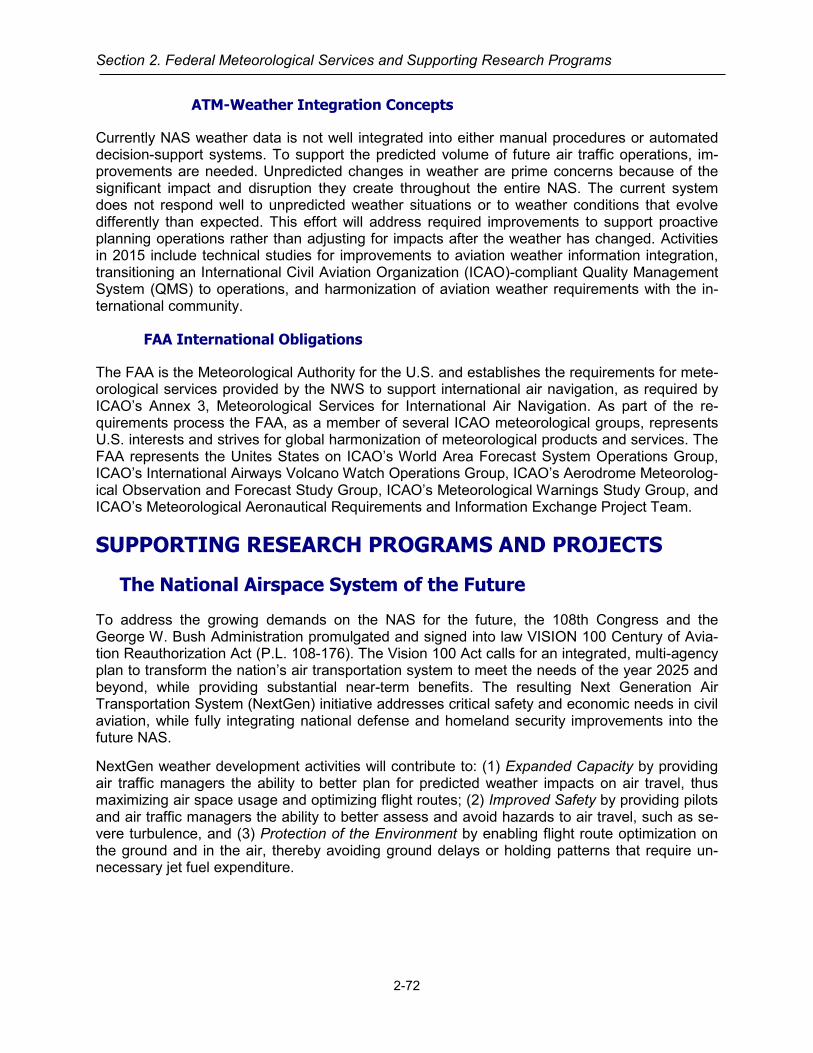
Section 2. Federal Meteorological Services and Supporting Research Programs
ATM-Weather Integration Concepts
Currently NAS weather data is not well integrated into either manual procedures or automated decision-support systems. To support the predicted volume of future air traffic operations, im-provements are needed. Unpredicted changes in weather are prime concerns because of the significant impact and disruption they create throughout the entire NAS. The current system does not respond well to unpredicted weather situations or to weather conditions that evolve differently than expected. This effort will address required improvements to support proactive planning operations rather than adjusting for impacts after the weather has changed. Activities in 2015 include technical studies for improvements to aviation weather information integration, transitioning an International Civil Aviation Organization (ICAO)-compliant Quality Management System (QMS) to operations, and harmonization of aviation weather requirements with the in-ternational community.
FAA International Obligations
The FAA is the Meteorological Authority for the U.S. and establishes the requirements for mete-orological services provided by the NWS to support international air navigation, as required by ICAO’s Annex 3, Meteorological Services for International Air Navigation. As part of the re-quirements process the FAA, as a member of several ICAO meteorological groups, represents U.S. interests and strives for global harmonization of meteorological products and services. The FAA represents the Unites States on ICAO’s World Area Forecast System Operations Group, ICAO’s International Airways Volcano Watch Operations Group, ICAO’s Aerodrome Meteorolog-ical Observation and Forecast Study Group, ICAO’s Meteorological Warnings Study Group, and ICAO’s Meteorological Aeronautical Requirements and Information Exchange Project Team.
SUPPORTING RESEARCH PROGRAMS AND PROJECTS
The National Airspace System of the Future
To address the growing demands on the NAS for the future, the 108th Congress and the George W. Bush Administration promulgated and signed into law VISION 100 Century of Avia-tion Reauthorization Act (P.L. 108-176). The Vision 100 Act calls for an integrated, multi-agency plan to transform the nation’s air transportation system to meet the needs of the year 2025 and beyond, while providing substantial near-term benefits. The resulting Next Generation Air Transportation System (NextGen) initiative addresses critical safety and economic needs in civil aviation, while fully integrating national defense and homeland security improvements into the future NAS.
NextGen weather development activities will contribute to: (1) Expanded Capacity by providing air traffic managers the ability to better plan for predicted weather impacts on air travel, thus maximizing air space usage and optimizing flight routes; (2) Improved Safety by providing pilots and air traffic managers the ability to better assess and avoid hazards to air travel, such as se-vere turbulence, and (3) Protection of the Environment by enabling flight route optimization on the ground and in the air, thereby avoiding ground delays or holding patterns that require un-necessary jet fuel expenditure.
2-72
Aviation Services
FAA Interagency Planning Office (IPO)
The FAA, NASA, and the Departments of Commerce, Defense, Homeland Security, and Trans-portation, along with the private sector and academic community, are working together with the Office of Science and Technology Policy to design and build the Next Generation Air Transpor-tation System (NextGen). Under the direction from H.R. 3547 Consolidated Appropriations Act, 2014 to transition Joint Planning and Development Office activities to the FAA NextGen office, the FAA established the IPO in May 2014 to facilitate interagency collaboration, harmonize avia-tion-related research activities, and help effect technology transfer between the NextGen part-ners. The IPO formalized the NextGen Executive Weather Panel to accomplish this mission across the aviation meteorology community. The IPO also works with the agencies to identify overarching challenges, emerging requirements, and potential technology development efforts that could enhance weather integration into national airspace operations.
FAA NextGen Office
Two principal FAA entities that report to the Assistant Administrator for NextGen are focused upon implementation of NextGen: the NAS Lifecycle Planning Division and the Aviation Weather Division (AWD) under the Office of Portfolio Management and Technology Development. The role of the NAS Lifecycle Planning Division is to ensure that the plans for the several NextGen strategic thrusts, called NextGen Portfolios, are coordinated and integrated for efficient near- and medium-term implementation across the FAA. This includes the NextGen Weather research and development as pre-implementation activities in the NAS Infrastructure Portfolio. Common Support Services-Weather (CSS-Wx), discussed earlier, is a transformational program that will address weather dissemination within the Air Navigation Service Provider infrastructure. NextGen Weather pre-implementation is focused on improving weather observations, weather forecasts, and operational decisions based upon that improved weather information by integrat-ing it into manual and automated decision support tools in the NAS. In addition to working with the AWD, this portfolio coordinates the investment analysis and acquisition of new weather sys-tems and services within the FAA’s Aviation Weather Services Directorate (AWSD), NO-AA/NWS, and other agencies.
FAA AWG and AWSD Roles in NextGen Transition
The AWSD and AWD have important roles in the transition from today’s aviation weather ser-vices to future CSS-Wx and NextGen weather forecast improvements, and other NextGen Weather Processing capabilities, as the FAA moves from air traffic control to air traffic man-agement (ATM). In the NextGen system, most communications will occur as digital data, much of it transferred directly from computer to computer. Relevant information will be shared easily among system users through network-enabled information access.
The AWSD develops mission need and investment analysis for initial investment decisions for FAA aviation weather sensors, forecasting capability, dissemination systems, and integration of improved weather capability into the NAS. The development of NAS weather requirements are essential artifact of the following NextGen documents: the Weather Concept of Operations, the Mission Needs Statement for Weather (MNS-339), the Preliminary Portfolio Requirements, and the Final Portfolio Requirements. The requirements work in this program feeds later-stage ac-tivities, as defined by the FAA Acquisition Management System (AMS) lifecycle, of the NAS In-frastructure portfolio.
2-73
Section 2. Federal Meteorological Services and Supporting Research Programs
The AWD focus on NextGen is described below and includes collaboration with Single Europe-an Sky ATM Research (SESAR), with ICAO for advanced aviation weather standards, and with all the U.S. agencies involved in NextGen. This work addresses the high cost of weather to to-day’s NAS, where weather is responsible for 70 percent of delays over 15 minutes and contrib-utes to 24 percent of accidents and 34 percent of fatalities. Up to two-thirds of weather delays are avoidable, but despite a continuous flow of improvements available through aviation weath-er science and implementation solutions aimed at providing better weather information, weather continues to have significant impacts on aviation costs and safety. The purposes of this program are to reduce the number of weather-related aviation accidents; reduce aviation flight delays, diversions, and cancellations; improve the operational efficiency of the NAS; and harmonize ICAO standard with U.S. practices in aviation weather.
The NextGen program in AWD is composed of three elements:
1. The Concept Identification and Development component generates, analyzes, manages, allocates, and validates requirements in the NextGen aviation weather portfolio. It focuses on the early stages of requirements from their inception/generation to the investment analy-sis and subsequent requirements decision. It develops transformational (NextGen mid-term and far-term capabilities), as well as evolutionary requirements (NextGen near-term capabili-ties). It formulates agreements between government and industry stakeholders on policies needed to meet requirements for airborne weather observations, including cost sharing, da-ta access and distribution, data reporting frequency, aircraft equipage, and other technical issues. Finally, this program develops policies necessary for the allocation of roles and re-sponsibilities in the provision of weather state information to meet requirements and U.S. commitments to ICAO.
2. The Global Harmonization component carries out FAA’s role as the U.S. Meteorological Authority to ICAO. It promotes global harmonization through the development of ICAO Standards and Recommended Practices and manuals/guideline documents for surface and airborne observations/forecasts and global dissemination of aviation weather information that are supportive of NextGen. This work is accomplished through developing and present-ing, to 12 ICAO planning, study, and operations groups, U.S. positions on issues arising from the ICAO Volcanic Ash program, the World Area Forecast System, the international Space Weather program, and amendments to ICAO Annex 3 and other guidance material to incorporate the NextGen concept of the 4-D Weather Data Cube.
3. The System Performance component develops metrics that provide a framework for ena-bling the FAA to measure the benefits of weather information for air traffic operations. It maintains standards for surface observations for the backup and augmentation of ASOS.
The NAS Infrastructure Portfolio
The NAS Infrastructure Portfolio is a planning and development portfolio that includes elements to ensure NextGen operational weather capabilities utilize a broad range of weather improve-ments and technologies to mitigate the effects of weather in future NAS operations. This portfo-lio has two major NextGen weather elements: NextGen weather observation improvements and NextGen weather forecast improvements. The NextGen weather elements will address many weather problems including, but not limited to, rightsizing the observations network, transition of weather research to operations, development of weather impact metrics, development of weather decision support tools, integration of weather information into operations, weather pro-cessor architecture redesign and restructuring, and transition planning for legacy systems. The NextGen weather elements will conduct planning, prototyping, demonstrations, engineering
2-74

Aviation Services
evaluation, and investment readiness activities leading to an implementation of operational ca-pabilities throughout the NextGen near, mid, and far terms.
A consistent and effective weather observation sensor network will be a cornerstone to im-proved NextGen weather capabilities. Currently the United States has fielded multiple weather surface sensor networks that vary in age up to 30 years. Ongoing technical refreshes and SLEPs can keep these sensors operating in the near to mid-term. However, as the demands of the NAS increase in the future, the present array of surface sensor systems will not be capable of delivering the required functionality. In addition, potential NextGen weather observation re-quirements might exceed current surface sensing capabilities (e.g., improved weather model initialization for increased weather forecast accuracy). Current surface observation systems also contain considerable overlap and waste that should be engineered out of the NAS. NextGen weather observation improvements will explore concepts for a next-generation surface sensing capability that can satisfy all current surface sensing requirements in a single system and be easily expandable to meet any future NextGen requirements.
The second NextGen weather element, NextGen weather forecast improvements, addresses the need to enable better weather decision-making and use of weather information in the trans-formed NAS. This need includes: (1) integrating weather information tailored for decision sup-port tools and systems into NextGen operations, (2) implementing improved forecasts by transi-tioning advanced forecast capabilities from aviation weather research, (3) developing and using metrics to evaluate the effectiveness of weather improvements in the NAS, (4) developing prob-abilistic forecasts that can be effectively used in air traffic and traffic flow management, and (5) determining the most effective solution for a processor architecture to support these capabilities. RWI will propose recommendations for near, mid, and far time frames, including a recommen-dation for transition of legacy systems.
Collectively the effect of the NextGen NAS Infrastructure Portfolio weather elements will result in aviation weather information no longer being just a stand-alone display, requiring cognitive in-terpretation and impact assessment, with limited ability to significantly mitigate delays. Instead, weather information is being designed to integrate with and support NextGen decision-oriented automation capabilities and human decision-making processes.
NOAA/National Weather Service
NOAA’s commitment to the NextGen initiative has two core components: NextGen IT/WebServices which will provide improved access to NOAA weather information in the formats required by NextGen users and the NextGen Weather program, which will improve the accura-cy, resolution and timeliness of weather information relevant to aviation users.
Specifically, NextGen IT/Web Services will provide an information technology infrastructure which is flexible and extensible to keep pace with users’ weather information needs in a rapidly changing technological environment. The greater and easier access to NOAA weather infor-mation for aviation decision-makers will facilitate better integration of this information into avia-tion users’ decision-making processes and systems.
The NWS NextGen Weather program conducts targeted development of aviation weather tools and techniques and supports the transition of these new technologies to operations. FY15 and FY16 efforts are focused on improved data assimilation methods for advanced numerical mod-els, evolution of statistical models for aviation weather prediction, prototyping of gridded weather information for aviation, and development of new capabilities to evaluate the performance of aviation forecasts.
2-75
Section 2. Federal Meteorological Services and Supporting Research Programs
NOAA aviation weather information will be available to users of the NAS and to the FAA Air Traffic Management community through the FAA’s Common Support Services – Weather Pro-gram (CSS-Wx). While NextGen IT Services implements common weather data services, CSS-Wx will also implement these common data services within the FAA enterprise, and will utilize the weather data and information from NOAA for use in weather impact decisions for aviation.
Aviation Weather Testbed
The NOAA/NWS Aviation Weather Testbed is a research-to-operations facility within the NOAA National Weather Service’s (NWS) National Centers for Environmental Prediction (NCEP) Avia-tion Weather Center (AWC). The AWT was established to facilitate the mission and realize the vision of NOAA NWS. The AWT achieves this through a physical and technical environment conducive to the efficient transfer of research into meteorological operations (or R2O). The AWT performs mission-relevant applied research and development (R&D) including R2O, and sup-ports relevant R2O efforts of external partners in government, industry, and academia. The goal of all AWT activities is state-of-the-art meteorology, technology, and professionalism in NOAA operations.
NOAA/Office of Oceanic and Atmospheric Research
Earth System Research Laboratory (ESRL)
Within NOAA’s Office of Oceanic and Atmospheric Research (OAR), the Global Systems Divi-sion of the Earth System Research Laboratory (ESRL/GSD) evaluates aviation weather impact variables such as icing, turbulence, ceiling and visibility, and convective weather and develops decision tools for NWS forecast offices, FAA traffic managers, and commercial and civil avia-tion. The FAA has also designated GSD as the independent assessor of its Aviation Weather Research Program-developed forecast and analysis projects.
GSD is developing a prototype Integrated Support for Impacted Air Traffic Environments (INSITE) tool that uses weather forecasts to identify hazardous weather that could impact air traffic routes. NWS forecasters can use INSITE to inform FAA Air Traffic managers about poten-tial weather hazards so they can re-route air traffic. INSITE will be transitioned to Initial Operat-ing Capability at the NWS in 2017.
GSD’s Experimental TRACON Approach and Departure Gate Forecast is a graphical product that helps air traffic controllers direct air traffic flow safely and efficiently around significant storms. GSD also created a prototype tool to assess the skill of these forecasts, and will expand the tool to include forecaster-modified output and prepare it for transition to NWS operations in 2018.
The experimental HRRR-Aviation predicts ceiling heights, visibility, aviation flight rules, and cloud top heights in support of the aviation industry for applications in tactical and strategic de-cision making in the aviation community. GSD is testing a real-time 3-km HRRR over Alaska to provide high-resolution output for an area with significant weather hazard prediction challenges and significant dependence on general aviation travel. The Alaskan HRRR better represents the extreme Alaskan terrain and extensive regions of low ceilings and reduced visibility.
2-76

Aviation Services
National Severe Storms Laboratory (NSSL)
NSSL is collaborating with the FAA’s Aviation Weather Research Program (AWRP) to signifi-cantly expand the product suite for aviation within the Multi-Radar, Multi-Sensor (MRMS) sys-tem. Expansion is targeted within four key areas. Quality and Assurance development seeks to insure the MRMS products are of the highest standard available. Tasks in this area include au-tomated calibration of differential reflectivity, development of a three-dimensional radar quality index, and the creation of a time stamp mosaic of the pixel age. New acquisitions are the sec-ond target area. Tasks in this area include the incorporation of Terminal Doppler Weather Radar (TDWR) observations into the MRMS mosaics, interpolating reflectivity to flight levels, and add-ing new domains in the western Pacific and over the Caribbean Sea. The third target area is convective weather algorithm development. These tasks include development of a physically-based convective growth and decay product and an automated boundary detection module. The final target area is for cold-season algorithm development. Products in this tasking include the development of a surface hydrometeor classification algorithm that can differentiate freezing rain from freezing drizzle and the creation of a terminal-area visibility product that accounts for snow effects. These efforts are overseen by an advisory panel made up of forecasters from several Center Weather Service Units (CWSUs), the Aviation Weather Center (AWC), as well as the FAA Command Center.
NSSL is actively engaged in a risk reduction activity for the Multifunction Phased Array Radar (MPAR) technology with the FAA and industry in designing and testing dual-polarized phased array radar panels required to determine the feasibility of using MPAR as the replacement tech-nology for weather and aircraft surveillance radars (i.e. multi-function). The NSSL has funded the development of 2 small-scale demonstrator phased array radar systems with research inter-ests at the University of Oklahoma and MIT Lincoln Laboratory. These demonstrators are providing an evaluation of dual polarization phased array radar technologies on a planar (MIT/LL) and cylindrical platform (OU). NSSL is also collaborating with the FAA on an Advanced Technology Demonstrator (ATD) upgrade to replace the SPY-1A passive phased array radar at the National Weather Radar Testbed (NWRT) with an active array dual polarization antenna. This replacement should be completed during FY18.
Federal Aviation Administration
Aviation Weather Research Program (AWRP)
The FAA’s AWRP performs applied research intended to mitigate the impact of weather on the NAS. Weather Program projects and initiatives:
• Support achievement of specific NextGen weather Operational Improvements as described in NextGen Implementation Plan.
• Mitigate weather related NAS safety and/or traffic flow efficiency issues with a line of sight to operations and existing and planned ATM systems supporting operations.
• Support the evolution of legacy weather capabilities that meet the weather information needs of today’s NAS users into the capabilities that fulfill the NextGen weather vision. This work is conducted in collaboration with the FAA’s designated weather provider, the National Weather Service (NWS).
The AWRP’s applied research focuses on advancing the state of weather information such that it can be exploited for integration into NextGen decision-support. This advanced weather infor-mation is expected to enhance NAS safety and capacity by supporting better operational plan-
2-77

Section 2. Federal Meteorological Services and Supporting Research Programs
ning and decision-making by operational users including air traffic managers, flight dispatchers, and pilots. In the near and midterm, some research will support tools and methodologies used by NWS forecasters to improve the accuracy and relevancy of legacy weather products and services still mandated by FAA regulatory guidance and/or international agreement.
Service Analysis
Weather Research for Service Analysis is a critical analysis of the various technologies for translating weather information into aviation constraints, and the application of the constraints to quantify operational impacts. Major areas of work include: Conducting climatology assessments, operational impact assessments, and gap analysis to validate a potential weather issue, identify opportunities and propose workable solutions; Conducting research associated with the Air Traf-fic Management (ATM) Weather Integration Plan for the Next Generation Air Transportation System (NextGen); Providing critical analyses of the various technologies for translating weath-er information into aviation constraints, and the application of the constraints to quantify opera-tional impacts; and determining which technologies address constraints and which address im-pacts. This work can be conducted as an independent assessment or as part of the New Ser-vice Needs as initial input into the Mission Analysis phase of the Acquisition Management Sys-tem (AMS) lifecycle.
Observations
Advanced Weather Radar Techniques (AWRT) research focuses on monitoring and improving the quality of information derived from weather radar networks, specifically techniques and products that improve weather support to aviation. This research has resulted in techniques for mitigating gaps in those networks to produce the Multi-Radar, Multi-Sensor (MRMS) capability. MRMS derives information from the Weather Surveillance Radar 88D (WSR-88D), TDWR, and a growing base of international weather radar networks and seamlessly integrates them into an all-weather radar network to form high resolution, three dimensional mosaics. Current efforts include incorporation of Caribbean weather radars into MRMS, developing methods to better identify types of precipitation by rain, snow, ice pellets or freezing rain depending on radar sig-natures and integrating new turbulence and icing detection algorithms into MRMS.
Forecasts and Modeling
In-Flight Icing
This research is aimed at developing improvements to in-flight icing diagnosis and forecasting with a goal of reducing the rate of aircraft icing related accidents and fatalities for aircraft opera-tions in the NAS. Over the continental United States, the Current Icing Product High Resolution (CIP-HiRes) and Forecast Icing Product High Resolution (FIP-HiRes) have been developed to provide hourly updates of current and forecast in-flight icing conditions out to 18 hours. These products include probability and severity of icing conditions, as well as super-cooled large drop potential. CIP-HiRes and FIP-HiRes products are available to all NAS users on ADDS, hosted on the AviationWeather.gov site, which provides comprehensive user-friendly aviation weather graphics including icing, turbulence, and convection. Current research efforts include develop-ment of a current and forecast icing product for Alaska, and development of enhanced icing weather diagnosis and forecast algorithms using weather parameters including liquid water con-tent, drop size, and temperature. The latter research effort called Model of Icing Conditions for Real-Time Operations (MICRO) will be used to produce future ice accretion products that will likely apply to a particular class of aircraft (prop, turboprop, jet, etc.) for use in the NAS by pilots
2-78

Aviation Services
and flight crews in avoiding hazardous icing areas. Planned future efforts also include develop-ment of a global (oceanic routes) forecast icing product.
Research was completed in FY2011 to enhance efficiency and safety during winter terminal op-erations through the development of a prototype for Liquid Water Equivalent Rate System (LWES) specification for determining holdover times more accurately than those from currently used visibility tables. Results from this research are being incorporated into the development of the Terminal Area Icing Weather Information for NextGen (TAIWIN) capability. The goal of the TAIWIN effort is to develop a comprehensive terminal area ground and in-flight icing weather capability (for use by pilots, air traffic and ground de-icing operations) to provide terminal area icing weather information for operational decision-making.
Additionally research is on-going for high altitude turbine engine icing forecasts. The project is called High Ice Water Content (HIWC). The purpose of the project is to improve diagnosis and forecast of high altitude ice crystal icing in deep convective clouds which can cause temporary engine shut-down and loss of power including damage to engine compressor blades. More than 140 ice crystal engine power loss events have occurred in the last 18 years. The goal is to pre-vent flights from flying through areas of high ice water content.
Convective Weather
Convective weather is a critical area of research due to the considerable impact thunderstorms have on NAS operations. These storms contribute to delays, diversions and cancellations, along with well-documented effects on safety and capacity. The FAA’s AWRP Convective Weather Research Program seeks to address this problem by: (1) Exploring how thunderstorm infor-mation is used to make decisions and assessing the need for improved dissemination and communication of this information; (2) Increasing the fundamental understanding of how thun-derstorms form, behave, and impact the NAS; and (3) Developing advanced thunderstorm anal-ysis and predictive capabilities.
The following research projects are underway: (1) Improve the blending of different weather model types for prediction of convective storms in the 1-4 hour time frame; (2) Conduct user evaluations and begin transition to operations of a technology to estimate radar-like precipitation intensity and echo top height of storms beyond radar range that combines global lightning data, satellite data, and output from numerical weather prediction models with existing radar mosaics; (3) Improve an initial probabilistic convective weather hazard guidance for oceanic regions from 0 – 36 hours; and (4) Identify and quantify the impacts of ramp closures due to lightning threats on NAS efficiency and safety of ground personnel, and determine if inefficiencies in lightning procedures (or the lack of procedures) can be mitigated with streamlined and consistent deci-sion support guidance. In addition to the specific areas of research identified above, convective weather research will also support the initiatives of the Collaborative Decision Making (CDM) community and work to improve the prediction of other convective weather hazards such as hail, windshear, and turbulence.
Turbulence
This research has focused on producing real-time turbulence nowcasts and probabilistic fore-casts of turbulence. The method utilized in meeting these objectives is a turbulence-forecasting capability in conjunction with two supporting sensor capabilities: one for in-situ detection of tur-bulence and the second for remote sensing of turbulence. The in-situ work has resulted in the deployment of an aircraft-based Eddy Dissipation Rate (EDR) turbulence detection algorithm on aircraft at Delta Air Lines, Southwest Airlines, and United Airlines. The remote sensing work has
2-79
Section 2. Federal Meteorological Services and Supporting Research Programs
targeted the use of data from the NEXRAD radar network. Data from the NEXRAD Turbulence Detection Algorithm, currently operational on NEXRAD, will be used as input for the production of a turbulence analysis (nowcast) product.
Ceiling and Visibility (C&V)
Unexpected low ceilings and restricted visibility conditions are a contributing factor in over 30% of all General Aviation weather-related accidents. In addition, C&V can significantly disrupt ter-minal operations by degrading an airport’s arrival rate and, in more severe cases, closing the airport entirely. This research is focused on developing an improved national-scale gridded analysis of ceiling and visibility conditions. These improved C&V products will take advantage of scientific advances in numerical weather modeling to provide information of conditions over da-ta-sparse or data-void areas between instrumented airfields. This research also seeks to incor-porate data harvested from satellite imagery and FAA weather cameras into the gridded fore-casts. These automated, rapidly-updated C&V products will support NextGen requirements as well as provide NWS forecasters with critical information to help keep pilots safe. The FAA is working with the NWS to more effectively and efficiently integrate numerical model output and C&V algorithms into the production of NWS terminal aerodrome forecasts (TAFs) and area fore-casts (FAs). Similarly, some of these advanced, automated capabilities will eventually be pro-vided directly to Air Navigation Service Providers (ANSPs) and NAS operational decision mak-ers. Currently, a gridded national C&V analysis (CVA) uses frequently updated C&V data from airfield observations to display C&V conditions as an automated national gridded display availa-ble via ADDS, hosted on the AviationWeather.gov site. C&V forecast information will eventually be provided hourly in both probabilistic and deterministic form to support both human users and future automated decision support systems. This research will also improve output from the Hel-icopter Emergency Medical Service (HEMS) display tool used in certain helicopter operations to facilitate their No-Go decisions. This year, the HEMS tool application has transitioned to NWS operations on the popular aviationweather.gov website.
Volcanic Ash
The FAA continues to lead the U.S.’s efforts to ensure the nation’s air transportation system maintains an excellent safety record for operations in air space contaminated with volcanic ash. Following the eruption of the Icelandic volcano Eyjafjallajökull in April 2010, the FAA participated in the ICAO Volcanic Ash Task Force. This task force primary mission was to develop a global safety risk management framework to determine safe levels of operation in airspace contami-nated by volcanic ash and deal with the issues from large volcanic eruptions that disrupt global air transportation. That volcanic event, which centered in Europe, caused global disruption in the aviation community, resulting in cancelations and delays of flights.
The FAA is taking the lead, in cooperation with other U.S. agencies and international partners, in the following areas and initiatives:
• Development of a Concept of Operations for volcanic ash information in support of air traffic operations and management
• Development of a collaborative forecasting model to support the information exchange and collaboration between various Volcanic Ash Advisory Centers as well as Meteorological Watch Office, Air Navigation Service Providers, and Airline Operations Centers in volcanic ash cloud analysis and forecasts
• Support an engine testing initiative for volcanic ash • Other efforts supported by various U.S. agencies and international partners include:
2-80

Aviation Services
• Continued research efforts to improve volcanic ash dispersion and transport models, which are key to providing improved forecasts of the location of ash clouds
• Improvements in volcano monitoring and the detection and reporting of volcano eruptions • Initial documentation of best practices for the VAACs
The successful completion of these programs will result in improvements to the air transporta-tion system, which will reduce the economic impacts from large volcanic eruptions and ensure no decline in safety.
Model Development and Enhancement (MD&E)
This AWRP research is targeted at developing and improving weather prediction models and data assimilation systems to better characterize the state of the atmosphere with the goal of providing superior aviation weather information to enhance NAS safety and efficiency. These assimilation and prediction systems utilize all the latest weather observations and advanced su-percomputers to create the most accurate and timely depiction of the future state of the weath-er. The future weather information output from these computer models serves as the underpin-ning for virtually all weather guidance for turbulence, inflight icing, convective weather, ceiling and visibility, winds, and winter weather beyond the first one-two hours.
This research has been a collaborative partnership of the FAA, NOAA, and the National Center for Atmospheric Research (NCAR) to build the Grid-point Statistical Interpolation (GSI) data as-similation system and Weather Research and Forecast (WRF) modeling framework. GSI and WRF provide a common framework that can accept enhancements from the broader weather research community. Key accomplishments have been the implementation into NWS opera-tions of the hourly-updated Rapid Refresh (RAP) and the High Resolution Rapid Refresh (HRRR) models. These models have yielded better wind forecasts and improved diagnoses and forecasts of weather hazardous to aviation, including turbulence, convective weather, in-flight icing, and ceiling and visibility over an expanded domain including Alaska and oce-anic areas. In addition, the models have resulted in improved storm-scale resolution of con-vective activity to support air traffic management decisions.
Current efforts are focused on RAP and HRRR improvements in data assimilation, resolution, and physics to enhance convective weather, turbulence, ceiling and visibility, and icing forecasts as well as expanding to global coverage. Efforts are also underway to develop ensemble fore-cast systems based upon the RAP, the HRRR, and other NOAA forecast models that will pro-vide probabilities and measures of uncertainty in the forecast.
Weather Technology in the Cockpit (WTIC)
The purpose of this NextGen weather research program is to reduce the negative impacts of ad-verse weather conditions on aircraft operations by developing, verifying, and validating recommen-dations to support airworthiness standards and guidance material for enabling availability and im-proving the quality and quantity of meteorological (MET) information available to the aircraft. There are numerous research projects within the WTIC
Figure 9: Weather in the Cockpit.
2-81

Section 2. Federal Meteorological Services and Supporting Research Programs
portfolio to achieve the overall project goal of recommending a 1Minimum Weather Service (MinWxSvc) that will enhance pilot weather decision-making when faced with adverse weather conditions. The portfolio of projects will perform the research necessary to address the over-arching WTIC research questions (the specific FAR Part 91 and FAR Part 121/135 research questions will be delineated below). Instrumental in gaining answers to these questions is re-search to identify gaps / shortfalls in MET information in the cockpit, the pilot understanding and interpretation of that information, the technology associated with presenting that information, and any operational, efficiency or safety risks associated with these gaps and shortfalls. A brief summary of several WTIC research projects are detailed in the following subsections.
General Aviation(GA) Minimum Weather Service
The GA research efforts are focused on the identification of causal factors for GA weather-related accidents and incidents, the gaps associated with the presentation of MET information in the cockpit, and the means to address those gaps. The specific WTIC GA research questions to be addressed are:
• What are the GA weather-related accident and incident causal factors, and the safety haz-ards and risks with the potential to become a causal factor?
• What is the minimum MET information needed in the GA cockpit? • What are the minimum performance parameters of the MET information for the cockpit? • What are the minimum rendering standards needed to enable proper interpretation of the
minimum MET information in the cockpit and to enable consistent, safe, and enhanced pilot weather effective decision-making?
• What are the gaps and shortfalls in pilot understanding and proper use of the MET infor-mation and technology, and what training is needed to address these gaps and shortfalls?
Research projects associated with the GA MinWxSvc include defining information required to aid GA pilots in adverse weather decision-making conducting causality analyses to identify, quantify, and assess gaps or issues associated with the use of cockpit MET information and technologies. Additional research will include assessing the feasibility to develop agile, low la-tency, adverse weather cockpit notifications that require minimal cognitive processing by the pilot. The GA MinWxSvc effort will also evaluate the utility of selected current MET products as decision support tools in high stress flight scenarios, and review issues associated with transi-tion from Visual Flight Rules (VFR) into Instrument Meteorological Conditions (IMC) to deter-mine pilot weather decision making trends.
The Mobile MET Application project is researching MET information that provides benefits to the cockpit when presented on a mobile application. In addition, it is also researching limitations and capabilities of existing technology to support the concept of operation for this mobile application. Phases I through III of this research project were successfully completed and recommendations originating from these phases will be included as GA MinWxSvc recommendations.
1 The term “minimum weather service” as used in this document is defined as the minimum weather information (MinWxSvc) content required in cockpits along with the associated parame-ters of that information, such as reliability, accuracy, update rates, and spatial resolution. The minimum weather service will also include rendering recommendations to reduce the likelihood of interpretation errors.
2-82

Aviation Services
Phases I through III of the WTIC Human Factors Standardization Assessment project have also been completed. Results indicate statistically significant variations in pilot awareness of adverse weather events. Specifically, the recognition by pilots of METARs (surface observations) chang-ing from indicating VMC to IMC at their destination or alternate airports was far below expecta-tions. During the Phase IV efforts, possible resolutions such as salience and notifications will be examined as potential solutions.
As part of the effort to address GA accidents and incidents associated with inadvertent VFR into IMC occurrences and ceiling and visibility risk factors, the WTIC Program is engaged in re-search to evaluate the feasibility of using crowd-sourcing and cloud technologies to identify, evaluate, and present more current visibility information to the pilot. The current research effort is using ground-based webcams to evaluate current visibility conditions.
The WTIC program is performing research to develop inputs for improving pilot training relative to MET information and MET display technology. This research entails the development of sce-nario based self-study online weather training and the revision and development of pilot written weather exam questions. Sample test questions are also being developed for research to as-sess pilot weather knowledge and retention.
The Partnership to Enhance General Aviation Safety, Accessibility and Sustainability (PEGA-SAS) , the FAA’s current Center of Excellence for GA research, has developed a device called the Weather Information Latency Demonstrator (WILD) which has the ability to vary the latency of MET information to simulate differences between cockpit MET information presentations and out-the-window (OTW) visual information. The benefits of the capabilities of the WILD for pilot training are being evaluated.
Part 121 / 135 Minimum Weather Service
The Part 121 / 135 research efforts are focused on the identification of weather-related opera-tional, efficiency, and safety risks associated with the availability and presentation of MET in-formation in the cockpit, and the means to address those risks. The specific WTIC FAR Part 121/135 research questions to be addressed are:
• What are the current operational inefficiencies and safety risks, by phases of flight, attribut-able to shortfalls of MET information in the cockpit?
• What are the potential NextGen operational inefficiencies and safety risks attributable to shortfalls of MET information in the cockpit?
• What is the minimum MET information needed in the 121 /135 cockpit? • What are the minimum performance parameters of the MET information for the cockpit? • What are the minimum rendering standards needed to enable correct interpretation of the
minimum MET information in the cockpit and to enable consistent, safe, and effective pilot weather decision-making?
• What are the gaps and shortfalls in pilot understanding and proper use of the MET infor-mation and technology, and what training is needed to address these gaps and shortfalls?
The WTIC program In Situ Turbulence project was successful in integrating turbulence infor-mation (objective and forecast) into NAS operations, both during the strategic flight planning process as well as the process of re-routing aircraft during flight.
The effort assessed the feasibility of using a PC tablet application displaying Graphical Turbu-lence Guidance (GTG) and EDR information in the cockpit. The capability was successfully demonstrated and received a positive response from the pilot participants. An EDR Quantifica-
2-83

Section 2. Federal Meteorological Services and Supporting Research Programs
tion of Benefits to the NAS was also conducted as part of this turbulence research. Significant efficiency and workload savings were determined through analysis of the objective flight data. Part 121 / 135 MinWxSvc recommendations were identified associated with rendering of turbu-lence information in the cockpit as well as a Technical Transfer Package to the airlines for equipping their aircraft with the EDR algorithm and implementation of the PC tablet application.
The WTIC program MET Information in Oceanic and Remote Regions Shortfall Analyses project identified current operational inefficiencies, potential NextGen operational inefficiencies, and potential safety risks (current and NextGen) attributable to gaps of MET information in the cock-pit in oceanic and other remote regions. Additional research has begun that will quantify the benefits of addressing the identified shortfalls / gaps. MET information outputs identified from this new phase of research will feed into the planned oceanic operational flight demonstration mentioned earlier.
The WTIC program successfully completed human-over-the-loop (HOTL) simulations that demonstrated the feasibility, benefits, and effectiveness of a turbulence notification in aiding pi-lot decision making for cabin management. Future research is necessary to determine how the notification information will be broadcast (i.e. communication link) and to whom the notification will be provided (i.e. flight specific or broadcast).
This WTIC Wind Information Requirements for NextGen Applications project includes research to provide accurate and timely wind information to Flight Management Systems (FMSs), and quantify any predicted benefits to associated NextGen application programs (e.g., Trajectory Based Operations (TBO), Continuous Lower Energy, Emissions and Noise (CLEEN), Interval Management). This project is focused on defining elements of wind quality that impact NextGen application programs and performing simulations to assess those impacts based on varying wind quality. Phases I through IV have been completed and have developed, refined, and uti-lized a Wind Information Analysis Framework to explore wind information needs across applica-tions, analyzed the performance of publically available forecasts versus aircraft-derived condi-tions, and evaluated if augmented FMS wind modeling would provide an improvement in Inter-val Management performance. This research activity is also supporting the efforts of RTCA Special Committee SC-206 (Aeronautical Information and Meteorological Data Link Services) in developing a “winds guidance” document. The intent of this industry standard is to provide guid-ance for the methodology of reporting and recommended quality of wind information necessary to support operations such as Interval Management and 4D TBO.
The WTIC program continues to work closely with multiple RTCA Special Committees to collab-oratively develop standards and guidance material associated with the delivery and presentation of MET information in the cockpit. The most extensive support is provided to RTCA SC-206, Aeronautical Information and Meteorological Data Link Services, and their efforts to develop recommendations for data link architecture and the dissemination of MET information between aircraft and ground users.
2-84
CLIMATE SERVICES
For the purposes of this Federal Plan, Climate Services are specialized meteorological and hydrological services established to meet the requirements of Federal, state, and local agen-cies for information on the historical, current, and future state of the earth system. Climate services include observations, monitoring, assessments, predictions, and projections of the atmosphere, hydrosphere, and land surface systems.
2-85
OPERATIONAL PROGRAMS INCLUDING PRODUCTS AND SERVICES
NOAA/National Weather Service
National Oceanic and Atmospheric Administration’s (NOAA) National Weather Service (NWS) provides climate services through the National Centers for Environmental Prediction’s (NCEP) Climate Prediction Center (CPC), the NWS Climate Services Branch (CSB), and more than 150 NWS regional and local offices nationwide. The NWS Climate Services Branch (CSB) provides programmatic support to CPC and NWS local offices. In collaboration with other NOAA offices, CSB develops training, education and outreach materials. CSB designs climate data mining and analysis tools, as well as local climate products for users of climate information. CSD fosters climate services ties with other NOAA offices, federal government agencies, academia and ex-ternal climate communities.
CPC delivers a broad range of products and services including climate monitoring and fore-casts, as well as regional climate impacts information. The product suite spans time scales from a week to seasons, extending into the future as far as technically feasible, and covers the land, the ocean and the atmosphere. CPC also identifies the important physical factors responsible for variability, anomalies, and trends in global and regional climate in order to improve these products. The NWS Weather Forecast Offices (WFOs), River Forecast Centers (RFCs), and Weather Service Offices (WSOs) use these products to deliver climate services to local users. Together with NWS regional offices, WFOs, RFCs, and WSOs are responsible for collecting climate data, developing locally-relevant products, and conducting local climate studies in re-sponse to user needs. Applications include the mitigation of weather-related natural disasters and uses in agriculture, energy, transportation, water resources, and health. Additionally, WFOs issue daily and monthly climate reports for their areas of responsibility, providing localized in-formation about temperature and precipitation records and extreme events such as droughts. WFOs serve as the local NOAA user interface for climate services, including outreach and edu-cation. They are also responsible for the integrity and continuity of the historical climate record for their area of responsibility.
Section 2. Federal Meteorological Services and Supporting Research Programs
NOAA/NESDIS
National Centers for Environmental Information/Center for Weather and Climate formerly known as the National Climatic Data Center (NCDC)
The National Centers for Environmental Information (NCEI, see www.ncei.noaa.gov), Center for Weather and Climate (CWC) is the trusted authority for U.S. and global retrospective weather and climate data and related environmental information. CWC provides the nation with environ-mental intelligence for decision-making through use-inspired applied science, the resulting products and services, and authoritative assessments and monitoring. Science at CWC is peer-reviewed, applied research that transforms data into authoritative, accessible, and actionable information. CWC’s product lines and services reflect the needs of customers representing the breadth of economic sectors at local, regional, national, and global scales.
CWC operates a reference surface observing network, sustains baseline historical data records that incorporate satellite and surface observations, and actively contributes to climate and weather monitoring and assessment efforts of national and international significance. Environ-mental information—from the stone age to the space age, e.g., from paleoclimate data to pre-sent in situ, atmospheric, ocean, and satellite data—are the basis for the CWC’s sustained sci-ence and services commitment to all users.
The State of the Climate in 2015 Report. The “State of the Climate” (http://www.ncdc.noaa.gov/bams-state-of-the-climate/) series has provided a detailed update on global climate indicators, notable weather events, and data collected by environmental monitor-ing stations and instruments since the report’s inception in 1990. For the 16th consecutive year, CWC (formerly known as the National Climatic Data Center, or NCDC) and CCOG (formerly known as the National Oceanographic Data Center) scientists served as lead editors and au-thors of the report, which was compiled by approximately 400 scientists from over 50 countries across the globe and published as a supplement to the Bulletin of the American Meteorological Society. For the fourth year, the report was accompanied by an online rollout at http://www.climate.gov, providing easy access to key themes of the report for the public.
The report used dozens of internationally recognized climate indicators to track and identify changes and trends in the global climate system. Each indicator included thousands of meas-urements from multiple independent datasets. The diverse array of international authors helped consolidate this wide range of data, using their expertise to more fully understand and com-municate the state of the complex climate system. The report provided a valuable reference for the increasing number of professionals and consultants who use climate conditions and trends in their work.
NCEI Website and Home Page. NCEI developed an integrated website landing page from the previous NOAA Data Centers and redesigned components of the previous NOAA Data Cen-ters websites by simplifying access to systems, data, and services. In addition, more efficient maintenance was implemented and Google Analytics was introduced to better analyze website traffic and anticipate customer needs. This enhanced redesign now allows better navigation for major topical areas, including data access and information, as well as streamlines content and data access systems into logical groupings. Customers are now able to easily gather pertinent data and information for their needs and operations. Additional benefits from this redesign in-clude simplified hardware and software support, enhanced security, and better use of personnel resources by streamlining maintenance.
2-86
Climate Services
Reference Environmental Data Records (REDR) Program. Formerly the Climate Data Rec-ords (CDR) Program, REDR transforms use-inspired science research results into operational data products in order to meet the growing historical needs of local, state, and federal govern-ment, industry, and academia. The REDR Program has amplified the investment of hundreds of millions of federal research dollars, particularly in NASA and NOAA, by transitioning the Nation’s best, most mature research-grade algorithms to NOAA operations. The REDR Program’s accu-rate determination of observed environmental patterns and trends helps the Nation to better prosper and be resilient to climate changes.
• The REDR Program generates and sustains a portfolio of operational satellite and in situ REDRs that are required for operational decision-making, environmental and climate policy development, catastrophic risk assessment, and national, state, and regional climate as-sessment and information products.
• The REDR Program provides continuing return on investments past the lifetime of major NOAA, DoD, and other meteorological observing investments, including satellites such as POES, GOES, NPP, DMSP and future JPSS and GOES-R instruments.
Record-Setting Volumes of Data. NCEI archives data to preserve them for posterity from every corner of the globe, including land-based, marine, model, radar, weather balloon, satellite, and paleoclimate data. CWC routinely incorporates, stewards, and provides access to these data to meet the needs of a wide variety of customers. In 2014, NCEI planned for vast increases in data requests, implemented new archival storage and access practices to reduce the cost of archive and delivery of data, and made improvements to the information technology infrastruc-ture to proficiently handle increases in data delivery. NCEI upgraded the system used to retrieve data from the digital archives in order to improve efficiency and reduce data delivery times for radar and satellite orders. For more information, see NCEI’s Data Access page, http://www.ncdc.noaa.gov/data-access.
Alaska Climate Division Data. NCEI scientists and climate services professionals worked with stakeholders in Alaska to identify, define, and implement 13 climate divisions within Alaska. These climate divisions are now serviced by near-real-time climate data, with a record that ex-tends back to 1925. Alaska’s near-real-time climate-division data services are now on par with those for the contiguous United States. The establishment of these divisions will allow for an expanded suite of prediction services from NOAA’s Climate Prediction Center.
U.S. Climate Reference Network (USCRN) Expansion in the State of Alaska. The USCRN Program, managed by NCEI, has been working to expand the network in Alaska since 2009. As of the end of 2014, a total of 16 stations have been installed and are operating across Alaska. During summer 2015, two new sites were installed in the Denali National Park and Preserve and in the Selawik National Wildlife Refuge, bringing the total number of operational sites in Alaska to 18. The plan is to install a total of 29 USCRN stations in Alaska by the end of 2022. Data from the USCRN stations in Alaska, as well as the 114 stations in the lower 48 states, and two in Hawaii, are available at http://www.ncdc.noaa.gov/crn/.
Regional Climate Services. The Regional Climate Services (RCS) program focuses on defin-ing requirements and developing products, services, and information access services for a broad range of users across the Nation. These efforts are supported by six Regional Climate Service Directors (RCSDs) in the six NWS Regional areas. The RCSDs assess the needs of public and private sector users at the local, state, regional, and federal levels and leverage the work of CWC, as well as the Center for Coasts, Oceans, and Geophysics’ (CCOG) coastal data development activities to ensure broad, national, comprehensive data and information for issues related to the interaction of land and coastal physical, biological, and chemical processes.
2-87

Section 2. Federal Meteorological Services and Supporting Research Programs
• The six RCSDs work closely with six independent, public-private sector Regional Climate Centers (RCCs) that focus on addressing local, state, and regional climate services and is-sues. Each RCC is located on a university campus, receives NOAA funding for a portion of their operations, and provides a range of services and products to NOAA, state and local agencies, businesses, and other stakeholders.
NOAA/Office of Marine and Aviation Operations
NOAA Ship Ronald H. Brown, an oceanographic and atmospheric research platform, is the largest vessel in the NOAA fleet (274 feet). With its instruments and sensors, Ronald H. Brown sails worldwide, supporting scientific studies to increase our understanding of the world's oceans and climate.
The Ronald H. Brown typically supports research programs of NOAA's Tropical Atmosphere-Ocean (TAO, http://www.pmel.noaa.gov/tao/) Project (real-time data from moored ocean buoys for improved detection, understanding and prediction of El Niño and La Niña). The primary ob-jective for the ship is servicing some of the approximately 60 Autonomous Temperature Line Acquisition Systems (ATLAS) and current meter moorings in the central and eastern equatorial Pacific. The Ronald H. Brown works in cooperation with the Woods Hole Oceanographic Insti-tute to conduct mooring recovery and deployment operations of the Stratus Ocean Reference Station, located under the stratocumulus clouds off Chile and Peru. The ship conducts meteoro-logical and air-sea flux observations to document and establish the accuracy of the moored met-rological observations and to observe oceanic and atmospheric variability. This region is of criti-cal importance to climate predictability.
Ronald H. Brown conducts the PIRATA Northeast Extension (PNE; http://www.aoml.noaa.gov/phod/pne/index.php) project, a joint project of Brazil, France, and the United States. The overarching goal is to improve knowledge and understanding of ocean-atmosphere variability in the tropical Atlantic. The ship will also be conducting the CalWater 2 project in the Pacific. The goal of this work is to develop and test methods to improve U. S. West Coast forecasts of damaging landfalling winter storms emerging from the data sparse Pa-cific Ocean. The project will involve multiple air and sea research platforms.
The WP-3D, G-IV, and DHC-6 aircraft will take part in several projects for the Office of Oceanic and Atmospheric research. In January, the G-IV will conduct the CalWater 2016 project studying high-altitude winds via NOAA airborne radar with the goal of improved weather and air-quality forecasts. During the summer, the DHC-6 Twin Otter aircraft will conduct a BioLidar mission in the Gulf of Mexico region. This mission will use an aerosol sensor and a Doppler Lidar to under-stand how atmospheric particles can influence weather and climate via cloud production, precip-itation, and light scattering with the goal of improved understanding atmospheric chemistry. One of NOAA’s other DHC-6 aircraft with conduct the Arctic Heat project in Alaska during June and July. This project will help increase understanding of the complex processes that produce varia-bility in the Arctic ecosystem with the goal of improvements in weather and sea-ice forecasting.
2-88
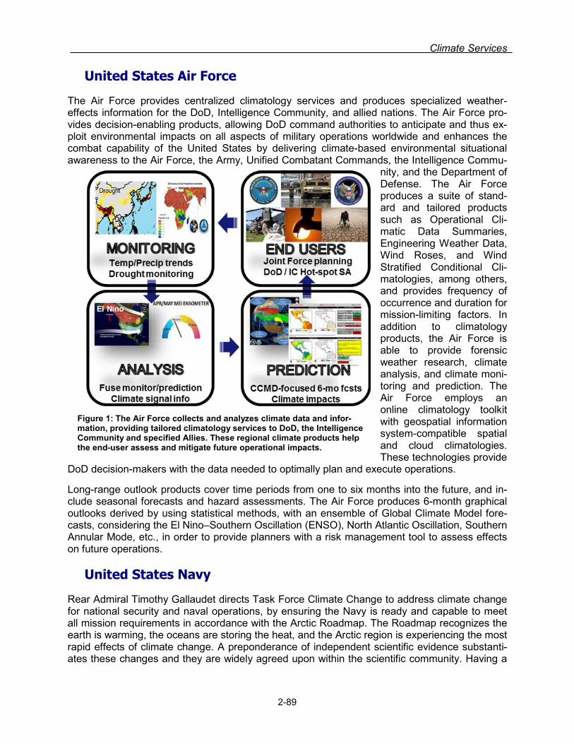
Climate Services
United States Air Force
The Air Force provides centralized climatology services and produces specialized weather-effects information for the DoD, Intelligence Community, and allied nations. The Air Force pro-vides decision-enabling products, allowing DoD command authorities to anticipate and thus ex-ploit environmental impacts on all aspects of military operations worldwide and enhances the combat capability of the United States by delivering climate-based environmental situational awareness to the Air Force, the Army, Unified Combatant Commands, the Intelligence Commu-
nity, and the Department of Defense. The Air Force produces a suite of stand-ard and tailored products such as Operational Cli-matic Data Summaries, Engineering Weather Data, Wind Roses, and Wind Stratified Conditional Cli-matologies, among others, and provides frequency of occurrence and duration for mission-limiting factors. In addition to climatology products, the Air Force is able to provide forensic weather research, climate analysis, and climate moni-toring and prediction. The Air Force employs an online climatology toolkit with geospatial information system-compatible spatial and cloud climatologies. These technologies provide
DoD decision-makers with the data needed to optimally plan and execute operations.
Long-range outlook products cover time periods from one to six months into the future, and in-clude seasonal forecasts and hazard assessments. The Air Force produces 6-month graphical outlooks derived by using statistical methods, with an ensemble of Global Climate Model fore-casts, considering the El Nino–Southern Oscillation (ENSO), North Atlantic Oscillation, Southern Annular Mode, etc., in order to provide planners with a risk management tool to assess effects on future operations.
Figure 1: The Air Force collects and analyzes climate data and infor-mation, providing tailored climatology services to DoD, the Intelligence Community and specified Allies. These regional climate products help the end-user assess and mitigate future operational impacts.
2-89
United States Navy
Rear Admiral Timothy Gallaudet directs Task Force Climate Change to address climate change for national security and naval operations, by ensuring the Navy is ready and capable to meet all mission requirements in accordance with the Arctic Roadmap. The Roadmap recognizes the earth is warming, the oceans are storing the heat, and the Arctic region is experiencing the most rapid effects of climate change. A preponderance of independent scientific evidence substanti-ates these changes and they are widely agreed upon within the scientific community. Having a

Section 2. Federal Meteorological Services and Supporting Research Programs
more reliable Arctic model and more accurate sea ice forecast would make it much safer for sur-face ships to operate there.
Navy is investing in significant Arctic research. It is important that it improve its understanding of the environment for safety of operations, because the Arctic will remain a harsh and challenging environment even as it becomes more accessible and active. This line of effort includes an em-phasis on research to better understand the changing climate and improve Arctic weather fore-cast capabilities, and on high resolution surveying of the seabed.
Naval installations may be at risk from rising sea levels, water resource challenges, wildfires, and extreme weather events. Navy's approach to mitigating these risks uses DOD-approved methodologies to map critical infrastructure on all its installations and work with an interagency group to predict local sea level rise. These assessments will be used to develop partnerships with the local communities and respond to near-term high-risk infrastructure vulnerabilities and plan for future infrastructure development. The Oceanographer has joined with NOAA and Old Dominion University in a pilot project for Hampton Roads, VA. Similar partnerships with other universities, research institutions, and various analyses groups will ensure our efforts are in-formed by the best and latest science and technology initiatives to leverage their expertise and share costs. These partnerships will provide valuable lessons learned for determining the way forward.
Figure 2: Private contractors conducting sea level rise surveys in North Carolina
Climate change and energy are two key issues that will play a significant role in shaping the fu-tures security environment. Working closely with U.S. departments and agencies, the Depart-ment of Defense has undertaken environmental security cooperative initiatives with foreign mili-taries that represent a way of building trust through sharing best practices on installations man-agement and operations. The DOD Climate Change Adaption Roadmap will review:
• Installation master plans to guide development activities • Integrated Natural Resource Management Plans/Cultural Resource Management Plans • Design and construction plans • Encroachment management plans and programs • Storm water management and other utility systems • Facility maintenance and repair cost models • Installation-level water resource management plans • Emergency preparedness and response planning activities.
2-90

Climate Services
Figure 3: U.S. submarine participating in Ice Exercise (ICEX) 2016.
The Arctic Council, founded in 1996, is the leading intergovernmental forum promoting coopera-tion, coordination and interaction among the Arctic states and Indigenous communities on common Arctic issues. ICEX 2016 involved 150 participants during three3 weeks of operation , including :
• 35 Organizations, supporting over 25 test objectives • 4 Services: Navy, Coast Guard, Army, and Air National Guard • 4 federal agencies: DoD, DoI, DHS, and DoS • 3 Allied Nations: UK, Canada, Norway • Canada to provide Royal Canadian Air Force (RCAF) transport aircraft and Royal Canadian
Navy (RCN) dive team • Norway – First involvement in ICEX. Sending observer in expectation of future participation • Academia (Naval Post Graduate School (NPGS), MIT and University of Washington-APL)
United States Geological Survey
The United States Geological Survey (USGS) is both a provider of and user of climate-related services, but the balance between these two activities is quite different from that of NOAA. The USGS provides climate data and models, like NOAA, that can be used by resource managers and policy makers to anticipate and adapt to climate change. The USGS climate and land use change science program, however, also has a strong emphasis on understanding relationships between climate change and hydrological, geologic, and biological processes.
USGS has expertise and numerous research projects and products that describe long-term changes in the Earth’s climate. The climatic datasets developed by the USGS are based primar-ily on Earth surface and subsurface records, in contrast to the atmospheric records developed by NOAA. USGS climatic datasets are derived from ice sheets, glaciers, and permafrost; tree rings, landscape-scale phenology, and other biological data; and rock, sediments, and other paleodeposits, in addition to modern meteorologic, hydrologic, and remote sensing instrumenta-tion. The USGS manages an international ice core facility in Denver, Colorado, and has numer-ous studies devoted to understanding the natural variability of climate and its attendant changes and to providing context for the development of mitigation and adaptation strategies. The Ice Core Laboratory is just one example of the services provided by the USGS to the scientific community engaged in understanding the Earth’s climate history. Another good example of the climate services provided by the USGS is the Department of the Interior’s network of regional
2-91
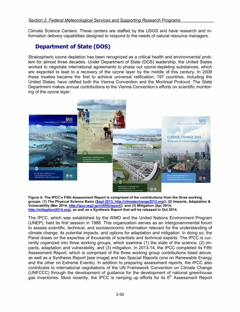
Section 2. Federal Meteorological Services and Supporting Research Programs
Climate Science Centers. These centers are staffed by the USGS and have research and in-formation delivery capabilities designed to respond to the needs of natural resource managers.
Department of State (DOS)
Stratospheric ozone depletion has been recognized as a critical health and environmental prob-lem for almost three decades. Under Department of State (DOS) leadership, the United States worked to negotiate international agreements to phase out ozone-depleting substances, which are expected to lead to a recovery of the ozone layer by the middle of this century. In 2009 these treaties became the first to achieve universal ratification; 197 countries, including the United States, have ratified both the Vienna Convention and the Montreal Protocol. The State Department makes annual contributions to the Vienna Convention’s efforts on scientific monitor-ing of the ozone layer.
Figure 4: The IPCC’s Fifth Assessment Report is comprised of the contributions from the three working groups: (1) The Physical Science Basis (Sept 2013, http://climatechange2013.org/); (2) Impacts, Adaptation & Vulnerability (Mar 2014, http://ipcc-wg2.gov/AR5/report/); and (3) Mitigation (Apr 2014, http://mitigation2014.org), as well as a Synthesis Report that will be released in Oct 2014.
The IPCC, which was established by the WMO and the United Nations Environment Program (UNEP), held its first session in 1988. This organization serves as an intergovernmental forum to assess scientific, technical, and socioeconomic information relevant for the understanding of climate change, its potential impacts, and options for adaptation and mitigation. In doing so, the Panel draws on the expertise of thousands of scientists and technical experts. The IPCC is cur-rently organized into three working groups, which examine (1) the state of the science, (2) im-pacts, adaptation and vulnerability, and (3) mitigation. In 2013-14, the IPCC completed its Fifth Assessment Report, which is comprised of the three working group contributions listed above, as well as a Synthesis Report [see image] and two Special Reports (one on Renewable Energy and the other on Extreme Events). In addition to preparing assessment reports, the IPCC also contributes to international negotiations of the UN Framework Convention on Climate Change (UNFCCC) through the development of guidance for the development of national greenhouse gas inventories. More recently, the IPCC is ramping up efforts for its 6th Assessment Report
2-92
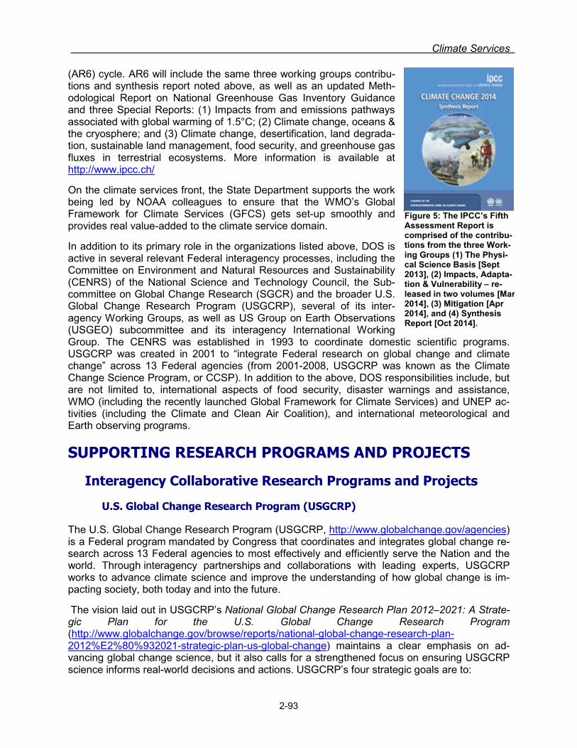
Climate Services
(AR6) cycle. AR6 will include the same three working groups contribu-tions and synthesis report noted above, as well as an updated Meth-odological Report on National Greenhouse Gas Inventory Guidance and three Special Reports: (1) Impacts from and emissions pathways associated with global warming of 1.5°C; (2) Climate change, oceans & the cryosphere; and (3) Climate change, desertification, land degrada-tion, sustainable land management, food security, and greenhouse gas fluxes in terrestrial ecosystems. More information is available at http://www.ipcc.ch/
On the climate services front, the State Department supports the work being led by NOAA colleagues to ensure that the WMO’s Global Framework for Climate Services (GFCS) gets set-up smoothly and provides real value-added to the climate service domain.
In addition to its primary role in the organizations listed above, DOS is active in several relevant Federal interagency processes, including the Committee on Environment and Natural Resources and Sustainability (CENRS) of the National Science and Technology Council, the Sub-committee on Global Change Research (SGCR) and the broader U.S. Global Change Research Program (USGCRP), several of its inter-agency Working Groups, as well as US Group on Earth Observations (USGEO) subcommittee and its interagency International Working Group. The CENRS was established in 1993 to coordinate domestic scientific programs. USGCRP was created in 2001 to “integrate Federal research on global change and climate change” across 13 Federal agencies (from 2001-2008, USGCRP was known as the Climate Change Science Program, or CCSP). In addition to the above, DOS responsibilities include, but are not limited to, international aspects of food security, disaster warnings and assistance, WMO (including the recently launched Global Framework for Climate Services) and UNEP ac-tivities (including the Climate and Clean Air Coalition), and international meteorological and Earth observing programs.
Figure 5: The IPCC’s Fifth Assessment Report is comprised of the contribu-tions from the three Work-ing Groups (1) The Physi-cal Science Basis [Sept 2013], (2) Impacts, Adapta-tion & Vulnerability – re-leased in two volumes [Mar 2014], (3) Mitigation [Apr 2014], and (4) Synthesis Report [Oct 2014].
SUPPORTING RESEARCH PROGRAMS AND PROJECTS
Interagency Collaborative Research Programs and Projects
U.S. Global Change Research Program (USGCRP)
The U.S. Global Change Research Program (USGCRP, http://www.globalchange.gov/agencies) is a Federal program mandated by Congress that coordinates and integrates global change re-search across 13 Federal agencies to most effectively and efficiently serve the Nation and the world. Through interagency partnerships and collaborations with leading experts, USGCRP works to advance climate science and improve the understanding of how global change is im-pacting society, both today and into the future.
The vision laid out in USGCRP’s National Global Change Research Plan 2012–2021: A Strate-gic Plan for the U.S. Global Change Research Program (http://www.globalchange.gov/browse/reports/national-global-change-research-plan-2012%E2%80%932021-strategic-plan-us-global-change) maintains a clear emphasis on ad-vancing global change science, but it also calls for a strengthened focus on ensuring USGCRP science informs real-world decisions and actions. USGCRP’s four strategic goals are to:
2-93

Section 2. Federal Meteorological Services and Supporting Research Programs
1. Advance Science - Advance scientific knowledge of the integrated natural and human components of the Earth system to understand climate and global change.
2. Inform Decisions - Provide the scientific basis to inform and enable timely decisions on ad-aptation and mitigation.
3. Conduct Sustained Assessments - Build sustained assessment capacity that improves the Nation’s ability to understand, anticipate, and respond to global change impacts and vul-nerabilities.
4. Communicate and Educate - Advance communication and education to broaden public understanding of global change and develop the scientific workforce of the future.
For more information, please refer to http://www.globalchange.gov/
NOAA/NESDIS
National Centers for Environmental Information/Center for Weather and Climate formerly known as the National Climatic Data Center (NCDC)
Explaining Extreme Events of 2015 from a Climate Perspective. For the fifth year, CWC scientists are collaborating with their colleagues across the globe to examine the causes of certain extreme weather and climate events. Scientists from CWC served as part of the team of lead editors for the report, entitled “Explaining Extreme Events from a Climate Perspective” and published as a supplement to the Bulletin of the American Meteorological Society. The re-port continues to grow, and last year 34 different research teams from around the world contrib-uted to the peer-reviewed report that examined the causes of 30 extreme events that occurred on all seven continents during 2014. A report looking at events in 2015 is in development. In addition to investigating the causes of these extreme events, these reports include multiple analyses of a single event, allowing scientists to compare and contrast the strengths and weak-nesses of their various analytic methods. Despite the different strategies, there was considera-ble agreement between the assessments of the same events, especially for heatwaves. By fur-ther developing the ability to put extreme weather and climate events into the longer-term con-text of climate change, NCEI is helping provide the public with the information needed to make decisions about effectively minimizing and preparing for the impacts of these events.
An Independent Record of Global Warming. In collaboration with researchers from the Uni-versity of South Carolina, the University of Colorado, and the University of Bern in Switzerland, NCEI developed a compilation of temperature records based on data from ice cores, corals, and lake sediment layers that revealed a pattern of global warming from 1880 to 1995 comparable to the global warming trend recorded by thermometers. While the thermometer-based global sur-face temperature record provides meaningful evidence of global warming over the past century, it is critical to have independent analyses to verify that record, because it can be affected by such things as land-use changes, shifts in station locations, and variations in instrumentation. For this analysis, the team used environmentally sensitive proxies to compile a temperature record spanning 130 years that is independent from thermometer-based records. The research, which was detailed in “Global Warming in an Independent Record of the Past 130 Years,”(http://www.ncdc.noaa.gov/news/independent-evidence-confirms-global-warming-instrument-record) published in Geophysical Research Letters, resolved some of the uncertainty associated with thermometer records.
Regional Surface Temperatures for Six Continents and the Arctic. NCEI scientists helped construct a one-of-a-kind synthesis and analysis of temperatures over the last 2,000 years for six different continents and the Arctic. This effort is part of a large international effort under the
2-94

Climate Services
auspices of the Past Global Changes Programme of the International Geosphere-Biosphere Programme. These reconstructions cover the last millennium on annual-to-decadal timescales and extend into the first millennium of the Common Era, which began in 1 A.D., on annual-to-multi-decadal timescales. To date, scientists have produced 2,000 year-long annual-to-decadal temperature time series for the hemispheres and the globe, but not at the continental scale.
For this project, NCEI scientists served as group leaders for the North American regional recon-struction and as part of the core writing team for the highly cited paper, “Continental-scale tem-perature variability during the last two millennia” in Nature Geoscience. NCEI also served as the data hub for the entire effort, producing state-of-the-art proxy and reconstruction datasets for the Common Era. Overall, this effort greatly extended the record of past climate and explicitly char-acterized uncertainties in the reconstructions. With these data, scientists will be able to better understand extremes in annual to decadal temperature fluctuations over the past 2,000 years in a way that is not possible using the instrumental record alone.
National Centers for Environmental Information/Center for Coasts, Oceans, and Geophysics
Sea Surface Temperature Datasets. The Niño 3.4 index is an important measure of El Niño Southern Oscillation (ENSO) conditions, which NOAA’s Climate Prediction Center uses to sup-port ENSO monitoring and forecasting. The Niño 3.4 index is calculated based on two NCEI da-tasets: the Optimum Interpolation Sea Surface Temperature (OISST, http://www.ncdc.noaa.gov/sst/) dataset and the Extended Reconstructed Sea Surface Tempera-ture (ERSST, https://www.ncdc.noaa.gov/data-access/marineocean-data/extended-reconstructed-sea-surface-temperature-ersst-v3b) dataset.
Pathfinder Sea Surface Temperature (PSST, http://www.nodc.noaa.gov/SatelliteData/pathfinder4km/) is a high-resolution, long time series of satellite sea surface temperature data. This operational reference environmental data record (REDR) is a primary source of information for numerous regional and global marine resource efforts, e.g., applications such as coral reef stress monitoring, local habitat characterization, as well as basic physical oceanographic work. The PSST REDR is recognized and utilized by the community as an authoritative source of information.
Global Gridded High Resolution Sea Surface Wind Blended From Multiple Satellite Ob-servations. The NOAA NCEI Blended Sea Winds dataset contains globally gridded, high-resolution ocean surface vector winds and wind stresses on a global 0.25° grid, and multiple time resolutions of six-hourly, daily, monthly, and 11-year (1995–2005) climatological monthlies. The period of record is July 9, 1987, to present. Blending observations from multiple satellites (up to six satellites since June 2002) allows for the creation of gridded wind speeds. The wind directions come from two sources depending on the products: for the research delayed mode product, the source is the National Centers for Environmental Prediction (NCEP) Reanalysis 2 (NRA-2) and for the near-real-time products, the source is the numerical weather prediction of the European Centre for Medium-Range Weather Forecasts. The user-friendly web interfaces and data formats have continued to extend the product's’ benefit to society, such as applications in marine transportation safety and efficiency (e.g., near-real-time use in ship routing services), ecosystems (e.g. World Coral Reef Watch), offshore renewable research and industry, forecasts in climate, weather, ocean and waves, and education.
The International Comprehensive Ocean-Atmosphere Data Set (ICOADS). The ICOADS is the result of NOAA NCEI’s partnership with its international colleagues. ICOADS offers sur-
2-95

Section 2. Federal Meteorological Services and Supporting Research Programs
face marine data spanning the past three centuries, and simple gridded monthly summary prod-ucts for 2° latitude x 2° longitude boxes back to 1800 (and 1°x1° boxes since 1960)—these data and products are freely distributed worldwide. As it contains observations from many different observing systems encompassing the evolution of measurement technology over hundreds of years, ICOADS is probably the most complete and heterogeneous collection of surface marine data in existence, and is a foundational dataset for ocean, weather and climate research and forecasts.
World Ocean Atlas. NCEI scientists have worked to construct the World Ocean Atlas, which contains objectively analyzed climatological fields of in situ temperature, salinity, oxygen, and other measured variables at standard depth levels for various compositing periods for the world ocean. CCOG scientists are working on the next release of the WOA, WOA17, incorporating many new data, extensively revising quality control and working on isobaric surfaces. Additions to the existing WOA (WOA13) over 2015 (forthcoming release) are climatological mean fields of conductivity (for use with SWARM satellite) and mean fields of density. Regional climatologies (https://www.nodc.noaa.gov/OC5/regional_climate/) for the Greenland, Iceland, and Norwegian Seas, the Nordic Seas and Northern North Atlantic, the Arctic, the East Asian Seas, and the Gulf of Mexico, were created from the Atlas, providing a set of high resolution mean fields for temperature and salinity.
World Ocean Database. NCEI scientists have increased the number of ocean profile casts in the World Ocean Database (WOD) by more than one million for a total of 14.6 million profiles. These data are the basis for the WOA (see above) but also used independently by researchers around the world and within NOAA for oceanographic, climate, and environmental studies.
Ocean Heat and Salt Content. NCEI scientists continue to update the time series of ocean heat content, salt content, and steric sea level change. Ocean heat content is the definitive measure of excess heat energy in the Earth’s system, as the ocean absorbs more than 90% of the excess heat trapped in the Earths system (atmosphere/oceans/land). All time series, figures, and data are available at http://www.nodc.noaa.gov/OC5/3M_HEAT_CONTENT/.
Global Gas Flaring Estimates. NCEI scientists have developed a prototype measurement, re-porting and verification (MRV) system for global gas flaring based on nighttime data collected by the Visible Infrared Imaging Radiometer Suite (VIIRS) sensor on the NOAA S-NPP. The system identifies gas flaring sites and estimates flared gas volumes and CO2 emissions on annual in-crements. This MRV system supports: 1) The UN and World Bank initiative to end routine gas flaring by 2030. 2) Calculation of oil and gas carbon intensities from specific production fields for compliance with Low Carbon Fuel Standards in California and parts of Europe. And 3) Tracking CO2 emission reductions for Intended Nationally Determined Contributions (INDC) under the recently signed UN climate change agreement.
Blended Analysis of the Sea Surface Salinity (BASS). CCOG scientists collaborate with Na-tional Center for Environmental Prediction (NCEP) scientists on a sea surface salinity (SSS) gridded product which is used in NCEP monthly climate reports. CCOG contributes the in situ portion of the blended data as one-degree gridded means of SSS. CCOG scientists also work directly with the Aquarius and SMOS SSS satellite data, validating with in situ data and using for further research on salinity cycles.
Global Temperature and Salinity Profile Program (GTSPP). CCOG scientists lead an inter-national effort to provide near-real time ocean profile temperature and salinity data to reanalysis products and other researchers. The data are quality controlled before being presented to us-ers.
2-96
Climate Services
NOAA/Office of Oceanic and Atmospheric Research (OAR)
The mission of climate research activities within NOAA/OAR is to monitor and understand Earth's climate system in order to predict the potential long-term changes in global climate as well as shorter-term climate variations that are of societal and economic importance. More in-formation on OAR’s climate research is available at: http://www.noaa.gov/climate.html
To achieve this mission, climate research across OAR is structured to support the long-term goal of Climate Adaptation and Mitigation described in NOAA’s Next-Generation Strategic Plan (NGSP). The NGSP identifies four Objectives under the Goal: (1) Improved scientific under-standing of the changing climate system and its impacts; (2) Assessments of current and future states of the climate system that identify potential impacts and inform science, service, and stewardship decisions; (3) Mitigation and adaptation efforts supported by sustained, reliable, and timely climate services; and (4) A climate-literate public that understands its vulnerabilities to a changing climate and makes informed decisions.
To meet these Objectives, OAR’s research is executed and delivered through a network of NO-AA line offices, laboratories and cooperative institutes, programs, and university-based partner-ship activities. Broadly, OAR’s laboratories and cooperative institutes contribute, both directly and indirectly, to all four Objectives. OAR’s Climate Program Office (CPO) manages NOAA’s largest climate competitive research program that funds high-priority science to advance under-standing of the causes and effects of climate variability and change. CPO manages a balanced portfolio of climate research, observation, monitoring, modeling, and decision science across a weather-to-climate time continuum to help communities and businesses better manage risks, build resilience, and adapt to a changing environmental conditions. CPO brings together and maintains relationships across NOAA laboratories, cooperative institutes, and university-based partners. OAR’s laboratories and cooperative institutes work in tandem with CPO to ensure NOAA meets its aim of an informed society anticipating and responding to climate and its im-pacts.
• Specific aims of research conducted under NOAA’s Goal’s Objective of improved scientific understanding include:
• Describe and understand the state of the climate through sustained atmospheric and ocean-ic observations and research related to global distributions, trends, sources and sinks of at-mospheric constituents that are capable of forcing change in the climate of the Earth
• Understand and predict climate variability and change from weeks to decades to centennial timescales
• Conduct advanced mathematical modeling of the climate and Earth systems, including natu-ral climate variability, anthropogenic climate change, weather and hurricane forecasts, El Niño prediction, and stratospheric ozone depletion to improve the prediction of climate phe-nomena
• Sustain the observing systems essential for climate, oceanographic monitoring, and data management
• Conduct physical process research to advance a seamless suite of information and forecast products
• Understand how decision makers use climate information to improve the ability of society to plan for and respond to climate variability and change.
2-97

Section 2. Federal Meteorological Services and Supporting Research Programs
NOAA/OAR Laboratories and Programs
Atlantic Oceanographic and Meteorological Laboratory (AOML)
AOML conducts mission oriented scientific research that seeks to understand the physical, chemical, and biological characteristics and processes of the ocean and atmosphere, both sep-arately and as a coupled system. The Laboratory's research theme related to oceans and cli-mate includes interdisciplinary scientific investigations of the physics of ocean currents and wa-ter properties, and on the role of the ocean in climate, extreme weather events, and ecosys-tems. The tools used to carry out these studies range from sensors on deep ocean moorings to satellite-based instruments to measurements made on research and commercial shipping ves-sels and autonomous vehicles, and include data analysis and numerical modeling as well as theoretical approaches. This includes stewardship of oceanic measurements relevant for cli-mate, including custodianship of major data sets, development and deployment of new sampling methods, new analysis tools, and carrying out long-term consistent environmental measuring programs.
In an effort to better understand and forecast climate, the Atlantic Oceanographic and Meteoro-logical Laboratory (AOML) contributes to the maintenance of the global Argo program (a global array of 3,000 vertically profiling floats), the global drifter program (which maintains a global ar-ray of more than 1500 surface drifters), the expendable bathythermograph program (the deploys more than 8000 XBTs each year and processes more than 14,000 XBTs each year). AOML col-laborates with the Pacific Marine Environmental Laboratory (PMEL) to monitor decadal-scale changes in a suite of physical, chemical, and biological parameters over the full water column, such as carbon dioxide uptake, ocean temperature, and circulation (e.g. Global Repeat Hydro-graphic/CO2/Tracer (GO-SHIP) surveys in Support of CLIVAR and Global Carbon Cycle objec-tives: Carbon Inventories and Fluxes program). In addition AOML maintains time series obser-vations of the Florida Current and Deep Western Boundary Current (Western Boundary Time Series program) and the Deep Western Boundary Current in the South Atlantic (the Southwest Atlantic Meridional Overturning Circulation Array); these programs contribute to the national and international programs designed to measure the meridional overturning circulation in the Atlantic Ocean which is the large scale ocean circulation that redistributes heat, fresh water and carbon north and south in the ocean. AOML manages these observational programs and conducts ocean circulation research on data collected through them. All of these programs are major con-tributors to the World Climate Research Programme’s Climate Variability and Predictability (CLIVAR) Experiment and the Global Ocean Data Assimilation Experiment. Combined with sat-ellites, these data provide a quantitative description of the changing state of the ocean and the patterns of ocean climate variability from months to decades, including heat, freshwater and carbon storage and transport.
In FY17 and beyond, AOML plans to increase understanding of the ocean's role in climate through the stewardship of long term ocean observations, analysis of observations and models and numerical simulation of ocean circulation induced changes to climate. For example, the Physical Oceanography Division (PHOD) of AOML will continue to show that the variation of surface and subsurface ocean temperature and salinity is important to and linked with the Atlan-tic meridional overturning circulation (AMOC), hurricane intensification and fisheries productivity on climate time scales.
2-98

Climate Services
Air Resources Laboratory (ARL)
To provide a sound scientific basis for understanding climate variability and change, the Air Re-sources Laboratory (ARL) contributes to two land-based reference observing networks: the U.S. Climate Reference Network (measuring surface climate variables) and the Surface Energy Budget Network.
In FY17, ARL will:
• Continue to provide maintenance and testing of existing technologies at the climate refer-ence networks and evaluate new technologies;
• Examine the impact of extreme events, such as a late spring freeze and mid-summer droughts, on the seasonal energy budgets of carbon and water in eastern hardwood decid-uous forests.
• Continue analysis of interactions between climate and air chemistry, and the performance of operational and research models.
• Continue developing new small unmanned aircraft systems (sUAS) measurement platforms for measuring thermodynamic parameters and surface layer characteristics as it relates to climate.
• ARL plans to continue coordinating with the National Integrated Drought Information System and the NOAA National Centers for Environmental Information concerning the National Soil Moisture and Temperature Network, and to develop support for the NWS Water Center us-ing the USCRN data.
Climate Program Office (CPO)
CPO manages a climate observations program and NOAA’s largest climate competitive re-search program that funds high-priority science to achieve its mission to advance scientific un-derstanding, monitoring, and prediction of climate and its impacts to enable effective decisions. CPO’s position at the intersection of the climate research, observation, monitoring, modeling, and decision science communities enables it to lead a balanced, mission-driven research agen-da and forge partnerships that enhance society’s ability to manage risks, enhance resilience, and adapt to a changing climate. CPO provides strategic guidance and coordination of NOAA’s climate science and services programs, and integrates them with the efforts of NOAA laborato-ries and external communities.
CPO also supports multi-disciplinary research and assessments that help communities better plan and respond to climate change and variability. CPO-supported research is conducted in regions across the United States, at national and international scales, and globally.
One of CPO’s core missions is to develop and sustain a global in situ climate observing system with partners such as AOML, PMEL, and NESDIS NOAA’s instruments are a vital part of an in-ternational system to monitor Earth’s climate and provide data for NOAA research, modeling, predictions, and forecasts. CPO leverages climate science capacity and capabilities to provide Americans with critically needed early warning systems that are timely and relevant for stake-holders at a range of scales spatially (local to global) and over time (weeks to decades) and in-clude the effects of changing climate conditions on extreme weather events.
CPO will continue to support modeling, research, analysis, and data collection aimed at gaining a better understanding of climate processes. These activities are essential steps toward deliver-ing climate prediction and assessment products for risk management and decision-making.
2-99

Section 2. Federal Meteorological Services and Supporting Research Programs
CPO will also sustain grant programs that advance the knowledge and capacity of decision makers to assess risk, prepare for, and respond to the impacts of climate variability and change.
FY 2017 Plans:
• Execute the OAR-NWS MOU that established a strategy between NWS and OAR to ensure NOAA meets the growing societal demand for climate information through improved model-ing and predictions as well as development of applications and tools for enhanced decision support services.
• Improve the understanding of predictability and the potential to advance the prediction of phenomena occurring on subseasonal to seasonal (S2S) time scales including focus on tropical cyclones, atmospheric rivers, and precipitation and temperature extremes. Continue development of subseasonal (e.g., Week 3-4) temperature and precipitation outlooks and products.
• Support scientific advancements in understanding of tropical convection, the coupled ocean-atmosphere-land-ice system, and persistent model biases (e.g., DYNAMO, AMOC, and Pa-cific Ocean Biases).
• As an element of its suite of observation systems and partnerships, advance plans for the Tropical Pacific Observing System 2020 projects which will support improved ENSO predic-tions as well as weather forecasts.
• Increase engagement with public and private partners to understand their vulnerability to extremes of weather and climate to help develop information needs and options for adapta-tion and mitigation, especially in the areas of heat health, water resources, and coastal flooding.
• Expand the Climate Resilience Toolkit to improve data visualization and offer interactive map layers showing climate-related stressors, people and assets impacted, and climate pro-jections and to facilitate knowledge sharing between climate experts and stakeholders in businesses and communities.
Earth System Research Laboratory (ESRL)
The Earth System Research Laboratory (ESRL) continues to make unparalleled contributions to the scientific understanding of climate change through its global atmospheric monitoring pro-gram, field missions to study atmospheric processes, laboratory studies, modeling work.
ESRL’s Chemical Sciences Division (CSD) climate research provides an improved predictive capability through a better understanding of the connections between emissions, atmospheric composition, and Earth’s climate system. Research is focused on addressing two of the greatest uncertainties in current climate models: water vapor and aerosols (airborne fine particles), in addition to ongoing work on non-CO2 greenhouse gases.
The ESRL Global Monitoring Division (GMD) conducts sustained observations and research related to global distributions, trends, sources and sinks of atmospheric constituents such as greenhouse and other trace gases, aerosols, ozone, a that are capable of forcing change in Earth’s climate. This research and long-term observations are used worldwide to advance cli-mate projections and provide scientific, policy-relevant, decision-support information to enhance society's ability to plan and respond to change.
Physical Sciences Division (PSD) strives to interpret the causes of observed climate variation, and advance the understanding, parameterization, and measurement of climate-relevant physi-cal processes. PSD research advances NOAA’s capacity to observe, understand, and predict the physical behavior of the climate system and related impacts on global-to-local scales over
2-100

Climate Services
timescales ranging from days to decades. Advances the predictive understanding of climate ex-tremes and variability impacting on the U.S., such as changes in the risk for heavy rainfall and snow events during an El Niño, are used to improve climate models and forecasts and develop new climate products that better serve the needs of the public and decision-makers.
The ESRL Global Systems Division (GSD) leads an Atmospheric Science for Renewable Ener-gy program with the objective to provide more accurate wind and cloud forecasts over a range of timescales to support the nation’s increase demands for better products and services. This includes the improvement of numerical weather prediction forecasts from the Rapid Refresh (RAP) and the High Resolution Rapid Refresh (HRRR) weather models for wind and solar ap-plications. Specific accomplishments have focused on the Planetary Boundary Layer (PBL) scheme. Explicit mixing of cloud water and ice to the turbulent mixing scheme in the MYNN PBL scheme has been added, and the subgrid-scale clouds from shallow-cumulus scheme have been coupled to the radiation scheme. Separate cloud mixing ratios for the deep- and shallow-cumulus schemes and their respective cloud fractions have been implemented in the RAP. Fur-ther, a blended turbulent kinetic energy (BTKE) scheme in the WRF model has been developed, for implementation in the RAP and HRRR.
GSD also leads the development of coupled modeling systems (in collaboration with CSD), combining weather/ocean/chemistry and aerosols to study processes relevant for global climate change, in particular the aerosol direct and indirect effects. Furthermore, these modeling tools are used to look at impacts of chemistry and air quality on medium range numerical weather prediction as well as seasonal and sub-seasonal forecasting.
All ESRL Divisions place a high priority on communicating the results of their research in deci-sion-support information products to underpin national and international decision-making. Their contributions include leadership and extensive participation in state-of-understanding national and international assessments on climate.
FY 17 Plans:
• Carry out the Shale Oil and Natural Gas Nexus (SONGNEX) investigation using NOAA’s “flying chemical laboratory” aboard the NOAA P-3 aircraft
• Execute a complementary airborne study of Fugitive Emissions concentrating on methane and other GHGs aboard the NOAA DHC6 aircraft.
• Analyze data from the SENEX and SEAC4RS field missions to understand climate effects of emissions, atmospheric chemistry, and transport in the southeastern U.S.
• Develop new prototype systems for regional drought diagnosis and prediction. • Develop large ensemble, multi-model, high resolution global modeling ability to resolve high
impact extreme events: heat waves, droughts, heavy precipitation. • Develop climate and weather guidance to reduce and manage drought and floods impacts
on watershed restoration. • Provide an integrated database for the International Arctic System for Observing the Atmos-
phere (IASOA). IASOA is a consortium of 10 sentinel Arctic Observatories that collect a wide range of detailed measurements relevant to weather and climate. This activity will support the Polar Prediction Project.
• Lead development of International Arctic science focus groups integrating information on the environmental state of clouds, radiation, surface-atmosphere exchanges, trace gases, black carbon and regional predictions in the Arctic region.
• Continue development of Arctic atmospheric observatories to obtain high-latitude climate data.
2-101

Section 2. Federal Meteorological Services and Supporting Research Programs
• Engage in diagnostic studies to enhance understanding of the two-way linkages between the Arctic region and the lower latitudes to improve prediction
• Continue long-term observations of atmospheric composition, providing annual updates of CarbonTracker, the NOAA Annual Greenhouse Gas Index (a national climate indicator), me-thane climatologies, CO2 trends (daily updates; a national climate indicator), the Ozone-Depleting Gas Index, GlobalView, and other long-term atmospheric composition data sets and products.
• Revise the mixing length in the MYNN planetary boundary layer (PBL) scheme to improve the representation of the local mixing in the RAP/HRRR.
• Improve the representation of the subgrid-scale clouds as well as the coupling between the subgrid-scale clouds and the turbulent mixing in the RAP/HRRR.
• Couple a mass-flux scheme to the MYNN PBL scheme to improve the representation of the non-local mixing in the RAP/HRRR.
• Develop a 3D surface flux capability in the MYNN surface layer scheme in the RAP/HRRR. • Improve the initial conditions of non-precipitating and precipitating clouds in RAP/HRRR hy-
drometeor analysis. • Continue aerosol studies as they related to global climate change.
Geophysical Fluid Dynamics Laboratory (GFDL)
Over the last half century in general, and the last few years in particular, GFDL has demonstrat-ed world leadership in pushing the boundaries of climate prediction and projections of climate change. Through direct participation in producing the Intergovernmental Panel on Climate Change (IPCC) 2007 Assessment and the Administration’s Climate Change Science Program Synthesis and Assessment Reports, GFDL’s premier climate science capacity and recent in-vestment in computer model infrastructure allow NOAA to deliver essential climate prediction information at the regional and local level and provide an invaluable and unique opportunity for the Nation to make critical progress in global change science. GFDL has delivered model output to the IPCC Fifth Assessment Report (AR5). Four model streams have been specifically de-signed for the climate integrations needed to address the major climate science challenges. All four streams are based on CM2.1, a GFDL coupled climate model with an atmospheric model resolution of 200km and an ocean model resolution of 100km. CM2.1 was considered among the highest quality models used in the previous IPCC Assessment Report, AR4, and was used again in AR5. Nearly 200 terabytes of model output was submitted to the 5th Coupled Model In-ter-comparison Project (CMIP5) for use in AR5. The four modeling streams are:
1. Decadal prediction experiments to better understand physical processes. 2. Earth System Models (ESMs), emphasizing biogeochemical carbon-climate feedbacks
through the use of a closed-carbon cycle. 3. Coupled climate models (CM3) with more realistic, self-consistent but complex atmospheric
physics and chemistry than in CM2.1. 4. High-resolution atmospheric models at 50km and 25km resolution forced by future ocean
states.
GFDL scientists continue to play an active role in AR5, and in some instances lead, in: model inter-comparison and model simulation analysis activities; submission of model data, quality control and archiving; analyses of the data outputs and inferences about the climate system. These activities will lead to a number of peer-reviewed publications based on the CMIP5 data-base of model output. GFDL has also made significant contributions, through high-resolution model experiments, to the North American Regional Climate Change Assessment Program (NARCCAP), and GFDL model experiments and science results were also used in the recently
2-102

Climate Services
released USGCRP National Climate Assessment. Significant progress in model development is expected in FY15 as the four modeling streams outlined above are unified into a new coupled model called CM4. New very high-resolution climate and Earth System models are being devel-oped and applied to address scientific questions regarding the impact of atmospheric composi-tion and ocean eddies on the climate system as well as regional-to-local impacts of climate vari-ability and change on marine ecosystems.
Great Lakes Environmental Research Laboratory (GLERL)
The Great Lakes Environmental Research Laboratory (GLERL) conducts climate research and modeling focused on the region of the Laurentian Great Lakes, which is shared by the USA and Canada. Investigation of impacts of climate change on hydrologic resources in the Great Lakes began during the late 1980s, and has been considerably overhauled in recent years. Hydrologic models with one-way driving of the surface by the atmosphere have been replaced by regional climate models with two-way coupling of the atmosphere to both land and water surfaces. The older generation of this type of model, the Coupled Hydrosphere-Atmosphere Research Model (CHARM) is being replaced by a newer version based on the Weather Research and Forecast-ing (WRF) model.
Of particular interest is the influence of climate and climate change on water quantity in the Great Lakes basin, and atmospheric and climatic research at GLERL are coordinated with hy-drologic study, as well as research on the dynamics of motion and thermodynamics of the lakes and their ice. In addition, GLERL has expertise in the dynamics of nutrient loading in rivers, and on the interaction among these nutrients, water temperature and dynamics, and the biota of the lower and upper food web, leading to end-to-end capability in the physical, chemical, and bio-logical aspects of this regional Earth system.
National Severe Storms Laboratory (NSSL)
NSSL scientists have collaborated with the NOAA NWS Storm Prediction Center to determine the observed climatology of severe thunderstorms in the U.S. and to explore different strategies for producing reliable seasonal predictions of severe weather. They have also worked with the international community to develop climatologies for other parts of the globe. In addition, they have examined data from different climate-projection studies, together with known relationships between environmental parameters and severe-weather occurrence, to hypothesize how se-vere-weather occurrence and intensity might change in different climate scenarios.
Pacific Marine Environmental Laboratory
The Pacific Marine Environmental Laboratory (PMEL) contributes to the advancement our un-derstanding of the impacts of climate variability and change through a long-term observations program that supports robust climate research. Key observational components include:
The Global Tropical Moored Buoy Array (GTMBA) was developed by PMEL in partnership with NOAA’s Climate Program Office and multiple international partners. PMEL now maintains both the PIRATA and RAMA Arrays in the Tropical Atlantic and Indian Oceans, respectively. The TAO/TRITON Array, the original component of the GTMBA, has been transitioned from PMEL to NWS/National Data Buoy Center. Moored buoys in the GTMBA report daily values of surface meteorological parameters and subsurface temperatures and salinity values via satellite for use by the NWS Climate Prediction Center and climate researchers world-wide.
2-103

Section 2. Federal Meteorological Services and Supporting Research Programs
PMEL contributes to the maintenance of the global Argo Float Array, through an international partnership under the direction of NOAA’s Climate Program Office and in conjunction with U.S. Argo partners Scripps Institute of Oceanography, Woods Hole Oceanographic Institution, the University of Washington, and AOML. PMEL scientists deploy floats, support the addition of new measurement and increased depth capabilities of Argo floats, conduct research on improving quality control of the Argo data. PMEL and CPO are co-managing the development of Deep Ar-go floats, extending the depth range of Argo floats from 2,000 meters to 6,000 meters.
PMEL scientists support the OceanSITES program of global moored ocean reference stations for climate, maintaining two moored platforms in the North Pacific, at the Kuroshio Extension Observatory (32.3oN 144.5oE) in the NW Pacific Ocean and at Ocean Station Papa (50oN 145oW) in the NE Pacific Ocean.
In conjunction with the International CLIVAR program, PMEL conducts ocean research on a global scale to monitor decadal-scale changes in a suite of physical, chemical, and biological parameters over the full water column, such as carbon dioxide uptake, ocean temperature, and circulation.
PMEL climate researchers are active in the Arctic region, using atmospheric models to predict long-term sea-ice extent and providing information on potential impacts to ecosystem managers and local communities on Arctic change. PMEL scientists, working with the National Marine Fisheries Service, also conduct research on the impacts of ocean climate change on marine resources, conducting research on ocean acidification and on the impact of ocean and climate change on North Pacific fishery and marine mammal populations.
U.S Department of Agriculture
National Institute of Food and Agriculture
National Institute of Food and Agriculture (NIFA) funding supports research projects that collect, analyze and utilize short and long-term weather and climate data as a base of information for the projection and prediction of climatic trends related to environmental impacts on agro-ecosystems, forests and rangelands for the development of adaptation and mitigation strategies for natural resources and agriculture production management. Through the Agriculture and Food Research Initiative (AFRI), NIFA has funded a set of projects on weather and climate re-lated research in collaboration with other U.S. federal agencies. These projects are focused on regional climate studies in agriculture lands and forests, and other areas of research related to carbon cycling, agro-ecosystem modeling, water sustainability, and economic consequences of adaptation and mitigation strategies. Emerging areas of research include the impact of climate on biofuel production and non-carbon dioxide greenhouse gas production.
Historical climate changes are derived from data gathering and modeling studies, enabling pre-diction of future crop production and irrigation needs. NIFA funding also supports studies on the predicted impact of climate and weather on food, feed, and fiber production and on natural re-source protection and utilization. These studies relate to forest and agricultural plant growth, rangeland productivity, cropping system selection, livestock production practices and natural resource management.
Man’s impact on climate systems is also well represented in NIFA funded studies of both micro-and macro-climatic change. These involve studies dealing with the climatic impact on air quality, water quality and quantity and agriculture waste management related to agricultural practices
2-104

Climate Services
and forest and urban development. Studies on climatic impact on nutrient cycling and carbon sequestration and emission are supported with NIFA funds.
United States Geological Survey
Water Resources Monitoring. The effects of warming temperatures on water resources are among the most certain and costly consequences of climate change in some regions of the United States, and water resources information should be an important component of (or closely linked with) a new national climate services program. The USGS is the nation’s water resource monitoring agency, with one or more offices in every State and a National stream and ground-water monitoring network that supports water management efforts at State and local levels, as well as vast western water resources managed by two other Department of the Interior bureaus: the Bureau of Reclamation and the Bureau of Land Management (BLM). The USGS has a long-established hydroclimatology research program and is the primary Federal science agency for water resource information. The USGS monitors the quantity and quality of water in the Nation's rivers and aquifers and develops tools to improve the application of hydrologic information, in-cluding the effects of a changing climate. This broad, diverse mission cannot be accomplished effectively without the contributions of the Cooperative Water Program with the 50 states. For more than 100 years, the Cooperative Program has been a highly successful cost-sharing part-nership between the USGS and water-resource agencies at the State, local, and Tribal Nation levels.
The USGS carries out research in climate change, regional hydrology, the carbon cycle, coastal erosion, and glaciology. The Water, Energy, and Biogeochemical Budgets (WEBB) program is studying processes controlling water, energy, and biogeochemical fluxes at five small research watersheds in the United States. This program includes research on the effects of atmospheric and climatic variables on watershed processes. There are also a number of ongoing studies to characterize trends in hydrologic data and to relate these trends to climatic variables. Re-searchers are also using global and regional climate models to enhance understanding of the potential effects of climate change and climate variability on U.S. land and water resources.
Glacier Monitoring. As part of its glaciology program, the USGS maintains an observation program on three benchmark glaciers representative of different climatic zones of the western United States, one in Washington, one on the south coast of Alaska, and one in the interior of Alaska. At each glacier, the program measures the winter snow accumulation, summer snow and ice ablation, air temperature, and runoff in the glacier basin. Beginning in 1959, this is the longest such record in North America. Analysis of this record is providing a greater understand-ing of climate variability and its effects on water resources of the western United States. The record clearly shows the effects of changing winter precipitation patterns associated with at-mospheric conditions in the northeast Pacific Ocean, including El Niño-La Niña events and the Pacific Decadal Oscillation.
To augment its glacier monitoring efforts, the USGS is using National Systems data to measure fluctuations of glaciers in Alaska, Washington, and Montana. Mountain glaciers are ideal sub-jects for these systems because they are remote, have an appropriate space scale, and require infrequent but repetitive observations. The observations have established a baseline of regional glacial conditions. The resulting archive of ongoing observations is being used to determine re-cent trends in glacier size and terminus location. In addition, techniques have been developed to generate derived products that provide critical glacial parameters, including DEMs, equilibri-um line altitudes, and ablation rates. These products are being incorporated into a glacial runoff
2-105
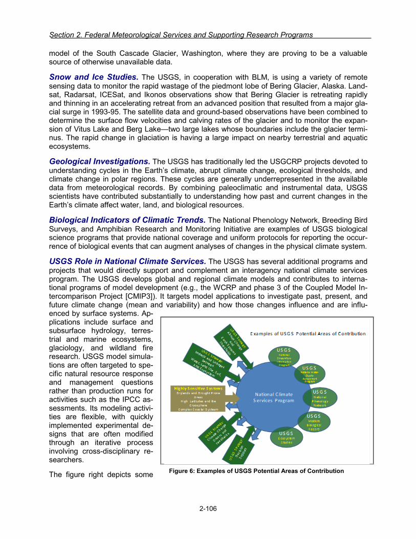
Section 2. Federal Meteorological Services and Supporting Research Programs
model of the South Cascade Glacier, Washington, where they are proving to be a valuable source of otherwise unavailable data.
Snow and Ice Studies. The USGS, in cooperation with BLM, is using a variety of remote sensing data to monitor the rapid wastage of the piedmont lobe of Bering Glacier, Alaska. Land-sat, Radarsat, ICESat, and Ikonos observations show that Bering Glacier is retreating rapidly and thinning in an accelerating retreat from an advanced position that resulted from a major gla-cial surge in 1993-95. The satellite data and ground-based observations have been combined to determine the surface flow velocities and calving rates of the glacier and to monitor the expan-sion of Vitus Lake and Berg Lake—two large lakes whose boundaries include the glacier termi-nus. The rapid change in glaciation is having a large impact on nearby terrestrial and aquatic ecosystems.
Geological Investigations. The USGS has traditionally led the USGCRP projects devoted to understanding cycles in the Earth’s climate, abrupt climate change, ecological thresholds, and climate change in polar regions. These cycles are generally underrepresented in the available data from meteorological records. By combining paleoclimatic and instrumental data, USGS scientists have contributed substantially to understanding how past and current changes in the Earth’s climate affect water, land, and biological resources.
Biological Indicators of Climatic Trends. The National Phenology Network, Breeding Bird Surveys, and Amphibian Research and Monitoring Initiative are examples of USGS biological science programs that provide national coverage and uniform protocols for reporting the occur-rence of biological events that can augment analyses of changes in the physical climate system.
USGS Role in National Climate Services. The USGS has several additional programs and projects that would directly support and complement an interagency national climate services program. The USGS develops global and regional climate models and contributes to interna-tional programs of model development (e.g., the WCRP and phase 3 of the Coupled Model In-tercomparison Project [CMIP3]). It targets model applications to investigate past, present, and future climate change (mean and variability) and how those changes influence and are influ-enced by surface systems. Ap-plications include surface and subsurface hydrology, terres-trial and marine ecosystems, glaciology, and wildland fire research. USGS model simula-tions are often targeted to spe-cific natural resource response and management questions rather than production runs for activities such as the IPCC as-sessments. Its modeling activi-ties are flexible, with quickly implemented experimental de-signs that are often modified through an iterative process involving cross-disciplinary re-searchers.
The figure right depicts some Figure 6: Examples of USGS Potential Areas of Contribution
2-106
Climate Services
of the potential areas of USGS collaboration and support toward a coordinated interagency na-tional climate services program.
National Aeronautics and Space Administration
Science Mission Directorate, Earth Science Division
Predicting the consequences of global change—whether natural or human induced—and devel-oping useful science-based applications of climate, weather, and hydrologic prediction systems are paramount challenges NASA’s weather research program. The program is primarily de-signed to apply NASA scientific remote sensing expertise to the problem of obtaining accurate and globally distributed measurements of the atmosphere and the assimilation of these meas-urements into research and operational weather forecast models in order to improve and extend U.S. and global weather prediction. Weather research at NASA is accomplished in collaboration across four focus areas (Atmospheric Composition, Climate Change & Variability, Water & En-ergy Cycle, and Weather). Some of the relevant key questions the focus areas address include the role of clouds in the climate system, atmosphere/ocean/ice/land interactions, extreme events (e.g., droughts, hurricanes), climate oscillations (ENSO, MJO, etc.), weather forecasting, and sub-seasonal to inter-annual climate diagnosis and prediction.
NASA has been a strong contributor to the national weather forecasting goals in the past, and will continue to be in the future, primarily through the development and use of data from space-based sensors. Satellite-based profiles of temperature and moisture have been routinely used in operational forecasting for more than 20 years, and NASA sensors hold promise for more accu-racy and spatial resolution (TRMM, GPM, Aqua, Terra, Suomi NPP, CloudSat, RapidSCAT, SMAP, CALIPSO, CYGNSS, RapidSCAT, and SMAP). Recent developments in assimilating radar and passive microwave data from TRMM and the Advanced Infrared Sounder (AIRS) data from Aqua are improving weather forecasts and contributing to developing long time series in support of climate studies. Further advances in predictive capabilities will come with data from the GPM constellation satellites, which can measure falling rain, snow, and ice in light to heavy quantities and cover the entire globe every three hours. NASA continues to work on the assimi-lation of cloudy radiance with the JCSDA partners.
Satellite Missions. Satellites provide critical climate change measurements via global cover-age, frequent sampling in both space and time, and near-uniform accuracy and stability. NASA initiated, and in selected cases has sustained for more than a decade, many global, high accu-racy, well-calibrated data records, such as total solar irradiance at the top of the atmosphere; Arctic Ocean sea ice extent and thickness; Antarctic and Greenland mass change and other characteristics; global sea level and global ocean surface vector wind; global ocean near-surface chlorophyll-a concentration; global land use and land cover; ozone in the stratosphere; and, global precipitation, including water vapor, rainfall and snow. These critical climate data records are a foundation for national and international studies of global and regional climate change, sea level rise, and study of the earth as a system.
NASA has 8 on-orbit satellite missions specifically related to climate services as defined by this Federal Plan: Aqua, CloudSat, Earth Polychromatic Camera (EPIC) onboard NOAA’s Deep Space Climate Observatory (DSCOVR), Ocean Surface Topography Mission (OSTM), Suomi National Polar-orbiting Partnership (Suomi NPP), Global Precipitation Measurement (GPM), the International Space Station (ISS)-RapidScat payload, and Soil Moisture Active Passive (SMAP) mission. The Aquarius mission, formerly on the list, ended June 7, 2015 when its host platform, the Satélite de Aplicaciones Científicas (SAC)-D suffered a mission-ending failure. SMAP, the
2-107
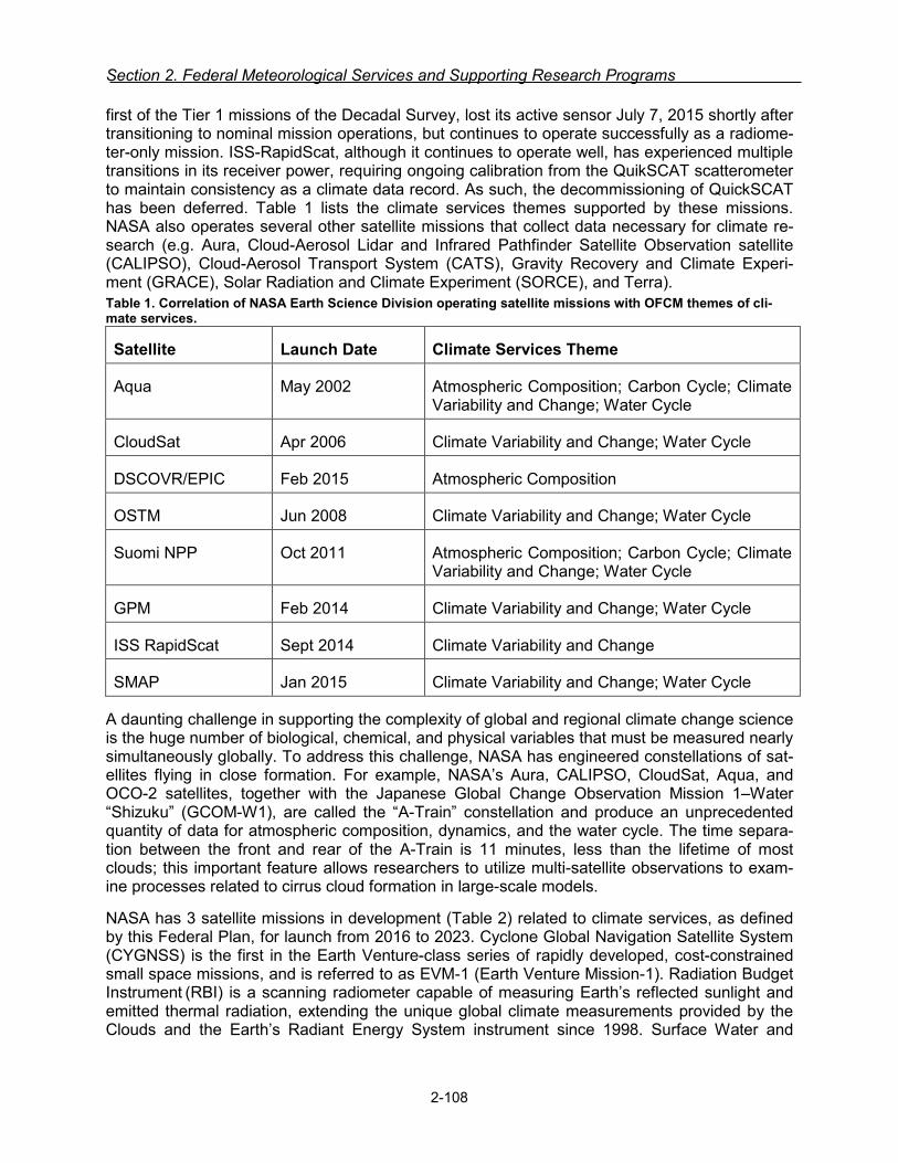
Section 2. Federal Meteorological Services and Supporting Research Programs
first of the Tier 1 missions of the Decadal Survey, lost its active sensor July 7, 2015 shortly after transitioning to nominal mission operations, but continues to operate successfully as a radiome-ter-only mission. ISS-RapidScat, although it continues to operate well, has experienced multiple transitions in its receiver power, requiring ongoing calibration from the QuikSCAT scatterometer to maintain consistency as a climate data record. As such, the decommissioning of QuickSCAT has been deferred. Table 1 lists the climate services themes supported by these missions. NASA also operates several other satellite missions that collect data necessary for climate re-search (e.g. Aura, Cloud-Aerosol Lidar and Infrared Pathfinder Satellite Observation satellite (CALIPSO), Cloud-Aerosol Transport System (CATS), Gravity Recovery and Climate Experi-ment (GRACE), Solar Radiation and Climate Experiment (SORCE), and Terra). Table 1. Correlation of NASA Earth Science Division operating satellite missions with OFCM themes of cli-mate services.
Satellite Launch Date Climate Services Theme
Aqua May 2002 Atmospheric Composition; Carbon Cycle; Climate Variability and Change; Water Cycle
CloudSat Apr 2006 Climate Variability and Change; Water Cycle
DSCOVR/EPIC Feb 2015 Atmospheric Composition
OSTM Jun 2008 Climate Variability and Change; Water Cycle
Suomi NPP Oct 2011 Atmospheric Composition; Carbon Cycle; Climate Variability and Change; Water Cycle
GPM Feb 2014 Climate Variability and Change; Water Cycle
ISS RapidScat Sept 2014 Climate Variability and Change
SMAP Jan 2015 Climate Variability and Change; Water Cycle
A daunting challenge in supporting the complexity of global and regional climate change science is the huge number of biological, chemical, and physical variables that must be measured nearly simultaneously globally. To address this challenge, NASA has engineered constellations of sat-ellites flying in close formation. For example, NASA’s Aura, CALIPSO, CloudSat, Aqua, and OCO-2 satellites, together with the Japanese Global Change Observation Mission 1–Water “Shizuku” (GCOM-W1), are called the “A-Train” constellation and produce an unprecedented quantity of data for atmospheric composition, dynamics, and the water cycle. The time separa-tion between the front and rear of the A-Train is 11 minutes, less than the lifetime of most clouds; this important feature allows researchers to utilize multi-satellite observations to exam-ine processes related to cirrus cloud formation in large-scale models.
NASA has 3 satellite missions in development (Table 2) related to climate services, as defined by this Federal Plan, for launch from 2016 to 2023. Cyclone Global Navigation Satellite System (CYGNSS) is the first in the Earth Venture-class series of rapidly developed, cost-constrained small space missions, and is referred to as EVM-1 (Earth Venture Mission-1). Radiation Budget Instrument (RBI) is a scanning radiometer capable of measuring Earth’s reflected sunlight and emitted thermal radiation, extending the unique global climate measurements provided by the Clouds and the Earth’s Radiant Energy System instrument since 1998. Surface Water and
2-108
Climate Services
Ocean Topography (SWOT) is a Tier 2 Decadal Survey mission to provide insight into the movement and distribution of Earth surface waters including both freshwater and oceans. Table 2: Correlation of NASA Earth Science Division missions in development with OFCM themes of climate services.
Satellite Planned Launch Climate Services Theme
CYGNSS 2016 Water Cycle
RBI 2021 Climate Variability and Change
SWOT 2020 Climate Variability and Change; Water Cycle
NASA continues with the pre-formulation studies of Decadal Survey and other mission concepts such as Climate Absolute Radiance and Refractivity Observatory (CLARREO), Active Sensing of CO2 Emissions over Nights, Days, and Seasons (ASCENDS), Aerosol-Cloud-Ecosystem (ACE), GEOstationary Coastal and Air Pollution Events (GEO-CAPE), Hyperspectral Infrared Imager (HyspIRI). Additionally, the Earth Science Technology Office (ESTO) makes significant investments in technology development activities directly addressing the priorities outlined in the Decadal Survey including the tiered missions as wells as Earth Venture through development of observation systems and information systems technologies.
The following activities will be undertaken or accomplished in FY 2017.
• CLARREO Pathfinder will enter the formulation phase in fall 2016. The CLARREO mission received funding to demonstrate essential measurement technologies required for the full mission. The allocated funds support the flight of a Reflected Solar (RS) spectrometer, host-ed on the International Space Station (ISS) in the 2020 time frame.
• CYGNSS will complete environmental test and prepare for launch in early FY17. • TEMPO will continue its development, including instrument level integration and test. • SWOT will complete its Key Decisions Point – C (KDP-C) review and enter development. • PACE will complete its System Requirements Review (SRR) and Key Decision Point – B
(KDP-B) review. • RapidScat will be removed from the ISS in late 2017, when its assigned slot will transition to
a new ISS payload. QuikSCAT decommissioning has been deferred. • The 2017 Senior Review will determine further mission extension of all operating missions
including those listed in Table 1.
NASA Science Research
As stated previously in this document, NASA’s Earth Science Research Program addresses complex, interdisciplinary Earth science problems in pursuit of a comprehensive understanding of the Earth system. The Research Program pioneers the use of both space-borne and aircraft measurements through its implementation of several elements: multi-disciplinary research and analysis, interdisciplinary research, data product generation, calibration and validation, airborne science, modeling and data assimilation, and enabling capabilities. Research and analysis (R&A) emphasizes the development of new scientific knowledge, including the analysis of data from NASA satellite missions and the development and application of complex models that as-similate these science data products and/or use them for improving predictive capabilities.
The following research activities will be undertaken or accomplished in FY 2017:
2-109

Section 2. Federal Meteorological Services and Supporting Research Programs
• Continue expanding the supercomputing capacity at the NASA Center for Climate Simula-tions (NCCS) to more than 4 quadrillion floating point operations per second (petaflops) for weather and climate modeling using the combination of CPUs and multi-core accelerator technologies such as Intel Phi or NVIDIA GPU processors. The storage system capacity will continue to grow to more than 40 petabytes to accommodate the data generated by high-resolution climate and weather model simulations including the nature run for Observation System Simulation Experiment (OSSE), reanalysis for climate data record (MERRA-2), and high-resolution climate projection downscalings.
• Continue operation of ground networks such as Tropospheric Ozone Lidar Network (TOLNet), AErosol RObotic NETwork (AERONET), and Micro-Pulse Lidar Network (MPLNET) for measuring time evolution of atmospheric trace constituents, including gases and aerosols. An international cooperative air quality field study with South Korea, KORUS-AQ or Korea U.S.-Air Quality, was conducted in April-June 2016, which integrated observa-tions from aircraft, ground sites, and satellites with air quality models to understand the fac-tors controlling air quality across urban, rural, and coastal interfaces.
• Through the Earth Venture Suborbital-2 (EVS-2) solicitation, a total of six investigations were selected in November 2014, three of which are of particular relevance because of their emphasis on atmospheric composition and its effect on meteorology: ObseRvations of Aer-osols Above Clouds and Their IntEractionS (ORACLES); Atmospheric Tomography Mission (Atom); and Atmospheric Carbon and Transport – America (ACT-America). Three ORA-CLES deployments are planned out of Namibia to probe how smoke particles from massive biomass burning in Africa influences cloud cover over the Atlantic. The first deployment was in August/September 2016. ATom will measure atmospheric composition constituent profiles from pole-to-pole in the Atlantic and Pacific over the period of FY 2016-FY 2018 to study the impact of human-produced air pollution on greenhouse gases and on chemically reactive gases in the atmosphere. ACT-America will measure atmospheric CO2 and CH4 over the central and eastern U.S. during all four seasons; a summer campaign was conducted in FY 2016 and two campaigns are planned for FY 2017. Of the five EVS-1 missions, three mis-sions have already concluded: Carbon in Arctic Reservoirs Vulnerability Experiment (CARVE), Deriving Information on Surface Conditions from COlumn and VERtically Re-solved Observations Relevant to Air Quality (DISCOVER-AQ), and Airborne Tropical TRop-opause EXperiment (ATTREX). The two remaining missions are wrapping up and include the following activities:
The Hurricane and Severe Storm Sentinel (HS3) EVS-1 investigation used two Global Hawk unmanned aircraft systems (UAS) (2012-2014) and the NASA WB-57 manned air-craft (2014 only) to obtain measurements necessary for improved understanding of the factors that impact hurricane intensity. HS3 has completed its KDP-F and will complete close-out during FY 2016. While the primary campaign has ended, data analysis will continue.
The Airborne Microwave Observatory of Subcanopy and Subsurface (AirMOSS) EVS-1 investigation has finished its airborne flights using an ultra-high frequency synthetic ap-erture radar to measure high spatial resolution soil moisture to provide insight into the vegetation activity and the uptake of carbon dioxide. In FY 2016, the project finished its work by analyzing collected data and model simulations to achieve its goal of reducing the uncertainty of global NEE (Net Ecosystem Exchange) estimates. There are no planned activities beyond FY 2016.
• The third Earth Venture Instrument (EVI-3) selections made in FY 2016 included a low-Earth orbit investigation, Time-Resolved Observations of Precipitation structure and storm Intensi-ty with a Constellation of Smallsats (TROPICS). TROPICS investigation will initiate design in
2-110
Climate Services
FY 2017 and once launched consist of a constellation of CubeSats to study the develop-ment of tropical cyclones through rapid-revisit sampling.
• The Earth Venture Mission-2 (EVM-2) CYGNSS project completed assembly, integration, and test of the 8 observatories at the Southwest Research Institute in FY 2016. In parallel with the hardware development, the mission’s science algorithm team worked with the Sci-ence Operations Center at the University of Michigan to prepare an initial algorithm for pro-duction of its Level 1, 2, and 3 science data products: (1) ocean surface scattering cross section, (2) instantaneous ocean surface wind speed, (3) and gridded ocean surface wind speeds. The mission’s science applications team is developing and testing data assimilation schemes for introducing CYGNSS data into modified versions of the Hurricane Weather Re-search and Forecasting (HWRF) model. Preliminary simulations indicate that there will be a significant positive impact on HWRF track and intensity forecast skill. CYGNSS is scheduled for launch in early FY 2017.
• NASA provides significant funding related to the use of the technique of GPS Radio Occulta-tion (GPSRO) for the study of atmospheric and related phenomena. In particular, NASA provides significant funding to the University Corporation for Atmospheric Research (UCAR) for its processing of data and the improvement of retrievals from the joint US/Taiwan Con-stellation Observing System for Meteorology, Ionosphere, and Climate (COSMIC-1)/Formosa Satellite Mission-3 (FORMOSAT-3) satellite constellation, emphasizing applica-tions to weather. UCAR processes and makes available data from COSMIC-1/FORMOSAT-3, as well as related GPSRO sensors on satellites of our international partners. NASA also funds scientists at the Jet Propulsion Laboratory to advance GPSRO retrievals, especially as they are important for climate research. Additionally, NASA supports a competed science team for Global Navigation Satellite Systems (GNSS). The most recent team, selected in Ju-ly 2015, includes ten investigators who will be funded for a total of four years. Among the scientific areas supported through this team are studies of the planetary boundary layer, as-similation of GNSS-reflection data into hurricane models, study of precipitation effects on GNSS occultation signals, and diagnosing fine-scale atmospheric variability using GPSRO data.
Department of Energy
Office of Science/ Biological and Environmental Research (BER) / Climate and Environmental Sciences Division (CESD)
CESD supports an integrated portfolio of basic research ranging from molecular to field scale studies with emphasis on the use of advanced computer models and multidisciplinary experi-mentation. As discussed, in http://science.energy.gov/ber/research/cesd/, CESD supports three groups of research activities, i.e., atmospheric sciences, environmental biogeochemistry, and earth system modeling. These three groups exploit two DOE scientific user facilities that focus on atmospheric and environmental observations to advance predictive understanding.
The atmospheric research activities are comprised of the Atmospheric System Research (ASR) Program and the Atmospheric Radiation Measurement (ARM) Climate Research Facility. To-gether, the ASR Program and ARM facility strive to understand the physics and dynamics gov-erning cloud, aerosol, and precipitation interactions as well as to advance an understanding of cloud evolution and radiative energy balance. As a world class observing capability, the ARM facility is comprised of a suite of research radars, lidars, in-situ observations of clouds, aerosols, and radiative transfer, supplemented by manned and unmanned aircraft. Permanent sites are located in the Southern Great Plains (Oklahoma), Arctic (Barrow), and eastern Atlantic (Azore Islands); there are three mobile facilities deployed for durations of 6 months to several years to
2-111

Section 2. Federal Meteorological Services and Supporting Research Programs
conduct targeted research. In FY 2016, the ARM facility began to incorporate Large Eddy Simu-lations as a research component of the SGP site.
The environmental investments within CESD are composed of the Terrestrial Ecosystem Pro-gram, Subsurface Biogeochemistry Program, and the Environmental Molecular Sciences La-boratory (EMSL) User Facility. These activities are designed to advance the ecological and hy-drological sciences, in order to improve a predictive understand of the process interactions ap-propriate for land and climate and earth system modeling. Major field activities include decadal scale experiments associated with studies of Arctic permafrost, boreal systems, tropical ecolo-gy, and river basins, each with a modeling component that links to earth system predictability research.
CESD modeling investments include a major emphasis on Earth System Model development, model analysis, and integrated assessment. Driven in large part by DOE’s goal to advance computational hardware and software capabilities to support increasingly complex scientific challenges, DOE has emphasized the prediction of extreme events, scale aware physics, non-hydrostatic-hydrostatic dynamics, and impact assessments. The Advanced Climate Model for Energy (ACME) is a new modeling platform, initiated in FY 2014, with links to the Community Earth System Model (CESM). A human component was added to the ACME framework that in-corporates the Global Change Assessment Model (GCAM).
National Science Foundation (NSF)
The National Science Foundation funds basic climate research, modeling, and process studies. This research portfolio includes support to individual investigators and collaborative groups, as well as funding for the National Center for Atmospheric Research (NCAR). NSF invests in the Community Earth System Model (CESM), a fully-coupled global climate model that provides state-of-the-art simulations of the Earth’s past, present, and future climate states. NSF also funds the supporting infrastruc-ture for climate studies by making computing resources required to perform data-intensive simulations available for community use.
As a basic science funding agency, NSF does not direct-ly provide climate services to federal, state, and local agencies. But through its funding of basic science re-search, NSF contributes to the fundamental understand-ing of the climate system which is required for the provi-sion of climate services.
Figure 7: The NCAR-Wyoming Supercomputing Center provides advanced computing services to scientists studying a broad range of disci-plines, including weather, climate, oceanogra-phy, air pollution, space weather, computational science, energy production, and carbon seques-tration. It also houses a landmark data storage and archival facility that will hold, among other scientific data, unique historical climate records. Courtesy: University Corporation for Atmospher-ic Research
2-112
EMERGENCY RESPONSE AND HOMELAND SECURITY SERVICES
For purposes of this Federal Plan, Emergency Response and Homeland Security Services are those specialized meteorological services and facilities established to meet the require-ments of Federal, state, and local agencies responding to natural disasters and security inci-dents. This category includes the use of atmospheric transport and dispersion (ATD) models for predicting the dispersion of airborne toxic substances; it also includes natural disaster monitoring and prediction services and the transport of water-borne toxic substances not in-cluded in basic services. For example, numerical weather prediction models used to forecast the path, intensity, and storm surge of landfalling tropical cyclones are part of basic services. Downstream models of the effects of a landfalling tropical cyclone on the infrastructure and population of a particular populated area could be included in this service category.
2-113
OPERATIONAL PROGRAMS INCLUDING PRODUCTS AND SERVICES
Federal Emergency Management Agency
The Robert T. Stafford Disaster Relief and Emergency Assistance Act (Stafford Act) authorizes the President to provide financial and other support to state, local, tribal, territorial, and insular area governments to support response, recovery, and mitigation efforts following a major emer-gency or disaster. Under the Stafford Act, when an incident occurs that overwhelms the re-sources of a state or tribe, and the governor or tribal leader requests federal disaster assis-tance, the President may issue a Stafford Act declaration of either an “emergency” or “major disaster”. This declaration triggers the Federal Emergency Management Agency’s (FEMA’s) au-thorities to provide and coordinate response and recovery assistance. The Federal government may also mobilize and deploy assets in anticipation of a formal request from the state for Fed-eral support.
Per the Post-Katrina Emergency Management Reform Act (PKEMRA), FEMA leads and sup-ports the Nation in a risk-based, comprehensive emergency management system of prepared-ness, protection, response, recovery, and mitigation. PKEMRA also requires that each federal agency with responsibilities under the National Response Framework (NRF) develop operation-al plans to ensure a coordinated federal response. The NRF established 14 Emergency Support Functions (ESFs) that are comprised of departments and agencies with particular authorities, resources, capabilities, and expertise to coordinate sector-specific disaster response actions.
In 2011, the President directed the development of a new National Preparedness System (NPS) that includes a National Planning Framework for each of five mission areas - prevention, protec-tion, mitigation, response, and recovery. These frameworks identify how the whole community will build and deliver the core capabilities required to address the threats that pose the greatest risks to our Nation. The President also directed the development of a Federal Interagency Op-erational Plan (FIOP) to support each of these frameworks and to describe how the Federal government will execute its responsibilities in support of state, local, tribal, and territorial efforts.

Section 2. Federal Meteorological Services and Supporting Research Programs
The FIOP for Response, for example, is an all-hazards plan based on a “maximum of maxi-mum” scenario that includes multiple catastrophic incidents and cascading impacts, including a major earthquake, a major land-falling hurricane, and a nuclear incident. Such a scenario would occur over a large geographic area, affect millions of people, and require response and recov-ery capabilities from across the whole community to include government at all levels, public and private sector resources, non-governmental organizations, and individual citizens. The concepts and tasks outlined in the FIOP for Response are scalable, flexible, and adaptable and can be used regardless of cause, size, location, or complexity of incidents.
The mission of the FEMA is to support U.S. citizens and first responders to ensure that as a Na-tion we work together to build, sustain, and improve our capability to prepare for, protect against, respond to, recover from, and mitigate all hazards. In carrying out its role, FEMA works with the Federal scientific community and meteorological agencies to ensure that appropriate risk information for hazards, vulnerabilities, and consequences is used to execute this mission.
The Response Directorate within FEMA administers the National Hurricane Program (NHP), which provides technical assistance to support both deliberate hurricane response/evacuation planning as well as operational decision making during hurricane approach. This technical as-sistance is primarily focused on supporting State/Local governments, as required by the author-izing language in Section 632 of the Post-Katrina Emergency Management Reform Act. Tech-nical assistance is delivered through the conduct of storm surge risk modeling and development of planning and operational storm surge risk products; conduct of hurricane evacuation studies for hurricane prone states and territories; delivery of emergency manager hurricane planning and decision-making training; providing a hurricane decision support technology tool; and providing real time technical assistance to support operational decision making through the Hur-ricane Liaison Team.
Under an Interagency Agreement between FEMA and the National Weather Service’s National Hurricane Center (NWS/NHC), the NHC develops and applies its SLOSH (Sea, Lake and Over-land Surges from Hurricanes) storm surge model to provide planning and operational products to support storm surge risk analysis. Development of these products includes model runs and simulations, as well as inundation mapping. The operational products are used to support state and local evacuation decisions and are used at all levels of government to prepare for the po-tential impacts and required response. The planning products are used as the basis for the haz-ard analysis and evacuation zone development work done as part of the Hurricane Evacuation Studies (HESs) process. Planning products are also used to assess the potential storm surge risk for an approaching hurricane prior to the availability of the operational products.
As part of the NHP, FEMA also develops, operates, maintains and distributes the HURREVAC decision-support software tool to approximately 20,000 government emergency managers an-nually. HURREVAC combines real-time NHC forecast data with evacuation clearance times from the HESs to guide emergency managers as to when decisions on hurricane evacuations would need to be made to ensure evacuation is completed before the arrival of hazardous con-ditions. The software is also widely used as a situational awareness and briefing tool and as a common operating platform to view official NHC hurricane forecast and risk information. Cur-rently the NHP is working with NHC and other program partners on the development of the next generation platform for emergency manager hurricane decision support, which will aim to in-crease accessibility and capability.
The NHP delivers training for emergency managers through coordination between FEMA, the NHC, and other program partners. The NHC develops training materials and provides instruc-
2-114

Emergency Response and Homeland Security Services
tors for NHP hurricane preparedness for decision makers courses taught at the NHC, at confer-ences and at State Emergency Operations Centers.
The NHC also directly supports the FEMA Hurricane Liaison Team (HLT), which ensures the rapid exchange of forecast and risk information between the NHC and the emergency manage-ment community. FEMA has two full time liaisons located in an office at the NHC. The liaisons interact with NHC forecasters and leadership and are able to provide tailored risk, impact, and timing technical assistance to emergency mangers and facilitate critical NHC to emergency manager communications. FEMA has a similar arrangement with the Central Pacific Hurricane Center to provide emergency management technical assistance for threats to Hawaii.
FEMA has also deployed a permanent liaison to the National Weather Service’s Storm Predic-tion Center (NWS/SPC) to ensure similar information flow between SPC and the emergency management community regarding severe thunderstorm risks, primarily with respect to torna-does and damaging winds.
FEMA is a partner of IWRSS (Integrated Water Resources Science and Services). Within FE-MA, Federal Insurance and Mitigation Administration (FIMA) manages the National Flood Insur-ance Program (NFIP).
FEMA actively supports the OFCM-sponsored Working Group for Disaster Impact Assessments and Plans: Weather and Water Data (WG/DIAP) and the WG/DIAP’s efforts to develop and im-plement the National Plan for Disaster Impact Assessments which outlines the interagency pro-cedures to coordinate and support the collection of perishable data after major storms (see re-lated COASTAL Act narrative on page 2-6). These data have applications in post-disaster miti-gation activities, the NFIP flood hazard analysis, the FEMA National Hurricane Program, and other FEMA risk analysis activities, such as the Multi-Hazard Loss Estimation Methodology (HAZUS).
Interagency Modeling and Atmospheric Assessment Center
The IMAAC provides a single point for the coordination and dissemination of Federal dispersion modeling and hazard prediction products that represent the Federal position during actual or potential incidents involving hazardous atmospheric releases. Through plume modeling analy-sis, the IMAAC provides emergency responders, as well as public health and emergency man-agers and planners with predictions of hazards associated with atmospheric releases to aid in the decision making process to protect the public and the environment.
The IMAAC is managed by the Department of Homeland Security (DHS) Federal Emergency Management Agency (FEMA) and supported by other federal departments and agencies includ-ing the Department of Defense (DoD), Department of Energy (DOE), Department of Health and Human Services (HHS), Environmental Protection Agency (EPA), National Oceanic and Atmos-pheric Administration (NOAA), and Nuclear Regulatory Commission (NRC). The IMAAC Tech-nical Operations Hub is operated by the Defense Threat Reduction Agency (DTRA).
Decision makers and first responders need timely and accurate plume predictions to help guide emergency response decisions. The IMAAC provides a suite of plume modeling tools that in-corporate meteorological, geographic and demographic data, as well as hazardous material in-formation, to predict the transport and potential downwind consequences of biological, chemical, radiological/nuclear, and natural releases. The IMAAC experts are available 24/7 to produce detailed quality-assured model predictions, utilize observations and field measurement data to refine analyses, and assist decision makers in product interpretation.
2-115

Section 2. Federal Meteorological Services and Supporting Research Programs
The IMAAC produces both technical analyses and briefing products tailored for communications to non-technical decision makers. The IMAAC plots show hazard areas, affected populations, potential casualties and/or fatalities, damage estimates, and health effect, public protective ac-tion and worker protection levels. The IMAAC utilizes NOAA National Weather Service’s mete-orological observations as well as variety of other available numerical weather prediction mod-els (NWP) for the plume products. During IMAAC activations, the IMAAC Technical Operations Hub will consult with NOAA to determine the preferred higher-resolution forecast model for the event and will utilize that model if possible.
The IMAAC has been used in response numerous real-world events, including chemical fires and train derailments, in-situ burns from the Deepwater Horizon oil spill, and sulfur dioxide vol-canic emissions in Hawaii.
IMAAC in coordination with its Federal interagency representatives are developing collaborative approaches to water modeling for CBRN events, to include oil and chemical spills. Over the next few months, IMAAC will actively engage with the FEMA Emergency Support Functions Leader-ship Group in seeking their input on this new capability in coordination with FEMA senior lead-ership and our IMAAC interagency members.
U.S. Coast Guard
The U.S. Coast Guard (USCG) directly supports all Department of Homeland Security (DHS) missions. It provides DHS the broad authorities, capabilities, and partnerships necessary to ac-complish its tasks in the maritime domain.
Coast Guard has three broad roles: Maritime Safety, Maritime Security, and Maritime Steward-ship. Each USCG role is composed of several statutory missions. Each of the eleven statutory missions is listed below under the appropriate role.
• Maritime Safety Missions
Marine Safety Search and Rescue
• Maritime Security Missions
Drug Interdiction Migrant Interdiction Defense Readiness Ports, Waterways, and Coastal Security
• Maritime Stewardship Missions
Living Marine Resources Marine Environmental Protection Other Law Enforcement (Fisheries) Aids to Navigation Ice Operations
Most USCG missions support more than one role. For example, the Aids to Navigation mission primarily supports the Maritime Stewardship role by preventing pollution from vessel groundings and collisions, while facilitating the movement of people and goods. But this mission also sup-ports our Maritime Safety Role by preventing accidents, injuries, and deaths. These interwoven
2-116

Emergency Response and Homeland Security Services
roles and complementary missions call for Coast Guard personnel and resources that are simi-larly multi-mission capable. This characteristic of USCG people and platforms—their ability to perform multiple missions—brings greater effectiveness, insight, and agility to bear in any situa-tion. It is a fundamental source of the Coast Guard’s strength. Support for meteorological opera-tions and supporting research is detailed in other sections of this plan.
NOAA/National Weather Service
National Incident Management System and Emergency Support Functions
NOAA’s National Weather Service (NWS) has derived responsibility to support the emergency operations of local, state, tribal, territorial, and insular area governments through the Robert T. Stafford Disaster Relief and Emergency Assistance Act of 1988. Further the Department of Homeland Security’s (DHS) National Response Framework (NRF) mandated by Presidential Policy Direction 8 provides the context for how the Nation responds to disasters and emergen-cies through the establishment of a National Incident Management System and Emergency Support Functions to align key roles and responsibilities. This Framework describes specific au-thorities and best practices for managing incidents that range from the serious local to large-scale terrorist attacks or catastrophic natural disasters.
NWS Impact-based Decision Support Services (IDSS) are provided for National Special Securi-ty Events as designated by the Secretary of Homeland Security, to Department of Homeland Security (DHS) coordinated Special Event Assessment Rating events, and in response to Inci-dents of National Significance (e.g., Hurricane Sandy). NWS can deploy Incident Meteorologists (IMETs) and Emergency Response Specialists to provide onsite support for large wildfires and other homeland security concerns, as well as for accidental releases/spills of hazardous chemical, biological, or radioactive materials.
NOAA has a permanently embedded meteorologist at FEMA Headquarters to provide real-time decision support to FEMA senior leadership and other national-level government decision-makers. In addition, the liaison (along with additional trained NWS meteorologists and/or hydrologists when necessary) will support activations at the National Response Coordination Center as a result of any expected or ongoing major disaster or emergency. NWS Regions have close partnerships with their respective FEMA Regions and regional interagency partners, and will deploy to the Regional Response Coordination Center(s) during activations, typically under a FEMA Mission Assignment. In addition, the NWS is in the process of hiring personnel to be permanently assigned to FEMA’s National-Incident Management Assistance Teams (N-IMATs). N-IMATs support the initial establishment of a unified command and provides situational awareness across the whole cummunity of federal, state, territortial, tribal, local and private sector decision-makers crucial to determining the level and type of immediate federal support that may be required. NOAA also has a liaison deployed to the DHS National Operations Center.
Post Storm Data Acquisition
NOAA NWS supports the OFCM-sponsored Working Group for Disaster Impact Assessments and Plans: Weather and Water Data (WG/DIAP) and its efforts to develop and implement the National Plan for Disaster Impact Assessments, which outlines the interagency procedures to coordinate and support the collection of perishable data after major storms. NWS trains volunteer SKYWARN® weather spotters to help assess weather and flood incidents. NWS conducts field surveys of damage utilizing the Damage Assessment Toolkit and leverages
2-117

Section 2. Federal Meteorological Services and Supporting Research Programs
NOAA aircraft and the USAF Auxiliary’s Civil Air Patrol for overflight reconnaissance. High-resolution satellite imagery can also be acquired for major incidents.
Data collected by the NWS contributes to Governors’ Disaster Declaration Requests, Preliminary Damage Assessment Reports and to FEMA’s evaluations. Data acquired by NOAA NWS is shared through the WG/DIAP and officially published in NOAA's National Centers for Environmental Information’s (NCEI) Storm Data.
FEMA Integrated Public Alert and Warning System (IPAWS) and Wireless Emergency Alerts.
The NWS pushes watches, warnings, advisories, and special statements in Common Alerting Protocol (CAP) format to the FEMA IPAWS Alert Aggregator. Warnings which pose an “imminent threat” to the general public pass through IPAWS to commercial wireless carriers and are broadcast as a 90 character WEA message on WEA-capable devices. The message notifies the recipient of the alert type, expiration time, a brief description of the action to be taken, and name of the alert originator (i.e., NWS). Almost all wireless carriers provide the WEA service and the majority of devices on the market are now WEA- capable.
From 2013 through 2015, the NWS actively collaborated with commercial wireless industry as well as Federal, emergency management, and academic partners in multiple working groups which were tasked by the Federal Communications Commission (FCC) to recommend improvements to WEA. In late 2015, the FCC released a Notice of Proposed Rulemaking (NPRM) based on many of the recommendations. The NPRM includes recommendations which would improve geographical targeting of WEA, increase the maximum allowable WEA message length, and allow for state and local testing of WEA.
The NWS and FEMA have made NWS CAP messages available over FEMA IPAWS and multiple NWS dissemination systems for repackaging and redistribution by alert distribution partners. The NWS also continues working with FEMA, the FCC, broadcast industry, and related partners on solutions which would provide compatibility between NWS-produced CAP and Emergency Alert System (EAS) signals broadcast by NOAA Weather Radio (NWR), so that NWS-CAP could be used to activate EAS.
NOAA Weather Radio (NWR).
NWR is used as a reliable and redundant means of communicating weather-related warnings directly to the public. NWR is a nationwide network of radio stations broadcasting continuous weather information directly from the nearest National Weather Service office. The broad NWR network reaches areas comprising 95 percent of the American public. NWR broadcasts official NWS warnings, watches, forecasts and other hazard information 24 hours a day, 7 days a week. Working with the FCC and FEMA, NWR is an "All Hazards" radio network, making it a single source for comprehensive weather and emergency information. As a key component of the EAS, NWR serves as a primary EAS input to media (radio, television, cable). In conjunction with Federal, State, and Local Emergency Managers and other public officials, NWR also broadcasts warning and post-event information for all types of hazards – including natural (such as earthquakes or avalanches), environmental (such as chemical releases or oil spills), and public safety (such as AMBER alerts or 911 Telephone outages).
2-118
Emergency Response and Homeland Security Services
National Tsunami Hazard Mitigation Program (NTHMP).
The National Weather Service (NWS) has oversight responsibility for the NTHMP. The mission of the NTHMP is to work with communities in vulnerable U.S. coastal areas on preparedness activities to respond to tsunami events. In response to the destructive Indian Ocean Tsunami (December 2004), the U.S. Tsunami Warning Program, including the NTHMP, was upgraded and expanded to enhance the monitoring, detection, warning, and communications capabilities designed to protect lives and property for all U.S. communities at risk.
NOAA/National Ocean Service
Center for Operational Oceanographic Products and Services (CO-OPS) Resilience Program
In 2014, NOAA CO-OPS rebranded the CO-OPS COASTAL Program to the CO-OPS Resili-ence Program. This Program continues to focus on non-navigational applications of CO-OPS observing systems, data, and products for ecosystem restoration and management. The Resili-ence Program also provides decision-support tools to aid managers and restoration practition-ers to plan for both current and future coastal conditions, and to anticipate and mitigate natural hazards. Real-time water level and meteorological information is critical for emergency manag-ers to make decisions related to evacuation and warnings for coastal communities, as well as to produce storm surge predictions.
The Storm QuickLook product, in particular, incorporates water level and meteorological infor-mation measured at National Water Level Observation Network (NWLON) and Physical Ocean-ographic Real-Time System (PORTS®) stations. Storm QuickLook bulletins are posted for tropi-cal cyclones that affect the United States coastline, but have also been created for the Deep-water Horizon oil spill and for elevated water levels in the Mississippi River that occurred in 2011. These bulletins provide near real-time, continuously updating oceanographic and meteor-ological data measured at affected water level stations. Also, 6-minute interval GOES transmis-sion capability supports the NWS storm surge warning program when expected water level ele-vations are predicted or observed during coastal storms and hurricanes.
The CO-OPS Resilience Program also provides aid to Tsunami Warning Centers, by supplying one-minute water level observations at coastal NWLON stations, as well as 15-second data as requested after a tsunami event. These data are used to assess the impact and damage of a tsunami. For more information see http://tidesandcurrents.noaa.gov/coastal.html.
In 2016, CO-OPS has developed a prototype Coastal Inundation Dashboard in three regions - Hampton Roads, New York City and North Carolina. This product provides Inundation alerts based on observed water level or model forecasted water levels exceeding NWS flood thresh-olds, rather than traditional high water advisory (Figure 1). The product also provides historical inundation information including yearly inundation events, top ten flood events, sea level trends, and exceedance probabilities (Figure 2). This historical information begins to bridge the gap be-tween event driven flooding and how the number of flood days have increased at many loca-tions due to sea level rise. Over the next year CO-OPS is working with NOAA partners to refine the product and to engage stakeholder before making the product operations in 2017.
2-119
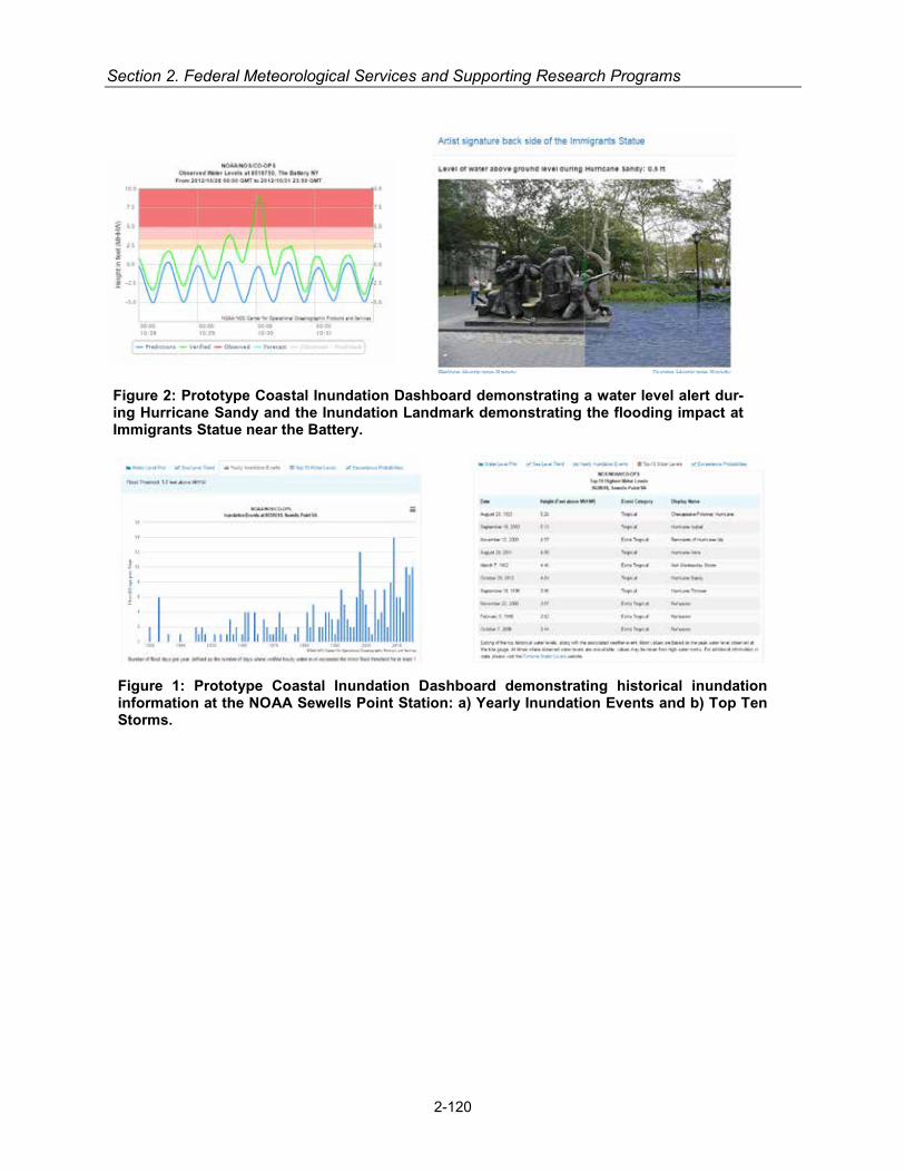
Section 2. Federal Meteorological Services and Supporting Research Programs
Figure 2: Prototype Coastal Inundation Dashboard demonstrating a water level alert dur-ing Hurricane Sandy and the Inundation Landmark demonstrating the flooding impact at Immigrants Statue near the Battery.
Figure 1: Prototype Coastal Inundation Dashboard demonstrating historical inundation information at the NOAA Sewells Point Station: a) Yearly Inundation Events and b) Top Ten Storms.
2-120
Emergency Response and Homeland Security Services
NOAA/Office of Marine and Aviation Operations
Among the NOAA/OMAO airborne observing systems fleet, the King Air (N68RF) and the Twin Otters (4 aircraft) can perform damage assessment flights following natural disasters. They pro-vide georeferenced, high-resolution photographs to the public via the Internet. These photo-graphs are extremely useful to local, county, and state government personnel, as well as to emergency managers and to the public at large, as they go about the business of assessing the damage and the nature and magnitude of the relief effort that will be required in the region as part of the FEMA National Response Framework.
United States Air Force
Air Force weather personnel characterize the weather-related portions of the operating envi-ronment to enable DoD decision-makers to anticipate and exploit the weather for air, ground, space, cyberspace, and intelligence operations. As this applies to ‘Emergency Response and Homeland Security Services,’ the Air Force provides meteorological information, products, and services required to support Air Force, Army, and other military operations in order to support the Nation’s emergency response and homeland security efforts including Defense Support to Civil Authorities such as Hurricane Reconnaissance missions in support of Department of Commerce. Different Air Force organizations support various aspects of the Nation’s homeland security efforts:
• The Air Force produces environmental products used to support both the daily and emer-gency response and homeland security operations of the U.S. Northern Command (US-NORTHCOM) and the North American Aerospace Defense Command (NORAD). The Air Force produces fine-resolution model and forecast products that can be leveraged by the U.S. Army Corps of Engineers and Defense Threat Reduction Agency (DTRA) in its hazard dispersion modeling and related emergency planning and response efforts. The Air Force also produces space weather products used to support both the daily and emergency re-sponse and homeland security operation of USNORTHCOM and NORAD, the Intelligence Community and other classified support.
• The Air Force produces both CONUS and worldwide geospatial representations of current and forecast weather used to support the National Geospatial-Intelligence Agency (NGA) in their homeland security mission.
• The Air Force is able to provide weather support to the Federal Aviation Administration (FAA) during a national emergency in cases when the FAA would fall under jurisdiction of DoD as prescribed under Executive Order 11161. This includes severe weather, aviation hazards, volcanic ash dispersion, and space weather.
• The Air Force Operational Weather Squadrons, who provide regional reach-back services, may support emergency planning and response operations for US interests at home or abroad.
• The Air Force, bilaterally with the U.S. Navy in Hawaii, routinely works with its civil U.S. and international tropical cyclone forecast centers to tailor forecasts and issue warnings to pro-tect DoD assets across the Pacific and Indian Ocean basins.
• The Air Force Reserve Command's "Hurricane Hunters" collect meteorological data in and around tropical cyclones, providing timely and accurate data to the National Hurricane Cen-ter to aid in their analysis, prediction and warning products to help mitigate and protect lives and property impacted by these tropical systems.
2-121

Section 2. Federal Meteorological Services and Supporting Research Programs
• At the local levels, Air Force weather personnel assigned to Air Force and Army installations participate in emergency management response in coordination with local, county, state, federal and non-government organizations.
United States Navy
Humanitarian Assistance and Disaster Response
Figure 3: Launching an Unmanned Underwater Vehicle an part of a Humanitarian Assistance and Disaster Response (HA/DR) operation
2-122
Navy METOC personnel support Humanitarian Assistance and Dis-aster Response (HA/DR) opera-tions aboard U.S. Navy and Coast Guard vessels. Military oceano-graphic survey vessels designated as T-AGS are continuously for-ward deployed and conduct hy-drographic, oceanographic and acoustic surveys in all the oceans of the world. These ships have modern full ocean depth multi-beam and single-beam sonar sys-tems for accurately measuring bot-tom depths and features, towed side-scan sonar systems for acoustic imaging of bottom fea-tures and navigation hazards,
ocean current profilers, sub-bottom profilers for measuring stratification of seabed sediments, and over-the-side devices that collect physical ocean parameters such as temperature and sa-linity with depth. These ships are capable of hosting a number of roll-on/roll-off systems, includ-ing systems for collection of seismic data and unmanned underwater vehicles. The ships are also equipped with C-band communications to send data directly back to the Naval Oceano-graphic Office for immediate processing. Three of the ships are complemented with hydrograph-ic survey vessels — smaller craft for shallow water hydrographic collection. We have been op-erating unmanned underwater vehicles (UUVs) for well over a decade. Their inventory consists of propelled vehicles, such as various models of the Remote Environmental Monitoring Units (REMUS) UUVs for collection of sonar, sub-bottom and optical data in addition to buoyancy controlled, high endurance UUVs, such as the Slocum glider and wave-powered Sensor Hosting Autonomous Remote Craft (SHARC) vehicles, which collect and transmit ocean and atmospher-ic data in real time for satellite transfer back to our operational production centers. Navy uses UUVs for direct support to operation missions. As part of our hydrographic capability, they also employ unique jet-ski variants called Expeditionary Survey Vehicles or ESVs. Outfitted with sin-gle-beam and side-scan sonar, in addition to accurate Global Positioning System navigation, ESVs can be rapidly deployed and conduct hydrographic survey into the surf zone, to places where traditional systems can’t go. This data is extremely useful for supporting expeditionary warfare and enabling missions like humanitarian assistance and disaster response. Weather forecasts and surveys of anchorages and piers provided commanders with the status of port accessibility, ensuring accessibility to the port critical to allowing food, water, medical supplies, materials, and other support to arrive by sea.

Emergency Response and Homeland Security Services
Partnerships and Stability Operations
Partnerships provide access to data sources, insight into emerging science and technology, and help all parties leverage limited budgets by reducing redundancy and pooling capabilities. Naval operational oceanography has a long history of executing cooperative military hydrographic and oceanographic surveys, as well as data, product and subject matter exchanges with internation-al partners. Their ability to provide emerging partners with improved capabilities in the areas of meteorology, oceanography and hydrography is unique and is highly regarded by combatant commanders and naval component commanders as an outstanding tool for strategic engage-ment. In turn, their partners provide access to information vital to forward-deployed naval opera-tions.
Navy METOC also maintains strong interagency partnerships. The integration of modeling ef-forts among the Navy, National Oceanic and Atmospheric Administration (NOAA), and U.S. Air Force, NUOPC provides an unparalleled global modeling capability that can be adapted by indi-vidual agencies for specific applications. Another strong example is their partnership with NOAA and the U.S. Coast Guard in operating the U.S. National/Naval Ice Center, providing ice analy-sis and forecasts to support safety of navigation for public, commercial and DoD use in the Arc-tic, Antarctic, Great Lakes, and all other large bodies of water affected by ice.
Figure 4: Launching a SLOCUM GLIDER from an Auxiliary General Survey (T-AGS) ship
U.S. Marine Corps
Chemical Biological Incident Response Force
The CBIRF METOC Analyst serves to provide essential meteorological and hazardous predic-tion information in support of CBIRF`s real world and training operations coupled with providing daily and weekly weather forecasts and climatological briefs to the corresponding staff to sup-port planning operations and typical battalion operations. Other duties include: research and implement new weather forecasting techniques or tools as well as new plume modeling soft-ware or tools; responsible for coordinating and maintaining liaison with local, state, and federal
2-123
Section 2. Federal Meteorological Services and Supporting Research Programs
agencies such as the Department of Homeland Security, Defense Threat Reduction Agency (DTRA), or Joint Task Force Civil Support (JTF-CS) in order to enable appropriate sharing of information and a combined arms response to Chemical Biological Radiological Nuclear Explo-sive (CBRNE) incidents that may occur within CBIRF`s purview; and work with the Battalion Chemist to develop plume modeling products that are disseminated in response to training or real world CBRNE events.
U.S. Geological Survey
The USGS mission provides for "the classification of the public lands and the examination of the geological structure, mineral resources, and products of the National Domain.” The USGS serves the Nation by providing reliable scientific information to describe and understand the Earth; minimize loss of life and property from natural disasters; manage water, biological, ener-gy, and mineral resources; and enhance and protect our quality of life. Among its broad respon-sibilities and efforts are identification, assessment, and monitoring of potentially hazardous are-as; development of capabilities to predict the time, place, and the severity of hazardous geolog-ic, hydrometeorologic, biologic, and chemical conditions or events; and dissemination of the findings and their implications, including the provision of technical and scientific advice to public officials. The USGS also maintains Bureau-wide efforts intended to educate the public about natural hazards.
The USGS has been delegated the Federal responsibility to provide notification and warnings for earthquakes, volcanoes, and landslides. In addition, USGS data-collection networks provide real-time information needed by other agencies to issue forecasts and warnings related to a va-riety of hazards. For example, the USGS seismic network supports NOAA tsunami warnings; the USGS streamgage network supports NOAA flood forecasts (see Hydrometeorological and Water Resources Services); the USGS geomagnetic observations support solar storm forecasts (see Space Weather Services); USGS biologic monitoring of wildlife diseases enhances as-sessments of potential human pathogens such as the H1NI influenza virus; and USGS geospa-tial and remotely sensed information supports a broad spectrum of disaster-response activities and operations from an “all-hazards” perspective.
The USGS established a secondary reception station for NOAA GOES at the USGS Earth Re-sources Observation and Science (EROS) Center in Sioux Falls, SD. Three new satellite anten-nas and an existing antenna at EROS are used in support of this effort. Three of these antennas support communications with the GOES East and GOES West satellites, along with a hot spare. The remaining antenna is designated for a DOMSAT link, which is used for data dissemination. EROS also receives streamgage data in real time from the GOES satellites and is making these data available to USGS and other stakeholders. The receive station at EROS serves as a back-up to the primary site [station] at Wallops Island, Virginia, which otherwise would represent a single point of failure in this vital data collection and dissemination system.
Beyond network operations, the USGS has the expertise and infrastructure to acquire, assess, disseminate, or preserve information that can be derived from the study of geological, hydrolog-ical, meteorological, chemical, or biological conditions before, during, or after an imminent or declared disaster or emergency. These capabilities can be tapped through mission assign-ments, interagency agreements, or third-party contracts, as provided by law and regulation.
2-124
Emergency Response and Homeland Security Services
Department of Energy
Field Site and National Laboratory Meteorological Services
In support of its national security, scientific research, and environmental stewardship missions, DOE has established and maintained operational meteorology programs at its field sites, na-tional laboratories and offices. It has also managed various atmospheric research projects in support of emergency response and homeland security services among other activities. With respect to these programs, field sites and national laboratories collect quality-assured meteoro-logical data, develop site-specific climatology from these measurements, use these data for var-ious applications, and provide local site weather forecasting.
Emergency response and homeland security services require characterization of atmospheric processes that determine fate and transport of hazardous material releases. Meteorology pro-grams directly contribute to the protection of public health and safety, and the environment, by accurately measuring and characterizing relevant local atmospheric processes to establish real-time and forecasted consequences.
DOE sites benefit from well-managed meteorological program support to 24/7 operations (e.g., work-force safety under severe weather and emergencies) and national defense programs.
Field Site and National Laboratory Operationao Meteorological Support
Operational meteorology programs provide customized meteorological monitoring services and local site weather forecasts for national defense projects, and for nuclear safety and emergency response programs. Each operational program is primarily focused on supporting emergency response, and protecting the safety of workers, public and the environment.
Operational meteorology programs are established at eight national laboratories, Hanford Site, Savannah River Site, Nevada National Security Site, Pantex Plant, Y-12 NSC and Waste Isola-tion Pilot Plant. Some of these programs incorporate 24/7 severe weather watches to reduce risk of potential adverse impacts on facilities, construction projects, property, and workers.
The DOE Meteorological Coordinating Council (DMCC) provides a forum for continuity of mete-orological activities at DOE sites. The DMCC overarching mission is to effectively coordinate meteorological programs at all DOE/NNSA sites to avoid duplication of effort and maximize pro-curement and operational frugality. The participants are engaged in many activities to improve the meteorological programs in DOE/NNSA, as well as improve the DOE interface with atmos-pheric sciences as a whole. Information on this council can be located at https://sp.eota.energy.gov/EM/SitePages/DMCC-Home.aspx.
DMCC FY 2016 Accomplishments:
• Reviewed operational meteorological programs at Oak Ridge National Laboratory, Y-12, and Los Alamos National Laboratory. An Assist Visit is planned for the Savannah River Site in FY 2017;
• Key contributor in revising ANSI/ANS-3.11, “Determining Meteorological Information at Nu-clear Facilities”;
• Published a Technical Report for Calculations of Atmospheric Dispersion at Onsite Loca-tions for DOE Nuclear Facilities;
2-125
Section 2. Federal Meteorological Services and Supporting Research Programs
• Key contributor in revising DOE-HDBK-1216-2015, “Environmental Radiological Effluent Monitoring and Environmental Surveillance”:
• Published a White Paper, “Wind Speed Data Resolution: Observed Effects on MACCS2 At-mospheric Dispersion Modeling Results.”
Nuclear Regulatory Commission
The Nuclear Regulatory Commission (NRC) Office of Nuclear Security and Incident Response coordinates NRC responses to nuclear facility emergencies through the activation of the NRC Operations Center. The Protective Measures Team has a meteorologist on staff to provide, and quality control, meteorology data for dose analysts in the NRC Operations Center. The dose analysts then rely on the Radiological Assessment System for Consequence Analysis (RAS-CAL) model to assess offsite consequences in the event of a radiological accident at an NRC-licensed facility. This model can incorporate real-time meteorological data from a site’s meas-urement station, in addition to real-time data provided through NWS ASOS stations, and can also incorporate forecast data from applicable stations.
SUPPORTING RESEARCH PROGRAMS AND PROJECTS
NOAA/Office of Oceanic and Atmospheric Research (OAR)
Atlantic Oceanographic and Meteorological Laboratory (AOML)
AOML conducts mission oriented scientific research that seeks to understand the physical, chemical, and biological characteristics and processes of the ocean and atmosphere, both sep-arately and as a coupled system. While the focus of the laboratory is on improving understand-ing through research, AOML houses a large component of the global ocean observing system, including Argo profiling floats and surface drifters. AOML also has maintained the long-standing expendable bathythermograph (XBT) program, which has a long-standing collaboration with the National Weather Service and the United States Coast Guard to develop and support the AMVER program. The AMVER program (Automated Mutual-Assistance Vessel Rescue AMVER reports allow the U. S. Coast Guard to track a vessel's position. The AMVER program relies on ships to submit four types of reports: (1) Sail Plans; (2) Position Reports; (3) Arrival Reports and (4) Deviation Reports, when necessary. The U. S. Coast Guard updates their database with the position information from these reports, which allows them to identify vessels in the vicinity of a ship in distress. AOML mains the software and processes all reports.
Air Resources Laboratory (ARL)
NOAA’s Air Resources Laboratory (ARL) develops and improves dispersion and air quality models and collects research-grade atmospheric measurements. Our programs support NOAA, broader US, and some international emergency response programs with an emphasis on chem-ical, nuclear, smoke, dust, and volcanic ash events. Our key NOAA customer is the National Weather Service, and we interact extensively with the National Ocean Service Office of Re-sponse and Restoration. ARL also provides a broad selection of web based assessment tools. ARL’s primary emergency response model platform is the Hybrid Single Particle Lagrangian In-tegrated Trajectory (HYSPLIT) model and has been made operational at NOAA’s National Cen-ters for Environmental Prediction (NCEP). HYSPLIT also serves as the national dispersion fore-casting capability in several other countries. HYSPLIT is the major product employed in the op-erations of the Regional Specialized Meteorology Center (RSMC) set up as a joint undertaking
2-126

Emergency Response and Homeland Security Services
of ARL and NCEP under the auspices of the World Meteorological Organization (WMO). The WMO/RSMC is the source of dispersion products in the event that a radioactive plume crosses international boundaries.
ARL provides meteorological support for the Department of Energy at the Idaho National Labor-atory (INL) in Idaho Falls and at the Nevada National Security Site (NNSS) north of Las Vegas. ARL meteorologists staff the DOE Emergency Operations Center during drills and emergencies, such as accidental toxic chemical releases and wildfires. ARL operates an additional mesonet in East Tennessee that collects ozone and basic meteorological information.
In FY17, ARL will:
• Continue to improve and adapt the HYSPLIT model to address threats imposed from radio-active material, volcanic ash, dust, and wildfire smoke, and other hazardous materials.
• Provide reach-back support to NWS and other organizations that use our models. • Continue to maintain mesonets in Nevada, Idaho, and eastern Tennessee. • Continue to support the Department of Energy at the INL and NNSS.
Great Lakes Environmental Research Laboratory (GLERL)
The Great Lakes Environmental Research Laboratory (GLERL) has developed and continues to upgrade the Great Lakes Coastal Forecasting System (GLCFS). This system produces fore-casts of waves, currents, temperature, ice, and other properties of the five Great Lakes and their connecting channels that are used by commercial ship captains, recreational boaters, fisher-men, beach managers, oil spill responders, and search and rescue personnel. The GLCFS is currently being upgraded from a system based on the Princeton Ocean Model (POM), to a sys-tem based on the Finite Volume Coastal Ocean Model (FVCOM), which allows the model to be executed with variable spatial resolution, among other capabilities..
The NOAA Great Lakes Regional Collaboration Team has also recently completed a technical memorandum that describes the particular roles and responsibilities for different NOAA offices and personnel in the Great Lakes in the event of a natural or human-caused emergency such as a severe winter storm, large wildfire, or oil spill. The team will be assisting other NOAA regions to adapt this approach for use in their areas, with consideration of the particular emergencies that might be anticipated in other regions such as hurricanes or earthquakes.
National Severe Storms Laboratory (NSSL)
In FY17, NSSL will continue collaboration with the NWS on research and development activities to advance our knowledge and understanding of severe convective storms and to provide new and improved tools and techniques for observation, prediction, and analysis of these storms and their associated hazards (tornadoes, damaging wind, flash flooding, etc.). As part of its FACETs paradigm research, NSSL will work with social scientists and emergency responders to bring about a Weather-Ready Nation resilient in the face of increasing vulnerability to severe weather. In FY15 and FY16, FACETs concepts were tested in collaboration with NWS forecasters and emergency managers in the Hazardous Weather Testbed. The work will be further refined and tested in the HWT with NWS forecasters, emergency managers and broadcast meteorologists in FY17 and FY18. This effort is also closely linked to the NWS Hazard Simplification project, with NSSL and NWS collaborating on the development and testing of new emergency messag-ing for hazards such as tornadoes.
2-127
Section 2. Federal Meteorological Services and Supporting Research Programs
Earth System Research Laboratory/ (ESRL)
The Earth System Research Laboratory (ESRL) partners with NWS on research and develop-ment that provide early warning forecasts and information to support emergency responses. The ESRL Global Systems Division (GSD) has collaborated with NWS in the development of fire weather prediction tools such as the FX-Net workstation, which provides weather data to Incident Meteorologists (IMETs) during wildfires. The FX-net is used to brief fire behavior ana-lysts and fire Incident Commanders onsite. GSD has also been running an experimental, West-ern US weather model, the High Resolution Rapid Refresh (HRRR)/Chem/ Smoke at 3-km reso-lution during wildfire season, which supports of smoke and fire management operations and provides critical situational awareness for the movement of fire fighters and emergency evacua-tion planning and execution.
The ESRL Physical Sciences Division (PSD) has been working with NWS local forecast offices and river forecast office on improved monitoring, nowcasting and forecasting of west coast win-ter time extreme precipitation events resulting from Atmospheric Rivers (ARs) - relatively narrow regions of enhanced atmosphere water-vapor transport that result in heavy precipitation and flooding. PSD has developed in situ and satellite monitoring and analysis tools to provide for the early detection of ARs and capabilities to better predict AR behavior that can stall over water-sheds resulting in flooding that can disrupt travel, induce mud slides, and cause catastrophic damage to life and property. In partnership with state and federal agencies, PSD has deployed a “picket fence of atmospheric river observatories (AROs) along the west coast of the US that provide critical information on the transport of moisture from the Pacific Ocean as nowcasts to anticipate flood risk and to assess the skill of weather model forecast in realtime. Complement-ing the ARO, snow-level radars have been installed in select mountainous basins along the West Coast that can be used to determine the surface area throughout the watershed that pre-cipitation is falling as snow versus rain and the risk for rain on snow events or flooding. Decision support tools continue to be developed to integrate the new information provided by the obser-vations and weather models into flood forecasts for risk management.
For the first time, Global Systems Division (GSD) researchers provided a new experimental Hazard Services platform in the NOAA Hazardous Weather Testbed (HWT) during May, 2016 as part of the Forecasting a Continuum of Environmental Threats (FACETs) effort. Forecasters worked with information about how ongoing threats will evolve over time and the probabilities that the threat will happen. This work will continue through FY17 and FY18. The software is tar-geted to transition to operations in FY18.
GSD is also demonstrating an early prototype of a high-impact weather forecast system in the NOAA Hazardous Weather Testbed. This “Warn-On-Forecast” using a new High-Resolution Rapid Refresh-Ensemble system that will ultimately produce forecasts that define the probability of a weather hazard occurring, quantify the confidence in its path, and adjust to trends in that threat level based on new observations. This work combines the best technologies from GSD and NSSL.
Department of Energy
The Department of Energy (DOE) Meteorological Coordinating Council (DMCC) was estab-lished in 1994 to coordinate meteorological activities among the field offices to enhance cost effectiveness and productivity and to leverage synergistic opportunities. DOE has delegated the operation of its site/facility meteorological programs to NOAA and to non-Federal for-profit man-agement and operating contractors. The DMCC membership is therefore composed of subject-
2-128

Emergency Response and Homeland Security Services
matter experts from within the DOE complex, representing the three components with opera-tional responsibilities for the following programs:
• Department of Commerce (DOC/NOAA) under interagency agreements • Management and operating (M&O) contractors • Private contractors
The DMCC operates as a subcommittee of the DOE Emergency Management Issues Special Interest Group (EMI SIG) and has a web page that can be accessed directly or through the Subcommittees and Working Groups tab of the EMI-SIG website. DMCC also issues an annual report as part of its presentation to the EMI SIG Steering Committee.
A current DMCC project is to improve the provision of quality-assured meteorological infor-mation and execution of transport and dispersion models that meet software quality assurance requirements. Products of the DMCC include evaluations of meteorological requirements con-tained in DOE orders and guidance documents, site meteorological program peer reviews (i.e., meteorological program assist visits), and, as needed, customized technical assistance. The DMCC has developed tools to enable DOE/NNSA sites to perform self-assessments of their in-dividual meteorological monitoring programs and the meteorological aspects of consequence assessment.
Nuclear Regulatory Commission
The Office of Nuclear Regulatory Research (RES) plans, recommends, and implements a pro-gram of nuclear regulatory research for nuclear power plants and other facilities regulated by the Nuclear Regulatory Commission (NRC). RES provides technical support, tools, and infor-mation to identify and resolve safety issues for current and new designs and technologies through testing, data development, analysis, and national and international collaboration. RES also develops regulatory guidance and participates in the development of criteria and consen-sus standards related to the protection of the public health and safety and the environment.
For FY17, staff in the RES is planning to improve the RASCAL computer code to include up-to-date models and provide technical support for the dispersion, deposition, and dose calculation models; for the meteorological data processor; and for the automatic meteorological download program. These updates will help to improve the decision-making process regarding off-site emergency actions.
In addition, the NRC staff in RES is planning to begin a project in the coming fiscal year that in-volves the integration of NOAA’s HYSPLIT model into the MACCS (MELCOR Accident Conse-quence Code System) consequence analysis code, one of NRC’s codes for predicting off-site consequences in probabilistic risk analyses. The HYSPLIT model was selected for integration with MACCS because it offers both puff and particle dispersion models, accepts a variety of publically available meteorological data, and offers updated graphical capabilities. These mod-els would also be able to assist with the more complex simulation situations that include com-plex terrain or long-distance transport.
2-129

Section 2. Federal Meteorological Services and Supporting Research Programs
2-130

HYDROMETEOROLOGY AND WATER RESOURCES SERVICES
For purposes of this Federal Plan, Hydrometeorology and Water Resources Services are those specialized meteorological services and facilities that combine atmospheric science, hydrology, and water resources in order to meet the requirements of Federal, state, and local agencies for information on the effects of precipitation events on infrastructure, water sup-plies, and waterways. These products and services also meet the needs of the general pub-lic in the conduct of everyday activities and for the protection of lives and property.
2-131
OPERATIONAL PROGRAMS INCLUDING PRODUCTS AND SERVICES
Interagency Collaborative Programs and Products
Integrated Water Resources Science and Services (IWRSS)
IWRSS is a business model for interagency collaboration. IWRSS brings a consortium of United States federal agencies with complementary water resources missions together to share re-sources to help address the Nation's water resources issues. These water resources challenges include: a) population growth and economic development are stressing water supplies and in-creasing vulnerability; b) a changing climate is impacting water availability and quality and in-creasing uncertainty; and, c) an aging water infrastructure is forcing critical, expensive deci-sions. The collective capabilities of Federal water agencies need to be leveraged to inform and guide increasingly important water decisions.
Initiated through an Interagency Memorandum of Understanding (MOU), IWRSS's overarching objective is to enable and demonstrate a broad, interactive national water resources information system to serve as a reliable and authoritative means for adaptive water related planning, pre-paredness and response activities. The goals are to:
• integrate information delivery and simplify access to this data, • increase accuracy and timeliness of water information, and • provide summit-to-the-sea, treetop-to-bedrock, high resolution water resources information
and forecasts for droughts to floods.
Currently the collaboration is with four United States federal agencies: USGS, NOAA, USACE, and FEMA. Other federal agencies are expected to join the consortium in the near future.
NOAA/National Weather Service
National Oceanic and Atmospheric Administration’s (NOAA) National Weather Service (NWS)has the primary responsibility among Federal agencies to provide advanced alerts of hy-drologic conditions via flood warnings and river forecasts in the United States. The provision of these water prediction and warning services are significantly influenced by anthropogenic activi-
Section 2. Federal Meteorological Services and Supporting Research Programs
ties associated with water management and water use (e.g., reservoir regulation, diversions, and withdrawals). In order to provide these important services, collaboration with other federal agencies is crucial as 24 Federal agencies have a role in water. The end-to-end forecast pro-cess employed by the NWS to provide hydrologic and water resources forecast and warning services leverages data and information from Federal partners and involves the following:
• Meteorological and hydrological observations and anthropogenic data; • Data collection, management and processing; • Science and technology infusion; • River and water quantity forecasting; • Inundation mapping; • Dissemination systems; • Performance measurement; and • Outreach and education.
NWS relies on routine access to water data and observations from other Federal agencies to produce and provide water forecasts and warnings. These Federal agencies and their respec-tive roles include the:
• Department of Interior (DOI)
U.S. Geological Survey (USGS) - real-time and historical streamflow observations, stream/river cross-sections, rating curves (relating streamflow to river stage), topograph-ic data (for inundation mapping)
U.S. Bureau of Reclamation (USBOR) – water use/regulation data
• U.S. Army Corps of Engineers (USACE) – water use/regulation data, real-time streamflow observations, and hydraulic models
• U.S. Department of Agriculture (USDA) – snow observations • Department of Energy (DOE) – water use/regulation data
The NWS hydrology and water resources program also leverages and expands NOAA science and service partnerships for the atmosphere, watersheds, estuaries, and oceans. Partnerships with the National Science Foundation, the Consortium of Universities for the Advancement of Hydrologic Science Inc. (CUAHSI), other universities, the private sector, and the international community are leveraged to improve and integrate modeling capabilities.
An NWS field infrastructure which includes 122 Weather Forecast Offices (WFO), 13 River Forecast Centers (RFC), the National Water Center (NWC), and the National Centers for Envi-ronmental Prediction’s (NCEP) Weather Prediction Center (WPC) and Climate Prediction Cen-ter (CPC) work as a team to provide hydrologic forecast and warning services from floods to droughts to minimize the loss of life and property and to meet the growing water resources ser-vice needs of our Nation. NWS hydrologic products and services support decision makers across a wide range of service sectors including emergency management, agriculture, hydro-power, reservoir management, watershed management, river commerce, municipal and indus-trial water supply, and recreation.
NWS Weather Forecast Offices (WFOs) assess and monitor the threat of flash and river flood-ing 24 hours a day 7 days a week to provide timely and accurate life-saving flood watches and warnings. Toward this end, WFOs integrate a spectrum of RFC, NCEP and NWC guidance, Doppler weather radar (NEXRAD)-based precipitation estimates, and real-time telemetered pre-cipitation and stream gauge observations, to provide routine river forecast services and critical,
2-132
Hydrometeorology and Water Resources Services
event-based decision support services. In addition, WFOs work with dam operators and the emergency management community to provide timely warnings for floods that result from infra-structure failure such as dam break and levee breaches. Moreover, WFOs routinely conduct lo-cal outreach and education to heighten public and partner awareness of flood risks and NWS hydrologic services.
NWS River Forecast Centers (RFCs) routinely generate short range (deterministic) through ex-tended range (probabilistic) river forecasts and (deterministic) flash flood guidance. Information from the RFCs serves as the basis for local flood and flash flood warnings, watches, and advi-sories issued by the WFOs. These RFC products typically incorporate guidance from WPC, CPC, NWC and the WFOs, and emphasize flooding impacts from meteorological events based on geographic area, land use, time of the year, and other factors. In order to provide objective simulations of future river flows, RFCs calibrate, operate, and verify sophisticated hydrologic models based on rainfall, soil characteristics, quantitative precipitation forecasts (QPFs), reser-voir regulations, and several other variables. Some RFCs, especially those in mountainous re-gions, also provide water-supply volume and peak-flow forecasts based on snow pack in high elevations. These water supply forecasts are used by a wide range of decision makers, includ-ing those in agriculture, hydroelectric dam operation and electricity generation, and water re-sources management. RFCs routinely coordinate with their associated WFOs, Federal water partners, stakeholders, NWC and the WPC.
A new element of the NWS water resources program infrastructure, the National Water Center (NWC) was completed in early 2014 on the campus of the University of Alabama in Tuscaloosa, AL. The NWC will enable NOAA, in partnership with other federal agencies, to deliver a new generation of water information and services to the Nation. NWC currently provides comprehen-sive snow observations, analyses, data sets and map products. NWC products and services are used by RFCs and WFOs to develop a variety of water resources products such as spring flood outlooks, water supply outlooks, river and flood forecasts, and reservoir inflow forecasts. Addi-tionally, the NWC provides and supports geographic information system (GIS) data sets and applications used by the RFCs in generating automated hydrologic forecast basin boundaries. NWC products and services also support a wide variety of government and private-sector appli-cations in water resource management, disaster emergency preparedness, weather and flood forecasting, agriculture, transportation and commerce. Planned for July 2016, the NWC will de-liver the National Water Model (NWM) (http://water.noaa.gov/about/nwm). The NWM is a high spatial and temporal resolution, continental-scale model of the Nation’s river and stream net-work. The underpinning technology for the NWM is a community-based, Earth System Modeling Framework (ESMF)-compliant, modeling framework. The NWM will augment and expand NO-AA’s current water quantity forecasts, delivered for approximately 4000 river locations with stream gages, primarily operated by the USGS, across the country, to streamflow forecasts for 2.7 million streams nationwide, and high-resolution gridded forecasts of soil moisture, evapo-transpiration, runoff, and other parameters. Future services, enabled by the NWM, will strength-en the Nation’s water forecast capabilities for floods and droughts, improve preparedness for water related disasters, and inform high-value water decisions at the local, state and national levels.
Personnel at the NCEP’s WPC (http://www.wpc.ncep.noaa.gov), located in College Park, Mary-land, routinely prepare a spectrum of analyses and forecast products spanning the period out to 7 days. The product suite is focused on heavy rainfall and heavy snowfall, and is used by the WFOs to develop local rainfall, snow, and ice forecasts. RFCs use the products to develop local river and flood forecasts. WPC collaborates with RFCs, WFOs and other Federal agencies, such as FEMA, during major flood and snowstorm events. In addition to the heavy precipitation focus, the WPC also provides an array of surface analyses and short-range forecast products,
2-133

Section 2. Federal Meteorological Services and Supporting Research Programs
and medium-range forecast products used by NWS field offices and the weather enterprise to enable readiness for high-impact weather.
NCEP’s CPC monitors and forecasts short-term climate fluctuations and generates guidance to communicate the effects climate patterns can have on the Nation. CPC develops and produces a suite of climate prediction and monitoring products, assessments, and discussions. These forecast products include 6-10 day, 8-14 day, one-month, and three month outlooks which de-pict the probability the temperature and precipitation will be above or below normal. CPC also routinely produces a U.S. Hazards Outlook, a U.S. Monthly Drought Outlook, a U.S. Seasonal Drought Outlook. CPC also partners with the USDA and the National Drought Mitigation Center to produce the U.S. Drought Monitor. These products are used by WFOs and RFCs to enhance decision support services and serve as an input to RFC-generated, ensemble-based, extended range (probabilistic) river forecasts.
The Community Hydrologic Prediction System (CHPS; http://www.nws.noaa.gov/oh/hrl/chps/index.html) is an operational framework that allows for broad systems interoperability at the 13 NWS RFCs, and supports new water resources-related forecasts. It reinforces NOAA’s national water information strategy, allowing NOAA’s research and development enterprise and operational service delivery infrastructure to be integrated and leveraged with other Federal water agency activities and the private sector. Through CHPS, and under the auspices of the IWRSS Consortium, NOAA plans to deliver a new suite of high-resolution forecasts (including estimates of uncertainty) for streamflow, soil moisture, soil tem-perature, and many other variables directly related to watershed conditions via collaboration and sharing of data and models with other Federal, university, and private-sector experts. Further-more, these activities will enable NOAA to deliver a national database of hydrologic analyses and predictions and generate user-friendly geographic information system (GIS) products for monitoring floods and drought. This activity contributes to the National Integrated Drought In-formation System (NIDIS).
Advanced Hydrologic Prediction Service (AHPS)
The overarching goals of AHPS are to provide: a) better forecast accuracy by incorporating ad-vanced hydrologic science into NWS models; b) more specific and timely information on fast-rising floods by using tools which make it easier to rapidly identify small basins affected by heavy rainfall and excessive runoff, and predict the extent and timing of the resulting inundation; c) new types of forecast information by incorporating enhanced techniques for quantifying fore-cast certainty and conveying this information in products which specify the probability of reach-ing various water levels; d) longer forecast horizons; e) easier-to-use products; and f) increased, more timely, and consistent access to hydrologic information. AHPS includes a suite of web-based products and information designed to support more informed decisions through timely and accurate hydrologic forecasts and warnings.
The NWS continues to implement AHPS which builds on the existing NWS infrastructure, in-cluding the Advanced Weather Information Processing System (AWIPS), NEXRAD, and CHPS. AHPS also provides Ensemble Streamflow Prediction (ESP) - a capability that allows the NWS to generate extended range (probabilistic) river forecasts which quantify the forecast certainty. This information enables decision makers to apply risk-based analyses as they prepare for, and respond to, flooding and better balance competing demands on water supply, especially during periods of drought. The ESP capability is being expanded to include new techniques to facilitate the comprehensive generation of probabilistic hydrologic information seamlessly from short- to long- forecast horizons within CHPS. This enhanced capability is referred to as the Hydrologic
2-134

Hydrometeorology and Water Resources Services
Ensemble Forecast Service (HEFS) and is being implemented at select river forecast locations across the country.
Another AHPS capability, known as Flash Flood Monitoring and Prediction (FFMP), combines high-resolution radar rainfall observations with GIS technology to provide more accurate and precise flash flood detection. Flash floods, typically caused by intense, small-scale convective systems, are the leading cause of flood fatalities. The added precision provided by FFMP great-ly reduces the area warned in flash flood warnings, making them more credible and leading to more effective and efficient public response, which ultimately saves lives. AHPS also provides opportunities to improve NOAA’s analysis and forecast capabilities related to coastal water con-ditions, through joint efforts with NOAA’s National Ocean Service (NOS) and Office of Oceanic and Atmospheric Research (OAR).
Integrated Water Resources Science and Services (IWRSS).
See Interagency Collaborative Programs and Products at the beginning of this section.
NWS Partnerships for Hydrometeorological Products and Services
Partnerships with a variety of Federal, state, and local agencies are critical to the NWS Hydro-logic Services Program. For example, the NWS works very closely on water-related issues with many federal water agencies including: the USGS, the Bureau of Reclamation, and the Bureau of Land Management in the Department of the Interior; with the USACE in the Department of Defense; the Department of Agriculture’s Natural Resources Conservation Service (NRCS); and FEMA in the Department of Homeland Security (DHS). Among these partnering activities are stream gaging, flood inundation mapping, river and water supply forecasting, and water man-agement. For example, river stage and flow observations and stage discharge relationships provided by the USGS and reservoir operation information provided by the USACE, are critical to NWS warning and forecast operations for the Nation’s rivers.
NOAA/Office of Marine and Aviation Operations (OMAO)
Within the NOAA/Office of Marine and Aviation Operations (OMAO) aircraft fleet, the AC-695A Commander 1000 (N45RF) and a DHC-6 Twin Otter (N46RF or N48RF) are used annually to conduct important snow-pack surveys (see http://www.nohrsc.noaa.gov/snowsurvey/) and soil moisture measurements throughout the U.S. During these survey flights, the gamma radiation sensors aboard these aircraft measure the naturally occurring terrestrial radiation emitted from the ground to obtain snow-water and soil moisture equivalent estimates. The data are transmit-ted to the National Operational Hydrologic Remote Sensing Center (NOHRSC; http://www.nohrsc.nws.gov/) up to three times a day, and, after further processing, the data are distributed to NWS field offices within five minutes of receipt from the aircraft. These data are used by the NWS to forecast river levels and potential flood events, resulting from snowmelt wa-ter runoff. Hydroelectric power interests and other water supply managers also use the data to regulate water storage and delivery.
U.S. Department of Agriculture
NRCS Hydrometeorological Observations
Snowmelt provides the majority of the annual water supply in the Western United States; there-fore, having information on snowpack is critical for water supply forecasts and management.
2-135
Section 2. Federal Meteorological Services and Supporting Research Programs
The Natural Resources Conservation Service (NRCS) measures snowpack and collects hydro-meteorological data in 13 Western States, including Alaska. NRCS’ Snow Survey and Water Supply Forecasting (SSWSF) Program conducts snow surveys at high elevations in the moun-tainous West. The data collection system includes approximately 1,112 active manual snow courses in the United States and Canada (Canada operates their own data collection, but shares data with US), and more than 878 automated Snow Telemetry (SNOTEL) and aerial markers (SNOLITE) monitoring stations. The NRCS collects data at the manual snow courses in cooperation with a number of different Federal, State, local, and private partners, as well as Ca-nadian agencies. The SNOTEL and manual snow course data, along with data from stream-gages, major reservoirs, and climatological observation stations managed by other agencies, are merged into a hydroclimatic database that is used to produce real-time watershed analyses and water supply forecasts. The purpose of water supply forecasts are to: (1) help irrigators make the most effective use of limited water supplies for agricultural production needs; (2) as-sist the Federal government in administering international water treaties with Canada and Mexi-co; (3) assist State governments in managing intrastate streams and interstate water compacts; (4) assist municipalities in planning the early management of anticipated water supplies and drought mitigation; (5) operate reservoirs to satisfy multiple use demands, including hydropower generation; (6) mitigate flood damages in levied areas and downstream from reservoirs; and (7) support fish and wildlife management activities associated with species protection legislation.
The automated SNOTEL and SNOLITE network transmits data from remote sites and is served on the web by the National Water and Climate Center in Portland, Oregon. The SNOTEL and SNOLITE network provides near-real-time remote hydrometeorological data that significantly improve flood stage forecasts and the monitoring of other life-threatening snow-related events. The primary use of the snow survey data is the production of water supply forecasts for more than 641 Western basins. All SNOTEL and SNOLITE data are provided hourly on the web and utilized by groups such as the National Weather Service (NWS) to assist in forecasting flood events. SNOTEL and SNOLITE information enables emergency management agencies to effec-tively mitigate drought and flood damages and to monitor and assess wildfire potential.
Water supply forecasts are produced bi-monthly each year from January through June, as well as mid-month forecasts and daily guidance for some basins beginning in December. The NRCS furnishes snow measurements that are combined with advanced snow modeling and analysis provided by the National Oceanic & Atmospheric Administration (NOAA). NOAA’s National Op-erational Hydrologic Remote Sensing Center continues to support joint NWS-NRCS efforts. The NRCS typically develops nearly 12,000 seasonal water supply forecasts for 641 streamflow forecast locations in 13 Western States. In addition, the Program provides daily water supply guidance forecasts for 331 of the 641 Western basins. These products provide information for water managers to adapt to weather changes as they occur. The web link for this information is http://www.wcc.nrcs.usda.gov/wsf/daily_forecasts.html.
Historical snow survey data are valuable to climate change researchers to aid in developing re-liable projections of climate change. It has been projected that changes to the hydrologic cycle in the Western States, resulting from changes in snowpack conditions and timing of snowmelt, will increase the water supply challenges the States face. Monitoring data provides assistance to water managers at all levels to adapt to the impacts of climate change. Snowpack measure-ments extend back decades, and in some cases over 100 years, highlighting the value of this high-altitude network for understanding and assessing changes in climate.
The SSWSF Program provides a variety of climate and water supply products that are used to assess drought in the West. These include SNOTEL snowpack and precipitation analyses in the mountains, water supply forecasts, and State Surface Water Supply Indexes (SWSI). These
2-136

Hydrometeorology and Water Resources Services
products are critical to the weekly production of the interagency Drought Monitor, a web-based report. Separate from the SSWSF Program, the NRCS also manages a cooperative nationwide network of 220 Soil Climate Analysis Network (SCAN) sites in 40 States, as well as Puerto Rico and the U.S. Virgin Islands. These SCAN sites monitor soil temperature and soil moisture, which support national drought monitoring, agriculture production, and climate change research. Presently, more than 430 SNOTEL stations also have soil moisture and soil temperature sen-sors.
U.S Army Corps of Engineers
In its civil operational activities, the Corps of Engineers (COE) uses a network of about 10,850 land-based gages. About 55 percent of these sites collect meteorological data, 35 percent col-lect a combination of hydrologic and meteorological data, and 10 percent collect hydrologic or water quality data. The meteorological gages commonly measure precipitation and temperature. All data are used in the regulation of COE dams and other water projects, for flood control, nav-igation, hydroelectric power, irrigation, water supply, water quality, and recreation. The COE funds or partially funds nearly half of all the gages it uses.
The COE funds NOAA/National Weather Service (NWS) to collect and maintain precipitation information from 876 meteorological sites. The COE funds the NWS for hydro-meteorological studies and funds the U.S. Geological Survey (USGS) for maintaining hydro-meteorological da-ta collection services for 2479 sites. The rest of the sites are maintained by the COE. Services performed by USGS vary by site and by year, and can include site visits, maintenance of equipment, replacement of damaged equipment, field measurements for verification of data and continuous monitoring of data results. About 90 percent of all COE sites provide real-time data via satellite, microwaves, meterbursts, landlines, or radio. Data from COE gage sites are availa-ble to NWS, and to other federal, state and local agencies.
U.S. Geological Survey
Hydrometeorological Data Collection and Distribution
The USGS’s Water Mission Area (WMA) collects streamflow, precipitation, water quality, ground-water level, and other water resources and clima-tological data as part of a national network and for a number of projects concerning rainfall-runoff, water quality, and hydrologic processes. Currently, the USGS collects continuous hydro-logic and meteorological data at about 9,000 sur-face water sites, 2,700 ground water-level sites, and 1,500 water quality sites. Periodic records are collected at approximately 1,500 additional surface water sites, 20,000 ground water sites, and 10,300 water quality sites. Precipitation rec-ords are collected at about 800 sites.
Near-real-time streamflow data and ancillary in-formation are provided to NWS RFCs for river forecast locations and to general public for all USGS streamgages via USGS NWIS website
Figure 1: The USGS has developed new rapidly de-ploy-able, mobile streamgages to provide short-term water-level data to critical areas lacking permanent streamgages. Image provided by USGS Office of Sur-face Water.
2-137

Section 2. Federal Meteorological Services and Supporting Research Programs
(http://waterdata.usgs.gov/nwis/). Additional historical and real-time water resources data also are available. During floods, these data are supplemented by additional flood flow measure-ments.
The USGS also collects precipitation samples at a number of sites to determine the atmospheric contribution of chemical constituent loads to runoff, and for defining the effect of atmospheric deposition on water quality and the aquatic environment.
Nuclear Regulatory Commission
At the Nuclear Regulatory Commission (NRC), work continues regarding the evaluation of ex-ternal hazard impacts on nuclear power plant licensees, which includes considering the effects from large precipitation events, snow pack and subsequent snow load, ice impacts, and other meteorological events that may potentially drive flooding hazards, such as storm surge. This work is in response to the accident that occurred at the Fukushima Dai-ichi nuclear power plant as a result of the Great Tohōku Earthquake and subsequent tsunami that occurred on March 11, 2011. Letters were issued to operating nuclear power plant licensees in order to request that they reevaluate all flooding hazards at their sites. The reevaluations were to be completed using updated information and present-day regulatory guidance and methodologies. The NRC staff, along with support from its consultants, continues to review these flood hazard reevaluations and the supplementary site-specific probable maximum precipitation analyses that have been submitted by licensees.
SUPPORTING RESEARCH PROGRAMS AND PROJECTS
NOAA/Office of Oceanic and Atmospheric Research (OAR)
Hydrometeorology Testbed (HMT)
The HMT conducts development and demonstration activities on precipitation and extreme weather conditions that can lead to both flooding and drought, and fosters and accelerates tran-sition of scientific advances and new tools into forecasting operations. Projects supported under HMT include those with middle to high Readiness Levels (RLs) that need support to transition them into NOAA operations. HMT's outputs support efforts to balance water resource demands and flood control in a changing climate. The HMT is a national program aimed at accelerating the infusion of new technologies, models, and scientific results from the research community into daily forecasting operations of the NWS at both the national (NCEP Weather Prediction Center and National Water Center) and regional (regional forecast centers and local forecast offices) levels. Activities at the HMT, which operates as an end-to-end demonstration project with forecasters and researchers joining forces in the operational setting, has focused on im-proving regional forecasts of extreme precipitation, both too much and too little. This is achieved by a combination of: a) unique observations designed to monitor precipitation, kinematic, and surface processes; b) transition research aimed at improved understanding of physical process-es leading to extreme precipitation; and c) operational forecast experiments to test new tools, methods, and models. HMT partners with organizations across NOAA, including NESDIS, OAR, NWS, NMFS, and NOS as well as regional academic and State authorities.
HMT is managed by OAR/ESRL’s Physical Sciences Division (PSD) in coordination with NWS’s Weather Prediction Center. The Office of Weather and Air Quality (OWAQ) is an executive sponsor and funds many of the HMT projects through the U.S. Weather Research Program
2-138

Hydrometeorology and Water Resources Services
(USWRP). Currently OWAQ is supporting five HMT projects that began in September 2015 and will continue for two years. OWAQ will coordinate a new external competition in FY16 for new projects that will start in FY17. Transition plans will be developed to describe the tasks and time table for transition of the current projects into an operational implementation in the NWS.
In FY17, ESRL/PSD will continue to operate and maintain major West Coast observing net-works that are sponsored by the California Department of Water Resources (CA-DWR) and the U.S. Dept. of Energy through the Pacific Northwest National Laboratory. In California, there are four primary types of observing networks that are each designed to help forecasters and other end users monitor storm-scale and climate change impacts. In Oregon and Washington, the primary purpose of the observing networks is to aid with wind energy forecasting. ESRL/PSD and HMT are also leading several projects in the California Russian River watershed as part of the NOAA Habitat Blueprint, aimed at sustaining healthy ecosystems. NSSL and HMT are con-ducting the HMT-Hydro testbed experiment in July of 2016 and 2017 in order to evaluate the latest developments in flash flood prediction tools and display software. ESRL/PSD will continue to implement an AWIPS-II development capability in FY17 to help foster the transition of HMT research products and data displays into operations. PSD and the NWS National Centers for Environmental Prediction (NCEP) Weather Prediction Center (WPC) are partnering to focus on improved predictions and forecasts of hydrometeorological fluxes for use as forcings for hydro-logic predictions by NOAA’s National Water Center.
Earth System Research Laboratory
Global Systems Division (GSD) works to streamline the process of issuing life-saving river flood, flash flood, and areal flood watches, warnings, and advisories. Experimental Hazard Services is a joint project between GSD, the NWS, and Raytheon. In the 2016 HWT-Hydro Experiment, re-searchers explored the utility of experimental watch and warning products conveying uncertainty and magnitude issued through the Hazard Services software. This allows research scientists to investigate human factors to determine operationally relevant best practices for the warning de-cision making process and the system usability of the Hazard Services platform. This evalua-tion will also take place in the summer of 2017. In 2018, the software will reach a level a maturi-ty for transition to operations.
Great Lakes Environmental Research Laboratory (GLERL)
GLERL conducts research and modeling to advance understanding of the hydrometeorological and hydrologic system of the Great Lakes basin. The Great Lakes is unique among hydrologic catchments worldwide in having about one-third of its area covered by fresh water, thus afford-ing water a stronger second chance to evaporate while within a water body in addition to evapo-transpiration from the land areas. Economic sectors such as fishing, shipping, and recreation are linked to the lake levels and water quality of the Great Lakes. A major product from GLERL is the Advanced Hydrologic Prediction System (AHPS, different from the NWS product of the same name) that provides probabilistic outlooks on a seasonal time scale, based on the Climate Prediction Center's meteorological outlooks (and corresponding Canadian products), for lake levels, precipitation, river flow, and other variables. GLERL also has the Great Lakes Hydrome-teorological Dashboard, a web-based system for displaying a wide variety of observational and model-generated data for lake levels, precipitation, ice cover, evaporation, and other variables. GLERL's hydrologic activities are coordinated with cooperating groups in both the operational and research realm through the Coordinating Committee on Great Lakes Basic Hydraulic and Hydrologic Data (CCGLBHHD, or "The Coordinating Committee"), including other US Govern-ment entities (US Geological Survey, US Army Corps of Engineers, EPA, and NOAA National
2-139

Section 2. Federal Meteorological Services and Supporting Research Programs
Ocean Service) and the Canadian Government (Environment Canada). Because of its level of expertise, GLERL is leading the development of the Great Lakes portion of the new National Water Model.
National Severe Storms Laboratory (NSSL)
Storm-scale Hydrometeorology Research.
NSSL is working with the NWS to bring enhanced weather information and capabilities to opera-tions. After more than a decade of development, testing and experimental evaluation, NSSL, in collaboration with the National Center for Environmental Prediction (NCEP), has delivered an operational Multi-Radar/Multi-Sensor (MRMS) system for use in NWS operations. MRMS assim-ilates and “cleans up” data from a wide variety of sources including radar networks, satellites, and surface observations to provide forecasters and hydrologists with the best-possible real-time analysis of the hazardous weather. The MRMS has facilitated considerable improvement in radar-based rainfall estimates and provides forecasters and hydrologists with an ability to “mine” the data set to extract new types of aviation, severe and hydrologic weather information. By placing high-quality, remotely-sensed data in a three-dimensional framework accessible to NWS forecasters, MRMS has opened the door to exciting new possibilities in improving flash flood and severe weather warnings, as well as short term forecasts.
The MRMS suite of quantitative precipitation estimates (QPEs) incorporates information from operational and research weather surveillance radars (e.g., NOAA/NWS WSR-88Ds, FAA Ter-minal Doppler Weather Radars, deployable “gap-filling radars, Canadian operational network radars, etc), GOES satellite data, lightning flash detections, rain gauge accumulations, surface and upper air observations, and numerical model outputs to produce CONUS wide gridded pre-cipitation estimates. These precipitation products, with their different levels of complexity, each have strengths and weaknesses that vary with season, geography, and precipitation type. The MRMS QPE initial operating capability is unique in the way that it uses dual polarization radar moments to improve the quality of the precipitation maps, automatically identifies the precipita-tion type at each grid point, applies differential Z-R relationships, corrects for the vertical profile of reflectivity, merges radar-based estimates with rain gauges, and estimates surface precipita-tion type. The proven accuracy and unprecedented high-resolution of the MRMS QPEs enables them to be used as forcing to a state-of-the-science flash flood prediction system. The MRMS QPE continues to improve by utilizing new dual-polarization radar techniques such as specific attenuation that is immune to radar calibration errors and to beam blockages. Further, the MRMS products are expanding in spatial coverage with the integration of new satellite observa-tions (GOES-R, GPM) of increased spatiotemporal resolutions.
The Flooded Locations And Simulated Hydrographs (FLASH) project takes advantage of the MRMS QPEs that capture rainfall at flash flood scale. The rainfall estimates are used to produce a suite of flash flooding products including the ratio of QPE-to-flash flood guidance, rainfall av-erage recurrence interval, and streamflow forecasts from the Ensemble Framework for Flash Flood Forecasting (EF5). EF5 yields forecasts of flash flooding using two different water balance configurations out to 6 hours in the future at every grid point in the conterminous US. FLASH is presently running in real-time and will be transferred to NWS operations using the MRMS re-search-to-operations conduit. FLASH outputs have been evaluated by forecasters during the Flash Flooding and Intense Rainfall (FFaIR) testbed experiment at the Weather Prediction Cen-ter in 2013, the Hazardous Weather Testbed-Hydro experiment in 2014 the Hydrometeorologi-cal Testbed-Hydro experiment in 2015 and 2016. EF5 outputs have been produced for a 10-year reanalysis period using MRMS forcing to and subsequently evaluated using USGS stream
2-140

Hydrometeorology and Water Resources Services
gauges and show excellent skill in simulating peakflow magnitudes and timing of peakflow in gauged basins. A manuscript summarizing these results has been recently accepted for publica-tion in the Bulletin of the American Meteorological Society. Given that the model parameters are based on observable features of the land surface, the same performance is to be expected in ungauged regions. The FLASH system offers an accurate, consistent, nation-wide solution for flash flood forecasting by the National Weather Service.
The Storm Surge Roadmap (SSR) provides a framework for a comprehensive NOAA strategy to holistically address the development of new technology, products and services to meet mission needs for storm surge and coastal total water level prediction. The SSR lays out the goals of NOAA’s storm surge enterprise and identifies solutions to meet them. The SSR addresses coastal inundation from both tropical and extratropical cyclones over all areas of U.S. interest, including impacts of storm surge on the riverine environment. SSR outputs provide forecasters with the necessary tools to more accurately forecast the threat of coastal inundation; ensure the threat of dangerous water levels is communicated to the public in an understandable manner, thereby facilitating them in making better life- and property-saving decisions; and enable clear articulation of risk information to decision-makers and other partners, thereby resulting in a re-duction of vulnerability to risks associated with coastal inundation. The SSR project portfolio lays out how new storm surge technologies, products, and services will be developed to meet specific strategic objectives.
NSSL contributes within this framework through the Coastal and Inland Flooding Observation and Warning (CI-FLOW) project, a multi-organizational, inter-disciplinary research and devel-opment project led by NSSL focused on improving NOAA’s prediction of total water level within tidally influenced watersheds. A real-time coupled model system that captures the total water level (tides + waves + storm surge + runoff) was developed through the CI-FLOW project. The modeling system couples precipitation estimates (NSSL’s Multi-Radar/Multi-Sensor system), a hydrologic model ensemble (NWS’s Hydrology Lab – Research Distributed Hydrologic Model), a storm surge model [ADvanced CIRCulation (ADCIRC) model], and a wave model (Simulating WAves Nearshore model) to obtain flood inundation extents and significant wave heights. The CI-FLOW project successfully tested the coupled modeling system in real time on Hurricane Earl (2010) and Hurricane Irene (2011) in the Tar-Pamlico and Neuse basins in North Carolina. NOAA’s NWS, NOS, and OAR are synchronizing forecast capabilities to develop a national op-erational water forecast system. CI-FLOW is playing an active role in NOAA strategic planning for coupled river modeling by communicating research results learned throughout the history of the project.
Department of Agriculture
Natural Resources Conservation Service
Within the Snow Survey and Water Supply Forecasting Program, there are a number of agency initiatives that support research and development in regards to system operations. These initia-tives include model development, quality assurance tools, radio and telemetry development, SCAN support, and radio spectrum management.
Nuclear Regulatory Commission
The Nuclear Regulatory Commission (NRC) conducts meteorological research to support li-censing activities. Current research activities include updating the methods used to estimate the effects of extreme precipitation events and developing an integrated approach for probabilistic
2-141
Section 2. Federal Meteorological Services and Supporting Research Programs
flood hazard assessments. The extreme precipitation work has been extended to assess the capability of regional numerical weather simulation models to accurately simulate extreme pre-cipitation events (e.g., mesoscale convective systems and tropical cyclones) and to utilize these models in investigating the impact of climate change on extreme precipitation events. In addi-tion, work has been initiated with the Department of the Interior’s Bureau of Reclamation to fo-cus on developing regional extreme precipitation frequency analyses with uncertainty regarding regions containing orographic features, and with help from the Department of Energy’s national laboratory system, NRC staff will also conduct an annual review of climate science and model-ing research and assess the potential impacts to nuclear power plants.
2-142

MILITARY SERVICES
OPERATIONAL PROGRAMS INCLUDING PRODUCTS AND SERVICES
For each of the military services with meteorological operational programs (U.S. Air Force, Na-vy, Army, Marine Corps, and Coast Guard), the discussion below first describes that service’s operational organizations, followed by a description of the principal meteorological products and services provided by these organizations.
U.S. Air Force
Organizations, Products and Services
Air Force organizations characterize the environment and enable exploitation of weather infor-mation for air, ground, space, cyberspace, and intelligence operations. Air Force weather per-sonnel provide mission-tailored air and space weather observations, forecasts, and services to the U.S. Air Force (USAF), U.S. Army (USA), and a variety of U.S. Government departments and agencies.
The Air Force Director of Weather manages the Air Force weather community and oversees or-ganization, training and equipping for weather personnel assigned to Air Force organizations, to include:
• Oversight of weather operations doctrine, policies, requirements, and standards for weather support for worldwide Air Force and Army;
• Evaluation of Air Force weather support effectiveness for worldwide military operations; • Management of weather officer, enlisted, and civilian career fields, associated manpower,
and organizational structure; • Space weather operations capabilities in support of all elements of the DoD; • Authoritative climatic data and information in support of, and consistent with National Cli-
mate Assessments and associated DoD activities involving the mitigation and adaptation of DoD and military planning and resource decisions, worldwide;
• Guidance and procedures to implement Air Force weather operations, to include Modeling and Simulation activities for the Air and Space Natural Environment;
• Oversight and advocacy for the Air Force weather systems and programs to include strate-gic planning, architecture, capabilities-based analyses, programming, budgeting and sus-tainment.
For purposes of this Federal Plan, Military Services are those meteorological operations, ser-vices, and capabilities established to meet the unique requirements of military user com-mands and their component elements. Programs and services that are not uniquely military in nature are reported under another service category (e.g., Basic Services, Aviation Services [civilian], Surface Transportation Services, or Emergency Response and Homeland Security Services).
2-143
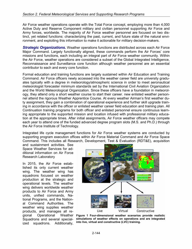
Section 2. Federal Meteorological Services and Supporting Research Programs
Air Force weather operations operate with the Total Force concept, employing more than 4,000 Active Duty and Reserve Component military and civilian personnel supporting Air Force and Army forces, worldwide. The majority of Air Force weather personnel are focused on two dis-tinct, yet related functions: characterizing the past, current, and future state of the natural envi-ronment, and exploiting this information to make it actionable for military decision-makers.
Strategic Organizations. Weather operations functions are distributed across each Air Force Major Command. Largely functionally aligned, these commands perform the Air Forces’ core missions and functions, each including an integral part of Air Force weather community. Within the Air Force, weather operations are considered a subset of the Global Integrated Intelligence, Reconnaissance and Surveillance core function although weather personnel are an essential contributor to each and every core function.
Formal education and training functions are largely sustained within Air Education and Training Command. Air Force officers newly accessed into the weather career field are university gradu-ates typically with a degree in meteorology/atmospheric science in order to meet aeronautical meteorologist forecaster minimum standards set by the International Civil Aviation Organization and the World Meteorological Organization. Since these officers have a foundation in meteorol-ogy, they attend only a short weather course to start their career. new enlisted weather person-nel attend the rigorous Weather Apprentice Course. At every weather Airman’s first weather du-ty assignment, they gain a combination of operational experience and further skill upgrade train-ing in accordance with the officer or enlisted weather career field education and training plan. All Continuation training programs for both officer and enlisted personnel ensure continuous learn-ing appropriate to the supported mission and location infused with professional military educa-tion at the appropriate times. After initial assignments, Air Force weather officers may compete each year to attend one of the funded advanced degree program slots (M.S. and Ph.D.) through the Air Force Institute of Technology.
Integrated life cycle management functions for Air Force weather systems are conducted by supporting program execution offices within Air Force Material Command and Air Force Space Command. This includes all Research, Development, Test & Evaluation (RDT&E), acquisition and sustainment activities. See Space Weather Services for ad-ditional information on Air Force Research Laboratory
In 2015, the Air Force estab-lished its only current weather wing. The weather wing has squadrons focused on weather production at the strategic and operational levels. The weather wing delivers worldwide weather products to Air Force and Army units, unified commands, Na-tional Programs, and the Nation-al Command Authorities. The weather wing supplies weather products, and manages all re-gional Operational Weather Squadrons and several special-ized squadrons. Additionally,
Figure 1 Four-dimensional weather scenarios provide realistic simulations of weather effects on operations and are integrated into live, virtual and constructive (LVC) training.
2-144
Military Services
squadrons are dedicated to build and maintain the world’s most comprehensive weather data-base of observation, forecast, climatological, and space weather products available to DoD per-sonnel through specified reach-back services.
Within the weather wing are co-located specialized weather squadrons that form a multi-million dollar strategic computer complex, production network, and applications. These units run the predictive models to include ensemble products to assist in predictive probability and the Global Air-Land Weather Exploitation Model (GALWEM) which is the basis of most Air Force weather prediction products. To support the analysis and prediction of the GALWEM, and other mis-sions, these units perform satellite data processing, ingesting and storing worldwide meteoro-logical satellite data to process data collected from Allies and ground stations established across various operational support squadrons across the globe. The Defense Meteorological Satellite Program (DMSP), operated by the Air Force, sustains a satellite in polar-orbit to pro-vide cloud, upper air, and space environmental data, and is a vital source of global weather data and information used to support intelligence community and military operations for more than 5 decades. These strategic units also have the ability to generate realistic climatic-based scenari-os to support military training events, especially those in support of the Army’s Mission Com-mand Training Program.
Space weather support to DoD is provided through a specialized, strategic-level weather squad-ron and its several solar observatories. This weather squadron uses space weather data col-lected from ground and space-based sensors to provide mission-tailored analyses, forecasts, warnings and strategic level products. These personnel monitor solar flares, noise storms, and other releases of energy from the sun and, when necessary, notify military and civilian organiza-tions concerned with space weather, power, and communications in countries throughout the world. See the section on Space Weather Services for further information. Due to related mis-sions supporting space-based assets, the squadron also provides or arranges support to the DoD intelligence community and complements products issued by internationally-accepted vol-canic ash advisory centers to ensure safety of global DoD aviation.
Similar to space weather support, climatic support is performed through a specialized weather squadron (see Climate Services).
Operational Weather Squadrons. The Operational Weather Squadron forms the backbone of regionally focused reach-back weather operations, providing a variety of weather forecast products (such as terminal aerodrome forecasts, weather watches, warnings, and advisories, aviation hazards and cloud forecasts) and support to Air Force, Army, Air National Guard, Air Force Reserve forces, and other users as directed in their respective operational areas. Opera-tional Weather Squadron areas of responsibility are generally aligned with the Unified Com-mand Plan’s geographic combatant commands. Operational Weather Squadron products gen-erally focus on characterizing the atmosphere for use by air operations centers, weather squad-rons, operational support squadrons, weather flights, and other units.
2-145

Section 2. Federal Meteorological Services and Supporting Research Programs
Figure 2: Operational Weather Squadrons Areas of Responsibility (AORs).
Figure 3: Example of Air Force weather support products. Air Operations Centers. Air Force weather personnel supporting geographic and functional air operations centers under operational control of their respective combatant commanders in-tegrate weather into the Air Force’s cornerstone operational-level command and control unit.
2-146
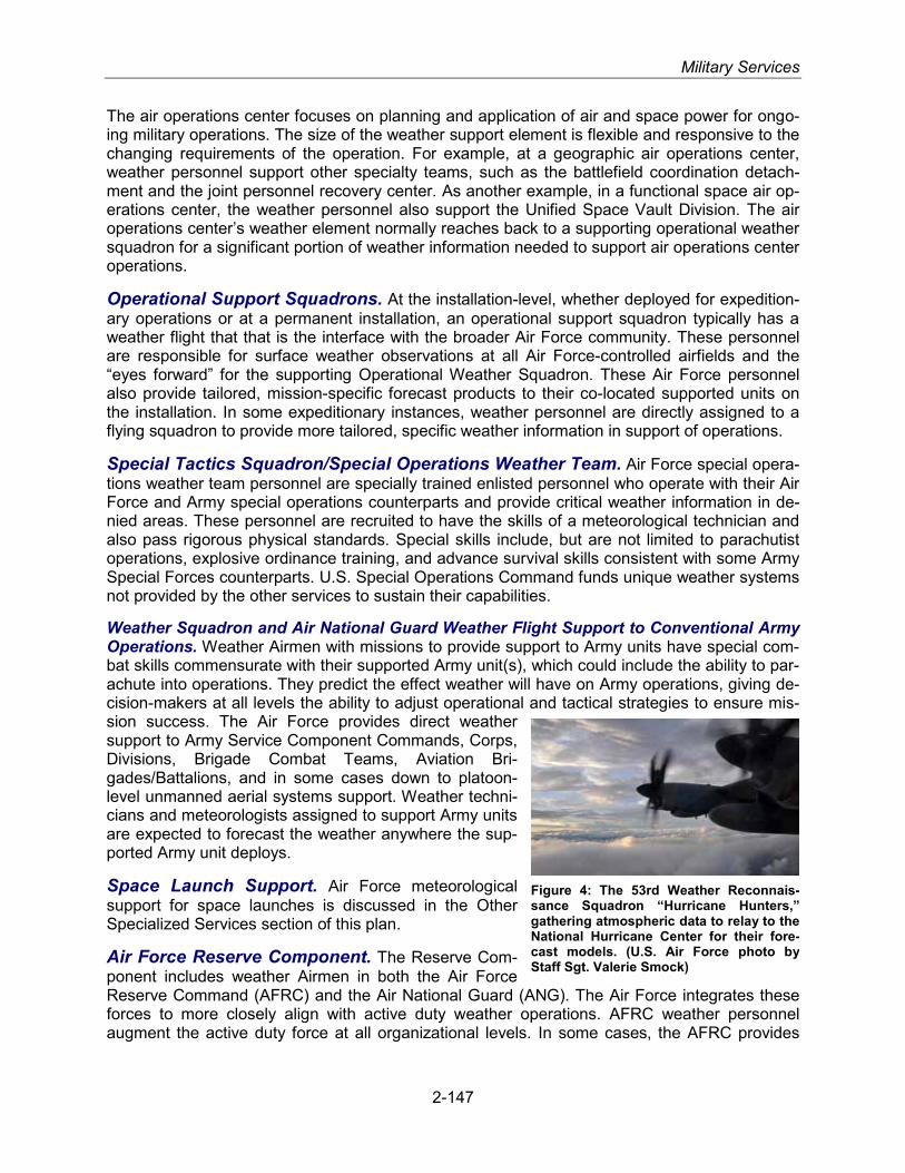
Military Services
The air operations center focuses on planning and application of air and space power for ongo-ing military operations. The size of the weather support element is flexible and responsive to the changing requirements of the operation. For example, at a geographic air operations center, weather personnel support other specialty teams, such as the battlefield coordination detach-ment and the joint personnel recovery center. As another example, in a functional space air op-erations center, the weather personnel also support the Unified Space Vault Division. The air operations center’s weather element normally reaches back to a supporting operational weather squadron for a significant portion of weather information needed to support air operations center operations.
Operational Support Squadrons. At the installation-level, whether deployed for expedition-ary operations or at a permanent installation, an operational support squadron typically has a weather flight that that is the interface with the broader Air Force community. These personnel are responsible for surface weather observations at all Air Force-controlled airfields and the “eyes forward” for the supporting Operational Weather Squadron. These Air Force personnel also provide tailored, mission-specific forecast products to their co-located supported units on the installation. In some expeditionary instances, weather personnel are directly assigned to a flying squadron to provide more tailored, specific weather information in support of operations.
Special Tactics Squadron/Special Operations Weather Team. Air Force special opera-tions weather team personnel are specially trained enlisted personnel who operate with their Air Force and Army special operations counterparts and provide critical weather information in de-nied areas. These personnel are recruited to have the skills of a meteorological technician and also pass rigorous physical standards. Special skills include, but are not limited to parachutist operations, explosive ordinance training, and advance survival skills consistent with some Army Special Forces counterparts. U.S. Special Operations Command funds unique weather systems not provided by the other services to sustain their capabilities.
Weather Squadron and Air National Guard Weather Flight Support to Conventional Army Operations. Weather Airmen with missions to provide support to Army units have special com-bat skills commensurate with their supported Army unit(s), which could include the ability to par-achute into operations. They predict the effect weather will have on Army operations, giving de-cision-makers at all levels the ability to adjust operational and tactical strategies to ensure mis-sion success. The Air Force provides direct weather support to Army Service Component Commands, Corps, Divisions, Brigade Combat Teams, Aviation Bri-gades/Battalions, and in some cases down to platoon-level unmanned aerial systems support. Weather techni-cians and meteorologists assigned to support Army units are expected to forecast the weather anywhere the sup-ported Army unit deploys.
Space Launch Support. Air Force meteorological support for space launches is discussed in the Other Specialized Services section of this plan.
Air Force Reserve Component. The Reserve Com-ponent includes weather Airmen in both the Air Force Reserve Command (AFRC) and the Air National Guard (ANG). The Air Force integrates these forces to more closely align with active duty weather operations. AFRC weather personnel augment the active duty force at all organizational levels. In some cases, the AFRC provides
Figure 4: The 53rd Weather Reconnais-sance Squadron “Hurricane Hunters,” gathering atmospheric data to relay to the National Hurricane Center for their fore-cast models. (U.S. Air Force photo by Staff Sgt. Valerie Smock)
2-147
Section 2. Federal Meteorological Services and Supporting Research Programs
very unique weather-related services not duplicated in the active duty force, such as AFRC’s “Hurricane Hunters.”
The AFRC’s “Hurricane Hunters,” assigned to a Weather Reconnaissance Squadron, provided means of collecting vital meteorological data, especially in and around tropical cyclones (See Emergency Response Section). Their specially equipped WC-130J aircraft collect temperature, moisture, wind, pressure, and visually observed information at the aircraft location as well as vertical profiles of the atmosphere collected by dropsondes. Hurricane Hunter aircraft penetrate the eyes of tropical cyclones to provide the National Hurricane Center very accurate center fix locations as well as other meteorological parameters, including sea level pressure. In addition to tropical cyclone reconnaissance, the unit is available to respond to other civil support missions such as collecting meteorological information to improve wintertime West Coast forecasts and to support scientific field programs.
To augment Operational Weather Squadron operations, AFRC organized two operational weather flights, each staffed by AFRC weather personnel, capable of augmenting an Opera-tional Weather Squadron. Additional Air Force Reserve weather personnel serve as individual mobilization augmentees assigned to various active Air Force organizations at all echelons, typ-ically in staff, forecasting, or scientific roles. There are weather traditional reservists working with an AFRC Remotely Piloted Aircraft (RPA) units. There are also Air Force Reserve weather personnel in Air Reserve Technician positions, i.e., combined full-time Civil Service/Air Force Reserve military positions, employed by HQ AFRC as a staff weather officer and by the Weath-er Reconnaissance Squadron as aerial reconnaissance weather officers. Lastly, AFRC civil ser-vice and contract weather personnel provide weather services at AFRC-operated bases in the U.S.
The ANG traditional program numbered weather flights, who meet monthly to train for their war-time mission. These flights provide weather support to ANG and Army National Guard units as mentioned in the previous paragraph. Air Combat Command (ACC)-gained ANG wings also have up to four traditional weather positions to provide weather operations for each wing’s flying mission. In addition, there are traditional weather positions in ANG Special Tactics Squadrons (Air Force Special Operations Command), and ANG RPA units. The ANG also has contract and civil service locations where it is responsible for providing peacetime weather support to airfield operations.
U.S. Army
USA Weather Support Structure
Weather support within the Army is a mix of Army and Air Force personnel and equipment in accordance with a United States Army (USA)–United States Air Force (USAF) agreement: Army Regulation [AR] 115-10/Air Force Instruction [AFI] 15-157 (IP), Weather Support for the U.S. Army, 10 September 2015. This multi-Service regulation describes the responsibilities of USAF and USA for providing weather support. Under this agreement, the USAF provides the Army with the necessary labor and unique tactical and fixed weather equipment to meet Army tactical, installation, and airfield support requirements for both Active and Reserve Components. The USAF assigns Air Force weather personnel to provide direct and indirect weather support to the Army Commands, Army Service Component Commands, and installations. The Army provides assigned Air Force personnel the equipment necessary to perform their Army support mission in the tactical environment. The Army also provides facilities and host services to Air Force per-
2-148

Military Services
sonnel assigned to Army installations. Each Service provides this support on a non-reimbursable basis.
Air Force Weather personnel provide installation, garrison, and tactical weather support on a daily basis to U.S. Army Forces Command, U.S. Army Europe, U.S. Army Pacific, U.S. Army Special Operations Command, Eighth U.S. Army, and the U.S. Army Training and Doctrine Command (TRADOC). The Army provides operational weather support to Army research, de-velopment, test, and evaluation (RDT&E) ranges, centers, and other research facilities using the Army Test and Evaluation Command’s meteorological teams. U.S. Army Space and Missile De-fense Command/Army Forces Strategic Command (SMDC/ARSTRAT) provides weather sup-port to the Ronald Reagan Ballistic Missile Defense Test Site at Kwajalein Atoll through a Mete-orological Environmental Test Support contractor.
Headquarters, Department of the Army, Army Commands, and Army Service Component Commands
Headquarters, Department of the Army (HQDA) The Office of the Deputy Chief of Staff, G-2, employs two civilian meteorologists whose primary duties are to establish weather policy within the Army, coordinate on AF weather policy issues with the Air Force Director of Weather (HQ USAF/A3/5), submit approved Army weather requirements and priorities to the HQ USAF/A3/5, coordinate with the AF on Army-AF and Joint Service weather operational concepts and doctrine, serve as the Army staff lead for meteorological satellite capabilities and issues, and review and coordinate Army-related support issues with the Office of the Secretary of De-fense, the Joint Staff, the Department of the AF, other Services, HQDA staffs, Army Commands, Direct Reporting Units, Army Service Component Commands, and other Federal Agencies. FY 2017 activities will focus on meteorological satellite activities, coordination of meteorological ac-tivities within the Army, and development of DoD level policy with the Services, Joint Staff, and OSD.
The Office of the Deputy Chief of Staff, G-3/5/7 (DCS, G-3/5/7), approves and prioritizes weath-er support requirements and programs to meet Army requirements, sets priorities for weather support for Army training and contingencies, coordinates with the HQ USAF on Army weather program and resource issues, and Army installation weather support requirements.
Project Manager Distributed Common Ground System – Army (PM DCGS-A) is a materiel de-veloper of weather capability in the Army and reports to Program Executive Office Intelligence, Electronic Warfare and Sensors (PEO IEWS) and Assistant Secretary of the Army for Acquisi-tion, Logistics and Technology (ASA(ALT)). DCGS-A work stations are issued to Air Force weather personnel providing direct weather support. In addition to developing, integrating, test-ing, and fielding capability, PM DCGS-A also leverages Air Force weather capability in support of Army operations.
Training and Doctrine Command. Headquarters, TRADOC, is responsible for leading the USA in development of and validating requirements for all Army weather capabilities and specif-ically for USA-USAF inter-Service weather operations, services concepts, and doctrine required in support of Army operations. TRADOC develops and manages USA weather training pro-grams, documents standard USA equipment for use by AFW personnel in the Table of Organi-zation and Equipment (TOE), and recommends modifications to the TOE and Common Table of Allowances to DCS, G-3/5/7, for approval as required. TRADOC’s Army Weather Proponent Of-fice (AWPO) processes tactical Army weather support requirements, represents the Army’s warfighting functions by determining needed weather capabilities and processing weather re-quirements found in Joint and USA conceptual documents from TRADOC centers and schools.
2-149

Section 2. Federal Meteorological Services and Supporting Research Programs
U.S. Army Intelligence Center of Excellence. The U.S. Army Intelligence Center of Excel-lence (USAICoE) is the TRADOC Army Weather Proponent Office (AWPO) for USA tactical weather support. As such, TRADOC’s AWPO represents the USA Warfighter by processing weather support requirements and developing solutions to satisfy those requirements when they are the responsibility of the USA. The AWPO collects and processes weather requirements from TRADOC schools/centers, USA Medical Command, and USA Corps of Engineers (USACE). Working through TRADOC/ARCIC USAICoE recommends solutions to satisfy those require-ments by processing tactical USA weather support requirements through the Joint Capabilities Integration and Development System (JCIDS) process. The AWPO employs one Department of the Army Civilian (DAC) to lead these weather requirement efforts. This DAC oversees the AW-PO efforts with the JCIDS process, and in all doctrine, organization, training, materiel, leader-ship, education, personnel, and facilities (DOTMLPF) work. This JCIDS and DOTMLPF work occurs within USAICoE and in conjunction with other USA Centers of Excellence and Army re-search and experimentation organizations.
U.S. Army Aviation Center of Excellence (USAACE). USAACE provides 10 courses in the aviation training curriculum that contain weather training for aviators and unmanned aircraft sys-tems operators. Currently USAACE owns six Automated Surface Observation Stations (ASOS) located within the USAACE flight training area (five) and one at Black Tower Unmanned Aerial System (UAS) training facility, Ft. Huachuca, AZ. These systems provide current weather data to the USAACE Air Force Weather Detachment located at Cairns Army Airfield (OZR) in support of Ft. Rucker’s and the UAS flight training mission. The National Weather service provides maintenance for these six systems through a contract at the cost of $25K a year, per system, for a total of $150K cost to USAACE ($175K in FY17).
Artillery Meteorological Education and Training. The U.S. Army Fires Center of Excel-lence is the proponent for artillery meteorological education and training. Computer Meteorolog-ical Data- Profiler (CMD-P) (AN/GMK-2) is a weather measurement system developed to pro-vide meteorological (MET) data to support artillery and target acquisition units. The AN/TSR-8 Global Broadcast Service (GBS) Satellite Receiver Suite receives polar orbiter MET data & communications satellite data and Operational Global Atmospheric Prediction System (NOGAPS) initialization data via a GBS satellite link. CMD-P provides MET data messages covering up to 500 km from the Profiler’s position. The CMD-P interfaces with the Advanced Field Artillery Tactical Data System (AFATDS) via Local Area Network (LAN) connection and is operated by the AFATDS Operator 13D. In the future, the system will no longer require the GBS receiver suite as part of a profiler system but will rely on the GBS connection from the TOC LAN (MET data is downloaded on Compact Disc via internet from the 557th Weather Wing). The sys-tem software will be capable of providing Field Artillery Computer MET and Gridded MET mes-sages on demand with or without an operator in-the-loop. These MET messages will be tailored to the mid-point of the trajectory for enhanced accuracy.
U.S. Army Test and Evaluation Command (ATEC). ATEC is responsible for providing operational meteorological support to USA RDT&E ranges. Under responsibilities established in AR 115-10/ AFI 15-157 (IP), ATEC meteorology teams provide meteorological data collection and analysis, and consultation to support USA and other DoD RDT&E activities at seven ATEC ranges.
U.S. Army Space and Missile Defense Command/Army Forces Strategic Command Support to the Ronald Reagan Ballistic Missile Defense Test Site. A subcommand of SMDC/ARSTRAT provides operational support to the Ronald Reagan Ballistic Missile Defense Test Site, including support for range activities (local and remote missile
2-150

Military Services
launches), missile weapons readiness testing, aviation and marine operations, and emergency operations. For further description of this support service, see “Other Specialized Services” in Section 2.
U.S. Army Products and Services
U.S. Army Artillery. The Profiler Block III provides highly accurate meteorological data to the Advanced Field Artillery Tactical Data Systems (AFATDS) to adjust artillery fire. The system supports battalion and brigade Field Artillery units. The Profiler Block III is connected to the Tac-tical Operations Center local area network and provides the Advanced Field Artillery Tactical Data Systems (AFATDS) with the meteorological requirement for achieving first round hits and fires for effect. The Profiler Block III uses weather data obtained from the Air Force through Mis-sion Command networks. It provides meteorological on demand with or without an operator in-the-loop to the AFATDS. A virtual module product improvement is currently under development and will be available in FY16 with an upgraded weather model and changing the software to be Common Operating Environment compliant.
Distributed Common Ground System–Army (DCGS-A). Weather Services. DCGS-A is the Army’s intelligence, surveillance, and reconnaissance enterprise for the analysis and pro-cessing, exploitation, and dissemination of information and intelligence data, across all eche-lons. DCGS-A leverages also Air Force Weather Capabilities, integrates tailored weather infor-mation and products provided by the Air Force and disseminates to Army command and control systems.
U.S. Navy
Operational Organizations
Oceanographer of the Navy. The Oceanographer of the Navy is the Chief of Naval Opera-tions’ resource, requirements and policy advisor for the Navy’s Oceanography Program. He also serves as the Navy’s senior policy advisor for issues relating to national ocean policy and gov-
ernance, and interagency ocean activities. The Office of the Oceanographer of the Navy’s (OCEANAV) mission is to provide Naval and Joint Forces with the environmental high ground through the use of physical battlespace information necessary to eliminate uncertainty and achieve a decisive warfighting competitive ad-vantage.
The Oceanographer and Navigator of the Navy, serves as the focal point for matters related to the Naval Oceanography enterprise (NOe), the Arctic region, and other marine science fields. The Oceanographer and his staff work closely with Information Domi-nance Type Command (IDFOR), U.S. Fleet Forces Command, Pa-cific Command (USPACOM), and the Office of Naval Research to ensure the proper resources are available to meet operational re-quirements. As the functional manager for GI&S, he works within the National System for Geospatial-Intelligence (NSG) and liaises with the National Geospatial-Intelligence Agency (NGA), National Reconnaissance Office (NRO), and the Department of Homeland Security (DHS) for strategic METOC and PNT programs. He acts as Naval Deputy to the NOAA Administrator and represents the Naval
Figure 5: RDML Tim Gallau-det, Oceanographer and Nav-igator of the Navy. RDML Gal-laudet also serves as Com-mander, Naval Oceanography and Meteorology Command (COMNAVMETOCCOM)
2-151

Section 2. Federal Meteorological Services and Supporting Research Programs
Oceanography Program in interagency and international forums.
The Navigator of the Navy provides guidance and standardization of METOC, maritime geospa-tial information, astrometric and precise-time models, databases, and environmental predictive techniques through the Oceanographic and Atmospheric Model Library (OAML). He coordinates NOe policy and architectures throughout Navy and DoD science and technology and RDT&E, along with related efforts in civilian agencies and develops means for transition from research to operational (R2O) applications. This integrated approach provides the Fleet and System Com-mands (SYSCOM) with critical information about the physical environment and its impacts on platforms, sensors, weapons, and personnel. Naval Meteorology and Oceanography support is integral to Navy, Marine Corps, and Joint Force capabilities to deter or win regional conflicts or major wars and conduct peacetime operations, including Humanitarian Assistance and Disaster Relief (HA/DR). CNO established the Information Warfare Forces Command (IFOR) the Navy’s newest TYCOM on 29 August 2014. IFOR integrates weather into the intelligence pillars of Bat-tlespace Awareness, Assured Fires, and Assured Command and Control. With this integrated man, train and equip (MT&E) portfolio, IFOR will coordinate closely with the aviation, surface ship, and submarine platform TYCOMs to deliver enhanced Information Dominance capability and readiness to the fleet.
Deputy Chief of Naval Operations for Infor-
mation Warfare N2/N6
Figure 6: Deputy Chief of Naval Operations for Information Warfare (N2/N6)
2-152

Military Services
This Command and Control (C2) preserves CNMOC as the Operational Commander which pro-vides environmental knowledge that enables Fleet Forces to operate safely and efficiently, with-out capability loss, due to adverse environmental conditions. It also enables enhanced sensor and weapons performance, providing a competitive advantage in maritime warfare.
Task Force Climate Change (TFCC). The Oceanographer of the Navy serves as Director of TFCC and develops comprehensive approaches regarding the Arctic and global climate change to guide future Navy public, policy, and strategy discussions. The National Strategy for the Arctic Region signed in 2013, recognizes that the Arctic is opening up for human enterprise, energy resources and will continue to increase as a strategic priority for the United States and Navy.
The U.S. Navy Arctic Implementation Plan was issued in February 2015 and prepares the U.S. Navy to respond effectively to future contingencies, delineates the U.S. Navy’s Arctic Region leadership role within the Defense Department, and articulates the Navy’s support to national priorities. The Arctic and climate change Roadmaps provide all encompassing, chronological, science-based guidance for future Navy operational and action from 2014 through 2030.
• Arctic Observation/Prediction International Engagement Plan
ONR leading development effort through Interagency Arctic Research Policy (IARPC) Committee
• Arctic Sensing Plan
R&D collection efforts ongoing OPNAV developing sensing strategy => POM 18 Improve Modeling/Prediction of Arctic Environment
Fleet Weather Center (FWC)
CTU 80.7.7 San Diego, CA
Fleet Nu-merical
Meteorology and Ocean-
ography Center
Naval Oceanog-raphy ASW Cen-
ter (NOAC) CTE 80.7.4.3
Naval Oceanogra-phy Special War-
fare Center (NOSWC)
CTE 80.7.4.1 San Diego, CA
CNMOC MSRC CP (58586)
CNMOC CP EAST (4385A)
NAVDEPNOAA DC (68027)
CNMOC CP PERS (4146A)
Shore duty Sea Duty Op Shore
Naval Oceanogra-phy Mine Warfare Center (NOMWC)
CTE 80.7.4.2
Commander, Naval Meteorology and
Oceanography Com-mand (CNMOC)
CTG 80.7
US Naval Ob-servatory
(USNO) CTU 80.7.3
Washington
Naval Oceanogra-phy ASW Center
(NOAC) CTE 80.7.4.4
USNO Flagstaff Station
CTE)
NMOPDD Yokosuka
CTE)
NMOPDD PAC CTE 80.7.5.1 (6466)
NMOPDD LANT CTE
Naval Mete-orology and Oceanogra-phy Profes-
sional Devel-opment Cen-
ter
Fleet Weather Center (FWC)
CTU 80.7.6 Norfolk, VA
Naval Ice Center (NIC) CTE 80.7.6.1 Suitland, MD
Joint Typhoon Warning Center
(JTWC) CTE 80.7.7.1
Pearl Harbor, HI
Naval Oceano-graphic Office
(NAVO) CTU 80.7.1
Stennis Space Center, MS
Fleet Survey Team (FST) CTE
80.7.1.1
Naval Ocean-ography Oper-
ations Com-mand (NOOC)
CTU 80.7.4 Stennis Space
Figure 7: Commander, Naval Meteorology and Oceanography Command CTG 80.7
2-153

Section 2. Federal Meteorological Services and Supporting Research Programs
ONR funding R&D of long-range Arctic models NRL sea ice prediction model
Naval Meteorology and Oceanography Command. The Naval Meteorology and Ocean-ography Command (COMNAVMETOCCOM) is responsible for the Command and management of the Naval Oceanography Program (NOP) utilizing meteorology and oceanography, GI&S, and precise time and astrometry, to leverage the environment to enable successful strategic, tactical and operational battle space utilization across the continuum of campaigning and at all levels of war: strategic, operational and tactical. COMNAVMETOCCOM will retain administrative control (ADCON) over the METOC fourth echelon commands, reporting to the Information Dom-inance Typer Command (IDFOR), and serving as the operational arm of the NOe. COM-NAVMETOCCOM's assets are globally distributed at shore facilities in fleet concentration areas.
Two central METOC Production Centers are located in the U.S. and operate through the Naval Oceanography Operations Command (NAVOCEANOPSCOM) at the Stennis Space Center (SSC) in Mississippi. As the Navy’s physical science team, Naval METOC personnel (Navy and Marine Corps) are highly educated sailors, marines, and civilians that measure and collect me-teorological, oceanographic, hydrographic and other data relevant to the physical battlespace. They use the data to analyze and determine current conditions, forecast the future state, and provide mission-focused impacts that enable commanders to make well-informed operational decisions across the entire spectrum of warfare. Operational oceanography operates along eight distinct lines of operations: maritime operations, aviation operations, fleet operations, nav-igation, precise time and astrometry, expeditionary warfare, anti-submarine warfare, and mine warfare. Maritime operations enable the safe operation of ships and submarines at sea through individualized forecasts, monitoring of their movement relative to hazardous weather, and alter-nate route advisories as warranted. Aviation operations are similar, but focus on the safe navi-gation of aircraft. Fleet operations represent our oceanography forces deployed on aircraft car-riers, amphibious assault ships, independent deployers and task forces. METOC and Navigation
services enable safety of surface and subsurface operations and support the Global Positioning System, networks, communications, and space-based systems. Expeditionary warfare (am-phibious warfare, riverine warfare and special operations), antisubmarine war-fare, and mine warfare (offensive min-ing and defensive countermeasures and clearance), as their names imply, support their respective warfare areas via a mixture of forward-deployed and reach-back capabilities required to pro-vide intelligence preparation of the op-erational environment (IPOE).
COMNAVMETOCCOM is focused on providing critical environmental knowledge to the war fighting disci-plines of Anti-Submarine Warfare; Na-val Special Warfare; Mine Warfare; In-telligence, Surveillance and Recon-naissance; and Fleet Operations
Figure 8: Naval personnel at Fleet Weather Centers monitor weather patterns and provide severe storm warnings to ships at sea and forces ashore.
2-154

Military Services
(Strike and Expeditionary), as well as to the support areas of Maritime Operations, Aviation Op-erations, Navigation, Precise Time, and Astrometry.
Major activities and additional subordinates within the command include the following:
• NAVOCEANOPSCOM, Stennis Space Center, MS • Fleet Weather Center Norfolk and Fleet Weather Center San Diego with subordinate units
and detachments • Naval Special Warfare Oceanography Center in San Diego, CA, (with components and de-
tachments in Stuttgart, Germany, Norfolk, and Pearl Harbor) • Naval Oceanography Anti-Submarine Warfare Centers in Yokosuka, Japan, and Stennis
Space Center, MS (with subordinate detachments) • Naval Oceanographic Office (NAVOCEANO), Stennis Space Center, MS • Fleet Survey Team, Stennis Space Center, MS • Naval Ice Center, Suitland, MD • Fleet Numerical Meteorology and Oceanography Center (FNMOC), Monterey, CA • USNO, Washington, DC • Naval Meteorology and Oceanography Professional Development Center, Gulfport, MS, with
detachments in Norfolk, VA; San Diego, CA; Pearl Harbor, HI; and Yokosuka, Japan
Naval Oceanography Operations Command. NAVOCEANOPSCOM is an echelon four METOC command that coordinates and manages efforts among field activities under the Opera-tional Oceanography enterprise to optimize warfighting resources, support safe operations, and enhance decision superiority within the battlespace through superior understanding and exploi-tation of the environment. The Command encompasses warfighting and enabling directorates for: Aviation Operations, Maritime Operations, Fleet Operations, Precise Time and Astronomy, Navigation, ISR (Intelligence, Surveillance, and Reconnaissance), Mine Warfare, Naval Special Warfare, and Anti-Submarine Warfare. Each directorate determines how that directorate’s ser-vices are delivered globally. Each directorate reports to a single Navy Captain who functions as Naval Oceanography’s Director of Operational Oceanography (DOO). The operations support portion of USN/USMC budget funds the day-to-day environmental support to the Department of Defense, the Active and Reserve Components of the Navy and Marine Corps, ten unified com-mands, and other agencies as directed by the Chief of Naval Operations. Over 1,228 military and civilian personnel conduct these activities at more than 22 locations worldwide.
Fleet Numerical Meteorology and Oceanography Center. FNMOC, is an echelon four activity reporting to CNMOC, is the NOe production center for meteorology. This center plays a significant role in the national capability for operational weather and ocean prediction by imple-menting, operating, maintaining, and improving Numerical Weather Production (NWP) systems,
Figure 9: Storm track predictions enable Naval METOC personnel to divert both ships and aircraft.
2-155
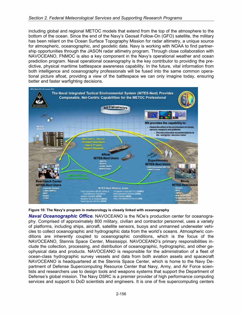
Section 2. Federal Meteorological Services and Supporting Research Programs
including global and regional METOC models that extend from the top of the atmosphere to the bottom of the ocean. Since the end of the Navy’s Geosat Follow-On (GFO) satellite, the military has been reliant on the Ocean Surface Topography Mission for radar altimetry, a unique source for atmospheric, oceanographic, and geodetic data. Navy is working with NOAA to find partner-ship opportunities through the JASON radar altimetry program. Through close collaboration with NAVOCEANO, FNMOC is also a key component in the Navy’s operational weather and ocean prediction program. Naval operational oceanography is the key contributor to providing the pre-dictive, physical maritime battlespace awareness capability. In the future, vital information from both intelligence and oceanography professionals will be fused into the same common opera-tional picture afloat, providing a view of the battlespace we can only imagine today, ensuring better and faster warfighting decisions.
Figure 10: The Navy’s program in meteorology is closely linked with oceanography Naval Oceanographic Office. NAVOCEANO is the NOe’s production center for oceanogra-phy. Comprised of approximately 800 military, civilian and contractor personnel, uses a variety of platforms, including ships, aircraft, satellite sensors, buoys and unmanned underwater vehi-cles to collect oceanographic and hydrographic data from the world’s oceans. Atmospheric con-ditions are inherently coupled to oceanographic conditions, which is the focus of the NAVOCEANO, Stennis Space Center, Mississippi. NAVOCEANO’s primary responsibilities in-clude the collection, processing, and distribution of oceanographic, hydrographic, and other ge-ophysical data and products. NAVOCEANO is responsible for the administration of a fleet of ocean-class hydrographic survey vessels and data from both aviation assets and spacecraft NAVOCEANO is headquartered at the Stennis Space Center, which is home to the Navy De-partment of Defense Supercomputing Resource Center that Navy, Army, and Air Force scien-tists and researchers use to design tools and weapons systems that support the Department of Defense’s global mission. The Navy DSRC is a premier provider of high performance computing services and support to DoD scientists and engineers. It is one of five supercomputing centers
2-156
Military Services
established under the DoD High Performance Computing Modernization Program (HPCMP). CNMOC maintains oversight of the Navy DSRC systems that have been operational since 1997.The Navy DSRC provides a high performance computing capability with primary emphasis on support of the largest, most computationally-intensive HPC applications. Our center leads the way for numerous HPCMP-wide initiatives and provides our users with in-depth computa-tional expertise and support. While the HPCMP is primarily focused on DoD research and de-velopment programs, the Navy DSRC is unique in that approximately 15 percent of its total ca-pability is apportioned for operational use by naval operational oceanography. Today, the Navy DSRC enables, on a daily basis, operational, global, regional, and port scale ocean circulation, as well as wave and sea ice forecast numerical models supporting worldwide Navy and DoD operations. Navy DSRC’s total computational capacity affords us computational space to not only improve our ocean models, but to bring online world-class atmospheric models within the DSRC and begin to more tightly couple ocean and atmospheric physics and energy exchange to provide a more accurate, longer range future state of the atmosphere.
Navy Products and Services
Maritime Weather Operations. The Fleet Weather Center in Norfolk, VA supports opera-tions for Commander Second Fleet (North Atlantic); Commander, Fourth Fleet (Caribbean Sea and South Atlantic); Commander, Sixth Fleet (Mediterranean Sea), and Arctic Region opera-tions.
The Fleet Weather Center in San Diego, CA supports operations for the Commander, Third Fleet (East Pacific); Commander, Fifth Fleet (Arabian Sea and Suez Canal); Commander, Sev-enth Fleet (West and Central Pacific) areas of responsibilities.
Navy meteorologists and forecasters provide Optimum Track Ship Routing (OTSR) and weather forecasts to support transoceanic voyages and coastal operations. OTSR services include:
Hazardous ocean and weather advisories and divert recommendations to ship Commanding Officers and Masters at sea
• Sortie recommendations for potentially damaging weather conditions in port • Preliminary climatologic outlooks for transit and mission planning • Routine ship weather forecasts and aviation weather forecasts for ship-based helicopters, to
include high wind and seas warnings and local area warnings for Fleet Concentration Areas
Joint Typhoon Warning Center (JTWC). The JTWC, established by the U.S. Pacific Command, is jointly manned with U.S. Navy and U.S. Air Force personnel. The JTWC provides tropical cyclone reconnaissance, forecasts, warnings, and decision support products to U.S. government agencies operating in the Pacific and Indian Oceans as directed by Commander, U.S. Pacific Command. JTWC, located in Pearl Harbor, Hawaii, is an internationally recognized tropical cyclone forecasting center.
FNMOC Numerical Weather Prediction Systems. FNMOC satisfies the military’s re-quirement for an operational global Numerical Weather Prediction (NWP) capability. This re-quirement is driven by the importance of weather and ocean conditions on modern military op-erations, the need to use classified weather observations to guarantee the very best weather and ocean predictions in theaters of conflict, and the imperative to produce and disseminate weather and ocean products to military decision makers without fear of interruption or compro-mise as a result of cyber terrorists or cyber warfare. FNMOC employs four primary models—the Navy Global Environmental Model (NAVGEM), the Coupled Ocean/Atmosphere Mesoscale
2-157

Section 2. Federal Meteorological Services and Supporting Research Programs
Prediction System (COAMPS), the Geophysical Fluid Dynamics Navy (GFDN) model, and the Wave Watch III model (WW3)—along with a number of specialized models and related applica-tions.
• NAVGEM is an improvement to the former Navy Operational Global Atmospheric System (NOGAPS) that drives nearly all other FNMOC models and applications in some fashion, and forms the basis for the FNMOC global Ensemble Forecast System.
• COAMPS is a high-resolution, non-hydrostatic regional model, multiply nested within NAVGEM. It has proven to be particularly valuable for forecasting weather and ocean condi-tions in highly complex coastal areas.
• GFDN is a moving-nest tropical cyclone model, nested within NAVGEM. It is used to fore-cast tropical cyclone tracks globally.
• WW3 is a spectral ocean wave model that is employed both globally (driven by NAVGEM) and regionally (driven by COAMPS) in support of a wide variety of naval operations.
FNMOC Products and Services. FNMOC’s complex and robust opera-tional prediction capability is designed to deliver detailed forecasts of wind stresses and heat fluxes to drive very high-resolution ocean models that pro-vide ocean thermal structure and cur-rents in support of anti-submarine and mine warfare operations, or near-shore wind, sea, and surf forecasts that direct-ly support Fleet Operations through ship-to-objective maneuver. FNMOC models feed directly into applications models, tactical decision aids, and other products that provide direct support to various weather-sensitive activities as-sociated with the optimum path aircraft routing, optimum track ship routing, is-suance of high-winds and high-seas warnings, hurricane/typhoon sortie decisions, covert in-gress/egress of Special Operations Forces, ballistic missile targeting, cruise missile launch and targeting, radar, EO, and FLIR system performance prediction in support of ship self-defense, naval gunfire operations, understanding the threats posed by airborne nucle-ar/biological/chemical agents, search-and-rescue at sea, and many other activities.
Many of FNMOC’s products are distributed to users over the Web via the PC-based METCAST system, and subsequently displayed and manipulated on the user’s PC with the Joint METOC Viewer (JMV) software. This includes all standard METOC fields, synoptic observations, and satellite imagery. FNMOC provides a Web-based capability called WxMap (i.e., “Weather Map”). WxMap, requiring only a Web browser for access, allows the user to select and quickly display predicted METOC fields for any user-defined geographical area. FNMOC benefits greatly from collocation with its supporting R&D activity, the Marine Meteorology Division of the Naval Re-search Laboratory (NRL/MRY). NRL/MRY is a world-class research organization, with focus on weather-related support to warfighting. FNMOC and NRL/MRY share space, data, software and computer systems, and together with the nearby Naval Postgraduate School represent one of the largest concentrations of weather-related intellectual capital in the Nation. Collocation and close cooperation between research and operations, such as exists between NRL/MRY and
Figure 11: AG1 James Patterson with the 82nd Expedition-ary Rescue Squadron, preparing a forecast.
2-158

Military Services
FNMOC, is the optimum arrangement for transitioning R&D quickly and cost effectively into new and improved operational weather prediction capabilities.
NAVOCEANO Products and Services. NAVOCEANO is the Navy's center for operational oceanographic support and provides daily analyses and forecasts of the ocean state with a se-ries of global, regional, and coastal ocean circulation and wave models. The core of the system is the dynamic Navy Coastal Ocean Model (NCOM) which predicts three-dimensional ocean properties to 96 hours. The 1/8 degree (14km/7.5nm) resolution Global NCOM covers the world from pole to pole and is coupled with the Arctic Polar Ice Prediction System, which forecasts ice properties for the National Ice Center. Twelve regional NCOMs are on line with 24 planned in 2014. Nested 1/36 degree (3km/1.7nm) regional NCOM domains of order 20 by 20 degree sizes provide high-resolution ocean forecasts in areas of Navy and national interest. Global and re-gional NCOM products and data fields are shared with our NOAA partners.
NAVOCEANO runs a series of coastal, estuarine, and river domains with resolutions as fine as 1/360 degree (300 m, 1000 ft) or less in the support of mine warfare and homeland security ef-forts. When appropriate, coastal NCOMs are supplemented by other models including HY-DROMAP, DELFT3D, and PCTIDES. The NCOMs are initiated through the assimilation of ocean data from satellites (sea surface temperature and altimetry) and various surface and sub-surface observing systems, including ship data, ARGO profiling floats, and gliders. Global NCOM will be replaced by the 1/12-degree resolution Global HYbrid Coordinate Ocean Model, which was developed under the National Ocean Partnership Program by a consortium of gov-ernment and academic scientists, led by NRL Stennis and including NOAA’s National Centers for Environmental Prediction (NCEP).
NAVOCEANO is the Navy's primary processing facility for a number of polar-orbiting and geo-stationary satellite collection systems, and is nationally recognized for satellite-derived sea-surface temperature and satellite altimeter-derived sea surface topography and wave height ob-servations. These products are shared with NOAA partners and are critically important to suc-cessfully running both the NAVOCEANO ocean models and FNMOC's NAVGEM and COAMPS atmospheric models.
U.S. Marine Corps
Operational Organizations
CMC, DC/AVN, APX-9. The senior USMC METOC officer is dual-hatted as the METOC Ser-vices Officer and the METOC Occupational Field (OccField) Sponsor. The billet resides within the Aviation Department, Headquarters, U.S. Marine Corps, Washington D.C. and is physically located in the Pentagon, Aviation Expeditionary Enablers (APX) branch.
The METOC Services Officer is the principal advisor and subject matter expert to the Deputy Commandant, Aviation. The Aviation Department mission is to assist and advise the Comman-dant of the Marine Corps on all matters relating to Marine Aviation consistent with Marine Corps requirements. Specific duties include, but are not limited to: advise the Commandant of the Ma-rine Corps on aviation safety, aviation policies, and Joint matters relating to aviation; provide principal aviation staff interface with the Chief of Naval Operations (CNO); ensure Marine Corps Aviation operates in compliance with Naval Aviation directives and programs; member of the Joint METOC Board Executive Steering Group; member of the Battlespace Awareness Func-tional Capabilities Board; member of the Joint Capabilities Board; USMC liaison to the National
2-159
Section 2. Federal Meteorological Services and Supporting Research Programs
Oceanic and Atmospheric Association and the Office of the Federal Coordinator for Meteorolo-gy.
The METOC Occupational Field Sponsor establishes policies and procedures for the effective management of officers and enlisted Marines serving in METOC billets across the MAGTF and supporting establishments.
Marine Liaison, Oceanographer of the Navy (N2/N6) The United States Marine Corps Liaison and Requirements Officer responsible for the funding of all programs associated with METOC support to the MAGTF resides within N2/N6E1, Oceanographer of the Navy, U.S. Na-val Observatory, Washington D.C. N2/N6E1 reports directly to the Deputy CNO (DCNO) for In-formation Dominance to enable informed program wholeness and warfighting capability trades for information, cyber, and electronic warfare systems. Led by a two-star admiral, most of the N2/N6E1 staff, to include the admiral, have office spaces at the Pentagon. The N2/N6E1 USMC Requirements Officer represents the Deputy Commandant for Aviation in all aspects of METOC policy and procedures, requirements, acquisitions, and finance and must maintain familiarization with defense acquisition, technology, and logistics life cycle management framework. This of-ficer also monitors Marine Corps METOC programs to ensure requirements are being met and advises the Program Sponsor of program status and milestone accomplishments.
Marine Liaison, Commander Naval Meteorology and Oceanography Command The United States Marine Corps Liaison Officer, Commander Naval Meteorology and Oceanography Command (COMNAVMETOCCOM) resides within N3, and is the principal advisor and subject matter expert for all MAGTF METOC support capabilities. Duties include: assist COM-NAVMETOCCOM in aligning the METOC support requirements for littoral and expeditionary warfare operations to include the proper employment and optimal utilization of MAGTF METOC capabilities in support of joint/combined operations; advise and assist COMNAVMETOCCOM in the planning, programming, budgeting, and procurement of MAGTF METOC equipment and in the preparation of concept of operations, specifications, and review of technical data for such equipment; assist in the development and review of METOC training materials, publications, in-structions, and directives in support of MAGTF littoral and expeditionary warfare operations; and serve as direct Liaison between Headquarters, Marine Corps (APX-9), Director of Intelligence (DIRINT), and COMNAVMETOCCOM for all matters requiring the concurrence of the Comman-dant of the Marine Corps.
Space and Naval Warfare System Command (SPAWAR) The SPAWAR METOC Officer serves as the Aviation Program Manager (APM) for METOC equipment in the Battlespace Awareness and Information Operations Program Office (PMW120) under the Program Execu-tive Office (PEO) Command, Control, Communicate, Computers and Intelligence (C4I). Duties include: ensures that validated Marine Corps METOC requirements are satisfied; provides tech-nical assistance regarding Marine Corps operations to other METOC project officers within and external to the METOC Systems Office; maintain, organize, and disseminate METOC software; and plan and manage the design, development, procurement, and life cycle support of hardware and software systems that measure, transmit, distribute, and process METOC data.
U.S. Marine Corps Forces (MARFOR). The MARFOR METOC officer serves as a Special Staff for the Commanding General of the MARFORs and resides within the G-2. The primary mission of the MARFOR METOC Officer is to advise and assist the MARFOR Commanding General in the development of METOC policies and the execution and management of METOC resources by planning, coordinating, and validating the collection, evaluation, interpretation, and dissemination of METOC data. Other duties include: maintain liaison with other Service coun-terparts and represent the MARFOR Commanding General at Joint Service METOC meetings;
2-160
Military Services
maintain staff cognizance and management coordination for METOC-related matters; serves as the Marine Corps Senior METOC Officer (SMO) when the MARFOR Headquarters (HQ) de-ploys; conducts staff studies directly related to improving MAGTF Warfighting capabilities; pre-pare and present staff and command level briefings; provides staff support in planning for the employment and use of organic METOC assets, equipment, and capabilities; provide climato-logical, meteorological, tidal, astronomical, and other METOC data for planning; and develop and prepare the METOC annex (Annex H) for OPLANs or OPORDs and provides METOC input into the communications and information systems (CIS) annex (Annex K), the intelligence annex (Annex B), and other annexes as necessary regarding METOC issues. MARFOR billets include assignment to Marine Forces Pacific (MARFORPAC) Camp Smith, HI and Marine Forces Command (MARFORCOM) Norfolk, VA.
Marine Expeditionary Force (MEF). The MEF METOC Officer serves as a Special Staff for the Commanding General of the MEF and resides within the G-2. The primary mission of the MEF METOC Officer is to advise and assist the MEF Commanding General in the development of METOC policies and the execution and management of METOC resources by planning, co-ordinating, and validating the collection, evaluation, interpretation, and dissemination of METOC data. Other duties include: maintain liaison with other Service counterparts and represent the MEF Commanding General at Joint Service METOC meetings; maintain staff cognizance and management coordination for METOC-related matters; serves as the Marine Corps SMO when the MEF HQ deploys; conducts staff studies directly related to improving MAGTF Warfighting capabilities; prepare and present staff and command level briefings; provides staff support in planning for the employment and use of organic METOC assets, equipment, and capabilities; provide climatological, meteorological, tidal, astronomical, and other METOC data for planning; and develop and prepare the METOC annex (Annex H) for OPLANs or OPORDs and provides METOC’s input into the CIS annex (Annex K), the intelligence annex (Annex B), and other an-nexes, as necessary regarding METOC issues.
Intelligence Battalion (Intel Bn). The Intel Bn provides the largest preponderance of METOC personnel outside of the Aviation Combat Element (ACE) and provides direct and general sup-port METOC personnel in the form of METOC Support Teams (MSTs) to all other elements of the MAGTF. The Intel Bn’s primary mission is to provide direct METOC support to the MEF G-2. The secondary mission is to provide MSTs to the Command Element (CE), Ground Combat El-ement (GCE), Logistics Combat Element (LCE), and Marine Expeditionary Units (MEUs); and are task-organized to support unique mission requirements.
Marine Division (MARDIV). The MARDIV METOC Chief serves as a Special Staff for the Commanding General of the MARDIV and resides within the G-2. The primary mission of the MARDIV METOC Chief is integrate into operational planning. Other duties include: prepare and present METOC briefs in support of mission planning and execution; forecast and identify envi-ronmental factors expected to impact operations; and provide expertise METOC input in the ar-eas of Doctrine, Organization, Training, Material, Leadership, Personnel, and Facilities on be-half of the Commanding General of the MARDIV.
Marine Logistics Group (MLG) The MLG METOC Chief serves as a Special Staff for the Commanding General of the MLG and resides within the G-2. The primary mission of the MLG METOC Chief is to integrate into operational planning. Other duties include: prepare and pre-sent METOC briefs in support of mission planning and execution; forecast and identify environ-mental factors expected to impact operations; and provide expertise METOC input in the areas of Doctrine, Organization, Training, Material, Leadership, Personnel, and Facilities on behalf of the Commanding General of the MLG.
2-161

Section 2. Federal Meteorological Services and Supporting Research Programs
Marine Aircraft Wing (MAW). The MAW METOC Officer serves as a Special Staff for the Commanding General of the MAW and resides within the G-2. The primary mission of the MAW METOC Staff is to integrate into operational planning and advise the Commanding General on the capabilities and limitations of the METOC personnel and equipment with the MAW. Other duties include: prepare and present METOC briefs in support of mission planning and execu-tion; forecast and identify environmental factors expected to impact operations; supervise the METOC collection strategy for the Air Wing; man and train TACC METOC personnel; assist subordinate commands in knowledge development for all METOC personnel in the Wing; and provide expertise METOC input in the areas of Doctrine, Organization, Training, Material, Lead-ership, Personnel, and Facilities on behalf of the Commanding General of the MAW.
Marine Air Control Group (MACG). The MACG METOC Chief serves as a Special Staff for the Commanding Officer of the MACG and resides within the S-3/S-5. The primary mission of the MACG METOC Chief is to integrate into operational planning and to advise the Commanding Officer on the capabilities and limitations of the METOC personnel and equipment within the MACG. Other duties include: assist in the execution and management of all METOC resources; coordinate effective methods of providing METOC support for the planning and execution of MAGTF operations; analyze and interpret centrally prepared products, alphanumeric data, satel-lite images, and Doppler radar coverage in order to provide forecast meteorological conditions, space weather, climatological and astronomical products, and impacts assessments for all re-quested operations within the scope of the MACG and its subordinate commands.
Marine Air Control Squadron (MACS)
MACS Weapons and Tactics Training Program (WTTP) The MACS METOC WTTP Chief is the subject matter expert to the Commanding Officer of the MACS and resides within the WTTP shop. The primary mission of the MACS METOC WTTP Chief is to supervise the training progression of MACS METOC personnel in accordance with MCO 3500.14C Aviation Training and Readiness Program Manual and NAVMC 3500.38A METOC Training and Readi-ness manual by continuously monitoring and supervising training input into Marine Sierra Hotel Aviation Readiness Program (MSHARP) and all source documentation to accurately portray combat readiness of the METOC sections within the MACS MATCDachments (Dets).
MACS Marine Air Traffic Control Detachments (MATCD) The MACS MATCD are where the preponderance of METOC personnel resides within the MAW. They also own and maintain the largest METOC support asset within the MAGTF; the Meteorological Mobile Facility (Re-placement) Next Generation [METMF(R) NEXGEN]. The METMF(R) NEXGEN is deployed to support sustained operations ashore and provides METOC personnel with a forward deployed data collection asset that is comparable to garrison systems. MACS MATCD METOC personnel provide general support to the Aviation Combat Element (ACE), but can be task-organized by way of METOC Support Teams (MSTs) to support the other elements of the MAGTF when re-quested through the chain of command. The duties of the MACS MATCD METOC personnel include: acquire, monitor, and analyze METOC data to produce tailored, value added infor-mation for supported units; operate all METOC equipment, including satellite receivers, radar, and other available environmental sensors and display equipment used as the basis for collect-ing and forecasting environmental conditions; prepare and disseminate forecasts focused on specific missions, locations, and METOC parameters critical to current operations and future planning; forecast upper-level winds; provide aviation flight weather briefings in support of avia-tion missions; and provide WWAs in support of sustained operations ashore to ensure force pro-tection.
2-162
Military Services
Operational Supporting Establishments
Regional METOC Center (RMC). The Marine Corps’ RMCs provide 24 hour direct (in person) and indirect (web, e-mail, and phone) regionalized METOC information, products, and services in support of Marine Corps operations and other military operations as may be directed from a garrison environment. The RMCs may be used as a reach-back source, but are not task-organized to provide operational METOC support to forward deployed personnel or to act as METOC Production Centers for other-than-garrison operations. RMCs have the secondary mis-sion to coordinate and supervise the training of all METOC forecasters in the MCICOM chain of command. As part of the regionalization concept of the RMCs, they are responsible for 24/7 METOC support for the station they are aboard and after field closure for all other stations within their area of responsibility (AOR). Those duties include: collect, evaluate, interpret, and dissem-inate METOC observations and forecasts; prepare and disseminate WWAs; prepare and brief aviation flight weather briefs; forecast upper-level winds; prepare and disseminate yearly astro-nomical data; provide climatological data upon request; and complete all other METOC request for information (RFI) as requested.
Other CONUS Marine Corps Bases and Air Stations. Station METOC support responsibilities include: METOC support to base training, tenant units, and transient aircrews; and liaison with the RMC to provide a continuous meteorological watch (METWATCH). The RMCs have final issuing authority for all terminal aerodrome forecasts (TAF) and weather WWAs for the bases and air stations within their respective area of responsibility. Other duties include collect, evalu-ate, interpret, and disseminate METOC observations; prepare and brief aviation flight weather briefs; forecast upper-level winds; prepare and disseminate yearly astronomical data; provide climatological data upon request; and complete all other METOC RFIs as requested. Although collaboration between the Station METOC subject matter expert and RMC personnel occurs, the RMCs have final issuing authority for all terminal aerodrome forecasts (TAF) and WWAs for the stations and bases within their respective region.
Marine Corps Aviation Support. The Marine Aircraft Wing (MAW) conducts the complete range of air operations in support of the MEF, to include anti-air warfare, offensive air support, assault support, aerial reconnaissance, electronic warfare, and control of aircraft and missiles. The MAW serves as the principal headquarters for the ACE. Most of the MAGTF’s METOC support assets reside within the MAW, specifically at the MACG and its subordinate Marine Air Traffic Control Detachments. These assets are organized, structured, and capable of supporting a variety of MAGTF and ACE-specific operations as defined by the size, scope, and mission re-quirements. Dedicated METOC support is available for all MAGTF elements from within the MAW/ACE.
Marine Corps Products and Services
METOC Support Capabilities—Meteorological Mobile Facility (Replacement) Next Generation [METMF(R)NEXGEN]. The highest level of METOC capability within the MAGTF is the METMF(R) NEXGEN. The METMF(R) NEXGEN provides the MAGTF with a lightweight, highly mobile, fully integrated FORCENet compliant meteorological system capable of sustaining METOC operations in direct or general support of all elements of the MAGTF. It provides a METOC capability similar to that found in garrison METOC facilities. METMF(R) NEXGEN provisions for all functions of environmental sensing and data ingest, for the efficient collation and integration of collected data, and for user-friendly graphic user interfaces (GUIs) and software tools necessary for accurate interpretation and value-added production. The METMF(R) NEXGEN enables the Marine METOC personnel to effectively turn relevant METOC
2-163

Section 2. Federal Meteorological Services and Supporting Research Programs
data into actionable environmental information which in turn can facilitate timely operational decision-making. The smallest level of METOC capability is the Naval
Integrated Tactical Environmental System - Variant IV (NITES IV). The NITES IV is designed as a scalable, flexible, and mobile system for a first in and last out capa-bility. The primary differences between the METMF(R) NEXGEN and NITES IV are size, logistics, scalability, mo-bility, and that the METMF(R) NEXGEN has organic sens-ing capabilities while the NITES IV sensing capabilities are limited. Thus, the NITES IV relies heavily on reach-back communications and MFC databases for data and prod-ucts. The NITES IV provides METOC personnel access to METOC data and products which are then analyzed and tailored for a specific mission.
Naval Integrated Tactical Environmental System (NITES IV). NITES IV is a modular system, used to pro-vide limited METOC support in a stand-alone mode with increasing capabilities realized with the addition of SIPR-NET/NIPRNET connectivity. The NITES-IV suite consists of three laptops. Each laptop is designed to perform a dif-ferent function, but all three are loaded with the same software and can perform the tasks of the others. Mission requirements, network availability, and embarkation space dictate how best to employ NITES IV.
Vaisala TacMet Meteorological Observation System. Organic to the METMF(R) NEXGEN and NITES IV, the TacMet is a field deployable, compact weath-er station for various field operations. Offering broad sensor capability, the local MAWS201M network system is used to pro-vide weather data to support air operations on a temporary or semi-permanent basis. The local system enhanced configuration offers full aviation support, interfacing with intelligent sensors such as ceilometer, present weather sensor, and electric field mill. These sensors are capable of being deployed up to 150 feet away from the systems. A standalone version of this sensor is also available to the METMF(R) NEXGEN in the form of two (2) Remote Sensor Sub-systems (RSS). The RSS in-cludes meteorological sensors from pre-positioned, remote locations. This portable, scalable system comprises a sensor set with wind speed and direction, barometric pressure, air tempera-ture, relative humidity, and precipitation sensors.
Figure 12: Meteorological Mobile Facility (Replacement) Next Generation [METMF(R)NEXGEN] deployed to Afghani-stan
Figure 13: METMF(R) NEXGEN provides critical enabling capabilities to collect, process, disseminate and inte-grate essential elements of information regarding the time-sensitive characterization of the physical environ-ment. Official U.S.M.C. photograph.
2-164

Military Services
U.S. Coast Guard
The U.S. Coast Guard (USCG) is a military, multi-mission maritime service and one of our Na-tion’s five armed forces. The USCG protects the public, the environment, and the economic in-terests in the Nation’s ports and waterways, along the coast, on international waters, and in oth-er maritime regions, as required to support national security. The USCG has a long history of environmental observations and science support. Support for meteorological operations and supporting research is detailed in other sections of this plan.
SUPPORTING RESEARCH PROGRAMS AND PROJECTS
Interagency Supporting Research Programs and Projects
National Earth System Prediction Capability (National ESPC), Research Partnering Initiative
This initiative is a Navy, Air Force, NOAA, DOE, NASA, and NSF partnership focused on coor-dinating development and transition to operations of numerical weather technology advances to improve joint mission performance. The vision is a national numerical weather prediction (NWP) system with interoperable components built on common standards and a common framework (the Earth System Modeling Framework), with managed operational ensemble diversity and a national global NWP research agenda to accelerate science and technology infusion. The re-search under National ESPC works to improve and extend forecast skill through coupled sys-tems. The research agenda aims to stimulate inter-agency interactions and collaborations in developing systems to improve forecasts at time scales from near-term weather to inter-seasonal/inter-annual. Current efforts are to couple domains such as atmosphere, ocean, ice, land and eventually other ecosystem components. Improvements in predictions in these broader domains and timescales will result in better severe weather warnings (hurricanes, tornadoes, snowstorms), better cost avoidance for weather sensitive industries (agriculture, transportation, utilities, defense), and better informed decision making for industry, defense, and the general public.
The precursor to National ESPC, the National Unified Operational Prediction Capability (NUOPC), established its Initial Operational Capability in January 2011. This National multi-model global ensemble is exchanged between NOAA, the Navy and the Air Force on a one de-gree grid for 72 variables out to 16 days. Upgrades to ensemble systems will continue and the resolution of the exchanged ensemble members is scheduled to be doubled by the end of 2016 to one half degree as computing and communications capabilities grow to support this require-ment. The partners continue to use and develop multi-model ensemble-based products such as the new Wave Watch 3 Ensemble that achieve substantial skill improvements over any single model solution.
U.S. Air Force Supporting Research Programs and Projects
Technology Transition Initiatives. The overarching objective of the Air Force meteorological and space environmental technology transition program is to give capability designers, opera-tional weather personnel, and weather information users the technology and tools to gain and maintain the advantage over a potential adversary. Air Force capability needs in the atmospher-ic and space environment sciences are articulated in the Initial Capabilities Document for the Meteorological and Oceanographic Environment, Capability Review assessments, Air Force
2-165

Section 2. Federal Meteorological Services and Supporting Research Programs
Strategic Plans (Strategic Master Plan), legacy Weather Operations Functional Concept and Enabling Concepts (Characterize the Environment, Exploit Environmental Information, and Net-Centric Operations), and supporting Flight Plans, concept and implementation plans. The Air Force also uses cooperative development and testing agreements with other governmental agencies and laboratories, as well as with for-profit companies. Both the Air Force Institute of Technology and the Naval Postgraduate School offer Air Force and Navy graduate students in the atmospheric and space environmental sciences opportunities to research topics of immedi-ate operational interest to U.S. Military Services.
Air Force Weather-Web-Enabled Service (AFW-WEBS) is a centralized web service providing access to environmental information appropriate to all levels of operation and command. The program is designed to leverage net-centric capabilities and geospatial display services via AFW-WEBS to provide the operational warfighting community a single point of assured access to the total Air Force authoritative environmental content from sources across the Air Force. All appropriate meteorological information will be serviced in geospatially-enabled formats for direct integration into warfighter systems and decision cycles. Consistent environmental characteriza-tions of key mission-impacting weather parameters improved by the forecaster-in-the-loop will be used as a common source for both visualized web content and for direct Machin-to-Machine services accessed by warfighter systems. Weather personnel as well as operators will employ AFW-WEBS to improve the quality, accuracy, and effectiveness of weather support processes. Command and Control, Intelligence, Surveillance and Reconnaissance, and mission planning systems leverage AFW-WEBS products and services to help more decision makers maintain battlespace awareness and use the knowledge gained from this process to plan and execute more effective missions.
Cloud Forecasting. In applied meteorological research and development, the Air Force is improving cloud forecasting techniques by increasing the resolution, using a new cloud interpre-tation/typing scheme, integrating available satellite (to include non-traditional meteorological satellite) into the cloud analysis, incorporating cloud optical properties, and blending numerical weather prediction with forecast cloud advection techniques. The Air Force has transitioned key advances in tactical decision aids into operations, permitting improved forecasting of electro-optical system performance and generation of cloud and target scene visualizations for training, system development, and mission rehearsal.
Weather Modeling for Air Force and Army Operations. The Air Force transitioned to a global weather prediction capability with the implementation of their Global Air-Land Weather Exploitation Model (GALWEM). Additionally, the Air Force will continue participation in research and development activities that bring advanced forecast capabilities in support of Air Force and Army operations in collaboration with National Center for Atmospheric Research (NCAR), NO-AA’s NCEP, NOAA’s Earth Systems Research Laboratory (ESRL), the University of Oklahoma’s Center for the Analysis and Prediction of Storms, and others. The GALWEM is a fully coupled model which brings dust and aerosol modeling capabilities. The Land Information System ana-lyzes the current state of the land surface to provide information to DoD and civilian agencies, and, through coupling with GALWEM, will improve prediction performance near the surface and in the low levels of the atmosphere. This enables Air Force weather personnel to improve char-acterization of the battlespace/operating environment for missions such as (but not limited to) low-level aircraft operations, the dispersion of aerosol contaminants, and the employment of precision-guided munitions. It also allows for input to trafficability assessments for ground forc-es.
In early 2012, the Air Force released the Air Force Weather Ensemble Prediction Suite (AF-WEPS) into operations. AFWEPS output, at both the mesoscale and global scale, provides bet-
2-166

Military Services
ter meteorological intelligence for military operations by objectively quantifying the forecast cer-tainty of mission-impacting meteorological parameters to optimize risk management for all eche-lons of decision making. It provides probabilistic algorithms for high-impact variables and quanti-fies biases, allowing concise, focused products.
Research Partnering Initiatives. The Air Force is partnering with the NWS and the Navy in the National Earth System Prediction Capability (N'ESPC). This partnership exists to enable a multi-agency global atmospheric ensemble forecast system and is an integration of ongoing coordi-nated efforts. The N'ESPC vision is a National Numerical Weather Prediction system with in-teroperable components built on common standards and framework (Earth System Modeling Framework) with managed operational ensemble diversity and a national global NWP research agenda to accelerate science and technology infusion.
U.S. Army Supporting Research Programs and Projects
Army Materiel Command (AMC)
AMC is responsible for the RDT&E of equipment to satisfy the USA’s requirements for meteoro-logical support. AMC provides meteorological and climatological support to RDT&E projects, involving electro-optical sensors and atmospheric and obscurant effects on systems and their performance. AMC has several major subordinate commands and elements carrying out weath-er R&D responsibilities, including the Research Development and Engineering Command, which has responsibility for the USA’s Research Development and Engineering Centers and ARL.
Battlefield Environment Division, ARL Computational and Information Sciences Directorate. The Battlefield Environment Division (BED of the Computational and Information Sciences Directorate in the Army Research Laboratory (ARL) conducts basic and applied re-search in atmospheric science and technology to provide actionable environmental intelligence crucial to the success of current and future operations. The research program focuses on: (1) measurements, modeling, and theoretical investigations of aerosols, acoustics, electro-optics, and adaptive optics to support advances in detection and identification within the battlefield en-vironment; (2) research to understand, measure, model, and predict the dynamics of the atmos-pheric boundary layer and its effects on Army systems and operations; and (3) research neces-sary to meet the Army’s requirements for detailed atmospheric analyses and very-short-range predictions (Nowcasts) over mission-execution battlespace domains in complex terrain areas and within urban environments. This mission effort will be car-ried out through the: (1) development of high-resolution, phys-ics-based, and semi-empirical models for urban and complex-terrain meteorology; (2) development of Tactical Decision Aids (TDAs) that describe the impacts expected, and the resulting performance degradation due to adverse environmental condi-tions, to include weather and terrain, for both Friendly and Threat systems; and (3) development of improved propagation and scattering models to be employed in novel techniques that can enhance the detection, identification, and localization of biological aerosols and acoustic and optical sources, and to enable evaluations that will improve the performance of acous-tic and electro-optic sensors. ARL has also implemented an Atmospheric Science Center (ASC) that will enhance research within the laboratory as well as promote cooperative research
Figure 14: High-resolution meteor-ological forecasts support a host of battlefield operations such as first round, fire-for-effect artillery shots. (U.S. Army photo)
2-167

Section 2. Federal Meteorological Services and Supporting Research Programs
with external partners from government, academia, and industry. The following sections outline the three main research programs planned within ARL-BED and the ASC for FY17.
Atmospheric Sensing. The objectives of this research program include: (1) experimental and theoretical research enabling high-resolution characterization of atmospheric and other envi-ronmental conditions that may affect the performance of acoustic and electro-optic systems, and the conception of methods to mitigate these effects; (2) development of aerosol, acoustic, and electro-optic DSTs that utilize observed or modeled atmospheric parameters to improve Warf-ighter performance within the battlefield environment; (3) development of theoretical and exper-imental technologies for the characterization of atmospheric constituents focused on the detec-tion of threat agent aerosols; and (4), development and advancement of environmental remote sensing science and technologies to increase knowledge of the battlefield environment and to support Army operations.
Atmospheric Modeling. The objectives of this program are to: (1) develop high-resolution, physics-based prognostic models and semi-empirical diagnostic models for ultra-fine-scale me-teorological forecasts in urban and complex terrain; (2) develop, modify, or adapt data assimila-tion tools that can ingest on-scene, traditional, and non-traditional weather observations, and fuse this information with forecasts to provide analyses and mission-execution Nowcast prod-ucts for operations and short-term mission planning; (3) design and develop the means to pro-cess these models and transfer meteorological data over a distributed network; (4) develop ca-pabilities to use deterministic and ensemble model probabilistic forecast output in weather DSTs, and develop new aids to exploit such new databases; and (5) support the Artillery Mete-orology community with expertise in meteorological modeling and atmospheric effects on artil-lery fires and target area meteorology.
Atmospheric Dynamics. The objectives of this effort are to: (1) develop applications to monitor and assess airborne hazards in complex terrain; (2) develop theoretical foundations and per-form experiments to characterize the fine-scale effects of local terrain on winds, turbulence, and vertical fluxes; (3) develop DSTs and associated databases that describe the impacts expected, and the resulting performance degradation due to adverse weather conditions for both Friendly and Threat systems; (4) assess the accuracy and value-added to the Warfighter of Nowcasts and TDAs; and (5) develop propagation models and improved theory for characterizing the at-mosphere and the effects of turbulence on emerging sensing applications in previously under-exploited spectral regions (including Terahertz) for communications and imaging, short-wave infrared active and passive imaging, and near-IR for directed energy systems. As part of the Atmospheric Dynamics research efforts, and in support of the modeling and sensing areas, ARL has implemented a Meteorological Sensor Array (MSA) within and near White Sands Missile Range, NM (WSMR. The MSA will consist of two, thirty-six meteorological tower sensor arrays; with other associated instrumentation such as LiDARs, SODARs, etc., situated in complex mountain/desert terrain. This test bed will provide a rich source of atmospheric characterization data for ARL and other research organizations.
Atmospheric Sciences Center (ASC). The ASC Brings together government, industry, and academia to advance atmospheric science and its application to critical defense technologies through a collaborative, innovative research ecosystem. Primary focus is atmospheric boundary layer research in complex terrain, both mountainous and urban. The associated MSA is envi-sioned to not only overcome the US Army’s critical microscale observational shortfall, but also to address greater, community-wide needs for high-resolution observational data, state of the art decision aids and applications, and the capability to verify and validate complex sensor devel-opment.
2-168

Military Services
ARL Army Research Office. The Army Research Office, Research Triangle Park, North Carolina, manages the Army's extramural basic research program in earth sciences. ARO seeks to advance understanding of the terrestrial environment by embracing long-term, high risk, high-payoff opportunities for the US Army with special emphasis on Earth Materials and Processes and Environmental Chemistry. Research seeks to explore the properties of Earth surface mate-rials and environments to discover how they respond to external forces and their interactions with the atmosphere, hydrosphere, and biosphere, especially in the context of chemical species affecting human health and the environment. The work is focused on processes occurring at spatial and temporal scales relevant to Army operations and land management. Fundamental research lays the foundation to support a range of Army needs, including the remote characteri-zation of land surfaces, the trafficability of ground vehicles, and environmental needs such as waste management and remediation.
U.S. Army Corps of Engineers R&D
The U.S. Army Corps of Engineers’ (USACE) Engineer Research and Development Center (ERDC) provides integrated research, development, and engineering services to solve the chal-lenging problems in military engineering, geospatial sciences, water resources, and environ-mental sciences for the Army and Department of Defense (DoD). The ERDC supports Army weapon systems RDT&E with all-season solutions for mitigating adverse environmental effects on Army operations. Basic and applied research is conducted on energy and mass transfer pro-cesses at and near the terrain surface. ERDC develops databases and models for predicting the state of the terrain including surface temperature, soil moisture, tactical decision aids, and geo-spatial tools supporting mobility analysis and sensor performance. Research will transition into Tactical Decision Aids (TDAs) within geospatial analysis tools to interpret and assist the Warf-ighter’s understanding of weather impacts on terrain applicable to Mission Command and Intel-ligence, Surveillance and Reconnaissance planning. These products transition to research and engineering programs including advanced technology demonstrations and specific programs of record.
In FY17, the ERDC will continue research to fuse static and dynamic geo-environmental infor-mation for augmenting real-time battlefield situational awareness and mission planning tools through the Army Terrestrial-Environmental Modeling and Intelligence System (ARTEMIS) Army Science and Technology Objective (STO). ARTEMIS is being executed with support from the Army Research Laboratory’s Battlefield Environment Division and FY17 will be the 3rd year of execution of this 4 year research program. FY17 planned efforts include: (1) the development of sound propagation modeling driven with 3D weather forecast with a validation experiment in mountainous and urban terrains; noise backgrounds and clutter models for acoustic, seismic, and radio frequency (RF) propagation models; and complete acoustic and RF sensor directivity models (e.g. antennas and beam formers); (2) complete evaluation of the Air Force Web Ser-vices Open Geospatial Consortium (OGC) data feed capability into ARC GIS terrain analysis tools; (3) develop ability to link real-time soil moisture from Air Force Web Services to a web based soil moisture and strength 30 meter downscaling capability; and (4) conduct research to improve the understanding of linkages between extreme weather events and human terrain in areas of strategic importance.
Army Test and Evaluation Command
ATEC is responsible for providing operational meteorological support to Army RDT&E. Under responsibilities established in AR 115-10/AFJI 15-157, ATEC meteorological units provide me-
2-169

Section 2. Federal Meteorological Services and Supporting Research Programs
teorological data collection and analysis, consultation, and weather forecast and warning ser-vices to support Army and other DOD RDT&E activities at seven ATEC ranges.
Enhancements to ATEC Four-Dimensional Weather System. The ATEC Meteorology Program is continuing to collaborate with the National Center for Atmospheric Research (NCAR) on enhancements to the ATEC Four-Dimensional Weather (4DWX) system, which is the back-bone of the meteorological support infrastructure at the Army test ranges. ATEC 4DWX model-ing capabilities include Weather Research and Forecasting (WRF) model based real-time four-dimensional data assimilation at the test ranges. It also provides Global Meteorology on De-mand, a globally relocatable mesoscale modeling system to support Army RDT&E (including ATEC distributed and virtual testing) at locations other than the Army ranges. Output from the 4DWX mesoscale model forecasts and analyses is used as meteorological input to atmospheric dispersion, noise propagation, ballistic trajectory, and other range applications models to simu-late many tests and their associated impacts. The 4DWX system contributes to improved test planning and conduct, selection of more representative locations for test sensors, inclusion of realistic atmospheric effects in virtual testing, and forensic analyses of meteorological effects on test results.
4DWX system enhancements during FY16 will include: Continued WRF and data assimilation development focused on forecasting improvements at each range, in addition to advances which apply generally to all WRF applications; improved lightning potential prediction; develop-ment of range climatologies; continued development of Very Large Eddy Simulation capabilities; continued development of an on-line automated real-time quality control for observations; and continued enhancements to the AutoNowcaster implementations at Redstone Test Center and at White Sands Missile Range. ATEC is also assessing the feasibility of operating the base 4DWX model on the High Performance Computing Modernization Office (HPCMO) managed high performance computer systems located at Stennis Space Center and Army Research La-boratory.
U.S. Navy Supporting Research Programs and Projects
Earth System Prediction Capabilities. The Navy’s Earth System Prediction Capability (ESPC) program will provide a more accurate, longer range, global ocean, atmosphere, and sea ice forecast system for decision support to safety of flight, safety of navigation, sensor and weapon performance, and mission planning, mitigation and effectiveness decisions.
Development of global coupled ensemble technologies will provide increased accuracy for lead times of 1-10 days as well as a new capability for accurate forecasts from the Tropics to the Arc-tic at tactical, operational, and strategic lead times. It will develop a Navy interface to NOAA’s products for seasonal to multi-annual lead times for deliberate planning through integrating at-mosphere, ocean, ice, land and near-space forecast models into a seamless prediction system.
This effort is the Navy contribution to a National ESPC for improved cross-Agency Research to Operations collaboration, and the development of more accurate forecast systems and more efficient computational architectures to allow for improved real-time operational prediction.
ESPC will deliver the next generation environmental prediction capability. Technologies that fully couple atmosphere-sea-wave-ice-land interface physical processes in numerical modeling will provide the fleet with the ability to characterize the global battlespace environment from the deep ocean through near-space regimes, on time scales ranging from hours to 90-days. Model ensemble techniques and coupled model architectures being developed in collaboration with
2-170

Military Services
Interagency partners will enable informed decision making across multiple time scales from tac-tical to strategic and all projected operational environments.
Research and Development challenges for the ESPC program of record include:
• Extending our predictive capability from minutes to months through a better understanding and operational representation of the earth system.
• Modeling the complex interaction between the oceans/lakes, atmosphere, land, ice and ecosystems.
• Using through-the-sensor, tactical and remotely sensed environmental observations to im-prove predictions of the physical, electro-magnetic, electro-optical and cyber environments.
• Linking improved environmental prediction skill to BonD Tier/2/3 Decision products for Ma-neuver Warfare, Energy Efficiency, Safety of Flight and Navigation, and sensor/weapon per-formance for effective Naval operations.
Additional information is available at the ESPC website at: www.espc.oar.noaa.gov/
Electromagnetic Maneuver Warfare (EMW) Under the mission pillar of Assured Command and Control, in direct support to EMW, the Navy is engaged in improving Electro-Magnetic (EM)/Electro-Optic (EO)/Electronic Warfare (EW) Spectrum Management, especially in Anti-Access/Area-Denial (A2/AD) environments by improving exploitation opportunities across cur-rent and emerging fleet sensor systems. The NOe under COMNAVOCEANCOM direction, has partnered with Program Manager Ships (PMS 405) in coordinating atmospheric and oceano-graphic efforts for Solid State Laser (SSL) Technology Maturation (TM) and Quick Reaction Ca-pability (QRC). An Integrated Product Team (IPT) is charged with providing 24/7 atmospheric characterization and performance prediction for SSL operations at any maritime location of Na-vy interest. Current focus is on modeling and measurements, needed in developing vertical temperature/moisture and turbulence profiles. CNMOC is the Navy authoritative source for what atmospheric models to tap into and FNMOC is the Navy’s lead atmospheric modeling center. Other participants include ONR 34, NRL, and COMNAVSPAWARSYSCOM. Tech Solutions is a SPAWAR-led R&D effort for a weather sensing system onboard naval surface ships called Au-tomated Shipboard Weather Observation System (ASO). The design of a variety of laser sys-tems, for example, the Modular Universal Laser Equipment (MULE), has used the R&D turbu-lence models to optimize systems for operation in the atmospheric environment expected in dif-ferent operational theaters.
2-171

Section 2. Federal Meteorological Services and Supporting Research Programs
2-172

SPACE WEATHER SERVICES
For purposes of this Federal Plan, Space Weather Services are those specialized meteoro-logical services and facilities established to meet the needs of users for information on space weather conditions and space weather storms that can affect terrestrial systems, space sys-tems, Earth’s atmosphere, and the space environment. Space weather services include monitoring and alerting of space weather storms and their effects on technological infrastruc-ture and human safety. Early warning of an approaching space weather storm, so that timely protective response is possible, is an important part of space weather services.
Figure 1: Space Weather Prediction Center illustration.
2-173
OPERATIONAL PROGRAMS INCLUDING PRODUCTS AND SERVICES
NOAA/National Weather Service
Space Weather Prediction Center
The National Centers for Environmental Prediction’s (NCEP) Space Weather Prediction Center (SWPC), within the National Oceanic and Atmospheric Administration’s (NOAA) National Weather Service (NWS), is the Nation’s official source of space weather alerts, watches and warnings for conditions in the space environment that impact systems and technologies that are vulnerable to space weather. SWPC provides real-time mon-itoring and forecasting of space weather events, conducts research in solar-terrestrial physics, and develops tech-niques for forecasting space weather storms. These ser-vices are provided to promote public safety and mitigate economic loss that could result from disruption of critical systems such as satellite operations, communications and navigation systems, and electric power distribution grids. SWPC operates the national civilian Space Weather Fore-cast Office, coordinating with Air Force’s 557th Weather Wing personnel at Offutt Air Force base in the production of joint products, ensuring a consistent message on the space weather forecast across both civilian and Department of De-fense (DOD) customer bases. The SWPC provides services to customers on a 24 hour-per-day, seven day-per-week ba-sis. SWPC products and services include observations and forecasts of solar, interplanetary, geospace, ionosphere and thermosphere conditions that impact technologies on Earth and in space. The SWPC also develops and evaluates new models and products and transitions them into operations. The SWPC takes a leading role in advocating and specifying new space-environment sensors for operational use.
The SWPC provides services to a broad user community of government agencies including Department of Defense, Na-

Section 2. Federal Meteorological Services and Supporting Research Programs
tional Aeronautics and Space Administration, Department of Homeland Security, Department of Energy, and Department of Transportation. The SWPC provides support to industries, public institutions, and private individuals including the electric power industry, the airline industry, the satellite industry, oil exploration, agriculture, and many users of high frequency communication and satellite navigation. The SWPC also serves as the primary international World Warning Agency for the International Space Environment Service. The SWPC shares data with interna-tional partners (solar wind, magnetic fields, X-ray, sunspot, energetic particles, and ionospheric measurements) in real-time and issues a consensus set of daily forecasts for international use.
U.S. Air Force
The mission of Air Force weather organizations is to enable DoD decision-makers to anticipate and exploit the weather for air, ground, space, cyberspace, and intelligence operations. As this applies to the ‘Space Weather Services’ category, Air Force weather personnel provide space environmental information, products, and services required to support Department of Defense (DoD) operations as required, providing actionable environmental impacts information directly to decision makers.
Personnel supporting space weather operations apply a detailed understanding of the space environment to translate raw data into useful military intelligence information, which can be inte-grated into the Common Operating Picture. Weather personnel monitor the sun’s emissions and provide mission-tailored analyses, forecasts, and warnings. Their products are used for mission planning and environmental situational awareness by national agencies, DoD operators, warf-ighters, and decision makers. Solar emission of highly-energetic particles, X-rays, and radio bursts can produce the following effects on DoD operations:
• Electrical anomalies and degrading of components to satellites and other equipment in orbit above the protective levels of the atmosphere.
• Impacts on electromag-netic signals influencing High Frequency (HF) com-munication, Ultra High Fre-quency (UHF) communica-tion, and Global Positioning System (GPS) satellite nav-igation signals. • Increased drag on satel-lites in low-earth orbit. • Increased interference or false returns to sunward or poleward looking radars. • Potential health impact of radiation exposure to high-altitude aviators and those flying over polar re-gions.
Space environmental in-formation is obtained through a combination of ground- and space-based
2-174
Figure 2: Continuous Monitoring of Solar Emissions and Space Weather Products.

Space Weather Services
systems. For the near-earth environment, e.g. ionosphere, ground-based and space-based sys-tems complement each other to provide highly accurate point source verification and specifica-tion and enable global coverage and theater-wide situational awareness. For the solar environ-ment, ground-based systems provide reliable observations of the sun in optical and radio fre-quencies, and space-based observations provide information (or data) unobtainable from the ground. Space-based systems provide in situ measurements of the space environment; i.e., so-lar wind and magnetosphere.
Space Weather observations includes Air Force operation of the Solar Electro-optical Observing Network (SEON), a network of ground-based observing sites located around the globe providing 24-hour coverage of solar phenomena at optical and/or radio wavelengths.
The SEON network sites utilize the Radio Solar Telescope Network (RSTN) and/or the Solar Observing Optical Network (SOON). The RSTN is composed of instruments that observe radio emissions from the sun and is used to monitor for solar radio bursts at eight specific frequencies as well as a spectral band. The SOON is used to monitor solar flare activity, which are some-times the precursor to coronal mass ejections that may interact with the earth’s magnetic field to create geomagnetic storms. The SOON images the sun in the hydrogen-alpha wavelength, which reveals the complex solar activity in the lower atmosphere or chromosphere, as well as imaging the sun in the continuum (white light), which shows sunspots on the sun’s surface, or photosphere. The SOON also enables the production of magnetic maps of the sun using a Zeeman splitting technique. When solar emissions are observed over threshold levels, solar an-alysts transmit activity messages that are used to prepare mission-tailored analyses, forecasts, and warnings used for mission planning, mission execution, and environmental situational awareness.
The Air Force employs a worldwide network of ground-based ionosondes and other sensors to provide environmental data in the ionosphere. It manages the NEXt-generation IONosonde (NEXION) sites worldwide. The Air Force is also in the process of fielding a network of Iono-spheric Scintillation and Total Electron Content (TEC) Observatories (ISTO). These sites will characterize attenuation of SATCOM and GPS radio signals in the global equatorial regions. NASA’s Jet Propulsion Laboratory operates a complementary global network of sensors, deriv-ing ionospheric line-of-sight total electron content from GPS signals, and provides these data to
the Air Force. Additional data are provided by the U.S. Geological Survey (USGS), which operates a network of ground-based magnetome-ters, primarily in North Ameri-ca, that provide the Air Force with critical measurements of the earth’s geomagnetic field and its variances.
From space, the Defense Me-teorological Satellite Program (DMSP) Special Sensor Pre-cipitating Electron and Ion Spectrometer measures low-energy precipitating electrons that cause the aurora. The DMSP Special Sensors-Ions, Figure 3: Solar optical and radio telescopes at Learmonth, Australia.
Source: U.S. Air Force.
2-175

Section 2. Federal Meteorological Services and Supporting Research Programs
Electrons, and Scintillation sensor provides top-side, in-situ measurements of the ionospheric environment, complementing ground-based sensors. These data are used to assess the impact of ionospheric conditions on ballistic-missile early warning radar systems and long-range com-munications. Additionally, the data are used to monitor global auroral activity and to predict the effects of the space environment on satellite operations. The Solar X-Ray Imager aboard NO-AA’s GOES-15 satellite monitors solar X-ray emissions and provides near real-time display for the Air Force and NOAA’s Space Weather Prediction Center. The Air Force also leverages space-based data from NASA and other agencies.
Air Force organizations will continue to provide DoD and the Intelligence Community with critical space weather products, to support the increased potential of operating in a contested space environment and the potential impact of space weather events on international security and in-frastructure.
U.S. Geological Survey
The Geomagnetism Program (http://geomag.usgs.gov) of the USGS Geologic Hazards Science Center provides real-time, ground-based measurements of the Earth’s magnetic field, which are an important contribution to the diagnosis of conditions in the near-Earth space environment of the Sun, the solar wind, the magnetosphere, the ionosphere, and the thermosphere. During ge-omagnetic storms, brought about by the complex interaction of the Earth’s magnetic field with that of the Sun’s, both high- and low-frequency radio communications can be difficult or impos-sible, global positioning systems (GPS) can be degraded, satellite electronics can be damaged, satellite drag can be increased, and astronauts and high-altitude pilots can be subjected to en-hanced levels of radiation.
Ground-based geomagnetic observatory data are complementary to those collected by space-based satellites; indeed, most of the hazardous effects on technological systems brought about by magnetic storms occur at or near the Earth’s surface. The Geomagnetism Program monitors ground-level magnetic activity by operating 14 magnetic observatories in the United States and its territories. Data from these observatories are transmitted to the Program’s headquarters in Golden, CO in near-real time. USGS and foreign observatory data streams are used to calculate storm-time disturbance indices, such as the magnetospheric ring-current index Dst, which serves as a standard proxy measure of magnetic storm intensity and is an important input to numerous operational physics-based models of the magnetospheric-ionospheric system. Data and storm-time disturbance indices are transmitted to SWPC, U.S. Air Force, and NASA in real time. In addition, USGS data are utilized by private industry, foreign space weather agencies, and academia.
USGS observatories are operated in cooperation with INTERMAGNET (http://www.intermagnet.org), an international consortium that coordinates the operation of over 120 geomagnetic observatories in 40 different countries; the role of INTERMAGNET was re-cently summarized in an article in the EOS newsletter, which is published by the American Ge-ophysical Union. In 2010, the U.S. Geological Survey began a novel public-private cooperative relationship with the oil and gas drilling industry to operate a magnetic observatory in Alaska. The USGS Geomagnetism Program is an integral part of the National Space Weather Program (NSWP).
2-176
Space Weather Services
Federal Emergency Management Agency
The Federal Emergency Management Agency (FEMA) has participated in the development of the National Space Weather Strategy (NSWS) and it’s supporting Space Weather Action Plan (SWAP). Specifically, FEMA took the lead in developing Goal #2: Enhance Response and Re-covery Capabilities alongside partner agencies including: DOE, DHS, NOAA and others. Addi-tionally, FEMA participated in the development of the remaining goals. FEMA will continue to coordinate with NOAA-SWPC, NASA, DHS and other agencies to better understand the fore-casting, observation, and impact analysis of space weather events.
FEMA continues to work across the Federal interagency to develop partnerships to increase preparedness against space weather threats. Along with the Department of Energy, FEMA has led the development of the Power Outage Incident Annex (POIA) to the Response and Recov-ery Federal Interagency Operations Plans (FIOP) to prepare for one of the primary threats from an extreme space weather event. While still under development, this plan will address the Fed-eral government’s roles and responsibilities during a large-scale, widespread power outage. In addition, to increase awareness of space weather across the Whole Community, FEMA main-tains a space weather section on the Ready.gov website (http://www.ready.gov/space-weather).
SUPPORTING RESEARCH PROGRAMS AND PROJECTS
Interagency Collaborative Programs
The Space Weather Operations, Research, and Mitigation (SWORM) task force, an interagency group organized under the National Science and Technology Council (NSTC), Environment, Natural Resources, and Sustainability (CENRS), Subcommittee on Disaster Reduction (SDR), was chartered in November 2014 to develop a national strategy and a national action plan to enhance national preparedness for space-weather events. With representatives from over 20 Departments and Agencies, the Assistant Administrator of NWS/NOAA serves as one of the Co-Chairs.
NOAA/National Weather Service
Space Weather Prediction Testbed
The SWPC operates the Space Weather Prediction Testbed (SWPT) to provide the operational Space Weather Forecast Office with new models, products, and forecast techniques. The SWPT provides research and development support for SWPC including model development and transition. The SWPT also validates and verifies new research results from the broader re-search community and works to develop and transition research models into operational prod-ucts and services. Through these activities the SWPT achieves its principal objective of infusing the benefits of new research and technology into operational space weather products and ser-vices, in order to improve the utility and capabilities of the SWPC alerts, watches, warnings, and forecasts for its customers.
SWPT Activities include:
• Maintaining awareness of scientific advances and new techniques being developed to iden-tify improved data-analysis techniques, forecast models and observational systems that have potential for significantly improving the forecast guidance provided by space weather forecasters;
2-177

Section 2. Federal Meteorological Services and Supporting Research Programs
• Conducting, supporting and managing focused research on data-analysis techniques/ algo-rithms, forecast models and observational systems that have the potential to significantly improve the forecast guidance provided to space weather customers;
• Developing, testing, validating and verifying promising numerical codes and forecast tech-niques, emerging from the research community to determine their potential benefits for pos-sible use in operations;
• Communicating the needs and requirements of the SWPC Forecast Center with stakehold-ers (operational, research, academic, international, and commercial) and to help the Nation establish space weather research priorities and improve space weather analysis and fore-casting;
Current projects at the SWPT include the following:
• Improvements in the one-to-four day forecasts of space weather storms by improving the definition and parameterization of coronal mass ejections for input into operational solar-heliospheric models that forecast the propagation of solar disturbances through interplane-tary space from the Sun to the Earth.
• Improving services to the electric power industry by implementing a geo-space/magnetosphere model so that SWPC can provide customers with regional forecasts and specifications of space weather impacts on Earth.
• Improving estimates of auroral impacts by the development and transition of a three -day auroral forecast model that will provide estimates of where and how intense the aurora will be. These forecasts will be used in other space weather models as well as by the general public interested in observing aurora.
• Improving services to Global Positioning System /Global Navigation Satellite System (GPS/GNSS) customers by the development of the Integrated Dynamics of Earth’s Atmos-phere (IDEA) model which combines the Whole Atmosphere Model (extended NWS/GFS model) and the Ionosphere Plasmasphere Electrodynmics model. This coupled modeling systems will provided multi-day forecasts of the conditions that lead to ionospheric scintilla-tion and the disruption of the GPS and GNSS signals.
U.S. Air Force
Air Force Research Laboratory
The Air Force Research Laboratory (AFRL) supports the Air Force space weather mission by executing research conducted by external agencies and by conducting in-house research on space weather. In space weather research, AFRL programs focus on ionospheric impacts to radio frequency systems, charged particle specification and forecasts, solar disturbance predic-tion, and neutral density effects on low-earth orbiting spacecraft. AFRL supports the develop-ment and upgrading of operational space weather sensors, models, and software products, in-cluding state-of-the-art ground-based scintillation detectors, total electron content sensors, ion-ospheric characterization, solar radio and optical emissions observing.
U.S. Geological Survey
The USGS Geomagnetism Program pursues scientific research for purposes of fundamental understanding of geomagnetic hazards, and developing products and services needed for relat-ed hazard assessment and monitoring. This work is consistent with priorities established in the strategic plans of the USGS Natural Hazards Mission Area (Goals 2 and 4, 2012), the Sub-
2-178

Space Weather Services
committee for Disaster Reduction (SDR, Grand Challenges 1 and 2, 2010), the National Space Weather Strategy and Space Weather Operations, Research, and Mitigation (SWORM) task force (2015) and the National Space Weather Action Plan (Goals 1, 5, and 6, 2015).
USGS Geomagnetism Program research contributes to the broad understanding of the Earth and its surrounding geospace. At the same time, Program research is targeted for societal rele-vance, especially for ground-level hazards associated with variable space-weather conditions. Program scientists analyze geomagnetic data, often in conjunction with other types of data, such as solar-wind data collected by satellites or geoelectric data collected during magnetotellu-ric surveys. Some Program research projects are phenomenological and inferential in nature, involving statistical and time-series analysis methods. Other projects involve comparisons of geomagnetic data and physics-based deterministic models. Specific projects include analysis of extreme magnetic-storm events, estimation of lithospheric and deep-Earth electrical conductivi-ty, induction of geoelectric fields in complex lithospheric conductivity, and magnetospheric-ionospheric model prediction of ground-level geomagnetic disturbance.
Program research leads to the development of products and services needed for assessments and real-time situational awareness of geomagnetic hazards, and it informs the operation of the observatory network. Specific development work includes calculation of magnetic activity indi-ces and mapping of geomagnetic disturbance. Work in support of operations includes the eval-uation of data quality, averaging, and bias. Program research staff provide expert scientific ad-vice, national and international leadership, and write research and educational articles about geomagnetism and associated hazards.
National Aeronautics and Space Administration
The objective of the Heliophysics Division of the National Aeronautics and Space Administra-tion’s (NASA) Science Mission Directorate (SMD) is to understand the Sun and its interactions with Earth and the solar system, including space weather. The three areas of concentration are theory development, data collection and analysis, and modeling of the resulting scientific under-standing. To support this effort, the division operates a fleet of 18 missions involving 28 space-craft. The region of space that must be covered is huge, extending from the Sun through the Earth’s near-space environment and outward to the edges of the solar system.
To meet national and societal needs, NASA coordinates its space weather activities with several interagency and international partners, including the National Oceanic and Atmospheric Admin-istration (NOAA), which is responsible for delivering operational space weather products and services to the nation. Currently, five NASA research missions provide data that have become essential to our nation’s space weather protection community. This is done by either direct broadcast from the satellite to a network of NASA and non-NASA receiving antennae, or by data that is processed in near real-time and made accessible via the internet. The Advanced Com-position Explorer (ACE) spacecraft provides data on the condition of the solar wind upstream of the Earth’s magnetic field. Additional space weather information is provided by the two Solar Terrestrial Relations Observatory (STEREO) spacecraft which broadcast beacon images of the far side of the Sun; as well as coronal mass ejection alerts from the European Space Agency (ESA)/NASA Solar and Heliospheric Observatory (SOHO) and super high-resolution images from the Solar Dynamics Observatory (SDO). Also, the two Van Allen Probes provide near-real-time information on the conditions in the Earth’s radiation belts.
NASA also supports the development of space weather technology and predictive capability with its Research Program and the Living with a Star Science Program. With the Research Pro-gram’s instrument development funding, NASA is developing the next generation of instruments
2-179
Section 2. Federal Meteorological Services and Supporting Research Programs
that will be capable of observing extreme space weather conditions. NASA works to continually improve the understanding of space weather that enables improvements to space weather pre-diction models. Also, within the Research Program, as a quality assurance activity to validate solar and space physics research models and to prepare them for transition into operational ac-tivities, NASA operates a Community Coordinated Modeling Center (CCMC), an interagency collaborative activity involving the National Science Foundation (NSF), NOAA, and the DoD.
Department of Energy
The U.S. Department of Energy National Nuclear Security Administration (DOE/NNSA) supports the NSWP through the collection and distribution of operational data, through participation in research missions with space weather applications, and through the development of space weather models such as DREAM and AE/AP-9. One of the most significant contributions is the collection and distribution of space weather data from DOE/NNSA instruments on U.S. govern-ment satellites in geosynchronous and GPS orbits. DOE/NNSA geosynchronous observations have been available continuously since 1979 and, since 1989, measurements span energies from a few electron volts (eV) to tens of MeV. Geosynchronous observations are also available in real time from multiple satellites which constitutes an important resource for driving real-time specification and forecast models.
DOE/NNSA space weather resources on GPS satellites include both particle measurements for the space radiation environment and impulsive RF measurements that provide important infor-mation on ionospheric structure and density with global coverage (24 satellites). GPS observa-tions cover the time period from 1983 to present so, as with other geosynchronous measure-ments, they provide an important resource for space weather climate models and for validation and testing of specification and forecast models.
DOE/NNSA, through the national laboratories, has also provided important space weather ca-pabilities through the construction and operation of scientific instruments that also provide im-portant space weather information. These include the plasma spectrometer on ACE (L1 solar wind), particle detectors on RBSP (ring current, radiation belts, solar particles), Forté (iono-spheric structure and density), and others. DOE/NNSA has also supported the development of space weather models. These include the next-generation climatology model (AE/AP-9) for spacecraft design and the DREAM model which is a real-time assimilative model for the radia-tion belts. Both models rely heavily on geosynchronous and GPS observations. A third is RAM-SCB which is a model of the ring current. DOE/NNSA strives to partner with other entities with space weather interests and is exploring new ways in which its data, models, and space weath-er services can be more fully utilized to support the national space weather enterprise.
National Science Foundation
The National Science Foundation (NSF) supports the National Space Weather Strategy and Na-tional Space Weather Action Plan in pursuing the program’s objective to perform the research and technology transfer needed to improve the specification and forecasts of space weather events that can cause disruption and failure of space-borne and ground-based technological systems and that can endanger human health. Space Weather is now a dedicated program at NSF, and is joined by several cross-cutting programs (CEDAR/GEM/SHINE) and support for NCAR’s High Altitude Observatory. Space weather relevant research efforts include the devel-opment of large-scale space weather forecast models, construction and operation of advanced ground-based instruments and networks for the observation of space weather parameters, and the development and demonstration of innovative and creative small space weather satellites.
2-180

SURFACE TRANSPORTATION SERVICES
For purposes of this Federal Plan, Surface Transportation Services are those specialized mete-orological services and facilities established to meet the weather information needs of the follow-ing surface transportation sectors: roadways, long-haul railways, the marine transportation sys-tem, rural and urban transit, pipeline systems, and airport ground operations. The roadway sec-tor includes State and Federal highways and all State and local roads and streets. The marine transportation system includes coastal and inland waterways, ports and harbors, and the inter-modal terminals serving them. Rural and urban transit includes bus and van service on road-ways and rail lines for metropolitan subway and surface “light-rail” systems. Operational and supporting research programs for Aviation Services are often also relevant to airport ground op-erations, but program budgets counted in Aviation Services are not double-counted here under airport ground operations, and vice versa.
2-181
OPERATIONAL PROGRAMS INCLUDING PRODUCTS AND SERVICES
NOAA/National Weather Service (NWS)
National Weather Service’s (NWS) Marine Program is the lead for the Nation’s marine and coastal weather services, encompassing a vast area from coastal waterways and near-shore bays and inlets to the open oceans spanning much of the northern and western hemispheres, as well as portions of the eastern hemisphere in the Pacific Basin. The program is aimed at en-suring safe and efficient transportation, fishing, recreation and offshore mineral exploration, in support of both commercial and recreational interests, and with consideration of the expanding and weather-sensitive U.S. coastal population. Forty-seven coastal Weather Forecast Offices (WFOs), the National Hurricane Center (NHC) and the Ocean Prediction Center (OPC) provide forecasts, analyses, watches, warnings and advisories of maritime conditions as well as coastal and tropical hazards. These services are provided for coastal waters, offshore and high seas waters, and Great Lakes near-shore and open lake waters. Coastal WFOs have responsibility for forecasts and warnings extending up to 60 nautical miles from the shore. NHC and OPC are responsible for offshore and high seas waters, meeting U.S. obligations to maritime weather safety under the International Convention for Safety of Life at Sea, to which the United States is a signatory.
Using observational data sources such as buoys and satellites, ship reports through the Volun-tary Observing Ship (VOS) program, and numerical model guidance, NWS forecasters monitor weather conditions continuously over their responsible maritime domain. They produce and dis-seminate routine forecast products and analyses, watches, warnings, and advisories which de-scribe maritime weather, sea ice and oceanographic conditions including tropical storms and coastal storm hazards. NWS coastal marine warning and forecast products describe wind, waves, visibility, icing, storm surge, coastal flooding, severe weather, high surf and rip currents.
Section 2. Federal Meteorological Services and Supporting Research Programs
NWS tropical storm products describe track and intensity as well as associated coastal hazards such as storm surge, waves, and inland impacts.
The Marine Program collaborates with a wide range of partners within and outside of NOAA. The program relies on the NWS Office of Observations and NOAA’s National Environmental Satellite, Data, and Information Service (NESDIS) for the collection of marine and coastal ob-servations and the delivery of marine and coastal products to users. Through the joint National Ice Center, the Program collaborates with NESDIS, the U.S. Navy, and the U.S. Coast Guard (USCG) to provide ice warning and advisory services. It supports the U.S. Navy, the U.S. Coast Guard, the U.S. Maritime Administration, and the U.S. Army Corps of Engineers (USACE) to operate the Nation’s Marine Transportation System safely. It collaborates with the Department of Defense, Federal Emergency Management Agency (FEMA), Department of Homeland Secu-rity (DHS), and USACE to provide tropical cyclone warning and forecast services; with the USCG, U.S. Navy, Air Force, and private entities to disseminate weather information to mari-ners. The Marine Program also collaborates with NOAA’s Office of Response and Restoration, DOD, USCG and DHS to support emergency responses to maritime incidences such as haz-ardous material spills; maritime domain search, rescue, and recovery operations; and to main-tain maritime domain situational awareness.
The Marine Program supports NOAA’s National Ocean Service (NOS) on the Physical Oceano-graphic Real-Time System (PORTS) and Tides programs; and through the World Meteorologi-cal Organization to coordinate maritime weather and ice safety services with national meteoro-logical and hydrological services world-wide for consistent and seamless services that cover world oceans.
The NWS and Federal Highway Administration are working together to improve the incorpora-tion of weather information by state Departments of Transportation (DOTs) in their decision making for high impact weather events. Currently, the NWS provides weather information through a variety of dissemination mechanisms used by some state DOTs for the purpose of ensuring motorist safety, and for protecting life and property. This includes coordination on fore-casts and wording of variable message signs along roadways, engagement with state DOTs on 2-way NWSChat and evaluation of road models based on NWS grids. NWS provides direct de-cision support to some state DOTs in certain non-routine situations, from real-time to seasonal events, which threaten public safety or can cripple road and bridge infrastructure. Support has been provided outside of standard products for fires (particulates and winds), dense fog, dust storms, hazardous material incidents/spills, coastal and inland flooding (flash flood, probabilistic river forecasts, precipitation frequency Atlas and runoff), and dangerous winter conditions (black ice, snow accumulation, melt related flooding) or tropical storms. Direct support includes single-slide Impact-based Decision Support Services graphics prepared for specific DOTs and experi-mental local graphical travel pages. State DOTs have also captured NWS graphics for redisplay directly on their public websites or internal web pages for each mile marker as well as for con-tent in their 5-1-1 Travel Information Systems. To improve readiness, NWS provides seasonal training workshops and site visits with state departments of transportation.
2-182

Surface Transportation Services
NOAA/National Ocean Service
Marine Transportation System Services
The National Ocean Service (NOS) is the primary civil agency within the federal government responsible for the health and safety of our nation's coastal and oceanic environment. Largely through the Center for Operational Oceanographic Products and Services (CO-OPS) program line (http://tidesandcurrents.noaa.gov/), NOS acquires water lev-els, currents, and other physical oceanographic and meteoro-logical data and distributes these data and circulation predic-tions as elements of an integrated NOS program. This pro-gram provides a comprehensive science-based suite of in-formation required by the marine transportation community to ensure safe and efficient transportation, including the transport of hazardous materials. NOS also provides coastal oceanographic and meteorological products required by the NWS to meet its short-term weather and forecasting respon-sibilities, including tsunami and storm surge warnings. NOS manages several observing systems and programs; however, four in particular are heavily linked to the capability of NOAA to meet the marine transportation needs of the nation. The following stations were installed to help meet this need. The new air gap sensor in Savannah, GA (Figure 2.) provides bridge clearance information so large ships can pass under the Ravenel Bridge with confidence. The new meteorological station in Key West (Figure 1.) will assist the NWS with weather forecasting in the region by providing valuable coastal observations.
National Water Level Observation Network (NWLON). NOS manages the NWLON, which officially consists of 210 stations located along the coasts of the United States and the Great Lakes, from which water level data as well as other oceanographic and meteorological data are collected and dis-seminated. NWLON provides data and supporting information to a number of NOAA and other federal programs, such as the NOS Nautical Charting Program, NOS Shoreline Mapping Program, NWS Tsunami Warning System, NWS storm surge warning/forecast activities, and the Climate Services Program. Approximately 182 of the 210 NWLON stations contain at least one meteorological sensor (an anemometer, a barome-ter, an air temperature sensor and at some Great Lakes sta-tions a relative humidity sensor), and 150 stations are outfitted with a full suite, which includes dual anemometers, a barome-ter and an air temperature sensor. Water level and meteorological data are automatically for-matted into SHEF bulletin format for inclusion into the NOAA AWIPS system. For more infor-mation, see http://tidesandcurrents.noaa.gov/nwlon.html.
Figure 2: This image is a new air gap station installed on the Ravenel Bridge in Savannah, GA.
Figure 1: This image is a new mete-orological station at Key West, FL on top of the NOAA Sanctuaries building on the southwest corner of the island.
2-183

Section 2. Federal Meteorological Services and Supporting Research Programs
2-184
Physical Oceanographic Real-Time System (PORTS®). PORTS® is a decision support tool which improves the safety and effi-ciency of maritime commerce and coastal re-source management through the integration of real-time environmental observations, forecasts, and other geospatial information. PORTS® measures and disseminates observations and predictions of water levels, currents, salinity, waves, bridge air gap and many meteorological parameters, needed and requested by the mari-ner to navigate safely. There are 29 existing PORTS® systems that comprise a total of 88 PORTS® water level stations. Currently, 72 of these stations contain at least one meteorologi-cal sensor (anemometer, barometer, air temper-ature sensor or a visibility sensor). In FY16, four new PORTS® were added to the network in Matagorda, TX, Savannah, GA, Cayahoga Riv-er, OH, and Cape Cod, MA. In FY17, two new PORTS® are planned in Port Everglades and Miami, FL.
The PORTS® systems come in a variety of sizes and configurations, each specifically designed to meet local user requirements. PORTS® is a partnership program in which local operating partners fund the installation and operation of the measurement systems. The largest of NOS' existing installations is composed of over 100 separate instruments. The smallest consists of a single water level gauge and associated oceanographic instruments. Regardless of its size, each PORTS® installation provides information that allows shippers and port operators to max-imize port throughput while maintaining an adequate margin of safety for the increasingly large vessels visiting United States ports. In addition, prevention of maritime accidents is the most cost effective measure that can be taken to protect fragile coastal ecosystems. One major oil spill can cost billions of dollars and destroy sensitive marine habitats critical to supporting coastal marine ecosystems. PORTS® provides information to make navigation safer, thus reduc-ing the likelihood of a maritime accident, and also provides the information necessary to mitigate the damages from a spill, should one occur. An extensible PORTS® can be integrated with other marine transportation technologies such as the Coast Guard’s Automated Identification System AIS, Electronic Chart Display Information Systems ECDIS, and Vessel Traffic Systems VTS. Visibility sensors are the most recent sensor type to be integrated into the PORTS® systems, and there are currently two visibility stations installed in Mobile Bay PORTS®, three in the San Francisco PORTS®, three in Jacksonville PORTS®, two in Narragansett PORTS® and one in the northern Chesapeake Bay PORTS®. More visibility installations are planned for Narragansett Bay and Chesapeake Bay PORTS® in FY16/17. For more information see http://tidesandcurrents.noaa.gov/ports.html.
National Operational Coastal Modeling Program (NOCMP). NOCMP serves a variety of users with oceanographic nowcast and forecast products for ports, estuaries and the Great Lakes. The integration of PORTS® technology and numerical circulation models allows now-casts and forecasts of up to five parameters (water level, current speed and direction, winds,
Figure 3: New water level comparison, the old acoustic technology verses the new microwave technology. The microwave system has no compo-nents in the water making it cheaper to maintain.
Surface Transportation Services
water temperature and salinity) within the boundaries of the thirteen models at locations where physical measurements are not available. In FY16 modelers completed a model upgrade in Lake Erie. This new upgrade utilizes a new model engine, higher grid area coverage and fore-casts out to 120 hours. In FY17 NOS hopes to establish a new model in the Gulf of Maine. On-going developments will enable the operational forecast systems to incorporate ecological fore-cast models and integrate the output with circulation measurements to provide information on transports of materials in the ecosystem essential for effective marine resource management and homeland security. Model information is automatically formatted into SHEF bulletin format for inclusion into the NOAA AWIPS system. For more information see http://tidesandcurrents.noaa.gov/nocmp.html.
The NOS Continuous Real-Time Monitoring System (CORMS). CORMS was designed to operate on a 24 x 7 basis to ensure the accuracy and working status of oceanographic and meteorological observations acquired via the NWLON and PORTS® programs. CORMS im-proves the overall data quality assurance of real-time measurements, reduces NOAA's potential liability by not publicly disseminating inadequate data, and makes the observations more useful for all applications. CORMS ingests real-time data from all field sensors and systems, including the operational nowcast/forecast models, determines data quality, and identifies and communi-cates the presence of invalid or suspect data to real-time users/customers who rely on the data. CORMS is especially vigilant during storm and tsunami events to ensure the full set of products and services is being disseminated in a timely fashion. An advanced version of this system, CORMS 3, provides personnel with alerts as soon as any sensor data are suspect or any com-munications problems arise. This enables speedier communication to instrument labs and field crews who may fix the station remotely or initiate emergency maintenance, thereby decreasing downtime of a particular station or sensor.
U.S. Coast Guard
Although no Coast Guard cutters or shore units are solely dedicated to meteorology, they col-lectively perform a variety of functions in support of the national meteorology program. USCG ocean-going cutters and coastal stations provide weather observations to the NWS. Coast Guard communications stations broadcast NWS marine forecasts, weather warnings, and weather facsimile charts. They also collect weather observations from commercial shipping for the NWS.
USCG conducts the International Ice Patrol (IIP) under the provisions of the International Con-vention for Safety of Life at Sea. The IIP uses sensor-equipped aircraft to patrol the Grand Banks of Newfoundland to locate and track icebergs that pose a hazard to North Atlantic ship-ping. Direct observations are supplemented and extrapolated using a numerical iceberg drift and deterioration model. IIP determines the geographic limits of the iceberg hazard and, twice daily, broadcasts iceberg warning bulletins and ice facsimile charts which define the limits of the iceberg threat during the iceberg season (spring and summer). IIP annually archives data on all confirmed and suspected icebergs, and forwards these data to the National Snow and Ice Data Center. These data can be accessed via the IIP web page, http://www.navcen.uscg.gov/?pageName=IIPHome. Archived data contains all iceberg sighting data along with the last model-predicted position of each berg.
The Coast Guard participates with the Navy and NOAA in supporting the National Ice Center, a multi-agency operational center that produces analyses and forecasts of Arctic, Antarctic, Great Lakes, and coastal ice conditions. The Coast Guard also collaborates with NOAA in operating the National Data Buoy Center (NDBC) which deploys and maintains NOAA’s automated net-
2-185
Section 2. Federal Meteorological Services and Supporting Research Programs
work of environmental monitoring platforms in the deep ocean and coastal regions. Five Coast Guard personnel fill key technical and logistics support positions within the NDBC. Coast Guard cutters support the heavy lift deployment and retrieval of data buoys and provide periodic maintenance visits to both buoys and coastal stations, expending approximately 180 cutter days annually. Coast Guard aircraft, small boats, and shore facilities also provide direct NDBC sup-port.
Meteorological activities are coordinated by the Office of Marine Transportation Systems at Coast Guard Headquarters. Field management of Coast Guard meteorological support services is performed at the Coast Guard Area and District levels.
SUPPORTING RESEARCH PROGRAMS AND PROJECTS
DOT/Federal Highway Administration
Road Weather Management Program
The Federal Highway Administration (FHWA) coordinates a number of research and develop-ment activities aimed at improving safety, mobility, environmental quality, and national security on the nation's highways. These activities include identification and mitigation of weather im-pacts on the roadway environment. The FHWA does not operate either the highways or their supporting weather systems but seeks to improve operations in partnership with other public agencies (primarily State Departments of Transportation), national laboratories, private firms, and universities across the transportation and meteorological communities. Since 1999, FHWA's weather-related research activities have been centered in the Road Weather Manage-ment Program (RWMP) within the Office of Transportation Operations in coordination with the Intelligent Transportation Systems (ITS) Joint Program Office, which is housed in the Office of the Assistant Secretary for Research and Technology.
The goals of the RWMP are limited but span many areas to include: improving understanding of weather impacts on highway transportation systems, demonstrating a nation-wide system for observed road weather data, research new environmental data sources, enhancing road weath-er (e.g. pavement temperature) and traffic modeling with weather inputs, enhancing mecha-nisms for communicating road weather information to users, and developing decision support tools. For FY2016─ FY2017, RWMP research projects include expanded road weather ob-served data management and decision support applications, and weather and road data from vehicles or mobile devices (mobile data).
Road Weather Observing, Data Collection and Management – The Weather Data Environment (WxDE)
Known as Environmental Sensor Stations (ESS), the standard method for observing road weather conditions is with fixed sensors near and/or actually embedded in the road surface or non-invasive sensors that report common atmospheric weather variables plus pavement and subsurface road temperature, road wetness and pavement chemical concentration. Owned and operated by state, provincial or local transportation agencies, nearly 2,500 ESS are deployed across North America and together comprise one of the largest weather observing networks.
From 2006-2013, a U.S. DOT-sponsored experimental system entitled Clarus collected, format-ted, quality checked, and displayed ESS road weather data from across North America. Upon meeting its goals, the Clarus System was decommissioned on June 15, 2013. However, the op-
2-186

Surface Transportation Services
erational capability of the Clarus System is currently being transitioned to the Meteorological Assimilation Data Ingest System (MADIS). MADIS ingests data from NOAA data sources and non-NOAA providers. The MADIS team will deploy Clarus algorithms operationally in FY 2017. In FY 2016, these agencies continued to collaborate in the transition efforts. An important area of current research for both agencies is the gathering of weather and road data from vehicles.
Recognizing the continued need for road weather observations in order to execute the RWMP research, the Program started a new project in FY 2014 called the Weather Data Environment (WxDE). The WxDE builds on the Clarus system’s ability to assimilate and provide access to road weather data from a network of fixed stations across the nation, and perform road weather data quality checks. In particular, the WxDE supports the intelligent aggregation, normalization, warehousing, processing, and dissemination of road weather data gathered from a variety of fixed and mobile sources. In fall 2013, an interim demonstration instance (see http://www.its-wxde.net/summaryMap.jsp) of the WxDE was launched to the community and since then, nu-merous improvements have been added to the system. In FY 2015 the program added im-provements to the WxDE and transitioned to an operational production instance for general ac-cess. The WxDE provides data on an interoperable platform to meet the needs of weather-related research focused towards Intelligent Transportation Systems (ITS). The WxDE will in-corporate the most recent version of Vehicle Data Translator 4.1 (VDT – see next page) so that input files containing weather data for mobile and RWIS sources, road segment definitions, and contextual data (e.g., radar, RTMA, METAR) can be included in the system. With the VDT 4.1, the WxDE can compute value-added forms of collected data and preform quality checks on mo-bile data, therefore increasing the amount of weather-related data available. In 2016 the team incorporated three new algorithms to quality check mobile observations. Additionally, work has begun and will be deployed in FY 2016 incorporating the Pikalert VDT functionality into the WxDE.
USDOT Connected Vehicle Research – Vehicle-Based Weather Observations
Connected Vehicles Research is a multimodal initiative that aims to enable safe, interoperable networked wireless communications among vehicles, the transportation infrastructure, and per-sonal communication devices.1 This research aims to leverage the potentially transformative capabilities of wireless technology to gather much more system data ultimately making surface transportation safer, smarter, and greener. Far beyond reliance on fixed or passive sensors, this emerging mobile technology has the potential to provide more extensive real-time travel and weather information to both the public sector and private industry.
Because vehicles were not designed as weather stations, direct weather sensor readings from original vehicle equipment are limited to mostly air temperature and pressure, but when com-bined with other vehicle data they could prove useful. Some of the inferred weather variables from vehicle data are precipitation rate, visibility, and road surface condition. The RWMP part-nered with National Center for Atmospheric Research (NCAR) to develop the Vehicle Data Translator (VDT), which processes weather-related data from cars and trucks in order to better characterize the driving conditions along standard distance (e.g. one mile) or user-defined road segments. In FY 2014, the VDT was updated from version 3.0 to the Pikalert Vehicle Data Translator (Pikalert VDT). In FY 2015, the Pikalert VDT received improvements to the science of its algorithms (for nowcasts, forecasts, analysis, etc.) resulting in VDT version 4.1. The outputs
1 See http://www.its.dot.gov/connected_vehicle/connected_vehicle.htm.
2-187

Section 2. Federal Meteorological Services and Supporting Research Programs
of VDT 4.1, which processes data from connected vehicles and roadside units into meaningful, actionable information, is being used by existing road weather connected vehicle applications. This data set will potentially lead to the development of new road weather connected vehicle applications as well. The VDT is made available to application developers and others via the Open Source Application Development Portal (OSADP) - http://itsforge.net/. In FY 2016, the VDT will undergo eight more enhancements to the algorithms, display, and data sets resulting in VDT version 5.0.
In FY 2016, the FHWA will continue to partner with NCAR and the states of Nevada, Michigan and Minnesota to demonstrate how data already resident on state fleet vehicles could be col-lected, processed, transmitted and used for providing motorist advisory warnings and enhancing maintenance decision support systems through the Integrated Mobile Observations (IMO) 3.0 project. The project has been helping to determine requirements, standards, and procedures for the collection and processing of weather, road condition, and vehicle status variables from mo-bile sources. Mobile weather and road condition data will also be integrated into the WxDE. The vision is for both public and private decision-makers to have the benefit of decision support tools that are supported by data from millions of vehicles through the connected vehicle initiative.
Road Weather High-priority Research Areas
The RWMP identified the following high-priority research areas for the ITS Strategic Plan2 for FY 2015-2019:
• Data and Applications – Continue research on road weather sensor design and integration within vehicles; data communications and standards; data management and quality check-ing; interpretation of observed mobile data and proper assimilation methods for incorpora-tion of mobile data with other observed and modeled data; and, improved methods for in-formation display and delivery including an understanding of human factors associated with user interpretation.
• State and Local Implementation Issues – From the existing RWMP projects, get a better un-derstanding of the barriers and opportunities for public agencies to make investments on Connected Vehicle RWM applications, including the extent of infrastructure investments.
• Multi-Modal Integration – Continue research to build the bridge between ongoing state DOT efforts and connected vehicles and automation, in accordance with updates to the National ITS Architecture.
• Architecture & Standards – Update the Connected Vehicle Reference Implementation Archi-tecture for RWM data and applications.
• Early Stage Applications – Continue to engage the solutions developer community to re-search and develop applications that leverage a flexible RWM connected vehicle communi-cations environment.
• Connected Vehicle Pilots – Create real-world environments, urban and rural, in which pub-lic- and private-sector cooperation in implementation can educate the deployment communi-ty on the opportunities for replicating deployment.
• Data Exchange Facilitation & Interoperability – Continue to coordinate, internationally and domestically, information sharing specifications, architecture, and standards necessary for enhanced road weather data sharing across the public and private sectors within the trans-portation and meteorological communities. Develop and promote strategies that will foster
2 http://www.its.dot.gov/strategicplan/
2-188

Surface Transportation Services
interoperability among agencies for ingesting and disseminating weather data more univer-sally.
• Surface Modeling – High spatial and temporal resolution surface modeling (integration of national weather prediction, pavement, traffic, and maintenance operations models)
• Vehicle Automation – Continue to understand the impact of road weather in connected vehi-cle automation and role of automation-enabled road weather applications in improving safe-ty, mobility and environment.
• Expanded Regional Pilots – Demonstrate data management capabilities to support multi-modal RWM operations and data fusion, including crowd-sourced information.
• Climate Change and Sustainability – Climate change, especially meeting the information needs during extreme weather events, and role of ITS in meeting the needs. Analyzing and anticipating the effects of climate change will ensure sustainable activities and strategies for deployment and operational decisions related to the ITS environment.
Weather Support for Traffic Managers
Unlike the national aviation system which has been a heavy user of weather information for decades, ground traffic management centers have been slow to integrate weather information into their operations. Since 2006, the RWMP focused a series of research projects on Weather-Responsive Traffic Management (WRTM) specifically addressing four areas: data collection and integration, human factors, WRTM strategies, and traffic analysis and modeling.
Initial research has been completed in many areas such as driver behavior in inclement weath-er; traffic speed and volume adjustment guidelines for various precipitation and visibility condi-tions; WRTM state of the practice review of management strategies; test and evaluation of those strategies; and message guidance for road weather advisory and control information.
Only until the last few years have traffic models incorporated weather data or the effects of weather. The RWMP completed research on the integration of weather into several traffic mod-els including dynamic traffic prediction and assignment systems. In FY 2015, deployment began on a limited basis in some US cities. Research is also being conducted on the use of mobile weather data for traffic management.
‘Pathfinder’ is a joint FHWA-National Weather Service (NWS) project for improving transporta-tion safety, mobility and economic productivity through cross-agency collaborative road weather information and messaging services. In this collaborative model, meteorologists at NWS Weather Forecasting Offices (WFOs) work directly with weather operations person-nel/meteorologists at DOTs and/or their private weather forecast firm before, during and after adverse weather events. The objective is to share information and develop a consistent public road weather message which highlights the travel impacts expected from any given weather event and provides decision support to public motorists. The states of California, Nevada, Utah and Wyoming were chosen to serve as a testbed for the documentation and evaluation of this collaborative model for a single winter season. These states were chosen not only because pre-vious communication channels had been established between the State DOTs via the I-80 Cor-ridor Coalition, but also because each of these four states represents a different DOT-private weather service provider relationship that conveniently spans the range of DOT-private scenari-os among the nation’s DOTs. The four states provided lessons learned, operating procedures, and information that was incorporated into a draft guidance document and training material for use by other DOTs as they apply the collaborative model to their own operational scenarios.
The Weather-responsive Traffic Management Program has completed three systems for evalua-tion in 2016. They are described below:
2-189
Section 2. Federal Meteorological Services and Supporting Research Programs
• The South Dakota DOT deployed their FHWA-funded weather responsive traveler infor-mation system. The system includes enhanced travel information on 511, SafeTravelUSA website, and the Android mobile app. The enhanced information includes National Weather Service Alerts, temperature and wind information accompanying camera images originating from Environmental Sensor Stations and potential road condition "threats" within the next 24 hours derived from Maintenance Decision Support System forecasts.
• The Wyoming DOT Mobile Road Condition Reporting Application, recently developed through a FHWA sponsored project, has been installed on more than 20 tablets in 2 districts in Wyoming. The application allows snow plow drivers to report road weather conditions and other information directly to the TMC using the tablets.
• The Michigan DOT deployed their FHWA-funded weather responsive traveler information system, WxTINFO – Weather Traveler Information. The system utilizes NWS models, ra-dars, forecasts, and advisories, watches, & warnings; and State owned environment sensor stations (ESS) and mobile observations. These data are input into the system and deter-mines locations that are affected, sends messages to the TMC with the associated DMS lo-cations for posting. In addition, the system supports messages for the State’s traveler infor-mation website, MiDrive.
The FHWA will continue participation in several OFCM projects including the WIST Working Group and the Committee on Integrated Observing Systems (CIOS), among others. The FHWA is also participating in NOAA efforts to explore the development of a national mesonet system, and is leading the Department’s effort regarding the transportation Societal Benefit Areas of the National Earth Observations assessment. Nearing the end of several research projects on data management and applications, the RWMP has begun to look at other problem areas and update the program’s research agenda. For example, research has begun on the impact of weather on trucking, especially in the area of delay costs in truck heavy corridors/regions. The RWMP looks forward to building on past successes and partnering with organizations that share the same passion for reducing the impact of weather on the nation’s surface transportation systems.
DOT/Federal Railroad Administration
The Federal Railroad Administration (FRA) has outlined plans to support research on improving the collection, dissemination, and application of weather data to enhance railroad safety through its Intelligent Weather Systems project included in the FRA’s 5-year Research and Development Strategic Plan. These programs address safety issues for freight, commuter, intercity passen-ger, and high-speed passenger railroads. Intelligent weather systems for railroad operations consist of networks of local weather sensors and instrumentation—both wayside and onboard locomotives—combined with national, regional, and local forecast data to alert train control cen-ters, train crews, and maintenance crews of actual or potential hazardous weather conditions.
FRA intends to examine ways that weather data can be collected on railroads and moved to forecasters, and ways that forecasts and current weather information can be moved to railroad control centers and train and maintenance crews to avoid potential accident situations. This is one of the partnership initiatives identified in the National Science and Technology Council’s National Transportation Technology Plan.
Operationally, the FRA relies on the meteorological data streams coming for the National Weather Service’s Storm Prediction Center when issuance of regulatory waivers to railroads during times of severe weather is necessary.
2-190
Surface Transportation Services
NOAA/National Ocean Service (NOS)
Marine Transportation Research
Ocean Systems Test and Evaluation Program (OSTEP). OSTEP facilitates the transi-tion of new oceanographic and meteorological sensors and systems to an operational status, in support of the NWLON and PORTS® programs. OSTEP tests instruments to ensure that they meet NOS requirements, develops operational deployment and implementation processes, and establishes quality-control criteria. OSTEP also develops defensible justification for the selection of instruments used for CO-OPS installations, and subsequent validation procedures for the de-vices traceable to U.S. National Standards or other accepted standards. Ongoing testing will reveal correlations of visibility data to other meteorological data types, and will result in a possi-ble change in the standard sensor configuration of PORTS® visibility stations. OSTEP also ap-proved a new microwave water level sensor which is now being implemented across the NWLON as a replacement for the acoustics water level sensors. The new technology is more accurate, cheaper and easier to maintain.
2-191

Section 2. Federal Meteorological Services and Supporting Research Programs
2-192
WILDLAND FIRE WEATHER SERVICES
For purposes of this Federal Plan, Wildland Fire Weather Services are those specialized mete-orological services and facilities established to meet the requirements of the wildfire manage-ment community at the Federal, state, tribal, and local levels. The primary areas of service are to support the reduction of wildfire initiation potential and the mitigation of both human and envi-ronmental impacts once initiation does occur. Services can include support to first responders and land managers and climate services tailored to wildland fire management.
2-193
OPERATIONAL PROGRAMS INCLUDING PRODUCTS AND SERVICES
Interagency Collaborative Programs and Products
Fire Weather Services in the National Coordination Structure for Wildland Fire Management
Wildland fire weather services are integral to wildland fire management. Wildland fire weather services enable emergency managers and state and local decision makers to understand the influences of weather and other atmospheric conditions on fire in the environment, and to make effective decisions about fire management and control.
National Wildfire Coordinating Group
The National Wildfire Coordinating Group (NWCG) is a collaborative group of intergovernmental partners with a shared vision and national responsibilities for wildland fire management. The partners focus on firefighter and public safety by improving coordination and integration through sharing talents, information, and resources. The NWCG develops and maintains standards, qualifications and training for use by its member organizations. The NWCG enables member agency efforts to be consistent and coordinated while working collaboratively toward common goals. The Executive Board of the NWCG includes the five Federal wildland fire management agencies: The Bureau of Land Management (BLM), Bureau of Indian Affairs (BIA), Fish and Wildlife Service (FWS) and National Park Service (NPS) in the U.S. Department of the Interior, and the U.S. Forest Service (USFS) in the Department of Agriculture. The Executive Board also includes representatives from the U.S. Fire Administration within the Federal Emergency Man-agement Agency, Department of Homeland Security, USFS Research, and three entities with responsibility for wildfire management on non-Federal forest lands: the National Association of State Foresters (NASF), the Intertribal Timber Council (ITC), and the International Association of Fire Chiefs. Oversight, policy coordination, and strategic direction for NWCG are provided by a series of federal and non-federal groups from the senior executive to the fire program levels.

Section 2. Federal Meteorological Services and Supporting Research Programs
The NWCG is organized into four branches, fourteen committees, and numerous subgroups, representing the many business areas of wildland fire (e.g. aviation, equipment, fuels, and quali-fications). The NWCG committee most directly and frequently involved with capabilities for in-forming the wildland fire community about fire weather is the Fire Environment Committee (FENC) in the Planning Branch. This Committee has chartered several permanent subcommit-tees:
• The Fire Weather Subcommittee (FWS) maintains the Interagency Wildland Fire Weather Station Standards and Guidelines, which addresses the network of permanently located Remote Automated Weather Stations (RAWS), portable stations used for incident response and prescribed fire, and manual fire weather stations. The Fire Environment Observation Unit under the FWS consists of the agency RAWS program managers who maintain the network of 2200 stations for their wildland fire agencies.
• The Fire Danger Subcommittee provides interagency direction to the Forest Service for the National Fire Danger Rating System (NFDRS) – a strategic planning tool and its national processor, the Weather Information Management System (WIMS). RAWS and manual sta-tion observations are key weather inputs to the NFDRS in WIMS.
• The Fire Behavior Subcommittee provides interagency guidance for the use of fire weather observations for determining fire behavior predictions from a variety of tactical applications. These predictions include the work of Fire Behavior Analysts working closely with Incident Meteorologists on incidents.
• The Fire Environment Core Curriculum Subcommittee provides technical expertise to the Training Branch to support the NWCG fire environment training courses.
In 2012, the FENC developed guidance released by the Executive Board on management of the RAWS network: http://www.nwcg.gov/pms/pubs/426/index.htm. The RAWS network is generally located in remote areas. RAWS observations fill a critical spatial gap in the initialization of the National Digital Forecast Database (NDFD).
National Interagency Fire Center
The National Interagency Fire Center (NIFC), located in Boise, Idaho, is the nation's support center for wildland firefighting. Eight different agencies and organizations are part of NIFC: the five wildland management agencies, the National Weather Service (NWS) in the National Oce-
anic and Atmospheric Administra-tion (NOAA), the National Associa-tion of State Foresters, and the U.S. Fire Administration. Decisions are made using the interagency cooperation concept because NIFC has no single director or manager.
The National Interagency Coordi-nation Center (NICC), located at the NIFC, coordinates the national mobilization of resources for wildland fire and other incidents throughout the United States. Wild-fire suppression is built on a three-tiered system of support: the local area, one of eleven geographic ar-
Figure 1: Entrance to the NIFC in Boise, showing the logos of the participating Federal agencies and the National Association of State Foresters.
2-194

Wildland Fire Weather Services
eas, and the national level. When a fire is reported, the local agency and its firefighting partners respond. If the fire continues to grow, the agency can ask for help from its Geographic Area Co-ordinating Center (GACC). When a geographic area has exhausted all its resources, it can turn to the NICC for help in locating what is needed, from air tankers to radios to firefighting crews to incident management teams.
National Predictive Services Program
Under the Predictive Services Program, meteorologists who specialize in fire weather services team with intelligence specialists and wildland fire analysts at the GACCs and the NICC to form Predictive Services Units. Each GACC and the NICC has a Predictive Services unit staffed with one or two meteorologists and an intelligence specialist. The NICC unit and Pacific Northwest GACC include a wildland fire analyst, and some of the GACC units add a fire behavior specialist during fire season. The Predictive Services units act as centers of expertise to produce integrat-ed planning and decision support tools that enable more proactive, safe, and cost-effective fire management.
NOAA/National Weather Service
The National Weather Service (NWS) Fire Weather Services support Federal, state, and local land management, supporting partners such as the Department of Interior and the Department of Agriculture. On the national level, the Analyze, Forecast and Support Office (AFSO) and NWS Office of the Chief Operating Officer directly support tactical and strategic operations at NIFC. In addition to its severe storm mission, the NWS Storm Prediction Center issues assess-ments of critical fire weather patterns up to 8 days in advance. NWS Weather Forecast Offices (WFOs) also issue a complete Fire Weather Forecast twice daily, with updates as needed. The forecast contains weather information relevant to fire control and smoke management for the next 36-48 hours. The appropriate dispatch zones and crews use this information to plan staff-ing levels, equipment placement, prescribed burn conditions, and to assess the daily fire dan-ger. Once per day, NWS meteorologists issue forecasts for specific wildland observation sites for input into the National Fire Danger Rating System (NFDRS). NFDRS determines land use restrictions and informs the public of the daily fire danger via the Smokey Bear awareness cam-paign. The WFOs also determine if a Fire Weather Watch or a Red Flag Warning needs to be issued. These products alert fire managers of the potential for weather conditions creating ex-treme fire behavior or overwhelming initial attack capability. Finally, upon request of incident managers, NWS forecasters issue spot forecasts for specific fire incidents, prescribed burn pro-jects or other all-hazard incidents. In addition, the National Center for Environmental Prediction produces high resolution model guidance for winds, relative humidity, convection, precipitation and heat that may impact fire growth and environmental smoke transport over the next 3-6 hours.
Upon request, NWS also provides on-scene assistance at large wildfires or other disasters, in-cluding hazardous materials incidents, by deploying Incident Meteorologists (IMETs) to work with Incident Management Teams. These forecasters are volunteers from around 50 WFOs across the nation, specially trained to respond to wildland fire incidents. Incident support may be as close as their home forecast area, or as far as across the continent. Normally within 24 hours of receiving a request for support, IMETs arrive at the incident site and assemble a mobile weather center capable of providing continuous meteorological support for the duration of the incident. They gather other weather information through a remote connection and provide stand-up and on-the-spot forecasts/analysis to firefighters and agency heads. The IMET program is
2-195

Section 2. Federal Meteorological Services and Supporting Research Programs
coordinated and implemented nationally by the National Fire Weather Operations Coordinator and the National Science and Dissemination Meteorologist at the NIFC.
The NWS has implemented regional digital weather files to complement currently-provided spot forecasts. The weather output enables Fire Behavior Analysts to directly input gridded weather data into fire danger assessments. These improvements are particularly important near zones where planned communities meet the wildland forests (known as the Wildland-Urban Interface). Recent improvements also include the creation of two fire weather specific gridded weather el-ements, an improved spot forecast program with access to smoke trajectory modeling. In addi-tion NOAA and the USFS signed a fire weather research MOU in August 2011 that serves to coordinate applied fire weather research among the two agencies. Finally, the NWS renewed the Interagency Agreement for Meteorological Services with land management Agency Federal partners in September of 2012. The Agreement is valid through September, 2017. NWS will continue excellent interagency relations with the wildland fire community through implementa-tion of a new Interagency Agreement for Meteorological Services.
USDA/U.S. Forest Service
The U.S. Forest Service (USFS) uses meteorological data for wildland fire (wildfire and pre-scribed fire) decision support. The Forest Service Fire and Aviation Management (FAM) pro-gram operates a network of approximately 966 remote automated weather stations (RAWS) in a national network of over 2600 stations. The network provides real-time information which forms the foundation for the, Weather Information Management System (WIMS) used widely by fire agencies across the country. The data collected are critical to strategic and tactical wildfire deci-sion-making, including use in the Wildland Fire Decision Support System, fire behavior and ef-fects applications, and for decision-making during pre-scribed fire operations.
The program provides liaison with the Satellite Telem-etry Interagency Working Group (STIWG) and its as-sociated Technical Working Group and with the Na-tional Weather Service (NWS), the wildland fire man-agement agencies in the Department of the Interior (BLM, FWS, BIA, and NPS), State fire protection agencies, and the National Wildfire Coordinating Group on the delivery of fire weather data and fore-casting, critical for safety and effectiveness of fire-fighting and for flash flood warnings. The Forest Ser-vice also manages the Interagency RAWS website (http://raws.fam.nwcg.gov). The information from RAWS forms the basis for fire danger assessments, pre-positioning of firefighting assets, and conducting prescribed fire operations. Costs for the program in-clude maintenance and support contracts, training and certification sessions, contracts for synthesis and de-livery of information to wildfire responders, fire weather forecasters, and state and local governments that use the data in real-time for critical decisions.
The agency works with the National Predictive Ser-vices Group at the National Interagency Fire Center to
Figure 2: Wildland fires in the wildland-urban interface are a continuing threat to lives and property.
2-196

Wildland Fire Weather Services
provide technical support and oversight to the 11 Geographic Area Coordination Centers. It also works closely with the Forest Service Research and Development to oversee the five Fire Con-sortia for Advanced Modeling of Meteorology and Smoke (FCAMMS) locations. This effort, in cooperation with NOAA and the Environmental Protection Agency, provides valuable fire weather, smoke forecasting and air quality information to fire and air quality programs. The FCAMMS and Predictive Services Group provide critical information for both planning of wildland fire activities as well as operational decision-making.
Forest Service FAM has also initiated the Wildland Fire Air Quality Response Program to ad-dress increasingly severe smoke impacts on the public from wildfires. The Program encom-passes a national emergency response cache of smoke monitoring and meteorological equip-ment which display data to internal decision-makers as well as the public through an array of websites including EPA’s AirNow. This program has developed a cadre of interagency technical specialists (THSP) called Air Resource Advisors who are available for deployment to wildfire incidents to provide immediate air quality impact information, fine particulate monitoring, predic-tive smoke modeling which is used to produce smoke impact forecasts and direct communica-tion and collaboration with states and communities affected by smoke. Operational smoke mod-eling by Air Resource Advisors includes state of the art modeling capacity from Forest Service R&D that operates at fine spatial scales using grids provided by NOAA as well as other partners and includes sufficient temporal depth for proactive decision making. The Program also coordi-nates and collaborates with CDC, EPA and many states in guiding air quality response to wild-fire smoke impacts.
The Wildland Fire Decision Support System (WFDSS) integrates state of the art science and technology in support of risk-informed decision making (wfdss.usgs.gov). It is a web-based sys-tem that integrates vegetation, topography, weather, and property and infrastructure data used to evaluate wildfire risk, conduct analysis, and document decisions for all wildland fires. It facili-tates access to a diverse set of analytical tools in the areas of fire behavior modeling, fire weather information, economic assessment, air quality and smoke management, and infor-mation technology to support efficient and effective wildland fire decisions consistent with feder-al and non-federal natural resource and wildland fire management plans and community wildland fire protection plans. The WFDSS greatly reduces the time to assemble and evaluate large databases by using comprehensive enterprise databases in a spatial context. The system also incorporates a progressive decision documentation and analysis process that can be scaled and adapted to match incident specific requirements and situational changes. Through WFDSS, information is assembled, consolidated, and processed for decision makers in a way that fosters collaboration and, ultimately, provides better opportunities to improve large wildland fire strategic decision making. WFDSS is continually upgraded to provide more useful infor-mation, easier to use applications, and data updates (wfdss.usgs.gov/wfdss/pdfs/Need2Know_2015.pdf).
U.S. Geological Survey
The U.S. Geological Survey (USGS), in cooperation with the USFS, routinely provides weekly forecasts of fire danger for the conterminous US and provides these forecasts to the National Interagency Fire Center. The forecasts are derived from an integration of vegetation condition observed from satellite and meteorological forecasts provided from the NWS’s National Digital Forecast Database (NDFD). The NDFD forecasts provide meteorological information necessary for the calculation of live and dead fuel moisture, a critical element in determining wildland fire danger.
2-197

Section 2. Federal Meteorological Services and Supporting Research Programs
For active fire, the Basic Fire Behavior and Short-Term Fire Behavior components of the WFDSS use forecasted weather from the NDFD. NDFD incorporates Remote Access Weather Station (RAWS) location to derive forecasted weather data. This forecast information, along with geospatial data provide by the USGS are used to derive live and dead fuel moisture characteris-tics and wind conditions to aid in the prediction of fire behavior.
Landslides Hazards Program. Debris flows and flash floods that originate from steep wa-tersheds burned by wildfire pose considerable hazards to downstream communities and struc-tures. Fires throughout the western U.S. have impacted hundreds of thousands of acres of pub-lic land and made it susceptible to increased runoff and debris-flow activity. Science-based in-formation on post wildfire debris-flow hazards is critically needed by Federal, State, and local agencies to issue warnings and to mitigate the impacts of post-fire hazards on people, their property, and natural resources. A joint NOAA/USGS, flash flood and debris flow warning sys-tem for recently burned basins in southern California was established in 2005 by linking the ex-isting NWS Flash Flood Monitoring and Prediction (FFMP) system with rainfall intensity-duration thresholds for burned areas developed by the USGS. Such a system is being used to issue Out-looks, Watches and Warnings that are disseminated to emergency-management personnel and the public through the NWS existing protocol. The USGS has also developed models for char-acterizing potential post-fire debris flow susceptibility that, when compared with forecast or measured precipitation, have been used to generate maps of potential hazards in real- time, which have been disseminated to the Federal Emergency Management Agency (FEMA) and the public through existing NWS protocol. The USGS has also developed models for characterizing potential post-fire debris flow susceptibility that, when compared with forecast or measured pre-cipitation, have been used to generate maps of potential hazards in real- time, which have been disseminated to FEMA and to State and local agencies. Since its inception, numerous adviso-ries have been given to residents and public officials, resulting in saved lives and reduced prop-erty damage.
SUPPORTING RESEARCH PROGRAMS AND PROJECTS
Department of Agriculture
U.S. Forest Service
The research and development (R&D) mission of the USFS is to develop and deliver knowledge and innovative technology to improve the health and use of the Nation’s forests and grass-lands—both public and private. R&D provides this information to landowners, managers, poli-cymakers, and the American people to help inform their decisions and actions. USFS research-ers work independently and with a range of partners to provide land managers with information and technology to make management and land use decisions on issues such as invasive spe-cies, healthy watersheds, wildfires, climate change, and traditional and alternative forest prod-ucts. The USFS R&D workforce includes scientists and technicians in the biological, physical, and social science fields, working in partnership with researchers from other agencies, academ-ia, nonprofit groups, and industry. A few of the key accomplishments:
• A study of climate change and land-use change impacts on fire weather and fire behavior in the eastern U.S. using regional-scale climate models. Forest service research used climate change projections from the North American Regional Climate Change Assessment Pro-gram to assess where changing climate conditions in different regions of the U.S. could re-sult in fire-weather conditions more conducive to extreme or erratic fire behavior. Results
2-198

Wildland Fire Weather Services
have improved understanding of potential effects that climate and land-use change have on the frequency of large and more extreme fires in the eastern U.S. because of more condu-cive fire-weather and fuel conditions.
• Comparison of smoke models. Forest Service scientists designed the Smoke and Emissions Model Inter-comparison Project to examine requirements for fire emissions and smoke im-pact modeling and conduct baseline comparisons between existing models and develop standard approaches for evaluating the operational capacity of new models. Results indicate lack of fire occurrence data quality for small fires is a major source of uncertainty for emis-sions inventories. The varying quality of wildland fuels maps used as input for modeling ap-plications imposes a major source of uncertainty even in national annual emissions totals. Recently two major data development projects have been funded to address this issue. The complex dynamics of smoke plumes that form over wildland fires pose a significant chal-lenge to correctly predicting air quality impacts.
• Forest service research is using emerging technologies such as airborne LiDAR to quantify and predict the dynamics of smoke plumes and associated transport processes to reduce uncertainty in determining the impacts of wildfire emissions on air quality and public health and safety. The research addresses gaps in parameterizing and validating smoke transport models and quantitatively defines uncertainties, biases, and limits in existing and emerging applications. Results indicate that previous estimates of wildfire emissions may have under-estimated the production of pollutants and, therefore, the potential of wildfire to degrade air quality.
• The Forest Service Planning Rule requires national forests to consider air quality when de-veloping plan components and to consider air resources consistently with soil and water re-sources. Forest Service managers use applications developed by Forest Service research-ers to measure or estimate the amount of atmospheric deposition occurring on National Forests and if the amount of deposition affects forest resources. With this requirement in mind, an Air Quality Portal has been developed as an online decision management tool to assist forest managers in evaluating air pollution impacts on their landscapes. By creating an easy-to-use resource to facilitate consideration of air resources for forest planning, we ensure a nationally consistent methodology which incorporates the best available science and data and eases the burden on land managers. Briefings and presentations have demonstrated and advertised this tool to internal and external staffs and organizations. In-ternal feedback has focused on using the Air Quality Portal as a model for providing guid-ance on forest planning in other resource areas. External feedback has focused on expand-ing availability of the tool for management use in other agencies and organizations, because the Portal is currently only available on the FS intranet.
National Aeronautics and Space Administration
The National Aeronautics and Space Administration (NASA) supports innovative, near-term demonstrations of its scientific results, technology developments, and satellite observations for societal benefit through its Applied Science Program element of the Earth Science Division (ESD). These projects serve as a bridge between NASA-generated data, derived products, in-formation, knowledge and the decision-making needs of public and private organizations. End-users of NASA’s products are able to apply Earth observations and model results to support ac-tivities that influence productivity, enhance quality of life, and strengthen the economy.
Wildland Fire Weather Applications: New Opportunities. In FY 2016, the Applied Sci-ences Program completed their second year (of a planned three-year supported effort) of the nine funded Phase II Wildfire Applications Projects. During the Phase II developments, the pro-jects are expected to successfully transition their capabilities to operational use by partner or-
2-199

Section 2. Federal Meteorological Services and Supporting Research Programs
ganizations. Partner organizations are expected to ramp-up their support and provide opera-tional continuity of the transitioned capabilities. The projects advancing to Phase II focused on fire-related multidisciplinary topics including health and air quality, ecological forecasting, fire weather, water resources, disasters, and climate, and addressed all stages of wildland fire activ-ities (pre-fire, active-fire, and post-fire assessment). In FY 2017, the projects are expected to provide baseline data, models and information, in a quasi-operational environment, allowing early assessment of adaptation by their partners. By the end of FY 2017, the projects are ex-pected to have operationalized/transitioned their models, tools, and information sets, for use within their partner organizations.
Of the nine selected Phase II wildland fire applications projects, four had a focused fire-weather forecasting and modeling component. Those four projects are highlighted here:
• Wildland Fire Behavior and Risk Forecasting focuses on improving forecasting of wildland fire behavior and risk through inclusion of NASA/NOAA remote sensing observations, inte-grated within NOAA fire weather forecasting systems (see Figure 1). The system is based on a coupled atmosphere-wildland fire model, which combines the Weather Research and Forecasting model (WRF) with a fire spread model (WRF-SFIRE) and a dynamic fuel mois-ture model. Dynamic data from NASA and NOAA orbital platforms (moisture estimation, burn scar mapping, and fire detection) are assimilated into the simulations. The system is accessed through NOAA FX-Net system or a website, and downloadable KML files for visu-alization in Google Earth. Expected operational partners to advance the capabilities include NOAA, US Forest Service, and BLM.
• An Integrated Forest and Fire Monitoring and Forecasting System for Improved Forest Man-agement in the Tropics focuses on development of a near-real-time alert system (FireCast) for use in under-served, non-traditional partner countries (such as Bolivia, Peru, Madagas-car, and Indonesia) to enable improved fire monitoring, forecasting and improving monitor-ing of illegal forest activities (harvesting, burning, etc.). FireCast will include monitoring by
Figure 3: Coupled SFIRE Model and FX-Net Systems. This project provides an advanced tool for fire spread forecasting and improved fire weather prediction in the hands of fire support personnel, in-tegrated into an environment, with which they are already familiar and use routinely. (Courtesy of S. Schranz, NOAA and CO State Univ.).
2-200
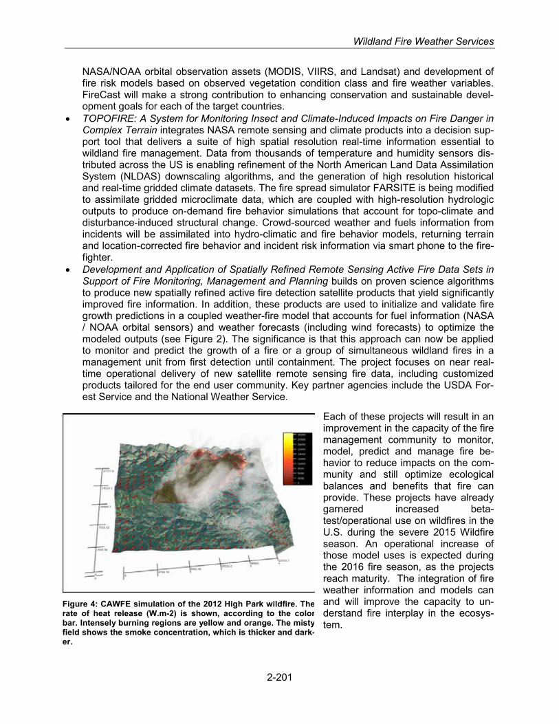
Wildland Fire Weather Services
NASA/NOAA orbital observation assets (MODIS, VIIRS, and Landsat) and development of fire risk models based on observed vegetation condition class and fire weather variables. FireCast will make a strong contribution to enhancing conservation and sustainable devel-opment goals for each of the target countries.
• TOPOFIRE: A System for Monitoring Insect and Climate-Induced Impacts on Fire Danger in Complex Terrain integrates NASA remote sensing and climate products into a decision sup-port tool that delivers a suite of high spatial resolution real-time information essential to wildland fire management. Data from thousands of temperature and humidity sensors dis-tributed across the US is enabling refinement of the North American Land Data Assimilation System (NLDAS) downscaling algorithms, and the generation of high resolution historical and real-time gridded climate datasets. The fire spread simulator FARSITE is being modified to assimilate gridded microclimate data, which are coupled with high-resolution hydrologic outputs to produce on-demand fire behavior simulations that account for topo-climate and disturbance-induced structural change. Crowd-sourced weather and fuels information from incidents will be assimilated into hydro-climatic and fire behavior models, returning terrain and location-corrected fire behavior and incident risk information via smart phone to the fire-fighter.
• Development and Application of Spatially Refined Remote Sensing Active Fire Data Sets in Support of Fire Monitoring, Management and Planning builds on proven science algorithms to produce new spatially refined active fire detection satellite products that yield significantly improved fire information. In addition, these products are used to initialize and validate fire growth predictions in a coupled weather-fire model that accounts for fuel information (NASA / NOAA orbital sensors) and weather forecasts (including wind forecasts) to optimize the modeled outputs (see Figure 2). The significance is that this approach can now be applied to monitor and predict the growth of a fire or a group of simultaneous wildland fires in a management unit from first detection until containment. The project focuses on near real-time operational delivery of new satellite remote sensing fire data, including customized products tailored for the end user community. Key partner agencies include the USDA For-est Service and the National Weather Service.
Each of these projects will result in an improvement in the capacity of the fire management community to monitor, model, predict and manage fire be-havior to reduce impacts on the com-munity and still optimize ecological balances and benefits that fire can provide. These projects have already garnered increased beta-test/operational use on wildfires in the U.S. during the severe 2015 Wildfire season. An operational increase of those model uses is expected during the 2016 fire season, as the projects reach maturity. The integration of fire weather information and models can and will improve the capacity to un-derstand fire interplay in the ecosys-tem.
Figure 4: CAWFE simulation of the 2012 High Park wildfire. The rate of heat release (W.m-2) is shown, according to the color bar. Intensely burning regions are yellow and orange. The misty field shows the smoke concentration, which is thicker and dark-er.
2-201

Section 2. Federal Meteorological Services and Supporting Research Programs
2-202

OTHER SPECIALIZED SERVICES
For purposes of this Federal Plan, Other Specialized Services include weather and climate information services and facilities established to meet the special needs of user agencies or constituencies not included in basic services or the preceding service categories. This ser-vice category includes any efforts to integrate the social sciences into meteorological opera-tions, applications, and services not already described in the preceding sections.
2-203
OPERATIONAL PROGRAMS INCLUDING PRODUCTS AND SERVICES
National Aeronautics and Space Administration
The National Aeronautics and Space Administration (NASA) provides operational weather sup-port to spaceflight operations through the Human Exploration and Operations Mission Direc-torate (HEOMD).
Kennedy Space Center Weather Office
The HEOMD Weather Projects at NASA Kennedy Space Center (KSC) has oversight responsi-bility for operation and maintenance of the weather information infrastructure required for NASA’s manned spaceflight programs, and Expendable Launch Vehicles (ELV) programs. The infrastructure is a multi-agency partnership between NASA, the Department of Defense (DOD), and the Department of Commerce (DOC), and includes NASA’s KSC, Marshall Space Flight Center (MSFC) and Johnson Space Center (JSC); the DOD’s US Air Force (USAF) 30th and 45th Space Wings; and the DOC’s National Oceanic and Atmospheric Administration (NOAA) National Weather Service (NWS) Spaceflight Meteorology Group (SMG). The KSC Weather Projects also provides daily staff meteorological support to KSC and NASA programs operating from KSC or the Eastern Range.
The ELV program operates from many locations, including Cape Canaveral Air Force Station (CCAFS) in Florida, Vandenberg Air Force Base (VAFB) in California, NASA Wallops Flight Fa-cility (WFF) in Virginia, the Alaska Aerospace Corporation Pacific Spaceport Complex – Alaska (PSCA) in Alaska, and the US Army Ronald Reagan Ballistic Missile Defense Test Site on Kwa-jalein Island. The KSC Weather Projects ensures that DOD weather support at DOD sites meets NASA requirements through training, technology, and tools. The KSC Weather Projects works with non-DOD sites and their weather service providers (such as the NWS or commercial com-panies) to provide similar assurance at those sites for NASA launches.
The KSC Weather Projects is the NASA lead for the joint NASA and USAF Lightning Advisory Panel (LAP), which provides independent scientific assessments of changes to the lightning launch commit criteria (LLCC) and technical guidance about lightning-related issues on facilities and ground operations. The Department of Transportation (DOT) Federal Aviation Administra-tion (FAA) utilizes the same criteria for lightning flight commit criteria (LFCC) at commercial spaceports.

Section 2. Federal Meteorological Services and Supporting Research Programs
In FY 2016, the KSC Weather Projects:
• Supported HEOMD through infrastructure and requirements concept studies for the Space Launch System (SLS), Multi-Purpose Crew Vehicle (MPCV), and Ground Systems Devel-opment and Operations (GSDO)
• Supported NASA ELV launches from the Eastern and Western Ranges, as well as commer-cial and DOD launches from the Eastern Range
• Supported infrastructure and concept of operations development for commercial launch pro-grams and NASA/WFF
• Supported the turnover, calibration and acceptance testing of the new Tropospheric Doppler Radar Wind Profiler (TDRWP; formally called the 50-MHz DRWP)
• Supported the Lightning System Upgrade (LSU) on the Eastern Range for data communica-tion and validation
• Continued assisting the FAA with sustainment of the LFCC for the commercial sector • Continued to work toward publishing an updated version of the LLCC Rationale document,
developing a NASA Standard document for the LLCC, and educating partners/stakeholders about the LAP and LLCC
In FY 2017, the KSC Weather Projects will:
• Continue to support the Launch Services Program and the International Space Station (ISS) program
• Continue to coordinate with NASA/WFF, PSCA, and other launch facilities in addition to the DOD Ranges
• Continue to support commercial launch operators in developing weather infrastructure, re-quirements, and concepts of operation
• Continue assisting the FAA with sustainment of the LFCC for the commercial sector • Support SLS, MPCV and GSDO through planning, design, test and operations of the test
flight programs • Continue to work with the Eastern Range and other Ranges to assure effective and efficient
meteorological services in support of vehicle processing, launch and recovery operations
Spaceflight Meteorology Group
The Space Meteorology Group (SMG) is located at NASA/JSC. In FY 2016, the SMG:
• Participated in planning meteorological support for MPCV future operations • Acted as meteorological consultant to NASA/JSC Flight Operations Directorate efforts for
the Commercial Crew Program (CCP) • Supported Orion parachute drop test events at Yuma Proving Ground, AZ, with surface and
upper wind forecasts • Supported NASA with enroute forecasts for recovery personnel flying roundtrip from Hou-
ston to Kazakhstan to retrieve U.S. astronauts returning from the ISS on the Russian Soyuz spacecraft
• Provided ongoing lightning and severe weather customized advisories for JSC manage-ment, weather sensitive operations, and employees
In FY 2017, the SMG will:
• Participate in NASA/JSC Mission Control Center (MCC) landing simulations for MPCV
2-204

Other Specialized Services
• Continue consultation with commercial crew mission scheduled to be controlled from the JSC MCC
• Implement AWIPS II enhancements focused on MPCV, other manned programs and JSC specific support
• Support Orion parachute drop test events at Yuma Proving Ground, AZ, with surface and upper wind forecasts
• Support NASA with enroute forecasts for recovery personnel flying roundtrip from Houston to Kazakhstan to retrieve U.S. astronauts returning from the ISS on the Russian Soyuz spacecraft
• Support the NASA/Langley Scientifically Calibrated in Flight Imagery (SCIFLI) project, as requested, by providing cloud forecasts for thermal imaging of commercial launch vehicles
• Provide lightning, severe weather, and tropical storm/hurricane customized advisories for JSC management, weather sensitive operations, and employees
The Space Radiation Analysis Group
The Space Radiation Analysis Group (SRAG) is located at JSC and is responsible for ensuring that the radiation exposure received by astronauts remains below established safety limits. SRAG is responsible for daily assessment of the space weather environment for human explo-ration, and works directly with flight control teams to assess real-time mission impacts of ad-verse space weather conditions. Some of the key space weather-related activities that SRAG is conducting in FY 2016 and FY 2017 include:
• Daily monitoring of the space weather environment and impact assessment for crewed mis-sions.
• Developing and maintaining protocols for radiation environment contingency response and analysis.
• Operating instruments both internal and external to crewed spacecraft for radiation environ-ment characterization, quantification and impact assessment.
• Building and processing of crew worn passive dosimeters and maintaining all crew radiation exposure records.
• Design and Development of next generation radiation sensors that reduce mass, volume, and power without compromising data integrity.
• Developing collaborations for maintaining necessary space radiation measurements for in-struments operating beyond planned lifetimes.
• Leading the development of space weather forecasting models. • Transitioning maturing space weather forecast models from research to operations. • Leading development of state-of-the-art radiation transport tools for vehicle design radiation
analysis. • Implementing state-of-the art radiation risk models used to ensure astronauts are within life-
time career radiation risk limits. • Providing annual, end-of-active service, and ad hoc astronaut radiation risk reports. • Providing planning and analyses of exploration class human exploration missions to ensure
radiation exposure limits are not exceeded and is kept ALARA given overall mission con-straints.
2-205

Section 2. Federal Meteorological Services and Supporting Research Programs
Marshall Space Flight Center
The Natural Environments Branch (NEB) develops and implements weather support require-ments for the SLS and other programs, including development and evaluation of launch con-straints.
In FY 2016, the NEB:
• Developed additional terrestrial environment specifications, as needed, and provided at-mospheric data and models for vehicle design, verification, and operation for the SLS and MPCV programs
• Developed day-of-launch ascent performance evaluation procedures relating to upper air wind and thermodynamic requirements, and supported launch commit criteria development for the SLS and MPCV programs
• Provided insight into the atmospheric data and models used for vehicle and operations de-sign for the CCP
In FY 2017, the NEB will:
• Continue to develop and improve atmospheric wind and thermodynamic climatological data sets and models for vehicle design and operational safety margin analysis for the SLS and MPCV programs
• Continue developing day-of-launch ascent performance evaluation procedures relating to upper air wind and thermodynamic requirements, and supporting launch commit criteria de-velopment for the SLS and MPCV programs
• Continue to provide insight into the atmospheric data and models used for vehicle and oper-ations design for the CCP
U.S. Air Force Space Launch Support
Air Force organizations provide meteorological and space weather products to the Nation’s space and missile programs, including a wide range of weather observing services at the Air Force Eastern Range and Kennedy Space Center (KSC). Air Force organizations also provide tailored forecasting for NASA’s manned and unmanned launches and for commercial launches from KSC. In addition, Air Force weather personnel provide specialized meteorological infor-mation for the Air Force Western Range at Vandenberg Air Force Base, California; the Pacific Missile Range, which includes Point Mugu and San Nicholas Island, California, and Barking Sands, Hawaii; White Sands Missile Range, New Mexico; Kwajalein Missile Range, Republic of the Marshall Islands; and other DoD research and test facilities as directed.
U.S. Army Space and Missile Defense Command
Support to the Ronald Reagan Ballistic Missile Defense Test Site (RTS)
The RTS meteorological services contractor provides support for range activities, including local and remote missile launches, missile weapons readiness testing, and aviation, marine, and emergency operations.
2-206

Other Specialized Services
A full suite of meteorological surface, upper air, satellite, radar, and lightning observing systems are available. Surface systems include an intra-atoll mesonet and an FAA-approved Automated Weather Observ-ing System (AWOS III-P/T), supporting range and International Civil Aviation Organization at Bucholtz Army Airfield (AAF) and an automatic meteorological observing system at Dyess AAF. Upper air sounding systems (1680 MHz), utiliz-ing Global Positioning System (GPS) radiosondes, are located on Kwajalein and Roi-Namur. One portable GPS up-per air system (403 MHz) is available to provide soundings at remote locations. A dual-polarized Doppler S-band weather radar provides weather surveillance from Kwajalein Island, and a Doppler C-band weather radar is available for operations at Wake Island. Both are volume-scanning radars that support prediction of lightning events. The Polar-orbiting Operational Environmental Satellite (POES) satellite receiver at Kwajalein is in the process of being replaced by a new X- and L-band dual frequency system that will provide the Range with multiple satellite capability for cloud detection, movement, analyses and one geostationary sat-ellite receiver, with data processing and analysis provided through McIDAS management and display supporting all systems. A low-gain lightning detection network of four sensors is availa-ble to the RTS meteorologist in support of Kwajalein Atoll. A thunderstorm sensor that includes a field mill supports lightning prediction and detection at Wake Island. One thunderstorm sensor is attached to the AWOS III-P/T at Bucholtz Army Airfield. RTS provides rocketsondes locally and at remote locations where radar tracking can support.
In cooperation with NASA Goddard Space Flight Center, RTS Weather continues to support global climate studies through Global Precipitation Measurement. Solar-Earth radiation fluxes monitoring with a suite of radiation measurements systems began in 1989 and are being reestablished by NOAA’S Earth Systems Research Laboratory (ESRL).
Figure 1: A rocketsonde launch on Kwajalein Atoll. U.S. Army Photo.
2-207
National Park Service/Fish and Wildfire Service
NPS Air Quality and Visibility Monitoring
The National Park Service (NPS) monitors air quality and visibility in a number of national parks and monuments. Gaseous pollutant data are collected on continuous and integrated (24-hour to weekly) bases. Surface meteorological data are collected and analyzed for hourly averages. Precipitation chemistry is determined on week-long integrated rainfall samples. Twenty-four-hour-average particle concentrations (mass, elemental analyses, some chemical constituent analyses) are measured every third day. Atmospheric light extinction is measured continuously and relayed to a central location for analyses.

Section 2. Federal Meteorological Services and Supporting Research Programs
Joint Air Quality Monitoring
The Fish and Wildlife Service (FWS) Air Quality Branch and the NPS Air Resources Division are located in Lakewood, Colorado. Expertise from both agencies is pooled to address the air quali-ty issues that are the responsibility of the Assistant Secretary of the Interior for Fish and Wildlife and Parks.
The NPS oversees the operation of the Interagency Monitoring of Protected Visual Environ-ments (IMPROVE) network and the IMPROVE Protocol network in cooperation with the Envi-ronmental Protection Agency (EPA), NOAA, the U.S. Forest Service (USFS), the FWS, the Bu-reau of Land Management, and various State organizations. Currently, the network has about 165 sites, mostly funded by the EPA in support of its regional haze regulations and through oth-er cooperators. The enhanced network allows a better characterization of visibility and fine par-ticle concentrations throughout rural and remote areas of the country (see figure below).
2-208
Figure 2: Map of one-year average standard visual range (SVR) from 2015, in kilometers, calculated from IMPROVE particle concentrations. Also shown are the locations of most of the IMPROVE and IMPROVE protocol sites in the contiguous U.S.
Nuclear Regulatory Commission
Assessments and evaluations of radiological impacts.
The Nuclear Regulatory Commission (NRC) continues to primarily be a user of meteorological information rather than perform research in the field. The NRC utilizes meteorological data to assess radiological impacts of routine airborne releases from facilities; to evaluate the impact of proposed changes in plant design and operation on unplanned and accidental releases; and to analyze the impacts of specific atmospheric conditions on various structures, systems, and components required to remain safe during operation at licensee facilities. The NRC also uses current meteorological information and climatological predictions of extreme meteorological

Other Specialized Services
events to evaluate new reactor designs and sites, as well as for existing and operating reactor locations. In FY 2016 and into 2017, the NRC continues to see a need for understanding rare phenomenon, such as maximum precipitation events.
Within the NRC, the Office of Nuclear Reactor Regulation and the Office of New Reactors con-duct safety reviews of nuclear power plant siting, design, construction, and operation. The Office of Nuclear Material Safety and Safeguards conducts similar reviews but of materials and waste facilities. In addition, the Office of New Reactors is also responsible for conducting environmen-tal reviews for environmental impact statements that pertain to new license applications and/or early site permit applications, as required by the National Environmental Policy Act of 1969. All of these reviews, both safety and environmental, include the consideration of air quality and me-teorological factors, regional climatology, and local meteorology. The staff within these NRC of-fices also conduct rulemaking activities to establish regulatory requirements and guidance, and the NRC Regional Offices ensure that NRC licensees comply with these regulatory require-ments.
SUPPORTING RESEARCH PROGRAMS AND PROJECTS
U.S. Army
U.S. Army Research Institute of Environmental Medicine
The U.S. Army Research Institute of Environmental Medicine (USARIEM) incorporates weather as an essential component in studying and modeling human physiology and biophysics, with the goal of improving Warfighter performance and minimizing health risks associated with environ-mental extremes. USARIEM and partners at U.S. Army Research Laboratory-White Sands Mis-sile Range (ARL-WSMR) are developing methodologies for integrating real-time local environ-mental data and Warfighter physiological data into predictive models and Soldier-scale weather forecasting. The effective combination of these two dynamic data streams will enable real-time predictions of environmental strain and physiological status for Warfighters.
National Park Service
Air Quality Research
The National Park Service (NPS) conducts research to develop and test air quality models to assess long-range transport, chemical transformation, and deposition of air pollutants. These models are used to estimate source contributions to, and to identify source regions responsible for, observed pollutant loadings.
The NPS is conducting research in the area of atmospheric nitrogen loading to high-elevation ecosystems in the Rocky Mountains, which have documented effects from nitrogen deposition. In conjunction with the Environmental Protection Agency, the NPS has been examining the bi-directional flux of ammonia in mountainous locations to ascertain the total loading to sensitive ecosystems.
A key focus of NPS research has been on visibility, as it affects the clarity and color of scenic views. Direct measurements of light scattering or relating atmospheric aerosol loading to light extinction properties are routinely used to quantify visibility. Photographs, however, are much more relatable to the average person. The NPS is exploring methods to provide quantitative
2-209

Section 2. Federal Meteorological Services and Supporting Research Programs
measurements from photographs. This can provide a powerful tool to communicate the effects of pollution on a scene to the public in a relatable way.
National Aeronautics and Space Administration
Applied Meteorology Unit
The Applied Meteorology Unit (AMU) is a joint venture between NASA, the USAF, and NOAA NWS. The AMU is co-located with the 45th Weather Squadron (45 WS) located at CCAFS. The AMU develops, evaluates, and transitions weather technology into operations.
In FY 2016, the AMU:
• Investigated lightning standoff distances to ensure safety while providing the maximum op-erational availability. Also, used clustering algorithms for initial development of an automat-ed lightning warning system.
• Provided new capability to several meteorological tools including the MetCast tool on AWIPS workstations, the lightning probability tool, the upper winds comparison tool, and the anvil cloud forecast tool. Also, performed tool troubleshooting and added improved docu-mentation.
• Expanded the 45 WS Weather Warning database project to consolidate weather warning metrics. Improved capability includes import of data from the Joint Environmental Toolkit (JET) into the database to produce monthly metrics as well as climatology.
• Is expanding the period of record of the existing Vandenberg wind tower climatology using data from December 2012 to September 2015
• Implemented a work around to increase the update time interval of the locally tuned AMU Weather Research and Forecasting (WRF) model when it stopped running in December. The AMU is replacing the damaged hardware.
• Created an Excel/Google Earth tool to plot 3-D trajectories so launch customers can view differences in location between the sounding balloon, TDRWP measurement and launch vehicle trajectory as well as the differences in the measured wind speeds.
• The AMU supported launch operations for 8 launches so far in FY2016: five Atlas V and three Falcon 9. The AMU expects to support 14 more launches in FY2016: four Atlas V, seven Falcon 9, and three Delta IV.
In FY 2017, the AMU will:
• Analyze and compare the upper level winds from the TDRWP against the CCAFS rawin-sonde data as part of the long-term operational acceptance test
• Continue development of an automated lightning warning system using lightning data, elec-tric field data and forecaster initialization
• Partner with the NWS Melbourne, FL, to develop a real-time triple-Doppler radar wind field display for operational analysis and model input
• Partner with other organizations to improve the locally tuned AMU WRF model • Support launch operations for Atlas V, Delta IV and Falcon 9
2-210
Other Specialized Services
Environmental Protection Agency
Air Quality Research
Meteorological support to the Environmental Protection Agency (EPA) Office of Research and Development and Office of Air and Radiation, EPA regional offices, and to State and local agencies includes the following activities:
• Conducting basic and applied research in air quality modeling • Conducting field studies for air quality model development and air quality model evaluations • Developing and applying multi-scale and multi-pollutant air quality models for pollution con-
trol, direct and indirect exposure assessments, and emission control strategy assessment • Reviewing of meteorological aspects of environmental impact statements, state implementa-
tion plans, and pollution variance requests • Providing Air Quality Index forecasts to state and local agencies for health advisory warn-
ings • Understanding the relationships between air quality and human health • Understanding the atmospheric loading of pollutants to sensitive ecosystems • Understanding the interactions of global climate change and air quality • Emergency response planning in support of homeland security
Meteorological expertise and guidance are also provided for developing the national air quality standards, modeling guidelines, and policy development activities of the EPA. In light of the 1990 Amendments to the Clean Air Act and the recent national rules, air quality models and the manner in which they are used are expected to continue to grow over the next few years. In the area of pollutant deposition, the evaluation of nitrogen, oxidant, sulfur, and aerosol chemistries will help to clarify the roles of model formulation, cloud processes, aerosols, radiative transfer, and air/surface exchanges in air quality model predictions, leading to a better understanding of model predictions relative to control strategy assessments. Further development and evaluation of existing air quality models will take place to accommodate the inter-pollutant effects, resulting from the variety of control programs that are now or may be in place, such as the new National Ambient Air Quality Standards for ozone and particulate pollution. These inter-pollutant effects include trade-offs among controls on ozone, sulfur oxides, nitrogen oxides, and volatile organic compounds, as well as developing predictable methods of forecasting the impacts on various measures of air quality.
With respect to the fine particulate model development, air quality models are being enhanced to accurately predict aerosol growth from precursors over local and regional-scale transport dis-tances. As the concentration thresholds for the standards decrease, it will be important to un-derstand intercontinental transport of pollution and how this would affect our ability to meet and maintain standards in the future. To assist in the evaluation of the contribution of various sources to regional air degradation, inert tracer and tagged species numerical models have been developed. These models will introduce separate calculations for inert or reactive chemical species emitted from a particular source or region. The calculations will proceed to simulate transport and transformation to a receptor point, where the contribution of emission sources can be discerned.
Atmospheric research, regarding the effects of climate change on regional air quality, involves both analytical and statistical climatology as well as linking global climate models with regional chemical transport models, and the development of coupled models to better simulate the inter-
2-211
Section 2. Federal Meteorological Services and Supporting Research Programs
actions between meteorology and atmospheric chemistry. Currently research is underway to test the efficacy of these models to accurately simulate the effects of aerosols on radiation.
Research in human exposure modeling includes both micro-environmental monitoring and modeling and the development of exposure assessment tools. This research entails linking air quality models to exposure models to understand the relationships between air quality and hu-man health. Micro-environmental algorithms are being developed based on field data to predict air quality in buildings, attached garages, and street canyons. These improved algorithms are then incorporated into micro-environmental simulation models for conducting human exposure assessments within enclosed spaces in which specific human activities occur.
In addition to the above major areas, dispersion models for inert, reactive, and toxic pollutants are under development and evaluation on all temporal and spatial scales; i.e., indoor, urban, complex terrain, mesoscale, regional, and global. Other efforts include modeling nutrient deposi-tion to the Chesapeake Bay and Gulf Coast, mercury deposition to the Florida Everglades, and the determination of meteorological effects on air quality. Atmospheric flow and dispersion ex-perimental data obtained from wind tunnel and convection tank experiments in the EPA Fluid Modeling Facility will be used to continue development and evaluation of these models along with providing researchers with insight into the basic physical processes that affect pollutant dispersion around natural and man-made obstacles. For example, the transport and dispersion of airborne agents in the Manhattan, New York, and the Pentagon were simulated in the wind tunnel to help build confidence in the modeling assessment of the source-receptor relationships for horrific events such as the one that occurred on September 11, 2001. The impacts of road-way configuration, noise barriers, and vegetation on air quality near roadways are being as-sessed, and improvements are being made to the EPA’s AERMOD model to better simulate the transport and dispersion of pollutants from roadways and building downwash.
Over the past 25 years, numerous air quality simulation models have been developed to esti-mate reductions in ambient air pollutant concentrations, resulting from potential emission control strategies. Separate models were developed, for example, for tropospheric ozone and photo-chemical smog, for acid deposition, and for fine particles. Distinct models also existed for ad-dressing urban scale problems and the larger regional scale problems. It has been recognized, however, that the various pollutant regimes are closely linked chemically, spatially, and tempo-rally in the atmosphere. The principal purpose of the Community Multi-scale Air Quality (CMAQ) modeling project was to develop a “one-atmosphere,” flexible environmental modeling tool that integrates the major atmospheric pollution regimes in a multi-scale, multi-pollutant modeling system. This system will enable high-level computational access to both scientific and air quality management users for socio-economic applications in community health assessments and eco-system sustainability studies.
The CMAQ model (first released in June 1998) is used by Federal and state agencies, industry, and academia and is updated periodically to reflect the state-of-science. The latest version of CMAQ, which includes science enhancements especially in the treatment of windblown dust, organic aerosols, and gas-phase photochemistry, is scheduled for release during the spring of 2017. It is also intended to serve as a community framework for continual advancement and for use in conducting environmental assessments. To this end, EPA has established a Community Modeling and Analysis System at the University of North Carolina in Chapel Hill, North Carolina, to provide user support and training to modelers at the state agencies and universities. New versions of the CMAQ modeling system and associated documentation (Installation and Opera-tions Manual, User Manual, Science Document, and tutorial) are publicly available. Additional information is available on the Laboratory website at http://www.epa.gov/nerl.
2-212

Other Specialized Services
From FY 2005 to FY 2008, the EPA worked closely with the NWS National Centers for Envi-ronmental Prediction (NCEP) in the continued development, evaluation, and use of a coupled meteorological-chemical transport model (WRF-CMAQ) for predicting ambient air quality over the continental United States. NWS implemented the CMAQ modeling system, to provide daily forecast guidance for ozone nationwide on an operational basis and fine particulate matter fore-cast on an experimental basis. State and local air quality management agencies are responsible to forecast local air quality and provide health advisory warnings.
The EPA, through participation in the interagency Information Technology Research and Devel-opment (IT R&D) Program, is developing a modeling framework that supports integration of di-verse models (e.g., atmospheric, land surface, and watershed). The EPA’s IT R&D work also enables increased efficiency in air quality-meteorological modeling through research on parallel implementation of the CMAQ modeling system. The evolving research seeks to improve the en-vironmental management community’s ability to evaluate the impact of air quality and watershed management practices, at multiple scales, on stream and estuarine conditions. The following primary objectives are directed toward this goal:
• Developing a prototype multiscale integrated modeling system with predictive meteorologi-cal capability for transport and fate of nutrients and chemical stressors
• Enabling the use of remotely sensed meteorological data • Developing a computer-based problem-solving environment with ready access to data,
models, and integrated visualization and analysis tools for water and air quality manage-ment, local and regional development planning, and exposure-risk assessments
A variety of research areas are being pursued such as the integration of hydrology and atmos-pheric models; coupling of meteorology and atmospheric chemistry calculations to account for the influence of radiatively active atmospheric pollutants on atmospheric dynamics and subse-quent effects on air pollution; enhanced atmospheric dry deposition models; multi-scale and spatially explicit watershed modeling tools; and model-coupling technology for integrating media and scale-specific models.
The EPA also maintains good working relationships with foreign countries to facilitate the ex-change of research meteorologists and research results, pertaining to meteorological aspects of air pollution. For example, agreements are currently in place with Canada, the United Kingdom, Greece, Japan, Korea, China, India, and Mexico, and with several European countries.
2-213

Section 2. Federal Meteorological Services and Supporting Research Programs
2-214

APPENDIX A: ACRONYMS
A-1

Appendix A - Acronyms
3DWF 3D [three dimensional] Wind Field [model] 4DWX Four-Dimensional Weather System AAWU Alaska Aviation Weather Unit ABO Atmospheric Baseline Observatories ABI GOES-R Advanced Baseline Imager ACC [USAF] Air Combat Command ACCESS Advancing Collaborative Connections for Earth System Science ACE Advance Composition Explorer AD Active Duty ADA Air Domain Awareness ADAS AWOS Data Acquisition System ADDS Aviation Digital Data Service ADM-Aeolus [ESA] Atmospheric Dynamics Atmospheric Dynamics Mission Aeolus
satellite AFB Air Force Base AFCENT Air Force Central Command AFI Air Force Instruction AFRC Air Force Reserve Command AFRI Agriculture and Food Research Initiative AFRL Air Force Research Laboratory AFW Air Force Weather AFWA Air Force Weather Agency AFWEPS Air Force Weather Ensemble Prediction Suite AFW-WEBS Air Force Weather Web Services AgriMet [Bureau of Reclamation] Agricultural Weather AHPS Advanced Hydrologic Prediction Service AIP Airport Improvement Program [FAA] AIRMoN Atmospheric Integrated Research Monitoring Network AMC U.S. Army Materiel Command AMS American Meteorological Society; [FAA] Acquisition Management
System; Autonomous Modular Sensor; Analysis and Modeling Subsystem
AMSR Advanced Microwave Scanning Radiometer AMSR-E [Aqua satellite] Advanced Microwave Scanning Radiometer-E AMSU A Advanced Microwave Sounding Unit – A AMU Applied Meteorology Unit ANG Air National Guard ANSP Air Navigation Service Provider AO Announcement of Opportunity AoA Analysis of Alternatives AOC [NOAA] Aircraft Operations Center AOML Atlantic Oceanographic and Meteorological Laboratory AOR Area of Responsibility ARL [NOAA] Air Resources Laboratory ARM Atmospheric Radiation Measurement Climate Research Facility ARS [USDA] Agricultural Research Service ARTCC Air Route Traffic Control Center ASCC Army Service Component Commands ASNE MSEA [DOD] Air and Space Natural Environment Modeling and Simulation
Executive Agent ASOS Automated Surface Observing System ASR Atmospheric System Research [activity in DOE/CESD]; Airport
Surveillance Radar ASR-11 Airport Surveillance Radar Model 11 ASR-9 Airport Surveillance Radar Model 9
A-2
Appendix A - Acronyms
ASWON Automated Surface Weather Observation Network ATCSCC Air Traffic Control System Command Center ATD atmospheric transport and dispersion ATDD Atmospheric Turbulence and Diffusion Division [NOAA] ATEC U.S. Army Test and Evaluation Command ATLAS Autonomous Temperature Line Acquisition System ATM Air Traffic Management ATO Air Traffic Organization [FAA] ATOP Advanced Technologies and Oceanic Procedures ATOS Applications, Transactions, and Observations Subsystem AVHRR Advanced Very High Resolution Radiometer AWC [NOAA/NECEP] Aviation Weather Center AWG Aviation Weather Group [FAA] AWIPS Advanced Weather Interactive Processing System AWOS Automated Weather Observing System AWOS III-P/T Automated Weather Observing System [variant of AWOS] AW-PO Army Weather Proponent Office AWRP Aviation Weather Research Program [FAA] AWRT Advanced Weather Radar Technique AWSD Aviation Weather Services Directorate AWSS Automated Weather Sensors Systems BASC Board on Atmospheric Sciences and Climate BCTP Battle Command Training Program BIA Bureau of Indian Affairs BLM Bureau of Land Management BOEM [DOI] Bureau of Ocean Energy Management BonD Battlespace on Demand C4I and Space Command, Control, Communication, Computers and Intelligence and
Space CAC [U.S. Army] Combined Arms Center CAgM [WMO] Commission for Agricultural Meteorology CALIPSO Cloud-Aerosol Lidar and Infrared Pathfinder Satellite Observations CAP Civil Air Patrol; Common Alerting Protocol CASR Committee for Aviation Services and Research CBRNE chemical, biological, radiological, nuclear, or explosive CCAFS Cape Canaveral Air Force Station CCMC Community Coordinated Modeling Center CCOG [NOAA] Center for Coasts, Oceans, and Geophysics CCSP U.S. Climate Change Science Program CDD [NOAA]Coastal Data Development CDMP Climate Database Modernization Program CDR climate data record CEDAR Coupling, Energetics, and Dynamics of Atmospheric Regions CEISC Committee on Environmental Information Systems and Communications CENR [NSTC] Committee on Environment and Natural Resources CENRS [NSTC] Committee on Environment, Natural Resources, and Sustainability CERIS Coastal, Estuary Resource Information System CESD Climate and Environmental Sciences Division [DOE Office of Science] CESM Community Earth System Model CFC chlorofluorocarbon CFSR Climate Forecast System Reanalysis CHARM Coupled Hydrosphere-Atmosphere Research Model CHPS Community Hydrologic Prediction System CI [NOAA]Cooperative Institute
A-3
Appendix A - Acronyms
CI-FLOW Coastal-Inland Flood Observation and Warning CICE DOE/OS/CESD sea ice model CICS Cooperative Institute for Climate and Satellites CICS-NC Cooperative Institute for Climate and Satellites North Carolina CIOS Committee for Integrated Observing Systems CIP Current Icing Product CISM Community Ice Sheet Model (DOE/OS/CESD) CJMTK Commercial Joint Mapping Tool Kit CLASS Comprehensive Large-Array data Stewardship System CLIVAR Climate Variability and Predictability Experiment CMAQ Community Multi-scale Air Quality CMAS Commercial Mobile Alert System CMD-P Computer Meteorological Data-Profiler CME coronal mass ejection(s) CMIP5 Coupled Model Intercomparison Project Phase 5 CMS Carbon Monitoring System CNES Centre National d’Etudes Spatiales CNMOC Commander, Naval Meteorology and Oceanography Command CNO Chief of Naval Operations CPCE Command Post Computing Environment COAMPS Coupled Ocean/Atmosphere Mesoscale Prediction System COAS North American Carbon Observation and Analysis System COASTAL Coastal Oceanographic Applications and Services for Tides and Lakes COASTAL Act [2012] Consumer Option for an Alternative System to Allocate Losses CoCoRaHS Community Collaborative Rain, Hail, and Snow [network] COE Corps of Engineers COLA Center for Ocean-Land-Atmosphere Studies COMNAVMETOCCOM Naval Meteorology and Oceanography Command CONPLAN Concept of Operations Plan COOP Cooperative Observer Program CO-OPS Center for Operational Oceanographic Products and Services COPC Committee for Operational Processing Centers CORMS Continuous Operational Real-time Monitoring System COSIM Climate, Ocean and Sea Ice Modeling Project COSMIC-2 Constellation Observing System for Meteorology Ionosphere and
Climate-2 CPC Climate Prediction Center CPP Command Post Platform CSD [NOAA/NWS] Climate Services Division CSED [DOE] Climate and Environmental Services Division CSESMO Committee for Space Environmental Sensor Mitigation Options CVA Ceiling and Visibility, Analysis [FAA/AWRP] CVF Ceiling and Visibility, Forecast [FAA/AWRP] CWDP Commerical Weather Data Pilot CWSU Center Weather Service Unit DAC [AOML] Data Assembly Center; Department of the Army Civilian DAPE Data Acquisition, Processing, and Exchange DART Deep-ocean Assessment and Reporting of Tsunamis DASI Digital Altimeter Setting Indicator DATM Defense Information Switched Network Asynchronous Transfer Mode
System DCGS-A Distributed Common Ground System-Army DEM digital elevation model DHS U.S. Department of Homeland Security DMCC DOE Meteorological Coordinating Council
A-4
Appendix A - Acronyms
DMSP Defense Meteorological Satellite Program DNF Defense Nuclear Facilities DOC U.S. Department of Commerce DOD U.S. Department of Defense DOE U.S. Department of Energy DOI U.S. Department of the Interior DOMSAT domestic communication satellite DOS U.S. Department of State DOT U.S. Department of Transportation DOTMLPF doctrine, organization, training, materiel, leadership, education,
personnel, and facilities DPG Dugway Proving Ground DSCOVR Deep Space Climate Observatory DSD [NOAA] Data Stewardship Division DTC Developmental Test Center; [U.S. Army] Developmental Test Command DTRA Defense Threat Reduction Agency DTSS Digital Topographic Support System DWL Doppler wind lidar EAS Emergency Alert System ECMT Enterprise Configuration Management Tool EcoFOCI Ecosystem-Fisheries Oceanography Coordinated Investigations ECV Essential Climate Variables EdIWG [CCSP] Education Interagency Working Group EERE [DOE] Office of Energy Efficiency and Renewable Energy ELV Expendable Launch Vehicle(s) EM electromagnetic EMC [NOAA/NCEP] Environmental Modeling Center EMI SIG Emergency Management Issues Special Interest Group EMSL Environmental Molecular Sciences Laboratory EMW Electromagnetic Maneuver Warfare ENSO El Nino-Southern Oscillation EOSDIS Earth Observing System Data and Information System EPA U.S. Environmental Protection Agency EPI Enhanced Precipitation Identification ERAM En Route Automation Modernization ERC [hurricane] eyewall replacement cycles ERDC [USACE] Engineer Research and Development Center EROS [USGS] Earth Resources Observation and Science [center] ESA European Space Agency ESM [DOE/OS/CESD] Earth System Models ESPC Earth System Prediction Capability ESRL Earth System Research Laboratory ESS Environmental Sensor Station(s) ESTO [NASA] Earth Science Technology Office ET evapotranspiration EUMETSAT European Organisation for the Exploitation of Meteorological Satellites FA [BLM] Fire and Aviation Directorate FAA Federal Aviation Administration FAR false alarm rate FCAMMS Fire Consortia for Advanced Modeling of Meteorology and Smoke FCMSSR Federal Committee for Meteorological Services and Supporting Research FEC Fire Executive Council FEMA Federal Emergency Management Agency
A-5

Appendix A - Acronyms
FFMP Flash Flood Monitoring and Prediction FHWA Federal Highway Administration FIP Forecast Icing Product FMF Fleet Marine Force FNMOC Navy Fleet Numerical Meteorology and Oceanography Center FOR Flight Operations Review FPAW Friends/Partners in Aviation Weather FRA Federal Railroad Administration FRD [NOAA/ARL] Field Research Division FSR Forest Service Research FTE full-time equivalent FWS U.S. Fish and Wildlife Service FY fiscal year GACC Geographic Area Coordinating Center GBS Global Broadcast Service GCOS Global Climate Observing System GEM Geospace Environment Modeling GEO Group on Earth Observations GEOSS Global Earth Observation System of Systems GFDL Geophysical Fluid Dynamics Laboratory [NOAA-associated] GFDN Geophysical Fluid Dynamics Navy [model] GHCN-M Global Historical Climatology Network-Monthly GIS geographic information system GLD Global Lagrangian Drifters GLERL Great Lakes Environmental Research Laboratory GLOBE Global Learning and Observations to Benefit the Environment GMD [NOAA/OAR/ESRL] Global Monitoring Division GODAE Global Ocean Data Assimilation Experiment GOES Geostationary Operational Environmental Satellite GOES-R Geostationary Operational Environmental Satellite R GOOS Global Ocean Observing System GOSIC Global Observing Systems Information Center GPM Global Precipitation Measurement Mission GPS Global Positioning System GPS-Met GPS-Meteorology GRA GOOS Regional Alliances GRIP Genesis and Rapid Intensification Processes [NASA project] GSD [ESRL] Global Systems Division GTGN Graphical Turbulence Guidance Nowcast GTOS Global Terrestrial Observing System GTS Global Telecommunications System HALE high altitude, long-endurance [UAS] HAZUS Multi-Hazard Loss Estimation Methodology HCFC hydrochlorofluorocarbon HEL high-energy laser HELSTF High Energy Laser Systems Test Facility HEOMD Human Exploration and Operations Mission Directorate (HEOMD) HF high frequency HFIP Hurricane Forecast Improvement Project HFPP HRD Field Program Plan HHWWS Heat Health Watch Warning Systems HIWPP High Impact Weather Prediction Project HMR [Nuclear Regulatory Commission] hydrometeorological report(s) HMT Hydrometeorological Testbed
A-6

Appendix A - Acronyms
HPC High Performance Computing HPC [NPAA/NCEP] Hydrometeorological Prediction Center HPCMP [DOD] High Performance Computing Modernization Program HQDA Headquarters, Department of the Army HRD [NOAA/OMAO] Hurricane Research Division HRRR High Resolution Rapid Refresh HSPD Homeland Security Presidential Directive HS3 [NASA] Hurricane Severe Storm Sentinel HWRF Hurricane Weather Research and Forecasting HYPOP Hybrid Coordinate Parallel Ocean Program [DOE model] HYSPLIT Hybrid Single Particle Lagrangian Integrated Trajectory [ATD model] IBTrACS International Best Track Archive for Climate Stewardship ICAO International Civil Aviation Organization ICESCAPE Impacts of Climate on Ecosystems and Chemistry of the Arctic Pacific
Environment ICMSSR Interdepartmental Committee for Meteorological Services and Supporting
Research ICOADS International Comprehensive Ocean-Atmosphere Data Set IDSS Impact-Based Decision Support Services IFEX Intensity Forecast Experiment IFOR Information Warfare Type Command IHC Interdepartmental Hurricane Conference IIP International Ice Patrol IMAAC Interagency Modeling and Atmospheric Assessment Center IMET Incident Meteorologist IMETS Integrated Meteorological System IMPROVE Interagency Monitoring of Protected Visual Environments [program] INL Idaho National Laboratory INSITE Integrated Support for Impacted Air Traffic Environments IPAWS Integrated Public Alert and Warning System IPB intelligence preparation of the battlespace IPCC Intergovernmental Panel on Climate Change IPE intelligence preparation of the environment IRTSS Infrared Target Scene Simulator ISCS International Satellite Communications System ISES International Space Environment Service ISMS [DOE] Integrated Safety Management System ISR intelligence, surveillance, and reconnaissance ISS International Space Station IT information technology IT R&D Information Technology Research and Development [Program] ITS Intelligent Transportation Systems ITWS Integrated Terminal Weather System IWEDA Integrated Weather Decision Aid IWGCCST Interagency Working Group on Climate Change Science and Technology IWP Integrated Water Prediction IWRSS Integrated Water Resources Science and Services JAG Joint Action Group JAG/ADM Joint Action Group on Architecture and Data Management JAG/CAPSA Joint Action Group for COASTAL Act Post-Storm Analysis JAG/CCM Joint Action Group for Centralized Communications Management JAG/JUTB Joint Action Group for Joint Urban Test Beds JAG/MD Joint Action Group on Metadata JAG/OCM Joint Action Group for Operational Community Modeling
A-7
Appendix A - Acronyms
JAG/ODAA Joint Action Group for Operational Data Acquisition for Assimilation JAWF Joint Agricultural Weather Facility JAWS Juneau Airport Wind System JCIDS Joint Capabilities Integration and Development System JCSDA Joint Center for Satellite Data Assimilation JHT Joint Hurricane Testbed JPDO Joint Planning and Development Office JPSS Joint Polar Satellite System JSC [NASA] Johnson Space Center JTTI Joint Technology Transfer Initiative JTWC Joint Typhoon Warning Center KDP Key Decision Point KSC [NASA] Kennedy Space Center KSCWO SOMD Weather Office at NASA Kennedy Space Center LAN local area network LAP Lightning Advisory Panel LBS Littoral Battlespace Sensing LDCM Landsat Data Continuity Mission LIDAR light detection and ranging LLCC lightning launch commit criteria LLWAS Low Level Wind shear Alerting System LLWAS-NE LLWAS Network Expansion LRGS [USGS] local readout ground station(s) M&O management and operating MACPEX Mid-latitude Airborne Cirrus Properties Experiment MADA Monsoon Area Drought Atlas MADIS Meteorological Assimilation Data Ingest System MAGTF Marine Air Ground Task Force MALE medium altitude, long endurance [UAS] MASPS Minimum Aviation Safety Performance Standards MAW Marine Aircraft Wing MEF Marine Expeditionary Force MET meteorological; Meteorology and Oceanography MetMF(R) Meteorological Mobile Facility-Replacement METOC meteorological and oceanographic METOP Meteorological Operational Polar METSAT meteorological satellite MM5 Mesoscale Model Version 5 MMS-P Meteorological Measurement Set-Profiler MOC [NextGen] Mid-term Operational Capability MODIS Moderate Resolution Imaging Spectroradiometer MOPS Minimum Operations Standards MOU memorandum of understanding MPAR multifunction phased array radar MPCV Multipurpose Crew Vehicle MRMS [FAA/AWRP] Multi-Radar Multi-Sensor [capability] MSFC Marshall Space Flight Center MST METOC Support Team MTOE Modified Table of Organization and Equipment MTSAT [Japanese] Multifunctional Transport Satellite MWPI Microburst Windspeed Potential Index MWSG Marine Wing Support Group MWSS Marine Wing Support Squadron
A-8
Appendix A - Acronyms
NAAMES North Atlantic Aerosols and Marine Ecosystems NADM North American Drought Monitor NADP National Atmospheric Deposition Program NAO NOAA Administrative Order; North Atlantic Oscillation NAPA National Academy of Public Administration NAS National Airspace System NASA National Aeronautics and Space Administration NASS National Agricultural Statistics Service NAVOCEANO Naval Oceanographic Office NAVOCEANOPSCOM Naval Oceanography Operations Command NBC nuclear, biological, and chemical NCA National Climate Assessment NCAR National Center for Atmospheric Research NCDC National Climatic Data Center NCEI [NOAA]National Centers for Environmental Inforamation NCEP National Centers for Environmental Prediction NCO NCEP Central Operations NCOM Navy Coastal Ocean Model NCV National Ceiling and Visibility [FAA/AWRP Product Team] NCWCP NOAA Center for Weather and Climate Prediction NDBC National Data Buoy Center NDFD National Digital Forecast Database NDMC National Drought Mitigation Center NEB Natural Environments Branch [MSFC] NEMS NOAA Environmental Modeling System NESDIS [NOAA] National Environmental Satellite, Data, and Information Service NEXION NEXt-generation IONosonde NEXRAD Next-Generation Weather Radar NextGen Next Generation Air Transportation System NFDRS National Fire Danger Rating System NFIP National Flood Insurance Program NGA National Geospatial-Intelligence Agency NGDC National Geophysical Date Center NGEE Next-Generation Ecosystem Experiments NGGPS Next Generation Global Prediction System NHC [NCEP] National Hurricane Center NICC National Interagency Coordination Center NIDIS National Integrated Drought Information System NIFA National Institute for Food and Agriculture NIFC National Interagency Fire Center NITES Navy Integrated Tactical Environmental System NNEW NextGen Network Enabled Weathe NNSA National Nuclear Security Administration NOAA National Oceanic and Atmospheric Administration NOCMP National Operational Coastal Modeling Program NODC National Oceanographic Data Center NOGAPS Navy Operational Global Atmospheric Prediction System NOHRSC National Operational Hydrologic Remote Sensing Center NOMADS National Operational Model Archive and Distribution System NOP Naval Oceanography Program NOPC National Operational Processing Centers Program Council NORAD North American Aerospace Defense Command NOS National Ocean Service NOWCON Network of Weather and Climate Observing Networks
A-9

Appendix A - Acronyms
NPDIA National Plan for Disaster Impact Assessments: Weather and Water Data
NPOESS National Polar-orbiting Operational Environmental Satellite System NPP NPOESS Preparatory Project NPRB North Pacific Research Board NPS National Park Service NRC Nuclear Regulatory Commission; National Research Council NRC/NLSC [DoD] National Reconditioning Center and National Logistics Support
Center NRCC [FEMA] National Response Coordination Center NRCS Natural Resources Conservation Service NRL Naval Research Laboratory NRL/MRY Marine Meteorology Division of the Naval Research Laboratory [NRL
Monterey] NTWC National Tsunami Warning Center NSF National Science Foundation NSIP National Streamflow Information Program NSIR Office of Nuclear Security and Incident Response NSPD National Security Presidential Directive NSSL [NOAA] National Severe Storm Laboratory NSWP National Space Weather Program NSWRC NextGen Surveillance and Weather Radar Capability NTAS Northwest Tropical Atlantic Station NTHMP National Tsunami Hazard Mitigation Program NUOPC National Unified Operational Prediction Capability NWC National Weather Center NWCG National Wildfire Coordinating Group NWIS National Water Information System NWLON National Water Level Observation Network NWM Numerical Weather Modeling NWP numerical weather prediction NWR NOAA Weather Radio NWRT National Weather Radar Testbed NWS [NOAA] National Weather Service NWSTG NWS Telecommunications Gateway OAR [NOAA] Office of Oceanic and Atmospheric Research OCE (USDA) Office of the Chief Economist OCIO [NOAA] Office of Chief Information Officer ODCS [U.S. Army] Office of the Deputy Chief of Staff OEP Operational Evolution Partnership [FAA airport designation] OFA [BLM] Office of Fire and Aviation OFCM Office of the Federal Coordinator for Meteorological Services and
Supporting Research OGC Open Geospatial Consortium OMAO [NOAA] Office of Marine and Aviation Operations OMB Office of Management and Budget ONR Office of Naval Research OPC Ocean Prediction Center OSPO [NOAA] Office of Satellite Product Operations OSSE observing system simulation experiment OSTEP Ocean Systems Test and Evaluation Program OSTM Ocean Surface Topography Mission OSTP Office of Science and Technology Policy OTN [Defense Information Systems Agency] Optical Transport Network OTSR Optimum Track Ship Routing
A-10
Appendix A - Acronyms
OWAQ Office of Air and Water Quality OWS [USAF] Operational Weather Squadron P3I Pre-Planned Product Improvement PACAF Pacific Air Forces PARISE Phased Array Radar Innovative Sensing Experiment PCMDI Program for Climate Model Diagnosis and Intercomparison PFO Polar Follow On PFHA probabilistic flood hazard assessment PLAN Personal Localized Alert Network PMEL Pacific Marine Environmental Laboratory PMM [NASA] Precipitation Measurement Missions PMP probable maximum precipitation PNE PIRATA Northeast Extension [project] PNT Positioning, navigation, and timing POD probability of detection POES Polar-orbiting Operational Environmental Satellite POP Parallel Ocean Program [DOE/OS/CESD model] POPS Primary Oceanographic Prediction System PORTS® Physical Oceanographic Real-Time System PPA Projects, Planning and Analysis PREDICT Pre-Depression Investigation of Cloud-systems in the Tropics PRISM Parameter-Elevation Regressions on Independent Slopes Model PSD [ESRL] Physical Sciences Division PTWC Pacific Tsunami Warning Center PVM Profiler Virtual Module QPE quantitative precipitation estimation(s) QPF quantitative precipitation forecast R&D research and development R2O Research to Operations RAP Rapid Refresh RASCAL Radiological Assessment System for Consequence Analysis RAWS Remote Automated Weather Stations (network) RBSP Ring Current, Radiation Belts, Solar Particles [satellite] RDT&E research development, test, and evaluation READY Real-time Environmental Applications and Display sYstem RES Office of Nuclear Regulatory Research RFC [NWS] River Forecast Center RGCM Regional and Global Climate Modeling [in DOE/OS/CESD] RIMS Radio Interference Measuring Set RMA Risk Management Agency ROC radar operations center ROMANS Rocky Mountain Atmospheric Nitrogen and Sulfur ROSES [NASA] Research Opportunities in Space and Earth Sciences RPA Remotely Piloted Aircraft RSMC Regional Specialized Meteorological Center RSTN Radio Solar Telescope Network RTC Redstone Test Center RTS Ronald Reagan Ballistic Missile Defense Test Site RTVS Real-Time Verification System RUC Rapid Update Cycle [NWS forecast model] RVR Runway Visual Range RWI Reduce Weather Impact RWMP Road Weather Management Program
A-11
Appendix A - Acronyms
SAFETEA-LU Safe, Accountable, Flexible, Efficient Transportation Equity Act: A
Legacy for Users SAR synthetic aperture radar SAS [NextGen] Single Authoritative Source SAWS Stand Alone Weather Sensors [FAA] SCAN Soil Climate Analysis Network SCAP Security Certification and Accreditation Package SCAPA Subcommittee for Consequence Assessment and Protective Actions SDAA [USDA] Strategic Data Acquisition and Analyses SDO Solar Dynamics Observatory SDR [CENRS] Subcommittee on Disaster Reduction SEBN Surface Energy Budget Network SEES Science, Engineering and Education for Sustainability SEM Space Environment Monitor SEON Solar Electro-optical Observing Network SERVIR Sistema Regional de Visualizacion y Monitoreo [NASA network] SESAR Single European Sky ATM Research SFMR stepped frequency microwave radiometer SGOT Strike Group Oceanography Team SGS Satellite Ground Services SHINE Solar, Heliospheric, and Interplanetary Environment SICPS Standard Integrated Command Post Shelter SIP Societal Impacts Program SIR System Integration Review SLEP Service Life Extension Program SLOSH Sea, Lake and Overland Surges from Hurricanes [storm surge model] SMAP [NASA] Soil Moisture Active-Passive [Satellite Mission] SMD [NASA] Science Mission Directorate SMDC [U.S. Army] Space and Missile Defense Command SMG [NWS] Spaceflight Meteorology Group SNOTEL SNOw pack TELemetry S-NPP Suomi National Polar Partnership satellite SOF Special Operations Forces SOHO Solar and Heliospheric Observatory SOMD [NASA] Space Operations Mission Directorate SOON Solar Observing Optical Network SOOP Ship of Opportunity Program SORD [NOAA/ARL] Special Operations and Research Division SOS Science On a Sphere® SPAWAR [US Navy] Space and Warfare Systems Command SPC [NCEP] Storm Prediction Center SPoRT [NASA] Short-term Prediction Research and Transition center SRS Solar Radio Spectrograph SST sea surface temperature SSWSF Snow Survey and Water Supply Forecasting Program STAR Center for Satellite Applications and Research STEM Science, Technology, Engineering, and Mathematics STEREO Solar Terrestrial Relations Observatory STIWG Satellite Telemetry Interagency Working Group STO Stience and Technology Objectives SWA [BLM] Soil, Water, and Air SWAFS Space Weather Analysis and Forecast System SWEF Space Weather Enterprise Forum SWIM [NextGen] System Wide Information Management SWPC Space Weather Prediction Center
A-12

Appendix A - Acronyms
SWSI State Surface Water Supply Index(es) TAF Terminal Aerodrome Forecast TAO Tropical Atmosphere-Ocean [Project] TAO/TRITON Tropical Atmosphere-Ocean/TRIangle Trans-Ocean buoy Network TAWS Target Acquisition Weapons Software TDA Tactical Decision Aid TDWR Terminal Doppler Weather Radar TFCC Task Force Climate Change T-IWEDA Tri-Service Integrated Weather Effects Decision Aid TMC traffic management center TOC Tactical Operations Center TOE Table of Organization and Equipment TOLNet Tropospheric Ozone Lidar Network TRADOC U.S. Army Training and Doctrine Command TRMM Tropical Rainfall Measuring Mission TSG thermosalinograph TSO Technical Standard Order [FAA] UAS unmanned aircraft systems; unmanned aerial systems UCAR University Corporation for Atmospheric Research UHF ultrahigh frequency UM Unified Model UNEP United Nations Environment Program UNFCCC United Nations Framework Convention on Climate Change UNOLS University-National Oceanographic Laboratory System UNSWC Unified National Space Weather Capability URI University of Rhode Island USA U.S. Army USACE U.S. Army Corps of Engineers USAF U.S. Air Force USAICoE U.S. Army Intelligence Center of Excellence USARNORTH U. S. Army North USASMDC U.S. Army Space and Missile Defense Command USCG U.S. Coast Guard USCRN U.S. Climate Reference Network USDA U.S. Department of Agriculture USDM U.S. Drought Monitor USFF U.S. Fleet Forces Command USFS U.S. Forest Service USGCRP U.S. Global Change Research Program USGS U.S. Geological Survey USHCN U.S. Historical Climatology Network USNO U.S. Naval Observatory USNORTHCOM U.S. Northern Command USWRP U.S. Weather Research Program UV ultraviolet VAAC Volcanic Ash Advisory Center VAFB Vandenberg Air Force Base VFR visual flight rules VORTEX2 Verification of the Origins of Rotation in Tornadoes Experiment 2 VOS Volunteer Observing System W&ACR Weather and Air Chemistry Research WAFS World Area Forecast System
A-13

Appendix A - Acronyms
WAMIS World AgroMeteorological Information Service WAOB World Agricultural Outlook Board WARP Weather And Radar Processor [FAA] WASDE World Agricultural Supply and Demand Estimates [report] WC/ATWC West Coast/Alaska Tsunami Warning Center WDA [USAF] Weather Data Analysis WEBB Water, Energy, and Biogeochemical Budgets WFDSS Wildland Fire Decision Support System WFIP Wind Forecast Improvement Project WFIP 2 Wind Forecasting Improvement Project in Complex Terrain WFO National Weather Service Forecast Office WG/CSAB Working Group for Cooperative Support and Backup WG/DIAP Working Group for Disaster Impact Assessments and Plans: Weather
and Water Data WG/OD Working Group for Observational Data WG/TBC Working Group for Test Bed Coordination WG/UM Working Group for Urban Meteorology WG/VA Working Group on Volcanic Ash WG/WIST Working Group on Weather Information for Surface Transportation WGA Western Governors’ Association WHDE Wind Hazard Detection Equipment WIFS WAFS Internet File Service WIMS weather information management system WIS WMO Information Service WMO World Meteorological Organization WoF Warn on Forecast [Program] WP Work Product WPC Weather Prediction Center WRAP Wildfire Research and Applications Partnership WRD [USGS] Water Resources Discipline WRE-N Weather Running Estimate-Nowcasts WRF Weather Research and Forecasting WRN Weather-Ready Nation WRTM Weather-Responsive Traffic Management WS [USAF] Weather Squadron WSDS Wind Shear Detection Services WS-LVC Weather Services – Live, Virtual, Constructive WSP [FAA] Weather Systems Processor WSR-88D Weather Surveillance Radar-1988 Doppler WTIC Weather Technology in the Cockpit WUI Wildland-Urban Interface WW3 Wave Watch III [model] WWCB Weekly Weather and Crop Bulletin WWLLN World Wide Lightning Locator Network WXG [USAF] Weather Group XBT Expendable BathyThermograph [Program]
A-14

Agency Points of Contact U.S. Department of Agriculture Mr. Mark Brusberg Dr. Harlan Shannon Department of Commerce National Oceanic and Atmospheric Administration Mr. Christopher Botnick National Environmental Satellite Data and Information Service Ms. Kelly Turner Ms. Lauren Jones National Ocean Service Mr. Darren Wright Mr. Jason Shadid National Weather Service Mr. Patrick Nield Ms. Sasha Pryborowski Office of Oceanic and Atmospheric Research Mr. Richard Fulton Ms. Melissa Pratt-Zossoungbo Office of Marine and Aviation Operations Ms. Linda Mallinoff Ms. Patricia Baxter Department of Defense Lt Col Daniel Weekley Ms. Marsha Korose U.S. Air Force Col Fred Williams U.S. Navy Mr. Philip Vinson U.S. Marine Corps Lt. Col. Jeff Wooldridge U.S. Army Mr. William Spendley Department of Energy Mr. Rick Petty Mr. Jose Maisonet Mr. Vaughn Standley Mr. Joel Cline Department of Homeland Security Federal Emergency Management Agency Mr. Daniel Porter (NOAA Liaison) U.S. Coast Guard Dr. Jonathan Berkson Department of the Interior U.S. Geological Survey Mr. Robert Mason Ms. Carol Finn National Park Service Mr. John Vimont Bureau of Land Management • Office of Fire and Aviation Mr. Grant Beebe • Office of Soil Water and Air Mr. McKinley Ben Miller Department of State Dr. David Reidmiller Department of Transportation Federal Aviation Administration Mr. Richard Lee Federal Highway Administration Mr. Paul Pisano Federal Railroad Administration Mr. Jared Withers Environmental Protection Agency Dr. Rohit Mathur Mr. Thomas Pierce National Aeronautics and Space Administration Dr. Tsengdar Lee Ms. Elizabeth Yoseph National Science Foundation Mr. Nicholas Anderson Nuclear Regulatory Commission Ms. Amy Sharp Smithsonian Institution Dr. Benjamin Andrews