Embed Size (px)
DESCRIPTION
The SouthGate site lies between the River Avon and the southern defences of Roman and later Bath. This volume describes the evolution of the local Avon flood plain from the Pleistocene to the 20th century. Highlights include a large Early and Late Mesolithic lithic assemblage, Anglo-Saxon extramural activity, the Norman and later development of the Southgate suburb, and an artificial watercourse which eventually became an open sewer known as the Bum Ditch. Later periods give glimpses of a low-status area that provided goods, food and services to the more familiar wealthy Georgian city, the ‘Baedeker’ air raids and the Beatles.To purchase a copy of this book visit the MOLA website (http://ow.ly/M0lYD)
Citation preview
M U S E U M O F L O N D O N A R C H A E O L O G Y M O N O G R A P H 6 8
MOLA
The evolution and exploitation of
the Avon flood plain at Bath and the
development of the southern suburbExcavations at SouthGate, Bath, 2006–9
Bruno Barber with Craig Halsey, Marek Lewcun and Christopher Phillpotts

The evolution and exploitation of theAvon flood plain at Bath and thedevelopment of the southern suburb
Excavations at SouthGate, Bath, 2006–9

MOLA Monograph Series
For more information about these titles and other MOLA publications visit thepublications page at www.mola.org.uk
1 Excavations at the priory and hospital of St Mary Spital, London
2 The National Roman Fabric Reference Collection: a handbook
3 The Cross Bones burial ground, Redcross Way, Southwark, London: archaeologicalexcavations (1991–8) for the London Underground Limited Jubilee Line Extension Project
4 The eastern cemetery of Roman London: excavations 1983–90
5 The Holocene evolution of the London Thames: archaeological excavations (1991–8) forthe London Underground Limited Jubilee Line Extension Project
6 The Limehouse porcelain manufactory: excavations at 108 –116 Narrow Street, London,1990
7 Roman defences and medieval industry: excavations at Baltic House, City of London
8 London bridge: 2000 years of a river crossing
9 Roman and medieval townhouses on the London waterfront: excavations at Governor’sHouse, City of London
10 The London Charterhouse
11 Medieval ‘Westminster’ floor tiles
12 Settlement in Roman Southwark: archaeological excavations (1991–8) for the LondonUnderground Limited Jubilee Line Extension Project
13 Aspects of medieval and later Southwark: archaeological excavations (1991 –8) for theLondon Underground Limited Jubilee Line Extension Project
14 The prehistory and topography of Southwark and Lambeth
15 Middle Saxon London: excavations at the Royal Opera House 1989–99
16 Urban development in north-west Roman Southwark: excavations 1974–90
17 Industry in north-west Roman Southwark: excavations 1984–8
18 The Cistercian abbey of St Mary Stratford Langthorne, Essex: archaeologicalexcavations for the London Underground Limited Jubilee Line Extension Project
19 Material culture in London in an age of transition: Tudor and Stuart period finds c 1450–c 1700 from excavations at riverside sites in Southwark
20 Excavations at the priory of the Order of the Hospital of St John of Jerusalem,Clerkenwell, London
21 Roman and medieval Cripplegate, City of London: archaeological excavations 1992–8
22 The royal palace, abbey and town of Westminster on Thorney Island: archaeologicalexcavations (1991–8) for the London Underground Limited Jubilee Line Extension Project
23 A prestigious Roman building complex on the Southwark waterfront: excavations atWinchester Palace, London, 1983–90
24 Holy Trinity Priory, Aldgate, City of London: an archaeological reconstruction andhistory
25 Roman pottery production in the Walbrook valley: excavations at 20–28 Moorgate,City of London, 1998–2000
26 Prehistoric landscape to Roman villa: excavations at Beddington, Surrey, 1981–7
27 Saxon, medieval and post-medieval settlement at Sol Central, Marefair, Northampton:archaeological excavations 1998–2002
28 John Baker’s late 17th-century glasshouse at Vauxhall
29 The medieval postern gate by the Tower of London
30 Roman and later development east of the forum and Cornhill: excavations at Lloyd’sRegister, 71 Fenchurch Street, City of London
31 Winchester Palace: excavations at the Southwark residence of the bishops of Winchester
32 Development on Roman London’s western hill: excavations at Paternoster Square, Cityof London
33 Within these walls: Roman and medieval defences north of Newgate at the MerrillLynch Financial Centre, City of London
34 The Augustinian priory of St Mary Merton, Surrey: excavations 1976–90
35 London’s Roman amphitheatre: excavations at the Guildhall
36 The London Guildhall: an archaeological history of a neighbourhood from earlymedieval to modern times
37 Roman London and the Walbrook stream crossing: excavations at 1 Poultry andvicinity, City of London
38 The development of early medieval and later Poultry and Cheapside: excavations at 1 Poultry and vicinity, City of London
39 Burial at the site of the parish church of St Benet Sherehog before and after the GreatFire: excavations at 1 Poultry, City of London
40 London’s delftware industry: the tin-glazed pottery industries of Southwark and Lambeth
41 Early and Middle Saxon rural settlement in the London region
42 Roman Southwark settlement and economy: excavations in Southwark 1973–91
43 The Black Death cemetery, East Smithfield, London
44 The Cistercian abbey of St Mary Graces, East Smithfield, London
45 The Royal Navy victualling yard, East Smithfield, London
46 St Marylebone church and burial ground in the 18th to 19th centuries: excavations at St Marylebone school, 1992 and 2004–6
47 Great houses, moats and mills on the south bank of the Thames: medieval and TudorSouthwark and Rotherhithe
48 The Rose and the Globe – playhouses of Shakespeare’s Bankside, Southwark:excavations 1988–91
49 A dated type series of London medieval pottery: Part 5, Shelly-sandy ware and thegreyware industries
50 The Cluniac priory and abbey of St Saviour Bermondsey, Surrey: excavations 1984–95
51 Three Ways Wharf, Uxbridge: a Lateglacial and Early Holocene hunter-gatherer site inthe Colne valley
52 The impact of the railways in the East End 1830–2010: historical archaeology from theLondon Overground East London line
53 Holywell Priory and the development of Shoreditch up to 1600: archaeology from theLondon Overground East London line
54 Archaeological landscapes of east London: six multi-period sites excavated in advance ofgravel quarrying in the London Borough of Havering
55 Mapping past landscapes in the lower Lea valley: a geoarchaeological study of theQuaternary sequence
56 Disease in London, 1st–19th centuries: an illustrated guide to diagnosis
57 The Augustinian nunnery of St Mary Clerkenwell, London: excavations 1974–96
58 The northern cemetery of Roman London: excavations at Spitalfields Market, LondonE1, 1991–2007
59 The medieval priory and hospital of St Mary Spital and the Bishopsgate suburb:excavations at Spitalfields Market, London E1, 1991–2007
60 A bioarchaeological study of medieval burials on the site of St Mary Spital: excavationsat Spitalfields Market, London E1, 1991–2007
61 The Spitalfields suburb 1539–c 1880: excavations at Spitalfields Market, London E1,1991–2007
62 Doctors, dissection and resurrection men: excavations in the 19th-century burial groundof the London Hospital, 2006
63 Lundenwic: excavations in Middle Saxon London, 1987–2000
64 ‘He being dead yet speaketh’: excavations at three post-medieval burial grounds inTower Hamlets, east London, 2004–10
65 Roman fortifications and urban development on the eastern hill: excavations atPlantation Place, City of London, 1997–2003
66 Medieval to early post-medieval tenements and Middle Eastern imports: excavations atPlantation Place, City of London, 1997–2003
67 Romano-British round houses to medieval parish: excavations at 10 Gresham Street,City of London, 1999–2002
68 The evolution and exploitation of the Avon flood plain at Bath and the development ofthe southern suburb: excavations at SouthGate, Bath, 2006–9

The evolution and
exploitation of the Avon
flood plain at Bath and
the development of the
southern suburb
Excavations at SouthGate, Bath,
2006–9
Bruno Barber with Craig Halsey, Marek Lewcun
and Christopher Phillpotts
MOLA MONOGRAPH 68
Published by MOLA (Museum of London Archaeology)
Copyright © MOLA 2015
All rights reserved. No part of this publication may be reproduced, stored in a retrieval system or transmitted, in any form or by any means, electronic,mechanical, photocopying, recording or otherwise, without prior permission of the copyright owner.
The Ordnance Survey mapping included in this publication is © Crown copyright, Ordnance Survey. All rights reserved.
A CIP catalogue record for this book is available from the British Library
Production and series design by Tracy Wellman
Typesetting and design by Sue Cawood
Reprographics by Andy Chopping
Copy editing by Simon Burnell
Series editing by Sue Hirst/Susan M Wright
Printed in the United Kingdom by Henry Ling Ltd
at the Dorset Press, an ISO 14001 certified printer
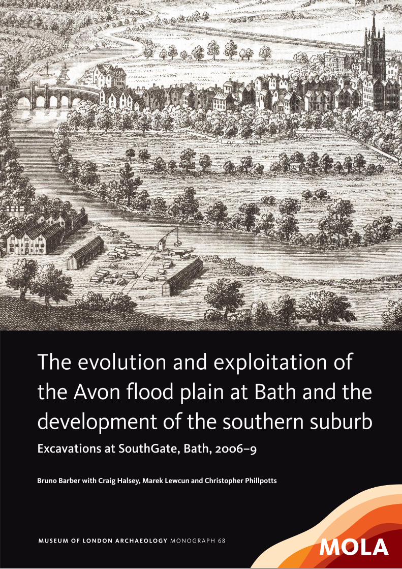
Front cover: a perspective view of the city of Bath 1758 (Bath in Time/Bath
Central Library) (Fig 173)

Principal author Bruno Barber
Documentary research Marek Lewcun (post-medieval), †Christopher Phillpotts (medieval)
Lithics Ian P Brooks
Moulded stone Mark Samuel
Building material Ian M Betts
Soil micromorphology Richard I Macphail
Geoarchaeology Craig Halsey with Mary Nicholls
Clay tobacco pipes Marek Lewcun with Jacqui Pearce
Pottery Nigel Jeffries (medieval and later), Amy Thorp (Roman)
Glass Lyn Blackmore
Accessioned finds Beth Richardson
Numismatica Julian Bowsher, †Geoff Egan
Slag Lynne Keys
Woodworking remains Damian Goodburn
Plant remains Anne Davis
Animal bone Alan Pipe
Molluscs Michael J Allen
Insects Enid Allison
Optically stimulated Phil Tomsluminescence dating
Radiocarbon dating Craig Halsey
Graphics Carlos Lemos with Juan Jose Fuldain (plans), Hannah Faux (finds)
Photography Andy Chopping, Maggie Cox, site staff
Project managers Rosalind Aitken, Julian Hill, Christopher Thomas
Editor Sue Hirst
CONTRIBUTORS

List of figures . . . . . . . . . . . . . . . . . . . . . . . . . . xi
List of tables . . . . . . . . . . . . . . . . . . . . . . . . . . xv
List of CD catalogues . . . . . . . . . . . . . . . . . . . . . xvi
List of CD figures . . . . . . . . . . . . . . . . . . . . . . xvi
List of CD tables . . . . . . . . . . . . . . . . . . . . . . . xvi
Summary . . . . . . . . . . . . . . . . . . . . . . . . . . . xvii
Acknowledgements . . . . . . . . . . . . . . . . . . . . . xviii
Introduction 1 1.1 Location and circumstances of fieldwork . . . . . . . 1
1.2 Historical and archaeological background . . . . . . . 5
1.3 Organisation of the report . . . . . . . . . . . . . . . 6
1.4 Textual and graphical conventions . . . . . . . . . . . 7
The archaeological sequence: prehistoric 2 2.1 The pre-Holocene landscape and environment
(period 0) . . . . . . . . . . . . . . . . . . . . . . . . . 9
Introduction . . . . . . . . . . . . . . . . . . . . . . . 9
The Pleistocene history of the Somerset Avon . . . . 9
The pre-Holocene geoarchaeological sequence . . . . 14
Discussion (period 0) . . . . . . . . . . . . . . . . . . 26
2.2 The Early Holocene landscape and evidence for
the Mesolithic exploitation of the Avon flood plain
(period 1) . . . . . . . . . . . . . . . . . . . . . . . . . 31
The Holocene geoarchaeological sequence . . . . . . 31
Evidence for the Mesolithic exploitation of the
Avon flood plain . . . . . . . . . . . . . . . . . . . . . 37
Discussion (period 1) . . . . . . . . . . . . . . . . . . 40
2.3 Later prehistoric land use (period 2) . . . . . . . . . . 40
The archaeological sequence: Roman to medieval 3 3.1 Roman period (period 3) . . . . . . . . . . . . . . . . 41
The site in relation to Roman Bath . . . . . . . . . . 41
The defences . . . . . . . . . . . . . . . . . . . . . . . 42
The Avon flood plain (OA1) . . . . . . . . . . . . . . 42
Discussion (period 3) . . . . . . . . . . . . . . . . . . 44
3.2 Post-Roman land use to the Alfredian burh
(period 4) . . . . . . . . . . . . . . . . . . . . . . . . . 45
Documentary evidence . . . . . . . . . . . . . . . . . 45
Archaeological evidence . . . . . . . . . . . . . . . . 46
Discussion (period 4) . . . . . . . . . . . . . . . . . . 47
3.3 The Saxo-Norman origins of the Southgate
suburb, c AD 950–1300 (period 5) . . . . . . . . . . . 47
Documentary evidence . . . . . . . . . . . . . . . . . 47
Archaeological evidence . . . . . . . . . . . . . . . . 50
CONTENTS
vi

Discussion (period 5) . . . . . . . . . . . . . . . . . . 90
3.4 The suburb in the later medieval period,
c 1300–1480 (period 6) . . . . . . . . . . . . . . . . . 92
Documentary evidence . . . . . . . . . . . . . . . . . 92
Archaeological evidence . . . . . . . . . . . . . . . . 93
Discussion (period 6) . . . . . . . . . . . . . . . . . . 95
The archaeological sequence: post-medieval 4 4.1 Decline and change, c 1480–1600 (period 7) . . . . . . 97
to modern Documentary evidence . . . . . . . . . . . . . . . . . 97
Archaeological evidence . . . . . . . . . . . . . . . . 99
Discussion (period 7) . . . . . . . . . . . . . . . . . 105
4.2 The 17th to early 18th century, c 1600–1725
(period 8) . . . . . . . . . . . . . . . . . . . . . . . . 106
Documentary evidence . . . . . . . . . . . . . . . . 106
Archaeological evidence . . . . . . . . . . . . . . . . 110
Discussion (period 8) . . . . . . . . . . . . . . . . . . 136
4.3 Another face of Georgian Bath, c 1726–1800
(period 9) . . . . . . . . . . . . . . . . . . . . . . . . 136
Documentary evidence . . . . . . . . . . . . . . . . 136
Archaeological evidence . . . . . . . . . . . . . . . . 139
Discussion (period 9) . . . . . . . . . . . . . . . . . . 157
4.4 The 19th century, c 1800–1900 (period 10) . . . . . . 158
Summary of documentary evidence . . . . . . . . . 158
Selected archaeological evidence . . . . . . . . . . . 159
Discussion (period 10) . . . . . . . . . . . . . . . . . 168
4.5 The 20th century, c 1900+ (period 11) . . . . . . . . 168
Selected documentary evidence . . . . . . . . . . . . 168
Selected archaeological evidence . . . . . . . . . . . 168
Thematic discussions 5 5.1 The significance of the Mesolithic assemblage . . . . 178
5.2 The character of the medieval suburb . . . . . . . . 181
The Bum Ditch (S8) . . . . . . . . . . . . . . . . . . 181
Environmental reconstruction . . . . . . . . . . . . . 183
5.3 The economy of medieval Bath . . . . . . . . . . . . 184
Evidence for cultivation and crop processing . . . . . 184
Evidence for animal husbandry . . . . . . . . . . . . 185
Food and diet . . . . . . . . . . . . . . . . . . . . . . 185
Textile manufacture . . . . . . . . . . . . . . . . . . 188
Other local craft/industrial activities . . . . . . . . . 188
Trade and commerce . . . . . . . . . . . . . . . . . . 189
5.4 The changing face of the post-medieval suburb . . . 189
Introduction . . . . . . . . . . . . . . . . . . . . . . 189
vii

The Bum Ditch (S8) . . . . . . . . . . . . . . . . . . 189
Trade and industry . . . . . . . . . . . . . . . . . . . 190
Food and diet . . . . . . . . . . . . . . . . . . . . . . 194
Environmental reconstruction . . . . . . . . . . . . . 195
Conclusions 6 6.1 The formation of the natural landscape . . . . . . . . 197
6.2 The prehistoric period . . . . . . . . . . . . . . . . . 197
6.3 The historic period . . . . . . . . . . . . . . . . . . . 198
6.4 Overview . . . . . . . . . . . . . . . . . . . . . . . . 198
Specialist appendices 7 7.1 Documentary research: identification of
individual tenements . . . . . . . . . . . . . . . . . . 200
7.2 The lithic assemblage . . . . . . . . . . . . . . . . . . 202
Excavation and sampling strategy . . . . . . . . . . . 202
Quantification and methodology . . . . . . . . . . . 203
Raw materials . . . . . . . . . . . . . . . . . . . . . 203
The lithic assemblage . . . . . . . . . . . . . . . . . . 203
7.3 The moulded stone . . . . . . . . . . . . . . . . . . . 213
Circumstances of survival . . . . . . . . . . . . . . . 213
Methodology . . . . . . . . . . . . . . . . . . . . . . 213
Catalogue . . . . . . . . . . . . . . . . . . . . . . . . 213
7.4 Other stone building material . . . . . . . . . . . . . 215
Roman . . . . . . . . . . . . . . . . . . . . . . . . . 215
Medieval . . . . . . . . . . . . . . . . . . . . . . . . 216
Post-medieval . . . . . . . . . . . . . . . . . . . . . 217
7.5 Geoarchaeological methodology . . . . . . . . . . . 217
Introduction . . . . . . . . . . . . . . . . . . . . . . 217
On-site recording and sampling . . . . . . . . . . . . 217
Off-site stratigraphic analysis . . . . . . . . . . . . . 218
Principles of facies analysis . . . . . . . . . . . . . . 218
Sample analysis strategy . . . . . . . . . . . . . . . . 219
GIS analysis . . . . . . . . . . . . . . . . . . . . . . . 220
7.6 Ceramic building material . . . . . . . . . . . . . . . 221
Roman . . . . . . . . . . . . . . . . . . . . . . . . . 221
Medieval . . . . . . . . . . . . . . . . . . . . . . . . 223
Post-medieval . . . . . . . . . . . . . . . . . . . . . . 224
7.7 Plaster and daub . . . . . . . . . . . . . . . . . . . . 226
Post-medieval . . . . . . . . . . . . . . . . . . . . . . 226
7.8 The clay tobacco pipes and kiln debris . . . . . . . . 226
Introduction . . . . . . . . . . . . . . . . . . . . . . 226
Quantification and methodology . . . . . . . . . . . 227
Distribution of the clay pipes on the site . . . . . . . 227
viii

Evidence of manufacture . . . . . . . . . . . . . . . 227
The sources of the pipes . . . . . . . . . . . . . . . . 227
Catalogue of illustrated pipes . . . . . . . . . . . . . 228
7.9 The Roman pottery . . . . . . . . . . . . . . . . . . 232
Methodology . . . . . . . . . . . . . . . . . . . . . . 232
Overall composition of the assemblage . . . . . . . . 232
Roman pottery from spit-excavated contexts . . . . 232
7.10 The medieval and later pottery . . . . . . . . . . . . 233
Medieval . . . . . . . . . . . . . . . . . . . . . . . . 233
Post-medieval . . . . . . . . . . . . . . . . . . . . . 237
7.11 The post-medieval glass . . . . . . . . . . . . . . . . 240
Introduction and methodology . . . . . . . . . . . . 240
Drinking vessels, late 16th to late 17th century . . . 241
Drinking vessels, late 17th to 19th century . . . . . . 244
Other tablewares . . . . . . . . . . . . . . . . . . . . 245
Household . . . . . . . . . . . . . . . . . . . . . . . 246
Glass beads . . . . . . . . . . . . . . . . . . . . . . . 246
Other objects . . . . . . . . . . . . . . . . . . . . . . 246
Wine bottles and other bottles . . . . . . . . . . . . 246
Window glass . . . . . . . . . . . . . . . . . . . . . 251
7.12 The accessioned finds . . . . . . . . . . . . . . . . . 252
Introduction . . . . . . . . . . . . . . . . . . . . . . 252
Summary by period . . . . . . . . . . . . . . . . . . 252
Catalogue . . . . . . . . . . . . . . . . . . . . . . . . 252
7.13 Numismatica . . . . . . . . . . . . . . . . . . . . . . 256
Discussion . . . . . . . . . . . . . . . . . . . . . . . 256
Catalogue format and abbreviations . . . . . . . . . 257
Catalogue of site coins . . . . . . . . . . . . . . . . . 257
Catalogue of the hoard from 7 Stanley Road (B63) . 260
7.14 The iron slag and related high-temperature debris . . 262
Introduction and methodology . . . . . . . . . . . . 262
Explanation of terms and processes . . . . . . . . . . 262
Summary . . . . . . . . . . . . . . . . . . . . . . . . 263
7.15 The woodworking remains . . . . . . . . . . . . . . 263
Methodology . . . . . . . . . . . . . . . . . . . . . . 263
Comparative material . . . . . . . . . . . . . . . . . 264
7.16 The plant remains . . . . . . . . . . . . . . . . . . . 264
Methodology . . . . . . . . . . . . . . . . . . . . . . 264
7.17 The animal bone . . . . . . . . . . . . . . . . . . . . 265
Introduction and methodology . . . . . . . . . . . . 265
Preservation and quantification . . . . . . . . . . . . 265
Assemblage summary . . . . . . . . . . . . . . . . . 266
ix
x
7.18 The molluscs . . . . . . . . . . . . . . . . . . . . . . 267
Introduction . . . . . . . . . . . . . . . . . . . . . . 267
Methods . . . . . . . . . . . . . . . . . . . . . . . . . 267
Aims . . . . . . . . . . . . . . . . . . . . . . . . . . . 267
Results . . . . . . . . . . . . . . . . . . . . . . . . . 267
Discussion and conclusions . . . . . . . . . . . . . . 270
7.19 The insects . . . . . . . . . . . . . . . . . . . . . . . 270
Introduction . . . . . . . . . . . . . . . . . . . . . . 270
Methodology . . . . . . . . . . . . . . . . . . . . . . 271
Results . . . . . . . . . . . . . . . . . . . . . . . . . 271
Discussion . . . . . . . . . . . . . . . . . . . . . . . 271
7.20 OSL dating . . . . . . . . . . . . . . . . . . . . . . . 273
Principles. . . . . . . . . . . . . . . . . . . . . . . . . 273
Sample collection and preparation . . . . . . . . . . 273
Acquisition and accuracy of De value . . . . . . . . . 273
Laboratory factors . . . . . . . . . . . . . . . . . . . 273
Environmental factors . . . . . . . . . . . . . . . . . 274
Acquisition and accuracy of Dr value . . . . . . . . . 274
Estimation of age . . . . . . . . . . . . . . . . . . . . 275
Summary . . . . . . . . . . . . . . . . . . . . . . . . 275
7.21 Radiocarbon dating . . . . . . . . . . . . . . . . . . 275
Radiocarbon results . . . . . . . . . . . . . . . . . . 275
Accuracy and contamination . . . . . . . . . . . . . 275
French and German summaries . . . . . . . . . . . . . . . . . . . . . . . . . . . . . . . . . . 278
Bibliography . . . . . . . . . . . . . . . . . . . . . . . . . . . . . . . . . . 280
Index . . . . . . . . . . . . . . . . . . . . . . . . . . . . . . . . . . 294
CD-ROM CD Catalogue 1
CD Figures 1–26
CD Tables 1–19
xi
Fig 1 Map showing the location of the site and nearby streets and sites . . . . . . . . . . . . . . . . . . . . . 2
Fig 2 View looking north along Southgate Street . . . . . 3Fig 3 Map showing the location of buildings and
structures . . . . . . . . . . . . . . . . . . . . . . . . 4Fig 4 Map showing the location of evaluation trenches,
excavation trenches and watching brief areas . . . . . 4Fig 5 View of typical open-area excavation, showing the
impact of pile caps from the 1970s development . . . 5Fig 6 View showing cramped conditions in the CSO/sewer
trench along Southgate Street . . . . . . . . . . . . . 5Fig 7 Graphical conventions used in this report . . . . . . 8Fig 8 Pleistocene river terraces and geology: a – as
mapped by the British Geological Survey (1965); b – schematic diagram showing the subdivision of the Avon Formation . . . . . . . . . . . . . . . . . . 13
Fig 9 Plan showing the location of excavation areas,geoarchaeological trenches and borehole data . . . . 15
Fig 10 Schematic section through: a – the northern part of geotrench 2; b – the central part of geotrench 3; c – the southern part of geotrench 2 . . . . . . . . 16
Fig 11 Surface plot of the Lias Clay, also showing scour features cut into the bedrock . . . . . . . . . . . . . . 18
Fig 12 Detailed view of load and flame structures beneathweakly horizontally bedded gravels (Gh), associated with architectural element GB (L2) . . . . . . . . . . 18
Fig 13 Detailed view of channelised terrace gravels (L3) in the west-facing section of geotrench 3 . . . . . . . 20
Fig 14 General view showing the full channel complex of L4 . . . . . . . . . . . . . . . . . . . . . . . . . . 21
Fig 15 Surface plot of Late Pleistocene deposits . . . . . . . 21Fig 16 Detailed view of distal part of primary Lateglacial
channel (L4) in west-facing section of geotrench 2 . . 22Fig 17 Detailed view of proximal part of primary
Lateglacial channel (L4) in west-facing section ofgeotrench 2 . . . . . . . . . . . . . . . . . . . . . . . 23
Fig 18 Surface plot of pre-L5 deposits . . . . . . . . . . . . 25Fig 19 Detailed view of secondary Lateglacial channel (L5) . 26Fig 20 Detailed view of tertiary Lateglacial channel (L6) . . 27Fig 21 North–south transect across the site illustrating the
complete set of lithofacies associations (L1–L11) . . . 28Fig 22 Schematic plan showing the development of channel
features and major landforms across the site: a – terrace gravels (L1–L3) and primary Lateglacialchannel (L4); b – secondary and tertiary Lateglacialchannels (L5–L6); c – Holocene channel (L10) . . . . 28
Fig 23 Surface plot of the Early Holocene . . . . . . . . . . 33Fig 24 Surface plot of pre-Holocene deposits . . . . . . . . 35
Fig 25 Contour plot showing the density of the lithic scatter by number of artefacts per square metre . . . 38
Fig 26 Contour plot showing the density of the lithic scatter by weight average . . . . . . . . . . . . . . . . 39
Fig 27 Typical single-platform bladelet cores, blades and bladelets from the lithic scatter . . . . . . . . . . . . 40
Fig 28 Leaf-shaped arrowhead <F19> . . . . . . . . . . . . . 40Fig 29 The site in relation to Roman Bath . . . . . . . . . . 41Fig 30 Possible Roman features and Roman find-spots
(period 3) . . . . . . . . . . . . . . . . . . . . . . . . 43Fig 31 Penannular brooch <S1> and strip bracelet <S3> . . 44Fig 32 Glass gaming counters <S7>–<S22> . . . . . . . . . . 45Fig 33 Conjectural plan of period 4 . . . . . . . . . . . . . . 46Fig 34 Reconstructed profile across the burghal ditch (S1) . . 46Fig 35 The site in relation to medieval Bath . . . . . . . . . 48Fig 36 Plan of principal Late Saxon to early post-Conquest
archaeological features (period 5, phase 1) . . . . . . 51Fig 37 Copper-alloy hooked tags <S23>–<S24> . . . . . . . 52Fig 38 Bath fabric B pitcher <P1> . . . . . . . . . . . . . . . 52Fig 39 Detailed plan showing Structures 5–7 and Open
Areas 7–10 . . . . . . . . . . . . . . . . . . . . . . . 54Fig 40 Silver halfpenny <C13> of Edward the Elder . . . . 55Fig 41 View of the grain dryer/oven (S6) . . . . . . . . . . 55Fig 42 Detail of the grain dryer/oven (S6) . . . . . . . . . . 56Fig 43 Bath fabric B jars <P2>–<P4> . . . . . . . . . . . . . 57Fig 44 Ceramic moulds <S26>–<S28> . . . . . . . . . . . . 57Fig 45 Oolitic limestone vessel <S29> . . . . . . . . . . . . . 58Fig 46 Plan of principal post-Conquest to c 1135
archaeological features (period 5, phase 2) . . . . . . 59Fig 47 View of the south (external) face of the city wall
(S12) . . . . . . . . . . . . . . . . . . . . . . . . . . . 60Fig 48 View of the north (internal) face of the city wall . . 61Fig 49 View of part of the causeway (S4) across the
silted-up burghal ditch (S1) . . . . . . . . . . . . . . 61Fig 50 Detailed plan showing activity in Open Areas
period 5, phase 2 . . . . . . . . . . . . . . . . . . . . 63Fig 51 Bath fabric A jar <P5> . . . . . . . . . . . . . . . . . 64Fig 52 Schematic south-facing sections across the
watercourse (S8) in the main excavation trenches,highlighting period 5, phase 2 activity . . . . . . . . 65
Fig 53 View of watercourse (S8) under excavation . . . . . . 65Fig 54 Detail showing the wattle revetment under
excavation . . . . . . . . . . . . . . . . . . . . . . . . 66Fig 55 Plan of principal archaeological features c 1135–
1250/70 (period 5, phase 3) . . . . . . . . . . . . . . 69Fig 56 Schematic south-facing sections across the
watercourse (S8) in the main excavation trenches,highlighting period 5, phase 3 activity . . . . . . . . 71
Fig 57 Detailed plan showing the remains of Building 2 and its relationship with the pond (S10) and watercourse (S8) . . . . . . . . . . . . . . . . . . . . 73
Fig 58 View of the west wall of sluice structure (B2) under excavation . . . . . . . . . . . . . . . . . . . . . . . . 73
Fig 59 Plan of principal archaeological features c 1250/70–99 (period 5, phase 4) . . . . . . . . . . . . . . . . . . 75
Fig 60 View of collapsed section of masonry <A1>,
FIGURES
xii
showing decorative tooling . . . . . . . . . . . . . . 76Fig 61 Stone spindle whorl <S25> and iron key <S32> . . . . 76Fig 62 View showing one of the larger exposures of the
surface of Road 1 . . . . . . . . . . . . . . . . . . . . 77Fig 63 Bath fabric A pitchers <P6>–<P7> . . . . . . . . . . . 78Fig 64 View of the kerb (S22) on the western side of
Road 1 . . . . . . . . . . . . . . . . . . . . . . . . . . 79Fig 65 View showing the frontage wall of Building 6
butted by the possible pavement (S19), seen in section . . . . . . . . . . . . . . . . . . . . . . . . . . 79
Fig 66 View of the conduit housing stones in situ . . . . . . 80Fig 67 View of the junction of two conduit housing
blocks . . . . . . . . . . . . . . . . . . . . . . . . . . 80Fig 68 Axonometric projection showing the construction
and possible reconstruction of the water supply system, Structure 18 . . . . . . . . . . . . . . . . . . 81
Fig 69 View looking south-east showing culvert (S21) built into Road 1 . . . . . . . . . . . . . . . . . . . . . . . 81
Fig 70 View showing work in progress on the frontage of Building 5, the possible pavement (S19) and the robbed water conduit (S18) . . . . . . . . . . . . . . 82
Fig 71 Detailed plans of part of the Southgate Street frontage (Buildings 6–10) to show the two stages of development during period 5, phase 4 . . . . . . . . 83
Fig 72 View of the south end of Building 9 under excavation . . . . . . . . . . . . . . . . . . . . . . . . 84
Fig 73 View of the drain within Building 9 . . . . . . . . . 84Fig 74 Detailed plan showing activity in Open Areas 16–17 . 85Fig 75 Decorated medieval pottery <P8>–<P10> from
Open Area 17 . . . . . . . . . . . . . . . . . . . . . . 86Fig 76 Schematic south-facing sections across the
watercourse (S8) in the main excavation trenches,highlighting period 5, phase 4 activity . . . . . . . . 87
Fig 77 Pottery <P11>–<P14> from artificial watercourse (S8) . . . . . . . . . . . . . . . . . . . . . . . . . . . 90
Fig 78 View of the medieval bridge from the east by Bernard Lens in 1718, showing the gate and the projecting chapel of St Lawrence . . . . . . . . . . . 93
Fig 79 Plan of principal archaeological features c 1300–1479 (period 6) . . . . . . . . . . . . . . . . . . . . . 94
Fig 80 Copper-alloy spoon or scale balance <S33> . . . . . . 95Fig 81 Detailed plan of Open Area 18 in period 6 . . . . . . 95Fig 82 Plan of principal archaeological features c 1480–
1599 (period 7) . . . . . . . . . . . . . . . . . . . . 100Fig 83 Detailed plan of Open Area 17 in period 7 . . . . . 101Fig 84 Copper-alloy buckles <S34>–<S35> and dress pin
<S36>, plain glass cylindrical beaker <G5> . . . . . 101Fig 85 View of stone-lined privy Structure 24 . . . . . . . 101Fig 86 Wanstrow ware pipkin <P15> . . . . . . . . . . . . 102Fig 87 Detailed plan of Open Area 18 in period 7 . . . . . 102Fig 88 Schematic south-facing sections across the
watercourse (S8) in the main excavation trenches,highlighting period 7 activity . . . . . . . . . . . . 103
Fig 89 Bacon roaster <P16> and medallion from chafing dish <P17>, from Structure 8 . . . . . . . . . . . . 104
Fig 90 Iron spur <S43> . . . . . . . . . . . . . . . . . . . . 105
Fig 91 View of the watercourse (S8), showing stone revetment (S28) and clay lining. . . . . . . . . . . . 105
Fig 92 Details from historic maps: a – Savile c 1600; b – Speed 1610; c – Gilmore 1694; d – Guidot 1717 . 108
Fig 93 Plan of principal archaeological features c 1600–1725 (period 8) . . . . . . . . . . . . . . . . . . . . 111
Fig 94 Detailed plan of Open Areas 15–17 and other nearby features in period 8 . . . . . . . . . . . . . . 112
Fig 95 Bristol-made tin-glazed ware drug jar <P18> . . . . 113Fig 96 View showing work in progress on the watercourse
(S8) . . . . . . . . . . . . . . . . . . . . . . . . . . 114Fig 97 Plan showing the development of Structure 32
during period 8 . . . . . . . . . . . . . . . . . . . . 115Fig 98 View of the base of the sluice controlling water
flow into Structure 32 . . . . . . . . . . . . . . . . 116Fig 99 View showing the final stage of development of
Structure 32 . . . . . . . . . . . . . . . . . . . . . . 117Fig 100 Pottery <P19>–<P22> from Open Area 17,
period 8 . . . . . . . . . . . . . . . . . . . . . . . . 119Fig 101 Glass beakers <G7>, <G13> and <G15> from Open
Area 17, period 8 . . . . . . . . . . . . . . . . . . . 120Fig 102 View of the foundations of square privy,
Structure 35 . . . . . . . . . . . . . . . . . . . . . . 121Fig 103 Detail of embossed sherd <P23> . . . . . . . . . . 121Fig 104 Detailed plan of Open Area 18 in period 8 . . . . . 122Fig 105 Comb <S40>, die <S42> and mount <S46> from
Open Area 18, period 8 . . . . . . . . . . . . . . . 123Fig 106 17th-century coins <C22> and <C24> from Open
Area 18, period 8 . . . . . . . . . . . . . . . . . . . 123Fig 107 View of timber floor of sawpit . . . . . . . . . . . 124Fig 108 Goblet <G33> and onion bottles <G83>–<G84>
from the watercourse (S8), period 8 . . . . . . . . . 125Fig 109 Schematic south-facing sections across the
watercourse (S8) in the main excavation trenches,highlighting period 8 activity . . . . . . . . . . . . 126
Fig 110 Falfield ware mug <P24> and Wanstrow ware jug <P25> from Structure 8, period 8 . . . . . . . . 127
Fig 111 Glass goblet <G48>, jar or beaker <G66> and flask <G99> from Open Area 31, period 8 . . . . . . . . 127
Fig 112 View of partially excavated group of Frechen stoneware jugs . . . . . . . . . . . . . . . . . . . . 128
Fig 113 Group of glass onion bottles <G81>a–h and small onion bottle <G82> . . . . . . . . . . . . . . . . . . 130
Fig 114 Plan showing features relating to the Civil War defences in period 8 . . . . . . . . . . . . . . . . . 132
Fig 115 Ditch sections: a – west-facing section of Structure 37; b – north-west-facing section of Structure 38 . . . . . . . . . . . . . . . . . . . . . . 133
Fig 116 View showing the investigation of ditch (S38) during the watching brief . . . . . . . . . . . . . . 134
Fig 117 Lead musket ball <S48> . . . . . . . . . . . . . . . 134Fig 118 Plan showing a distinct phase of early 18th-century
activity identified towards the north of the site (OA23) . . . . . . . . . . . . . . . . . . . . . . . . 135
Fig 119 Key Bridge or Old Bridge c 1755 by Thomas Robins the elder . . . . . . . . . . . . . . . . . . . . . . . . 137
xiii
Fig 120 Detail from Wood’s map of 1735 . . . . . . . . . . 138Fig 121 Detail from Harcourt Masters’ map of 1795 . . . . 138Fig 122 Plan of prinicipal archaeological features c 1726–99
(period 9) . . . . . . . . . . . . . . . . . . . . . . . 140Fig 123 Detailed plan of the north-west part of the site in
period 9 . . . . . . . . . . . . . . . . . . . . . . . . 142Fig 124 Detailed plan of the south-west part of the site in
period 9 . . . . . . . . . . . . . . . . . . . . . . . . 143Fig 125 Pottery <P26>–<P30> from Open Area 25 . . . . . 145Fig 126 Glass from period 9: beaker or jar <G14>, goblet
stem <G34>, shallow goblet bowl <G36>, onion bottle <G85>, case bottle <G98> and onion bottle with applied seal <G79> . . . . . . . . . . . . . . . 146
Fig 127 View of the eastern cellar of Building 27 . . . . . . 148Fig 128 Wanstrow ware shallow bowl <P31> . . . . . . . . 149Fig 129 Wooden book cover <S70> from the artificial
watercourse (S8) . . . . . . . . . . . . . . . . . . . 151Fig 130 South Somerset slip-coated dish <P32> and
Wanstrow ware candlestick <P33> . . . . . . . . . . 151Fig 131 Glass from period 9: goblets <G29> and <G47>,
flask <G57>, onion bottle <G86>, bottles with applied seals <G80>,<G89>, <G92>, mallet bottle base <G88> and possible imported bottle <G100> . 152
Fig 132 Schematic south-facing sections across the watercourse (S8) and culvert (S51) in the main excavation trenches, highlighting period 9 structures and deposits . . . . . . . . . . . . . . . . 153
Fig 133 View of the Bum Ditch culvert (S51), showing the contrast between the alluvial soils of Open Area 32 and the infilled Bum Ditch (S8) . . . . . . 153
Fig 134 English porcelain saucer <P34> . . . . . . . . . . . 154Fig 135 Domestic items from a cesspit (S59): copper-alloy
button <S53>, pins <S55>, pipeclay wig curler <S56> and copper-alloy finger ring <S65> . . . . . 155
Fig 136 View of Building 39 under excavation . . . . . . . 155Fig 137 Pipeclay wig curlers <S37>–<S39> . . . . . . . . . 156Fig 138 Tin-glazed ware ointment pots <P35>–<P37> . . . 157Fig 139 Wanstrow ware or Avon-sourced red ware bowl
<P38> . . . . . . . . . . . . . . . . . . . . . . . . . 157Fig 140 Detail from Cotterell’s survey of 1852 . . . . . . . 158Fig 141 Plan of principal archaeological features c 1800–99
(period 10), plotted on the Ordnance Survey map of 1885 . . . . . . . . . . . . . . . . . . . . . . . . 160
Fig 142 Blue transfer-printed tea wares <P39>–<P42> . . . 161Fig 143 Plate <P43> and one-handled red ware chamber
pots <P44>–<P45> . . . . . . . . . . . . . . . . . . 161Fig 144 Ivory and bone toothbrushes <S50>–<S51> . . . . 162Fig 145 Bone domino <S73> with stone and ceramic alleys
<S75>–<S78> . . . . . . . . . . . . . . . . . . . . . 162Fig 146 Glass from period 10 contexts: counter or lens
<G76>, shaft-and-globe/onion-type bottle <G78>,bladder onion bottle <G87>, seal from Pyrmont water bottle <G93>, flask <G101> . . . . . . . . . . 163
Fig 147 Intact tin-glazed ware ointment pots <P46>–<P47> . 164Fig 148 View of typical later 19th-century cellars of
Building 57 . . . . . . . . . . . . . . . . . . . . . . 164
Fig 149 View of decorative floor of light well in Building 59 . . . . . . . . . . . . . . . . . . . . . . 165
Fig 150 View showing fireplace and cast-iron fittings in Building 62 . . . . . . . . . . . . . . . . . . . . . . 166
Fig 151 The interior of St James’s Hall, c 1870 . . . . . . . 166Fig 152 Copper-alloy works token <C63> . . . . . . . . . . 167Fig 153 Stoneware blackleading bottles <P48>–<P52>
and bung jar <P53> from Open Area 40 . . . . . . 167Fig 154 Detail of the Bath bomb impacts map of 1942 . . . 168Fig 155 View showing bomb damage between Stanley
Road and Newark Street in April 1942 . . . . . . . 169Fig 156 Plan of principal archaeological features and find-
spots c 1900+ (period 11) . . . . . . . . . . . . . . . 170Fig 157 Glass from period 11: imported machine-made wine
bottles <G90>–<G91>, Codd bottles <G94>–<G96>,beer bottle <G97> and phial <G102> . . . . . . . . 171
Fig 158 Part of a bone china miniature teacup or egg cup <P54> . . . . . . . . . . . . . . . . . . . . . . . . . 171
Fig 159 View showing home improvements in a cellar of Building 57 . . . . . . . . . . . . . . . . . . . . . . 172
Fig 160 Copper-alloy, paper and paste brooch <S67> . . . . 172Fig 161 Beatles poster . . . . . . . . . . . . . . . . . . . . . 173Fig 162 View of excavation in progress on the remains of
the bomb-damaged cellars of Building 61 . . . . . 173Fig 163 Button box (contents) <S63> and locket <S64> . . . 174Fig 164 White ware mug <P55> . . . . . . . . . . . . . . . 174Fig 165 Coin hoard <CHd1>–<CHd74> from 7 Stanley
Road . . . . . . . . . . . . . . . . . . . . . . . . . 175Fig 166 Commemorative display pottery <P56>–<P59> . . . 175Fig 167 Miniature or toy bone china <P60>–<P63> and
functional vessels <P64>–<P66> . . . . . . . . . . . 176Fig 168 Memorial stone from a bomb-damaged mason’s
yard . . . . . . . . . . . . . . . . . . . . . . . . . . 176Fig 169 View showing bomb damage on the east side of
Newark Street in April 1942 . . . . . . . . . . . . . 177Fig 170 View of the Southgate shopping centre before
closure and demolition . . . . . . . . . . . . . . . . 177Fig 171 Plan showing the location and density of the
Mesolithic flint scatter in relation to the modelled Early Holocene surface topography . . . . . . . . . 179
Fig 172 Stone metalworking mould <S30> . . . . . . . . . 188Fig 173 A perspective view of the city of Bath 1758,
showing the southern suburb . . . . . . . . . . . . 190Fig 174 Plan of the properties on the east side of Southgate
Street, showing the concordance of plots from the 1641 survey with later house numbers . . . . . 201
Fig 175 View showing excavation and artefact sampling in progress . . . . . . . . . . . . . . . . . . . . . . . 202
Fig 176 View showing recovery of artefacts by wet sieving in progress . . . . . . . . . . . . . . . . . . . . . . . 203
Fig 177 Charts showing the distribution of blades by size . 209Fig 178 Microliths, arrowheads and burins . . . . . . . . . 210Fig 179 Other tools . . . . . . . . . . . . . . . . . . . . . . 211Fig 180 Child’s gravestone <A2> . . . . . . . . . . . . . . . 214Fig 181 Fragments of high-relief sculptural frieze <A6> . . 214Fig 182 Part of post-medieval water feature <A9> with

child’s bare feet and concealed lead pipe . . . . . . . 215Fig 183 Stone building material <A12>–<A16> . . . . . . . 216Fig 184 Roman tile and brick <T1>–<T3> . . . . . . . . . 222Fig 185 Floor-tile designs of the Nash Hill <T4>–<T6>
and Malvern <T7>–<T9> groups . . . . . . . . . . 223Fig 186 Partly decorated ridge tile <T10> . . . . . . . . . . 224Fig 187 Decorated delft wall tiles <T11>–<T14> . . . . . . 225Fig 188 Decorative plaster moulding <T15> . . . . . . . . . 226Fig 189 Clay pipes <CP1>–<CP10> and <CP11>–<CP14> . 228
Fig 190 Clay pipes <CP15>–<CP25> . . . . . . . . . . . . 230Fig 191 Frechen stoneware jugs of the mid 17th century
from a pit in the Ham meadow . . . . . . . . . . . 240Fig 192 Medieval coins <C14> and <C16> and tokens/
jettons <C17>–<C19> . . . . . . . . . . . . . . . . 258Fig 193 17th-century tokens <C59>–<C60> . . . . . . . . . 260Fig 194 Selected coins from the hoard: <CHd9>,
<CHd14>, <CHd23>, <CHd71> and souvenir medallion <CHd64> . . . . . . . . . . . . . . . . . 261
xiv
Table 1 British Late Quaternary climatostratigraphy . . . . 10Table 2 Most recent model of the Avon Formation . . . . . 12Table 3 Medieval pottery from period 5, phase 1 . . . . . . 52Table 4 Medieval pottery from period 5, phase 2 . . . . . . 60Table 5 Medieval pottery from period 5, phase 3 . . . . . . 70Table 6 Medieval pottery from period 5, phase 4 . . . . . . 74Table 7 Medieval pottery from period 6 . . . . . . . . . . . 93Table 8 Post-medieval pottery from period 7 . . . . . . . . 99Table 9 Post-medieval pottery from period 8 . . . . . . . 112Table 10 Post-medieval pottery from period 9 . . . . . . . 141Table 11 Summary of the occurrence of food and other
useful plants by period . . . . . . . . . . . . . . . 186Table 12 Summary of numbers of lithic artefacts by
context . . . . . . . . . . . . . . . . . . . . . . . 204Table 13 Summary of weight of lithic artefacts by
context . . . . . . . . . . . . . . . . . . . . . . . 206Table 14 Details of illustrated worked flint <F1>–<F43> . . 208Table 15 Cores by type . . . . . . . . . . . . . . . . . . . . 208Table 16 Scrapers by type . . . . . . . . . . . . . . . . . . 212Table 17 Summary of the illustrated stone, ceramic and
other building material . . . . . . . . . . . . . . 215Table 18 Lithofacies classification used in this report . . . . 219Table 19 Architectural elements classification used in
this report . . . . . . . . . . . . . . . . . . . . . . 219Table 20 Lithofacies associations defined in this report . . 220Table 21 Summary of ceramic building material fabric
types . . . . . . . . . . . . . . . . . . . . . . . . . 222Table 22 Details of illustrated medieval and post-
medieval pottery <P1>–<P66> . . . . . . . . . . 233Table 23 Common medieval pottery fabrics from Bath . . 234Table 24 Post-medieval pottery by source of supply
and statistical counts . . . . . . . . . . . . . . . . 237Table 25 Post-medieval red earthenwares by period . . . . 238Table 26 Somerset wares by period and statistical counts . 238Table 27 Wanstrow wares by period and statistical counts . 239Table 28 General quantification of the categories of glass
in the three main periods . . . . . . . . . . . . . . 240Table 29 Classification of the 16th- to 17th-century glass
beaker forms . . . . . . . . . . . . . . . . . . . . 241Table 30 Types of 16th- to 17th-century wine glass . . . . 243Table 31 Quantification of the different bottle forms in
periods 8, 9 and 10 . . . . . . . . . . . . . . . . . 247Table 32 Distribution of the site coins and tokens . . . . . 256Table 33 Distribution of the hoard coins . . . . . . . . . . 257Table 34 Summary of slag types and processes . . . . . . . 263Table 35 Statistical details for smithing hearth bottoms . . 263Table 36 List of wood samples identified to species by
microscope . . . . . . . . . . . . . . . . . . . . . 264Table 37 Total recovery of faunal remains as species and
fragment counts by period . . . . . . . . . . . . . 266Table 38 Faunal composition by period . . . . . . . . . . . 267Table 39 Mineral content of the Hot Bath (or Hetling)
spring at Bath . . . . . . . . . . . . . . . . . . . . 269Table 40 Radiocarbon results . . . . . . . . . . . . . . . . 276
TABLES
xv
CD CATALOGUECD Cat 1 Complete catalogue of selected glass items
CD FIGURESCD Fig 1 Land-use diagramCD Fig 2 Detailed view of scour feature infilled with gravel
lag depositsCD Fig 3 Detailed view showing sampling location OSL19CD Fig 4 View of the west-facing section of geotrench 3CD Fig 5 Detailed view of terrace gravelsCD Fig 6 Detailed view of proximal channel fills of primary
Lateglacial channel (L4)CD Fig 7 View of a geoarchaeologist recording fills of
primary Lateglacial channel (L4)CD Fig 8 Detailed view of fills of primary Lateglacial
channel (L4)CD Fig 9 Detailed view of secondary Lateglacial channel
(L5)CD Fig 10 Detailed view of northern part of secondary
Lateglacial channel (L5)CD Fig 11 Detailed view of horizontally bedded sands and
silts infilling secondary Lateglacial channel (L5)CD Fig 12 Detailed view of secondary Lateglacial channel (L5)CD Fig 13 Scan of subsample M623A, showing the boundary
between poorly sorted sands and gravels of unit 4and sandy loam of unit 3
CD Fig 14 Photomicrograph of subsample M623B, showingwell-sorted sands of unit 5
CD Fig 15 Scan of part of monolith {624}CD Fig 16 Scan of subsample M624A, showing irregular and
discontinuous junction between alluvium (unit 1),fragmented buried topsoil (unit 2up, Ah1) and underlying lower topsoil (unit 2, Ah2)
CD Fig 17 View of soil horizon and overlying alluvium,with sketch showing sample locations
CD Fig 18 Photomicrograph of subsample M458A (unit 41.2)showing patchy, burrowed, once humic soil,charcoal and a gravel-sized clast of ferruginised
humic soil clast: a – under plane polarised light; b – under oblique incident light
CD Fig 19 Photomicrograph of subsample M458B (unit 41.2)showing biologically worked sands and coarseinclusions of burned ?peat or other relict organicmatter: a – under plane polarised light; b – underoblique incident light
CD Fig 20 Detailed view showing a section through quarryfills in the south-west part of the Ham (OA13)
CD Fig 21 Plot showing the distribution of lithic artefacts byquadrant
CD Fig 22 Distribution of Early Mesolithic core typesCD Fig 23 Distribution of Late Mesolithic core typesCD Fig 24 Distribution of Early Mesolithic microlithsCD Fig 25 Distribution of Late Mesolithic microlithsCD Fig 26 Distribution of all scrapers
CD TABLESCD Table 1 Lithic assemblage raw dataCD Table 2 Quantification details for the iron slag and related
debrisCD Table 3 Plant remains from period 5, phases 1 and 2CD Table 4 Plant remains from period 5, phases 3–4, and
period 6CD Table 5 Plant remains from periods 7–9CD Table 6 Mandibular dental eruption and wearCD Table 7 Summary of ante- and post-mortem modificationCD Table 8 Molluscs from the Lateglacial channel (L4) and
alluvium in post-medieval quarry (OA19)CD Table 9 Molluscs from the period 4, phase 2 fills of the
?burghal ditch (S1)CD Table 10 Molluscs from the period 5, phase 3 fills of the
artificial watercourse (S8)CD Table 11 Sediment log from the borehole through the
lower fills of the ?burghal ditch (S1)CD Table 12 Details of subsamples examined for insect remainsCD Table 13 Ecological groups used in analysisCD Table 14 Host plants of phytophagous beetles and bugsCD Table 15 List of invertebrates present in the samples
analysed in detailCD Table 16 Invertebrate remains recorded by scanning from
bulk sample flotsCD Table 17 Main statistics of the beetle and bug assemblagesCD Table 18 Proportions of terrestrial beetles and bugs
within the assemblagesCD Table 19 Dr, De and age data of submitted samples
CD-ROM
xvi
This volume presents the results of excavations on the site ofthe Bath SouthGate shopping centre, carried out in the courseof redevelopment from 2006 to 2009 on behalf of SouthGateLimited Partnership and Multi Development UK. Theconstruction of a new shopping centre afforded MOLA theopportunity to investigate a 3.55ha site located between thenorth bank of the River Avon and the southern defences ofRoman and later Bath. This report is intended to provide a newlandscape history for the area from the remote past to the lastmajor redevelopment of the 1970s.
Extensive geoarchaeological work has allowed themodelling and dating of the main stages in the evolution of this little-studied part of the Avon flood plain from at least theLate Devensian (23–11.5ka BP) through to the Holocene. Thegeoarchaeological stratigraphic chronological framework hasbeen verified by optically stimulated luminescence dating. The Dimlington stadial to Windermere/Allerød transition wasparticularly well preserved on the site and illustrates a changefrom a gravel-dominated braided river system to a single-threaded channel during a period of climate amelioration.Although the pre-Holocene landforms were not directlyassociated with human activity, they can be related to the widerpattern of climate-driven change that shaped the landscape andset the template for subsequent human occupation.
In the south-eastern corner of the site, Late Devensianterrace deposits were left elevated above the Holocene riverchannel, providing a convenient area of high and dry landwhich formed the focus of Early to Late Mesolithic activity.
A spread of 16,002 lithic artefacts points to task-based activitieson or immediately adjacent to the site, with a typologicallyderived date range of c 9400–<7000 BP. However, soilmicromorphology and other geoarchaeological and distributionanalyses indicate that the recovered scatters and the soils inwhich they occurred were subject to a variety of post-depositional processes. Nonetheless, the findings add to agrowing picture of the exploitation of inland river valleysduring the Mesolithic, both in the area generally and perhaps inthis location in particular, as a result of the special attraction ofthe nearby hot springs.
Little evidence for the use of the flood plain in the laterprehistoric or Roman periods was recovered, but the outerdefences of the Anglo-Saxon burh were investigated andextramural activity of rural and perhaps popular religiouscharacter recorded. Following the Norman Conquest, majorlandscape reorganisation took place, with extensive quarrying,the construction of the earliest southern road out of the city,the laying out of burgage plots and creation of an artificialwatercourse to serve as a mill race and perhaps also as a flooddefence. The deposition of a thick layer of weatheredminerogenic alluvium across the majority of the site was relatedto the increase in suspended sediment carried across the floodplain during overbank flood events. Archaeological evidenceshows that most of this alluviation took place from the 10th and 11th centuries, associated possibly with agriculturalintensification in upland areas as well as with engineeredmodifications to the flow of the river. The occupation of thesouthern suburb is well represented from the mid 13th centuryand its character and development are reconstructed in achronological narrative which gives a picture of a relativelylow-status area that provided goods, food and services to themore familiar wealthy Georgian city and terminates in twodestructive events of the 20th century – the ‘Baedeker’ air raidsof 1942 and the construction of the first Southgate shoppingcentre in the 1970s.
SUMMARY
xvii

MOLA (Museum of London Archaeology) are grateful to theSouthGate Limited Partnership and our client MultiDevelopment UK for funding this project, and to theirconsulting engineer Hugh Burbidge. The client’s archaeologicalconsultants were Tom Hassall and Steven Weaver (CgMs).Richard Patten (Arup) acted as the client’s representative duringmost of the fieldwork. The project was overseen on behalf ofthe local authority by Richard Sermon (Bath and North EastSomerset Council (B&NES) Archaeology Officer) and hispredecessor Bob Sydes, while additional archaeological advicewas provided by staff of English Heritage (South-west Region),Vanessa Straker (Regional Science Advisor) and Phil McMahon(Inspector of Ancient Monuments), and Susan Fox (RomanBaths Museum, Bath). Thanks are also due to Aidan Lynch andJohn Reid of Buro4.
We would like to thank Mark Williamson, Phil Ball and JamesGledhill of the main contractor, Sir Robert McAlpine, for theirfriendly and positive attitude to managing the interface betweenthe archaeological and construction programmes. In practicalmatters on site Mark Morgan and Brian Cauwood were alwaysconsiderate and helpful. Construction works at Churchill Housewere managed by Simon Box (HBG Development Ltd/BAM).
The fieldwork was managed on site for MOLA by BrunoBarber. Excavation supervisors were †Richard Bluer, BruceEaton, Marek Lewcun, Nikcola Lyons and Dan Waterfall, all ofwhom have made valuable contributions to the assessment andanalysis process leading to the production of this report. DavidJamieson, Richard Sayer, Gemma Stevenson and Bruce Watsonsupervised aspects of fieldwork only, assisted by DamionChurchill, Miranda Haig and Jenny Lee. Mark Burch, NevilleConstantine, Catherine Drew and Dan Waterfall providedsurvey/geomatics support. Geoarchaeological investigationswere supervised by Craig Halsey, with advice from JaneCorcoran. Environmental and finds sample processing weresupervised on and off site by James Andrews, with overall
management by John Giorgi and Jane Corcoran. Initialquantification of the sieved flint assemblage was conducted byTony Grey. Finds management was by Fiona Seeley, withassistance from †Penny MacConnoran. Peter Rauxlohprocessed data relating to the lithics assemblage and advised onits use within the SouthGate ArcGIS project.
Advice on the local pottery was generously given by Charlesand Nancy Hollinrake on site, and by †Alan Vince and MikePonsford during assessment. We are also grateful to Jon Cotton(formerly of the Museum of London) for discussing aspects ofexcavation methodology, and to Keith Faxon for his initialadvice on the lithics. Ian Tyers advised on the suitability ofsamples for dendrochronological dating.
Such a large, long-running project employed many MOLAfield archaeologists, too numerous to mention individually, butwithout whom our work could not have been completed. Attimes of intense programme pressure additional staff were madeavailable from the following organisations: CotswoldArchaeology, Exeter Archaeology, Gahan and Long Ltd,Network Archaeology, Northamptonshire Archaeology andWessex Archaeology. All worked with good humour inconditions that often left much to be desired.
Marek Lewcun would like to thank Philip Brown for detailsof his collection of pipes from Bath, Reg Jackson for discussingthe Bristol-style pipes in context [1880], Allan Peacey forexamining and advising on some of the overfired pipes and kilnwaste and Roger Price for sharing his most recent work on theBristol pipe-making industry. The authors are grateful to ColinJohnston and the staff of the Bath Record Office, AnnBuchanan (Bath Central Library), Mike Chapman and ElizabethHolland (Survey of Old Bath) and Marta Inskip for theirassistance with the cartographic and documentary sources. Weare also grateful for the help of Stuart Burroughs and TonyMarshall (Museum of Bath at Work), Jim Warren (Bath BlitzMemorial Project) and Roderick Millard (B&NES HistoricEnvironment Record Officer). Don Walker (MOLA) providedinformation on the single human bone from the site.
Damian Goodburn is grateful to Karen Stewart for checkingthe microscopic wood species identifications. Michael Allenthanks Paul Davies for advice and information regarding themollusc assessment, and Richard Preece, Martin Willing and theConchological Society of Great Britain and Ireland for aid inconfirming certain species identifications.
ACKNOWLEDGEMENTS
xviii

To the memory of Richard Bluer and Christopher Phillpotts in appreciation of their contributions to
the Bath SouthGate project and to the work of MOLA and its predecessors
over many years

Bytwixt the bridge and the south gate of Bath I markid fair
medows on eche hand … The cite of Bath is sette booth yn a
fruteful and pleasant botom, which is environid on every side
with greate hilles, out of which cum many springes of pure water
that be conveyid by dyverse ways to serve the cite.
From a description of Bath by the 16th-century antiquary John Leland (Leland, Itinerary 2, 140)