Embed Size (px)
Citation preview
the Competitiveness and Innovation framework Programme (CIP) ICT Policy Support Programme (PSP) Call 6 Grant 325140 EUROPEAN LOCATION FRAMEWORK
Presentation to:
By:
Date:
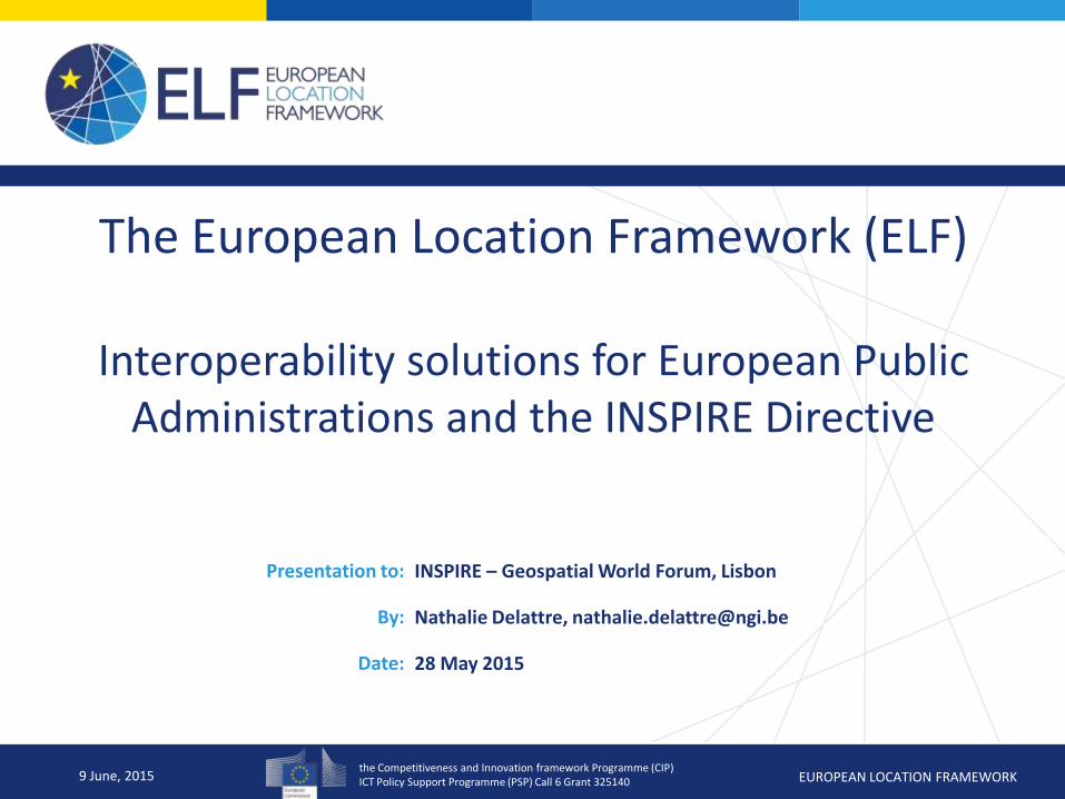
The European Location Framework (ELF)
Interoperability solutions for European Public Administrations and the INSPIRE Directive
INSPIRE – Geospatial World Forum, Lisbon
Nathalie Delattre, [email protected]
28 May 2015
9 June, 2015
the Competitiveness and Innovation framework Programme (CIP) ICT Policy Support Programme (PSP) Call 6 Grant 325140 EUROPEAN LOCATION FRAMEWORK
Presentation to:
Author:
Date:
9 June, 2015
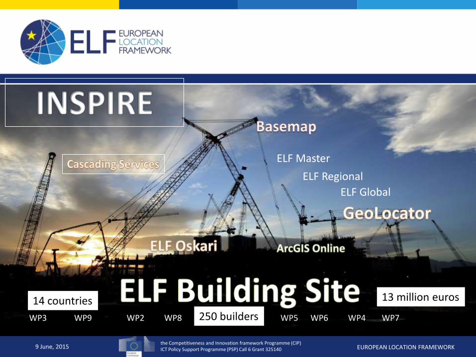
WP3 WP2 WP4 WP5 WP6 WP7 WP8 WP9
ELF Master
ELF Global
ELF Regional
13 million euros 14 countries
250 builders
the Competitiveness and Innovation framework Programme (CIP) ICT Policy Support Programme (PSP) Call 6 Grant 325140 EUROPEAN LOCATION FRAMEWORK
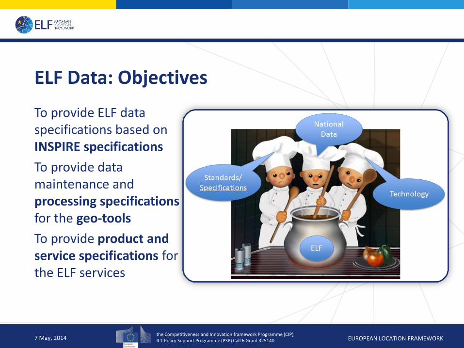
ELF Data: Objectives
To provide ELF data specifications based on INSPIRE specifications
To provide data maintenance and processing specifications for the geo-tools
To provide product and service specifications for the ELF services
7 May, 2014
the Competitiveness and Innovation framework Programme (CIP) ICT Policy Support Programme (PSP) Call 6 Grant 325140 EUROPEAN LOCATION FRAMEWORK
Main challenges to face in providing ELF data
• To provide national authoritative reference data
• To provide cross-border harmonised data at European level
• to meet users needs (European)
• To insure sustainable maintenance and updates of the data ( quality insurance)
• To adopt a standard dedicated to data exchange and used by the geoprocessing tools.
9 June, 2015
the Competitiveness and Innovation framework Programme (CIP) ICT Policy Support Programme (PSP) Call 6 Grant 325140 EUROPEAN LOCATION FRAMEWORK
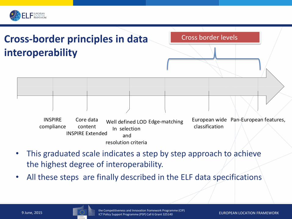
Cross-border principles in data interoperability
• This graduated scale indicates a step by step approach to achieve the highest degree of interoperability.
• All these steps are finally described in the ELF data specifications
9 June, 2015
3 921/04/2014
INSPIREcompliance
16/05/2014
Core data content
INSPIRE Extended
12/07/2014
Edge-matching
13/08/2014
European wide classification
16/06/2014
Well defined LODIn selection
and resolution criteria
18/09/2014
Pan-European features,
Cross border levels
the Competitiveness and Innovation framework Programme (CIP) ICT Policy Support Programme (PSP) Call 6 Grant 325140 EUROPEAN LOCATION FRAMEWORK
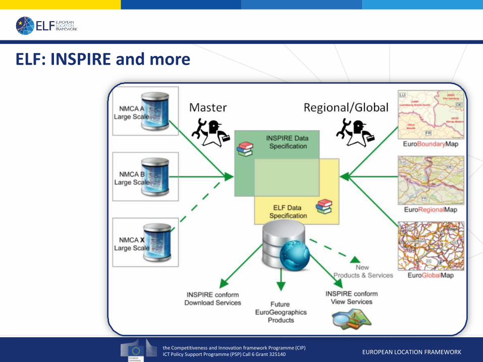
ELF: INSPIRE and more

the Competitiveness and Innovation framework Programme (CIP) ICT Policy Support Programme (PSP) Call 6 Grant 325140 EUROPEAN LOCATION FRAMEWORK
Data Content by themes and Level of Detail
7 May, 2014
MASTER LoD0 Master LoD1/2 REGIONAL GLOBAL
Cadastral Parcels
(CP)
Administrative Units (AU) Administrative Units (AU): AU
& NUTS
Administrative Units (AU)
Addresses (AD) Hydrography (HY) Hydrography (HY): HY & SR Hydrography (HY): HY & SR
Sea Regions (SR)
Transport Networks (TN) Transport Networks (TN) Transport Networks (TN)
Geographical
Names (GN)
Geographical Names (GN) Geographical Names (GN):
GN & POP
Geographical Names (GN):
GN & POP
Elevation (EL) Elevation (EL) Elevation (EL) Elevation (EL)
Land Cover (LC) Land Cover (LC): POP & VEG Land Cover (LC): POP
Buildings (BU) Buildings (BU) Buildings (BU)
Protected Sites (PS) Protected Sites (PS)
Miscellaneous (MISC)
the Competitiveness and Innovation framework Programme (CIP) ICT Policy Support Programme (PSP) Call 6 Grant 325140 EUROPEAN LOCATION FRAMEWORK
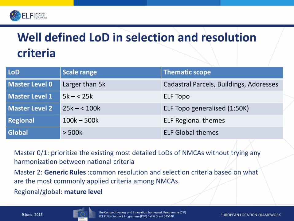
Well defined LoD in selection and resolution criteria
Master 0/1: prioritize the existing most detailed LoDs of NMCAs without trying any harmonization between national criteria
Master 2: Generic Rules :common resolution and selection criteria based on what are the most commonly applied criteria among NMCAs.
Regional/global: mature level
9 June, 2015
LoD Scale range Thematic scope
Master Level 0 Larger than 5k Cadastral Parcels, Buildings, Addresses
Master Level 1 5k – < 25k ELF Topo
Master Level 2 25k – < 100k ELF Topo generalised (1:50K)
Regional 100k – 500k ELF Regional themes
Global > 500k ELF Global themes
the Competitiveness and Innovation framework Programme (CIP) ICT Policy Support Programme (PSP) Call 6 Grant 325140 EUROPEAN LOCATION FRAMEWORK
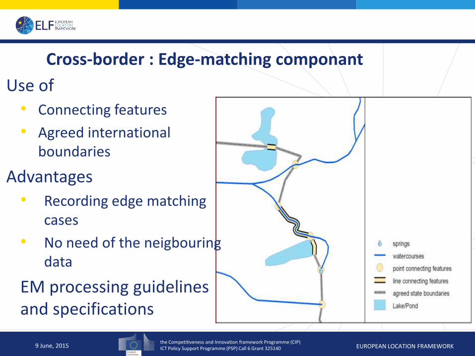
Cross-border : Edge-matching componant
9 June, 2015
Use of
• Connecting features
• Agreed international boundaries
Advantages
• Recording edge matching cases
• No need of the neigbouring data
EM processing guidelines and specifications
the Competitiveness and Innovation framework Programme (CIP) ICT Policy Support Programme (PSP) Call 6 Grant 325140 EUROPEAN LOCATION FRAMEWORK
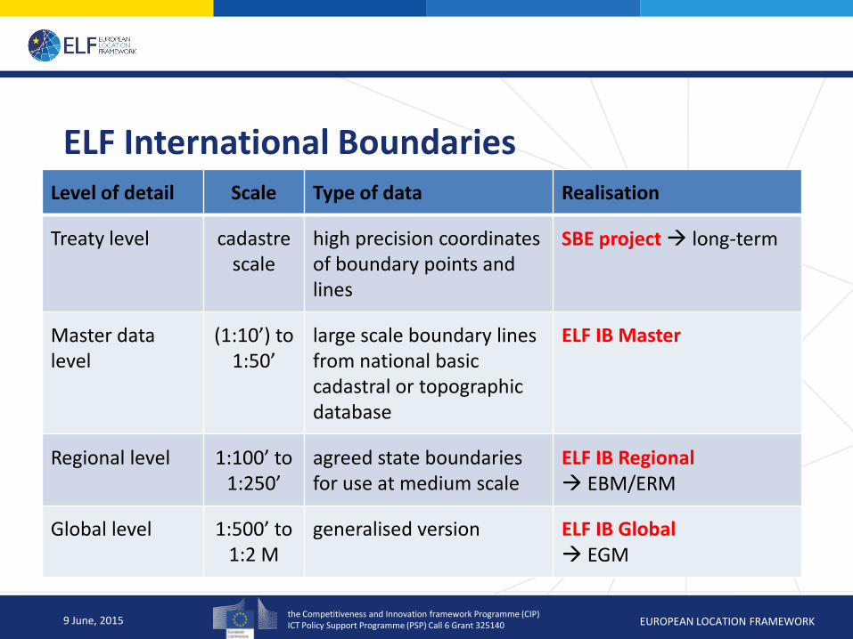
ELF International Boundaries
9 June, 2015
Level of detail Scale Type of data Realisation
Treaty level cadastre scale
high precision coordinates of boundary points and lines
SBE project long-term
Master data level
(1:10’) to 1:50’
large scale boundary lines from national basic cadastral or topographic database
ELF IB Master
Regional level 1:100’ to 1:250’
agreed state boundaries for use at medium scale
ELF IB Regional EBM/ERM
Global level 1:500’ to 1:2 M
generalised version ELF IB Global EGM
the Competitiveness and Innovation framework Programme (CIP) ICT Policy Support Programme (PSP) Call 6 Grant 325140 EUROPEAN LOCATION FRAMEWORK
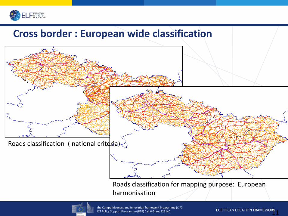
Cross border : European wide classification
11
Roads classification ( national criteria)
Roads classification for mapping purpose: European harmonisation
the Competitiveness and Innovation framework Programme (CIP) ICT Policy Support Programme (PSP) Call 6 Grant 325140 EUROPEAN LOCATION FRAMEWORK
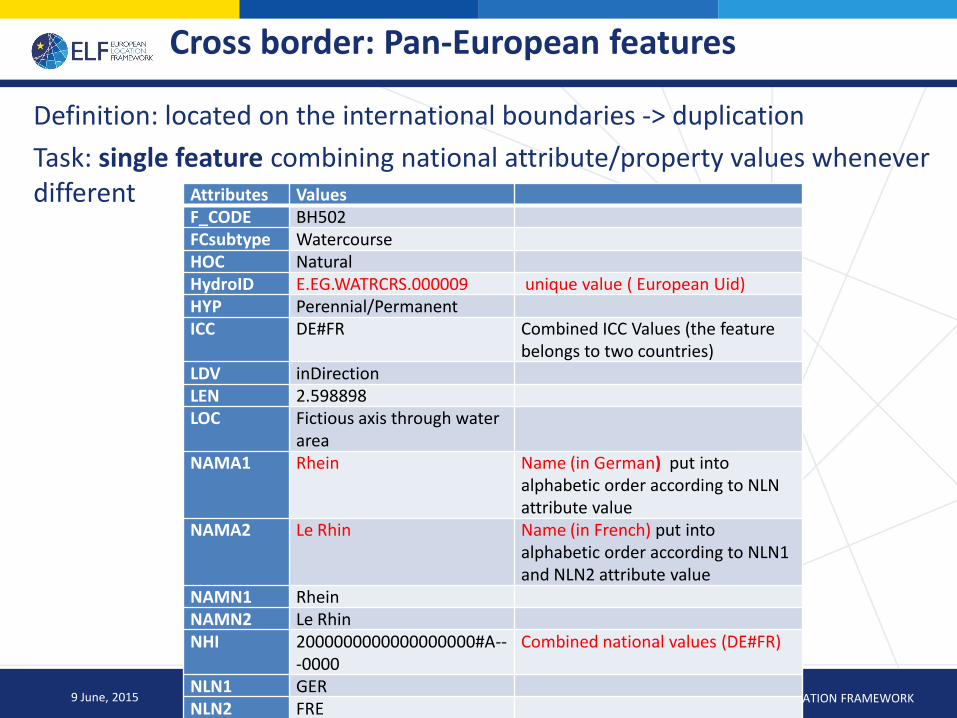
Cross border: Pan-European features
Definition: located on the international boundaries -> duplication
Task: single feature combining national attribute/property values whenever different
9 June, 2015
Attributes Values F_CODE BH502 FCsubtype Watercourse HOC Natural HydroID E.EG.WATRCRS.000009 unique value ( European Uid) HYP Perennial/Permanent ICC DE#FR Combined ICC Values (the feature
belongs to two countries) LDV inDirection LEN 2.598898 LOC Fictious axis through water
area
NAMA1 Rhein Name (in German) put into alphabetic order according to NLN attribute value
NAMA2 Le Rhin Name (in French) put into alphabetic order according to NLN1 and NLN2 attribute value
NAMN1 Rhein NAMN2 Le Rhin NHI 2000000000000000000#A--
-0000 Combined national values (DE#FR)
NLN1 GER NLN2 FRE NVS Navigable
the Competitiveness and Innovation framework Programme (CIP) ICT Policy Support Programme (PSP) Call 6 Grant 325140 EUROPEAN LOCATION FRAMEWORK
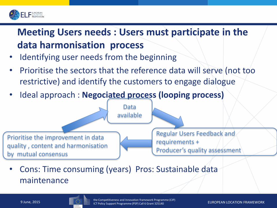
Meeting Users needs : Users must participate in the data harmonisation process
• Identifying user needs from the beginning
• Prioritise the sectors that the reference data will serve (not too restrictive) and identify the customers to engage dialogue
• Ideal approach : Negociated process (looping process)
• Cons: Time consuming (years) Pros: Sustainable data maintenance
9 June, 2015
Data available
Regular Users Feedback and requirements + Producer’s quality assessment
Prioritise the improvement in data quality , content and harmonisation by mutual consensus
the Competitiveness and Innovation framework Programme (CIP) ICT Policy Support Programme (PSP) Call 6 Grant 325140 EUROPEAN LOCATION FRAMEWORK
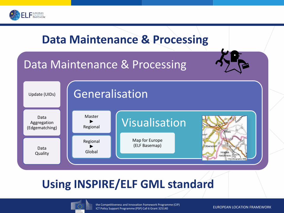
Data Maintenance & Processing
Data Maintenance & Processing
Update (UIDs)
Data Aggregation
(Edgematching)
Data Quality
Generalisation
Master ►
Regional
Regional ►
Global
Visualisation Map for Europe (ELF Basemap)
Using INSPIRE/ELF GML standard
the Competitiveness and Innovation framework Programme (CIP) ICT Policy Support Programme (PSP) Call 6 Grant 325140 EUROPEAN LOCATION FRAMEWORK
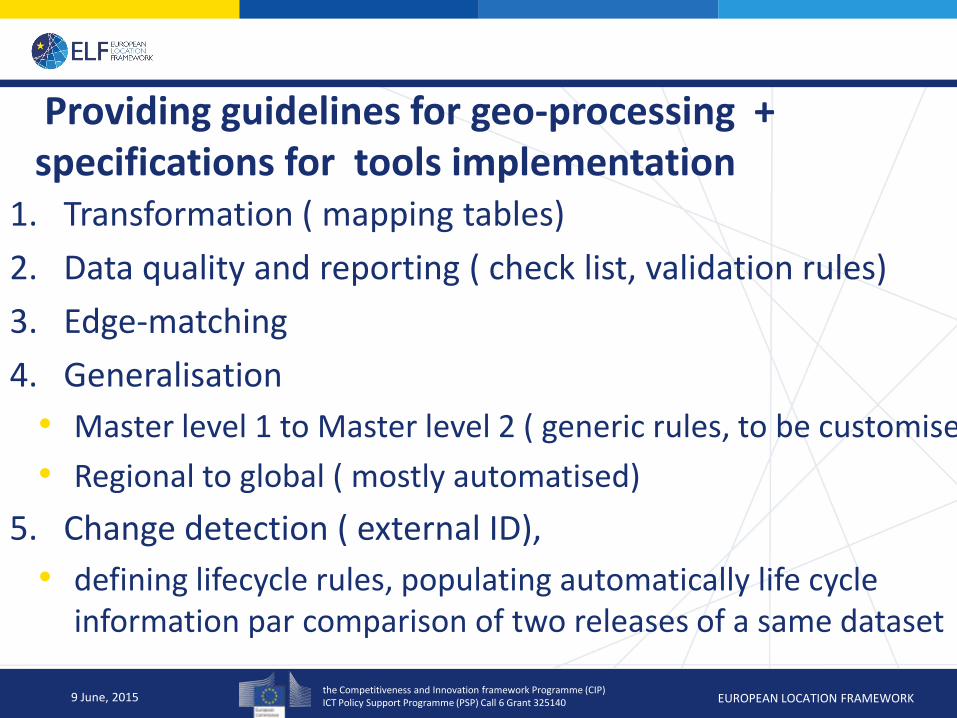
Providing guidelines for geo-processing + specifications for tools implementation
1. Transformation ( mapping tables)
2. Data quality and reporting ( check list, validation rules)
3. Edge-matching
4. Generalisation
• Master level 1 to Master level 2 ( generic rules, to be customised
• Regional to global ( mostly automatised)
5. Change detection ( external ID),
• defining lifecycle rules, populating automatically life cycle information par comparison of two releases of a same dataset
9 June, 2015
the Competitiveness and Innovation framework Programme (CIP) ICT Policy Support Programme (PSP) Call 6 Grant 325140 EUROPEAN LOCATION FRAMEWORK
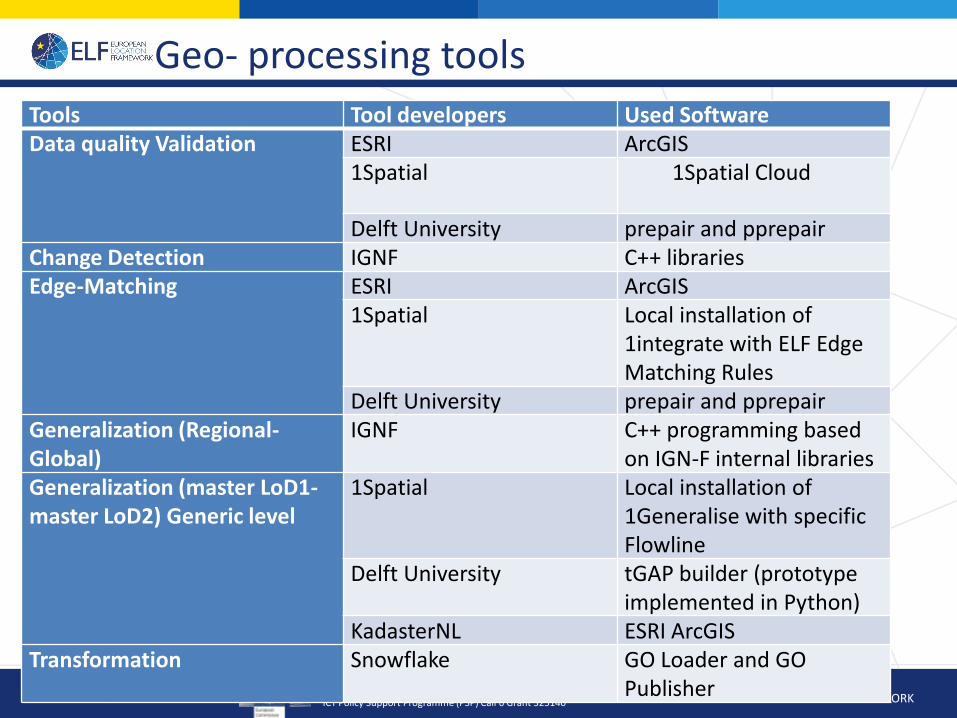
Geo- processing tools
9 June, 2015
Tools Tool developers Used Software Data quality Validation ESRI ArcGIS
1Spatial 1Spatial Cloud
Delft University prepair and pprepair Change Detection IGNF C++ libraries Edge-Matching ESRI ArcGIS
1Spatial Local installation of 1integrate with ELF Edge Matching Rules
Delft University prepair and pprepair Generalization (Regional-Global)
IGNF C++ programming based on IGN-F internal libraries
Generalization (master LoD1-master LoD2) Generic level
1Spatial Local installation of 1Generalise with specific Flowline
Delft University tGAP builder (prototype implemented in Python)
KadasterNL ESRI ArcGIS Transformation Snowflake GO Loader and GO
Publisher

the Competitiveness and Innovation framework Programme (CIP) ICT Policy Support Programme (PSP) Call 6 Grant 325140 EUROPEAN LOCATION FRAMEWORK
Lessons learnt after implementation and testing
1. The ELF/INSPIRE data schema is a little bit too advanced to be easily transformed into most of the GIS software and tools. ( Oracle, PostgreSQL, Geodatabase)
• Tools provider set up their own transformation solutions from INSPIRE/ELF GML into internal flattened data format, which could lead to different interpretation.
• Geo-processing tools are currently restricted to simple features
• Basemap application requires simple features
9 June, 2015
the Competitiveness and Innovation framework Programme (CIP) ICT Policy Support Programme (PSP) Call 6 Grant 325140 EUROPEAN LOCATION FRAMEWORK
Lessons learnt after implementation and testing
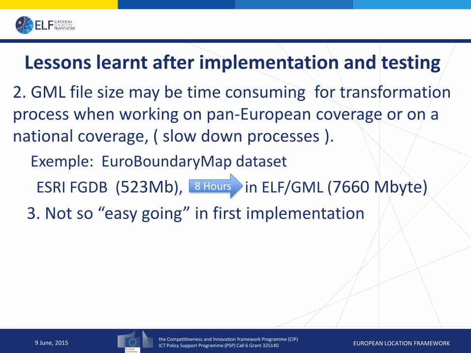
2. GML file size may be time consuming for transformation process when working on pan-European coverage or on a national coverage, ( slow down processes ).
Exemple: EuroBoundaryMap dataset
ESRI FGDB (523Mb), in ELF/GML (7660 Mbyte)
3. Not so “easy going” in first implementation
9 June, 2015
8 Hours
the Competitiveness and Innovation framework Programme (CIP) ICT Policy Support Programme (PSP) Call 6 Grant 325140 EUROPEAN LOCATION FRAMEWORK
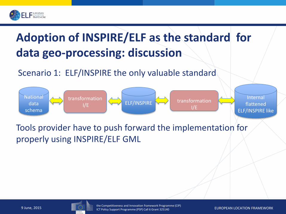
Adoption of INSPIRE/ELF as the standard for data geo-processing: discussion
Scenario 1: ELF/INSPIRE the only valuable standard
Tools provider have to push forward the implementation for properly using INSPIRE/ELF GML
9 June, 2015
transformation
I/E
National data
schema
transformation I/E ELF/INSPIRE
Internal flattened
ELF/INSPIRE like
the Competitiveness and Innovation framework Programme (CIP) ICT Policy Support Programme (PSP) Call 6 Grant 325140 EUROPEAN LOCATION FRAMEWORK
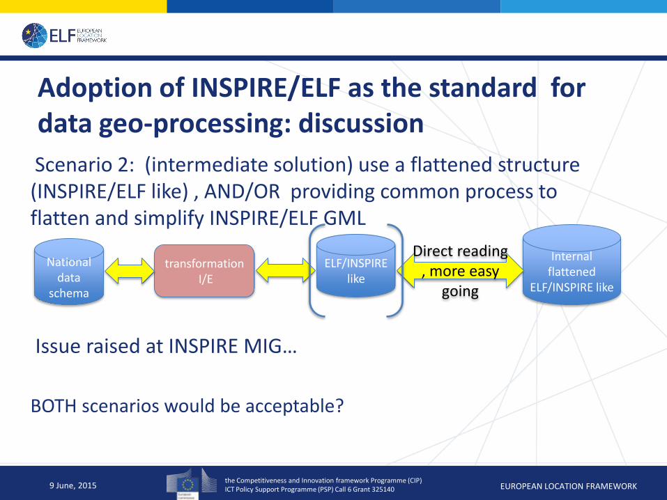
Adoption of INSPIRE/ELF as the standard for data geo-processing: discussion
Scenario 2: (intermediate solution) use a flattened structure (INSPIRE/ELF like) , AND/OR providing common process to flatten and simplify INSPIRE/ELF GML
Issue raised at INSPIRE MIG…
BOTH scenarios would be acceptable?
9 June, 2015
National data
schema
transformation I/E
ELF/INSPIRE like
Internal flattened
ELF/INSPIRE like
Direct reading , more easy
going
the Competitiveness and Innovation framework Programme (CIP) ICT Policy Support Programme (PSP) Call 6 Grant 325140 EUROPEAN LOCATION FRAMEWORK
Summary
1. Data cross-border interoperability and harmonisation is composed of several degrees of interoperability that should be tackled in a step by step approach.
2. Users should be included from the beginning in the data harmonisation process by providing regular feedback
3. INSPIRE standard is still a bit too elaborated to be used in geo-processing
Solutions for improving the implementation using the INSPIRE standard
Solutions for symplifying the standard
9 June, 2015
the Competitiveness and Innovation framework Programme (CIP) ICT Policy Support Programme (PSP) Call 6 Grant 325140 EUROPEAN LOCATION FRAMEWORK
From isolated components to integrated, cross-border seamless authoritative reference data …
Thank you!
17 Dec, 2014