Embed Size (px)
Citation preview
The Effects of Rapid Geological Change on Archaeology in Hawai'i
GARY F. SOMERS
IN THE PREFACE TO Volcanoes in the Sea Macdonald and Abbott (1970: ix), in referring to the Hawaiian Islands and other islands in the mid-Pacific, noted: "We who make our homes in the islands tend to become complacent in our surroundings, giving little thought to the grandeur of the scenery around us and to the dramatic processes that brought it into being." Archaeologists working in Hawai'i are no exception to this observation. Although archaeologists now realize that "the Hawaiian Islands are not a 'cultural laboratory' in which environment can be held to have remained 'constant''' (Kirch 1985: 290), they tend to concentrate on the culture of the colonizing Polynesians as a major force that shaped the island ecosystem. Little attention is given to how natural events could have shaped and reshaped that ecosystem as well.
The three major geologically based events that this paper will be concerned with are volcanic eruptions, earthquakes, and tsunamis. In the two thousand or so years that humans have inhabited the Hawaiian Islands, three volcanoes on the island of Hawai'i (KIlauea, Mauna Loa, and Hualalai) and one on the island of Maui (Hale akala) have been active. Active volcanoes not only mean eruptions and lava flows but also earthquakes. Earthquake swarms both precede and follow eruptions and are the result of shifting of rocks in the volcanic structures when the volcanoes swell and shrink. Although most of the earthquakes in Hawai'j are small and do little or no damage, a few large earthquakes have been recorded on the island of Hawai'i in historic times (Macdonald and Abbott 1970: 252-254). Strong earthquakes can generate tsunamis, or seismic sea waves. In historic times in Hawai'i waves that have done moderate to severe damage have been generated locally or have come from the Aleutian Islands, South America, and Kamchatka (Macdonald and Abbott 1970: 260-261). How volcanic eruptions, earthquakes, and tsunamis in the last one to two thousand years have impacted both the people living in Hawai'i and the archaeological remains associated with them have not received the attention they deserve by archaeologists.
There are two primary areas archaeologists must become more cognizant of as they study the archaeological record. The first is the impact such geological events
Gary F. Somers is Pacific Area Archaeologist, National Park Service, 300 Ala Moana Boulevard, Honolulu, HI 96825. Asian Perspectives, Vol. 30. no. 1. © 11.)()1 by Umvcrslty ofHawati Press. All rights n.:scrvcJ.
134 Asian Perspectives, xxx (1), 1991
had on the people who were living in the area. This not only includes direct impact to habitation, subsistence, and religious structures and activities, but also to the more subtle impact such events have on the underlying mind set and life ways that produced such structures and activities. The second is the impact such events, even in modem times, have on the archaeological record that is available for study.
HISTORICALL Y RECORDED EVENTS
On Maui, in about 1790, lava flowed from two vents on the southwest rift zone of Haleakala and poured into the ocean at Makena. The age of the flow was determined by comparing charts of the coastline of Maui made by the exploring expeditions commanded by La Perouse and Vancouver. Although La Perouse's map, made in 1786, showed a broad shallow bay, Vancouver's map, made in 1793, showed a prominent peninsula-a peninsula that was formed by a lava flow bctween the two visits (Macdonald and Abbott 1970:50-51). According to Kirch (1985:33), "this eruption certainly must have covered Hawaiian settlements, since the coastline in this area is known to have been heavily populated."
On Hawai'i, Hualalai last crupted in 1800-1801. Lava flows from that eruption buried several villages, covered Wainanali'i Fishpond, destroyed a number of plant ations, and filled up a deep bay twenty miles long. The destruction was significant enough that Kamehameha himself offered sacrifices to Pele to stop the flows (Ellis 1979:30-31; Kamakau 1961: 184-186; 1964:67). According to Ellis (1979:31), "stone walls, trees, and houses, all gave way before it."
Kilauea and Mauna Loa have been much more active than Hualalai during the historic period, and the historical record of the impacts of eruptions from Kilauea on areas of Hawaiian habitation, subsistence, and procurement is much more extensive. The best sources that document these impacts are Brigham (1909), Dibble (1909), and Ellis (1979).
One of the more unusual events, the destruction of a portion of Keoua's army, was also one of the earliest ones recorded by western observers. In 1790 a rare explosive eruption at Kilauea killed a portion of Keoua's army that was passing by the caldera at the time (Dibble 1909:51-53). Dibble's information came from informants who had been part of Keaua's army and had survived the eruption. The bodies were apparently never buried; an unburied skull was found by one of Dibble's missionaries who travelled through the area in the late 18305 or early 18405 (Dibble 1909: 53), and Brigham (1909: 36) noted that "the bones of the perished warriors I have myself seen in the place where they are said to have died." Swanson and Christiansen (1973: 86) analyzed the available data and concluded that "a hot base surge, composed primarily of super heated steam, caught the middle party of King Keoua's army" and "the hot gases seared their lungs, causing them to suffocate, and the intense heat scorched their skin. "
Although this may be the most dramatic recorded case of adverse impacts of volcanic eruptions on Hawaiians, it is far from the typical case. More often adverse impacts were caused by lava, earthquakes, landslides, and tsunamis. The most complete record of the history of Kilauea eruptions and their impacts during the nineteenth century is Brigham (1909). In 1840 an eruption from Kilauea's summit reached the ocean. The flow alternated between surface and subterranean flows and
SOMERS: HAW AI'r GEOLOGY 135
"after flowing underground several miles, perhaps six or eight, it again broke out like an overwhelming flood, and sweeping forest, hamlet, plantation, and everything before it, rolled down with resistless energy to the sea" (Brigham 1909: 52).
In 1865 Brigham visited Keanakako'j Pit Crater and noted that "the traces of the ancient adz-making, which gave Keanakako'i (the workshop of the adzes) its name, were abundant, but thc fragments of the adzes usually abundant in such quarries werc not noticed" (Brigham 1909:90-91). A subsequent flow in 1877 (Brigham 1909: 132) partially fillcd the crater and buried the adz quarry. Brigham's (1909:91 n. 71) observation that "every trace of stone-working has been hidden" by this 1877 flow was borne out in 1987 when an archaeologist examined both the surface adjacent to the rim of the crater and the perimeter of the crater floor and found no evidence of prehistoric quarrying (Withrow 1987: 2).
The most destructive, and probably the best documented, series of volcanic events occurred in 1868 in the Ka'ii and Puna districts. The severity and combination of lava flows, earthquakes, tsunamis, and landslides were such that many western observers recorded their impacts. Brigham did a good job of compiling the various accounts; the following quotes from Brigham (1909) illustrate the impact of these events.
Every stone wall, almost every house, in Kau was overturned, and the whole was done in an instant (101).
Along the shore between Kapoho and Kalae, villages were swept away [by the tsunami], and even heavy stone houses disappeared before the destroying waves (103).
Made Kealakomo, Puna, at daylight. The houses nearest the beach gone; same at Kahue. All swept clean at Apua. Reached Keauhou, Kau, at seven a.m. and anchored . . . . Every building, eleven in all, washed away; not a stick or stone of them left standing (103).
About four thousand acres of good pasture land were destroyed, besides which lava ran over an immense district of worthless land (105).
But all these signs of destruction are thrown in the shade by the grandeur of the force which shook off the side of the paJi, burying in a minute thirty-one human beings, many hundred head of cattle, and entire flocks of goats, and ending four miles from its beginnings in a mighty river of mud (109).
From Punaluu onward to Honuapo, all houses swept away except two standing on high lava ridges .... Not a house remains in the considerable village of Honuapo: the sea occupies the site of former dwellings (113).
In all, in Ka'u, Brigham (1909: 118) recorded 201 houses destroyed either by landslide, tsunami, earthquake, or lava flow.
Ellis also recorded a number of incidents of impacts on villages and fields. The earthquake at Kaimii in 1823 happened about two months before Ellis' visit. It threw down a large stone wall and opened a chasm through a house. It also passed through fields of potatoes and scorched and spoiled the potatoes growing in the direction of the fissure. Perhaps more significantly, it also passed through a well and increased the quantity of water in it but greatly deteriorated its quality by increasing its saltiness (Ellis 1979: 195-196).
Ellis also noted a large landslide at the village of Laupihoehoe that occurred eight or nine months before his visit. According to Ellis (1979: 271), "the mass that
136 Asian Perspectives, xxx (1), 1991
had fallen lay in ruins at the base [of the perpendicular face], where it had formed two considerable hills, filled up a large fish pond and part of the sea, presenting altogether a scene of wide-spread desolation. "
MODERN OBSERVATIONS
In 1946, an Aleutian earthquake generated a tsunami that hit Hawai'i and drove water inland to heights as great as 17 m above sea level. At least two areas that are known to contain extensive archaeological features, Halawa Valley and Waikolu Valley on Moloka'i, were severely impacted by the tsunami. The wave flooded the majority of the taro fields in Hilawa Valley, salting and destroying the crop (Kirch 1985:33). The wave eroded a large part of the Halawa Dune Site, MO-Al-3, an early settlement site, leaving only two small mounds standing on the floodplain (Kirch 1985: 76). Archaeological evidence of similar impacts from prehistoric tsunamis was found at fla'ena, Kaua'i. Stratigraphic evidence of prehistoric tsunamis included well-sorted, laminated deposits of sand with larger coral debris up to 3 m above present sea level (Kirch 1985: 33).
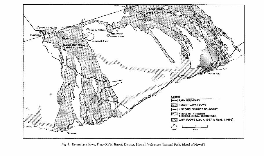
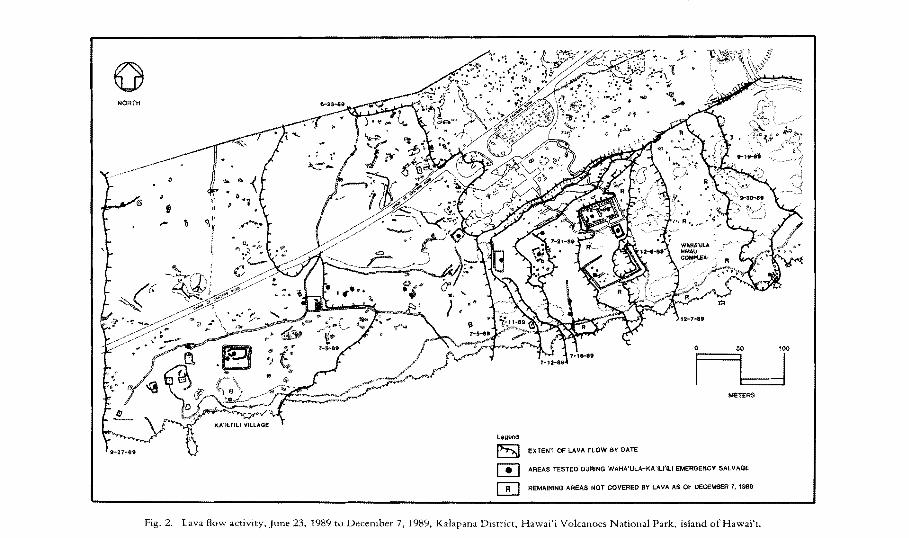
Some of the best records of actual impacts of lava flows on archaeological resources comes from the work the National Park Service has been doing at Hawai'i Volcanoes National Park on the island of Hawai'i. The National Park Service has been recording and documenting the impacts of the ongoing eruption (1983 to present) from Pu'u'6'6 and Kupaianaha vents on the cast rift zone of Kilauea on the cultural resources in Hawai'i Volcanoes National Park (see Carter and Somers 1990; Ladefoged et al. 1987). Since 1974 over 28,000 archaeological features have been recorded in the park, and since 1985 over 14,500 of them have been buried by lava. Also, over 300 recorded archaeological features were buried by lava flows from the Maunaulu eruption from 1969 to 1975. Many hundreds or even thousands of additional features were undoubtedly buried as well, because those lava flows occurred in an area of the park that had only received cursory, reconnaissance-level archaeological survey. Village sites, religious structures, water sources, pahoehoe block procurement areas, canoe mooring holes, and agricultural fields have all been buried. Figure 1 shows the overall impact of these two eruptions on areas in the park where archaeological features are known to exist. Figure 2 illustrates in greater detail how lava flows buried Ka'ili'ili Village and all of the Waha'ula Heiau Complex except for the three main structures.
RESPONSES TO AN UNSTABLE ENVIRONMENT
The historical record and modern observations have documented the impacts of volcanic eruptions on what today would be identified as archaeological sites. According to the geological record, this has been an ongoing process for the entire span of Hawaiian occupation on the Big Island. Kilauea's surface is very young; 70 percent is younger than 500 years, 90 percent younger than 1100 years. Between A.D. 1200 and A.D. 1800 Kilauea flows covered more than 80 percent of its surface (Holcomb 1987: 346). Mauna Loa and Hualalai are not as active as Kilauea; nevertheless about 40 percent of Mauna Loa's surface has been covered in the last 1000 years (Lock wood and Shipman 1987: 515) and about 25 percent of the surface of Hualalai has an age ofless than 1000 years (Moore et a1. 1987: 575).
o
o
Legend
B PARK BOUNDARY
RECENT LAVA FLOWS
HISTORIC DISTRICT BOUNDARY
AREAS WITH KNOWN ARCHEOLOGICAL RESOURCES
~ LAVA FLOWS (Jan. 4,1987 to Sept. 1,1989)
(]) o Miles
Fig. 1. Recent lava flows, Puna-Ka'fi Historic District, Hawai'j Volcanoes National Park, island of Hawai'i.
o NORTH
t ".. 'II '1." y
i
o 50 100
I I I METERS
l~end
[SI EXTENT OF LAVA FLOW BY DATE
m AREAS TESTED DURING WAHA'ULA-KA'ILI'ILI EMERGENCY SALVAGE
W REMAINING AREAS NOT COVERED BY LAVA AS OF DECEMBER 7, 198e
Fig. 2. Lava flow activity, June 23, 1989 to December 7, 1989. Kalapana District, Hawai'i Volcanoes National Park. island ofHawai'i.

SOMERS: HAWAI'1 GEOLOGY 139
How this unstable environment influenced settlement and subsistence patterns or, in other words, how Hawaiians responded to such impacts are questions that have not been given the attention they deserve by archaeologists. The historical record contains a few references to responses to volcanic impacts. In discussing the 1868 cataclysm, Handy and Pukui noted:
By far the greatest devastation at that time was wrought by the accompanying tidal waves in the fishing villages along the rugged south-eastern coast of Ka Lae, the cape. In all of these the loss oflife was great, and in many the physical destruction was such that they were no longer habitable. These marks of alteration or desolation are still notable in most. None ever recovered their former prosperity (1972:240).
Perhaps of even greater relevance is footnote 72 on page 240 of Handy and Pukui (1972):
Mrs. Pukui's grandmother was a survivor of the devastation wrought at Waikapuna, her home being on a slightly higher ground; but the valley and the fresh springs were ruined for any subsequent cultivation, by the tidal waters and heaped-up sands. Her home was later moved mauka, to the uplands above Na'alehu.
Brigham noted a strikingly different response to the destruction from the same event in the Punalu'u to Honu'apo area. After quoting from a letter from Mr. Coan in 1868 that described the destruction, Brigham (1909: 113 n.85) remarked, presumably in 1909, when his book was published, "to the casual traveler no signs of this shore catastrophe remain. Wharves and villages replace those destroyed, and even a sugar-mill and its surrounding hamlet occupies one of the points where the ravages were greatest."
A similar response seems to have occurred at 'Apua Point and Kahue. As noted earlier in this paper, the houses at Kahue and 'Apua were all swept clean by the tsunami in 1868 (Brigham 1909: 103, 113). Nevertheless, when Smart (1965 : 31-32) conducted an archaeological survey in that portion of Hawai'i Volcanoes National Park in 1964, he recorded many archaeological sites at both 'Apua and Kahue. Included among the sites were house platforms, petroglyphs, a possible heiau, and burial platforms. It appears these two villages were rebuilt after the 1868 tsunami. It should also be noted that the possible heiau was closer to the shore than any of the house platforms and its condition was so bad that definite identification was 110t possible.
EFFECTS OF LIVING ON A VOLCANO
An interesting addition to the physical responses to the destruction is the historically recorded attitudes of Hawaiians to volcanic activities. In describing the 1823 earthquake at Kaimii, Ellis commented on the house through which the chasm passed:
We entered a house, sixteen feet by twelve in the inside, through which it had passed. Ten persons ... were asleep here at the time it occurred .... The trembling of the ground, they said, awoke them, but before they could think what it was that had disturbed them, the earth opened with a violent percussion.
We asked them if they were not alarmed? They said they were at first, but after remaining awake some time, and finding the shock was not repeated, they lay down and slept till morning, when they filled up the fissure with grass and earth! (1979: 195).
140 Asian Perspectives, xxx (1), 1991
The way Ellis presented this information makes it clear that he was surprised by this cavalier attitude toward what he considered a startling occurrence. Similar attitudes were expressed by Dibble (1909) and Brigham (1909). Whereas these westerners looked at volcanic eruptions with a sense of awe and amazement, they noted that Hawaiians did not. Brigham (1901 : 63) noted that "all that concerned the aborigines was the descent of a destroying lava stream into their fertile fields or over the sand beaches and into the bays, so important to a fishing population." This attitude, which clearly reflects the influence of living for generations on an island with active volcanoes, is discussed in Handy and Pukui (1972) and Handy and Handy (1972). In discussing the numerous volcanic eruptions in Ka'ii, Handy and Pukui noted:
Small wonder that its [Ka'u's 1 population became inured to cataclysms of cosmic dimensions, and to the jolts and reverberations of earthquakes. The magnitude of the earth drama that is literally "under foot" for every Ka'uan, night and day, was a dominant factor in conditioning the character of the people ofKa'u (1972:208).
Handy and Handy noted much the same thing when they commented:
Ka'u is a country where the terrain and nature of physiography and geological formations, the weather, the ocean, and vulcanism above all else, gave physical environment a dominance that was overwhelming, and in the end catastrophic. The courageous Hawaiian pioneers took this country unto themselves; they adjusted themselves to it; they made it their own; but in the end, when they were weakened by the foreign invasions of new peoples with their new religions, foods, vices, and diseases, it overwhelmed them (1972:556-557).
Whereas Hawaiians treated Pele, the fire goddess, with a great deal of respect and reverence and performed rituals for her propitiation, it also seems, based on the observations of Ellis, Dibble, and Brigham, and the comments by Handy and Pukui, that they viewed volcanic eruptions and earthquakes as common, if not every day, occurrences. On the other hand, western observers viewed such events as aweinspiring phenomenon that were the subject of scientific curiosity and investigation, and they were puzzled when Hawaiians did not treat them in the same manner. If the threat was not imminent, Hawaiians did not worry about it.
RESOURCE AVAILABILITY
Clearly impacts from lava flows, earthquakes, and tsunamis affected not only the actual habitation areas of Hawaiians, but also affected, both positively and adversely, the resources that were available to Hawaiians. Probably the best known example of the beneficial effects of geological events is the Mauna Kea adze quarry. Volcanic eruptions beneath the Waihu glaciation 170,000-175,000 years ago formed the large escarpment of dense Hawaiite that was extensively used by Hawaiian adze makers even though it was at an elevation of over 11,000 feet (Cleghorn 1986: 376; Porter 1987: 592).
Another example, which has yet to be investigated, is the footprints area of Hawai'i Volcanoes National Park (this is the area where Ke6ua's army was killed). An extensive area was blanketed by ash from the A.D. 1790 eruption from Kilauea. Although little archaeological work has been done in this area, there are numerous
SOMERS: HAWAI'1 GEOLOGY 141
features that sit on top of remnants of this ash. These features appear to have been both shelters and agricultural features. Perhaps the ash increased the agricultural potential of the area and attracted Hawaiians to it, much like the increased agricultural potential that resulted from the volcanic ash from Sunset Crater in northeastern Arizona. Following the eruption between A. D. 1046 and 1070, the population of that area expanded enormously due to the increased agricultural productivity caused by the ash (Martin and Plog 1973: 143).
Other beneficial impacts could well have taken place during the period of Hawaiian occupation and have since been obliterated by subsequent geological events. The changes that are resulting from the ongoing eruption from Kupaianaha vent illustrate this quite well. Eruptions in the past created the famous black sand beach at Kaimu, which was an important canoe landing site. That beach has now been covered by new lava flows. At the same time, parts of the coastline within Hawai'i Volcanoes National Park have been transformed from steep, imposing, wave-washed cliffs to sloping black sand beaches. This is especially true at Kamoamoa, which was both a prehistoric and a historic village site. What was once a rugged coastline that necessitated making holes in the rocks to secure a canoe ramp for launching and landing canoes has been transformed into a beautiful black sand beach that would have made launching and landing canoes much easier. It is uncertain, however, how permanent this beach will be. Now that the source of cinders from lava flows into the ocean has moved several miles away, the beach has already started to erode.
The challenge for archaeologists will be trying to determine how changes such as these affected Hawaiians in prehistoric times. An example of this challenge can be found in Hawai'i Volcanoes National Park. Most of the area within the park that has been covered by lava flows since 1985 was part of the Kane Nui 0 Hamo lava flows that were only 500 to 750 years old (Holcomb 1987: Fig. 12.5). Human occupation of the area could very well predate those flows. Farther west in the park, west of Keauhou Point, there are numerous recorded archaeological sites in lava tubes in the Kipukancne flows that date to 1000 to 1500 years B.P. (Holcomb 1987: Fig. 12.5). One of the sites, HV -75, has been radiocarbon dated. The calibrated age ranges (one sigma) for the three samples from the site were A.D. 31 to 247, A.D. 676 to 890, and A.D. 898 to 1146 (Carter and Somers 1990: Table 3). The first range is highly questionable because it is older than the lava flow that the tube is in. The other two age ranges, however, are consistent with the flow's age of A.D. 450 to 950 and indicate Hawaiian occupation in the park could well predate the Kane Nui 0 Hamo flows. Those flows undoubtedly both created and destroyed opportunities for Hawaiians, and archaeologists must look for the clues to those changes.
As previously demonstrated, resources that were available for use could rapidly be destroyed. Sources of adze material, agricultural fields, habitation areas, water sources, and other critical resources have been buried by lava or landslides. Similar impacts must also have occurred to marine resources, but these have not been recorded to the same extent, except the impact to fish ponds. Again, the ongoing lava flows from Kupaianaha vent some indication of what the impact might have been. Many of the resources, such as pipipi (Nerita sp.) and 'opihi (Helcioniscus sp.), that were collected along the inshore coastal area of portions of Hawai'i Volcanoes National Park have been severely impacted by both lava flows and volcanic cinders suspended in the water.
142 ilsian Perspectives, xxx (1), 1991
ARCHAEOLOGICAL OBSERV ABILITY AND INTERPRET A TION
Clearly the impact of geological events, such as lava flows, earthquakes, and tsunamis, presents a challenge to archaeologists trying to reconstruct and interpret prehistoric and historic human occupation in the Hawaiian Islands. One way to put the problem into perspective is to consider the whole of the Puna-Ka'u Historic District in Hawai'i Volcanoes National Park. The district, which is listed on the National Register of Historic Places because of its rich and varied archaeological resource base, covers 129,655 acres. Based on data contained in Holcomb (1987: Fig. 12.12) about 85 percent (or about 110,000 acres) of the district has been covered by lava in the last 1000 years and another 10 percent or so (or about 13,000 acres) between 1000 and 1500 years ago. How much volcanic activity has affected the archaeologists' ability to reconstruct the early occupational history of the park will probably never be known, but at the same time the question must be kept in mind as archaeologists study the archaeological record that exists today.
At the same time, geological change can be beneficial to archaeologists attempting to identify the archaeological record. A good example of this is Haleakala National Park. In 1962 Lloyd Soehren conducted an archaeological smvey in Haleakala Crater. At one site, MH-49, recorded on the crater floor, he noted "traces of a number of shelters or windbreaks arc scattered over a large area" (Soehren 1963:181). When the author examined the same area in 1986, the evidence was strikingly different. There were at least two dozen well-defined shelters in good condition. One shelter even had a cache of slingstones and three cores in it. This site is in an area of cinder deposits, and cinders in the crater move during heavy storms (Ron Nagata, personal communication). Apparently this site was mostly buried by cinders when Soehren visited it in 1962, but storms between then and 1986 have uncovered it.
An interesting example of taking geological evidence into account when interpreting the archaeological record was presented in Ladefoged, Somers, and LaneHamasaki (1987). One of the trails recorded in Hawai'i Volcanoes National Park was a stepping-stone trail that crossed an eighteenth century 'a' a flow 1. 53 km inland from the village of Kamoamoa. The most curious aspect of this trail was that it was only 61 m from the end of the flow. As stated in Ladefoged, Somers, and LaneHamasaki:
It would have been quite simple to walk around the flow rather than constructing a trail to go over the flow. People heading inland were probably coming slightly from the SW and heading to the NE and thus could not have avoided the flow altogether. This is based on the alignment of Kamoamoa Settlement and Kamoamoa Mauka Settlements #1 and #2, the possible destinations of the trail users. The construction of this segment of trail suggests Kamoamoa Settlement, the mauka settlements, and a plain trail connecting them, existed before the lava flow occurred. The stepping stone trail may have been built to connect the sections of plain trail which were cut off from each other by the lava flow (1987:75).
Obviously it is important for archaeologists to recognize and record evidence of geological events that might significantly have affected the archaeological record. This might not be as easy as it seems. Brigham's observations in 1909 concerning the 1868 cataclysm are of particular interest in this regard:
Forty years have passed and I have little to add to the careful record of these observers, nearly all of whom have passed from earth. Neither have I much to correct in my own
SOMERS: HAWAI'r GEOLOGY 143
observations on the record. Many times I have passed through the country so terribly shaken, and every time I have cause to wonder, not at the rapidity of the destructive force of the earthquakes and lava streams, but at the rapid healing in the skin of Mother Earth in this climate. The great cones, the wide chasms arc there, but how changed! Quiet and peaceful, they add so much to the grandeur if not to the beauty of the scene. The avalanche of earth, stone and water that was so much more fatal to life than the volcanic outbreak, has now disappeared beneath vegetation, and while I could trace it easily in 1880, when I passed that way a few months ago I could not point it out to my companions (1909: 118).
In less than 30 years (1880 to 1909) the evidence of one of the greatest natural disasters recorded on the Big Island "disappeared beneath vegetation," and Brigham could no longer even point it out to his companions!
SUMMARY AND CONCLUSIONS
Tremendous change can take place very rapidly, not only in terms of geological events such as lava flows and earthquakes, but also in terms of subsequent vegetation growth that obscures the evidence of those events. Archaeologists trying to reconstruct and understand prehistoric settlement and subsistence patterns that may be as much as 1500 to 2000 years old must take these factors into account. The archaeological evidence that is readily available today might have little or no relevance to earlier occupations or activities. The fact that the archaeological record extant today might be significantly skewed and incomplete due to geological events that have occurred during the period of occupation by Polynesians must be considered when constructing hypotheses and models about Polynesian occupation of the Hawaiian Islands.
Evidence from Hawai'i Volcanoes National Park illustrates the problem. Since 1985 over 14,500 recorded archaeological features have been buried by lava flows. An unknown number of unrecorded features have also been buried. Fortunately, some of what was lost and how the archaeological record that is still available for study has changed was recorded. What is unknown, however, is how that record might already have been changed by earlier lava flows, earthquakes, tsunamis, and other geological events.
In addition to the archaeological record, archaeologists must begin to recognize and attempt to deal with the effects such events had on the people who were living on the Islands when they occurred. As noted previously, Hawaiians dearly had mechanisms for responding to volcanic eruptions when they disrupted or buried their residences, fields, and other activity areas. After the 1868 cataclysm, the home of Mrs. Pukui's grandmother was moved from Waikapuna to the uplands above Na'alehu. At 'Apua and Kahue the villages were rebuilt. In the Punalu'u to Honu'apo area wharves and villages replaced those that had been destroyed. More attention must be paid to how responses such as these in prehistoric times would be reflected in the archaeological record.
If archaeologists are to be successful in their attempts to reconstruct the prehistory of the Hawaiian Islands, they must do a better job of incorporating geological evidence into their studies. A general knowledge of the geology of the Hawaiian Islands is not sufficient. Even a general knowledge of the geology of a particular island is not enough. To the extent possible the specific details of the geological history of the specific archaeological study area must be taken into account. If they
144 Asian Perspectives, xxx (1), 1991
are not, especially on the Big Island, the accuracy of archaeological conclusions must be questioned.
Geological change in Hawai'i can happen rapidly and not only can destroy vast amounts of archaeological evidence, but also change the landscape and seascape dramatically. The challenges to a resident population to deal with these changes would have been tremendous. Equally challenging is the task that faces archaeologists today in identifying these changes and in recognizing the cultural responses to them. What makes this even more challenging is the likelihood that in parts of Hawai'i, a significant portion of the archaeological record could be buried under lava.
REFERENCES
BRIGHAM, WILLIAM T.
1909 The Volcanoes of Kilauea aHd MaUfW Loa on the island of Hawaii. Memoirs of the Bernice Pauahi Bishop Museum 2(4).
CARTER, LAURA A., AND GARY F. SOMERS
1990 Here Today Lava Tomorrow: Archaeological Work in Hawaii Volcanoes National Park 1987 to 1989. Honolulu: Pacific Area Office, National Park Service.
CLEGHORN, PAUL L. 1986 Organizational structure at the Mauna Kea Adze Quarry Complex, Hawaii. Journal of
Archaeological Science 13: 375-387.
DIBBLE, SHELDON
1909 A History qfthe Saudwich Islands. Honolulu: Thomas. G. Thrum.
ELLIS, WILLIAM
1979 Journal of William Ellis. Rutland, Vt.: Charles E. Tuttle Company.
HANDY, E. S. CRAIGHILL, AND ELIZABETH GREEN HANDY
1972 Native Planters in Old Hawaii. B. P. Bishop Museum Bulletin 233. Honolulu.
HANDY, E. S. CRAIGHlLL, AND MARY KAWENA PUKUI
1972 The PolynesiaH Family System in Ka'u, Hawai'i. Rutland, Vt.: Charles E. Tuttle Company.
HOLCOMB, ROBIN T.
1987 Eruptive history and long-term behavior of Kilauea Volcano, in Volcanism in Hawaii, Volume 1: 261-350, ed. Robert W. Decker, Thomas L. Wright, and Peter H. Stauffer. U.S. Geological Survey Professional Paper 1350. Washington, D.C.: United States Government Printing Office.
KAMAKAU, SAM un M.
1961 Ruling Chiefs of Hawaii. Honolulu: The Kamehamcha Schools Press. 1964 Ka Po'e KaMko (The People of Old). B. P. Bishop Museum Special Publication 51. Honolulu.
KIRCH, PATRICK VINTON
1985 Feathered Gods and Fishhooks: An Introduction to HdWiiatl Archae%,qy atld Prehistory. Honolulu: University of Hawaii Press.
LADEFOGED, THEGN, GARY F. SOMERS, AND M. MEllA LANE-HAMASAKI
1987 A Settlement Pattern Atwlysis of a Portion of Hawaii Volcanoes National Park. Westem Archaeological and Conservation Center Publications in Anthropology 44.
LOCKWOOD, JOHN P., AND PETER W. LIPMAN
1987 Holocene eruptive history of Mauna Loa Volcano, in Volcanism in Hawaii, Vol. 1: 509-535, cd. Robert W. Decker, Thomas L. Wright, and Peter H. Stauffer. U.S. Geological Survey Professional Paper 1350. Washington, D.C.: United States Govemment Printing Office,
MACDONAtD, GORDON A., AND AGATIN T. ABBOTT
1970 Volcanoes in the Sea. Honolulu: University of Hawaii Press,
MARTIN, PAUL S., AND FRED PLOG
1973 The Archaeology of Arizona. Garden City, N.Y.: Doubleday/Natural History Press.
MOORE, RICHARD B., DAVID A. CLAGUE, MEYER RUBIN, AND WENDY A. BOHRSON
1987 Hualalai Volcano: A preliminary summary of geologic, petrologic, and geophysical data, in

SOMERS: HAWAI'I GEO).OGY 145
Volcanism in Hawaii, VoL 1: 571-585, cd, Robert W, Decker, Thomas L Wright, and Peter H, Stauffer. U,S, Geological Survey Professional Paper 1350, Washington, D,C,: United States Government Printing Office,
PORTER, STEPHEN C, 1987 Pleistocene subglacial eruptions on Mauna Kea, in Volcanism in Hawaii, VoL 1: 587-598, ed,
Robert W, Decker, Thomas L Wright, and Peter H, Stauffer. U,S, Geological Survey Professional Paper 1350, Washington, D,C, United States Government Printing Office,
SOEHREN, LLOYD J, 1%3 An Archaeological Survey of Portions of East Mau;, Hawaii. Manuscript on file, Pacitic Area
Office, National Park Service; Honolulu,
SMART, COLIN D,
1%5 The Archaeological Resources of Hawaii Volcanoes National Park: Part T, An Archaeological Survey o[Parts of Hawaii Volcanoes National Park, Manuscript on file, Pacific Area Office, National Park Service, Honolulu,
SWANSON, DONALD A" AND ROBERT L CHRISTIANSEN
1973 Tragic base surge in 1790 at Kilanea Volcano, Ce%RY 1(2): 83-86,
WITHROW, BARBARA M, 1987 Report of Archaeological Field Investigations, Hawaii Volcanoes National Park, July 1987,
Manuscript on file, PacifiC Area Office, National Park Service, Honolulu.