Embed Size (px)
Citation preview

The economics of spaceTransforming life on earth

The economics of space | Transforming life on earth
01
We’re at an inflexion point in the private sector space race. It’s been 50 years since humans first set foot on the moon, and we’re now in a three-horse race between companies to be the first to put a billionaire into orbit. Yet alongside all the ‘huff and blast-off’ of space tourism, applications of a new generation of satellites have the potential to revolutionise industries, and change people’s lives here on Earth.
Space as an idea fascinates people, but few believe it will affect their lives in a tangible way. However, we believe the trends are emerging that mean space has something to offer virtually every industry. In this paper we focus on three domains where space-based services are starting to offer tangible value for businesses, societies and consumers, namely: agriculture, consumer connectivity and climate change.
Most of all, we would love to hear from you; if there are questions that spring to mind as you explore this material, please let us know. The economics of space is in its very early stages, and we want to open a conversation with people about how they might develop.
Happy space exploration!
Introduction The economics of space is changing
02
The economics of space | Transforming life on earth
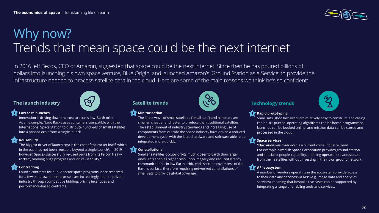
In 2016 Jeff Bezos, CEO of Amazon, suggested that space could be the next internet. Since then he has poured billions of dollars into launching his own space venture, Blue Origin, and launched Amazon’s ‘Ground Station as a Service’ to provide the infrastructure needed to process satellite data in the cloud. Here are some of the main reasons we think he’s so confident:
Why now? Trends that mean space could be the next internet
The launch industry
1 Low cost launches Innovation is driving down the cost to access low-Earth orbit. As an example, Nano Racks uses containers compatible with the International Space Station to distribute hundreds of small satellites into a phased orbit from a single launch.
2 Reusability The biggest driver of launch cost is the cost of the rocket itself, which in the past has not been reusable beyond a single launch1. In 2019 however, SpaceX successfully re-used parts from its Falcon Heavy rocket2, marking huge progress around re-usability.*
3 Contracting Launch contracts for public sector space programs, once reserved for a few state-owned enterprises, are increasingly open to private industry through competitive bidding, pricing incentives and performance-based contracts.
Satellite trends
1 Miniturisation The latest wave of small satellites (‘small sats’) and nanosats are smaller, cheaper and faster to produce than traditional satellites. The establishment of industry standards and increasing use of components from outside the Space industry have driven a reduced development cycle, with the latest hardware and software able to be integrated more quickly.
2 Constellations Smaller satellites occupy orbits much closer to Earth than larger ones. This enables higher resolution imagery and reduced latency communications. In low Earth orbit, each satellite covers less of the Earth’s surface, therefore requiring networked constellations of small sats to provide global coverage.
Technology trends
1 Rapid prototyping Small sats (shoe box sized) are relatively easy to construct: the casing can be 3D-printed, operating algorithms can be home-programmed, launches can be booked online, and mission data can be stored and processed in the cloud3.
2 Space services “Operations-as-a-service” is a current cross-industry trend. For example, Swedish Space Corporation provides ground station and specialist people capability, enabling operators to access data from their satellites without investing in their own ground network.
3 API ecosystem A number of vendors operating in the ecosystem provide access to their data and services via APIs (e.g. image data and analytics services), meaning that bespoke use cases can be supported by integrating a range of enabling tools and services.

The economics of space | Transforming life on earth
03
Space-enabled use cases How space can support terrestrial challenges
Agriculture
Can space help farmers to feed 9.8 billion people on Earth? A growing population and crop yields under threat from climate change pose huge environmental and social challenges; space can help us address these.
Consumer connectivity
Can space help Telcos connect the world’s unconnected? The internet remains unavailable to 3.5 billion people on Earth; space can help to bring these people online and provide access to key health and education services.
Climate change management
Can space help societies respond better to climate change and natural disasters? 800 million people live in geographies prone to flood-related disasters alone. Space services may help us to safeguard our vulnerable populations.
Enabling technologies
Learn about key developments in space technologies that are enabling a new generation of terrestrial applications.
Click on a question to explore a use case.
04
The economics of space | Transforming life on earth
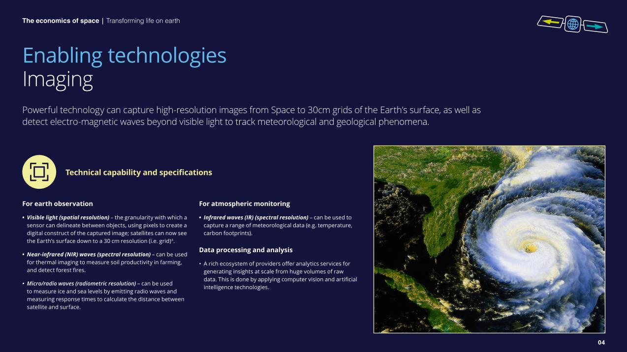
Enabling technologies ImagingPowerful technology can capture high-resolution images from Space to 30cm grids of the Earth’s surface, as well as detect electro-magnetic waves beyond visible light to track meteorological and geological phenomena.
For earth observation
• Visible light (spatial resolution) – the granularity with which a sensor can delineate between objects, using pixels to create a digital construct of the captured image; satellites can now see the Earth’s surface down to a 30 cm resolution (i.e. grid)4.
• Near-infrared (NIR) waves (spectral resolution) – can be used for thermal imaging to measure soil productivity in farming, and detect forest fires.
• Micro/radio waves (radiometric resolution) – can be used to measure ice and sea levels by emitting radio waves and measuring response times to calculate the distance between satellite and surface.
For atmospheric monitoring
• Infrared waves (IR) (spectral resolution) – can be used to capture a range of meteorological data (e.g. temperature, carbon footprints).
Data processing and analysis
• A rich ecosystem of providers offer analytics services for generating insights at scale from huge volumes of raw data. This is done by applying computer vision and artificial intelligence technologies.
Technical capability and specifications

05
The economics of space | Transforming life on earth
Enabling technologies TelecommunicationsBreakthroughs in low latency, high speed telecommunications networks are overcoming the long-standing quality barriers associated with sat-comms. Moreover, emerging space networks can blend with ground-based networks to improve existing terrestrial grids while creating new communications infrastructure.
Latency
• Low latency communications have huge commercial value; reducing the time to transmit data can enable online gaming and new computing paradigms such as streaming cloud-based operating systems to devices.
• LEO sats are up to 35 times closer to Earth than geostationary (GEO) sats, reducing latency to levels comparable with terrestrial internet connections5.
Ground terminals
• Ground terminals are required to communicate with LEO satellites, with users tethering to terminals to connect to space networks. Traditionally expensive, terminals are projected to become increasingly affordable with a view to supporting mass market applications, such as connected vehicles.
• To use sat communications, it’s likely that smartphones and other connectivity devices will then tether to the ground terminal to connect to the space-based network.
• The potential for reduced infrastructure costs with space-enabled networks could enable leapfrogging of terrestrial comms in countries that lack infrastructure.
Connection reliability
• Constellations can provide network redundancy; if multiple sats are within range of a ground terminal, then communication problems due to weather may be avoided by switching connection to unaffected satellites.
Technical capability and specifications

06
The economics of space | Transforming life on earth
Enabling technologies SatellitesLEOs and smaller sats enable development and deployment approaches normally associated with software engineering; sats stay in orbit for shorter periods of time, which, in combination with lower per-unit costs, drives a more iterative and agile approach to sat development.
Satellite typologies
LEO satellites represent a new approach to sat engineering and venturing: ‘release often’, maintain short production lifecycles (i.e. ‘time in orbit’), and deliver fast-paced design iterations by building sats from a larger number of standardised components.
• Cost base6: LEO sats can cost as little as $7,000 per unit, compared to $850m for GEO sats. Some savings are realised by using commoditised electronics. However, the benefits case is not simple: many LEO sats are required to provide coverage equal to one traditional, geostationary (GEO) satellite.
• Satellite sizes7: tiny LEO sat units such as cubesats are as small as shoe boxes and weigh just 1-10kg, while GEO sats can be the size and mass of a bus.
• Orbit altitude8: LEOs are 160-2,000km from Earth, compared to GEOs that are around 36,000km away, therefore enabling LEOs to maintain reduced comms latency and sharper image resolution.
• Orbit period9: circumnavigating Earth in as little as 90 mins, LEOs ‘scan’ over our surface while GEOs have a 24 hour orbit period, holding a constant position over Earth.
• Connection strategy: the GEO orbit enables a constant connection to be held with a ground terminal. LEOs require ground terminals to switch connections frequently between satellites that are passing over.
Technical capability and specifications

07
The economics of space | Transforming life on earth
Agriculture Can space help feed 9.8 billion people by 2050?
The global population is expected to grow to 9.8 billion by 205010; this growth, coupled with rising incomes in developing nations, will increase global demand for food by over 60 per cent11, driven by exponential growth in demand for proteins in the developing world (with a particular emphasis on meat and dairy production). These changes will put staggering pressure on agricultural industry to adapt to meet required levels of production. Adding to this pressure, the impacts of climate change – higher temperatures, extreme weather, drought – pose serious risks of reducing the quantity and quality of our food supplies.
Applications of space technology have significant potential to form part of our response to this growing issue. Space technology can be applied up and down the supply chain, from growers to retailers. This section will focus on use cases for farmers and growers, and providers of crop protection services as these are the main direct users of space-enabled precision-farming capabilities.
Precision agriculture uses all three aspects of space technology: from satellite connectivity machine-to-machine communication, or IoT real-time sensing; to satellite navigation for guidance of machines; and, increasingly, Earth observation for monitoring crop performance to help farmers make more informed decisions about inputs (e.g. water, fertiliser, pesticides) and optimise yields. The greatest impact of precision agriculture is likely to be in replacing farmers’ day-to-day decisions with insights, recommendations, and even automated actions informed by space-enabled technology. Doing so may help farmers optimise or protect attainable yields, at a lower cost, and with lower impact on the environment.
Applications of space technology have significant potential to form part of our response to this growing issue. Space technology can be applied up and down the supply chain, from growers to retailers.

08
The economics of space | Transforming life on earth
Agriculture Space-enabled agriculture applications
Scaleable Earth observation
Earth Observation (EO), i.e. remote collection intelligence about the Earth’s surface, feeds into a wide range of use cases across agricultural production.
The increased granularity and frequency of images collected by satellites, and pervasive access to cloud data storage and processing are facilitating the creation of a “single source of the truth” for agricultural data.
EO imagery can be used to monitor variations in fields across the growing season. Linking this data to soil and weather data within crop models enables farmers to apply precise levels of fertiliser and herbicides, helping to optimise and protect their crop yield.
Moreover, sharing this data between farms and crop protection companies creates the possibility for new business models which share value and risk with farmers, enabling more sustainable and effective use of crop protection products.
Ubiquitous connectivity
LEO satellites provide reliable, low power coverage over wide areas which is ideal for use cases in agriculture. It is especially powerful in remote locations, or the developing world, where terrestrial infrastructure does not support use cases economically.
Low-cost sensors can provide growers with critical real-time information about threats to crops. Measures of temperature and humidity from soil sensors or weather stations, or the use of pest or spore traps can indicate increased threats from disease or pests.
In addition to yield, IoT-enabled irrigation can support more sustainable farming practices, by detecting water levels in the soil. Water is delivered only when needed, which in some cases has saved up to 50% in water usage for irrigation12.
Real-time positioning
Real-time kinematics (RTK) is a technique used to guide farm machinery, enabled by satellite navigation.
RTK guidance is an enabler of future farm technologies, such as self-drive tractors, drones and robotic sprayers that apply precise amounts of herbicide to weeds. Combining monitoring data from EO and IoT sensors with on-board sensing in these new farm technologies will revolutionise the way in which farmers are able to intervene to tackle specific problems with their crops.
The move towards real-time monitoring will be a significant timesaver for farmers, changing the way they manage their farm, optimising crop walking strategies and helping them to spend more of their time on higher value activities like agronomy or running commercial aspects of the farm.

09
The economics of space | Transforming life on earth
Agriculture Development of satellite use cases in agriculture
Launch providers
Satellite operators
Business process
Data platform
Application layer
Developed components
Leading Launch and Satellite Operators are starting to provide capabilities that are needed to support sophisticated use cases in the agricultural sector.
The downward trend in costs of launch and the increase in quality and refresh rates of available satellite data mean that the potential value of use cases will continue to grow.
The key question for innovation is how to integrate this data into decision support or management information systems throughout the supply chain, from farmers to retailers. Success will require a combination of data infrastructure and end-user applications – as well as new commercial and operational models to underpin them.
Developing components
While APIs exist to allow custom app development on satellite data (e.g. NASA Earth and Planet API), end users require rapidly-accessible actionable insights, and at scale. Most do not have the time or skills to develop these insights themselves.
Moreover, with traditional models using satellite data, commercial users face high costs, and find themselves locked into siloed platforms from a single satellite operator. This creates upfront costs for end users, and can prevent the development of use cases that would be achievable by combining multiple datasets.
Data providers taking an ecosystem-led approach could increase opportunities for innovation in use cases that leverage satellite data. Such an approach might feature cost per use models for EO data, and open data platforms, enabled by cloud technology.
Partnerships between satellite operators and other players in the ecosystem, such as between Farmer’s Edge and Planet, are required to put the actionable insights offered by satellite data into the hands of farmers and growers across the world.
10
The economics of space | Transforming life on earth
Agriculture The role of satellites in the wider agricultural ecosystem
Satellites only part of the yield puzzle
Satellite data and connectivity have huge potential, but form only one part of a highly complex puzzle in agriculture. Furthermore, the context is very different for commercial farms in the developed world than for smallholder farms in the developing world.
Precision agriculture is an indispensable part of commercial farming. Variable rate technologies automate decisions in response to moisture levels and soil conditions, in order to maximise yields. Satellite data and connectivity are an increasingly important part of the decision-support information set. However further development is required to integrate these capabilities into existing decision-making, demonstrating clear added value, and with the right business model to enable mass adoption.
Smallholders represent 70 per cent of the world’s farms and play an essential role in ensuring food security and creating employment13. Production processes are less sophisticated, and farmers typically own mobile phones, rather than smartphones, leading to an asymmetry of information. Making satellite data useful requires a very different operational model. The Gezira project provides irrigation advice via SMS updates – in some cases increasing yields by over 200 per cent14.
The scale of precision differs, but both commercial growers and smallholders can benefit. Single commercial growers might use a D2C service with advanced variable rate solutions. A developing world solution might serve 10,000 farmers operating on the same land area, but requiring much simpler decision support such as a text message saying when to irrigate or harvest.
Connecting global supply chains Satellite data and connectivity can improve the quality of decisions of farmers and growers, driving increased yields and greater efficiency in the application of inputs like water and pesticides. However, greater consistency and visibility at the farm level has knock-on benefits right through supply chains.
Consumers are putting pressure on retailers to demonstrate provenance and sustainable sourcing of their produce, however, the majority of food shoppers are also price sensitive15. Vienna University has devised a way to use EO data to map land-use change by crop type, and trace the impact along supply chains16. This process offers a more cost-effective way to inspect and map land-use change over time, reducing knock-on costs to retailers. The data also contributes to a more accurate view of the end-to-end carbon footprint of agricultural products. As such, EO data can be used to help consumers make more informed choices on sustainable food.
Due to the seasonal variability of agriculture incomes, providers of crop insurance are another important part of the ecosystem. Today, many smallholders are covered by index-based insurance, which allows providers to determine whether a pay-out is warranted based on observations taken remotely. CGAP and Pula (an insurance and technology company in Africa and Asia), have shown that integrating satellite data can significantly reduce the cost of providing insurance to smallholders over large areas17.
11
The economics of space | Transforming life on earth
Consumer connectivity Can space connect the world’s unconnected?
Global demand for connectivity and data continues to grow rapidly. The number of connected devices is expected to increase to 20.4bn by 2020 from 8.4bn in 201718. Between 2016 and 2021, global average mobile data consumption is predicted to grow by five times, from around 1.7GB to 8.9GB per person each month19.
3.5bn people – nearly 50 per cent of the global population – do not currently have access to the internet20. Increasing connectivity for underserved populations in Africa, Latam and Asia has the potential to increase productivity by 25 per cent and generate 140m jobs21. Moreover, greater connectivity will enable businesses, schools and healthcare institutions to serve many more individuals.
Technological developments in the field of low Earth orbiting (LEO) small satellites are enabling satellite internet to overcome the principal obstacles that have so far prevented its widespread adoption, namely: speed, quality and cost. Given this, some of the most immediate areas of application are those where it is currently very costly and/or challenging to deploy broadband fibre cabling or large cellular towers, such as in remote regions and in parts of the developing world.
Technological developments in the field of low Earth orbiting (LEO) small satellites are enabling satellite internet to overcome the principal obstacles that have so far prevented its widespread adoption, namely: speed, quality and cost.

12
The economics of space | Transforming life on earth
Consumer connectivity Space-enabled connectivity applications
In the developing world, the imperative remains to bring communities online to reduce poverty and improve access to critical public services, including education and healthcare. According to the UN 100 million individuals in Africa live beyond broadband and cell network coverage22, and satellites will be required to help to bring the entire African population online by 2030.
Satellite operators such as Quika are aiming to provide free internet for underserved communities by cross-subsidisation from advertising, ‘pay as you grow’ services for small businesses, and backhaul network capacity for ISPs23.
Affordable connectivity is a key driver of socio-economic development – Deloitte estimate that the increase in GDP driven by affordable internet could take 160 million people out of extreme poverty24. Further benefits include better monitoring and treatment of disease, and proving 640 million with access to online educational content25. As an example, the European Space Agency has been working with AXA to deliver satellite-enabled services that improve healthcare access in Egypt through teleconsultations and remote health coaching26.
Significant swathes of populations in developed nations live remotely and beyond the coverage of traditional broadband and cell networks. In the UK alone nearly 1m remote premises are still unable to receive 10mbps broadband (Ofcom’s minimum speed threshold)27. The challenge for operators is to find a commercially viable way of extending broadband and/or cell networks to relatively small numbers of people in low density regions. LEO satellites may offer a viable solution by providing additional capacity for operators to extend their coverage.
For example, LeoSat advertise their technology as being compatible with existing 4G, 5G and LTE cellular systems in order to integrate with existing infrastructures. Moreover, the UK government is planning to invest £6.8bn in 5G infrastructure over the next 9 years28 – in doing so may create demand for LEO capacity to ensure that people in rural communities are not left behind.
Poor coverage continues to be a major reason why customers switch mobile operators, so improving quality and reach is likely have a direct impact on providers’ revenues and remain a top priority29.
The ‘Internet of Things’ is expected to grow rapidly over the next few years, with Statista estimating 75 billion devices to be in operation by 202530. Moreover, many ‘Things’ will remain out of reach of terrestrial networks, creating a need for non-traditional connectivity sources, including satellite-enabled networks.
Effectively, terrestrial IoT sensors gather data, which is delivered to satellites through bespoke ground terminals (‘gateways’). These in turn transmit data to the cloud which can be accessed readily by end users through APIs and software applications.
Satellites are positioned to support remote/field operations across industries, spanning: • Transport and logistics, where satellite IoT can support
freight monitoring and asset tracking.
• Mining, to enable equipment maintenance and process optimisation.
• Utilities, to deliver smart meter reading and infrastructure management.
• Agriculture, for water and soil irrigation, preventative maintenance and livestock tracking.
Remote communities in the developing world
Rural communities in developed nations
Machine-to-machine, IoT connectivity

13
The economics of space | Transforming life on earth
Consumer connectivity Development of satellite use cases for consumer connectivity
Consumer devices
Launch providers
Satellite operators
Ground terminals
Customer operations
Developed capability
Market leadership and a partial commoditisation is already taking place upstream in the ecosystem, highlighting that most of the opportunity whitespace for telcos and connectivity players may exist further downstream.
The cost and speed of launching small satellites have been radically reduced in recent years. For example, UK company ‘Open Cosmos’, claims to be able to develop and launch an end-to-end small satellite mission for £500,000 in just one year. The service includes designing the payload, coordinating launch, arranging insurance and integrating cloud data feeds. In comparison, traditional small satellite missions can cost between £2 to £5m and take between 2-4 years31.
Providers claim that LEO small satellite constellations are now able to provide constant low latency, high bandwidth global coverage. For example, Telesat claims download speeds of 50mbps and latency of 30-50 milliseconds32; these speeds are comparable with UK averages of ~50mbps and ~12-30 milliseconds respectively33.
Developing capability
Ground terminals Ground terminals are required for users to connect devices to satellite networks. The market is likely to fragment between full-stack satellite operators and specialist terminal manufacturers. In 2019, SpaceX sought permission from the Federal Communications Commission for a licence to deploy one million of its own ground transmitters for end users to connect with its Starlink satellites34. In comparison, Japanese telco JRC35, has partnered with specialist antenna manufacturer Intellian to enhance their maritime connectivity offering. Moreover, this technology is projected to retail for between $200-$300 per unit36, which means in theory every car in the world could have one: if so this would drive down the unit cost.
Customer operations The majority of emergent satcoms players are yet to acquire a significant customer base. There remains a question over how they will achieve this: do they make direct-to-consumer plays, and own the customer relationship? Or, do they act as a service provider to incumbent operators by providing backhaul network capacity, and relinquish control of the end-user relationship? New competitors also present a challenge to incumbent network operators. If emergent satellite operators offer a less capital intensive way to access/improve quality of service to rural customers, how might they feel about acting as an aggregator of connectivity infrastructure, some of which they may not own? Ultimately, most end users demand low latency and high-quality coverage at a fair price. Whether this new generation of satellite internet providers can manage this at scale is yet to be proven.

14
The economics of space | Transforming life on earth
Consumer connectivity The role of satellites in the wider connectivity ecosystem
Will satellites revolutionise transport and travel?
Connected vehicles Connectivity is problematic outside of urban environments; however when “combined with terrestrial networks, satellite offers the ability for service providers to offer a seamless and always-on connectivity” 37. Satellites can enable vehicle-to-vehicle communications, and autonomous (e.g. cruise control) and semi-autonomous (e.g. parking assistance) operations.
Aviation Panasonic have partnered with the UK satellite operator Inmarsat to offer in-flight broadband. Inmarsat estimates the in-flight connectivity market will grow to $130 billion by 203538. This new consumer channel could unlock new services and radically change in-flight experiences, for example, online gaming and video conferencing could become next-gen in-flight entertainment.
Maritime Demand is increasing in both commercial and consumer contexts, with merchant and cruise operators seeking improved connectivity to drive operational efficiencies, monitor their carbon emissions and provide better internet access for passengers. Telesat claims to be “revolutionizing connectivity at sea” by providing connectivity to the different shipping segments39.
Drones, satellites or other aircraft? A number of big players are betting on other aerial platforms, such as drones and stratospheric air balloons, to achieve the same results as satellites. For example, Google’s Project Loon is launching a first commercial pilot to bring 4G to remote villages in Kenya through a fleet of air balloons40 after a number of successful trials (e.g. providing internet to Puerto Rico in the wake of Hurricane Maria).
While balloons appear cheaper and less resource-intensive to launch than satellites, they are highly reliant on good weather, meaning that storms and strong winds can cause disruption to launches.
In comparison, Facebook’s Project Aquila originally envisioned a global internet powered by drones cruising at 60,000 feet, but tests highlighted engineering problems that have resulted in an indefinite halt to operations41.
The debate over which, if any, aerial connectivity platform will dominate is far from settled, but bringing internet to 3.5bn unconnected people42 will almost certainly require collaboration between many different players.
15
The economics of space | Transforming life on earth
Climate change management Can space help societies adapt better to climate change and natural disasters?
There is a growing urgency for governments across the world to better-equip societies to improve or adapt to the long-term effects of climate change while also dealing more effectively with the devastation caused by natural disasters such as droughts, floods and super-storms.
Globally, up to 800 million people are concentrated in areas vulnerable to flooding43. It is estimated that this number will increase significantly due to environmental changes, such as rising sea levels and increasingly frequent and extreme weather events. Moreover, the impact of these natural phenomena is exacerbated by socio-economic factors, such as population increases, urbanisation, and a lack of sufficient governmental planning, regulation, design, and counter-measures.
It is therefore crucial that key actors in academia, government, and the private and public sectors should collaborate to radically improve both short-term responses, and long-term mitigation and adaptation capabilities.
Space offers a platform from which to improve our ability to monitor and manage the climate; terrestrially-based weather and climate monitoring systems cover a relatively small portion of the Earth’s surface44, whereas Earth observation satellites can now capture granular surface and atmospheric data from all across the Earth every twenty four hours45.
Globally, up to 800 million people are concentrated in areas vulnerable to flooding.

16
The economics of space | Transforming life on earth
Climate change management Space-enabled climate applications
Short term: Disaster management
It is estimated that extreme flooding has claimed the lives of over 500,000 and displaced over 650 million people globally over the past 30 years49; the incidence of disastrous events appears now to be much more frequent50.
The international space agencies have been contributing to the International Charter on Space and Major Disasters since 2000, freely sharing disaster-related imagery and data. Private satellite operators have more recently thrown their weight behind the effort51. This collaboration helps to improve the quality, quantity and accessibility of data, which in turn aids damage limitation and recovery optimisation.
Before Planet Labs built a satellite constellation big enough to capture daily images of the Earth’s entire landmass, specific satellites had to be requisitioned to gather images of affected areas. This had two disadvantages: delay, and an inability to gather before-the-event footage, making it much harder for responders to know what had been affected. Another operator, Maxar, has expertise in applying machine learning to satellite data, making it easier to understand data without the need for geospatial experts to decipher it, as was the case previously.
Space capabilities are also improving our ability to prevent flooding disasters. After devastating floods hit the Republic of Congo in 2017, Planet Labs supported the government to build flood monitoring systems to prevent similar future catastrophes, and in 2018 the organisation analysed data captured by the system to enable the government to relocate 7,000 refugees who had attempted to settle in a flood-prone area52.
Long term: Climate change monitoring
Climate change is immensely complicated, and building effective climate change adaptation and mitigation capabilities requires a deep understanding of causes, effects and trends.
Earth observation (EO) satellites are now crucial for global climate monitoring and management because they provide rich data on sea levels, greenhouse gases, glaciers and forests. According to the European Space Agency (ESA), the EU’s ‘Copernicus’ program is the “most ambitious programme to date” 53, gathering global data from satellite observations, and providing tools for analysis for scientists through to policy makers. When used in climate models, this data will allows us to understand more effectively the past, present and, critically, the future.
Capabilities are rapidly advancing. In 2019, the ESA announced plans to fund a constellation of satellites that can, for the first time, monitor the Earth’s net C02 emissions. This will “provide a unique and independent source of information to assess the effectiveness of policy measures on decarbonisation” 54. At a national level, in December 2019 the UK government announced a pioneering new satellite data centre in collaboration with the Natural Environment Research Centre (NERC) and the UK Space Agency (UKSA). The centre will bring together PhD environmental scientists, mathematicians, physicists and computer scientists to “support cutting-edge scientific discovery, new data-based products and new Earth Observation technologies that will provide benefits to society” 55. Satellite capabilities are therefore being increasingly placed at the centre of efforts to manage climate change.

17
The economics of space | Transforming life on earth
Climate change management Development of satellite use cases for climate change management
Governance & policy
Launch providers
Satellite operators
Data platform
Application layer
Developed components
The infrastructure required to capture rich EO data is well developed, with satellites already capturing terabytes of observational and atmospheric data on a daily basis.
The space agencies have long supported climate and disaster response efforts by making data available: NASA has a well-established disaster response unit (‘Disasters Program’) that provides Earth observation data services to help responders adapt to catastrophes such as hurricanes, floods and wildfires56.
Similarly, private operators are increasingly making EO data readily available to governments, humanitarian aid groups and scientists. Operators in the domain such as Planet Labs, Maxar and Airbus see this as being critical to their core mission.
Developing components
Data Platform(s) While there are efforts to build integrated data platforms, such as the Global Earth Observation System of Systems (GEOSS), there is much to do to improve reliability and accessibility. Moreover, as a commercial asset, raw EO data is becoming commoditised: space agencies openly share EO data, and private operators are offering open access to basic EO data, such as Airbus through its OneAtlas Sandbox platform.
Application Layer Operators are increasingly monetising data by offering analytics products and services, and charging third parties for volume-based data access through APIs. These applications can improve forecasting, monitoring, and mitigation and disaster response activities for end users. ‘Monitoring on-demand’ is
Planet Lab’s disaster management solution, enabling users to access high-resolution pre-and-post event imagery, within specific timeframes, and with seamless API integration57. US startup Watt Time is developing a platform to measure CO2 emissions from factories across the world with a view to improving carbon traceability58.
Governance and policy Environmental monitoring will support both public and private sectors. Governments will be able to more accurately measure the impact of policy on the environment and in turn shape future policies. In the private sector, investors can use satellite data to both inform investments and to hold companies to account over environmental commitments. Scaling the application of satellite data in finance may help to improve the availability of sustainable finance globally.
18
The economics of space | Transforming life on earth
Will satellites help accelerate sustainable finance across the global economy?
Transitioning to a sustainable, resilient global economy will be one of the most resource-intensive endeavours in human history. Meeting the Paris Agreement targets is estimated to require around $6 trillion a year in infrastructure investments59. The financial sector can help enable this transition through sustainable finance. Ultimately, as the UK Satellite Applications Catapult puts it, “getting financial markets to integrate climate and environmental interests into decision-making will help financial institutions appropriately manage risk, reduce losses, and improve the resilience of the financial system” 60.
There are a number of ways that satellites can support sustainable finance, including:
• Verifying the performance of an asset or organisation against environment, social and governance (ESG) factors and commitments.
• Informing decision-making around green investments by providing granular environmental risk information.
• Creating scale in demand for ‘sustainable finance’ by increasing its accessibility and competitiveness as a financial product. Climate and environment data from satellites can reduce the management overheads for such products through more efficient asset performance monitoring and reporting.
There are promising developments in this segment of sustainable finance. In 2019, Investec launched a project with the World Wildlife Forum exploring the potential for sovereign debt portfolio managers to use satellite data to inform investment decisions based on countries’ commitments to biodiversity conservation61. Moreover, in early 2020, US credit rating company S&P Global Ratings successfully deployed spatial technology to complete an analysis of US water utilities from data from National Aeronautics and Space Administration satellite missions62.
In recognition of the emergence and potential of this area of sustainable finance, the Spatial Finance Initiative (SFI) was launched in collaboration between the Alan Turing Institute, Green Finance Institute, Satellite Applications Catapult, and the University of Oxford. The initiative was established in order to “bring together research capabilities in space, data science, and financial services to make them greater than the sum of their parts” 63.
An immediate focus for the SFI is to develop publicly available, consistent datasets through the GeoAsset project. This will enable applications to be developed for sustainable finance use cases, including climate risk management, ESG transparency and infrastructure development64.
Therefore, there are reasons to believe that spatial finance is set to take off and help make significant contributions towards transitioning to a green and resilient global economy.
Climate change management The role of satellites in the greening of the global economy

The economics of space | Transforming life on earth
19
Closing remarksPrivate sector innovation has radically increased the potential value that space, as an economic resource, can create for industries and organisations on Earth. This has been achieved mainly through the reduction in the cost of launch services, the increased capabilities of modern satellites, and advancements in terrestrial ground terminals that process data and communications from space.
This upstream infrastructure has laid the foundations for two broad space-enabled capabilities, namely: Earth observation and next-gen satellite telecommunications. Within both of these fields we are beginning to see the emergence of an impactful range of downstream business applications.
In the field of Earth observation, satellites now capture terabytes of granular images from all corners of the Earth on a daily basis. This data is increasingly used by sophisticated software to generate insights that inform organisational decision-making. Agriculture is a prime example, where satellite data is progressively helping farmers answer complex questions on optimising crop yields – a growing imperative given global population growth.
Within telecommunications, the explosion of small-sat constellations could shake up the way that broadband internet is distributed across the world, and bring connectivity to communities and locations where previously not possible.
This report is intended to provoke thoughts on the ways in which space may, in the not-so-distant future, augment and enhance how things are done on Earth. The three areas that we have focused on – agriculture, connectivity and climate – are by no means exhaustive, but represent what we believe to be three high priority areas where space looks set to have a seismic impact.
We are excited by the future possibilities, and encourage all who are interested to join the discussion and help shape the thinking...
Contact us
Matt Guest [email protected]
Charlie Jackson [email protected]
Spencer Terry [email protected]
Ed Cooper [email protected]

20
The economics of space | Transforming life on earth
Sources1. Elon Musk, ISS R&D Conference (19/07/17)
2. SpaceX Falcon Heavy Rocket Lofts 24 Satellites in 1st Night Launch, Space.com (2019)
3. AWS Case Study: European Space Agency, Amazon website (2019)
4. Digital Globe company website (2019)
5. IADC Space Debris Mitigation Guidelines (2007)
6. How a NASA Team Turned a Smartphone into a Satellite Business, Nasa website (19/04/18)
7. Satellite Technologies for Large Integrated Constellations in LEO and MEO, Satellite Applications Catapult (2018)
8. IADC Space Debris Mitigation Guidelines (2007)
9. Cognitive Radio Architecture (2006)
10. The United Nations website (2017)
11. Global demand for food is rising, Harvard Business Review (2016)
12. Government of Canada website (2019)
13. Connecting Smallholders to Markets, Food & Agriculture Organisation (2019)
14. Satellites in support of smallholder farming, World Bank (2019)
15. Food trends report, Lloyd’s Register (2019)
16. Fineprint project, Vienna University (2019)
17. Using Satellite Data to Scale Smallholder Agricultural Insurance, CGAP (2018)
18. Press Release, Gartner (07/02/17)
19. Worldwide smartphone average monthly cellular data usage from 2016 to 2021, Statista (2020)
20. SpaceX will launch dozens of “Starlink” satellites, The Economist (2019)
21. The Value of Connectivity, Deloitte (2014)
22. Connecting Africa Through Broadband, The Broadband Commission (2019)
23. Quika company website (2020)
24. The Value of Connectivity, Deloitte (2014)
25. ibid
26. Joining forces with the ESA to make healthcare accessible worldwide, AXA Newsroom (2019)
27. Connected Nations Report, Ofcom (2018)
28. National Infrastructure and Construction Pipeline (2018)
29. Analysis on consumer behaviour for US mobile phone carriers, Consumer Intelligence Research Partners (2015)
30. Internet of Things (IoT) connected devices installed base worldwide from 2015 to 2025, Statista (2020)
31. Open Cosmos at the 34th Symposius, YouTube (2018)
32. Telesat website (2020)
33. UK Home Broadband Performance, Ofcom (2017)
34. Ars Technica article (02/11/19)
35. Press release, Intellian company website (07/05/19)
36. Electronically Steerable, Flat-Panel Antennas for Satellite and Terrestrial Connectivity, CircleID (10/02/19)
37. Satellite Technologies for Broadband to Vehicles, Satellite Applications Catapult (2018)
38. Inmarsat company website (2019)
39. Telesat website (2020)
40. Google’s internet balloon project is about to start its first commercial trial, MIT Technology Review (2019)
41. FB abandons quest to build its own internet drones, The Verge (2019)
42. Digital in 2018, Hootsuite (2018)
43. Atlas of Mortality and Economic Losses from Weather, Climate and Water Extremes (1970–2012), World Meteorological Organization
44. Climate Change: 11 Facts You Need To Know, Conservation International company website (2019)
45. Press release, Planet company website (2020)
46. Copernicus overview, ESA website (2020)
47. Satellites key to ’10 Insights in Climate Science’ report, ESA website (2020)
48. UK satellites to help lead the fight against climate change, Gov.uk website (30/12/19)
49. Flooded Cities, Adriana Kocornik-Mina, Thomas K.J. McDermott, Guy Michaels and Ferdinand Rauch (2015)
50. Extreme weather events in Europe: Preparing for climate change adaptation: an update on EASAC’s 2013 study”, EASAC (2018)
51. Planet Becomes First Private-Sector Data Provider To Directly Support The International Charter On Space And Major Disasters, Planet company website (13/08/18)
52. How Flood Mapping From Space Protects The Vulnerable And Can Save Lives, Planet company website (17/06/19)
53. NASA Earth Science Disasters Program Website (2019)
54. ESA Website (2020)
55. Natural Environment Research Council Website (2020)
56. NASA Earth Science Disasters Program website (2019)
57. Planet company website (2019)
58. Watt Time company website (2020)
59. Crossing the bridge to sustainable infrastructure investment, Inter-American Development Bank (2016)
60. Growing Sustainable Finance and the Opportunity for Geospatial Solutions, Satellite Applications Catapult website (2019)
61. Sustainability and Satellites, Investec and the World Wildlife Forum (2019)
62. Space, The Next Frontier: Spatial Finance And Environmental Sustainability, S&P Global Ratings (2020)
63. Spatial Finance Initiative website (2020)
64. Ibid
This publication has been written in general terms and we recommend that you obtain professional advice before acting or refraining from action on any of the contents of this publication. Deloitte MCS Limited accepts no liability for any loss occasioned to any person acting or refraining from action as a result of any material in this publication.
Deloitte MCS Limited is registered in England and Wales with registered number 03311052 and its registered office at Hill House, 1 Little New Street, London EC4A 3TR, United Kingdom.
Deloitte MCS Limited is a subsidiary of Deloitte LLP, which is the United Kingdom affiliate of Deloitte NSE LLP, a member firm of Deloitte Touche Tohmatsu Limited, a UK private company limited by guarantee (“DTTL”). DTTL and each of its member firms are legally separate and independent entities. DTTL and Deloitte NSE LLP do not provide services to clients. Please see www.deloitte.com/about to learn more about our global network of member firms.
© 2020 Deloitte MCS Limited. All rights reserved.
Designed and produced by 368 at Deloitte. J19844