Embed Size (px)
Citation preview
THE EASTBOURNE NATURAL HISTORY &
ARCHAEOLOGICAL SOCIETYFounded 1867
AUTUMN NEWSLETTER No 81 Dec 2014
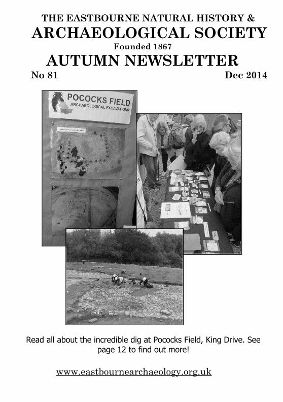
Read all about the incredible dig at Pococks Field, King Drive. Seepage 12 to find out more!
www.eastbournearchaeology.org.uk
EASTBOURNE NATURAL HISTORY & ARCHAEOLOGICAL SOCIETY
Founded 1867PRESIDENT: Olive Woodall
LIFE VICE-PRESIDENT: Patricia StevensChairman Robin Reffell
Robin Cottage12 The Village
Meads, Eastbourne BN20 7RD Tel: 01323 648226
Hon. Treasurer & Membership Secretary John Warren49 Prideaux Rd
Eastbourne BN21 2NETel: 01323 731792
Hon. Secretary & Newsletter Editor Helen Warren (contact details John, as above)
Programme Secretary Lawrence Stevens Tel: 01323 734496
Ass. County Archaeologist Greg Chuter Tel: 01273 481608 [email protected]
Committee: Patricia Stevens, Derek Leppard, Alison Selmes, Hayley Forsyth
A Message from the EditorDear Members,Some of us learnt about the amazing discoveries at Pococks Field in Kings Drive when a group of members visited the site in October, see photos on the cover. More was discovered when Giles Dawkes came to talk to the Society in November. The record numbers included visitors and members, who are working with Giles and his team as volunteers. Find out more about this exciting site, that has been settled from prehistory until Tudor times, by reading John Warren’s report on page 12.Also over the next two years an ambitious project will be undertaken to investigate a number of important archaeological sites which are under threat from coastal erosion along the Seven Sisters coastline. Volunteers from local communities will be working with The National Trust .The project aims torecord and examine the sites which cover from Prehistoric settlements to Bronze Age burial mounds andSecond World War defences. For more information see: www.nationaltrust.org.uk/birling-gap-seven-sisters/ or email: [email protected] .
Please let me have copy for the March 2015 Newsletter by 23 February. With all good wishes for Christmas and the New Year.
Helen Warren e: [email protected]
Report on Caspar Johnson's talk on the Bexhill-Hastings Link RoadA full room of 44 visitors and members assembled to hear the County Archaeologist, CasparJohnson, working entirely without notes, reveal and explain the findings discovered during the construction of the Bexhill to Hastings link road, which apparently must not be called a by-pass. With the help of an RAF LIDOR map we saw the full extent of the area excavated, from Upper Coombe Haven, or Bulverhythe in Bexhill, through the Coombe Valley following the line of the Bexhill to Crowhurst railway, and on through Crowhurst itself and Powdermills,to link with the Battle-Hastings road.
Casper was insistent that they have NOT found a camp for William the Conqueror, nor a siteof the Battle of Hastings, nor anything associated with 1066, but what they had found was much more interesting.
The total area of the scheme is a crescent, six miles long, in places up to half a mile wide, and six to eight metres deep where the valleys are filled with alluvium and colluvium, and traverses a series of streams and rivers running off the Weald clays into Coombe Valley. The whole excavation scheme is truly vast. The plan was to set the road down into the landscape to make as little visual impact as possible, which would mean cutting off the tops of ridges and filling in the valleys. Ponds for three purposes had to be planned for. i: to capture potentially toxic waste from the road surface; ii: to allow for flood compensations; & iii: to preserve bio-diversity and ecology. The area contained potential paleo-wetland sites, with associated islands now buried under flat reclaimed marshland, as well as the ridges of higher dry land, and the whole area was surveyed using many different techniques includinggeo-electrical, magnetometry and ground penetrating radar, as well as the more traditional geo-technical test pits and boreholes.
Models were constructed showing the conditions at different periods and showed the relative rate of sea level change since the last ice-age approx. 10,000 years BC, ie the end of the Pleistocene Era, and the beginning of the Holocene. Through the beginning of this period the sea level rise was very rapid as the vast ice sheets melted, becoming more stableat the beginning of the Neolithic some 4,000 years ago. We were shown a spiral wheel diagram illustrating the relative lengths of each period, which unfortunately I cannot reproduce, but the date details were asfollows:
Mesolithic 10,000 – 4,000 years BCNeolithic 4,000 – 2,300 BCBronze Age 2,300 – 700 BCIron Age 700 – 43 ADRoman 43 – 450 ADSaxon/early Medieval 450 – 1066 ADMedieval to 1543 ADPost Medieval to 1914 AD
The valleys show the sequence with marine clays overlaying the natural post glacial surface during the paleo-Mesolithic period reflecting the rapid sea level rise, itself covered by fresh water organic alluvium and peat, covered again by thick ochre soils from alluvial and colluvial hill wash from human activity formed between 800BC and the 4th/5th Century AD.
The planning application had to include a scheme to survey and record all the archaeological details before their necessary destruction, including the details of railway architecture, farm buildings, track ways and field boundaries, as well as the older material. Oxford Archaeology won the contract, and their work runs ahead of the road construction. First metal detector's swept the whole area, and remarkably found no metal artefacts before 1840 over the whole scheme! This may be explained by the fact that the soil is very acidic and aggressively corrodes small metal objects and bone and other organic material.
A great surprise has been the very large number of Mesolithic flint scatters, over 300 individual events, in several concentrations through the length of the scheme, amounting to many hundreds of thousands of individual flakes of flint. All flakes over 10mm are 3D plottedby GPS coordinates, and bagged for later study and analysis. The uniquely large number allows subtle evidence of early human activity, revealing good and bad craftsmanship and possible child work for the very small flakes, and development of different tool kits to match changing environmental circumstances, with larger tools in the earlier periods for larger animals, aurochs, horse, moose, and smaller hunting points, arrow heads and micro-liths being found for later periods as woodlands develop and prey animals become smaller. Theyalso subtly reveal different activities, hunting tools being produced at lower slopes which would have been at the edge of the marsh and woodland, and different, processing tools, ie burins, borers, scrapers and adzes being produced on higher ground, which would have been settlement sites. The quality of these flints is extraordinary, and it is possible to identifydifferent flint types and their sources. There are no flints found naturally on any of the sites, and as the sea was a considerable distance out from the present coast at the beginning of the Mesolithic, their presence represents a considerable investment in time and effort fetching them in to what was then a relatively inland, and upland location. Pits with hazelnuts and charcoal have also been found, a good dating source, and a series of early Mesolithic postholes have been discovered. Casper would not say it was a house, but that it could be a hide, that it was probably multi-phase, and was associated with burnt flints, suggesting occupation.
The levels of data coming from this complex and very important site comes from maintaininga high level of data recording throughout the scheme, and is very largely due to the scrupulous and enthusiastic direction of the site. The work has generated a lot of paperwork,archaeology is truly now become a real science. Several radio-metric methods of dating are used. Carbon 14 is the most common, but thermo-luminescence and OSL optical techniques are also employed.
Environmental sampling is undertaken from about 50% of the soils, using a mechanised sieving system to gather small flakes missed by excavators, and flotation tanks to retrieve seeds, plant material and pollen. These show a range of vegetation; reeds, trees of various sorts, scrub and grasses. A very recent find on one of the islands in the deep paleo-wetland areas is the first good evidence of worked timber with oak tree trunks laid parallel, and numbers of cross pieces, looking much like a track way. Not all of the wood shows tool marks, so it may be natural, but it is an intriguing discovery. It points from the island towards a track way on higher ground and associated burnt mounds. C14 dating reveals a potential Neolithic date of 2200 BC.
There is a late Neolithic ring ditch with a gap, (penanular). This could be a henge or a barrow. In fact there is the same range of monuments through the landscape as is found on the Downs, which has been a welcome surprise.
At the wetland edge of the Bronze Age landscape several burnt mounds have been found, with associated charcoal, pottery, barbed and tanged arrowheads, and part of a wristband. These are usually found in high status sites such as the Amesbury Archer buried at Stonehenge. The mounds invariably have a round and a square pit, sluice channels and post holes, suggesting a covering. Their use is unknown, but there has been speculation and theory from a site for brewing beer to a sweat lodge for Shamanic use.
Near Upper Wilting Farm the footprint of Roman buildings and enclosures have been found, in association with a large number of iron smelting bloomery furnaces and slag. The slag exists as a huge bank falling into the valley, and covers a succession of furnaces of several different types and sizes on terraces set into the slope. The earliest iron working may have been late Iron Age, but it was the Romans who turned its production into a massive industrial undertaking. The sheer number, variety and scale of the furnaces, together with their repair and re-use are evidence of a very important aspect of the Roman occupation of Sussex. Dating has been from pottery finds, Gaulish Samian ware of about 150 AD, black burnished ware and several other types.
Upper Wilting was a Saxon Manor, and corn-drying ovens have been found with charred cereal grains, giving a date of 7th or 8th century, revealing a glimpse of grain production in thelandscape.
There are blanks or voids of activity within the scheme, as is normal in any landscape, but it is the sheer scale of the link road scheme that allows these blank areas, interspersed with areas of intense activity, to be identified where they may otherwise have been invisible.
There was a lively question and answer session, and Chairman Robin Reffell gave the society’s sincere vote of thanks for this detailed and fascinating talk about a complex multi-period site. The audience gave their acclamation by enthusiastic applause.
Report from John Warren
Lewes Castle and its Centuries Old History a talk from Sally White
Lawrence Stevens introduced our speaker, Sally White to a capacity audience, telling us that she was a former custodian of the Castle, and we were pleased to receive a cheerful and upbeat appraisal of the Castle from its inception to the present day.
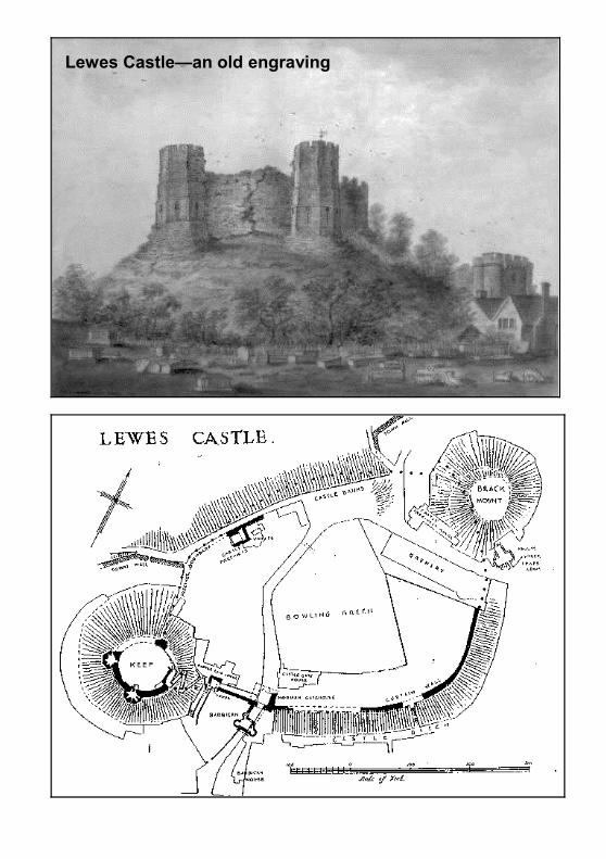
Having been successfully wired for sound Sally then dropped her entire set of prompt cards and promised us an interesting evening. Re-gathering herself, the early slides dispelled the myth that the castle was only the Keep, a photograph from a willing stranger’s back bedroom window, drawings and a model that is available to public view, clearly show the considerable extent of the site, and how much domesticity was probably included within the walls.
After the Norman Conquest, England was divided into Rapes, and possession and tax gathering powers bestowed upon trusted friends of the king. Step forward William De Warenne. Encouraged to build defensible structures, the first Castle is likely to have been a Mott and Bailey, of timber construction, possibly even pre-fabricated and transported from France in about 1075. It would have been erected quickly, in perhaps as little as two months. William chose the centre of Lewes, which was already a fortified town. With views down the Ouse towards the coast, this was a defendable location with navigation almost to the doors. It was noted that the moat was never a wet one, simply a dry ditch. The Towers of the Keep were built in the 12th Century and afforded excellent views over the area.
The second centre of the Castle was the Brack Mound, an imposing viewpoint, built probably on an existing mound amplified by the addition of chalk blocks. Originally, with wooden superstructure there would have been allowance for a period of settlement of the mounds before they were expected to take the pressure of stone buildings. By 1100, the Brack Mound was 20 feet higher than the Keep and truly imposing. There may have been central wells in both for a secure water supply. (A further mound shown in a drawing dated 1855, located on the current Dripping Pan, may have had a part to play in the fortification of Lewes). The Keep was the De Warenne family place of safety, and may not have been too luxurious. It would seem that the Castle was sparsely populated most of the time. De Warenne has land in 12 Counties and moved between them, the King keeping any one magnate’s property spread out to guard against the consolidation of a compact power base by his ‘friends’.
In 1077 the De Warennes (William and Gundrada) travelled to the Priory at Cluny in France, after which they decided to found the Cluniac Priory of St Pancras in Lewes. This was a massive construction site covering an area about the same as the Castle, or perhaps slightly greater, it employed huge numbers and housed a significant community. Lewes grew enormously to service the needs of the Priory and records indicating the amount of food required show the size of the undertaking. When Cromwell later had the Italian, Portinari,
Lewes Castle—an old engraving
demolish the Priory in 1539, it was largely destroyed, but in a way is still there, since the construction stone appears to have ‘migrated’ into most of the dwellings in the town. It was later further destroyed by driving the railway line through it. Gundrada died in 1085, William 3 years later, and was buried with her, but their graves were ‘lost’ for some time. They were rediscovered in 1845 in very small leaden coffins near the high altar of the Priory church when the railway was driven through the site, and are today visible, but irreverently displayed in the south chapel of the Church of St. John.
William’s son William (what else could he have been called?) married Isobel and carried on the good work, completing the Castle and the Priory. It was still in good repair in the 13th Century. Henry 111 had the town walls rebuilt, just before Simon de Montfort defeated him at the Battle of Lewes in 1264. De Warenne, ever the King’s man, fled to France. It is estimated that 2700 men died in the battle. The conflict led to the Barons and the King agreeing to a Parliament. When, later, Simon De Montfort was defeated, John De Warenne returned and regained his family lands. The Grandson added the Barbican Gate to the Castle in the 1300s. Sally expounded a theory about the unlikeliest ofpouring boiling oil down through the slots on the parapet onto assailants, apart from anything else who was going to clean up the mess? The last Earl De Warrenne died without issue in 1347, after which the castle was untenanted, and began to fall into decay.
In 1377, there was a French raid. The Prior was captured from the Priory and held to ransom. 1381 saw the Peasants Revolt, when the mob broke into the castle, destroyed documents, and consumed £100.00 worth of wine. The Castle began to decline thereafter until it was eventually sold off in sections in the 15th Century.
In a brief rally, the armaments were significantly increased, to include cannon, at the threat of the Armada in 1588. When that was defeated it was reported that a whole barrel of gunpowder was used in letting off the cannons in celebration (no change for Lewes there then). The weapons were dispersed and buildings demolished in the 1600s and in January 1639 the bumpiest bowling-green in the country was established within the outer walls, it is still there, owned and tended by an archaeologically resistant Bowls Club.
In the 18th Century an ale house (probably one of many, this is Lewes remember), was located on the edge of the bowling green, backing into Brack Mound and boasting all sorts of mythology in order to attract customers. We saw the almost entirely hyperbolic advertisement.
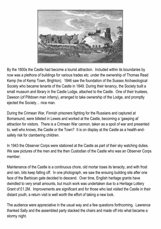
By the 1800s the Castle had become a tourist attraction. Included within its boundaries by now was a plethora of buildings for various trades etc. under the ownership of Thomas Read Kemp (he of Kemp Town, Brighton). 1846 saw the foundation of the Sussex Archaeological Society who became tenants of the Castle in 1849. During their tenancy, the Society built a small museum and library in the Castle Lodge, attached to the Castle. One of their trustees, Dawson (of Piltdown man infamy), arranged to take ownership of the Lodge, and promptly ejected the Society… nice man.
During the Crimean War, Finnish prisoners fighting for the Russians and captured at Bomarsund, were billeted in Lewes and worked at the Castle, becoming a ‘gawping at’ attraction for visitors. There is a Crimean War cannon, taken as a spoil of war and presented to, well who knows, the Castle or the Town? It is on display at the Castle as a health-and-safety risk for clambering children.
In 1943 the Observer Corps were stationed at the Castle as part of their sky watching duties. We saw pictures of the men and the then Custodian of the Castle who was an Observer Corpsmember.
Maintenance of the Castle is a continuous chore, old mortar loses its tenacity, and with frost and rain, bits keep falling off. In one photograph, we saw the ensuing building site after one face of the Barbican gate decided to descend. Over time, English heritage grants have dwindled to very small amounts, but much work was undertaken due to a Heritage Lottery Grant of £1.2M. Improvements are significant and for those who last visited the Castle in their distant youth, a return visit is well worth the effort of taking a new look.
The audience were appreciative in the usual way and a few questions forthcoming. Lawrence thanked Sally and the assembled party stacked the chairs and made off into what became a stormy night.
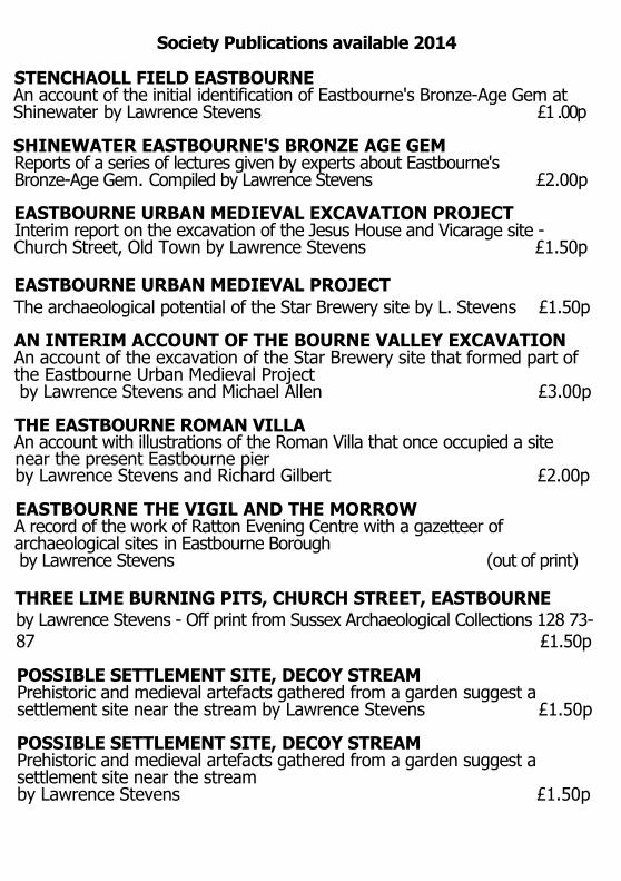
Society Publications available 2014
STENCHAOLL FIELD EASTBOURNEAn account of the initial identification of Eastbourne's Bronze-Age Gem at Shinewater by Lawrence Stevens £1 .00p
SHINEWATER EASTBOURNE'S BRONZE AGE GEMReports of a series of lectures given by experts about Eastbourne's Bronze-Age Gem. Compiled by Lawrence Stevens £2.00p
EASTBOURNE URBAN MEDIEVAL EXCAVATION PROJECTInterim report on the excavation of the Jesus House and Vicarage site -Church Street, Old Town by Lawrence Stevens £1.50p
EASTBOURNE URBAN MEDIEVAL PROJECTThe archaeological potential of the Star Brewery site by L. Stevens £1.50p
AN INTERIM ACCOUNT OF THE BOURNE VALLEY EXCAVATIONAn account of the excavation of the Star Brewery site that formed part of the Eastbourne Urban Medieval Project by Lawrence Stevens and Michael Allen £3.00p
THE EASTBOURNE ROMAN VILLAAn account with illustrations of the Roman Villa that once occupied a sitenear the present Eastbourne pier by Lawrence Stevens and Richard Gilbert £2.00p
EASTBOURNE THE VIGIL AND THE MORROWA record of the work of Ratton Evening Centre with a gazetteer of archaeological sites in Eastbourne Borough by Lawrence Stevens (out of print)
THREE LIME BURNING PITS, CHURCH STREET, EASTBOURNEby Lawrence Stevens - Off print from Sussex Archaeological Collections 128 73-87 £1.50p
POSSIBLE SETTLEMENT SITE, DECOY STREAMPrehistoric and medieval artefacts gathered from a garden suggest a settlement site near the stream by Lawrence Stevens £1.50p
POSSIBLE SETTLEMENT SITE, DECOY STREAMPrehistoric and medieval artefacts gathered from a garden suggest a settlement site near the stream by Lawrence Stevens £1.50p
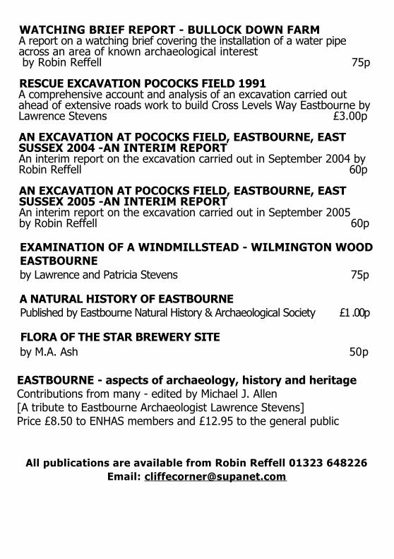
WATCHING BRIEF REPORT - BULLOCK DOWN FARMA report on a watching brief covering the installation of a water pipe across an area of known archaeological interest by Robin Reffell 75p
RESCUE EXCAVATION POCOCKS FIELD 1991A comprehensive account and analysis of an excavation carried out ahead of extensive roads work to build Cross Levels Way Eastbourne by Lawrence Stevens £3.00p
AN EXCAVATION AT POCOCKS FIELD, EASTBOURNE, EAST SUSSEX 2004 -AN INTERIM REPORTAn interim report on the excavation carried out in September 2004 by Robin Reffell 60p
AN EXCAVATION AT POCOCKS FIELD, EASTBOURNE, EAST SUSSEX 2005 -AN INTERIM REPORTAn interim report on the excavation carried out in September 2005by Robin Reffell 60p
EXAMINATION OF A WINDMILLSTEAD - WILMINGTON WOODEASTBOURNEby Lawrence and Patricia Stevens 75p
A NATURAL HISTORY OF EASTBOURNEPublished by Eastbourne Natural History & Archaeological Society £1 .00p
FLORA OF THE STAR BREWERY SITEby M.A. Ash 50p
EASTBOURNE - aspects of archaeology, history and heritage Contributions from many - edited by Michael J. Allen[A tribute to Eastbourne Archaeologist Lawrence Stevens]Price £8.50 to ENHAS members and £12.95 to the general public
All publications are available from Robin Reffell 01323 648226Email: [email protected]
The November Meeting, Giles Dawkes talks about “Pococks Field”
The room was packed to capacity, with 95 seats taken, and one latecomer standing, to hear Giles Dawkes explain what had been found at Pococks Field. Giles explained that they were at the halfway point of the excavation, and that he had come straight from the dig, with his trowel still in his pocket and mud on his trousers, and that it was all very exciting, with more archaeology being exposed every time the diggers removed more topsoil, with so far over 4000 contexts, and 23 buildings. There was a table to view a selection of the interesting finds.
All finds are identified and located by GPS, then drawn into auto-cad, so that the entire site is represented in one drawing that can be zoomed into for closer analysis. Finds of discrete periods can then be identified and filtered out to be able to view and analyse each period in isolation. Aerial photos are taken by a drone all over the site, these are then stitched together to form one image, that can then be dropped onto the auto-cad drawing. All this modern technology is a great aid for contextual interpretation. An A4 site map was present as a hand-out.
The Bronze Age, and all periods of the Iron Age are represented, with Roman burials, building material and a possible shrine within an enclosure, Saxon buildings and settlement evidence, Medieval boundaries and track-ways, and a Tudor house. Geologically it is at the Eastern edge of the rising chalk-lands, and would have had a fresh water stream close by, with a tidal salt water lagoon, that is now largely filled with alluvium and colluvium and turned to pasturage. The site is multi-layered, very crowded, and in antiquity would have been an ideal settlement location, with the fish and wildfowl resource of the lagoon, and the higher chalk slopes for pasture and arable crops. Several drove-ways are in evidence, Iron Age and Medieval leading uphill from the marsh, and a broad Roman track running parallel to the shoreline, along the approximate line of King’s Drive. There was particularly an enormous amount ofbriquetage debris from Iron Age salt working. There is even a possible Neolithic antler, found in a later Bronze Age pit context. The site would have been attractive throughout antiquity, as evidenced by the Shinewater site on the Eastern side of the lagoon. Earlier periods are possibly below features that are still being dug, and may emerge later.
This week a Bronze Age enclosure ditch has been identified, together with lots of Bronze Age pits that have “burnt mound” material of shattered flints within them. No-one is entirely sure what the purpose of the pits was, but they could have contained water, for cooking, beer making or shamanic sweat baths!
There are huge amounts of Iron Age pot briquetage waste and pedestals associated with salt making, in at least 50 pits, representing industrial scale production. The actual sites of production have not yet been found, but would have taken place near the edge of the lagoon.
One theory is that this could represent the activity of a single season, so may represent a transitional activity, but there is also lots of settlement evidence, with a round house in an enclosure ditch, very well preserved bread ovens, several structured depositions, including ahorse head with harness pieces, and a dog. Interestingly the settlement seems to be all on the sloping ground, with the higher, flatter ground reserved for pasture or agricultural use.
There is a 2nd century Roman mortuary enclosure with an enigmatic square building in the centre, with just the robbed out one metre wide chalk foundations remaining, that could be aRoman shrine, indeed there are a whole series of Roman buildings with associated cobble flooring, a Roman corn drier, and stone post pads that could be for a granary. There are 16 burials from both the Roman and Iron Age periods, with excellent bone preservation, the Ph. levels being perfect.
The Saxon period is represented by ditches, several sunken houses with associated weaving combs, pin-beaters, loom weights and a chalk spindle whorl. There is also a post-built building, this is not a typical long hall-house, but an almost square short-house, with ground fast supports and possible plank walls. This is for uncertain use, and appears tohave nothing at the corners.
There are several Medieval period ditches as field and house boundaries, cobbled areas with associated square buildings, a possible dovecote, coins, lead weights, and ceramics, allin the same general area as earlier periods, and an 8 x 4 meter house platform terraced intothe slope to provide a flat floor, which contains a simple brick hearth. A slightly later ditch contains the semi-articulated bones of a dog and a pig’s head. There is a later, large building with 1 meter wide chalk foundations, dated by tiles to a late 14th or 15th century date.This has no evidence of a hearth or internal features, all floor levels having been lost, and would probably have had a simple central fire, with smoke exiting at roof level. There were Tudor period add-on rooms of a washroom and brew-house, with charcoal evidence of a hearth, built of robbed out stone from an earlier building mixed with Tudor tiles. This buildinghas an associated cobbled courtyard with evidence of blacksmithing, horse shoes and harness pieces, and points to it being built as a gentry level house that changed use over time, becoming more utilitarian and agricultural. Demolition rubble from the building containstypical 17th century Rhineland salt-glazed stoneware. The 1830 tithe map shows a building at the approximate location, but it is not very detailed and it cannot be certain that it was thisone, and may be Pococks farmhouse. There may be some documentary evidence buried in the archives at Chatsworth, but that will need a lot more research.
The Q & A session revealed that it was known that there were features within the field, particularly the double lynchet track-way and enigmatic stone built tank that were dug by thesociety, and that EBC had asked English Heritage to have the site listed as of archaeological significance, but without a specific feature this was impossible, hence the early decision to do a complete site strip excavation. One particularly interesting find is a
highly decorated, channelled Roman brick that would have contained a lead pipe, and whichare usually associated with high status Roman baths. This led to speculation that a Roman villa, or similar may have been present close by, possibly under the site of the DGH, which was simply bulldozed away during the construction of the hospital. There are rumours that this happened, though no-one can now ever know. The society’s finds of thousands of Roman pot shards, including Samian-ware, and pieces of flue tile at the Poplin Marsh site just east of the DGH, gives credence to this possibility. Lawrence Stevens told us that the report of that dig is very close to publication.
The site will continue to be dug until February or March, but future visits are now problematical because it has become an active building site with lots of machines working, which carries difficult health and safety implications.
Society chairman Robin Reffell proposed the vote of thanks, and the filled room gave enthusiastic thanks for this most instructive and informative talk.
Report by John Warren
ARCHAEOLOGICAL METALWORK COURSE
with LUKE BARBER of Sussex Archaeological Society
Saturday, 17th January 2015 from 10 a.m. to 4 p.m.
Education Room, Worthing Museum
The Course is an introduction to the range of metals and alloys andtheir uses from the Bronze Age to the early 20th Century. It is designed to explain all aspects of metalwork using visual presentations, handling sessions and informal discussion and willinclude an opportunity to practise your identification skills.
Luke will also be looking at different approaches to metalwork reports and what information can be discovered to aid siteinterpretation.
The cost for the day is £25 for members and £30 for non members including refreshments.
If you are interested, contact Gill Turner by email:[email protected] or Tel: (01903) 692522
Our Christmas meeting on Friday 12th December
Four brief talks by Society Members
“Chemistry and Glass” Steve SimsSteve will attempt to cover the chemical constituents used in the
manufacture of glass in an historical setting with particular reference to theaffects of age, and the effects of burial on the appearance and
integrity of archaeological finds of glass artefacts.
“Putting together the Summerdown Camp Exhibition” Katherine BucklandThe Summerdown Camp Project has uncovered untold stories and
discovered exciting revelations about medical treatments,ofwill appear inan emotive exhibition in March 2015. Discover some of these stories and
find out what goes into putting on the exhibition.
All this plus…Books, Raffle and Seasonal Refreshments!
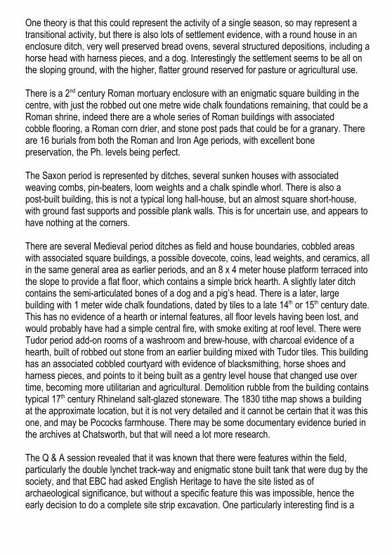
“Taking the Piss” Richard Ribbons Recently retired GP, Richard will talk about
Medieval urine jars, uroscopy and the practice of Medieval medicine.
Which of the four humours will you prove to be?
“A Viking Burial” Hazel DurlingHazel will be telling us about two contrasting Viking burial sites, and exploring the relationship between Viking pagan burial and existing Anglo-Saxon Christian burial practice. She will also tell us about thespread of 'Viking' culture and forms of memory and commemoration.
ENHAS Programme
Friday 12th Dec Christmas Meeting
Come to enjoy an informal evening of four brief talks given by Society members. There is a raffle and seasonal refreshments—mince pies and coffee/tea
(See page 15 for more details.)
Friday 9th Jan The Archaeology of Poplin Marsh 1992Lawrence Stevens who directed the Society’s excavation, will talk about this Iron Age and Roman site found during the construction of Cross Levels Way Eastbourne.
Friday 13th Feb Eastbourne’s extensive early Anglo-Saxon Cemetery and the discovery of an Iron Age Settlement in 1990Patricia Stevens was Director of this Society’s excavation of the site at St. Annes Hill. She will illustrate her talk showing the evidence for Iron Age settlement, the early Anglo-Saxon cemetery and it’s burials, together with reference to the later Anglo-Saxon Cemetery on Ocklynge Hill.
Friday 13th Mar Iron Age Sussex – A Social HistoryJohn Manley will provide an overview of Iron Age roots in Sussex and show how they were organised, developed and changed. It will be a focus on people – not so much pots or postholes! The talk will thus provide a background to and compliment the talks by Giles, Lawrence and Patricia. See John’s website: www.timetalks.co.uk
Friday 24th Apr Annual General Meeting followed byThe Life and Archaeology of Augustus Henry Lane-Fox Pitt Rivers
Robin Reffell will talk about Pitt Rivers “The Father of Scientific Archaeology”. Pitt Rivers was an innovator who looked beyond the obsession of the time of burial mounds. He recognised the value of finds and their context and conducted experiments to back up analysis. His work in Sussex will be highlighted.
Our meetings are held at: St Saviour’s Church Hall, Spencer Rd, Eastbourne BN21 4PA
Meetings start at 7.30 pm, doors open: 7.15 pm.
Members free, visitors £2.50
*
Saturday July 25th
Eastbourne Archaeology Symposium 2015
“The Eastbourne and Willingdon Prehistoric Lagoon”
Birley Centre, Carlisle Rd, Eastbourne BN21 4EF
*E: [email protected] or T: 01323 648226
www.eastbournearchaeology.org.uk