Embed Size (px)
Citation preview
U.S. Department of the Interior U.S. Geological Survey
TEACHING GUIDE
lig.
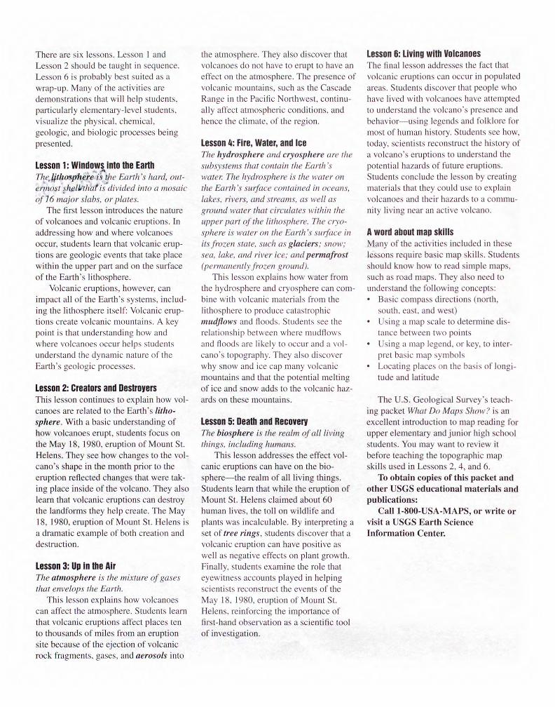
The Earth's Systems
Hydrosphere
Lithosphere
Atmosphere
The Earth is a system comprising interactive components.
Volcanoes is an interdisciplinary set of materials for grades 4-8. Through the story of the 1980 eruption of Mount St. Helens, students will answer fundamental questions about volcanoes: "What is a volcano?" "Where do volcanoes occur and why?" "What are the effects of vol-canoes on the Earth system?" "What are the risks and the benefits of living near volcanoes?" "Can scientists forecast vol-canic eruptions?"
This teaching packet reflects the goals of the National Science Education Standards developed by the National Research Council. These standards rec-
ommend that middle school students be able to understand the Earth as a system. By learning about volcanoes, students will understand that the Earth comprises interacting components, or subsystems: the geosphere and the biosphere. In turn the geosphere comprises the lithosphere, the atmosphere, the hydrosphere, and the cryosphere. (fig. 1) These lessons show how the eruption of Mount St. Helens affected all of the Earth's subsystems.
Although volcanoes is an earth sci-ence subject, the activities in this packet incorporate a number of related subjects, including other sciences, social studies,
DEPOSITORY language arts, and mathematics.
Contents of this packet • Two-sided color poster • Teaching guide (with glossary and
bibliography) • Six lesson plans with timed activities • Evaluation sheet
About the poster The poster is a key visual aid for many of the activities. Side 1 is a dramatic photo-graph of Mount St. Helens erupting on May 18, 1980. Side 2 is a series of pho-tographs and illustrations annotated with text written for student readers. The sec-tion titled "Volcanoes" is a basic intro-duction to volcanoes and volcanic eruptions. The section titled "Mount St. Helens" tells the story of the May 18, 1980, eruption of Mount St. Helens and the effect the eruption had on each of the components of the Earth system.
Each photograph and diagram has a number. When lessons refer to specific photographs and illustrations, they are referenced as "poster fig:' followed by the number of the photograph or diagram.
About the lessons Each lesson includes: • Illustrated background information • Two step-by-step, timed activities • Reproducible Master Sheets for mak-
ing overhead transparencies or photo-copies
• Reproducible Activity Sheets for your students
There are six lessons. Lesson 1 and Lesson 2 should be taught in sequence. Lesson 6 is probably best suited as a wrap-up. Many of the activities are demonstrations that will help students, particularly elementary-level students, visualize the physical, chemical, geologic, and biologic processes being presented.
Lesson 1: Windowilnto the Earth Thedithosphere i.9 the Earth's hard, out-ermost piellithat is divided into a mosaic of 76 major slabs, or plates.
The first lesson introduces the nature of volcanoes and volcanic eruptions. In addressing how and where volcanoes occur, students learn that volcanic erup-tions are geologic events that take place within the upper part and on the surface of the Earth's lithosphere.
Volcanic eruptions, however, can impact all of the Earth's systems, includ-ing the lithosphere itself: Volcanic erup-tions create volcanic mountains. A key point is that understanding how and where volcanoes occur helps students understand the dynamic nature of the Earth's geologic processes.
Lesson 2: Creators and Destroyers This lesson continues to explain how vol-canoes are related to the Earth's litho-sphere. With a basic understanding of how volcanoes erupt, students focus on the May 18, 1980, eruption of Mount St. Helens. They see how changes to the vol-cano's shape in the month prior to the eruption reflected changes that were tak-ing place inside of the volcano. They also learn that volcanic eruptions can destroy the landforms they help create. The May 18, 1980, eruption of Mount St. Helens is a dramatic example of both creation and destruction.
Lesson 3: Up in the Air The atmosphere is the mixture of gases that envelops the Earth.
This lesson explains how volcanoes can affect the atmosphere. Students learn that volcanic eruptions affect places ten to thousands of miles from an eruption site because of the ejection of volcanic rock fragments, gases, and aerosols into
the atmosphere. They also discover that volcanoes do not have to erupt to have an effect on the atmosphere. The presence of volcanic mountains, such as the Cascade Range in the Pacific Northwest, continu-ally affect atmospheric conditions, and hence the climate, of the region.
Lesson 4: Fire, Water, and Ice The hydrosphere and cryosphere are the subsystems that contain the Earth's water. The hydrosphere is the water on the Earth's surface contained in oceans, lakes. rivers, and streams, as well as ground water that circulates within the upper part of the lithosphere. The cryo-sphere is water on the Earth's surface in its frozen state, such as glaciers; snow; sea, lake, and river ice; and permafrost (permanently frozen ground).
This lesson explains how water from the hydrosphere and cryosphere can com-bine with volcanic materials from the lithosphere to produce catastrophic mudfiows and floods. Students see the relationship between where mudflows and floods are likely to occur and a vol-cano's topography. They also discover why snow and ice cap many volcanic mountains and that the potential melting of ice and snow adds to the volcanic haz-ards on these mountains.
Lesson 5: Death and Recovery The biosphere is the realm of all living things, including humans.
This lesson addresses the effect vol-canic eruptions can have on the bio-sphere—the realm of all living things. Students learn that while the eruption of Mount St. Helens claimed about 60 human lives, the toll on wildlife and plants was incalculable. By interpreting a set of tree rings, students discover that a volcanic eruption can have positive as well as negative effects on plant growth. Finally, students examine the role that eyewitness accounts played in helping scientists reconstruct the events of the May 18, 1980, eruption of Mount St. Helens, reinforcing the importance of first-hand observation as a scientific tool of investigation.
Lesson 6: Living with Volcanoes The final lesson addresses the fact that volcanic eruptions can occur in populated areas. Students discover that people who have lived with volcanoes have attempted to understand the volcano's presence and behavior—using legends and folklore for most of human history. Students see how, today, scientists reconstruct the history of a volcano's eruptions to understand the potential hazards of future eruptions. Students conclude the lesson by creating materials that they could use to explain volcanoes and their hazards to a commu-nity living near an active volcano.
A word about map skills Many of the activities included in these lessons require basic map skills. Students should know how to read simple maps, such as road maps. They also need to understand the following concepts: • Basic compass directions (north,
south, east, and west) • Using a map scale to determine dis-
tance between two points • Using a map legend, or key, to inter-
pret basic map symbols • Locating places on the basis of longi-
tude and latitude
The U.S. Geological Survey's teach-ing packet What Do Maps Show? is an excellent introduction to map reading for upper elementary and junior high school students. You may want to review it before teaching the topographic map skills used in Lessons 2, 4, and 6.
To obtain copies of this packet and other USGS educational materials and publications:
Call 1-800-USA-MAPS, or write or visit a USGS Earth Science Information Center.
Glossary
Active volcano: A volcano that is cur-rently erupting, or has erupted during recorded history.
Aerosol: Fine liquid or solid particles suspended in the atmosphere. Aerosols resulting from volcanic eruptions are tiny droplets of sulfuric acid--sulfur dioxide that has picked up oxygen and water.
Ash: Fragments less than 2 millimeters (about V8 inch) in diameter of lava or rock blasted into the air by volcanic explosions.
Atmosphere: The mixture of gases, aerosols, solid particles, and water vapor that envelops the Earth.
Biosphere: The realm of all living things. Crater: The circular depression contain-
ing a volcanic vent. Cinder cone: A steep-sided volcano
formed by the explosive eruption of cinders that form around a vent. Cinders are lava fragments about 1 centimeter (about 1/2 inch) in diameter.
Crust: The Earth's outermost layer. Contour lines: Parallel lines used on
topographic maps to show the shape and elevation of the land. They con-nect points of equal elevation.
Cryosphere: The ice and snow on the Earth's surface, such as glaciers; sea, lake, and river ice; snow; and per-mafrost.
Dome: A steep-sided mound that forms when very viscous lava is extruded from a volcanic vent.
Dormant volcano: An active volcano that is in repose (quiescence) but is expect-ed to erupt in the future.
Extinct volcano: A volcano that is not expected to erupt again.
Geosphere: The nonliving parts of the Earth: t he lithosphere, the atmosphere, the cryosphere, and the hydrosphere.
Glacier: A thick mass of ice resulting from compacted snow that forms when more snow accumulates than melts annually.
Harmonic tremor: Continuous rhythmic earthquakes in the Earth's upper litho-sphere that can be detected by seismo-graphs. Harmonic tremors often pre-cede or accompany volcanic eruptions.
Hot spot: An area in the middle of a lithospheric plate where magma rises
from the mantle and erupts at the Earth's surface. Volcanoes sometimes occur above a hot spot.
Hydrosphere: The water that covers 71 percent of the Earth's surface as oceans, lakes, rivers, and streams. The hydro-sphere also includes ground water, water that circulates below the Earth's surface in the upper part of the lithosphere.
Lateral blast: A sideways-directed explo-sion from the side or summit of a vol-cano.
Lava: The term used for magma once it has erupted onto the Earth's surface.
Leeward: The side of a land mass shel-tered from the wind—the opposite of windward.
Lithosphere: The Earth's hard, outermost shell. It comprises the crust and the upper part of the mantle and is divided into a mosaic of 16 major slabs, or plates.
Lithospheric plates: A series of rigid slabs (16 major ones at present) that make up the Earth's outer shell. These plates float on top of a softer, more plastic layer in the Earth's mantle. (Also called tectonic plates.)
Magma: Molten rock containing liquids, crystals, and dissolved gases that forms within the upper part of the Earth's mantle and crust. When erupt-ed onto the Earth's surface, it is called lava.
Mantle: A zone in the Earth's interior between the crust and the core that is 2,900 kilometers (1,740 miles) thick. (The lithosphere is composed of the topmost 65-70 kilometers (39-42 miles) of the mantle and the crust.)
Mudflow: A flowing mixture of water and debris (intermediate between a volcanic avalanche and a water flood) that forms on the slopes of a volcano. Sometimes called a debris flow or lahar, a term from Indonesia where volcanic mudflows are a major hazard.
Permafrost: Permanently frozen ground at high latitude and high elevation.
Prevailing winds: The direction from which winds most frequently blow at a specific geographic location.
Seismograph: A scientific instrument that detects and records vibrations (seismic waves) produced by earth-quakes.
Shield volcano: A volcano that resem-bles an inverted warrior's shield. It has long gentle slopes produced by multi-ple eruptions of fluid lava flows.
Snowline: The lowest elevation at which snow remains from year to year and does not melt during the summer.
Spreading ridges: Places on the ocean floor where lithospheric plates separate and magma erupts. About 80 percent of the Earth's volcanic activity occurs on the ocean floor.
Stratovolcano: A steep-sided volcano built by lava flows and tephra deposits. (Also called composite volcano.)
Subduction zone: The place where two lithospheric plates come together, one riding over the other. Most volcanoes on land occur parallel to and inland from the boundary between the two plates.
Tephra: Solid material of all sizes explo-sively ejected from a volcano into the atmosphere.
Topographic map: A map that uses con-tour lines to represent the three-dimen-sional features of a landscape on a two-dimensional surface.
Tree rings: Concentric rings formed annually as a tree grows.
Vent: The opening at the Earth's surface through which volcanic materials (lava, tephra, and gases) erupt. Vents can be at a volcano's summit or on its slopes; they can be circular (craters) or linear (fissures).
Viscosity: Measure of the fluidity of a substance. Taffy and molasses are very viscous; water has low viscosity.
Volcano: A vent (opening) in the Earth's surface through which magma erupts; it is also the landform that is construct-ed by the eruptive material.
Volcanic avalanche: A large, chaotic mass of soil, rock, and volcanic debris moving swiftly down the slopes of a volcano. Volcanic avalanches can also occur without an eruption as a result of an earthquake; heavy rainfall; or unsta-ble soil, rock, and volcanic debris. (Also called debris avalanche.)
Windward: The side of a land mass fac-ing the direction from which the wind is blowing—the opposite of leeward.
Bibliography
Print Publications *indicates juvenile books
Brantley, S.R. Volcanoes of the United States. Reston, Va.: U.S. Geological Survey general-interest publication, 1994.
Crandell, D.W. and Nichols, D.R. Volcanic Hazards at Mount Shasta, California. Reston, Va.: U.S. Geological Survey, 1987.
Decker, R. and Decker, B. Mountains of Fire: The Nature of Volcanoes. New York: Cambridge University Press, 1991.
Decker, R. and Decker, B. Volcanoes. New York: W. H. Freeman and Co., 1989
Findley, R. "Eruption of Mount St. Helens," National Geographic. Washington D.C.: National Geographic Society, January 1981.
Foxworthy, B.L. and Hill, M. Volcanic Eruptions of 1980 at Mount St. Helens: The First 100 Days. Reston, Va.: U.S. Geological Survey Professional Paper 1249, 1982.
Grove, N. "Volcanoes: Crucibles of Creation," National Geographic. Washington, D.C.: National Geographic Society, December 1992.
Hays, W.W. ed. Facing Geologic and Hydrologic Hazards: Earth Science Considerations. Reston, Va.: U.S. Geological Survey Professional Paper 1240-B, 1981.
Lauber, P. Volcano: The Eruption and Healing of Mount St. Helens. New York: Bradbury Press, 1986. *
Mannes, J. "Volcanoes," Kids Discover. New York: Kids Discover, June/July 1993.*
Our Violent Earth. Washington, D.C.: National Geographic Society, 1982.*
Simkin, T. and Siebert, L. Volcanoes of the World: A regional directory, gazetteer, and chronology of volcanism during the last 10,000 years. 2d edition. Tucson, Ariz.: Geoscience Press, Inc., 1994.
Tilling, R.I. Eruptions of Hawaiian Volcanoes: Past, Present, and Future. Reston, Va.: U.S. Geological Survey gen-eral-interest publication, 1987.
Tilling, R.I. Eruptions of Mount St. Helens: Past, Present, and Future.
Reston, Va: U.S. Geological Survey general-interest publication, 1990.
Tilling, R.I. Monitoring Active Volcanoes. Reston, Va.: U.S. Geological Survey general-interest publication, 1987.
Tilling, R.I. Volcanoes. Reston, Va.: U.S. Geological Survey general-interest publication, 1993.
This Dynamic Planet: World Map of Volcanoes, Earthquakes, Impact Craters, and Plate Tectonics. Reston, Va.: U.S. Geological Survey map poster, 1994.
Volcano: in the series Planet Earth. Alexandria, Va.: Time-Life Books, 1982.
Wright, T.L. and Pierson, T.C. Living with Volcanoes: The U.S. Geological Survey's Volcano Hazards Program. Reston, Va.: U.S. Geological Survey Circular 1073, 1992.
Video Tapes Born of Fire. National Geographic
Society Video, 1983. Nature: The Volcano Watchers.
WNET and BBC-TV (PBS), 1987. Volcano. National Geographic Society
Video, 1989. Volcanoes: Understanding the
Hazards. Earth Science Video Library. The Story of America's Great
Volcanoes. Questar Video, Inc., 1992.
The U.S. Geological Survey The U.S. Geological Survey (USGS), U.S. Department of the Interio►; provides the Nation with reliable, impartial informa-tion to describe and understand the Earth.
This information is used to minimize loss of life and property from natural disas-ters; manage water, biological, energy, and mineral resources; enhance and pro-tect the quality of life; and contribute to wise economic and physical development
For information on these and other USGS products and services, call 1-800-USA-MAPS, fax 703-648-5548, or e-mail: [email protected].
Receive information from the EARTH-FAX fax-on-demand system, which is available 24 hours a day at 703-648-4888.
The address for the USGS home page is <URL: http://www.usgs.gov/>
The address for the USGS educational learning web home page is
<URL: http://www.usgs.gov/education/>
Acknowledgments We greatly appreciate the technical assis-tance provided by the following U.S. Geological Survey reviewers: Richard S. Williams, Jr., Research Geologist, Woods Hole, Mass.; Steven R. Brantley, Public Information Scientist, Cascades Volcano Observatory, Vancouver, Wash.; and John H. Wittmann, Cartographer, Michael P. Ryan, Research Geologist, and Marion M. Fisher, Hydrologist, Reston, Va.