Embed Size (px)
Citation preview
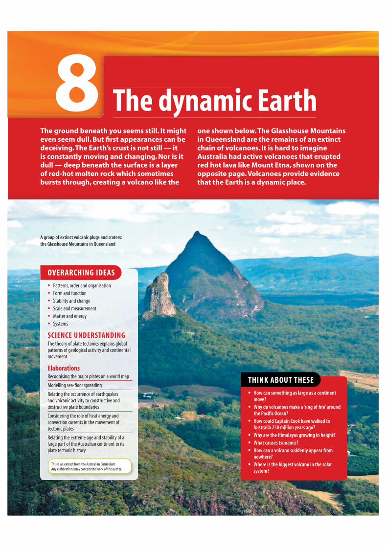
The dynamic Earth8The ground beneath you seems still. It might
even seem dull. But fi rst appearances can be
deceiving. The Earth’s crust is not still — it
is constantly moving and changing. Nor is it
dull — deep beneath the surface is a layer
of red-hot molten rock which sometimes
bursts through, creating a volcano like the
one shown below. The Glasshouse Mountains
in Queensland are the remains of an extinct
chain of volcanoes. It is hard to imagine
Australia had active volcanoes that erupted
red hot lava like Mount Etna, shown on the
opposite page. Volcanoes provide evidence
that the Earth is a dynamic place.
THINK ABOUT THESE
• How can something as large as a continent move?
• Why do volcanoes make a ‘ring of fi re’ around the Pacifi c Ocean?
• How could Captain Cook have walked to Australia 250 million years ago?
• Why are the Himalayas growing in height?
• What causes tsunamis?
• How can a volcano suddenly appear from nowhere?
• Where is the biggest volcano in the solar system?
A group of extinct volcanic plugs and craters: the Glasshouse Mountains in Queensland
OVERARCHING IDEAS
• Patterns, order and organisation
• Form and function
• Stability and change
• Scale and measurement
• Matter and energy
• Systems
SCIENCE UNDERSTANDINGThe theory of plate tectonics explains global
patterns of geological activity and continental
movement.
ElaborationsRecognising the major plates on a world map
Modelling sea-fl oor spreading
Relating the occurrence of earthquakes
and volcanic activity to constructive and
destructive plate boundaries
Considering the role of heat energy and
convection currents in the movement of
tectonic plates
Relating the extreme age and stability of a
large part of the Australian continent to its
plate tectonic history
This is an extract from the Australian Curriculum.
Any elaborations may contain the work of the author.

THE DYNAMIC EARTH 279
YOURQUEST
‘Descend into the crater of Yokul of Sneffels, which the
shade of Scataris caresses before the Kalends of July,
audacious traveller, and you will reach the centre of the
Earth. I did it.’
So wrote Jules Verne in his science fi ction novel Journey to the centre of the Earth, which was published
in 1864. The novel describes a fascinating journey by
the adventurous Professor Lidenbrock, his nephew
Axel and their guide Hans to the centre of the Earth.
Their quest begins with a descent into the crater of
the extinct volcano Snæfellsjökull in Iceland. On their
journey they discover oceans, forests and mountains
illuminated by a strange ‘electric’ sky. They meet
prehistoric beasts and other monsters and survive
terrifying storms. Eventually they get back to the
surface, by crawling out of the active volcano Mount
Etna on the island of Sicily, hundreds of kilometres
from the crater of Snæfell in Iceland.
CREATE1 Write your own science fi ction short story about an
attempted journey to the centre of the Earth. Before
starting, think about what you would really expect to
fi nd beneath the surface and what sort of vehicle you
would need to travel in.
THINK2 What would you expect to fi nd at the very centre of
the Earth?
3 Think about the substances found close to the surface
of the Earth — close enough to the surface to be
able to reach with drills and tunnels. Make a list of
substances that are:
(a) used to provide energy for heating, transport and
industry
(b) used for building and other construction
(c) exceptionally valuable
(d) able to fi nd their way naturally to the surface.
4 The Earth’s crust (the outer solid layer) is constantly
changing. Make a list of events that occur because of
these changes.
Journey to the centre of the Earth . . .
Mount Etna is one of the most active volcanoes in the world and is the
largest volcano in Europe. Could people really crawl out of it if they had
travelled to the Earth’s core, as they did in Jules Verne’s classic 1864 novel
Journey to the centre of the Earth?

280 SCIENCE QUEST 9
S C I E N C E A S A H U M A N E N D E AV O U R8.1
The Earth’s crust
The Earth’s crust is the very
thin, hard, outer layer of
our planet. To get an idea
of how thin the Earth’s
crust is, compare it to
a medium-sized apple.
Imagine that the apple
is the Earth. The crust
would be as thin as the
skin of the apple. Two
questions have intrigued
geologists for more than
a hundred years: What lies
beneath the crust? Why is
the crust moving?
Beneath the crustQuestions about what is beneath the Earth’s surface have inspired curiosity and imaginative writing — such as Jules Verne’s novels. The idea of drilling through to or even travelling to the centre of the Earth is appealing. There could be no better way to fi nd out what is down there. But the deepest man-made holes in the Earth have been drilled to only about 15 km of the 6370 km distance to the centre. Other methods had
Comparing the Earth’s crust to the skin of an apple
makes it easier to understand how thin it is.
to be found to fi nd out what is beneath the surface of the Earth.
Scientists use data from earthquakes to fi nd out what lies inside the Earth. Earthquakes produce waves, known as seismic waves, that transfer energy through the crust. It is the energy of these waves that causes destruction at the surface. Seismic waves travel at different speeds and behave differently as they pass through different substances below the crust. By analysing the behaviour of seismic waves, scientists have been able to identify the state
and chemical composition of the substances inside the Earth.
Moving continents THE SHRINKING THEORY Geologists of the 1800s believed that, as the Earth cooled, the crust began to shrink and wrinkle. They believed that the continents were the high parts of the wrinkles and that oceans covered the lower parts. During the late 1800s and early 1900s evidence was found that showed that the continents were moving. At fi rst, the geologists thought that the movement was caused by the wrinkles moving relative to each other.
THE CONTINENTAL DRIFT THEORYIn 1912, a German meteorologist named Alfred Wegener proposed a new theory. He had noticed that the present day continents looked as though they would fi t together very much like a jigsaw puzzle. Wegener suggested that the continents were fl oating, or drifting, on a denser material below. He proposed that the continents were breaking apart and rejoining in a process that he called continental drift.
The structure of the Earth
Crust (or lithosphere)The Earth’s crust, which includes landforms, rocks and soil. It is
mostly solid rock, is rigid and has high strength. It varies in thickness
from as little as 5 km under the ocean to about 70 km under
mountain ranges like the Himalayas.
HydrosphereThe water on or at the
surface of the Earth,
including oceans, lakes,
rivers, rain and mist.
Outer coreMolten iron and nickel.
Temperatures mostly between
4000 °C and 6000 °C. About
2300 km thick.
Inner coreMostly iron. Solid owing to
the extreme pressure.
Temperatures up to 7000 °C.
About 1200 km thick.
AtmosphereA blanket of gases that surrounds the Earth to
a height of approximately
145 km. Mostly made up of nitrogen
and oxygen, which support life on
Earth.
MantlePartially molten rock.
Temperatures mostly between 500 °C
and 2000 °C. About 2900 km thick. The top part
of the mantle is the source of magma that erupts
onto the surface.

THE DYNAMIC EARTH 281
INQUIRY: INVESTIGATION 8.1
Continental drift
SOUTH
AMERICA
Lystrosaurus – a land reptile
Cynognathus – a land reptile
Mesosaurus – a freshwater reptile
Glossopteris – a fern
AFRICA
INDIA
AUSTRALIA
ANTARCTICA
KEY INQUIRY SKILLS:
• questioning and predicting
• evaluating
Equipment:
enlarged copy of the map above
scissors
• Cut out the continents from the enlarged copy of the map above.
• Examine the distribution of fossils on each continent.
• Rearrange the continents into one supercontinent by matching the distribution of fossils.
DISCUSS AND EXPLAIN1 How do you think the distribution of fossils helps to prove Wegener’s
theory of continental drift?
2 Suggest at least one other way in which the continents can be put together.
H%RRNSOXVH%RRNSOXVeLesson
Drifting continentsLearn how the supercontinent Pangaea broke up to form the continents we know today.
eles-0129
Distribution of a selection of fossils of ancient organisms
A SUPERCONTINENT
Wegener also believed that, at one time, all of the continents were
joined together in a single ‘supercontinent’ that he called Pangaea.
This belief was supported by the discovery of fossils of the same land
animals in some of the continents. Pangaea was surrounded by a vast
sea called Panthalassa.
UNDERSTANDING
AND INQUIRING
REMEMBER1 Copy and complete the table
below.
Layer Description
Atmosphere
Hydrosphere
Crust
Mantle
Outer core
Inner core
2 Even though the inner core is hotter than the molten outer core, it is solid. Explain why this is the case.
3 Outline how the shrinking theory, popular during the 1880s, explained the existence and movement of the continents.
4 Describe two observations that provided evidence for Wegener’s theory of continental drift.
5 What were Pangaea and Panthalassa?
THINK6 According to Wegener’s theory
of continental drift, upon which layer of the Earth are the continents fl oating?
CREATE7 Create a poster of the Earth
that shows the four main layers beneath the surface and the important characteristics of each layer
8.1 Continental driftworksheet

282 SCIENCE QUEST 9
O V E R A R C H I N G I D E A8.2
Stability and change:
Plate tectonics
Plates on the moveWith the use of technology such as sonar and satellite imaging, geologists have been able to demonstrate that the Earth’s crust is divided into approximately 30 plates, not just the separate continents.
The plates move on a layer of partially molten rock in the upper mantle. Some of the plates are very large, while others are quite small. The plates move because heat causes the partially molten rock in the mantle to expand
and rise towards the surface. It spreads out, cools and falls back under the force of gravity. This creates a convection
current that keeps the plates moving slowly.
The plates can consist of two types of crust. The continents are made up of continental
crust, which is between 30 km and 70 km thick. The plates beneath the oceans consist of oceanic crust. Oceanic crust is much thinner than continental crust and has an average thickness of about
Convection currents in the mantle
A simplifi ed map showing the major tectonic plates that make up the Earth’s crust.
The arrows show the direction of plate movement.
MantleInner core
of solid metal
Outer core of
molten metal
Crust
Convection
current
Volcano
6 km. It is also a little denser than continental crust due to differences in its chemical composition.
The plates move slowly (usually just a few centimetres in a year), and can slide past each other, push against each other or move away from each other.
The map below shows the location of some of the major plates and boundaries. The location of some of the boundaries is still not certain. These are shown on the map by dotted lines.
The theory of continental drift paved the way for the more recent theory of plate
tectonics, which explains much more than the movement of continents. The theory of plate tectonics explains, for example, why the Himalayas are growing in height, why Iceland is slowly splitting in two and why new rock is being formed in the middle of the ocean.
Pacific PlateAfrican Plate
Eurasian Plate
Juan deFuca Plate
ScotiaPlate
NazcaPlate
Indo-AustralianPlate
AntarcticPlate
CocosPlate
Arabian
Plate
IranianPlate
SouthAmerican
Plate
AntarcticPlate
NorthAmerican
Plate
CaribbeanPlate
Tropic of Cancer
Arctic Circle
Equator
Tropic of Capricorn
PhilippinePlate
I N D I A N
O C E A N
A R C T I C O C E A N
PA C I F I C
O C E A N
A T L A N T I C
O C E A N
A T L A N T I C
O C E A N
1
20000 4000 km
Plate boundary
Uncertain plateboundary
Movement of plate

THE DYNAMIC EARTH 283
Sliding plates
COLLIDING PLATESWhen two plates push against each other, two separate changes take place. Where oceanic crust pushes against continental crust, a process called subduction occurs, as shown in the diagram below. The oceanic crust sinks below the less dense continental crust. This movement causes powerful earthquakes and creates explosive volcanoes when the oceanic crust melts and cold sea water meets hot magma.
PLATES MOVING APARTThe map shows that, in the middle of the major oceans, plates are moving away from each other in opposite directions. As they move apart, magma from the mantle rises, forming underwater volcanoes and creating new oceanic crust as it is cooled and solidifi ed by sea water. An underwater ridge is formed as magma along the plate boundaries rises. The sea fl oor spreads as new volcanoes appear and more new crust is created. New segments of the Earth’s crust are continuously being formed at these ocean ridges.
The spreading
seafl oor
Oceanic crust Oceanic crust
Solidupper mantle
SLIPPING AND SLIDINGWhen two neighbouring plates slide past each other, earthquakes occur. Even when the sliding is smooth, small earthquakes, or tremors, occur. More severe earthquakes occur when something prevents the plates from sliding. Pressure builds up until there is enough force to restart the sliding with a jolt. The San Andreas Fault in the United States is perhaps the best known example of a boundary between sliding plates.
HOW ABOUT THAT!
The majority of the world’s active volcanoes lie along the edges of the Pacifi c
Plate. They form a circle around the Pacifi c Ocean known as the Ring of Fire.
AUSTRALIA
PACIFIC
OCEAN
NORTHAMERICA
SOUTHAMERICA
ASIA
New Zealand
Indonesia
Japan
20000 4000 km
1
Oceanic crust
melts as it
sinks under
continental
crust. Magma
bursts through
the crust to
form a volcano.
When two continents on colliding plates push against each other, huge mountain ranges are formed
as continental crust crumples upwards. The Himalayas are still being raised as the Indo–Australian Plate pushes upwards against the Eurasian Plate.
Magma recycledWhile new oceanic crust is formed from cooling lava at ocean ridges, old oceanic crust is pushed downwards at subduction zones, eventually melting to form magma. This slow and continuing natural process of ‘recycling’ old crust and producing new crust takes place over millions of years.
The Ring of Fire

284 SCIENCE QUEST 9
HOW ABOUT THAT!
Fossils of ancient sea creatures
can be found at the top of the
Himalayas, thousands of metres
above sea level. How did they get
there?
If you look at a map of the world,
you will notice that India is joined
to Asia. But that was not always
the case. India has been moving
towards Asia since it broke away
from Gondwanaland millions of
years ago. At fi rst, seas separated
the two lands. But now, the Indo–
Australian Plate and the Eurasian
Plate have collided. The current
edges of these plates are both made
of continental crust, so one plate
will not easily slide under the other.
Instead, the two are crumpling
against each other, forming the
Himalaya mountains. Sediments
that once lay at the bottom of the
sea between the two landmasses
have been forced upward and
can be found at the peaks of the
mountain range.
WHAT DOES IT MEAN?
The word tectonic is derived from the Greek word tektonikos,
meaning ‘builder’.
WW
The w
Further evidenceStrong evidence for the theory of plate tectonics has been provided by the location of volcanoes and earthquakes, growing mountain ranges, spreading ocean ridges and the movement of the continents. However there is further evidence:• Two-hundred-million-year-old fossils of the same land animals have
been found in all of the southern continents. As these animals could not swim from one continent to another, this is evidence for the theory of continental drift and therefore supports the theory of plate tectonics.
• The rocks further away from the mid-lines of ocean ridges are older than those closer to the centre. This supports the idea that new rock is being formed in the middle of ocean ridges, continuously pushing the older rock aside.
The continental jigsawThe theory of plate tectonics enabled a more complete reconstruction of the movement of continents proposed by the continental drift theory. Geologists now believe that about 200 million years ago the supercontinent Pangaea broke up into two smaller continents called Laurasia and Gondwanaland. The continents of Africa, South America, Antarctica and Australia were all part of Gondwanaland.
(a) 250 million years ago (c) 65 million years ago
(b) 200 million years ago (d) 45–38 million years ago
Pangaea
South America
broke away from
Antarctica.
Australia began
to break away
from Antarctica.
North
America
Europe
Asia
Africa
India
South
America
Australia
Madagascar
Antarctica
North
America
Europe
Asia
Africa
India
South
America
Antarctica
Laurasia
Gondwana
Gondwana broke
away from Laurasia
and moved slowly
towards the South
Pole.
Australia moved
away from
Antarctica.
Australia
Australia on the moveSince Australia began to separate from Antarctica about 65 million years ago, it has slowly moved northward. Its climate has changed — from cold, to cool and wet, to warm and humid, to the hot and dry conditions that most of the continent experiences today. The movement of the tectonic plates is continuous and they are still moving today, taking the continents with them. Australia will continue to move north at the rate of a few centimetres each year. As it does, its climate can be expected to change very slowly. This, in turn, will affect the habitats of all living things.

THE DYNAMIC EARTH 285
UNDERSTANDING AND INQUIRING
REMEMBER
1 What is the theory of plate tectonics?
2 If the Earth’s surface consists of moving plates,
what are the plates moving on?
3 How is oceanic crust different from continental
crust?
4 Describe what happens at the boundaries
between plates when the plates:
(a) slide past each other
(b) push against each other
(c) move away from each other.
5 State one location on Earth where:
(a) two plates are sliding past each other
(b) subduction is occurring
(c) volcanoes have formed away from the edges of
plates.
6 What is Gondwanaland?
H%RRNSOXVH%RRNSOXV
7 Use the Plate tectonics weblink in your eBookPLUS
to answer the following questions about the changes
that take place at plate boundaries.
(a) Describe and compare convergent and
divergent boundaries.
(b) Are divergent boundaries constructive or
destructive boundaries? Explain your answer.
(c) What drives the formation of mid-ocean
ridges?
(d) Explain how scientists were able to prove that
new crust was being formed at mid-ocean
ridges.
(e) At which type of plate boundary are the
Earth’s major earthquakes most likely to
occur?
(f ) How are plates moving relative to each other
at conservative boundaries?
THINK
8 Explain why earthquakes are common in the regions
surrounding the Himalayas.
9 What is the Ring of Fire and why, according to the
theory of plate tectonics, does it exist?
10 List, in point form, the evidence that supports the
theory of plate tectonics.
11 The theory of continental drift was fi rst proposed
in 1912, over 50 years before the theory of plate
tectonics was put forward. The evidence for the
theory of continental drift also supports the theory
of plate tectonics. Explain the difference between the
two theories.
12 The illustration below represents part of a plate
boundary.
(a) Identify the type of boundary shown.
(b) Describe the movement of the plates on either side
of the plate boundary.
(c) Should this boundary be described as a
constructive or a destructive boundary? Explain
your answer.
13 Explain why the climate of most of the Australian
continent has changed from cold to hot and dry during
the past 65 million years.
INVESTIGATE
14 The plates that make up the Earth’s crust move only a
few centimetres each year. Do some calculations to see
whether it is really possible that Australia could have
moved as far from South America as it is today.
15 Research and report on the use of sonar in mapping the
ocean fl oor.
16 Find out how climate change, whether due to the
northward movement of the Indo–Australian Plate or
global warming, is likely to affect amphibians such as
frogs and toads.
CREATE
17 Construct a model of converging continental crust. Use
two piles of paper to represent the two sections of crust.
Push the two piles of paper together.
(a) What happens at the point where the paper piles
meet?
(b) Describe how this relates to the way the Himalayas
have formed.
(c) What would you expect the rocks to look like
in a mountain range formed by converging
plates?
18 Create your own model of sea-fl oor spreading using
paper or other readily available materials.
19 Test your knowledge of plate
boundaries by completing the
Does the Earth move?
interactivity. int-067
H%RRNSOXVH%RRNSOXV
8.2 Plate tectonicsworksheet

286 SCIENCE QUEST 9
S C I E N C E U N D E R S TA N D I N G8.3
Rocks under pressure
As the plates that make
up the Earth’s crust slowly
move, solid rock is pushed,
pulled, bent and twisted.
The forces on the rocks in
the crust are huge — large
enough to fold them into
rolling hills and valleys and
large enough to crack them
and move them up, down
or sideways. Folded and
broken rocks are found well
beyond the edges of the
plate boundaries.
Bending without
breaking
When you hold a sheet of paper
with one hand on each end and
then move the ends towards each
other, the paper bends upwards or
downwards.
The forces beneath the Earth
are so large that layers of rock
bend and crumple without
The folding of the Himalayas continues as
two parts of the Earth’s crust collide with
each other.
Tightly folded rock strata in the walls of Hamersley Gorge National Park, Western Australia
Forces on solid layers of rock fold them into
anticlines and synclines.
Anticline
Syncline
Length of
crust decreases
breaking, just as the paper
does. This process is known
as folding. Most of the major

THE DYNAMIC EARTH 287
INQUIRY: INVESTIGATION 8.3
Modelling foldsRocks are usually folded well below
the Earth’s surface. The anticlines and
synclines can be seen only along road
cuttings or where erosion has exposed
the layers of rock. A model is a useful
way to describe how folded rocks
would appear under the surface.
KEY INQUIRY SKILL:
• planning and conducting
Equipment:
3 or 4 pieces of differently coloured
plasticine
knife or blade
board
• Roll the pieces of plasticine into
1 cm thick layers.
• Place the layers of coloured
plasticine on top of each other. Press
down lightly on the layers, so that
they stick together.
• With the palms of your hands, very
gently compress the layers from the
side.
• Model the processes of weathering
and erosion on your plasticine layers.
DISCUSS AND EXPLAIN1 Describe the appearance of the
plasticine when the layers are
compressed.
2 Draw a diagram of the plasticine
after compression, labelling
anticlines and synclines.
3 Imagine that the rock layers are
eroded at the Earth’s surface. Draw
diagrams of the eroded layers
when viewed from above and
when viewed from the side. Label
the oldest and youngest layers.
(Remember that the oldest layers are
deposited before the younger ones.)
mountain ranges around the Earth have been shaped in this way. The shape of the Himalayas is the result of the folding of rock as two of the plates that make up the Earth’s crust slowly collide. They are still rising as the plates continue to grind into each other.
Folds that bend upwards are called anticlines. Those that bend downwards are called synclines. Generally anticlines and synclines are formed well below the surface of the Earth and are not visible unless they are exposed by erosion of softer rock. They can
INQUIRY: INVESTIGATION 8.2
Modelling faultsKEY INQUIRY SKILL:
• planning and conducting
Equipment:
3 or 4 pieces of differently coloured plasticine
a thin sheet of polystyrene
knife or blade
• Place the fi rst piece of plasticine
on the bench and fl atten it into
a rectangular shape. Do not
make it too thin. Cut a piece
of polystyrene the same size,
and fi t it over the plasticine
rectangle.
• Add two or three more layers
of plasticine with a layer of
polystyrene between each
layer.
• Cut through the layers on an
angle as shown in the diagram
below. Use the two parts to
model each of the two types of
fault shown below.
DISCUSS AND EXPLAIN1 Draw a diagram of each fault. Label it with arrows to show the direction in
which each block moved to create the fault.
2 Describe the plate movement that could be responsible for each type of
fault.
(a) Normal fault (b) Reverse fault
Normal fault
Reverse fault
often be seen in road cuttings or
in cliffs formed by fast-fl owing
streams.
The Great Dividing RangeAustralia’s Great Dividing Range,
which stretches all the way
from northern Queensland to
Tasmania, was formed by folding.
It is actually a chain of separate
mountain ranges, including the
Carnarvon Range in central
Queensland, the Blue Mountains
of New South Wales, the

288 SCIENCE QUEST 9
UNDERSTANDING AND INQUIRING
REMEMBER
1 What is folding and how is it
caused?
2 Explain why the Himalayas are
still growing in height.
3 Explain the difference between a
syncline and an anticline.
4 What causes earthquakes along
the San Andreas Fault?
5 Explain the difference between a
reverse fault and a normal fault.
THINK
6 Explain with the aid of some
labelled diagrams how
mountains could be formed by
faulting.
7 There is a lot of faulting as well
as folding in the Himalayas.
Explain how it is possible for
folding mountains to develop
faults later in their geological
history.
CREATE
8 Construct a model to
demonstrate the formation
of the Gulf region of South
Australia.
INVESTIGATE
9 Imagine that you were offered
the chance to spend a year in a
high school in a leafy northern
suburb of Los Angeles, just two
kilometres from the San Andreas
Fault. Would you accept the
offer? Explain your response.
8.3 Folding and faultingworksheet
Australian Alps, the Dandenong Ranges near Melbourne and the Central highlands of Tasmania.
Macdonnell
Kimberle
y
Barkly
Flin
ders
Hamersley
Musgrave
NullarborNullarbor
Great Dividing Range
Macdonnell
Kimberle
y
Barkly
Flin
ders
Hamersley
Musgrave
Great Dividing Range
Australia’s Great Dividing Range was formed
by folding as a result of the movement of the
Earth’s tectonic plates.
FaultsSometimes rocks crack as a result of the huge forces acting on them. Once movement occurs along a crack, it is called a fault.
The Gulf region of South Australia has been formed by a series of faults. Two blocks of crust have dropped down between faults to form Spencer Gulf and Gulf St Vincent. Between these sunken blocks, which are called rift valleys, is a block that has been pushed upwards by the forces below. This block, called a horst, has formed Yorke Peninsula. The movement along these faults is responsible for the occasional earthquakes in the Adelaide area.
If movement along a fault is sideways, that is, where the blocks of crust slip horizontally past each other, it is termed a slip fault. The San Andreas Fault in California is a slip fault. It stretches about 1200 kilometres along the coast, passing through San Francisco and to the north of Los Angeles. A large movement of the blocks on either side of this fault line in 1989 created a major earthquake
The Gulf region of South Australia has been
formed by a series of faults.
The San Andreas Fault
Adelaide
Yorke
Peninsula
A B
Spencer
Gulf
Kangaroo Island
Gulf St Vincent
Yorke
PeninsulaSpencer
GulfAdelaide
Gulf
St Vincent
Horst
A
B
Rift valley Rift valley
in San Francisco, killing at least 62 people. The earthquakes experienced in this area in recent years appear to be caused by a buildup of pressure along the fault. Scientists believe that it will not be long before the pressure is relieved through a catastrophic earthquake.
Shake, rattle and roll
S C I E N C E A S A H U M A N E N D E AV O U R8. 4
THE DYNAMIC EARTH 289
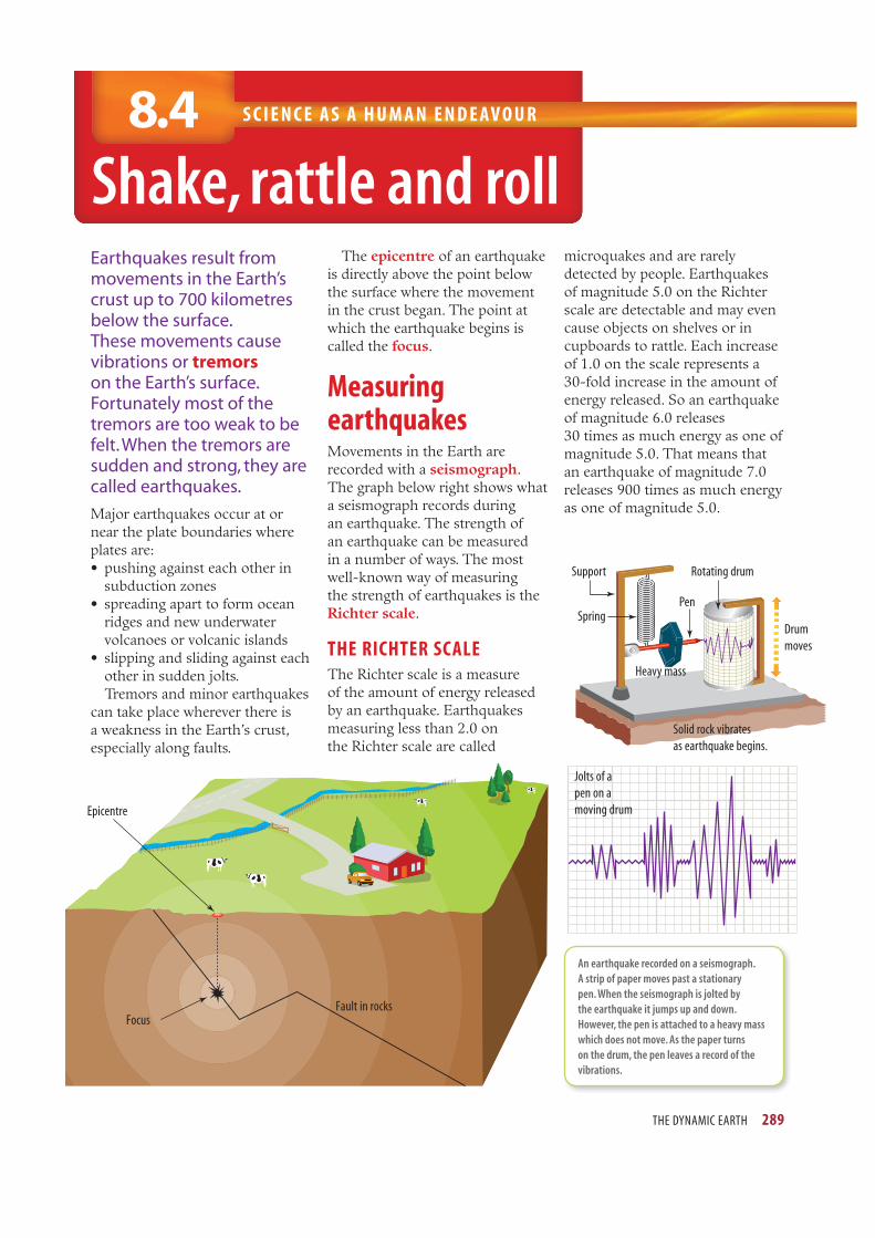
Earthquakes result from
movements in the Earth’s
crust up to 700 kilometres
below the surface.
These movements cause
vibrations or tremors
on the Earth’s surface.
Fortunately most of the
tremors are too weak to be
felt. When the tremors are
sudden and strong, they are
called earthquakes.
Major earthquakes occur at or
near the plate boundaries where
plates are:
• pushing against each other in
subduction zones
• spreading apart to form ocean
ridges and new underwater
volcanoes or volcanic islands
• slipping and sliding against each
other in sudden jolts.
Tremors and minor earthquakes
can take place wherever there is
a weakness in the Earth’s crust,
especially along faults.
microquakes and are rarely
detected by people. Earthquakes
of magnitude 5.0 on the Richter
scale are detectable and may even
cause objects on shelves or in
cupboards to rattle. Each increase
of 1.0 on the scale represents a
30-fold increase in the amount of
energy released. So an earthquake
of magnitude 6.0 releases
30 times as much energy as one of
magnitude 5.0. That means that
an earthquake of magnitude 7.0
releases 900 times as much energy
as one of magnitude 5.0.
Fault in rocksFocus
Epicentre
The epicentre of an earthquake
is directly above the point below
the surface where the movement
in the crust began. The point at
which the earthquake begins is
called the focus.
Measuring earthquakesMovements in the Earth are
recorded with a seismograph.
The graph below right shows what
a seismograph records during
an earthquake. The strength of
an earthquake can be measured
in a number of ways. The most
well-known way of measuring
the strength of earthquakes is the
Richter scale.
THE RICHTER SCALEThe Richter scale is a measure
of the amount of energy released
by an earthquake. Earthquakes
measuring less than 2.0 on
the Richter scale are called
An earthquake recorded on a seismograph.
A strip of paper moves past a stationary
pen. When the seismograph is jolted by
the earthquake it jumps up and down.
However, the pen is attached to a heavy mass
which does not move. As the paper turns
on the drum, the pen leaves a record of the
vibrations.
Jolts of a
pen on a
moving drum
Rotating drum
Drum
moves
Pen
Heavy mass
Solid rock vibrates
as earthquake begins.
Support
Spring

290 SCIENCE QUEST 9
P A C I F I C
O C E A N
A T L A N T I C
O C E A N
CHILE
USA
1
0 1000 2000 3000 4000 km
DART locations
USA
Chile
Completed
Planned
The Richter scale is not always a good indication of the destructive power of an earthquake. In a crowded city, small earthquakes can cause many deaths, injuries and a great deal of damage, cutting off water, gas and electricity supplies. Larger earthquakes in remote areas cause few injuries and little damage.
DESTRUCTIVE POWERThe destructive power of an earthquake in any location also depends on its distance from the epicentre. For example, the Tennant Creek earthquake of 1988 in the Northern Territory had a Richter magnitude of 6.7; however, only two buildings and the natural gas pipeline were damaged. The epicentre of the earthquake was 40 kilometres north of the town. Yet the earthquake that devastated Newcastle in New South Wales in 1989 registered 5.6 on the Richter scale, killed 13 people, hospitalised 160 others, demolished
The locations of
DART buoys
earthquakes, seismologists can use sensors to monitor movement along plate boundaries and fault lines. When pressure build-ups occur they can at least warn authorities that an earthquake is likely. As yet there is no reliable early warning system in place. However, seismologists are experimenting with a variety of methods using satellites, Earth-based sensors and even animal behaviour.
Tsunami early warning systems rely on the early detection of earthquakes and a system of buoys placed around the Pacifi c and Atlantic Oceans. This system is called DART (Deep-ocean Assessment and Reporting of Tsunamis). Sudden rises in sea level are detected by the buoys and alerts are sent to tsunami warning centres.
Waves of destructionEarthquakes occurring under the water or near the coast can cause giant waves called tsunamis. These huge waves travel through the ocean at speeds of up to 900 kilometres per hour. When the waves approach land the water gets shallower. This causes the waves to slow down and build up to heights of up to 30 metres.
300 buildings and damaged tens of thousands more. The epicentre of that earthquake was only fi ve kilometres west of the city.
Living on the edgeFor the people living near the plate boundaries, particularly on the edges of the Pacifi c Ocean, the ability of scientists to predict earthquakes and tsunamis is critical. The scientists who study earthquakes are called seismologists.
Although it is diffi cult to predict the time, location and size of
Some of the destruction caused by the December 1989 Newcastle earthquake

THE DYNAMIC EARTH 291
The destructive power of
tsunamis became very clear on
26 December 2004 when about
300 000 people across South-
East Asia, southern Asia and
eastern Africa died. Millions
more lost their homes. The
tsunami, known as the Sumatra–
Andaman tsunami, was caused
by a huge earthquake under the
ocean fl oor about 250 kilometres
off the coast of the Indonesian
island of Sumatra. The
earthquake measured 9.0 on
the Richter scale. It pushed a
1000-kilometre-long strip of
the ocean fl oor about 30 metres
upwards.
The worst destruction
occurred on the south-
west coast of Sumatra when
the tsunami struck about
15 minutes after the earthquake
took place. The tsunami
pushed a three-metre-high
wall of water, mud and debris
a distance of 10 kilometres
inland near the Sumatran city
of Banda Aceh. Thousands
were killed in Sri Lanka,
India and Thailand as well.
Death and destruction also
occurred in Malaysia, Myanmar,
Bangladesh and the Maldives.
More than eight hours after the
earthquake, the tsunami arrived
at the east coast of Africa, more
than 5000 kilometres from the
epicentre of the earthquake.
Even at that distance from the
earthquake, the tsunami caused
fl ooding which killed more than
160 people on the coasts of
Somalia, Kenya and Tanzania.
INQUIRY: INVESTIGATION 8.4
Making a seismographKEY INQUIRY SKILLS:
• planning and conducting
• evaluating
Equipment:
retort stand, bosshead and rod
spring
cardboard
A4 paper
sticky tape
felt pen
500 g or 1 kg weight
(or a can full of sand)
• Set up the equipment as
shown in the diagram on
the right.
• Have your partner move the cardboard past the pen while you thump
the surface on which your seismograph sits.
DISCUSS AND EXPLAIN1 Does the model work?
2 How could you improve the model?
A model seismograph
This map shows the huge area affected by the tsunami on 26 December 2004.
Seismic activity
Fast-moving waves Waves slow down in shallow water.
Crests are closer together and higher.
Sticky tape
Sheet
of
paper
Spring Felt pen
touching
paper
Cardboard moved
past pen
Hand thumps
bench
Indonesia
Bangladesh
Myanmar
Malaysia
Indonesia
Epicentre
Andaman and
Nicobar Islands
(India)
Thailand
Sri Lanka
India
Maldives
Seychelles
Somalia
Worst affected districts
Affected countriesKenya
Tanzania

292 SCIENCE QUEST 9
UNDERSTANDING AND INQUIRING
REMEMBER
1 How are earthquakes caused?
2 Distinguish between an Earth tremor and an earthquake.
3 What name is given to the point at which an earthquake begins?
4 Where is the epicentre of an earthquake?
5 What quantity is the Richter scale a measure of?
6 Explain why a tsunami only a few metres high in open ocean can reach heights of up to 30 metres by the time it reaches land.
7 Explain how seismologists are able to make
predictions about the likelihood of an earthquake.
ANALYSING DATA
8 The table below shows the number of people killed in some of the major earthquakes in recent years.
Year Location
Number
of deaths
(approx.)
Richter
scale
magnitude
1994 Los Angeles, USA 57 6.6
1995 Kobe, Japan 6 400 7.2
1999 Iznit, Turkey 17 000 7.4
2001 Gujarat, India 20 000 7.9
2003 Bam, Iran 26 000 6.6
2004 Sumatra, Indonesia 230 000 9.0
2008 East Sichuan, China 90 000 7.9
2010 Haiti (Caribbean Sea) 316 000 7.0
2011 Sendai, Japan 18 000 9.0
(a) List two pairs of earthquakes that provide evidence that the Richter scale does not indicate the loss of life in earthquakes.
(b) What factors, apart from the Richter scale measurement, affect the number of deaths in an earthquake?
(c) How much more energy was released by the 2004 Sumatra earthquake than the 2010 Haiti earthquake?
(d) Suggest why there were more fatalities as a result of the Haiti earthquake.
THINK
9 Explain why Indonesia is more likely to experience major earthquakes than Australia.
10 Outline some of the long-term consequences of the damage done to nuclear power stations by the Sendai tsunami.
INVESTIGATE
11 Use the internet or other resources to research and compare the 2004 Sumatra earthquake and the 2011 Japan earthquake. Write a report about the differences between the earthquakes and their consequences.
12 Find out why earthquakes are more likely to occur in some areas than others.
13 Use the Tsunami weblink in your eBookPLUS to learn more about the 2004 Sumatra–Andaman tsunami.
H%RRNSOXVH%RRNSOXV
The world was reminded of the destructive power of tsunamis in March 2011, when an earthquake struck that was of the same magnitude as the 2004 Sumatra–Andaman earthquake. The epicentre of this earthquake was only 70 kilometres off the coast of the Japanese island of Honshu. The nearest major city was Sendai, where the port and airport were almost totally destroyed. In that city at least 670 people were killed and about 2200 were injured. Around 6900 houses were totally destroyed, with many more partially destroyed. Waves of up to 40 metres in height were recorded on the coast and some caused damage as far as 10 kilometres inland.
Several nuclear reactors were shut down immediately following the earthquake that caused the tsunami. However, that wasn’t enough to prevent meltdowns in three reactors at the Fukushima Daiichi Power Plant, resulting in explosions and the leakage of radiation into the atmosphere, water and soil.
8.4 Earthquakes8.5 Plotting earthquake activity
worksheets
The tsunami of March 2011 destroyed entire cities.
Mountains of fi re
S C I E N C E U N D E R S TA N D I N G8. 5
THE DYNAMIC EARTH 293
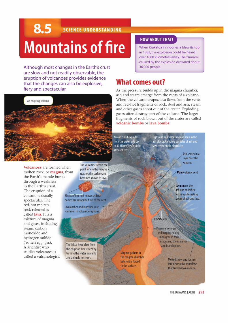
Although most changes in the Earth’s crust
are slow and not readily observable, the
eruption of volcanoes provides evidence
that the changes can also be explosive,
fi ery and spectacular.
HOW ABOUT THAT!
When Krakatoa in Indonesia blew its top
in 1883, the explosion could be heard
over 4000 kilometres away. The tsunami
caused by the explosion drowned about
36 000 people.
What comes out?As the pressure builds up in the magma chamber,
ash and steam emerge from the vents of a volcano.
When the volcano erupts, lava fl ows from the vents
and red-hot fragments of rock, dust and ash, steam
and other gases shoot out of the crater. Exploding
gases often destroy part of the volcano. The larger
fragments of rock blown out of the crater are called
volcanic bombs or lava bombs.
Volcanoes are formed when
molten rock, or magma, from
the Earth’s mantle bursts
through a weakness
in the Earth’s crust.
The eruption of a
volcano is usually
spectacular. The
red-hot molten
rock released is
called lava. It is a
mixture of magma
and gases, including
steam, carbon
monoxide and
hydrogen sulfi de
(‘rotten egg’ gas).
A scientist who
studies volcanoes is
called a vulcanologist.
An erupting volcano
Magma gathers in
the magma chamber
before it is forced
to the surface.
Blocks of hot rock known as lava
bombs are catapulted out of the vent.
Avalanches and landslides are
common in volcanic eruptions.
An ash cloud explodes
from the crater and up
to 30 kilometres into the
atmosphere.
Lightning can sometimes be seen in the
ash clouds. Colliding particles of ash and
lava create static electricity.
Ash settles in a
layer over the
volcano.
Main volcanic vent
Lava covers the
ash and solidifi es,
forming alternating
layers of ash and lava.
Pressure from gas
and magma mixing
underground forces
magma up the main vent
and branch pipes.
Branch pipe
Melted snow and ice turn
into destructive mudfl ows
that travel down valleys.
A
la
v
Ma in v
ava co v
shand as
fo
la
M
La
as a
f
l
L
a
anch
P
ceturn
kfh
The volcanic crater is the
point where the magma
reaches the surface and
becomes known as lava.
The initial heat blast from
the eruption ‘boils’ trees by
turning the water in plants
and animals to steam.

294 SCIENCE QUEST 9
The lava fl owing from a volcano can be runny or pasty like toothpaste. If it is runny, it can fl ood large areas, cooling to form large basalt plains like those in Victoria’s western district and in Melbourne, and to the city’s north and south.
Thick, pasty lava builds up on the sides of volcanoes and can also block the vents as it cools.
Paricutin, a new volcano in Mexico. It began as a small crack in a fi eld of corn.
When this happens, gases build up in the magma below. As the pressure increases, the volcano can bulge and ‘blow its top’, thrusting rocks, gases and hot lava high into the air.
Birth of a volcanoOn a cool winter’s day in 1943, a small crack opened up in a fi eld of corn on a quiet, peaceful Mexican farm. When red-hot cinders shot out of the crack, the shocked farmer tried to fi ll it with dirt. The next day, the crack had opened up into a hole over two metres in diameter. A week later, the dust, ash and rocks erupting from the hole had formed a cone 150 metres high! Explosions roared through the peaceful countryside and molten lava began spewing from the crater, destroying the village of Paricutin. The eruptions continued and, within a year, the new mountain, named Paricutin, was 300 metres high. When the eruptions stopped in 1952, Paricutin was 410 metres high.
Hot spotsAlthough most of the world’s volcanoes are found at the edges of the plates of the Earth’s crust, some lie over hot spots. These hot spots are regions of the crust where the mantle below is extremely hot. The volcanoes of western Victoria and Queensland have formed over hot spots.
Dead or alive?Volcanoes that are erupting or have recently erupted are called active volcanoes. Mount Pinatubo in the Philippines, which erupted in June 1991 killing 300 people, is an active volcano. There was so much smoke and ash coming from Mount Pinatubo that scientists believe that the Earth’s weather was cooler for over a year. The cloud of smoke and ash was believed to have blocked out about four per cent of the heat from the sun.
Extinct volcanoes are those that have not erupted for thousands of years. They are effectively dead and are most unlikely to erupt again.
HOW ABOUT THAT!
Volcanoes don’t occur only on Earth. The biggest
volcano in the solar system is on Mars. It is named
Olympus Mons (Mount Olympus) and is more than
double the height of Mount Everest!
H%RRNSOXVH%RRNSOXVeLesson
Volcanoes
Learn how volcanoes are formed, and what happens when they blow their tops.
eles-0130
THE DYNAMIC EARTH 295
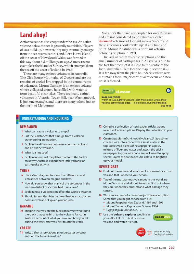
UNDERSTANDING AND INQUIRING
REMEMBER 1 What can cause a volcano to erupt?
2 List the substances that emerge from a volcanic
crater during an eruption.
3 Explain the difference between a dormant volcano
and an extinct volcano.
4 What is a hot spot?
5 Explain in terms of the plates that form the Earth’s
crust why Australia experiences little volcanic or
earthquake activity.
THINK 6 Use a Venn diagram to show the differences and
similarities between magma and lava.
7 How do you know that many of the volcanoes in the
western district of Victoria had runny lava?
8 Explain how a volcano can affect the world’s weather.
9 Should Mount Gambier be described as an extinct or
dormant volcano? Explain your answer.
IMAGINE10 Imagine that you are the Mexican farmer who found
the crack that gave birth to the volcano Paricutin.
Write an account of what you saw and how you felt
during the week after you fi rst found the crack.
CREATE11 Write a short story about an underwater volcano
entitled The birth of an island.
12 Compile a collection of newspaper articles about
recent volcanic eruptions. Display the collection in your
classroom.
13 Create a papier-mâché model volcano. Shape some
chicken wire into a cone with a small crater at the
top. Soak small pieces of newspaper in a pasty
mixture of fl our and water and attach the sticky
newspaper to your wire cone. You will need to apply
several layers of newspaper. Use colour to brighten
up your model.
INVESTIGATE14 Find out the name and location of a dormant or extinct
volcano that is close to your school.
15 Two of the most famous volcanoes in the world are
Mount Vesuvius and Mount Krakatoa. Find out where
they are, when they erupted and what damage they
caused.
16 Write an account of a recent major volcanic eruption.
Some that you might choose from are:
• Mount Ruapehu, New Zealand, 1994 and 1996
• Mount Tavurvur, Papua New Guinea, 1994
• Eyjafjallajökull, Iceland, 2010.
17 Use the Volcano explorer weblink in
your eBookPLUS to build a virtual
volcano and watch it erupt.
H%RRNSOXVH%RRNSOXV
Land ahoy!Active volcanoes also erupt under the sea. An active volcano below the sea is generally not visible. If layers of lava build up, however, they may eventually emerge from the sea as a volcanic island. Lord Howe Island, off the coast of New South Wales, was formed in this way about 6.5 million years ago. A more recent example is the island of Surtsey, which emerged from the sea off the coast of Iceland in 1963.
There are many extinct volcanoes in Australia. The Glasshouse Mountains of Queensland are the remains of cooled lava trapped in the central vents of volcanoes. Mount Gambier is an extinct volcano whose collapsed craters have fi lled with water to form beautiful clear lakes. There are many extinct volcanoes in Victoria. Tower Hill, near Warrnambool, is just one example, and there are many others just to the north of Melbourne.
Volcanoes that have not erupted for over 20 years and are not considered to be extinct are called dormant volcanoes. Dormant means ‘asleep’ and these volcanoes could ‘wake up’ at any time and erupt. Mount Pinatubo was a dormant volcano before its eruption in 1991.
The lack of recent volcanic eruptions and the small number of earthquakes in Australia is due to the fact that most of it is close to the centre of the Indo–Australian Plate (see the map in section 8.2). It is far away from the plate boundaries where new mountains form, major earthquakes occur and new crust is formed.
H%RRNSOXVH%RRNSOXVeLesson
Deep-sea miningWatch an ABC Catalyst video to learn more about where most volcanic activity takes place — not on land, but under the sea.
eles-1086
8.6 Volcanic activity8.7 Geological activity
worksheets

296 SCIENCE QUEST 9
T H I N K I N G T O O L S8.6
Affi nity diagrams and
double bubble maps
Allows you to become aware of
both your and others’ feelings
and thoughts about issues
how to …?What do these topics have in
common and what is different?
why use?
‘JK method’ named
after its developer
Jiro Kawakita
alsocalled
example
Double bubble map
comparison
question
Affinity diagram
Topic
Group 1
View or
response
View or
response
View or
response
View or
response
Group 2
View or
response
View or
response
View or
response
View or
response
Group 3
View or
response
View or
response
View or
response
View or
response
Group 4
View or
response
View or
response
View or
response
View or
response
1. Think about a topic and write any ideas you have onto small pieces
of paper.
2. Examine your pieces of paper and put similar ideas into groups.
Feel free to rearrange your groups until you are happy with them.
3. Think of names for your groups.
4. Now you are ready to draw an affinity diagram like the one below.
Affinity diagrams
identify groups based
on their similarities.
Double bubble maps
identify both similarities
and differences.
Difference
Both organise ideas or
features into groups.
Similarity
Feature
Feature
Feature
Feature
Feature
Feature
TopicFeature
Feature
Feature
Feature
Feature
TopicFeature
FeatureFeature
Feature

THE DYNAMIC EARTH 297
UNDERSTANDING AND INQUIRING
THINK AND CREATE1 (a) Write each of the ideas listed below on a small
card or sticky note.
FUDWHU
lava
RFHDQ�ULGJH
Richter scale
Krakatoa
FRQWLQHQWDO�GULIW
eruption
outer core
atmosphere(3,&(175(
seismologist
HDUWKTXDNHV
NWK][
������ subduction
convection current
crust inner core
�������PDQWOHmagma
DFWLYH
H[WLQFW
dormant
tsunami
ˊ˛ˆ˔ˑ˕˒ˊˇ˔ˇ
���������� ��
KRWVSRW
(b) Arrange the ideas on the cards into four categories in
an affi nity diagram like the one shown below. Write a
title for each category. If any of the ideas fi t into more
than one category, choose the single category that
best suits it.
???? ????
???? ????
The dynamic Earth
(c) Add at least two more ideas to each category.
2 Use your affi nity diagram from question 1 and any
other relevant terms to create double bubble maps
that illustrate the similar and different features of the
following pairs of topics:
(a) folding and faulting
(b) earthquakes and volcanoes
(c) continental drift and plate tectonics.
The fi gure below can be used to help you get started on
a double bubble map for folding and faulting.
Folding
Crust
Syncline
Anticline
Bending
Colliding plates
Faulting
Earthquakes
San Andreas

S T U DY C H E C K L I S T I C T
298 SCIENCE QUEST 9
THE THEORY OF PLATE TECTONICS
n describe the Earth’s crust and compare it with other
layers below and above the Earth’s surface
n describe evidence supporting the theory of plate
tectonics, including the location of volcanic activity
and earthquakes
n recognise the major plates on a map of the Earth
n explain the movement of plates in terms of heat and
convection currents in the Earth’s mantle
n describe and compare the processes of subduction
and the formation of ocean ridges
n model the process of subduction and sea-fl oor
spreading
FOLDING AND FAULTING
n describe and model the processes of folding and
faulting
n relate folding to the movement of tectonic plates and
the formation of mountain ranges
n explain the formation of faults in terms of the forces
acting within the Earth’s crust and the movement of
plates relative to each other
EARTHQUAKES AND VOLCANOES
n relate the occurrence of major earthquakes and
volcanoes to the movements along plate boundaries
n compare the energy released by earthquakes with
different values on the Richter scale
n associate tsunamis with earthquakes and volcanic
activity
n identify the main features of a volcano
n distinguish between lava and magma
n describe and compare the characteristics of active,
dormant and extinct volcanoes
n relate the age and stability of the Australian continent
and its lack of volcanic and major earthquake activity
to its location away from plate boundaries
SCIENCE AS A HUMAN ENDEAVOUR
n explain how the theory of plate tectonics developed
from the earlier theory of continental drift and further
evidence
n describe the use of scientifi c ideas and technology in
the development of the theory of plate tectonics
n describe the role of seismologists and vulcanologists
in the investigation of the Earth’s crust
n explain the importance of early warning systems to
people living near plate boundaries, particularly on
the edges of the Pacifi c Ocean. Activity 8.1Revising the
dynamic Earth
Activity 8.2Investigating the
dynamic Earth
Activity 8.3Analysing the
dynamic Earth
INDIVIDUAL PATHWAYS H%RRNSOXVH%RRNSOXV
H%RRNSOXVH%RRNSOXV SummaryeLessons
Drifting continentsIn this eLesson you will see how, over millions of years,
the giant supercontinent Pangaea broke up to form the
continents that we know today.
Searchlight ID: eles-0129
Deep-sea miningWatch an ABC Catalyst video to learn more about where most
volcanic activity takes place — not on land, but under the sea.
Searchlight ID: eles-1086
VolcanoesIn this eLesson you will learn how volcanoes are formed,
what happens when they blow their tops and how volcanic
eruptions change the face of the Earth.
Searchlight ID: eles-0130
Interactivities
Does the Earth move?Test your knowledge of plate boundaries by clicking on the
diagram which best fi ts a series of statements.
Searchlight ID: int-0674

LO O K I N G B AC K
THE DYNAMIC EARTH 299
12 The San Andreas Fault makes much of coastal California, including the cities of Los Angeles and San Francisco, susceptible to earthquakes.(a) Explain why the San Andreas Fault is called a slip
fault.(b) What causes major earthquakes along this fault?
13 Distinguish between the epicentre of an earthquake and its focus.
14 What is a seismograph used to measure?
15 How much more energy is released by an earthquake that registers 6.0 on the Richter scale than by one that registers 7.0 on the Richter scale?
16 Suggest two reasons why an earthquake that registers 6.6 on the Richter scale can cause more deaths and devastation than an earthquake that registers 7.9 on the Richter scale.
17 Before a volcano erupts, its vents are blocked with thick, pasty lava.(a) What change takes place to cause the volcano to
erupt?(b) How is the lava emerging from a volcano different
from magma?
18 Name three gases present in the lava that are released from a volcano.
19 Distinguish between a dormant volcano and an extinct volcano.
20 Identify two causes of tsunami.
A B
C D
E
F
G
H
8.8 The dynamic Earth: Puzzles8.9 The dynamic Earth: Summary
work
sheets
1 Which layers of the Earth have the following characteristics?(a) Completely molten(b) Partially molten(c) Includes solid rock, soil and landforms(d) Solid and mostly made up of iron (e) Lies above the surface
2 Describe two pieces of evidence that supported Wegener’s theory of continental drift.
3 Explain how scientists know about what lies deep below the surface of the Earth without going there.
4 According to the theory of plate tectonics, the Earth’s crust is divided into a number of slowly moving plates. (a) What makes the plates move?(b) What can happen when two plates slide past each
other?(c) How does the plate tectonics theory explain the
increasing height of the Himalayas?
5 What is the major difference between the continental drift theory and the theory of plate tectonics in terms of what makes up the Earth’s crust?
6 Where on Earth is the Ring of Fire and why does it exist?
7 How is an ocean ridge different from a subduction zone?
8 When oceanic crust pushes against continental crust, why does the oceanic crust slide underneath the continental crust?
9 Describe the movements in the Earth’s crust that cause the folding of rock that has shaped most of the Earth’s mountains.
10 Explain how faults are created.
11 Copy the diagrams below and label them using the following words: anticline, continental crust, magma, normal fault, oceanic crust, reverse fault, solid upper mantle, syncline.
(a) A subduction zone
(b) Two types of faulting
(c) Folding upwards and downwards
(a)
(b) (c)

I C T AC T I V I T I E S
Disaster-proofSEARCHLIGHT ID: PRO-0108
Scenario
Earthquakes occur when pressure built up between adjacent sections of rock in the Earth’s crust is suddenly released. The bigger the earthquake’s magnitude, the greater the amount of energy that shakes the Earth. Solid ground seems to move like water, roads crack, buildings fall and people die. However, the magnitude of the earthquake is not necessarily a good indication of how deadly it will be. The May 2006 earthquake in Java had a magnitude of 6.2 and caused the deaths of nearly 6000 people, yet the 2004 Guadalupe earthquake was the same size but killed only 1 person. In some cases, magnitude 5.3 earthquakes have killed more people than those with magnitude 8.1. In fact, one of the key predictors other than magnitude of how deadly an earthquake in an area will be is how heavily populated the area is and what type of buildings are there. It is a sad fact that the majority of people who die in earthquakes do so because the buildings around them fail.
While Australia is not near a plate boundary, as the more earthquake-prone regions of the world are, we are not out of danger. The 1984 Newcastle earthquake had a magnitude of 5.6 and resulted in 13 deaths, 160 injuries and damage to over 60 000 buildings. With this in mind, your company — Shakeless Seismic Solutions — has been approached by a wealthy client who suffers from acute seismophobia. She wishes to build a five-storey office block in Perth and she wants it to be as earthquake-proof as possible. However, yours is not the only company that she has approached. In order to determine which business she will award the contract to, she is asking each company not only to come up with a design, but also to have a scale model of their design tested on a shake-table earthquake simulator.
Your task
Your group will use research, ingenuity and online simulators to design a five-storey office block that will survive an earthquake. You will build a scale model of your design and compete with other groups to determine which model/design is able to withstand the most energetic shaking on the simulator and so which company will win the building contract. Your model will need to fulfill the following criteria:• It should have a total mass of no more than 1.5 kg.• It should have a base area no bigger than 20 cm x
20 cm and should have a height of at least 50 cm.
300 SCIENCE QUEST 9
• No glue, staples, nails or pins are allowed to be used; however, you may use interlocking pieces.
• It must be freestanding (it may not be stuck to the table in any way).
Before testing, you will be required to explain the main aspects of your design to the client (your teacher) and describe what makes the model and the real building earthquake-proof.
Process
• Open the ProjectsPLUS application for this chapter located in your eBookPLUS. Watch the introductory video lesson and then click the ‘Start Project’ button to set up your project group. You can complete this project individually or invite other members of your class to form a group. Save your settings and the project will be launched.
MEDIA CENTRE
Your Media Centre
contains:
• a testing criteria document
• a selection of useful weblinks
• an assessment rubric.
Your ProjectsPLUS application is available in this chapter’s Student Resources tab inside your eBookPLUS. Visit www.jacplus.com.au to locate your digital resources.
SUGGESTED
SOFTWARE
• ProjectsPLUS• Adobe Flash• Java• Internet access
• Navigate to your Research Forum. Here you will find a number of different headings under which you will organise your research. You may delete those topics that you will not be considering or add your own topics if you find your research going in a different direction.
• Start your research. Make notes about information that you think will be relevant to your project, including what factors determine a building’s stability in an earthquake. Enter your findings as articles under your topic headings in the Research Forum. You should each find at least three sources (other than the textbook, and at least one offline such as a book or encyclopedia) to help you discover extra information about earthquakes and how they affect buildings. You can view and comment on other group members’ articles and rate the information that they have entered. When your research is complete, print out your Research Report to hand in to your teacher.
• Visit your Media Centre and download the testing criteria for your design from the Document section. Your Media Centre also includes weblinks that you may find useful for your project. Some of these links will take you to online earthquake simulators that will allow you to test the effectiveness of particular building features.
• Use what you have learned to build your model for test day.
THE DYNAMIC EARTH 301


![This Dynamic Earth[1]](https://img.pdfslide.us/doc/110x75/577d2a6b1a28ab4e1ea920eb/this-dynamic-earth1.jpg)


![Conspiracy] Battles Beneath the Earth](https://img.pdfslide.us/doc/110x75/577d38291a28ab3a6b973302/conspiracy-battles-beneath-the-earth.jpg)

![This Dynamic Earth [USGS]](https://img.pdfslide.us/doc/110x75/61afbe740fce3b376342b9fe/this-dynamic-earth-usgs.jpg)