Embed Size (px)
Citation preview
1
The Dutch Layers Approach to Spatial Planning and Design:
A Fruitful Planning Tool or a Temporary Phenomenon?
JEROEN VAN SCHAICK* and INA KLAASEN
Department Urbanism, Faculty of Architecture, Delft University of Technology,
P.O.Box 5043, 2600 GA Delft, The Netherlands; e-mail: [email protected]
*corresponding author
ABSTRACT In 1998 a stratified model that distinguished spatial planning tasks on the basis of the
differing spatial dynamics of substratum, networks and occupation patterns – i.e. three layers – was
introduced in the national debate on spatial planning in the Netherlands. Although using layered
models was not a new thing, this model hit a nerve in spatial planning practice, initially in particular
on a national level, but later also on the provincial and municipal level. Since 1998 this ‘layers model’
has developed into an approach to spatial planning and design: the Dutch layers approach. In the
process it got transformed in different ways. In this paper we aim to provide information on and
insight in the development of the layers approach between 1998 and 2009 both from a theoretical
angle as well as that from its application in practice, focusing on the variations of the layers approach
that have been constructed since its introduction. We then add our own comments to the ongoing
Dutch discourse concerning the layers approach, both in general and from the point of view of the
relation between 'time' and 'space'. Concluding we also answer the question posed in de title.
Introduction
The Dutch layers approach is an approach developed in the last decade in the Dutch planning praxis in
which the layers stand for aspects of concern in the domain of urban and regional design and planning.
The approach is of interest to us in our ongoing research around the theme 'time-oriented thinking in
spatial planning and design' because of the structuring role allotted to the time aspect within the
approach. More in general the approach might be of interest to a wider audience than the Dutch

2
language community because of the embedding of the approach in Dutch spatial planning praxis since
the turn of the century. Dutch spatial planning praxis has been of interest to the international debate on
planning since long. However, since the late 1990s the exemplary status of Dutch planning is being
questioned (see e.g. Hajer & Zonneveld, 2000). Contemporary to this critical view of Dutch spatial
planning in the context of the ‘network society’, the introduction and adoption of the layers approach
has been an integral part of the Dutch discourse on rethinking the principles of spatial planning. We
will start with explaining the origin of this approach, followed by a brief outline of the use of layers in
spatial sciences that may have inspired this specific layers approach. The latter, because we want to
point out that the layers approach didn't come out of the blue. We will then explore, firstly, the way
the original 'layers model' and it's development into a planning tool has been interpreted in the Dutch
spatial planning discourse, and, secondly, how the approach has been used - and adapted - in Dutch
spatial planning praxis during the past decade, i.e. which variations in the layers approach - and
possibly trends - can be distilled from policy documents and other documents from planning practice.
Basing ourselves on these building blocks we will then contribute our own points of view.
The Dutch layers approach as it was developed in the late 1990s
The Dutch layers approach originates in a model constructed between 1996 and 1998 by De Hoog,
Sijmons and Verschuuren. In the context of the research project Het Metropolitane Debat (the
metropolitan debate) these professional designers and planners were asked to create a base for the
strategic choices that had to be made regarding the future spatial development of the Netherlands in
the light of climate change, water management, the economic position of the Netherlands in
international networks, urban dynamics in relation to the values and attractiveness of the landscape
and the need for integral planning (Frieling 1998; De Hoog, Sijmons & Verschuuren1998a; 1998b). In
their answer to this question and based on their criticism regarding blue print types of plans that show
little concern for the process of transformation and interaction of different dynamics, they proposed a
stratified model, on a regional level of scale, which connected planning tasks to different time scales
of spatial dynamics (Table 1). True to their design background the model has an important visual
3
component that exemplifies how these layers are perceived in planning practice (Figure 1). Also visual
schemes play a role (Figure 2).
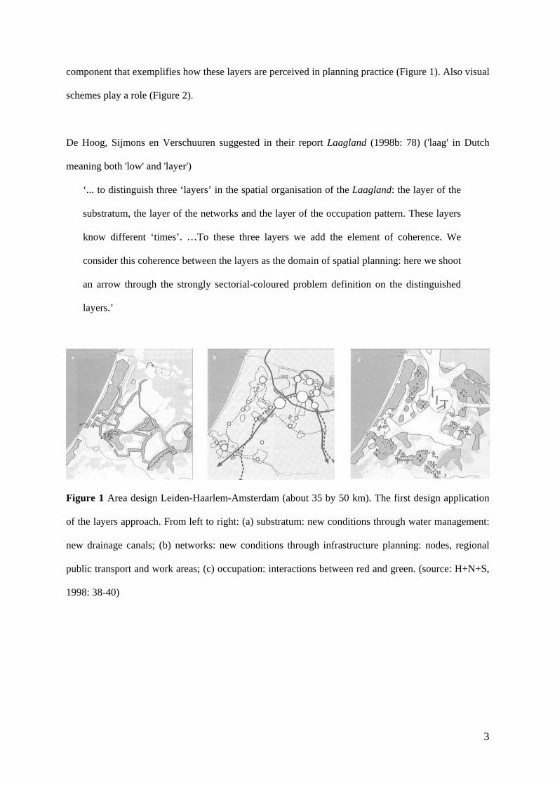
De Hoog, Sijmons en Verschuuren suggested in their report Laagland (1998b: 78) ('laag' in Dutch
meaning both 'low' and 'layer')
‘... to distinguish three ‘layers’ in the spatial organisation of the Laagland: the layer of the
substratum, the layer of the networks and the layer of the occupation pattern. These layers
know different ‘times’. …To these three layers we add the element of coherence. We
consider this coherence between the layers as the domain of spatial planning: here we shoot
an arrow through the strongly sectorial-coloured problem definition on the distinguished
layers.’
Figure 1 Area design Leiden-Haarlem-Amsterdam (about 35 by 50 km). The first design application
of the layers approach. From left to right: (a) substratum: new conditions through water management:
new drainage canals; (b) networks: new conditions through infrastructure planning: nodes, regional
public transport and work areas; (c) occupation: interactions between red and green. (source: H+N+S,
1998: 38-40)

4
Figure 2 (a), (b) and (c) Peter Dauvellier in cooperation with H2Ruimte visualises the layers
approach for the urban region Haaglanden as part of a step-by-step cyclical planning process. (a, left)
Shown is one of 4 quadrants of the cycle: Verkennen (Exploring). (b, middle) illustrates how to deal
with relations between the layers; (c, right) illustrates that each layer can be elaborated into detail.
Source: Stadsgewest Haaglanden (2003)
Their main assumption was that the substratum physically transforms slower than the networks, which
in turn transform at a lower rate than the physical structures on the occupation layer. This assumption
led to the idea that the layers from bottom to top set priorities and conditions for spatial planning tasks
on the other layers.

5
Table 1
Design and planning tasks
Approaches
Layer 1 Substratum - Dealing with the physical effects of climate change - Modernising the water management system
- Nature engineering - Civil engineering
Layer 2 Networks - Strengthening the position of the Netherlands in international networks - Control and steer the growth of mobility
- Complexes approach (developing nodes for exchange of information and knowledge) - Corridor approach (developing mainports and hinterland connections)
Layer 3 Occupation - Accommodating spatial claims and shrinkage in relation to values and attractivity
- ‘Écology’-approach (An ecology defined as a locally characteristic ‘life-style-environment’) - Mold-Contramold approach (city vs. landscape)
Coherence - Creating synergy between interventions
- Conditioning spatial planning - Facilitating spatial planning
Table 1 Design tasks and related approaches as they appeared in the analysis of almost 50 Dutch
spatial plans for the Netherlands. The analysis organised the plans using the layers model. Source: De
Hoog, Sijmons, Verschuuren (1998b)
Table 1 shows how De Hoog, Sijmons and Verschuuren viewed the connections of the layers to
planning and design tasks. In addition to these strategic components explained in verbal language, the
layers model and the layers approach have an important visual component that exemplifies how these
layers are generally perceived in planning practice: for the substratum a map of soil and water, for the
networks a map of the physical infrastructure networks and for occupation a map of built-up areas (see
Figure 1).
This layer model hit a nerve in spatial planning practice, initially in particular on a national level, but
later also on the provincial and municipal level where it quickly became known as the layers approach.
At the turn of the century, the layers model started to play a prominent role in the yearly explorations
for a national planning agenda by the national spatial planning agency (RPD 2000; 2001). Over the
next decade the layers model became formalized as a planning approach – layers approach - in
national, provincial and local planning documents (Van der Cammen & De Klerk 2003). Although the
6
three layers remained the main ingredient, the layers approach was often amended, adjusted and
reinterpreted since, as we will see further on in this article.
Cognate layers approaches
We speak of the 'Dutch' layers approach to distinguish it from other layers approaches in spatial design
and planning or related domains, both 'historical' ones and present ones. It is important to understand
the layers approach in relation to cognate approaches as they demonstrate that both the conceptual
ingredients of the approach as well as the principle of framing planning questions in terms of layers
have pedigree in the domains of geography and planning. Such pedigree may be one of the reasons
why the Dutch layers approach took hold in Dutch planning praxis.
With regard to layers approaches in related domains, different authors have suggested different roots.
The national spatial planning agency, the first to use the approach in spatial planning studies and
policies (RPD 2000; 2001; VROM 2001a; 2001b), sees it as a fusion of theoretical frameworks from
historical geography derived from Braudel (1949) - and social geography – derived from Vidal de la
Blache (1922). Braudel's (1949) concept of longue durée is seen as an important source of inspiration
for the logic on transformation dynamics that is part of the layers approach.
The domain of ecology has also been seen as providing inspiration for the approach. Priemus (2007:
671) is an example: ‘as the predecessor of the Layers Approach, the Strategy of Two Networks
(Tjallingii 1996) is interesting.’ One of the authors of the original model confirms this (interview
Maurits de Hoog, August 2009). Also the so-called casco-approach of Sijmons (1991), another author,
is often seen as a predecessor of the layers approach. However, Sijmons himself distinguishes them
clearly: ‘[in the casco-concept] time is a decisive factor, as in the later layers approach, but the casco-
concept focuses on a different level of scale and thus has different consequences. Where the layers
approach distinguishes three layers, the casco-concept is meant to be applied at layer 3, the occupation
layer.’ (Hajer, Sijmons & Feddes 2006: 40) Also derived from ecology, the so-called ‘triplex model’ is
much cognate to the layers approach. This model, distinguishing between a-biotic, biotic and
7
anthropogenic influences on the landscape, was derived from the work by McHarg (1969) and has
been very influential in the domain of landscape architecture (Roncken, 2003).
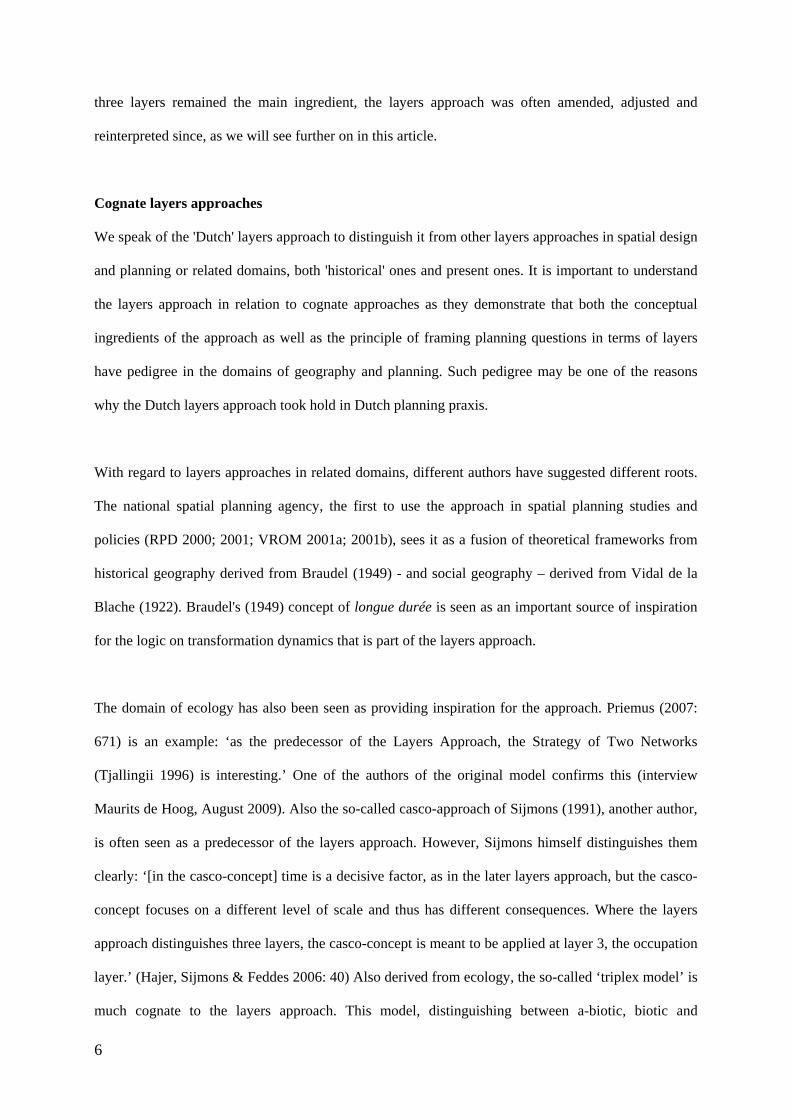
From a different viewpoint, Van Schaick (2005) analysed a series of four other stratified models that
integrate societal questions with physical-spatial questions. His analysis is based on a comparison
between the model of ‘social space’ by Lefebvre (1974 (1991)), the model of the ‘space of flows’ by
Castells (1996), the model of the ‘network city’ by Dupuy (1991; 2008; see Figure 3a) and a model of
the city as it is seen in urban design (Heeling, Meyer & Westrik, 2002; see Figure 3b). An important
conclusion of his analysis was that the strength of stratified models that try to integrate societal
questions with physical-spatial questions lies in the underlying time-concept and the way the model
deals with network concepts. Other examples of stratified models in urban planning include Trancik’s
model of urban design approaches (Trancik, 1980) and the Urbs-Civitas-Topos triad as it is used by
the Dutch Scientific Council program on Urbanisation and Urban Culture (Jansen, Leerssen &
Taverne, 2003).
Figure 3a and 3b The stratified urban planning models by Heeling, Meijer & Westrik (2002) (left)
and Dupuy (1991; 2008) (right)
8
The development of mapping layers in urban design and planning since the 1960s can also be seen as a
factor in the adoption of the Dutch layers approach in urban planning practice. An early example of
mapping layers is the work by landscape architect Ian McHarg (1969) although layered thematic
mapping can be traced back to much earlier dates (e.g. Harness, 1837)(see Robinson, 1955). Such
layered mapping is seen as an important inspiration for the development of computational tools for
mapping layers such as Geographic Information Systems (GIS)(Foresman, 1998). Since the 1990s
both geography and spatial planning have seen a growing influence in using computational tools in
spatial analysis and in spatial design, in particular GIS, Computer Aided Design (CAD) and
graphically-oriented software such as Adobe Photoshop and Adobe Illustrator. These software families
use the principle of layers as organizing structure of data and of maps. Although difficult to identify
empirically as a trend, we suspect that this representational characteristic and in particular the relative
ease with which multiple layers can be developed and combined, has gained much ground in spatial
planning and design in recent years. Instead of focusing on the content of a layer in the layers
approach, it is then the principle of superimposition itself that may have inspired the Dutch layers
approach.
The Dutch layers approach in Dutch planning discourse since 1998
From 1998 onwards, the layers model and the resulting layers approach became an important subject
in an already vivid discussion about the regional level in planning, about the balance between local
and national responsibility for spatial planning, and about the importance of water-related and
infrastructure problems in spatial planning (see e.g. ten Cate 1998). Despite its popularity, criticism
has developed both in practice and in academic circles. But still, there are no inventories available on
planning documents that use this layers approach and few studies exist that thoroughly analyse the
approach. Below, we outline those accounts in which the Dutch layers approach has been evaluated
and analysed as a representation of the Dutch discourse, both academic and professional, on the layers
approach. Although we cannot claim to be complete, we expect few more studies of an analytical
nature exist than mentioned here.
9
The landscape architect Dirk Sijmons, one of the founding fathers of the Dutch layers approach (see
De Hoog, Sijmons & Verschuuren 1998a) addresses in a retrospective chapter ‘the further adventures
of the layers model’ (Sijmons 2002: 135-150). Sijmons (ibid.) speaks – almost - consistently about the
‘layers model’ instead of the ‘layers approach’ when he means the original version from 1998. The
layers model, he states, was first meant as a ‘strategic proposal to organize a multitude of spatial tasks
and projects’. Strategic in the sense that not everything is equally important, but that from this
ordering would arise a new logic of prioritizing one project or task over the other; a new logic of
which task would belong to which level of government. The basis for this logic was the planning
horizon of these tasks. ‘It was a working philosophy, a strategic model, a planning concept. Since then
it went its own way’ (Sijmons 2002: 146). Sijmons describes how he is slightly surprised by the
popularity of the model after 1998; especially since ‘the layer concept is an agreement in the here and
now, without pretentions of universality and eternal value. At another time or at another scale other
priorities will fit.’ (ibid.) In the following part of his text, Sijmons distinguishes between two
directions in which the layers model mutated. Along the first direction, exemplified by the Ruimtelijke
Verkenningen 2000 (spatial explorations; RPD, 2001) the model became ‘heavier’. Along the second
line of development, exemplified by the Fifth Memorandum on Spatial Planning (VROM, 2001a), the
model was slimmed down.
Sijmons (2002) signals that the ‘heavy’ line of thinking tries to develop the layers model as both a
descriptive and an explanatory model grounded in history. Sijmons states that this translation of the
normative character of the 1998 model ignores the strategic component of the layers model as a whole,
including planning tasks on each layer. He signals that the ‘weighting’ of the layers model, especially
in its ‘substratum’ layer, makes the model inflexible and ‘bottom-heavy’. Sijmons is even more critical
of the development he signals in the Fifth Memorandum on Spatial Planning. In his view, it is a dead-
end to develop the layers model as a neutral instrument for editorial purposes, in particular, when the
approach is subsequently abandoned in the concrete spatial vision presented in the planning document.
These statements, however, didn't put a halt to the debate on the layers approach, nor stopped the
10
different ways the layer approach became interpreted in practice. The Dutch Social-Economic
Advisory Council SER had already advised positively on the layers approach as included in the Fifth
Memorandum seeing it as an important basis for an integral vision of spatial quality (SER, 2001). In
line with this positive review of the layers approach, Teunissen sees, in 2002, much room for
improvement. He formulates the following focal points for the further development of the layers
approach: (1) spatial quality and the layers approach, (2) interactions on and between layers, (3)
complex interaction of highly dynamic and less dynamic layers, (4) the layers approach as instrument
for plan development and the shaping of coalitions, and (5) the fit between development-oriented
planning and the layers approach (Teunissen, 2002).
In 2006 Sijmons is stronger in his disapproval than in 2002: ‘The layers approach is meant as a
contribution to the political-administrative steering of the ‘spatial business’… it was a story about a
subsidiarity. But it has often been used as a description of reality. That was a big mistake. They
confused a planning concept, which it is, with a kind of director’s trick to go through the same
material in a new battle order.’ (Hajer, Sijmons & Feddes, 2006: 41) And later on in the book: ‘I am
happy we invented it and that we applied it a couple of times in a nice way, and maybe we’ll use it
again, but you shouldn’t make it obligatory’ (ibid.: 55).
Zonneveld gives two explanations for the rift between the layers approach as analytical framework and
the content of spatial policies in the Fifth Memorandum. On the one hand, Zonneveld (2005: 10-11)
explains, there was an internal professional dispute on the approach. On the other hand, ‘it was
impossible to carry [the layers approach] through because large, spatially relevant policy domains are
not part of the Fifth Memorandum or indeed any spatial planning memorandum.’ In the end, politically,
the Memorandum could only limit itself to policies with regard to occupation patterns, more in
particular to containing urban development. This rift, we assert, seems to have had significant
consequences for the further life of the layers approach in spatial planning practices.
11
In their work on the history of Dutch spatial planning, Hans van der Cammen and Len de Klerk
reconstruct the rise of the layers approach as part of the discourse around the turn of the century in
their chapter on ‘networks [or networking] in the new century’. Their introduction of that chapter
indicates the unease of the profession with developments at the end of the 20th century: ‘Apparently
the societal dynamics exceeded the rate of adaptation of the physical environment and spatial planning
did not seem to be capable to bridge that gap.’ (Van der Cammen & De Klerk 2003:363) In this
chapter, they explain that although the underlying reasoning of the conceptual framework might be
faulty, it is a framework that carries three major design and planning tasks for the 21st century: the
spatial dimension of water management, the spatial consequences of increased mobility and new
spatial concepts for urbanisation and for so-called ‘natural’ landscapes. But their analysis of the layers
approach does not delve deeper than that. They limit their final remark on the layers approach to its
increased popularity at the turn-of-the-century.
Vonk-Noordegraaf (2003) takes a different approach. Instead of positioning the layers approach in the
discourse, she analyses the value of the approach in comparison to three other ‘area approaches’. Her
analytical framework is built around the normative premises, vision and method of each approach that
result in a concrete product of the approach. Although she recognizes that there are many possible
interpretations of the layers approach, she focuses her analysis of the layers approach on the version as
it was developed in RPD (2001) (Vonk-Noordegraaf 2003: 29, 35). She concludes that for the
approach to deliver concrete results it is necessary that involved actors subscribe to the underlying
rules-of-the-game of hierarchical planning in which planning tasks on the layer ‘substratum’ are
conditional to those on the layer ‘networks’, which are conditional to those on the layer ‘occupation’.
She signals two reasons why the layers approach is often abandoned after being used in the analytical
phase of a planning process. Firstly, Vonk-Noordegraaf states, the conceptual framework offered by
the approach is often seen as too rigorous to be applied in real-life planning, especially in an
intersectoral planning processes. Secondly, it lacks in theorisation about what to do in an urban
planning process after having done the analysis using the layers approach. She finds that this often
requires a translation into and/or a combination with other conceptual frameworks to result in concrete
12
planning products. Although deemed valuable for spatial analysis (Vonk-Noordegraaf 2003: 89), she
concludes that the layers approach, as she analysed it, is ‘not of value’ to create a spatial plan (ibid.:
41). In addition, when she compares the layers approach to other supposedly integral area-based
approaches, she concludes that integration often means safe-guarding an agenda in the planning
process based in other fields of expertise than spatial planning. Werksma, Dauvellier, Maring and
Puylaert (2007) have a more positive and pragmatic attitude towards the layers approach. They sketch
the possibilities offered by adapting the initial layers approach for practical purposes. Their point of
view is that the layers approach offers possibilities for interdisciplinary and intersectoral planning
processes.
Hugo Priemus analyses the layers approach from the viewpoint of ‘changing preconditions for
planning’. Rather than analysing planning practices, he critically reviews the theoretical basis of the
layers approach. He sets out ‘to amend this approach and to propose a network approach, as a method
to consider spatial variants and spatial economic investments alternatives within the framework of
green, blue, traffic, ICT and urban networks’ (Priemus 2004: 268). In a second paper (Priemus 2007),
he extends his argumentation for this amendment. Priemus’ main critique concerns the hierarchy
between the layers of the layers approach. He describes and substantiates that the theory of differing
spatial transformation rates at each layer is not supported by real life spatial dynamics. The basis for
his amendment of the layers approach is based on reciprocal relationships between layered networks
on multiple scales: (1) networks of the substratum (blue and green), (2) networks for transport, ICT,
water and energy, (3) urban networks (both the co-operating cities as well as the dynamic spatial
pattern of urban functions).
Recently, The Netherlands Institute for Spatial Research explicitly chose not to use the layers
approach to formulate ‘spatial questions of the future for the current policy agenda’ (Schuur, Janssen,
Klaver, Pieterse & Snellen, 2007). The authors of that explorative document gave two reasons. Firstly,
despite cartographic and stylistic advantages in particular in design processes, there is no direct
relation between the layer on which a development occurs and its urgency in policy making.

13
According to the authors, this makes it difficult to develop policy recommendations from an analysis
based on the layers approach. Secondly, the layers approach complicates matters, because it simplifies
functional distinctions, hierarchical relations between layers and the differences in rate of
transformation. For this reason it offers little room, the authors claim, to think about future spatial
questions in the long term.
Summarising the above we conclude that the original layers model was meant by the 'inventors' to be
hierarchical in the sense of a temporal level of scale (from less dynamic to highly dynamic) as well as
to which level of government tasks belonged (spatial level of scale); that the model was not to be seen
as a model of reality; and that it was not to be seen as static but as flexible. After the transition of the
model into an approach criticism focuses on the assumptions regarding the level of dynamics; that the
theory behind the approach neglected real-life planning problems and was unsuccessful with regard to
interrelating sector decisions; and that suggestions of the approach being useful in developing policy
recommendations or producing concrete spatial plans was a fallacy. Other authors take a more
pragmatic view underlining the usefulness of the approach for developing integral visions, for
interdisciplinary work, and for planning tasks in relation to different types of networks.
The discourse outlined above is clearly part of a wider debate in spatial planning in which
professionals and academics are trying to make sense of spatial planning and design tasks against a
background of social and economic changes. Perhaps for that reason, the Dutch layers approach
triggers a value-laden discussion either supporting or heavily criticizing the layers approach as a
relevant planning approach. This of course invites a look at what was happening in the mean time in
spatial planning practice.
The layers approach since 1998 in Dutch practice
In this section we describe how the perception of the layers approach has developed in spatial planning
practice. We aim to clarify the diversity of perceptions of the possible workings of the layers approach
along two lines of analysis: (1) key documents and (2) the embedment in planning practice.
14
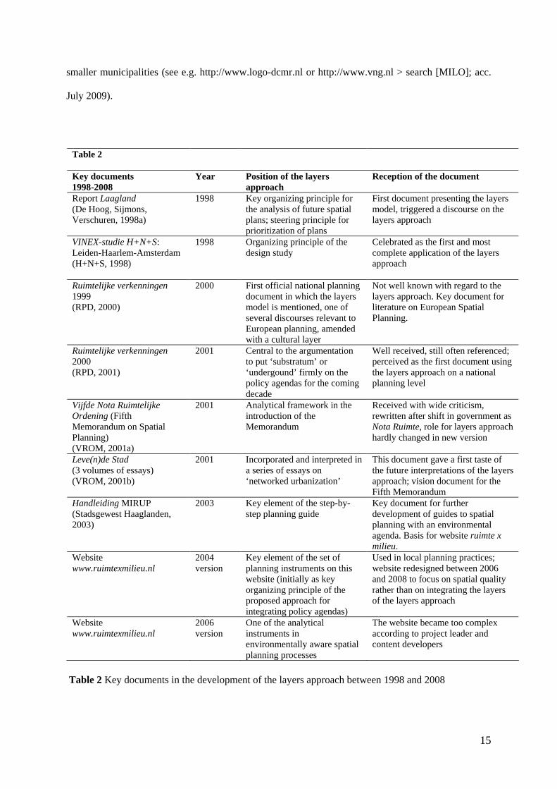
Key documents
The Dutch layers approach has become a widely accepted approach in mainstream spatial planning
through a number of key documents that explicitly promote it. The list of key documents in this
paragraph (Table 2) shows that the discussion on the layers approach has been largely practice-driven
with a key role for national planning circles. As might be expected, a closer look at these documents
shows that the interpretation of the layers model as a layers approach has known variations from the
moment of introduction of the layers model. Each key document in the process of adoption of the
approach in planning practice shows new interpretations and/or roles for the layers approach.
Embedment in planning practice
The layers model can be found in many policy documents on spatial planning. On a national planning
level it has been present since the Ruimtelijke Verkenningen 1999 (spatial explorations) (RPD 2000;
see Figure 4), and subsequently in those from 2000, which is regarded as the birth ground of the layer
‘approach’ (RPD 2001). The Fifth Memorandum on Spatial Planning (VROM 2001a) and the
National Spatial Strategy (VROM 2006) adopted the layers model in its analytical chapter. The most
recent document from the Ministry on Spatial Planning Randstad 2040 (VROM, 2008) again refers to
the layers approach as one of its building blocks although not as central as before: ‘For a sustainable
Randstad it is necessary to properly balance between the three dimensions of sustainability (people,
planet, profit) and between the three layers from the layers approach’ (ibid.: 71). An important
administrative level at which the layers approach in its fullest sense has been adopted is at the
provincial, i.e. regional level. Especially in the regional provincial plans (streekplannen) just after the
turn of the century its philosophy if not the approach itself is almost omnipresent (e.g. Provincie
Noord-Brabant, 2002; Provincie Noord-Holland, 2002; see for an overview PBL, 2008). But the layers
model, if not the layers approach, has also been adopted in many places on a local level, either in
municipal structure plans (e.g. Gemeente Amsterdam 2003) or in vision documents on future local
developments (e.g. Driehoek RZG, 2003). Further, the layers model has often been used in plans of
15
smaller municipalities (see e.g. http://www.logo-dcmr.nl or http://www.vng.nl > search [MILO]; acc.
July 2009).
Table 2
Key documents 1998-2008
Year Position of the layers approach
Reception of the document
Report Laagland (De Hoog, Sijmons, Verschuren, 1998a)
1998 Key organizing principle for the analysis of future spatial plans; steering principle for prioritization of plans
First document presenting the layers model, triggered a discourse on the layers approach
VINEX-studie H+N+S: Leiden-Haarlem-Amsterdam (H+N+S, 1998)
1998 Organizing principle of the design study
Celebrated as the first and most complete application of the layers approach
Ruimtelijke verkenningen 1999 (RPD, 2000)
2000 First official national planning document in which the layers model is mentioned, one of several discourses relevant to European planning, amended with a cultural layer
Not well known with regard to the layers approach. Key document for literature on European Spatial Planning.
Ruimtelijke verkenningen 2000 (RPD, 2001)
2001 Central to the argumentation to put ‘substratum’ or ‘undergound’ firmly on the policy agendas for the coming decade
Well received, still often referenced; perceived as the first document using the layers approach on a national planning level
Vijfde Nota Ruimtelijke Ordening (Fifth Memorandum on Spatial Planning) (VROM, 2001a)
2001 Analytical framework in the introduction of the Memorandum
Received with wide criticism, rewritten after shift in government as Nota Ruimte, role for layers approach hardly changed in new version
Leve(n)de Stad (3 volumes of essays) (VROM, 2001b)
2001 Incorporated and interpreted in a series of essays on ‘networked urbanization’
This document gave a first taste of the future interpretations of the layers approach; vision document for the Fifth Memorandum
Handleiding MIRUP (Stadsgewest Haaglanden, 2003)
2003 Key element of the step-by-step planning guide
Key document for further development of guides to spatial planning with an environmental agenda. Basis for website ruimte x milieu.
Website www.ruimtexmilieu.nl
2004 version
Key element of the set of planning instruments on this website (initially as key organizing principle of the proposed approach for integrating policy agendas)
Used in local planning practices; website redesigned between 2006 and 2008 to focus on spatial quality rather than on integrating the layers of the layers approach
Website www.ruimtexmilieu.nl
2006 version
One of the analytical instruments in environmentally aware spatial planning processes
The website became too complex according to project leader and content developers
Table 2 Key documents in the development of the layers approach between 1998 and 2008

16
Although the presence of the layers approach in policy documents is an important indicator, it should
also be seen as significant that professional courses, guidelines and handbooks have eagerly adopted
‘the’ layers approach, or an interpretation of it, as part of the toolbox for practical spatial planning, but
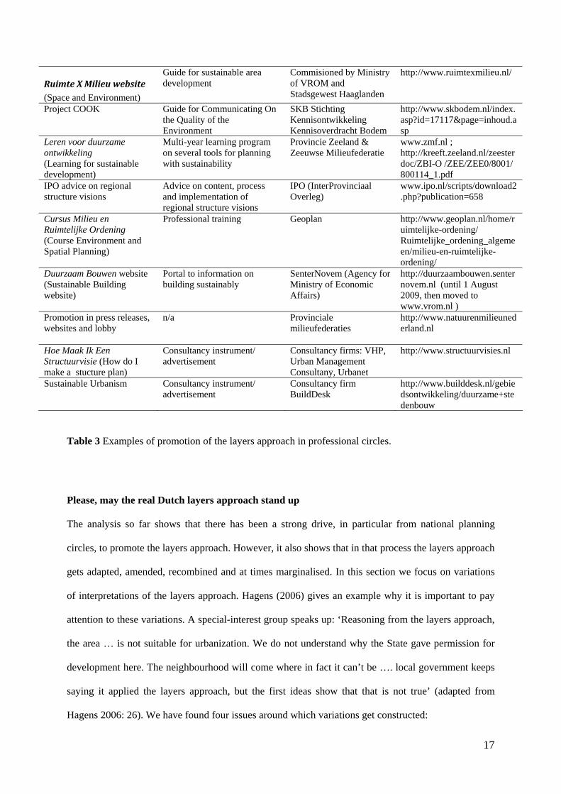
also in related fields such as transportation and environmental planning (see Table 3).
Figure 4 The first occurrence of the layers approach in an official, although explorative, policy
document. The layers approach is embedded in a whole range of discourses related to the European
Spatial Development Perspective (ESDP) and adapted to include ‘the cultural dimension’. Was the
layers approach not viable to begin with? Source: RPD (2000)
Table 3
Examples of professional promotion of the layers approach
Type of instrument Organization Web reference (accessed July 2009)
Atlas Amsterdam (Dijkstra, Reitsma, Rommerts, 1999)
Atlas of historical urban development structured by a version of the layers approach
Under guidance of dRO Amsterdam
none
4xAmsterdam – Ontwerpen aan de stad (de Hoog, 2005)
Popularized, personal vision on urban design in the city of Amsterdam
Private product by author, facilitated by dRO Amsterdam
none
Handreiking LOGO (DCMR, 2004)
Guide for Improving environmental quality through cooperation
DCMR Milieudienst Rijnmond; Provincie Zuid-Holland
http://www.logo-dcmr.nl
MIRUP Handreiking voor Milieu in Ruimtelijke Plannen (Guide for Environment in Spatial Plans)
Guide for municipalities to make environment part of the planning process; Basis for Ruimte X Milieu
Stadsgewest Haaglanden http://duurzaambouwen.senternovem.nl/praktijk/164-mirup.html
Handreiking MILO Milieukwaliteit In de LeefOmgeving (partially based on LOGO)
Guide for Environmental quality of the living environment
Projectbureau MILO at VNG (Vereniging Nederlandse Gemeenten) and Ministry VROM
http://www.vng.nl/smartsite.dws?id=63966&ch=DEF; http://www.stadenmilieu.nl; http://www.vrom.nl/get.asp?file=Docs/milieu/handreikingMILO.pdf
17
Table 3 Examples of promotion of the layers approach in professional circles.
Please, may the real Dutch layers approach stand up
The analysis so far shows that there has been a strong drive, in particular from national planning
circles, to promote the layers approach. However, it also shows that in that process the layers approach
gets adapted, amended, recombined and at times marginalised. In this section we focus on variations
of interpretations of the layers approach. Hagens (2006) gives an example why it is important to pay
attention to these variations. A special-interest group speaks up: ‘Reasoning from the layers approach,
the area … is not suitable for urbanization. We do not understand why the State gave permission for
development here. The neighbourhood will come where in fact it can’t be …. local government keeps
saying it applied the layers approach, but the first ideas show that that is not true’ (adapted from
Hagens 2006: 26). We have found four issues around which variations get constructed:
Ruimte X Milieu website (Space and Environment)
Guide for sustainable area development
Commisioned by Ministry of VROM and Stadsgewest Haaglanden
http://www.ruimtexmilieu.nl/
Project COOK Guide for Communicating On the Quality of the Environment
SKB Stichting Kennisontwikkeling Kennisoverdracht Bodem
http://www.skbodem.nl/index.asp?id=17117&page=inhoud.asp
Leren voor duurzame ontwikkeling (Learning for sustainable development)
Multi-year learning program on several tools for planning with sustainability
Provincie Zeeland & Zeeuwse Milieufederatie
www.zmf.nl ; http://kreeft.zeeland.nl/zeesterdoc/ZBI-O /ZEE/ZEE0/8001/ 800114_1.pdf
IPO advice on regional structure visions
Advice on content, process and implementation of regional structure visions
IPO (InterProvinciaal Overleg)
www.ipo.nl/scripts/download2.php?publication=658
Cursus Milieu en Ruimtelijke Ordening (Course Environment and Spatial Planning)
Professional training Geoplan http://www.geoplan.nl/home/ruimtelijke-ordening/ Ruimtelijke_ordening_algemeen/milieu-en-ruimtelijke-ordening/
Duurzaam Bouwen website (Sustainable Building website)
Portal to information on building sustainably
SenterNovem (Agency for Ministry of Economic Affairs)
http://duurzaambouwen.senternovem.nl (until 1 August 2009, then moved to www.vrom.nl )
Promotion in press releases, websites and lobby
n/a Provinciale milieufederaties
http://www.natuurenmilieunederland.nl
Hoe Maak Ik Een Structuurvisie (How do I make a stucture plan)
Consultancy instrument/ advertisement
Consultancy firms: VHP, Urban Management Consultany, Urbanet
http://www.structuurvisies.nl
Sustainable Urbanism Consultancy instrument/ advertisement
Consultancy firm BuildDesk
http://www.builddesk.nl/gebiedsontwikkeling/duurzame+stedenbouw
18
Level of scale, both temporal and spatial
Hierarchy of planning priorities
The different roles contributed to the Dutch layers approach
The reinterpretation of the content of a layer and of the amount of layers
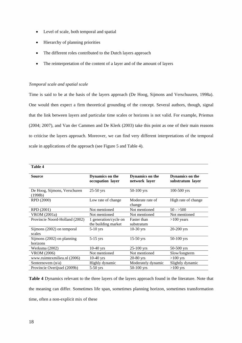
Temporal scale and spatial scale
Time is said to be at the basis of the layers approach (De Hoog, Sijmons and Verschuuren, 1998a).
One would then expect a firm theoretical grounding of the concept. Several authors, though, signal
that the link between layers and particular time scales or horizons is not valid. For example, Priemus
(2004; 2007), and Van der Cammen and De Klerk (2003) take this point as one of their main reasons
to criticise the layers approach. Moreover, we can find very different interpretations of the temporal
scale in applications of the approach (see Figure 5 and Table 4).
Table 4
Source Dynamics on the occupation layer
Dynamics on the network layer
Dynamics on the substratum layer
De Hoog, Sijmons, Verschuren (1998b)
25-50 yrs 50-100 yrs 100-500 yrs
RPD (2000) Low rate of change Moderate rate of change
High rate of change
RPD (2001) Not mentioned Not mentioned 50 - >500 VROM (2001a) Not mentioned Not mentioned Not mentioned Provincie Noord-Holland (2002) 1 generation/cycle on
the building market Faster than substratum
>100 years
Sijmons (2002) on temporal scales
5-10 yrs 10-30 yrs 20-200 yrs
Sijmons (2002) on planning horizons
5-15 yrs 15-50 yrs 50-100 yrs
Werksma (2002) 10-40 yrs 25-100 yrs 50-500 yrs VROM (2006) Not mentioned Not mentioned Slow/longterm www.ruimtexmilieu.nl (2006) 10-40 yrs 20-80 yrs >100 yrs Senternovem (n/a) Highly dynamic Moderately dynamic Slightly dynamic Provincie Overijssel (2009b) 5-50 yrs 50-100 yrs >100 yrs
Table 4 Dynamics relevant to the three layers of the layers approach found in the literature. Note that
the meaning can differ. Sometimes life span, sometimes planning horizon, sometimes transformation
time, often a non-explicit mix of these
19
Some of these variations can be explained by the particular document focussing on one or a
combination of the following: planning horizons, market cycles, the time necessary to negate
interventions in physical space, observed transformation dynamics or as a metaphor for how
untouchable a layer should be for spatial interventions. In most of these documents an explicit
justification for choosing one time indicator over another (e.g. 5-50 yrs instead of 5-10 yrs) is absent,
although the of time scales remains the same throughout all documents. Often the temporal logics are
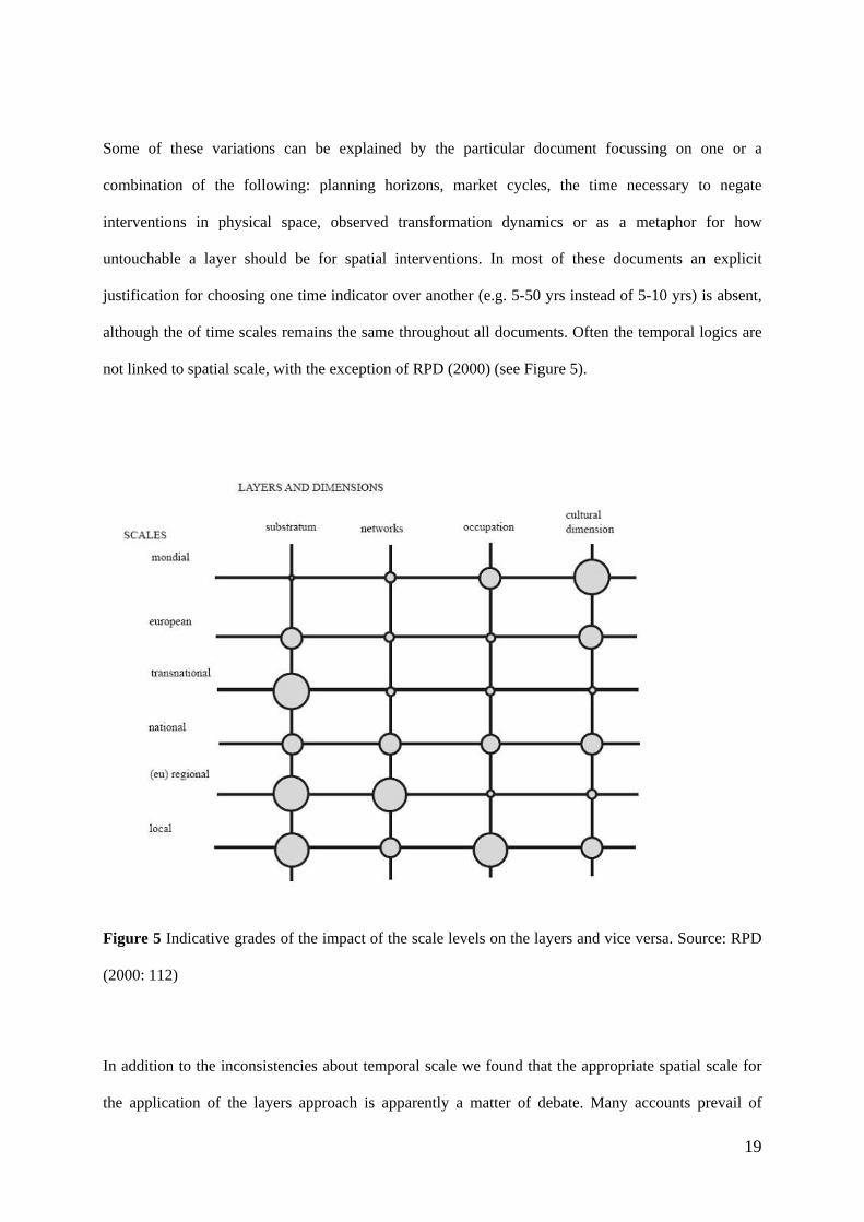
not linked to spatial scale, with the exception of RPD (2000) (see Figure 5).
Figure 5 Indicative grades of the impact of the scale levels on the layers and vice versa. Source: RPD
(2000: 112)
In addition to the inconsistencies about temporal scale we found that the appropriate spatial scale for
the application of the layers approach is apparently a matter of debate. Many accounts prevail of

20
application on much lower spatial scale levels than the original regional level of scale of which
Sijmons stipulated that it was the only appropriate scale for their model (Sijmons 2002). The MIRUP-
guide, for example, uses a fictive example on the neighbourhood level (Stadsgewest Haaglanden,
2003). On the other extreme, the RPD (2000) considers the relevant spatial scale levels up to the
'global scale' (see Figure 5). In addition, the 'grade of impact' which the RPD suggest in that Figure
would imply to consider multiple scales on each layer and on each scale multiple layers with different
prioritisations.
Hierarchy of planning priorities
A major point of disagreement in the debate on the layers approach is the perceived necessity or
dysfunctionality of promoting a – somewhat sectoral - hierarchy of planning tasks on the basis of the
layers approach in the sense that decisions on a lower layer condition the ones on the layers above.
Hagens (2006: 25, citing VROM, 2006) provides us with a typical example from the Nota Ruimte: ‘of
the three layers …not one is most important for spatial development’; while the policy document
states not far below: ‘at the same time it is inherent to the layers approach that the bottom layer sets
conditions for those on top’. Although De Hoog, Sijmons & Verschuuren (1998b), the RPD (2000)
and Sijmons (2002) explain that a hierarchical planning strategy is a fundamental property of the
layers approach, outside these documents and within the spatial planning domain little has come of
this claim.
Two alternatives have developed in practice. One is the neutral application of the layers model as an
organising instrument for analytical maps, even though this has been heavily criticised by both the
original developers of the layers model and in the wider planning debate after the publication of the
Fifth Memorandum on Spatial Planning. As far as we know though, many municipalities still use the
layers approach in this way. The other alternative is to disregard or marginalise the hierarchy from the
original 1998 model and to focus on the integrative possibilities that the approach offers. In this
alternative, one uses the layers approach as a way to facilitate integrating sectoral interests in spatial
planning processes. Examples of this approach can be found on the website www.ruimtexmilieu.nl

21
(accessed June 2010) and in training and consultancy practices as those promoted by Geoplan (see
Table 3), by Werksma (2002) and by Werksma, Dauvellier, Maring and Puylaert (2007). In their view
it is an integrating tool to put sustainability issues and interdisciplinary planning back on the agenda of
spatial planning. However, the transformation of the website www.ruimtexmilieu.nl in the last years
exemplifies that the layers approach in itself is not suitable to carry this on its own. It was to be
adapted to incorporate the problems encountered in concrete planning processes and, lately, to
incorporate urban quality as a central criterion.
The different roles contributed to the Dutch layers approach
Much ambiguity prevails with regard to the role that the layers approach plays in urban planning and
design. Several authors (e.g. Sijmons 2002; van Schaick & Klaasen 2007) have paid attention to the
mixing of different roles within single planning documents. The following ambiguities exist about the
interpretation of the instrumental value of the layers approach:
1. The layers approach is a model i.e. a reduction of physical reality; is an approach giving
guidelines for a planning process; is a metaphor whereby each layer indicates a set of actors, a
set of interests or a set of tasks
2. The approach is descriptive (what constitutes our city region); is analytical (either a plan
analysis or situation analysis); is strategic (instrument for searching, qualifying, prioritizing
and choosing certain solutions over others).
3. The approach is integrative (framework for co-operation or negotiation between sectors and/or
stakeholders); separates i.e. stimulating possibly conflicting sectoral policy agendas; is a
combination of both.
4. The approach is a communication tool (facilitating participation by laymen), is an editorial
tool (in particular for planning documents); is a building block (for a future policy); is a
leading philosophy (influencing agenda setting and the development of new ideas).
While the simplicity of the model suggest an easy framing of planning problems, these ambiguities
show that it is in fact not as simple as it seems.
22
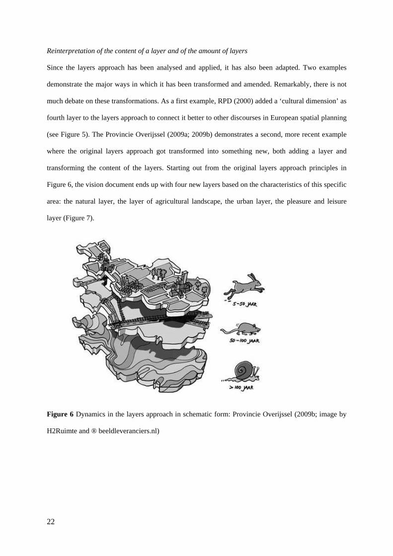
Reinterpretation of the content of a layer and of the amount of layers
Since the layers approach has been analysed and applied, it has also been adapted. Two examples
demonstrate the major ways in which it has been transformed and amended. Remarkably, there is not
much debate on these transformations. As a first example, RPD (2000) added a ‘cultural dimension’ as
fourth layer to the layers approach to connect it better to other discourses in European spatial planning
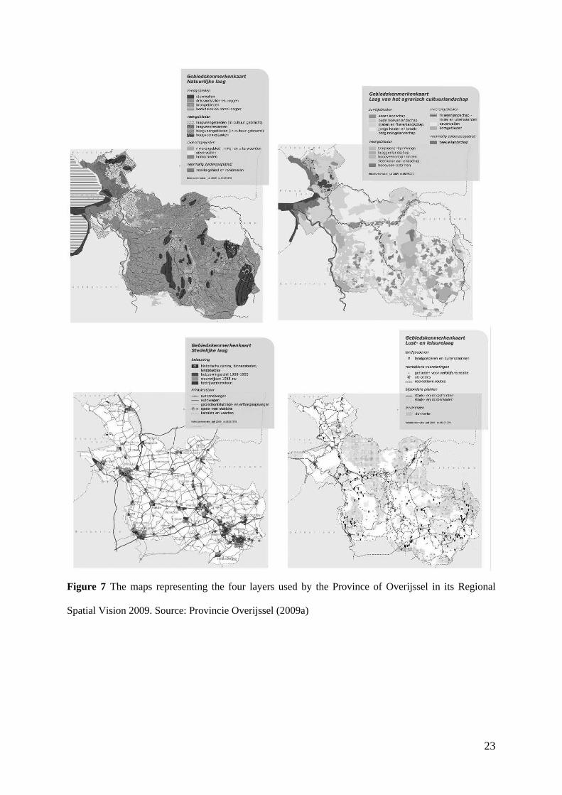
(see Figure 5). The Provincie Overijssel (2009a; 2009b) demonstrates a second, more recent example
where the original layers approach got transformed into something new, both adding a layer and
transforming the content of the layers. Starting out from the original layers approach principles in
Figure 6, the vision document ends up with four new layers based on the characteristics of this specific
area: the natural layer, the layer of agricultural landscape, the urban layer, the pleasure and leisure
layer (Figure 7).
Figure 6 Dynamics in the layers approach in schematic form: Provincie Overijssel (2009b; image by
H2Ruimte and ® beeldleveranciers.nl)
23
Figure 7 The maps representing the four layers used by the Province of Overijssel in its Regional
Spatial Vision 2009. Source: Provincie Overijssel (2009a)

24
Comments
In this article we described an approach to spatial design and planning that was introduced in the
Netherlands in 1998 as the Dutch layers model, and how variably its development has been in practice
into what the past decade has become known as the Dutch layers approach. Starting point of interest
was the way in which, certainly in the original model, spatial planning was connected to the notion
'time', in other words to the dynamics of natural and societal processes. From this point of view we see
a fundamental problem regarding the layers approach. We will start, however, with contributing in
more in general to the ongoing discourse concerning the approach.
In general
The model in it most rudimentary form distinguishes three ‘layers’ that constitute the physical-spatial
urban system: substratum, networks, and occupation. To describe the layers approach, however, only
as a model does not capture what it is. Swiftly being coined an ‘approach’ rather than a model, the
layers approach is not meant to be a model in the sense of a reduction of a specific physical reality.
The compiling of layers in the model needs rather to be seen as a ‘frame’ within the domain of urban
and regional design and planning. The 'frame' that the layers approach offers is both descriptive in
nature, i.e. what subsystems is the physical-spatial system composed of (agreeing with Sijmons that
this may differ from situation to situation), as well as prescriptive, i.e. normative: how should
designers and planners act upon the transformation processes at each layer and, particularly, with
regard to the interaction of layers. More in general frames like this assist planners and designers in
acquiring insight in their role in the domain of spatial planning and design, in their planning and
design tasks and in the complexity of their work (compare this, for example, with the use of theoretical
frameworks in research).
The approach only provides a concrete framework for decisions related to arguments from a
perspective of spatial transformation dynamics and that only if the temporal level of scale is related to
the spatial scale - which, unfortunately, differs from subsystem to subsystem, and also within
subsystems (Klaasen 1993; 2004). For his reason we agree with those who state that the approach is

25
not a planning concept in the sense that it is a 'recipe' for a specific design or plan. It is normative in
the sense of prioritising certain planning tasks over others and it is normative with regard to who is
responsible for which planning tasks (see Table 1), and on what governmental level. This is in line
with Dirk Sijmons’ suggestion cited in the literature review above that other levels of scale than the
original regional one would require new agreements on prioritisation. That would imply that a layers
approach could be applied on many different levels of spatial scale, provided that the temporal logics
of the layers are fundamentally shifted.
In practice we find: differences in the hierarchical prioritisation of planning tasks; confusion about
appropriate levels of scale for the successive layers; and variations constituted by the practical
adoption of the approach by sectoral planning specialists playing a prominent role, such as water
specialists or transport specialists. These variations are often related to the diversity of roles the layers
approach has played in relation to a particular planning process, and is exemplified by the different
ways in which the approach gets visualised – or not visualised – in planning documents. Regrettably,
however, usually without justifying these variations on the 1998-model. This of course causes
confusion among those participating in the planning process, resulting in misconceptions. But our
analysis did not allow for registering definite trends in this respect. The most fruitful use of the
approach might be as a tool for analysing a specific situation. However, for that the layers approach as
such was not developed – and isn’t needed, as also before 1998 plan situations were always analysed
from different perspectives.
The number of variations on the original 1998-model seems to be linked to the popularity of the layers
approach in practice, the latter stimulated by the Ministry of Housing, Spatial Planning and the
Environment that played an important role in promoting the layers approach in planning guides, and
by pointers from umbrella organisations in spatial planning. This obviously did not result, however, in
a consistent and substantiated application of the approach, as the list of ambiguities about the role of
the approach in physical planning shows (see section above). Improving the approach, for instance
following Teunissen's suggestions (see section on 'planning discourse') would, in our opinion, make

26
the actual application of the approach as a framework even more complicated, and would as such not
enhance the quality of spatial plans and designs.
It remains for us to comment on those who hold the pragmatic view that the layers approach assists in
either stimulating integrative planning or, on the other hand, clarifying conflicts, or that it can do both.
As far as we know corroboration for the truth of this assumption is lacking (is this corroboratory
anyway?) - it might be true though, in particular for laypersons.
Regarding time-oriented spatial planning and design
The starting point of our interest in the Dutch layers approach concerned time-oriented thinking in
spatial planning and design. In this context the layers approach is an exemplar of the way in which
mainstream urban and regional planning and design deals with incorporating time aspects in spatial
planning practices, i.e. focusing on transformations in the physical environment, processes with a large
temporal grain compared to people’s life span. Thinking about the relation between 'time' and 'space'
in this way was a fundament for the original 1998-model, based as this model was on the differences
in transformation pace of the layers, and on what the latter meant for prioritizing some planning and
design tasks over others. In this original model the temporal levels of scale were also related to
appropriate spatial levels of scale and so to appropriate governmental levels. Although the
transformation-pace-argument is indeed in many cases used as basis for adopting a layers approach, it
is then generally abandoned in the actual planning, i.e. it is, more often than not, form without content.
Arbitrariness seems to be the appropriate label to put on the differing time horizons of the different
layers in the different documents.
There is another side, though, to time-related spatial planning and design when one realises that the
function of the built environment implies the accommodation of temporal-spatial patterns of use
linked to social-cultural and economic as well as natural daily and weekly processes; processes that are
rather cyclic instead of linear; processes that are subjected to biological and cultural restraints and that
have a relatively small temporal grain. Diverse as the layers approach has become, still none of the
27
layers approaches in the plan documents studied is enriched with a ‘use layer’ – not even in those
cases where a cultural layer was added. A critical view on this lack of attention to this user side in the
Dutch layers approach has been expressed before by Priemus (2007) and Van Schaick and Klaasen
(2007). There is a general lack of attention in spatial planning and design to this 'carrying' function of
the built environment, and not just in the Netherlands (Klaasen, 2004; Drewe, 2005). A profound
discussion on the time concept and further research on time-oriented planning and design is called for,
going beyond the layers approach.
Conclusions
Although the original ideas behind the 1998 layers model were clearly articulated (though already
disputable), from the muddle of the many variations and the underlying debates on the layers approach
since then, we can’t but conclude that - although officially promoted as such - the Dutch layers
approach is not a ready-made format for design and planning that just needs some adapting in a
specific context. Neither can we support ideas about 'exporting' the approach across the Dutch borders,
with the exception maybe of its use as ‘framing’ complex planning contexts, in particular in explaining
the complexity of physical planning to laymen. In our view the layers approach seems to be no more
than again another, temporarily popular, framework for which the world of designers and planners is
well-known; exemplary in other words for an ongoing ‘conversation’. The prevalence of the layers
approach in guides for spatial planning ensures the application of the approach in at least one more
generation of structure visions on the local and the provincial level of governance. However, there are
indications that the popularity of the layers approach is already declining. Also, many of the issues
addressed through the layers approach – such as the relation between spatial development and mobility,
or the role of environment and ecology in planning - are not new, but are newly wrapped up. Other
new ways of wrapping are developing in which the Dutch layers approach is recombined and
marginalised in favour of other spatial planning frameworks, for instance network-based approaches
and ‘sustainability’ approaches in all their different meanings. Accordingly our answer to the question
posed in the title of this article is that we look upon the layers approach as a temporary phenomenon.
28
Acknowledgements
We thank the two anonymous referees for their useful comments. In addition we thank Maurits de
Hoog, Jan Goedman and Henk Werksma for their insights on the layers approach from a practice-
based point of view.
References
BRAUDEL, F. (1949) La Méditerranée et le Monde Méditerranéen a l'Epoque de Philippe II, 3
vols. Armand-Colin: Paris.
CASTELLS, M. (1996) The Information Age: Economy, Society and Culture. Vol 1: The Rise of
the Network Society. Blackwell: Oxford.
CEVO (Centrale Examencommissie Vaststelling Opgaven vwo/havo/vmbo) (2007) Aardrijkskunde
Havo - Syllabus Centraal Examen 2009. CEVO: Utrecht.
DE HOOG, M., SIJMONS, D. & VERSCHUUREN, S. (1998a) Laagland. HMD (Het Metropolitane
Debat) – Herontwerp: Amsterdam.
DE HOOG, M., SIJMONS, D. & VERSCHUUREN, S. (1998b) Herontwerp van het Laagland, in
D.H. Frieling (Ed.) Het Metropolitane Debat, pp 74-87. THOTH: Bussum
DE HOOG, M. (2005) 4xAmsterdam – Ontwerpen aan de Stad. THOTH: Bussum.
DCMR (Dienst Centraal Milieubeheer Rijnmond) (2004) LOGO, Stappenplan en
Gebruikshandleiding voor een Duurzame Ruimtelijke Kwaliteit. DCMR: Schiedam.
DIJKSTRA, C., REITSMA, M. & ROMMERTS, A. (1999) Atlas Amsterdam. THOTH: Bussum.
DREWE, P. (2005) Time in Urban Planning and Design in the ICT Age, in E.D. Hulsbergen, I.T.
Klaasen and I. Kriens (Eds) Shifting Sense - Looking Back to the Future in Spatial Planning, pp
197-212. Series Design/Science/Planning. Techne Press: Amsterdam.

29
DRIEHOEK RZG (2003) Strategiedocument driehoek RZG, Zuidplas,
http://www.zuidplas.nl/assets/driehoekrzg/documentatie/Strategiedocument.pdf (accessed 13 July
2009)
DUPUY, G. (1991) L’Urbanisme des Réseaux – Théories et Méthodes. Armand-Colin: Paris.
DUPUY, G. (2008) Urban Networks – Network Urbanism, compiled and edited by J.van Schaick
and I.T. Klaasen, Series Design/Science/Planning. Techne Press: Amsterdam.
FORESMAN, T.W. (1998) History of Geographic Information Systems: Perspectives from the
Pioneers. Prentice Hall PTR
GEMEENTE AMSTERDAM (2003) Structuurplan Amsterdam – Kiezen voor Stedelijkheid. Deel
1 Het Plan. DRO, Gemeente Amsterdam: Amsterdam.
H+N+S (1998) De Driehoek in Beeld. Gebiedsuitwerking Leiden-Haarlem-Amsterdam. Provincie
Noord-Holland: Haarlem.
HAGENS, J. (2006) De Lagenbenadering in de Ruimtelijke Planning. Over de Waarde van de
Nederlandse Club Sandwich, Topos, 3, pp. 24-27.
HAJER, M., SIJMONS, D. & FEDDES, F. (2006) Een Plan dat Werkt - Ontwerp en politiek in de
regionale planvorming. NAi Publishers: Rotterdam.
HAJER, M. & ZONNEVELD, W. (2000) Spatial Planning in the Network Society—Rethinking the
Principles of Planning in the Netherlands. European Planning Studies, Vol. 8, No. 3, 2000
HARNESS, H. D. (1837) Atlas to Accompany the Second Report of the Railway Commissioners,
Ireland. Irish Railway Commission: Dublin.
HEELING, J., MEYER, V.J. & WESTRIK, J. (2002) De Kern van de Stedebouw in het perspectief
van de 21ste eeuw. Dl. 1. Het Ontwerp van de Stadsplattegrond. SUN publishers: Amsterdam

30
JANSEN, H.S.J., LEERSSEN, J.TH., TAVERNE, E.R.M. (2003) Stadsruimte: Diversiteit en
Samenhang in de Stedengeschiedenis van Nederland. Verkenning Urbanisatie en Stedelijke
Cultuur. NWO - Netherlands Organisation for Scientific Research,
http://www.urbansciences.eu/MediaMap.aspx?id=39&fileName=stadsruimte2003.doc (accessed 22
July 2009)
KLAASEN, I.T. (2004) Knowledge-based Design: Developing Urban and Regional Design into a
Science, Series Design/Science/Planning. Techne Press: Amsterdam.
MCHARG, I.L. (1969) Design with Nature. American Museum of Natural History: New York.
LEFEBVRE, H., 1974 (translation 1991) The Production of Space. Blackwell Publishing: Oxford.
PBL (Planbureau voor de Leefomgeving) (2008) Streekplannen in Beeld. Landelijk Overzicht van
Provinciale Streek- en Omgevingsplannen, version 2 March 2009,
http://www.rivm.nl/bibliotheek/rapporten/500073002.pdf (accessed 9 July 2010)
PRIEMUS, H. (2004) From a Layers Approach towards a Network Approach: A Dutch Contribution
to Spatial Planning Methodology, Planning, Practice and Research, 19(3), pp. 267-283
PRIEMUS, H. (2007) The Networks Approach: Dutch Spatial Planning between Substratum and
Infrastructure Networks, European Planning Studies, 15(5), pp. 667-686.
PROVINCIE NOORD-BRABANT (2002) Streekplan Noord-Brabant 2002 'Brabant in Balans'.
Provincie Noord-Brabant: ’s-Hertogenbosch.
PROVINCIE OVERIJSSEL (2009a) Omgevingsvisie Overijssel - Visie en uitvoeringsprogramma
voor de ontwikkeling van de fysieke leefomgeving van de provincie Overijssel. Provincie
Overijssel: Zwolle.
PROVINCIE OVERIJSSEL (2009b) Omgevingsvisie Overijssel - Visie op de ondergrond.
Provincie Overijssel: Zwolle.
31
ROBINSON, A.H. (1955) The 1837 Maps of Henry Drury Harness. The Geographical Journal, Vol.
121, No. 4 (Dec., 1955), pp. 440-450
RONCKEN, P.A. (2003) Gespleten Erfenis van de Modernen. Blauwe Kamer, 5: 52-56
RPD (Rijksplanologische Dienst) (2000) Ruimtelijke Verkenningen 1999, Ruimtelijke
Perspectieven in Europa. Ministerie van VROM: Den Haag.
RPD (Rijksplanologische Dienst) (2001) Ruimtelijke Verkenningen 2000, Het Belang van een
Goede Ondergrond. Ministerie van VROM: Den Haag.
SCHUUR, J., JANSSEN, L. KLAVER, S., PIETERSE, N. and SNELLEN, D. (2007) De Ruimtelijke
Vraagstukken van de Toekomst voor de Beleidsagenda van Nu. Ruimtelijk Planbureau/Milieu
en Natuurplanbureau: Den Haag/Bilthoven.
SER (Sociaal Economische Raad) (2001) Advies over de Vijfde Nota Ruimtelijke Ordening
2000/2020, Publicatienummmer 7. Sociaal Economische Raad: Den Haag.
SIJMONS, D. (1991) Het Casco-concept: een Benaderingswijze voor Landschapsplanning, (IKC-
NBLF, Utrecht)
SIJMONS, D., (2002) Landkaartmos en Andere Beschouwingen over Landschap. Uitgeverij 010:
Rotterdam.
STADSGEWEST HAAGLANDEN (2003) MIRUP: Handreiking voor Milieu in Ruimtelijke
Plannen, in cooperation with TNO INRO and Dauvellier Planadvies. Stadsgewest Haaglanden,
Sector Milieu: Den Haag.
TEN CATE, F. (1998) Het Lage(n) Land – Een Oproep vanuit de Vakwereld, final result of the
project ‘Ruimte, Groen en Mobiliteit na 2010; op weg naar nieuwe rijksnota’s’.
bnSP/NIROV/NVTL: Den Haag.
32
TEUNISSEN, A. (2002) Dynamiek Gerichte Planning, in Stichting Planologische Diskussiedagen (Ed.)
De Steden Begrensd. Plandag 2002. Stichting Planologische Diskussiedagen: Amsterdam.
TJALLINGII, S. (1996) Ecological Conditions: Strategies and Structures in Environmental
Planning. Instituut voor Bos- en Natuuronderzoek: Wageningen.
VAN DER CAMMEN, H. and DE KLERK, L. (2003) Ruimtelijke Ordening. Van Grachtengordel
tot Vinexwijk. Het Spectrum: Utrecht.
VAN SCHAICK, J. (2005) Integrating the Social and Spatial Aspects of the Urban System, in E.D.
Hulsbergen, I.T. Klaasen and I. Kriens (Eds) Shifting Sense - Looking Back to the Future in
Spatial Planning, pp 251-264, Series Design/Science/Planning. Techne Press: Amsterdam.
VAN SCHAICK, J., KLAASEN, I.T. (2007) Dynamics of Urban Networks as Basis for the Re-
development of Layers approaches, in G.Bruyns, A.Fuchs, M.J.Hoekstra, V.J. Meyer and A.van
Nes (Eds) Proceedings of the 4th International Seminar on Urbanism and Urbanization. The
European Tradition in Urbanism - and its Future, pp135-142. TUDelft, Faculteit Bouwkunde:
Delft.
VIDAL DE LA BLACHE, P. (1922) Principes de Géographie Humaine. Armand Colin: Paris.
VNG (2004) Handreiking Milieukwaliteit in de Leefomgeving. VNG Uitgeverij: Den Haag.
VONK-NOORDEGRAAF, A. (2003) Plannen vanuit Ideeen; de Waarde van Vier
Gebiedsbenaderingen in Ruimtelijke Planning, Alterra rapport 776. Alterra: Wageningen.
VROM (Ministerie Volksgezondheid, Ruimtelijke Ordening en Milieu) (2001a) Vijfde Nota over de
Ruimtelijke Ordening 2000 / 2020, Ruimte Maken, Ruimte Delen, Deel 1. Ministerie van
VROM: Den Haag.

33
VROM (Ministerie Volksgezondheid, Ruimtelijke Ordening en Milieu) (2001b) Levende Stad (3 vols
in box). Vol.1: 10 Essays over Netwerkverstedelijking/Vol.2: Stedelijke Transformaties/Vol.3:
Lagen en Dimensies. VROM 010627/h/12-01. Ministerie van VROM: Den Haag.
VROM (Ministerie Volkshuisvesting Ruimtelijke Ordening en Milieu) (2006) Nota Ruimte: Ruimte
voor Ontwikkeling. Deel 4. Ministerie van VROM: Den Haag.
VROM (Ministerie Volkshuisvesting Ruimtelijke Ordening en Milieu) (2008) Structuurvisie
Randstad 2040 – Naar een Duurzame en Concurrerende Topregio. Ministerie van VROM: Den
Haag.
WERKSMA, H. (2002) Kwaliteit(s)lagen, in Stichting Planologische Diskussiedagen (Ed.) De Steden
Begrensd. Plandag 2002. Stichting Planologische Diskussiedagen: Amsterdam.
WERKSMA, H., DAUVELLIER, P., MARING, L. and PUYLAERT, H. (2007) Pilots Ruimtelijke
Ordening Ondergrond – Processpoor. Ministerie van VROM: Den Haag.
ZONNEVELD, W. (2005) The Europeanization of Dutch National Spatial Planning: An Uphill Battle,
DISP, 2005(163), pp. 4-15.