Embed Size (px)
Citation preview

Heriot-Watt University Research Gateway
Heriot-Watt University
The distribution of selected MPA search features and Priority Marine Features off the NEcoast of ScotlandHirst, N.E.; Clark, L.; Sanderson, William
Publication date:2012
Document VersionPublisher's PDF, also known as Version of record
Link to publication in Heriot-Watt University Research Portal
Citation for published version (APA):Hirst, N. E., Clark, L., & Sanderson, W. (2012). The distribution of selected MPA search features and PriorityMarine Features off the NE coast of Scotland. Scottish Natural Heritage.
General rightsCopyright and moral rights for the publications made accessible in the public portal are retained by the authors and/or other copyright ownersand it is a condition of accessing publications that users recognise and abide by the legal requirements associated with these rights.
If you believe that this document breaches copyright please contact us providing details, and we will remove access to the work immediatelyand investigate your claim.

Download date: 13. Sep. 2018

Scottish Natural HeritageCommissioned Report No.

i
C O M M I S S I O N E D R E P O R T
Commissioned Report No. 500
The distribution of selected MPA search
features and Priority Marine Features off the
NE coast of Scotland
For further information on this report please contact:
Laura Clark
Scottish Natural Heritage
Great Glen House
INVERNESS
IV3 8NW
Telephone: 01463-725 231
E-mail:[email protected]
This report should be quoted as:
Hirst, N.E., Clark, L. & Sanderson, W.G. (2012). The distribution of selected MPA search
features and Priority Marine Features off the NE coast of Scotland. Scottish Natural Heritage Commissioned Report No.500.132pp.
This report, or any part of it, should not be reproduced without the permission of Scottish Natural Heritage. This
permission will not be withheld unreasonably. The views expressed by the author(s) of this report should not be
taken as the views and policies of Scottish Natural Heritage.
© Scottish Natural Heritage 2012

ii
The distribution of selected MPA search
features and Priority Marine Features off the
NE coast of Scotland
Commissioned Report No.: 500
Contractor: Heriot-Watt University
Year of publication: 2012
Background
To help target nature conservation action SNH and JNCC have generated a focused list of
habitats and species of importance in Scottish waters - the Priority Marine Features (PMFs).
Provisions to designate new Marine Protected Areas (MPAs) within Scottish waters have
recently been introduced through the Marine (Scotland) Act 2010 and the UK Marine and
Coastal Access Act 2009. A subset of the PMFs (MPA search features) will drive the
identification of Nature Conservation MPAs.
Two areas located on the north-east coast of Scotland were identified for survey due to
records of MPA search features. The first of these areas is located just off Noss Head near
Sinclair’s Bay. The second is located within the outer area of the Moray Firth known as the
Southern Trench.
The purpose of this study was to confirm the presence of a horse mussel bed, Modiolus modiolus, in the survey area off Noss Head and to determine if any other PMFs / MPA
search features were also present. Sampling stations were also targeted in and around the
shelf deep area of the Southern Trench to again identify the presence of any PMFs / MPA
search features such as burrowed mud biotopes and ocean quahog (Arctica islandica)
communities.
Main findings
x A total of 17 biotopes were recorded in 2011 within the Noss Head and Southern
Trench survey areas using both drop down video and grab sample apparatus.
x The presence of a horse mussel bed (SS.SBR.SMus.ModT), a PMF / MPA search
feature, was confirmed at 10 drop down video stations off Noss Head. Video analysis
and previously collected acoustic multibeam data were used to estimate the full
extent of the horse mussel bed. Using these data sources the size of the bed has
been estimated to be 3.85 km2: the largest known horse mussel bed in Scottish
waters.
COMMISSIONED REPORT
Summary

iii
x Video analysis recorded 75 different taxa within the horse mussel bed, suggesting an
extremely biologically diverse community. However, a full biodiversity assessment
was not possible during our survey due to the inability of the sampling equipment to
penetrate the horse mussel substrate to obtain infaunal samples.
x In addition to the biotope SS.SBR.SMus.ModT eight other biotopes / biotope
complexes were recorded at Noss Head including: SS.SMx.CMx.OphMx,
SS.SMx.CMx, SS.SCS.CCS, SS.SMx.CMx.FluHyd, CR.MCR.EcCr.FaAlCr, SS.SSa.CFiSa, CR.MCR.EcCr.FaAlCr.Bri and SS.SSa.CMuSa. The most
numerous and widespread biotope complex recorded was ‘Circalittoral mixed
sediments’ (SS.SMx.CMx), which was observed at 39 stations.
x In the Southern Trench (MPA search feature ‘shelf deep’) two PMFs were observed:
‘burrowed mud’ (also an MPA search feature) and the ‘white cluster anemone’,
Parazoanthus anguicomus. ‘Sea pens with burrowing megafauna’,
(SS.SMu.CFiMu.SpnMeg) biotope was observed inside and outside of the Southern
Trench ‘shelf deep’ at 28 stations covering an estimated total area of 225.85 km2.
Sea pens (Pennatula phosphorea) were seen in low numbers, possibly indicating
disturbance.
x A further seven biotope complexes were recorded in and around the Southern
Trench using drop down video and infaunal grabs. These included SS.SMx.CMx,
SS.SMu.Csa.Mu, SS.SSa, SS.SMu.CFiMu, SS.SCS.CCS, SS.SMx.CMx.FluHyd
and SS.SSA.CmuSa. The most numerous and widespread biotope complex
observed was circalittoral fine mud (SS.SMu.CFiMu), found at 47 stations.
For further information on this project contact: Laura Clark, SNH, Great Glen House, Inverness, IV3 8NW
E-mail: [email protected]
Tel: 01463-725 231
For further information on the SNH Research & Technical Support Programme contact: DSU (Policy & Advice Directorate), Scottish Natural Heritage, Great Glen House, Inverness, IV3 8NW.
Tel: 01463 725000 or [email protected]

iv
CONTENTS
List of Figures .......................................................................................................... v�
List of Tables ........................................................................................................... vi�
1. INTRODUCTION ................................................................................................. 1�
1.1� Survey objectives .................................................................................. 2�1.2� Noss Head ............................................................................................ 2�
1.2.1� Previous marine biological surveys ....................................................... 2�1.2.2� PMFs/ MPA search features within the Noss Head survey area ........... 6�1.2.3� Geodiversity features ............................................................................ 7�1.2.4� Related human activities ....................................................................... 8�
1.3� Southern Trench ................................................................................... 9�1.3.1� Previous surveys ................................................................................... 9�1.3.2 PMFs and MPA search features ........................................................... 12�1.3.3� Geodiversity features .......................................................................... 12�1.3.4� Related human activities ..................................................................... 14�
2.� METHODS ........................................................................................................ 14�
2.1 � Video Survey ....................................................................................... 14�2.1.1� Noss Head video survey .................................................................... 15�2.1.2 � Southern Trench video survey ............................................................ 16�
2.2 � Infaunal survey .................................................................................... 16�2.3� Analysis of drop down video .............................................................. 19�2.4� Analysis of infaunal samples ............................................................... 19�
2.4.1� Infaunal analysis ................................................................................. 20�2.4.2� Particle size analysis ........................................................................... 20�
3. � RESULTS ......................................................................................................... 21�
3.1� Noss Head ......................................................................................... 21�3.1.1 � General description ............................................................................. 21�3.1.2 � PMFs / MPA search features observed ............................................... 22�3.1.3 � Grab sample analysis .......................................................................... 27�3.1.4� Multibeam data and extent estimates of the horse mussel bed ......... 30�
3.2� Southern Trench ................................................................................. 31�3.2.1 � General description ............................................................................. 31�3.2.2� PMFs / MPA search features observed .............................................. 32�3.2.3� Distirbution of other biotopes ............................................................... 34�3.2.4� Grab sample analysis .......................................................................... 34�
4. � DISCUSSION .................................................................................................... 38�
4.1 Noss Head horse mussel bed (SS.SBR.SMus.ModT) ................................... 38�4.2� Southern Trench - burrowed mud ...................................................... 40�4.3� Human activities observed .................................................................. 41�4.4� Geological features ............................................................................. 41�4.5� Further work ........................................................................................ 42�
5. REFERENCES ............................................................................................... 43�
Appendix 1. Drop down video data entry sheet .................................................... 46�

v
Appendix 2. Noss Head Drop down video field log. - Details of taxa observed can
be seen in Appendix 4 ....................................................................... 47�Appendix 3. Southern Trench Drop down video field log - Details of taxa observed
can be seen in Appendix 5 ................................................................ 54�Appendix 4. Biotope list for stations at Noss Head: Substrates, biota, biotopes and
PMFs/MPA search features recorded during the drop-down video survey. .............................................................................................. 64�
Appendix 5. List of Biotopes found at each station within the Southern Trench
survey area 2011. ............................................................................. 74�Appendix 6.� Biotope Photographic inventory of recorded biotopes ...................... 84�Appendix 7. Biotope photographic inventory and stations where biotopes were
recorded – Southern Trench ............................................................. 87�Appendix 8. Grab sampling data sheet ................................................................. 90�Appendix 9. Noss Head grab sampling field log. .................................................. 91�Appendix 10. Southern Trench Grab sampling Field log. ..................................... 93�Appendix 11. Grab sample infauna data Noss Head and Southern Trench ......... 96�Appendix 12. Noss Head Particle Size Analysis ................................................. 118�Appendix 13. Southern Trench Particle Size Analysis ........................................ 119�Appendix 14. NE Alba Na Mara survey log, Marine Scotland ............................. 120�
LIST OF FIGURES
Figure 1. Survey areas in 2011: Noss Head and the Southern Trench 1
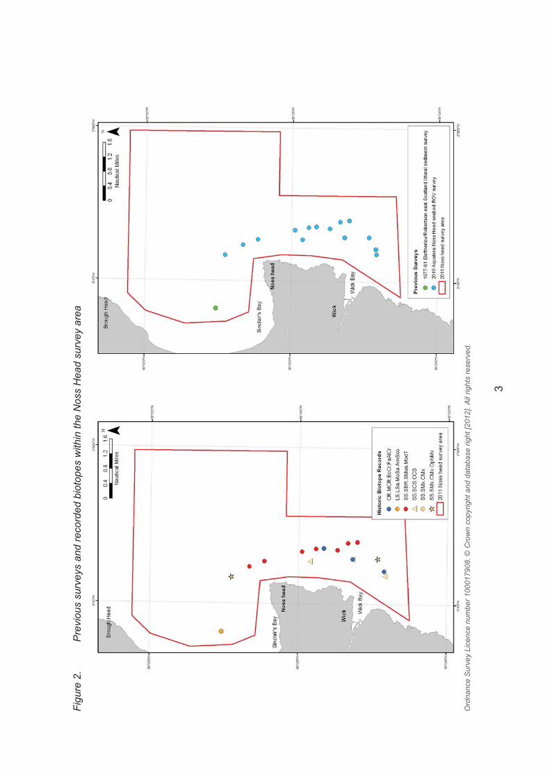
Figure 2. Previous surveys and recorded biotopes within the Noss Head survey area 3
Figure 3. Map from MMT (2010) of the propsed cable route at Noss Head 4
Figure 4. Estimate of horse mussel bed extent from the analysis of Triscom video data 6
Figure 5. Bathymetry image from acoustic multibeam data collected by BGS and SNH in 2011 8
Figure 6. Previous surveys that have been conducted within the Southern Trench survey area 10
Figure 7. Morphology of the Southern Trench (from SEA5; Holmes et al., 2004) 11
Figure 8. Spatial zoning of marine conservation priority for minke whale (B.acutorostrata) within the southern outer Moray Firth, North-east Scotland 12
Figure 9. Bathymetry from acoustic multibeam data collected by BGS and SNH 13
Figure 10. T.V. sledge and camera equipment used for DDV tows 14
Figure 11. Noss Head drop down video (DDV) sampling stations 15
Figure 12. Southern Trench drop down video (DDV) sampling stations 16
Figure 13. Southern Trench grab sample (STG8). Photographs before and after processing 17

vi
Figure 14. Noss Head grab survey stations 18
Figure 15. Southern Trench grab survey stations 19
Figure 16. Distribution of biotopes recorded during the 2011 survey off Noss Head, and historic records of PMFs from the area 22
Figure 17. Detailed distribution of the horse mussel bed and approximate extent from interpolation between video stations 23
Figure 18. Still images of horse mussel (M. modiolus) bed off Noss Head 24
Figure 19. Biotope distribution from anlaysis of the infaunal samples 29
Figure 20. MDS plot of Noss Head grab data clustered into post hoc assigned groups a-d and labelled by grab number 30
Figure 21. Multibeam showing approximate horse mussel bed extents overlaid with horse mussel (M. modiolus) biotope records from DDVs 31
Figure 22. Biotope codes and approximate extent of SS.SMu.CFiMu.SpnMeg distribution within the Southern Trench survey area 33
Figure 23. Photographs of SS.SMu.CFiMu.SpnMeg biotope found within the Southern Trench 33
Figure 24. Biotopes assigned to grab sample stations in the Southern Trench study area 36
Figure 25. MDS plot of Southern Trench grab data clustered into post hoc assigned groups a-i and labelled by grab number 38
LIST OF TABLES
Table 1. Marine biological surveys carried out in the Noss Head area 2 Table 2. Previous marine biological surveys carried out in the Southern Trench area 9 Table 3. Biotope classification descriptions for Noss Head stations 21 Table 4. Horse mussel bed species abundance data from DDV 24 Table 5. Descriptive and diversity statistics of sediment infauna grab samples, Noss
Head 27 Table 6. Summary of PSA from Noss Head grab samples 28 Table 7. Biotope classification descriptions from Southern Trench 32

vii
Table 8. Descriptive and diversity statistics for infaunal data collected from Southern Trench grab samples 35
Table 9. PSA for Southern Trench grab samples 37 Table 10. Comparison of known UK horse mussel beds 39 Acknowledgements We would like to thank the following personnel for contributions to the field work:
M. Robertson, D. Bova, C. Shand and C. Hepple (MSS). Infaunal analysis was carried out
by Peter Garwood (Identecheate). Robert Cook and Flora Kent from Heriot Watt University
carried out the particle size analysis. Dr Joanne Porter (HWU) assisted with DDV species
identification. We would also like to thank the captain and crew of the MSS survey vessel
Alba na Mara for all their help and advice during the survey.
SNH is also grateful to SSE for providing access to their survey data collected to inform high
voltage transmission projects in the waters off Noss Head.
This project was funded by Marine Scotland as part of the Scottish MPA project.

1
1. INTRODUCTION
Provisions to designate new Marine Protected Areas (MPAs) within Scottish waters have
recently been introduced through the Marine (Scotland) Act 2010 and the UK Marine and
Coastal Access Act 2009. To help target nature conservation action SNH and JNCC have
generated a recommended list of habitats and species of importance in Scottish waters - the
Priority Marine Features (PMFs). A subset of the PMFs (MPA search Features) will drive the
identification of Nature Conservation MPAs (Marine Scotland, 2011a).
Recent research projects have collated available datasets detailing the distribution of the full
suite of MPA search features and PMFs to ensure that the best possible use is made of
existing records in the identification of new MPAs. New survey work has also been
commissioned to validate their continued presence, in selected areas, and to underpin the
development of formal MPA proposals, established using the Scottish MPA Selection Guidelines (Marine Scotland, 2011b).
Two areas along the east coast of Scotland were identified for targeted survey work due to
the presence of historical records of PMFs and MPA search features. The first of these
areas is located just off Noss Head, east of Wick (Figure 1), where, in 2009 a large horse
mussel bed was discovered (Triscom, 2010). The second site, the Southern Trench, is
located in the outer area of the Moray Firth, (Figure 1). Here one of the largest ‘shelf deeps’
in Scottish waters is present, a large scale MPA search feature.
Figure 1. 2011 Survey areas: Noss Head and the Southern Trench
Ordnance Survey Licence number 100017908. Bathymetry GEBCO © SNH Crown copyright and database right [2012]. All rights reserved.

2
1.1 Survey objectives
The purpose of this study was to undertake a detailed habitat survey of the seabed at Noss
Head and the Southern Trench (Figure 1). The survey programme was designed to generate
sufficient information on the distribution, quality and extent of the MPA search features
present in these locations, to enable SNH to undertake a preliminary assessment of the
merits of the 2010 survey area against the Scottish MPA selection guidelines (Marine
Scotland, 2011b).
The work programme encompassed the following main tasks:
1. Review existing information on the sublittoral MPA search features and PMFs within
the two survey areas.
2. Design and undertake a survey programme to ascertain the current distribution,
quality and extent of MPA search features and PMFs within the two survey areas.
3. To compare the quality and size of the Noss Head mussel bed to others within
Scotland and the UK.
1.2 Noss Head
Noss head is located to the north of Wick in an area of exposed coastline on the north-east
coast of Scotland. Wick, once a thriving herring fishing village, has now diversified with North
Sea oil interests providing work for those living nearby.
1.2.1 Previous marine biological surveys
Prior to 2010 there had been relatively little formal survey work carried out in the Noss Head
area (Figure 2, Table 1 and Appendix 12). In June 2010, Aquaterra Ltd and Triscom Marine
were contracted by Scottish and Southern Electric (SSE) to survey a potential route for the
positioning of a new electrical cable and hub platform off the east coast of Wick. A remotely
operated vehicle (ROV) was used for this survey. However, no features of conservation
interest were observed (Aquatera and Triscom, 2010).
Table 1. Marine biological surveys carried out in the Noss Head area Year
of survey
Organisation Details Reference PMFs/ MPA search feature
1977 –
1981
Nature
Conservancy
Council
1977-81 Eleftheriou/Robertson east
Scotland littoral sediment survey
Report
Unpublished
(MNCR)
NA
*June
2010
Aquatera Ltd
and Triscom
ROV Survey of Potential Cable Route
and Offshore hub location in. The
survey crew included Roving Eye
Enterprises, Aquaterra and Triscom
Report
unpublished
None
*Sep-
Oct
2010
MMT
Consultancy
This carried out geophysical,
geotechnical and ROV surveys
MMT 2010 Horse mussel
bed
Oct
2010
Trisom Marine ROV survey to determine the limits of
mussel bed and/or find a "patch of
least disturbance" through the bed
Triscom Marine
(2010) and
Moore &
Roberts (2011)
Horse mussel
bed
* Data not included within Figure 2
3
Figu
re 2
. P
revi
ous
surv
eys
and
reco
rded
bio
tope
s w
ithin
the
Nos
s H
ead
surv
ey a
rea
O
rdna
nce
Sur
vey
Lice
nce
num
ber 1
0001
7908
. © C
row
n co
pyrig
ht a
nd d
atab
ase
right
[201
2]. A
ll rig
hts
rese
rved
.

4
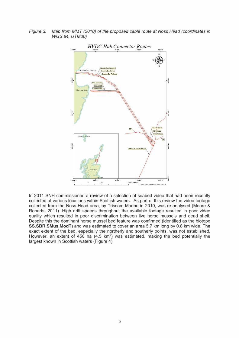
A survey by MMT Consultancy, in September/October 2010, consisted of two main phases,
the first of which involved the use of acoustic side scan sonar to survey the geophysical
seabed for a cable corridor (Figure 3). Processed data from this phase of the survey were
then used to perform a targeted drop down video (DDV) survey. The DDV survey highlighted
the presence of a large area of gravel mixed with horse mussel shells (SS.SMx.CMx)
located 2.8 km from where the proposed cable was to come ashore at Noss Head (Figure 3).
The quantity of shell was seen to gradually increase eastwards, becoming a dense horse
mussel bed (SS.SBR.SMus) approximately 3.2 km from shore. The bed was considered to
be diverse with species such as Ophiothrix fragilis and Asterias rubens recorded as abundant. The greatest density of shells, and species diversity, was observed at depths
between 35 m to 45 m with the bed extending east for 850 m where the seabed became
characterised by gravel mixed with horse mussel shells and occasionally boulders
(SS.SMx.CMx). An additional cross-transect was surveyed 700 m in a north to south
direction, perpendicular to the proposed cable route. Video from this transect revealed a
continuous bed of horse mussels. Analysis of the side scan sonar showed that the extent of
the bed, in a north to south direction, was at least 3.5 km long, and in a west to east
direction, reached approximately 1 km.
A further survey in October 2010 investigated the horse mussel bed further (Triscom, 2010).
The survey highlighted the presence of dense live and dead horse mussel shells and
records of associated epifauna such as the brittlestar Ophiothrix fragilis. Mapping within the
report delineates what was thought to be the eastern and western extents of the bed. Areas
were also noted where horse mussels were absent to the west and south of the mussel bed.
In addition, analysis of the video footage collected from sampling stations within Sinclair’s
Bay found no evidence of horse mussels. In conclusion the Triscom report identified the
eastern and western edges of the horse mussel bed and also highlighted the absence of
horse mussels to the north and south.
5
Figure 3. Map from MMT (2010) of the proposed cable route at Noss Head (coordinates in WGS 84, UTM30)
In 2011 SNH commissioned a review of a selection of seabed video that had been recently
collected at various locations within Scottish waters. As part of this review the video footage
collected from the Noss Head area, by Triscom Marine in 2010, was re-analysed (Moore &
Roberts, 2011). High drift speeds throughout the available footage resulted in poor video
quality which resulted in poor discrimination between live horse mussels and dead shell.
Despite this the dominant horse mussel bed feature was confirmed (identified as the biotope
SS.SBR.SMus.ModT) and was estimated to cover an area 5.7 km long by 0.8 km wide. The
exact extent of the bed, especially the northerly and southerly points, was not established.
However, an extent of 450 ha (4.5 km2) was estimated, making the bed potentially the
largest known in Scottish waters (Figure 4).

6
Figure 4. Estimate of horse mussel bed extent from the analysis of Triscom video data (from Moore & Roberts, 2011)
�Based upon Ordnance Survey material with the permission of the Controller of HMSO © Crown copyright (2011) Licence no. 100017908 �
1.2.2 PMFs/ MPA search features within the Noss Head survey area
The broad habitat type “horse mussel beds” (Modiolus modiolus) is listed as both a PMF and
a MPA search feature. Horse mussels can form small clumps, extensive sheets, or build up
as reef-like structures (Holt et al., 1998; Lindenbaum et al. 2008). Dense horse mussel reefs
are known to support a range of associated fauna and are identified as ‘biogenic reefs’ under
the Habitats Directive description of ‘reefs’ (http://jncc.defra.gov.uk/page-1448). The diversity
of flora and fauna associated with horse mussel reefs make them of high conservation
importance. These biogenic structures can be extremely dense, ranging from 4 to 600
mussels per m2, inhabiting depths of up to 70 m in the UK (Rees et al., 2008; Rees, 2009).
They can also form on a variety of substrates from cobbles to muddy gravel and sand in
moderately tide swept waters.
Factors such as geographic position, habitat availability, and environmental conditions,
including current, affect the structure and function of a horse mussel bed (Mair et al., 2000).
Different formations of reef may occur depending on the tidal strength and sediment type.
Horse mussel reefs often form localised areas of high biodiversity and productivity on parts
of the seabed that are otherwise tide swept and sand scoured (Rees et al., 2008).

7
Horse mussel beds are divided into four different biotopes according to Connor et al. (2004).
These are SS.SBR.SMus.ModT: Modiolus modiolus beds with hydroids and red seaweeds
on tide-swept circalittoral mixed substrata, SS.SBR.SMus.ModMx: Modiolus modiolus beds
on open coast circalittoral mixed sediment, SS.SBR.SMus.ModHAs: Modiolus modiolus beds with fine hydroids and large solitary ascidians on very sheltered circalittoral mixed
substrata, and SS.SBR.SMus.ModCvar: Modiolus modiolus beds with Chlamys varia,
sponges, hydroids and bryozoans on slightly tide-swept very sheltered circalittoral mixed
substrata. The biotope SS.SBR.SMus.ModT is generally found in moderately strong
currents or wave exposed areas, typically on open coast such as off Noss Head, but also in
tide-swept channels of marine inlets.
There were no other previous records of PMFs or MPA search features within the 2011 Noss
Head survey area.
1.2.3 Geodiversity features
In 2011 (8th to 17
th August) acoustic multibeam data were collected by SNH and BGS on
board the Northern Lighthouse Board Vessel, NLV Polestar within the 2011 Noss Head
survey area (Figure 5). A Konsberg EM3002D Multibeam Echosuonder was used with a
2000 swath. At least 25% overlap was used through out the acoustic survey to ensure that a
minimum IHO order was reached as well as to maximise the amount of seabed covered in
the time period. The data collected were processed using CARIS software to produce
accurate bathymetry data showing the variable seabed characteristics and structures
present in the area.
Due to the timing of the acoustic survey only partially processed data were available for
survey planning purposes.

8
Figure 5. Bathymetry image from acoustic multibeam data collected by BGS and SNH in 2011
Ordnance Survey Licence number 100017908n © Crown copyright and database right [2012]. All rights reserved. © SNH, MSS, & BGS NOT TO BE USED FOR NAVIGATION
1.2.4 Related human activities
Literature suggests that horse mussel beds may be adversely impacted by mobile fishing
practices such as scallop dredging and trawling (e.g. Magorrian & Service, 1998; Strain et al., 2012). Within the Triscom report (2010) areas of barren seabed were noted in areas
where static gear (creels) were also observed. However, there are no published reports
providing evidence of mobile gear within the Noss Head study area and the damage noted
cannot be directly attributed to fishing practices.
The proposed cable route may, potentially, have a direct physical impact on the seabed
within the Noss Head area. Recovery times due to such activities are likely to be long for
biogenic structures such as horse mussel beds. However, this would be subject to the extent

9
of physical impacts such as pipeline installations, trenching and use of jack up oil rigs (Holt
et al., 1998).
1.3 Southern Trench The Southern Trench is a discrete deep water area along the south of the outer Moray Firth,
located 10 km from land between the coastal ports of Banff and Fraserburgh (Figure 1). The
morphology of the trench is irregular and is the most topographically complex region in the
Moray Firth (Brooks et al., 2011). The Southern Trench is one of approximately 150 similar
discrete channels located off the east and north-east coasts of Scotland and is 58 km long,
up to 9 km wide and, in places, up to 250 m deep (Bradwell et al., 2008).
1.3.1 Previous surveys
Previous marine biological surveys carried out within the 2011 Southern Trench survey area
include those conducted by organisations such as Seasearch, Marine Scotland Science
(MSS), and the British Geological Survey (BGS) (Figure 6, Table 2 and Appendix 12). In
addition a dedicated cetacean survey was also conducted in 2007 by the Cetacean
Research and Rescue Unit.�
Table 2. Previous marine biological surveys carried out in the Southern Trench area
Year Organisation Survey description Reference PMFs/ MPA
search Features
2001 -
2003
MSS/FRS
Archived video recordings obtained
by MSS/FRS while undertaking
Nephrops norvegicus stock
assessments were re-analysed to
obtain data on sea pen distribution.
Greathead
et al., 2007 SS.SMu.SpnMeg
2003
British
Geological
Survey (BGS)
under contract to
Geotek Ltd
Report on the seabed and
superficial geology and geological
processes in the Department of
Trade and Industry (DTI) Strategic
Environment Assessment area 5
(SEA5), using data from the DTI
2003 survey including multi-beam
bathymetry, side scan sonar,
seismic reflection profiles, sea-floor
photographs and samples. The
report integrates
the 2003 survey results with the
pre-existing geological reports,
maps and other publications in the
scientific press.
Holmes et al., 2004
N/A
*2000-
2005
Cetacean
Research and
Rescue Unit
136 cetacean encounters on
dedicated boat surveys of an 880
km2 area of the southern outer
Moray Firth between Lossiemouth
and Fraserburgh
Robinson
and Tetley,
2007
Balaenoptera acutorostrata
(minke whale)
2005 Seasearch Diving survey of the wreck of the
Remeura NA Molva molva
2011 MSS
Nephrops stock assessment video
from 2008-2010 analysed to
determine sea pen abundance
No
reference SS.SMu.SpnMeg
* Data not shown in Figure 6

10
Figure 6. Previous surveys that have been conducted within the Southern Trench survey
area
Ordnance Survey Licence number 100017908. Bathymetry GEBCO © SNH Crown copyright and database right [2012]. All rights reserved.
As part of their annual survey programme Marine Scotland Science (MSS) conduct regular
surveys to monitor the abundance, age structure and geographical distribution of the
principal commercial fish stocks in Scottish waters. The Southern Trench is one such area
which has been subject to assessment of Nephrop stocks. In 2007 a review of the video
collected during these stock assessments was analysed in order to evaluate the distribution
of sea pens (Greathead et al., 2007). Two species of sea pen, Vigularia mirabilis and
Pennatula phosphorea, were observed. Video from more recent MSS Nephrop surveys
(2008 – 2010) have also been analysed (not published) and offer a more recent account of
the presence of these two species (Figure 6).
As part of the Strategic Environmental Assessment Area 5 work (SEA5; Holmes et al., 2004), detailed surveys were conducted along a section of the Southern Trench focusing on
the geology and morphology of the trench and surrounding seabed. This survey involved the
collection of samples for particle size analysis as well as scattered drop down video stations
and detailed acoustic multibeam data (Figure 7). Results suggest that the Southern Trench
is an exceptional example of an enclosed (glacial) seabed basin.

11
Figure 7. Morphology of the Southern Trench (from SEA5; Holmes et al., 2004)
a. colour-shaded topography, DTI survey 2003 b. extract of seabed-terrain model c. example of
seabed-slope changes associated with submarine slumps, southern flank d. bedrock at the presumed slip surface of the uppermost slump scarp e. seabed armour of pebbles, cobbles and boulders, extract from extensive photographic survey of the plateau.
As well as the importance of the Southern Trench for its geodiversity value, the surrounding
area has also been highlighted as potentially important for aggregations of the minke whale,
Balaenoptera acutorostrata (Tetley, 2010). The distribution and “environmental associations”
of minke whales within the Moray Firth have been studied along the southern embayment
between the coast and deep trench areas (Robinson & Tetley, 2007). Several studies have
indicated the seasonal movements of minke whale (see Robinson et al., 2009) and
correlations with surface temperature meso-scale features (Tetley, 2010). Minke whale
distribution is not linked to benthic communities in the Southern Trench.
Within the Moray Firth important areas for the conservation of minke whale are thought to include Lossiemouth, Whitehills, Banff and Macduff (offshore to 50 m depth), and the area of

12
coast between Gamrie Bay, Troup Head, Sandend and offshore to the lower Southern
Trench (Tetley 2010: Figure 8).
Figure 8. Spatial zoning of marine conservation priority for minke whale (B. acutorostrata) within the southern outer Moray Firth, Northeast Scotland (from Tetley 2010)
Conservation priority determined from modelled Maxent tm habitat suitability, with those areas of suitable habitat being divided into inferred Priority (determined critical for constant B.acutorostrata utilisation), Buffer (determined important with respects to spatio-temporal fluctuations in utilisation) and Corridor zones (deemed necessary for movement to and between MPAs).
1.3.2 PMFs and MPA search features
The Southern Trench was identified as an area to be surveyed largely due its geodiversity
importance as a ‘shelf deep’, a large scale MPA search feature (Brooks et al., 2011). Aside
from the aforementioned minke whale no other PMFs / MPA search features have been
previously recorded in the area. However, MSS recorded sea pens, Vigularia mirabilis and
Pennatula phosphorea throughout the trench, suggesting that the broad habitat ‘burrowed
mud’ is present, and likely to be represented by the component biotope SS.SMu.SpnMeg
(Table 3).
1.3.3 Geodiversity features
The SNH commissioned report by Brooks et al., (2011) aimed to develop a scientific
framework for the assessment of key geodiversity areas against the 'concepts of importance'
outlined in the MPA selection guidelines (Marine Scotland, 2011b). The report also identified
and documented the key geodiversity areas in Scottish waters using this scientific
framework. The Southern Trench survey area was identified as one of these key sites.
Large-scale seabed incisions are a characteristic feature of the shelf seabed off east and
north-east Scotland and the Southern Trench is one of the largest examples of this (Brooks
et al., 2011). The Southern Trench is an exceptional example of an enclosed (glacial)
seabed basin and is regarded as scientifically important for further understanding of ice
sheet drainage patterns in this region; detailed morphological analysis suggest it was formed
from at least two erosion events operating in different directions (Brooks et al., 2011). The
morphology of the trench is irregular and forms the most topographically complex region of
the Moray Firth. Previous surveys using multibeam and single beam echo sounder data (e.g.
Holmes et al., 2004) showed this complexity: to the west, the trench is broadly orientated
east-west, while to the east, the trench trends in an east-north-easterly direction. This
Fraserburgh Gamrie Bay Sanend
Troup Head

13
orientation is broadly similar to other trenches in the outer Moray Firth (Bradwell et al., 2008)
and although smaller, these commonly have branching, sinuous courses and a length
greater than 10 km. The Southern Trench is unusual in that it is cut through both Quaternary
deposits and the underlying bedrock.
The cross-sectional profile of the trench is asymmetric, with a steep north-facing slope and a
shallower shelving south-facing slope (Long and Stoker, 1986). The SEA5 multibeam survey
(Holmes et al., 2004) revealed that in places the trench is very steep-sided with slope angles
of more than 50o and that here is evidence of gravity-driven slumping, slump scarp faces
and slide deposits.
In August 2011 acoustic multibeam data were collected by SNH and BGS on board the
Northern Lighthouse Board Vessel NLV Polestar. The area surveyed was adjacent to that
completed for the SEA5 work (Holmes et al., 2005). The processed bathymetry data can be
seen in Figure 9. Further information regarding the equipment used can be seen in Section
1.1.3. Only partially processed data were available for survey planning purposes in the
present study.
Figure 9. Bathymetry from acoustic multibeam data collected by BGS and SNH in 2011
Ordnance Survey Licence number 100017908n © Crown copyright and database right [2012]. All rights reserved. © SNH, MSS, & BGS NOT TO BE USED FOR NAVIGATION

14
1.3.4 Related human activities
Human activities taking place within and around the Southern Trench are largely fishing
related. The area to the north of Fraserburgh is heavily used by local creel fisherman and
consequently less boat traffic is present due to the large numbers of creel lines and buoys.
Trawling, mainly for Nephrops, is also a popular fishing activity within and around the
Southern Trench. The Nephrops fishery in Scottish waters has developed from a few tonnes
in the early 1960s to over 31,000 tonnes in 2009, and Nephrops is currently the second most
valuable species landed in Scotland (£78.3 million in 2009).
Static and mobile fishing gear is known to have a direct impact on the seabed (e.g. Kaiser et al., 2006) and also affect cetaceans. The most likely possible effects on minke whale
populations within the Southern Trench survey area are by-catch and habitat degradation.
To mitigate impacts and sustainably manage the economic benefits of the dolphin watching
industry, the Dolphin Space Programme (Woods-Ballard et al., 2003) has been developed.
2. METHODS
Between the 2nd
and 13th of September 2011 a collaboration of scientists from Heriot Watt
University, Scottish Natural Heritage (SNH) and Marine Scotland Science (MSS) undertook
a survey using drop down video (DDV), stills photography and Day grabs aboard RV Alba na Mara (for details see the survey log in Appendix 14). ROV deployment was also scheduled
but faults in the propulsion system and power failures meant that it was not used in this
survey. All original data records used uncorrected depth and were later amended during
video analysis to depth below sea level, taking into account the 4.3 m draft of the Alba na Mara.
2.1 Video Survey
A Konsberg OE14-366 colour zoom camera was used alongside a Konsberg 14-208 digital
stills camera. The camera and lights were mounted onto a sledge and a 600 m load-bearing
polyurethane umbilical cable was used on a TV winch (Figure 10).
Figure 10. T.V. sledge and camera equipment used for DDV tows
.
In all deployments the sled obtained 5 -10 minutes of footage. Immediately prior to video
deployment, a ‘clapper board’ with the date, time and station number was recorded on the
video tape to mark the start of each new tow. When the camera was settled on the seabed,

15
the position (WGS 84 Datum), start time (GMT), and depth (from ship’s computer), were
recorded in the manual log (Appendix 1 and 2). The video recording started at the same
time. The sled was then towed at 0.5 - 1.0 knots across the seabed either by drifting with the
current or using the drive of the vessel to compensate for prevailing sea state and tidal
conditions. During each deployment, substrate type and main taxa were recorded onto the
field log. At the end of each transect the end position, depth and time were logged. Stills
were taken manually every minute (approximately) and the number of stills was recorded in
the field log. Video footage was recorded to Mini DV tape using a Sony GV-D1000 mini DV
portable video. Mini DV tapes were backed up to DVD.
2.1.1 Noss Head video survey
Fifty-one video stations were targeted within the Noss Head survey area (Figure 11). Survey
stations were chosen using a stratified random coarse grid pattern with a higher density of
stations around the horse mussel records. The recently collected bathymetric multibeam
data were also used for planning purposes.
Figure 11. Noss Head drop down video (DDV) sampling stations
Ordnance Survey Licence number 100017908. Bathymetry GEBCO © SNH Crown copyright and database right [2012]. All rights reserved

16
2.1.2 Southern Trench video survey
Seventy-four video stations were completed within the Southern Trench and surrounding
plateau (Figure 12). Again, survey stations were chosen using a stratified random coarse
grid pattern with a higher density of stations in the most likely PMF areas, taking into account
historic particle size analysis (PSA) data, bathymetric multibeam data, and macrobenthic
survey records. A small number of pre-planned sampling station sites had to be moved due
to a high number of creels obstructing the safe deployment of the DDV. Figure 12. Southern Trench drop down video (DDV) sampling stations
Ordnance Survey Licence number 100017908. Bathymetry GEBCO © Crown copyright and database right [2012]. All rights reserved
2.2 Infaunal survey
A subset of the drop down video sampling stations were pre-selected as grab sampling
stations so as to represent the range of likely sedimentary habitats. A 0.1m2 Day grab was
deployed once at each sampling station with a small sub sample of each grab taken for
Particle Size Analysis (PSA). Before emptying the grab a ruler was used to measure
sediment depth to confirm that the sample was of an acceptable volume. For mud the
sample was required to be no less than 7 cm, and for hard packed sands no less than 5 cm
deep (Rumohr, 1990). In addition, if the mouth of the grab was found to be open once it
reached the surface, then the sample was rejected. A maximum of three attempts were
permitted at each grab sampling station.
Once on board the grab was placed into a secure stand with a receiving container
underneath. After checking the sample was acceptable a visual inspection was made

17
recording the following: type of sediment, colour, and depth of redox potential difference
(RPD) layer, depth of sample, texture / presence of surface features, and a photograph was
taken (Appendix 10).
Once the sample had been inspected the contents were emptied into the receiving tray, and
the inside of the grab rinsed through to ensure the entire sample was collected. Care was
taken not to wash sediment from the outside of the grab into the sample. The grab was
washed between deployments to prevent cross contamination of samples.
A waterproof label was added to the sample stating the survey and location name, station,
and date. The sample was then processed using a 1 mm sieve over a sorting table.
Contents of the sample retained after sieving were placed in a sample bucket with the
corresponding waterproof label and sealed. The sample bucket was then labelled and the
contents preserved in buffered 4% Formaldehyde solution. Photographs of the sample in the
grab and post processing were taken (e.g. Figure 13) and logged in the grab field log
(Appendix 10).
Figure 13. Southern Trench grab sample (STG8). Photographs before and after processing.
A total of 10 infauna sampling stations were selected within the Noss Head survey area
(Figure 14, Appendix 8) to target the range of likely sedimentary habitats as well as the
horse mussel bed. Due to the nature of the consolidated horse mussel bedform, the Day
grab was ineffective for retrieving samples from this habitat, as was a pipe dredge.
A total of 20 infauna sampling stations were selected within the Southern Trench survey
area using a stratified random coarse grid pattern to increase sampling effort in areas where
PMFs were most likely (Figure 15 and Appendix 9). Overall, sampling aimed to gain a
broader understanding of the range and variation of habitat types at different depths.

18
Figure 14. Noss Head grab survey stations
Ordnance Survey Licence number 100017908. SNH © Crown copyright and database right [2012]. All rights reserved

19
Figure 15. Southern Trench grab survey stations
�Ordnance Survey Licence number 100017908. Bathymetry GEBCO © SNH Crown copyright and database right [2012]. All rights reserved
2.3 Analysis of drop down video
All video footage was analysed using Adobe Premier Pro. The proportions of different
substrate types, and the species present were recorded using either numerical abundance of
individuals or SACFOR scales of colonies and larger aggregations of individuals (see
Hiscock, 1996). Biotopes were allocated according to Connor et al. (2004) (Appendix 4 and
5). The presence of PMF / MPA search features was specifically noted for each tow.
Where an obvious biotope change occurred along a transect a new record was begun and
species counts re-started. Both biotope records from the same tow were labelled separately
e.g. NH1 and NH1a. Still images were used to increase confidence and resolution for the
identification of taxa. For quality control purposes 10 % of all video tows were independently
scored and discrepancies between records used to reconcile records from the tow or to re-
analyse all tows from a similar habitat type (depending on the type of error). No biotope
codes had to be changed below level 5 classification (Connor et al., 2004).
2.4 Analysis of infaunal samples
Grab samples were analysed for infaunal species with a sub sample undergoing particle size
analysis (PSA). Biotopes were allocated to grab stations according to Connor et al. (2004),
by accounting for key species presence and abundances with PSA descriptions from the
grab samples.

20
2.4.1 Infaunal analysis Infaunal organisms were processed in the laboratory after the survey. Each sample was split
into a light and coarse fraction, by repeated elutriation over a 0.5 mm mesh sieve. The light
fraction was further divided into material retained on a 1.0 mm mesh and the smaller fraction
separated. Each fraction was then examined in a petri dish under a dissecting microscope
and individual macrofaunal specimens were extracted using forceps. The coarse fraction
was also separated using a 2.0 mm mesh. This 2.0 mm fraction was examined in an enamel
tray, using magnifying goggles, and the fauna extracted. The remaining coarse material was
examined in the same way as the light fraction, under a dissecting microscope. All extracted
fauna was identified as far as was practical, using the available literature. A voucher
collection was also retained and sent to the Scottish National Museum for quality assurance
and reference purposes.
Infaunal species and abundance data were analysed using the statistical package PRIMER
v6 (Clarke & Warwick 2001). Data were square root transformed and Bray Curtis similarity
data was subjected to a similarity profile (SIMPROF) analysis to determine whether there
was any structure in the data. Similarity percentage (SIMPER) analysis was then used to
examine the species that most contributed to difference between groups.
The infaunal species data were also used to aid biotope assignment by comparing key
species and their abundance with species recorded from DDV footage at the same locations.
2.4.2 Particle size analysis Particle Size Analysis (PSA) was conducted following The National Marine Biological
Analytical Quality Control Scheme (NMBAQC)’s “Best Practice Guidance notes” (Manson,
2011). Each sample was stirred to homogenise the sample with a spatula. Live and dead
shell was removed from the sample. A subsample of approximately 100 g (mud and sand),
or a minimum of 200 g for gravel was taken. A glass petri dish was pre-weighed to 2 decimal
places; this measurement was then subtracted from future measurements.
The sample was placed in the pre-weighed petri dish and dried in a drying oven at around
60°C for 24 hours. The sample was allowed to cool for approximately 5 minutes then re-
weighed. The first few samples were put back into the oven for another 24 hours and then
re-weighed. If they had lost more water (got lighter) then the drying process was repeated
until the mass was stable. This then gave a bench mark for drying times of the remaining
samples.
Each sample was wet sieved through a 63�m sieve, using distilled water and 3 - 5% sodium
hexametaphosphate. The contents of the sieve were washed back into the beaker and dried
again for 12 hours, then re-weighed. This weight minus the first dry weight gave the fine
fraction (<63�m). The 63�m sieve was gently cleaned and allowed to dry.
The coarse sample (>63 �m) was added to the top sieve of a clean sieving stack, and left
running for 20 minutes. Each of the sieved fractions were weighed, with any material that fell
through the final 63�m sieve added to the original (<63�m) fine fraction.
The percentage of each size fraction was classified according to the Wentworth scale e.g.
0.9 % Medium sand (grain size of 250-500�m). This allowed the overall average grain size
to be used in the modified Folk triangle soft sediment matrix (Connor et al., 2004), to help aid
in biotope classification.

21
3. RESULTS
A total of 17 biotopes were recorded within the two survey areas using both DDV and grab
sample analysis (Table 3, Figure 16). Habitat descriptions, biotopes and PMF records for
the 125 stations are summarised in Section 3.1, for Noss Head, and Section 3.2, for the
Southern Trench.
3.1 Noss Head
3.1.1 General description
Fifty-one drop down video deployments were carried out in the Noss Head survey area
ranging in depth from 22 m - 67 m. A total of nine biotopes were recorded using DDV and
grab sampling (Table 3, Figure 13). Field notes taken during the video deployments can be
seen in Appendix 2 with a more detailed description of the analysis of the video transects in
Appendix 4. A photographic inventory of the biotopes listed in Table 3 can be referenced in
Appendix 6.
Table 3. Biotope classification descriptions for Noss Head stations (based on Connor et al., 2004)
Rock biotopes (IR = infralittoral rock; CR = circalittoral rock) Sublittoral Sediment biotopes (SS)
High energy infralittoral rock (HIR) High energy circalittoral rock (HCR) Sublittoral coarse sediment (SCS)
Moderate energy infralittoral rock (MIR) Moderate energy circalittoral rock (MCR) Sublittoral sand (SSa)
Low energy infralittoral rock (LIR) Low energy circalittoral rock (LCR) Sublittoral mud (SMu)
Feature of infralittoral rock (FIR) Feature of circalittoral rock (FCR) Sublittoral mixed substrata (SMx)
Examples IR.HIR = Habitat complex (level 3 in classification)
IR.HIR.KFaR = Biotope complex (level 4 in classification)
IR.HIR.KFaR.LhypR = Biotope level (anything longer = sub-
biotope)
Sublittoral macrophytes on sediment (SMp)
Sublittoral biogenic reefs on seds (SBR)
Biotope Description Count
CR.MCR.EcCr.FaAlCr Faunal and algal crusts on exposed to moderately wave-exposed
circalittoral rock 1
CR.MCR.EcCr.FaAlCr.Bri Brittlestar bed on faunal and algal encrusted, exposed
to moderately wave-exposed circalittoral rock 2
SS.SCS.CCS Circalittoral coarse sediment 3
SS.SSa.CMuSa Circalittoral muddy sand 1
SS.SSa.CFiSa Circalittoral fine sand 4
SS.SMx.CMx.FluHyd Flustra foliacea and Hydrallmania falcata on tide-swept
circalittoral mixed sediment 6
SS.SMx.CMx Circalittoral mixed sediment 15
SS.SMx.CMx.OphMx Ophiothrix fragilis and/or Ophiocomina nigra brittlestar beds
on sublittoral mixed sediment 8
SS.SBR.SMus.ModT Modiolus modiolus beds with hydroids and red seaweeds on tide-
swept circalittoral mixed substrata
10
The most frequently recorded biotope complex within the Noss Head survey area was
‘circalittoral mixed sediments’ (SS.SMx.CMx) which was observed at 29 stations (Figure 16).
Sublittoral sands and muddy sands (SS.SSa) biotopes were observed at five stations
between 20 m and 63 m. Other biotope complexes observed included moderate energy
circalittoral rock (CR.MCR) and sublittoral coarse sediments (SS.SCS), although these were
observed in low numbers. Stations of the soft sediment biotope complex SS.SCS were only
found close inshore in shallow waters between 22 m and 28 m. The rest of the survey area
showed no distinct pattern of biotope types with the exception of the horse mussel bed,
which was surrounded by a mixture of hard substrate biotope complexes: SS.SMx.CMx and
CR.MCR. Soft sediment biotopes (SS.SSa) were found at scattered sites in Sinclair’s Bay.

22
Figure 16. Distribution of PMF and non-PMF biotopes recorded during the 2011 survey off Noss Head, and historic records of PMFs from the area
Ordnance Survey Licence number 100017908. SNH © Crown copyright and database right [2012]. All rights reserved
3.1.2 PMFs / MPA search features observed A single MPA search feature was observed within the Noss Head survey area: The horse
mussel bed biotope SS.SBR.SMus.ModT was recorded at 10 stations (Figure 16). On
analysis of the video the bed, although patchy in places, showed the horse mussels covered
an area of approximately 2.5 km2 (Figure 17) within an area of 5 km by 1 km. At NH4
(central bed), and NH44 (western edge of bed) horse mussels were ‘frequent’ (1-9 / 10 m2).
At another six stations (NH11, NH46, NH37, NH50, NH43 andNH49) they were ‘abundant’
(1-9 / m2), and at a further two central stations (NH47 and NH21) they were ‘super abundant’
(1-9 / 0.1m2: see SACFOR scale; Hiscock, 1996). Overall there was a lack of obvious
pattern in the patchiness to the horse mussels, with areas where they were frequent,
abundant or superabundant interspersed throughout the bed extent.
Surface sediment composition in these areas (where visible) was ~90% dead shell with <5%
mud, medium / coarse grained sand, or gravelly shell. The SS.SBR.SMus.ModT biotope

23
was recorded between 37 m and 47 m. Neighbouring stations with the biotope SS.SMx.CMx may have contained some live M. modiolus but this was not visible on the video footage.
Large expanses of dead shell around the main bed suggested that it may previously been
more extensive or that shell has been washing off the bed for a prolonged period of time.
Areas of exposed underlying mud were seen on one tow NH43, suggesting an area of recent
physical damage.
The horse mussel (M. modiolus) bed biotope supported numerous species (Table 4, Figure
18) including Ophiothrix fragilis (F-S), encrusting sponges (R-C), the hydroids Sertularia cupressina (O-S), Abietinaria abietina (R), Halecium sp. (R-A), and Kirchenpaueria pinnata
(O-S) and occasional bryozoan species including Parasmittina trispinosa. Mobile
macrofauna were dominated by Echinus esculentus with occasional Cancer pagurus,
Pagurus bernhardus, Crossaster papposus, Asterias rubens and holothurians such as
Neopentadactyla mixta and Cucumaria frondosa. Table 5 shows abundance of species at
each M. modiolus biotope station. There were no conspicuous spatial patterns in species
abundances in the different parts of the bed. A full description of the video station is provided
in Appendix 4.
Figure 17. Distribution and approximate extent of the horse mussel bed at Noss Head
Ordnance Survey Licence number 100017908. SNH © Crown copyright and database right [2012]. All rights reserved

24
Figure 18. Still images of horse mussel (M. modiolus) bed off Noss Head
NH46 (Photo CRW_3905) NH11 (Photo CRW_3834)
Table 4. Horse mussel bed species abundance data from DDV. Details of species abundance from the remaining stations surveyed at Noss Head can be found in Appendix 6.
Species NH11 NH46 NH43 NH44 NH37 NH50 NH4 NH49 NH47 NH21Porifera indet.
(encrusting) O R C O R C C R R
Myxilla sp. R O C
Halecium sp. F A A R F R O
Kirchenpaueria pinnata F A F C F O S F
Nemertesia antennina R R
Abietinaria abietina R R R
Abietinaria filicula? R
Hydrallmania falcata R R
Sertularia cupressina O A S A A A F F C
Hydroidea sp. R
Alcyonium digitatum O R
Lineus longissimus 1
Spirobranchus triqueter O O O R R
Pagurus bernhardus 1 4 2 1 1 5 1
Cancer pagurus 2 1 5 4 4 7 2 4
Buccinum undatum 2 1
Modiolus modiolus A A A F A A F A S S
Aequipecten opercularis 3 1 2
Pecten maximus 2
Flustra foliacea O C R
Parasmitina tripspinosa O R O
Schizotricha frutescens O S
Omalesecosa ramulosa R R R

25
Species NH11 NH46 NH43 NH44 NH37 NH50 NH4 NH49 NH47 NH21Antennella secundaria R
Bryozoa indet crusts R R R O R
Luidia ciliaris 1 1
Solaster endeca 1
Crossaster papposus 5 3 3 4 6 2 2 1
Henricia sp. 10 12 12 3 1 27 8 4 12 2
Asterias rubens 16 24 56 36 26 37 9 26 5 8
Hippasteria phrygiana 2 2 1
Asteroidea sp. 1
Ophiothrix fragilis A F A A A A A A S S
Ophiocomina nigra S S S
Ophiura albida F
Echinus esculentus 112 96 140 126 111 120 130 73 48 24
Neopentadactyla mixta 1
Cucumaria frondosa 6 1 1
Holothuria sp. 1
Ascidia virginea 2 3 8 5 14 4
Squalus acanthias 1
Anguilla anguilla? 1
Myoxocephalus scorpius 1 3 3 3 2 1 1 4 1
Pholis gunnellus 1 1
Pleuronectidae
indet. 1
Pisces indet. 1
Egg Case indet. 1
Rhodophyceae indet R
3.1.3 Distribution of other biotopes
Other biotopes, not listed as a PMF or MPA search feature, were also recorded within the
Noss Head survey area. The brittlestar bed biotope SS.SMx.CMx.OphMx was recorded at
eight stations, three of which were located to the north-east of the horse mussel bed and
three along the southern edge of the bed extent (Figure 16). Typically, the sediment
composition among the SS.SMx.CMx.OphMx stations was estimated to be approximately
40% cobbles, 40% pebbles, 10% stone gravel, 5% shell gravel, and 5% coarse / medium
grain sand and dead shell. The SS.SMx.CMx.OphMx biotope supported a range of
epifauna species but was dominated by dense O. fragilis and Ophiocomina nigra (C-S).
Other species recorded included Alcyonium digitatum (A), encrusting sponges (R-O), Flustra foliacea (O), Spirobranchus triqueter (F), hydroid and bryozoan sp. (O-R). Mobile fauna was
dominated by E. esculentus with rare occurrences of C. pagurus, P. bernhardus, C. papposus and A. rubens. There was no conspicuous geographic variation in species
composition and abundances between SS.SMx.CMx.OphMx stations.
26
The circallitoral mixed sediment biotope complex SS.SMx.CMx was recorded at 15 stations
spread throughout the survey area, between 19.7 m - 60.7 m depth along the eastern edge
of the M. modiolus bed (Figure 16). Sediment composition was ~ 80% dead shell, 10% shell
gravel and the rest composed of poorly sorted sands. The SS.SMx.CMx biotope complex
supported species including encrusting sponge (R-O), F. foliacea (F), S. triqueter, P. tripspinosa (R-C), hydroid species including Nemertesia antennina and Hydrallmania falcata
(R-F), bryozoans (R-O) and Lanice conchilega (O). The mobile fauna was dominated by E. esculentus (C) with C. pagurus (R), P. bernhardus, C. papposus, A. rubens and O. fragilis
(C-A) and Munidia sp. (R). The coarse sand biotope complex SS.SCS.CCS was recorded at three stations (Figure 16)
on the western, inshore edge of the M. modiolus bed, between 31.4 m - 36.8 m depth. This
biotope consisted of ~ 80% coarse sands with medium sand (~ 10%) and fine sand and
gravel (<5 %) making up the rest. The SS.SCS.CCS complex had epifauna consisting of E. esculentus, P. bernhardus, A. rubens and Alcyonidium diaphanum (R) and the sand eel
Hyperoplus lanceolatus was occasionally seen.�
The tide swept circalittoral mixed sediment SS.SMx.CMx.FluHyd biotope was recorded at
six stations (Figure 16) towards the eastern side of the survey area between 53 m - 68.4 m
depth. These stations were dominated by mixed sediment including boulders cobbles and
pebbles, however, unlike the SS.SMx.CMx biotope complex records (above), a conspicuous
epifaunal community was present and dominated by F. foliacea (R-A), E. esculentus (C), S. triqueter (O-A), hydroids (R-C) and bryozoans (R).
�Faunal crusts were recorded on circalittoral rock CR.MCR.EcCr.FaAlCr at two stations
(NH3B, NH13) inshore and to the west of the survey area in 36 m and 29.1 m respectively.
These stations were dominated by boulders and bedrock with abundant E. esculentus, S. triqueter and common encrusting sponges and bryozoans.
The circalittoral fine sand SS.SSa.CFiSa biotope complex was recorded at four stations
(NH7, NH57, NH54, NH59) in the north-east of the survey area between 37.7 m - 71.3 m
depth. This biotope was composed of mainly fine to medium sands. Epifauna were rare in
their occurrence and consisted of P. bernhardus, F. foliacea and hydroid sp. as well as the
sand eel H. lanceolatus and one spotted ray, Raja montagui.
A brittlestar bed was also recorded on epifaunally dominated bedrock
CR.MCR.EcCr.FaAlCr.Bri at two stations (NH28, NH26); one at the northern and one at the
southern end of the survey area at 28.3 m and 48.6 m respectively. Much like the
CR.MCR.EcCr.FaAlCr biotope in our survey, the substrate was dominated by rock and
mixed sediment with superabundant O. fragilis, A. digitatum (O-A), E. esculentus (C), and
rare P. bernhardus and A. rubens. The circallitoral muddy sand biotope complex SS.SSa.CMuSa was recorded at only one
inshore station (NH58) to the north-west of the survey area at 29.7 m depth. Visible biota
were extremely sparse from the video record (one A. rubens, one Liocarcinus depurator, and
one flatfish).�
Two other incidental records of PMF species were also made off Noss Head: a European eel
(marine stage; Anguilla anguilla) at NH43, and a spiny dogfish (Squalus acanthias) at NH50
and NH13.

27
3.1.3 Grab sample analysis
Seven grab samples were collected as part of the Noss Head survey (Figure 19). A further
five grabs were attempted but the hard substrate of the horse mussel bed probably
prevented the jaws of the grab closing properly (see Appendix 8 for full details). Full infauna
species data are available in Appendix 10.
Table 5. Descriptive and diversity statistics of sediment infauna grab samples, Noss Head.
Grab Sample
Species S
Abundance N
Species Richness
D
Pielou's Evenness
J Shannon H'(loge)
Simpson 1-
Lambda' NHG3 82 477 13.13 0.7926 3.493 0.9373
NHG4 74 352 12.45 0.8288 3.567 0.9545
NHG6 107 633 16.43 0.8017 3.746 0.9485
NHG7 64 312 10.97 0.8147 3.388 0.9418
NHG8 102 673 15.51 0.7939 3.672 0.9524
NHG10 22 126 4.342 0.7612 2.353 0.8422
NHG11 141 1370 19.38 0.7418 3.671 0.9406
The station with the least number of infaunal species and individuals (NHG10; Table 5) was
adjacent to the sparse DDV station NH15 (SS.SCS.CCS). At the other extreme, NHG11
contained more than six times the number of species (141). The most abundant species
found at NHG11 were Sphaerosyllis bulbosa (201), Nematoda (188), Goodallia triangularis
(138) and Amphipholis squamata (79). There where no clear spatial patterns between
stations, with stations with the most and least number of species and abundances spatially
interspersed.
PSA analysis from the grabs at Noss Head broadly matched the sediment records from
video footage from the same locations. One grab (NHG07) contained a large proportion of
hard material and a PSA sample was not possible but the fauna was nonetheless analysed.
A full table of sediment analysis data is given in Appendix 12. Noss Head samples were
dominated by gravel, very fine gravel and very coarse to coarse sand. PSA samples here do
not represent the entire Noss Head area because they were restricted by the inability of the
Day grab to penetrate hard packed shelly sediments (Table 6). It was apparent from video
footage that large areas off Noss Head were dominated by dead shell and mixed rocky /
cobbly sediments, particularly around the horse mussel bed area, however, grab sampling
was not possible in these areas. The biotopes assigned to the grab stations reflect the
nearest DDV station biotopes, confirming the biotope assignment process was satisfactory
for both visual DDV assesment and infaunal species and substrate assessment.

28
Table 6. Summary of PSA from Noss Head grab samples.
Sieved Fraction
(�m) Wentworth ClassNee NHG06 NHGO8 NHG10 NHG04 NHG03 NHG11
>4000 Gravel 12.1 34.9 0.3 16.1 7.8 4.2
2000 -
4000
Very fine
gravel 18.5 20.6 6.2 29.2 18.2 14.6
1000 -
2000
Very
coarse
sand 25.1 19.1 45.2 25.9 41.5 30.6
500 -
1000
Coarse
sand 24.4 13.6 45.4 13.8 26.2 34.2
250 - 500
Medium
sand 16.0 6.7 1.9 8.9 2.9 13.0
125 - 250 Fine sand 1.4 1.9 0.4 1.8 0.5 1.2
63 - 125
Very fine
sand 0.5 0.6 0.1 0.7 0.3 0.4
<63 Silt & Clay 2.0 2.6 0.5 3.5 2.6 1.7
MDØ (median diameter
in phi) -0.70 -1.80 -0.52 -1.32 -0.90 -0.50
MD (median diameter in
mm) 1.62 3.48 1.43 2.50 1.87 1.41
QDØ (quartile deviation
in phi) 1.15 N/A 0.49 0.95 0.62 0.73
QD (quartile deviation in
mm) 0.45 N/A 0.71 0.52 0.65 0.60
Error in Sieving (%) 0.97 -2.50 0.23 0.95 0.28 -0.08
Folk substrate class Gravelly
sand
Gravelly
sand
Very coarse
sand
Gravelly
sand
Gravelly
sand
Gravelly
sand

29
Figure 19. Biotope distribution from anlaysis of the infaunal samples
Ordnance Survey Licence number 100017908. © Crown copyright and database right [2012]. All rights reserved
SIMPROF analysis using PRIMER v6 identified one group of stations and three stand -
alone stations within the grab data (Figure 20). The single cluster of stations (d) consisted of
four gravelly stations which had a similar community composition (stations 3, 6, 8, and 11).
A subsequent SIMPER analysis showed that this group was driven by small differences in
abundance of a large number of polychaetes, molluscs and echinoderms. This community
occurred in circalittoral mixed sediment (SS.SMx.CMx) but bore little resemblance to the
biotopes listed in this part of the national biotope classification (Connor et al., 2004), largely
because five of the six biotopes in this part of the classification are described from epifauna
records. Nevertheless, within the biotope complex SS.SMx.CMx, Connor et al. (2004)
recognises that "a variety of communities can develop which are often diverse".
Consequently our infaunal records are either an infaunal representation of the brittlestar bed
biotope SS.SMx.CMx.OphMx and the Flustra and hydroid biotope SS.SMx.CMx.FluHyd
OR mixed sediment biotopes that have yet to be described. Either way, the classification
would appear to need development in this area and we are therefore unable to assert a
biotope beyond the complex level (SS.SMx.CMx).

30
The other samples from the Noss Head area (stations NH7 and NH4) were also found in
similar gravelly habitats but with differing abundances of many ubiquitous species. Station
10 was differentiated mainly because it contained very coarse sand with far fewer species.
These grab samples can therefore be attributed to the circalittoral mixed sediment biotope
complexes SS.SMx.CMx and SS.SCS.CCS (Table 6).
Figure 20. MDS plot of Noss Head grab data clustered into post hoc assigned groups a-d and labelled by grab number. Green circles illustrate the 20% similarity level
3.1.4 Multibeam data and extent estimates of the horse mussel bed
Our examination of multibeam data showed that it was possible to distinguish some of the
same horse mussel bedforms reported by Lindenbaum et al. (2008) and Robinson et al. (2012) using 2 m resolution images from Noss Head. However, when DDV records of the
horse mussel bed from video surveys were overlayed it was not possible to see the
characteristic textural multibeam features in all instances. From the ground truthing of the
bedform and experience of this bedform elsewhere (Lindenbaum et al., 2008; Robinson et al., 2012) it was possible to map these parts of the horse mussel bed with confidence.
Interpolation between video tow areas where dense horse mussels had been recorded was
also undertaken, irrespective of the multibeam data. Both these polygons were added
together (Figure 21) to arrive at a conservative estimate for the bed of 3.85 km2.

31
Figure 21. Multibeam showing approximate horse mussel bed extents overlaid with horse mussel (M. modiolus) biotope records from DDVs (pink tracks). Insert shows detail of characteristic horse mussel bedform on multibeam
Ordnance Survey Licence number 100017908n © Crown copyright and database right [2012]. All rights reserved. . © SNH, MSS, & BGS NOT TO BE USED FOR NAVIGATION
3.2 Southern Trench
3.2.1 General description
Drop down video tows were carried out at 74 sites in and around the Southern Trench
between depths of 34 m and 214 m. A total of eight biotopes were recorded using DDV and
grabs (Figure 22, Table 7). A field log of video tows can be seen in Appendix 3 with detailed
descriptions of each transect in Appendix 5. A photographic inventory of each biotope
recorded can be referenced in Appendix 6.
The most abundant biotope complex observed within the Southern Trench survey area was
circalittoral fine mud (SS.SMu.CFiMu) found at 47 stations, with circalittoral mixed sediment
(S.SMx.CMx) recorded at 19 stations (Figure 22). Stations with soft sediment biotope groups
SS.SMu.CFiMu, SS.SMu.CsaMu, SS.SCS and SS.SSa were found throughout the central

32
strip of the Southern Trench. The rest of the survey area showed no distinct pattern of
biotope types and was a mixture of hard substratum biotopes including SS.SMx.CMx, and
SS.SMx.CMx.FluHyd on plateaus often near steep depth changes, and soft sediment
biotopes in the deeper areas.
Table 7. Biotope classification descriptions from Southern Trench stations based on Connor et al. (2004).
Rock biotopes (IR = infralittoral rock; CR = circalittoral rock) Sublittoral Sediment biotopes (SS)
High energy infralittoral rock (HIR) High energy circalittoral rock (HCR) Sublittoral coarse sediment (SCS)
Moderate energy infralittoral rock (MIR) Moderate energy circalittoral rock (MCR) Sublittoral sand (SSa)
Low energy infralittoral rock (LIR) Low energy circalittoral rock (LCR) Sublittoral mud (SMu)
Feature of infralittoral rock (FIR) Feature of circalittoral rock (FCR) Sublittoral mixed substrata (SMx)
Examples IR.HIR = Habitat complex (level 3 in classification)
IR.HIR.KFaR = Biotope complex (level 4 in classification)
IR.HIR.KFaR.LhypR = Biotope level (anything longer = sub-
biotope)
Sublittoral macrophytes on sediment (SMp)
Sublittoral biogenic reefs on seds (SBR)
Biotope Description Count
SS.SCS.CCS Circalittoral coarse sediment 1
SS.SSa.CMuSa Circalittoral muddy sand 5
SS.SSa Sublittoral sands and muddy sands 2
SS.SMx.CMx.FluHyd Flustra foliacea and Hydrallmania falcata on tide-swept
circalittoral mixed sediment 1
SS.SMx.CMx Circalittoral mixed sediment 18
SS.SMu.CFiMu.SpnMeg Sea pens and burrowing megafauna in circalittoral
fine mud
28
SS.SMu.CSaMu Circalittoral sandy mud 1
SS.SMu.CFiMu Circalittoral fine mud 19
3.2.2 PMFs / MPA search features observed
Burrowed mud with sea pens and megafauna (SS.SMu.CFiMu.SpnMeg) was identified at
28 stations between depths of 70 m and 188 m (Figure 22). These records were largely
located within the large scale feature ’shelf deep’ (Figure 22), with a decline in frequency of
occurrence towards the eastern end of the trench where the seabed rose steeply to a mixed
rocky plateau. Although the biotope was recorded widely, the abundance of the sea pen
Pennatula phosphorea (Figure 23) was low, with an average of seven individuals per
transect. However, two areas of sea pen distribution (SS.SMu.CFiMu.SpnMeg) were
identified covering an area of approximately 50 km long and 10 km wide, with an estimated
total size of 225.85 km2
(Figure 22). Our records of this biotope contained the sea pen
Pennatula phosphorea, but other species such as Alcyonium digitatum, Munida sp., Urticina eques and Virgularia mirabilis were also present. Crustacean burrows, including Nephrops norvegicus and Goneplax rhomboides were Common, but these species were rarely seen.
The hydroid Tubularia indivisa was recorded as Rare at depths of 50 m – 100 m. This was
attributed to drift specimens on small pebbles with greater numbers observed on the trench
plateau. The most abundant species recorded were Pennatula phosphorea, Munida sp.,
Goneplax burrows and unidentifiable fish. The highest abundance (44 individuals) of
Pennatula phosphorea was recorded at station ST37.
Due to the similar nature of the biotopes SS.SMu.CFiMu.SpnMeg, SS.SMu.CFiMu and SS.SMu.Csa.Mu, there was little difference in species composition and abundance visible
from video records at these stations. Many SS.SMu.CFiMu stations were similar to
SS.SMu.CFiMu.SpnMeg except that sea pens were present.

33
Figure 22. Biotope codes and approximate extent of SS.SMu.CFiMu.SpnMeg distribution in the Southern Trench
Ordnance Survey Licence number 100017908. Bathymetry GEBCO © SNH Crown copyright and database right [2012]. All rights reserved
One other PMF was also observed within the Southern Trench: The white cluster anemone, Parazoanthus anguicomus, was Rare at 153 m – 178 m on a steep rock face at station
ST33.
Figure 23. Photographs of SS.SMu.CFiMu.SpnMeg biotope found within the Southern Trench.
ST68 (CRW_4033) ST9 (CRW_2191)

34
3.2.3 Distirbution of other biotopes
In addition to the MPA search features and PMF biotopes already discussed other biotopes/
biotope complexes observed included SS.SMx.CMx, SS.SMu.CsaMu, SS.SSa, SS.SMu.CFiMu, SS.SCS.CCS, SS.SMx.CMx.FluHyd and SS.SSA.CMuSa. The sublittoral fine mud biotope complex SS.SMu.CFiMu was recorded at 19 stations between 43 m - 214 m (Figure 22; Appendix 5). The SS.SMu.CFiMu stations were not
attributed to either SS.SMu.CFiMu.SpnMeg or SS.SMu.CFiMu.MegMax as there was not
enough evidence of key species normally associated with them such as Maxmuelleria lankesteri or sea pens. In addition some stations identified as SS.SMu.CFiMu were not
heavily burrowed or contain large numbers of mounds, and identifying which species
occupied those burrows was not possible from the grab samples.
The circallitoral mixed sediment biotope complex SS.SMx.CMx was recorded at 18 stations
between 34 m - 192 m (Figure 22; Appendix 5). The centre of the trench within the shelf
deep generally consisted of either circalittoral fine mud with sea pens and burrowing
megafauna or circalittoral fine mud (SS.SMu.CFiMu.SpnMeg, SS.SMu.CFiMu). Towards
the eastern end of the trench, however, circallitoral muddy sand (SS.SSa.CMuSa) biotopes
were present. All of the biotopes recorded in the Southern Trench were estimated to have
>70% mud and fine sand. Where sudden depth changes occurred within the trench, creating
plateaus, circallitoral mixed sediment biotopes (SS.SMx.CMx) were recorded and in
shallower depths between 54 m – 55 m an area of tide swept circallitoral mixed sediment
with hydroids and bryozoans SS.SMx.CMx.FluHyd was observed.
The visible macrofauna of soft sediment biotopes / biotope complexes such as
SS.SMu.CFiMu.SpnMeg, SS.SMu.CsaMu (62 m depth), SS.SSa (38 m and 77 m depth), SS.SMu.CFiMu, SS.SCS.CCS (82 m depth) and SS.SSa.CMuSa (72 m – 121 m depth) were dominated by burrowing species such as Cerianthus lloydii, Chaetopterus sp. (tubes), Cirripedia sp. and N. norvegicus, as well as abundant mobile species such as juvenile fish
and rarely ray species including Raja montagui, Raja clavata and Bathyraja brachyurops.
Also recorded were soft corals Alcyonium digitatum (R-C), Urticina eques (mostly C but
locally S, with ~500 individuals in a DDV tow), Pagurus bernhardus (F), A.rubens (mostly C
but locally S, with ~280 individuals), Metridium senile (R), as well as rare hydroid and
bryozoan turfs.
Scattered throughout the area, patches of pebbles and drift material were observed at 17
stations supporting communities of the calcified worm Salmacina dysteri (R-O).
3.2.4 Grab sample analysis
Day grab samples were taken at 20 locations within the Southern Trench survey area
(Figure 24, Appendix 10). Full species infauna data are given in Appendix 11, with a
summary in Table 8.

35
Table 8. Descriptive and diversity statistics for infaunal data collected from Southern Trench grab samples.
Grab Sample
Species S
Abundance N
Species Richness
D
Pielou's Evenness
J Shannon H'(loge)
Simpson 1-
Lambda'
ST1 82 313 14.1 0.83 3.658 0.9499
ST2 48 169 9.162 0.7247 2.806 0.8388
ST3 36 86 7.857 0.8746 3.134 0.9379
ST4 42 141 8.285 0.8581 3.207 0.9451
ST5 23 62 5.331 0.8943 2.804 0.9313
ST6 49 163 9.423 0.807 3.141 0.9281
ST7 95 579 14.78 0.7128 3.246 0.8714
ST8 75 202 13.94 0.8817 3.807 0.966
ST9 46 101 9.751 0.931 3.564 0.9739
ST10 95 251 17.01 0.9183 4.182 0.9823
ST11 56 160 10.84 0.779 3.136 0.8754
ST12 46 85 10.13 0.9113 3.489 0.9647
ST13 79 286 13.79 0.8875 3.878 0.9728
ST14 27 68 6.162 0.8742 2.881 0.9276
ST15 65 250 11.59 0.7672 3.203 0.8883
ST16 35 110 7.233 0.8744 3.109 0.9435
ST17 70 217 12.83 0.8795 3.737 0.9681
ST18 36 90 7.778 0.8927 3.199 0.9496
ST19 55 236 9.883 0.7385 2.959 0.8759
ST20 66 202 12.25 0.8617 3.61 0.9595
The number of species per grab sample (Table 8) with the highest number of species found
at ST7 and ST10 (95 species at each: SS.SMu.CsaMu). The lowest number of species (23)
was at ST5 from the biotope SS.SCS.CCS, closely followed by ST14 (27) from the biotope SS.SSa.CMuSa. The same variety in abundance of individuals can be seen with a range
from 62 individuals at ST5 to 579 at ST7, matching the stations with highest and lowest
species numbers. No patterns were observed regarding species abundances or species
counts, with the highest abundance at stations ST7 and ST10 along the central axis of the
trench where ST14, a low species station was also found. Muddier SS.SMu stations had
higher species and individual counts than sandier SS.SSa stations. The most abundant
species were Echinocardium cordatum, Astrorhiza limicola, Galathowenia oculata, Galathowenia oculata, Nereimyra punctata, and Prionosio banyulensis. SIMPROF analysis using PRIMER v6 showed a separation of stations into nine groups from
the Southern Trench (Figures 24 and 25). Three clusters of muddy infaunal communities (e,
h & f) occurred in the deeper and more gently shelving flanks of the Southern Trench.
These communities were differentiated on subtle differences in the abundance of a large
number of polychaetes and to a lesser extent, bivalves. Two of these communities were
located in sandy mud sediments whilst the others were more often observed in areas of
muddy sand. Station 10 differed slightly from the other sandy mud stations in its community
composition, again, in terms of subtle abundances of a large number of species, but was
nevertheless closely allied. All of these stations corresponded with records of

36
SS.SMu.CFiMu or SS.SMu.CFiMu.SpnMeg (Figure 24) with the exception of two records of
a more mixed sediment (CMx biotope complex).
Stations around the periphery of the trench (58 m - 118 m) fell into two clusters and there
were also some singletons. All of these were in sandier sediments (Table 9) and in the case
of the stations STG01, STG02, STG04, STG09 cluster, a higher abundance of
Echinocardium cordatum were recorded. The sediment composition of some of these
peripheral stations also appeared to consist of greater quantities of mud, especially stations
ST09, ST07, and ST020.
PSA analysis from the 20 grabs at the Southern Trench matched the sediment profiles
estimated from video footage, and historic data provided by the BGS (2008 - 2009). A full
table of sediment data is given in Appendix 11.
Figure 24. Biotopes assigned to grab sample stations in the Southern Trench study area
Ordnance Survey Licence number 100017908. Bathymetry GEBCO © Crown copyright and database right [2012]. All rights reserved

37
Tabl
e 9.
P
SA
for S
outh
ern
Tren
ch g
rab
sam
ples
S
ieve
d
Fra
cti
on
(�m
) W
en
two
rth
C
lass
S
TG
03
ST
G
18
ST
G
19
ST
G
02
ST
G
04
ST
G
09
S
TG
07
ST
G
05
ST
G
06
ST
G
08
ST
G
01
ST
G
11
ST
G
13
S
TG
1
7
ST
G
10
S
TG
20
ST
G
12
ST
G
14
S
TG
1
6
ST
G
15
>4
00
0
Gra
ve
l 0
.0
0.0
0
.0
0.0
0
.0
0.0
0
.4
0.9
0
.2
1.0
0
.4
0.0
8
.0
0.2
0
.0
2.5
1
.7
0.0
0
.0
0.3
2000 -
4000
Ve
ry f
ine
gra
ve
l 0
.0
0.0
0
.0
0.0
0
.3
0.0
1
.0
2.7
0
.9
0.4
0
.3
0.0
9
.0
0.2
0
.1
3.8
1
.8
0.0
0
.1
0.0
1000 -
2000
Ve
ry c
oa
rse
sa
nd
0
.0
0.1
0
.0
0.0
0
.5
0.1
1
.5
5.5
0
.9
0.8
0
.2
0.1
1
8.7
0
.7
0.6
4
.3
4.9
0
.0
1.8
0
.5
50
0 -
10
00
C
oa
rse
sa
nd
0
.3
1.9
0
.4
0.6
2
.1
0.9
6
.6
22
1
.8
4.0
2
.1
2.0
1
6.4
7
.5
4.2
8
.0
9.5
0
.2
2.1
5
.2
250 -
500
Me
diu
m
sa
nd
0
.9
4.3
5
.7
14
.3
22
.1
5.2
2
9.5
5
8.8
2
4.3
2
3.2
2
2.6
1
7.7
1
0
43
2
6.9
2
8.6
4
5.9
1
.5
1.5
3
4.2
12
5 -
25
0
Fin
e s
an
d
5.8
1
4.7
5
5.9
6
6.2
6
3.9
5
1.5
4
1.9
8
.7
65
.2
54
.9
57
.0
50
.5
18
.9
34
.2
40
.8
38
.8
29
.7
12
.2
7.1
3
3.4
63 -
125
Ve
ry f
ine
sa
nd
5
1.4
3
3.6
2
4.7
9
.6
6.4
3
3.2
1
0.3
0
.2
2.0
1
0.2
1
2.7
1
7.2
8
.0
3.9
1
2.7
9
.0
2
45
.5
31
.1
8.9
<6
3
Silt
& C
lay
41
.6
45
.5
13
.2
9.3
4
.7
9.1
8
.9
1.2
4
.7
5.6
4
.7
12
.5
11
.0
10
.3
14
.7
4.8
4
.6
40
.5
56
.4
17
.5
MD
Ø (
me
dia
n d
iam
ete
r in
ph
i)
3.3
4
3.4
2
.25
2
.01
1
.9
2.3
5
1.7
6
0.8
4
1.8
5
1.9
0
1.9
1
2.0
9
0.3
5
2.4
8
1.9
2
1.5
8
1.2
0
3.3
0
3.6
5
1.7
6
MD
(m
ed
ian
dia
me
ter
in
mm
) 0
.10
0
.09
0
.21
0
.25
0
.27
0
.20
0
.30
0
.56
0
.28
0
.27
0
.27
0
.23
0
.78
0
.18
0
.26
0
.33
0
.44
0
.10
0
.08
0
.30
QD
Ø (
qu
art
ile
de
via
tio
n in
ph
i)
0.5
0
0.6
6
0.5
1
0.3
4
0.3
7
0.5
3
0.6
0
0.4
4
0.3
8
0.4
5
0.4
2
0.5
3
0.5
0
0.5
9
0.6
5
0.6
8
0.5
5
0.5
5
0.5
5
0.7
5
QD
(q
ua
rtile
de
via
tio
n in
mm
) 0
.71
0
.64
0
.70
0
.79
0
.78
0
.69
0
.66
0
.74
0
.77
0
.73
0
.75
0
.69
0
.71
0
.66
0
.64
0
.62
0
.68
0
.69
0
.68
0
.59
Err
or
in S
ievin
g (
%)
0.1
2
0.7
2
-0.0
2
-
0.1
1
0.3
6
0.0
1
0.3
5
4.4
0
0.1
0
0.6
9
0.3
9
-
0.9
9
0.1
5
-
0.2
8
-
0.0
9
-0.4
9
-0.4
4
-0.2
2
0.3
8
0.4
6
Fo
lk c
lassific
atio
n
Sa
nd
y
Mu
d
Mu
dd
y
Sa
nd
Sa
nd
y
Mu
d
Sa
nd
y
Mu
d
/Sa
nd
Sa
nd/
Sa
nd
y
Mu
d
Sa
nd/
Sa
nd
y
Mu
d
Sa
nd/
Sa
nd
y
Mu
d
Sa
nd
Sa
nd/
Sa
nd
y
Mu
d
Sa
nd/
Sa
nd
y
Mu
d
Sa
nd/
Sa
nd
y
Mu
d
Sa
nd
y
Mu
d
Sa
nd
y
Gra
ve
lly
Mu
d
Sa
nd
y
Mu
d
Sa
nd
y
Mu
d
Sa
nd
y
Mu
d
/Sa
nd
y
Gra
ve
lly
Mu
d
Sa
nd
y
Mu
d/S
an
dy
Gra
ve
lly
Mu
d
Mu
dd
y
Sa
nd
Mu
dd
y
Sa
nd
Sa
nd
y
Mu
d

38
Figure 25. MDS plot of Southern Trench grab data clustered into post hoc assigned groups a-i and labelled by grab number. Blue lines show PSA fractions contributing to separation of stations. Green ellipses illustrate broad similarity at the 20% level
4. DISCUSSION
4.1 Noss Head horse mussel bed (SS.SBR.SMus.ModT)
Previous surveys in the Noss Head area (Triscom Marine, 2010 and MMT, 2010) enabled a
450 ha (4.5 km2) estimated of the size of the horse mussel (M. modiolus) bed (MMT, 2010)
to be made (Moore & Roberts, 2011). By interpolating superior quality video and
superimposing an analysis of multibeam data, the present survey has confirmed the identity
of the habitat and produced a more conservative estimate of 384.5 ha (3.85 km2). This
extent measure should be regarded cautiously because the multibeam data did not
distinguish all areas of the horse mussel bed. In addition extensive areas to the north and
north-east consisted of large amounts of dead shell (SS.SMx.CMx) which may have
concealed further dense live horse mussels that have not been accounted for.
Prior to the present study, the largest known horse mussel bed in the UK was reported from
off the Llyn Peninsula, North Wales, and was estimated to be 375 ha (Lindenbaum et al., 2008, Table 10). There are reports of a potentially larger bed off the Ards Peninsula in
Northern Ireland (Edwards pers. comm. 2012) but work is currently underway to measure
the size, health and species composition of the bed. The Noss Head bed is therefore the
largest confirmed horse mussel bed in Scottish and UK waters, but, given the accuracy of
measurement, it is probably better considered the largest in Scotland and one of the three
largest in the UK.

�
���
2XU�GURS�GRZQ�YLGHR�UHFRUGV�VKRZHG�KHWHURJHQHLW\�ZLWKLQ�WKH�EHG��ZLWK�DUHDV�RI�KLJK�KRUVH�PXVVHO�GHQVLW\�LQWHUVSHUVHG�ZLWK�H[SDQVHV�RI�VKHOO�PDWHULDO�DV�VHHQ�RII�WKH�/O\Q�3HQLQVXOD��6DQGHUVRQ� HW� DO��� ������ 5RELQVRQ� HW� DO��� ������� � 2XU� H[WHQW� HVWLPDWH� WKHUHIRUH� GRHV� QRW��HQWLUHO\�LQFOXGH������KRUVH�PXVVHO�GHQVLW\�EXW�FDSWXUHV�WKH�KHWHURJHQHLW\�ZLWKLQ�WKH�RYHUDOO�ELRKHUP��7KH�SURFHVVHG�PXOWLEHDP�GDWD�ZHUH�XQDEOH�WR�GLIIHUHQWLDWH�EHWZHHQ�EHG�DUHDV�RI�ORZ�UHOLHI�DQG�FDQQRW�WKHUHIRUH�EH�UHOLHG�RQ�LQ�LVRODWLRQ�WR�REWDLQ�DEVROXWH�ERXQGDULHV�DV�KDV�EHHQ�XVHG�RII�WKH�/O\Q�3HQLQVXOD��/LQGHQEDXP�HW�DO�����������1HYHUWKHOHVV��K\GUR�DFRXVWLFV�PD\�\HW�EH�DEOH�WR�GLVWLQJXLVK�DUHDV�RI� ORZ�UHOLHI�E\�FKDUDFWHULVWLFV�RI� WKH�EDFNVFDWWHU��VHH�/LQGHQEDXP�HW�DO���������LI�WKLV�FRXOG�EH�SURFHVVHG�HIIHFWLYHO\���,QIDXQD�VDPSOHV�FROOHFWHG�LQ������ZLWKLQ�WKH�1RVV�+HDG�VXUYH\�DUHD�FRQWDLQHG�D�WRWDO�RI�����WD[D�� +RZHYHU�� WKHVH� WD[D� GLG� QRW� FRPH� IURP� WKH� KRUVH� PXVVHO� EHG� LWVHOI� EHFDXVH� WKH�VDPSOLQJ�JHDU� DYDLODEOH� ZDV� XQDEOH� WR� SHQHWUDWH� WKLV� KDELWDW�� � 'HVSLWH� WKLV�� ��� WD[D� ZHUH�UHFRUGHG� IURP� ''9� VWDWLRQV� ZLWKLQ� WKH� KRUVH� PXVVHO� EHG�� 7DEOH� ��� VKRZV� FRPSDUDWLYH�VSHFLHV�QXPEHUV�EHWZHHQ�KRUVH�PXVVHO�EHGV�WKURXJKRXW�WKH�8.��,I�LQIDXQDO�VDPSOHV�FRXOG�EH� REWDLQHG� IURP� 1RVV� +HDG� LW� VHHPV� OLNHO\� WKDW� WKH� QXPEHU� RI� UHFRUGHG� VSHFLHV� ZRXOG�LQFUHDVH� SDUWLFXODUO\� GXH� WR� WKH� WLGH�VZHSW� QDWXUH� RI� WKH� HQYLURQPHQW� WKHUH�� 0DQ\� RI� WKH�VWXGLHV�VKRZQ�LQ�7DEOH����XVHG�GLYHUV�WR�UHFRYHU�VDPSOHV�IURP�WKH�UHVSHFWLYH�KRUVH�PXVVHO�EHGV�� WKXV� RYHUFRPLQJ� SUREOHPV� RI� JUDE� SHQHWUDWLRQ� DQG� PHVR�VFDOH� KHWHURJHQHLW\� �VHH�/LQGHQEDXP�HW�DO���������5HHV�HW�DO�����������7KH�DYDLODEOH�HYLGHQFH�VWURQJO\�VXJJHVWV�WKDW�WKH� 1RVV� +HDG� EHG� ZRXOG� EH� IRXQG� WR� EH� D� VLJQLILFDQW� µELRGLYHUVLW\� KRWVSRW¶� LI� D� IXOO�ELRGLYHUVLW\�DVVHVVPHQW�LV�FRPSOHWHG�LQ�IXWXUH�����7DEOH������ &RPSDULVRQ�RI�NQRZQ�8.�KRUVH�PXVVHO�EHGV�
�1XPEHU�
RI�VSHFLHV��
7\SH�RI�FRDVW� %HG��V��
�6DPSOLQJ�PHWKRG� %HG�VL]H� $XWKRU�
����WRWDO� (QFORVHG� *XWWHU�6RXQG��2UNQH\�
'LYHU�FOXPS�VDPSOHV��[����YLGHR�WUDQVHFW�DQG�
GLYHU�01&5�8QNQRZQ� +LUVW�HW�DO���������
����WRWDO� 2SHQ� 3RLQW�RI�$\UH��1��,VOH�RI�0DQ�
�*UDE�JHDU�DQG�YLGHR���
'HWDLOV�XQNQRZQ�� 8QNQRZQ�+ROW�DQG�6KDOOD��XQSXEOLVKHG��LQ�+ROW�HW�DO���������
����WRWDO� (QFORVHG� 6WUDQJIRUG�/RXJK��1�,��
'LYHU�VDPSOHV����[�����P��FRUHV���YLGHR�DQG�
GLYHU�01&5�DW���VLWHV�
����NP��
UHPDLQLQJ�5REHUWV�HW�DO��
�������
����WRWDO� 2SHQ� 3HQ�/O\Q��1��:DOHV�
�'LYHU�VXFWLRQ�VDPSOHV�
���[�����P��FRUHV�� �����NP��
5HHV�HW�DO���������
/LQGHQEDXP�HW�DO���������
����WRWDO� (QFORVHG� 1RUWK�&DYD��2UNQH\�
'LYHU�FOXPS�VDPSOHV��[����YLGHR�WUDQVHFW�DQG�
GLYHU�01&5�8QNQRZQ� +LUVW�HW�DO���������
����WRWDO� (QFORVHG� /RFK�$OVK��1�:��6FRWODQG�
'LYHU�FOXPS�VDPSOHV��[����YLGHR�WUDQVHFW�DQG�
GLYHU�01&5������NP�� 0DLU�HW�DO���������
����WRWDO� (QFORVHG� %XVWD�9RH��6KHWODQG�
'LYHU�FOXPS�VDPSOHV��[����YLGHR�WUDQVHFW�DQG�
GLYHU�01&5�� 0DLU�HW�DO���������
����WRWDO� (QFORVHG�/RFK�&UHUDQ�
�XSSHU�EDVLQ���:��6FRWODQG�
'LYHU�FOXPS�VDPSOHV��[����YLGHR�WUDQVHFW�DQG�
GLYHU�01&5������NP�� 0DLU�HW�DO���������

�
���
1XPEHU�RI�
VSHFLHV��
7\SH�RI�FRDVW� %HG��V��
�6DPSOLQJ�PHWKRG� %HG�VL]H� $XWKRU�
����YLGHR�RQO\��
2SHQ� 1RVV�+HDG��1�(��6FRWODQG�
�'URS�GRZQ�YLGHR� �����NP�� +LUVW�HW�DO���WKLV�
YROXPH��
��� (QFORVHG�$QQDW�1DUURZV��QU�&RUSDFK��:��6FRWODQG�
'LYHU�FOXPS�VDPSOHV��[����YLGHR�WUDQVHFW�DQG�
GLYHU�01&5������NP�� 0RRUH�HW�DO��
�������
��� (QFORVHG�/RFK�/HYHQ�
�$Q�'XQDQ��:��6FRWODQG�
'LYHU�FOXPS�VDPSOHV��[����YLGHR�WUDQVHFW�DQG�
GLYHU�01&5������NP�� 0RRUH�HW�DO��
�������
����YLGHR�RQO\��
2SHQ� &RSLQVD\��2UNQH\�
�'URS�GRZQ�YLGHR� �����NP�� +LUVW�HW�DO���������
��� (QFORVHG� 3RUW�$SLQ��:��6FRWODQG�
'LYHU�FOXPS�VDPSOHV��[����YLGHR�WUDQVHFW�DQG�
GLYHU�01&5������NP�� 0RRUH�HW�DO��
�������
������ �6RXWKHUQ�7UHQFK���EXUURZHG�PXG���/DUJH�VFDOH� VHDEHG� LQFLVLRQV�DUH�D� FKDUDFWHULVWLF� IHDWXUH�RI� WKH� VKHOI� VHDEHG�RII� HDVW� DQG�QRUWK�HDVW�6FRWODQG��DQG�WKH�6RXWKHUQ�7UHQFK�LV�RQH�RI�WKH�ODUJHVW��%URRNV�HW�DO����������,Q�WKH�SUHVHQW�VXUYH\�WKH�30)���03$�VHDUFK�IHDWXUH�6�60X�&)L0X�6SQ0HJ��D�FRPSRQHQW�RI�WKH�EURDG�KDELWDW� EXUURZHG�PXG��ZDV�REVHUYHG� UHJXODUO\� WKURXJKRXW� WKH�6RXWKHUQ�7UHQFK�VXUYH\�DUHD�����VWDWLRQV���7ZR�GLVWLQFW�DUHDV�RI� WKLV�ELRWRSH�ZHUH�FRQWDLQHG�ZLWKLQ�DQ�DUHD�DSSUR[LPDWHO\����NP�ORQJ�DQG����NP�ZLGH��ZLWK�DQ�HVWLPDWHG�WRWDO�VL]H�RI��������NP���������NP��DQG�������NP����7KLV�ELRWRSH�ZDV�REVHUYHG�ERWK� LQVLGH�DQG�RXWVLGH�RI� WKH�VKHOI�GHHS�ODUJH�VFDOH�IHDWXUH�ZLWK�QXPEHUV�RI�VHD�SHQV��ZKLFK�KHOS�WR�FKDUDFWHULVH�WKH�ELRWRSH��ORZ���������LQGLYLGXDOV����*UHDWKHDG�HW�DO���������IRXQG�³)UHTXHQW´�DQG�³&RPPRQ´�3��SKRVSKRUHD�LQ�WKH� 0RUD\� )LUWK� DV� ZHOO� DV� UHFRUGV� RI�9��PLUDELOLV�� ZKLFK� ZDV� FRPSOHWHO\� DEVHQW� IURP� WKH�SUHVHQW�VXUYH\��5HFRUGV�IURP�WKH�1HSKURSV�VWRFN�DVVHVVPHQW�YLGHR�LQ������±�������ZHUH�ODUJHO\� ORFDWHG� RXWVLGH� RI� WKH� WUHQFK� ZLWK� RQO\� D� IHZ� KLVWRULF� UHFRUGV� ZLWKLQ� WKH� 6RXWKHUQ�7UHQFK�SULRU�WR�������,W�LV�WKHUHIRUH�QRW�SRVVLEOH�WR�GHWHUPLQH�LI�WKH�66�60X�&)L0X�6SQ0HJ�ELRWRSH�KDV�FKDQJHG�LQ�UHFHQW�\HDUV�IURP�KLVWRULF�GDWD���3��SKRVSKRUHD� LV�NQRZQ�WR�UHWUDFW�LQWR�WKH�VHGLPHQW�ZKHQ�GLVWXUEHG�KRZHYHU�GXH�WR�WKH�VLPLODULWLHV�RI�WKH�''9�V\VWHP�XVHG�LQ������ZLWK�WKH�V\VWHP�XVHG�E\�*UHDWKHDG�HW�DO���������LW�LV�XQOLNHO\�WKDW�WKH�ORZ�DEXQGDQFH�HVWLPDWHV�ZHUH�FDXVHG�E\�WKH�YLGHR�VOHG���7KH�ILQH�PXG�ELRWRSH�FRPSOH[�66�60X�&)L0X�ZDV�UHFRUGHG�DW�D�QXPEHU�RI�VWDWLRQV�GXULQJ�WKH�VXUYH\�ZKHQ�WKHUH�ZDV�QR�HYLGHQFH�RI�RWKHU�EXUURZLQJ�RUJDQLVPV�VXFK�DV�0D[LPXHOOHULD�ODQNHVWHUL�RQ�YLGHR�RU�ZLWKLQ� WKH� LQIDXQD�VDPSOHV��1HYHUWKHOHVV�� D�QXPEHU�RI� WKH� VWDWLRQV�DVVLJQHG� WR� WKH� ELRWRSH� FRPSOH[�66�60X�&)L0X� UHVHPEOHG� WKH�66�60X�&)L0X�6SQ0HJ�ELRWRSH�EXW�ZLWK�WKH�DEVHQFH�RI�DQ\�VHD�SHQ�VSHFLHV���,W�LV�OLNHO\�WKDW�JUHDWHU�JUDE�VDPSOLQJ�LQWHQVLW\� ZRXOG� KDYH� DOORZHG� JUHDWHU� UHVROXWLRQ� RI� WKLV� ELRWRSH� FRPSOH[� �66�60X�&)L0X��KRZHYHU� WKLV� ZDV� QRW� ZLWKLQ� WKH� WLPH� FRQVWUDLQWV� RI� WKH� FXUUHQW� VXUYH\�� 1HYHUWKHOHVV�� RXU�YLGHR� IRRWDJH�GRHV�VXJJHVW� WKH�SUHVHQFH�RI� ODUJH�EXUURZLQJ�RUJDQLVPV�VXFK�DV�*RQHSOD[�UKRPERLGHV��1HSKURSV�QRUYHJLFXV�DQG�FDOOLDQDVVLG�VKULPSV�LQ�VRPH�SDUWV�RI�WKH�WUHQFK���������

41
4.3 Human activities observed
No clear signs of human impact such as trawl marks were observed during the Southern
Trench survey, however, the low numbers of Pennatula phosphorea suggests they may
have declined.
The most direct threat to SS.SMu.CFiMu.SpnMeg is from demersal fishing gear and there is
good evidence that this biotope is threatened by trawling elsewhere (OSPAR, 2010). The
intensity of Nephrops fisheries and their wide geographic coverage mean they have the
potential to affect large areas of sea pens and burrowing megafauna (Hughes, 1998). The
Southern Trench is known to be fished for Nephrops. High abundances of unidentified
juvenile fish were recorded within the Southern Trench in the present study, and commercial
fish such as whiting and pouting were also recorded: indicating that the area may also have
some importance for fin fisheries.
During the fieldwork creel boats were present throughout the Southern Trench survey area.
The presence of multiple creels, connected to each other via strings could potentially, leave
drag scars on the seabed, or ‘cheese-wire’ sea pen communities (SpnMeg) when hauled.
Although this potential impact is recognised elsewhere (Hughes et al., (1998) there is also
evidence of resilience to this kind of activity (Kinnear et al., 1996).
Within the central part of the Noss Head horse mussel bed, areas of exposed mud were
observed, clear of any shell material (NH44). This may be as a direct result of recent fishing
activity: possibly benthic trawl scars, or more likely, creel drag scars as NH44 was close to
numerous creel buoys. Damage to horse mussel beds and their associated epifauna by
demersal fishing gear has been inferred in Strangford Lough and implicated in loss of horse
mussel beds off the south-east of the Isle of Man (Holt et al., 1998; Magorrian & Service,
1998; Strain et al., 2012). The sensitivity of horse mussel beds to static gears is not known
to be high but some epifauna, and the bed structures themselves may be of medium
sensitivity under high fishing intensity (e.g. Holt, 1998; JNCC & Natural England, 2011).
4.4 Geological features
The Southern Trench is an exceptional example of an enclosed (glacial) seabed basin. The
morphology of the trench is irregular and forms the most topographically complex region of
the Moray Firth (Brooks et al., 2011). The shelf deep was observed to largely consist of
muddy sediments ranging from sandy mud to fully burrowed mud habitats in the central band
of the trench. At the edge of the basin, where steep depth changes occur, the habitat
changes to mixed substrate with boulders cobbles and pebbles with patches of softer
sandier substrate where the depth plateaued around the trench periphery.
Noss Head, however, showed no geological features of importance other than the formation
of the extensive horse mussel bed. Multibeam data collected for this survey around the Noss
Head area highlighted variable seabed types in the north and north-east, compared to the
remainder of the survey area. Waves could be clearly distinguished on the multibeam
images with DDV confirming these as sand waves. There were no other features of
geological interest highlighted by the multibeam images or discovered during current survey.
42
4.5 Further work
4.5.1 Noss Head
There is scope for further identification and more accurate mapping of the horse mussel bed
off Noss Head by re-processing the raw backscatter high resolution multibeam data (as seen
in Lindenbaum et al., 2008) using different software. It would also be beneficial to better
understand the health status and better evaluate the biodiversity of the Noss Head horse
mussel bed. Tidal conditions and depth of the site make diver collected clump samples
challenging, but not impossible with careful preparation. The alternative is to employ
aggressive grab sample gear such as a Hammond or Kingston grab because conventional
Day and Van Veen Grabs are known to be unsuccessful on this type of seabed.
4.5.2 Southern Trench
A further extension to the work carried out in the Southern Trench, with greater sampling
intensity, could be carried out to investigate further multibeam features such as steep rock
slopes and drop offs which may support a wider community of recorded PMF search
features such as Parazoanthus anguicomus. If other PMF / MPA search features are
confirmed it could aid in MPA assessment for the area.

43
5. REFERENCES
Aquatera and Triscom. 2010. Appendix 3-A ROV Survey of Potential Subsea Cable Route and Offshore Hub Location in the Moray Firth.
Bradwell, T., Stoker, M.S., Golledge, N.R., Wilson, C.K., Merritt, J.W., Long. D., Everest, J.,
Hestvik, O.B., Stevenson, A.G., Hubbard, A.L., Finlayson, A.G. & Mathers, H.E. 2008. The
Northern sector of the last British Ice Sheet: maximum extent and demise. Earth-Science Reviews, 88, 207–226.
Brooks, A.J., Kenyon, N.H., Leslie, A., Long, D. & Gordon, J.E. 2011. Characterising
Scotland's marine environment to define search locations for new Marine Protected Areas.
Part 2: The identification of key geodiversity areas in Scottish waters (interim report July
2011). Scottish Natural Heritage Commissioned Report No.430 (Project no. 28877).
Clarke, K.R. & Warwick, R.M. 2001. Change in marine communities: an approach to statistical analysis and interpretation. 2nd ed. PRIMER-E, Plymouth.
Connor, D.W., Allen, J.H., Golding, N., Howell, K.L., Lieberknecht, L.M., Northen, K.O. &
Reker, J.B. 2004. The National Marine Habitat Classification for Britain and Ireland. Version
04.05. Peterborough: Joint Nature Conservation Committee. ISBN: 1 861 07561 8 (internet
version).
Greathead, C.F., Donnan, D.W., Mair, J.M. & Saunders, G.R. 2007. The sea pens Virgularia mirabilis, Pennatula phosphorea and Funiculina quadrangularis: distribution and
conservation issues in Scottish waters. Journal of. Marine Biology Association of the United Kingdom, 87, 1095–1103.
Hirst, N.E., Cook, R.L., James, B., Kent, F.E.A., Loxton, J.L., Porter, J.S. & Sanderson, W.G.
2012. The distribution of Priority Marine Features and MPA search features in Orkney
waters: Rousay to Copinsay including Eday Sound and points in Scapa Flow. Scottish Natural Heritage Commissioned Report No. 509.
Hiscock, K. 1996. Marine Nature Conservation Review: rationale and methods.
Peterborough: Joint Nature Conservation Committee. [Coasts and seas of the United
Kingdom. MNCR series.].
Holmes, R., Bulat, J., Henni, P., Holt, J., James, C., Kenyon, N., Leslie, A., Long, D.,
Musson, R., Pearson, S. & Stewart, H. 2004. DTI Strategic Environmental Assessment Area
5 (SEA5): Seabed and superficial geology and processes. British Geological Survey Report CR/04/064N.
Holt, T.J., Rees, E.I.S., Hawkins S.J. and Seed, R. 1998. Biogenic reefs, An overview of
dynamic and sensitive characteristics for conservation managent of marine SACs. UK marine SACs Project for SNH, DOE (NI), CCW, EN, JNCC & SAMS, IX, pp. 170.
Hughes, D.J. 1998. Sea pens and burrowing mega fauna (volume III). An overview of
dynamic and sensitivity characteristics for conservation management of marine SACs.
Scottish Association for Marine Science (UK Marine SACs Project), pp. 105.
JNCC & Natural England. 28 April 2011. Advice from the Joint Nature Conservation
Committee and Natural England with regard to fisheries impacts on Marine Conservation
Zone habitat features. FINAL VERSION

44
Kaiser, M.J., Clarke, K.R., Hinz, H., Austen, M.C.V., Somerfield, P.J. & Karakassis, I. 2006. Global analysis and prediction of the response of benthic biota and habitats to
fishing. Marine Ecology Progress Series, 311, 1-14.
Kinnear, J.A.M., Barkel, P.J., Mojseiwicz, W.R., Chapman, C.J., Holbrow, A.J., Barnes, C. &
Greathead, C.F.F. 1996. Effects of Nephrops creels on the environment. Fisheries Research Services Report No. 2/96. Lindenbaum, C., Bennell, J.D., Rees, E.I.S., McClean, D., Cook, W., Wheeler, A.J. &
Sanderson, W.G. 2008. Small-scale variation within a Modiolus modiolus (Mollusca:
Bivalvia) reef in the Irish Sea: I. Seabed mapping and reef morphology. Journal of the Marine Biological Association of the United Kingdom, 88, 133-141.
Long, D. & Stoker, M. 1986. Valley asymmetry: Evidence for periglacial activity in the Central
North Sea. Earth Surface Processes and Landforms, 11, 525 – 532.
Magorrian, B.H. & Service, M. 1998. Analysis of underwater visual data to identify the
impact of physical disturbance on horse mussel (Modiolus modiolus) beds. Marine Pollution Bulletin, 36(5), 354-359.
Mair, J.M., Moore, C.G., Kingston P.F. & Harries, D.B. 2000. A review of the status, ecology
and conservation of horse mussel Modiolus modiolus beds in Scotland. Scottish Natural Heritage Commissioned Report no. F99PA08, pp. 89. Marine Scotland. 2011a. A Strategy for Marine Nature Conservation in Scotland's Seas
http://www.scotland.gov.uk/Topics/marine/marine-
environment/Conservationstrategy/marineconstrategy/
Marine Scotland. 2011b. Marine Protected Areas in the Seas around Scotland. Guidelines
on the selection of MPAs and development of the MPA network. Available from
<http://www.scotland.gov.uk/marinescotland/mpaguidelines>
Marine Scotland Science. http://www.scotland.gov.uk/Topics/marine/marine-
environment/species/fish/shellfish/nephrops, accessed on 29 March 2012.
Mason, C. 2011. Best Practice Guidance: Particle Size Analysis (PSA) for Supporting
Biological Analysis. The National Marine Biological Analytical Quality Control Scheme
(NMBAQC).
MMT. 2010. Marine Survey Report: Project Shetland HVDC Cable Link - HUB - Geophysical Survey. Report by MMT for Scottish and Southern Energy, MMT Project number 100711,
November 2010.
Moore, C.G. & Roberts, J. M. 2011. An assessment of the conservation importance of
species and habitats identified during a series of recent research cruises around Scotland. Scottish Natural Heritage Commissioned Report No. 446. Moore, C. G., Harries, D. B. & Trigg, C. 2012. The distribution of selected MPA search
features within Lochs Linnhe, Etive, Leven and Eil: a broadscale validation survey. Scottish Natural Heritage Commissioned Report No. 502.
OSPAR. 2010. Quality Status Report 2010. Case Reports for the OSPAR List of threatened and/or declining species and habitats – Update. http://qsr2010.ospar.org/media/assessments/p00358_case_reports_species_and_habitats_2
008.pdf

45
Rees, E.I.S. 2009. Background document for Modiolus modiolus beds. Biodiversity Series,
OSPAR Commission. pp. 28.
Rees, E.I.S., Sanderson, W.G., Mackie, A.S.Y. & Holt, R.H.F. 2008. Small-scale variation
within a Modiolus modiolus (Mollusca: Bivalvia) reef in the Irish Sea. III. Crevice, sediment
infauna and epifauna from targeted cores. Journal of the Marine Biological Association of the United Kingdom, 88(1), 151-156.
Roberts, D., Davies, C., Mitchell, A., Moore, H., Picton, B., Portig, A., Preston, J., Service,
M., Smyth, D., Strong, D. & Vize, S. 2004. Strangford Lough Ecological Change
Investigation (SLECI). Report to Environment and Heritage Service by the Queen’s
University, Belfast.
Robinson, K.P. & Tetley, M.J. 2007. Behavioural observations of foraging minke whales
(Balaenoptera acutorostrata) in the outer Moray Firth, north-east Scotland. Journal of the Marine Biological Association of the United Kingdom. Vol 87. Issue 1, pp. 85-86.
Robinson, K.P., Tetley, M.J. & Mitchelson-Jacob, E.G. 2009. The distribution and habitat
preference of coastally occurring minke whales (Balaenoptera acutorostrata) in the outer
southern Moray Firth, northeast Scotland. Journal of Coastal Conservation. Vol 13, No1. pp.
39-48.
Robinson, K.A., Mackie, A.S.Y., Lindenbaum, C., Darbyshire, T., Van Landeghem, K.J.J. &
Sanderson, W.G. 2012. Seabed Habitats of the Southern Irish Sea. Seafloor
Geomorphology as Benthic Habitat. Elsevier.
Rumohr, H. 1990. Soft Bottom Macrofauna: Collection and Treatment of Samples. Techniques in Marine Environmental Sciences No.8. ICES, pp. 18.
Sanderson, W.G., Holt, R., Kay, I., Ramsay, K., Perrins, J., Mcmath, A.J. & Rees, E.I.S.
2008. Small-scale variation within a Modiolus modiolus (Mollusca: Bivalvia) reef in the Irish
Sea. II. Epifauna recorded by divers and cameras Journal of the Marine Biological Association of the United Kingdom, 88(1), pp. 143–149.
SNH. 2011. Priority Marine Features. <http://www.snh.gov.uk/protecting-scotlands-
nature/safeguarding-biodiversity/priority-marine-features/priority-marine-features/>,
accessed on 03 January 2012.
Strain, E.M.A., Allcock, A.L., Goodwin, C.E., Maggs, C.A., Picton, B.E.& Roberts, D. 2012. The long-term impacts of fisheries on epifaunal assemblage function and structure, in a
Special Area of Conservation. Journal of Sea Research, 67, 58–68.
Tetley, M. 2010. The Distribution, Ecological Niche Modelling and Habitat Suitability Mapping of the Minke Whale within the North Atlantic. Chapter IV. The habitat suitability mapping of
Balaenoptera acutorostrata within the contiguous North Atlantic: applications for future
marine spatial planning and management strategies. Bangor University Thesis.
Triscom Marine. 2010. Horse mussel bed investigation off Noss Head, Oct 21-22 2010.
Report TT1015. Appendix 5A. Unpublished report to Aquatera Ltd, Orkney.
Woods-Ballard, A., Parsons, E.C.M., Hughes, A.J., Velander, K.A., Ladle, R.J. & Warburton,
C.A. 2003. The sustainability of whale-watching in Scotland. Journal of Sustainable Tourism 11 (1), 40-55.

46
Ap
pe
nd
ix 1
. D
rop
do
wn
vid
eo
da
ta e
ntr
y s
he
et
Date
L
oc
ati
on
S
tati
on
S
tart
T
ime
Sta
rt
Co
ord
ina
tes
Do
min
an
t S
ub
str
ate
T
yp
e
Ta
xa
En
d
Tim
e
En
d
Co
ord
ina
tes
De
pth
-
sta
rt
& e
nd
(m
)
Co
mm
en
ts

47
Ap
pe
nd
ix 2
. N
os
s H
ea
d D
rop
do
wn
vid
eo
fie
ld l
og
. -
De
tails o
f ta
xa
ob
se
rve
d c
an
be
se
en
in
Ap
pe
nd
ix 4
Date
L
ocati
on
Sta
tio
n D
VD
N
o
Sta
rt
Tim
e
(GM
T)
En
d
Tim
e
(GM
T)
Sta
rt
Co
ord
ina
tes
En
d
Co
ord
ina
tes
S
tart
De
pth
(m
) E
nd
De
pth
(m
) D
om
inan
t S
ub
str
ate
C
om
men
ts
03/0
9/1
1N
oss
He
ad
NH
27
1
07
:30
07
:35
58.2
9.5
87N
003.1
.558W
58.2
9.7
38N
003.1
.600W
5
0
50
Larg
e B
ould
ers
,
brittle
sta
r beds
Bould
ers
larg
e, to
o
rou
gh
to
o c
ontin
ue
so d
ive a
bort
ed.
Dense b
rittle
sta
r
dom
inate
d. 6 p
hoto
s
03/0
9/1
1N
oss
He
ad
NH
11
1
07:5
7.6
08.1
0.4
458.2
9.0
01N
00
3.2
.167
W
58.2
9.2
32N
003.2
.212W
3
7
37
.98
Sm
all B
ould
ers
,
with
she
ll/g
rave
l
29 p
hoto
s, good
transect, m
ixed s
hell
and g
ravel w
ith
em
pty
mussel shells
03/0
9/1
1N
oss
He
ad
NH
14
1
08.2
6.3
808:3
3
58.2
9.3
28N
00
3.0
.995
W
58.2
9.5
20N
003.0
.981W
48.6
6
49.3
8
Dense B
rittle
sta
r
be
d w
ith
sm
all
cobble
s
7 p
hoto
s, good
transect dom
inate
d
by b
rittle
sta
r bed
03/0
9/1
1N
oss
He
ad
NH
34
1
08:5
4.4
09:0
4.2
58.2
8.4
64N
00
3.1
.144
W
58.2
8.6
08N
003.1
.135W
41.9
4
43.8
S
hell/G
ravel,
em
pty
shells
12 P
hoto
s, good
transect,
shell/g
ravel, lots
of
em
pty
shells
03/0
9/1
1N
oss
He
ad
NH
8
1
09:2
0.5
09:2
9.3
58.2
8.3
72N
00
3.2
.031
W
58.2
8.2
99N
003.1
.975W
34.3
6
38.1
.975
Shell/G
ravel,
em
pty
shells
9 P
hoto
s, good
transect, incre
ase in
shell density
tow
ard
s e
nd
of
transect.
03/0
9/1
1N
oss
He
ad
NH
47
1
10:1
1.2
10:1
8.6
58.2
8.3
00N
00
3.1
.433
W
58.2
8.1
22N
003.1
.353W
39.2
5
38.9
6
Mussel bed,
em
pty
shells
10 P
hoto
s, dense
brittle
sta
rs in m
iddle
of tr
ansect, M
odio
lus

48
Date
L
ocati
on
Sta
tio
n D
VD
N
o
Sta
rt
Tim
e
(GM
T)
En
d
Tim
e
(GM
T)
Sta
rt
Co
ord
ina
tes
En
d
Co
ord
ina
tes
Sta
rt D
ep
th
(m)
En
d D
ep
th
(m)
Do
min
an
t S
ub
str
ate
C
om
men
ts
03/0
9/1
1N
oss
He
ad
NH
21
2
11:0
7.3
11:1
1.5
58.2
7.5
29N
00
3.1
.298
W
58.2
7.3
57N
003.1
.278W
39.3
7
40.4
M
ussel bed,
em
pty
shells
5 P
ho
tos, T
ow
to
o
fast to
ward
s e
nd
.
03/0
9/1
1N
oss
He
ad
NH
5
2
11:2
4.5
11:2
9.6
58.2
7.6
01N
00
3.2
.263
W
58.2
7.5
68N
003.2
.292W
27.1
7
27.5
4
Sand
Sand w
aves w
ith
sca
tte
red
sh
ells a
nd
em
pty
shells, 6
photo
s.
03/0
9/1
1N
oss
He
ad
NH
15
2
11:4
1.4
11:4
5.3
58.2
7.8
82N
00
3.2
.033
W
58.2
7.4
78N
003.2
.010W
28.2
4
27.5
S
and
Sand w
aves, 4
photo
s
03/0
9/1
1N
oss
He
ad
NH
46
2
12:0
3.4
12:1
2.0
58.2
8.0
10N
00
3.1
.492
W
58.2
7.7
44N
003.1
.524W
38.1
1
38.9
4
Mod
iolu
s bed,
gra
vel/sand
Pa
tch
es o
f
gra
vel/shell b
etw
een
exp
anses o
f
Mod
iolu
s. B
ig
ch
an
ge
at 1
2:0
8.
Qu
ite
de
nse
are
as o
f
Mod
iolu
s. 9
photo
s
03/0
9/1
1N
oss
He
ad
NH
45
2
12:3
0.3
12:3
4.2
58.2
8.2
28N
00
3.2
.156
W
58.2
8.1
03N
003.2
.124W
29.6
9
32.5
S
and, gra
velly
sa
nd
Noth
ing b
ut sand
waves, bit o
f alg
ae,
4 p
hoto
s
03/0
9/1
1N
oss
He
ad
NH
29
2
12:5
2.3
12:5
9.2
58.2
8.4
21N
00
3.0
.455
W
58.2
8.2
66N
003.0
.432W
48.7
1
48.4
Sm
all b
ould
ers
,
covere
d in
brittle
sta
rs
7 P
hoto
s, B
ould
ers
to g
ravel back to
bould
ers
, dom
inant
brittle
sta
rs. C
hange
from
bould
ers
to
gra
vel at 12:5
8
03/0
9/1
1N
oss
He
ad
NH
6
2
13:1
0.3
13:1
7.1
58.2
8.9
96N
00
3.0
.190
W
58.2
7.8
31N
003.0
.215W
49.2
5
49.4
Gra
velly s
and,
co
bb
les, sm
all
bould
ers
.
7 P
hoto
s, fe
w
sw
itches o
f dom
inant
su
bstr
ate
03/0
9/1
1N
oss
He
ad
NH
35
2
13:3
1.4
13:4
0.1
58.2
8.3
32N
00
3.0
.930
W
58.2
8.1
50N
003.0
.948W
43.5
7
43.5
7
Gra
velly s
and,
Bould
ers
, shell
9 p
hoto
s, lo
ts o
f
em
pty
shell

49
Date
L
ocati
on
Sta
tio
n D
VD
N
o
Sta
rt
Tim
e
(GM
T)
En
d
Tim
e
(GM
T
Sta
rt
Co
ord
ina
tes
E
nd
C
oo
rdin
ate
s
Sta
rt D
ep
th
(m)
En
d D
ep
th
(m)
Do
min
an
t S
ub
str
ate
C
om
men
ts
03/0
9/1
1N
oss
He
ad
NH
36
3
13:5
4.5
14:0
1.2
58.2
7.5
08N
00
3.0
.529
W
58.2
7.3
74N
003.0
.582W
47.0
7
46.8
5
Gra
vel and e
mpty
sh
ells
Lots
of em
pty
shells.
6 P
hoto
s, patc
hes o
f
poss. live M
odio
lus
03/0
9/1
1N
oss
He
ad
NH
48
3
14:1
2.3
14:1
9.2
58.2
7.3
95N
00
3.0
.358
W
58.2
7.2
77N
003.0
.434W
48.7
2
48.4
4
Shell/G
ravel,
em
pty
shells
Shell/G
ravel, lots
of
em
pty
shells,
possib
ly s
cattere
d
live M
odio
lus.
7
photo
s
03/0
9/1
1N
oss
He
ad
NH
37
3
14:2
5.4
14:3
7.4
58.2
7.1
98N
00
3.0
.654
W
58.2
7.0
21N
003.0
.823W
46.5
4
47.0
5
Gra
velly, S
hell,
clu
mps o
f
modio
lus
Clu
mps o
f live
Mod
iolu
s, m
ore
dense a
t 14:3
4. 12
photo
s
03/0
9/1
1N
oss
He
ad
NH
50
3
14:4
9.0
14:5
6.6
58.2
7.4
85N
00
3.1
.008
W
58.2
7.3
47N
003.1
.139W
42.9
41.8
6
Mod
iolu
s bed,
gra
vel/sand
Lo
ts o
f A
ster
ias
on
de
nse
are
as o
f
mussels
. Lots
of
brittle
sta
rs. 9 p
hoto
s
03/0
9/1
1N
oss
He
ad
NH
43
3
15:0
4.3
15:1
2.5
58.2
7.1
93N
00
3.1
.432
W
58.2
7.0
47N
003.1
.588W
41.9
3
42.2
2
Mod
iolu
s bed,
gra
vel/sand
Becam
e g
ravelly
with m
ore
em
pty
shells a
t 15:1
0. M
ore
em
pty
sh
ells a
nd
rubble
at 15:1
2
03/0
9/1
1N
oss
He
ad
NH
4
3
15:5
6.5
16:0
4.3
58.2
7.0
68N
00
3.1
.389
W
58.2
7.2
21N
003.1
.176W
42.4
5
42.4
5
Modio
lus w
ith
sa
nd
an
d g
rave
l
pa
tche
s
Patc
hy leadin
g to
de
nse
r M
odio
lus
with lots
of dead
sh
ells. 8
ph
oto
s
03/0
9/1
1N
oss
He
ad
NH
44
4
16:1
4.3
16:2
0.2
58.2
7.3
66N
00
3.1
.590
W
58.2
7.4
98N
003.1
.478W
40.0
1
39.8
8
Gra
velly s
hell a
nd
Mod
iolu
s
Mod
iolu
s in
cre
asin
gly
dense
after
16:1
7. G
ravel
patc
h a
t 16:1
8 then
ba
ck to
Mod
iolu
s -
dre
dg
e?

50
Date
L
ocati
on
Sta
tio
n D
VD
N
o
Sta
rt
Tim
e
(GM
T)
En
d
Tim
e
(GM
T)
Sta
rt
Co
ord
ina
tes
E
nd
C
oo
rdin
ate
s
Sta
rt D
ep
th
(m)
En
d D
ep
th
Do
min
an
t S
ub
str
ate
C
om
men
ts
03/0
9/1
1N
oss
He
ad
NH
42
4
16:3
7.2
16:4
3.4
58.2
6.5
55N
00
3.1
.271
W
58.2
6.7
25N
003.1
.422W
43.5
1
44.8
8
Britt
lesta
r b
ed
on
gra
velly s
hell
Po
ssib
le liv
e
sca
tte
red
Mod
iolu
s,
lots
of em
pty
shells.
Fast to
w. 7 p
hoto
s
03/0
9/1
1N
oss
He
ad
NH
1
4
16:5
6.2
17:0
1.1
58.2
6.3
98N
00
3.1
.271
W
58.2
6.5
32N
003.1
.233W
43.5
5
43.5
7
Gra
velly s
hell w
ith
bould
ers
Po
ssib
le s
ca
tte
red
live M
odio
lus.
Bould
ers
at end o
f
transect. F
ast to
w. 6
photo
s
03/0
9/1
1N
oss
He
ad
NH
49
4
17:1
2.5
17:1
8.3
58.2
6.6
10N
00
3.1
.095
W
58.2
6.7
28N
003.1
.094W
46.2
3
45.5
5
Gra
velly s
hell,
em
pty
shells
Mod
iolu
s clu
mps,
lots
of em
pty
shells
and b
rittle
sta
rs. 6
photo
s
03/0
9/1
1N
oss
He
ad
NH
33
4
17:3
1.3
17:3
6.5
58.2
6.3
61N
00
3.0
.595
W
58.2
6.4
84N
003.0
.571W
49.7
3
49.8
8
Sa
nd
an
d c
ob
ble
s
to s
mall b
ould
ers
Sm
all b
ould
ers
at
17:3
3. N
o M
odio
lus.
6 p
ho
tos
03/0
9/1
1N
oss
He
ad
NH
30
4
17:4
5.1
17:5
0.4
58.2
6.5
96N
00
3.0
.342
W
58.2
6.7
20N
003.0
.277W
52.1
4
52.1
4
Co
bb
les a
nd
gra
velly s
and
Occasio
na
l b
igg
er
bould
ers
.
04/0
9/1
1N
oss
He
ad
NH
13
5
07
:08
.10
7:1
4,2
958.2
9.4
14N
00
3.5
.610
W
58.2
9.4
06N
003.5
.469W
22.8
6
24.8
2
Rocky r
eef,
bould
ers
Change to s
and a
nd
larg
e b
ould
ers
at
07:1
2. 7 p
hoto
s
04/0
9/1
1N
oss
He
ad
NH
7
5
07:2
9.4
07:3
4.2
58.3
0.1
77N
00
3.4
.307
W
58.3
0.1
87N
003.4
.192W
3
3
33
.48
Sa
nd
Sand, noth
ing e
lse.
5 P
hoto
s
04/0
9/1
1N
oss
He
ad
NH
10
5
07:4
4.6
07:5
0.4
58.3
0.3
33N
00
3.3
.196
W
58.3
0.4
57N
003.3
.117W
41.5
4
43.0
5
Gra
velly s
and a
nd
scattere
d b
ould
ers
Brittle
sta
rs
dom
inate
d b
ut not
de
nse
. 6
ph
oto
s.

51
Date
L
ocati
on
Sta
tio
n D
VD
N
o
Sta
rt
Tim
e
(GM
T)
En
d
Tim
e
(GM
T)
Sta
rt
Co
ord
ina
tes
E
nd
C
oo
rdin
ate
s
Sta
rt D
ep
th
(m)
En
d D
ep
th
Do
min
an
t S
ub
str
ate
C
om
men
ts
04/0
9/1
1N
oss
He
ad
NH
28
5
08:1
0.6
08:1
5.5
58.3
2.2
32N
00
3.4
.621
W
58.3
2.3
89N
003.4
.559W
2
4.0
7
23
.56
Sa
nd
an
d b
ed
rock
Be
dro
ck d
ense
ly
red w
ith b
rittle
sta
rs. 5
Photo
s
04/0
9/1
1N
oss
He
ad
NH
23
5
08:3
3.5
08:3
7.0
58.3
1.4
58N
00
3.3
.119
W
58.3
1.5
61N
003.3
.138W
47.8
8
50.3
7
Bould
ers
Vid
eo
sto
ps tw
ice
be
fore
be
ing
abort
ed. 3 p
hoto
s.
04/0
9/1
1N
oss
He
ad
NH
3
5
10:1
8.5
10:2
4.3
58.2
9.2
25N
00
3.3
.144
W
58.2
9.2
19N
003.2
.912W
29.9
4
31.7
Gra
velly s
and,
sa
nd
an
d
scattere
d b
edro
ck
Change to e
xte
nsiv
e
bedro
ck a
t 10:2
1.
Lots
of em
pty
mussel shells. 6
photo
s
04/0
9/1
1N
oss
He
ad
NH
41
5
11:0
9.1
11:1
5.1
58.2
6.4
39N
00
3.1
.418
W
58.2
6.3
08N
003.1
.518W
41.9
1
42.7
8
Shell a
nd g
ravel,
occasio
na
l
builders
6 p
hoto
s, B
rittle
sta
r
dom
inate
d
04/0
9/1
1N
oss
He
ad
NH
17
5
11:2
8
11:3
3.3
58.2
5.5
45N
00
3.2
.464
W
58.2
5.4
40N
003.2
.374W
3
9.5
5
40
Gra
velly s
and a
nd
bould
ers
5 p
hoto
s. R
ocky r
eef
and b
rittle
sta
rs
04/0
9/1
1N
oss
He
ad
NH
18
5
11:4
5.1
11:5
7.4
58.2
5.1
06N
00
3.3
.240
W
58.2
4.9
68N
003.3
.140W
37.8
5
37.6
5
Gra
velly s
hell w
ith
cobble
s
Britt
lesta
r
dom
inate
d, T
OW
FA
ST
. 7 p
hoto
s
04/0
9/1
1N
oss
He
ad
NH
19
5
12:0
5.5
12:1
1.3
58.2
5.3
71N
00
3.1
.283
W
58.2
5.2
30N
003.1
.166W
5
7.3
5
9
Gra
vel, s
hell a
nd
cobble
s
Fast to
w, 6 p
hoto
s
04/0
9/1
1N
oss
He
ad
NH
32
6
12:2
7.1
12:3
2.4
58.2
5.3
50N
00
3.0
.157
W
58.2
5.2
55N
003.0
.087W
64.1
9
63.7
S
and, B
roken
sh
ell
6 p
hoto
s. S
andy
gra
vel and b
roken
sh
ell
04/0
9/1
1N
oss
He
ad
NH
26
6
12:5
2.3
12:5
8.4
58.2
6.1
63N
00
3.1
.579
W
58.2
6.0
60N
003.1
.432W
43.4
1
44.3
9
Gra
vel and b
roken
sh
ell
Dom
inate
d b
y
brittle
sta
rs. F
ast to
w.
7 P
hoto
s

52
Date
L
ocati
on
Sta
tio
n D
VD
N
o
Sta
rt
Tim
e
(GM
T)
En
d
Tim
e
(GM
T)
Sta
rt
Co
ord
ina
tes
En
d
Co
ord
ina
tes
Sta
rt D
ep
th
(m)
En
d D
ep
th
Do
min
an
t S
ub
str
ate
C
om
men
ts
04/0
9/1
1N
oss
He
ad
NH
39
6
13:1
5.5
13:2
1.1
58.2
6.2
14N
00
3.0
.390
W
58.2
6.1
21N
003.0
.356W
56.5
5
58.7
4
Gra
velly s
and
Gra
velly s
and. 6
photo
s
05/0
9/1
1N
oss
He
ad
NH
28
(a)
7
07:1
7.1
07:1
9:3
858.3
0.8
93N
00
3.3
.582
W
58.3
0.9
54N
003.3
.500W
42.5
6
42.9
8
Sand
Occasio
na
l bo
uld
ers
,
3 p
ho
tos
05/0
9/1
1N
oss
He
ad
NH
28
(a)
7
07:2
9.1
07:3
2.0
58.3
1.0
16N
00
3.3
.064
W
58.3
1.0
64N
003.3
.046W
4
4.7
7
45
.2
Sa
nd
an
d R
ock
4 p
hoto
s, Lots
of
sq
uat lo
bste
rs
05/0
9/1
1N
oss
He
ad
NH
58
7
07:5
0.6
07:5
5.1
58.3
1.3
67N
00
3.5
.375
W
58.3
1.4
14N
003.5
.295W
25.4
9
25.3
4
Sand
5 P
hoto
s. Just sand
wa
ves
05/0
9/1
1N
oss
He
ad
NH
56
7
08:2
2
08:2
8.6
58.3
1.4
14N
00
3.0
.115
W
58.3
1.5
07N
002.5
9.9
55W
61.9
5
61.6
8
Gra
velly s
and
6 p
hoto
s
05/0
9/1
1N
oss
He
ad
NH
57
7
08:4
4.6
08:5
0.1
58.3
1.4
16N
002.5
8.4
72W
58.3
1.5
07N
002.5
8.4
34W
52.8
54.7
8
Sand
6 P
hoto
s, ju
st sand
05/0
9/1
1N
oss
He
ad
NH
54
7
09:0
9.5
09:1
4.5
58.3
0.3
85N
002.5
8.1
99W
58.3
0.4
46N
002.5
8.1
99W
66.6
2
66.9
7
Sand
6 p
hoto
s
05/0
9/1
1N
oss
He
ad
NH
55
7
09:3
6.5
09:4
1.2
58.3
0.4
47N
00
3.1
.147
W
58.3
0.5
22N
003.1
.158W
5
3.9
7
53
.72
Sa
nd
an
d c
ob
ble
s
Changes to s
hell
and g
ravel at 09:3
7.
6 p
hoto
s
05/0
9/1
1N
oss
He
ad
NH
16
7
10:0
0.4
10:0
5.3
58.2
9.3
63N
002.5
9.5
35W
58.2
9.4
11N
002.5
9.4
74W
61.8
8
61.7
5
Shell a
nd g
ravelly
sand, w
ith
co
bb
les.
Occasio
na
l bo
uld
ers
.
5 p
hoto
s

53
Date
L
ocati
on
Sta
tio
n D
VD
N
o
Sta
rt
Tim
e
(GM
T)
En
d
Tim
e
(GM
T)
Sta
rt
Co
ord
ina
tes
En
d
Co
ord
ina
tes
Sta
rt D
ep
th
(m)
En
d D
ep
th
Do
min
an
t S
ub
str
ate
C
om
men
ts
05/0
9/1
1N
oss
He
ad
NH
53
7
10:1
7.6
10:2
3.4
58.2
9.2
70N
002.5
8.1
02W
58.2
9.3
76N
002.5
8.0
18W
64.4
9
65.0
2
Sand a
nd r
ock
Onto
sand a
t 10:2
2
for
few
se
co
nd
s th
en
more
rock. 7 p
hoto
s
05/0
9/1
1N
oss
He
ad
NH
51
8
12:3
8.1
12:4
3.3
58.2
8.6
45N
002.5
8.6
27W
58.2
8.6
00N
002.5
8.5
41W
54.2
5
54.4
S
and
Occasio
na
l bo
uld
ers
covere
d in
sponge/a
lgae. 6
photo
s
05/0
9/1
1
Noss
He
ad
NH
52
8
12:5
5.5
12:5
9.6
58.2
8.4
79N
002.5
7.3
44W
58.2
8.4
55N
002.5
7.2
77W
57.6
9
59.7
7
Sand
Sand. 5 p
hoto
s
05/0
9/1
1N
oss
He
ad
NH
59
8
13:1
2.0
13:1
5.2
58.2
8.9
22N
002.5
7.9
66W
58.2
8.8
82N
002.5
7.9
45W
46.8
5
52.4
S
and
Sand.3
photo
s
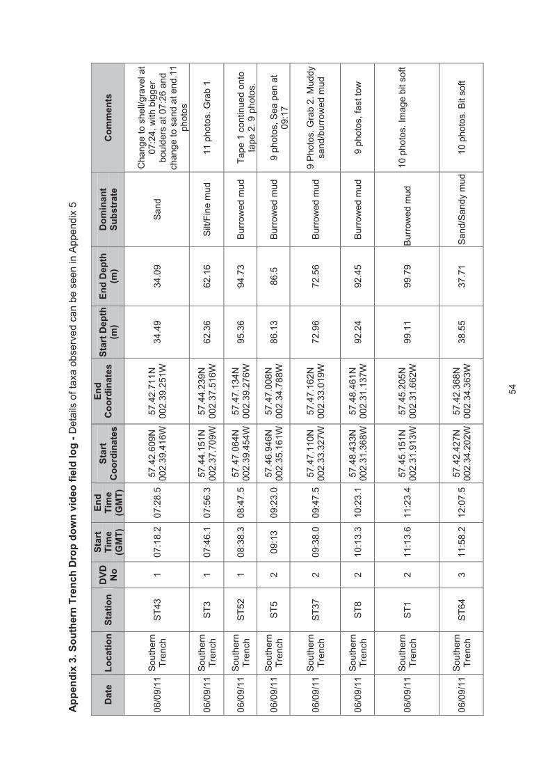
54
Ap
pe
nd
ix 3
. S
ou
the
rn T
ren
ch
Dro
p d
ow
n v
ide
o f
ield
lo
g -
De
tails o
f ta
xa
ob
se
rve
d c
an
be
se
en
in
Ap
pe
nd
ix 5
Date
L
ocati
on
Sta
tio
n
DV
D
No
Sta
rt
Tim
e
(GM
T)
En
d
Tim
e
(GM
T)
Sta
rt
Co
ord
ina
tes
En
d
Co
ord
ina
tes
Sta
rt D
ep
th
(m)
En
d D
ep
th
(m)
Do
min
an
t S
ub
str
ate
C
om
men
ts
06/0
9/1
1 S
outh
ern
Tre
nch
ST
43
1
07:1
8.2
07:2
8.5
57.4
2.6
09N
002.3
9.4
16W
57.4
2.7
11N
002.3
9.2
51W
34.4
9
34.0
9
Sand
Change to s
hell/g
ravel at
07:2
4, w
ith b
igger
bould
ers
at 07:2
6 a
nd
change to s
and a
t end.1
1
photo
s
06/0
9/1
1 S
outh
ern
Tre
nch
ST
3
1
07:4
6.1
07:5
6.3
57.4
4.1
51N
002.3
7.7
09W
57.4
4.2
39N
002.3
7.5
16W
62.3
6
62.1
6
Silt/F
ine m
ud
11 p
hoto
s. G
rab 1
06/0
9/1
1 S
outh
ern
Tre
nch
ST
52
1
08:3
8.3
08:4
7.5
57.4
7.0
64N
002.3
9.4
54W
57.4
7.1
34N
002.3
9.2
76W
95
.36
94
.73
Bu
rrow
ed
mud
Ta
pe
1 c
on
tinu
ed
on
to
tap
e 2
. 9
ph
oto
s.
06/0
9/1
1 S
outh
ern
Tre
nch
ST
5
2
09:1
3
09:2
3.0
57.4
6.9
46N
002.3
5.1
61W
57.4
7.0
08N
002.3
4.7
88W
86
.13
86
.5
Bu
rrow
ed
mud
9 p
hoto
s, S
ea p
en a
t
09:1
7
06/0
9/1
1 S
outh
ern
Tre
nch
ST
37
2
09:3
8.0
09:4
7.5
57.4
7.1
10N
002.3
3.3
27W
57.4
7.1
62N
002.3
3.0
19W
72
.96
72
.56
Bu
rrow
ed
mud
9 P
hoto
s. G
rab 2
. M
uddy
sa
nd
/bu
rrow
ed
mu
d
06/0
9/1
1 S
outh
ern
Tre
nch
ST
8
2
10:1
3.3
10:2
3.1
57.4
8.4
33N
002.3
1.3
68W
57.4
8.4
61N
002.3
1.1
37W
92
.24
92
.45
Bu
rrow
ed
mud
9
ph
oto
s, fa
st to
w
06/0
9/1
1 S
outh
ern
Tre
nch
ST
1
2
11:1
3.6
11:2
3.4
57.4
5.1
51N
002.3
1.9
13W
57.4
5.2
05N
002.3
1.6
62W
99
.11
99
.79
Bu
rrow
ed
mud
10 p
hoto
s. Im
age b
it s
oft
06/0
9/1
1 S
outh
ern
Tre
nch
ST
64
3
11:5
8.2
12:0
7.5
57.4
2.4
27N
002.3
4.2
02W
57.4
2.3
68N
002.3
4.3
63W
38.5
5
37.7
1
Sand/S
andy m
ud
10 p
hoto
s. B
it s
oft

55
Date
L
ocati
on
Sta
tio
n
DV
D
No
Sta
rt
Tim
e
(GM
T)
En
d
Tim
e
(GM
T)
Sta
rt
Co
ord
ina
tes
E
nd
C
oo
rdin
ate
s
Sta
rt D
ep
th
(m)
En
d D
ep
th
(m)
Do
min
an
t S
ub
str
ate
C
om
men
ts
06/0
9/1
1 S
outh
ern
Tre
nch
ST
22
3
12:3
1.1
12:4
0.3
57.4
3.5
94N
002.3
0.8
90W
57.4
3.6
16N
002.3
0.6
26W
73
.08
73
.05
Bu
rrow
ed
mud
10 p
hoto
s, A
lcyo
nium
at
12:3
3?, quite far
from
origin
al sta
tion.
06/0
9/1
1 S
outh
ern
Tre
nch
ST
65
3
12:5
9.1
13:0
8.4
57.4
2.5
34N
002.2
9.1
49W
57.4
2.6
04N
002.2
9.0
35W
38.1
1
38.2
4
Gra
vel and
pe
bb
les
11
ph
oto
s, cha
ng
e to
bould
ers
at end
06/0
9/1
1 S
outh
ern
Tre
nch
ST
41
3
13:2
9.5
13:3
9.2
57.4
4.1
03N
002.2
6.9
60W
57.4
4.1
79N
002.2
6.8
14W
43.6
6
43.5
7
Sandy m
ud w
ith
pe
bb
les a
nd
co
bb
les a
nd
occasio
na
l
bould
ers
10
ph
oto
s.
06/0
9/1
1 S
outh
ern
Tre
nch
ST
19
3
14:0
2.4
14:1
2.2
57.4
5.5
84N
002.2
8.3
92W
57.4
5.6
71N
002.2
8.4
93W
122.6
7
115.9
B
urr
ow
ed
mud
an
d m
ud
9 p
hoto
s. G
rab 3
06/0
9/1
1 S
outh
ern
Tre
nch
ST
61
4
14:3
9.4
14.5
0.0
757.4
7.0
60N
002.2
8.4
22W
57.4
7.1
83N
002.2
8.3
22W
86
.55
87
.46
Bu
rrow
ed
mud
1
1 p
ho
tos
06/0
9/1
1 S
outh
ern
Tre
nch
ST
44
4
15:1
1.3
15:2
1.2
57.4
6.5
04N
002.2
6.1
4W
57.4
6.4
73N
002.2
5.7
80W
10
8.3
3
11
0.6
B
urr
ow
ed
mud
T
raw
l m
ark
at 1
5:1
9
06/0
9/1
1 S
outh
ern
Tre
nch
ST
68
4
16:0
9.1
16:1
8.6
57.4
5.3
67N
002.2
5.9
79W
57.4
5.4
68N
002.2
5.7
39W
14
1.9
2
13
5.6
1
Bu
rrow
ed
mud
10 p
hoto
s. B
ig m
eta
l box
at end
07.0
9.1
1 S
outh
ern
Tre
nch
ST
25
5
11:3
1.1
11:4
0.3
57.4
3.4
27N
1.5
7.9
69W
57.4
3.3
82N
1.5
7.7
09W
43.7
5
43.1
3
Sand a
nd r
ock
10 p
hoto
s, 2 p
oss. not
taken. M
ain
ly s
and

56
Date
L
ocati
on
Sta
tio
n
DV
D
No
Sta
rt
Tim
e
(GM
T)
En
d
Tim
e
(GM
T)
Sta
rt
Co
ord
ina
tes
E
nd
C
oo
rdin
ate
s
Sta
rt D
ep
th
(m)
En
d D
ep
th
(m)
Do
min
an
t S
ub
str
ate
C
om
men
ts
07.0
9.1
1 S
outh
ern
Tre
nch
ST
29
5
12:0
1.4
12:1
1.2
57.4
5.5
48N
1.5
7.5
44W
57.4
5.6
45N
1.5
7.3
52W
56.5
3
57.2
4
Muddy g
ravel
10 p
hoto
s. R
ope o
n
transect, o
ccasio
nal
bould
ers
.
07.0
9.1
1 S
outh
ern
Tre
nch
ST
26
5
12:2
9.3
12:3
9.5
57.4
7.0
84N
001.5
7.1
07W
57.4
7.2
45N
001.5
6.9
07W
76.1
78.1
1
Muddy s
and
10 p
hoto
s, 2 p
ossib
ly n
ot
taken. C
am
era
bouncy
07.0
9.1
1 S
outh
ern
Tre
nch
ST
51
5
13:0
9.4
13:2
6.4
57.4
8.6
99N
001.5
5.8
64W
57.4
8.7
66N
001.5
5.3
79W
202.0
5
207.3
2
Sandy m
ud
13 p
hoto
s n
ot at re
gula
r
inte
rvals
. C
am
era
bouncy
07.0
9.1
1 S
outh
ern
Tre
nch
ST
12
6
13:5
3.2
14:0
3.4
57.5
0.2
03N
001.5
7.5
29W
57.5
0.2
65N
001.5
7.3
16W
11
7.5
5
10
8.3
6
Mu
d/b
urr
ow
ed
mud
8 p
hoto
s, cam
era
bouncy.
Sea p
en a
t 14:0
0
08.0
9.1
1 S
outh
ern
Tre
nch
ST
23
6
07:4
7.1
07:5
7.6
57.4
6.2
29N
001.4
8.6
88W
57.4
6.1
14N
001.4
7.9
75W
53
.28
57
.83
Pe
bb
les a
nd
co
bb
les.
11 p
hoto
s. F
ast to
w
08.0
9.1
1 S
outh
ern
Tre
nch
ST
34
6
08:2
6.2
08:3
6.4
57.4
8.1
94N
001.4
6.3
92W
57.4
8.0
98N
001.4
5.7
75W
82.1
7
82.4
2
Gra
velly s
and
11 p
hoto
s, ru
bble
at end
of tr
ansect. G
rab 5
08.0
9.1
1 S
outh
ern
Tre
nch
ST
36
6
09:2
0.5
09:3
0.2
57.4
9.0
08N
001.4
0.3
45W
57.4
8.9
13N
001.3
9.8
42W
54
55
.44
Sand, pebble
s
and c
obble
s
08.0
9.1
1 S
outh
ern
Tre
nch
ST
35
7
09:5
9.2
10:0
9.5
57.5
0.3
74N
001.3
5.1
90W
57.5
0.2
61N
001.3
4.5
94W
65.3
7
64.9
S
andy m
ud a
nd
pe
bb
les
11 p
hoto
s, bit fast.

57
Date
L
ocati
on
Sta
tio
n
DV
D
No
Sta
rt
Tim
e
(GM
T)
En
d
Tim
e
(GM
T)
Sta
rt
Co
ord
ina
tes
E
nd
C
oo
rdin
ate
s
Sta
rt D
ep
th
(m)
En
d D
ep
th
(m)
Do
min
an
t S
ub
str
ate
C
om
men
ts
08.0
9.1
1 S
outh
ern
Tre
nch
ST
40
7
11:1
1.2
11:2
1.4
57.5
1.2
78N
001.3
8.8
71W
57.5
1.2
73N
001.3
8.2
67W
113.7
2
113.8
5
Muddy S
and
11 p
hoto
s, cam
era
tow
a
bit fast. G
rab 6
08.0
9.1
1 S
outh
ern
Tre
nch
ST
28
7
11:5
4.1
12:0
6.3
57.5
3.1
77N
001.3
8.1
14W
57.5
3.1
46N
001.3
7.6
86W
77.8
2
78.7
1
Muddy S
and
12 p
hoto
s. C
am
era
very
bouncy.
08.0
9.1
1 S
outh
ern
Tre
nch
ST
17
7
12:4
1.6
12:5
2.1
57.5
3.3
12N
001.4
4.4
87W
57.5
3.3
72N
001.4
4.2
12W
72.2
9
73.8
4
Muddy S
and
10 P
hoto
s. C
am
era
very
bo
uncy
08.0
9.1
1 S
outh
ern
Tre
nch
ST
55
8
13:1
8.2
13:2
9.1
57.5
1.2
19N
001.4
3.1
84W
57.5
1.2
69N
001.4
2.7
93W
11
3.3
4
12
0.8
7
Mu
d
11 p
hoto
s. C
am
era
very
bouncy.
08.0
9.1
1 S
outh
ern
Tre
nch
ST
60
8
13:4
9.3
13:5
9.4
57.5
0.1
80N
001.4
3.3
93W
57.5
0.2
28N
001.4
3.1
89W
82.7
5
79.0
4
Sandy m
ud a
nd
pe
bb
les
10 p
hoto
s, C
am
era
a b
it
bo
uncy
08.0
9.1
1 S
outh
ern
Tre
nch
ST
11
8
14:2
3.3
14:3
6.2
57.5
0.3
48N
001.4
6.5
47W
57.5
0.4
74N
001.4
6.3
14W
163.8
1
153.2
8
Sandy M
ud
12 p
hoto
s, fish? A
t 14:3
0
08.0
9.1
1 S
outh
ern
Tre
nch
ST
59
8
15:2
2.2
15:3
7.2
57.5
0.6
26N
001.4
8.9
46W
57.5
0.8
39N
001.4
8.7
52W
11
1.1
5
80
.23
Mu
d a
nd
Pebb
les
12 p
hoto
s. 15:2
8 o
nw
ard
s
ba
d v
iz, slo
pin
g u
pw
ard
s.
08.0
9.1
1 S
outh
ern
Tre
nch
ST
50
9
16:1
4.6
16:2
6.2
57.5
0.4
96N
001.5
2.3
27W
57.5
0.6
06N
001.5
2.2
22W
10
7.0
5
97
.39
Mu
d a
nd
Pebb
les
11 p
hoto
s, ra
y a
t end,
an
d la
rge
anem
on
e

58
Date
L
ocati
on
Sta
tio
n
DV
D
No
Sta
rt
Tim
e
(GM
T)
En
d
Tim
e
(GM
T)
Sta
rt
Co
ord
ina
tes
E
nd
C
oo
rdin
ate
s
Sta
rt D
ep
th
(m)
En
d D
ep
th
(m)
Do
min
an
t S
ub
str
ate
C
om
men
ts
08.0
9.1
1 S
outh
ern
Tre
nch
ST
15
9
17:0
2.6
17:1
6.5
57.5
0.2
15N
001.5
0.3
78W
57.5
0.3
99N
001.5
0.3
49W
168.3
108.4
4
Sandy m
ud/M
ud
14 p
hoto
s, lo
ts o
f sta
rfis
h
08.0
9.1
1 S
outh
ern
Tre
nch
ST
45
9
17:3
6.1
17:4
5.4
57.4
9.2
74N
001.4
8.7
88W
57.4
9.3
65N
001.4
8.6
50W
106.0
4
107.2
8
Sandy m
ud
10 p
hoto
s
09.0
9.1
1 S
outh
ern
Tre
nch
ST
71
9
08:0
8.2
08:2
1.4
57.4
9.5
27N
001.4
9.6
65W
57.4
9.4
92N
001.4
9.4
78W
148.0
1
137
Gra
velly m
ud
Dro
p c
am
era
fra
me.
Cla
pper
board
at end o
f
clip o
n D
VD
. D
riftin
g
alo
ng
slo
pe
th
en
upw
ard
s
at 08:1
7.
09.0
9.1
1 S
outh
ern
Tre
nch
ST
72
9
08:3
9.3
08:5
7.1
57.4
9.3
56N
001.5
0.7
01W
57.4
9.2
34N
001.5
0.3
52W
192.4
4
139.3
9
Sandy M
ud
Dro
p c
am
era
fra
me.
Goin
g u
p g
entle s
lope. 15
photo
s.
09.0
9.1
1 S
outh
ern
Tre
nch
ST
27
9
09:5
6.3
11:1
1.0
57.4
9.3
76N
001.5
3.8
44W
57.4
9.4
33N
001.5
3.3
48W
205.4
196.1
5
Sandy M
ud
Ba
ck to
ca
mera
sle
dg
e.
14 p
hoto
s. P
ossib
le s
ea
pen a
t 10:0
0. B
ad v
iz.
Sw
apped c
am
era
, but
identical set up. B
ig
anem
one a
t 10:0
7.
08.0
9.1
1 S
outh
ern
Tre
nch
ST
11
8
14:2
3.3
14:3
6.2
57.5
0.3
48N
001.4
6.5
47W
57.5
0.4
74N
001.4
6.3
14W
163.8
1
153.2
8
Sandy M
ud
12 p
hoto
s, fish? a
t
14:3
0.1
0
08.0
9.1
1 S
outh
ern
Tre
nch
ST
59
8
15:2
2.2
15:3
7.2
57.5
0.6
26N
001.4
8.9
46W
57.5
0.8
39N
001.4
8.7
52W
11
1.1
5
80
.23
Mu
d a
nd
Pebb
les
12 p
hoto
s. 15:2
8 o
nw
ard
s
ba
d v
iz, slo
pin
g u
pw
ard
s.

59
Date
L
ocati
on
Sta
tio
n
DV
D
No
Sta
rt
Tim
e
(GM
T)
En
d
Tim
e
(GM
T)
Sta
rt
Co
ord
ina
tes
E
nd
C
oo
rdin
ate
s
Sta
rt D
ep
th
(m)
En
d D
ep
th
(m)
Do
min
an
t S
ub
str
ate
C
om
men
ts
09.0
9.1
1 S
outh
ern
Tre
nch
ST
67
10
10:5
4.5
11:0
5.1
57.5
2.2
42N
001.4
8.1
59W
57.5
2.2
94N
001.4
7.9
87W
88.5
8
88.5
7
Bu
rrow
ed
mud/M
ud
11 P
hoto
s
09.0
9.1
1 S
outh
ern
Tre
nch
ST
9
10
11:3
0.4
11:4
0.5
57.5
2.3
77N
001.5
2.5
03W
57.5
2.2
93N
001.5
2.2
93W
92
.22
92
.45
Bu
rrow
ed
Mud
9
ph
oto
s
09.0
9.1
1 S
outh
ern
Tre
nch
ST
16
11
12:3
4.2
12:4
4.3
57.5
1.7
04N
00
2.0
.083W
57.5
1.7
70N
001.5
9.8
62W
87
.73
85
.4
Bu
rrow
ed
Mud
1
0 p
ho
tos
09.0
9.1
1 S
outh
ern
Tre
nch
ST
18
11
13:1
4.4
13:2
4.4
57.5
0.2
21N
00
2.4
.419W
57.5
0.3
58N
002.4
.448W
9
5.5
9
90
.06
Bu
rrow
ed
Mud
1
0 p
ho
tos, b
ad
viz
09.0
9.1
1 S
outh
ern
Tre
nch
ST
21
11
13:5
6.4
14:0
6.5
57.4
8.3
67N
00
2.0
.438W
57.4
8.4
70N
002.0
.333W
1
32
.4
13
0.5
4
Bu
rrow
ed
mud
9 p
hoto
s, bad v
iz. G
rab
10
09.0
9.1
1 S
outh
ern
Tre
nch
ST
39
12
14.3
8.0
114:4
8.4
57.4
7.7
82N
002.1
;.529W
57.4
7.8
82N
002.1
.761W
213.9
8
209.7
5
Sand/S
andy m
ud
13
Ph
oto
s, C
lap
per
at
end o
f to
w
09.0
9.1
1 S
outh
ern
Tre
nch
ST
66
12
15:1
6.0
15:2
6.4
57.4
8.5
67N
00
2.5
.693W
57.4
8.6
76N
002.5
.950W
125.5
1
100.6
B
urr
ow
ed m
ud
11 p
hoto
s, G
rab 1
1
09.0
9.1
1 S
outh
ern
Tre
nch
ST
63
12
16:2
1.2
16:3
2.1
57.4
7.1
41N
00
2.6
.463W
57.4
7.3
13N
002.6
.401W
1
13
.08
10
0.3
1
Bu
rrow
ed
Mud
1
1 p
ho
tos, b
ad
viz

60
Date
L
ocati
on
Sta
tio
n
DV
D
No
Sta
rt
Tim
e
(GM
T)
En
d
Tim
e
(GM
T)
Sta
rt
Co
ord
ina
tes
E
nd
C
oo
rdin
ate
s
Sta
rt D
ep
th
(m)
En
d D
ep
th
(m)
Do
min
an
t S
ub
str
ate
C
om
men
ts
09.0
9.1
1 S
outh
ern
Tre
nch
ST
57
12
17:0
7.1
17:1
7.4
57.4
5.2
25N
00
2.7
.143W
57.4
5.3
24N
002.7
.381W
1
36
.74
13
6.7
4
Bu
rrow
ed
mud
1
1 p
ho
tos
09.0
9.1
1 S
outh
ern
Tre
nch
ST
48
12
17:4
1.4
17:5
2.4
57.4
5.2
93N
002.1
0.4
01W
57.4
5.3
66N
002.1
0.1
75W
155.9
128.3
9
Mud/B
urr
ow
ed
mud
9 p
hoto
s, bad v
iz
10.0
9.1
1 S
outh
ern
Tre
nch
ST
31
13
07:1
9.2
07:2
9.5
57.4
3.7
88N
002.1
2.5
76W
57.4
3.8
42N
002.1
2.7
55W
43.0
9
42.3
S
an
d , c
ob
ble
s
and p
ebble
s
11
ph
oto
s, viz
a b
it h
azy
10.0
9.1
1 S
outh
ern
Tre
nch
ST
46
13
08:0
3.3
08:1
2.4
57.4
3.2
30N
002.1
8.4
17W
57.4
3.2
96N
002.1
8.6
72W
41.9
1
40.8
7
Gra
velly s
and
and c
obble
s
11 p
hoto
s, 5 m
ay n
ot
ha
ve
ta
ken
. O
ccasio
na
l
bould
ers
, m
ore
rocky
tow
ard
s e
nd o
f tr
ansect
10.0
9.1
1 S
outh
ern
Tre
nch
ST
13
13
08:3
4.3
08:4
4.1
57.4
3.2
35N
002.2
2.3
70W
57.4
3.2
64N
002.2
2.4
76W
49.3
4
49.0
4
Sa
nd
an
d
pe
bb
les
Gra
b 1
3, 10 p
hoto
s
10.0
9.1
1 S
outh
ern
Tre
nch
ST
10
13
09:0
5.3
09:1
5.3
57.4
4.4
49N
002.2
0.0
93W
57.4
4.5
80N
002.1
9.9
56W
79
.25
86
.49
Bu
rrow
ed
mud
10 p
hoto
s
10.0
9.1
1 S
outh
ern
Tre
nch
ST
47
13
09:3
1.6
09:4
2.4
57.4
5.5
84N
002.1
8.3
93W
57.4
5.6
86N
002.1
8.1
75W
17
2.1
1
54
.96
Bu
rrow
ed
mud
9
ph
oto
s b
ad
viz
. G
rab
14

61
Date
L
ocati
on
Sta
tio
n
DV
D
No
Sta
rt
Tim
e
(GM
T)
En
d
Tim
e
(GM
T)
Sta
rt
Co
ord
ina
tes
E
nd
C
oo
rdin
ate
s
Sta
rt D
ep
th
(m)
En
d D
ep
th
(m)
Do
min
an
t S
ub
str
ate
C
om
men
ts
10.0
9.1
1 S
outh
ern
Tre
nch
ST
62
14
10:5
7.5
11:0
8.1
57.4
5.6
58N
002.2
1.3
02W
57.4
5.7
32N
002.2
1.0
65W
12
2.1
1
30
.56
Bu
rrow
ed
mud
1
0 p
ho
tos, b
ad
viz
10.0
9.1
1 S
outh
ern
Tre
nch
ST
4
14
11:2
9.5
11:4
0.2
57.4
5.6
30N
002.2
3.3
65W
57.4
5.7
17N
002.2
3.1
51W
11
0
11
2.0
6
Sandy m
ud,
pe
bb
les a
nd
cobble
s
11 p
hoto
s. G
rab 1
5
10.0
9.1
1 S
outh
ern
Tre
nch
ST
69
14
12:0
7.1
12:1
8.1
57.4
7.1
78N
002.2
4.0
27W
57.4
7.2
94N
002.2
3.8
96W
10
1.5
4
99
.61
Bu
rrow
ed
mud
11 p
hoto
s, tim
er
on v
ideo
late
by 3
min
s. B
ad v
iz
10.0
9.1
1 S
outh
ern
Tre
nch
ST
38
14
12:3
1.1
12:4
1.5
57.4
7.0
89N
002.2
2.7
99W
57.4
7.2
21N
002.2
2.6
54W
102.7
7
104.5
4
Burr
ow
ed m
ud
Hazy, bad v
iz. 11 p
hoto
s
10.0
9.1
1 S
outh
ern
Tre
nch
ST
70
14
13:0
4.4
13:1
6.5
57.4
6.4
13N
002.1
9.2
23W
57.4
6.5
92N
002.1
8.8
80W
87.4
3
70.0
4
Bu
rrow
ed
Mud/M
ud
Hazy, bad v
iz. D
VD
slightly longer
than D
V
tape, w
hic
h r
an o
ut.
10.0
9.1
1 S
outh
ern
Tre
nch
ST
7
15
13:3
1.6
13:4
2.2
57.4
7.4
93N
002.1
9.3
86W
57.4
7.6
24N
002.1
9.2
25W
114.7
2
120.0
2
Burr
ow
ed M
ud
9 p
hoto
s, H
azy, bad v
iz
10.0
9.1
1 S
outh
ern
Tre
nch
ST
58
15
14:1
1.3
14:2
2.3
57.4
7.2
76N
002.1
7.5
78W
57.4
7.3
43N
002.1
7.7
31W
12
1.4
9
12
2.0
2
Bu
rrow
ed
Mud
1
5 p
ho
tos
10.0
9.1
1 S
outh
ern
Tre
nch
ST
54
15
14:4
4.4
14:5
4.3
57.4
7.4
16N
002.1
5.2
58W
57.4
7.5
27N
002.1
5.4
54W
12
6.1
9
12
0.7
6
Bu
rrow
ed
mud
1
0 p
ho
tos, b
ad
viz

62
Date
L
ocati
on
Sta
tio
n
DV
D
No
Sta
rt
Tim
e
(GM
T)
En
d
Tim
e
(GM
T)
Sta
rt
Co
ord
ina
tes
E
nd
C
oo
rdin
ate
s
Sta
rt D
ep
th
(m)
En
d D
ep
th
(m)
Do
min
an
t S
ub
str
ate
C
om
men
ts
10.0
9.1
1 S
outh
ern
Tre
nch
ST
42
15
15:5
9.5
16:1
5.4
57.4
7.0
11N
002.1
0.2
56W
57.4
6.8
18N
002.1
0.3
48W
117
86.9
5
Mud/B
roken S
hell
16 p
hoto
s S
lopin
g
10.0
9.1
1 S
outh
ern
Tre
nch
ST
2
16
16:4
7.2
16:5
7.3
57.4
6.0
34N
002.1
4.3
47W
57.4
5.9
58N
002.1
4.5
38W
10
8.8
1
11
2.5
6
Bu
rrow
ed
Mud
10 p
hoto
s. H
eavily
burr
ow
ed. S
tation m
oved
due to w
reck b
ein
g
pre
se
nt
10.0
9.1
1 S
outh
ern
Tre
nch
ST
56
16
17:1
5.6
17:2
7.1
57.4
5.3
58N
002.1
6.2
38W
57.4
5.2
70N
002.1
6.3
13W
17
1.0
6
18
8.2
6
Bu
rrow
ed
Mud
9
ph
oto
s. B
ad
viz
10.0
9.1
1 S
outh
ern
Tre
nch
ST
73
16
17:4
9.3
18:1
3.5
57.4
4.5
10N
002.1
4.5
37W
57.4
4.2
00N
002.1
4.5
54W
17
0.2
3
45
.36
Bu
rrow
ed
mud
23 p
hoto
s. T
urn
ing to
pe
bb
les tow
ard
s e
nd
11.0
9.1
1 S
outh
ern
Tre
nch
ST
6
17
08:1
3:5
008:2
4.2
57.4
8.6
29N
002.2
2.9
73W
57.4
8.7
67N
002.2
3.0
57W
97
.81
95
.7
Bu
rrow
ed
Mud
N
O S
TIL
LS
. G
PS
tra
ck
every
min
only
.
11.0
9.1
1 S
outh
ern
Tre
nch
ST
53
17
09:0
0.1
09:1
0.3
57.5
0.2
24N
002.1
7.4
49W
57.5
0.2
98N
002.1
7.5
53W
90.5
6
89.9
4
Burr
ow
ed M
ud
NO
ST
ILLS
. G
rab 1
8
11.0
9.1
1 S
outh
ern
Tre
nch
ST
20
17
09:4
3.3
09:5
4.1
57.4
9.2
54N
002.1
3.1
19W
57.4
9.3
16N
002.1
3.2
22W
99
.23
99
.4
Bu
rrow
ed
Mud
N
O S
TIL
LS
11.0
9.1
1 S
outh
ern
Tre
nch
ST
49
17
10:1
9.2
10:2
9.3
57.5
0.1
27N
00
2.9
.364W
57.5
0.0
68N
002.9
.529W
1
08
.91
10
8.1
8
Bu
rrow
ed
Mud
10 p
hoto
s, flash n
ot
wo
rkin
g

63
Date
L
ocati
on
Sta
tio
n
DV
D
No
Sta
rt
Tim
e
(GM
T)
En
d
Tim
e
(GM
T)
Sta
rt
Co
ord
ina
tes
E
nd
C
oo
rdin
ate
s
Sta
rt D
ep
th
(m)
En
d D
ep
th
(m)
Do
min
an
t S
ub
str
ate
C
om
men
ts
11.0
9.1
1 S
outh
ern
Tre
nch
ST
32
17
11:1
8.2
11:3
0.5
57.4
8.1
57N
00
2.7
.965W
57.4
8.2
41N
002.8
.022W
9
9.5
5
97
.78
Bu
rrow
ed
Mud
/
Mud
11 p
hoto
s
11.0
9.1
1 S
outh
ern
Tre
nch
ST
33
18
11:5
8.3
12:1
1.4
57.4
9.9
10N
00
2.8
.276W
57.4
7.0
54N
002.8
.085W
153.4
178.4
5
Mu
d a
nd
co
bb
les
with r
ock o
utc
rop
14 p
hoto
s, in
tere
sting
dro
p o
ff r
ock o
utc
rop a
t
12
:03
.
11.0
9.1
1 S
outh
ern
Tre
nch
ST
24
18
12:3
3.3
12:4
8.5
57.4
6.0
63N
00
2.7
.392W
57.4
6.3
01N
002.7
.188W
153.5
8
88.6
8
Mu
d a
nd
pe
bb
les/c
obble
s17 p
hoto
s. G
rab 1
9
11.0
9.1
1 S
outh
ern
Tre
nch
ST
14
18
13:4
0.5
13:5
2.0
57.4
3.4
92N
00
2.6
.953W
57.4
3.7
04N
002.6
.861W
50.3
6
52.3
4
Gra
velly S
and
12 p
hoto
s, no fla
sh
11.0
9.1
1 S
outh
ern
Tre
nch
ST
30
18
14:1
3.2
14:2
3.2
57.4
4.1
93N
00
2.2
.197W
57.4
4.3
37N
002.2
.181W
4
0.1
2
40
.24
Gra
velly w
ith
pe
bb
les a
nd
cobb
les
NO
ST
ILLS
. G
PS
tra
ck
eve
ry s
eco
nd
11.0
9.1
1 S
outh
ern
Tre
nch
ST
74
19
14:4
1.4
14:4
9.4
57.4
5.7
70N
00
2.0
.190W
57.4
5.8
74N
002.0
.145W
6
8.4
3
67
.23
Gra
velly s
and
and p
ebble
s
NO
ST
ILLS
, G
rab 2
0

64
Ap
pe
nd
ix 4
. B
ioto
pe
lis
t fo
r s
tati
on
s a
t N
os
s H
ea
d:
Sub
stra
tes,
bio
ta, b
ioto
pes
and
PM
Fs/M
PA
sea
rch
feat
ures
rec
orde
d du
ring
the
drop
-dow
n vi
deo
surv
ey.
Sta
tio
n
Su
bs
tra
te
Bio
ta
Bio
top
e
PM
Fs
NH
27
Brittle
sta
r bed o
ver
cobble
s,
pe
bb
les, b
ou
lde
rs a
nd
pa
tch
es o
f
gra
ve
l a
nd
she
ll.
Dense B
rittle
sta
r cover
Oph
ioth
rix fr
agilis
(S
),
Oph
ioco
min
a ni
gra
(S),
with A
bundant A
lcyo
nium
di
gita
tum
support
ing a
com
munity o
f E
chin
us
escu
lent
us (
35),
Ast
eria
s ru
bens
(5),
Flu
stra
folia
cea
(O),
sponge a
nd h
ydro
id turf
s (
R)
SS
.SM
x.C
Mx.O
phM
x
None
NH
11
Mod
iolu
s b
ed in
ters
pe
rsed
with
are
as o
f d
ead s
he
ll a
nd
gra
ve
l
an
d o
cca
sio
na
l B
ou
lders
an
d
co
bb
les.
Mod
iolu
s bed w
ith liv
e M
odio
lus
(A),
support
ing a
hig
hly
bio
div
ers
e c
om
munity o
f H
ydro
ids inclu
din
g
Ser
tula
ria c
upre
ssin
a (O
), A
biet
erna
ria a
biet
ina
(R),
Hal
eciu
m s
p. (F
), N
emer
tesi
a an
tenn
ina
(R),
Kirc
henp
auer
ia p
inna
ta (
F)
as w
ell a
s m
obile fauna
such
as O
phio
thrix
frag
ilis (
A),
Oph
ioco
min
a ni
gra
(S)
Ech
inus
esc
ulen
tus
(112),
A
ster
ias
rube
ns(1
6),
H
enric
ia s
p. (1
0)
SS
.SB
R.S
Mus.M
odT
Ho
rse
Mu
sse
l
Mod
iolu
s m
odio
lus
NH
14
Brittle
sta
r bed o
ver
cobble
s,
pe
bb
les, b
ou
lde
rs a
nd
pa
tch
es o
f
gra
vel and e
mpty
shell.
Dense B
rittle
sta
r cover
Oph
ioth
rix fr
agilis
(S),
Oph
ioco
min
a ni
gra
(S),
with A
bundant A
lcyo
nium
digi
tatu
m s
upport
ing a
com
munity o
f E
chin
us
escu
lent
us (5
1),
Aste
rias r
ubens(9
), P
omat
ocer
os
triqu
eter
(F
) sponge a
nd h
ydro
id turf
s (
R)
SS
.SM
x.C
Mx.O
phM
x
None
NH
34
Shell m
ixed w
ith g
ravel w
ith
patc
hy B
rittle
sta
r bed
Locally a
bundant O
phio
thrix fra
gilis
, and O
phio
com
ina
nigr
a w
ith a
spars
er
com
munity o
f E
chin
us e
scul
entu
s (3
0),
Pom
atoc
eros
triq
uete
r (R
), H
ydro
ids (
R),
Ast
eria
s ru
bens
(4),
Cro
ssas
ter p
appo
sus
(6),
and P
agur
us
bern
hard
us (
5)
SS
.SM
x.C
Mx
None

65
Sta
tio
n
Su
bs
tra
te
Bio
ta
Bio
top
e
PM
Fs
NH
8
Gra
ve
l w
ith
sca
tte
red
cob
ble
s
and s
hell
Do
min
ate
d b
y E
chin
us e
scul
entu
s (2
6),
and
Ast
eria
s ru
bens
(15),
with R
are
Red A
lgae S
pp, and S
ponge
Spp, H
ydra
llman
ia fa
lcat
a (O
), A
lcyo
nidi
um d
iaph
anum
(O),
Mod
iolu
s m
odio
lus
(R).
SS
.SM
x.C
Mx
None
NH
47
Mod
iolu
s b
ed w
ith
pa
tche
s o
f
em
pty
shell
Mod
iolu
s bed w
ith liv
e M
odio
lus
(S),
support
ing a
hig
hly
bio
div
ers
e c
om
munity o
f H
ydro
ids inclu
din
g
Kirc
henp
auer
ia p
inna
ta (
S)
Ser
tula
ria c
upre
ssin
a (C
)
an
d S
chiz
otric
ha fr
utes
cens
(S
) , M
assiv
e y
ellow
sponge S
p (
C),
th
e s
easquirt
Asc
idia
virg
inea
(C
) a
s
well a
s m
obile fauna s
uch a
s O
phio
thrix
frag
ilis,
and
Oph
ioco
min
a ni
gra
(S)
, E
chin
us e
scul
entu
s (4
8),
and
Hen
ricia
sp
.(12)
SS
.SB
R.S
Mus.M
odT
Ho
rse
Mu
sse
l
Mod
iolu
s m
odio
lus
NH
21
Mod
iolu
s b
ed w
ith
pa
tche
s o
f
em
pty
shell
Mod
iolu
s bed w
ith liv
e M
odio
lus
(S),
support
ing a
hig
hly
bio
div
ers
e c
om
munity o
f H
ydro
ids inclu
din
g
Nem
erte
sia
ante
nnin
a (R
), K
irche
npau
eria
pin
nata
(F
),
Bry
ozoa
ns s
uch
as P
aras
miti
na tr
ipsp
inos
a (O
) as w
ell
as m
obile fauna s
uch a
s O
phio
thrix fra
gilis
(O
),E
chin
us
escu
lent
us (2
4),
Ast
eria
s ru
bens
(8)
SS
.SB
R.S
Mus.M
odT
Ho
rse
Mu
sse
l
Mod
iolu
s m
odio
lus
NH
5
Co
ars
e g
rain
sa
nd
s w
ith
patc
hes
scattere
d s
hell a
nd p
atc
hes o
f
pe
bb
les
Extr
em
ely
spars
e h
abitat w
ith o
nly
Pag
urus
be
rnha
rdus
(1),
Ast
eria
s ru
bens
(1),
Lim
anda
lim
anda
(1),
and C
rab s
p. (1
)
SS
.SC
S.C
CS
N
one
NH
15
Coars
e g
rain
sands
Extr
em
ely
spars
e h
abitat w
ith o
nly
Ech
inus
esc
ulen
tus
(1),
Hyp
erop
lus
lanc
eola
tus
(7),
and A
lgae S
pp (
R)
attached to d
etr
itus.
SS
.SC
S.C
CS
N
one

66
Sta
tio
n
Su
bs
tra
te
Bio
ta
Bio
top
e
PM
Fs
NH
46
Mod
iolu
s b
ed in
ters
pe
rsed
with
are
as o
f d
ead s
he
ll a
nd
gra
ve
l
an
d o
cca
sio
na
l co
bb
les.
Mod
iolu
s bed w
ith liv
e M
odio
lus (
A),
su
pp
ort
ing
a
hig
hly
bio
div
ers
e c
om
munity o
f H
ydro
ids inclu
din
g
Ser
tula
ria c
upre
ssin
a (A
), H
alec
ium
sp.
(A
), a
nd
Kirc
henp
auer
ia p
inna
ta (
A)
as w
ell a
s m
obile fauna
such
as E
chin
us e
scul
entu
s (9
6),
Ast
eria
s ru
bens
(24),
Oph
ioth
rix fr
agili
s (F
), A
lcyo
nium
dig
itatu
m,
Pom
atoc
eros
triq
uete
r (O
), a
nd
Rare
Encru
stin
g
Sponge S
pp, and B
ryozoans.
SS
.SB
R.S
Mus.M
odT
Ho
rse
Mu
sse
l
Mod
iolu
s m
odio
lus
bed
NH
45
Gra
velly c
oars
e s
and
Extr
em
ely
spars
ely
popula
ted w
ith o
nly
Alc
yoni
dium
di
apha
num
(R
), a
nd H
yper
oplu
s la
nceo
latu
s (5
) S
S.S
CS
.CC
S
None
NH
29
Britt
lesta
r b
ed
ove
r cob
ble
s a
nd
pe
bb
les
Brittle
sta
r bed o
f O
phio
thrix
frag
ilis (
S),
and
Oph
ioco
min
a ni
gra
(O),
with A
lcyo
nium
dig
itatu
m (
A),
Pom
ato
cero
s triquete
r (C
), E
chin
us e
scul
entu
s (4
3)
an
d F
lust
ra fo
liace
a (O
). L
ess a
bundant fa
una inclu
ded
Encru
sting S
ponge s
p. (R
), M
assiv
e y
ellow
sponge s
p.
(R)
an
d N
emer
tesi
a an
tenn
ina
(R)
SS
.SM
x.C
Mx.O
phM
x
None
NH
35
Gra
ve
l w
ith
sca
tte
red
she
ll a
nd
pebble
s w
ith o
ccasio
nal bould
ers
Spars
ely
popula
ted s
tation w
ith (
O)
Pom
atoc
eros
tri
quet
er a
nd F
lust
ra fo
liace
a, E
chin
us e
scul
entu
s (1
6)
, and R
are
Hyd
rallm
ania
falc
ata,
Encru
sting S
ponge
sp., a
nd S
chiz
otric
ha fr
utes
cens
SS
.SM
x.C
Mx
None
NH
36
Gra
ve
l w
ith
sca
tte
red
she
ll a
nd
pe
bb
les
Fairly
spars
e s
tation d
om
inate
d b
y O
ccasio
nal
Hyd
roid
s S
ertu
laria
cup
ress
ina,
Hal
eciu
m s
p. a
nd
Hyd
rallm
ania
falc
ata,
with P
omat
ocer
os tr
ique
ter (
F),
Ech
inus
esc
ulen
tus
(21),
and R
hodo
phyt
a sp
. (R
),
SS
.SM
x.C
Mx
None

67
Sta
tio
n
Su
bs
tra
te
Bio
ta
Bio
top
e
PM
Fs
NH
48
Co
bb
les a
nd
pe
bb
les w
ith
pa
tch
y
gra
velly s
and
Fairly
spars
e s
tation d
om
inate
d b
y F
lust
ra fo
liace
a (F
),
Pom
atoc
eros
triq
uete
r (O
), S
ertu
laria
cup
ress
ina
(O),
Sch
izot
richa
frut
esce
ns (
R)
and E
chin
us e
scul
entu
s (4
1)
SS
.SM
x.C
Mx.F
luH
yd
None
NH
37
Mod
iolu
s bed w
ith e
mpty
shell,
shell g
ravel and c
oars
e s
and
Mod
iolu
s bed w
ith L
ive M
odio
lus
(A),
support
ing
a
com
munity o
f O
phio
thrix
frag
ilis
(S),
Oph
ioco
min
a ni
gra
(S),
Ech
inus
esc
ulen
tus
(111),
Ast
eria
s ru
bens
(26),
Flu
stra
folia
cea
(C),
Ser
tula
ria c
upre
ssin
a (A
),
an
d C
ucum
aria
fron
dosa
(6)
SS
.SB
R.S
Mus.M
odT
Ho
rse
Mu
sse
l
Mod
iolu
s m
odio
lus
NH
50
Mod
iolu
s bed w
ith e
mpty
shell,
shell g
ravel and c
oars
e s
and
Mod
iolu
s be
d w
ith L
ive M
odio
lus (
A),
sup
po
rtin
g a
div
ers
e c
om
munity o
f O
phio
thrix fra
gilis
(S
), , E
chin
us
escu
lent
us (
120),
Ast
eria
s ru
bens
(37),
Encru
sting
Sponge S
p (
C),
Hen
ricia
Sp
(27),
Ser
tula
ria c
upre
ssin
a (A
), a
nd K
irche
npau
eria
pin
nata
(C
) as w
ell a
s
ind
ivid
ua
ls o
f F
ish
sp
ecie
s.
SS
.SB
R.S
Mus.M
odT
Ho
rse
Mu
sse
l
Mod
iolu
s m
odio
lus,
and
Spin
y d
ogfish
(Squ
alus
ac
anth
ias)
NH
43
Mod
iolu
s bed w
ith e
mpty
shell,
shell g
ravel and c
oars
e s
and
Mod
iolu
s b
ed w
ith L
ive M
odio
lus
(A),
support
ing
a
div
ers
e c
om
munity d
om
inate
d b
y E
chin
us e
scul
entu
s (1
40),
Ast
eria
s ru
bens
(56),
Encru
sting S
ponge s
p.
(C),
Hen
ricia
sp.
(12),
Ser
tula
ria c
upre
ssin
a (S
), a
nd
Hal
eciu
m s
p. (
A).
With less a
bundant specie
s s
uch a
s
Buc
cinu
m u
ndat
um (
1),
Pho
lis g
unne
llus
(1),
and
Asc
idia
virg
inea
(3).
SS
.SB
R.S
Mus.M
odT
Ho
rse
Mu
sse
l
Mod
iolu
s m
odio
lus,
and
Eu
rope
an
ee
l
(ma
rin
e s
tag
e;
Ang
uilla
ang
uilla
)

68
Sta
tio
n
Su
bs
tra
te
Bio
ta
Bio
top
e
PM
Fs
NH
4
Mod
iolu
s bed w
ith e
mpty
shell
and s
andy g
ravel patc
hes
Mod
iolu
s bed w
ith L
ive M
odio
lus (
F),
Oph
ioth
rix fr
agilis
(A),
Ech
inus
esc
ulen
tus
(130),
Encru
sting S
ponge s
p
(C),
Ser
tula
ria c
upre
ssin
a (F
), K
irche
npau
eria
pin
nata
(F),
and B
ryozoa indet cru
sts
(O
)
SS
.SB
R.S
Mus.M
odT
Ho
rse
Mu
sse
l
Mod
iolu
s m
odio
lus
NH
44
Mod
iolu
s bed w
ith e
mpty
shell
and s
andy g
ravel patc
hes
Mod
iolu
s bed w
ith L
ive M
odio
lus
(F),
Ophio
thrix fra
gilis
(A),
Ech
inus
esc
ulen
tus
(126),
Encru
sting S
ponge s
p
(O),
Ser
tula
ria c
upre
ssin
a (A
), S
chiz
otric
ha fr
utes
cens
(O),
and B
ryozoa indet cru
sts
(R
)
SS
.SB
R.S
Mus.M
odT
Ho
rse
Mu
sse
l
Mod
iolu
s m
odio
lus
NH
42
Britt
lesta
r b
ed
on
gra
ve
lly s
and
and s
hell
Brittle
sta
r bed h
eavily d
om
inate
d b
y O
phio
thrix
frag
ilis
(S),
with little e
lse b
ut
Ech
inus
esc
ulen
tus
(53),
Encru
sting S
ponge s
p. (O
), S
ertu
laria
cup
ress
ina
(R),
Hyd
rallm
ania
falc
ata
(R)
and B
ucci
num
und
atum
(1)
SS
.SM
x.C
Mx.O
phM
x
None
NH
1
Britt
lesta
r b
ed
on
gra
ve
lly s
and
and s
hell w
ith o
ccasio
nal
bould
ers
Brittle
sta
r bed h
eavily d
om
inate
d b
y O
phio
thrix
frag
ilis
(A),
Cora
llin
aceae indet pin
k c
rusts
(O
), S
piro
bran
chus
tri
quet
er (
F),
Ech
inus
esc
ulen
tus
(33),
a
nd
rare
Hydro
ids, B
ryozoa, and S
ponges
SS
.SM
x.C
Mx.O
phM
x
None
NH
49
Mod
iolu
s bed w
ith e
mpty
shell,
shell g
ravel and c
oars
e s
and
Mod
iolu
s bed w
ith L
ive M
odio
lus
(A),
support
ing
a
div
ers
e c
om
munity d
om
inate
d b
y O
phio
thrix
frag
ilis
(A),
Ser
tula
ria c
upre
ssin
a (F
), E
chin
us e
scul
entu
s (7
3),
Ast
eria
s ru
bens
(26),
Hal
eciu
m s
p.(
O),
an
d
Kirc
henp
auer
ia p
inna
ta (
O).
SS
.SB
R.S
Mus.M
odT
Ho
rse
Mu
sse
l
Mod
iolu
s m
odio
lus

69
Sta
tio
n
Su
bs
tra
te
Bio
ta
Bio
top
e
PM
Fs
NH
33
Co
ars
e s
an
ds a
nd
gra
ve
l w
ith
co
bb
les a
nd
occasio
na
l b
ou
lde
rs
with
be
dro
ck a
t e
nd
of tr
ansect
Do
min
ate
d b
y F
lust
ra fo
liace
a (A
), B
rittle
sta
rs
Oph
ioth
rix fr
agili
s (C
), O
phio
com
ina
nigr
a (C
), w
ith
Occasio
nal H
ydro
ids S
ertu
laria
cup
ress
ina,
Abi
etin
aria
abie
tina,
Hal
eciu
m s
p. a
nd
Ech
inus
esc
ulen
tus
(54).
SS
.SM
x.C
Mx
None
NH
30
Cobble
s a
nd p
ebble
s o
n g
ravelly
sa
nd
Div
ers
e H
abitat dom
inate
d b
y F
lust
ra fo
liace
a (C
),
Bry
ozoa
in
de
t cru
sts
(O
), E
chin
us e
scul
entu
s (3
0),
Rare
Hydro
ids a
nd invert
ebra
tes
SS
.SM
x.C
Mx
None
NH
13
Bo
uld
ers
an
d b
ed
rock o
n
gra
velly s
and
Do
min
ate
d b
y C
rusta
cea
sp
. (S
), S
piro
bran
chus
tri
quet
er (
A),
Myx
illa
sp. (A
), P
aras
miti
na tr
ipsp
inos
a (C
), a
nd O
phio
thrix
frag
ilis (
C).
CR
.MC
R.E
cC
r.F
aA
l
Cr
Spin
y d
ogfish
(Squ
alus
ac
anth
ias)
NH
7
Fin
e a
nd m
ediu
m s
ands
Extr
em
ely
spars
e w
ith o
nly
Pag
urus
ber
nhar
dus
(1)
SS
.SS
A.C
FiS
a
None
NH
10
Gra
velly s
and w
ith c
oars
e s
and
pa
tche
s a
nd
occasio
na
l b
ou
lde
rs
Oph
ioth
rix fr
agili
s (A
), C
rusta
cea s
p. (A
), E
chin
us
escu
lent
us (
57),
Par
asm
itina
trip
spin
osa
(F),
with
Occasio
na
l Fl
ustra
folia
cea
and E
ncru
sting S
ponge s
p.
Als
o indiv
idual H
ippa
ster
ia p
hryg
iana
, and M
unid
a sp.
SS
.SM
x.C
Mx
None
NH
28
Britt
lesta
rs o
n L
arg
e b
ou
lders
an
d b
ed
rock w
ith
san
dy p
atc
hes
Super
Abun
dant B
rittle
sta
rs O
phio
thrix
frag
ilis locally,
Alc
yoni
um d
igita
tum
(O
), E
chin
us e
scul
entu
s (1
10),
Par
asm
itina
trip
spin
osa
(O),
an
d O
cca
sio
na
l M
yxill
a sp
.
CR
.MC
R.E
cC
r.F
aA
l
Cr.
Bri
No
ne
NH
23
Co
bb
les a
nd
sm
all b
ou
lders
on
gra
vely
sand
Oph
ioth
rix fr
agili
s (C
), E
ncru
sting P
orife
ra s
p. (O
),
Flus
tra fo
liace
a (O
), P
aras
miti
na tr
ipsp
inos
a (O
),
Ser
tula
ria c
upre
ssin
a (O
), and R
are
Sch
izom
avel
la s
p.
SS
.SM
x.C
Mx
None

70
Sta
tio
n
Su
bs
tra
te
Bio
ta
Bio
top
e
PM
Fs
NH
3A
S
cattere
d s
hell a
nd g
ravel
Spars
e s
tation w
ith A
lcyo
nidi
um d
iaph
anum
(C
),
Encru
sting P
orife
ra s
p. (O
), F
lust
ra fo
liace
a (F
),
Co
rallin
acea
e in
de
t p
ink c
rusts
(F
), H
ydro
idea
sp
. (R
),
Ech
inus
esc
ulen
tus
(10),
and C
ross
aste
r pap
posu
s (
2).
SS
.SM
x.C
Mx
None
NH
3B
B
ed
rock w
ith
pa
tche
s o
f g
rave
l
and s
hell
Co
mm
on
encru
sting
fa
un
a s
uch
as P
aras
miti
na
trips
pino
sa, A
lcyo
nidi
um d
iaph
anum
, E
ncru
sting
Porife
ra s
p. (O
), B
ryozoa indet cru
sts
(O
),
Co
rallin
acea
e in
de
t p
ink c
rusts
(F
), a
nd
Hyd
roid
s s
uch
as S
ertu
laria
cup
ress
ina
(R),
and H
ydra
llman
ia fa
lcat
a (R
). L
ack o
f m
obile fauna s
uch a
s A
ster
ias
rube
ns (
5)
CR
.MC
R.E
cC
r.F
aA
l
Cr
No
ne
NH
41
Brittle
sta
rs o
n s
helly g
ravel w
ith
pa
tche
s o
f b
ed
rock a
nd
occasio
nal bould
ers
Dense B
rittle
sta
r cover
Oph
ioth
rix fr
agilis
(S
),
Oph
ioco
min
a ni
gra
(S),
Ser
tula
ria c
upre
ssin
a (O
),
Hyd
rallm
ania
falc
ata
(O),
Encru
sting P
orife
ra s
p. (O
),
Ech
inus
esc
ulen
tus
(65),
with little e
lse s
uch
as C
ance
r pa
guru
s (2
), A
ster
ias
rube
ns (
1),
and L
ineu
s lo
ngis
sim
us (
1).
SS
.SM
x.C
Mx.O
phM
x
None
NH
17
Brittle
sta
rs o
n s
helly g
ravel w
ith
pa
tche
s o
f b
ed
rock a
nd
occasio
nal bould
ers
Dense B
rittle
sta
r bed d
om
inate
d b
y O
phio
thrix
frag
ilis
(S),
Alc
yoni
um d
igita
tum
(A
) , E
chin
us e
scul
entu
s (8
0),
Par
asm
itina
trip
spin
osa
(O)
an
d S
ertu
laria
cup
ress
ina
(O)
SS
.SM
x.C
Mx.O
phM
x
None
NH
18
Brittle
sta
rs o
n s
helly g
ravel w
ith
pa
tche
s o
f b
ed
rock a
nd
occasio
nal bould
ers
Dense B
rittle
sta
r cover
Oph
ioth
rix fr
agilis
(S
),
Oph
ioco
min
a ni
gra
(S),
Alc
yoni
um d
igita
tum
(A
),
Par
asm
itina
trip
spin
osa
(A),
Ech
inus
esc
ulen
tus
(134),
Encru
sting P
orife
ra s
p. (C
), F
lust
ra fo
liace
a (F
),
Hyd
roid
s (
R-C
), L
anic
e co
nchi
lega
(4),
and P
isces s
p.
(12).
SS
.SM
x.C
Mx.O
phM
x
None

71
Sta
tio
n
Su
bs
tra
te
Bio
ta
Bio
top
e
PM
Fs
NH
19
Gra
ve
lly s
an
ds w
ith
peb
ble
s a
nd
sh
ell
Spi
robr
anch
us tr
ique
ter (
A),
Oph
ioth
rix fr
agili
s (C
),
Ech
inus
esc
ulen
tus
(46),
Flu
stra
folia
cea
(O),
Encru
sting
Porife
ra s
p. (O
), w
ith a
bundant
Lani
ce
conc
hile
ga (
31),
and S
alm
acin
a dy
ster
i (R
)
SS
.SM
x.C
Mx
None
NH
32
Gra
velly s
and p
atc
hes w
ith
co
bb
les a
nd
pe
bb
les w
ith
occasio
nal sm
all b
ould
ers
Little m
obile life, dom
inate
d b
y e
ncru
sting s
pecie
s.
Ves
icul
aria
spi
nosa
? (
C),
Euc
ratia
loric
ata?
(O
),
Hal
eciu
m s
p. (C
), E
chin
us e
scul
entu
s (1
0)
SS
.SM
x.C
Mx.F
luH
yd
None
NH
26
Pebble
s o
n s
helly g
ravel w
ith
em
pty
shell a
nd b
ould
ers
Do
min
ate
d b
y A
lcyo
nium
dig
itatu
m (
A),
Oph
ioth
rix
fragi
lis L
ocally S
uper
abundant, E
chin
us e
scul
entu
s (8
0),
Encru
sting P
orife
ra s
p. (O
), S
piro
bran
chus
tri
quet
er (
F),
Ser
tula
ria c
upre
ssin
a (O
), H
ydra
llman
ia
falc
ata
(O),
and R
are
Bry
ozoa indet cru
sts
.
CR
.MC
R.E
cC
r.F
aA
l
Cr.
Bri
No
ne
NH
39
Pebble
s a
nd c
obble
s o
n g
ravelly
sh
ell a
nd
sa
nd
Abundant S
piro
bran
chus
triq
uete
r and F
lust
ra fo
liace
a w
ith C
om
mon H
ydro
idea s
p., a
lso H
alec
ium
sp. (O
),
Nem
erte
sia
ante
nnin
a (O
), a
nd H
ydra
llman
ia fa
lcat
a (O
), L
anic
e co
nchi
lega
(21),
and 1
2 P
isces s
p.
SS
.SM
x.C
Mx.F
luH
yd
None
NH
28
A
Coars
e g
ravelly s
and a
nd
bould
ers
Do
min
ate
d b
y C
rusta
cea
sp
. (A
), S
piro
bran
chus
tri
quet
er (
A),
Par
asm
itina
trip
spin
osa
(C),
Alc
yoni
um
digi
tatu
m (F
), F
lust
ra fo
liace
a (F
), H
ydro
idea s
p. (
O),
an
d E
chin
us e
scul
entu
s (3
7).
SS
.SM
x.C
Mx
None
NH
58
Fin
e m
uddy s
and w
ith d
iato
m
film
s
Incre
dib
ly s
pars
e w
ith o
nly
Ast
eria
s ru
bens
(1),
Lioc
arci
nus
depu
rato
r (1
), a
nd P
leuro
nectifo
rm s
p. (1
).
SS
.SS
a.C
MuS
a
None

72
Sta
tio
n
Su
bs
tra
te
Bio
ta
Bio
top
e
PM
Fs
NH
56
Gra
vel and c
oars
e s
and w
ith
pebble
s, cobble
s
No s
pecie
s in g
reat abundance.
Ves
icul
aria
spi
nosa
?
(C),
Nem
erte
sia
ram
osa
(O),
Cora
llin
aceae indet pin
k
cru
sts
(O
), F
lust
ra fo
liace
a (F
), E
chin
us e
scul
entu
s (6
),
an
d R
are
Bry
ozoa
ns, H
yd
roid
s a
nd
Sp
on
ge
SS
.SM
x.C
Mx.F
luH
yd
None
NH
57
Mix
ed s
and w
ith s
cattere
d
pe
bb
les a
nd
sh
ell
Extr
em
ely
Spars
e w
ith o
nly
Hydro
idea s
p. (R
),
Pag
urus
ber
nhar
dus
(1),
De
cap
oda
in
det.
(1
), a
nd
Hyp
erop
lus
lanc
eola
tus
(4).
SS
.SS
a.C
FiS
a
None
NH
54
Mix
ed s
and w
ith s
cattere
d
pe
bb
les a
nd
sh
ell
Extr
em
ely
Spars
e w
ith o
nly
Pag
urus
ber
nhar
dus
(1),
Flu
str
a foliacea (
R),
Hydro
idea s
p. (R
), a
nd R
aja
mon
tagu
i (1
).
SS
.SS
a.C
FiS
a
None
NH
55
Patc
hy g
ravelly s
and w
ith
pe
bb
les a
nd
co
bb
les a
nd
ra
re
bould
ers
Flus
tra fo
liace
a (A
), O
phio
thrix
frag
ilis
(C),
Ech
inus
es
cule
ntus
(48),
Spi
robr
anch
us tr
ique
ter (
F),
Par
asm
itina
trip
spin
osa
(F),
Ser
tula
ria c
upre
ssin
a (O
),
Hal
eciu
m s
p. (
O),
Kirc
henp
auer
ia p
inna
ta (
O),
and
Cru
sta
cea s
p. (F
).
SS
.SM
x.C
Mx
None
NH
16
Co
bb
les a
nd
pe
bb
les w
ith
co
ars
e
gra
velly s
and p
atc
hes a
nd r
are
bould
ers
and s
catter
shell
Dom
inate
d b
y F
lustr
a foliacea (
F),
Spi
robr
anch
us
triqu
eter
(C
), O
phio
thrix
frag
ilis
(Locally A
), S
ertu
laria
cu
pres
sina
(F
), H
alec
ium
sp. (F
), a
nd C
rusta
cea s
p.
(F).
SS
.SM
x.C
Mx.F
luH
yd
None
NH
53
Mix
ed s
and
with c
obble
s,
pe
bb
les a
nd
occasio
na
l b
ou
lde
rs
Do
min
ate
d b
y N
emer
tesi
a an
tenn
ina,
and
Spi
robr
anch
us tr
ique
ter (
C),
Flu
stra
folia
cean
(F
),
Ser
tula
ria c
upre
ssin
a (F
), H
alec
ium
sp. (F
), a
nd
Ech
inus
esc
ulen
tus
(13).
With R
are
Jan
olus
sp. (1
),
an
d L
uidi
a ci
liaris
(1
).
SS
.SM
x.C
Mx
None
NH
51
Mix
ed s
and
with c
obble
s a
nd
pebble
s a
nd r
are
bould
ers
Little
life
re
cord
ed
, Fl
ustra
folia
cea
(F),
Ser
tula
ria
cupr
essi
na (
O),
Nem
erte
sia
ante
nnin
a (O
), A
ste
roid
ea
sp
. (1
), M
unid
a sp. (1
), E
ncru
sting P
orife
ra s
p. (R
),
Spi
robr
anch
us tr
ique
ter (
R),
and E
chin
us e
scul
entu
s (4
).
SS
.SM
x.C
Mx
None

73
Sta
tio
n
Su
bs
tra
te
Bio
ta
Bio
top
e
PM
Fs
NH
52
Mix
ed s
and
with c
obble
s a
nd
pebble
s a
nd r
are
bould
ers
No s
ingle
specie
s d
om
inating h
eavily.
Flus
tra fo
liace
a (F
), H
ydro
idea
sp
. (O
), S
ertu
laria
cup
ress
ina
(O),
Nem
erte
sia
ante
nnin
a (O
), C
rusta
ce
a s
p. (R
), E
chin
us
escu
lent
us (
5).
SS
.SM
x.C
Mx
None
NH
59
Fin
e s
and
No b
iota
record
ed
SS
.SS
A.C
FiS
a
None

74
Ap
pe
nd
ix 5
. L
ist
of
Bio
top
es
fo
un
d a
t e
ac
h s
tati
on
wit
hin
th
e S
ou
the
rn T
ren
ch
su
rve
y a
rea
20
11
. S
tati
on
S
ub
str
ate
B
iota
B
ioto
pe
P
MF
s
ST
43
Gra
velly s
and a
nd B
ould
ers
with s
cattere
d s
mall b
ould
ers
,
co
bb
les a
nd
pe
bb
les
Dom
inate
d b
y M
unid
a s
p. (7
7),
Spi
robr
anch
us
triqu
eter
(F
), a
nd A
lcyo
nium
dig
itatu
m (
O)
with R
are
Encru
sting P
orife
ra s
p., H
ydro
ids a
nd F
lust
ra
folia
cea.
Less a
bundant H
yper
oplu
s la
nceo
latu
s (7
),
Ech
inus
esc
ulen
tus
(5),
Ast
eria
s ru
bens
(5),
A
ND
Lioc
arci
nus
depu
rato
r (5)
SS
.SM
x.C
Mx
None
ST
3
Sandy m
ud w
ith s
cattere
d s
hell
Spars
e s
tation w
ith m
ost abundant org
anis
ms M
unid
a sp
. (9
), A
ster
ias
rube
ns (
9),
Hyrd
roid
sp. (R
),
Flus
tra
folia
cea
( R
), and L
ioca
rcin
us d
epur
ator
(6).
S
S.S
Mu.C
sa.M
u
None
ST
52
Bu
rrow
ed
mud
Extr
em
ely
spars
e s
tation w
ith o
nly
Pis
ces s
p. (3
),
AN
D G
onep
lax
rhom
boid
es (
1)
SS
.SM
u.C
FiM
u.S
pnM
eg
Burr
ow
ed M
ud
ST
5
Bu
rrow
ed
mud
Spars
e s
tation w
ith o
nly
Pis
ces
sp. (1
7),
Lio
carc
inus
de
pura
tor (
2),
Pen
natu
la p
hosp
hore
a (2
), N
ephr
ops
norv
egic
us (
2),
Ast
eria
s ru
bens
(1),
and
Aste
roid
ea s
p. (1
).
SS
.SM
u.C
FiM
u.S
pnM
eg
Burr
ow
ed M
ud
ST
37
Bu
rrow
ed
mud
Spars
e s
tation h
eavily d
om
inate
d b
y P
enna
tula
ph
osph
orea
(44),
with r
are
Virg
ular
ia m
irabi
lis (
2),
Aeq
uipe
cten
ope
rcul
aris
(1),
Lui
dia
cilia
ris (
1),
Nep
hrop
s no
rveg
icus
(1),
Li
ocar
cinu
s de
pura
tor(
1),
an
d P
agur
us b
ernh
ardu
s (1
).
SS
.SM
u.C
FiM
u.S
pnM
eg
Burr
ow
ed M
ud
ST
8
Bu
rrow
ed
mud
Very
little b
iota
with o
nly
Lio
carc
inus
dep
urat
or (
1),
Pis
ces s
p.(
1),
Pen
natu
la p
hosp
hore
a(1),
Virg
ular
ia
mira
bilis
(1),
Ple
uro
nectifo
rm s
p. (1
).
SS
.SM
u.C
FiM
u.S
pnM
eg
Burr
ow
ed M
ud
ST
1
Bu
rrow
ed
mud
Most abundant bio
ta P
isces s
p. (1
1),
w
ith o
nly
Ast
eria
s ru
bens
(3),
Pag
urus
ber
nhar
dus(
2),
Lioc
arci
nus
depu
rato
r(2),
Nep
hrop
s no
rveg
icus
(2).
S
S.S
Mu.C
FiM
u.S
pnM
eg
Burr
ow
ed M
ud

75
Sta
tio
n
Su
bs
tra
te
Bio
ta
Bio
top
e
PM
Fs
ST
64
Sandy m
ud w
ith s
cattere
d s
hell
Very
little b
iota
with o
nly
Lio
carc
inus
dep
urat
or (
3),
Astr
ope
cte
n irr
eg
ula
ris (
3),
Ast
eria
s ru
bens
(2),
Pag
urus
ber
nhar
dus
(1),
Pis
ces s
p. (1
), V
irgul
aria
m
irabi
lis(1
), a
nd P
leuro
nectifo
rm s
p. (1
) S
S.S
SA
N
one
ST
22
Bu
rrow
ed
mud
with
sca
tte
red
sh
ell
Spars
e s
tation n
ot heavily d
om
inate
d b
y a
ny o
ne
sp
ecie
s inclu
din
g A
lcyo
nium
dig
itatu
m (
R),
Tu
bula
ria
indi
visa
(R
), and O
mal
esec
osa
ram
ulos
a (R
)
attached to loose m
ate
rial, w
ith o
nly
3 P
enna
tula
ph
osph
orea
. S
S.S
Mu.C
FiM
u.S
pnM
eg
Burr
ow
ed M
ud
ST
65
Mu
dd
y s
an
d w
ith
cob
ble
s,
pe
bb
les a
nd
occasio
na
l sm
all
bould
ers
Do
min
ate
d b
y M
unid
a sp. (2
0),
with S
piro
bran
chus
triqu
eter
(C
), E
chin
us e
scul
entu
s (9
), O
mal
esec
osa
ram
ulos
a (O
), and P
aras
miti
na tr
ipsp
inos
a (O
).
SS
.SM
x.C
Mx
None
ST
41
Mix
ed s
and
with c
obble
s,
pe
bb
les, sm
all a
nd
la
rge
bould
ers
A v
ariety
of H
ydro
ids inclu
din
g H
alec
ium
sp
. (C
),
Ser
tula
ria c
upre
ssin
a (F
), a
s w
ell a
s b
ryozoans
Par
asm
itina
trip
spin
osa
(O),
and O
mal
esec
osa
ram
ulos
a (R
) w
ith m
obile fauna d
om
inate
d b
y
Ech
inus
esc
ulen
tus
(12)
and M
unid
a sp. (8
) S
S.S
Mx.C
Mx
None
ST
19
Bu
rrow
ed
mud
Spars
e s
tation w
ith o
nly
Pis
ces s
p. (3
0),
Gon
epla
x rh
ombo
ides
(1),
Nep
hrop
s no
rveg
icus
(1),
Pen
natu
la
phos
phor
ea (
1)
Ast
rope
cten
irre
gula
ris (
1),
an
d
Tris
opte
rus
lusc
us (
4).
S
S.S
Mu.C
FiM
u.S
pnM
eg
Burr
ow
ed M
ud
ST
61
Bu
rrow
ed
mud
Spars
e s
tation w
ith o
nly
Pen
natu
la p
hosp
hore
a (4
)
spre
ad o
ut th
roughout sta
tion,
Virg
ular
ia m
irabi
lis (
2),
Ple
uro
nectifo
rm s
p. (1
), a
nd R
are
Tub
ular
ia in
divi
sa
on
drift
ma
teria
l.
S
S.S
Mu
.CF
iMu
.Sp
nM
eg
Bu
rrow
ed
Mud
ST
44
Bu
rrow
ed
mud
Larg
e n
um
bers
of ju
venile fis
h, P
isces s
p. (1
00),
but
litt
le o
the
r vis
ible
bio
ta inclu
din
g L
iocarc
inu
s
de
pura
tor
(1),
Nep
hrop
s no
rveg
icus
(3
),
Ple
uro
nectifo
rm s
p. (1
) and T
risop
teru
s lu
scus
(6).
S
S.S
Mu.C
FiM
u.S
pnM
eg
Burr
ow
ed M
ud
ST
68
Bu
rrow
ed
mud
The m
ost abundant specie
s o
f A
stro
pect
en ir
regu
laris
(8),
R
are
Tub
ular
ia in
divi
sa o
n o
utc
rops,
Mel
anog
ram
mus
aeg
lefin
us (
2),
Virg
ular
ia m
irabi
lis
(2),
Pen
natu
la p
hosp
hore
a (3
), N
ephr
ops
norv
egic
us
(3),
and
Pag
urus
ber
nhar
dus
(3).
S
S.S
Mu.C
FiM
u.S
pnM
eg
Burr
ow
ed M
ud

76
Sta
tio
n
Su
bs
tra
te
Bio
ta
Bio
top
e
PM
Fs
ST
25
Sandy m
ud w
ith r
are
larg
e
bo
uld
er
ou
tcro
ps
Va
rie
ty o
f o
rgan
ism
s d
om
ina
ted
by A
lcyo
nium
di
gita
tum
(F
) on o
utc
rops,
Mun
ida
sp. (1
0),
Ech
inus
es
cule
ntus
(6),
Cirripedia
sp. (O
), and H
ydro
id s
p.
(O).
S
S.S
Mu.C
FiM
u
None
ST
29
Mix
ed g
ravelly s
and w
ith
co
bb
les, p
ebb
les a
nd
sm
all
bould
ers
Mo
st a
bun
dan
t sp
ecie
s A
lcyo
nium
dig
itatu
m (
C )
,
Mun
ida
sp. (1
2),
Flu
stra
folia
cea
(O),
Sp
iro
bra
nchu
s
triqu
eter
(O
), H
ydro
id s
p. (O
)
SS
.SM
x.C
Mx
None
ST
26
Fin
e s
an
d a
nd
sh
ell
Fe
w s
pecie
s r
eco
rde
d, A
lcyo
nium
dig
itatu
m
(O),P
agur
us b
ernh
ardu
s (1
), P
isce
s sp
. (1),
Lui
dia
cilia
ris (
6),
Hip
past
eria
phr
ygia
na (
2),
Actinia
ria
indet.
(2)
and
Ast
rope
cten
irre
gula
ris (
1).
S
S.S
Sa
N
one
ST
51
Fin
e M
ud
an
d s
he
ll
Dom
inate
d h
eavily b
y U
rtici
na e
ques
(67)
with o
nly
a
few
oth
er
sp
ecie
s in
clu
din
g C
eria
nthu
s llo
ydii
(3),
Pag
urus
ber
nhar
dus
(4),
an
d A
ster
ias
rube
ns (
2).
S
S.S
Mu.C
FiM
u
None
ST
12
Bu
rrow
ed
mud
Spars
e s
tation w
ith o
nly
Alc
yoni
um d
igita
tum
(R
),
Pag
urus
ber
nhar
dus
(1),
Pis
ces s
p. (1
), P
enna
tula
ph
osph
orea
(1),
Nep
hrop
s no
rveg
icus
(2).
S
S.S
Mu.C
FiM
u.S
pnM
eg
Burr
ow
ed M
ud
ST
23
Gra
velly m
ixed s
and w
ith
co
bb
les a
nd
pe
bb
les
Supera
bundant S
piro
bran
chus
triq
uete
r on m
ixed
rock w
ith A
ster
ias
rube
ns (
16),
Hip
past
eria
phr
ygia
na
(7),
Cha
etop
teru
s sp. (T
ubes)
(3),
Pis
ces s
p. (6
), a
nd
Mun
ida
sp
. (8).
S
S.S
Mx.C
Mx
None
ST
34
Gra
velly c
oars
e s
and a
nd s
hell
Mun
ida
sp. (1
0),
Urti
cina
equ
es (
2),
Alc
yoni
um
digi
tatu
m (
R )
, S
alm
acin
a dy
ster
i (R
) a
nd indiv
idual
record
s o
f specie
s s
uch a
s L
uidi
a ci
liaris
and
Ple
uron
ecte
s pl
ates
sa.
SS
.SC
S.C
CS
N
one
ST
36
Gra
velly m
ixed s
and w
ith
co
bb
les a
nd
ab
und
an
t p
eb
ble
s
and s
cattere
d s
mall b
ould
ers
Fre
qu
en
t Fl
ustra
folia
cea,
Ech
inus
esc
ulen
tus
(22),
Spi
robr
anch
us tr
ique
ter (
S),
Ser
tula
ria c
upre
ssin
a (O
), H
ippa
ster
ia p
hryg
iana
(6
), L
uidi
a ci
liaris
(7),
the
most abundant org
anis
ms r
ecord
ed.
SS
.SM
x.C
Mx.F
luH
yd
None

77
Sta
tio
n
Su
bs
tra
te
Bio
ta
Bio
top
e
PM
Fs
ST
35
Mu
dd
y s
an
d w
ith
pe
bb
les a
nd
cobb
les
Dom
inate
d b
y S
pirobra
nchus triquete
r (A
), E
chin
us
escu
lent
us (
31),
Alc
yoni
um d
igita
tum
(O
), H
ippa
ster
ia
phry
gian
a (3
), L
uidi
a ci
liaris
(3),
with R
are
Flu
stra
fo
liace
a and H
ydro
ids.
SS
.SM
x.C
Mx
None
ST
40
Mu
dd
y s
an
d w
ith
sca
tte
red
sh
ell
Very
spars
e s
tation w
ith o
nly
Rare
Alc
yoni
um
digi
tatu
m, P
agur
us b
ernh
ardu
s (1
), P
leuro
nectifo
rm
sp
. (1
), C
haet
opte
rus
sp. (T
ubes)
(3),
and 1
Eut
rigla
gu
rnar
dus.
S
S.S
Sa.C
MuS
a
None
ST
28
Mu
dd
y s
an
d w
ith
sca
tte
red
sh
ell
Very
spars
e s
tation w
ith o
nly
4 O
phiu
ra o
phiu
ra,
Actinia
ria indet. (
1),
Bat
hyra
ja b
rach
yuro
ps (
1),
Ast
rope
cten
irre
gula
ris (
3),
an
d 4
Pag
urus
be
rnha
rdus
. S
S.S
Sa.C
MuS
a
None
ST
17
Mu
dd
y s
an
d w
ith
sca
tte
red
sh
ell
and s
mall b
ould
ers
Not dom
inate
d b
y a
ny o
ne s
pecie
s b
ut w
ith indiv
idual
counts
of m
any inclu
din
g R
are
Hydro
id s
p. A
nd
Alc
yoni
um d
igita
tum
, U
rtici
na e
ques
(5),
and s
ingle
co
unts
of C
eria
nthu
s llo
ydii
, Raj
a cl
avat
a and
Tris
opte
rus
lusc
us.
SS
.SS
a.C
MuS
a
None
ST
55
Muddy s
and
Dom
inate
d b
y juvenile P
isces s
p. (1
00),
and A
ster
ias
rube
ns (
85),
with R
are
Alc
yoni
um d
igita
tum
, and
Sal
mac
ina
dyst
eri,
Aeq
uipe
cten
ope
rcul
aris
(6),
Pag
urus
ber
nhar
dus
(4),
Met
ridiu
m s
enile
(2),
and
indiv
idual counts
of specie
s inclu
din
g R
ajidae
sp.,
an
d A
tele
cycl
us ro
tund
atus
. S
S.S
Sa.C
MuS
a
None
ST
60
Muddy s
and w
ith p
ebble
s,
co
bb
les a
nd
sca
tte
red
sh
ell
Spars
e s
tation m
ostly p
opula
ted b
y A
lcyo
nium
di
gita
tum
(O),
Mun
ida
sp. (9
), P
agur
us b
ernh
ardu
s (4
), R
are
Encru
sting P
orife
ra s
p. A
nd H
ydro
id s
p.
With 2
Dendro
bra
nchia
ta s
p.
SS
.SS
a.C
MuS
a
None

78
Sta
tio
n
Su
bs
tra
te
Bio
ta
Bio
top
e
PM
Fs
ST
11
Mu
dd
y s
an
d w
ith
pe
bb
les a
nd
cobb
les
La
rge
nu
mb
ers
of
Urti
cina
equ
es (
45),
as w
ell a
s
Alc
yoni
um d
igita
tum
(O
), R
are
Flu
stra
folia
cea,
Aeq
uipe
cten
ope
rcul
aris
(9),
and C
eria
nthu
s llo
ydii
(2).
S
S.S
Mu.C
FiM
u
None
ST
59
Mix
ed s
and w
ith p
ebble
s,
co
bb
les s
om
e s
he
ll a
nd
scattere
d b
ould
ers
Co
mm
on
Alc
yoni
um d
igita
tum
, 21 A
ster
ias
rube
ns,
Mun
ida
sp
. (3
), A
ctin
iaria
inde
t. (2
), M
erla
ngiu
s m
erla
ngus
(2),
as w
ell a
s indiv
idual counts
of oth
er
org
an
ism
s.
SS
.SM
x.C
Mx
No
ne
ST
50
Fin
e m
ud w
ith s
cattere
d s
hell
and p
ebble
s
Sm
all c
ounts
of only
a few
specie
s inclu
din
g
Met
ridiu
m s
enile
(2),
Rajidae s
p. (1
), C
eria
nthu
s llo
ydii
(1),
Hydro
id s
p. (R
),
Om
ales
ecos
a ra
mul
osa
an
d S
piro
bran
chus
triq
uete
r (R
on p
ebble
s),
and
Ra
re S
alm
acin
a dy
ster
i S
S.S
Mu.C
FiM
u
None
ST
15
Fin
e m
ud w
ith s
catters
shell,
pebble
s a
nd r
are
bould
ers
Massiv
ely
dom
inate
d b
y 2
80 A
ster
ias
rube
ns,
Fre
qu
en
t A
lcyo
nium
dig
itatu
m o
n p
ebble
s a
nd
bo
uld
ers
, w
ith
sm
all c
ou
nts
of o
the
r sp
ecie
s in
clu
din
g
Sal
mac
ina
dyst
eri (
R),
Urti
cina
equ
es (
9),
Aeq
uipe
cten
ope
rcul
aris
(14),
Met
ridiu
m s
enile
(4),
and M
acro
podia
sp. (1
).
SS
.SM
u.C
FiM
u
None
ST
45
Fin
e m
ud w
ith s
catters
shell,
pebble
s a
nd r
are
bould
ers
Lo
w n
um
bers
of sp
ecie
s a
nd
cou
nts
with
exce
ption
of
Urti
cina
equ
es (
36),
but w
ith R
are
Alc
yoni
um
digi
tatu
m, C
eria
nthu
s llo
ydii
(4),
and P
agur
us
bern
hard
us (
3),
bein
g the h
ighest counts
. S
S.S
mu.C
FiM
u
None
ST
71
Mix
ed
sa
nd
s w
ith
pe
bb
les a
nd
cobb
les
Massiv
ely
dom
inate
d b
y 3
20 U
rtici
na e
ques
, 34
Ast
eria
s ru
bens
, A
lcyo
nium
dig
itatu
m (
O),
Sal
mac
ina
dyst
eri (
O),
Encru
sting P
orife
ra s
p. (O
), a
nd C
om
mon
Hyd
roid
sp
. S
S.S
Mx.C
Mx
No
ne
ST
72
Sandy m
ud w
ith s
cattere
d s
hell,
pebble
s a
nd c
obble
s
Massiv
ely
dom
inate
d b
y 5
00 U
rtici
na e
ques
, 200
Ast
eria
s ru
bens
, Cer
iant
hus
lloyd
ii (9
), w
ith R
are
or
indiv
idual counts
of specie
s s
uch a
s S
alm
acin
a
dyst
eri (
R )
, Fl
ustra
folia
cea
(R )
, B
oloc
era
tued
iae
(1),
and
Hen
ricia
sp. (1
).
SS
.SM
x.C
Mx
None

79
Sta
tio
n
Su
bs
tra
te
Bio
ta
Bio
top
e
PM
Fs
ST
27
Fin
e m
ud
with
so
me
sh
ell
Lo
w a
bu
nd
ances o
f o
nly
a fe
w s
pe
cie
s in
clu
din
g 1
4
Cer
iant
hus
lloyd
ii , M
etrid
ium
sen
ile (3
), A
equi
pect
en
oper
cula
ris (
9),
Hol
othu
roid
ea s
p. (7
), U
rtici
na e
ques
(1
2),
and S
alm
acin
a dy
ster
i (R
).
SS
.SM
u.C
FiM
u
None
ST
67
Bu
rrow
ed
mud
with
sca
tte
red
sh
ell
Do
min
ate
d b
y P
enna
tula
pho
spho
rea
(13),
with R
are
Alc
yoni
um d
igita
tum
, and U
rtici
na e
ques
(2),
and
indiv
idual counts
of specie
s s
uch a
s V
irgul
aria
m
irabi
lis.
SS
.SM
u.C
FiM
u.S
pnM
eg
Burr
ow
ed M
ud
ST
9
Bu
rrow
ed
mud
with
sca
tte
red
sh
ell
Do
min
ate
d b
y P
enna
tula
pho
spho
rea
(17),
with o
nly
few
oth
er
sp
ecie
s s
uch
as A
ctin
iaria
in
de
t. (
3),
Bol
ocer
a tu
edia
e (2
), and R
are
Alc
yoni
um d
igita
tum
on s
hell m
ate
rial
SS
.SM
u.C
FiM
u.S
pnM
eg
Burr
ow
ed M
ud
ST
16
Bu
rrow
ed
mud
with
sca
tte
red
sh
ell
Do
min
ate
d b
y P
enna
tula
pho
spho
rea
(22),
with o
nly
Cer
iant
hus
lloyd
ii (5
), a
nd indiv
idual coun
ts o
f
specie
s s
uch a
s A
ctinia
ria indet. (
1),
Nep
hrop
s no
rveg
icus
(1),
Pis
ces s
p. (1
),
SS
.SM
u.C
FiM
u.S
pnM
eg
Burr
ow
ed M
ud
ST
18
Bu
rrow
ed
mud
with
sca
tte
red
sh
ell
Dom
inate
d b
y juvenile fis
h P
isces s
p. (1
00),
Rare
Porife
ra s
p., P
enna
tula
pho
spho
rea
(4),
Nep
hrop
s no
rveg
icus
(2),
and indiv
idual counts
of specie
s s
uch
as P
leuro
ne
ctifo
rm s
p.
SS
.SM
u.C
FiM
u.S
pnM
eg
Burr
ow
ed M
ud
ST
21
Bu
rrow
ed
mud
with
sca
tte
red
sh
ell
Little r
ecord
ed life w
ith o
nly
Urti
cina
equ
es (3
),
Pag
urus
ber
nhar
dus
(3),
Pen
natu
la p
hosp
hore
a (1
),
Hydro
id s
p. (R
on s
hell),
and T
risop
teru
s lu
scus
(1),
Deca
po
da
sp. (1
).
SS
.SM
u.C
FiM
u.S
pn
Me
gB
urr
ow
ed
Mud
ST
39
Fin
e s
an
d w
ith
sca
tte
red
sh
ell
Low
record
s w
ith M
ost abundant specie
s
Aeq
uipe
cten
ope
rcul
aris
(7),
with U
rtici
na e
ques
(6),
Hyp
erop
lus
lanc
eola
tus
(3),
Pag
urus
ber
nhar
dus
(3),
Ast
eria
s ru
bens
(2).
In
div
idu
al cou
nts
of sp
ecie
s
inclu
din
g M
unid
a s
p., P
leur
onec
tifor
m s
p., a
nd
Actinia
ria
indet.
SS
.SM
u.C
FiM
u
None

80
Sta
tio
n
Su
bs
tra
te
Bio
ta
Bio
top
e
PM
Fs
ST
66
Bu
rrow
ed
mud
with
sca
tte
red
sh
ell
Extr
em
ely
spars
e s
tation w
ith o
nly
Urti
cina
equ
es (
1),
Pag
urus
ber
nhar
dus
(1),
Pis
ces s
p. (1
), a
nd
Pen
natu
la p
hosp
hore
a (1
).
SS
.SM
u.C
FiM
u.S
pnM
eg
Burr
ow
ed M
ud
ST
63
Bu
rrow
ed
mud
Dom
inate
d b
y 1
4 P
enna
tula
pho
spho
rea,
De
nd
rob
ran
ch
iata
sp
. (9),
Virg
ular
ia m
irabi
lis (
2),
AN
D
indiv
idual counts
of specie
s inclu
din
g B
oloc
era
tued
iae
SS
.SM
u.C
FiM
u.S
pnM
eg
Burr
ow
ed M
ud
ST
57
Fin
e m
ud w
ith s
cattere
d s
hell,
pebble
s a
nd b
ould
ers
Sm
all c
ounts
of a few
specie
s the m
ost abundant
be
ing
Urti
cina
equ
es (
8),
Mun
ida
sp
. (6
), A
ster
ias
rube
ns (
5),
and L
ioca
rcin
us d
epur
ator
(3).
S
S.S
Mu.C
FiM
u
None
ST
48
Bu
rrow
ed
mud
with
sca
tte
red
sh
ell
Sm
all n
um
bers
of ty
pic
al soft s
edim
ent specie
s
inclu
din
g A
ster
ias
rube
ns (
12),
Pag
urus
ber
nhar
dus
(9),
Nep
hrop
s no
rveg
icus
(4),
Hydro
id s
p. (R
),
Deca
po
da
sp. (3
) a
nd
Gob
ius
sp. (3
) S
S.S
Mu.C
FiM
u
None
ST
31
Mix
ed
mu
dd
y s
an
d w
ith
pe
bb
les, co
bb
les a
nd
sm
all
bould
ers
Mix
ed s
ubstr
ate
dom
inate
d b
y A
bundant
Spi
robr
anch
us tr
ique
ter,
and C
irrip
edia
sp
. W
ith
Bry
ozoa s
p. (O
), E
ncru
sting P
orife
ra s
p. (O
), H
yrd
roid
sp. (R
), and M
unid
a sp. (9
).
SS
.SM
x.C
Mx
None
ST
46
Mix
ed
mu
dd
y s
an
d w
ith
pe
bb
les, co
bb
les a
nd
sm
all
bould
ers
Mix
ed s
ubstr
ate
dom
inate
d b
y A
bundant
Spi
robr
anch
us tr
ique
ter,
and C
irrip
edia
sp. W
ith
Mun
ida
sp. (7
), E
ncru
sting P
orife
ra s
p. (F
),
Par
asm
itina
trip
spin
osa
(F),
Bry
ozoa s
p. (F
), a
nd
Cro
ssas
ter p
appo
sus
(2)
SS
.SM
x.C
Mx
None
ST
13
Mix
ed
mu
dd
y s
an
d w
ith
pe
bb
les, co
bb
les a
nd
sm
all
bould
ers
Mix
ed s
ubstr
ate
dom
inate
d b
y O
ccasio
nal
Spi
robr
anch
us tr
ique
ter,
and C
irrip
edia
sp. W
ith o
nly
Lioc
arci
nus
depu
rato
r (3),
Ple
uron
ectif
orm
sp.
(2),
Gob
ius
sp. (2
), a
nd indiv
iduals
of
Pag
urus
be
rnha
rdus
, A
ster
ias
rube
ns.
SS
.SM
x.C
Mx
None
ST
10
Bu
rrow
ed
mud
with
sca
tte
red
sh
ell
Spars
e s
tation w
ith o
nly
Pen
natu
la p
hosp
hore
a (4
),
Gob
ius
sp. (2
), T
risop
teru
s lu
scus
(1
), A
ster
ias
rube
ns (
6),
Mun
ida
sp. (5
), a
nd H
yper
oplu
s la
nceo
latu
s (1
) S
S.S
Mu.C
FiM
u.S
pnM
eg
Burr
ow
ed M
ud

81
Sta
tio
n
Su
bs
tra
te
Bio
ta
Bio
top
e
PM
Fs
ST
47
Bu
rrow
ed
mud
with
sca
tte
red
sh
ell
Extr
em
ely
spars
e s
tation w
ith the e
xception o
f la
rge
num
bers
of ju
venile fis
h (
100),
Gon
epla
x rh
ombo
ides
(1
), and
Sab
ella
pav
onin
a (2
) S
S.S
Mu.C
FiM
u.S
pnM
eg
Burr
ow
ed M
ud
ST
62
Bu
rrow
ed
mud
with
sca
tte
red
sh
ell
Extr
em
ely
spars
e s
tation w
ith o
nly
R
aja
mon
tagu
i (1
), R
are
Hyd
roid
sp
. O
n s
he
ll, P
leuro
ne
ctifo
rm s
p.
(2),
Pen
natu
la p
hosp
hore
a (5
), L
ioca
rcin
us d
epur
ator
(1
), a
nd
Rare
En
cru
stin
g P
orife
ra s
p. o
n lo
ose
mate
rial.
SS
.SM
u.C
FiM
u.S
pnM
eg
Burr
ow
ed M
ud
ST
4
Mix
ed
mu
dd
y s
an
d w
ith
cobble
s, pebble
s a
nd s
hell
Mun
ida
sp. (2
1),
am
ongst pebble
s a
nd c
obble
s
covere
d w
ith S
alm
acin
a dy
ster
i (O
), E
ncru
sting
Porife
ra s
p. (R
),
Tubu
laria
indi
visa
(R )
, N
emer
tesi
a an
tenn
ina
(R )
, A
iebe
tena
ria a
iebe
tena
ria (O
), w
ith
Den
drob
ranc
hiat
a sp.
SS
.SM
x.C
Mx
None
ST
69
Bu
rrow
ed
mud
Extr
em
ely
spars
e s
tation w
ith o
nly
Gob
ius
sp. (1
),
Pis
ces s
p. (7
), A
ster
ias
rube
ns (1
), P
agur
us
bern
hard
us (
1),
and P
enna
tula
pho
spho
rea
(1)
SS
.SM
u.C
FiM
u.S
pnM
eg
Burr
ow
ed M
ud
ST
38
Bu
rrow
ed
mud
with
sca
tte
red
sh
ell
Sta
tion d
om
inate
d b
y P
isce
s sp
. (1
08),
with o
nly
Pag
urus
ber
nhar
dus
(1),
Lio
carc
inus
dep
urat
or (1
),
Nep
hrop
s no
rveg
icus
(1)
an
d P
enna
tula
pho
spho
rea
(1)
SS
.SM
u.C
FiM
u.S
pnM
eg
Burr
ow
ed M
ud
ST
70
Bu
rrow
ed
mud
with
sca
tte
red
shell, cobble
s a
nd p
ebble
s
Mun
ida
sp. (
14
), P
agur
us b
ernh
ardu
s (9
), A
ster
ias
rube
ns (
6),
Pis
ces s
p. (5
), P
enna
tula
pho
spho
rea
(6),
Rare
Hydro
ids a
ttached to loose m
ate
rial as w
ell a
s
sm
all c
ounts
of oth
er
specie
s s
uch a
s M
etrid
ium
se
nile
(1),
and G
obiu
s sp
. (1
) S
S.S
Mu.C
FiM
u.S
pnM
eg
Burr
ow
ed M
ud
ST
7
Bu
rrow
ed
mud
with
sca
tte
red
sh
ell
Only
fis
h s
pecie
s r
ecord
ed a
t th
is s
tation w
ith
Pis
ces s
p. (
50
), a
nd
Hyp
erop
lus
lanc
eola
tus
(1)
SS
.SM
u.C
FiM
u
None
ST
58
Bu
rrow
ed
mud
Sta
tion s
pars
e b
ut again
dom
inate
d b
y fis
h w
ith
Pis
ces s
p. (1
2),
Pag
urus
ber
nhar
dus
(1),
Aste
roid
ea
sp. (1
), a
nd
Nep
hrop
s no
rveg
icus
(1).
S
S.S
Mu.C
FiM
u
None

82
Sta
tio
n
Su
bs
tra
te
Bio
ta
Bio
top
e
PM
Fs
ST
54
Bu
rrow
ed
mud
Only
fis
h s
pecie
s r
ecord
ed a
t th
is s
tation w
ith
Pis
ces s
p. (1
00
) S
S.S
Mu
.CF
iMu
N
one
ST
42
Sandy m
ud w
ith p
ebble
s s
hell
and s
cattere
d b
ould
ers
Occasio
na
l S
alm
acin
a dy
ster
i with M
unid
a sp
. (1
6),
rock c
overe
d b
y R
are
Encru
sting P
orife
ra s
p.,
Om
ales
ecos
a ra
mul
osa
, H
ydro
id s
p., a
nd M
etrid
ium
se
nile
(1)
SS
.SM
x.C
Mx
None
ST
2
Bu
rrow
ed
mud
Do
min
ate
d b
y P
isces s
p. (2
) b
ut w
ith
possib
le R
are
Alc
yoni
dium
dia
phan
um, N
ephr
ops
norv
egic
us (
4),
an
d in
div
idua
ls o
f Li
ocar
cinu
s de
pura
tor,
an
d
Pag
urus
ber
nhar
dus
SS
.SM
u.C
FiM
u
None
ST
56
Bu
rrow
ed
mud
with
sca
tte
red
pe
bb
les, co
bb
les a
nd
sh
ell
One indiv
idual P
enna
tula
pho
spho
rea
SS
.SM
u.C
FiM
u.S
pnM
eg
Burr
ow
ed M
ud
ST
73
A
Bu
rrow
ed
mud
Do
min
ate
d b
y A
ster
ias
rube
ns (
54),
Mun
ida
sp. (1
9),
Urti
cina
equ
es (
14),
Pag
urus
ber
nhar
dus
(6),
and
Deca
po
da
sp. (
8)
SS
.SM
u.C
FiM
u
None
ST
73B
Mix
ed s
and
y m
ud w
ith c
obb
les
and p
ebble
s
Do
min
ate
d b
y A
ster
ias
rube
ns (
50),
Mun
ida
sp. (3
3),
Decapoda s
p. (4
), R
are
Hydro
ids,
Nep
hrop
s no
rveg
icus
(5),
an
d R
are
Sal
mac
ina
dyst
eri
SS
.SM
x.C
Mx
None
ST
6
Bu
rrow
ed
mud
Spars
e s
tation w
ith o
nly
Pis
ces s
p. (1
0),
Ple
uro
nectifo
rm s
p. (
1),
Tris
opte
rus
lusc
us (
9),
Scy
liorh
inus
can
icul
a (1
) S
S.S
Mu.C
FiM
u
None
ST
53
Bu
rrow
ed
mud
Spars
e s
tation w
ith o
nly
Pis
ces s
p. (
4),
and
Nep
hrop
s no
rveg
icus
(2)
SS
.SM
u.C
FiM
u
None
ST
20
Bu
rrow
ed
mud
Extr
em
ely
Spars
e s
tation w
ith o
nly
N
ephr
ops
norv
egic
us (
1)
SS
.SM
u.C
FiM
u
None
ST
49
Fin
e to
me
diu
m s
an
ds w
ith
sh
ell
Rare
Porife
ra s
p. O
n s
hell w
ith o
nly
indiv
idual counts
of C
eria
nthu
s llo
ydii
, Ple
uro
nectifo
rm s
p., N
ephr
ops
norv
egic
us, G
onep
lax
rhom
boid
es, a
nd P
agur
us
bern
hard
us
SS
.SM
u.C
FiM
u
None

83
Sta
tio
n
Su
bs
tra
te
Bio
ta
Bio
top
e
PM
Fs
ST
32
Bu
rrow
ed
mud
with
she
ll
Very
spars
e s
tation w
ith o
nly
Pen
natu
la p
hosp
hore
a (2
), P
leuro
nectifo
rm s
p. (1
), P
agur
us b
ernh
ardu
s (2
)
Mer
lang
ius
mer
lang
us(1
), a
nd T
ubul
aria
indi
visa
,
Hydro
id s
p. O
n p
ebble
s a
nd b
ould
ers
. S
S.S
Mu.C
FiM
u.S
pnM
eg
Burr
ow
ed M
ud
ST
33
Sandy m
ud w
ith s
cattere
d
cobble
s, pebble
s a
nd b
ould
ers
Rare
outc
rop o
f P
araz
oant
hus
angu
icom
us s
tee
p
rocky o
utc
rop o
n a
slo
pin
g s
oft
se
dim
en
t a
rea
with
co
bb
les a
nd
pe
bb
les s
uppo
rtin
g M
unid
a sp
. (3
3),
Ra
re S
alm
acin
a dy
ster
i, E
chin
us e
scul
entu
s (9
),
Urti
cina
equ
es (7
), P
enna
tula
pho
spho
rea
(1),
an
d
Virg
ular
ia m
irabi
lis (
3)
with R
are
Hydro
id s
pecie
s,
Cer
iant
hus
lloyd
ii (2
), a
nd
Met
ridiu
m s
enile
(2).
S
S.S
Mu.C
FiM
u.S
pnM
eg
Bu
rrow
ed
Mud
an
d
Par
azoa
nthu
s an
guic
omus
ST
24
Sandy m
ud w
ith s
cattere
d
cobble
s, pebble
s a
nd b
ould
ers
Co
mm
on
Sal
mac
ina
dyst
eri,
Mun
ida
sp. (4
7),
Encru
sting P
orife
ra s
p. (R
),
Pen
natu
la p
hosp
hore
a (3
), R
are
hydro
ids, D
endro
bra
nchia
ta s
p. (1
0),
Lim
anda
lim
anda
(2),
an
d in
div
idu
als
of sp
ecie
s s
uch
as C
ance
r pag
urus
S
S.S
Mu.C
FiM
u.S
pnM
eg
Burr
ow
ed M
ud
ST
14
Gra
velly m
uddy s
and w
ith
pe
bb
les a
nd
sh
ell
Co
mm
on
Alc
yoni
um d
igita
tum
on
lo
ose
pe
bb
les a
nd
sh
ell, w
ith
Rare
Sal
mac
ina
dyst
eri,
Mun
ida
sp. (1
2),
Spi
robr
anch
us tr
ique
ter (
O),
Hydro
id s
p. (O
), a
nd
sm
all n
um
bers
of o
the
r sp
ecie
s s
uch
as
Urti
cina
eq
ues
(3)
SS
.SM
x.C
Mx
None
ST
30
Mu
dd
y s
an
d w
ith
cob
ble
s,
pe
bb
les a
nd
sh
ell
Do
min
ate
d b
y M
unid
a sp
. (2
0),
with lesser
num
bers
of oth
er
specie
s s
uch a
s E
chin
us e
scul
entu
s (8
),
Luid
ia c
iliar
is (3
), a
nd
Hip
past
eria
phr
ygia
na (1
), w
ith
Rare
Hydro
id s
p., A
lcyo
nium
dig
itatu
m a
nd
Sal
mac
ina
dyst
eri
SS
.SM
x.C
Mx
None
ST
74
Mu
dd
y s
an
d w
ith
pe
bb
les a
nd
sh
ell
Do
min
ate
d b
y A
ster
ias
rube
ns (4
4),
Alc
yoni
um
digi
tatu
m (O
), M
unid
a sp
. (9
), E
ncru
sting P
orife
ra s
p.
(R )
, and R
are
Hydro
id s
p.
SS
.SM
x.C
Mx
None

84
Appendix 6. Biotope Photographic inventory of recorded biotopes
Biotope and Sites Photograph
SS.SBR.SMus.ModT
Modiolus modiolus beds with hydroids
and red seaweeds on tide-swept
circalittoral mixed substrata�
NH11, NH47, NH21, NH46, NH37,
NH50, NH43, NH4, NH44, NH49
SS.SMx.CMx.OphMx
Ophiothrix fragilis and/or Ophiocomina nigra
brittlestar beds on sublittoral mixed
sediment.
NH27, NH14, NH29, NH42, NH1,
NH41, NH17, NH18
SS.SMx.CMx Mixed (heterogeneous) sediment
habitats in the circalittoral zone
(generally below 15-20m) including
well mixed muddy gravelly sands or
very poorly sorted mosaics of shell,
cobbles and pebbles embedded in or
lying upon mud, sand or gravel.
NH34, NH8, NH35, NH36, NH33,
NH30, NH10, NH23, NH3, NH19,
NH28A, NH55, NH53, NH51. NH52
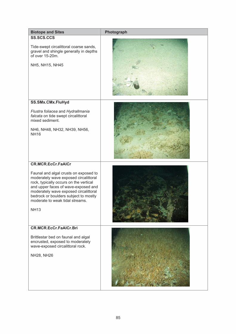
85
Biotope and Sites Photograph
SS.SCS.CCS Tide-swept circalittoral coarse sands,
gravel and shingle generally in depths
of over 15-20m.
NH5, NH15, NH45
SS.SMx.CMx.FluHyd Flustra foliacea and Hydrallmania falcata on tide swept circalittoral
mixed sediment�
NH6, NH48, NH32, NH39, NH56,
NH16
CR.MCR.EcCr.FaAlCr Faunal and algal crusts on exposed to
moderately wave exposed circalittoral
rock, typically occurs on the vertical
and upper faces of wave-exposed and
moderately wave exposed circalittoral
bedrock or boulders subject to mostly
moderate to weak tidal streams.
NH13
CR.MCR.EcCr.FaAlCr.Bri Brittlestar bed on faunal and algal
encrusted, exposed to moderately
wave-exposed circalittoral rock.
NH28, NH26
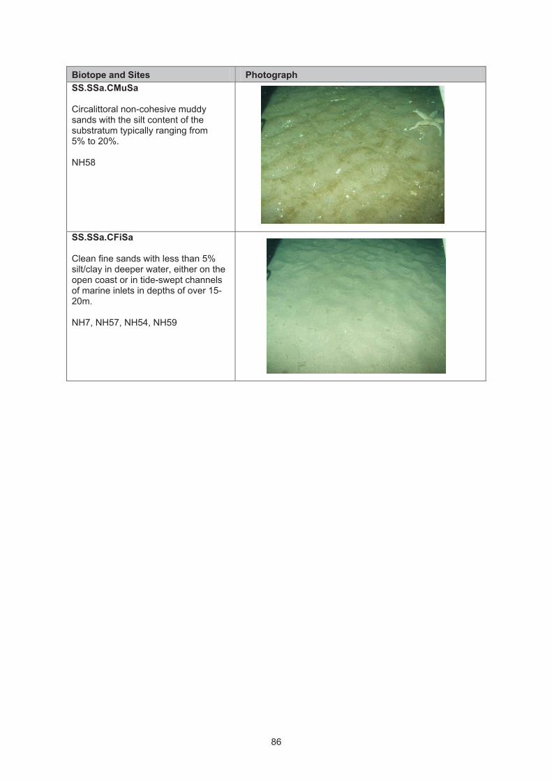
86
Biotope and Sites Photograph
SS.SSa.CMuSa Circalittoral non-cohesive muddy
sands with the silt content of the
substratum typically ranging from
5% to 20%.
NH58
SS.SSa.CFiSa Clean fine sands with less than 5%
silt/clay in deeper water, either on the
open coast or in tide-swept channels
of marine inlets in depths of over 15-
20m.
NH7, NH57, NH54, NH59

87
Appendix 7. Biotope photographic inventory and stations where biotopes were recorded. – Southern Trench
Biotope and Sites Photograph
SS.SSa
Sublittoral sands and muddy sands.
Clean medium to fine sands or non-
cohesive slightly muddy sands on
open coasts, offshore or in
estuaries and marine inlets.
ST64, ST26
SS.SMx.CMx Mixed (heterogeneous) sediment
habitats in the circalittoral zone
(generally below 15-20m) including
well mixed muddy gravelly sands or
very poorly sorted mosaics of shell,
cobbles and pebbles embedded in or
lying upon mud, sand or gravel.
ST43, ST65, ST41, ST29, ST23,
ST35, ST59, ST71, ST72, ST31,
ST46, ST13, ST4, ST42, ST14, ST30,
ST74, ST73B
SS.SCS.CCS Tide-swept circalittoral coarse sands,
gravel and shingle generally in depths
of over 15-20m.
ST34

88
Biotope and Sites Photograph
SS.SMx.CMx.FluHyd Flustra foliacea and Hydrallmania
falcata on tide swept circalittoral
mixed sediment�
ST36
SS.SMu.CFiMu.SpnMeg
Sea pens and burrowing mega fauna
in circalittoral fine mud.
ST52, ST37, ST8, ST1, ST22, ST19,
ST61, ST44, ST68, ST12, ST67, ST9,
ST16, ST18, ST21, ST66, ST67,
ST10, ST47, ST62, ST69, ST38,
ST70, ST56, ST32, ST33, ST24
SS.SMu.CFiMu
Sublittoral muds, occurring below
moderate depths of 15-20 m, either on
the open coast or in marine inlets
such as sea lochs. The sea pens
Virgularia mirabilis and Pennatula phosphorea are characteristic of this
biotope complex together with the
burrowing anemone Cerianthus lloydii and the ophiuroid
Amphiura spp.
ST52A, ST25, ST51, ST11, ST50,
ST15, ST45, ST27, ST39, ST57,
ST48, ST7, ST58, ST54, ST2, ST6,
ST53, ST20, ST49, ST73A
SS.SSa.CMuSa Circalittoral non-cohesive muddy
sands with the silt content of the
substratum typically ranging from
5% to 20%.
ST40, ST28, ST17, ST55, ST60
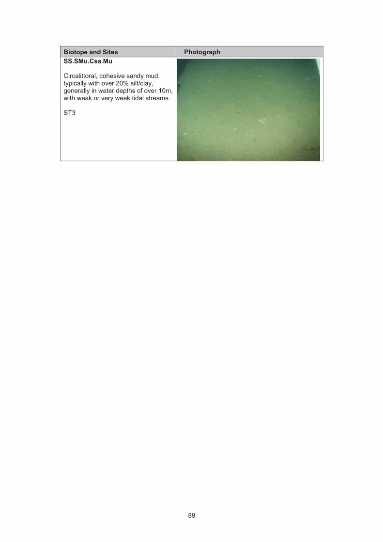
89
Biotope and Sites Photograph
SS.SMu.Csa.Mu
Circalittoral, cohesive sandy mud,
typically with over 20% silt/clay,
generally in water depths of over 10m,
with weak or very weak tidal streams.
ST3

90
Ap
pe
nd
ix 8
. G
rab
sa
mp
lin
g d
ata
sh
ee
t
Date
L
ocati
on
S
tati
on
T
ime
Infa
un
a/P
SA
Sed
imen
t T
yp
e
Sed
imen
t C
olo
ur
De
pth
of
RP
D
La
ye
r
De
pth
of
Sam
ple
T
extu
re/P
resen
ce
of
Su
rfac
e
featu
res
Ph
oto
gra
ph

91
Ap
pe
nd
ix 9
. N
os
s H
ea
d g
rab
sa
mp
lin
g f
ield
lo
g.
Date
L
oc
ati
on
S
tati
on
T
ime
Sam
ple
S
ed
imen
t ty
pe
S
ed
imen
t C
olo
ur
De
pth
of
RP
D
La
ye
r D
ep
th o
f sam
ple
T
extu
re/S
urf
ace
featu
res
Ph
oto
gra
ph
04/0
9/2
011
Noss H
ead
G01
15:0
5B
enth
ic
FA
ILE
D
n/a
n/a
n/a
n/a
F
ailed
04/0
9/2
011
Noss H
ead
G01
15:0
9B
enth
ic
FA
ILE
D
n/a
n/a
n/a
n/a
572
04/0
9/2
011
Noss H
ead
G01
15:1
4B
enth
ic
FA
ILE
D
n/a
n/a
n/a
n/a
F
ailed
04/0
9/2
011
Noss H
ead
G02
15:3
0B
enth
ic
FA
ILE
D
n/a
n/a
n/a
n/a
F
ailed
04/0
9/2
011
Noss H
ead
G02
15:3
4B
enth
ic
FA
ILE
D
n/a
n/a
n/a
n/a
576
04/0
9/2
011
Noss H
ead
G02
15:3
8B
enth
ic
FA
ILE
D
n/a
n/a
n/a
n/a
F
ailed
04/0
9/2
011
Noss H
ead
G02
15:4
0B
enth
ic
FA
ILE
D
n/a
n/a
n/a
n/a
577
04
/09
/201
1N
oss H
ead
G0
3
15
:50
Benth
ic/P
S
A
Gra
vel
Beig
e
n/a
3
578, 580
04/0
9/2
011
Noss H
ead
G03
15:5
8B
enth
ic
FA
ILE
D
n/a
n/a
n/a
n/a
579
04/0
9/2
011
Noss H
ead
G04
16:0
5B
enth
ic
MIS
SF
IRE
n/a
n/a
n/a
n/a
n/a
04/0
9/2
011
Noss H
ead
G04
16:0
7B
enth
ic
FA
ILE
D
n/a
n/a
n/a
n/a
n/a
04
/09
/201
1N
oss H
ead
G0
4
16
:10
Benth
ic/P
S
A
Gra
vel/S
hell
Beig
e
n/a
3
Shells o
n s
urf
ace
04/0
9/2
011
Noss H
ead
G04
16:1
6B
enth
ic
FA
ILE
D
n/a
n/a
n/a
n/a
n/a
04/0
9/2
011
Noss H
ead
G05
17:2
0B
enth
ic
FA
ILE
D
n/a
n/a
n/a
n/a
n/a
04/0
9/2
011
Noss H
ead
G05
17:2
6B
enth
ic
FA
ILE
D
n/a
n/a
n/a
n/a
n/a
04/0
9/2
011
Noss H
ead
G05
17:3
8B
enth
ic
FA
ILE
D
n/a
n/a
n/a
1 liv
e m
odio
lus
586,5
87
04/0
9/2
011
Noss H
ead
G05
17:4
0B
enth
ic
FA
ILE
D
n/a
n/a
n/a
n/a
n/a
04/0
9/2
011
Noss H
ead
G05
17:4
4B
enth
ic
FA
ILE
D
n/a
n/a
n/a
n/a
n/a
04
/09
/201
1N
oss H
ead
G0
6
17
:52
Benth
ic/P
S
A
Shell,
Gra
vel
Beig
e
n/a
8
Larg
e b
roken
sh
ells
58
8,5
89
04/0
9/2
011
Noss H
ead
G07
17:5
4B
enth
ic
FA
ILE
D
n/a
n/a
n/a
n/a
n/a

92
Date
L
oc
ati
on
S
tati
on
T
ime
Sam
ple
S
ed
imen
t ty
pe
S
ed
imen
t C
olo
ur
De
pth
of
RP
D
La
ye
r D
ep
th o
f sam
ple
T
extu
re/S
urf
ace
featu
res
Ph
oto
gra
ph
04
/09
/201
1N
oss H
ead
G0
7
18
:14
Be
nth
ic
Shell,
Gra
vel
Beig
e
n/a
2
Sponge, S
hell
596-5
98
04
/09
/201
1N
oss H
ead
G0
8
18
:25
Benth
ic/P
S
A
Shell,
Gra
vel
Beig
e
n/a
6
Sponge, S
hell
600,6
01
04/0
9/2
011
Noss H
ead
G09
18:3
5B
enth
ic
FA
ILE
D
n/a
n/a
n/a
n/a
n/a
04/0
9/2
011
Noss H
ead
G09
18:3
6B
enth
ic
FA
ILE
D
n/a
n/a
n/a
n/a
n/a
04/0
9/2
011
Noss H
ead
G09
18:4
0B
enth
ic
FA
ILE
D
n/a
n/a
n/a
n/a
n/a
05
/09
/201
1N
oss H
ead
G1
0
14
:38
Benth
ic/P
S
A
Sand
Beig
e
n/a
10cm
N
one
606, 609, 610
05
/09
/201
1N
oss H
ead
G1
1
14
:46
Benth
ic/P
S
A
Gra
vel and
shell
Beig
e
n/a
8cm
B
roken s
hell
611-6
14
05
/09
/201
1N
oss H
ead
G1
2
14
:57
Be
nth
ic
FA
ILE
D
n/a
n
/a
n/a
n
/a
n/a
05
/09
/201
1N
oss H
ead
G1
2
15
:00
Be
nth
ic
FA
ILE
D
n/a
n
/a
n/a
n
/a
n/a
05
/09
/201
1N
oss H
ead
G1
2
15
:03
Be
nth
ic
FA
ILE
D
n/a
n
/a
n/a
n
/a
n/a

93
Ap
pe
nd
ix 1
0.
So
uth
ern
Tre
nc
h G
rab
sa
mp
lin
g F
ield
lo
g.
Date
L
oc
ati
on
S
tati
on
T
ime
(bst)
S
am
ple
S
ed
imen
t ty
pe
S
ed
imen
t C
olo
ur
De
pth
of
RP
D L
aye
r D
ep
th o
f sam
ple
T
extu
re/S
urf
ace
featu
res
Ph
oto
gra
ph
06.0
9.1
1
South
ern
Tre
nch
G0
1
09
:25
Be
nth
ic
and P
SA
Muddy
Sand
Dark
Gre
y
n/a
7.5
n/a
615, 616
06.0
9.1
1
South
ern
Tre
nch
G0
2
10
:55
Be
nth
ic
and P
SA
Muddy
Sand
Dark
Gre
y
n/a
7.5
n/a
617,6
18
06.0
9.1
1
South
ern
Tre
nch
G0
3
15
:21
Be
nth
ic
and P
SA
M
ud
Da
rk
Gre
en/B
row
n
n/a
13.8
n/a
625-6
27
07.0
9.1
1
South
ern
Tre
nch
G0
4
13
:48
Be
nth
ic
and P
SA
Sandy
mud
Dark
bro
wn
27
.4n/a
631-6
33
08.0
9.1
1
South
ern
Tre
nch
G0
5
09
:52
Be
nth
ic
and P
SA
Gra
velly
sa
nd
Reddis
h
Bro
wn
n/a
9.5
n/a
634-6
36
08.0
9.1
1
South
ern
Tre
nch
G0
6
12
:32
Be
nth
ic
and P
SA
Sandy
mud
Dark
Bro
wn
n/a
5
Shell
n/a
08.0
9.1
1
South
ern
Tre
nch
G0
7
15
:45
Not
en
oug
h in
Gra
b
n/a
n/a
n/a
n/a
n/a
n/a
08.0
9.1
1
South
ern
Tre
nch
G0
7
16
:00
Be
nth
ic
and P
SA
Sandy
mud
Dark
bro
wn
n/a
6
Worm
tubes
645-6
47
08.0
9.1
1
South
ern
Tre
nch
G0
8
17
:32
MIS
SF
IRE
n/a
n
/a
n/a
n
/a
n/a
n
/a
08.0
9.1
1
South
ern
Tre
nch
G0
8
17
:37
Not
en
oug
h in
Gra
b
n/a
n/a
n/a
n/a
n/a
n/a

94
Date
L
oc
ati
on
S
tati
on
Tim
e
(bst)
Sam
ple
Sed
imen
t ty
pe
Sed
imen
t C
olo
ur
De
pth
of
RP
D L
aye
rD
ep
th o
f sam
ple
Textu
re/S
urf
ace
featu
res
Ph
oto
gra
ph
08.0
9.1
1
South
ern
Tre
nch
G0
8
17
:44
Be
nth
ic
and P
SA
Sandy
mud
Dark
bro
wn
n/a
6.5
n/a
n/a
09.0
9.1
1
South
ern
Tre
nch
G0
9
12
:47
Not
en
oug
h in
Gra
b
n/a
n/a
n/a
n/a
n/a
n/a
09.0
9.1
1
South
ern
Tre
nch
G0
9
13
:00
Be
nth
ic
and P
SA
Sandy
mud
Dark
bro
wn
n/a
7.5
n/a
653, 654
09.0
9.1
1
South
ern
Tre
nch
G1
0
15
:15
Be
nth
ic
and P
SA
M
ud
Gre
en
ish
Bro
wn
n/a
7.8
n/a
655-6
57
09.0
9.1
1
South
ern
Tre
nch
G1
1
16
:35
Be
nth
ic
and P
SA
M
ud
Dark
bro
wn
n/a
7.9
n/a
n/a
09.0
9.1
1
South
ern
Tre
nch
G1
2
19
:02
Sto
nes in
teeth
n/a
n/a
n/a
n/a
n/a
n/a
09.0
9.1
1
South
ern
Tre
nch
G1
2
19
:05
Be
nth
ic
and P
SA
S
and
Dark
bro
wn
n/a
6.8
n/a
n/a
10.0
9.1
1
South
ern
Tre
nch
G1
3
09
:50
Be
nth
ic
and P
SA
Gra
velly
sand
Dark
bro
wn
25
n/a
666-6
68
10.0
9.1
1
South
ern
Tre
nch
G1
4
10
:51
MIS
SF
IRE
n/a
n
/a
n/a
n
/a
n/a
n
/a
10.0
9.1
1
South
ern
Tre
nch
G1
4
10
:57
Be
nth
ic
and P
SA
M
ud
Da
rk
Gre
en/B
row
n
n/a
14.5
n/a
n/a
10.0
9.1
1
South
ern
Tre
nch
G1
5
12
:47
Be
nth
ic
and P
SA
M
ud
Da
rk
Gre
en/B
row
n
n/a
11
n/a
n/a

95
Date
L
oc
ati
on
S
tati
on
Tim
e
(bst)
Sam
ple
Sed
imen
t ty
pe
Sed
imen
t C
olo
ur
De
pth
of
RP
D L
aye
rD
ep
th o
f sam
ple
Textu
re/S
urf
ace
featu
res
Ph
oto
gra
ph
10.0
9.1
1
South
ern
Tre
nch
G1
6
14
:51
Be
nth
ic
and P
SA
M
ud
Da
rk
Gre
en/B
row
n
n/a
14
n/a
n/a
10.0
9.1
1
South
ern
Tre
nch
G1
7
17
:25
Be
nth
ic
and P
SA
Sandy
mud
Da
rk b
row
n
n/a
8
n/a
n/a
11.0
9.1
1
South
ern
Tre
nch
G1
8
10
:17
Be
nth
ic
and P
SA
M
ud
Gre
en
ish
Bro
wn
21
2n
/a
n/a
11.0
9.1
1
South
ern
Tre
nch
G1
9
13
:57
Be
nth
ic
and P
SA
Sandy
mud
Gre
en
ish
Bro
wn
27
n/a
n/a
11.0
9.1
1
South
ern
Tre
nch
G2
0
15
:55
Be
nth
ic
and P
SA
Sandy
mud
Da
rk b
row
n
27
.5n/a
n/a

96
Ap
pe
nd
ix 1
1.
Gra
b s
am
ple
in
fau
na
da
ta N
os
s H
ea
d a
nd
So
uth
ern
Tre
nc
h
MC
S
Co
de
S
pecie
s
NO
SS
HE
AD
S
OU
TH
ER
N T
RE
NC
H
3
4
6
7
8
10
11
1
2
3
45
6
7
8
9
10
11
12
13
14
15
16
17
18
19
2 0
A
Ast
rorh
iza
limic
ola
3
3
1
8
1
0
3
1
1
1
16
2
A
Pel
osin
a ar
bore
scen
s
2
1
D0632
Cer
iant
hus
lloyd
ii
4
1
6
1
1
2
2
2
D0766
Edw
ards
ia c
f.
clap
ared
ii
2
15
5
5
4
2
12
3
6
D618
Virg
ular
ia
mira
bilis
1
D623
Pen
natu
la
phos
phor
ea
2
D662
Act
inia
ria
inde
t.
1
1
D783
Car
yoph
yllia
sm
ithii
1
F
Flat
wor
m in
det
1
1
3
3
7
1
1
G001
Nem
eter
a in
det.
6
2
14
7
1
6
6
24
4
1
3
6
7
2
1
9
3
2
7
1
5
5
2
1
9
G0034
Tubu
lanu
s po
lym
orph
us
2
2
1
1
G0039
Cer
ebra
tulu
s sp
.
1
1
1
2
1
G007
Cep
halo
thric
idae
ind
et.
1
1
G059
M
icru
ra in
det.
1
G109
Oer
sted
ia
dors
alis
4
2
1
1
G117
Te
tras
tem
ma
sp
.
1
HD
N
emat
oda
24
3
0
78
4
4
18
8
2
1
1
1
L29
Spa
della
ce
phal
opte
ra
2
5
N01
Sip
uncu
la
inde
t. 1
2
2
3
1
1
1
1
N14
Gol
fingi
a el
onga
ta
1

97
MC
S
Co
de
S
pecie
s
NO
SS
HE
AD
S
OU
TH
ER
N T
RE
NC
H
3
4
6
7
8
10
11
1
2
3
45
6
7
8
9
10
11
12
13
14
15
16
17
18
19
2 0
N17
Gol
fingi
a vu
lgar
is
1
2
N25
Nep
haso
ma
min
utum
1
7
5
2
1
N28
Thys
anoc
ardi
a pr
ocer
a
1
N34
Pha
scol
ion
stro
mbu
s
1
1
1
1
P0
00
6
Chr
ysop
etal
um
1
2
P0
00
9
Dys
pone
tus
1
2
1
P0
01
5
Pis
ione
re
mot
a
1
7
3
1
3
P0
02
5
Po
lyn
oid
in
de
t. 3
7
1
3
15
4
8
14
7
4
1
6
P0
02
7
Aca
nthi
cole
pis
aspe
rrim
a fr
a
g.
P0
03
2
Ady
te
pellu
cida
1
1
1
P0
04
4
Eni
po
kinb
ergi
fra
g.
P0
04
9
Gat
tyan
a ci
rros
a
1
1
1
P0
05
0
Mal
mgr
enia
in
det.
6
1
1
1
P0
05
9
Har
mot
hoe
fragi
lis
fra
g.
fr
ag
.
P0
06
6
Mal
mgr
enia
lju
ngm
anni
3
4
P0
06
8
Mal
mgr
enia
m
arph
ysae
1
P0
07
0
Mal
mgr
enia
m
cint
oshi
1
4
4
3
P0
08
2
Lepi
dono
tus
squa
mat
us
2
1
P0
09
2
Pho
loe
balti
ca
1
2
1
2
5
1
1
1
0
1
6
1
9
3
1
2
3
P0
09
3
Pho
loe
pal
lida
2
1
3
1
2
P0
09
4
Pho
loe
inor
nata
1
1
P0
10
9
Sth
enel
ais
limic
ola
1
1
1
1
1
1

98
MC
S
Co
de
S
pecie
s
NO
SS
HE
AD
S
OU
TH
ER
N T
RE
NC
H
3
4
6
7
8
10
11
1
2
3
45
6
7
8
9
10
11
12
13
14
15
16
17
18
19
2 0
P0
11
4
Phy
llodo
cida
e 2
1
P0
11
8
Ete
one
long
a
1
P0
12
2
Hes
ionu
ra
elon
gata
4
3
P0
13
0
Mys
tides
ca
eca
1
3
3
1
5
P0
13
6
Pse
udom
ytid
es
limba
ta
4
1
P0
14
6
Phy
llodo
ce
rose
a
1
1
P0
15
5
Eul
alia
m
uste
la
1
1
4
1
2
P0
16
1
Eul
alia
viri
dis
1
P0
16
3
Eum
ida
sp
. in
det
2
3
1
3
5
3
3
P0
16
5
Eum
ida
ocke
lman
ni
2
P0
16
7
Eum
ida
sang
uine
a 6
3
2
1
P0
17
1
Ner
eiph
ylla
ru
bigi
nosa
1
1
P0
19
5
Lacy
doni
a m
irand
a 1
1
1
3
6
12
P0
25
5
Gly
cera
juv.
in
det.
1
P0
25
6
Gly
cera
alb
a
1
1
3
P0
26
0
Gly
cera
la
pidu
m
5
12
1
7
7
3
3
5
1
1
5
4
6
P0
26
2
Gly
cera
ox
ycep
hala
1
P0
26
3
Gly
cera
roux
ii
2
2
2
2
2
4
2
1
1
2
P0
26
8
Gly
cind
e no
rdm
anni
1
2
2
2
1
1
P0
27
1
Gon
iada
m
acul
ata
2
1
1
1
3
1
4
P0
28
2
Eph
esie
lla
abys
soru
m
1
3
P0
28
5
Sph
aero
doro
psi
s in
det.
1

99
MC
S
Co
de
S
pecie
s
NO
SS
HE
AD
S
OU
TH
ER
N T
RE
NC
H
3
4
6
7
8
10
11
1
2
3
45
6
7
8
9
10
11
12
13
14
15
16
17
18
19
2 0
P0
29
1
Sph
aero
doru
m g
raci
lis
1
2
1
8
P0
29
4
Hes
ioni
dae
juv.
inde
t. 1
4
3
6
P0
30
0
Gyp
tis
prop
inqu
a 8
7
2
29
67
2
P0
30
3
Hes
iosp
ina
sim
ilis
3
11
5
5
8
P0
30
5
Kef
erst
eini
a ci
rrat
a 7
2
7
18
1
1
3
P0
31
1
Ner
eim
yra
punc
tata
1
3
2
2
9
1
3
P0
31
3
Oph
iodr
omus
fle
xuos
us
1
P0
31
7
Pod
arke
pa
llida
1
P0
31
9
Pod
arke
opsi
s ca
pens
is
1
P0
34
0
Gly
phoh
esio
ne
klat
ti
1
1
P0
34
9
Syl
lis c
ornu
ta
4
4
4
1
4
1
P0
35
5
Eur
ysyl
lis
tube
rcul
ata
7
1
1
6
17
P0
35
8
Syl
lis in
det.
1
1
1
P0
35
8
Syl
lis s
p. E
1
2
3
8
P0
35
8
Syl
lis s
p. H
1
5
1
8
1
P0
36
2
Tryp
anos
yllis
co
elia
ca
7
6
21
21
34
P0
36
5
Syl
lis
arm
illar
is
2
31
2
P0
37
1
Syl
lis
varie
gata
1
P0
37
5
Am
blyo
sylli
s fo
rmos
a 2
1
2
P0
37
7
Dio
plos
yllis
ci
rros
a
2
2
P0
37
9
Eus
yllis
as
sim
ilis
1
4
1
1
5
P0
38
0
Eus
yllis
bl
omst
rand
i 4
4
16
6
1
2

10
0
MC
S
Co
de
S
pecie
s
NO
SS
HE
AD
S
OU
TH
ER
N T
RE
NC
H
3
4
6
7
8
10
11
1
2
3
45
6
7
8
9
10
11
12
13
14
15
16
17
18
19
2 0
P0
38
7
Odo
ntos
yllis
fu
lgur
ans
4
2
8
1
P0
38
8
Odo
ntos
yllis
gi
bba
61
2
7
49
32
35
P0
39
1
Opi
stho
dont
a pt
eroc
haet
a
3
1
9
P0
40
3
Stre
ptos
yllis
bi
dent
ata
1
1
2
P0
40
6
Syl
lides
cf.
japo
nica
1
5
1
2
2
1
P0
42
1
Exo
gone
he
bes
1
1
4
1
1
1
2
P0
42
2
Exo
gone
na
idin
a
3
4
2
1
2
2
1
1
6
P0
42
3
Exo
gone
ve
ruge
ra
2
3
3
1
1
1 3
P0
42
5
Sph
aero
sylli
s bu
lbos
a 2
4
47
1
12
33
20
1
1
P0
42
6
Sph
aero
sylli
s er
inac
eus
1
P0
43
0
Sph
aero
sylli
s ta
ylor
i 1
2
13
4
2
P0
43
1
Sph
aero
sylli
s te
tralix
1
1
1
2
1
29
P0
43
4
Aut
olyt
us in
det
5
5
5
4
4
4
2
P0
43
5
Aut
olyt
us
alex
andr
i 1
5
3
2
P0
45
8
Ner
eidi
dae
juv.
inde
t
1
P0
45
8
Rul
lierin
erei
s sp
. A
1
P0
47
4
Ner
eis
elito
ralis
1
1
1
P0
47
6
Ner
eis
pela
gica
1
1
0
1
P0
47
8
Ner
eis
zona
ta
3
P0
49
3
Agl
aoph
amus
ru
bella
1
2
1
P0
49
4
Nep
htys
juv.
in
det.
1
3

10
1
MC
S
Co
de
S
pecie
s
NO
SS
HE
AD
S
OU
TH
ER
N T
RE
NC
H
3
4
6
7
8
10
11
1
2
3
45
6
7
8
9
10
11
12
13
14
15
16
17
18
19
2 0
P0
49
6
Nep
htys
ca
eca
1
P0
49
8
Nep
htys
ci
rros
a
3
1
1
P0
49
9
Nep
htys
ho
mbe
rgii
1
1
2
1
2
1
3
P0
50
2
Nep
htys
ke
rsiv
alen
sis
1
1
1
3
1
3
P0
50
3
Nep
htys
lo
ngos
etos
a
1
P0
52
6
Eup
hros
ine
bore
alis
7
P0
54
2
Hya
linoe
cia
tubi
cola
1
P0
54
4
Not
hria
br
itann
ica
1
1
P0
57
7
Lum
brin
eris
fra
gilis
1
2
1
P0
57
9
Lum
brin
eris
gr
acili
s
1
1
6
1 0
6
4
2
2
1
1
21
1
17
1
1
1 7
P0
58
0
Lum
brin
eris
hi
bern
ica
4
3
3
P0
59
1
Dril
oner
eis
filum
fra
g.
P0
59
7
Not
ocirr
us
scot
icus
1
P0
61
3
Oph
ryot
roch
a in
det.
1
P0
63
8
Pro
todo
rvill
ea
kefe
rste
ini
14
P0
66
5
Orb
inia
se
rtula
ta
1
1
P0
67
2
Sco
lopl
os
arm
iger
14
1
2
1
1
3
1
1
2
1
1
6
P0
68
4
Aric
idea
ca
ther
inae
1
P0
68
5
Aric
idea
ce
rrut
ii
6
1
1
P0
68
6
Ari
cide
a la
ubie
ri
1
2
P0
69
0
Cirr
opho
rus
bran
chia
tus
1

10
2
MC
S
Co
de
S
pecie
s
NO
SS
HE
AD
S
OU
TH
ER
N T
RE
NC
H
3
4
6
7
8
10
11
1
2
3
45
6
7
8
9
10
11
12
13
14
15
16
17
18
19
2 0
P0
69
9
Par
adon
eis
lyra
1
5
1
1
4
4
P0
71
2
Api
stob
ranc
hus
tullb
ergi
1
1
P0
71
8
Poe
cilo
chae
tus
serp
ens
1
1
2
1
P0
72
0
Spi
onid
ae
inde
t.
2
1
P0
72
3
Aon
ides
pa
ucib
ranc
hiat
a
4
11
1
1
2
1
1
1
2
1
P0
73
3
Laon
ice
bahu
sien
sis
2
3
1
2
1
1
2
4
1
4
1
P0
74
7
Min
uspi
o ci
rrife
ra
4
4
2
3
2
1
4
2
2
2
4
1
P0
74
8
Pol
ydor
a in
det.
1
8
1
1
1
2
1
P0
75
1
Pol
ydor
a ca
ulle
ryi
1
P0
76
2
Pol
ydor
a so
cial
is
2
P0
76
4
Prio
nosp
io
dubi
a
1
2
5
2
1
7
1
15
4
P0
76
5
Prio
nosp
io
falla
x
6
1
1
2
1
3
P0
76
6
Prio
nosi
o ba
nyul
ensi
s 1
2
6
12
2
34
21
1
2
P0
77
3
Pse
udop
olyd
ora
pa
ucib
ranc
hiat
a
4
1
1
1
1
1
1
1
P0
77
4
Pse
udop
olyd
ora
pul
chra
1
P0
77
9
Sco
lele
pis
bonn
ieri
1
P0
78
4
Sco
lele
pis
sp.
A
1
P0
78
4
Sco
lele
pis
sp. B
5
P0
78
8
Spi
o ar
mat
a
3
P0
79
4
Spi
opha
nes
bom
byx
8
5
3
1
1
1
1

10
3
MC
S
Co
de
S
pecie
s
NO
SS
HE
AD
S
OU
TH
ER
N T
RE
NC
H
3
4
6
7
8
10
11
1
2
3
45
6
7
8
9
10
11
12
13
14
15
16
17
18
19
2 0
P0
79
6
Spi
opha
nes
kroy
eri
5
2
8
4
4
1
2
2
2
1
5
4
6
1
3
P0
80
4
Mag
elon
a al
leni
3
1
1
5
1
1
P0
81
1
Cha
etop
teru
s sp
.
1
1
1
1
P0
82
2
Cirr
atul
idae
in
det.
1
2
P0
82
3
Aph
eloc
haet
a sp
. A
1
1
P0
83
2
Cha
etoz
one
chris
tiei
1
P0
83
4
Cha
etoz
one
seto
sa
5
1
5
1
2
3
1
1
2
1
1
P0
83
5
Cirr
atul
us s
p.
1
P0
84
0
Dod
ecac
eria
sp
.
1
P0
84
6
Thar
yx
killa
riens
is
1
1
1
2
1
2
P0
87
8
Dip
loci
rrus
gl
aucu
s
2
1
8
1
2
1
14
2
4
7
2
2
2
1
6
P0
88
1
Flab
ellig
era
affin
is
1
1
1
1
P0
89
0
Mac
roch
aeta
sp
.
1
5
3
14
1
P0
89
1
Mac
roch
aeta
cl
avic
orni
s
3
1
P0
90
7
Cap
itella
ca
pita
ta
2
P0
91
9
Med
iom
astu
s fra
gilis
1
2
5
4
4
1
1
7
1
4
P0
92
0
Not
omas
tus
sp.
2
3
3
1
1
2
1
1
P0
92
5
Per
esie
lla
clym
enoi
des
1
1
2
3
3
1
1
3
4
5
P0
92
7
Pse
udon
otom
astu
s so
uthe
rni
2
1
P0
93
8
Mal
dani
dae
inde
t.
1
P0
94
4
Pra
xillu
ra
long
issi
ma
1
1

10
4
MC
S
Co
de
S
pecie
s
NO
SS
HE
AD
S
OU
TH
ER
N T
RE
NC
H
3
4
6
7
8
10
11
1
2
3
45
6
7
8
9
10
11
12
13
14
15
16
17
18
19
2 0
P0
95
5
Cly
men
ura
inde
t.
1
1
P0
95
5
Cly
men
ura
trici
rrat
a
2
2
2
1
2
2
3
1
1
P0
96
0
Euc
lym
ene
inde
t.
2
1
1
P0
96
0
Euc
lym
ene
sp.
A
5
P0
97
1
Pra
xille
lla
affin
is
1
6
6
3
P0
97
2
Pra
xille
lla
grac
ilis
3
P0
98
2
Nic
omac
he
trisp
inat
a
3
P0
98
4
Not
opro
ctus
sp
. 2
4
3
1
2
9
P0
99
0
Rho
dine
gr
acili
or
fra
g.
1
1
1
P0
99
9
Oph
elia
bo
real
is
1
1
P1
01
4
Oph
elin
a ac
umin
ata
2
1
2
P1
02
0
Sca
libre
gmat
ida
e sp
. 1
1
P1
02
6
Sca
libre
gma
celti
cum
4
1
1
P1
02
7
Sca
libre
gma
infla
tum
1
2
1
1
3
16
2
1
8
1
1
2
P1
03
1
Ner
illid
ae
inde
t.
1
P1
06
2
Pol
ygor
dius
in
det.
2
2
7
1
1
P1
06
9
Pro
todi
lus
inde
t.
3
P1
08
3
Pro
todr
iloid
es
chae
tifer
1
P1
08
8
Sac
coci
rrus
pa
pillo
cerc
us
2
P1
09
3
Gal
atho
wen
ia
ocul
ata
6
7
2
1
32
13
27
6
8
55
1
3
79
4
21
5
76
P1
09
4
Myr
ioch
ele
sp.
13

10
5
MC
S
Co
de
S
pecie
s
NO
SS
HE
AD
S
OU
TH
ER
N T
RE
NC
H
3
4
6
7
8
10
11
1
2
3
45
6
7
8
9
10
11
12
13
14
15
16
17
18
19
2 0
P1
09
5
Myr
ioch
ele
dani
elss
eni
13
4
1
1
1
1
P1
09
8
Ow
enia
fu
sifo
rmis
17
4
1 42
1
2
14
7
4
1
6
4
9
4
4
P1
10
2
Am
phic
tene
au
ricom
a
2
3
P1
10
7
Lagi
s ko
reni
10
2
2
1
2
1
5
P1
11
7
Sab
ella
ria
spin
ulos
a
19 8
4
1
2
P1
11
8
Am
phar
etid
ae
inde
t.
2
5
P1
13
4
Am
phar
ete
balti
ca
5
P1
13
5
Am
phar
ete
falc
ata
1
2
1
4
3
6
2
11
1
9
6
P1
13
9
Am
phar
ete
linds
troem
i
4
1
6
4
1
2
3
4
P1
14
2
Am
phic
teis
gu
nner
i
1
1
1
1
P1
14
7
Ano
both
rus
grac
ilis
1
2
2
1
1
1
2
7
3
1
2
6
7
1
7
4
P1
16
0
Sab
ellid
es
octo
cirr
ata
1
1
1
1
P1
17
3
Oct
obra
nchu
s flo
ricep
s
1
P1
17
5
Tere
belli
des
stro
emi
1
2
6
1
8
4
5
3
P1
17
7
Tric
hobr
anch
us
glac
ialis
1
4
1
5
3
4
1
P1
17
9
Tere
belli
dae
inde
t.
2
1
1
1
4
1
P1
19
0
Eup
olym
nia
nesi
dens
is
4
9
1
3
P1
19
5
Lani
ce
conc
hile
ga
3
1
1
1
1
1
1
1
P1
21
7
Pis
ta c
rista
ta
1
P1
22
9
Am
aean
a tri
loba
ta
1
P1
23
3
Lysi
lla lo
veni
2
1
2
1
1
P1
23
4
Lysi
lla n
ivea
3
2
1

10
6
MC
S
Co
de
S
pecie
s
NO
SS
HE
AD
S
OU
TH
ER
N T
RE
NC
H
3
4
6
7
8
10
11
1
2
3
45
6
7
8
9
10
11
12
13
14
15
16
17
18
19
2 0
P1
23
5
Pol
ycirr
us
inde
t.
4
6
8
P1
24
2
Pol
ycirr
us
med
usa
11
3
2
P1
24
3
Pol
ycirr
us
norv
egic
us
3
2
1
1
P1
24
4
Pol
ycirr
us
plum
osus
2
P1
24
9
Par
athe
lepu
s co
llaris
5
P1
25
4
Thel
epus
ci
ncin
natu
s
1
5
P1
25
7
Sab
ellid
ae ju
v.
inde
t. 9
10
6
7
25
P1
26
7
Cho
ne d
uner
i
2
1
4
P1
26
9
Cho
ne
filic
auda
ta
5
11
1
1
9
36
P1
27
1
Dem
onax
sp.
1
P1
28
0
Euc
hone
ru
broc
inct
a
3
P1
28
1
Euc
hone
so
uthe
rni
2
1
1
4
3
3
P1
28
2
Fabr
icia
sp.
1
1
P1
28
9
Jasm
inei
ra
caud
ata
1
P1
29
0
Jasm
inei
ra
eleg
ans
1
2
1
P1
31
6
Pse
udop
otam
illa
reni
form
is
1
1
P1
31
8
Sab
ella
di
scife
ra
1
P1
32
0
Sab
ella
pa
voni
na
1
1
P1
32
7
Chi
tinop
oma
serr
ula
1
P1
33
4
Hyd
roid
es
norv
egic
a 3
2
2
1
3
P1
34
1
Pom
atoc
eros
tri
quet
er
1
3
1
4
10
6
1
8
10
7
MC
S
Co
de
S
pecie
s
NO
SS
HE
AD
S
OU
TH
ER
N T
RE
NC
H
3
4
6
7
8
10
11
1
2
3
45
6
7
8
9
10
11
12
13
14
15
16
17
18
19
2 0
P1
34
3
Ser
pula
ve
rmic
ular
is
1
1
1
4
1
16
2
P1
50
1
Enc
hytra
eida
e in
det.
1
1
0
1
6
Q33
Cal
lipal
lene
br
eviro
stris
3
3
1
1
Q44
Ano
plod
acty
lus
petio
latu
s
1
Q56
H
alac
arid
ae
6
1
5
7
R0022
Sca
lpel
lum
sc
alpe
llum
1
R0041
Ver
ucca
st
roem
ia
3
10
8
R0785
H
arpa
ctic
oida
1
3
5
4
1
8
R2412
O
stra
coda
4
2
2
1
7
S0
09
2
Het
erom
ysis
fo
rmos
a
1
1
S0
09
8
Gam
mar
idea
in
det.
1
1
6
2
1
1
1
1
2
S0
10
2
Aph
erus
a bi
spin
osa
1
1
2
S0
12
4
Mon
ocul
odes
bo
real
is
2
S0
13
1
Per
iocu
lode
s lo
ngim
anus
1
S0
13
8
Syn
chel
idiu
m
mac
ulat
um
1
1
1
S0
14
0
Wes
twoo
dilla
ca
ecul
a
3
1
1
1
1
S0
15
6
Am
philo
cus
inde
t.
1
1
S0
15
8
Am
philo
chus
m
anud
ens
10
24
S0
16
4
Gita
na s
arsi
3
S0
17
7
Leuc
otho
e in
cisa
1
1
S0
17
8
Leuc
otho
e lil
jebo
rgi
1
S0
18
0
Leuc
otho
e sp
inic
arpa
7

10
8
MC
S
Co
de
S
pecie
s
NO
SS
HE
AD
S
OU
TH
ER
N T
RE
NC
H
3
4
6
7
8
10
11
1
2
3
45
6
7
8
9
10
11
12
13
14
15
16
17
18
19
2 0
S0
18
6
Cre
ssa
dubi
a
1
5
S0
20
7
Ste
noth
oe s
p.
2
1
2
S0
21
3
Ste
noth
oe
mar
ina
1
1
S0
24
8
Uro
thoe
el
egan
s
1
1
2
7
1
1
1
1
1
1
1
1
1
2 1
S0
25
4
Har
pini
a an
tenn
aria
2
2
1
1
1
2
S0
25
5
Har
pini
a cr
enul
ata
1
S0
26
5
Par
amet
apho
xus
fulto
ni
2
3
1
5
6
S0
27
1
Lysi
anas
sida
e 1
1
1
1
S0
27
4
Aci
doto
mum
no
dife
ra
2
1
1
S0
29
6
Hip
pom
edon
de
ntic
ulat
us
1
1
2
1
1
S0
30
1
Lepi
depe
creu
m lo
ngic
orne
1
1
S0
30
5
Lysi
anas
sa
plum
osa
1
S0
35
1
Aus
trosy
rrho
e fim
bria
tus
1
1
1
2
5
S0
36
0
Arg
issa
ha
mat
ipes
1
S0
38
2
Iphi
med
ia
obes
a
4
S0
38
4
Iphi
med
ia
spat
ula
1
1
S0
39
6
Lilje
borg
ia
kina
hani
1
1
1
3
1
3
S0
39
9
List
riella
mol
lis
3
S0
40
6
Nic
ippe
tu
mid
a
3
S0
41
3
Aty
lus
vedl
omen
sis
5
3
2
3
3
1
1
3
2
S0
41
8
Gue
rnea
co
alita
1
4
2
S0
41
9
Trite
ata
sp.
1

10
9
MC
S
Co
de
S
pecie
s
NO
SS
HE
AD
S
OU
TH
ER
N T
RE
NC
H
3
4
6
7
8
10
11
1
2
3
45
6
7
8
9
10
11
12
13
14
15
16
17
18
19
2 0
S0
42
3
Am
pelis
ca
inde
t.
1
1
2
S0
42
7
Am
pelis
ca
brev
icor
nis
1
1
2
S0
43
8
Am
pelis
ca
spin
ipes
3
S0
44
0
Am
pelis
ca
tenu
icor
nis
1
1
1
2
1
1
1
1
2 2
S0
44
2
Am
pelis
ca
typi
ca
3
1
S0
49
3
Mel
phid
ipie
lla
mac
ra
1
S0
50
2
Cer
adoc
us
sem
iser
ratu
s 1
1
1
3
6
S0
50
3
Che
irocr
atus
in
det.
2
1
1
2
S0
51
8
Mae
ra lo
veni
3
S0
51
9
Mae
ra o
thon
is
1
1
4
1
4
S0
53
7
Isae
idae
inde
t.
8
1
S0
53
9
Gam
mar
opsi
s co
rnut
a 3
2
1
S0
54
1
Gam
mar
opsi
s m
acul
ata
2
0
2
1
S0
54
2
Gam
mar
opsi
s ni
tida
1
S0
54
3
Gam
mar
opsi
s pa
lmat
a
3
S0
55
0
Mic
ropr
otop
us
mac
ulat
us
1
S0
55
2
Pho
tis
long
icau
data
3
2
2
3
9
S0
56
1
Eric
htho
nius
in
det.
1
S0
58
3
Aut
onoe
lo
ngip
es
1
1
1
S0
58
8
Lept
oche
irus
hirs
utim
anus
3
1
2
S0
58
9
Lept
oche
irus
pect
inat
us
4
7
2
S0
61
8
Sip
hono
ecet
es
kroy
eran
us
5

11
0
MC
S
Co
de
S
pecie
s
NO
SS
HE
AD
S
OU
TH
ER
N T
RE
NC
H
3
4
6
7
8
10
11
1
2
3
45
6
7
8
9
10
11
12
13
14
15
16
17
18
19
2 0
S0
62
9
Dyo
pedo
s po
rrec
tus
2
1
1
S0
64
6
Cap
rella
lin
earis
55
2
S0
65
1
Par
iam
bus
typi
cus
3
S0
65
7
Pht
isic
a m
arin
a
2
1
1
S0
65
9
Pse
udop
rote
lla
phas
ma
6
1
S0
79
6
Gna
thia
ox
yura
ea
11
3
1
3
6
6
1
4
5
2
S0
85
3
Eur
ydic
e in
erm
is
3
23
2
1
3
11
S0
89
2
Jani
ra
mac
ulos
a 9
1
6
7
2
S0
89
6
Mic
roch
aron
ha
rris
i
19
2
S0
91
1
Par
amun
na
bilo
bata
4
S0
92
5
Eur
ycop
e sp
. 2
S0
95
1
Arc
ture
lla
dila
tata
1
1
S1
11
8
Ara
phur
a br
evim
ana
1
S1
13
2
Lept
ogna
thia
br
evire
mis
1
1
14
3
12
13
S1
13
5
Lept
ogna
thia
pa
ram
anca
1
S1
14
0
Pse
udop
arat
ana
is b
atei
1
S1
14
2
Tana
opsi
s gr
acili
s
11
1
S1
20
6
Eud
orel
la
emar
gina
ta
1
2
S1
20
8
Eud
orel
la
trunc
atul
a
1
1
1
1
1
S1
22
4
Cum
ella
py
gmae
a
2
S1
22
8
Nan
nast
acus
un
guic
ulat
us
1
1
S1
24
4
Dia
styl
idae
in
det.
1
1

11
1
MC
S
Co
de
S
pecie
s
NO
SS
HE
AD
S
OU
TH
ER
N T
RE
NC
H
3
4
6
7
8
10
11
1
2
3
45
6
7
8
9
10
11
12
13
14
15
16
17
18
19
2 0
S1
25
1
Dia
styl
is la
evis
6
4
2
S1
25
5
Dia
styl
is
tum
ida
1
1
1
S1
25
7
Dia
styl
oide
s bi
plic
ata
2
4
3
2
1
1
1
2
S1
27
6
Dec
apod
a ju
v.
inde
t.
3
1
S1
27
6
Dec
apod
a in
det.
1
S1
33
7
Car
idio
n in
det.
1
S1
34
5
Eua
lus
pusi
olus
8
2
19
3
1
1
S1
36
7
Pro
cess
a no
uvel
i
1
1
2
S1
37
4
Pan
dalin
a br
eviro
stris
2
S1
38
8
Phi
loce
ras
fasc
iatu
s
1
S1
40
9
Cal
ocar
is
mac
andr
eae
1
S1
41
5
Cal
liana
ssa
subt
erra
nea
1
2
1
1
1
1
2
1
2
S1
41
9
Upo
gebi
a de
ltaur
a
4
S1
44
5
Pag
urid
ae
inde
t.
2
S1
44
8
Ana
pagu
rus
hynd
man
ni
2
S1
44
9
Ana
pagu
rus
laev
is
1
3
1
S1
46
0
Pag
urus
cu
anen
sis
1
S1
46
3
Pag
urus
pu
besc
ens
2
S1
47
0
Gal
athe
a sp
.
3
1
S1
47
2
Gal
athe
a in
term
edia
1
2
5
1
1
9
1
S1
47
4
Gal
athe
a ne
xa
3
1
S1
47
8
Mun
ida
rugo
sa
1

11
2
MC
S
Co
de
S
pecie
s
NO
SS
HE
AD
S
OU
TH
ER
N T
RE
NC
H
3
4
6
7
8
10
11
1
2
3
45
6
7
8
9
10
11
12
13
14
15
16
17
18
19
20
S1
48
2
Pis
idia
lo
ngic
orni
s
10
1
S1
51
8
Hya
s ar
aneu
s
2
S1
52
0
Inac
hina
e in
det.
2
S1
53
1
Mac
ropo
dia
linar
esi
1
S1
55
5
Ate
lecy
clus
ro
tund
atus
1
1
1
S1
57
7
Lioc
arci
nus
inde
t.
1
S1
60
6
Gon
epla
x rh
ombo
ides
1
W0
00
6
Scu
topu
s ve
ntro
linea
tus
1
2
2
W0
00
9
Cha
etod
erm
a ni
tidul
um
1
1
1
1
1
2
1
W0
03
0
Neo
men
ia
carin
ata
1
W0
05
3
Lept
ochi
ton
asel
lus
2
1
6
3
5
1
1
11
W0
16
1
Gib
bula
tu
mid
a 3
4
1
0
W0
17
2
Juju
binu
s m
iliar
is
1
W0
18
1
Cal
liost
oma
form
osum
1
W0
20
4
Dis
kole
ps
pusi
lla
1
6
W0
27
0
Turr
itella
co
mm
unis
1
1
W0
34
4
Alv
ania
pu
nctu
ra
2
W0
36
8
Ono
ba
acul
eus
2
W0
41
8
Cae
cum
gl
abru
m
5
13
W0
43
0
Apo
rrha
is
pesp
elec
ani
1
W0
46
5
Era
to v
olut
a
1
W0
47
6
Vel
utin
a sp
.
1

11
3
MC
S
Co
de
S
pecie
s
NO
SS
HE
AD
S
OU
TH
ER
N T
RE
NC
H
3
4
6
7
8
10
11
1
2
3
45
6
7
8
9
10
11
12
13
14
15
16
17
18
19
20
W0
48
9
Pol
inic
es
fusc
us
1
W0
49
0
Pol
inic
es
mon
tagu
i
1
1
2
2
1
1
4
W0
49
1
Pol
inic
es
pulc
hellu
s
2
1
1
1
1
1
1
1
1
W0
60
3
Eul
ima
bilin
eata
1
W0
66
9
Vitr
eolin
a ph
ilipp
i
1
W0
71
5
Col
us g
raci
lis
1
W0
79
5
Man
gelia
ju
v.in
det.
1
W0
90
8
Odo
stom
ia
inde
t.
1
W0
92
2
Bra
chys
tom
ia
eulim
oide
s
1
W0
93
1
Chr
ysal
lida
sp.
1
W0
98
5
Turb
onill
a cr
enat
a
1
W1
00
2
Cep
hala
spid
ea
inde
t.
1
W1
02
3
Rox
ania
ut
ricul
us
1
1
W1
02
8
Cyl
ichn
a cy
lindr
acea
1
2
1
1
1
1
1
1
2
1
W1
04
5
Phi
line
scab
ra
1
1
1
W1
07
7
Ret
usa
obtu
sa
1
W1
24
3
Nud
ibra
nchi
a in
det.
6
7
4
1
2
1
4
2
W1
51
4
Pul
sellu
m
affin
e
3
1
W1
51
9
Ant
alis
ant
alis
6
5
2
1
3
5
3
2
2
2
1
5
5
2
W1
56
9
Nuc
ula
nitid
osa
1
1
1
1
1
W1
57
1
Nuc
ula
sulc
ata
2
W1
68
8
Gly
cym
eris
gl
ycym
eris
4
3
2
W1
69
5
Myt
ilus
edul
is
9

11
4
MC
S
Co
de
S
pecie
s
NO
SS
HE
AD
S
OU
TH
ER
N T
RE
NC
H
3
4
6
7
8
10
11
1
2
3
45
6
7
8
9
10
11
12
13
14
15
16
17
18
19
20
W1
70
2
Mod
iolu
s m
odio
lus
8
10
3
2
1
1
1
6
1
W1
71
5
Cre
nella
de
cuss
ata
1
7
W1
74
3
Lim
aria
lo
scom
bi
2
1
W1
74
6
Lim
atul
a su
baur
icul
ata
1
4
2
1
W1
76
8
Pec
tinid
ae ju
v.
1
1
1
W1
77
1
Pec
ten
max
imus
1
W1
78
6
Pal
liolu
m
tiger
inum
1
1
1
W1
80
5
Ano
miid
ae
4
1
2
4
2
2
W1
82
7
Myr
tea
spin
ifera
1
1
1
2
W1
82
9
Luci
nom
a bo
real
is
1
1
1
W1
83
7
Thya
sira
fle
xuos
a
3
3
1
1
1
1
5
W1
86
6
Gal
eom
mat
acea
inde
t.
2
1
W1
87
5
Kel
lia
subo
rbic
ulat
a
1
W1
89
2
Mon
tacu
ta
subs
triat
a
1
W1
90
2
Telli
mya
fe
rrug
inos
a
2
1
1
W1
90
6
Mys
ella
bi
dent
ata
1
1
4
1
0
W1
92
5
Ast
arte
su
lcat
a 1
2
W1
92
9
Goo
dalli
a tri
angu
laris
6
10
1
1
38
W1
93
6
Goo
dalli
a m
onta
gui
1
2
1
W1
94
3
Aca
ntho
card
ia
echi
nata
3
2
1
3
1
2
W1
95
1
Par
vica
rdiu
m
oval
e
1
1
W1
97
5
Spi
sula
el
liptic
a 1
2
1

11
5
MC
S
Co
de
S
pecie
s
NO
SS
HE
AD
S
OU
TH
ER
N T
RE
NC
H
3
4
6
7
8
10
11
1
2
3
45
6
7
8
9
10
11
12
13
14
15
16
17
18
19
20
W2
00
6
Pha
xas
pellu
cidu
s
2
1
3
W2
01
5
Arc
opag
ia
cras
sa
1
W2
04
8
Gar
i cos
tula
ta
1
W2
05
1
Gar
i fe
rven
sis
1
1
2
1
1
2
1
W2
06
1
Abr
a ni
tida
8
2
2
4
15
3
1
4
9
5
W2
06
2
Abr
a pr
ism
atic
a
5
1
5
2
2
3
1
1
5
W2
07
2
Arc
tica
isla
ndic
a
1
1
1
1
1
W2
09
1
Ven
us c
asin
a
1
2
1
W2
09
5
Gou
ldia
m
inim
a
1
1
W2
09
8
Cha
mel
ea
stria
tula
1
1
1
W2
10
0
Cla
usin
ella
fa
scia
ta
1
W2
10
4
Tim
ocle
a ov
ata
1
1
1
2
1
1
W2
11
3
Tape
s rh
ombo
ides
1
1
W2
12
8
Dos
inia
lu
pinu
s
1
1
1
W2
13
9
Mys
ia u
ndat
a
1
W2
14
1
Mya
cea
juv.
in
det.
1
W2
15
7
Cor
bula
gib
ba
1
W2
16
6
Hia
tella
arc
tica
1
W2
23
1
Thra
cia
phas
eolin
a
W2
23
3
Thra
cia
villo
sius
cula
2
1
1
2
4
W2
23
9
Coc
hlod
esm
a pr
aete
nue
1
1
ZA
1
Pho
roni
s
3
4
1
3
4
1
2
2
11
4
ZB
02
6
Ast
rope
cten
irr
egul
aris
1
2
1

11
6
MC
S
Co
de
S
pecie
s
NO
SS
HE
AD
S
OU
TH
ER
N T
RE
NC
H
3
4
6
7
8
10
11
1
2
3
45
6
7
8
9
10
11
12
13
14
15
16
17
18
19
20
ZB
07
5
Cro
ssas
ter
papp
osus
1
ZB
12
4
Oph
ioth
rix
fragi
lis
2
3
1
3
3
7
ZB
14
7
Oph
ioph
olis
ac
ulea
ta
1
2
14
1
0
ZB
15
2
Am
phiu
ra
chia
jei
3
7
1
1
2
ZB
15
4
Am
phiu
ra
filifo
rmis
8
16
3
2 2
12
6
7
16
7
15
3
6
20
3
ZB
16
1
Am
phip
holis
sq
uam
ata
26
1
7
45
48
1
7
9
10
ZB
16
7
Oph
iura
affi
nis
3
5
3
1
2
3
2
ZB
16
8
Oph
iura
alb
ida
2
3
1
4
1
4
2
2
4
ZB
19
3
Psa
mm
echi
nus
mili
aris
1
1
1
1
ZB
198
E
chin
us
escu
lent
us
1
ZB
21
2
Ech
inoc
yam
us
pusi
llus
1
2
2
2
1
9
4
19
1
1
1
3
7
5
3
1
ZB
21
9
Spa
tang
us
purp
ureu
s
1
ZB
22
2
Ech
inoc
ardi
um
juv.
inde
t.
4
1
1
2
1
4
1
ZB
22
3
Ech
inoc
ardi
um
cor
datu
m
52
65
1 0
10
1
5
7
7
5
2
2
1
ZB
22
4
Ech
inoc
ardi
um
flav
esce
ns
2
1
4
1
1
0
4
1
ZB
22
8
Bris
sops
is
lyrif
era
3
1
ZB
22
9
Hol
othu
roid
ea
juv.
inde
t.
1
ZB
25
7
Pse
udot
hyon
e ra
phan
us
1
ZB
26
2
Thyo
ne fu
sus
2
1
1
1
ZB
29
1
Lept
osyn
apta
in
det.
1
1
1
1
1
2
1
ZB
292
Le
ptos
ynap
ta
berg
ensi
s
1
ZB
29
9
Labi
dopl
ax
busk
ii
2
2
2
8
3
6
1
1

11
7
MC
S
Co
de
S
pecie
s
NO
SS
HE
AD
S
OU
TH
ER
N T
RE
NC
H
3
4
6
7
8
10
11
1
2
3
45
6
7
8
9
10
11
12
13
14
15
16
17
18
19
20
ZC
18
Sac
cogl
ossu
s in
det.
1
1
ZD
Tu
nica
ta
1
1
ZD
Com
poun
d as
cidi
an
P
P
P
P
ZD
084
Asc
idie
lla
aspe
rsa
1
ZD
110
Pol
ycar
pa
inde
t.
1
ZD
135
Bol
teni
a ec
hina
ta
1
ZD
145
M
olgu
lidae
1
ZD
159
Eug
yra
aren
osa
2
1
ZG
P
isce
s
1
1
1
Bra
nchi
osto
ma
lanc
eola
tum
1
EP
IFA
UN
A I
D U
NC
ER
TA
IN
C053
Le
ucos
olen
ia
P
C131
S
cyph
a
P
P
P
C475
C
liona
P
P
P
P
D597
Alc
yoni
um
digi
tatu
m
P
Y0
13
C
risia
P
Y0
65
D
ispo
rella
P
Y0
76
Alc
yoni
dium
di
apha
num
P
Y0
81
Alc
yoni
dium
pa
rasi
ticum
P
Y2
99
C
ella
ria
P
C001
P
orife
ra
P
P
P
P
D
Hyd
roid
ea
P
P
P
P
Y
Bry
ozoa
P
P
P
P
P
P

11
8
Ap
pe
nd
ix 1
2.
No
ss
He
ad
Pa
rtic
le S
ize
An
aly
sis
Sie
ved
Fra
cti
on
(�m
) W
en
two
rth
C
las
s
NH
G0
6
NH
GO
8
NH
G1
0
NH
G0
4
NH
G0
3
NH
G1
1
>4000
Gra
vel
12.1
34.9
0.3
16.1
7.8
4.2
2000 -
4000
Very
fin
e g
ravel
18.5
20.6
6.2
29.2
18.2
14.6
10
00
- 2
00
0
Very
coars
e
sand
25.1
19.1
45.2
25.9
41.5
30.6
50
0 -
100
0
Co
ars
e s
an
d
24
.4
13
.6
45
.4
13
.8
26
.2
34
.2
25
0 -
500
Me
diu
m s
and
16
.0
6.7
1
.9
8.9
2
.9
13
.0
12
5 -
250
Fin
e s
an
d
1.4
1
.9
0.4
1
.8
0.5
1
.2
63 -
125
Very
fin
e s
and
0.5
0.6
0.1
0.7
0.3
0.4
<63
Silt &
Cla
y
2.0
2.6
0.5
3.5
2.6
1.7
MD
Ø (
media
n d
iam
ete
r in
phi)
-0.7
0
-1.8
0
-0.5
2
-1.3
2
-0.9
0
-0.5
0
MD
(m
edia
n d
iam
ete
r in
mm
) 1.6
2
3.4
8
1.4
3
2.5
0
1.8
7
1.4
1
QD
Ø (
quart
ile d
evia
tion in p
hi)
1.1
5
N/A
0.4
9
0.9
5
0.6
2
0.7
3
QD
(quart
ile d
evia
tion in m
m)
0.4
5
N/A
0.7
1
0.5
2
0.6
5
0.6
0
Err
or
in S
ievin
g (
%)
0.9
7
-2.5
0
0.2
3
0.9
5
0.2
8
-0.0
8

11
9
Ap
pe
nd
ix 1
3.
So
uth
ern
Tre
nc
h P
art
icle
Siz
e A
na
lys
is
S
ieve
d
Fra
cti
on
(�
m)
Wen
two
rth
C
lass
S
TG
3
ST
G18
ST
G19
ST
G2
ST
G4
ST
G9
ST
G7
ST
G5
ST
G6
ST
G8
ST
G1
ST
G1
1
ST
G13
ST
G17
ST
G1
0
ST
G2
0
ST
G12
ST
G1
4
ST
G16
ST
G1
5
>4
00
0
Gra
ve
l 0
.0
0.0
0
.0
0.0
0
.0
0.0
0
.4
0.9
0
.2
1.0
0
.4
0.0
8
.0
0.2
0
.0
2.5
1
.7
0.0
0
.0
0.3
2000 -
4000
Ve
ry f
ine
gra
ve
l 0
.0
0.0
0
.0
0.0
0
.3
0.0
1
.0
2.7
0
.9
0.4
0
.3
0.0
9
.0
0.2
0
.1
3.8
1
.8
0.0
0
.1
0.0
1000 -
2000
Ve
ry c
oa
rse
sa
nd
0
.0
0.1
0
.0
0.0
0
.5
0.1
1
.5
5.5
0
.9
0.8
0
.2
0.1
1
8.7
0
.7
0.6
4
.3
4.9
0
.0
1.8
0
.5
50
0 -
10
00
C
oa
rse
sa
nd
0
.3
1.9
0
.4
0.6
2
.1
0.9
6
.6
22
.0
1.8
4
.0
2.1
2
.0
16
.4
7.5
4
.2
8.0
9
.5
0.2
2
.1
5.2
25
0 -
50
0
Me
diu
m s
an
d
0.9
4
.3
5.7
1
4.3
2
2.1
5
.2
29
.5
58
.8
24
.3
23
.2
22
.6
17
.7
10
.0
43
.0
26
.9
28
.6
45
.9
1.5
1
.5
34
.2
12
5 -
25
0
Fin
e s
an
d
5.8
1
4.7
5
5.9
6
6.2
6
3.9
5
1.5
4
1.9
8
.7
65
.2
54
.9
57
.0
50
.5
18
.9
34
.2
40
.8
38
.8
29
.7
12
.2
7.1
3
3.4
63
- 1
25
V
ery
fin
e s
an
d
51.
4
33
.6
24
.7
9.6
6
.4
33
.2
10
.3
0.2
2
.0
10
.2
12
.7
17
.2
8.0
3
.9
12
.7
9.0
2
.0
45
.5
31
.1
8.9
<6
3
Silt
& C
lay
41.
6
45
.5
13
.2
9.3
4
.7
9.1
8
.9
1.2
4
.7
5.6
4
.7
12
.5
11
.0
10
.3
14
.7
4.8
4
.6
40
.5
56
.4
17
.5
MD
Ø (
me
dia
n d
iam
ete
r in
phi)
3.3 4
3.4
0
2.2
5
2.0
1
1.9
0
2.3
5
1.7
6
0.8
4
1.8
5
1.9
0
1.9
1
2.0
9
0.3
5
2.4
8
1.9
2
1.5
8
1.2
0
3.3
0
3.6
5
1.7
6
MD
(m
ed
ian
dia
me
ter
in
mm
)
0.1 0
0.0
9
0.2
1
0.2
5
0.2
7
0.2
0
0.3
0
0.5
6
0.2
8
0.2
7
0.2
7
0.2
3
0.7
8
0.1
8
0.2
6
0.3
3
0.4
4
0.1
0
0.0
8
0.3
0
QD
Ø (
qu
art
ile
de
via
tio
n in
phi)
0.5 0
0.6
6
0.5
1
0.3
4
0.3
7
0.5
3
0.6
0
0.4
4
0.3
8
0.4
5
0.4
2
0.5
3
0.5
0
0.5
9
0.6
5
0.6
8
0.5
5
0.5
5
0.5
5
0.7
5
QD
(q
ua
rtile
de
via
tio
n in
mm
)
0.7 1
0.6
4
0.7
0
0.7
9
0.7
8
0.6
9
0.6
6
0.7
4
0.7
7
0.7
3
0.7
5
0.6
9
0.7
1
0.6
6
0.6
4
0.6
2
0.6
8
0.6
9
0.6
8
0.5
9
Err
or
in S
ievin
g (
%)
0.1 2
0.7
2
-
0.0
2
-
0.1
1
0.3
6
0.0
1
0.3
5
4.4
0
0.1
0
0.6
9
0.3
9
-
0.9
9
0.1
5
-
0.2
8
-
0.0
9
-
0.4
9
-
0.4
4
-
0.2
2
0.3
8
0.4
6

120
Appendix 14.
NE Alba Na Mara survey log, Marine Scotland, Marine Laboratory, Aberdeen
Author Mike Robertson (MSS)
Vessel FRV Alba na Mara
Cruise 1211A
Date 02 September – 13 September 2011
Ports
Loading Fraserburgh, 29 August 2011
Port Call Flexible, 7 September
Unloading Fraserburgh, 13 September 2011
Personnel M. Robertson (SIC)
D. Bova (2 – 7 September)
C. Shand (2 – 7 September)
C. Hepple (7 – 13 September)
L. Clark (Visitor – SNH)
N. Hirst (Visitor – Heriot Watt University)
Estimated days by project: 12 days – SP02q (10797)
Sampling Gear
x Day grabs, Bucket/Pipe dredge, grab table and sieving stand/s
x 1 mm sieves
x ROV plus cable
x Drop frame and TV sledge
x 600m umbilical
Objectives
1. To validate the presence and extent of the Horse Mussel Modiolus modiolus and
map the full extent of the bed present in the area.
2. To determine the presence of other Primary Marine Features (PMFs) / Marine
Protected Area (MPA) search features within the Noss Head survey area.
3. To determine the presence of PMFs and MPA search features within the “shelf deep”
located within the Southern Trench.
4. To determine the presence of other PMFs / MPA search features within the Southern
Trench survey area with a focus on the seabed located within the minke whale
hotspot.

121
Narrative
Alba na Mara sailed from Fraserburgh at 1215 on Friday 2 September and, after completing
safety and muster exercises, made passage to the northern sampling stations located off
Noss Head. On arrival at 1900, a safe anchorage was identified in Sinclair Bay where the
vessel spent the night.
At 0800 on the morning of 3 September, Alba moved to the first sampling position of 50 and
commenced work on delineating the extent of Modiolus modiolus (Horse Mussel) beds in the
area. A TV and digital still camera equipped sledge was deployed throughout the area of
interest while grab samples were collected from specific sites (See Figure 1 and Table 1).
Two ROV deployments were also attempted while in the Noss Head area, one while at
anchor in Sinclair Bay and the other drifting with the tide. Work continued off Noss Head for
the next few days and was concluded at 1500 hrs on the afternoon of 5 September with all
objectives achieved. Alba then sailed for the Moray coast, arriving there and dropping
anchor in Portsoy Bay at 2015 hrs.
On the morning of 6 September, the vessel sailed at 0800 for the Southern Trench and
started a survey of the area. Over the next 5 days (7 – 11 September), video footage, digital
still images and benthic grab samples were collected from a total of 74 stations throughout
the Southern Trench (see Figure 2 and Table 2) with the vessel either dropping anchor in
Aberdour Bay (2) or tying up in Fraserburgh Harbour (4) each night. All objectives were
achieved. A gear and scientific staff change was carried out on the morning of 7 September
in Fraserburgh. On the 12 September, because of the severe, southerly gale force winds
forecast for the area, Alba remained in port.
After offloading the vessel, scientific personnel returned to Aberdeen on the morning of 13
September. Samples were transferred to a hire vehicle and driven to Edinburgh while all
sampling equipment was also returned to Aberdeen.
Results TV tows, digital still images and Day grab samples were collected from Noss Head and from
the Southern Trench as detailed below. All sample and image analysis will be carried out by
Heriot Watt University staff with a full report being available early next year.

122
Figure 1. Noss Head Sampling Positions Ƈ Grab Samples Ɣ TV tows/digital stills
Date TV Tows completed Digital Still Photos Valid Day Grab Samples
3/9/2011 26 200 0
4/9/2011 13 75 4
5/9/2011 12 61 3
Total 60 336 7
Table 1. Noss Head Sampling
Figure 2. Southern Trench Sampling Positions. Ƈ Grab Samples Ɣ TV tows/digital stills
Date TV Tows
completed
Digital Still
Photos
Valid Day Grab
Samples
Comments
6/9/2011 15 149 3
7/9/2011 5 51 1 Work abandoned -
weather
8/9/2011 14 156 5
9/9/2011 13 146 4
10/9/2011 16 198 5
11/9/2011 5 0 3 Digital still camera failed
Total 68 700 21
Table 2. Southern Trench Sampling

www.snh.gov.uk© Scottish Natural Heritage 201ISBN:
Policy and Advice Directorate, Great Glen House,Leachkin Road, Inverness IV3 8NWT: 01463 725000
You can download a copy of this publication from the SNH website.