Embed Size (px)
Citation preview
South African Archaeological Society
The corbelled buildings of the Karoo are stone
buildings with dome-shaped roofs. ‘Corbelling’ refers
to the roof, which is constructed by moving each
successive row of flat stones slightly inwards, i.e.
placing the stones on the centre of gravity of the
stones below them. In this way the roof is gradually
closed by a dome-shaped construction. Another term
for corbelling is ‘overhanging’. Corbelled buildings
have been constructed for thousands of years and are
found throughout the Mediterranean and the Middle
East, as well as in the British Isles. Those found on
Malta date to 4850 BC.
In 1960 the National Monuments Council asked
James Walton to investigate some of the corbelled
buildings that occurred in the Karoo. As a result of his
report a number were declared National Monuments.
He created an album of all the corbelled buildings
visited by him, as well as a list of those he had heard
about but not visited – a total of 55 buildings (Walton
1960). This list, together with information gleaned
from farmers in the Loxton district, provided the foun-
dation on which to start a search for these iconic
Karoo structures. In 2008 members of the Vernacular
Architecture Society of South Africa started a project
to locate as many of these buildings as possible. More
than 100 corbelled structures were measured and
mapped, while over 40 still need to be recorded.
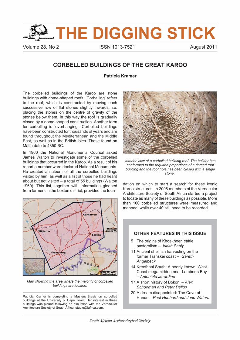
THE DIGGING STICK
CORBELLED BUILDINGS OF THE GREAT KAROO
Patricia Kramer
Volume 28, No 2 ISSN 1013-7521 August 2011
Patricia Kramer is completing a Masters thesis on corbelledbuildings at the University of Cape Town. Her interest in thesebuildings was piqued following an excursion with the VernacularArchitecture Society of South Africa. [email protected].
OTHER FEATURES IN THIS ISSUE
5 The origins of Khoekhoen cattle
pastoralism – Judith Sealy
11 Ancient shellfish harvesting on the
former Transkei coast – Gareth
Angelbeck
14 Kreefbaai South: A poorly known, West
Coast megamidden near Lamberts Bay
– Antonieta Jerardino
17 A short history of Bokoni – Alex
Schoeman and Peter Delius
20 A dream disappointed: The Cave of
Hands – Paul Hubbard and Jono Waters
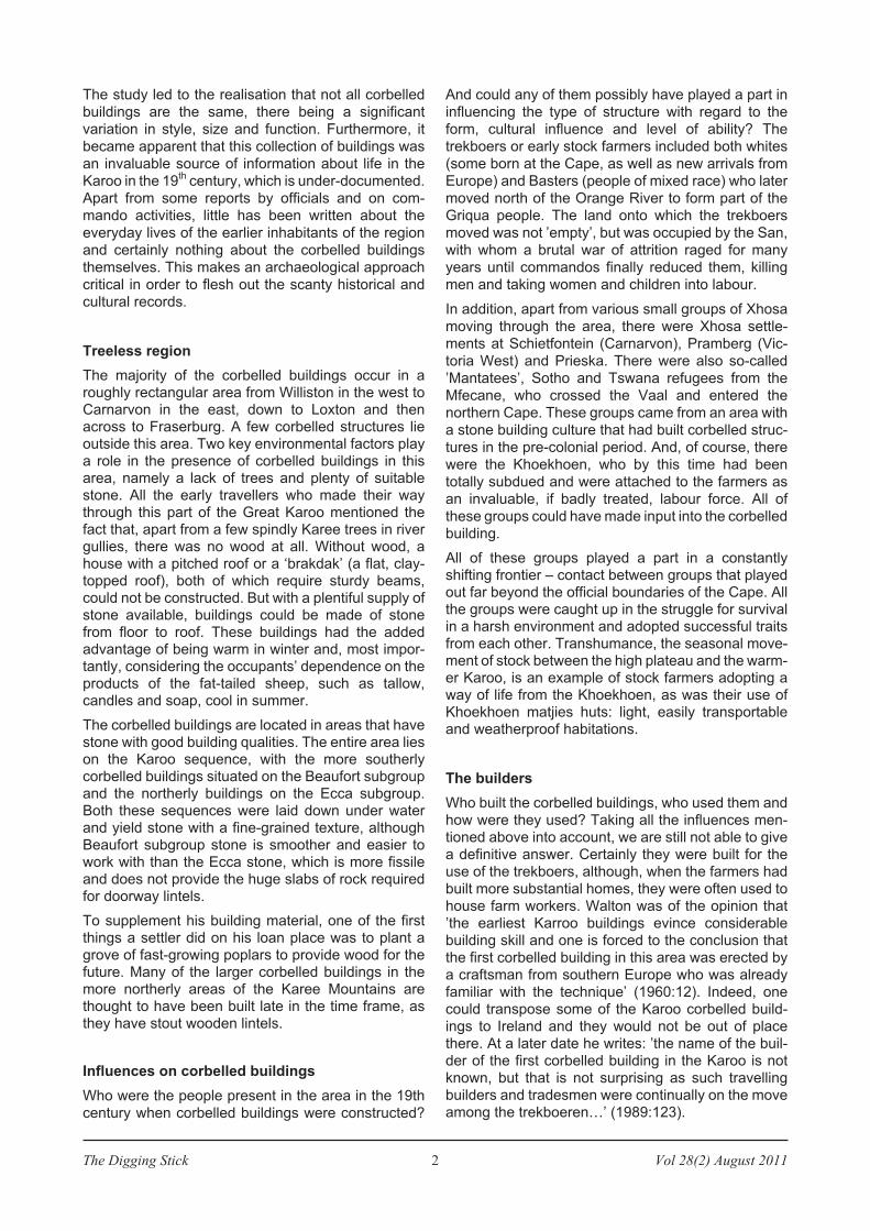
Map showing the area where the majority of corbelledbuildings are located.
Interior view of a corbelled building roof. The builder hasconformed to the required proportions of a domed roof
building and the roof hole has been closed with a singlestone.
The Digging Stick 2 Vol 28(2) August 2011
The study led to the realisation that not all corbelled
buildings are the same, there being a significant
variation in style, size and function. Furthermore, it
became apparent that this collection of buildings was
an invaluable source of information about life in the
Karoo in the 19th
century, which is under-documented.
Apart from some reports by officials and on com-
mando activities, little has been written about the
everyday lives of the earlier inhabitants of the region
and certainly nothing about the corbelled buildings
themselves. This makes an archaeological approach
critical in order to flesh out the scanty historical and
cultural records.
Treeless region
The majority of the corbelled buildings occur in aroughly rectangular area from Williston in the west toCarnarvon in the east, down to Loxton and thenacross to Fraserburg. A few corbelled structures lieoutside this area. Two key environmental factors playa role in the presence of corbelled buildings in thisarea, namely a lack of trees and plenty of suitablestone. All the early travellers who made their waythrough this part of the Great Karoo mentioned thefact that, apart from a few spindly Karee trees in rivergullies, there was no wood at all. Without wood, ahouse with a pitched roof or a ‘brakdak’ (a flat, clay-topped roof), both of which require sturdy beams,could not be constructed. But with a plentiful supply ofstone available, buildings could be made of stonefrom floor to roof. These buildings had the addedadvantage of being warm in winter and, most impor-tantly, considering the occupants’ dependence on theproducts of the fat-tailed sheep, such as tallow,candles and soap, cool in summer.
The corbelled buildings are located in areas that havestone with good building qualities. The entire area lieson the Karoo sequence, with the more southerlycorbelled buildings situated on the Beaufort subgroupand the northerly buildings on the Ecca subgroup.Both these sequences were laid down under waterand yield stone with a fine-grained texture, althoughBeaufort subgroup stone is smoother and easier towork with than the Ecca stone, which is more fissileand does not provide the huge slabs of rock requiredfor doorway lintels.
To supplement his building material, one of the firstthings a settler did on his loan place was to plant agrove of fast-growing poplars to provide wood for thefuture. Many of the larger corbelled buildings in themore northerly areas of the Karee Mountains arethought to have been built late in the time frame, asthey have stout wooden lintels.
Influences on corbelled buildings
Who were the people present in the area in the 19th
century when corbelled buildings were constructed?
And could any of them possibly have played a part in
influencing the type of structure with regard to the
form, cultural influence and level of ability? The
trekboers or early stock farmers included both whites
(some born at the Cape, as well as new arrivals from
Europe) and Basters (people of mixed race) who later
moved north of the Orange River to form part of the
Griqua people. The land onto which the trekboers
moved was not ’empty’, but was occupied by the San,
with whom a brutal war of attrition raged for many
years until commandos finally reduced them, killing
men and taking women and children into labour.
In addition, apart from various small groups of Xhosa
moving through the area, there were Xhosa settle-
ments at Schietfontein (Carnarvon), Pramberg (Vic-
toria West) and Prieska. There were also so-called
’Mantatees’, Sotho and Tswana refugees from the
Mfecane, who crossed the Vaal and entered the
northern Cape. These groups came from an area with
a stone building culture that had built corbelled struc-
tures in the pre-colonial period. And, of course, there
were the Khoekhoen, who by this time had been
totally subdued and were attached to the farmers as
an invaluable, if badly treated, labour force. All of
these groups could have made input into the corbelled
building.
All of these groups played a part in a constantlyshifting frontier – contact between groups that playedout far beyond the official boundaries of the Cape. Allthe groups were caught up in the struggle for survivalin a harsh environment and adopted successful traitsfrom each other. Transhumance, the seasonal move-ment of stock between the high plateau and the warm-er Karoo, is an example of stock farmers adopting away of life from the Khoekhoen, as was their use ofKhoekhoen matjies huts: light, easily transportableand weatherproof habitations.
The builders
Who built the corbelled buildings, who used them andhow were they used? Taking all the influences men-tioned above into account, we are still not able to givea definitive answer. Certainly they were built for theuse of the trekboers, although, when the farmers hadbuilt more substantial homes, they were often used tohouse farm workers. Walton was of the opinion that’the earliest Karroo buildings evince considerablebuilding skill and one is forced to the conclusion thatthe first corbelled building in this area was erected bya craftsman from southern Europe who was alreadyfamiliar with the technique’ (1960:12). Indeed, onecould transpose some of the Karoo corbelled build-ings to Ireland and they would not be out of placethere. At a later date he writes: ’the name of the buil-der of the first corbelled building in the Karoo is notknown, but that is not surprising as such travellingbuilders and tradesmen were continually on the moveamong the trekboeren…’ (1989:123).
Vol 28(2) August 2011 3 The Digging Stick
Van der Waal-Braaksma and Ferreira take exception
to this view of the local inhabitants and state that in
their opinion the corbelled building was the natural
progression from the rondawel with a reed roof, which
was well known (1986:77). The trekboers were used
to living in round matjieshuisies, so the round interior
shape of the corbelled building would not have been
strange to them. The possible presence in the area
the Mantatees may also have played a role, although
their buildings were much smaller compared to the
corbelled buildings of the Karoo.
By the time we get to the construction of the laterbuildings around the 1870s, there are some oralrecords. T’kokoboos, for example, ’was apparentlybuilt by its original owner and a Coloured labourer in15 days’ (Walton 1960:7). It has a date of 1851inscribed over the door. Vlieefontein was built byGabriel Gehardus Krugel in about 1855 before hismarriage (Shearing 1977 in Walton 1993) and theowners of Arbeidersfontein claimed that Schuins-hoogte was built between 1860 and 1872 by twocoloured men named Tiensjielings and Gedaanwerk(Van der Waal-Braaksma & Ferreira 1986:78). So itseems that some of the later buildings were built by’Coloured’ workers together with the farmer.
The corbelled buildings era
When did the trekboers feel secure enough in their
land holding to start investing in stone buildings? They
started moving into the Nieuweveld area from about
the 1750s. In the Roggeveld they initially practised
transhumance farming. It was common for these
farmers to live in their wagons, in matjieshuisies or
harbeeshuisies. However, as they moved further
inland, they began to acquire loan places in the area
under discussion and transhumance was based more
on moving seasonally within the same region in
search of water and pasture. This meant that most
people now had a ’home’ or permanent farm, as well
as additional farms, most of which were acquired as
loan places with leases of typically 15 years and rent
payable annually. In theory, only the ’opstal’ could be
sold as the land still belonged to the Dutch East India
Company (VOC). But in practice this was largely
ignored as sales prices clearly indicate that the entire
loan place was being sold. By virtue of its tax on the
transaction, the VOC was complicit in this informal
arrangement.
What did this mean in terms of security and improve-ments on the land? Very few loan places were re-tracted, even if a farmer was years in arrears on hisrent, and this provided a feeling of security. However,in 1813 the Cradock Proclamation changed the waypeople thought about the land. The proclamation de-clared that from then on land would be held in perpet-ual quitrent, i.e. the entire loan place could be sold orbequeathed. It now belonged to the loan holder aslong as he paid his rent and on condition that he hadhis land surveyed and registered. At last the farmerhad the legal permanency he required to invest inmore permanent dwellings, such as stone corbelledbuildings. This state of affairs is reinforced by the factthat William Burchell, an astute observer of the land-scape, failed to mention any corbelled or beehive-shaped buildings when he travelled through the areain 1811 (Burchell 1922). So although we are still un-able to pinpoint an exact date for the construction ofthe first corbelled buildings, we can say probably notbefore 1813.
The latest dates for their construction can be based ona variety of factors, namely oral records, dates andremarks on surveyor’s diagrams, and the use ofmaterials that can be dated, such as pieces of railwaytrack used for door lintels. On this basis, the lastcorbelled buildings, including the famous provincialmonument of Arbeidersfontein, were constructed inthe 1870s. It appears, therefore, that the corbelledbuilding tradition spanned a period of about 60 years.
Corbelled building construction
Corbelled buildings exhibit outer variability. In fact, notwo corbelled buildings are the same in terms of eitherdimensions or style, and are thus true vernacular buil-dings. Construction of corbelled buildings is based onthe same principles as the construction of a dome.There is a direct relationship between the floor dia-meter and the height of the building, which shouldform an equal-sided triangle, although the most suc-cessful dimensions are those in which the roof heightis slightly greater than the floor diameter, with the roofslightly pointed instead of being a flattened semi-circular shape.
The lower walls of the building are double stone wallswith through stones linking the two layers for support.Unlike the dry-stone corbelled buildings of Europe,the South African structures have clay mortar be-tween the stones. The curved roof, however, is con-structed differently. The stones used in the construc-
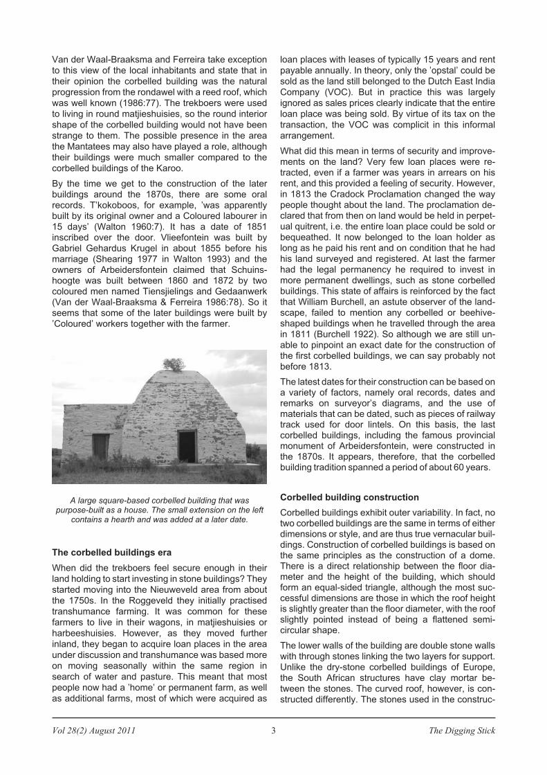
A large square-based corbelled building that waspurpose-built as a house. The small extension on the left
contains a hearth and was added at a later date.
The Digging Stick 4 Vol 28(2) August 2011
tion of the roof should be flat and evenly sized. Each
row of stones is moved inwards by about a third so
that it rests on the centre of gravity of the stone below.
To keep these stones stable and prevent them from
toppling inwards, a second outer layer (the revetment)
is placed on them, sloping down slightly to form a
counterweight and stabilise the roof. The hole at the
peak of the roof is closed by a roof stone. A well-built
building will have just one roof stone, but buildings
without ideal proportions often need up to five stones
to close the hole. Contrary to popular belief, the roof
stones are not removed to allow smoke to exit the
building; all cooking was done outside in a protective
bush or stone ’skerm’ or shelter.
A typology has been devised to categorise the buil-
dings. This is based in the first instance on the base
shape of the building, which is either square, round or
oval (of the latter there is only one example), followed
by subtypes based on dimensions considered to be
defining, such as roof height or floor dimensions. In
this way three main categories and seven subcategor-
ies have been created.
One of the subcategories is important as it defines thefunction of buildings. This is the size of the door. Half-door openings are only found in buildings that wereconstructed to be used as kafhoks or chaff store-rooms, while full-door openings are found in housesor store rooms. Buildings with half-door openings areusually associated with a trapvloer or threshing floor,and they do not have windows or other featuresassociated with a house. Buildings with full-dooropenings that have windows, wall niches and stoneshelves were built to be inhabited.
Buildings were altered over time as their functionchanged. So, for example, many kafhoks were con-verted to dwelling places for farm workers. KarelSchoeman writes: ’Die posisie van Februarie Baadjesop Gunstfontein het die voordeel ingehou dat hulle tenminste die vensterlose karbeelhut eenkant van dieposta mog bewoon’ (1986:129). One sure way toidentify such a change in function is the enlargementof the door, which leaves the edge of the lower part ofthe doorway rough and uneven. The lack of windows,niches or shelves are further clues.
In a few cases, abandoned houses have been con-
verted to kafhoks once the family had built another
house. In this instance the doorstep (drumpel) is
raised by about 450 mm and this new wall is obvious
to the naked eye. Other purposes for corbelled
buildings are more difficult to identify, though those
with a built-in soap-making pot were obviously soap
houses. Others with no windows and none of the
features attributed to a dwelling were probably store-
rooms for meat and fat-based products.
Conclusion
This kind of archaeology is based on direct obser-
vations – understanding how the buildings were con-
structed and unravelling the subsequent stratigraphy
as changes were made over the years. Using these
facts together with the location of the buildings, infor-
mation on the historical background of the area and
surviving local stories, this project on the corbelled
buildings of the Great Karoo is beginning to yield
interesting facts about the lives of the 19th
century
inhabitants of the area.
References
Burchell, WJ. 1853 (1822-24). Travels in the interior of Southern
Africa. Vol. 1. London: Batchworth Press.
Schoeman, K. 1986. Die wêreld van die digter. Cape Town: Human
& Rousseau.
Van der Waal-Braaksma, G, & Ferreira, O. 1986. Die noordweste:
die stoflike kultuuruitinge van die streek se bewoners.
Johannesburg: Genootskap vir Afrikaanse Volkskunde.
Walton, J. 1960. Corbelled buildings of the Karee Berge. Report of
a survey carried out for the National Monuments Council.
Walton, J. Corbelled buildings in the Kareeberge. Report of a
survey carried out in May 1960 in the Carnarvon and Williston
Districts (Second survey in 1964). Album: Document Centre,
University of Stellenbosch, 1993.
Walton, J. 1989. Old Cape farmsteads. Cape Town: Human &
Rousseau.
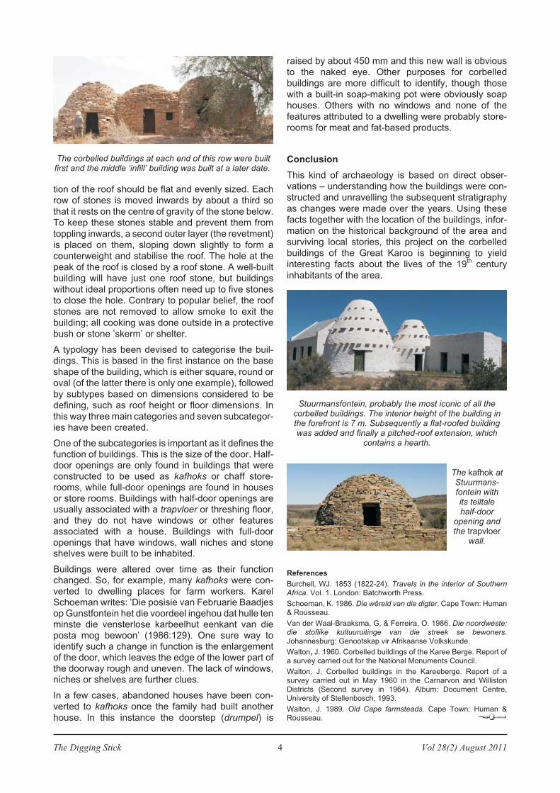
Stuurmansfontein, probably the most iconic of all thecorbelled buildings. The interior height of the building inthe forefront is 7 m. Subsequently a flat-roofed buildingwas added and finally a pitched-roof extension, which
contains a hearth.
The kafhok atStuurmans-fontein withits telltalehalf-door
opening andthe trapvloer
wall.
The corbelled buildings at each end of this row were builtfirst and the middle ‘infill’ building was built at a later date.
Vol 28(2) August 2011 5 The Digging Stick
From the late 15th
century onwards, ships’ log books,
diaries of visitors to the Cape and similar sources
described the Khoekhoen people who lived along the
western and southern Cape coasts with their flocks of
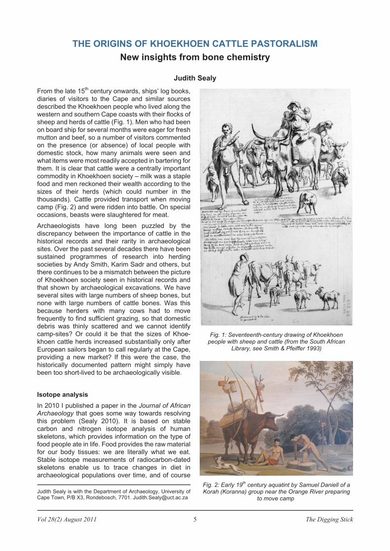
sheep and herds of cattle (Fig. 1). Men who had been
on board ship for several months were eager for fresh
mutton and beef, so a number of visitors commented
on the presence (or absence) of local people with
domestic stock, how many animals were seen and
what items were most readily accepted in bartering for
them. It is clear that cattle were a centrally important
commodity in Khoekhoen society – milk was a staple
food and men reckoned their wealth according to the
sizes of their herds (which could number in the
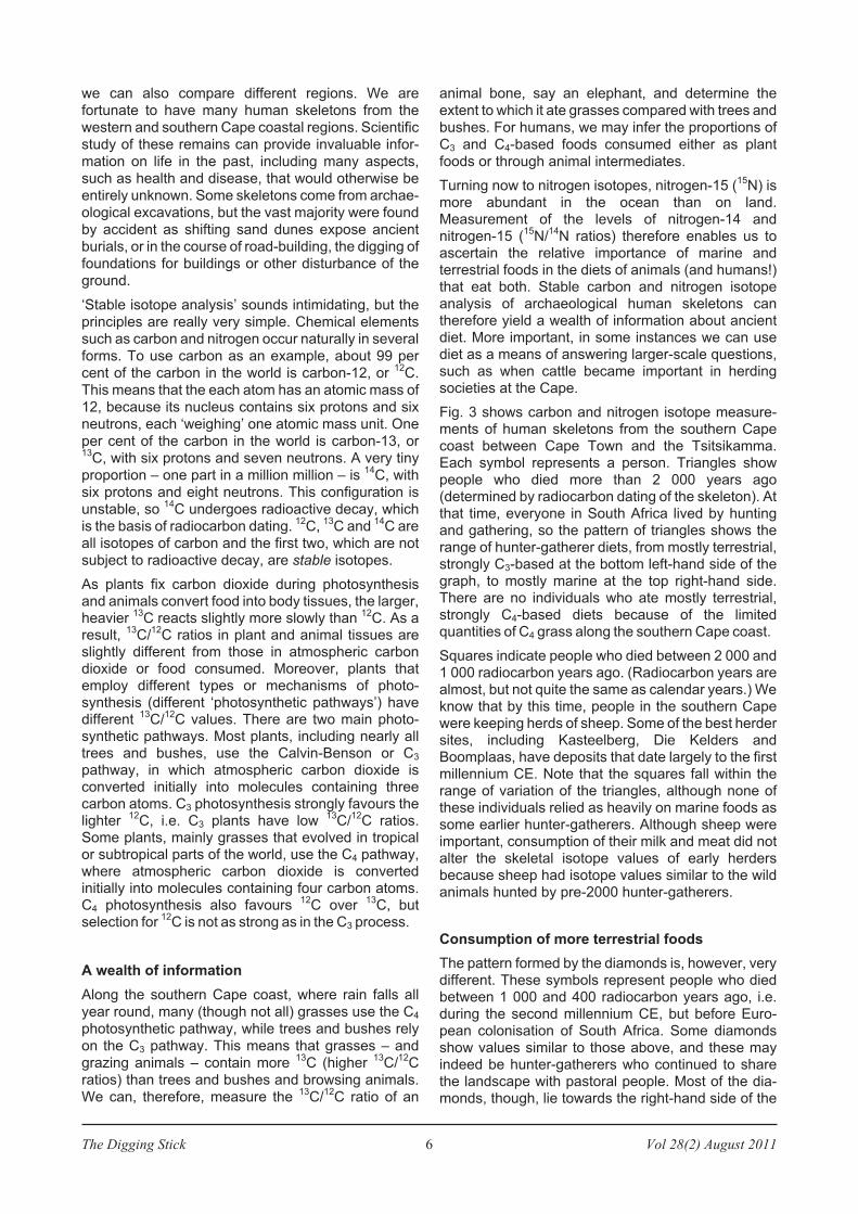
thousands). Cattle provided transport when moving
camp (Fig. 2) and were ridden into battle. On special
occasions, beasts were slaughtered for meat.
Archaeologists have long been puzzled by the
discrepancy between the importance of cattle in the
historical records and their rarity in archaeological
sites. Over the past several decades there have been
sustained programmes of research into herding
societies by Andy Smith, Karim Sadr and others, but
there continues to be a mismatch between the picture
of Khoekhoen society seen in historical records and
that shown by archaeological excavations. We have
several sites with large numbers of sheep bones, but
none with large numbers of cattle bones. Was this
because herders with many cows had to move
frequently to find sufficient grazing, so that domestic
debris was thinly scattered and we cannot identify
camp-sites? Or could it be that the sizes of Khoe-
khoen cattle herds increased substantially only after
European sailors began to call regularly at the Cape,
providing a new market? If this were the case, the
historically documented pattern might simply have
been too short-lived to be archaeologically visible.
Isotope analysis
In 2010 I published a paper in the Journal of African
Archaeology that goes some way towards resolving
this problem (Sealy 2010). It is based on stable
carbon and nitrogen isotope analysis of human
skeletons, which provides information on the type of
food people ate in life. Food provides the raw material
for our body tissues: we are literally what we eat.
Stable isotope measurements of radiocarbon-dated
skeletons enable us to trace changes in diet in
archaeological populations over time, and of course
THE ORIGINS OF KHOEKHOEN CATTLE PASTORALISM
New insights from bone chemistry
Judith Sealy
Judith Sealy is with the Department of Archaeology, University ofCape Town, P/B X3, Rondebosch, 7701. [email protected]
Fig. 1: Seventeenth-century drawing of Khoekhoenpeople with sheep and cattle (from the South African
Library, see Smith & Pfeiffer 1993)
Fig. 2: Early 19th
century aquatint by Samuel Daniell of aKorah (Koranna) group near the Orange River preparing
to move camp
The Digging Stick 6 Vol 28(2) August 2011
we can also compare different regions. We are
fortunate to have many human skeletons from the
western and southern Cape coastal regions. Scientific
study of these remains can provide invaluable infor-
mation on life in the past, including many aspects,
such as health and disease, that would otherwise be
entirely unknown. Some skeletons come from archae-
ological excavations, but the vast majority were found
by accident as shifting sand dunes expose ancient
burials, or in the course of road-building, the digging of
foundations for buildings or other disturbance of the
ground.
‘Stable isotope analysis’ sounds intimidating, but the
principles are really very simple. Chemical elements
such as carbon and nitrogen occur naturally in several
forms. To use carbon as an example, about 99 per
cent of the carbon in the world is carbon-12, or12
C.
This means that the each atom has an atomic mass of
12, because its nucleus contains six protons and six
neutrons, each ‘weighing’ one atomic mass unit. One
per cent of the carbon in the world is carbon-13, or13
C, with six protons and seven neutrons. A very tiny
proportion – one part in a million million – is14
C, with
six protons and eight neutrons. This configuration is
unstable, so14
C undergoes radioactive decay, which
is the basis of radiocarbon dating.12
C,13
C and14
C are
all isotopes of carbon and the first two, which are not
subject to radioactive decay, are stable isotopes.
As plants fix carbon dioxide during photosynthesisand animals convert food into body tissues, the larger,heavier
13C reacts slightly more slowly than
12C. As a
result,13
C/12
C ratios in plant and animal tissues areslightly different from those in atmospheric carbondioxide or food consumed. Moreover, plants thatemploy different types or mechanisms of photo-synthesis (different ‘photosynthetic pathways’) havedifferent
13C/
12C values. There are two main photo-
synthetic pathways. Most plants, including nearly alltrees and bushes, use the Calvin-Benson or C3
pathway, in which atmospheric carbon dioxide isconverted initially into molecules containing threecarbon atoms. C3 photosynthesis strongly favours thelighter
12C, i.e. C3 plants have low
13C/
12C ratios.
Some plants, mainly grasses that evolved in tropicalor subtropical parts of the world, use the C4 pathway,where atmospheric carbon dioxide is convertedinitially into molecules containing four carbon atoms.C4 photosynthesis also favours
12C over
13C, but
selection for12
C is not as strong as in the C3 process.
A wealth of information
Along the southern Cape coast, where rain falls all
year round, many (though not all) grasses use the C4
photosynthetic pathway, while trees and bushes rely
on the C3 pathway. This means that grasses – and
grazing animals – contain more13
C (higher13
C/12
C
ratios) than trees and bushes and browsing animals.
We can, therefore, measure the13
C/12
C ratio of an
animal bone, say an elephant, and determine the
extent to which it ate grasses compared with trees and
bushes. For humans, we may infer the proportions of
C3 and C4-based foods consumed either as plant
foods or through animal intermediates.
Turning now to nitrogen isotopes, nitrogen-15 (15
N) ismore abundant in the ocean than on land.Measurement of the levels of nitrogen-14 andnitrogen-15 (
15N/
14N ratios) therefore enables us to
ascertain the relative importance of marine andterrestrial foods in the diets of animals (and humans!)that eat both. Stable carbon and nitrogen isotopeanalysis of archaeological human skeletons cantherefore yield a wealth of information about ancientdiet. More important, in some instances we can usediet as a means of answering larger-scale questions,such as when cattle became important in herdingsocieties at the Cape.
Fig. 3 shows carbon and nitrogen isotope measure-ments of human skeletons from the southern Capecoast between Cape Town and the Tsitsikamma.Each symbol represents a person. Triangles showpeople who died more than 2 000 years ago(determined by radiocarbon dating of the skeleton). Atthat time, everyone in South Africa lived by huntingand gathering, so the pattern of triangles shows therange of hunter-gatherer diets, from mostly terrestrial,strongly C3-based at the bottom left-hand side of thegraph, to mostly marine at the top right-hand side.There are no individuals who ate mostly terrestrial,strongly C4-based diets because of the limitedquantities of C4 grass along the southern Cape coast.
Squares indicate people who died between 2 000 and1 000 radiocarbon years ago. (Radiocarbon years arealmost, but not quite the same as calendar years.) Weknow that by this time, people in the southern Capewere keeping herds of sheep. Some of the best herdersites, including Kasteelberg, Die Kelders andBoomplaas, have deposits that date largely to the firstmillennium CE. Note that the squares fall within therange of variation of the triangles, although none ofthese individuals relied as heavily on marine foods assome earlier hunter-gatherers. Although sheep wereimportant, consumption of their milk and meat did notalter the skeletal isotope values of early herdersbecause sheep had isotope values similar to the wildanimals hunted by pre-2000 hunter-gatherers.
Consumption of more terrestrial foods
The pattern formed by the diamonds is, however, verydifferent. These symbols represent people who diedbetween 1 000 and 400 radiocarbon years ago, i.e.during the second millennium CE, but before Euro-pean colonisation of South Africa. Some diamondsshow values similar to those above, and these mayindeed be hunter-gatherers who continued to sharethe landscape with pastoral people. Most of the dia-monds, though, lie towards the right-hand side of the
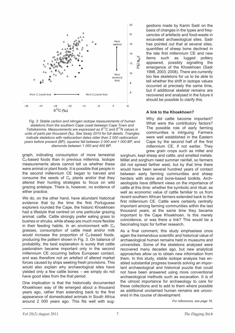
Vol 28(2) August 2011 7 The Digging Stick
graph, indicating consumption of more terrestrialC4-based foods than in previous millennia. Isotopemeasurements alone cannot tell us whether thesewere animal or plant foods. It is possible that people inthe second millennium CE began to harvest andconsume the seeds of C4 plants and/or that theyaltered their hunting strategies to focus on wildgrazing antelope. There is, however, no evidence ofeither practice.
We do, on the other hand, have abundant historicalevidence that by the time the first Portugueseexplorers rounded the Cape, the historic Khoekhoenhad a lifestyle that centred on one particular grazinganimal: cattle. Cattle strongly prefer eating grass tobushes or shrubs, while sheep are much more flexiblein their feeding habits. In an environment with C4
grasses, consumption of cattle meat and/or milkwould increase the proportion of C4-based foods,producing the pattern shown in Fig. 3. On balance ofprobability, the best explanation is surely that cattlepastoralism became important only in the secondmillennium CE occurring before European contact,and was therefore not an artefact of altered marketforces caused by ships seeking fresh provisions. Thiswould also explain why archaeological sites haveyielded only a few cattle bones – we simply do nothave good sites from the that period.
One implication is that the historically documentedKhoekhoen way of life emerged about a thousandyears ago, rather than extending back to the firstappearance of domesticated animals in South Africaaround 2 000 years ago. This fits well with sug-
gestions made by Karim Sadr on thebasis of changes in the types and freq-uencies of artefacts and food-waste inexcavated archaeological sites. Sadrhas pointed out that at several sites,quantities of sheep bone declined inthe late first millennium CE and newitems such as lugged potteryappeared, possibly signalling theemergence of the Khoekhoen (Sadr1998, 2003, 2008). There are currentlytoo few skeletons for us to be able totell whether the shift in isotope valuesoccurred at precisely the same time,but if additional skeletal remains arerecovered and analysed in the future itshould be possible to clarify this.
A link to the Khoekhoen?
Why did cattle become important?What were the contributory factors?The possible role of early farmingcommunities is intriguing. Farmerswere well established in the EasternCape by the second half of the firstmillennium CE, if not earlier. Theygrew grain crops such as millet and
sorghum, kept sheep and cattle, and smelted metals.Millet and sorghum need summer rainfall, so farmersdid not spread farther west, but by that time therewould have been several hundred years of contactbetween early farming communities and sheepherders with stone and bone-based toolkits. Arch-aeologists have different views on the importance ofcattle at this time: whether the symbolic and ritual, aswell as economic value of cattle familiar to us fromrecent southern African farmers extended back to thefirst millennium CE. Cattle were certainly centrallyimportant among farming communities within the lastthousand years, at the same time they becameimportant to the Cape Khoekhoen. Is this merelycoincidence, or was there a link? This would be afascinating topic for further research.
As a final comment, this study emphasises onceagain the tremendous scientific and historical value ofarchaeological human remains held in museums anduniversities. Some of the skeletons analysed wererecovered many decades ago, but new analyticalapproaches allow us to obtain new information fromthem. In this study, stable isotope analysis has en-abled substantial progress towards solving an impor-tant archaeological and historical puzzle that couldnot have been answered using more conventionalarchaeological methods such as excavation. It is ofthe utmost importance for archaeology to care forthese collections and to add to them where possibleas additional unclaimed human remains are uncov-ered in the course of development.
For references, see page 16.
Fig. 3: Stable carbon and nitrogen isotope measurements of humanskeletons from the southern Cape coast between Cape Town and
Tsitsikamma. Measurements are expressed as ä13
C and ä15
N values inunits of parts per thousand (‰). See Sealy 2010 for full details. Trianglesindicate skeletons with radiocarbon dates older than 2 000 radiocarbon
years before present (BP), squares fall between 2 000 and 1 000 BP, anddiamonds between 1 000 and 400 BP.
The Digging Stick 8 Vol 28(2) August 2011
The town of Orania is located 40 km from Hopetown in
the Northern Cape Province. Orania was established
in 1965 by the Department of Waterworks as a
construction camp for the building of a canal system
for the Orange River Scheme.
Numerous rock engravings dating from the Late
Stone Age occur, alongside historical engravings and
graffiti on the dolerite rocks of a range of hills
stretching from east to west through the town. The
graffiti is mostly the work of white visitors since 1762.
They scratched their names, dates and interesting
sayings on the rocks, sometimes using the same rock
faces as the prehistoric artists, to the point of even
vandalising the earlier work.
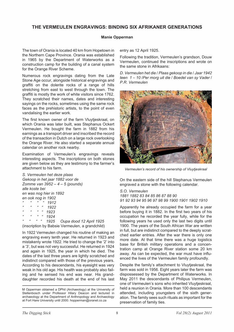
The first known owner of the farm Vluytjeskraal, on
which Orania was later built, was Stephanus Ockert
Vermeulen. He bought the farm in 1882 from his
earnings as a transport driver and inscribed the record
of the transaction in Dutch on a large rock overlooking
the Orange River. He also started a separate annual
calendar on another rock nearby.
Examination of Vermeulen’s engravings reveals
interesting aspects. The inscriptions on both stones
are given below as they are testimony to the farmer’s
attachment to his farm.
S. Vermeulen het deze plaas
Gekoop in het jaar 1882 voor de
Zomme van 3952 – 4 – 5 (pounds)
alle koste bei
en was nog hier in 1892
en ook nog in 1902
“ “ “ “ 1912
“ “ “ “ 1922
“ “ “ “ 1923
“ “ “ “ 1924
“ “ “ “ 1925 Oupa dood 12 April 1925
(inscription by Babsie Vermeulen, a grandchild)
In 1922 Vermeulen changed his routine of making an
engraving every tenth year. He returned in 1923 and
mistakenly wrote 1922. He tried to change the ‘2’ into
a ‘3’, but was not very successful. He returned in 1924
and again in 1925, the year in which he died. The
dates of the last three years are lightly scratched and
indistinct compared with those of the previous years.
According to his descendants, his eyesight was very
weak in his old age. His health was probably also fail-
ing and he sensed his end was near. His grand-
daughter recorded his death at the end of his last
entry as 12 April 1925.
Following the tradition, Vermeulen’s grandson, Douw
Vermeulen, continued the inscriptions and wrote on
the same stone in Afrikaans:
D. Vermeulen het die / Plaas gekoop in die / Jaar 1942
teen 1 – 10 /Per morg uit die / Boedel van sy Vader /
P.R. Vermeulen
On the eastern side of the hill Stephanus Vermeulen
engraved a stone with the following calendar.
S.O. Vermeulen
1881 1882 83 84 85 86 87 88 90
91 92 93 94 95 96 97 98 99 1900 1901 1902 1910
Apparently he already occupied the farm for a year
before buying it in 1882. In the first two years of his
occupation he recorded the year fully, while for the
following years he used only the last two digits until
1900. The years of the South African War are written
in full, but are indistinct compared to the deeply scrat-
ched earlier entries. After the war there is only one
more date. At that time there was a huge logistics
base for British military operations and a concen-
tration camp at Orange River station some 20 km
away. As can be expected, the war must have influ-
enced the lives of the Vermeulen family profoundly.
Despite the family’s attachment to Vluytjeskraal, the
farm was sold in 1956. Eight years later the farm was
dispossessed by the Department of Waterworks. In
May 2011 the descendants of Philipus Vermeulen,
one of Vermeulen’s sons who inherited Vluytjeskraal,
held a reunion in Orania. More than 100 descendants
attended, including youngsters of the sixth gener-
ation. The family sees such rituals as important for the
preservation of family ties.
THE VERMEULEN ENGRAVINGS: BINDING SIX AFRIKANER GENERATIONS
Manie Opperman
M Opperman obtained a DPhil (Archaeology) at the University ofStellenbosch under Professor Hilary Deacon and lectured inarchaeology at the Department of Anthropology and Archaeologyat Fort Hare University until 2000. [email protected]
Vermeulen’s record of his ownership of Vluytjeskraal
Vol 28(2) August 2011 9 The Digging Stick
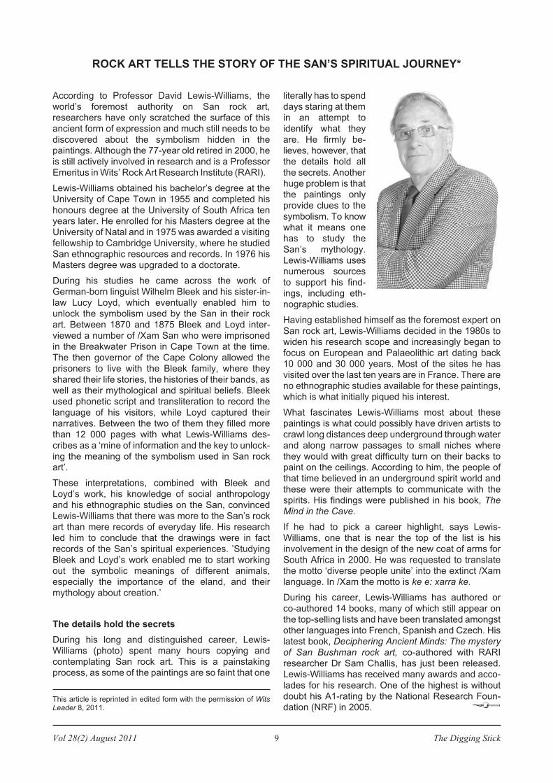
According to Professor David Lewis-Williams, the
world’s foremost authority on San rock art,
researchers have only scratched the surface of this
ancient form of expression and much still needs to be
discovered about the symbolism hidden in the
paintings. Although the 77-year old retired in 2000, he
is still actively involved in research and is a Professor
Emeritus in Wits’ Rock Art Research Institute (RARI).
Lewis-Williams obtained his bachelor’s degree at the
University of Cape Town in 1955 and completed his
honours degree at the University of South Africa ten
years later. He enrolled for his Masters degree at the
University of Natal and in 1975 was awarded a visiting
fellowship to Cambridge University, where he studied
San ethnographic resources and records. In 1976 his
Masters degree was upgraded to a doctorate.
During his studies he came across the work of
German-born linguist Wilhelm Bleek and his sister-in-
law Lucy Loyd, which eventually enabled him to
unlock the symbolism used by the San in their rock
art. Between 1870 and 1875 Bleek and Loyd inter-
viewed a number of /Xam San who were imprisoned
in the Breakwater Prison in Cape Town at the time.
The then governor of the Cape Colony allowed the
prisoners to live with the Bleek family, where they
shared their life stories, the histories of their bands, as
well as their mythological and spiritual beliefs. Bleek
used phonetic script and transliteration to record the
language of his visitors, while Loyd captured their
narratives. Between the two of them they filled more
than 12 000 pages with what Lewis-Williams des-
cribes as a ‘mine of information and the key to unlock-
ing the meaning of the symbolism used in San rock
art’.
These interpretations, combined with Bleek and
Loyd’s work, his knowledge of social anthropology
and his ethnographic studies on the San, convinced
Lewis-Williams that there was more to the San’s rock
art than mere records of everyday life. His research
led him to conclude that the drawings were in fact
records of the San’s spiritual experiences. ’Studying
Bleek and Loyd’s work enabled me to start working
out the symbolic meanings of different animals,
especially the importance of the eland, and their
mythology about creation.’
The details hold the secrets
During his long and distinguished career, Lewis-
Williams (photo) spent many hours copying and
contemplating San rock art. This is a painstaking
process, as some of the paintings are so faint that one
literally has to spend
days staring at them
in an attempt to
identify what they
are. He firmly be-
lieves, however, that
the details hold all
the secrets. Another
huge problem is that
the paintings only
provide clues to the
symbolism. To know
what it means one
has to study the
San’s mythology.
Lewis-Williams uses
numerous sources
to support his find-
ings, including eth-
nographic studies.
Having established himself as the foremost expert on
San rock art, Lewis-Williams decided in the 1980s to
widen his research scope and increasingly began to
focus on European and Palaeolithic art dating back
10 000 and 30 000 years. Most of the sites he has
visited over the last ten years are in France. There are
no ethnographic studies available for these paintings,
which is what initially piqued his interest.
What fascinates Lewis-Williams most about these
paintings is what could possibly have driven artists to
crawl long distances deep underground through water
and along narrow passages to small niches where
they would with great difficulty turn on their backs to
paint on the ceilings. According to him, the people of
that time believed in an underground spirit world and
these were their attempts to communicate with the
spirits. His findings were published in his book, The
Mind in the Cave.
If he had to pick a career highlight, says Lewis-
Williams, one that is near the top of the list is his
involvement in the design of the new coat of arms for
South Africa in 2000. He was requested to translate
the motto ‘diverse people unite’ into the extinct /Xam
language. In /Xam the motto is ke e: xarra ke.
During his career, Lewis-Williams has authored or
co-authored 14 books, many of which still appear on
the top-selling lists and have been translated amongst
other languages into French, Spanish and Czech. His
latest book, Deciphering Ancient Minds: The mystery
of San Bushman rock art, co-authored with RARI
researcher Dr Sam Challis, has just been released.
Lewis-Williams has received many awards and acco-
lades for his research. One of the highest is without
doubt his A1-rating by the National Research Foun-
dation (NRF) in 2005.
ROCK ART TELLS THE STORY OF THE SAN’S SPIRITUAL JOURNEY*
This article is reprinted in edited form with the permission of WitsLeader 8, 2011.
The Digging Stick 10 Vol 28(2) August 2011
WORLD ARCHAEOLOGY
Llama muck drove Inca success
How could the inhospitable Andean highlands of Peru
nurture the great Inca civilisation? The answer,
unearthed in lake sediments high up in the Peruvian
Andes, seems to be llama muck. South America’s
most important crop is maize. Its cultivation is what
allowed people to stop being hunter-gatherers. If
crops were good and grain silos bulged, they had time
for mining metals, developing culture and fighting
wars with their neighbours.
The switch to agriculture happened at different times
in different places. Analysis of mud cores from the bed
of a small lake close to the mountain fortress city of
Ollantaytambo, Peru, reveals that, there at least, it
happened very fast. A study by the French Institute of
Andean Studies in Lima, Peru, shows that maize
pollen suddenly appeared in lake-bed mud 2 700
years ago. Until then it seems that people mostly ate
wild foods such as quinoa, which could not have
sustained a large and thriving civilisation.
But what triggered the sudden emergence of this crop
3 350 m up in the Andes? A temporarily warmer
climate probably helped, but so did llama dung. The
mud cores revealed that around the same time as
maize pollen became dominant, the remains of
oribatid mites, soil-dwelling bugs that consume
animal excrement, also increased. Llamas had been
domesticated about 3 500 years ago. But around
2 700 years ago the extra mite remains in the mud
suggest that the hills were suddenly alive with large
numbers of llamas, indicating a bonanza of excrement
for spreading on fields as fertiliser.New Scientist, 22 May 2011
Ancient language dictionary finished
An ambitious project to identify, explain and provide
citations for the words written in cuneiform on clay
tablets and carved in stone by Babylonians, Assyrians
and others in Mesopotamia between 2500 BC and AD
100 has been completed after 90 years of labour. The
21-volume Chicago Assyrian Dictionary (CAD) was
produced by the Oriental Institute at the University of
Chicago. The CAD is not simply a word list. By
detailing the history and range of uses of each word, it
is in essence a cultural encyclopaedia of Mesopo-
tamian history, society, literature, law and religion.
Over the years, researchers filled out millions of index
cards with references to the use of 28 000 words. The
entries for each word denote various meanings and
reference the contexts and ways in which it was used.Eurekalert, 05/06/11
The Cape Gallery seeks
to expose you to Fine Art
rooted in an African tradition
that is both eclectic
and diverse. We rotate our
exhibitions monthly,
touching your imagination
with the unique cultural
stamp that is our continent.
60 Church Street Cape Town
Gallery Hours:
Mon - Fri: 09h30 - 17h00
Sat: 10h00 - 14h00
Tel: +27 21 423 5309
Fax: +27 21 424 9063
E-mail: [email protected]
Web: www.capegallery.co.za
American Express, Mastercard, Visa and Diners
cards are accepted. Reliable arrangements can be
made to freight purchases to foreign destinations.
‘Tokeloshi Agtervolging’ by Leon de BliquyTHE CAPE
GALLERY
The Cape Gallery deals in fine art work by SA artistsand stocks a selection of paintings depicting South
African rock art.
Vol 28(2) August 2011 11 The Digging Stick
There are two reasons why historians know very little
about the lifestyle of the various Khoesan groups that
once inhabited South Africa’s former Transkei coast
(FTC). Firstly, most of the FTC Khoesan had been
assimilated into Bantu-speaking tribes long before
Europeans established contact with the region and,
secondly, despite its wealth of archaeological sites,
very little research has been undertaken there.
Of all the subsistence activities practised by the FTC
Khoesan, shellfish harvesting must surely have been
the most important. The coastline is littered with shell
middens, some of them of considerable size. These
middens are testament to the Khoesan people’s
dependence on marine resources. Some contem-
porary amaXhosa groups still practise shellfish har-
vesting, but mainly to supplement their maize-based
diet. These groups probably harvest shellfish in very
much the same way as their predecessors did.
Beginning in the 1970s, researchers like Bigalke
(1973) and Hockey et al (1988) began a series of
ethnographic studies on the Transkei inhabitants’
‘past and present patterns of exploiting the intertidal
resources of [the coast’s] 260 km shoreline’
(Claassen 1998:43). Cheryl Claassen would later
describe this research as being ‘the most extensive
project undertaken to understand the human adaption
to and utilisation of shellfish …’ (idem). Despite the
invaluable ethnographic information that was gained
from these studies we still know very little about how
exactly shellfish were harvested in ancient times. It is
this issue that I wish to explore here.
Systematic edge damage
In his book, Shorelines Strandlopers and Shell
Middens (2006), Cape Town-based archaeologist
John Parkington points out that ‘most shells recov-
ered [from shell middens] show very few signs of
systematic damage during collection’. He goes on to
explain that ‘this must mean that limpets were
removed from the rocks by a swift sideways jolt, prob-
ably with the hand or foot or a wooden stick, and per-
haps when the animal was slightly elevated whilst
feeding. Mussels, of course, could simply be
wrenched off their rocky perch by hand’ (Parkington
2007:33).
Parkington’s theory on how shellfish may have been
harvested by hand or foot is most likely correct. How-
ever, the limpet shells with ‘few signs of systematic
damage’ described by him probably come from the
south or west coast, where most of his research on
shell middens was done. The limpet shells illustrated
in Fig. 1 were found at two different midden sites on
the southern FTC and both display what looks like
systematic edge damage.
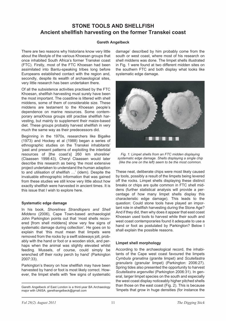
These neat, deliberate chips were most likely caused
by tools, possibly a result of the limpets being levered
off the rocks. Limpet shells displaying these distinct
breaks or chips are quite common in FTC shell mid-
dens (further statistical analysis will provide a per-
centage of how many limpet shells display this
characteristic edge damage). This leads to the
question: Could stone tools have played an impor-
tant role in shellfish harvesting during the Stone Age?
And if they did, then why does it appear that east coast
Khoesan used tools to harvest while their south and
west coast contemporaries found it adequate to use a
hand or foot as postulated by Parkington? Below I
shall explain the possible reasons.
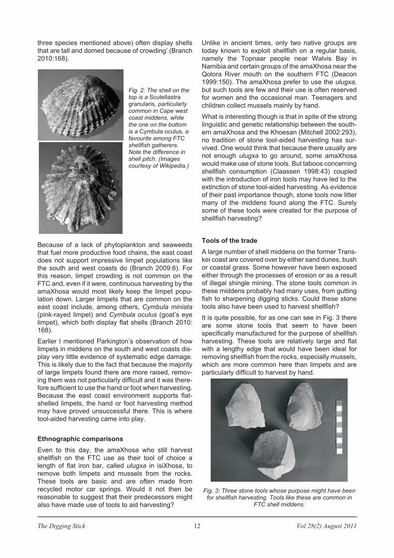
Limpet shell morphology
According to the archaeological record, the inhabi-
tants of the Cape west coast favoured the limpets
Cymbula granatina (granite limpet) and Scutellastra
granularis (granular limpet) (Parkington: 2006:27).
Spring tides also presented the opportunity to harvest
Scutellastra argenvillei (Parkington 2006:31). In gen-
eral, larger limpet species on the south and especially
the west coast display noticeably higher pitched shells
than those on the east coast (Fig. 2). This is because
‘limpets that grow in huge densities (for instance the
STONE TOOLS AND SHELLFISH
Ancient shellfish harvesting on the former Transkei coast
Gareth Angelbeck
Gareth Angelbeck of East London is a third-year BA Archaeologymajor with UNISA. [email protected]
Fig. 1: Limpet shells from an FTC midden displayingsystematic edge damage. Shells displaying a single chip(like the one on the left) seem to be the most common.
three species mentioned above) often display shells
that are tall and domed because of crowding’ (Branch
2010:168).
Because of a lack of phytoplankton and seaweedsthat fuel more productive food chains, the east coastdoes not support impressive limpet populations likethe south and west coasts do (Branch 2009:8). Forthis reason, limpet crowding is not common on theFTC and, even if it were, continuous harvesting by theamaXhosa would most likely keep the limpet popu-lation down. Larger limpets that are common on theeast coast include, among others, Cymbula miniata(pink-rayed limpet) and Cymbula oculus (goat’s eyelimpet), which both display flat shells (Branch 2010:168).
Earlier I mentioned Parkington’s observation of howlimpets in middens on the south and west coasts dis-play very little evidence of systematic edge damage.This is likely due to the fact that because the majorityof large limpets found there are more raised, remov-ing them was not particularly difficult and it was there-fore sufficient to use the hand or foot when harvesting.Because the east coast environment supports flat-shelled limpets, the hand or foot harvesting methodmay have proved unsuccessful there. This is wheretool-aided harvesting came into play.
Ethnographic comparisons
Even to this day, the amaXhosa who still harvest
shellfish on the FTC use as their tool of choice a
length of flat iron bar, called ulugxa in isiXhosa, to
remove both limpets and mussels from the rocks.
These tools are basic and are often made from
recycled motor car springs. Would it not then be
reasonable to suggest that their predecessors might
also have made use of tools to aid harvesting?
Unlike in ancient times, only two native groups are
today known to exploit shellfish on a regular basis,
namely the Topnaar people near Walvis Bay in
Namibia and certain groups of the amaXhosa near the
Qolora River mouth on the southern FTC (Deacon
1999:150). The amaXhosa prefer to use the ulugxa,
but such tools are few and their use is often reserved
for women and the occasional man. Teenagers and
children collect mussels mainly by hand.
What is interesting though is that in spite of the strong
linguistic and genetic relationship between the south-
ern amaXhosa and the Khoesan (Mitchell 2002:293),
no tradition of stone tool-aided harvesting has sur-
vived. One would think that because there usually are
not enough ulugxa to go around, some amaXhosa
would make use of stone tools. But taboos concerning
shellfish consumption (Claassen 1998:43) coupled
with the introduction of iron tools may have led to the
extinction of stone tool-aided harvesting. As evidence
of their past importance though, stone tools now litter
many of the middens found along the FTC. Surely
some of these tools were created for the purpose of
shellfish harvesting?
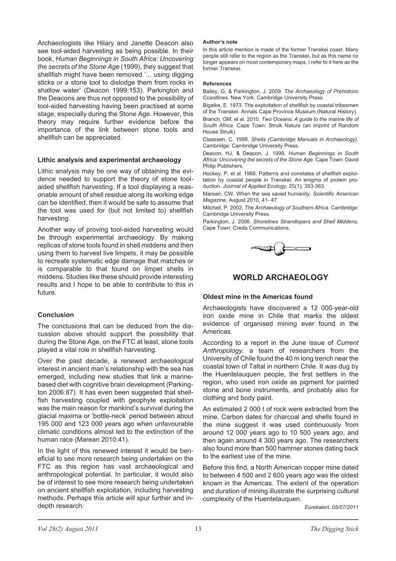
Tools of the trade
A large number of shell middens on the former Trans-
kei coast are covered over by either sand dunes, bush
or coastal grass. Some however have been exposed
either through the processes of erosion or as a result
of illegal shingle mining. The stone tools common in
these middens probably had many uses, from gutting
fish to sharpening digging sticks. Could these stone
tools also have been used to harvest shellfish?
It is quite possible, for as one can see in Fig. 3 there
are some stone tools that seem to have been
specifically manufactured for the purpose of shellfish
harvesting. These tools are relatively large and flat
with a lengthy edge that would have been ideal for
removing shellfish from the rocks, especially mussels,
which are more common here than limpets and are
particularly difficult to harvest by hand.
The Digging Stick 12 Vol 28(2) August 2011
Fig. 2: The shell on thetop is a Scutellastragranularis, particularlycommon in Cape westcoast middens, whilethe one on the bottomis a Cymbula oculus, afavourite among FTCshellfish gatherers.Note the difference inshell pitch. (Imagescourtesy of Wikipedia.)
Fig. 3: Three stone tools whose purpose might have beenfor shellfish harvesting. Tools like these are common in
FTC shell middens.
Vol 28(2) August 2011 13 The Digging Stick
Archaeologists like Hilary and Janette Deacon also
see tool-aided harvesting as being possible. In their
book, Human Beginnings in South Africa: Uncovering
the secrets of the Stone Age (1999), they suggest that
shellfish might have been removed ‘... using digging
sticks or a stone tool to dislodge them from rocks in
shallow water’ (Deacon 1999:153). Parkington and
the Deacons are thus not opposed to the possibility of
tool-aided harvesting having been practised at some
stage, especially during the Stone Age. However, this
theory may require further evidence before the
importance of the link between stone tools and
shellfish can be appreciated.
Lithic analysis and experimental archaeology
Lithic analysis may be one way of obtaining the evi-
dence needed to support the theory of stone tool-
aided shellfish harvesting. If a tool displaying a reas-
onable amount of shell residue along its working edge
can be identified, then it would be safe to assume that
the tool was used for (but not limited to) shellfish
harvesting.
Another way of proving tool-aided harvesting would
be through experimental archaeology. By making
replicas of stone tools found in shell middens and then
using them to harvest live limpets, it may be possible
to recreate systematic edge damage that matches or
is comparable to that found on limpet shells in
middens. Studies like these should provide interesting
results and I hope to be able to contribute to this in
future.
Conclusion
The conclusions that can be deduced from the dis-
cussion above should support the possibility that
during the Stone Age, on the FTC at least, stone tools
played a vital role in shellfish harvesting.
Over the past decade, a renewed archaeological
interest in ancient man’s relationship with the sea has
emerged, including new studies that link a marine-
based diet with cognitive brain development (Parking-
ton 2006:87). It has even been suggested that shell-
fish harvesting coupled with geophyte exploitation
was the main reason for mankind’s survival during the
glacial maxima or ’bottle-neck’ period between about
195 000 and 123 000 years ago when unfavourable
climatic conditions almost led to the extinction of the
human race (Marean 2010:41).
In the light of this renewed interest it would be ben-
eficial to see more research being undertaken on the
FTC as this region has vast archaeological and
anthropological potential. In particular, it would also
be of interest to see more research being undertaken
on ancient shellfish exploitation, including harvesting
methods. Perhaps this article will spur further and in-
depth research.
Author’s note
In this article mention is made of the former Transkei coast. Many
people still refer to the region as the Transkei, but as this name no
longer appears on most contemporary maps, I refer to it here as the
former Transkei.
References
Bailey, G, & Parkington, J. 2009. The Archaeology of Prehistoric
Coastlines. New York: Cambridge University Press.
Bigalke, E. 1973. The exploitation of shellfish by coastal tribesmen
of the Transkei. Annals Cape Province Museum (Natural History).
Branch, GM, et al. 2010. Two Oceans: A guide to the marine life of
South Africa. Cape Town: Struik Nature (an imprint of Random
House Struik).
Claassen, C. 1998. Shells (Cambridge Manuals in Archaeology).
Cambridge: Cambridge University Press.
Deacon, HJ, & Deacon, J. 1999. Human Beginnings in South
Africa: Uncovering the secrets of the Stone Age. Cape Town: David
Philip Publishers.
Hockey, P, et al. 1988. Patterns and correlates of shellfish exploi-
tation by coastal people in Transkei: An enigma of protein pro-
duction. Journal of Applied Ecology, 25(1), 353-363.
Marean, CW. When the sea saved humanity. Scientific American
Magazine, August 2010, 41- 47.
Mitchell, P. 2002. The Archaeology of Southern Africa. Cambridge:
Cambridge University Press.
Parkington, J. 2006. Shorelines Strandlopers and Shell Middens.
Cape Town: Creda Communications.
WORLD ARCHAEOLOGY
Oldest mine in the Americas found
Archaeologists have discovered a 12 000-year-old
iron oxide mine in Chile that marks the oldest
evidence of organised mining ever found in the
Americas.
According to a report in the June issue of Current
Anthropology, a team of researchers from the
University of Chile found the 40 m long trench near the
coastal town of Taltal in northern Chile. It was dug by
the Huentelauquen people, the first settlers in the
region, who used iron oxide as pigment for painted
stone and bone instruments, and probably also for
clothing and body paint.
An estimated 2 000 t of rock were extracted from the
mine. Carbon dates for charcoal and shells found in
the mine suggest it was used continuously from
around 12 000 years ago to 10 500 years ago, and
then again around 4 300 years ago. The researchers
also found more than 500 hammer stones dating back
to the earliest use of the mine.
Before this find, a North American copper mine dated
to between 4 500 and 2 600 years ago was the oldest
known in the Americas. The extent of the operation
and duration of mining illustrate the surprising cultural
complexity of the Huentelauquen.
Eurekalert, 05/07/2011
The Digging Stick 14 Vol 28(2) August 2011
Pre-colonial shell middens dating to c. 3000 – 2000
BP are amongst the largest archaeological sites on
South Africa’s west coast, and perhaps the entire
coastline. These massive sites are known among
archaeologists as ‘megamiddens’ (Parkington 1976).
At least two of these are known at Paternoster (Yates
2004), but the large majority are situated around
Lamberts Bay and Elands Bay (Fig. 1) (Jerardino
2010, in press). The coming about of these unique
sites have recently been explained by rising human
population densities, longer residential permanence
after 3500 years BP and successive reformulations of
hunter-gatherer subsistence choices, which involved
both marine and terrestrial ecosystems. For instance,
isotopic studies conducted on West Coast human
skeletal remains and zooarchaeological analyses
strongly suggest that a substantial amount of forager
diet was at this time derived from marine resources
(Lee-Thorp et al. 1989).
More specifically, shellfish collection shifted from a
lower caloric-yielding mix of limpets, whelks and black
mussels before 3000 BP to the intensive collection of
the latter from about 2600 BP, with localised impact
on molluscan fauna at this time. When it came to the
less consumed terrestrial resources, coastal hunter-
gatherers also became much less reliant on large
mobile game (e.g. eland) and more so on small, terri-
torial bovids (e.g. steenbuck, grysbok or grey duiker)
and tortoises after 3500 BP, with this subsistence
behaviour most strongly emphasised during the
’megamidden millennium’ (Jerardino in press).
Among the known megamiddens, Kreefbaai South
(KFS) is the most poorly studied (Fig. 1), as only basic
observations were gathered in 1986 by Royden Yates
and Anthony Manhire (UCT, SARU database).
Although no excavations and radiocarbon dating of
KFS have ever been conducted, it is very likely that
this site conforms to the chronological patterning
observed for all other such large sites. The following is
an account of a recent GPS-assisted survey of KFS
and immediately adjacent areas.
Kreefbaai South
According to GPS fixes with an average of 4 m
accuracy, KFS is 440 m long and 120 m wide. Aerial
photographs allowed identification of the highest point
at close to 9 m. Interestingly, when relying solely on
aerial photographs such as those available from
Google Earth imagery, and following the apparent
differences in surface texture, KFS size estimates
appear to be much smaller, namely 190 m long and 54
m wide. KFS seems to be as large as Kreefbaai C
(KFC), which is 500 m long and 50 m to 100 m wide,
but its conservation state is better than most other
known megamiddens, since little has been lost to
farming activities and road building.
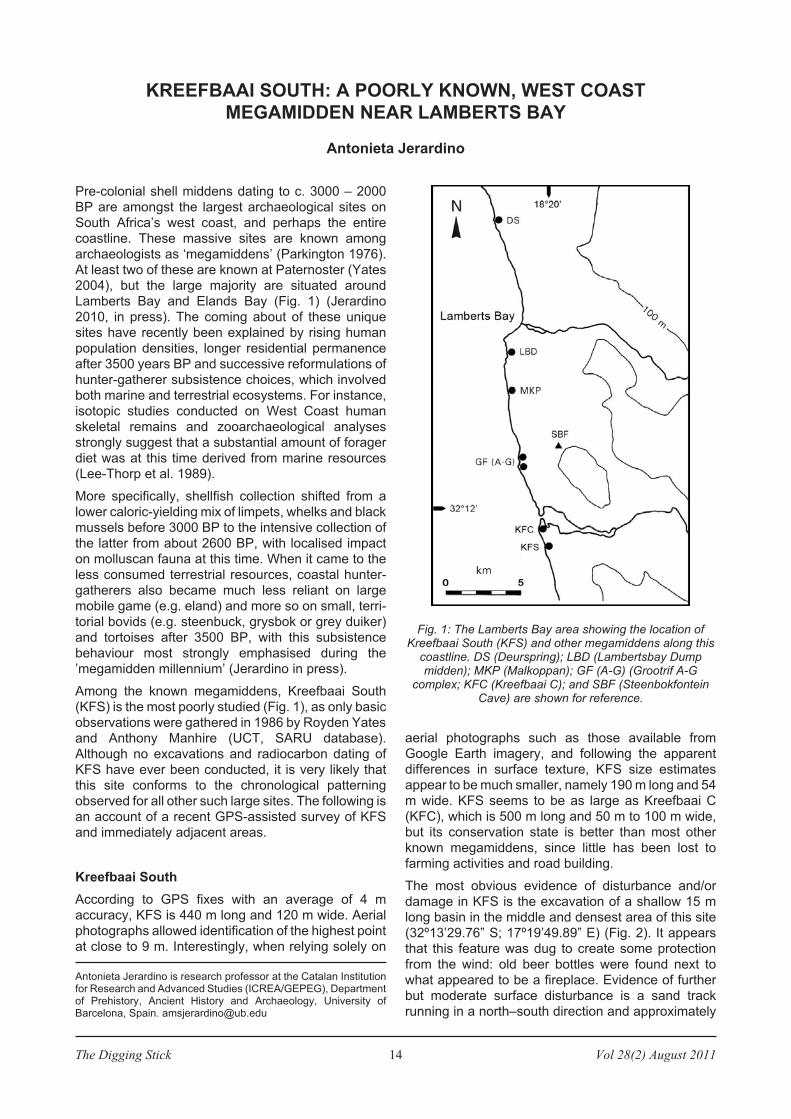
The most obvious evidence of disturbance and/or
damage in KFS is the excavation of a shallow 15 m
long basin in the middle and densest area of this site
(32º13’29.76” S; 17º19’49.89” E) (Fig. 2). It appears
that this feature was dug to create some protection
from the wind: old beer bottles were found next to
what appeared to be a fireplace. Evidence of further
but moderate surface disturbance is a sand track
running in a north–south direction and approximately
KREEFBAAI SOUTH: A POORLY KNOWN, WEST COAST
MEGAMIDDEN NEAR LAMBERTS BAY
Antonieta Jerardino
Antonieta Jerardino is research professor at the Catalan Institutionfor Research and Advanced Studies (ICREA/GEPEG), Departmentof Prehistory, Ancient History and Archaeology, University ofBarcelona, Spain. [email protected]
Fig. 1: The Lamberts Bay area showing the location ofKreefbaai South (KFS) and other megamiddens along this
coastline. DS (Deurspring); LBD (Lambertsbay Dumpmidden); MKP (Malkoppan); GF (A-G) (Grootrif A-G
complex; KFC (Kreefbaai C); and SBF (SteenbokfonteinCave) are shown for reference.
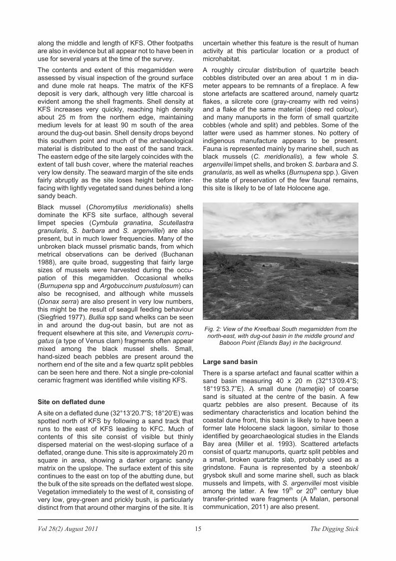
Vol 28(2) August 2011 15 The Digging Stick
along the middle and length of KFS. Other footpaths
are also in evidence but all appear not to have been in
use for several years at the time of the survey.
The contents and extent of this megamidden were
assessed by visual inspection of the ground surface
and dune mole rat heaps. The matrix of the KFS
deposit is very dark, although very little charcoal is
evident among the shell fragments. Shell density at
KFS increases very quickly, reaching high density
about 25 m from the northern edge, maintaining
medium levels for at least 90 m south of the area
around the dug-out basin. Shell density drops beyond
this southern point and much of the archaeological
material is distributed to the east of the sand track.
The eastern edge of the site largely coincides with the
extent of tall bush cover, where the material reaches
very low density. The seaward margin of the site ends
fairly abruptly as the site loses height before inter-
facing with lightly vegetated sand dunes behind a long
sandy beach.
Black mussel (Choromytilus meridionalis) shells
dominate the KFS site surface, although several
limpet species (Cymbula granatina, Scutellastra
granularis, S. barbara and S. argenvillei) are also
present, but in much lower frequencies. Many of the
unbroken black mussel prismatic bands, from which
metrical observations can be derived (Buchanan
1988), are quite broad, suggesting that fairly large
sizes of mussels were harvested during the occu-
pation of this megamidden. Occasional whelks
(Burnupena spp and Argobuccinum pustulosum) can
also be recognised, and although white mussels
(Donax serra) are also present in very low numbers,
this might be the result of seagull feeding behaviour
(Siegfried 1977). Bullia spp sand whelks can be seen
in and around the dug-out basin, but are not as
frequent elsewhere at this site, and Venerupis corru-
gatus (a type of Venus clam) fragments often appear
mixed among the black mussel shells. Small,
hand-sized beach pebbles are present around the
northern end of the site and a few quartz split pebbles
can be seen here and there. Not a single pre-colonial
ceramic fragment was identified while visiting KFS.
Site on deflated dune
A site on a deflated dune (32°13’20.7”S; 18°20’E) was
spotted north of KFS by following a sand track that
runs to the east of KFS leading to KFC. Much of
contents of this site consist of visible but thinly
dispersed material on the west-sloping surface of a
deflated, orange dune. This site is approximately 20 m
square in area, showing a darker organic sandy
matrix on the upslope. The surface extent of this site
continues to the east on top of the abutting dune, but
the bulk of the site spreads on the deflated west slope.
Vegetation immediately to the west of it, consisting of
very low, grey-green and prickly bush, is particularly
distinct from that around other margins of the site. It is
uncertain whether this feature is the result of human
activity at this particular location or a product of
microhabitat.
A roughly circular distribution of quartzite beach
cobbles distributed over an area about 1 m in dia-
meter appears to be remnants of a fireplace. A few
stone artefacts are scattered around, namely quartz
flakes, a silcrete core (gray-creamy with red veins)
and a flake of the same material (deep red colour),
and many manuports in the form of small quartzite
cobbles (whole and split) and pebbles. Some of the
latter were used as hammer stones. No pottery of
indigenous manufacture appears to be present.
Fauna is represented mainly by marine shell, such as
black mussels (C. meridionalis), a few whole S.
argenvillei limpet shells, and broken S. barbara and S.
granularis, as well as whelks (Burnupena spp.). Given
the state of preservation of the few faunal remains,
this site is likely to be of late Holocene age.
Large sand basin
There is a sparse artefact and faunal scatter within a
sand basin measuring 40 x 20 m (32°13’09.4”S;
18°19’53.7”E). A small dune (hametjie) of coarse
sand is situated at the centre of the basin. A few
quartz pebbles are also present. Because of its
sedimentary characteristics and location behind the
coastal dune front, this basin is likely to have been a
former late Holocene slack lagoon, similar to those
identified by geoarchaeological studies in the Elands
Bay area (Miller et al. 1993). Scattered artefacts
consist of quartz manuports, quartz split pebbles and
a small, broken quartzite slab, probably used as a
grindstone. Fauna is represented by a steenbok/
grysbok skull and some marine shell, such as black
mussels and limpets, with S. argenvillei most visible
among the latter. A few 19th
or 20th
century blue
transfer-printed ware fragments (A Malan, personal
communication, 2011) are also present.
Fig. 2: View of the Kreefbaai South megamidden from thenorth-east, with dug-out basin in the middle ground and
Baboon Point (Elands Bay) in the background.
The Digging Stick 16 Vol 28(2) August 2011
Conclusions
Other than the initial and small-scale sampling and
dating of the KFC megamidden (Jerardino 2010),
much remains to be learned about the archaeology of
the Kreefbaai area. KFS is by far the best preserved of
all the megamiddens and together with a few other
such sites reflects a unique subsistence and settle-
ment choice pursued by pre-colonial hunter-gatherers
of the West Coast of South Africa. The relationship, if
any, between these large sites and smaller peripheral
occupations is also poorly understood. Ongoing farm-
ing, recreational, housing and other developments
threaten the conservation and timely study of these
rare sites. Archaeologists working both in research
and heritage management institutions should work
closely together to ensure conservation of and edu-
cation about these magnificent sites.
Acknowledgements
Many thanks to Mr Boutie Louw
for granting access to his prop-
erty and to Anne Solomon for
editorial assistance.
References
Jerardino, A. 2010. Large shell
middens in Lamberts Bay,
South Africa: a case of hunter-
gatherer resource intensifi-
cation. Journal of Archaeo-
logical Science 37: 2291–2302.
Jerardino, A. 2010, in press.
Large shell middens and hunter-
gatherer resource intensification
along the West Coast of South
Africa: the Elands Bay case
study. Journal of Island and
Coastal Archaeology.
Lee-Thorp, JA, Sealy, JC, van
der Merwe, NJ. 1989. Stable
carbon isotope ratio differences
between bone collagen and
bone apatite, and their relation-
ship to diet. Journal of Archaeo-
logical Science 16: 585–599.
Miller, DE, Yates, JE, Parking-
ton, JE, & Vogel, JC. 1993.
Radiocarbon-dated evidence
relating to a mid-Holocene rela-
tive high sea-level on the south-
western Cape coast, South
Africa. South African Journal of
Science 89: 35–44.
Parkington, J. 1976. Coastal
settlement between the mouths
of the Berg and the Olifants
rivers, Cape Province. South
African Archaeological Bulletin
31: 127–140.
Siegfried, WR. 1977. Mussel-
dropping behaviour of kelp gulls.
South African Journal of
Science 73: 337–341.
Yates, R. 2004. Archaeological
Heritage Resources Assess-
ment: Portion 37 of the Farm
Uitkomst 23, Paternoster, Saldanha Bay Municipality, Western
Cape Province. Unpublished report prepared for Deon Van Zyl
Consultants, Iziko South African Museums, Cape Town.
Khoekhoen cattle pastoralism (continued)
References
Sadr, K. 1998. The first herders at the Cape of Good Hope. African
Archaeological Review 15:101-132.
Sadr, K. 2003. The Neolithic of southern Africa. Journal of African
History 44:195-209.
Sadr, K. 2008. Invisible herders? The archaeology of Khoekhoe
pastoralists. Southern African Humanities 20:179-203.
Sealy, J. 2010. Isotopic evidence for the antiquity of cattle-based
pastoralism in southernmost Africa. Journal of African Archaeology
8: 65-81.
Smith, AB, & Pfeiffer, RH. 1993. The Khoikhoi at the Cape of Good
Hope. Seventeenth-century drawings in the South African Library.
Cape Town: South African Library.
Vol 28(2) August 2011 17 The Digging Stick
The stonewalled and terraced sites dotted across the
undulating landscape of Mpumalanga conjure up an
epoch of productivity and prosperity. But the narra-
tives of conflict and violence in the oral traditions that
refer to this area and period paint a bleaker picture.
For many decades this apparent contradiction was
not interrogated as these sites remained cloaked in a
shroud of scholarly neglect. In recent years, however,
this indifference has given way to mounting interest as
archaeologists and historians have embarked on joint
research. Based on the insights available from both
material and oral sources, they have developed a
deeper understanding of the history of these stone-
walled sites. The dialogue between these disciplines
has delineated a fascinating world, and raised impor-
tant new questions about how it operated and adap-
ted (see Delius & Schoeman 2008; Maggs 2008).
Collaboration
This collaboration combined material from archae-
ological (e.g. Van Hoepen 1939; Mason 1968; Evers
1973, 1975; Marker & Evers 1976; Collett 1982;
Maggs 1995) and historical sources (e.g. Berliner Mis-
sions Berichte; Merensky 1862; Winter 1912; Hunt
1931; Mönnig 1963, 1967). All these sources have
limitations, and reflect the period in which they were
collected and/or published. Many of the recorded oral
sources focussed on the history of the Pedi polity, only
mentioning the people of Bokoni when they became
entangled in the politics of the Pedi. A key exception
was a 1930s University of Pretoria MA thesis on the
Sekoni language by the linguist CW Prinsloo. In the
thesis the history of Bokoni is used as background
information for understanding elements of Sekoni.
Prinsloo’s Bokoni (the land of Bakoni) consisted of the
area between Machadodorp, Lydenburg and Sabie.*
This is the broad region in which the stonewalled
terraced sites occur (see Delius & Schoeman 2008 for
a more extensive discussion; Fig. 1).
The Bokoni sequence
The history of Bokoni can be divided into four phases.
The first phase comprises the earliest era that is
archaeologically visible, but on which oral traditions
are mute. The second phase relates to the period
during which the open-valley sites in the Elands,
Crocodile and Sabie valleys constituted the core of
Bokoni. During the third phase the people of Bokoni
retreated into kloof sites, which were re-occupied in
the fourth phase by hybrid communities. This
sequence is explored in more detail below.
Phases 1 and 2
We do not as yet know when the tradition of building
the stonewalled and terraced sites, which are so char-
acteristic of Bokoni, started. However, we do know
that communities have occupied Bokoni since at least
the 17th
century since the earliest collected Pedi tra-
dition recalls that in approximately 1650 a group of
A SHORT HISTORY OF BOKONI
Alex Schoeman and Peter Delius
MH Schoeman is with the School of Geography, Archaeology andEnvironmental Studies, University of the Witwatersrand, Johannes-burg. [email protected]
Professor Peter Delius is with the Department of History, Universityof the Witwatersrand, Johannesburg. [email protected]
* Whilst we adopt Prinsloo’s description of the region as ‘Bokoni’,we have not found convincing evidence that the ‘Bakoni’ formed aunited, uniform ethnic group. In fact, at this stage the data issuggesting the opposite (see Delius & Schoeman 2008, 142-145).
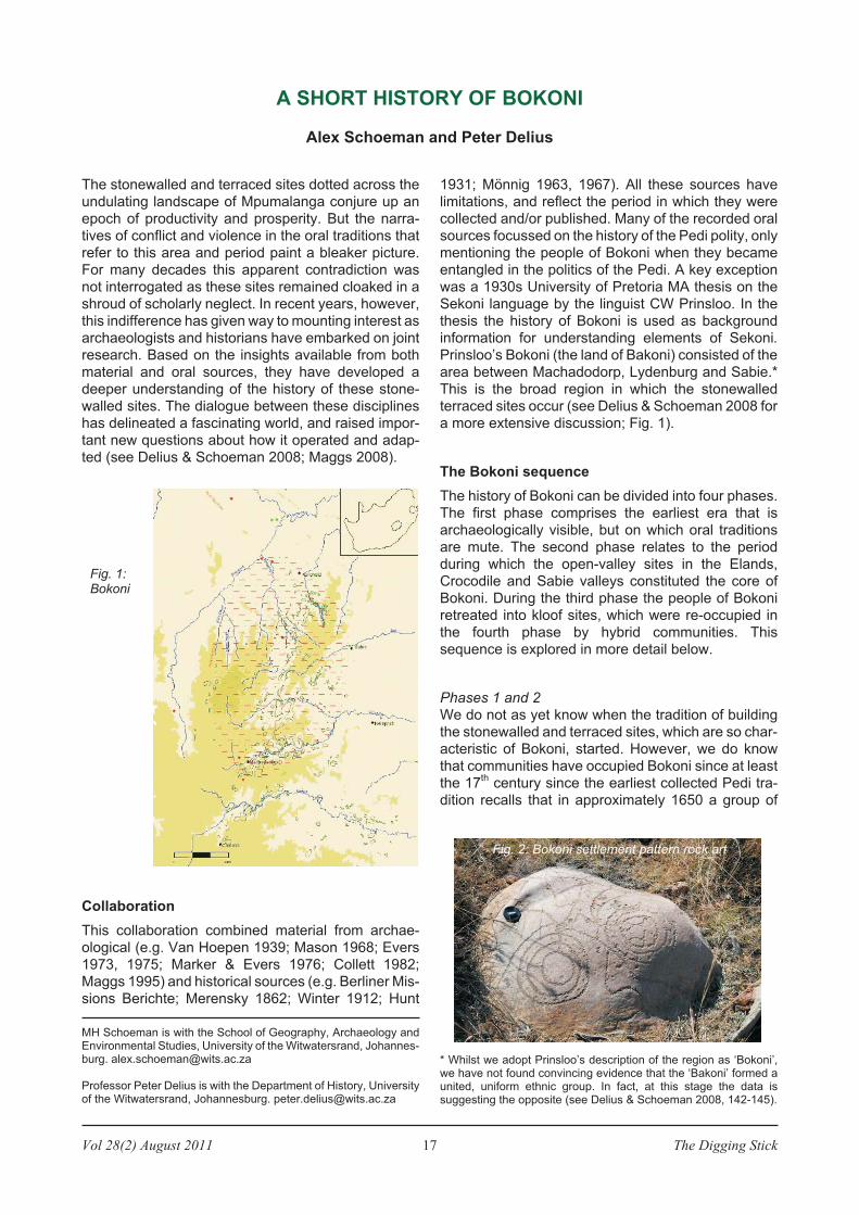
Fig. 1:Bokoni
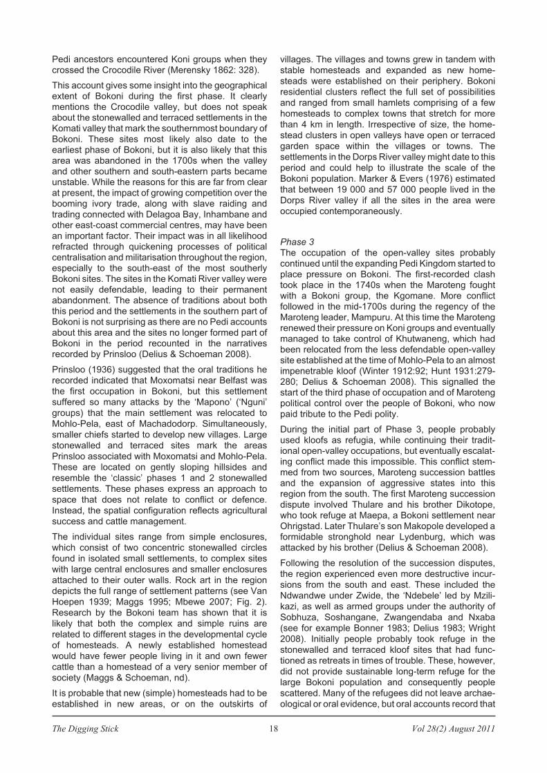
Fig. 2: Bokoni settlement pattern rock art
The Digging Stick 18 Vol 28(2) August 2011
Pedi ancestors encountered Koni groups when theycrossed the Crocodile River (Merensky 1862: 328).
This account gives some insight into the geographicalextent of Bokoni during the first phase. It clearlymentions the Crocodile valley, but does not speakabout the stonewalled and terraced settlements in theKomati valley that mark the southernmost boundary ofBokoni. These sites most likely also date to theearliest phase of Bokoni, but it is also likely that thisarea was abandoned in the 1700s when the valleyand other southern and south-eastern parts becameunstable. While the reasons for this are far from clearat present, the impact of growing competition over thebooming ivory trade, along with slave raiding andtrading connected with Delagoa Bay, Inhambane andother east-coast commercial centres, may have beenan important factor. Their impact was in all likelihoodrefracted through quickening processes of politicalcentralisation and militarisation throughout the region,especially to the south-east of the most southerlyBokoni sites. The sites in the Komati River valley werenot easily defendable, leading to their permanentabandonment. The absence of traditions about boththis period and the settlements in the southern part ofBokoni is not surprising as there are no Pedi accountsabout this area and the sites no longer formed part ofBokoni in the period recounted in the narrativesrecorded by Prinsloo (Delius & Schoeman 2008).
Prinsloo (1936) suggested that the oral traditions he
recorded indicated that Moxomatsi near Belfast was
the first occupation in Bokoni, but this settlement
suffered so many attacks by the ‘Mapono’ (‘Nguni’
groups) that the main settlement was relocated to
Mohlo-Pela, east of Machadodorp. Simultaneously,
smaller chiefs started to develop new villages. Large
stonewalled and terraced sites mark the areas
Prinsloo associated with Moxomatsi and Mohlo-Pela.
These are located on gently sloping hillsides and
resemble the ‘classic’ phases 1 and 2 stonewalled
settlements. These phases express an approach to
space that does not relate to conflict or defence.
Instead, the spatial configuration reflects agricultural
success and cattle management.
The individual sites range from simple enclosures,
which consist of two concentric stonewalled circles
found in isolated small settlements, to complex sites
with large central enclosures and smaller enclosures
attached to their outer walls. Rock art in the region
depicts the full range of settlement patterns (see Van
Hoepen 1939; Maggs 1995; Mbewe 2007; Fig. 2).
Research by the Bokoni team has shown that it is
likely that both the complex and simple ruins are
related to different stages in the developmental cycle
of homesteads. A newly established homestead
would have fewer people living in it and own fewer
cattle than a homestead of a very senior member of
society (Maggs & Schoeman, nd).
It is probable that new (simple) homesteads had to be
established in new areas, or on the outskirts of
villages. The villages and towns grew in tandem with
stable homesteads and expanded as new home-
steads were established on their periphery. Bokoni
residential clusters reflect the full set of possibilities
and ranged from small hamlets comprising of a few
homesteads to complex towns that stretch for more
than 4 km in length. Irrespective of size, the home-
stead clusters in open valleys have open or terraced
garden space within the villages or towns. The
settlements in the Dorps River valley might date to this
period and could help to illustrate the scale of the
Bokoni population. Marker & Evers (1976) estimated
that between 19 000 and 57 000 people lived in the
Dorps River valley if all the sites in the area were
occupied contemporaneously.
Phase 3The occupation of the open-valley sites probablycontinued until the expanding Pedi Kingdom started toplace pressure on Bokoni. The first-recorded clashtook place in the 1740s when the Maroteng foughtwith a Bokoni group, the Kgomane. More conflictfollowed in the mid-1700s during the regency of theMaroteng leader, Mampuru. At this time the Marotengrenewed their pressure on Koni groups and eventuallymanaged to take control of Khutwaneng, which hadbeen relocated from the less defendable open-valleysite established at the time of Mohlo-Pela to an almostimpenetrable kloof (Winter 1912:92; Hunt 1931:279-280; Delius & Schoeman 2008). This signalled thestart of the third phase of occupation and of Marotengpolitical control over the people of Bokoni, who nowpaid tribute to the Pedi polity.
During the initial part of Phase 3, people probablyused kloofs as refugia, while continuing their tradit-ional open-valley occupations, but eventually escalat-ing conflict made this impossible. This conflict stem-med from two sources, Maroteng succession battlesand the expansion of aggressive states into thisregion from the south. The first Maroteng successiondispute involved Thulare and his brother Dikotope,who took refuge at Maepa, a Bokoni settlement nearOhrigstad. Later Thulare’s son Makopole developed aformidable stronghold near Lydenburg, which wasattacked by his brother (Delius & Schoeman 2008).
Following the resolution of the succession disputes,
the region experienced even more destructive incur-
sions from the south and east. These included the
Ndwandwe under Zwide, the ‘Ndebele’ led by Mzili-
kazi, as well as armed groups under the authority of
Sobhuza, Soshangane, Zwangendaba and Nxaba
(see for example Bonner 1983; Delius 1983; Wright
2008). Initially people probably took refuge in the
stonewalled and terraced kloof sites that had func-
tioned as retreats in times of trouble. These, however,
did not provide sustainable long-term refuge for the
large Bokoni population and consequently people
scattered. Many of the refugees did not leave archae-
ological or oral evidence, but oral accounts record that

Vol 28(2) August 2011 19 The Digging Stick
some joined the Ndzundza Ndebele at KwaMaza,while others took refuge in rugged areas such as themountains in northern Bokoni where substantialterraced and stonewalled sites are found in deep,inaccessible kloofs.
Once the conflict subsided, a process of politicalregrouping began that culminated in the emergenceof a new chiefdom led by a Bokoni commoner namedMarangrang in the late 1820s. He soon embarked onan aggressive expansion of the area under his controlfrom his base near Lydenburg. It is likely that this basewas the earlier stronghold of Khutwaneng, which ismarked by intensive residential terracing, LaterMarangrang moved to the Dwars River, which con-tains several intensively terraced sites that probablydate to the pre-Mfecane period. It is likely thatMarangrang re-occupied one of these sites. Hisexpansionist policies brought him into conflict with there-established Pedi polity, now under the leadershipof Sekwati. This conflict led to the final destruction ofBokoni, the final scattering of its people and the end ofstonewalled settlements in the region (Delius &Schoeman 2008).
Phase 4Some of the scattered people of Bokoni returned totheir old homes when the troubles ended (Prinsloo1936:12-13), but these occupations were mereshadows of Bokoni and the communities eventuallyhad to accept Boer authority. Others were eventuallyabsorbed into those societies that gave them refuge,while some remained on the margins and maintaineda degree of autonomy from both sets of rulers (Delius1983:24-29, 37-38, 90-91). One of the best known ofthese scattered Bokoni groups found refuge at theBerlin Mission station, Botšhabelo. Here theyencountered Dinkwanyane, a Christian member ofthe Pedi royal family who played a key leadership roleat Botšhabelo.
The Koni group were led by Chief Phassoane, whogrew up in a Bokoni village located near the ElandsRiver. When Dinkoanyane became dissatisfied withthe political processes at Botšhabelo, Phassoanesuggested that they move to his childhood home. Themove was blocked by the Landdros, but Dinkwanyanestill left the mission station and a community under hisleadership established Mafolofolo at another Bokonirefuge site near the Spekboom River, north of Lyden-burg (Delius 1983: 171-172; Delius & Schoeman2008:155-156). Mafolofolo was a formidable fortressand one example of a much wider trend in the secondhalf of the 19
thcentury of stone walling techniques
developed by the Koni influencing the development oflarge-scale and extremely effective mountain strong-holds. These included the capitals of the Pedi, theKopa, the Ndzundza Ndebele, the Pulana and otherpolities. They used a combination of natural features,stone walling and the acquisition of large numbers ofrifles to create fortresses that filled attackers withdread and could only be taken with massive military
resources and heavy loss of life. They played a vitalpart in the history of the region in the 19
thcentury.
Conclusion
The sequence outlined in this article shows thatcollaboration between archaeologists and historianshas ensured that the limitations of oral and archae-ological sources were taken into account, but werealso transcended. By combining oral and archae-ological sources the Bokoni team placed the stone-walled Mpumalanga sites in historical context andthereby opened new avenues for understanding sitedistribution, architecture and complexity.
References
Bonner, P. 1983. Kings, commoners and concessionaires. Johan-nesburg: Ravan Press.
Collett, DP. 1982. Excavations of stone-walled ruin types in theBadfontein valley, Eastern Transvaal, South Africa. The SouthAfrican Archaeological Bulletin 37:34-43.
Delius, P. 1983. The land belongs to us: The Pedi polity, the Boersand the British in the nineteenth century Transvaal. Johannesburg:Ravan Press.
Delius, P, and Schoeman, MH. 2008. Revisiting Bokoni: Populatingthe stone ruins of the Mpumalanga escarpment. In Swanepoel, N,Esterhuysen, AB, & Bonner, P (eds), Five hundred yearsrediscovered,. Johannesburg: Wits University Press, 135-168.
Evers, TM. 1973. Iron Age research in the Eastern Transvaal,South Africa, 1971. Current Anthropology 14(4):487-489.
Evers, TM. 1975. Recent Iron Age research in the EasternTransvaal, South Africa. South African Archaeological Bulletin 30:71-83.
Hunt, DR. 1931. An account of the Bapedi. Bantu Studies V, 291-326.
Lekgoathi, SP. 2009. Colonial experts, local interlocutors, infor-mants and the making of an archive on the ‘Transvaal Ndebele,1930–1989. Journal of African History 50 (1): 61-80.
Maggs, T. 1995. Neglected rock art: The rock engravings ofagriculturist communities in South Africa. South AfricanArchaeological Bulletin 50:132-142.
Maggs, T. 2008. The Mpumalanga escarpment settlements: Someanswers, many questions. in Swanepoel, N, Esterhuysen, AB, &Bonner. P (eds), Five hundred years rediscovered, 169–181.
Maggs, T, & Schoeman, MH. 2008. The Mpumalanga escarpmentsettlements: Further work in progress’. Paper for the FYIconference ‘Continuing Conversations at the Frontier’, University ofCape Town, 17–19 June 2008.
Marker, ME, & Evers, TM. 1976. Iron Age settlement and soilerosion in the Eastern Transvaal. South African ArchaeologicalBulletin 31:153-165.
Mason, RJ. 1968. Transvaal and Natal Iron Age settlement reveal-ed by aerial photography and excavation. African Studies 27:1-14.
Mbewe, R. 2007. Engraved rocks at Boomplaats farm: Farmersettlement rock engravings of Mpumalanga Province, South Africa.MA dissertation, University of the Witwatersrand.
Merensky, A. 1862. Beitrage zur Geschichte der Bapeli. BerlinerMission Berichte 1862.
Mönnig, HO. 1963. The Baroka Ba Nkwana. African Studies 22 (4)
Mönnig, HO. 1967. The Pedi. Pretoria: Van Schaik.
Prinsloo, CW. 1936. Klank- en vormleer van BaKoni. MAdissertation. Pretoria: University of Pretoria.
Van Hoepen, ECN. 1939. A pre-European Bantu culture in theLydenburg District. Argeologiese Navorsing van die NasionaleMuseum, Bloemfontein II(5):47-74.
Winter, JA. 1912. The tradition of Ra’lolo. South African Journal ofScience IX:90.
Wright, J. 2008. Rediscovering the Ndwandwe Kingdom. InSwanepoel, N, Esterhuysen, AB, & Bonner. P (eds), Five hundredyears rediscovered, Johannesburg: Wits Press. 217-239.
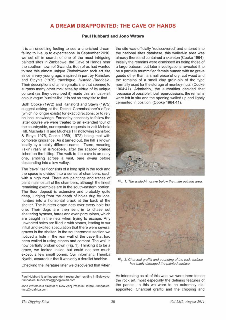
The Digging Stick 20 Vol 28(2) August 2011
It is an unsettling feeling to see a cherished dream
failing to live up to expectations. In September 2010,
we set off in search of one of the most intriguing
painted sites in Zimbabwe: the Cave of Hands near
the southern town of Gwanda. Both of us had wanted
to see this almost unique Zimbabwean rock art site
since a very young age, inspired in part by Ransford
and Steyn’s (1975) travelogue, Historic Rhodesia.
Their descriptions of an enigmatic site that seemed to
surpass many other rock sites by virtue of its unique
content (as they described it) made this a must-visit
on our vague ’bucket-list’. It is not an easy site to find.
Both Cooke (1972) and Ransford and Steyn (1975)
suggest asking at the District Commissioner’s office
(which no longer exists) for exact directions, or to rely
on local knowledge. Forced by necessity to follow the
latter course we were treated to an extended tour of
the countryside, our repeated requests to visit Mchela
Hill, Muchela Hill and Muchezi Hill (following Ransford
& Steyn 1975, Cooke 1959, 1972) being met with
complete ignorance. As it turned out, the hill is known
locally by a totally different name – Tsere, meaning
’(skin) rash’ in isiNdebele, after the scabby orange
lichen on the hilltop. The walk to the cave is an easy
one, ambling across a vast, bare dwala before
descending into a low valley.
The ’cave’ itself consists of a long split in the rock and
the space is divided into a series of chambers, each
with a high roof. There are paintings and traces of
paint in almost all of the chambers, although the finest
remaining examples are in the south-eastern portion.
The floor deposit is extensive and probably quite
deep, judging from the depth of holes dug by local
hunters into a horizontal crack at the back of the
shelter. The hunters drape nets over every hole but
one. Their dogs are then sent in to chase out
sheltering hyraxes, hares and even porcupines, which
are caught in the nets when trying to escape. Any
unwanted holes are filled in with stones, leading to our
initial and excited speculation that there were several
graves in the shelter. In the southernmost section we
noticed a hole in the rear wall of the cave that had
been walled in using stones and cement. The wall is
now partially broken down (Fig. 1). Thinking it to be a
grave, we looked inside but could not see much
except a few small bones. Our informant, Themba
Nyathi, assured us that it was only a derelict beehive.
Checking the literature later we discovered that when
the site was officially ’rediscovered’ and entered into
the national sites database, this walled-in area was
already there and contained a skeleton (Cooke 1964).
Initially the remains were dismissed as being those of
a large baboon, but later investigations revealed it to
be a partially mummified female human with no grave
goods other than ’a small piece of dry, cut wood and
the remains of a small clay grain-bin of the type
normally used for the storage of monkey-nuts’ (Cooke
1964:41). Admirably, the authorities decided that
’because of possible tribal repercussions, the remains
were left in situ and the opening walled up and lightly
cemented in position’ (Cooke 1964:41).
As interesting as all of this was, we were there to see
the rock art, most especially the defining features of
the panels. In this we were to be extremely dis-
appointed. Charcoal graffiti and the chipping and
A DREAM DISAPPOINTED: THE CAVE OF HANDS
Paul Hubbard and Jono Waters
Paul Hubbard is an independent researcher residing in Bulawayo,Zimbabwe. [email protected]
Jono Waters is a director of New Zanj Press in Harare, [email protected]
Fig. 1: The walled-in grave below the main painted area.
Fig. 2: Charcoal graffiti and pounding of the rock surfacehas badly damaged the painted surface.
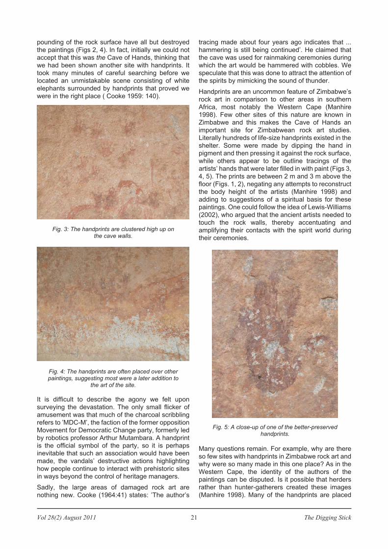
Vol 28(2) August 2011 21 The Digging Stick
pounding of the rock surface have all but destroyed
the paintings (Figs 2, 4). In fact, initially we could not
accept that this was the Cave of Hands, thinking that
we had been shown another site with handprints. It
took many minutes of careful searching before we
located an unmistakable scene consisting of white
elephants surrounded by handprints that proved we
were in the right place ( Cooke 1959: 140).
It is difficult to describe the agony we felt upon
surveying the devastation. The only small flicker of
amusement was that much of the charcoal scribbling
refers to ’MDC-M’, the faction of the former opposition
Movement for Democratic Change party, formerly led
by robotics professor Arthur Mutambara. A handprint
is the official symbol of the party, so it is perhaps
inevitable that such an association would have been
made, the vandals’ destructive actions highlighting
how people continue to interact with prehistoric sites
in ways beyond the control of heritage managers.
Sadly, the large areas of damaged rock art are
nothing new. Cooke (1964:41) states: ’The author’s
tracing made about four years ago indicates that ...
hammering is still being continued’. He claimed that
the cave was used for rainmaking ceremonies during
which the art would be hammered with cobbles. We
speculate that this was done to attract the attention of
the spirits by mimicking the sound of thunder.
Handprints are an uncommon feature of Zimbabwe’s
rock art in comparison to other areas in southern
Africa, most notably the Western Cape (Manhire
1998). Few other sites of this nature are known in
Zimbabwe and this makes the Cave of Hands an
important site for Zimbabwean rock art studies.
Literally hundreds of life-size handprints existed in the
shelter. Some were made by dipping the hand in
pigment and then pressing it against the rock surface,
while others appear to be outline tracings of the
artists’ hands that were later filled in with paint (Figs 3,
4, 5). The prints are between 2 m and 3 m above the
floor (Figs. 1, 2), negating any attempts to reconstruct
the body height of the artists (Manhire 1998) and
adding to suggestions of a spiritual basis for these
paintings. One could follow the idea of Lewis-Williams
(2002), who argued that the ancient artists needed to
touch the rock walls, thereby accentuating and
amplifying their contacts with the spirit world during
their ceremonies.
Many questions remain. For example, why are there
so few sites with handprints in Zimbabwe rock art and
why were so many made in this one place? As in the
Western Cape, the identity of the authors of the
paintings can be disputed. Is it possible that herders
rather than hunter-gatherers created these images
(Manhire 1998). Many of the handprints are placed
Fig. 3: The handprints are clustered high up onthe cave walls.
Fig. 4: The handprints are often placed over otherpaintings, suggesting most were a later addition to
the art of the site.
Fig. 5: A close-up of one of the better-preservedhandprints.
The Digging Stick 22 Vol 28(2) August 2011
over other paintings, suggesting they were the latest
additions to the site. However, the southern and
western areas of Zimbabwe have long been sus-
pected as having been a ’refuge’ for hunter-gatherers
who did not wish to interact with the new agricultural
lifestyle (Walker 1995), which suggests that these
people were the artists. Excavations in the extensive
deposit would go a long way to answering such
queries and provide fascinating insights into the pre-
history of an area long-neglected by researchers.
References
Cooke, CK. 1959. Rock art of Matabeleland. In: Prehistoric rock art
of the Federation of Rhodesia and Nyasaland, R Summers (ed.),
Salisbury: National Publications Trust, 112-162.
Cooke, CK. 1964. An unusual burial in the Gwanda district of South-
ern Rhodesia. The South African Archaeological Bulletin 19 (74):
41-42.
Cooke, CK. 1972. A guide to the historic and prehistoric mon-
uments of Rhodesia. Salisbury: National Museums and
Monuments of Rhodesia.
Lewis-Williams, JD. 2002. The mind in the cave. London: Thames &
Hudson.
Manhire, A. 1998. The role of handprints in the rock art of the south-
western Cape. The South African Archaeological Bulletin 53 (168):
98-108.
Ransford, O, & Steyn, P. 1975. Historic Rhodesia. Salisbury:
Longmans Rhodesia.
Walker, NJ. 1995. Late pleistocene and holocene hunter-gatherers
of the Matopos. Uppsala: Societas Archaeologica Uppsalensis
(Studies in African Archaeology 10).
ARCHAEOLOGY IN AFRICA
Brass rings found on the east coast
The rings in the photo below were shown to a friend of
mine in the Kosi area of KwaZulu-Natal. The local
fisherman said that they had come down the family
from his grandfather and that they had been used to
pay lobola, although the next day he said that he had
dug them up.
The rings were sometimes called neck rings, but I
don’t know if they were ever used as such. They were
a major trade item by European traders on the east
coast of Africa. They are made of brass and were the
basic form in which this metal arrived in the region.
Brass is an alloy of copper and zinc. Zinc is highly
volatile and therefore requires a special smelting
technology that was not known in sub-Saharan Africa.
For this reason all brass had to be imported. Yet
brass, with its long-Iasting gleam, was highly prized.
For example, it was considered a royal metal in the
Zulu kingdom. There were special smiths who
reworked the imported metal into a series of special
artefacts. The most famous and elaborate was the
inxotha, a broad armband with decorated ridges that
was awarded by the king (i.e. Shaka and Dingane) to
senior men of the realm. All brass artefacts were
decorative rather than functional, but their
significance lies really in their high status and even
mystical values.
It is interesting but not really surprising that some of
these rings should be found in the Kosi area since
most would have been imported via Maputo.
Shipwreck survivors of an English ship at Durban and
the Dutch ship Stavenisse in 1687 lived very well off
trading ‘copper neck and arm rings’ (probably brass)
for food with the local people, who wanted only these
rings and glass beads in the way of trade. (See The
Record by D Moodie, entries under Stavenisse,
Centaur, etc.) Tim Maggs, Cape Town
Giant Stone Age axes found in Lake Makgadigadi
The giant 66 0002
km basin of Botswana’s LakeMakgadikgadi has provided information aboutpossible migration routes and hunting practices ofhumans in the Middle to Late Stone Age periodsbetween 150 000 and 10 000 years ago. Researchersfrom the School of Geography and the Environment atOxford University have found evidence that suggeststhe region was once both considerably drier andwetter than it is today. The thousands of stone toolsfound on the lake bed shed new light on how humansadapted to several substantial climate change eventsduring the period that coincided with the last Ice Agein Europe.
Their research was prompted by the discovery of what
are believed to be the world’s largest stone tools on
the bed of a lake. Four giant stone hand axes,
measuring over 30 cm long but of uncertain age, were
recovered in the 1990s in an area littered with tens of
thousands of smaller stone-age tools and flakes.
Many of the tools were found on the dry lake floor, not
around its edge, indicating the congregation of
animals and humans round watering holes on the lake
bed. Physorg.com, 2009
Vol 28(2) August 2011 23 The Digging Stick
For the past four months, I’ve been trying to accessthe ancient site of Leptis Magna, but geopolitics haverather got in the way. Seventy-five miles or so fromTripoli, Leptis has not seen any active conflict – yet.Still, it would have felt not a little self-indulgent for meto drift around the ancient monuments taking noteswhile all about was on fire.
Now I wish I’d travelled before the conflict began.Rebel forces in Libya reported this week [June] thatColonel Gaddafi is using the site as an archaeologicalshield. Missiles, launchers and troops are, they say,snuggled among the columns, corridors and arch-ways. Nato forces – in Gaddafi’s reckoning – won’tbomb them, or his men. Clever. They won’t. But ifGaddafi is holding explosives in this World HeritageSite, a single stray cigarette butt could kick-start asequence that sends it all up in smoke.
The loss of Leptis would be unthinkable. Founded by
Phoenician traders in the Bronze Age, the city-
complex has been a theatre of power and pleasure, of
indulgence and intellect for more than 3 000 years. It
is one of the best-preserved ancient sites in the
Mediterranean. Ruled by Carthage for centuries, the
Romans quickly conquered it. Recent discoveries
include an eye-wateringly exquisite series of Roman-
period mosaics, where warriors hound animals and a
spent gladiator lords it over the corpse of his sparring
partner. It was a local boy, Septimius Severus, who in
the 2nd century AD really made Leptis roar, rebuilding
the forum and the port. As Roman emperor he
promoted the city to the premier league. Leptis is a
megalithic incarnation of this region’s high-octane,
personality-driven history.
Archaeological sites become significant in times of
turmoil. The most recent, shocking example of monu-
mental muscle-flexing has been Iraq. Apart from the
wartime looting of 4 000 treasures (now a feature of
Egypt and Syria too; tomb-raiding pits are pock-
marking the sands around sites like Giza), while still in
power Saddam Hussein crudely reconstructed the
monuments of Babylon. Just as the original builder,
King Nebuchadnezzar, had done 25 centuries before,
he stamped bricks for the monument with: ‘In the era
of President Saddam Hussein, the protector of Great
Iraq, reproducer of its awakening and the builder of its
civilisation’. Fifteen years later, US forces positioned
their camp over the ancient city, cutting across the
foundations of the Tower of Babel. Stone and brick-
work, pottery and human remains were bulldozed to
dig anti-tank trenches. Despite their vandalism, US
soldiers talked of the comfort of operating in the
shadow of buildings that had endured millennia.
Gaddafi is playing an old game. While he might endup crushing his country’s treasures, he is also stylinghimself as their saviour by placing his arms in theirmidst. The Khmer Rouge resolved to destroy every
last wicker-basket’s-worth of national culture, but leftthe giant palace complexes of Angkor Wat andAngkor Thom to stand proud. The Taliban announcedthey were preserving the purity of Afghanistan bydynamiting the 6
thcentury monumental Buddhas of
Bamiyan.
Occupying the corridors of bygone power is evenmore sinister, more telling than simply razing them tothe ground. Last year I travelled to the steppes on theborders of Siberia and Kazakhstan where a newBronze Age civilisation is being discovered. At least40 lost cities are lying under the grasslands, and thestartling thing is that they are all swastika shaped. Themost fully excavated, Arkaim, has yielded pots andstonework also decorated with swastikas. There is astrong chance that this is the location of an earlyAryan civilisation.
I found myself in extraordinary company there, withmany trying to stake their claim to the discoveries,including Russian nationalists, a contingent of thereformed Cossack army plus a scattering of neo-fascist mystics. Russia’s Putin and Medvedev havebeen photographed at the digs. The appeal is clear.As one Cossack told me: ‘The Nazis were right to lookfor an Aryan master race, they were just searching inthe wrong place. It is Arkaim that shows the masterrace is us.’
Safeguarding remains such as Leptis is vital not just
because of their ancient delights but because they
remind us of the scale of mankind’s ambition, and of
the blood, sweat and tears of ordinary folk who spent
and lost their lives realising such monuments. The
accumulated human back story of archaeological
sites has great mass. It is why men like Gaddafi – who
talk big but whose strength, in truth, is one -man small
- have a love-hate relationship with the triumphs of the
past. They either try to hide behind them or wipe them
out of existence.Article (edited) by Bettany Hughes in The Guardian, June 2011
ARCHAEOLOGY IN BRIEF
Marlborough Mound built in 2400 BC. A Wiltshire
mound where the legendary wizard Merlin was
purported to be buried has been found to date back to
2400 BC. Radiocarbon-dating tests were carried out
on charcoal samples taken from mound. The 19 m
high mound had previously mystified historians.
Some believed it dated back to about 600 AD. Others
have wondered whether it is Silbury’s little sister.
Silbury Hill, an artificial man-made mound about 8 km
away, also dates back to 2400 BC. Marlborough
Mound was reused as a castle and became an
important fortress for the Norman and Plantagenet
kings. It was also the scene for major political events.
BBC News, June 2011
TYRANTS WILL ALWAYS EXPLOIT ANCIENT TREASURES
The Digging Stick 24 Vol 28(2) August 2011
WORLD ARCHAEOLOGY
Excavated bomb suggests early start for artillery
Archaeologists in north-western Germany have dis-
covered two projectiles from the 17th
century that sug-
gest exploding cannon balls have been around longer
than thought. They appear to be the invention of
Christoph Bernhard von Galen (1606-1678), who by
dint of hard work and strict devotion to God managed
to attain the rank of prince-bishop. The man liked to
rub shoulders with generals and was fond of using
gunpowder to lend authority to Jesus’ words.
The Dutch in particular felt the wrath of this Catholic
weapons fanatic from Münster. In 1672, Galen sent
heavy mortars rolling north, which his artillerymen
filled with hollow iron shot weighing over 70 kg. These
odd explosives shot high into the sky with a mighty
boom. One fell into a moat, where it extinguished.
Nearly 350 years later, the bomb has come to light in
the swampy soil of East Frisia during excavations at a
defensive fortification near Dielen dating to 1580.
The object is larger than a medicine ball and is cast
from iron, with sides 5 cm thick. It still contained some
7 kg of gunpowder and even the fuse was still present.
Another shell, identical in its construction, surfaced at
the site last year. Some researchers could hardly
believe the news of the finds. Documents from 1326
do report the first instances of armies using gun-
powder to sling stone cannonballs into the air, with the
heaviest recorded projectile for cracking fortifications
weighing 697 kg. Soon after came experiments in fill-
ing the cannons’ barrels with lead shot, red-hot iron
balls or leather hides filled with scrap metal.
But the history of artillery shells, intended to explode
after reaching their targets with the help of a fuse, was
one marked by false starts. Around 1450, craftsmen
began filling hollow iron balls with gunpowder for use
as shot. Often the technique failed. The cannoneers
had to reach into the mortar’s opening, light the fuse,
then quickly fire the weapon. If their timing was off, the
entire cannon would blow up before the projectile had
left the barrel. They also often failed to calculate the
projectile’s trajectory correctly. The technology nec-
essary for propelling bombs remained difficult to
improve. During the American Civil War the two sides
still shot at each other using solid iron balls.
Bishop Galen may well have been ahead of his time.
The shells now discovered have an opening con-
taining a wooden stake, drilled down the middle and
containing gunpowder that reaches as far as the
explosive charge inside the cannonball. Attached to
the outside of the ball is netting made of thick cords
that all connect to the wooden fuse. The cannonball
was coated with bitumen and wrapped in rough cloth.
The researcher surmises this signifies the metal ball
self-ignited from the heat when it was fired and burned
as it whizzed through the air. Der Spiegel, 06/06/11
The South AfricanArchaeological Society
This is the society for members of the public and
professionals who have an interest in archaeology and
related fields such as palaeontology, geology and
history. Four branches serve the interests of members.
They arrange regular lectures and field excursions
guided by experts, annual and occasional symposia, and
longer southern African and international archaeological
tours.
The Society was founded in 1945 to promote archae-
ology through research, education and publication. It is a
non-profit organization – Registration No. 024-893-NPO.
Cape Town head office: PO Box 15700, Vlaeberg,
8018. Tel: +27 (0)21 481 3886. Fax: +27 (0)21 481 [email protected]. www.archaeologysa.co.za.
Trans-Vaal Branch: PO Box 41050, Craighall, 2024
Membership Secretary: Mrs Pamela Küstner
012 365 [email protected]
Western Cape Branch: PO Box 426, Muizenberg, 7950
Chairperson: Ms Yvonne Viljoen
021 788 [email protected]
KwaZulu-Natal Branch:c/o Natal Museum, P/Bag
9070, Pietermaritzburg, 3200
Secretary: Ms Christine Sievers
031 563 [email protected]
Trans-!Gariep Branch: David Morris
053 839 2706
The Society produces the following publications:
�South African Archaeological Bulletin, a
scientific publication of current research in southern
Africa – twice a year
�The Digging Stick, the Society’s general interest
magazine – three issues a year
�Goodwin Series, an occasional publication on a
specific field of archaeological interest
Subscription rates for 2011 are as follows: Individuals:
Single – R230; Joint/Family – R245; Junior membership
– R160; Africa ordinary – R250; Overseas ordinary –
R450*. Institutions: Local and African – R450; Overseas
– R900*. [* Plus R100 bank charges]
The Digging Stick
Editor and advertising: Reinoud BoersPO Box 2196, Rivonia, 2128Tel/fax: 011 803 2681Cell: 082 566 6295
Layout: Marion Boers
Printer: TVaal Johannesburg