Embed Size (px)
Citation preview
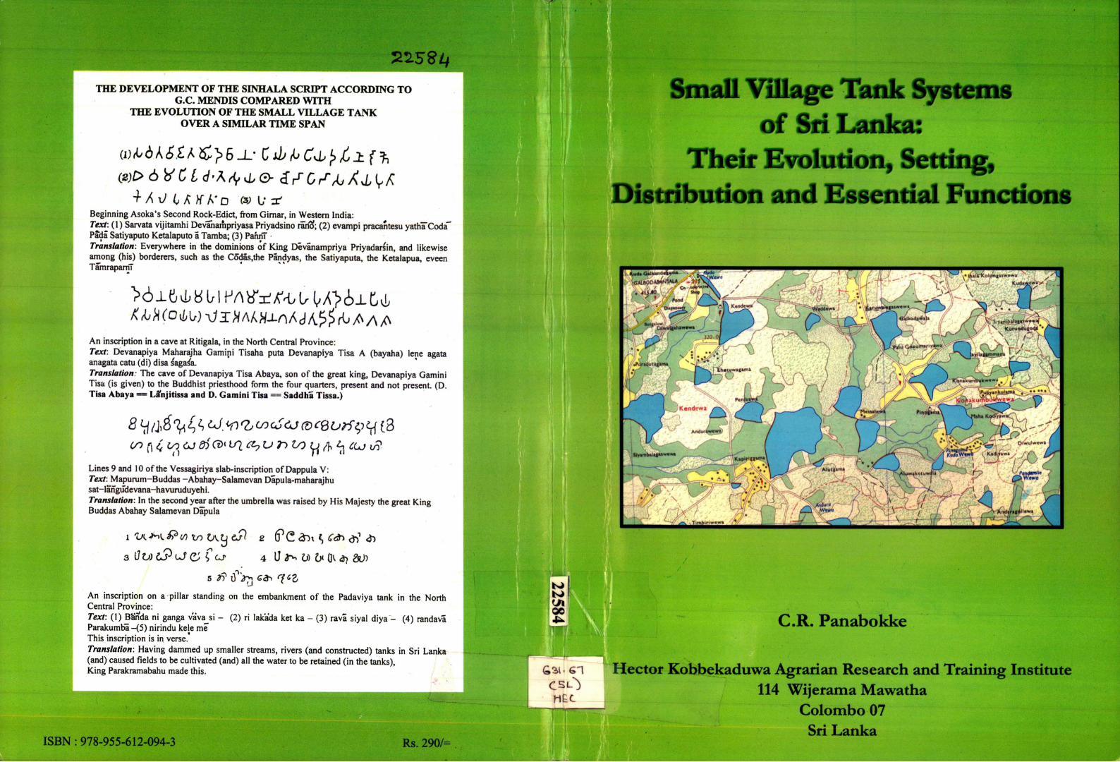
THE DEVELOPMENT OF THE SINHALA SCRD?T ACCORDING TO G.C. MENDIS COMPARED WITH
THE EVOLUTION OF THE SMALL VILLAGE TANK OVER A SIMILAR TIME SPAN
Beginning Asoka's Second Rock-Edict, from Gimar, in Western India: Text: (1) Sarvata vijitamhi Devihaifipriyasa Priyadsino rario; (2) evampi pracantesu yatha"Coda"~ Pada Satiyaputo Ketalaputo a Tamba; (3) PahnT Translation: Everywhere in the dominions of King Devanampriya Priyadarsin, and likewise among (his) borderers, such as the C6~das,the Pandyas, the Satiyaputa, the Ketalapua, eveen TamraparnT
An inscription in a cave at Ritigala, in the North Central Province: Text: Devanapiya Maharajha Gamini Tisaha puta Devanapiya Tisa A (bayaha) lene agata anagata catu (di) disa sagasa. Translation: The cave of Devanapiya Tisa Abaya, son of the great king, Devanapiya Gamini Tisa (is given) to the Buddhist priesthood form the four quarters, present and not present. (D. Tisa Abaya == Lffnjitissa and D. Gamini Tisa = Saddha Tissa.)
cn (\(f toCJdSCfrVl£hUr> to fa % Ojj IS? Lines 9 and 10 of the Vessagiriya slab-inscription of Dappula V: Text: Mapurum-Buddas -Abahay-Salamevan Dapula-maharajhu sat-langude vana-havuruduyeh i. Translation: In the second year after the umbrella was raised by His Majesty the great King Buddas Abahay Salamevan Dapula
i u M P w v> C\tJ cfl s (PC fr>\«, c& #) <*>
3 OV) 1$ OJ £ , f CJ- 4 U 3 ^ l» 6< OV <3? &j>
5 3? cP>7j qcz An inscription on a pillar standing on the embankment of the Padaviya tank in the North Central Province: Text: (1) Barfda ni ganga vava si - (2) ri lakada ket ka - (3) rava siyal diya - (4) randava Parakumba-(5) nirindu kele me This inscription is in verse. Translation: Having dammed up smaller streams, rivers (and constructed) tanks in Sri Lanka (and) caused fields to be cultivated (and) all the water to be retained (in the tanks), King Parakramabahu made this.
ISBN : 978-955-612-094-3
Small Village Tank Systems of Sri Lanka:
Their Evolution, Setting, Distribution and Essential Functions
C.R. Panabokke
Hector Kobbekaduwa Agrarian Research and Training Institute 114 Wijerama Mawatha
Colombo 07 Sri Lanka

V 4
cr 1 130
Small Village Tank Systran of Sri Lanka:
Their Evolution, Setting, Distribution and Essential Functions
CR. Panabokke
Special Publication July 2009
Hector Kobbekaduwa Agrarian Research and Training Institute 114, Wijerama Mawatha
Colombo 07 Sri Lanka
2 2 5 8 4 LIB - • :o
KARTI

First Published 2009
© Hector Kobbekaduwa Agrarian Research and Training Institute
All rights reserved
Cover page design: Ms. Bimali C Munasinghe
ISBN : 978-955-612-094-3
ii

F O R E W O R D
In a long and arduous scientific study-trek spanning over half a century, mostly in the dry zone of Sri Lanka, the author has endeavoured to understand the varying facets of the form and content of the dry zone's physical environmental components - soils, physiographic characteristics, geology, water supply and drainage patterns - which both challenged and supported the human power of endurance and ingenuity, not only in mere survival of man but also in nurturing a remarkable hydraulic civilization over the centuries in such an exacting dry zone environment.
The author's heightened passion for and interest in the landscape hydrology of this undulating hard rock landscape, and his scholarly association with the International Irrigation/Water Management Institute (IWMI) in the 1980s, appear to have directed him in particular to study the cascade based small village tank systems meticulously. He has made several succinct and outstanding research contributions during the 1980s and 1990s.
This volume is the most comprehensive and concise publication to date, which has consulted almost all the available authentic sources, not simply by glossing over them, but by rigorously giving meaningful interpretations to the ideas expressed in them. New interpretations to the ideas already expressed by past scholars are generally lacking in current studies conducted in Sri Lanka. Throughout this study the author has attempted to fill this void.
Looking at this study as a whole, it becomes evident that it will undoubtedly be a launching pad for future generations of scholars to continue from where the author has left.
The chapters in this publication are well sequenced to flow from one to the other. As a whole, it has convincingly led to argue that irrigation based on small village tanks developed on the hard rock terrain is a unique and very old system developed in Sri Lanka. This is significantly different from other ancient irrigation systems such as the Mesopotamian, Egyptian and Indus, which are based on rivers and their alluvial plains and often margined by desert environments.
This study is well substantiated with maps and diagrams, each of which speaks volumes about the subject that the author has painstakingly and logically marshalled throughout. In this regard, Chapters 2 and 3 remain as an outstanding contribution.
The perceptive and strategic changes in irrigation systems of ancient Sri Lanka from the Anuradhapura period to the Polonnaruwa period, that is, not only of the irrigation engineers but also of the rulers, is referred to in this study. The author's brief comparison of the irrigation code of Hammurabi King of Babylon (1900 B.C.) with that of King Parakramabahu the Great (1153-1186 A.D.) is very striking. He has convincingly argued that where the maintenance of small village tanks had been the responsibility of the village communities, their management remained intact notably
iii

during the Anuradhapura period; but during the Polonnaruwa period the centralized management of irrigation had frequent deteriorations (except under the able rulers) when the general administrative institutions collapsed.
A good researcher having embedded all his arguments in a wide canvas, always makes a summation of all his arguments with highlights carefully included. Chapter 5 has done the same by highlighting the major points of the author's study. This is the climax chapter in this volume, which refers to the history, a comparison of small and big tanks, stability of village irrigation systems, irrigation as a risk minimizing way of life, past and present land tenure, irrigations rituals and ceremonies etc.
In sum, Dr. Panabokke has professed a great interest in the genesis of the cascade-based irrigation civilization of the dry zone of Sri Lanka in his characteristic scientific style, and this will surely be a fitting forerunner to the intended publications of Volumes II and III.
V.K. Nanayakkara Director Hector Kobbekaduwa Agrarian Research and Training Institute
iv

"A proper scientific study of any village irrigation work should really begin in the field."
This Volume I is dedicated to
Henry Parker 1849-1924 Robert Wilson levers 1850-1905 Richard Leslie Brohier 1892-1980 Cyril Wace Nicholas 1898-1961
The true pioneers in the scientific field study of the country's ancient irrigation works
ACKNOWLEDGEMENT
I wish to express my special thanks to Mr. D.G.P. Seneviratne, former Director HARTI for having invited me to undertake the writing of this set of volumes on the "Small Village Tanks of Sri Lanka". His invitation was made to me at the conclusion of a Symposium held at HARTI on "Small Tank Settlements in Sri Lanka" in August 2004. It was a 'scholar's' agreement in which I was free to make full use of the essential support services available at HARTI, and to complete the task within a 'reasonable' time frame.
Because of my several other commitments, I have to confess that this 'reasonable' time frame got itself extended to well beyond the initially envisaged three year period. Furthermore, as the writing progressed I became more engrossed in the subject, especially after the writings of Dr. Joseph Needham and his communications with Martin Wickramasinghe the 'Sage of Koggala' were kindly made available to me through the courtesy of the latter's son Mr. V.K. Wickramasinghe. I, however, seek no apology on this score for exceeding the 'reasonable' time frame.
It was also very fortunate that Mr. V.K. Nanayakkara, Director, HARTI (2005 to July 2009), himself had a scholarly interest in the subject area of the small village tanks of this country, which gave an additional support and encouragement to my study. In the same tradition of scholarly directors of HARTI, Mr. J. Alwis, (Director of HARTI from 1987 to 1989) made the first preliminary review of the final draft manuscript in October 2008. His preliminary review helped me very significantly, to give an improved focus and attention
^ to the evolutionary aspects of the small village tank.
Mr. J. Alwis considers the small village tank of the ancient period as the "cradle and nursery of the nation and the nucleus of the NCP village" and, that its study helps "to create a new awareness on the history and culture of the people".
Prof. Marcus Karunanayake made very constructive comments on the very first initial draft in 2006. And these were accommodated in my subsequent drafts. Both Dr. W.G. Jayasena, former Deputy Director (Research) and Dr. L.P. Rupasena present Deputy Director (Research) have been very supportive of this study, and they have unfailingly provided me with all assistance to complete this volume I. I wish to also express my gratitude to Mrs. Ranjika de Silva, former Registrar of HARTI who gave me all essential support and assistance during the period 2005-2008.
I owe a very special debt of gratitude to my long-standing friend and colleague Dr. M.U.A. Tennakoon who so selflessly came to my assistance in the final phase of this endeavour when I was having some health concerns. He not only tied the loose-ends together, but also made considerable improvements to the figures, layouts and front page design.
I wish to also express my sincere thanks to Mr. S. Rameswaran, Acting Head, Publication Unit and especially Ms. Dilanthi Hewavitharana and Mr. Palitha Gunaratne for their
* patience and willing co-operation in the many changes and revisions made during the initial and final stages of completing this publication.
vii
Contents
Page No.
Foreword Acknowledgement Contents Prologue Abbreviations
CHAPTER ONE Introduction
1.1 Scope and Previous Studies 1.2 Present Estimates of Number of Village Tanks in Sri Lanka 1.3 Distribution Patterns of Tanks in Sri Lanka 1.4 National Setting-Presently Functioning and Abandoned Tanks 1.5 (a) Village Irrigation - 'Economic Review', Peoples Bank Special
Report, Vol.1 l . N o . I I , 1986 1.5 (b) Small Tank Settlements 1.6 Special Attributes of the Village Tanks of South Asia, and
Estimates of their Number 1.7 Village Level Institutions
CHAPTER TWO Early Historic Period (500 B.C. to 300 A.D.) Evolution of the Small Village Tank in North Central Sri Lanka
2.1 Genesis 2.1.1 The Transitional Iron Age 2.2 The Early Historic Phase 2.3 Essential Role and Function of the Early Village Tank 2.4 Transition to Wetland Rice Cultivation 2.5 Hydrological and Archaeological Analysis of Sanchi Dams and
Basawakkulama Reservoir 2.6 A Comparison of the Irrigation Systems of Ancient Egypt, Mesopotamia
and the Indus Civilization with those of Ancient Sri Lanka 2.7 Some Unique Features of Ancient Irrigation Landscapes
CHAPTER THREE Middle Historic Period (300 A.D. To 1000 A.D.) Spread of Wetland Rice: Form and Order of Cascade Systems
3.1 Spread of Wetland Rice Cultivation 3.2 Small Tank Cascade Systems 3.3 Essential Nature of Small Tank Cascade Systems 3.4 Merits of Considering Tank Cascade Systems over Individual Tanks 3.5 Distribution Patterns
iii vii ix xiii xv
1 2 2 6
10 10
11 11
12
12 15 16 18 18
20
21 22
23
23 24 24 25 28
IX

3.6 Multiple Uses of Water within a Cascade 3.7 Period from 600 A.D. to 1000 A.D.
29 30
CHAPTER FOUR Polonnaruwa Kingdom - Major Systems from 1000 A.D. to 1250 A.D 32
4.1 The Tamankaduwa District 32 4.2 Hydrology and Governance of Polonnaruwa Kingdom 32 4.3 The Post 1250 A.D. Period 36
CHAPTER FIVE Some Aspects of Traditional Irrigation in Small Village Tanks 37
5.1 Past Observations 37 5.2 Small and Big Tanks 38
5.3 Stability of the Village Irrigation System 39 5.4 Irrigation as a Way of Life 40 5.5 Land Tenure-Traditional and Modern 40 5.6 The Growth of the State and the Breakdown of the Traditional System 41 5.7 Rituals and Ceremonies 41 5.8 Regulations Governing the Proprietary Rights to Water 42 5.9 Irrigation Code of Hammurabi, King of Babylon, 1900 B.C.
Compared with Exhortation of King Parakrama Bahu of Sri Lanka (1153 A.D.-l 186 A.D.) 42
5.10 Irrigation Eco-Systems 43
CHAPTER SIX A Scientific Approach to Investigations on Village Irrigation Works 45
6.1 Pre-scientific Administration 46 6.2 Origin of Systematic Study 46 6.3 Output of Special Division 46 6.4 Training of Field Staff 47 6.5 Economic Importance of Village Tanks 47 6.6 Domestic Importance of Village Elas 48 6.7 Criteria of Development 48 6.8 The Human Factor 49 6.9 Scientific Investigation 50 6.10 Scientific Analysis and Synthesis 50 6.11 General Impressions 50 6.12 Science vs. Tradition 51 6.13 Conclusion 51
References 53 Epilogue 57 Glossary 84
4
x
List of Figures
Figure 1
Figure 2 Figure 3
Figure 4
Figure 5 Figure 6(a) Figure 6(b) Figure 7
Figure 7(a) Figure 7(b) Figure 7(c) Figure 8 Figure 9(a) Figure 9(b)
Figure 10 Figure 11 Figure 12 Figure 13 Figure 14
Figure 15
Existing, Restored and Unrestored Tanks Small as well as Big Tanks - From Sessional Paper xiv of 1905 3 Tank Density in Sri Lanka - E.Cook 1935 4 Distribution of Small and Big Tanks in Semi Humid Sub Humid and Semi Arid Agro-Climates 5 Size Class Distribution of Small Tanks in the Four Districts 7 The Main River Basins of the Rajarata 8 Working Tanks and Watersheds 9 Abandoned Tanks and Watersheds 9 Natural Drainage Pattern of the- North Central Region of Sri Lanka 13 Architecture of a Stream Landscape on Hard Rock Basement 14 Rudimentary Ponds and Position of Reservoir 14 Location of Rudimentary Ponds in the Stream Landscape 15 The Hydrography of the Rajarata 17 Cross Section of Inland Valley 19 Shallow Regolith Aquifer in Lower Part of Valley in the Landscape 22 Schematic Representation of Small Tank Cascade 26 Three Typical Cascades Close to Anuradhapura 27 Cascade Distribution Pattern within Malwathu Ova Basin 29 Major Irrigation Reservoirs of Thamankaduwa 33 The Hydrography of Tamankaduwa and the Ancient Irrigation Schemes-Broh ie r ( 1941) 34 Small Tank Cascade Distribution and Natural Drainage System of Anuradhapura District 74
List of Tables
Table 1.1 Number of Functioning and Abandoned Small Tanks within Each Province 6
Table 3.1 Summary Statement of the Distribution Pattern 28
xi

PROLOGUE
"To comprehend the present and move towards the future requires an understanding of the past, an understanding that is sensitive, analytical, and open to critical inquiry. "
(Romila Thapar, 2002)
It is unequivocally recognized by reputed scholars and historians alike that irrigated agriculture had been the bedrock on which this island's civilization was founded; and that it was the sequential progress and success of irrigation, beginning with the small village tank circa 300 BC, that led to the cultural, architectural and technological florescence witnessed through the Early Historic Period of this country, culminating in the remarkable techno-culrural achievements of the 5* to 6 t h century A.D. period and beyond.
Yet, very little is known to date regarding the manner in which this evolution took place, particularly during the Early Historic Period, and what factors had guided and shaped such a trajectory of evolution in the past. In this regard there are hardly any meaningful insights that could be garnered from this country's well known chronicles and ancient texts. Furthermore, even the several lithic inscriptions of this period refer mainly to the much larger works associated with various rulers. Little or no attention had been given to the smaller village irrigation works that had endured from around the 3 r i century B.C. to the middle of the 13 t h
century A.D.
A commonly held view among some scholars and historians is that the art of irrigated wetland rice cultivation was introduced to this country by the early Aryan settlers who had arrived around 500 B.C. This view has been based mainly on the commentaries contained in the ancient chronicles, as well as on various oral traditions coming down from past historic times.
Reputed scholars in this field, such as Henry Parker and R.L. Brohier had, however expressed doubts on the foregoing position at various times. In his monumental volume titled 'Ancient Ceylon' (1909), Henry Parker has distinguished between (a) digging channels, as is common in the alluvial plains of Mesopotamia and the Indus river basins, both of which are situated in a very arid desert environment, and (b) construction of reservoirs, a common feature in the Deccan terrain of peninsular India, which is situated in a sub-humid, monsoon environment where a rain-fed seasonal kharif crop was grown in addition to irrigated crops.
Brohier (1975) had observed that whereas in the flat plains of southern India no improvement on the shallow village tank was possible owing to the flat nature of the terrain, conditions necessary for the construction of deeper and larger village tanks existed in the undulating terrain of Ceylon's dry zone. Both Parker and Brohier had drawn our attention to the taller height of bunds in the traditional village tanks in the Nuwarakalaviya region of North Central Sri Lanka when compared with the shorter height of bunds of the small tanks in the Thamil Nadu plains.
The classical irrigation systems of ancient Mesopotamia of 2500 B.C., and of the Indus Valley of 1750 B.C. had developed on the alluvial plains of the major river systems, namely, the Euphrates and Indus. Irrigation was "run-off-the-river" type, and was practiced in all seasons. Soils were deep, 10-20 m depth, fine textured and having a very good water holding capacity.
By contrast, the early circa 250 B.C. irrigation systems of Sri Lanka were small, reservoir-based and developed on the hard rock basement terrain. Soils were mostly shallow, less than
xiii
1.5 m depth, coarse textured and with a low water holding capacity. This necessitated frequent irrigation deliveries. Irrigation was mainly confined to a single maha season per year.
Our present understandings of the geomorphological characteristics of this hard rock basement terrain are based on the recent findings of the British Geological Survey which had been conducting studies in the hard rock areas of tropical Africa and South Asia over the past twenty five years. It has been observed that the uppermost outer crust of the hard rock basement complex has been altered by the normal weathering processes to form a distinct horizon or layer, termed the 'regolith.' The drainage matrix of the 'etched plain' as shown in Figure 7 of Chapter 2 of this Volume, has been carved out on this regolith horizon by the natural processes of stream formation.
As discussed in Chapter 2, Section 2.1, the early beginnings of irrigation in Sri Lanka had taken place along these narrow inland valleys that make up the drainage matrix of such an 'etched plain.' As reasoned by levers (1899), the ancient tank builders took advantage of the architecture of this drainage matrix to make chains of rudimentary tanks in these narrow inland valleys, and these subsequently evolved into the small tank cascade systems as we recognize them today.
Romila Thapar (2008) has more recently commented that "various sciences are giving us dimensions of knowledge that are new, such as the data on environmental factors affecting history - and this has led to new perspectives on the past in terms of both evidence and the manner in which it is analyzed. "
Such new dimensions of knowledge generated in respect of the regolith horizon of the hard rock basement terrain, together with the drainage matrix of an 'etched plain,' could thereby be considered as significant examples of how such new dimensions of scientific knowledge have been able to shed new and proper light on the evolution of the small village tank on the hard rock basement terrain of North Central Sri Lanka, or the Nuwarakalaviya region.
As reasoned by Shaw and Sutcliffe (2003) by around 300 BC, a body of empirical relations on rainfall, run-off, and storage must have been developed from the experience of small tanks and cascade systems in Sri Lanka. At the same time, persons who designed the irrigation works of this land were well versed in rainfall patterns, land form types, soil properties and a sound understanding of hydro-dynamics.
It is this corpus of scientific knowledge together with a sound empirical understanding of the hydrological relationships that enabled the next quantum leap in the design and construction of more sophisticated larger irrigation works starting from the reign of King Vasabha around the fist century AD.
The three annexes presented in pages 60-79 of this volume should give the reader an indication of the evolution in thinking over this period. It is essential for the reader to keep in mind that this particular Volume I deals mainly with the evolution of the Small Village Tank through the Early Historic Period of Sri Lanka since 300 BC. The advances that subsequently took place leading to major tank construction in the Middle Historic Period await further study and analysis by scholars working in an inter-disciplinary mode.
xiv
Abbreviations
AER Agro Ecological Region
ADB Asian Development Bank
DAS Department of Agrarian Services
EP Eastern Province
FAO Food and Agricultural Organization of the United Nations
FO Farmer Organization
GA Government Agent
IF AD International Fund for Agricultural Development
IRDP Integrated Rural Development Project
IIMI International Irrigation Management Institute
IWMI International Water Management Institute
JICA Japan International Cooperation Agency
MASL Mahaweli Authority of Sri Lanka
NCP North Central Province
NIRP National Irrigation Rehabilitation Project
NP Northern Province
NWP North Western Province
NWS&DB National Water Supply & Drainage Board
OFCs Other Food Crops
PRDP Participatory Rural Development Project
SP Southern Province
SVT Small Village Tank
VIRP Village Irrigation Rehabilitation Project
WHO World Health Organization
WRB Water Resources Board
XV

T his publication should be considered as Volume I of a three volume series to be completed by HARTI by end of 2010. The main title of this three volume series is "THE SMALL VILLAGE TANK SYSTEMS OF SRI LANKA: THEIR EVOLUTION, SETTING, DISTRIBUTION AND ESSENTIAL FUNCTIONS." The composition of the three individual volumes is as follows:
VOLUME I: EVOLUTION, FORM AND ORDER AND PREVIOUS
STUDIES
This volume will be made up of six chapters, of which the first four chapters will cover the period from Early Historic (500 BC to 300 AD), Middle Historic (300 AD to 1000 AD), and the Polonnaruwa period 1000 AD to 1250 AD., ;and the subsequent chapters will deal with aspects of Traditional Irrigation and Scientific Approaches.
VOLUME II: SETTING, DISTRIBUTION PATTERNS, HYDROGRAPHY AND ESSENTIAL FUNCTIONS
This volume will cover the following three regions: Rajarata, Wayamba/Wanni Hathpattu, and Ruhuna; and consider the Essential Functions in the Respective Regions.
VOLUME III: DECLINE AND REVIVAL
This volume will be made up of four chapters: (1) Decline (2) Revival (3) Colonial Period and (4) Post Colonial Period
xvii

CHAPTER ONE
Introduction
1.1 Scope and Previous Studies
This Volume 1 is based on studies conducted and published in this country by various authors, mostly after the 1950s, when the importance of small scale irrigation works came to be recognized. There was nothing on the scale of R.L. Brohier's monumental studies on major irrigation systems available in respect of the small village tanks upto this period, with the exception of the landmark study made by E.R. Leach in 1959 on a traditional village irrigation system in Pul Eliya, North Central Sri Lanka (Nuwarakalawiya).
B.H Farmer's groundbreaking study on "Pioneer Peasant Colonization in Ceylon" (1957) deals with aspects of the general setting of the small village tank in the dry zone's Nuwarakalawiya landscape, and its relevance to settlement planning and irrigation layout in the major colonization schemes being implemented under various government agencies during that period.
The pioneering three volume album on 'Sri Lanka Wewas and Reservoirs' compiled and published by P.U. Ratnatunga in 1979 under the auspices of the Sri Lanka Freedom from Hunger Campaign provided the main impetus for many of the subsequent studies carried out in this country. Around this same period, a series of special studies were initiated by the then Department of Agrarian Services which helped to further stimulate interest in the study of the country's small village tank systems.
In a concise survey of irrigation systems in Sri Lanka M.M. Karunanayake, 1983, devotes a separate chapter to the country's 'Village Irrigation Systems' in which he makes an analytical assessment of (a) the seasonality problems in village irrigation, and (b) the cropping adjustments to rainfall patterns.
A good opportunity for further in-depth studies on the 'Small Village Tank Systems of North Central Sri Lanka' was afforded to the International Irrigation Management Institute (IIMI) in the mid 1990s under the IFAD funded Participatory Rural Development Project (PRDP) in the North Central Province. This study required the development of rational criteria for the rehabilitation of small village tanks in this region. Findings from this study have been reported in two volumes by Sakthivadivel, R., Panabokke, C.R. et.al. (1995).
Several subsequent studies carried out by IIMI both in North Central and Southern Sri Lanka led to an 'in-depth' study on small tanks, and the findings from these studies were published in a Country Paper of 72 pages under the title 'Small Tanks in Sri Lanka, Evolution, Present Status and Issues' in 2002. The principal constraints facing the small tank settlements at present have been discussed in this 'clinical' study.
This first volume will draw on the findings of the foregoing studies as well as the more recent Data Book for 'Village Irrigation Schemes of Sri Lanka' published in

2000 by the Water Management Division of the Department of Agrarian Services. This Data Book for each district gives the location and command area for each tank as well as the number of farmer families under each tank.
1.2 Present Estimates of Number of Village Tanks in Sri Lanka
An accurate depiction of tank* distribution in this country in recent times was afforded by Ratnatunga (1979) in his three volume publication of Wewas and Reservoirs in Sri Lanka. The term 'wewa' is used by him to refer to a man-made lake or pond which has been constructed by local people with indigenous skills from pre-biblical times. The term 'reservoir' is used by him to refer to means of storing water designed with engineering knowledge.
In these three volumes which cover the North, North Central, North Western and Southern Province regions of the country, the tanks appearing on the one inch to one mile topographical sheets of the Survey Department have been numbered serially within each river basin. According to figures given in this three volume publication, the total number of both functioning and abandoned tanks is 18,387 which could be taken as the most reliable and acceptable figure for Sri Lanka.
1.3 Distribution Patterns of Tanks in Sri Lanka
The earliest map showing tank distribution across the whole country was that compiled by Sir John Keane in his Report on Irrigation in Ceylon, in Sessional Paper No. XIV of 1905. This map (figure 1) shows the existing, restored and un-restored small as well as big tanks in relation to the restoration of irrigation works during the period 1855-1904. Even by present day standards, this map which was produced 100 years ago depicts the regional tank distribution pattern of the country in a very reliable manner. This Sessional Paper No.XIV also has a separate chapter of eleven pages which deals with Village and Minor works; and relevant aspects of these Village Works will be discussed in the subsequent Volume 3, of this series which is to be published in sequence to Volume 2.
The next rational depiction of tanks in the country was by Elsie Cook, Reader in Geography at the then Ceylon University College, Colombo in 1935. As shown in figure 2, it shows the number of tanks of all sizes occurring within each of the 1 inch to 1 mile topographic sheets covering the whole country. As could be seen in figure 2, the highest tank density of more than 800 per topo sheet is found in the Wariyapola and Galgamuwa, one-inch to one-mile scale topo sheets followed by the Medawachchiya, Anuradhapura, Dambulla and Horowupathana topo sheets which have a tank density of between 400 and 800 tanks per topo sheet.
In a more recent study by Panabokke et al. (2002), a count was taken of both presently functioning and abandoned small tanks in each of the 70 river basins covering the North Central (NCP), North Western (NWP), Southern (SP) and Northern (NP) provinces. Both small and big tank distribution is shown in figure 3. It should also be noted that the NWP represents a sub-humid agro-climate in the IL3 agro-ecological region; while the NCP represents a semi-humid agro-climate in the
* The term 'tank' as used in this text derives from the earlier term 'tanque' that was used by the Portugese to describe these man-made reservoirs.
2

DL1 agro-ecological region, and the SP represents a semi-arid agro-climate in the DL5 agro-ecological region. As depicted in the Agro-ecological region map of Sri Lanka, 1L3 represents a sub humid climate, while DL5 represents a semi-arid tropical climate.
Figure 1 - Existing, Restored and Unrestored Tanks Small as well as Big Tanks -From Sessional Paper xiv of 1905
Matara
3
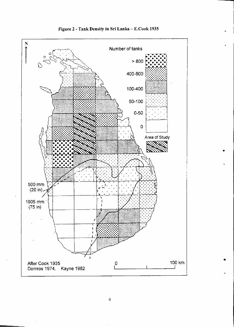
Figure 2 - Tank Density in Sri Lanka - E.Cook 1935
N f ^ Number of tanks
After Cook 1935 0 100 km Domros 1974, Kayne 1982 I 1 1
4

Figure 3 - Distribution of Small and Big Tanks in Semi Humid Sub Humid and Semi Arid Agro-Climates
N
DL 5 - Semi Arid
5

1.4 National Setting-Presently Functioning and Abandoned Tanks
Based on the foregoing studies, it has been possible to estimate the number of functioning and abandoned tanks in respect of each of the provinces. The results are given in table 1, which shows that the highest percentage of abandoned tanks is found in the Northern Province and the lowest in the North-Western or Wayamba Province.
Table 1: Number of Functioning and Abandoned Small Tanks within Each Province
Region Total No. of Small Tanks
Percentage of Functioning Tanks
Percentage of Abandoned Tanks
Rajarata (NCP) 4,017 52 48
Ruhuna(SP) 1,410 46 54
Wayamba (NWP) 6,463 65 35
North (NP) 1,424 43 57
The size class distribution of small tanks for four districts, which is based on the command area for each size class as given in the Data Book of DAS, is shown in figure 4. This figure shows that the dominant size class of tanks within the Anuradhapura district falls within the 10-20 ha size command area, while the same for the Kurunegala district is less than 6 ha. size command area. In the case of the Hambantota and Puttalam districts, there are two dominant size classes, namely, the 0-6 ha. and the 10-20 ha. sizes. These figures question the rationale of the presently adopted criteria of 80 ha. or 200 acres as the upper limit used by the Irrigation Department to distinguish the small tanks from the bigger tanks. A district-wise differential would therefore be considered more appropriate.
In order to better illustrate the locations and distribution patterns of both functioning and abandoned tanks across the landscapes, a set of maps was prepared which cover the nine river basins that make up the whole of the Rajarata (see figure 5). This includes the whole of the Anuradhapura district and extends up to the eastern and western shores as shown in figure 5. Two figures which show (a) working tanks and watersheds and (b) abandoned tanks and watersheds are shown in figures 6 (a) and 6 (b).
As could also be seen from figure 6 (a), the highest proportion of small tanks is situated within the central area of this province. At the same time, it could also be observed from figure 6 (b) that the highest number and density of abandoned tanks occur around the mid-aspects of the Moderagam Aru which is in the western segment of the province; and also in the mid-aspects of the Yan Oya which is in the eastern segment of the province. Reasons for the presence of abandoned tanks in this manner have been discussed by Panabokke (1997).
In more recent studies carried out in the very dry Malala Oya basin which is situated in the Southern Province of the country, it has been very clearly recognized that not all small tanks were built for irrigation, but most of them served as storage tanks to replenish the water table which augments the groundwater supply in the domestic wells located along the main natural drainage valleys.
6

r
Figure 4 - Size Class Distribution of Small Tanks in the Four Districts
70
60
50
LT-CL Anuradhapura Kurunegala Puttalam Hambantota
@<6 B6-10 m 10-20 • 20-30 I 30-40 • >40
1

Figure 5 - The Main River Basins of the Rajarata

Figure 6 (a) - Working Tanks and Watersheds
It is now clearly recognized that the large number of small tanks that are distributed across the undulating landscape of the dry zone are not randomly located and distributed as commonly perceived; rather they are found to occur in the form of distinct cascades that are positioned within well defined small watersheds or meso-catchment basins. Further aspects on this matter are discussed in sections 3.3 to 3.6 of chapter 3 of this volume.
1.5 (a) Village Irrigation - 'Economic Review' of Peoples Bank Special Report Vol. 11, No. 11,1986
A special report on Village Irrigation was published by S.L. Tilakasiri of the Research Department of the People's Bank in the journal 'Economic Review' in February 1986.
The lead article by Tilakasiri deals with the 'Historical Perspective, Present Status and Key Issues' (p 3-15) of village irrigation.
'Irrigation Laws and the Peasant' is discussed by I.K. Weerawardane (p 10-13).
'Tenurial Arrangements and Water Use' is discussed by Tilakasiri (p 6-7) inset.
'Some Issues in the Improvement of Village Irrigation Works' is discussed by J. Alwis (p 12-13) inset.
In addition, there are two short reviews (insets) dealing with (a) Investment in Village Irrigation, and (b) Village Irrigation Special Works.
This special report in the journal 'Economic Review' of 1986, could be considered the most concise and selective publication on this subject for the particular period that it covers. In this sense it complements the contents of the present volume in several aspects, and it would thus constitute a very useful reference source for further subject matter analysis.
1.5 (b) Small Tank Settlements
A one-day Symposium on "Small Tank Settlements in Sri Lanka" was held in August 2004 under the auspicious of the HARTI. Seven individual papers were presented in two Technical Sessions by well known scholars in this field of small tank research. The titles of six of these papers and their authors are given below.
Author Title of Paper
• P.B. Dharmasena Small Tank Heritage and Current Problems • M.U.A Tennakoon Tanks are not Mono-Functional they are
Multifunctional • C.R. Panabokke Small Tank Settlements in Sri Lanka • C M . Madduma Bandara Relevance of Cascade System in Minor
Irrigation Rehabilitation • J. Handawela Understanding Rainfall in Tank Management • D.Prabath Vitharana Village Tank Categorization
10

1.6 Special Attributes of the Village Tanks of South Asia, and Estimates of their Number
Some special attributes of the village tanks according to the DHAN Foundation publication of 2002 titled "Village Tanks of South Asia" are as follows:
1. Now considered as one of the oldest man-made ecosystems. 2. As an engineering system, it is historically one of the oldest in engineering
design. 3. As a social system, it benefits all sections of the village community, especially
women. 4. They are also considered as being eco-friendly; they ensure groundwater
recharge in the more arid environments; they are considered both as flood moderators and drought mitigators and they are more easily managed.
5. They easily lend themselves to decentralized management which better ensures their care and upkeep.
6. Livestock depend heavily on tanks for drinking water, and both migrant and resident water birds find these small tanks a safe haven for their habitation.
It is estimated that there is a total of around 160,000 village tanks of varying size and shape distributed across the three south Indian states of Andhra Pradesh (65,000), Tamil Nadu (39,000) and Karnataka (36,000) according to DHAN Foundation (2002). The figure for Sri Lanka shown in Section 1.2 is around 18,387, and this includes both functioning and abandoned tanks.
1.7 Village Level Institutions
Construction of tanks was carried out by the villagers themselves, who also developed their own indigenous institutions for maintaining and operating their tank systems as common property resources. These institutions were empowered to own and manage their tanks and to raise income from fisheries and various aquatic plants as well as reeds growing in the tanks.
Over the years they had evolved a variety of property right mechanisms to share water and to maintain their tanks. Contingency plans had also been formulated to determine the extent of land that could be irrigated during seasons of scanty rainfall and to decide upon the extent of land that each fanner could cultivate during such dry periods.
Further aspects of traditional irrigation that existed in these small village tanks is discussed in chapter 5 of this publication.
11
CHAPTER TWO
Early Historic Period (500 B.C. to 300 A.D.) Evolution of the Small Village Tank in North Central Sri Lanka
2.1 Genesis
At the outset, it should be kept in mind that for any form of human settlement to get established in this dry zone environment, an assured and a reliable supply of water, especially for domestic needs, is an essential pre-requisite in order to tide over the protracted dry season that occurs every year from late May to September. The severity of this dry season is best expressed by Nicholas (1959) when he states "during the annual drought the temperature rises, a strong drying south-west wind blows throughout the day, the grass turns to stubble and is easily fired, the vegetation droops and the undergrowth dies down. The smaller tanks shrink to muddy pools, the streams and watercourses run dry, and the larger rivers (except for Mahaweli and Walawe) are reduced to mere trickles of flowing water, or break up into disconnected pools". The main problem in the dry zone is to provide an adequate supply of water for domestic use during this annual drought. Of man's hierarchical needs for water, that for drinking, washing and other domestic and livestock requirements get precedence over that for irrigation.
In the quest for an assured water supply which would have helped to tide over this dry season, it would soon have been recognized that because of the absence of any form of naturally occurring shallow groundwater in this hard rock basement region, some manner of surface storage in small rudimentary ponds would have been the only feasible alternative. As commented by levers more than 100 years ago (1899), "It may be broadly stated that without artificial storage of water, human existence in the North Central Province would be impossible." The minimum depth of such rudimentary ponds should be more than 1.5 m or 150 cm in order to be able to counter-balance an evaporation loss of around 900 mm for the period from May to September.
These early man-made rudimentary ponds were able to store the rainfall and local run-off during the rainy maha season, and where these were of sufficient depth, they could store and hold an adequate depth of water over the aforesaid five month dry season by frugal use, to exclusively meet their domestic needs. The improved quality of the iron tools available ca. 450 B.C. would also have enabled the excavation of both soil and weathered rock down to depths of around 2 m or 200 cm.
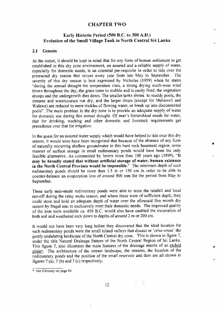
It would not have been very long before they discovered that the ideal location for such rudimentary ponds were the small inland valleys that dissect or 'criss-cross' the gently undulating landscape of the North Central dry zone. This is shown in figure 7, under the title Natural Drainage Pattern of the North Central Region of Sri Lanka. This figure 7, also illustrates the main features of the drainage matrix of an etched plain*. The architecture of the stream landscape, the streams, the location of the rudimentary ponds and the position of the small reservoir and dam are all shown in figures 7 (a), 7 (b) and 7 (c) respectively.
* See Glossary on page 84
12

Figure 7 - Natural Drainage Pattern of the- North Central Region of Sri Lanka
The naturally occurring drainage matrix of an etched plain* can be observed in the above figure 7, Drawn to a scale of 1:750,000.
* note the small inland valleys that correspond to the first and second order drainage network of an "etched plain." See Section 2.7 of this chapter which explain the term ' 'etched plain.'
22584 13
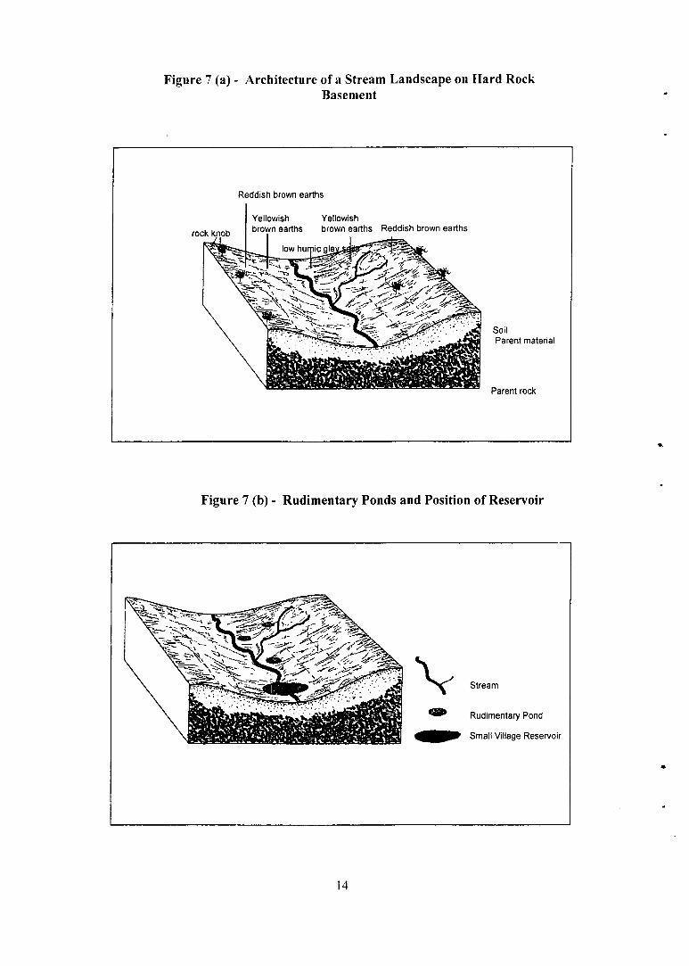
Figure 7 (a) - Architecture of a Stream Landscape on Hard Rock Basement
Figure 7 (b) - Rudimentary Ponds and Position of Reservoir
14

Figure 7 (c) - Location of Rudimentary Ponds in the Stream Landscape
Rudimentary Ponds
A.D.N. Fernando (1982) considers this rudimentary pond to be the first hydraulic structure made by man at the stage when he was moving from a hunter gatherer to rainfed agriculture, with these rudimentary ponds supplying his domestic water needs.
And as further developed by Brohier (1975) "It is possible that many a primitive pond-reservoir was later converted to a 'tank' as the science of irrigation progressed." According to C.W. Nicholas (1959) "The village tank was a well-established feature of the dry zone. By the beginning of the second century B.C., if not earlier, the entire dry zone was populated; more thickly in the North Central region."
As commented again by levers (1899), "The North Central Province, although apparently flat, is in reality undulating, and the ancient tank builders took advantage of this conformation to make chains of (small) tanks in the valleys", or what is today referred to as the small tank cascade system.
Quite fortuitously, the highest density of such small linear inland valleys happen to occur around the central aspects of the North Central Province, and this is clearly evident by reference to the 1 inch to 1 mile topo sheets of this region as well as by stereoscopic view of air photographs (see figure 8). It is, therefore, not surprising that this particular region afforded better opportunities for the early settlers to locate these small ponds of sufficient depth which later evolved into the small tank settlements for multifunctional use, including irrigated rice.
2.1.1 The Transitional Iron Age
With the progressive establishment of the Iron Age in Sri Lanka from around 1,000 to 500 B.C. (Deraniyagala, 1992), suitable iron implements became available for both forest clearing as well as for rudimentary earth works. Around 400 B.C., more improved and effective iron tools had become available for selective felling and
15

burning of the tough, hard-wooded dry zone forest, which in turn enabled the clearing of small extents of forest land sufficient for a family for 'swidden' or chena cultivation. Around 300 B.C., iron tools of superior hardness that could engrave the Brahmi* scripts on the hard rock drip-ledges of caves had also been developed. The earlier Brahmi inscriptions refer mainly to simply prepared rock shelters and the names of their lay donors. The later Brahmi inscriptions increasingly refer to the donation of tanks to the Sangha. Raj Somadeva (1997) states that approximately 4,000 lithic inscriptions have been found in Sri Lanka aggregating the period between 250 B.C. to 50 A.D.
At the same time, with the evolution of sharper and harder iron implements it was possible to dig, shift and move the hard, non-friable, reddish brown earths* of this region. This, in no uncertain terms enabled the advance from the small rudimentary pond to the earliest prototype of the small village tank with a larger storage capacity, and also with adequate storage and supply of water for a viable settlement of several families around this small tank. These could be considered the earliest forms of small tank settlement from which grew the traditional small tank village as we now recognize it (also see sections 2.1 and 2.2 in annex 2).
2.2 The Early Historic Phase
By the second century B.C. stable human settlements had become well-established around this early prototype of the small village tank. The size or storage capacity of these tanks in their early stages, especially in relation to their depth, was just about sufficient to meet the domestic needs of the families settled around these small tanks. At this stage of evolution it should be very clearly recognized that chena cultivation with kurakkan had been the main cereal component. The existence of several primitive land races of kurakkan cultivars in Sri Lanka, together with the botanical name of eleusina coracana given to it, is itself an indication of the antiquity of this cereal, both in its presence as well as in its utilization as the main cereal grain used in this country at that time.
At this stage of evolution, there was a satisfactory equilibrium or balance between the extents of land available for chena cultivation within a short agro-distance from the small tank settlement, and the number of families that could utilize the limited storage in these small tanks. It should also be noted that chena cultivation in its original form entailed only a partial or selective forest clearing and burning, and not the clean felling that is commonly practiced today. A few rare survivals of this early form of selective forest clearing for chena cultivation could yet be observed in the western parts of the Wilachchiya Korale bordering the Wilpattu Sanctuary area. It should also be borne in mind that in its original form and with the low population density prevailing at that time, this early system of chena cultivation could be considered a highly sustainable form of agriculture which also provided a very reliable measure of food security.
* Brahmi Script (see Glossary p.84) The characters from which the modem Sinhalese script developed, and are almost the same Brahmi script inscription of emperor Asoka in India, (see back cover page)
+ Reddish Brown Earth soils of the dry zone of Sri Lanka are very much harder than the Red Soils of the South India, and are also very abrasive on iron implements
16
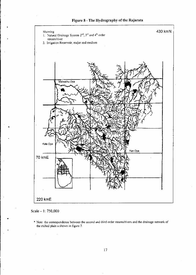
Figure 8 - The Hydrography of the Rajarata
Showing 430 kmN 1. Natural Drainage System 2"d, 3 r d and 4 t h order
stream/river 2. Irrigation Reservoir, major and medium
220 kmE
S c a l e - 1:750,000
* Note the correspondence between the second and third order steams/rivers and the drainage network of the etched plain a shown in figure 7.
17

2.3 Essential Role and Function of the Early Village Tank
Up to this period, the main role of the small village tank was to meet the multiple requirements of these early settlers who derived their main food supply from this early form of chena cultivation. These requirements from the small tank included domestic use, washing and bathing, meeting the needs of livestock procuring wetland edible plants from the tank bed, religious rituals and clay extraction for pottery and other needs.
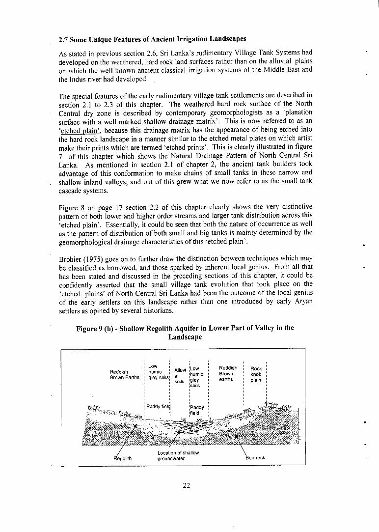
But perhaps the most important function of this small tank, as we now recognize, was to recharge the shallow phreatic water table which is now referred to as the 'regolith aquifer' of this hard rock region. It is this recharge of the phreatic water table throughout the dry season that sustains the fresh water supply in the domestic wells located within the 'gangoda' of the village hamlet, without which village settlers could not have maintained their quality of life (see section 2.3 of annex 2 and also figure 9 (b) at end of this chapter).
This should be considered a very significant and important phase in the evolution of the small village tank settlement, because it was this combined use of both the stored surface water together with the phreatic groundwater which, though limited in amount, that made it a more dependable and a life giving resource.
The traditional hand-dug domestic well located in the village 'gangoda' below the small village tank had provided the village domestic requirements for several centuries despite their relatively low yields and seasonal water level fluctuations. This is further explained by Panabokke, 2007, in page 83 of his publication titled 'Groundwater Conditions in Sri Lanka - a Geomorphic Perspective' published by National Science Foundation. Also see figure 9 (b) at the end of this chapter.
As further stated by Paranavitana (1959), "Reservoirs in which the rainfall of the monsoons was stored to irrigate rice fields where the need arose, in addition for supplying water during the prolonged dry season, were thus constructed at every important village settlement. The contour of the ground was admirably suited for the construction of such reservoirs. An earthen dam was thrown across the upper part of a valley through which a stream ran in the rainy season. The size of such reservoirs depended on the quantity of water which the stream carried from its catchments area; the height and length of the dam depended on the human labour that was available for its construction."
2.4 Transition to Wetland Rice Cultivation
Once they had advanced to a stage where they were able to construct village tanks with a larger storage capacity, the cultivation of rice became possible. In order to get beyond the level of pure subsistence agriculture based on chena cultivation to a more advanced state of 'subsistence affluence', irrigation became a necessity. The origins of irrigation in its elemental form in this country can be traced back to this stage. It should be emphasized that wetland rice cultivation in its early form was a purely indigenous development and not one introduced by early Aryan settlers as is often stated by some historians and scholars.
18
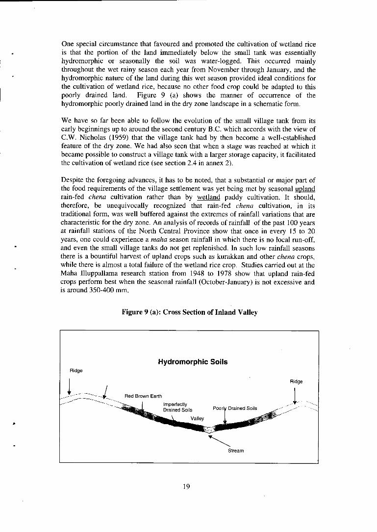
One special circumstance that favoured and promoted the cultivation of wetland rice is that the portion of the land immediately below the small tank was essentially hydromorphic or seasonally the soil was water-logged. This occurred mainly throughout the wet rainy season each year from November through January, and the hydromorphic nature of the land during this wet season provided ideal conditions for the cultivation of wetland rice, because no other food crop could be adapted to this poorly drained land. Figure 9 (a) shows the manner of occurrence of the hydromorphic poorly drained land in the dry zone landscape in a schematic form.
We have so far been able to follow the evolution of the small village tank from its early beginnings up to around the second century B.C. which accords with the view of C.W. Nicholas (1959) that the village tank had by then become a well-established feature of the dry zone. We had also seen that when a stage was reached at which it became possible to construct a village tank with a larger storage capacity, it facilitated the cultivation of wetland rice (see section 2.4 in annex 2).
Despite the foregoing advances, it has to be noted, that a substantial or major part of the food requirements of the village settlement was yet being met by seasonal upland rain-fed chena cultivation rather than by wetland paddy cultivation. It should, therefore, be unequivocally recognized that rain-fed chena cultivation, in its traditional form, was well buffered against the extremes of rainfall variations that are characteristic for the dry zone. An analysis of records of rainfall of the past 100 years at rainfall stations of the North Central Province show that once in every 15 to 20 years, one could experience a maha season rainfall in which there is no local run-off, and even the small village tanks do not get replenished. In such low rainfall seasons there is a bountiful harvest of upland crops such as kurakkan and other chena crops, while there is almost a total failure of the wetland rice crop. Studies carried out at the Maha Illuppallama research station from 1948 to 1978 show that upland rain-fed crops perform best when the seasonal rainfall (October-January) is not excessive and is around 350-400 mm.
Figure 9 (a): Cross Section of Inland Valley
Hydromorphic Soils Ridge
Ridge
Stream
19

Based on the foregoing considerations, it is very evident that the small village tank served the primary purpose of garnering sufficient rain water and run-off that could supply the minimum domestic needs of the settlers over the dry periods; and only in years of more than average rainfall would it be possible to allocate the stored water in the tank for the cultivation of wetland rice. As expressed by D.T. Devendra, 1965, in his well known publication, Tanks and Rice, "centuries ago life was centered around the tank and man moved away from them as new situations arose. Our age is witnessing the trek to the waters, back to the things which sustained their forefathers."
2.5 Hydrological and Archaeological Analysis of Sanchi Dams and Basawakkulama Reservoir
Shaw and Sutcliffe (2003) have reasoned that the Sanchi reservoirs located across the smaller tributaries of the Betwa river in Sanchi, Bhopal (Madhya Pradesh) India, were built around the second to third century B.C. in order to increase the agricultural output required to support an increased population that was hitherto dependant solely on rain-fed wheat cultivation.
A similar situation had existed in north central Sri Lanka around the same period where rain-fed chena cultivation alone could not meet the increased food requirements of a growing population. As shown in the preceding section (2.4) of this chapter, the transition to wetland rice cultivation was also taking place around this time in Sri Lanka, and that in years of more than average rainfall wetland rice cultivation was very feasible.
Shaw and Sutcliffe (2003) have also observed that the relative configuration of monasteries, reservoirs and settlements in Sanchi is so similar to Sri Lanka, and there are grounds for suggesting that they were underlain by a similar socio-religious system. They also state that "there is sufficient evidence of similarity of dating and design of the dams at Sanchi and of Sri Lanka to suggest that there could have been exchange of technical expertise between the two areas, which were of course in touch during the period of 'Buddhist evangelism'."
It is also stated by the same authors that a "body of empirical relations on rainfall, run-off and storage must have been developed from the experience of small tanks and small tank cascade systems of Sri Lanka." Similarly Jayewardene (1997), is of the view that the persons who designed the ancient irrigation work in Sri Lanka "were well versed in rainfall patterns, landform types, soil properties, construction materials, and above all an amazing grasp of hydro-dynamics."
The Basawakkulama tank at Anuradhapura is known to have been built around 300 B.C. which is around the same period that there was close interaction between Sanchi and Sri Lanka through the medium of the Buddhist missionaries and pilgrims of that period.
20

2.6 A Comparison of the Irrigation Systems of Ancient Egypt, Mesopotamia and the Indus Civilization with those of Ancient Sri Lanka
It is firstly essential to differentiate between the irrigation systems of ancient Mesopotamia and those of ancient Egypt. The former irrigated the broad alluvial plains of the Tigris and Euphrates at all seasons, while the latter involved a chain of retention basins for silt deposition, and these were filled for only 45 days in a year. The Nile has also been considered the most gentlemanly of all rivers because it gives ample warning of its rise and fall, and it makes no abrupt changes. This should be compared with the more turbulent flow patterns of the rivers of Monsoon Asia including those of Sri Lanka.
One should, at the same time, recognize the Indus (Harappan) civilization starting around 2500 BC which flourished until around 1750 BC. This Harappan culture is considered to be the largest among the three viz. Egyptian, Mesopotamian and Indus Civilization.
As stated by Brohier, 1975 - "we have it on authority that the art of artificial irrigation originated so far back as 4,000 years B.C in the Valley of the Euphrates." This has been further developed by Joseph Needham in Vol. IV. Part 3 in 'Science and Civilization in China' in collaboration with Wang Ling and Lu Gwei-Djen; Cambridge University Press (1971). Hydraulic Engineering, Comparisons and Conclusions (p 365-378) in which it states "Broadly speaking, the hydraulic works of the great civilizations of South Asia combined various proportion of the Egyptian and Babylonian patterns to form more mixed and flexible system".
"Yet it was never in India that the fusion of the Egyptian and Babylonian patterns achieved its most complete and subtlest from. This took place in Ceylon, the work of both cultures." The rationale for this pronouncement of Joseph Needham will be further discussed subsequently in section 2.7.
It should, at the same time, be recognized that the irrigation systems of ancient Egypt and Mesopotamia as well as those of the Indus valley had developed on what we now recognize as the various types of alluvial formations of more recent geologic age. These various types of alluvial plains stand out in sharp contrast to Sri Lanka's hard rock landscapes of a much older geologic age on which the early forms of small scale irrigation system had developed.
At the same time, while the irrigation systems of Egypt, Mesopotamia and Indus had developed on the depositional alluvial plains that were made up of deep alluvial silt deposits of a depth over 10 meters, the early irrigation systems of Sri Lanka had developed on the eroded 'planation surfaces' of the hard basement rocks where the soils were comparatively shallow and generally less than 1.5 m in depth. Furthermore, these shallow soils that had developed on the hard rock planation surfaces were much more coarser in their textures than the fine textured alluvial soils that had developed on the alluvial plains of Mesopotamia and the Indus Valley, and they also had a lower water holding (retention) capacity. Furthermore, because of their hard consistence when dry, they could be worked only when they were moistened by the rain or by available irrigation water. In addition, because of the sharp, angular quartz sand particles present in these soils, they were very abrasive on the iron implements that were used for working these soils.
21
2.7 Some Unique Features of Ancient Irrigation Landscapes
As stated in previous section 2.6, Sri Lanka's rudimentary Village Tank Systems had developed on the weathered, hard rock land surfaces rather than on the alluvial plains on which the well known ancient classical irrigation systems of the Middle East and the Indus river had developed.
The special features of the early rudimentary village tank settlements are described in section 2.1 to 2.3 of this chapter. The weathered hard rock surface of the North Central dry zone is described by contemporary geomorphologists as a 'planation surface with a well marked shallow drainage matrix'. This is now referred to as an 'etched plain', because this drainage matrix has the appearance of being etched into the hard rock landscape in a manner similar to the etched metal plates on which artist make their prints which are termed 'etched prints'. This is clearly illustrated in figure 7 of this chapter which shows the Natural Drainage Pattern of North Central Sri Lanka. As mentioned in section 2.1 of chapter 2, the ancient tank builders took advantage of this conformation to make chains of small tanks in these narrow and shallow inland valleys; and out of this grew what we now refer to as the small tank cascade systems.
Figure 8 on page 17 section 2.2 of this chapter clearly shows the very distinctive pattern of both lower and higher order streams and larger tank distribution across this 'etched plain'. Essentially, it could be seen that both the nature of occurrence as well as the pattern of distribution of both small and big tanks is mainly determined by the geomorphological drainage characteristics of this 'etched plain'.
Brohier (1975) goes on to further draw the distinction between techniques which may be classified as borrowed, and those sparked by inherent local genius. From all that has been stated and discussed in the preceding sections of this chapter, it could be confidently asserted that the small village tank evolution that took place on the 'etched plains' of North Central Sri Lanka had been the outcome of the local genius of the early settlers on this landscape rather than one introduced by early Aryan settlers as opined by several historians.
Figure 9 (b) - Shallow Regolith Aquifer in Lower Part of Valley in the Landscape
Reddish Brown Earths
Low humic gley soils
Paddy field,
Alluvi al soils
Low humic gley soils
Paddy field
Reddish Brown earths
Rock knob plain
Regolith
/ ' Location of shallow groundwater ed rock
22
CHAPTER THREE
Middle Historic Period (300 A.D. to 1000 A.D.) Spread of Wetland Rice: Form and Order of Cascade Systems
3.1 Spread of Wetland Rice Cultivation
The more extensive cultivation of wetland rice had to await the advance from the village tank to the major tank. This advance took place around the first century A.D. with Vasabha being the first of these tank building kings. At the same time, village tank construction proceeded apace as the population increased and spread to new regions.
From all available accounts, it is clear that the spread of these small village tanks would have taken place concurrently with the construction of the well-known major irrigation works, especially those of King Mahasen, during the later second and early third century A.D.
The country had now arrived at a stage where the construction and spread of major tanks was, on the whole, a state driven enterprise under the direction of the ruling monarchs, while the small village tank construction was almost exclusively undertaken and implemented by the local village communities as in neighbouring Tamil Nadu during the Sangam Period ( 2 n d century A.D.), where the rulers built the large tanks and dams, while the local population constructed the smaller village tanks as shown by Ludden (1978). This dual development also led to two contrasting cultures of tank maintenance and irrigation water management.
The technology of construction of these small village tanks had been fairly simple and straightforward and certainly within the capability of village resources as well as their construction skills. At the same time, the design and construction of the major irrigation works had reached a certain level of maturity and there is no reason to doubt that the expertise that had by then developed for major construction works would have been applied with some modification to the construction of the smaller village tanks as well. A body of empirical relationships on rainfall, run-off and storage must have been known by 350 A.D. when very advanced hydraulic structures were being built.
Prior to the evolution of the bisokotuwa or the cistern type sluice for the major tanks, the simpler baked clay or terra-cotta 'hatti sorouwwa' had been developed for the needs of the small tank. At a stage where the construction of a larger size village tank with a bigger storage capacity became feasible, an improved 'keta sorouwwa' enabled the regulated delivery of water from the tank to the rice fields below. The main features of the traditional hatti sorouwwa are described in Appendix (I) of this volume at the end of Annex 3 (b). It is believed that the concept of the sluice in its rudimentary form had been the invention of the early Sri Lankan artisans.
At this stage, around the second and third century A.D., wetland rice cultivation was taking place under both the new major tanks constructed by the rulers, and also under the larger sized village tanks that were being built by the village communities. It is around this period that the basic elements of the traditional water management culture
23

of the nation state were getting shaped, especially that relating to dry season scarcity contrasting with wet season adequacy or surplus.
Nicholas (1959) also notes "From the first quarter of the second century, the country enjoyed a long period of tranquility for three hundred years during which the transition from moderately big to very large irrigation works took place".
3.2 Small Tank Cascade Systems
It was mentioned earlier in this publication (see section 2.1) how the early settlers took advantage of the small inland valleys that criss-cross the landscape as shown in figure 7, in the North Central region to make chains of small tanks. At this stage of development, the local population had also mastered the art of construction of tanks of varying size along the length of these inland valleys, which gave rise to the development of the chain of tanks or cascades of small tanks as described by Madduma Bandara (1985) and M.U.A. Tennakoon (1994). Wetland rice cultivation is observed to be most successful in the lowermost tank within the cascade which is usually larger in size and has more inflow into it as could be seen in figure 10.
Tennakoon (1994) states that, "the cascade concept is an age-old concept which had been the linking thread of irrigation development and management throughout the irrigation history of this country." Implied in Tennakoon's statement is that any small tank in this landscape should be seen as an integral part of the cascade in which it is located, and should, therefore, be viewed and studied not in isolation, but as a component of the several production systems that function within the meso-catchment of the cascade.
At the same time, it should be recognized that the small tank cascade settlement was traditionally a closed system with the settlers living a frugal and contended life style with very little or no external inputs. Based on rain-fed chena cultivation, lowland rice cultivation, mixed homestead gardening, cattle grazing, herding and tank fish harvesting, a traditionally self-sufficient life style was maintained. This situation had undergone radical change over the last 150 years, and the main production systems are now linked to external supplies and several market forces. As a result, the earlier self-sufficient equilibrium no longer prevails and many imbalances are now observed in the small village tank settlements.
3.3 Essential Nature of Small Tank Cascade Systems
It is now clearly recognized that the large number (more than 15,000) of small tanks that are distributed across the undulating landscape of the dry zone are not randomly located and distributed as commonly perceived; rather they are found to occur in the form of distinct cascades that are positioned within well-defined small water sheds or meso-catchment basins. A cascade of tanks is made up of 4 to 10 individual small tanks, with each tank having its own micro-catchment, but where all of the tanks are situated within a single meso-catchment basin. These meso-catchment basins could vary in extent from 6 to 10 sq miles, with a modal value of 8 sq miles in the North Central Province region.
A schematic representation of a typical small tank cascade system at a scale of 1:50,000 is shown in figure 10. The main elements that make up a cascade, namely (a)

the watershed boundary of the meso-catchment, (b) the individual micro-catchment boundaries of the small :tanks, (c) the main central valley, (d) side valleys, (e) axis of the main valley and (f) the component small tanks as well as the irrigated rice lands are shown in the same figure 10. These small tanks form a series of successive water bodies along small water courses and are called a 'cascading system'. The advantage of such a system is that excess water from a reservoir along with the water used in its command area is captured by the next downstream reservoir, and is thus continuously re-used. This system helps to surmount irregularly distributed rainfall, nonavailability of large catchment areas and the difficulty of constructing large reservoirs (eco-friendly nature). Sakthivadivel and Panabokke (1996) have discussed the hydrology and setting of the Small Tank Cascade Systems in Country Paper No. 13 of IIMI.
According to Abernathy (1993), "the small tank cascade irrigation systems have developed as ultimate stock-type irrigation systems with long histories which date back to over a thousand years and were once the backbone of an ancient hydraulic civilization which flourished in the north-central part of the country."
A cluster of three typical small tank cascades close to Anuradhapura that lie adjacent to each other and are easily observed on the Maradankadawala-Tirappane road with the aid of the 1 inch to 1 mile topo sheet of Anuradhapura is depicted in figure 11. The kilometer sign posts shown in this map figure will help the reader to make out where he or she is when traveling on this road, and thus enable the traveler to easily locate the tank cascade systems on the ground.
3.4 Merits of Considering Tank Cascade Systems over Individual Tanks
As seen in figures 10 and 11, the hydrology of the whole meso-catchment within which the individual small tanks are located has a specific significance in as far as it relates to the hydrology of the individual tanks themselves. For example, while the small tank located in the uppermost aspect of either the main valley or the side valley receives its run-off exclusively from its own micro-catchment, the other tanks located mid-way or at the lower aspect of the main valley will receive their run-off from a larger catchment together with the drainage flows from the tank immediately above it. Thus, the hydrology of the lowermost tank within the cascade will be determined by the run-off generated by the whole meso-basin together with the drainage flows from all the tanks and paddy fields located above it.
As shown by Panabokke (2007), the shallow regolith groundwater is located in the lowland, which generally lies adjacent to and athwart the lowermost member of the soil catena as shown inlfigures 9 (a) and (b) of the previous chapter. The groundwater regime is therefore confined to a specific topographical location within the cascade, and not at random across the landscape as commonly envisioned. Panabokke (2007) has also shown that the safely exploitable groundwater in the dry season is mainly confined to those areas immediately adjacent to the main axis of the cascade. Senaratne (1996) has studied the ground water table in a tank environment as well as in a cascade environment and he has developed a methodology to estimate the carrying capacity of agro wells within a cascade.
25

Figure 10: Schematic Representation of Small Tank Cascade
26

Figure 11: Three Typical Cascades Close to Anuradhapura
27
3.5 Distribution Patterns
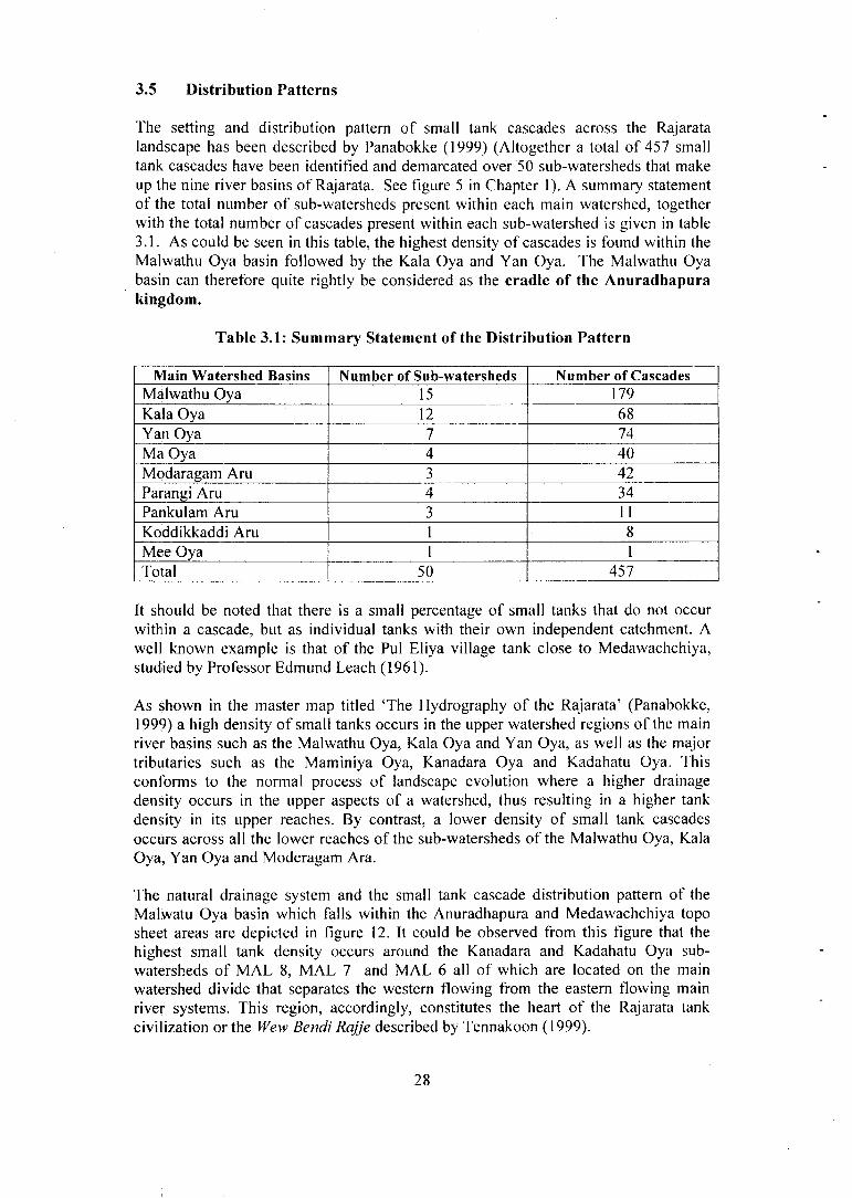
The setting and distribution pattern of small tank cascades across the Rajarata landscape has been described by Panabokke (1999) (Altogether a total of 457 small tank cascades have been identified and demarcated over 50 sub-watersheds that make up the nine river basins of Rajarata. See figure 5 in Chapter 1). A summary statement of the total number of sub-watersheds present within each main watershed, together with the total number of cascades present within each sub-watershed is given in table 3.1. As could be seen in this table, the highest density of cascades is found within the Malwathu Oya basin followed by the Kala Oya and Yan Oya. The Malwathu Oya basin can therefore quite rightly be considered as the cradle of the Anuradhapura kingdom.
Table 3.1: Summary Statement of the Distribution Pattern
Main Watershed Basins Number of Sub-watersheds Number of Cascades Malwathu Oya 15 179 Kala Oya 12 68 Yan Oya 7 74 Ma Oya 4 40 Modaragam Aru 3 42 Parangi Aru 4 34 Pankulam Aru 3 11 Koddikkaddi Aru 1 8 Mee Oya 1 1 Total 50 457
It should be noted that there is a small percentage of small tanks that do not occur within a cascade, but as individual tanks with their own independent catchment. A well known example is that of the Pul Eliya village tank close to Medawachchiya, studied by Professor Edmund Leach (1961).
As shown in the master map titled 'The Hydrography of the Rajarata' (Panabokke, 1999) a high density of small tanks occurs in the upper watershed regions of the main river basins such as the Malwathu Oya, Kala Oya and Yan Oya, as well as the major tributaries such as the Maminiya Oya, Kanadara Oya and Kadahatu Oya. This conforms to the normal process of landscape evolution where a higher drainage density occurs in the upper aspects of a watershed, thus resulting in a higher tank density in its upper reaches. By contrast, a lower density of small tank cascades occurs across all the lower reaches of the sub-watersheds of the Malwathu Oya, Kala Oya, Yan Oya and Moderagam Ara.
The natural drainage system and the small tank cascade distribution pattern of the Malwatu Oya basin which falls within the Anuradhapura and Medawachchiya topo sheet areas are depicted in figure 12. It could be observed from this figure that the highest small tank density occurs around the Kanadara and Kadahatu Oya sub-watersheds of MAL 8, MAL 7 and MAL 6 all of which are located on the main watershed divide that separates the western flowing from the eastern flowing main river systems. This region, accordingly, constitutes the heart of the Rajarata tank civilization or the Wew Bendi Rajje described by Tennakoon (1999).
28

Figure 12 - Cascade Distribution Pattern within Malwathu Oya Basin
Scale 1:650,000
denotes sub-watershed boundary e.g. MAL (1), MAL (2) MAL (7), MAL (8)
denotes cascade boundary
* The Kunchuttu, Kanadara and Kende Korales fall within sub-watersheds of MAL 4,5,6 and 7 respectively.
Another important feature of this particular region is the very low incidence of abandoned tanks. There is also an oral tradition in this region that it was never totally abandoned even during the disturbed period between the thirteenth and nineteenth centuries and it is said to have had an unbroken history of continuous settlement over the last 2,000 years. It is also claimed that during the heyday of the Anuradhapura civilization, this region had a very close symbiotic association with the main capital city and it was also its main source of food sustenance.
3.6 Multiple Uses of Water within a Cascade
It is now becoming increasingly evident that the surface waters that have been captured and stored in these small village tanks had served a multitude of functions apart from irrigation supply for paddy during the wet maha season. It had been recognized by levers (1899) and Abeyratne (1956), that because of the highly variable nature of the rainfall coupled with the high evaporation rates for a greater part of the
29

year, and the paucity of readily accessible and adequate groundwater supplies in this hard rock region, it was these small tank surface storage systems that provided the lifeblood for human existence in this environment.
It is also now being increasingly recognized that the uses of water for several other essential purposes such as inland fisheries, livestock needs during the dry season, replenishment of groundwater conditions, domestic bathing needs and environmental amelioration during the enhanced dry months from July - September should all collectively be assigned an economic and social value.
It is also considered essential to partition the efficient use of the direct rain or the 'green water' which is more efficiently utilized by rain-fed chena cultivation, in contrast with the run-off collected and stored 'blue water' in these small tanks which is less efficiently utilized in paddy cultivation as shown by Navaratne (1998).
Balancing and harmonizing the utilization of this 'green water' and 'blue water' components should undoubtedly be a major research and management thrust in the future research mandate of the Department of Agriculture. Sustainable food production within a cascade or meso-basin would, in the long run, be strongly governed by our ability to achieve a balanced use of both direct rainfall and surface stored supply of small tanks.
3.7 Period from 600 A.D. to 1000 A.D.
By the fifth to the sixth century A.D., a full development of both small and big tanks had taken place in Rajarata, and according to Nicholas (1959) the eighth, ninth and tenth centuries were, on the whole, a period of progress and affluence for the people of that period.
Nicholas (1959) also comments on the achievements accomplished by the seventh century which reveal an extraordinary high technical ability of the Sinhala engineers of that time. He also states that "nothing is known today of how these engineers of old and the technician under them set about their work, what mathematical formulae they employed in their calculations, and what instruments they used". Surveys made in modern times for the restoration of ancient works have disclosed that the instruments they used were capable of the same precision as modern instruments.
Rice cultivation under the large major tank was promoted by the rulers of that period largely for state income generation, and this activity of major tank construction took place mainly under the patronage of the then rulers.
The smaller and medium size tanks were constructed by the village communities as well as by influential local chieftains and village leaders. These smaller scale works served mainly as centres for settlement, and in seasons when adequate rains were received rice cultivation was possible. Aspects of small tank settlements in Sri Lanka have been described and discussed in further detail by Panabokke (2004), Tennakoon (2004).
According to Nicholas (1959), the period between the eighth and tenth centuries A.D. was a period of affluence for the people of Sri Lanka because of the full development
30

of both major and minor irrigation works. It was also the period that witnessed the highest proliferation of tank based settlements (Deraniyagala, 1997).
The absence of famines during this period is also noted by Siriweera (1989), which indicates a period of agricultural prosperity based on both big and small tank irrigation systems.
This period of four hundred years could therefore be considered as the most prosperous and creative time span of the Anuradhapura kingdom, which was brought about mainly by a fully functional and efficient irrigation technology.
According to Nicholas (1959), "the slowing down that took place in the eighth and ninth centuries in the building of new large dams and tanks and canals could be due to the fact that what had been already accomplished was more or less adequate to meet the domestic food requirements of the nation. Also the time for embarking on new projects was fast approaching in order to keep pace with the growing population. But these possible new ventures would have been delayed by disturbances of invasions and other destabilizing occurrences that took place during the second half of the tenth century."
Nicholas (1959) observes that "Archaeological evidence, based upon the constructional design or the materials of dams, sluices spillways, bunds and other features of irrigation works, offers but slender material for building up a total of chronology. We are dependent almost wholly on the chronicles and the inscriptions" He further notes that after every prolonged war, the chronicles record, as a matter of course, the repair or restoration of the damaged irrigation works. "It was, therefore, a very important responsibility of the State to maintain the vast and complex irrigation system inefficient working condition".
In the light of such condition it is not difficult to understand that it was not until Parakramabahu I ascended the throne in the middle of the twelfth century that the next significant leap in large scale irrigation construction began to take place.
31

CHAPTER FOUR
Polonnaruwa Kingdom - Major Systems from 1000 A.D. to 1250 A.D.
4.1 The Tamankaduwa District
As described and discussed in the preceding chapter, the Anuradhapura kingdom was characterized by both major and minor irrigation systems; and the larger systems were managed by the state bureaucracy, while the smaller village systems were self-managed by the village communities.
As could be seen in figure 13 which shows the location of the major irrigation reservoirs of Parakrama Samudra, Minneriya Wewa, Kaudulla Wewa and Giritale Wewa, the landscape of the Thamankaduwa is dominated exclusively by major irrigation systems. It is also clearly visible from Brohier's figure 14 the diagram of the 'Hydrography of Tamankaduwa' that both the landscape and landforms of this region do not lend themselves to the establishment of small village tank systems or small tank cascade systems.
A closer examination of the one inch to one mile topo sheets of this area also reveals the limited opportunity that exists for the building of small tanks in this landscape, except for a few clusters in the northern parts of drainage network.
This is further corroborated by Brohier (1941), who states, "There are two reasons why there are not so many chains of small tanks in Tamankaduwa. One is that the nature of the country did not readily lend itself to the application of the leading principles on which the small tank systems is based. The other, possibly the greater factor, was the facilities which the country afforded for bolder designs evolved from centuries of experience."
Brohier (1941) also observes that the Minneriya Wewa, as a rain-fed reservoir filled from its immediate catchment, might justly be assumed to be the oldest work which was constructed and utilized for irrigation in this district and he also further states that nature has done much to form the Minneriya tank. It has a catchment of nearly 95 sq. miles, and was formed by filling the intervening gaps between adjoining hills with massive bunds.
Because of the foregoing considerations, it is therefore not surprising that this Tamankaduwa region afforded better opportunities for the development of a network of major irrigation reservoirs as well as more advanced long distance conveyance canals such as the Elahera canal, the Kaudulla-Kantalai Yoda Ela and Kalinga Ela canal systems (see figure 14).
4.2 Hydrology and Governance of Polonnaruwa Kingdom
The Polonnaruwa kingdom was therefore one that was essentially dominated by large irrigation systems as could be seen in Brohier's diagram figure 14 showing the Hydrography of Tamankaduwa together with the ancient irrigation schemes. Furthermore, in contrast to the Anuradhapura kingdom which had to rely solely on the seasonal flow of the principal Oyas, namely (Malwathu Oya, Yan Oya, Kala Oya,
32

Figure 13 - Major Irrigation Reservoirs of Thamankaduwa
Scale 1:500,000
As shown in Figure 13 (above) the Tamankaduwa landscape is dominated by the four major irrigation reservoirs of Parakrama Samudra, Minneriya Wewa, Kaudulla Wewa and Giritale Wewa. A few clusters of small village tanks could be noticed in the north and northwestern parts of the drainage network. The villus are shown along the Mahaweli flood plain.
33
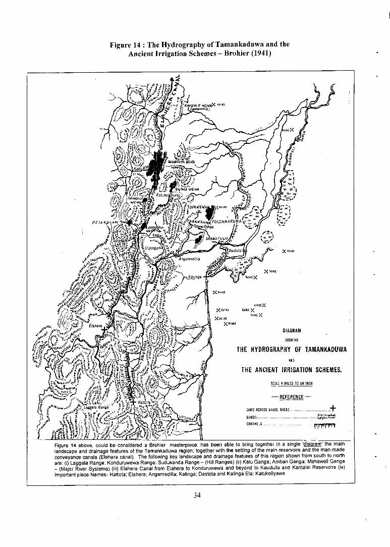
Figure 14 : The Hydrography of Tamankaduwa and the Ancient Irrigation Schemes - Brohier (1941)
Figure 14 above, could be considered a Brohier masterpiece, has been able to bring together in a single 'diagram' the main landscape and drainage features of the Tamankaduwa region, together with the setting of the main reservoirs and the man-made conveyance canals (Elehara canal). The following key landscape and drainage features of this region shown from south to north are: (i) Laggala Range; Konduruwewa Range; Sudukanda Range - (Hill Ranges) (ii) Kalu Ganga; Amban Ganga; Mahaweli Ganga - (Major River Systems) (iii) Elahera Canal from Elahera to Konduruwewa and beyond to Kaudulla and Kantalai Reservoirs (iv) Important place Names- Hattota; Elahera; Angamedilla; Kalinga; Dastota and Kalinga Ela; Katukeliyawa
34
Moderaganm Aru) all of which originate and are also located entirely within the drier rainfall region of DLL the Polonnaruwa region was located within a better endowed rainfall region especially by the Kalu ganga - Amban ganga systems which had a good dry season flow because the upper catchments of the Amban ganga and Kalu ganga were all located within a moist rainfall and the agro-ecological region of ILL Hence, both the landscape forms as well as a better endowed hydrology of this region enabled the construction of a network of interconnected major reservoirs and major conveyance canal systems.
Even prior to the Mahaweli diversion of 1977, this major tank and canal complex of Polonnaruwa district had a better and more stable level of paddy production than that of the Anuradhapura district. One could, therefore, reason that the Polonnaruwa kingdom enjoyed a higher degree of hydrological stability than the Anuradhapura kingdom, which was exclusively located within a dry agro-ecological regime of DLL
A further difference could be noted in the type of governance that characterized the Polonnaruwa kingdom when compared with the Anuradhapura kingdom. The well-integrated network of major tanks with an assured water supply lent itself to a strong centralized management under the authority of a single monarch who wielded great power and authority. This is well symbolized in the statue of the ruler Parakramabahu located on the bund of the Parakarama Samudra*. The dignity, puissance and self-reliance of this statue have been rendered with great refinement and skill in a manner that brings out the power and authority that this monarch is said to have embodied.
In contrast, the Anuradhapura kingdom featured a few strategic major tanks such as the Kala Wewa, Nachchaduwa, Nuwara Wewa and Padawiya together with a very large number, over 2,500 minor tanks which were managed and governed by smaller village tank based republics. There was no such concentration of power at the Centre as in the case of the Polonnaruwa kingdom at least in respect of irrigation system management.
This becomes evident when we see the total collapse of the Polonnaruwa irrigation network consequent on the collapse of the Central Government. Whereas in the case of the Anuradhapura kingdom, despite the collapse of the Central Government, many village tanks continued to function well up to and even beyond the seventeenth century.
The underlying reasons for the collapse of the Polonnaruwa kingdom are best stated by the Sri Lankan historian K.M. de Silva (1981) in the following terms:
"A complex irrigation network such as that of the Polonnaruwa kingdom requires a high level of organization and efficiency in administration. The comprehensive disintegration of the political system bequeathed by Parakramabahu I would have paralyzed the administrative machinery which kept this irrigation network in running order. Under the Anuradhapura kings, the village institutions and regional administrations had ensured the survival of some parts of the irrigation system at least during periods of turmoil at the capital-succession disputes and periods of civil war and invasion. But, the over-centralization of administration in the Polonnaruwa
According to Dr. Raja de Silva (2005) it is considered a representation of the sage-Agastya rather than that of a monarch.
35

kingdom appears to have had a deleterious effect on local initiatives, with the result that when royal authority collapsed at Polonnaruwa, administrative units in the outlying regions were no longer capable of maintaining their sections of the irrigation network in good repair".
4.3 The Post 1250 A.D. Period
While the complex hydraulic civilization of the Polonnaruwa kingdom was losing its vigour and drifting into decline by the mid-thirteenth century, conditions in the Anuradhapura kingdom were rather different. The village tank institutions scattered across the Anuradhapura kingdom, especially in the Nuwarakalawiya region had shown a high degree of resilience that enabled them to survive the periods of turmoil and breakdown of the Central Government.
A reliable indicator of the state of the small village tank in the Nuwarakalawiya region, during the mid-seventeenth century could be had from the account left by Robert Knox when he had visited and frequently journeyed into the North Central areas of Anuradhapura for plotting his escape along the Malwathu Oya. It could be gleaned from his book 'Historical Relation of Ceylon' published in 1682 in London, that his visits to the Nuwarakalawiya region had taken place during the mid-sixteen seventies, and what he has written about these 'ponds' or tanks reflect the conditions prevailing at that period in the North Central region.
In Chapter 3 of An Historical Relation of Ceylon, Knox describes 'Artificial Ponds' which really refers to these small village tanks. "Where there are no springs or rivers to furnish them with water, as it is in these northern parts, they supply this defect by saving of rain water, which they do, by casting up great banks (bunds) in convenient places to stop and contain the rains that fall, and so save it till they have occasion to let it out into their fields. These are made rounding like a C or half moon, every town has one of these ponds, which if they can but get filled with water, they count their corn is as good in the barn. It was no small work to the ancient inhabitants to make all these bunds, of which there is a great number, being some two, some three fathoms in height, and in length some above a mile, some less, not all of a size. When they would use the water, they cut a gap in one end of the bund, and so draw the water little by little, as they have occasion for watering the corn. These ponds in dry weather dry up quite".
If one were to trace the pathways traversed by Robert Knox in his search for an escape route along the main stem of the Malwathu Oya, it could be realized that the small village tanks that he describes had been functioning in varying degrees throughout the areas that he had travelled during that period around the years between 1675 and 1680.
In the course of conducting field studies in the Kunchuttu, Kanadara and Kende Korales which fall within the sub-watershed numbers MAL (4), MAL (5), MAL (6) and MAL (7), of the Malwathu Oya (see figure 12) which have high density of small tanks per square mile, it was learnt that the oral tradition among the older villagers is that they have had an unbroken continuity of occupation in these tank villages throughout the tenth to seventeenth century, and even up to the colonial period of the nineteenth century. Reasons for this long term stability in these specific areas will be discussed in volume 2 of this series.
36

CHAPTER FIVE
Some Aspects of Traditional Irrigation in Small Village Tanks
5.1 Past Observations
One of the best accounts of small village tank irrigation as it existed during the latter half of the nineteenth century is provided in levers Manual of the North Central Province published in 1899 (Govt. Printer). A Sinhala translation of the Manual has been made in 2005 by Dr. M.U.A. and Warsha Tennakoon (S. Godage and Sons Printers). Chapter eleven of this Manual deals with irrigation and it occupies 40 pages out of the Manual's total of 276 pages. The traditional irrigation methods that were being practiced at that time have been well documented in this publication by levers who was the Government Agent of the North Central Province from 1890 to 1893, having also earlier served in this province in various administrative positions.
levers shows a remarkable grasp of the natural environment and the hydrography of this region which he expresses in the following terms: "It may be broadly stated that without artificial irrigation and storage of water, human existence in the North Central Province would be impossible"*.
He also states "As the North Central Province, although apparently flat, is in reality undulating, the ancient tank builders took advantage of this conformation to make chains of tanks in the village. The bund or embarkment was made to run into the high ground on each side of the valley, the capacity of the tank depending not only on the catchment area, but also on the height of the high ground on either side, so far as it allows that we-kanda (bund) to be raised. The spill {vana) was usually placed on a natural rock surface on the high ground at the end of the bund. The surplus water from the spills of the upper tanks, as well as from the fields cultivated under them, supplied the lower tanks". In other words he had anticipated what we now identify as the 'small tank cascade system' as described in chapter 3 of this publication (sections 3.3 -3.7).
levers further states that "It is absolutely certain that at one time there must have been an enormous population, and this population could not have existed without tanks. Nevertheless, there can be no doubt that the country was everywhere studded with tanks and ponds in the days of the former kings, and that there was neither lack of water nor population to till and cultivate the land."
levers recognizes the organic evolution of the small village tank in the following terms: "Given this long period of perhaps one thousand years to develop by experiment and experience, these irrigation systems, it is not surprising that these works that astonish us now would have been progressively perfected over this period of time".
levers has also been sensitive to the sustainability of these small village tank systems when he states, "In a climate such as this the growth of vegetation is fatal to irrigation works, unless they receive constant attention. When trees and shrubs grow on the spills of tanks and so obstruct the escape of surplus water, it soon overtops the bunds
* Emphasis has been by the author.
1 i n n \ " i _ i . j r \ •• v . 37

of the tanks and a breach is formed in the earthwork which enlarges with every monsoon; and the roots of trees growing into the embankment disintegrate them while growing and cause leaks in the these embankments."
5.2 Small and Big Tanks
As observed by levers, the country was everywhere studded with tanks in the days of the former kings. The widely distributed small village tanks were the centres of the traditional village settlements. Larger tanks were considered to be the work of the centralized irrigation bureaucracy. It was previously assumed that both small and big tanks were the work of a centralized state bureaucracy.
Professor Edmund Leach (1959) argues that although the large tanks may have been the work of a bureaucracy, the small village tanks were definitely not.
1. Based on his own field research, Leach considers "Sri Lanka's rural villages never actually depended upon the large tanks for their survival. When the Central Government was disrupted and the major tanks fell into disrepair, village life could carry on quite adequately. Each village still possessed its own small-scale irrigation system which was maintained by the villagers themselves".
2. "From ancient times, normal repair work to the village tanks has been the customary work of ordinary people. Major repairs and new constructions were traditionally undertaken by a specialized group - the Kulankatti, but these people worked for the villagers on direct contract and they were not employees of the State."
3. "The running of the village irrigation system was thus firmly in the hands of the local community. It is only since about 1860 that a centralized Irrigation Department has had the right to interfere on matters relating to the maintenance and use of village tanks."
4. Traditionally, much of the maintenance work on the tanks was carried out during the Rajakariya - the forty-day period when every Sinhalese villager was required to work free for the king. The Rajakariya should not, however, be seen as constituting a state-run maintenance programme. The villagers were not indentured labourers nor were they employed by the State. On the contrary, the work was organized at the local level. Moreover, the villagers had a considerable say in the work they undertook unlike the indentured labourers who are trained to carry out tasks allocated to them.
5. The evidence from Sri Lanka, has been able to clearly show that not only did villagers run their own irrigation systems quite independently of the State but they continued to do so even after the State had effectively collapsed.
6. According to Emerson Tennent (1860) "Cultivation, as it existed in the north of Ceylon", he writes, "could only be carried on by the combined labour of the whole local community, applied in the first instance to collect and secure the requisite (water) supply for irrigation and afterwards to distribute it to the rice lands which were tilled by the united exertions of the inhabitants, among
38

whom the crop was divided in due proportions. So indispensable were 'concord and union' in such operations that injunctions for their maintenance were sometimes engraved on the rocks, as an imperishable exhortation to forbearance and harmony". Tennent rejects the suggestion that Sri Lanka's irrigation works broke down as a result of faulty construction.
7. On the matter of the destruction and final abandonment of the tanks, Tennent insist that it should be seen as the inevitable outcome of social decay and in particular. "The disruption of the local communities by whom they were so long maintained". With that disruption came an end to that 'concord and union' which Tennent held to be so critical to the running of the irrigation works.
5.3 Stability of the Village Irrigation System
The ancient village tank based civilization endured from around the third century B.C. to the middle of the thirteenth century A.D. Political decay set in thereafter and this was followed by de-population across the whole region in the subsequent centuries. Almost all the small village tanks in existence today are of ancient origin, but only a few can claim to have been in continuous use over the centuries. The great majority of them have been abandoned at various times and then restored again according to Leach (1961).
In section 4.3 in chapter 4 of this volume, it was shown that the few that have been in continuous use, are those situated in a few select sub-watersheds in Malwathu Oya, where according to the oral tradition among the elder village settlers, they claim to have been in continuous operation throughout the tenth to seventeenth century and thereafter, up to the colonial period of the nineteenth century.
As commented by Leach (1961), "Statistics about the demographic conditions in the ancient kingdom tend to be fabulous rather than exact, but around the tenth century A.D., the population of the Nuwarakalaviya district can scarcely have been less than it is today". In support of his assertion, he cites the Chinese traveller Fa Hsien who describes Anuradhapura of the late fourth century A.D. as a large and prosperous city which also supported several thousand monks; which is evident that the economy of that period was such that it could support such a number of dependent persons. As further cited by Brohier 1935, it is probable that the distribution of population on the ground at that time was rather similar to what it was in Fa Hsien's time.
A greater majority of the present day villagers claim that their small tank settlements had been founded around the time of a former king Vatta Gamini Abhaya, most commonly known as Valagam Bahu who ruled around 1 s t century B.C. Under Sri Lanka's dry zone conditions, the traditional belief is that once a village and its irrigation tank have been constructed, it is there for all time. As old inscriptions usually state 'ira handa pavathina thuru', meaning 'so long as the sun and the moon exist', under the traditional system that faith in the future was well founded. As with other peasant societies, the agricultural system was geared to minimizing risks rather than to maximizing yields, and this approach helped to ensure the sustainability of the settlements.
39

5.4 Irrigation as a Way of Life
Since ancient times paddy growing was not an occupation; but rather a way of life, closely interwoven with other social activities. Each stage in the agricultural cycle from weeding to ploughing, to transplanting the paddy and finally, to harvesting was accompanied by special ceremonies involving song, music and dance. Indeed, those traditional dances which still survive clearly originated in such ceremonies being based on rhythmic movements which visibly symbolize reaping, ploughing and digging.
As in all peasant societies, agriculture was very much a family affair. Each member of the family, including the children had specific responsibilities. For instance, one child's job was to drive away any marauding monkeys from the paddy field; another's was to look after the cattle and water buffaloes. One or two children would help their father in the fields; the rest would help their mother to harvest firewood, to prepare food and to milk the cows and buffaloes - the girls being specifically responsible for weeding and for making mats.
In this sense, there was a tradition of mutual help - 'attamd' - within the village; neighbours could thus be relied upon to help with pressing, day-to-day chores and, more important still, with the more onerous responsibility of maintaining the tanks.
Robert Knox (1681) describes in considerable detail the whole sequence of paddy growing in the Kandyan regions of Sri Lanka's mid-country which also shows the tradition of mutual help in weeding and harvesting. He describes the manner of their reaping (harvesting) in the following terms:
"At reaping, they are excellent good, just after the English manner. The whole course, as they join together in tilling, so in their harvest also; for all fall in together in reaping one man's field, and so to the next, until every man's corn be down. In addition, the custom is that every man, during the reaping of his corn, feeds all the rest with victuals. Thus, women's work is to gather up the corn and carry it all together."
5.5 Land Tenure-Traditional and Modern
As described by Leach (1961), the land in Pul Eliya is now divided into two categories, namely the 'Old Field' of around 40 acres, and the 'New Land' sold and purchased. The 'Old Field' is divided into two sections namely; the 'Upper field' and the 'Lower field'. Each section in turn is divided into more than one hundred strips of land which are farmed by different families. The distribution of these holdings is strictly egalitarian in a way that those who own land in the lowest and least advantageous portion of the upper fields also own land in the highest and most advantageous portion of the lower field since the latter is the area with first access to irrigation water.
By contrast, the land holdings in 'New Land' category are distributed according to the laws of the market in a way that the rich control the best land and the poor have to be content with the marginal land. Such a situation according to Leach is bound to have very drastic implications for the village considered as a social entity, because the most likely group of people to operate and maintain an irrigation system is a group of
40

related kinsmen who are capable of co-operating in a way that people unrelated by family bonds cannot.
Finally, the new "New Lands" have been dogged by problems over the allocation of water. In the "Old Field", water is allocated on the basis of a time honoured rotational system which ensures that everyone receives their fair share at the right time. In Leach's view, the system is so highly "traditionalized" that it is impossible to change. Also the Vel Vidane and his friends now have a dominating economic position in the village with the result the allocation of water in the new lands has become both inequitable and arbitrary.
5.6 The Growth of the State and the Breakdown of the Traditional System
The development of the market economy followed a rapid expansion in the powers of the state. In fact, one of the first steps taken by the British colonial administration was to strip the responsibility of maintaining the tanks from the villagers and to place it in the hands of a Central Irrigation Department. The results were catastrophic.
"Today, according to Leach (1961) the irrigation system of most dry zone villages is crude in comparison to that which existed under the ancient civilization. Rare indeed is the village which still has its full complement of operational tanks. Although, recently, a certain amount of work has been done to de-silt the larger tanks, the Government has not seen it fit to include the smaller tanks in the programme."
To the Irrigation Department, the smaller tanks have been considered as relics of the past, and are also considered redundant on the basis of cost-benefit analysis of the rehabilitation or maintenance effort.
"The sophistication of the traditional irrigation has thus been sacrificed in the interests of economic expediency. With it has gone a whole way of life; the tradition of mutual help has all but disappeared and many essential agricultural tasks - in particular weeding - are no longer properly carried out."
5.7 Rituals and Ceremonies
levers (1899) observes that "upon every tank bund one tree is spared in order to serve for the worship of the deity 'Aiyanayaka Deviyo' who is the particular guardian of the village tank."
The ceremony in which this deity is worshipped is called the Mutti Mangallaya or the Pot Ceremony to God Aiyanayaka who is said to preside over these tanks which are supposed to be under his special protection. The ceremony consists of hanging up of chatti pots with some betel, arecanut, saffron water and aromatic resins placed inside the pot. As perceptively noted by Tennakoon (2004), "Tank water being the lifeblood of the villagers, it has become their food and wealth giver. Hence, the people gave their best in the past, to own, protect, manage, respect and use water carefully. Wherever possible, in order to strengthen their own efforts to do better in all the above activities, they invoke the blessings of their religious teachings and supernatural powers in many forms and rituals. These include the appeasing of God Aiyanayake, who according to tradition is the guardian god of tanks, Ganesh or Pillaiyar the protector of crops from elephants and also the protector of village cattle
41

from all adversities, Goddess Pattini believed to be the protector of people from epidemics. All these aimed to ensure collective sustainability be they the "pot ceremonies", Kiri-itireema or vows made to fulfill respectively to God Aiyanayake, Pillaiyar and Goddess Pattini."
They also boil rice and milk and place it before a tree in the ceremony called the '£/>/'-ithirima'. A very common custom is the hanging up of a small forked twig on a branch of a tree overhanging a foot path as the record of a vow made, or an invocational prayer for protection from evil spirits and wild beasts.
A fuller description of the 'Pot ceremony' and 'Kiri itirimd' as given in levers Manual of the North Central Province (1899) is reproduced in appendix 2: page 82 of this volume.
5.8 Regulations Governing the Proprietary Rights to Water
As stated by Nicholas and Paranavitana (1959), the fifth century commentator Buddhagosa had cited samples of the salutary regulations which guided irrigation practices in his time as follows: "All men in the community have a proprietary right to the water in the reservoir. In order to feed the crops, a main channel issues forth from the reservoir and goes through the fields. The water in that channel, too, when it flows along it, is common property. From that main channel, smaller distributory channels branch out and supply water to individual fields. The water from such feeder channels is not allowed to be taken by persons other than those who fields they serve."
"In seasons of droughts, when the supply of water in the reservoir is reduced, water is distributed to each field by turns."
"Where a person diverts the water into his own channel or field with dishonest intention from the distributory channel, or allows the water to flow into waste land, he has committed an offence."
From the above, it is clear that although the reservoir itself was held in common by the village community, the fields irrigated by the reservoir were individually owned. However, in order to prevent wastage of water, it was necessary that the flooding and ploughing of the fields should be undertaken in an orderly sequence. Owners of fields who contravened the orders with regard to ploughing, etc were fined.
5.9 Irrigation Code of Hammurabi, King of Babylon, 1900 B.C. Compared with Exhortation of King Parakrama Bahu of Sri Lanka (1153 A.D.-1186 A.D.)
The ancient irrigation systems of the former Babylonian kingdom were situated in a flat alluvial plain in a desert environment, and they drew their irrigation supply from the river Euphrates. In contrast to the reservoir (tank) based irrigation systems of the dry zone of Sri Lanka, the irrigation systems of the Middle East region were mainly canal based, run-off-the river type .
It would be apposite to compare the irrigation code of Hammurabi reproduced below, with edicts of the Sri Lankan rulers at various periods, especially Parakrama Bahu of the Polonnaruwa period.
42

King of Babylon Irrigation Code
This is the irrigation code of Hammurabi. King of Babylon, 1900 B.C.
"If anyone is too lazy to keep his dikes in order and fails to do so, and if a breach is made in his dike and the fields have been flooded with water, the man in whose dike the breach was opened shall replace the grain which he has destroyed."
"If he is not able to replace the grain, he and his property shall be sold, and the people whose grain the water carried off shall share the proceeds."
"If anyone opens his irrigation canals to let in water, but is careless, and the water floods the field of his neighbour, he shall measure out grain to the latter in proportion to the yield of the neighbouring field."
"I have made the Canal of Hammurabi, a blessing for the people of Shumer and Accad. I have made water flow in the dry channels and have given unfailing supply to the people. I have changed desert plains into well-watered land. I have given them fertility and plenty, and made them the abode of happiness so sayeth Hammurabi, King of Babylon.
Exhortation made by King Parakrama Bahu (1153-1186) AD
"In the realm that is subject to me there are apart from many strips of country where the harvest flourishes mainly by rain water, but few fields which are dependent on rivers with permanent flow or on great reservoirs. Also by my mountains, by thick jungle, and by widespread swamps, my kingdom is much straightened."
'It is not meet that men like us should live and enjoy what has come into our hands and not care for the people-'
"-Truly in such a country not even a little water that comes from the rain must flow into the ocean without being made useful to man."
5.10 Irrigation Eco-Systems
Pioneering studies on major irrigation systems have been reported by D.L.O. Mendis on the 'Evolution and Development of Ancient Irrigation Eco-Systems' in this country. His principal findings have been reported in the E.O.E. Pereira Commemoration Lecture of 1989 and also in the Transactions of the Institute of Engineers, Sri Lanka in 1986. He has further developed his findings in a series of subsequent papers that are referenced in a more recent Pugwash Conference on 'Science and World Affairs' publication in 2007; p 153-155 by the Sri Lanka Pugwash group which also cites his relevant contributions in this field.
Based on these pioneering studies of Mendis on major irrigation systems, a more recent popular science booklet version titled 'Ecosystem Based Indigenous Water Management' by three authors Peiris, Narayana and Wijesinghe has been produced under the 'Science Book Series No. 3 ' published by the National Science Foundation of Sri Lanka.
43

It should, however, be clearly borne in mind that the irrigation management issues of major irrigation systems have their own imperatives and compulsions which are not replicated in the small village tank irrigation systems of this country.
Some aspects of the foregoing will be further developed and discussed in the proposed Volume 2 of this three volume series to be published in 2009 under the HARTI auspices.
44

CHAPTER SIX
A Scientific Approach to Investigations on Village Irrigation Works
A little over seventy years ago in a landmark address made to the Engineering Association of Ceylon by J.S. Kennedy (former Director of Irrigation) titled 'Evolution of Scientific Development of Village Irrigation Works', he outlined a scientific approach to the study of village irrigation works based on the first principles of engineering science.
In almost every aspect, I consider his paper made up of 34 pages of text and 29 pages of figures and tables, as one of the most analytical and scientific studies published to date in respect of village irrigation works and also unsurpassed to date by any other publication on this subject of small village tanks of this country.
It is regretted however, that the full significance and importance of this very professional study has yet to be fully grasped and applied by modern day Engineers when it comes to investigations needed to be carried out especially in the field of small village tank rehabilitation.
There are two very special statements in Kennedy's paper that I thought fit to single out, and these are reproduced below:
(i) "every village irrigation work has an individuality of its own, and when located on the topographical map, the engineer has to next acquire the sense and substance of that individuality."
(ii) "science is a systematic and formulated knowledge, and when the knowledge that has been systematically accumulated on a subject, by trained observation and experiment is fully organized, the subject becomes amenable to quantitative treatment."
In view of the difficulty that would be experienced by present day readers in gaining access to Kennedy's original paper of around 65 pages that appears in the 'Transactions of the Engineering Association of Ceylon', 1934, I have, in the rest of this chapter, taken the liberty of presenting selected extracts of Kennedy's original paper in as far as these would have a bearing on our present day investigations of the field problems connected with the small village tanks, especially those of the North-Central Province.
45

Selected Extracts From Kennedy's Original Paper of 1934 6.1 to 6.12p.48 to 51
6.1 Pre-scientific A dministration
"The present intense concentration of the Irrigation Department on the development of village irrigation works originated, at least in part, in the railway disaster that occurred near Medawachchi in 1923. Prior to that occurrence, village irrigation works was regarded as outside the scope of the Department's normal engineering duties. The works themselves were, as they still are, under the care of the Revenue Officers. A number of Irrigation Inspectors was seconded to assist the Revenue Officers with the technical matters that arose from the routine inspection of the works, and the only occasions when the engineers of the Department were consulted was when a disaster had occurred, or a need arisen, that were beyond the powers of the villagers to repair or supply. The assistance the Department then rendered was confined to the repair of the damage, to the provision of the structure asked for, or to affording technical advice on the suggested restoration of the work; but practically no consideration was given to the wider possibilities of fully developing the scope and efficiency of the existing work. No attempt was made or contemplated to collect scientific statistics of such minor works or to apply anything like scientific principles to their repair, improvement or restoration. Tradition was the ruling principle and such development as did occur was spasmodic, and occasioned only by the local and immediate pressure of the slowly-increasing population of the village. "
6.2 Origin of Systematic Study
"The Railway disaster of 1923 forcibly directed attention to the potential danger that every village tank lying above the railway constituted. As a result, it was decided that the. Irrigation Department should conduct a full investigation into the safety status of every village tank, whether 'worked' or abandoned, that was in any way a potential danger to the railway between Polgahawela, Mannar and Jaffna. The investigations of these tanks-there were 354 on the original list-was commenced by Messrs. Emerson and Biddell in October, 1923, and was subsequently completed by the Writer in 1926. Apart from pursuing its original object, namely, the safety of the railway from floods caused by the breaching of village tanks, the investigation soon revealed the great possibilities of development that many of the tanks offered and its scope was accordingly extended. In this investisation, knowledge of the subject of villase tanks was for the first time, systematically collected and collated on scientific lines, and the foundations of the present organization for their scientific development were soundly established. A considerable advance has subsequently been made with the structure in all its many ramifications, and the recent creation of the special village works division was analogous to the foundation of a large scale productive laboratory in which the processes of observation and experiment could be carried out systematically and extensively and in which the personnel of the village irrigation staff could be intensively trained. "
6.3 Output of Special Division
"Since October, 1932, in the electoral district of Anuradhapura, sixty village tanks have been fully investigated on scientific lines at a cost of Rs. 3,000/=. Of these,
46

designs and estimates of necessary improvements for complete development have been prepared for forty-seven. The area previously cultivated under these forty-seven tanks was 3,203 acres. After the improvements have been effected a total area of 5,754 acres will be irrigable. This is an increase of 60 acres under each of the 47 tanks. The actual or estimated cost of these improvements, exclusive of establishment chares, amounts to Rs. 133,610/=. Assuming that the benefits of the improvements are assessed only in terms of the new area rendered irrigable, the cost of the Government for the improvements is Rs. 52/= per acre for 2,551 acres of new paddy
fields. Actually this assumption ignores the very great benefit conferred on the existing fields by the substitution of reliable standards of security, represented by permanent spills, sluices, and bund levels for the previous happy-go-lucky condition of unknown jeopardy in which these tanks existed. On this broader basis, the cost of the improvements works out at Rs. 22.60 per acre. "
6.4 Training of Field Staff
"If it is realized that every minor irrigation work is a major irrigation work in miniature, but with its own problems, hydraulic and otherwise, occurring full size', /'/ will be appreciated that minor irrigation works offer an ideal training ground, both for the embryo engineer and for the intelligent subordinate. The general control of village irrigation works by the Revenue Officers works excellently, but the matters on which the Revenue Officers require technical advice are generally of a nature that calls for trained engineering knowledge, which their present technical assistants, unless specially trained, cannot be expected to possess. It is now being realized that, though village irrigation works are individually limited in extent, the problems they present are the same problems in concentrated from that confront the engineer on large projects, and that, without special training or specific instructions for procedure, the employment of subordinate members of the Department on such duties are largely ineffective. The advantages that a specialized village works division affords for the intensive training necessary will be appreciated, but, so far as other demands on their time permit, all the various Divisional Irrigation Engineers are helping to train the technical staff of the Department in the technique of minor irrigation works. "
6.5 Economic Importance of Village Tanks
"The total area under paddy in Ceylon is, according to the latest statistics, approximately 800,000 acres. This area may be divided into four main categories according to the system of irrigation in vogue in each:
Irrigation System Acres Present Day Extent (1990) I. Major Works 160,000 500,175 (Major) II. Village Tanks 200,000 340,000 (Medium) III. Village Elas 170,000 434,700 (Minor) IV Direct Rainfall 270,000
Total 800,000
47

In this paper, we are concerned primarily with classes II and III; though, to an increasing extent, scientific attention is being called to the irrigation and drainage requirements of the fourth class.
Everybody who has any acquaintance with the village life of this island will realize the predominant importance to the villager of his village tank or village Ela, and it is unnecessary to enlarge on their sociological aspect. To the modern irrigation engineer, these works present many points of professional interest, of which, perhaps the most striking, is the vast amount of manual labour that has been expended on their construction. Assuming that the average village tank bund is 1,500 feet long and 8 feet high with 1 on 2 side slopes and top width 5 feet, the average earth work in each is 2,500 cubes. There are some 5,000 village tanks in a working condition, and possibly 10,000 more that have been abandoned. In the bunds of the working tanks alone there are, therefore, 12'A million cubes of earth work, and possibly another 25 million cubes stand waiting in the jungle to be restored to usefulness. One is compelled to pay tribute of awe-struck admiration to the labour, and, though we may entertain doubts as to the practical efficiency of some of this vast effort, we must recognize the enormous permanent asset that much of it has already been, and more will be, to the practical development, on scientific lines, of a large-scale development of agriculture under the village tanks in this country. "
6.6 Domestic Importance of Village Elas
"To a much less, but still appreciable extent, the work our predecessors accomplished in the construction of village Elas remains an asset for modern development. In the Central Province, Upper Uva, and Sabaragamuwa there are at least 7,500 village irrigation works, other than tanks, in use to-day. The scope for extensive development of the great majority of these works is limited, both by the small extent of potential paddy land undeveloped and by the economic conditions attendant on agriculture under them. Large-scale development, in a wide commercial sense, is impossible under these works, but their domestic importance to the villagers immediately concerned is just as vital as that of the village tank in the Low-country. It is in recognition of this fact that their improvement on scientific lines is being prosecuted, with a view to improve the irrigation amenities of existing cultivation, and to giving the cultivator more time to attend to his other agricultural operations. "
6.7 Criteria of Development
"With this prefatory sketch of the general position and possibilities of the village irrigation works of Ceylon, we may pass on to what is more immediately the subject of this paper, namely, the evolution of a scientific technique for dealing with the problems and possibilities that these works present. Essentially, such a technique must be evolved not from tradition, but from deliberate research and experiment in the utilization of the natural forces concerned, of which, in this instance, hydraulic phenomena present the only, nor the most difficult, problem. There are four main criteria in every irrigation development scheme:
1. Accurate estimation of the average yield of the catchment, i.e. of the amount of water available in normal years for irrigation, and of the maximum flood run-off that will have to be discharged.
48

2. Sound appreciation of the natural or existing possibilities of the site for storage of diversion.
3. Definite information as to the extent of potential paddy land available for irrigation under the scheme.
4. Reliable evidence of the extent to which a real, live demand for more paddy land exists, or would in the immediate future arise, amongst the potential beneficiaries under the scheme, and of their attitude towards development.
The first of these criteria is concerned with meteorological and hydrological data. Trained judgment will always be necessary for the accurate application of the principles involved, particularly when, as is usually the case, the available data are scanty, but the principles themselves have already acquired the status of scientific laws. The second criterion requires a complete and thorough investigation of the topographical, artificial and geological conditions existing at the site or alternative sites of the work, and the presentation of all relevant facts in the most concise and coherent form. Judgment is again required for the third criterion, so far as village irrigation as circumstances will seldom justify the expense of a preliminary survey of the potential irrigable area. Tlie fourth criterion is concerned with the human factor, and, being in many ways the most difficult and uncertain to deal with, will be considered first. Tlie whole art of development of villase irrigation works on a practical, economic and efficient basis depends on the accurate establishment of these four criteria on the sound appreciation of their interrelated effects and on the production of a scheme that makes the best possible use of the possibilities offered by all four."
6.8 The Human Factor
"Of the four criteria specified, the last is the most mutable and least amenable to anything like scientific prediction. At the same time, its importance is fundamental. To quote from the recent Report of the Royal Commission on Agriculture: 'Of all the
factors making for prosperous agriculture, by far the most important is the outlook of the peasant himself. The extract, already quoted, from the Report of the Sub-Committee on the Irrigation Department, draws attention to the inherent dislike of emigration that characterizes the peasant of Ceylon, and it is because of the formidable obstacle that this characteristic has always imposed against the development of large-scale colonization schemes that the policy of village works development has been adopted. But, while the effect of this policy is to bring improved irrigation amenities to the individual village, instead of inviting the villagers to leave home and take advantage of irrigation services available elsewhere, it does not necessarily ensure that they will accept the offer or turn it to full advantage, and if any real and lasting benefit is to accrue to the village in particular, and to the island's food production problem in general, from the Government's many-sided assistance to rural agriculture, willing and effective co-operation on the part of the villager himself is an indispensable factor. The creation and encouragement of a spirit of co-operation in the villagers must be the constant aim of all concerned with the project. There must, of course, be no sentimental interference with the villager's healthy and traditional sense of personal responsibility for his own village irrigation work. His appreciation of the improvements effected must be sincere and spontaneous, if he is to be relied on to exploit, and maintain them, to his own advantage; and there is no way of establishing such appreciation unless he is convinced they are sound and suitable, and unless he has himself co-operated in their accomplishment. It must be
49

remembered that the average villager is an experienced practical irrigator. His knowledge of the records and possibilities of his water supply is extensive, and, though founded on tradition and untrained observation, is generally valuable to the scientific investigator. Practical suggestions by the villager are always worth consideration on their own merits, and, while it would be as imprudent to accept as established, without further verification, the data he suggests, as it would be foolish to ignore his suggestion on their merits, the mere fact that he has been consulted will go a long way towards inclining him to appreciate the offer of scientific assistance. "
6.9 Scientific Investigation
"It will tend to clarity if, at this point, we define the signification of the term 'Scientific' as it has been applied in this paper. Science is systematic and formulated knowledge, and when the knowledge that has been systematically accumulated on a subject, by trained observation and experiment, is fully organized, the subject becomes amenable to quantitive treatment. It is the somewhat ambitions aim of this Paper to indicate that definite progress has been made towards the elevation of the subject of village irrigation works into a scientific category. "
6.10 Scientific Analysis and Synthesis
"The procedure of the engineer in that consideration, and the lines along which he conceives, and designs, what he considers the best scheme or alternative schemes of development for the work, may be analyzed thus:
The formation of accurate general impressions in regard to the four criteria of development specified in para 8.
1. The checking, confirmation, completion and expansion of the data given in the plans and report.
2. Visualization of possible development schemes both in scope and detail. 3. Selection of a final scheme or alternative schemes in outline and the component
details. 4. Production of detailed plans and estimate, and his own report on the general
criteria of the project.
This, in the barest outline, summarizes the process of assimilation of data, and production of a scheme, by the engineer, and, in order to make the later, constructive process intelligible, some of the items in the first two stages will have to be considered in more detail".
6.11 General Impressions
"Every village irrigation work has an individuality of its own and when he has located the particular work under consideration on the topo map, the engineer has next to acquired the sense and substance of that individuality. It is likely that he has himself visited the work before or during the investigation, and, if so he will already have formed certain impressions at first hand. Even before his personal inspection, however, or before the detailed plans and report of the investigation are available
50
C's-83. - -•
much can be learned about the work form the one-inch topo sheet, the Observatory report the Settlement Officer's report (if available), and the preliminary schedule.
It would be difficult to exaggerate the importance of the contoured topo maps produced by the Ceylon Survey Department; and the Writer would take this opportunity of recording his grateful appreciation of the indispensable assistance these maps have been to him in his study of this subject. It is regretted that consideration of cost precluded the reproduction for this paper of a complete topo sheet in colour, and the small reproduction on Plate I fails completely to give an idea of the excellent original. This small section is included, however, to illustrate the next stage in the assimilation process, namely, the plotting of the catchment area of the work, which, in all cases each engineer concerned with the project should plot or check for himself."
6.12 Science vs. Tradition
"Science must recognize, of course that the traditional preservation of redundant tanks is, at least in part, due to the other conveniences that they confer on the villages besides that of efficient storage for irrigation. In any case, anything like high-handed interference with traditional rights would be a calamitous blow to all hopes of cooperative progress. If tactful suggestion and patient explanation fail, there is no more to be said or done, and our efforts must be restricted to the best that can be done within the limits allowed. A similar attitude must be adopted with regard to the converse case, which occurs with at least equal frequency, namely the restriction of the potential enlargement of a tank by the existence of fields immediately above its present full supply perimeter. When the fields under upper tanks abut on the F.S. contour of a lower one, any raising of the F.S.L. in the latter will submerge, for more or less prolonged periods, the fields of the former. Sometimes such submergence is accepted as unobjectionable."
6.13 Conclusion
"Ceylon is essentially an agricultural country, yet, in 1930, her paddy fields produced only seven million bushels of rice out of a total of twenty-four million bushels consumed. Seventeen million bushels were imported at a cost of seventy-six million rupees.
If this unfavourable balance is ever to be adjusted, the development of the island's latent powers for producing her own staple food must be pushed with far more vigour and system in the future than has been done in the past. All feasible avenues of approach to the goal must be scientifically explored and all the agents concerned must whole-heartedly co-operate in their exploitation.
In the earlier sections of this Paper, the latent possibilities of Ceylon's village irrigation works were sketched and the magnitude of the field their number offers was suggested. The tangible results of eight months of concentrated, scientific engineering activity on the working tanks in one area were shown to be an increase of 80 per cent, in the area previously irrigated, at an estimated cost to the Government ofRs. 52 per acre. Leaving out of account for the present the vast number of long-abandoned works for the restoration of which, except in isolated instances, there is no demand, it can be safely stated that every one of the thousands of village works now
51

in use can be improved by the application of the scientific procedure already evolved. It would not be prudent to suggest that proportionately equal benefits will necessarily accrue to all the other five thousand village tanks, but the Writer, at least, is firmly convinced that, in addition to providing irrigation facilities of guaranteed certainty to the present area of 200,000 acres, in addition to providing an ideal training ground for the island's future engineers, scientific administration could increase the total area, under selected village tanks by 50 per cent to 300,000 acres, at a cost of the Government not exceeding five million rupees, and that the additional area would immediately be brought under cultivation by the villagers now on the spot. "
Acknowledgement by J.S. Kennedy
This paper is accompanied by eleven appendices and six diagrams. The Writer desires to express his thanks for the courteous assistance afforded to him by Mr. O.S. Bird, of the Survey Department, in the preparation of these diagrams, and his appreciation of the way of Survey Department has reproduced them. He also desires to express his indebtedness to Mr. B.G. Meaden, Director of Irrigation, for the encouragement that his personal interest and advice have afforded, and for his official permission to publish certain Departmental regulations.
52

References
Abeyratne, E., 1956, Dryland Farming in Ceylon, Tropical Agriculturist, 112:191-229
Abeysinghe, A., 1982, Minor Irrigation in Sri Lanka. Economic Review, People's Bank, Parts 1 and 25-28; 22-28
Alwis, J., 1986, Some Issues in Improvement of Village Irrigation Works. Economic Review People's Bank, Vol. 11, 12-13
Brohier, R.L., 1934 & 1935, Ancient Irrigation Works of Ceylon, Colombo. Government Press 3 volumes, Re-print by Ministry of Mahaweli Development, 1996, Vol.1, 37 pp/Vol.2, 42 pp/Vol. 3, pp 69
Brohier, R.L., 1941, Irrigation and Agricultural Colonization in Ceylon, The Tamankaduwa District, and the Elahera-Minneriya Canal, Government Press p p 5 9
Brohier, R.L.,1975, Food and the People, Lake House Investments Ltd., pp 200
Cook, E.K., 1935, Ceylon, its Geography, Resources and People, Sri Lanka, University of Colombo, pp 215
Deraniyagala, S.U., 1992, The Pre-History of Sri Lanka: An Ecological Perspective Archaeological Survey, Colombo, Archaeological Department, Vols. 1&2, pp 759
Deraniyagala, S.U., 1997, Pre- and Proto Historic Settlements in Sri Lanka, Economic Review, People's Bank, Vol. 23, 3-7
De Silva, K.M., 1981, A History of Sri Lanka, O U P Delhi, pp 603
Devendra, D.T., 1965, Tanks and Rice, M.D. Gunasena, pp 201
Dharmasena, P.B., 2004, Small Tank Heritage (HARTI) Symposium, pp 31-39
DHAN Foundation, 2002, Village Tanks of South Asia, R&D Center, Madurai, Ten Country Papers, pp 162
Farmer, B.H., 1957, Pioneer Peasant Colonization in Ceylon - London, pp 357
Fernando, A.D.N., 1982, The Ancient Hydraulic Civilization of Sri Lanka, Royal Asiatic Society New Series, Vol XXVII, p 48
Handawela, J., 2004, Understanding Rainfall in Tank Management (HARTI) Symposium, pp 48-55
Itakura J. and Abernathy, C. L., 1993, Water Management in a Tank Cascade System, IIMI, Working Paper 24; pp 47
53

levers, R.W.,1899, Manual of the North Central Province, Govt. Printer, Colombo. pp277
Jayewardene, Rukshan, A., 1997, Ancient Irrigation and its Impact on Early Historic Sri Lanka, Economic Review, People's Bank, Vol 23, pp 13-15
Karunanayake, M.M., 1983, Irrigation Systems in Sri Lanka, A Survey, University of Linkoping, Sweden, pp 86
Keane, Sir John, 1905, Report on Irrigation in Ceylon, Sessional Paper XIV of 1905, Government Press, Colombo, pp 47
Kennedy, J.S., 1936, Evolution of Scientific Development of Village Irrigation Works in Proceedings of Engineering Association of Ceylon, Colombo, pp 229-320
Knox, Capt Robert., 1681, The Historical Relation of the Island of Ceylon, Reprint 1958, The Ceylon Historical Journal, Vol. VI., No. 1-4, pp 304
Leach, E.R,, 1959, Hydraulic Society of Ceylon, Past and Present, 15: 2-26
Leach, E.R., 1961, Pul Eliya: A Village in Ceylon, A Study on Land Tenure and Kinship, Cambridge University Press, XIV pp 346
Leach, E.R., 1980, Village Irrigation in the Dry Zone of Sri Lanka, Ed. E.W. Coward, in Irrigation and Agricultural Development in Asia, Ithaca, USA Cornell University, pp 91-126
Ludden. D., 1978, Patronage and Irrigation in Tamil Nadu, Indian Social History Review, Vol XVI, No. 3, pp 347-365
Madduma Bandara, C M . , 1985, Catchments Ecosystems and Village Tank Cascades in the Dry Zone, Ricdel Publishing Company
Madduma Bandara, C M . , 2004, Relevance of Cascade for Minor Irrigation (HARTI) Symposium, pp 43-47
Mendis, D.L.O., 1986, Evolution and Development of Irrigation Eco-Systems in Ancient Sri Lanka, Trans Inst. Eng., Vol. 1, pp 13-29
Mendis, D.L.O., 1989, Hydraulic Civilization, Irrigation Eco-systems and the Modern State, E.O.E. Pereira Commemoration Lecture, Institute of Engineers, pp 42
Navaratne, W.M.U., 1998, Water Balance Study in Minor Tanks, M. Phil Thesis, PGIA, Peradeniya
Needham, Sir Joseph, 1971, Science and Civilization in China, Vol. HI
Nicholas, C.W. and Paranavithana S., 1959, History of Ceylon, Vol 1, Pt 1, Book II Chapter 8 and Book III, Chapter 6, University of Peradeniya
54

Nicholas, C.W., 1959, The Yala and Wilpattu National Reserves, The Ceylon Forester, Vol. IV. No. 1, 1959, pp 39
Nicholas, C.W., 1963, Historical Topography of Ancient and Medieval Ceylon, Royal Asiatic Society, Colombo, Ch. 1-xxiv, pp 232 (New series special Number), Vol.VI
Panabokke, C.R., 1997, The Abandoned Tanks of the Rajarata and Ruhunu in Address to Sri Lanka Association of Advancement of Science
Panabokke, C.R., 1999, The Small Tank Cascade Systems of the Rajarata, Their Setting, Distribution and Hydrography, MASL-IWMI, pp 39
Panabokke, C.R., 2000, Nature and Properties of Small Tank Systems of the Dry Zone, Proceeding of Workshop held at PGIA, Peradeniya, Published by NSF, pp 33-47
Panabokke, C.R., Sakthivadivel R. and Weerasinghe A., 2002, Small Tanks in Sri Lanka: Evolution, Present Status and Issues, I WMI Publication, pp 1-74
Panabokke, C.R., 2004, Small Tank Settlements in Sri Lanka, Symposium, HARTI, Colombo, pp 56-68
Panabokke, C.R., 2007, Groundwater Conditions in Sri Lanka, National Science Foundation, ch 12, ppl-150
Paranavitana, S., 1959, Chapter 8, Civilization of the Early Period in History of Ceylon, Vol. l ,P t 1 U O P
Peiris, K., Narayana M. and Wijesinghe, S., 2008, Ecosystem Based Indigenous Water Management, NSF (Booklet), pp 4-12
Ratnatunga, P.U., 1979, Sri Lanka Wewas and Reservoirs Album for the Anuradhapura, Kurunegala and Hambanthota Districts, Sri Lanka Freedom from Hunger Campaign, FFHC, Colombo, 3 Vols
Sakthivadivel, R., Panabokke, C.R., Jinapala, K., et al.,1995, Natural Resources Management of North Central Province, Colombo, IIMI, XX, Volume 1 & 2, pp 230
Sakthivadivel R., Panabokke C.R. and Fernando N., 1996, Nature of Small Tank Cascade Systems and Framework for Their Rehabilitation, IIMI, Country Paper No. 13, pp 54
Shaw, Julia and Sutcliffe J., 2003, Water Management, Patronage Networks and Religious Changes: New Evidence from Sanchi Dam Complex and Counterparts in Sri Lanka, South Asian Studies, 2003, Vol. 17, pp 73-103
Shaw, J. and Sutcliffe J.V., 2001, Ancient Irrigation Works in Sanchi Area: an Archaeological and Hydrological Investigation, South Asian Studies Vol. 17, pp 55-75
55
Senaratne, A., 1996, Use of Groundwater in North Central Sri Lanka, Consultancy Report to IWMI
Siriweera, W.I., 1989, Floods, Droughts and Famines in Pre-colonial Sri Lanka, Modern Ceylon Studies (Special Issue), pp 79-85.
Somasiri, S., 1991, Water Conservation in Small Tanks, Tropical Agriculturist 141: pp 1-20
Somasiri, S., 1992, Irrigation Potential of Minor Tanks, Tropical Agriculturist 149: pp 41-58
Tennakoon, M.U.A., 2000. Evolution and Role of Small Tank Cascade (Ellangawa) Systems Workshop at PGIA, Peradeniya. Published by NSF, pp 13-32
Tennakoon, M.U.A., 2002, Small Tank Cascades as Development Units in the Dry Zone, Economic Review, People's Bank, Jan-Feb, pp 21-29
Tennakoon, M.U.A., 2004, Small Tanks are Multifunctional, Symposium HART1, Colombo, pp 1-7
Tennakoon, M.U.A., 2005, Ellangawa (Sinhala Original), 17 Ch., 119 pp., S. Godage and Sons Printers, Maradana, Colombo 10
Tennent, J. Emerson, 1859, Ceylon an Account of the Island in two Volumes Vol. 1, 619 pp, Vol. 2, 660 pp, Reprint 1996, Asia Books New Delhi, India
Thilakasiri, S.L., 1986, Village Irrigation, Special Report Economic Review, Vol.11 pp 3-16
Weerawardena, I.K., 1986, Irrigation Laws and the Peasant, Economic Review, People's Bank, Vol.11, No.II pp 10-13
Witharana, D.D. Prabath, 2004, Village Tank Categorization, Symposium, HARTI, Colombo, pp 16-22
56

EPILOGUE
"Lay Bare the Roots" Martin Wickramasinghe
'Ape Gama' (Translation by Lakshmi de Silva)
In the first preliminary review of the draft manuscript made by J. Alwis towards the latter part of last year, he had touched on the 'heart of the matter' when he states that "this study brings out an important dimension in creating a new awareness on the history and culture of the people. After all the small village tank that existed in ancient times was the cradle and nursery of the nation, and the nucleus of the NCP village."
Following on the above review, Dr. M.U.A. Tennakoon, author of several reputed publications on small tank cascade development in the dry zone, was to observe that 'this study confirms the fact that our surface irrigation in the dry zone is a unique system developed on a 'weathered' hard rock land surface rather than on an 'alluvial plain'.
The unique features of the ancient small irrigation systems of Sri Lanka have been highlighted in this Volume 1, and it has been shown that the small village tank evolution which took place on the weathered hard rock landscape of the dry zone was the outcome of the local genius of the early settlers in this landscape, rather than one introduced by the early Aryan settlers as opined by several historians.
As perceptively observed by levers who was Government Agent of the North Central Province from 1890 to 1893, "that human existence in the North Central Province would be impossible without the artificial storage of water", the earliest settlers in this region would have made every possible endeavour to ensure an adequate and reliable supply of water during the dry season, the severity of which has been best described by Nicholas in the first paragraph of Chapter 2 of this Volume 1.
It is to the eternal credit of these early settlers who had successfully wrought out a remarkable technology of land and water resource management in such a demanding environment. The genesis of the evolution of the small village tank as described and discussed in Chapter 2 of this Volume 1 should give us some useful insights into the manner in which such a remarkable technology had taken shape in the past.
57

Annex 1
Aspects of the Small Tank Heritage of Rajarata
Convocation Address: Third Convocation of the Rajarata University, held at the
BMICH on 28 January 2002
by C.R. Panabokke
I wish to thank the Council and Vice Chancellor of the Rajarata University for giving me the privilege of delivering today's Convocation Address.
I have selected today's topic for several reasons. First, small or village tank settlements, I believe, have always been the backbone of the Rajarata civilization from ancient times, and, second, these small tanks find their best expression across the various landscapes of Rajarata. At the same time, the small tank systems have always occupied a position of priority in our national heritage and conscience.
Although many well-known studies have been carried out in the recent past on the more impressive ancient major or larger irrigation works by several eminent scholars such as Parker (1905), Brohier (1935-41), Nicholas 1959, Paranavitana (1958) and Gunawardena (1978), no studies of similar scope on small tank systems have been reported. From the social science perspective, the well-known study at Pul Eliya by Prof. Edmund Leach stands out as a special landmark.
Wanigaratne (1998) considers that Sri Lanka's irrigation heritage draws on two main traditions. The "Greater Tradition " of the Mahasammatha follows the construction and management of thousands of small village based tank systems; and the "Lesser Tradition" of the Chulasammatha that emerges from the construction and management of large storage reservoirs and canal complexes.
Interpretations of ancient texts by several historians, for example Pridham, Abeywardena and Siriweera et.al. have also provided useful insights into certain periods. Some of the best accounts of small village tank systems, as they existed during the latter half of the nineteenth century, are provided in levers 'Manual of the North Central Province' (1899) from which I shall be drawing several conclusions in the latter part of my address.
The Form and Order of Small Tank Systems
A proper scientific study of any kind of natural system begins with a broad characterization and understanding of its form and order. A general look at the one inch to one mile topographic sheets of the Survey Department of Sri Lanka shows an apparently scattered and random distribution pattern of small tanks and paddy command areas across the land surface of the North Central Province (NCP). However, a closer examination of the natural drainage patterns in relation to the location of the individual tanks reveals a distinct cascade pattern, as identified by Madduma Bandara (1983). It is now referred to as the 'small tank cascade system.' Around the same period, another son of the soil of Rajarata, M. U.A. Tennakoon was able to identify some indigenous and traditional understandings of these cascades or
58

the Ellangawas, which is the folkloristic term for these cascades - he also asserts that this Ellengawa or cascade concept had been well entrenched in the minds of the ancient farmers and water resource managers. I agree with him in another sense, I consider the small tank builders of that period had a profound understanding of their landscape, landforms and landscape hydrology, or what we in modern science term geomorphology' of the different landscapes of this region.
An International Fund for Agricultural Development (IFAD) funded the study for the Anuradhapura Participatory Rural Development Project (PRD) in 1995 enabled the International Irrigation Management Institute (IIMI) to study the small tank cascade systems in the Anuradhapura district in a wider setting. In 1996, this study was extended to cover whole of the Rajarata with assistance from the Mahaweli Authority of Sri Lanka (MASL). As a result of these studies, it is now well-established that the nine river basins that constitute Rajarata are made up of 50 sub-watersheds and 457 small tank cascades. The Malwathu Oya which is the largest of the nine river basins is itself made up of 15 sub-watersheds and 179 small tank cascades. It could, therefore, quite rightly be considered the 'cradle' of the Sinhalese civilization (Nicholas, 1959). This, in more or less a systematic manner, characterizes the form and order of the small tank systems of Rajarata.
It is within this framework of the location and hydrography of these 457 cascade meso-basins that meaningful analysis and interpretation of the hydrological endowment and carrying capacity or approximately 3,000 functioning small tanks of Rajarata can be made. It is relevant in this context to refer to a significant statement made as far back as 1936 by a very distinguished former Director of the Irrigation Department, J.S. Kennedy. He states, "Every village irrigation work has an individuality of its own, and when located on the topo map, the engineer has next to acquire the sense and substance of that individuality." In other words, Kennedy was searching for that elusive form and order' in order to better grasp and understand the essential nature of small tank systems that he was working with.
Distribution Patterns
Although Rajarata is located wholly within the dry zone of the NCP, its natural environment is by no means uniform or homogeneous as commonly assumed. There is a distinct variation in the annual and seasonal rainfall as well as in the natural hydrology as one proceeds from the eastern part of the region to the western part. Similarly, a distinct variation in landforms, soils and underlying geology can be observed as one proceeds from east to west.
One of the striking features in the tank distribution pattern in Rajarata is the decreasing density of small tank cascades as one proceeds from the eastern segment of this region to the western segment. Panabokke (1999) has discussed and explained the underlying reasons for this significant variation. There is clear evidence that a major portion of the Wilpattu National Park, especially the area outside the Moderagam Aru basin, had never been a human habitat even in the ancient period when compared with the Yala National Park. This is supported by Nicholas (1959) who states "the Yala and Wilpattu National Reserves occupy two of the most arid regions in the dry zone of Sri Lanka, the former situated in the south-east within the Hambantota District, and the latter in the north-west within the Puttalam and Anuradhapura Districts. Though climatically similar with regard to rainfall,
59

temperature, and weather conditions generally, the two reserves are vastly dissimilar topographically. Yala is an area mainly maritime, with its coast indented by a succession of salt lagoons and with many rock outcrops on the coast itself and several rocky hills, 500feet high within a mile or two of the sea. The hinterland is very hilly. The soil is fertile and the ruins of many ancient tanks and temples bear evidence of the existence of a population in former time. In Wilpattu, on the other hand, rocks and hills are a great rarity and the characteristic feature, which has given the area its name, is a number of inland lakes of natural formation (S. Vila; T Villu). These Villus vary in size from l/8'h of a mile to 11/2 miles in perimeter, and two of them (one of which is the largest Villu) are salt lakes. In the Villu area an extent of about 60 square miles, the soil is sandy and infertile and there never was any paddy cultivation or permanent human settlement there in historical times because no remains whatsoever exist of ancient irrigation works or temples or buildings of brick or stone. But, the chert and quartz artifacts and the potsherds of pre-historic man are plentiful."
Evolution and Design of Early Cascade Systems
There have been hardly any studies carried out on the past evolution of these small tanks. Historical references, however, indicate that these small tank systems have been in existence in varying degrees since the early to middle Historic Period.
Indirect and circumstantial evidence points to the fact that these small-scale irrigation reservoirs or tanks were the precursors to the larger and more impressive irrigation works that were constructed during the reign of various rulers after 400 A.D. From all accounts it is clear that the spread of these small tank irrigation systems would have taken place concurrent to the construction of major irrigation systems.
However, while the construction of the major large-scale irrigation works were controlled and directed by various kings and the higher echelons of the irrigation bureaucracy of that period, the small tank systems were initiated and constructed by small village communities through communal effort throughout this period of approximately fifteen centuries.
There are no recorded scripts or historical documents describing the methods employed in site selection and the location of small tanks along these inland valleys during the ancient or medieval periods. At best, some fragments of the oral-traditional knowledge handed down from past generations is yet available with some of the present-day village elders.
The technology of construction and maintenance of these small tanks was fairly simple and straightforward and certainly within the capability of village labor resources as well as their construction skills. Going by the fact that by 400 or 500 A.D. the design and construction of the major irrigation networks had attained a high level of technical sophistication, it can be reasoned that the technology of small tank design and construction could also have attained a high level of maturity long before this period.
According to this oral tradition, initial settlements usually took place in the middle segment of the main valley. The settlement started with a small tank which was
60

progressively increased in size by successive generations. Evidence of this was recently seen in some recently excavated cross sections of bunds of some old small tanks that were rehabilitated by the Department of Agrarian Sen'ices (DAS). This was very visible particularly in places where a whole cross section was exposed for placing the new concrete tower sluices in position. One could clearly observe different layers of differently colored soil material of varying thickness that had been placed in position during different periods, which could not however be adequately dated to identify their construction periods.
According to tradition, in selecting the most appropriate location within the main valley, a site that had a low, rounded, rock outcrop that could have been used as a natural spillway essentially determined the location of the main tank bund. This had to be at the terminal end of either the left or right bank extremity of the main tank bund. In all of the small tanks which had a water-spread size of more than 50 acres, the spillways were located at these natural low relief rock outcrops. When one studies the detailed geomorphology of this peneplained land surface, it reveals a high incidence of such rock outcrops of varying shapes, forms and relief.
According to Somasiri (1991), the location and distribution of small tanks in the Anuradhapura district of the NCP is determined, more by social factors and site features rather than by the hydrological properties of the catchment. It is not known during which period a major proliferation of the presently existing small tanks took place within the individual cascades. One fact that is however quite clear, is that not all these smaller or micro tanks, especially in the NCP, were for purposes of irrigating paddy. Instead they served a number of other multiple uses including augmentation of the groundwater table in order to keep the domestic well water supply at a minimum level during the protracted dry seasons and also acted as silt trapping tanks (Kulu Wewa) during the rainy season.
There are no records or traditional knowledge available on the hydraulic design and storage capacity of the tanks. How the key frydrological parameters were determined, especially those relating to the amounts of rainfall, run-off and tank volumes are not known. A body of empirical relationships would have been known at that period, which could have helped in determining the amount of storage possible within a water body created by an earthen bund of specific dimensions.
By 400 and 500 A.D., very advanced hydraulic structures had been designed and constructed, which required a sound knowledge of some of the key hydrological relationships pertaining to rainfall, run-off and storage volumes. There is no reason to doubt that this body of expert knowledge available for major reservoir and sluice-channel construction could have been extended with some modifications for the design and construction of the smaller tank systems as well.
Siriweera (1989) in his review of droughts and famines in the medieval period records that for the whole period between 600 A.D. and the reign of Parakaramabahu (1276 A.D.) there are no references to famines in chronicles or in literature. It could, therefore, be indirectly inferred that a greater part of the small tank cascades of Rajarata were in some operational form during this six hundred year period - which enabled the settlers to combat drought which is common even today.
61
Causes for Abandonment in the Past
Abeysinghe (1982) states that there are several thousand abandoned tanks in the dry zone of this country which must be kept in that state for one or more reasons he explains as follows: they lack adequate catchment area, they lack suitable soils for agriculture they lack approach roads, or they are located far away from human habitation or on the borders of nature reserves or wildlife sanctuaries.
In the NCP in much of the western segment the abandoned tanks are located in either poorly hydrologically endowed meso-catchments or in very rocky and gravelly rock-knob-plain landforms. The early settlers had probably no proper appreciation of either the hydrology or the land quality in this region. In contrast, in much of the eastern segment of this province there is a sharper relief of the meso land form and this has contributed to the instability of these tanks. In times of severe cyclonic depressions that occur during the November-December period, high intensity rainfall amounting to over 300 mm per day is experienced. During such storms, the surge of the overland run-off is very high on this type of landscape due to its sharp relief and these result in breaching of bunds of tanks unless they are very robustly constructed. This is also a view supported by the local residents of this region.
In contrast, in the central segment of this province there is almost a virtual absence of abandoned tanks, because in the upper sub-watershed areas, the landforms tend to be very subdued. Local residents also state that the small tank cascades located in the upper aspects of these sub-watersheds have been in continuous existence and use since the medieval period. Adopting an heuristic approach, it could be demonstrated that there are different sets of reasons for the abandonment of small tanks in the different parts of the Rajarata. These have been discussed by Panabokke (1997).
The Period of Decline
Wanigaratne (1999) observes that the volume of accretionary capital in labour efforts and material invested in small tank systems would have been colossal. This capital represents cumulative investment by successive generations of village families in several thousand villages using resources within their reach - this in turn would have led to the evolution of appropriate institutional mechanisms that helped to maintain some order and stability in the management of small tanks over hundreds of years. However, disconnection from the larger irrigation systems that fell into decline from about 1200 A.D. also led to a slow entropic decline in the small systems as well, but not to the same extent of total collapse.
While the management bureaucracies of the larger irrigation systems, which were under the Central Government collapsed totally along with the state, the village level tank systems and their management mechanisms survived in varying degrees.
Robert Knox (1681) gives a graphic description of these small tanks, "Every town (village) has one of these ponds (tanks) of which there is a great numbers the banks of which are in length above a mile, some less - not all of a size. " He does not mention sluices and spillways but he states that they cut a 'gap' in one end of the tank in order to draw water for irrigating the 'corn' (rice).
62

During field studies conducted in the Kende, Kunchuttu, Kanadara and Ulagalle Korales (traditional administrative divisions), I have come across several tank villages in hydrologically stable and better endowed locations, which claim an unbroken record of occupation throughout the whole medieval period. Areas of Rajarata which have a low percentage of abandoned small tanks can be considered as those which had a better endowed and stable hydrology which in turn enabled unbroken continuity of occupation.
In effect, M.U.A. Tennakoon's Wew-Bendi-Rajje refers to this area, which he identifies as one of the more hydrologically stable areas of Rajarata and an area which encompasses much of the ancient and present Kende Korales and the Rambewa-Ranpathvila areas.
The Nineteenth Century
One of the best accounts of the state of small village tank systems as they existed in the latter half of the nineteenth century can be found in chapter 11 (pp 132-169) of levers' Manual of the North Central Province (1899). Two statements by levers shows his profound understanding of the Rajarata environment. These are:
• "It may be broadly stated that without artificial irrigation and storage of water, human existence in the North Central Province would be impossible. "
• "As the North Central Province, although apparently flat is in reality undulating, the ancient tank builders took advantage of this conformation to make chains of tanks in the valleys. "
It is stated that in the year 1855 the total number of tanks in Nuwarakalawiya was around 2,000. Of these, 1,514 tanks were with a few exceptions regularly cultivated. The Nuwarakalawiya register for the year 1873 shows a total of 2,877 tanks with 1500 of them abandoned or uninhabited.
It is also stated that between the years 1815 and 1874, no government assistance was given to the people to restore or repair their sluices or tanks and that they were left to their own devices. On the top of this the British administration abolished the Rajakariya system (system of administration relating to tank maintenance) in 1832 on grounds that it was a form of slavery. No alternative system was introduced for the repair and maintenance of tanks by the community and many minor irrigation works fell into neglect and general decay.
According to Weerawardena (1986), scripts and pillar inscriptions from 1000 A.D. prove the point that farmers had to adhere to certain laws laid by the king or regional chieftains in relation to the repair, maintenance and management of small irrigation systems. The adherence to these laws over many generations resulted in the birth of customs and traditions, which gave the irrigation systems a discipline which continued up to British times. The ancient Rajakariya system was a compulsory personal labour obligation that helped to guarantee the maintenance of these small irrigation systems over several centuries.
63

After forty years of neglect, Governor William Gregory in 1873 created the new administrative division of the NCP for the express purpose of giving long-needed relief for restoration of village tanks. J.F. Dickson, the Government Agent for the NCP at that time proceeded to implement the new policy of Governor Gregory, and by 1879 he had successfully achieved astonishing improvements according to levers. Experiments were made, during 1889for producing a cheap and efficient village tank sluice. By 1890 a total of 958 village tanks had been provided with durable cement pipe sluices. This sluicing of tanks alone resulted in a remarkable increase in paddy production in Rajarata.
Bertram Bastianpillai (1967) deals very completely and analytically with the period of British rule from 1870 to 1890 in his 'Revival of Irrigation Enterprises' in the Journal of Historical and Social Studies.
By the turn of the century, almost all small village tanks had been supplied with a durable sluice which helped to conserve tank water supply and also to do away with the wasteful practice that Knox had described "... cutting a gap in one end of the bank to draw water little-by-little for watering their corn. "
What was to follow in the subsequent century has been adequately documented by several writers over the last fifty years. Aheeyar (2000) describes in summary, the forms of minor tank irrigation institutions that existed during the pre-colonial era, the colonial era and the post-independence period. It has been pointed out that the country's customary water laws had evolved over the years for collective operation and because water was the more scarce resource, there were more tenurial concerns towards water than land.
Conclusion
There is now an increasing awareness of the multiple functions and importance of the diverse benefits of the presently functioning small tank or village irrigation systems. It is also now well recognized that since these small tanks constitute a very important part of the rural landscapes and its ecosystems, there is a strong rationale for ensuring the sustainability of these village tank settlements for economic, social and environmental reasons.
I have given you only some selected aspects of the heritage of these small village tank systems. Being located in the very heartland of Rajarata, your university has all the opportunities to explore and study the many aspects of these cascade systems, which I have not been able to adequately identify in the course of my own studies conducted in the recent years.
64
References
Abeysinghe, A., 1982, Minor Irrigation in Sri Lanka, Parts 1 & 2, Economic Review
Aheeyar, M.M.M., 2000, In Food Security and Small Tank Systems, Proceedings of a Workshop, National Science Foundation
Bastiampillai, B., 1967, The revival of irrigation enterprise in Ceylon, 1870-1890. Ceylon Journal of Historical and Social Studies, 10, pp 1-26
Ivers, R. W., 1899, Manual of the North Central Province, Govt. Printer, Colombo, pp277
Kennedy, J.S., 1936, Evolution of Scientific Development of Village Irrigation Works in Proceedings of Engineering Association of Ceylon, Colombo, pp 229-320
Knox, Capt Robert, 1681, The Historical Relation of Island of Ceylon, Reprint, 1958, The Ceylon Historical Journal, Vol. VI, No. 1-4
Madduma Bandara, CM., 1985. Catchment Ecosystems and Village Tank Cascades in the Dry Zone, Ricdel Publishing Company
Nicholas, C.W., 1959, The Yala and Wilpattu National Reserves, The Ceylon Forester, Vol. IV, No. 1, 1959, pp 39
Panabokke, C.R., 1997, The abandoned tanks of the Rajarata and Ruhunu, Address to Sri Lanka Association of Advancement of Science
Panabokke, C.R., 1999, The Small Tank Cascade Systems of the Rajarata, MASL-IWMI, pp 39
Parker, Henry, 1909, Ancient Ceylon; Luzoc, London, 1905
Siriweera, W.I., 1987, Droughts andfamines in pre-colonial Sri Lanka, Modern Ceylon Studies, 79-85
Somasiri, S., 1991, Water conservation in small tanks, Trop. Agric, 141
Tennakoon, M.U.A., 1995, Cascade or EUangawa, Personal communication
Weerawardena, IK, 1986, Irrigation laws and the peasant, Economic Review, Vol.11, No.II
Wanigaratne, R., 1999, Foreword to Small Tank Cascade Systems of the Rajarata, MAS-IWMI, p. ii-vi
65

Annex 2
Evolutiotand Growth of Small Village Tank Irrigation over the Past Two Millennium
Synopsis of Paptr presented at Royal Asiatic Socitty - Monthly Lecture Series 29 August, 2005
by C.R. Panabokke
1. Introduction
• Increasing interest shovn in recent years towards an improved understanding of Small Village Tank Irngation Systems in South Asia.
• A recent (2003) publication by DHAN Foundation on ^Village Tanks of South Asia' brings out some of tht special attributes of the village tanks.
i. Now considered as ore. of oldest man made ecosystems. ii. As an engineering system it is historically one of the oldest in
engineering design. iii. They are eco-friendly and ensure groundwater recharge in arid
regions. iv. As social systems they benefit all sections of the village community
especially women. • It is estimated that there is a total of around 140,000 village tanks of varying
size and shape distributed across three states of Andhra Pradesh (65,000), Tamil Nadu (39,000), and Karnataka (36,000) in India.
• In Sri Lanka the total number of tanks (big and small) which include both functioning and abandoned tanks is around ( 18,500] - Ratnatunga (1979).
• Distribution patterns shown by Keane (1905), Cook (1935), Author (1999), (2000) depict the regional spread within the country.
2. Genesis and Evolution
• During the Early Iron Age or the Protohistoric period (ca 1,500 - 1,000 B.C.), with the advent of iron technology around 1,000 B.C. (Deraniyagala 1997), a rudimentary form of rain-fed chena cultivation became possible. With progressive improvement and refinement in iron technology, iron tools of sufficient hardness enabled the engraving of the ^brahmi' scripts on the hard rocks of this region. The first appearance of writing in the Brahmi script occurs around 600 - 500 B.C., which marks the commencement of the Early Historic Period 500 B.C. - 300 A.D. (Deraniyagala).
• Around 400 B.C., more improved and harder iron tools became available for selective felling and burning of the tough, hard wooded dry zone forest, which in turn enabled the clearing of the minimum extent of forest land by a family for 'Swidden' or chena cultivation.
66

2.1 In the Beginning (role of water)
• For any form of viable human settlement to get established in the dry zone, a reliable and assured supply of water is an essential prerequisite, especially to tide over the protracted dry season from May - September e.g. levers (1899 Reference).
• Rudimentary ponds - of more than 1.5 meter depth could be excavated by the iron tools that had now become available ca. 400 B. C.
• Ideal location for such ponds were the small inland valleys of the North-Central Region - CW. Nicholas (1959); levers (1899). Natural drainage network of the NCP - 1st and 2nd order streams (figures will be shown).
• The small village tank marks the beginning of organized human settlement in this country. According to CW. Nicholas, "the village tank was a well establishedfeature of the dry zone by the first century B. C. By the beginning of Second Century B.C., if not earlier, the entire dry zone was populated, more thickly in the North Central Region; and the construction of tanks and other irrigation works had begun ".
• levers (1899) "it may be broadly stated that without artificial storage of water, human existence in the North Central Province would be impossible ".
• levers (1899), "The North Central Province, although apparently flat, is in reality undulating, and the ancient tank builders took advantage of this conformation to make chains of (small) tanks in the valleys ", or what is today referred to as the small tank cascade system.
2.2 Transition from Rudimentary Ponds to earliest prototype of the Small Village Tank Settlement Later 4th Century B.C. stable human settlements had become well established around these early prototypes of smallvillage tanks.
• Main features of early prototype of the Small Vilage Tank (SVT) - size and storage volume of this early prototype was just about sufficient to meet the domestic needs.
• Main food supply came from chena esp. kurakkan, existence of several primitive land races of 'Elusina coracana'.
• Short agro-distance from settlement to chera.
2.3 Role of Groundwater Hitherto Unrecognizfd
• Most important function of SVT wa to recharge the phreatic water table throughout the dry season.
• Now recognized as the ^Regolith Aquifer' of the basement hard rocks of Africa and Sri Lanka.
• More dependable and life f'ving resources precious liquid-Brohier' (1975.)
2.4. Transition to Wetland RicfCultivation
• Once they had advaned to a stage where they were able to construct village tanks with a larger mage capacity, the cultivation of rice became possible. In order to get beond the stage of pure subsistence agriculture based on chena cultivation to a more advanced state of 'subsistence affluence', irrigation become a necessity. The origins of irrigation in its elemental form
67
in this country had, without any doubt, surely taken place at this stage. And here it should be emphasized that wetland rice cultivation in its early form was purely an indigenous development and not one introduced by early Aryan settlers as is often stated by some historians and scholars.
• Hydromorphism or the seasonally wet (saturated) state of the soil immediately beneath the SVT excluded any other form of cropping other than wetland rice (see Rice-Soil-Water-Land IRRI, 1978).
• Despite this advance to wetland rice cultivation, a substantial or a major part of food requirements of the village settlement was yet being met by seasonal rain-fed chena cultivation; rainfall variability and stability and hydrological balance.
2.5 Evolution of the Small Tank Cascade Systems - their Form and Order
One of the more significant outcomes from recent studies conducted on small village tanks has been the recognition of the cascade mode of occurrence of these tanks across the NCP landscape by Madduma Bandara (1985) and M.U.A. Tennakoon (1995) the Fllangava' by the latter. It is now clearly recognized that the multitude of small tanks present across the dry zone landscape are not randomly located and distributed as commonly perceived; rather they are found to occur in a logical order in the form of well defined cascades that are situated within well defined individual (meso) basins. A cascade is usually made up of 4 to 10 individual small tanks situated within a single meso basin of 6 to 10 sq. miles area. Within nine river basins of the Rajarata one could identify a total of 457 cascades which contain a total of around 4,200 small tanks both functioning and abandoned.
The small tank cascade systems have developed as ultimate stock-type irrigation systems with a long history that dates back to over a thousand years. These were once the backbone of an ancient hydraulic civilization which flourished in the North Central part of the country (Abernathy 1993).
These small tank reservoirs form successive series of water bodies along the small seasonal water courses and are called a 'cascading system'. Water used in command area is captured by the next downstream reservoir, and then put to use again in the subsequent downstream reservoir. Thus water is continuously ^recycled'. This system helps to surmount irregularly distributed rainfall, unavailability of large catchment areas and also circumvents the difficulty of circumventing large reservoirs (eco-friendly nature).
68

Annex 3 (a)
The Setting and Role of Small Tank Cascade Systems in the Ancient Irrigation Network of the Rajarata
Abstract of lecture given to the Royal Asiatic Society of Sri Lanka, Colombo, July 1997
by C.R. Panabokke
1. Introduction
Small tank systems distributed over the Rajarata, North-Central Province, have been the subject of study by several scholars and professionals since the nineteen thirties. All these studies have mainly focused on the individual small tank.
A shift in emphasis from a single small tank to 'cascade of tanks' takes place following the work of CM. Madduma Pandora (1985), and M.U.A. Tennakoon (1986). The latter highlighted the importance of treating the network of small tanks in the small valleys in their totality rather than treating each reservoir in isolation.
2. Definition of Small Tank Cascade Systems
Folkloristic term 'Ellangawa' - Tennakoon (1986) Elian - hanging together; gawd - one after other.
Definitions of Madduma Bandara (1985); improvements Abernethy (1994) refinements in nomenclature Panabokke (1994).
Illustration of layout and main elements of a cascade.
Display of three typical cascades close to Anuradhapura. See figure II, chapter 3.
(a) Tirappane - simple, medium (b) Ulagalla - moderate, large (c) Maha Kanamulla - complex, large
3. Characterizing the Order and Form of Irrigation Systems
Importance of studying and characterizing the order andform of irrigation systems in order to ask the proper question, e.g. R.L. Brohier's studies have helped to characterize the order and form of the larger and medium systems, and thereby pose the proper issues.
4. Past Studies on Small Village Tanks
(a) Kennedy (1933). Evolution for Scientific Development of Village Irrigation Works.
(b) E.K Cook (1951). A Geography of Ceylon. (c) B.H. Farmer (1957); E. Leach (1961). Pul Eliya; E. Abeyratne (1961); M. U.A.
Tennakoon (1974); C. Madduma Bandara (1985).
69

The Setting q, ,an jank Cascade Systems in the Rajarata Landscape
(i) Distril.in pattern within a major watershed basin and sub-watersh
- Malwaiu Oyc> - Yan Oya - Moderagcai Ara
(ii) Relationship to positi.- 0f ancient larger tanks. (iii) Evolution of Nuwara ..va from cascade to major tank (will be shown
in Volume 2) (iv) Different shapes and for, 0fcasCades, and range of sizes.
Typologies.
Regional Differences in the Denv 0f Occurrence and Role in Water Resources Conservation Utilization
(i) Reasons for high density in Ka.'ara Oya, Sub-Watershed (SWS), Kadahathu Oya SWS, Medium density in Maminiya Oy^wS, Low density in Talawa - Modaragn SWS
(ii) Relationship to landscape, rainji geology and nature of soil overburden.
(iii) Diminishing density and disappearane as one proceeds from east to west. Factors responsible for this phenomenon.
(iv) Influence of land forms and drainage d&isity on hydrological endowment of cascades
Some Key Issues and Questions
(i) Critical carrying capacity ~ where exceeded in the pasiand today (ii) Different causes for abandoned tanks. (iii) Contrast with the Southern Dry Zone. (iv) Future Mahaweli development - NCP canal
70
Tl

Annex 3 (b)
General Setting, Nature and Main Characteristics of Small Tank Cascades in the Anuradhapura District
Text of the lecture given at the Sri Lanka Association for the Advance of Science,
January 1995
by C.R. Panabokke
1. Introduction
Several studies have been reported over the past 20 years on the small tank cascade systems of the dry zone of this country. Most of these studies have been conducted by social scientists and geographers, of which the better known are those of Dr. M.U.A. Tennakoon in the 1970s, and Prof. Madduma Bandara in the 1980s. Of equal importance are the recent studies reported by D.L.O. Mendis on the linkages between small and large tank systems. More recently, very important studies on the water balance of single small tanks have been reported by Drs. Somasiri and Dharmasena
from Maha llluppallama and also by Prabath Witharana of Agrarian Services in the North-Central Province.
Very recently these studies have been advanced further by J. Itakura from the International Irrigation Management Institute (IIMI), who has reported on the water balance of a complete small tank cascade system at Tirappanne.
It is now recognized that there is a need for a unifying framework for the study of these small tank cascade systems in order to properly interpret the studies from the different disciplines, and also to achieving the maximum benefits in their field application.
Such a unifying framework can best be evolved by studying the small tank cascades in their natural setting as natural systems. I will not be dealing the larger tank systems which have been adequately dealt with by R.L. Brohier and will restrict my talk mainly to small tank cascade systems of the Rajarata or Anuradhapura district, and not the Polonnaruwa District.
The small tank systems in Anuradhapura in Rajarata have a certain distinctiveness compared to those of the South. Apart from being natural systems, these small tank cascade systems are more robust and sustainable systems than the large ones, in that they have survived political and social upheavals and have been in continuous occupation and cultivation for over 2000 years.
Now, with that brief introduction, I will get on to the main part of the study.
Parti
First, let us get straight to the definition of a small cascade. As defined by Prof. Madduma Bandara, A cascade is a connected series of tanks organized within a small catchment of the dry zone landscape,' as shown in figure 10. The indigenous or folkloristic terms for a cascade according 10 M.U.A. Tennekoon is 'Ellangawa'
71

meaning hanging together one behind the other. Also seen in figure 10 is a two dimensional depiction of a typical small tank cascade system. Its main elements, namely watershed boundary, main valley, the axis and the side valleys, are shown in this figure. These are termed the meso-catchments and are made up of several micro-catchments, as indicated in figure 10.
I wish to thank Mr. G.T. Dharmasena (DD Hydrology ID) who, two weeks ago, brought to my attention that classical paper by J.S. Kennedy, former Director of Irrigation in 1933. I have extracted some significant portions from that paper of 1936 in which it states "Every village irrigation work has an individuality of its own, and when located on a topographical map the engineer has next to acquire the sense and substance of that individuality. " This is a very significant statement made over 60 years ago and is even more valid now.
In respect of scientific investigations, Kennedy states "When the knowledge is fully organized the subject becomes amenable to quantitative analysis. " This presentation builds upon the earlier work of Kennedy, later elaborated by Arumugam, updated by Ponrajah in 1982. It also builds on the more precise water balance and runoff studies by Somasiri and Dharmasena.
It could be observed that the density of tanks in the one inch topographical sheet of Anuradhapura is less than that of the Medawachchiya sheet. We look at the one inch sheets of Vavunia, Padaviya, Marichchukaddai, Medawachchiya, Horowpatana, Kala Oya, Anuradhapura and Dambulla and brought them together on to one sheet. The result shown here is like what one could see in the office of the Director of Irrigation and looking at the maps on the wall through the wrong end of a telescope. "Sometimes looking at things from the wrong end can be more enlightening. "
Same thing in a different form in the overhead - see figure 15.
The five cascades that were studied in details are shown here in figure 15. Anuradhapura district is made up of around 4,000 small tanks, of which nearly 3,000 are in working order. All these tanks can be grouped into about 280 cascades. Prof Madduma Bandara had done it for two sheets, which are the Medawachchiya and Anuradhapura sheets. He gets a figure of 127.
The most logical way of looking at small tanks is in the form of their cascades. Each cascade is hydrologically independent, while the individual tanks within the cascade are inter-dependent.
2. Regional Drainage and Distribution Patterns
The Anuradhapura district is located within the lowest peneplain of the island and consists of a gently undulating to undulating land surface or a plantation' surface. This land surface is characterized by the occurrence of a large number of both micro-catchments and meso-catchments as could be observed in figure 15.
All small tank cascades are located within these meso-catchments which correspond to the second or third order inland valleys of this landscape.
72
It could also be observed in figure 15 that all these meso-catchment basins or inland valleys drain into either a first or second order stream. These first and second order streams subsequently drain into the larger third order streams, such as the Kanadara Oya andMaminiya Oya; which, in turn, drain into the final fourth order river such as the Malwathu Oya, Kala Oya, Yan Oya, etc., which drain into the sea.
The three main fourth order rivers - Kala, Malwathu and Yan Oya, and the four main third order streams - the Modaragama, Kanadara, Maminiya and Ma Oya have their main watershed areas located within the district itself except for a very minor portion in the south. The Yan Oya and Ma Oya flow in a north to north-east direction within the smaller eastern segment of the district divided by the main central watershed divide which runs approximately north-south.
As could be observed in figure 15, the highest density of small tank cascades is found to occur in the upper aspect of Kanadara Oya, the Kadahathu Oya and the upper catchment area of the streams that drain into the Mahakanadarawa Tank. A moderate density of small tank cascades is found to occur in the intermediate catchment areas of the Nachchaduwa Wewa and Kala Wewa. A lower density of small tank cascades is found to occur within the main catchment area of the Yan Oya, Mora Oya, Modaragam Aru and the lower aspect of the Malwathu Oya.
It should also be noted that there is a very small percentage of small tanks that do not occur within a cascade, but as individual tanks with their independent micro-catchment. A well-known example is that of the Pul Eliya tank village close to Medawachchiya studied by Leach in 1959 and oft™ rit»A by social science researchers.
A nrpH ' —"wmation of the shape and the form of the landscape, also termed ~.„u-jorm reveals that the distribution pattern of the small tank cascade systems as well as the small tank density of the region is primarily governed by the land-form type of the region together with the natural drainage pattern.
The higher small tank cascade density as shown in figure 15 is mainly confined to those area having a gently undulating relief with the surrounding terrain consisting of slopes of less than four per cent. Tim lower small tank cascade density is mainly confined to those areas having an undulating relief with the surrounding terrain consisting of slopes between four so eight per cent. This relationship was clearly observed during the field studies.
Although it could be argued that there should be a higher tank density in areas that receive a higher rainfall, this does not always follow because the nature of the land-form can exert an overriding influence. This is best illustrated within the Yan Oya catchment basin locked within the eastern segment of the district in figure 15, where despite the higher rainfall a lower tank density is obsen>ed because of the greater relief of the la*dfiorm which corresponds to undulating to rolling with the slope of four to eightpet" cent or more.
However, <n the western segment of the district, which has a lower rainfall than the eastern segment, the density of small tank cascade is significantly lower as could be seen in figure 15.
73

The decrease in small tank cascade density with increasing local or regional relief or the surrounding land-forms is also clearly observed in figure 15, which shows a decreasing density west of the Kala Wewa - Nachchaduwa - Anuradhapura -Medawachchiya transact.
Figure 15 : Small Tank Cascade Distribution and Natural Drainage System of Anuradhapura District
5. Thimbiri wewa cascade
The lithology of the underlying basement rocks as well as the permeability overlying soil profile could also exert a significant influence on the tank density of the area. For example, the area east of Anuradhapura is made up of the highland series of precambrian rocks consisting of charnockite gneisses and some metasediments, while the area west of Anuradhapura is made up of the Vijayan complex consisting of gneisses, migmatites and granitoids.
Correspondent^, the nature of the soil overburden also exerts an influence on the tank density of the area. For example, the very low tank density that is observed north west and south-east of the Mahawilachchiya tank in the Modaragam Aru area
74

is primarily determined by the very porous and highly permeable nature of the soils that occur in this part of the district. It could also be further observed that the Aluthwewa soil catena which occupies the eastern and central segment of the district has more compact and less permeable soil profiles than the roanorewa catena which occupies the south-western segment and which has less compact and more permeable soil profile.
Overall, the factors that govern the distribution patterns and tank densities of the small tank cascade system could be ranked as follows:
1. Geomorphology of the landscape - mainly land-form type 2. Rainfall - amount and season 3. Nature of the underlying geology or lithology; and nature of the soil profile
overburden.
Further research would need to be conducted by a post-graduate University member in order to work out the essential nature of the relationship between the foregoing
factors as far as they influence the pattern and density of the small tank cascade systems in this environment.
3. Typology
How do we characterize and type these different cascades? A categorization is necessary for organizing knowledge, in the natural system here, especially when it comes to management. This was recognized by Kennedy; where in 1935 he states "when the knowledge has been fully organized the subject is amendable to quantitative treatment. "
As a preliminary exercise, it should not be too difficult to demarcate the catchment or watershed boundaries of each and every small tank cascade system in the Anuradhapura district. But, this would be too time consuming at this preliminary stage and could be conveniently deferred to a later stage. As an alternative approach, the watershed boundaries of 20 small tank cascades were demarcated on the one inch to one mile topographical sheets which gave a first approximation of the range of small tank cascades with respect to size, form and shape.
From the above 20, the following five small tank cascades were selected on the basis that these five could be representatives of the rest of the small tank cascades in the district.
1. Mahakanumulla cascade 2. Tirappane cascade 3. Ulagalla cascade 4. Gangurewa cascade 5. Timbiriwewa cascade
These are shown demarcated in figure 15. The Tirappane and Mahakanamulla cascades were included in this selection because considerable prior studies had been already carried out on the hydrology and water balance by IIMI scientists from 1991 on the Tirappane cascade; and agronomic and groundwater studies by the
75

Mahailluppallama > oarch scientists of the Department of Agriculture on the Mahakanamulla cascto sinCe 1989. The results of the foregoing studies could thus be profitably utilized it.,stabliiiing meaningful relationships between those findings and the main characterises of tfe other cascades.
As mentioned earlier, the snail tankcascades of this district are of varying form, size and shape in their make up ard composition. Some are long and narrow in form with a dominant main valley and sub-domihnt side valleys as in the case of the Tirappane cascade shown at scale one inch to on<.mHe in figure 11. Others could be long and broad in form, with several branched s-(e valleys as in the case of the Kanamulla cascade, also shown in the same scale ii figure 11. There are others that could be considered transitional in form to the h o v e two cascades as, for example, the Thimbiriwewa cascade shown in figure 15.
Based on the study of a total of 12 small tat; cascades, both on the one inch to one mile topographical sheets, together with supprting field studies on the ground to check the correct disposition and arrangemet of the individual component small tanks, the central valley, side valleys and watered boundaries, one could arrive at a broad typology as follows:
1. Linear 2. Branched 3. Transitional
The above could be considered as the first or highest level of characterization of the small tank cascades of the district and is denoted by prefix LI.
The second level of characterization of L2 of small tank cascades is essentially descriptive and helps to provide a figurative characterization of tht cascade. Based on the field study of the 12 small tank cascades mentioned earlier, the following parameters were selected as being most significant in terms of characterization at this second level L2. These parameters are referred to as descriptors and constitute the following:
1. Size - large, medium, small 2. Length - long, short (form)
straight, irregular (shape) 3. Breadth - broad, narrow 4. Location of side valleys - head-end
middle tail-end
The third level of characterization L3 is one that takes into account those parameters that have a profound influence on the hydrological endowment of the particular cascade.
The following determinants have therefore been adopted for the third level of characterization L3 of the small tank cascade systems.
76
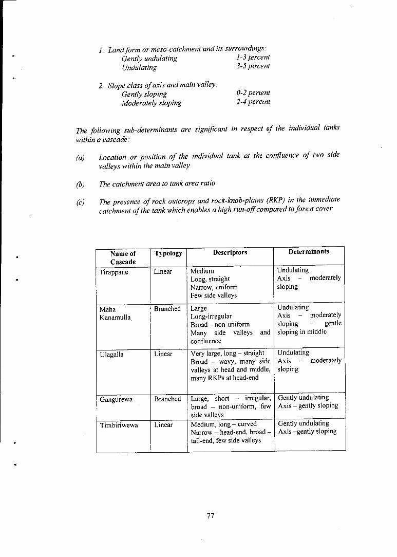
1. Landform or meso-catchment and its surrourdings: Gently undulating 1-3 percent Undulating 3-5 pircent
2. Slope class of axis and main valley: Gently sloping 0-2 pertent Moderately sloping 2-4 perant
The following sub-determinants are significant in respect of the individual tanks within a cascade:
(a) Location or position of the individual tank at the confluence of two side valleys within the main valley
(b) The catchment area to tank area ratio
(c) The presence of rock outcrops and rock-knob-plains (RKP) in the immediate catchment of the tank which enables a high run-off compared to forest cover
Name of Cascade
Typology Descriptors Determinants
Tirappane Linear Medium Long, straight Narrow, uniform Few side valleys
Undulating Axis - moderately sloping
Maha Kanamulla
Branched Large Long-irregular Broad - non-uniform Many side valleys and confluence
Undulating Axis - moderately sloping - gentle sloping in middle
Ulagalla Linear Very large, long - straight Broad - wavy, many side valleys at head and middle, many RKPs at head-end
Undulating Axis - moderately sloping
Gangurewa Branched Large, short - irregular, broad - non-uniform, few side valleys
Gently undulating Axis - gently sloping
Timbiriwewa Linear Medium, long - curved Narrow - head-end, broad -tail-end, few side valleys
Gently undulating Axis -gently sloping
77

(A)
Appendix 1
Main Features of the Traditional Keta Sorowwa and Its Earlier Proto-Type
the Haiti Sorowwa
Adopted from Sri Lanka Freedom from Hunger Campaign (FFHC) Farmer
Series No. 3 of (1992)
Every village tank has two sluices one on each bank. Sluices for small village tanks which hold around 2.5 meters of water above the dead storage level were, in ancient times, made of burnt clay components or 'terra cotta'. The vertical portion of the sluice, which is termed the hatti, is made up of a number of burnt clay vases shaped in the form of a tapering cylinder. These burnt clay vases fit one over the other to form a vertical pipe as shown in Diagram 1.
Diagram 1: Components of a Hatti Sorowwa
1. ME 77 BAT A (BURNT CLAY PIPE) SIDE VIEW 2. METI BATA (BURNT CLAY PIPE) END VIEW 3. ALI-OLUWA (BURNT CLAY JUNCTION BLOCK) 4. SILL LEVEL OF SLUICE 5. STICK TRIPOD 6. STICK OF TRIPOD 7. STICK OF TRIPOD 8. STICK OF TRIPOD
78
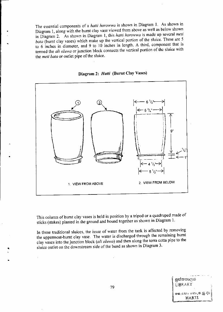
The essential components of a hatti horowwa is shown in Diagram 1. As shown in Diagram 1, along with the burnt clay vase viewed from above as well as below shown in Diagram 2. As shown in Diagram 1, this hatti horowwa is made up several meti bata (burnt clay vases) which make up the vertical portion of the sluice. These are 5 to 6 inches in diameter, and 9 to 10 inches in length. A third, component that is termed the ali oluwa or junction block connects the vertical portion of the sluice with the meti bata or outlet pipe of the sluice.
This column of burnt clay vases is held in position by a tripod or a quadruped made of sticks (stakes) planted in the ground and bound together as shown in Diagram 1.
In these traditional sluices, the issue of water from the tank is affected by removing the uppermost-burnt clay vase. The water is discharged through the remaining burnt clay vases into the junction block (ali oluwa) and then along the terra cotta pipe to the sluice outlet on the downstream side of the bund as shown in Diagram 3.
79
ges5 23 2 ^ 3 ( 3 c6 LIBRARY
L HARTI

Diagram 3: Hatti Haowwa
Once the upper clay vase is thus removed, the water level drops to the top of the next vase. Replacing the top vase retards the flow but does not stop the flow fully. It is necessary to wade in at times up to a five feet height of water within the tank in order to manipulate this operation.
The burnt clay parts of the hatti horowwa are usually fragile and needed frequent replacement. The burnt clay vases did not last very long, but were cheap and easily replaced. In the case of the burnt clay junction block {ali oluwa), when damaged it was more difficult to replace until the wewa was empty. The burnt clay (terra-cotta) pipes lasted longer.
80

(B) Improved Irrigation Department Sluice Siras-Keta Horowwa
The Irrigation Department in "its early years improved the traditional Keta Sorowwa by using concrete pipes in place of the clay pipes. They also introduced a concrete junction block and concrete verticals, resembling drainage pipes in place of the clay vases.
The components of the Siras-Keta Hirowwa (on the inlet side) are shown in Diagram 4.
The verticals (Siras-Keta) of this type o\ sluice were sealed at the joint with clay and straw and they functioned well. It was rarely that they sprang a leak below the water level.
One shortcoming with this improved sluice was thau, the verticals were about 30 kilos in weight, and were therefore difficult to lift and pace in position, especially when standing more than waist deep in water.
Diagram 4: Siras-keta Horowwa (hlet side)
1. SLUICE-VERTICALS PIPES 4. OUTLET PIPE COLLARS 2. JUNCTION BLOCK 9. SILL LEVEL OF SLUICE 3. SLUICE-OUTLET PIPES 10. FULL SUPPLY LEVEL
81

Appendix 2
Extracts from levers Manual of the North Central Province (1899) Pot Ceremony and Kiri Ithirima
1. "Mutti Mangalya " or the Pot Ceremony to God A iyana.
"The God Aiyana presides over tanks which are supposed to be under his special protection. When a tank fills and is about to spill the elders of the village, chiefly Gamaralas, proceed to the tank, and at the muttinamana tree a salute is 'offered' to the god by the firing of two guns. The chief Gamarala then steps forward and sends up a yatika, or an address, in which he announces to the god that the tank is being filled and that cultivation will be begun, and that after the harvest is gathered the Mutti Mangalaya will be performed. At the same time a few copper coins - one or two fanams in value - are wrapped up in a piece of rag daubed in saffron. The piece of rag with copper is then tied to a branch of the tree closing the ceremony by commending the tank, village its residents, and its cattle to the protection of the deity. This last ceremony is calledpanduru bandinawa. "
"The harvest is gathered. The villagers assemble and appoint a day for the performance of the mutti ceremony. The nearest Anumetirala (the mouthpiece or oracle of a god) is invited; the tom-tom beaters and the dhobis are noticed. The appointed day arrives, and the chief Gamarala directs that every shareholder of the village should contribute towards the mutti-feast. Rice, coconut oil, cakes and sweet plantains, and betel and arecanut are collected. At even the assembled people are served with rice and curry, milk rice, cakes, and plantain. The meal being over, the Anumetirala, accompanied by the whole village, proceeds in procession with two new earthen pots to where the tree stands on the bund. A raised platform, overhung with cloth and built under the shade of the tree at an early hour of the evening, receives the betel offering. The pots incensed and daubed with saffron, the now placed on the platform, oryahana. The Anumetirala sends up ayatikawa, or an address to the god, and then beings to dance. Dancing and tom-toming continue till dawn. At break of day the pots are carried up to the tree and laid on the stumps of two branches. "
"The god, through his Anumetirala, makes known that the offerings are accepted, and that the tank, the village with its inhabitants, both man and beast, are taken under his protection for a certain period one, two or three years, according to the pleasure of his divine majesty. The people return to the village and the Anumetirala with them. The latter dances and the tom-toms beat until the midday meal is ready. At noon this is eaten and the people disperse. "
Kiri Itirima
"After each crop is reaped and gathered the shareholders collect new rice, and take it to a place on the bund where there is a lactiferous tree. "
"Here a shed is built with a platform (messa). An offering of 100 betel leaves and 100 arecanuts is made and placed on the messa. Rice is then put into three pots and boiled with coconut milk, and is offered to the five divinities Aiyana Deyiyo, Kambili Deyiyo, Puddurasa Deyiyo, Ilandari Deyiyo and Kadugal Bandara, who are invoked for the protection of health, tank, crop, cattle, etc. "
82

The rice so offered is then divided among all the people present, who eat it and the ceremony ends.
3. Pillaiyar-wendima - Worship of Ganesha under the name ofPillaiyar
"On the same days on which mutti mangalya and kiri-itirima are performedpillaiyar -wendima takes place. The pillaiyar's Kapurala proceeds to the nearest pillaiyar kovil and there prepares a messa with white cloths decorated with flowers, over which he first offers betel leaves and arecanuts and then prepares milk boiled with cocoanut milk, which he offers to the god. He invokes him to protect the tank, cattle, health, etc. He then takes the rice so offered and divides it among all present there, who eat it, and so the ceremony ends. " .
83

Glossary
Bisokotuwa Cistern type masonry sluice of ancient large tank
Brahmi Script The characters of the earliest inscriptions of Ceylon - seen in the drip ledges of caves
Chena Shifting dry-land cultivation
Etched Plain Being 'etched' or engraved on to the hard basement rock, similar to artists engraving on metal plates for printing copies
Ela Canal or rivulet, brook
Gangoda Highland
Godawala Shallow depression that can hold water
Horowwa/Sorowwa Sluice or outlet from tank - man-made
Korale A traditional administrative area
Kulam A tank
Kuluwewa Silt-trapping small tanks
Kurakkan Finger Millet (Elusine Coracana)
Liyadda On-farm irrigated basin with small bunds
Maha Major cultivation season (associated with the longer rainy season)
Mahawamsa Ancient text on Sri Lanka's history
Olagama Tanks under which no permanent settlement exists
Puranawela Old paddy fields
Rajakariya Ancient custom of compulsory labour for tank maintenance
Regolith Partially decomposed weathered rock
Villu Natural pond-lake - not man-made
Velvidane Traditional irrigation headman
Welyaya Tract of paddy field
Wewa Tank
Yala Minor cultivation season (shorter rainy season)
Yaya A tract of paddy fields
Yoda Ela Giant Irrigation Channel
22584
84