Embed Size (px)
Citation preview

The development of onshore wind turbines
Renewable Energy Planning Guidance Note 3

0 V3 June 2013
Current Document Status
Version V4 Status Approved
Date 17/12/13 Approving body PPAP
Responsible Officer NDH Date approved 25/11/11
Version History
Date Version Author/Editor Comments
25/11/11 V1 PR PPAP adopted version
17/07/12 V2 EIW Revisions
04/06/13 V3 NDH Revision relating to Historic Environment
03/02/14 V4 NDH Revisions relating to Noise; Proximity to roads/railways; fees; requirements to consult prior to submission of application and bird guidance.

1 V3 June 2013
The Development of Onshore Wind Turbines in Cornwall
This guidance document has been prepared to assist all parties involved in the renewable energy development process. It is intended that the guidance document will be adopted by the Council as a “Supplementary Planning Document” following the adoption of the Council’s Core Strategy proposed after 2013. Until then the status of this document is that it has been
approved by Members of the Council’s Planning Policy Advisory Panel and while it will not attract the full weight of an SPD document will attract some weight in decisions reached on
planning applications.
Introduction
This guidance note aims to provide planning advice in respect of onshore wind.
The Government has set targets to increase electricity and/or heat generation from renewable sources. Cornwall Council is keen to promote the generation of electricity and/or heat from renewable sources in Cornwall in order to contribute towards a more sustainable future.
This guidance note is part of a series of planning guidance notes for Renewable Energy prepared by Cornwall Council. Other guidance notes include:
1. <50kW solar PV and solar thermal
2. >50kW solar PV
3. Onshore wind
4. Anaerobic Digestion
5. Hydropower
6. Biomass
7. Heat pumps
8. Deep Geothermal
9. Advanced Energy from Waste
These guidance notes will be regularly reviewed and updated and can be viewed on our website at www.cornwall.gov.uk/renewableenergy
We hope that you find this planning guidance useful but if you have any queries please do not hesitate to contact the Planning, Housing and Regeneration Service at [email protected] or ring 0300 1234 151.
We continuously seek to improve the quality of the advice and guidance that we offer and we would be happy to receive comments, suggestions or images which may improve this guidance document.

2 V3 June 2013
Contents Page
Wind Resource in Cornwall 3
Feed in Tariff 4
Renewable Obligation Certificate 4
Definition of Turbine Size and Associated Information 4
Anatomy of a Wind Turbine 6
Getting Started 6
Environmental Impact Assessment 8
Issues to be Considered in any Planning Application: 11
a) Landscape Sensitivity and Visual Amenity 15
b) Ecology 21
c) Historic Environment 25
Case Study 1: Garlenick Wind Turbines 28
d) Noise 29
Case Study 1: Gorran Community Wind 32
e) Shadow Flicker 34
f) Public Rights of Way 35
g) Soils and Hydrology 36
h) Access and Servicing Requirements 37
i) Aviation and Telecommunications 38
j) Community Involvement and Benefits 39
k) Decommissioning 40
Appendix 1 Electricity Generating Capacity 42
Appendix 2 Environmental Impact Assessment 43
Appendix 3 Information Required for a Wind Turbine Planning Application 45
Appendix 4 Landscape and Visual Impact Assessment 46
Appendix 5 Landscape Site Assessment Small Scale Wind Development 48
Appendix 6 Wind Turbine Planning Application Advisory Note 53
Appendix 7 Wind Turbine Template Planning Conditions 66
Appendix 8 Cornwall Council / RSPB Interim Guidance for Birds and Single/Several Wind Turbines
88

3 V3 June 2013
Wind Resource in Cornwall Cornwall has some of the highest average wind speeds of any European country. The map shown on the right, shows where the highest average wind speeds are in Cornwall; the darker the area the higher the wind speeds. Cornwall has high average annual wind speed of 6.5 metres per second. This wind resource was first harnessed when the UK’s commercial scale wind farm was constructed at Delabole in 1991 with an installed capacity (potential maximum electrical output) of 4MW. There are now 9 operational commercial wind farms in Cornwall with a total installed capacity of 58 MW and the Council has produced a guide showing their locations; an extract showing these locations is reproduced below.

4 V3 June 2013
Feed in Tariff The Feed in Tariff (FiT) scheme essentially provides a financial subsidy towards the uptake of renewable energy technologies, and includes electricity generated from wind turbines. In respect of wind turbines, the FiT scheme applies for a period of 20 years and for domestic customers the income is tax free and index linked for the same period.
There has been a growing interest from both community groups and individual investors in installing single or multiple turbines of the very small to medium size and the Council is keen to assist these organisations.
Renewable Obligation Certificates Renewable Obligation Certificates (ROCs) are another form of financial subsidy and are available for schemes of 5MW or more. (See http://www.decc.gov.uk/en/content/cms/meeting_energy/renewable_ener/renew_obs/renew_obs.aspx). With the output of turbines increasing this tariff may apply to single or double turbine applications in the future. However operators of any new wind turbines with a capacity of between 50kW and 5MW have the one-off option of applying under the Renewable Obligations Orders (ROO) or the Feed in Tariff (FiT) scheme. This is done using the ROO-FiT accreditation process via the Ofgem Renewables and CHP Register. Once the turbine in question has been accredited under the scheme chosen, the operator of the station cannot switch to the other scheme.
Definition of Turbine Size and Associated Information Turbine Size Throughout this guidance the description of a wind turbine in kilowatts (kW) refers to the rated power or installed generating capacity of that wind turbine. That is its maximum electrical output in ideal and consistent wind conditions. The power generated by a turbine in relation to the electricity used per annum for a typical house in Cornwall is set out in Appendix 1. For the purposes of this guidance document Cornwall Council uses the following definitions as used in previous Council reports and studies based on tip height of wind turbines from ground level;
Domestic <18 metres
Very Small 18-25 metres
Small 26-60 metres
Medium 61-99 metres
Large 100-150 metres
5 V3 June 2013
Existing Tall Structures in Cornwall In order to visualise how these different turbine heights relate to other structures the illustration below sets out some existing structures, and their heights, within Cornwall.

6 V3 June 2013
Anatomy of a wind turbine
Planning for Wind Energy Development in Cornwall The Planning and Regeneration function of Cornwall Council is structured within different teams. The Local Planning Team prepares planning policy and the Development Management Team deal with planning applications. The relevant Area Planning Committees would normally determine any planning applications but if the proposal has an installed capacity of 5 MW or greater, covers an area of 2 hectares or more or is considered to be strategically significant it would be considered by the Strategic Planning Committee.
Getting Started Initial Site Selection Wind Resource This is the fundamental requirement in order for a wind turbine to be financially viable and will be part of an applicant’s initial feasibility study. Most wind turbines require an annual average wind speed of at least 6 metres per second to be considered operationally viable. Average wind speed data is available from a number of sources. The wind speed at a particular site may however be affected by topography, screening (by tall buildings or trees), or even turbidity from existing wind turbines in the area, and therefore in some instances it may be prudent to measure the average wind speed at the site over a 12 month period. If an anemometer is needed to monitor
Planning Team
Role in Renewable Energy Contact Details
[email protected] Local
Planning Team
Develops policy and guidance across Cornwall Tel: 0300 1234 151
Strategic Development Management
Determines planning applications for strategic development across Cornwall
[email protected] Tel: 0300 1234 151
Rotor Diameter The diameter of the rotor refers to the distance between the swept area of the blade tips of the wind turbine. Hub Height The hub height is the distance from the base of the wind turbine at ground level to the centre point of the turbine rotor hub. Blade Tip Height This is the distance from the base of the turbine at ground level to the tip of the wind turbine blade at the highest point from the ground.

7 V3 June 2013
wind speed at a prospective site a temporary planning consent will be required. This has a cost implication and may not be viable for individual wind turbine proposals. The met office provides a ‘Virtual Met Mast’ wind data service for wind turbine developers which can be obtained via the link: Virtual Met Mast™ http://wwwpre.metoffice.gov.uk/energy/renewables/wind/site/metmast Grid Connection Some of Cornwall’s existing rural electricity supply lines may need to be upgraded to allow even a very small wind turbine to be connected to the electricity grid. Therefore initial discussions with the local grid provider, Western Power Distribution, are essential to determine the cost of a future grid connection. A wind turbine supplier/developer may be able to undertake these discussions on your behalf. This will obviously not be an issue in circumstances where it is not proposed to connect the wind turbine to the electricity grid, for example where the electricity generated would be used directly, or where the electricity generated would be stored using batteries. Site Access The ability to gain vehicular access to the potential site for the purposes of the
installation and future maintenance of the wind turbine needs to be confirmed before the project can proceed to a planning application. This should not normally be a problem for up to medium sized wind turbines but many sites are approached by narrow lanes and access by mobile crane needs to carefully considered. Again this aspect should be discussed locally with the wind turbine supplier/developer; however if it is necessary to create a new access into a field or to widen an existing field entrance, or to create a permanent access/maintenance track this may require planning permission. The Council provides advice on the movement of abnormal loads and can be contacted via [email protected] . Further information regarding highway access is provided in the section on Access and Servicing Requirements’ below.
Proximity to Roads and Railways The Department of Transport published updated guidance on wind turbine topple distances in September 2013 (circular 02/2013)[1]. The circular states that the
Installation of Vestas V80 wind turbine (60m hub, 100m tip) at the Goonhilly Wind Farm, Cornwall showing the size of cranes required.

8 V3 June 2013
Highways Agency will seek a minimum setback from the highway boundary of height + 50 metres or height x 1.5, whichever is the lesser. The guidance provides further detail on where variations to this set back distance will be acceptable.
The circular also advises that turbines should be located away from junctions, tight bends and crossings; and that visual distraction should be minimised by the provision of a clear, continuous view of the proposal that develops over the maximum possible length of approach carriageway. It is therefore advised that the appropriate bodies such as the Highway Agency or Network Rail are contacted if the proposed turbine is to be located near to such infrastructure. Environmental Impact Assessment (EIA) Environmental Impact Assessment (EIA) is a systematic process of identifying, predicting and evaluating the likelihood of significant effects of a development on the environment. In planning terms, EIA has a specific connotation and will need to be considered carefully in the development process. Planning legislation advises that wind turbines above a 15m height are capable of being EIA development (known as ‘Schedule 2’ development). In those cases a formal ’Screening Opinion’ should be obtained from the local planning authority to confirm whether or not a proposed wind turbine would need to be subject to EIA (see ‘obtaining a ‘Screening Opinion’ from the planning authority’ below). In some sensitive areas of Cornwall, such as Areas of Outstanding Natural Beauty, wind turbines will automatically qualify as ‘Schedule 2’ development regardless of their height. However whether EIA is actually required will need to be evaluated on a case by case basis. Any proposed wind turbine, and its location, should therefore be carefully considered before any planning application is prepared and submitted, and to avoid any unnecessary delays it is recommended that a formal Screening Opinion be obtained from the local planning authority. Obtaining a ‘Screening Opinion’ from the planning authority The Council is able and willing to provide formal confirmation of whether a wind turbine proposal would need to be supported by an Environmental Statement (ES).

9 V3 June 2013
This is known as a ‘Screening Opinion’. Please contact the Planning & Regeneration team ([email protected] or ring 0300 1234 151) for further details regarding this matter. A flow chart of the EIA Screening Procedures and the Screening Decision can be seen in appendix 2. To find out whether a proposed wind turbine would be located in a ‘sensitive area’ you can follow this link: to Cornwall Council’s interactive mapping http://mapping.cornwall.gov.uk/website/ccmap/ and search on Environment for SSSIs, AONB, WHS, Scheduled Monuments, SACs and SPAs in Cornwall.

10 V3 June 2013
The legislation covering Screening Opinions (the Town and Country Planning (Environmental Impact Assessment) Regulations 2011) states that: “A request for a Screening Opinion in relation to an application for planning permission should be accompanied by:
(a) a plan sufficient to identify the land; (b) a brief description of the nature and purpose of the development and of its
possible effects on the environment; and (c) such other information or representations as the person making the request
may wish to provide or make.” The information to be submitted to the Council when requesting a Screening Opinion should include a plan to show the location of the proposed wind turbine(s) and nearest residential properties, details of the likely wind turbine specification including height, and likely sound emissions, together with a plan to show the maximum theoretical visibility of the wind turbine, known as a ‘Zone of Visual Influence (ZVI)’, and which can be provided by the wind turbine supplier or a reputable consultant. Obtaining a Scoping Opinion from the local planning authority If an Environmental Impact Assessment is required you are advised to obtain a Scoping Opinion from the local planning authority. This Scoping Opinion will set out the detail and content that the Environmental Statement would need to address when submitting any planning application. The case officer dealing with the Screening Opinion will be able to provide further assistance regarding this matter. Applying for Planning Permission Pre-application Discussions with the Local Planning Authority Since 31 January 2012 the Council has introduced a fee for its pre-application service, which allows the Council to improve its service and provide a more consistent level of advice within agreed response times. For proposals such as the types considered in this guidance note, the Council strongly recommends that on going pre-application discussions take place, with the benefit of comments from key consultees. In order to provide this service the Council recommends that a Planning Performance Agreement (PPA) is entered into. A PPA is a framework agreed between the Council, as the local planning authority, and an applicant for the management of complex development proposals within the planning process. A PPA allows both the developer and the Council to agree a project plan and programme which will include the appropriate resources necessary to generally determine the planning application to a firm timetable. To find out more, you can view our Planning Performance Agreement (PPA) charter1. The Council is happy to have an initial no-cost discussion with developers about how a PPA can assist a development project. Planning application Fee A planning application for a small domestic wind turbine will be treated as an alteration or curtilage operation and the planning application will therefore fall within Category 6 or 7A of the Fees Regulations. Details of the latest fees are available on Cornwall Council’s website at the following link www.cornwall.gov.uk/default.aspx?page=15907
1 Planning Performance Agreement charter http://www.cornwall.gov.uk/idoc.ashx?docid=a27ce252-36c7-4eef-b0f0-2b523355ee04&version=-1

11 V3 June 2013
Larger non domestic wind turbines will normally be regarded as ‘Category 5’ planning applications for fee purposes. The planning application fee for a single non domestic wind turbine, or multiple wind turbines, can be calculated by combining the area of land over which the blades of each wind turbine can rotate with the area of the footprint of any ancillary structures and engineering works. Using land within the perimeter of a windfarm for agriculture would not require planning permission for change to a mixed use. On sites larger than 5 hectares a fixed planning application is payable with an additional fee for each 0.1 hectares in excess of the first 5 hectares, subject to a maximum total. Details of the latest fees are available here www.cornwall.gov.uk/default.aspx?page=15907 Planning application ‘red line’ and ‘blue line’. The planning application site boundary for a wind turbine should be delineated by a ‘red line’ on a plan. This red line should encompass all development that requires planning permission. It is not necessary to include within the red line(s) any other land between multiple wind turbines if no development is proposed here. However all land within the control or ownership of the applicant should be shown and edged with a blue line. An example of the red line and fee calculation is provided below: Application to add one wind turbine to a windfarm, with a substation, buried cable, extended access track and enlargement of the perimeter fence, including land that the blades rotate over, substation and other engineering works, but excluding the access track, the relevant area is 2 hectares.. Planning applications should not be submitted in an ‘outline’ type and will need to be full/detailed in their content. Appendix 3 sets out a template for the level of information that is required for a planning application submission. Householder permitted development rights for micro wind turbines New permitted development rights set out in The Town and Country Planning (General Permitted Development) (Amendment) (England) Order 2011 for micro wind turbines came into effect on 5th December 2011(See letter from The Chief Planning Officer available at http://www.communities.gov.uk/publications/planningandbuilding/lettergeneralpermitted ). Essentially a turbine that complies with the MCS Planning Standards (http://microgenerationcertification.org/admin/documents/MCS%20020%20Planning%20Standards%20Issue%201.0.pdf), is not located on “safeguarded land” (see safeguarded land tool http://aviationtool.planningportal.gov.uk/) and would not exceed either 15 metres in height if attached to a building, or 11.1 metres if ground mounted may be permitted development. However there are many other factors that need to be considered and therefore you are strongly advised to obtain confirmation from the relevant Planning Team whether a turbine requires planning permission or is considered permitted development.
12 V3 June 2013
Issues to be considered in any Planning Application The erection of any wind turbine currently requires planning permission. However legislation is currently being drafted by the Government to allow exceptions to this for wind turbines which are mounted on buildings or ground mounted within the curtilage of the dwelling house. In certain cases planning permission is not required and would be known as ‘permitted development’. Future editions of this guidance note will set out the scope of the permitted development legislation when it has been confirmed by Government. Table 1 sets out the type and level of information that would normally be required to accompany any planning application depending on the location and size of wind turbine proposed. The information in this table is provided for guidance only and is not definitive. Prospective developers or applicants are urged to contact the local planning authority to discuss the level and extent of any information which may be required in support of any planning application as this will vary depending upon the size and scale of development proposed and the particular location.
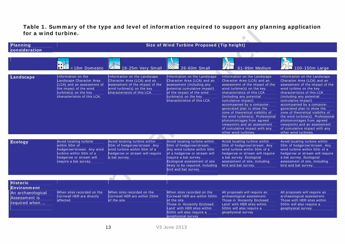
13 V3 June 2013
Table 1. Summary of the type and level of information required to support any planning application for a wind turbine.
Planning consideration
Size of Wind Turbine Proposed (Tip height)
<18m Domestic 18-25m Very Small 26-60m Small 61-99m Medium 100-150m Large Landscape Information on the
Landscape Character Area (LCA) and an assessment of the impact of the wind turbine(s) on the key characteristics of this LCA.
Information on the Landscape Character Area (LCA) and an assessment of the impact of the wind turbine(s) on the key characteristics of this LCA.
Information on the Landscape Character Area (LCA) and an assessment (including any potential cumulative impact) of the impact of the wind turbine(s) on the key characteristics of this LCA.
Information on the Landscape Character Area (LCA) and an assessment of the impact of the wind turbine(s) on the key characteristics of this LCA (including any potential cumulative impact) accompanied by a computer-generated plan to show the zone of theoretical visibility of the wind turbine(s). Professional photomontages from agreed viewpoints and an assessment of cumulative impact with any other wind turbines.
Information on the Landscape Character Area (LCA) and an assessment of the impact of the wind turbine on the key characteristics of this LCA (including any potential cumulative impact) accompanied by a compute- generated plan to show the zone of theoretical visibility of the wind turbine(s). Professional photomontages from agreed viewpoints and an assessment of cumulative impact with any other wind turbines.
Ecology Avoid locating turbine within 50m of hedgerow/stream. Any wind turbine within 50m of a hedgerow or stream will require a bat survey.
Avoid locating turbine within 50m of hedgerow/stream. Any wind turbine within 50m of a hedgerow or stream will require a bat survey.
Avoid locating turbine within 50m of hedgerow/stream. Any wind turbine within 50m of a hedgerow or stream will require a bat survey. Ecological assessment of site likely to be required, including bird and bat survey.
Avoid locating turbine within 50m of hedgerow/stream. Any wind turbine within 50m of a hedgerow or stream will require a bat survey. Ecological assessment of site, including bird and bat survey.
Avoid locating turbine within 50m of hedgerow/stream. Any wind turbine within 50m of a hedgerow or stream will require a bat survey. Ecological assessment of site, including bird and bat survey.
Historic Environment
An archaeological Assessment is required when….
When sites recorded on the Cornwall HER are directly affected
When sites recorded on the Cornwall HER are within 250m of the site
When sites recorded on the Cornwall HER are within 500m of the site. Those in ‘Anciently Enclosed Land’ with HER sites within 500m will also require a geophysical survey
All proposals will require an archaeological assessment. Those in ‘Anciently Enclosed Land’ with HER sites within 500m will also require a geophysical survey
All proposals will require an archaeological assessment. Those with HER sites within 500m will also require a geophysical survey
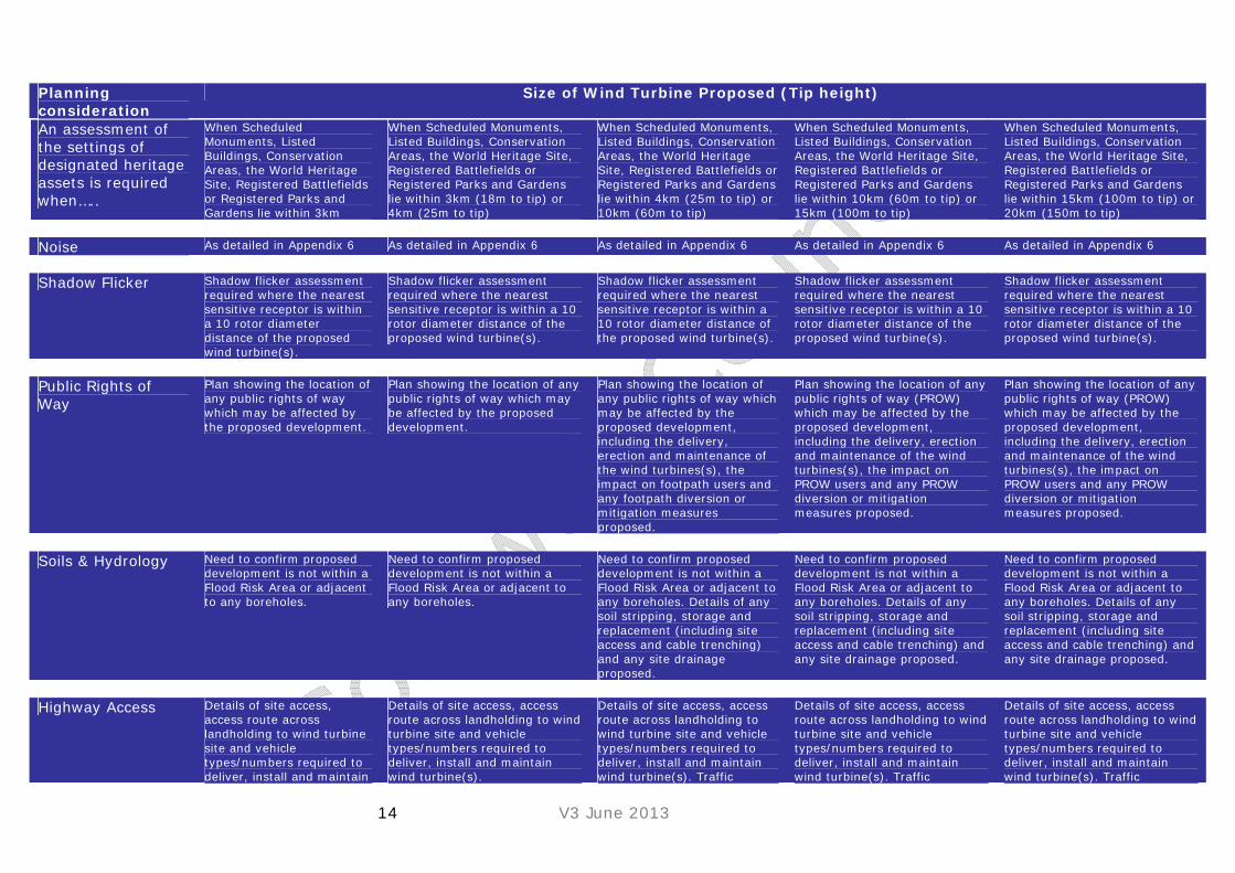
14 V3 June 2013
Planning consideration
Size of Wind Turbine Proposed (Tip height)
An assessment of the settings of designated heritage assets is required when…..
When Scheduled Monuments, Listed Buildings, Conservation Areas, the World Heritage Site, Registered Battlefields or Registered Parks and Gardens lie within 3km
When Scheduled Monuments, Listed Buildings, Conservation Areas, the World Heritage Site, Registered Battlefields or Registered Parks and Gardens lie within 3km (18m to tip) or 4km (25m to tip)
When Scheduled Monuments, Listed Buildings, Conservation Areas, the World Heritage Site, Registered Battlefields or Registered Parks and Gardens lie within 4km (25m to tip) or 10km (60m to tip)
When Scheduled Monuments, Listed Buildings, Conservation Areas, the World Heritage Site, Registered Battlefields or Registered Parks and Gardens lie within 10km (60m to tip) or 15km (100m to tip)
When Scheduled Monuments, Listed Buildings, Conservation Areas, the World Heritage Site, Registered Battlefields or Registered Parks and Gardens lie within 15km (100m to tip) or 20km (150m to tip)
Noise As detailed in Appendix 6 As detailed in Appendix 6 As detailed in Appendix 6 As detailed in Appendix 6 As detailed in Appendix 6
Shadow Flicker Shadow flicker assessment required where the nearest sensitive receptor is within a 10 rotor diameter distance of the proposed wind turbine(s).
Shadow flicker assessment required where the nearest sensitive receptor is within a 10 rotor diameter distance of the proposed wind turbine(s).
Shadow flicker assessment required where the nearest sensitive receptor is within a 10 rotor diameter distance of the proposed wind turbine(s).
Shadow flicker assessment required where the nearest sensitive receptor is within a 10 rotor diameter distance of the proposed wind turbine(s).
Shadow flicker assessment required where the nearest sensitive receptor is within a 10 rotor diameter distance of the proposed wind turbine(s).
Public Rights of Way
Plan showing the location of any public rights of way which may be affected by the proposed development.
Plan showing the location of any public rights of way which may be affected by the proposed development.
Plan showing the location of any public rights of way which may be affected by the proposed development, including the delivery, erection and maintenance of the wind turbines(s), the impact on footpath users and any footpath diversion or mitigation measures proposed.
Plan showing the location of any public rights of way (PROW) which may be affected by the proposed development, including the delivery, erection and maintenance of the wind turbines(s), the impact on PROW users and any PROW diversion or mitigation measures proposed.
Plan showing the location of any public rights of way (PROW) which may be affected by the proposed development, including the delivery, erection and maintenance of the wind turbines(s), the impact on PROW users and any PROW diversion or mitigation measures proposed.
Soils & Hydrology Need to confirm proposed development is not within a Flood Risk Area or adjacent to any boreholes.
Need to confirm proposed development is not within a Flood Risk Area or adjacent to any boreholes.
Need to confirm proposed development is not within a Flood Risk Area or adjacent to any boreholes. Details of any soil stripping, storage and replacement (including site access and cable trenching) and any site drainage proposed.
Need to confirm proposed development is not within a Flood Risk Area or adjacent to any boreholes. Details of any soil stripping, storage and replacement (including site access and cable trenching) and any site drainage proposed.
Need to confirm proposed development is not within a Flood Risk Area or adjacent to any boreholes. Details of any soil stripping, storage and replacement (including site access and cable trenching) and any site drainage proposed.
Highway Access Details of site access, access route across landholding to wind turbine site and vehicle types/numbers required to deliver, install and maintain
Details of site access, access route across landholding to wind turbine site and vehicle types/numbers required to deliver, install and maintain wind turbine(s).
Details of site access, access route across landholding to wind turbine site and vehicle types/numbers required to deliver, install and maintain wind turbine(s). Traffic
Details of site access, access route across landholding to wind turbine site and vehicle types/numbers required to deliver, install and maintain wind turbine(s). Traffic
Details of site access, access route across landholding to wind turbine site and vehicle types/numbers required to deliver, install and maintain wind turbine(s). Traffic

15 V3 June 2013
Planning consideration
Size of Wind Turbine Proposed (Tip height)
wind turbine(s). Management Plan may be required showing delivery route of wind turbine(s) on public highway (incl. vehicle swept path tracking where necessary) and hours/days of delivery.
Management Plan showing delivery route of wind turbine(s) on public highway (incl. vehicle swept path tracking where necessary) and hours/days of delivery.
Management Plan showing delivery route of wind turbine(s) on public highway (incl. vehicle swept path tracking where necessary) and hours/days of delivery.
Aviation & Telecommunications
For wind turbines >11m tall, or with a rotor diameter >2m, confirmation that the MoD, CAA and NATS have been consulted in respect of the proposed development and raise no objection.
Confirmation that the MoD, CAA and NATS have been consulted in respect of the proposed development and raise no objection.
Confirmation that the proposed development would not have a detrimental impact on existing telecommunications (phone, radio and TV) links and that the MoD, CAA and NATS have been consulted in respect of the proposed development and raise no objection.
Confirmation that the proposed development would not have a detrimental impact on existing telecommunications (phone, radio and TV) links and that the MoD, CAA and NATS have been consulted in respect of the proposed development and raise no objection.
Confirmation that the proposed development would not have a detrimental impact on existing telecommunications (phone, radio and TV) links and that the MoD, CAA and NATS have been consulted in respect of the proposed development and raise no objection.

16 V3 June 2013
a) Landscape Character and Visual Amenity Different places have different ‘landscape character’. Landscape character is the distinct, recognisable and consistent pattern of elements that occur in a particular landscape and how these are perceived. It reflects particular combinations of geology, landform, soils, vegetation, land use and human settlement. Understanding a landscape’s character is key to ensuring new development can be accommodated successfully within a landscape. The Cornwall and Isles of Scilly Landscape Character Assessment (2007)2 records the variations in landscape character across Cornwall, identifying 40 Landscape Character Areas (LCAs). The Landscape Character Area information specific to any development site can be accessed through the Cornwall Council web site at www.cornwall.gov.uk/cornwall_landscape. Cornwall is made up of a range of landscapes with a rich diversity of heritage and natural assets – it is important to understand the character of the landscape and how wind energy development might affect this character. Once an understanding of the qualities of the existing landscape has been established it is then possible to determine the sensitivity of the landscape to change and whether the landscape has the capacity to accept differing types of development. Areas of high scenic quality within Cornwall are recognised through landscape designations. Landscapes of distinctive natural beauty are protected by Area of Outstanding Natural Beauty (AONB) status. Over 30% of Cornwall is designated as an Area of Outstanding Natural Beauty. The Cornwall Area of Outstanding Natural Beauty (www.cornwall-aonb.gov.uk) is comprised of 12 discrete and separate areas, including Bodmin Moor, the Camel Estuary and sections of the north and south coast. The Tamar Valley Area of Outstanding Natural Beauty covers the Tamar Valley estuary and its inland rivers both in Cornwall and Devon. The purpose of the Area of Outstanding Natural Beauty designation is to conserve and enhance the natural beauty of the area. The designation gives formal recognition to an area’s landscape importance and allows for the development of communities and economic activity. It is important to understand why a landscape is valued and how wind energy development might affect the special qualities of the landscape. The Cornwall AONB covers 958 sq km and consists of 12 separate geographical areas as shown in the map below.
2 Cornwall Council (2007) Cornwall and Isles of Scilly Landscape Character Study [http://www.cornwall.gov.uk/default.aspx?page=20139 accessed January 2011]
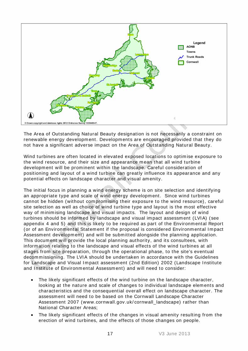
17 V3 June 2013
The Area of Outstanding Natural Beauty designation is not necessarily a constraint on renewable energy development. Developments are encouraged provided that they do not have a significant adverse impact on the Area of Outstanding Natural Beauty.
Wind turbines are often located in elevated exposed locations to optimise exposure to the wind resource, and their size and appearance mean that all wind turbine development will be prominent within the landscape. Careful consideration of positioning and layout of a wind turbine can greatly influence its appearance and any potential effects on landscape character and visual amenity.
The initial focus in planning a wind energy scheme is on site selection and identifying an appropriate type and scale of wind energy development. Since wind turbines cannot be hidden (without compromising their exposure to the wind resource), careful site selection as well as choice of wind turbine type and layout is the most effective way of minimising landscape and visual impacts. The layout and design of wind turbines should be informed by landscape and visual impact assessment (LVIA) (see appendix 4 and 5) and this is likely to be required as part of the Environmental Report (or of an Environmental Statement if the proposal is considered Environmental Impact Assessment development) and will be submitted alongside the planning application. This document will provide the local planning authority, and its consultees, with information relating to the landscape and visual effects of the wind turbines at all stages from site preparation, through the operational phase, to the site’s eventual decommissioning. The LVIA should be undertaken in accordance with the Guidelines for Landscape and Visual Impact assessment (2nd Edition) 2002 (Landscape Institute and Institute of Environmental Assessment) and will need to consider:
The likely significant effects of the wind turbine on the landscape character, looking at the nature and scale of changes to individual landscape elements and characteristics and the consequential overall effect on landscape character. The assessment will need to be based on the Cornwall Landscape Character Assessment 2007 (www.cornwall.gov.uk/cornwall_landscape) rather than National Character Areas;
The likely significant effects of the changes in visual amenity resulting from the erection of wind turbines, and the effects of those changes on people.

18 V3 June 2013
Since there are often local variations in landscape character and sensitivity within a Character Area a site-specific analysis should be undertaken to identify specific landscape and visual issues at any given site.
Other statutory bodies have provided useful guidance with regards to landscape sensitivity and visual amenity such as Natural England “Making Space for renewables: assessing on-shore wind development (TIN069)” (publications.naturalengland.org.uk/publication/23024) and English Heritage “Wind Energy and the Historic environment” (http://www.english-heritage.org.uk/publications/wind-energy-and-the-historic-environment) and “The Setting of Heritage Assets” (http://www.english-heritage.org.uk/publications/setting-heritage-assets/). The choice of site and development type should respect the specific sensitivity of the Landscape Character Area concerned and should accord with the guidance set out for that Landscape Character Area. It will also be important to consider potential cumulative effects at this stage. The following information provides some generic guidance on siting wind energy development in Cornwall:
Site wind energy development on large scale smooth, convex or flat landform rather than dramatic rugged landforms or distinct landform features (including prominent headlands and cliffs) where this does not compromise other landscape sensitivities;
Avoid selecting sites on important undeveloped or distinctive skylines, or skylines with important cultural or historic landmark features (including skylines of elevated coastlines and coastal headlands);
Locate wind turbines on the most level part of a site or follow contours to avoid a confusing variation of turbine heights;
Ensure sites do not span across marked changes in character on the ground, such as changes in topography (this may be less of an issue where changes in character are less readable on the ground);
Site wind energy development to minimise views of blade tips only (which can be distracting);
Siting of wind turbines should not dominate, or prevent the understanding and appreciation of, historic landmarks features such as hilltop monuments, engine houses or church towers;
Site wind turbines away from the coastal edge and its immediate hinterland so that they do not detract from the relative remoteness or undeveloped character of Cornwall’s coastline and to avoid wind turbulence and wind shear for wind turbines and to avoid potential harm to any important bird populations which may be present;
Any wind turbine development on hills and plateaux should generally be set back from edges to minimise impacts on views from the valleys, estuaries, and coast and to avoid potential harm to birds;
Consider locations in association with main road corridors, business parks, and railways, as well as reclaimed, industrial and man-made landscapes where other landscape sensitivities are not compromised;
Significant impacts on key views from important viewpoints (including views which are integral to the character of conservation areas), popular tourist and scenic routes and settlements should be minimised; at distances of less than around 2km, wind turbines are likely to be prominent in the views;

19 V3 June 2013
Sites for larger turbines should avoid historic landscape types of ‘Upland Rough Ground’, ‘Coastal Rough Ground’, ‘Prehistoric Enclosures’, ‘Ornamental’, and ‘Historic Cores’ which are considered by Cornwall Council as highly vulnerable to wind turbine development;
Avoid areas where ground level disturbance affects landscapes that are difficult to restore (e.g. deep peat or bog) or semi-natural habitats and to avoid potential harm to any important bird populations which may be present;
There may be some opportunity to site smaller single wind turbines in relation to farm buildings with larger scale single wind turbines sited in relation to larger businesses or community buildings - development should be commensurate with (or reflect) the scale of the associated buildings however if sited too close wind shear could adversely effect the output of the wind turbine;
Avoid sites where tracks would need to be introduced into areas of open moorland or coastal rough ground and to avoid potential harm to any important bird populations which may be present;
When selecting sites consider potential impacts of transporting the wind turbine(s) to site, and the possible limitations presented by narrow lanes bounded by high Cornish hedges and enclosed by tree tunnels;
Consider sites where areas of existing woodland could filter views of wind turbines and screen ground-level features of wind turbine developments;
Ensure siting of wind turbine(s) do not adversely affect the natural beauty of the Cornwall Area of Outstanding Natural Beauty (as set out in the emerging Area of Outstanding Natural Beauty Management Plan (2011-2016) or the Tamar Valley Area of Outstanding Natural Beauty (as set out in the Area of Outstanding Natural Beauty Management Plan 2009-2014);
Protect the outstanding universal value (OUV) of the World Heritage Site (WHS) through conservation of the components that contribute to OUV (including remains of mines, engines houses, smallholdings, ports, harbours, canals, railways, tram roads, industries allied to mining, and new towns and villages reflecting the extended period of industrial expansion and prolific innovation) and the integrity of this unified, coherent cultural landscape3;
Protect the character of conservation areas (including views integral to their character) and views to and from historic parks and gardens/battlefields (particularly designed views)4.
Wind turbine design should be carefully considered in respect of the potential visual impact on the landscape and the following should be considered:
Ensure the heights of wind turbine(s) do not overwhelm the scale of hills, ridges, and historic monuments;
Simple, pale grey colours will be most suitable for larger wind turbine(s) (to reduce contrast with the sky and match existing wind turbines in Cornwall). However, in some cases darker colours may be suitable for very small wind turbines to help them blend into their setting;
3 Cornwall Council’s Historic Environment Service should be approached directly to obtain advice on development that could affect the WHS. 4 Cornwall Council’s Historic Environment Service should be approached directly to obtain advice on development that could affect these assets.

20 V3 June 2013
Avoid use of coloured advertising logos on wind turbines, particularly in rural areas.
Ancillary features related to wind turbine development should be carefully considered in order to minimise any adverse visual impact and the guidance below should be followed:
Minimise damage to narrow lanes, Cornish hedges, trees, historic bridges and gateposts as a result of road widening – repair and replace any features lost;
Minimise the length of new tracks introduced into the landscape, using existing routes wherever possible;
Any new tracks should follow contours, avoiding steep slopes or wet ground where possible, and following field boundaries or woodland edges where possible – in some cases this may result in slightly longer lengths of track being required;
Ensure the surface of tracks blend into the surrounding landscape and aim to re-vegetate tracks (in full or in part) following construction where not needed for future maintenance;
Prevent damage and alterations to the characteristic small-scale winding road network;
Avoid use of urbanising elements in rural situations, such as kerbs, and minimise areas of hard surfacing, fencing and lighting.
Where possible, house transformers within the turbine towers to reduce their visual impacts;
Ensure on-site cables are buried underground (without damage to existing Cornish hedges or archaeology) to minimise impacts on landscape character and visual amenity - grid connections should be underground wherever possible;
Substation and control buildings should be carefully sited and should generally avoid high or exposed locations – use existing and locally occurring vegetation to screen such features;
Ensure any ancillary features match the local vernacular (e.g. using locally occurring materials on substations, control buildings and transformer cabins, if not housed within the turbines);
Ensure any ancillary features match the local vernacular (e.g. using local building materials and styles on substations, control buildings and transformer cabins, if not housed within the wind turbines);
If lighting is required on wind turbines for aviation purposes, use infra-red lighting where possible to minimise visual impacts at night.
21 V3 June 2013
Checklist Planning Application Information requirements
A Landscape and Visual Impact Assessment (LVIA) will be required to accompany all planning applications for wind turbines; however the detail and extent of these assessments will vary according to the nature and location of the proposed development. The Council cannot specify the level of information required to accompany all application types because planning applications will vary in their characteristics, a reputable wind turbine developer or planning consultant should be able to provide services that can produce this information or recommend the services of an appropriate company who can do this. However in general terms smaller scale wind turbines which are proposed in landscapes which are not sensitive for their visual and landscape interest will require proportionally less information than larger turbines or turbines in sensitive and/or protected areas e.g. Areas of Outstanding Natural Beauty. Cumulative impact Cumulative impact is a complex issue which will become increasingly relevant to the assessment of wind turbine schemes in Cornwall. Cumulative limits may present an eventual limit to the extent of wind energy development in particular areas. Cumulative effects may occur when a number of wind turbines or other developments begin to influence the overall character and perception of a particular landscape. In terms of landscape character, the introduction of a renewable energy development scheme and the degree of landscape change will depend on the net loss or gain to the physical fabric of the landscape. The consideration of cumulative effects can only be undertaken on a case by case basis in the light of existing baseline conditions, descriptions and visualisations of effects on key receptors, and relationships with other developments (both existing and proposed). Cornwall Council provides an online mapping service, which is regularly updated, and which shows the location of approved wind turbines, operational wind turbines, wind turbines refused planning permission and sites subject to a request for a Screening Opinion for the erection of a wind turbines, up-to-dated maps can be viewed at (Cornwall Council - Renewable Energy Page http://www.cornwall.gov.uk/Default.aspx?page=25182).
In general terms smaller scale wind turbines should not give rise to a significant cumulative impact unless they are proposed in particularly sensitive areas or within areas where a high number of wind turbines already exist or are planned.
Checklist Planning Application Information requirements In certain instances professional photomontages may be required for smaller turbines so pre-application discussions are always recommended between the developer/applicant and Council.
Any buildings required in order to house electrical switchgear, inverters etc should be designed and constructed in order to minimise their landscape and visual impact and should typically be of an ‘agricultural’ style, clad with timber or local stone.

22 V3 June 2013
Size of wind turbine(s) proposed Level of landscape/visual information likely to be required to support planning application
Domestic <18m
Information on the Landscape Character Area (LCA) and an assessment of the impact of the wind turbine(s) on the key characteristics of this LCA.
Very Small 18-25m
Information on the Landscape Character Area (LCA) and an assessment of the impact of the wind turbine(s) on the key characteristics of this LCA.
Small 26-60m
Information on the Landscape Character Area (LCA) and an assessment (including any potential cumulative impact) of the impact of the wind turbine(s) on the key characteristics of this LCA.
Medium 61-99m
Information on the Landscape Character Area (LCA) and an assessment of the impact of the wind turbine(s) on the key characteristics of this LCA (including any potential cumulative impact) accompanied by a computer generated plan to show the zone of theoretical visibility of the wind turbine(s). Professional photomontages from agreed viewpoints and an assessment of cumulative impact with any other wind turbines.
Large 100-150m
Information on the Landscape Character Area (LCA) and an assessment of the impact of the wind turbine on the key characteristics of this LCA (including any potential cumulative impact) accompanied by a computer generated plan to show the zone of theoretical visibility of the wind turbine(s). Professional photomontages from agreed viewpoints and an assessment of cumulative impact with any other wind turbines.
b) Ecology Wind turbines are often proposed on, or in close proximity to, exposed rural and often upland or coastal areas in order to benefit from high average wind speeds. Such locations in Cornwall may contain some of the most important and sensitive habitats and species, some of which are legally protected. There is a need to ensure any potentially significant or damaging effects on these habitats and species are avoided or minimised. The Cornwall Council Mapping Service (http://www.cornwall.gov.uk/Default.aspx?page=17724) identifies sites of high and protected ecological value such as a Site of Special Scientific Interest, or a Special Area of Conservation, or a Cornwall Nature Conservation (County Wildlife Site). The Council recommends that such areas should, where possible, be avoided for all wind turbine development.
The information to be submitted with a planning application will need to demonstrate, through an ecological assessment that no harm would be caused to such sites. Where potential impacts cannot be avoided any mitigation measures proposed should be clearly outlined. This may present an opportunity for habitat enhancement and/or habitat re-creation which could be set out in a habitat management plan.
Biological and Geological Conservation: Planning Good Practice Guidance for Cornwall (2007) This Good Practice Guidance provides advice on how to take account of bio-diversity and geo-diversity in the development process. It also sets out legal requirements and good practice recommendations (see
23 V3 June 2013
http://www.cornwall.gov.uk/idoc.ashx?docid=0bb84ae2-8fbe-4b3f-a4cd-4709dd3bc42b&version=-1)
Ecology Survey Requirements
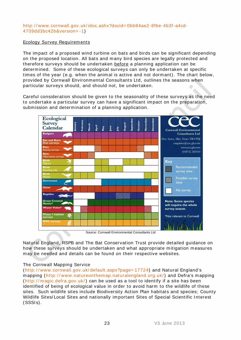
The impact of a proposed wind turbine on bats and birds can be significant depending on the proposed location. All bats and many bird species are legally protected and therefore surveys should be undertaken before a planning application can be determined. Some of these ecological surveys can only be undertaken at specific times of the year (e.g. when the animal is active and not dormant). The chart below, provided by Cornwall Environmental Consultants Ltd, outlines the seasons when particular surveys should, and should not, be undertaken.
Careful consideration should be given to the seasonality of these surveys as the need to undertake a particular survey can have a significant impact on the preparation, submission and determination of a planning application.
Source: Cornwall Environmental Consultants Ltd
Natural England, RSPB and The Bat Conservation Trust provide detailed guidance on how these surveys should be undertaken and what appropriate mitigation measures may be needed and details can be found on their respective websites.
The Cornwall Mapping Service (http://www.cornwall.gov.uk/default.aspx?page=17724) and Natural England’s mapping (http://www.natureonthemap.naturalengland.org.uk/) and Defra’s mapping (http://magic.defra.gov.uk/) can be used as a tool to identify if a site has been identified of being of ecological value in order to avoid harm to the wildlife of these sites. Such wildlife sites include Biodiversity Action Plan habitats and species; County Wildlife Sites/Local Sites and nationally important Sites of Special Scientific Interest (SSSIs).
24 V3 June 2013
Birds There is currently little evidence that single turbines or wind farms have significant effects on bird species. However, advice from nature conservation bodies indicates that this is likely to be the result of a lack of published data. Studies from America have shown that the domestic cat and glass windows are the major cause of bird related deaths. However it is known that certain bird species are more vulnerable to injury or death from impact with wind turbines, in particular wintering golden plover, wintering hen harrier, breeding nightjar and chough. All these species and their habitats are present in Cornwall. It is therefore recommended that a precautionary approach to assessing potential impacts on birds is undertaken for all wind turbine proposals, regardless of their location or height. Single turbines For single wind turbine proposals a checklist should be completed for all proposals to confirm whether or not detailed bird surveys should be undertaken. In many cases it is likely that planning applications for small single wind turbines would not need to be accompanied by detailed bird surveys. Wind Farms The RSPB, Cornwall Wildlife Trust and Environmental Records Centre for Cornwall and the Isles of Scilly may have wildlife data available to inform the Environmental Statement. However, a desk study and existing data may be insufficient and specific survey work may need to be undertaken - consultation with the Council and the relevant nature conservation organisations will help determine if such surveys are necessary (see Cornwall Council - Biodiversity and Geological Conservation webpage http://www.cornwall.gov.uk/Default.aspx?page=12898). The impact on bats and birds can be significant depending on the wind turbine location, number, scale, and design and therefore surveys may need to be undertaken before a planning application can be determined. For some proposals (particularly for very small and small turbines), additional surveys may not be necessary. All breeding birds and their nests (during construction and/or use) are protected by law, therefore the site should, at the very least, be inspected prior to work being carried out, and if breeding birds are found then appropriate measures should be applied. Natural England, RSPB and The Bat Conservation Trust provide detailed guidance on how wildlife surveys should be undertaken should they be necessary and what appropriate mitigation measures may be needed (TIN069 “Assessing the effects of onshore wind farms on birds” http://publications.naturalengland.org.uk/publication/23024). In the absence of sufficient existing data to determine likely impacts, survey work will be needed. For birds, survey work needs to take account of possible bird presence throughout the year (i.e. birds may be breeding, wintering or using or flying through the site on passage in spring and autumn) and nocturnal as well as diurnal surveys may be required. Survey work over more than one season or year may be required if significant populations of sensitive species are found. Cornwall Council and the RSPB have produced guidance Bats

25 V3 June 2013
Cornwall Council has recently produced, in conjunction with Natural England and the Cornwall Wildlife Trust, the guidance below with respect to bats and small wind turbines.
Appropriate land use management is to be encouraged and the following advice should be considered;
Aim for continuation of the existing land use underneath the wind turbines so that the landscape continues to flow underneath and around the wind turbines, or link land use to adjoining land uses especially if this can create more robust semi-natural habitats and reduce habitat fragmentation.
Land use around wind turbines will have to be carefully managed to prevent the habitat from attracting species sensitive to collision with wind turbines. (This would not be an issue if the guidance above has been followed and the wind turbine is not located where there are going to be any significant impacts on birds.) It may be better to create suitable replacement habitat at a safe distance away from the wind turbines rather than maintain habitat underneath such wind turbines. If displacement of birds is an issue then improvement of

26 V3 June 2013
the site might off-set any possible impacts to some degree. However, changes in management around wind turbines might make the habitats more attractive to other species (possibly ones which were not detected during the Environmental Statement/Environmental Assessment), particularly if there is a decrease in intensity of land-use.
Consider providing enhanced management of landscape features, habitats and historic assets as part of a development, including contributing to wider landscape scale targets and projects in Cornwall’s Biodiversity Action Plan, Cornwall’s Biodiversity and Geodiversity Action Plan, and the emerging Green Infrastructure Strategy.
Encourage traditional management of farmland including maintaining small fields and hedgerows, allowing elm and other hedge tree regeneration or, where appropriate, planting of native or locally naturalised tree species in hedges in order to restore landscape character following the impacts of elm disease.
Checklist Planning Application Information requirements Size of wind turbine(s) proposed Level of ecological information likely
to be required to support planning application
Domestic <18m
Avoid locating turbine within 50m of hedgerow/stream. Any wind turbine within 50m of a hedgerow or stream will require a bat survey
Very Small 18-25m
Avoid locating turbine within 50m of hedgerow/stream. Any wind turbine within 50m of a hedgerow or stream will require a bat survey.
Small 26-60m
Avoid locating turbine within 50m of hedgerow/stream. Any wind turbine within 50m of a hedgerow or stream will require a bat survey. Ecological assessment of site likely to be required, including bird and bat survey.
Medium 61-99m
Avoid locating turbine within 50m of hedgerow/stream. Any wind turbine within 50m of a hedgerow or stream will require a bat survey. Ecological assessment of site, including bird and bat survey.
Large 100-150m
Avoid locating turbine within 50m of hedgerow/stream. Any wind turbine within 50m of a hedgerow or stream will require a bat survey. Ecological assessment of site, including bird and bat survey.
c) Historic Environment
Cornwall has an especially important historic environment, a key part of its distinct cultural heritage, with one of the highest densities of designated historic assets in the country (Scheduled Monuments, Listed Buildings, Conservation Areas, the World Heritage Site, Registered Battlefields and Registered Parks and Gardens).
To find out if you are in or adjacent to any of these sites please visit: http://www.cornwall.gov.uk/default.aspx?page=17724.

27 V3 June 2013
In addition Cornwall has a rich heritage of undesignated sites, the conservation of which is a material consideration under national (NPPF) and local planning policy. An indication of the known distribution of these sites is available from the Historic Environment Record which can be viewed online at: http://www.heritagegateway.org.uk/gateway/advanced_search.aspx.
Developers should bear in mind that there is potential for further unknown sites to exist almost anywhere within the county.
Potential impact on the historic environment
The potential impact of a wind turbine(s) on Cornwall’s historic environment can be defined in two ways;
1. Direct physical impact on identified features of historic interest, including previously undiscovered archaeology. This can be through ground disturbance associated with foundations, trenching for cable runs, fencing, temporary haul routes and so on. Generally proposals should be located away from known archaeological sites (as recorded on the Cornwall Historic Environment Record).
2. Visual impact on the setting of historic assets; the setting of heritage assets is an important consideration under the NPPF. Every heritage asset has a setting, defined as the surroundings in which it is experienced, and elements of which can make a positive or negative contribution to the significance of an asset5. The extent and significance of setting, and the impact of development upon it, are not fixed as they change over time and need to be assessed on a case by case basis.
The need for Assessment
The Council will normally require robust and comprehensive heritage statements to be submitted as part of the application validation process and to satisfy NPPF and the requirements of the Cornwall Council local validation list-
5 See definition in NPPF Glossary Page 56.
Special Regard: S66 (1) of the Planning (Listed Buildings and Conservation Areas) Act 1990 places a statutory duty on the authority to have “special regard to the desirability of preserving” listed buildings and their settings. Cornwall Council will discharge this duty by insisting that the settings of designated heritage assets are appropriately assessed using appropriate professional expertise as indicated by the experience of assessors and membership of relevant professional bodies and by according considerable weight to the effects of applications on the settings of those assets . Where assessments are submitted which do not provide the authority with sufficient confidence that this statutory duty can be discharged applicants will be invited to defer determination of those applications until this can be provided.
28 V3 June 2013
robust because they are analytical, succinct and authoritative; comprehensive because they address the guidelines.
The assessment of impacts needs to be considered with great care at the pre-application stage, and the Historic Environment Advice Team (via the Cornwall Council Pre-application process http://www.cornwall.gov.uk/default.aspx?page=25877), should be consulted at an early stage so that they can advise applicants as to the scope of assessments, whether in exceptional cases they may not be required, and what mitigation measures might be proposed where necessary. These assessments are still likely to be required even if an Environmental Impact Assessment screening process does not lead to an EIA; it is not appropriate to undertake these assessments following determination of planning applications although where archaeological sites are likely to be affected planning consents will oblige developers to fund archaeological mitigation in line with NPPF P141 and the emerging Cornwall Local Plan.
The NPPF Section 12 (particularly paragraph 128) makes it clear that applicants must demonstrate what is significant about the site and its setting, whether their proposals will harm the historic environment, and to what degree. These assessments need to tell us more than we can already glean from simple consultation with the Cornwall and Isles of Scilly Historic Environment Record – they need to consider the further potential for what may lie under the surface, and/or what the wider visual impacts might be on historic buildings, upstanding archaeological monuments and historic landscapes. Briefs for archaeological and setting assessments are available from Cornwall Council Historic Environment Advisors as a part of the Council’s pre-application services. .
The council will use the guidance set out in the checklist below to determine when applications should be supported by assessments for:
Direct impact - whether through archaeological assessments and/or geophysical surveys. The Council will expect such assessments to be undertaken to the professional standards equivalent to those set out by the Institute for Archaeologists and by appropriately qualified and experienced expertise.
And/or
Impact on the setting of designated heritage assets - and whether English Heritage should be consulted in accordance with statutory requirements. In all cases the council will expect assessments to follow the guidance set out in ‘The Setting of Heritage Assets’ (http://www.english-heritage.org.uk/publications/setting-heritage-assets/) and be undertaken by appropriately qualified and experienced historic environmental professionals. Not all designated assets have settings to which a wind turbine, even at close distances, would represent an unacceptable impact, but some types of asset, particularly those with a strong presence in the landscape, are especially vulnerable.
Such assessments are distinct from those undertaken as part of Landscape and Visual Impact Assessments because they depend on specialist consideration of the specific significance of each heritage asset.

29 V3 June 2013
For taller turbines which require a ZTV to assist with the assessment of landscape impacts this information should be provided to those undertaking setting assessments. The siting guidance provided on page 16, 17 and 18 of this guidance note contains further useful advice.
These requirements might apply not only to designated sites – assessments may sometimes be appropriate for undesignated sites of significance, and there may be occasions when applications affect previously unrecorded sites that the Council (or English Heritage) assess as potentially archaeologically sensitive.
Planning Conditions
If planning applications are approved within known archaeologically sensitive locations, or which affect the setting of heritage assets, the Council will set conditions for mitigation measures that are proportionate and appropriate, including, for instance, professional archaeological monitoring of groundworks. However, without adequate assessment, overly burdensome conditions might be imposed or the application simply recommended for refusal on the basis of a lack of information on which to judge it.
In addition to consideration of what might be thought of as the purely archaeological features, existing Cornish hedges and established vegetation, including mature trees, should be retained wherever possible. Trees and hedges should be protected during construction. Additional hedge planting should be considered where such landscape screening would be beneficial to the proposed development.
Checklist Planning Application Information requirements Size of wind turbine(s) proposed An
archaeological assessment will
be required when….
An Assessment of the settings of
designated heritage assets will be required
when…
Domestic <18m
When sites recorded on the Cornwall HER are directly affected
When Scheduled Monuments, Listed Buildings, Conservation Areas, the World Heritage Site, Registered Battlefields or Registered Parks and Gardens lie within 3km
Very Small 18-25m
When sites recorded on the Cornwall HER are within 250m of the site
When Scheduled Monuments, Listed Buildings, Conservation Areas, the World Heritage Site, Registered Battlefields or Registered Parks and Gardens lie within 3km (18m to tip) or 4km (25m to tip)

30 V3 June 2013
Size of wind turbine(s) proposed An archaeological
assessment will be required
when….
An Assessment of the settings of
designated heritage assets will be required
when…
Small 26-60m
When sites recorded on the Cornwall HER are within 500m of the site. Those in ‘Anciently Enclosed Land’ with HER sites within 500m will also require a geophysical survey
When Scheduled Monuments, Listed Buildings, Conservation Areas, the World Heritage Site, Registered Battlefields or Registered Parks and Gardens lie within 4km (25m to tip) or 10km (60m to tip)
Medium 61-99m
All proposals will require an archaeological assessment. Those in ‘Anciently Enclosed Land’ with HER sites within 500m will also require a geophysical survey
When Scheduled Monuments, Listed Buildings, Conservation Areas, the World Heritage Site, Registered Battlefields or Registered Parks and Gardens lie within 10km (60m to tip) or 15km (100m to tip)
Large 100-150m
All proposals will require an archaeological assessment. Those with HER sites within 500m will also require a geophysical survey
When Scheduled Monuments, Listed Buildings, Conservation Areas, the World Heritage Site, Registered Battlefields or Registered Parks and Gardens lie within 15km (100m to tip) or 20km (150m to tip)

31 V3 June 2013
Case Study 1: Large wind. Garlenick Wind Turbines, Grampound Ref: PA11/02693
Photo courtesy of Airvolution Energy
Background The Garlenick Estate covers approximately 100 hectares of land outside the ancient township of Grampound, roughly midway between Truro and St Austell. The wind farm scheme comprises two turbines with a maximum hub height of 60m with a maximum tip height of 100m. The scheme has a total installed capacity of 4MW, equivalent to the powering of 1800 homes (as a comparison the population of Grampound is approximately 640 residents). The erection of two wind turbines with a maximum tip height of 100 metres, together with a substation and control building, access, associated hardstandings and upgrading of the existing access junction onto the A390. Key Issues and mitigation Landscape and Visual Impact Schemes of this scale inevitably give rise to a landscape and visual impact and there is little mitigation that can be achieved; however careful siting of the turbines reduced the impacts. The site lies outside any area of national or local landscape policy designation. Both were important considerations for a scheme of this scale given at the time there were no turbines of a comparative size in this area of Cornwall. The scheme gives rise to some impact on the Landscape Character Area however it would not unacceptably later the key fabric of this LCA, and within the general views also lie the non natural china clay landscape. The visual impact of the turbines on users of the A390 was also a key consideration, and while there would be some significant impact these were localised to short duration views across relatively short sections of the highway. Historic Sites and Listed Buildings The application, which was sited adjacent to a deserted medieval village and many other archaeological sites known through cropmark evidence, was supported by a full archaeological assessment which demonstrated a high potential for archaeological remains from the medieval and prehistoric periods. Further field evaluation demonstrated however that the impact area lay to the north of the greatest extent of medieval settlement. Archaeological impacts were minimised by design by ensuring that access to the turbine sites made use of an existing trackway and a programme of archaeological monitoring of ground impacts during construction. Due to the size of the proposed turbines and their proximity to very significant listed buildings with the Conservation Area of Grampound an assessment of the setting of heritage assets was undertaken for the applicants by the same historic environment consultancy. Having consulted designations across a wide area this document focussed on the key impacts of the proposal which were limited to a small number of assets. This demonstrated that the turbines would not impact on the setting of the village or its buildings as the village is protected by the ridge of a hill over which the turbines would be located. Several other important listed buildings lie within the views of the turbines in particular Penans Farm (Grade II*) and while there were some views of the turbine from the house the most significant aspects of the setting of this building today was demonstrated to relate mostly to views to the buildings away from the turbines. It is

32 V3 June 2013
very important to note that the assessments, although carried out by the same consultancy, involved different specialists (archaeology and historic buildings and landscapes) – reinforcing the need for and efficacy of such work being undertaken by suitably qualified individuals or organisations which meet minimum agreed national standards for the various areas of work required. Community Benefit A Community Benefit scheme of £3000 per MW p.a. accompanies this scheme (£12,000 total). The money is to be paid into a Community Fund to be managed by an independent agency. d) Noise All wind turbines will produce sound when rotating, which usually comes from two sources;
i. Aerodynamic Noise-generated by the movement of the blades through the air, ii. Mechanical Noise- from the generator and any associated gearbox.
Potential noise sensitive receptors such as residential accommodation, schools, offices, campsites & caravan sites etc may be affected depending on wind speed, wind direction, background noise levels and distance from the wind turbine(s). Cornwall Council’s Wind Turbine Assessment Panel has provided an Advisory Note which is attached as Appendix 6. The advice considers wind turbines in three categories;
Small turbines – one that meets the BWEA definition of a small turbine which is a wind turbine having a rotor swept area of 200m2 or less. In a horizontal axis wind turbine, this equates to a rotor diameter of 16 metres.
Large wind turbines – one that falls outside the scope of the BWEA definition Multiple large wind turbine projects.
Noise Sensitive Receptor A noise sensitive receptor is generally defined as any housing, school, hospital, care home, churches, camping and caravan sites etc regularly used by the public.
33 V3 June 2013
Checklist Planning Application Information requirements In respect of noise assessment requirements for proposed wind energy applications, all applications should provide sufficient information to determine whether or not noise is likely to be an issue. Where potential impacts are identified further information, assessment and mitigation recommendations will be necessary, regardless of the size or number of wind turbines involved.
Curtilage This is used to describe the extent of the residential planning unit. The boundary of a private garden or the extent of the land surrounding a factory or warehouse for example is often used to describe the extent, and is normally physically defined on the ground e.g. by a fence, wall or hedge, but also by use/function.
Financial Involvement ‘Financial Involvement’ is a term used in ETSU-R-97 which allows a consideration to be given to increasing the permissible margin above background to be increased to 45dB(A) where “…the occupier of the property has some financial involvement in the wind farm” (ETSU-R-97 paragraph 24). The term ‘Financial Involvement’ is not however statutorily defined, there is no further guidance in PPS22 or its companion guide, and while the term has been considered by Planning Inspectors, an assessment of noise will need to be given on a case by case basis. Further, the ETSU-R-97 considers the term in the context of wind farms and not for individual turbines. The Council believes it would assist both developers and the wider public if further guidance be given on the scope of “Financial Involvement” for use in the consideration of planning applications for single and multiple turbines. With the agreement of the Council’s Environmental Protection Team Wind Turbine Assessment Panel the Council considers financial involvement to be applicable where the following criteria are satisfied: • Occupiers of properties who own the land on which a wind turbine/farm is
proposed; • Persons who have invested money in the wind turbine/farm and seek to gain a
financial return from it. The following are not considered to satisfy the scope of financial involvement: • Single ‘up front’ or annual payments to an occupier of a property (whether
those payments are accepted or not); • Relations of applicants/operators who would be beneficiaries of will trusts in the
site. The Council welcomes discussion with developers to identify the extent of prospective financial involvement before planning applications are submitted.

34 V3 June 2013
The key objective of Cornwall Council will be to ensure that noise levels for turbines are limited at the curtilage of noise sensitive receptors to:-
35dBLAeq for small turbine/s, 35dBLA90 for large turbine/s 45dBLA90 for turbine/s at financially involved premises ETSU-derived limits with a minimum fixed daytime limit of 35dBLA90
The full information requirements and example conditions are contained in Appendix 6. Wind Turbine Planning Application Advisory Note - Noise

35 V3 June 2013
Case Study 2: Medium Scale Community wind.
PA10/04518
Gorran
Background Tregerrick Farm, Gorran Highlanes is located on a ridge of high ground approximately 3.5km North West of Gorran Haven. Community Power Cornwall in association with the landowner and community submitted an application to erect two 50kw wind turbines. Issues and mitigation Noise Due to the typical low rural background noise level in the area, there may be occasions when the turbines may be audible at certain receptors. However, the predicted noise levels were calculated to be 30dB at the nearest residential property. In response to concerns over noise, the turbines were repositioned to mitigate any potential noise impact on the adjoining campsite. Landscape The site is located close to the public highway and as a result is visible by the public. However, the turbines are slim in profile and are therefore not considered to have a negative impact on the landscape.

36 V3 June 2013
Larger Scale Single Turbines and Wind Farms In the case of larger scale wind turbines and wind farms, it is realistic to expect at least a desktop noise assessment at the application stage. The following information should be provided as a minimum;
Plan identifying the location of the proposed wind turbine(s), with respect to noise-sensitive receptors;
A table, detailing the separation distance between the proposed wind turbine location(s) and noise-sensitive receptors;
Noise emission data for the proposed wind turbine (manufacturers test data). Auditable predictions to determine wind turbine noise levels at closest noise-
sensitive receptors.
It would be necessary for the prediction of wind turbine noise to use an appropriate noise prediction framework, such as that provided in ISO9613 and to consider the additional guidance on wind farm noise assessment that is contained within the Institute of Acoustics (IOA) March/April 2009 bulletin, “Prediction and assessment of wind turbine noise - Agreement about relevant factors for noise assessment from wind energy projects”. The effect of the wind turbine(s) should be considered cumulatively with other existing or consented wind farms/turbines in the area. If it can be demonstrated that the noise level from the wind turbine will be less than 35dB LA90, 10 min at all noise-sensitive receptors, with an appropriate margin for prediction uncertainties, then no further assessment will normally be required. Where the above identifies that the 35dB indicative limit is likely to be exceeded, then it will be necessary for the applicant to submit a full ETSU-R-97 compliant noise assessment, based on detailed background noise monitoring and regression analysis. Meteorological information should be captured during any noise survey, as required by the ETSU-R-97 guidance, and the noise survey should capture data under a range of wind speeds that represents the full operating range of the proposed wind turbine. The effects of wind-sheer should also be taking into consideration, in accordance with the procedures set out in the Institute Of Acoustics Bulletin referenced above. Size of wind turbine(s) proposed Level of noise information likely to be
required to support planning application
Domestic <18m
Plan showing distance of proposed wind turbine from any noise sensitive property, details of any property occupied by persons with a financial involvement in the proposed development, acoustic data for specific make/model of wind turbine(s) proposed and twelve figure grid reference for turbine locations. Separation distance between turbine(s) and nearest noise sensitive premises.
Very Small 18-25m
Plan showing distance of proposed wind turbine from any noise sensitive property, details of any property occupied by persons with a financial involvement in the proposed development, acoustic data for specific make/model of wind turbine(s) proposed and twelve figure grid reference for turbine locations. Separation distance between turbine(s) and nearest noise sensitive premises
Small 26-60m
Plan showing distance of proposed wind turbine from any noise sensitive property, details of any property occupied by persons with a financial involvement in the proposed development, acoustic data for specific make/model of wind turbine(s) proposed and twelve figure grid reference

37 V3 June 2013
Size of wind turbine(s) proposed Level of noise information likely to be required to support planning application for turbine locations. May also require table detailing the separation distance between proposed wind turbine(s) and any noise sensitive receptors, background noise survey and auditable predictions of noise levels.
Medium 61-99m
Plan showing distance of proposed wind turbine from any noise sensitive property, details of any property occupied by persons with a financial involvement in the proposed development, acoustic data for specific make/model of wind turbine(s) proposed and twelve figure grid reference for turbine locations. Table detailing the separation distance between proposed wind turbine(s) and any noise sensitive receptors, background noise survey and auditable predictions of noise levels.
Large 100-150m
Plan showing distance of proposed wind turbine from any noise sensitive property, details of any property occupied by persons with a financial involvement in the proposed development, acoustic data for specific make/model of wind turbine(s) proposed and twelve figure grid reference for turbine locations. Table detailing the separation distance between proposed wind turbine(s) and any noise sensitive receptors, background noise survey and auditable predictions of noise levels.
e) Shadow flicker Wind turbine blades rotate typically between 15 and 50 revolutions per minute, usually at a constant speed. If a wind turbine is viewed with the sun behind it, under specific conditions an effect known as ‘shadow flicker’ can occur. This is when the blades of a wind turbine cast a shadow on neighbouring properties whereby intermittent “flicker” can occur particularly through constrained openings such as windows. Modern wind turbines are designed to operate at frequencies lower than those connected to epilepsy.
The potential of shadow flicker can be mapped to identify any properties that may be affected. This is likely to be a seasonal occurrence, as it relates to the angle of the sun, and is unlikely to occur during cloudy conditions. Any potential impacts can be mitigated, for example, by switching the wind turbines off for the short period of time when the problem may potentially occur.
The Council may request a shadow flicker assessment and the identification of appropriate necessary mitigation measures where the nearest residential premises are within 10 rotor diameters of the proposed wind turbine(s).
Checklist Planning Application Information requirements In general smaller scale wind turbines will require little or no assessment on this issue however where a wind turbine is proposed within 10 rotor diameters of a sensitive receptor a planning application will need to include a shadow flicker assessment which can be prepared by a suitable consultant.
Size of wind turbine(s) proposed Level of shadow flicker information likely to be required to support planning application
Domestic <18m
Shadow flicker assessment required where the nearest sensitive receptor is within a 10 rotor diameter distance of the proposed wind turbine(s).

38 V3 June 2013
Size of wind turbine(s) proposed Level of shadow flicker information likely to be required to support planning application
Very Small 18-25m
Shadow flicker assessment required where the nearest sensitive receptor is within a 10 rotor diameter distance of the proposed wind turbine(s).
Small 26-60m
Shadow flicker assessment required where the nearest sensitive receptor is within a 10 rotor diameter distance of the proposed wind turbine(s).
Medium 61-99m
Shadow flicker assessment required where the nearest sensitive receptor is within a 10 rotor diameter distance of the proposed wind turbine(s).
Large 100-150m
Shadow flicker assessment required where the nearest sensitive receptor is within a 10 rotor diameter distance of the proposed wind turbine(s).
f) Public Rights of Way Public rights of way include footpaths, bridleways and byways open to all traffic. There are 4,357km (2,706 miles) of public rights of way in Cornwall including 491km (305 miles) of South West Coast Path. It is an offence to obstruct a pavement (footway) and the fact that planning permission has been granted, or is not required, does not entitle a developer to obstruct, interfere or move a Public Right of Way. The Definitive Map and Statement is the legal record of public footpaths, bridleways and byways and can be viewed at http://www.cornwall.gov.uk/default.aspx?page=12899. Any proposal for a wind turbine should carefully consider the impact of such development on the users of any adjacent public right of way, including footpaths and bridleways. Such development should not have a significant detrimental impact on the amenity of people using the footpath or bridleway and the health and safety of such users should be carefully considered, both during the construction, operation and maintenance of the facility. Under the provisions of the Wildlife and Countryside Act 1981, a Modification Order may be applied for to re-grade or delete an existing right of way. It is recommended that discussions take place with the Countryside Access Team (0300 1234 202 or [email protected]) at the earliest opportunity to discuss possible impacts on any public right of way. It is also recommended that discussions are undertaken with a planning officer at the Council if any action is necessary. Mitigation measures, such as temporary or permanent route diversion, improvements to the right of way network or the installation of interpretation or visitor facilities should be considered. Plans submitted in support of any planning application should detail any public rights of way which may be affected by the proposed development, together with any mitigation or enhancement methods proposed.
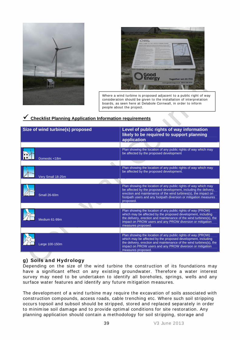
39 V3 June 2013
Checklist Planning Application Information requirements Size of wind turbine(s) proposed Level of public rights of way information
likely to be required to support planning application
Domestic <18m
Plan showing the location of any public rights of way which may be affected by the proposed development
Very Small 18-25m
Plan showing the location of any public rights of way which may be affected by the proposed development.
Small 26-60m
Plan showing the location of any public rights of way which may be affected by the proposed development, including the delivery, erection and maintenance of the wind turbines(s), the impact on footpath users and any footpath diversion or mitigation measures proposed.
Medium 61-99m
Plan showing the location of any public rights of way (PROW) which may be affected by the proposed development, including the delivery, erection and maintenance of the wind turbines(s), the impact on PROW users and any PROW diversion or mitigation measures proposed.
Large 100-150m
Plan showing the location of any public rights of way (PROW) which may be affected by the proposed development, including the delivery, erection and maintenance of the wind turbines(s), the impact on PROW users and any PROW diversion or mitigation measures proposed.
g) Soils and Hydrology Depending on the size of the wind turbine the construction of its foundations may have a significant effect on any existing groundwater. Therefore a water interest survey may need to be undertaken to identify all boreholes, springs, wells and any surface water features and identify any future mitigation measures.
The development of a wind turbine may require the excavation of soils associated with construction compounds, access roads, cable trenching etc. Where such soil stripping occurs topsoil and subsoil should be stripped, stored and replaced separately in order to minimise soil damage and to provide optimal conditions for site restoration. Any planning application should contain a methodology for soil stripping, storage and
Where a wind turbine is proposed adjacent to a public right of way consideration should be given to the installation of interpretation boards, as seen here at Delabole Cornwall, in order to inform people about the project.
40 V3 June 2013
replacement and this methodology should subsequently be adhered to during site development. Development on agricultural land should;
aim to minimise disturbance to the agricultural land and field boundary features ;
be temporary, capable of removal and ‘reversible’; and minimise their landscape/visual impact and their impact on the rural scene.
The installation and use of access tracks should be kept to an absolute minimum. Agricultural vehicles, including tractors, quad bikes and 4WD, should be capable of servicing these facilities without the need to construct access tracks. Where new access routes have to be constructed any potential impacts on hydrology, drainage and surface water run-off will need to be indentified and mitigated where appropriate..
Checklist Planning Application Information requirements Size of wind turbine(s) proposed Level of hydrological information likely
to be required to support planning application
Domestic <18m
Need to confirm proposed development is not within a Flood Risk Area or adjacent to any boreholes.
Very Small 18-25m
Need to confirm proposed development is not within a Flood Risk Area or adjacent to any boreholes.
Small 26-60m
Need to confirm proposed development is not within a Flood Risk Area or adjacent to any boreholes. Details of any soil stripping, storage and replacement (including site access and cable trenching) and any site drainage proposed.
Medium 61-99m
Need to confirm proposed development is not within a Flood Risk Area or adjacent to any boreholes. Details of any soil stripping, storage and replacement (including site access and cable trenching) and any site drainage proposed.
Large 100-150m
Need to confirm proposed development is not within a Flood Risk Area or adjacent to any boreholes. Details of any soil stripping, storage and replacement (including site access and cable trenching) and any site drainage proposed
h) Access and Servicing Requirements During the construction and for future servicing needs, a traffic management plan may need to be prepared in order to avoid unnecessary local traffic disruption. The traffic management plan should seek to include measures such as;
Avoidance of HGV deliveries during local peak/school traffic periods Temporary traffic management systems for site access Reduced speed limits on all identified routes to reduce potential for traffic
accidents

41 V3 June 2013
In addition to the wind turbine(s) themselves, the development may require additional ancillary infrastructure depending on the size and number of wind turbines, such as road access to the site and on-site tracks, a temporary construction compound, a concrete foundation pad for each wind turbine, anemometer masts (to monitor wind direction and speed) and a control building or substation (which controls the operation of the wind turbines and transmits electricity at the appropriate voltage to the nearest suitable point of the local distribution network). Details of these features will be assessed at the pre–application discussion with the local planning authority.
Checklist Planning Application Information requirements
Size of wind turbine(s) proposed Level of highway access information likely to be required to support planning
application
Domestic <18m
Details of site access, access route across landholding to wind turbine site and vehicle types/numbers required to deliver, install and maintain wind turbine(s).
Very Small 18-25m
Details of site access, access route across landholding to wind turbine site and vehicle types/numbers required to deliver, install and maintain wind turbine(s).
Small 26-60m
Details of site access, access route across landholding to wind turbine site and vehicle types/numbers required to deliver, install and maintain wind turbine(s). Traffic Management Plan may be required showing delivery route of wind turbine(s) on public highway (incl. vehicle swept path tracking where necessary) and hours/days of delivery.
Medium 61-99m
Details of site access, access route across landholding to wind turbine site and vehicle types/numbers required to deliver, install and maintain wind turbine(s). Traffic Management Plan showing delivery route of wind turbine(s) on public highway (incl. vehicle swept path tracking where necessary) and hours/days of delivery.
Large 100-150m
Details of site access, access route across landholding to wind turbine site and vehicle types/numbers required to deliver, install and maintain wind turbine(s). Traffic Management Plan showing delivery route of wind turbine(s) on public highway (incl. vehicle swept path tracking where necessary) and hours/days of delivery.
i) Aviation and Telecommunications A single wind turbine can cause air traffic safety problems due to:
Representing a potential collision risk for low flying aircraft, especially if near a local aerodrome or a military air field;
Interference with ground based air traffic control radar and aircraft landing instruments.
Therefore, in accordance with Civil Aviation Authority (CAA) Policy (see CAA Policy and Guidelines on Wind Turbines (2009)), the CAA, Ministry of Defence (MOD) and the National Air Traffic Services (NATS) should be consulted at an early stage of project inception as an objection in terms of air safety that cannot be viably overcome could prevent any scheme progressing and may result in the refusal of planning permission for such a proposal. Consultation with these bodies should therefore be conducted using a standard British Wind Energy Association proforma (http://www.bwea.com/aviation/index.html) and submitted to the MOD which consults with it appropriate departments as well as with NATS. The CAA will only comment when a planning application has been formally registered with the local planning authority.

42 V3 June 2013
In addition the MOD have to be consulted in respect of wind turbine planning applications where any proposed wind turbine would have a tip height above 11m from ground level or have a rotor diameter of 2m or more and it is therefore advised they are consulted at the outset of the project. The MOD offer advice on the safeguarding of their assets, such as radar facilities and aerodromes, on their factsheet (http://www.mod.uk/DefenceInternet/MicroSite/DIO/WhatWeDo/Operations/ModSafeguarding.htm).
Interference with Electromagnetic Transmissions “Planning for renewable energy: A Companion Guide to Planning Policy Statement 22” provides the following advice regarding Interference with Electromagnetic Transmissions: “Wind turbines can potentially affect electromagnetic transmissions in two ways: by blocking or deflecting line of sight radio or microwave links, or by the ‘scattering’ of transmission signals. There are a plethora of line of sight radio and microwave signals throughout England, including radio and TV links to local transmitters (Rebroadcast Links or RBLs), telecommunication links and police and emergency service links. Generally, turbine siting can mitigate any potential impacts, as the separation distance required to avoid problems is generally a matter of a few hundred metres. In some cases, it may be possible to effectively re-route the signal around the development, at the developer’s expense, to overcome the problem. Scattering of signal mainly affects domestic TV and radio reception, and the general public may be concerned that a wind farm will interfere with these services. Experience has shown that when this occurs it is of a predictable nature and can generally be alleviated by the installation or modification of a local repeater station or cable connection. Most characteristics of a wind turbine play a part in determining the nature and degree of signal scattering, including the rotor diameter, the number of blades, the rotational speed, the blade construction and material, and the blade and machine geometry. The tower and blades may scatter radiation, and the blades may further interfere with radiation scattered by the tower. The interference effects can often be reduced and this possibility should be discussed with the relevant representatives. Specialist organisations responsible for the operation of the electromagnetic links typically require a 100m clearance either side of a line of sight link from the swept area of turbine blades, though individual consultations would be necessary to identify each organisation’s safeguarding distance. Effects on such links can usually be resolved through careful siting of individual turbines.”
Checklist Planning Application Information requirements
Size of wind turbine(s) proposed Level of aviation and telecommunications information likely to be required to support
planning application
Domestic <18m
For wind turbines >11m tall, or with a rotor diameter >2m, confirmation that the MoD, CAA and NATS have been consulted in respect of the proposed development and raise no objection.
Very Small 18-25m
Confirmation that the MoD, CAA and NATS have been consulted in respect of the proposed development and raise no objection.

43 V3 June 2013
Small 26-60m
Confirmation that the proposed development would not have a detrimental impact on existing telecommunications (phone, radio and TV) links and that the MoD, CAA and NATS have been consulted in respect of the proposed development and raise no objection.
Medium 61-99m
Confirmation that the proposed development would not have a detrimental impact on existing telecommunications (phone, radio and TV) links and that the MoD, CAA and NATS have been consulted in respect of the proposed development and raise no objection.
Large 100-150m
Confirmation that the proposed development would not have a detrimental impact on existing telecommunications (phone, radio and TV) links and that the MoD, CAA and NATS have been consulted in respect of the proposed development and raise no objection.
j) Community Involvement and Benefits i) Community Involvement Community involvement should be considered as an integral part of the development process. The Regen SW guidance “south west engagement protocol and guidance for wind energy” (October 2004) should be used as a guide where possible. In essence, the local community should be engaged, by the developer, at the pre-design, conceptual stage, ideally utilising a local exhibition/presentation where community views can be sought and recorded. A second exhibition/presentation should be arranged, by the developer, some weeks prior to submission of the planning application. This second consultation should allow sufficient time to seek community views/opinions, and take them into consideration, prior to the submission of any final planning application. Any planning application should detail the exhibitions/presentations, any views/representations received and how any planning application was influenced/amended to accord with such representations. The developer may also wish to undertake an exhibition/presentation following the submission of a planning application. ii) Community Benefits The Council would expect a financial contribution proportionate to the scale of the wind turbine(s) to an appropriate local community fund based around the FIT income of the scheme. For more details please see guidance from Department of Energy and Climate Change (www.decc.gov.uk). Many organisations such as RegenSW (Communities for renewables initiative), Community Power Cornwall ( Confirmed Projects - Community Power Cornwall) and the Green Trust http://www.greentrustwind.co.uk/Home.html offer ways that the local community can become involved in renewable energy generation.
The development of a community wind turbine such as this project at Gorran, Cornwall, may assist in optimising the available wind resource at a site while also facilitating greater public engagement and involvement and is something Cornwall Council is keen to promote.

44 V3 June 2013
Checklist Planning Application Information requirements Heads of Terms to show how the community benefit package will be delivered (to be secured under a planning obligation under s106 of the Town and Country Planning Act 1990 through a “Unilateral Undertaking”) should be submitted with the planning application, although please note such requirements should only be necessary for non domestic, larger commercial scale turbines. A draft Unilateral Undertaking template can be made available on request. k) Decommissioning Planning permission for wind turbines may be subject to conditions (appendix 7) which require the future decommissioning of turbines in a set period of time (usually 25 years) and the return of the ground to its previous appearance. If the turbine fails during the consent period and stops generating electricity for a period of more than 12 months it will be expected to be removed unless there are genuine mitigating circumstances and the ground reinstated to avoid the potential visual harm of a derelict structure in the landscape. This does not preclude an extension of time application should the turbine still be viably functioning after 25 years.
Checklist Planning Application Information requirements
Confirmation that the site will be decommissioned once it is no longer operational.

45 V3 June 2013
Appendix 1: Electricity Generating Capacity
Planning applications for wind turbines should be accompanied by the following information.
Installed capacity (kW) 1
Capacity factor 2
Estimated annual production (kWh p.a.) 3
Number of residential properties electricity equivalent 4
Notes: 1 Installed capacity is the full-load, continuous rating of the wind turbine(s) under specific conditions as designated by the manufacturer. In other words, this is the power generated when the wind turbine is working at full capacity. 2 Capacity factor is the calculated factor which compares the wind turbines actual production over a given period of time with the amount of power the plant would have produced if it had run at full capacity for the same amount of time. The capacity factor should take account of the specific equipment and the specific location. It is expressed as a percentage. 3 Estimated annual production of electricity based upon the installed capacity and the capacity factor. 4 Number of residential properties that would be powered by the estimated annual production based upon the U.K. average household consumption of 4,629 KWh/year, the South West England average household consumption of 4,993 KWh/year and the Cornwall average household consumption of 5,869 KWh/year (DECC 2007). The number of U.K., SW and Cornwall household equivalent should be provided in this box. Average electricity consumption in Cornwall is currently greater than the U.K. and SW average and so the number of typical residential properties in Cornwall powered by a particular source would be lower.

46 V3 June 2013
Appendix 2: Environmental Impact Assessment Screening Procedures and the Screening Decision Flow chart 1 shows an overview of the screening procedure

47 V3 June 2013
Flow chart 2 shows the screening decision process.

48 V3 June 2013
Appendix 3: Information Required for a Wind Turbine Planning Application
A location plan (1:1250 metric scale) A site/block plan (1:500 metric scale) Elevation of turbine(s) Details of any ancillary works or buildings proposed, including elevations Design and access statement A supporting statement Fencing specification and details (where applicable) Details of connection to electrical grid When screening identifies the need for an EIA a Environmental Statement with
necessary information shall be submitted Where an EIA is not required the screening process may require additional
information not identified on this list An ecological assessment where applicable A landscape/visual assessment if the application site lies within, or would
impact upon, an Area of Outstanding Natural Beauty or World Heritage Site A historic environment statement where applicable (see above). Completed ‘Electricity Generating Capacity’ form (see Appendix A).

49 V3 June 2013
Appendix 4: Landscape and Visual Impact Assessment Whether the Environmental Impact Assessment Regulations (EIA) are applied to an application or not, the impact of the proposal on landscape character and visual amenity will need to be examined through a process of Landscape and Visual Impact Assessment (LVIA). Such an assessment will need to cover the following detail: 1 Description of the development
The need for the development; The timescale for construction, operation and where appropriate
decommissioning; The site’s location and overall layout including plans, elevations and sections; Visual representations of the development. In discussion with Cornwall Council
it maybe necessary to provide detail of the turbine(s) within the surrounding landscape to include photomontages, single frame images, transparencies, wire frames;
Turbine’s design / specification, method of construction / installation; Reasonable estimates of quantity and type of traffic which will be generated
through construction and operation.
2 Site Description Area of proposed land which the development will occupy, clearly described and
indicated on a map or diagram; Description of the main reasons for the site selection and any alternative sites
or overall layouts considered; Description of the land use of the surrounding area; Description of any local policies and designations which are relevant to the
proposal; 3 Landscape Baseline Conditions
The current condition of the landscape. Cornwall Landscape Assessment 2007 can provide the landscape character information relevant to the site and its setting. The specific landscape character information can be accessed at www.cornwall.gov.uk/cornwall_landscape;
Relationship of the site to any designated areas of landscape at a national, regional or local level, and to areas of landscape value or scenic quality.
Looking at the sensitivity of the landscape, its quality value, and the contribution the site and its setting make to the landscape character. In particular elements or characteristics of the landscape character that can be replaced or substituted.
4 Predictions of Impact
Assess the scale/magnitude of change to the existing landscape character and visual experience for each phase of the proposal. Consideration will need to given to visitor and resident populations, and seasonal variations;
In discussion with the Cornwall Council it maybe necessary to provide a Zone of Theoretical Visibility (ZTV) for the development clearly indicating distance radii from the site. The intervals of the radii and the scope of the ZTV will be specific to differing types of development and will need to be agreed;
The methods used to establish the magnitude of change should be clearly described and be appropriate and reasonable in relation to the landscape and visual impact of the development;
Evaluation of the direct, cumulative (in relation to other such development) medium and long term effects resulting from the existence of the turbines.

50 V3 June 2013
5 Impact Significance The applicant will need to clearly explain how significance has been assessed,
and what judgement criteria have been used to reach the conclusions; The assessment of significance should consider the impact the turbine(s) will
have on the existing landscape, the sensitivity of the landscape, the people affected and the extent to which the impact can be mitigated or is reversible;
Identify the significance of impacts that remain following mitigation. 6 Mitigation
Describe the measures proposed to avoid, reduce and if possible remedy any significant adverse impacts on both landscape character and visual amenity;
Provide an indication of the effectiveness of the stated measures; Clear indication of how the mitigation measures will be implemented.
7 Presentation of the Landscape and Visual Impact Assessment
The document should be clear and logical in its layout and presentation and be capable of being understood by a non–specialist;
It should be a balanced document providing an unbiased account of the landscape and visual effects, with reasoned and justifiable arguments;
Plans, diagrams and visual representations should be provided to assist in the understanding of the development and its impact, and should be clearly labelled with all locations reference in the text

51 V3 June 2013
Appendix 5: Landscape Site Assessment Small Scale Wind Development
1 Description of development 2 Location of site 3 Landscape Character Area within which the site is located (refer to
the web based Cornwall Landscape Character Assessment :- Cornwall Council - Landscape Character Assessment} The assessment will need to examine adjacent Landscape Character Areas where the site is located close to the Area’s boundary.
4 Is the site within the Cornwall or Tamar Area Of Outstanding Natural
Beauty (AONB)? Yes / No What is the distance to the boundary of the nearest AONB
5 Is the site within an Area of Great Landscape Value (AGLV)?
Yes / No
Looking at the relevant Landscape Character Area from the Cornwall Landscape Assessment 2007, how much of the “description” and “key characteristics” relate to the site? High - Many features are in common with the character area description or key characteristics Moderate - Some features are in common with the character area description or key characteristics Low - Few features are in common with the character area description or key characteristics
6
None – the has no features in common with the character area description or key characteristics
What aspects of the character of the area will be changed by the development, to what magnitude and to what extent? High - High level of change. High adverse effect Moderate - Moderate level of change. Moderate adverse effect Low - Few changes, Low adverse effect
7
No change

52 V3 June 2013
Combine the values derived from Points 6 and 7 above to determine the sensitivity of the landscape character to wind turbines of this scale:- Point 7 Proposed Change
Low Moderate High Low L LM M Moderate L/M M MH
8
Point 6 Landscape Character Significance High M MH H
Sensitivity of Landscape Character Low Site makes little contribution to the landscape character and
is not significantly vulnerable to change. Low / Moderate Site makes a small contribution to the landscape character
which is vulnerable to adverse change, or the site is fairly significant in terms of character, but the character can withstand the change.
Moderate Site makes a good contribution to the landscape character which will suffer a level of adverse change due to the wind turbine development
Moderate / High Site contributes much to the local distinctiveness and character of the area and is vulnerable to change.
High The site is typical of the area’s character and the wind turbine/s is /are likely to be detrimental to this.
How visible is the site from the surrounding landscape, with the visual impact be high, moderate, low, or no impact? High - The turbine(s) is very visible from the landscape around the site, with little potential to mitigate the visual impact Moderate - The turbine(s) is visible from a number of locations, with some potential for mitigation Low - The turbine(s) is partially visible from a small number of locations with likely potential for mitigation
9
None - The turbine(s) would not be visible from any position within the surrounding landscape
10 Determining the overall landscape and visual sensitivity to the turbine(s).
The value rating from Point 8 - Sensitivity of Landscape Character, and the value rating from Point 9 – Visibility when combined give a value of the landscape’s overall sensitivity to turbine(s)
Landscape Sensitivity to Change (Point 8)
+ Visibility (Point 9) =
Overall Sensitivity to Proposed Change (Point 10)
Point 9 Visibility

53 V3 June 2013
High Moderate Low High H MH M Moderate High H MH M Moderate MH M ML Moderate Low MH M ML
Point 8 Sensitivity of Landscape Character
Low M ML L Overall Sensitivity to Turbine Development
Low Overall Sensitivity – (L) There will be little discernable impact on the
landscape, and or the landscape has potential to be positively enhanced through the construction of a turbine(s). Any small changes in landscape character will not be strongly expressed
Low / Moderate Overall Sensitivity – (LM) Small adverse changes in the landscape character which are unlikely to be strongly expressed. There is likely to be a potential for landscape enhancement.
Moderate Overall Sensitivity – (M) There will be some negative change in the landscape character which will be visible, there may be potential for mitigation through appropriate scaling, siting, and design, or screening.
Moderate / High Overall Sensitivity – (MH) The construction of a turbine(s) will result in a significant negative effect or change in the landscape character that will be highly visible with unlikely potential for mitigation.
High Overall Sensitivity – (H) The construction of a turbine(s) will result in a significant negative effect or change in the landscape character that will be highly visible with no potential for mitigation, which would not in itself have an impact upon character.

54 V3 June 2013
Appendix 6: Wind Turbine Planning Application Advisory Note
Environmental Health Minimum Information Requirements for Wind Turbine Planning Applications
Sept 2013 (version 16) The applicant will need to provide the following information in their full application. Failure to do so may mean that Environmental Health object to the application due to insufficient information being provided to adequately assess the impact of noise. In turn this may also lead to the planning application being recommended for refusal on grounds of insufficient noise information to satisfy the local planning authority that the proposal would not adversely affect the living conditions of residents in the area. The key objective of Cornwall Council will be to ensure that turbine noise levels at noise sensitive receptors are limited to:-
35dB LAeq - small turbine/s 35dB LA90 - large turbine/s 45dB LA90 – large turbine/s at financially involved premises For ETSU-derived limits, a minimum fixed daytime limit 35dB LA90
These noise limits must take account of all wind turbines in the vicinity and where there are already a number of turbines planned or consented in the area, this may result in a noise limit for an individual turbine of less than 35dB LA90. A new wind turbine will still be expected to meet the appropriate noise limit at third party properties that have a 45dB LA90 limit for their own wind turbine. Where ETSU-derived limits are applied, a post-commissioning monitoring condition will be attached to the planning consent. Other applications may also have post commissioning monitoring conditions applied. It should be noted that Environmental Health will make a consultation response based upon the information provided. However, certain site specific definitions of noise sensitive receptors, curtilage, financially-involved premises etc. will ultimately be determined by the Planning Officer/Committee. In order to fully capture all information pertaining to this application, all documentation and general queries should be directed to the relevant Planning Case Officer.
Definitions:-
Small and Large Turbines

55 V3 June 2013
A small turbine is one that meets the RenewableUK (formally known as BWEA) definition, as stated in British Wind Energy Association Small Wind Turbine Performance and Safety Standard 29 Feb 2008 available through the following link http://www.renewableuk.com/ A wind turbine having a rotor swept area 200m2 or less. In a horizontal axis wind turbine this equates to a rotor diameter of 16m. A large turbine is any turbine that falls outside the scope of this definition

56 V3 June 2013
Curtilage For the purposes of this advisory note the word ‘curtilage’ is used to describe an existing domestic garden area boundary. It is not used to describe the entire extent of a land parcel. Desktop Site Specific Noise Assessment As an absolute minimum a desktop site specific noise assessment will be required for all wind turbine applications. Please refer to the attached Environmental Health checklist for full details of what is required to be contained in a noise assessment. We expect the guidance in the Institute of Acoustics “A Good Practice Guide to the Application of ETSU-R-97 for the Assessment and Rating of Wind Turbine Noise” [May 2013] to be followed. Hereafter referred to as “The IOA Guidance”. http://www.ioa.org.uk/pdf/ioa-gpg-on-wtna-issue-01-05-2013.pdf A Desktop Site Specific Noise Assessment must provide predicted noise levels at the curtilage of identified noise sensitive premises and, where appropriate, financially involved properties in the vicinity of the proposed location of the turbine. Printouts from computer models used to make predictions or produce noise contour maps are insufficient by themselves and must be accompanied by a site specific assessment. The cumulative noise impact of all turbines; existing, consented and in the planning process must be included. Please refer to section 5 of the IOA Guidance for further information. In order to minimize the risk to the operator we require predictions to be based on the apparent sound power level plus uncertainty (see the IOA Guidance on the application of uncertainty), and to include penalties for any identified tonality in accordance with ETSU-R-97. The appropriate prediction methodology should be applied as follows:
Small turbines – please refer to Equation A.2 in the British Wind Energy Association Small Wind Turbine Performance and Safety Standard 29 [Feb 2008] (i.e. basic hemispherical sound propagation). The equation should be based upon the declared apparent sound power level at 8 m/s at hub height
Large turbines - predictions will be accepted using ISO 9613 – 2
following the IOA guidance on input parameters.
The noise assessment must be undertaken by a qualified and competent acoustician, and all the data inputs, justification for use of these values, assumptions made, and margins of error must also be included in the assessment.

57 V3 June 2013
NB: Due to the increasing number of wind turbines in Cornwall, please note it is likely that site specific noise limit/s will be set, that are based on predicted turbine noise levels rather than the single turbine or the ETSU derived limits. Detailed Site Specific Noise Assessment Please refer to the attached Environmental Health checklist for full details of what is required to be contained in a noise assessment. A detailed site specific noise report will be required where ETSU-derived limits are sought. The report must include all of the requirements detailed above for the desktop study, full details of the background measurements and a table showing the following noise data for wind speeds between the cut in wind speed to 10 metres per second at 10 metres height:
Predicted turbine noise levels at noise sensitive properties Measured background noise levels at agreed representative
locations undertaken in accordance with ETSU-R-97. ETSU-R-97 derived noise levels The difference between the predicted noise level and the ETSU-R-
97 noise levels NB: Due to the increasing number of wind turbines in Cornwall, please note it is likely that site specific noise limit/s will be set, that are based on predicted turbine noise levels rather than the single turbine or the ETSU derived limits. KEY POINTS :– Candidate Turbines In the event that an alternative turbine to that contained in the submitted noise assessment is chosen for installation, then a new desktop site specific noise assessment of the proposed turbine will be required to be submitted to and approved in writing by the Local Planning Authority. Noise Sensitive Receptors Please note that caravan and camp sites and holiday lets in separate ownership are classed as noise sensitive receptors and any noise assessment must provide predicted turbine noise levels at these locations. Financially Involved Properties The financially-involved properties should be clearly identified and a statement must be included to the effect that they meet the following definition of financially-involved:
Occupiers of properties who own the land on which a wind
turbine/farm is proposed; Persons who have invested money in the wind turbine/farm and
seek to gain a financial reward from it.

58 V3 June 2013
Background Noise Monitoring For applications that require background noise monitoring, the monitoring locations must be agreed in writing with Environmental Health in advance. Two weeks notice must be given of the intended start date to provide the opportunity for an Officer from Environmental Health to attend, where appropriate, during the installation of the equipment. The noise assessment should state the name of the Officer with whom the locations were agreed. Care should be taken to choose appropriate monitoring locations for background noise monitoring, and avoid taking measurements during unrepresentative noisy periods such as local events, peak holiday times near main roads, or following unusually heavy rainfall events near streams etc. Refer to the IOA Guidance for further information. Cumulative Noise Impact Assessments If the proposed turbine produces noise levels within 10dB of any turbines (existing/consented/turbines or currently the subject of an application) at the same receptor locations, then a cumulative noise impact assessment will be required. Any screening for cumulative effect will need to be undertaken by a competent and qualified acoustician Maps showing locations of these turbines can be found at:- http://www.cornwall.gov.uk/default.aspx?page=25182 Please note these maps may not contain the very latest information and you are advised to contact the Planning Officer for further advice. We would usually expect the cumulative impact assessment to be based on the consented levels of existing or approved turbines in the first instance. However, there may be some circumstances where an alternative approach is more appropriate. If you wish to use an alternative approach then please contact an Environmental Protection Officer in the Community and Environmental Protection team to discuss. Directivity can be taken into account for cumulative assessments only. The methodology must be clearly demonstrated and the guidance in section 4.4 of the IOA guidance should be followed.
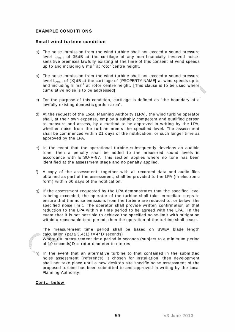
59 V3 June 2013
EXAMPLE CONDITIONS Small wind turbine condition a) The noise immission from the wind turbine shall not exceed a sound pressure
level LAeq,T of 35dB at the curtilage of any non-financially involved noise-sensitive premises lawfully existing at the time of this consent at wind speeds up to and including 8 ms-1 at rotor centre height.
b) The noise immission from the wind turbine shall not exceed a sound pressure
level LAeq,T of [X]dB at the curtilage of [PROPERTY NAME] at wind speeds up to and including 8 ms-1 at rotor centre height. [This clause is to be used where cumulative noise is to be addressed]
c) For the purpose of this condition, curtilage is defined as “the boundary of a lawfully existing domestic garden area”.
d) At the request of the Local Planning Authority (LPA), the wind turbine operator shall, at their own expense, employ a suitably competent and qualified person to measure and assess, by a method to be approved in writing by the LPA, whether noise from the turbine meets the specified level. The assessment shall be commenced within 21 days of the notification, or such longer time as approved by the LPA.
e) In the event that the operational turbine subsequently develops an audible tone, then a penalty shall be added to the measured sound levels in accordance with ETSU-R-97. This section applies where no tone has been identified at the assessment stage and no penalty applied.
f) A copy of the assessment, together with all recorded data and audio files obtained as part of the assessment, shall be provided to the LPA (in electronic form) within 60 days of the notification.
g) If the assessment requested by the LPA demonstrates that the specified level is being exceeded, the operator of the turbine shall take immediate steps to ensure that the noise emissions from the turbine are reduced to, or below, the specified noise limit. The operator shall provide written confirmation of that reduction to the LPA within a time period to be agreed with the LPA. In the event that it is not possible to achieve the specified noise limit with mitigation within a reasonable time period, then the operation of the turbine shall cease.
The measurement time period shall be based on BWEA blade length calculation (para 3.4(1) t=4*D seconds) Where t = measurement time period in seconds (subject to a minimum period of 10 seconds)D = rotor diameter in metres
h) In the event that an alternative turbine to that contained in the submitted
noise assessment (reference) is chosen for installation, then development shall not take place until a new desktop site specific noise assessment of the proposed turbine has been submitted to and approved in writing by the Local Planning Authority.
Cont… below

60 V3 June 2013
Informative The supplied acoustic data demonstrates that the recommended noise condition is predicted to be met. Whilst the prediction is considered to be ‘worst case scenario’, it is nevertheless theoretical and the potential exists for noise from the installed turbine to exceed the predicted levels. The risk of this occurring becomes greater as the predicted level approaches the consented level. We would therefore always advise applicants to maximise the separation distance between the turbine and noise sensitive receptors. It should also be noted that if the turbine develops any characteristic noise e.g. tonal components, which may unreasonably affect nearby residents and lead to a noise complaint, then this Department has a duty to investigate. Where evidence of a noise nuisance exists, formal action to abate the nuisance will be taken through the service of a noise abatement notice. Large wind turbine condition
a) The noise emission from the wind turbine when operating in isolation shall not exceed the predicted integer sound pressure level LA90 10 minutes level when calculated in accordance with “A Good Practice Guide to the Application of ETSU-R-97 for the Assessment and Rating of Wind Turbine Noise” May 2013 using an effective sound power level of [please insert sound power level plus uncertainty e.g. 87.45 + (2.49 x 1.645)] = 91.54 dB(A), at the curtilage of any non-financially involved noise-sensitive premises lawfully existing at the time of this consent at wind speeds up to and including 10 ms-1 at 10m height. Sound limits at noise sensitive properties include those stated in Table 1 below:
Table 1: sound limits LA90 10 mins at wind speeds up to and including 10 ms-1 at the curtilage of non-financially involved residential receptors Treblethick Cottages 30 dB(A) Greenwix 26 dB(A) Treveglos 22 dB(A) Tregaddock 24 dB(A) St Mabyn Holiday Park 26 dB(A) Glenmorris 29 dB(A)
b) For the purpose of this condition, curtilage is defined as “the boundary of a
lawfully existing domestic garden area”. c) At the request of the Local Planning Authority (LPA), the wind turbine
operator shall, at their own expense, employ a suitably competent and qualified person to measure and assess, by a method to be approved in writing by the LPA, whether noise from the turbine meets the specified level. The assessment shall be commenced within 21 days of the notification, or such longer time as approved by the LPA.
d) In the event that the operational turbine subsequently develops an audible
tone, then a penalty shall be added to the measured sound levels in accordance with ETSU-R-97. This section applies where no tone has been identified at the assessment stage and no penalty applied.
e) A copy of the assessment, together with all recorded data and audio files
obtained as part of the assessment, shall be provided to the LPA (in electronic form) within 60 days of the notification.

61 V3 June 2013
f) If the assessment requested by the LPA demonstrates that the specified level is being exceeded, the operator of the turbine shall take immediate steps to ensure that the noise emissions from the turbine are reduced to, or below, the specified noise limit. The operator shall provide written confirmation of that reduction to the LPA within a time period to be agreed with the LPA. In the event that it is not possible to achieve the specified noise limit with mitigation within a reasonable time period, then the operation of the turbine shall cease.
g) In the event that an alternative turbine to that contained in the submitted
noise assessment (MLM AB/100102R1 27 July 2013) is chosen for installation, then development shall not take place until a new desktop site specific noise assessment of the proposed turbine has been submitted to and approved in writing by the Local Planning Authority.
Informative The supplied acoustic data demonstrates that the recommended noise condition is predicted to be met. Whilst the prediction is considered to be ‘worst case scenario’, it is nevertheless theoretical and the potential exists for noise from the installed turbine to exceed the predicted levels. The risk of this occurring becomes greater as the predicted level approaches the consented level. We would therefore always advise applicants to maximise the separation distance between the turbine and noise sensitive receptors. It should also be noted that if the turbine develops any characteristic noise e.g. tonal components, which may unreasonably affect nearby residents and lead to a noise complaint, then this Department has a duty to investigate. Where evidence of a noise nuisance exists, formal action to abate the nuisance will be taken through the service of a noise abatement notice.

62 V3 June 2013
Site Specific Noise Assessment Environmental Health Check List The noise assessment must include the following information. Please refer to the Institute of Acoustics “A Good Practice Guide to the Application of ETSU-R-97 for the Assessment and Rating of Wind Turbine Noise” May 2013 for more detailed information. Hereafter referred to as “The IOA Guidance”. http://www.ioa.org.uk/pdf/ioa-gpg-on-wtna-issue-01-05-2013.pdf 1.0 General requirements 1.1 The turbine model, hub height and rotor diameter yes 1.2 The BWEA test report or IEC 61400-11 report to include full
octave data, information on tones and uncertainty. Where data is warranted, we will still expect to see the full test report on which the warrantee is based
yes
1.3 A 12-figure national grid reference for the precise location of the proposed turbine
yes
1.4 A map showing the separation distance to the curtilage of non-involved noise-sensitive premises (usually a residential premises but may be a camp or caravan site)
yes
1.5 A 12-figure national grid reference for the precise location of the assessment position at the receptor
yes
1.6 The same information in (1.1) – (1.6) above for each turbine considered in any cumulative noise assessment
yes n/a
1.7 Identification of all financially involved properties yes 1.8 A statement to demonstrate how any identified financially
involved properties meet the Council’s definition yes
1.9 A statement regarding the nature of any let or tenanted properties owned by the applicant
yes
1.10 A statement regarding whether or not the turbine is a candidate model
yes
2.0 Noise predictions 2.1 Prediction methodology
For small wind turbines – hemispherical methodology based upon the declared apparent sound power level. If YES please go to section 2.7. For large wind turbines ISO 9613 based on the apparent sound power level and octave band data from the test report
yes n/a
yes n/a
2.2 Where octave data in the test report is not provided for the relevant wind speed, please provide full details of
yes n/a

63 V3 June 2013
scaling/normalisation methodology
2.3 The following model input parameters must be used Receptor height = 4m G = 0.5 for soft ground (G=1 should never be used) G = 0 to be used where the majority of propagation is over paved ground or over large bodies of water, and/or no spectral data available (see section 4.3.3 of the IOA guidance Atmospheric conditions of 10°C and 70% humidity (please refer to ISO 9613-2 for co-efficients)
yes
yes no
yes no
yes
2.4 Where octave band data is not provided in the turbine test report, the calculation may be undertaken using the broadband sound power level, with attenuation at 250 Hz and the use of G=0
yes n/a
2.5 The sound power level must be adjusted, where necessary, for a higher hub height than that stated for the test data, in accordance with IEC 61400-14. Full details of calculations must be provided
yes n/a
2.6 Where G=0.5 the ISO 9613-2 prediction must include an allowance for uncertainty as specified in section 4.3.6 of the IOA Guidance
Test report uncertainty multiplied by a factor of 1.645 unless the warranted sound power level is higher. In this event the warranted sound power level should be used in the prediction.
Where no data on uncertainty is provided in the test report, then +2dB should be applied to the predictions
yes n/a
yes n/a
2.7 Any tones identified in the test report should be applied to the prediction in accordance with ETSU-R-97
yes
2.8 The valley/steep slope test should be undertaken in accordance with section 4.3.9 of the IOA guidance and the relevant correction factor applied to the prediction where necessary.
yes n/a
2.9 Topographic screening effects should be limited to a reduction of no more than 2dB and then only if there is no direct line of sight between the highest point on the turbine rotor and the receiver location
yes n/a

64 V3 June 2013
3.0 Cumulative noise assessment 3.1 A cumulative noise impact assessment must be undertaken
where noise from the proposed turbine/s produces noises levels within 10 dB of any existing turbines at the same receptor location. Full details of any screening for the potential for cumulative must be provided. Refer to IOA guidance section 5.
3.2 Cumulative noise assessment based upon consented turbine levels ( unless otherwise agreed in writing with the Environmental Protection Officer)
yes
yes n/a
4.0 Background Noise Monitoring & Assessment
4.1 Details and description of baseline measurement locations,
including a map illustrating the locations and a description of the noise environment at the location
yes
4.2 Evidence that locations were agreed in writing with Local Authority, and that two weeks notification of intended start date of survey given. To include name of Environmental Protection Officer with whom agreed.
yes
4.3 Details of survey period, which must be of sufficient length to gather required data, subject to a minimum period of 1 week
yes
4.4 Full details of equipment used, including microphone shield specification and calibration information
Class 1 precision standards (IEC 61672) or Type 1 precision standards (BS EN 60651) used Large diameter, double layer microphone windscreen used (not the standard small 90mm, single layer), or system with comparable protection against wind generated noise at the microphone
yes
4.5 Calibration drift less than 0.5 Calibration drift 0.5 – 1.5 – evidence provided that demonstrates ok to use Calibration over 1.5 – measurements discarded
yes
4.6 Noise, wind and rainfall measurements synchronised.
yes 4.7 Photographs of monitoring equipment in situ
yes 4.8 Monitoring equipment sited on façade most exposed to
turbine noise
yes
4.9 Evidence that microphone is 1.2-1.5m above ground
yes 4.10 Evidence that microphone is between 3.5m and 20m from a
dwelling yes

65 V3 June 2013
4.11 Evidence that microphone is at least 3.5m from any reflecting surfaces except the ground
yes
4.12 Evidence that microphone is located sufficiently separated from trees and running water
yes
4.13 Predominant noise sources during set up and pick up identified
yes
4.14 Details of type of rain gauge used and location
yes 4.15 Rainfall measurements
yes 4.16 Full details of data exclusions e.g. for rainfall/dawn
chorus/other turbines, regarding periods which have been excluded. Excluded data to be illustrated in time history or scatter plots.
yes
4.17 Details of method of wind speed measurement (e.g. met mast with one or two anemometers, including height of anemometers, LIDAR, SODAR)
yes
4.18 Wind shear corrections, when using met mast with anemometer at 10m height, with details of method. Please refer to section 4.5 and Annex A of the IOA Guidance
yes n/a
4.19 Directional analysis of wind data if required. Please refer to section 3.1.22-24 of the IOA Guidance
yes n/a
4.20 The data must be presented in a table containing background noise levels, predicted turbine noise levels, cumulative predicted noise levels(if applicable), ETSu limits and difference between predicted turbine noise levels and derived limits.
yes
4.21 The above data must also be presented graphically with the type, order & coefficient of the regression line clearly marked.
yes
4.22 The raw data must be available and provided on request
yes I confirm that the minimum information requirements in respect of the assessment of noise have been met. Applicants/Agents Name ____________________________________________ Position ____________________________________________________ Date _______________________________________________________
66 V3 June 2013
Appendix 7: Wind Turbine Template Planning Conditions Please note that these template planning conditions are provided for information purposes only. This list of planning conditions is not intended to be exhaustive and Cornwall Council reserves the right to amend these conditions, or impose additional planning conditions, as required by any specific planning application.
Commencement of Development
1. The development hereby permitted shall be commenced within three years of the date of this decision.
Reason: To comply with s91 of the Town and Country Planning Act 1990 (as amended) and to prevent accumulation of unimplemented planning permissions. Approved Documents
2. The development shall be constructed in accordance with the following drawings and documents;
Drawing (Proposed new and upgraded track) Drawing (Proposed substation and control building) Drawing (Proposed turbine foundation and transformer) Drawing (Proposed site layout) Drawing (Proposed wind turbine elevations and detail) Drawing (Site location plan) Reason: For the avoidance of doubt and in the interests of proper planning and to meet with Government Guidance: Greater Flexibility for Planning Permissions: October 2010 Duration of Planning Permission
3. The Local Planning Authority shall be notified in writing of the date when electricity from the development is first supplied to the grid and, other than any temporary construction compound, the development hereby permitted shall be removed from the site following the expiry of 25 years from that date: the turbines shall be decommissioned and the turbines and all related above-ground structures shall be removed from the site. Following the removal of the turbines and structures, the land shall be re-instated in accordance with a Decommissioning Method Statement that shall be submitted for the approval of the Local Planning Authority at least 18 months before the date of the decommissioning of the

67 V3 June 2013
wind turbines. That method statement shall include details of the manner, management and timing of the reinstatement works to be
undertaken and shall be accompanied by a Traffic Management Plan for the removal of the large turbine components. The removal works and the reinstatement of the site shall be carried out in accordance with the approved scheme unless otherwise agreed in writing by the Local Planning Authority.
Reason: In recognition of the expected life of the wind turbines and that infrastructure needs to be removed to prevent unacceptable landscape and visual impacts.
4. The Local Planning Authority shall be notified of any wind turbine that fails to produce electricity for supply to the electricity grid for a continuous period of 12 months. This wind turbine and its associated ancillary equipment shall be removed from the site within a period of 6 months from the end of that 12 month period, in accordance with a scheme that has been submitted to and approved in writing by the Local Planning Authority. That scheme shall include the details of the manner, management and timing of the works to be undertaken and shall also include a Traffic Management Plan for the removal of the large turbine components. That part of the site shall be restored in accordance with a detailed scheme that has been submitted to and approved in writing by the Local Planning Authority.
Reason: In recognition of the expected life of the wind turbines and that infrastructure needs to be removed to prevent unacceptable landscape and visual impacts Construction Traffic Management Plan
5. No development shall be begun until a Construction Traffic Management Plan has been submitted to and approved in writing by the Local Planning Authority. The scheme shall include details relating to:
(a) construction vehicle routeing and hours/days of deliveries; (b) the management of the junctions with and crossings of the public
highway and other public rights of way; (c) temporary/advanced warning signage; (d) an access improvement scheme; (e) proposed accommodation works and where necessary a programme
for their subsequent removal and the reinstatement of street furniture, where required along the route;
The development shall be carried out in accordance with the approved scheme. Reason: In the interests of highway safety

68 V3 June 2013
Temporary Construction Compound
6. The temporary construction compound and all materials, plant and structures within it shall be removed and the land returned to its former use within a period of – months following the commissioning of the wind turbines, or within a period of X months of the commencement of development, whichever is the sooner.
Reason: To prevent unacceptable landscape and visual impacts.
7. No development shall take place until details of the wind turbine design, specifications and colour has been submitted to and approved in writing by the Local Planning Authority. Only the approved wind turbines shall be installed on the site and they shall be maintained in the approved colour.
Reason: To ensure that the development does not have a detrimental impact on quality of life and the natural environment Height of Wind Turbine(s)
8. Each turbine shall not exceed a maximum height of XX metres to the tip height of the blades above natural ground level.
Reason: To prevent unacceptable landscape and visual impacts Rotation of Wind Turbine Blades
9. All of the wind turbine blades shall rotate in the same direction. Reason: To prevent unacceptable landscape and visual impacts. Appearance of Wind Turbines
10. The wind turbines shall not display any sign, symbol or logo on any external surface, unless previously agreed in writing with the local planning authority, except as required for health and safety purposes.
Reason: To prevent unacceptable landscape and visual impacts. Lighting
11. Any lighting associated with the construction and operation of the wind turbines shall only be installed and used in accordance with a scheme that has first been submitted to and approved in writing with the Local Planning Authority before the commencement of development.
Or;

69 V3 June 2013
12. No wind turbine or anemometry mast shall be externally lit for any
purpose unless otherwise previously approved in writing by the Local Planning Authority.
Reason: To minimise visual impact. Design & Appearance of Built Structures
13. Before the erection of the sub-station and control building, details of its design and the materials to be used, together with the details of any fenced compound shall be submitted to, and approved in writing by the Local Planning Authority. Development shall be carried out in accordance with the approved details.
Reason: In the interests of visual amenity. Underground Cabling
14. No development shall take place until a scheme for the location of all underground cabling has been submitted to and approved by the LPA.
Or
15. All electrical cabling between the individual wind turbines and the site connection building on the application site shall be installed underground. No electricity generated by the development shall be supplied for public consumption until all electrical cabling between the on site connection building and the connection to the electricity grid (at ---) has been installed underground.
Reason: In the interests of protecting the natural environment and to protect visual amenity. Public Rights of Way
16. No construction work shall take place on the route of, or immediately adjacent to, a public right of way until a scheme to ensure the safety of users of the right of way (by appropriate signage, temporary diversion or temporary closure) has been submitted to and approved in writing by the Local Planning Authority. The scheme shall be undertaken in full accordance with the approved details unless otherwise agreed in writing with the Local Planning Authority.
Reason: In the interests of the safety and amenity of users of the pubic rights of way network

70 V3 June 2013
Interpretation/Information Board
17. Within three months of the commissioning of the wind turbine an interpretation/information board shall be erected at the site. The details to be contained on the interpretation/information board (which shall include company contact details), its dimensions and proposed location shall be submitted to and approved in writing by the Local Planning Authority. The interpretation/information board shall subsequently be erected and maintained throughout the operational life of the windfarm.
Reason: In the interests of the safety of local residents and visitors to the area and to raise awareness about renewable energy. Archaeological Works
18. No development shall take place until the applicant has secured the implementation of a programme of archaeological work in accordance with a written scheme of investigation which has been submitted by the applicant and approved in writing by the Local Planning Authority. In the event of any previously unidentified or disclosed archaeological remains being found during the course of the development, any works that may affect those said remains shall cease until an archaeological recording/preserving programme has been approved in writing with the Local Planning Authority. The development shall then only proceed in accordance with the details of that approved recording/preserving programme.
Reason: To protect cultural heritage assets. Ecological Assessments & Mitigation
19. No development shall take place until a scheme for ecological mitigation has been submitted to and approved in writing by the Local Planning Authority. The scheme shall remain in place until the wind turbines have been decommissioned and the land restored in accordance with this condition. The objective of the scheme shall be the management and, where possible, the enhancement of the ecological and wildlife habitats of the site. The scheme shall provide for:
a. detailed methods and a timetable for reinstating disturbed ground on site where appropriate. Disturbed ground shall include land at turbine bases, crane hard standing, cable trenches, access tracks and the construction compound;
b. replacement woodland planting, the consolidation of existing hedgerows through bulk planting; replacement planting immediately adjacent to the new access gates; new planting in headlands of fields with proposed turbines; a specification for gate types; and a specification and location plan for the 30 hazel dormouse nesting boxes;

71 V3 June 2013
c. monitoring of habitats, plants, birds, bats and other mammal
species at yearly intervals for the 5 years following commencement and at 5 yearly intervals thereafter, in order to inform an on going management programme; and
d. mitigation tree planting for the loss and disturbance to trees on the site.
Reason: In the interest of maintaining and improving the habitats, biodiversity and nature conservation of the site. Electro-magnetic interference/TV reception
20. No development shall take place on site until a baseline domestic television and domestic radio reception study has been undertaken in the area by a qualified television and domestic radio engineer and submitted to the Local Planning Authority. A mitigation scheme setting out the details of works necessary to mitigate any adverse effects to domestic television and domestic radio signals in the area caused by the development shall also be submitted to and approved in writing by the Local Planning Authority before development begins. The mitigation scheme shall include provision for investigating and dealing with any claim by any person for domestic loss or interference of television and/or radio reception at their household within 24 months of the final commissioning of the wind farm, and any mitigation works must be carried out in accordance with the approved mitigation scheme.
Reason: In the interests of protecting living conditions of the occupiers of nearby dwellings Shadow Flicker
21. No development shall take place until a scheme, which shall include a computerised control system designed to shut down turbines at those times when, as determined by sensors mounted on the turbines, actual shadowing of properties would otherwise occur, to alleviate the incidence of shadow flicker, has been submitted to and approved in writing by the Local Planning Authority. Development shall be carried out in accordance with the approved scheme.
Reason: In the interests of protecting living conditions of the occupiers of nearby dwellings Micro-siting
22. Where no micro-siting has been proposed within the planning application this matter should be addressed by the Approved Documents conditions, i.e. wind turbines to be erected as shown on the approved drawings. Where micro-siting has been clearly

72 V3 June 2013
proposed within the planning application the following condition should be considered;
23. Turbines shall be located in positions shown in drawing xxx
(Proposed Site Layout) or up to Xm from these positions in any direction. The location of a wind turbine between Xm and Xm from any position shown on drawing xxx shall only be allowed with prior approval from the Local Planning Authority. A plan showing the position of the turbines ‘as built’ will be submitted to the Local Planning Authority within one month of the commissioning of the wind turbine.
Reason: To enable positioning of turbines to minimise impact on the natural environment Noise - example conditions. Please note these may be amended on a site by site basis; small and large refer to the definitions in appendix 6 for noise assessments, rather than the general planning definitions of size. Small wind turbine condition i) The noise immission from the wind turbine shall not exceed a sound pressure
level LAeq,T of 35dB at the curtilage of any non-financially involved noise-sensitive premises lawfully existing at the time of this consent at wind speeds up to and including 8 ms-1 at rotor centre height.
j) The noise immission from the wind turbine shall not exceed a sound pressure
level LAeq,T of [X]dB at the curtilage of [PROPERTY NAME] at wind speeds up to and including 8 ms-1 at rotor centre height. [This clause is to be used where cumulative noise is to be addressed]
k) For the purpose of this condition, curtilage is defined as “the boundary of a lawfully existing domestic garden area”.
l) At the request of the Local Planning Authority (LPA), the wind turbine operator shall, at their own expense, employ a suitably competent and qualified person to measure and assess, by a method to be approved in writing by the LPA, whether noise from the turbine meets the specified level. The assessment shall be commenced within 21 days of the notification, or such longer time as approved by the LPA.
m) In the event that the operational turbine subsequently develops an audible tone, then a penalty shall be added to the measured sound levels in accordance with ETSU-R-97. This section applies where no tone has been identified at the assessment stage and no penalty applied.
n) A copy of the assessment, together with all recorded data and audio files obtained as part of the assessment, shall be provided to the LPA (in electronic form) within 60 days of the notification.
o) If the assessment requested by the LPA demonstrates that the specified level is being exceeded, the operator of the turbine shall take immediate steps to ensure that the noise emissions from the turbine are reduced to, or below, the

73 V3 June 2013
specified noise limit. The operator shall provide written confirmation of that reduction to the LPA within a time period to be agreed with the LPA. In the event that it is not possible to achieve the specified noise limit with mitigation within a reasonable time period, then the operation of the turbine shall cease.
The measurement time period shall be based on BWEA blade length calculation (para 3.4(1) t=4*D seconds) Where t = measurement time period in seconds (subject to a minimum period of 10 seconds)D = rotor diameter in metres
p) In the event that an alternative turbine to that contained in the submitted
noise assessment (reference) is chosen for installation, then development shall not take place until a new desktop site specific noise assessment of the proposed turbine has been submitted to and approved in writing by the Local Planning Authority.
Large wind turbine condition a) The noise immission from the wind turbine shall not exceed a sound pressure
level LA90 10 minutes of 35dB at the curtilage of any non-financially involved noise-sensitive premises lawfully existing at the time of this consent at wind speeds up to and including 10 ms-1 at 10m height.
b) The noise immission from the wind turbine shall not exceed a sound pressure
level LA90 10 minutes [X]dB at the curtilage of [PROPERTY NAME] at wind speeds up to and including 10 ms-1 at 10m height. [This clause is to be used where cumulative noise is to be addressed]
c) The noise immission from the wind turbine shall not exceed a sound pressure level LA90 10 minutes of 45dB at the curtilage of any financially involved noise-sensitive premises, as identified in the application documentation, lawfully existing at the time of this consent at wind speeds up to and including 10 ms-1 at 10 m height.
d) For the purpose of this condition, curtilage is defined as “the boundary of a lawfully existing domestic garden area”.
e) At the request of the Local Planning Authority (LPA), the wind turbine operator shall, at their own expense, employ a suitably competent and qualified person to measure and assess, by a method to be approved in writing by the LPA, whether noise from the turbine meets the specified level. The assessment shall be commenced within 21 days of the notification, or such longer time as approved by the LPA.
f) In the event that the operational turbine subsequently develops an audible tone, then a penalty shall be added to the measured sound levels in accordance with ETSU-R-97. This section applies where no tone has been identified at the assessment stage and no penalty applied.
g) A copy of the assessment, together with all recorded data and audio files obtained as part of the assessment, shall be provided to the LPA (in electronic form) within 60 days of the notification.
h) If the assessment requested by the LPA demonstrates that the specified level is being exceeded, the operator of the turbine shall take immediate steps to ensure that the noise emissions from the turbine are reduced to, or below, the specified noise limit. The operator shall provide written confirmation of that
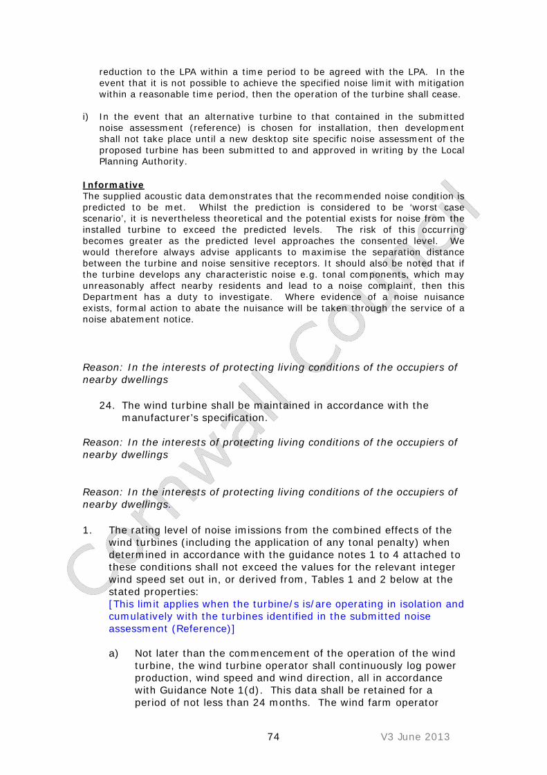
74 V3 June 2013
reduction to the LPA within a time period to be agreed with the LPA. In the event that it is not possible to achieve the specified noise limit with mitigation within a reasonable time period, then the operation of the turbine shall cease.
i) In the event that an alternative turbine to that contained in the submitted noise assessment (reference) is chosen for installation, then development shall not take place until a new desktop site specific noise assessment of the proposed turbine has been submitted to and approved in writing by the Local Planning Authority.
Informative The supplied acoustic data demonstrates that the recommended noise condition is predicted to be met. Whilst the prediction is considered to be ‘worst case scenario’, it is nevertheless theoretical and the potential exists for noise from the installed turbine to exceed the predicted levels. The risk of this occurring becomes greater as the predicted level approaches the consented level. We would therefore always advise applicants to maximise the separation distance between the turbine and noise sensitive receptors. It should also be noted that if the turbine develops any characteristic noise e.g. tonal components, which may unreasonably affect nearby residents and lead to a noise complaint, then this Department has a duty to investigate. Where evidence of a noise nuisance exists, formal action to abate the nuisance will be taken through the service of a noise abatement notice. Reason: In the interests of protecting living conditions of the occupiers of nearby dwellings
24. The wind turbine shall be maintained in accordance with the manufacturer’s specification.
Reason: In the interests of protecting living conditions of the occupiers of nearby dwellings Reason: In the interests of protecting living conditions of the occupiers of nearby dwellings. 1. The rating level of noise imissions from the combined effects of the
wind turbines (including the application of any tonal penalty) when determined in accordance with the guidance notes 1 to 4 attached to these conditions shall not exceed the values for the relevant integer wind speed set out in, or derived from, Tables 1 and 2 below at the stated properties: [This limit applies when the turbine/s is/are operating in isolation and cumulatively with the turbines identified in the submitted noise assessment (Reference)]
a) Not later than the commencement of the operation of the wind
turbine, the wind turbine operator shall continuously log power production, wind speed and wind direction, all in accordance with Guidance Note 1(d). This data shall be retained for a period of not less than 24 months. The wind farm operator

75 V3 June 2013
shall provide this information in the format set out in Guidance Note 1(e) to the Local Planning Authority on its request, within 14 days of receipt in writing of such a request.
b) No electricity shall be exported until the wind farm operator has
submitted to the Local Planning Authority for written approval a list of proposed independent consultants who may undertake compliance measurements in accordance with this condition. Amendments to the list of approved consultants shall be made only with the prior written approval of the Local Planning Authority.
c) No wind turbine shall be operated on the site until a scheme has
been submitted to and agreed with the local planning authority for monitoring the rating level of noise imissions at up to five selected residential locations (or at representative locations close to those properties, to be agreed with the local planning authority) during six months following connection to the electricity grid and full operation of the turbine on the site. The duration of such monitoring shall be sufficient to provide comprehensive information on noise levels in a representative range of wind speeds and wind directions with the wind turbine operating normally. Monitoring shall be carried out in accordance with the approved monitoring scheme and a copy of the assessment report, together with all recorded data and audio files obtained as part of the assessment, shall be provided to the LPA (in electronic form) within three months of completion of the scheme.
d) Within 21 days from receipt of a written request from the Local
Planning Authority following a complaint to it from an occupant of a dwelling alleging noise disturbance at that dwelling, the wind farm operator shall, at its expense, employ a consultant approved by the Local Planning Authority to assess the level of noise imissions from the wind farm at the complainant’s property in accordance with the procedures described in the attached Guidance Notes. The written request from the Local Planning Authority shall set out at least the date, time and location that the complaint relates to and any identified atmospheric conditions, including wind direction, and include a statement as to whether, in the opinion of the Local Planning Authority, the noise giving rise to the complaint contains or is likely to contain a tonal component.
e) The assessment of the rating level of noise imissions shall
be undertaken in accordance with an assessment protocol that shall previously have been submitted to and approved in writing by the Local Planning Authority. The protocol shall include the proposed measurement location identified in accordance with the Guidance Notes where measurements for compliance checking purposes shall be undertaken, whether noise giving rise to the complaint contains or is likely to

76 V3 June 2013
contain a tonal component, and also the range of meteorological and operational conditions (which shall include the range of wind speeds, wind directions, power generation and times of day) to determine the assessment of rating level of noise imissions. The proposed range of conditions shall be those which prevailed during times when the complainant alleges there was disturbance due to noise, having regard to the written request of the Local Planning Authority under paragraph (d), and such others as the independent consultant considers likely to result in a breach of the noise limits.
f) Where a dwelling to which a complaint is related is not listed in
the tables attached to these conditions, the wind farm operator shall submit to the Local Planning Authority for written approval proposed noise limits selected from those listed in the Tables to be adopted at the complainant’s dwelling for compliance checking purposes. The proposed noise limits are to be those limits selected from the Tables specified for a listed location which the independent consultant considers as being likely to experience the most similar background noise environment to that experienced at the complainant’s dwelling. The rating level of noise imissions resulting from the combined effects of the wind turbines when determined in accordance with the attached Guidance Notes shall not exceed the noise limits approved in writing by the Local Planning Authority for the complainant’s dwelling.
g) The wind farm operator shall provide to the Local Planning
Authority the independent consultant’s assessment of the rating level of noise emissions undertaken in accordance with the Guidance Notes within 2 months of the date of the written request of the Local Planning Authority for compliance measurements to be made under paragraph (d), unless the time limit is extended in writing by the Local Planning Authority. The assessment shall include all data collected for the purposes of undertaking the compliance measurements, such data to be provided in the format set out in Guidance Note 1(e) of the Guidance Notes. The instrumentation used to undertake the measurements shall be calibrated in accordance with Guidance Note 1(a) and certificates of calibration shall be submitted to the Local Planning Authority with the independent consultant’s assessment of the rating level of noise imissions.
h) Where a further assessment of the rating level of noise
imissions from the wind farm is required pursuant to Guidance Note 4(c), the wind farm operator shall submit a copy of the further assessment within 21 days of submission of the independent consultant’s assessment pursuant to paragraph (e) above unless the time limit has been extended in writing by the Local Planning Authority.

77 V3 June 2013
i) If the assessment requested by the LPA demonstrates that the specified level is being exceeded, the operator of the turbine shall take immediate steps to ensure that the noise emissions from the turbine are reduced to, or below, the specified noise limit. The operator shall provide written confirmation of that reduction to the LPA within a time period to be agreed with the LPA. In the event that it is not possible to achieve the specified noise limit with mitigation within a reasonable time period, then the operation of the turbine shall cease.
Table 1 – Between 07:00 and 23:00 – Noise limits expressed in dB LA90,10 minute as a function of the standardised wind speed (m/s) at 10 metre height as determined within the site averaged over 10 minute periods.
Standardised wind speed at 10 meter height (m/s) within the site averaged over 10-minute periods
Location
1 2 3 4 5 6 7 8 9 10 11 12
Table 2 – Between 23:00 and 07:00 – Noise limits expressed in dB LA90,10-minute as a function of the standardised wind speed (m/s) at 10 metre height as determined within the site averaged over 10 minute periods.
Standardised wind speed at 10 meter height (m/s) within the site averaged over 10-minute periods
Location
1 2 3 4 5 6 7 8 9 10 11 12
Table 3: Coordinate locations of the properties listed in Tables 1 and 2. Property Easting Northing

78 V3 June 2013
Note to Table 3: The geographical coordinate references are provided for the purpose of identifying the general location of noise sensitive receptors to which a given set of noise limits applies.

79 V3 June 2013
GUIDANCE NOTES These notes are to be read with and form part of the noise condition. They further explain the condition and specify the methods to be employed in the assessment of complaints about noise imissions from the wind farm. The rating level at each integer wind speed is the arithmetic sum of the wind farm noise level as determined from the best-fit curve described in Guidance Note 2 of these Guidance Notes and any tonal penalty applied in accordance with Guidance Note 3. Reference to ETSU-R-97 refers to the publication entitled “The Assessment and Rating of Noise from Wind Farms” (1997) published by the Energy Technology Support Unit (ETSU) for the Department of Trade and Industry (DTI). Guidance Note 1 (a) Values of the LA90,10 minute noise statistic should be measured at
the complainant’s/identified property, using a sound level meter of EN 60651/BS EN 60804 Type 1, or BS EN 61672 Class 1 quality (or the equivalent UK adopted standard in force at the time of the measurements) set to measure using the fast time weighted response as specified in BS EN 60651/BS EN 60804 or BS EN 61672-1 (or the equivalent UK adopted standard in force at the time of the measurements). This should be calibrated in accordance with the procedure specified in BS4142: 1997 (or the equivalent UK adopted standard in force at the time of the measurements). Measurements shall be undertaken in such a manner to enable a tonal penalty to be applied in accordance with Guidance Note 3.
(b) The microphone should be mounted at 1.2 – 1.5 metres above
ground level, fitted with a two-layer windshield or suitable equivalent approved in writing by the Local Planning Authority, and placed outside the complainant’s dwelling/identified noise sensitive receptor. Measurements should be made in “free field” conditions. To achieve this, the microphone should be placed at least 3.5 metres away from the building facade or any reflecting surface except the ground at the approved measurement location. In the event that the consent of the complainant for access to his or her property to undertake compliance measurements is withheld, the wind farm operator shall submit for the written approval of the Local Planning Authority details of the proposed alternative representative measurement location prior to the commencement of measurements and the measurements shall be undertaken at the approved alternative representative measurement location.
(c) The LA90,10 minute measurements should be synchronised with
measurements of the 10-minute arithmetic mean wind and operational data logged in accordance with Guidance Note 1(d), including the power generation data from the turbine control systems of the wind farm.
80 V3 June 2013
(d) To enable compliance with the conditions to be evaluated, the wind
farm operator shall continuously log arithmetic mean wind speed in metres per second and wind direction in degrees from north at hub height for each turbine and arithmetic mean power generated by each turbine, all in successive 10-minute periods. Unless an alternative procedure is previously agreed in writing with the Planning Authority, this hub height wind speed, averaged across all operating wind turbines, shall be used as the basis for the analysis. All 10 minute arithmetic average mean wind speed data measured at hub height shall be ‘standardised’ to a reference height of 10 metres as described in ETSU-R-97 at page 120 using a reference roughness length of 0.05 metres . It is this standardised 10 metre height wind speed data, which is correlated with the noise measurements determined as valid in accordance with Guidance Note 2, such correlation to be undertaken in the manner described in Guidance Note 2. All 10-minute periods shall commence on the hour and in 10- minute increments thereafter.
(e) Data provided to the Local Planning Authority in accordance with
the noise condition shall be provided in comma separated values in electronic format.
(f) A data logging rain gauge shall be installed in the course of the
assessment of the levels of noise imissions. The gauge shall record over successive 10-minute periods synchronised with the periods of data recorded in accordance with Note 1(d).
(g) The precise definition of “normal operation” should be agreed in
writing with the local authority prior to the commencement of the development on the basis of data available but should generally be taken to mean when the turbine power output is not significantly different from the reference power curve using the nacelle anemometer.
Guidance Note 2 (a) The noise measurements shall be made so as to provide not less
than 100 valid data points as defined in Guidance Note 2 (b) (b) Valid data points are those measured in the conditions specified
in the agreed written protocol under paragraph (e) of the noise condition, but excluding any periods of rainfall measured in the vicinity of the sound level meter. Rainfall shall be assessed by use of a rain gauge that shall log the occurrence of rainfall in each 10 minute period concurrent with the measurement periods set out in Guidance Note 1. In specifying such conditions the Local Planning Authority shall have regard to those conditions which prevailed during times when the complainant alleges there was disturbance due to noise or which are considered likely to result in a breach of the limits.

81 V3 June 2013
(c) For those data points considered valid in accordance with Guidance Note 2(b), values of the LA90,10 minute noise measurements and corresponding values of the 10- minute wind speed, as derived from the standardised ten metre height wind speed averaged across all operating wind turbines using the procedure specified in Guidance Note 1(d), shall be plotted on an XY chart with noise level on the Y-axis and the standardised mean wind speed on the X-axis. A least squares, “best fit” curve of an order deemed appropriate by the independent consultant (but which may not be higher than a fourth order) should be fitted to the data points and define the wind farm noise level at each integer speed.
Guidance Note 3 (a) Where, in accordance with the approved assessment protocol under
paragraph (e) of the noise condition, noise imissions at the location or locations where compliance measurements are being undertaken contain or are likely to contain a tonal component, a tonal penalty is to be calculated and applied using the following rating procedure.
(b) For each 10 minute interval for which LA90,10 minute data have
been determined as valid in accordance with Guidance Note 2 a tonal assessment shall be performed on noise imissions during 2 minutes of each 10 minute period. The 2 minute periods should be spaced at 10 minute intervals provided that uninterrupted uncorrupted data are available (“the standard procedure”). Where uncorrupted data are not available, the first available uninterrupted clean 2 minute period out of the affected overall 10 minute period shall be selected. Any such deviations from the standard procedure, as described in Section 2.1 on pages 104-109 of ETSU-R-97, shall be reported
(c) For each of the 2 minute samples the tone level above or below
audibility shall be calculated by comparison with the audibility criterion given in Section 2.1 on pages 104109 of ETSU-R-97.
(d) The tone level above audibility shall be plotted against wind
speed for each of the 2 minute samples. Samples for which the tones were below the audibility criterion or no tone was identified, a value of zero audibility shall be used.
(e) A least squares “best fit” linear regression line shall then be
performed to establish the average tone level above audibility for each integer wind speed derived from the value of the “best fit” line at each integer wind speed. If there is no apparent trend with wind speed then a simple arithmetic mean shall be used. This process shall be repeated for each integer wind speed for which there is an assessment of overall levels in Guidance Note 2.
(f) The tonal penalty is derived from the margin above audibility of the
tone according to the figure below.

82 V3 June 2013
0
1
2
3
4
5
6
0 1 2 3 4 5 6 7 8
Tone Level above Audibility (dB)
Pen
alty
(d
B)
Guidance Note 4 (a) If a tonal penalty is to be applied in accordance with Guidance Note
3 the rating level of the turbine noise at each wind speed is the arithmetic sum of the measured noise level as determined from the best fit curve described in Guidance Note 2 and the penalty for tonal noise as derived in accordance with Guidance Note 3 at each integer wind speed within the range specified by the Local Planning Authority in its written protocol under paragraph (e) of the noise condition.
(b) If no tonal penalty is to be applied then the rating level of the
turbine noise at each wind speed is equal to the measured noise level as determined from the best fit curve described in Guidance Note 2.
(c) In the event that the rating level is above the limit(s) set out in the
Tables attached to the noise conditions or the noise limits for a complainant’s dwelling approved in accordance with paragraph (f) of the noise condition, the independent consultant shall undertake a further assessment of the rating level to correct for background noise so that the rating level relates to wind turbine noise imission only.
(d) The wind farm operator shall ensure that all the wind turbines in
the development are turned off for such period as the independent consultant requires to undertake the further assessment. The further assessment shall be undertaken in accordance with the following steps:
(e) Repeating the steps in Guidance Note 2, with the wind farm
switched off, and determining the background noise (L3) at each integer wind speed within the range requested by the Local Planning Authority in its written request under paragraph (d) and the approved protocol under paragraph (e) of the noise condition.

83 V3 June 2013
(f) The wind farm noise (L1) at this speed shall then be calculated as follows where L2 is the measured level with turbines running but without the addition of any tonal penalty:
L1 = 10 log [10 L2/10 – 10 L3/10]
(g) The rating level shall be re-calculated by adding arithmetically
the tonal penalty (if any is applied in accordance with Note 3) to the derived wind farm noise L1 at that integer wind speed.
25. (h) If the rating level after adjustment for background noise
contribution and adjustment for tonal penalty (if required in accordance with note 3 above) at any integer wind speed lies at or below the values set out in the Tables attached to the conditions or at or below the noise limits approved by the Local Planning Authority for a complainant’s dwelling/ identified noise sensitive receptor in accordance with paragraph (f) of the noise condition then no further action is necessary. If the rating level at any integer wind speed exceeds the values set out in the Tables attached to the conditions or the noise limits approved by the Local Planning Authority for a complainant’s dwelling/noise sensitive receptor in accordance with paragraph (f) of the noise condition then the development fails to comply with the conditions
26. No development shall commence until details of a nominated
representative, to act as a point of contact for local residents in connection with conditions x to x above, have been submitted to the Local Planning Authority. This shall include the arrangements for notifying and approving any subsequent change in the nominated representative. The nominated representative shall have responsibility for liaison with the Local Planning Authority in connection with any noise complaints made during the construction, operation and decommissioning of the wind farm.
Reason: In the interests of protecting living conditions of the occupiers of nearby dwellings. Informative
o No building materials must be stored on the public right of way;
o Vehicle movements must be arranged so as not to interfere with the public's use of the way;
o The safety of members of the public using the right of way must be ensured at all times;
o No additional barriers (e.g. gates) are to be placed across the right of way;

84 V3 June 2013
o There must be no diminution in the width of the right of way available for use by members of the public;
o No damage or alteration must be caused to the surface of the right of way and
o Wildlife mitigation fencing must not be placed across the right of way.

85 V3 June 2013
Guidance Notes relating to conditions 21- 25 These notes are to be read with conditions 21 - 25. They further explain these conditions and specify the methods to be deployed in the assessment of complaints about noise emissions from the wind turbines. NOTE 1: Values of the LA90, 10min noise statistic should be measured at the complainant’s property, using a sound level meter of IEC 651 Type 1, or BS EN 61672 Class 1, standard (or the equivalent relevant UK adopted standard in force at the time of the measurements) set to measure using a fast time weighted response. This should be calibrated in accordance with the procedure specified in BS 4142:1997 (or the equivalent relevant UK adopted standard in force at the time of the measurements). The microphone should be mounted at 1.2-1.5 metres above ground level, fitted with a two layer windshield or suitable equivalent approved by the local authority, and placed outside the complainant’s dwelling. Measurements should be made in "free-field" conditions, so that the microphone should be placed at least 3.5 metres away from the building facade or any reflecting surface except the ground. The LA90, 10min measurements should be synchronised with measurements of the 10-minute arithmetic average wind speed and with operational data from the turbine control systems of the wind turbines. The wind turbines operator shall continuously log arithmetic mean wind speed and arithmetic mean wind direction data in 10 minute periods from the hub height anemometer located on the site meteorological mast to enable compliance with the conditions to be evaluated. NOTE 2: The noise measurements should be made so as to provide not less than 20 valid data points as defined in Note 2 paragraph (b). Such measurements should provide valid data points for the range of wind speeds, wind directions, times of day and power generation requested by the planning authority. In specifying such conditions the planning authority shall have regard to those conditions which were most likely to have prevailed during times when the complainant alleges there was disturbance due to noise. At its request the wind turbines operator shall provide all of the data collected under condition 19 to the planning authority. Valid data points are those that remain after all periods during rainfall have been excluded. A least squares, "best fit" curve of 2nd order polynomial should be fitted to the plotted against corresponding wind speed data from the hub height anemometer on the site, 'standardised' to a reference height of 10 metres as described in ETSU-R-97 at page 120 using a reference roughness length of 0.05 metres. This defines the rating level at each integer wind speed following the addition of any tonal penalty as described in Note 3.
86 V3 June 2013
NOTE 3: Where, in the opinion of the planning authority noise emissions at the location or locations where assessment measurements are being undertaken contain a tonal component, the following rating procedure should be used. For each 10-minute interval for which LA90,10min data have been obtained as provided for in Note 1, a tonal assessment shall be performed on noise emissions during 2 minutes of each 10-minute period. The 2 minute periods should be regularly spaced at 10-minute intervals provided that uninterrupted clean data are available. Where clean data are not available, the first available uninterrupted clean 2 minute period out of the affected overall 10-minute period shall be selected. Any such deviations from standard procedure shall be reported. For each of the 2-minute samples the margin above or below the audibility criterion of the tone level difference, Delta Ltm, should be calculated by comparison with the audibility criterion given in Section 2.1 on pages 104-109 of ETSU-R-97. The margin above audibility is plotted against wind speed for each of the 2-minute samples. For samples for which the tones were below the audibility criterion or no tone was identified, substitute a value of zero audibility. A linear regression should then be performed to establish the margin above audibility at the assessed wind speed for each integer wind speed. lf there is no apparent trend with wind speed then a simple arithmetic average shall be used. The tonal penalty is derived from the margin above audibility of the tone according to the figure below. The rating level at each wind speed is the arithmetic sum of the wind turbines noise level, as determined from the best fit curve described in Note 2, and the penalty for tonal noise.
Note 4: If a tonal penalty is to be applied in accordance with Note 3 the rating level of the turbine noise at each wind speed is the arithmetic sum of the measured noise level as determined from the best fit curve described in Note 2 and the penalty for tonal noise as derived in accordance with Note 3 above at each integer wind speed within the range requested by the Local Planning Authority in its written request in accordance with paragraph (B) of the condition.

87 V3 June 2013
If no tonal penalty is to be applied then the rating level of the turbine noise at each wind speed is equal to the measured noise level as determined from the best fit curve described in Note 2. In the event that the rating level of noise at the dwelling to which a complaint relates is higher at any wind speed than the limit(s) set out in the tables attached to the conditions or the noise limits for a complainant’s dwelling in accordance with paragraph (C) of the noise condition, the independent consultant shall undertake a further assessment of the rating level to correct for background noise so that the rated level relates to wind turbine noise emissions only. The wind turbines operator shall ensure that all the wind turbines in the development are turned off for such period as the independent consultant requires to undertake the further assessment. The further assessment shall be undertaken in accordance with the following steps:
(i) Repeating the steps in Note 2, with the wind turbines switched off, and determining the background noise (L3) at each integer wind speed within the range requested by the Local Planning Authority in its written request.
(ii) The wind turbines noise (L1) at this speed shall then be calculated as follows where L2 is the measured level with turbines running but without the addition of any tonal penalty: The rating level shall be re-calculated by adding the tonal penalty (if any is applied in accordance with Note 3) to the derived wind turbines noise L1 at that integer wind speed.
Small wind turbines The noise emissions from the wind turbine/s shall not exceed a sound pressure level LAeq,T of 35dB at the curtilage of any dwelling lawfully existing at the time of this consent at wind speeds up to and including 8 ms-1 at rotor centre height. Any measurement shall be made at a height of 1.2m and at a minimum distance of 3.5m from any façade or acoustically reflective surface. Following notification from the Local Planning Authority (LPA) that a justified complaint as been received, the wind turbine operator shall, at their own expense, employ a suitably competent and qualified person to measure and assess, by a method to be approved in writing by the LPA, whether noise from the turbine meets the specified level. The assessment shall be commenced within 21 days of the notification, or such longer time as approved by the LPA. A copy of the assessment report, together with all recorded data and audio files obtained as part of the assessment, shall be provided to the LPA (in electronic form) within 60 days of the notification. The operation of the turbine shall cease if the specified level is confirmed as being exceeded.

88 V3 June 2013
The measurement time period shall be based on BWEA blade length calculation (para 3.4(1) t=4*D seconds) Where t = measurement time period in seconds (subject to a minimum period of 10 seconds) D = rotor diameter in metres
Single large turbine In order to protect the amenities of the nearest dwelling(s), the noise emissions from the wind turbine shall not exceed a sound pressure level LA90, 10min of 35dB up to wind speeds of 10m/s at 10m height when measured from the perimeter of any dwelling lawfully existing at the date of this consent (including the garden area). Following notification from the Local Planning Authority (LPA) that a justified complaint has been received, the wind turbine operator shall, at their own expense, employ a suitably competent and qualified person to measure and assess, by a method to be approved in writing by the LPA, and whether noise from the turbine meets the specified level. The assessment shall be commenced within 21 days of the notification, or such longer time as approved by the LPA. A copy of the assessment report, together with all recorded data and audio files obtained as part of the assessment, shall be provided to the LPA (in electronic form) within 60 days of the notification. The operation of the turbine shall cease if the specified level is confirmed as being exceeded.

89 V3 June 2013
APPENDIX 8: Cornwall Council / RSPB Interim Guidance for Birds and Single/Several Wind Turbines

Cornwall Council / RSPB Interim Guidance for Birds and Single/Several
Wind Turbines
Recommended approach for birds and
single/several (1-3) small wind turbines (10 –
50m hub height or 5 – 100kW)
NB Please note that some of these figures have to be professional interpretation as we do not have sufficient research to fully understand
the implications for birds as yet.
SURVEY GUIDANCE If the proposal is within a high or medium sensitivity zone or holds significant
populations of sensitive species (e.g. wintering golden plover, wintering hen harrier, waterfowl, seabirds and starlings, etc (see Table 1) we recommend that a suitably qualified and experienced ecologist is employed to undertake the
necessary surveys and reporting following the guidance given.
The effort and nature of the survey will always be based on a site by site basis and there is no one document that can be followed to identify the type of survey
required. It will depend on the size of the development, location, existing habitats, and how the site is used by sensitive species. However, there is current
guidance produced by Natural England, Scottish Natural Heritage and the RSPB and this is referenced/linked below.
The cost of the survey must be reasonable, whilst providing the information needed for a sound planning decision. Without sufficient survey effort the
application cannot be validated. The surveys will be more expensive and time consuming if the proposed site is large or known to be in a high sensitivity zone with adverse impacts.
Table 2 Indicative survey effort required*
Survey effort
Low → High
Size (hub height) and number of wind turbines
<3x <18m
<3x 18-25m
<3x 26-49m
<3x ≥50m
≥3x of any size
Unknown 0-1year 0-1year 0-2year 0-3year 3year+
Medium 2years 2years 2years 2years 3year+
Low ↓
High Sensitivity zone
High 3years 3 years 3 years 3year+ 3year+
* These figures are best guesses so may need amending in the future
ECOLOGICAL REPORT The report to accompany the application must include the results from both the field and desk study to the defined standards (see references and sensitive bird
species in Cornwall Table 1). The importance of the site may be related to bird presence at specific times of the day or night and season. E.g. winter, spring and
autumn. The desk study information and reference to the bird species Table 1 will help inform the survey timings.
Before submission we strongly advise that you consult Natural England and the RSPB to ensure the proposals meet standard survey requirements. The RSPB is a
charity which aims to provide advice where sensitive sites or significant numbers of sensitive species are affected.
The survey information should be used to inform both the location and design to include avoiding direct and indirect impacts on birds and their habitats. The
report should include details of the necessary habitat enhancements and their management, mitigation, and an appropriate monitoring strategy.
Potential Impacts on Birds
The impacts of wind turbines on birds include the following and proposals should aim to avoid these;

1 Direct Loss or deterioration of habitats to the wind turbine and related infrastructure, by;
*destruction of habitat under turbine or access roads
*creating disturbance during construction and operation *creating run off into a watercourse, during construction which may impact on a designated site downstream
*altering watercourses, drainage and other important semi-natural habitats that may impact on the ecological value of the sites
2 Indirect habitat loss as a result of displacement by disturbance, by
*causing birds to avoid breeding, feeding, roosting or resting in areas with wind turbines
* wind turbines obstructing ‘flight lines’ or ‘flyways’, These are the aerial pathways which birds use regularly to move between feeding and roosting sites or along migratory routes.
*by displacing birds and other species on or near a designated site.
N.B the size of the displacement area around the turbine can vary with the species concerned.
3 Mortality *due to collisions with turbines and associated infrastructure (such as power
lines), causing bird injury and or death.
4 Increased energy expenditure due to a barrier effect of larger arrays or rows of turbines:
*birds may have to fly for long periods of time or great distances to fly around and avoid wind turbines.
*this may create a barrier between designated sites and wider areas, or by affecting migratory routes.
NB A wind turbine proposal does not have to be within a designated site to have an effect on the habitats or
species for which it is designated. Please refer to Table 1 of sensitive species and the
territory size and buffer zone for those species.
Avoidance
The National Planning Policy
Framework states that where significant ecological harm will result the application should be
refused so siting in the right place is the key step in this
process.

Mitigation/compensation/enhancement
The level of mitigation and compensation is directly related to the level of impact
and will need to be determined on a case by case basis. Specific mitigation and compensation may be required dependent of the location and species. For example, the wind turbines may have to be temporarily
‘switched off’* during seasons and times of day when the important species are particularly active or creation of wild bird seed mixes in areas with corn and cirl
buntings away from turbines. *There is currently mixed case law about whether this is appropriate as a condition.
Appropriate land use management is to be encouraged and the following advice should be considered;
*aim to retain the existing valuable habitat/ land uses beneath wind turbines.
*if displacement of birds is the issue then improvement of the site might off-set any possible impacts.
*increase the value of habitat creation by siting replacement or new habitats at a
safe distance from the turbines. Re-linking and de-fragmenting at a landscape scale is to be encouraged providing it does not ‘attract’ sensitive species. (This should not be a problem if the guidance to avoid sensitive sites and species has
been followed.)
*consider the replacement of BAP habitats to meet Cornwall’s Biodiversity Action Plan targets and projects
*Encourage traditional management of farmland including maintaining small fields and hedgerows, allowing elm and other hedge tree regeneration or, where
appropriate, planting of locally native provenance trees in hedges to restore the landscape as a result of the impacts of elm disease.
Enhancement
All wind turbine applications offer the opportunity for enhancement which should be sought for birds that are affected. Therefore we recommend that an area of land is enhanced for birds at a suitable location and clearly this must not be at
the expense of existing good habitats such as culm grassland. This is particularly important as there is little research undertaken to measure the likely cumulative
impacts of wind turbines. Although the cropped land and short term leys outside the medium/high areas
may have low wildlife value there will be a cumulative effect for some species and in particular farmland birds when wind turbines are installed on this land. It
is relatively easy to benefit this type of bird so the recommendation is 7% of the land affected by the proposal is enhanced using the high value farmland bird option.
Buffer zones should be identified to ensure that enhancement is outside the zone
of influence. For instance, for farmland birds a buffer of 200m is recommended.

Corn Bunting, Cirl Bunting and Chough are key species to target for enhancement (see Table 1).
A section 106 agreement may be appropriate to ensure habitat management in
perpetuity. This will need to include the maintenance of the land set aside for enhancement for the lifetime of the turbine (25 years)
CONSULTATION Pre-application discussions with the Local Planning Authority
Since 31 January 2012 the Council has introduced a fee for its pre-application
service, which allows the Council to improve its service and provide a more consistent level of advice within agreed response times. For large scale proposals for wind turbine installations, the Council recommends that on going pre-
application discussions take place, with the benefit of comments from key consultees. In order to provide this service the Council recommends that a
Planning Performance Agreement (PPA) is entered into. A PPA is a framework agreed between the Council as local planning authority and an applicant for the
management of complex development proposals within the planning process. A PPA allows both the developer and the Council to agree a project plan and programme which will include the appropriate resources necessary to generally
determine the planning application to a firm timetable.
To find out more, you can view our Planning performance agreement charter. The Council is happy to have an initial no-cost discussion with developers about how a PPA can assist a development project.
Early consultation between developers, planners and Natural England are
beneficial to the site selection process to avoid sensitive locations and to provide

suitable designs including layouts. Non Government organisations such as the RSPB and Cornwall Wildlife Trust will provide advice where proposed turbines will
be situated close to sensitive sites or potentially impact on significant numbers of species identified in Table 1 at international or national levels.
MONITORING Construction and post construction monitoring of the species affected maybe required where mitigation measures are in place.
We recommend that a dated photograph of any mitigation measures is submitted
annually to the planning authority to confirm the presence of the habitats through the lifetime of the permission.
KEY SURVEY REFERENCES
• Natural England’s Technical Information Note TIN069 “Assessing the effects of onshore wind farms on birds”
publications.naturalengland.org.uk/file/91021 has general guidance on when assessments are required and types of assessment for wind turbine development. It suggests EIA likely to be required for more than five
turbines or a generating capacity of greater than 5MW.
• Scottish Natural Heritage’s Guidance “Natural Heritage assessment of small scale wind energy projects which do not require formal Environmental Impact Assessments (EIA)”, March 2008
http://www.snh.gov.uk/docs/C206956.pdf provides guidance on small scale projects which do not require and EIA and which include a minimum
of 3 wind turbines. Includes a useful flow diagram on when to consult SNH. “Where a proposal lies out side Zone 3 of our strategic location guidance [zone of highest sensitivity] or is for a turbine of less than 50m
and is unlikely to have an impact on a designated site or protected species (see guidance in annex B) we do not require to be consulted on
ornithological interests” and “potential impact on habitats and species. However, a local authority may choose to do so where local nature conservation designations or the presence of European Protected Species
could give cause for concern.” “In certain areas, where there are either multiple small scale wind turbine proposals, or where there is a number of
larger scale, commercial wind farm proposals or existing and consented wind farms, SNH is likely to require a more detailed level of assessment than those described above.”
• SNH’s Guidance “Survey Methods for use in assessing the impacts of
onshore windfarms on bird communities”. November 2005. (Revised December 2010) http://www.snh.gov.uk/docs/C278917.pdf is a good
reference but it still does not have definitive guide for developers eg 2x 50m turbine requires 1yr of surveys etc.
• “Mapped and written guidance in relation to birds and onshore wind energy development in England”, J. A. Bright, R. H. W. Langston, S.
Anthony, RSPB Research Report No 35, 2009. http://www.rspb.org.uk/Images/EnglishSensitivityMap_tcm9-237359.pdf

• RSPB’s “Wind Turbines and Sensitive Bird Populations: A Spatial Planning
Guide for on-shore wind farm developments in Cumbria”, Dec 2007, Tim Youngs and Dave Shackleton. A 30page doc with maps of sensitivity areas
for hen harrier, goose/swan and flyways. http://www.rspb.org.uk/Images/spatialplanning_tcm9-173109.pdf
• SNH’s “Assessing significance of impacts from onshore windfarms on birds outwith designated areas” July 2006.
http://www.snh.org.uk/pdfs/strategy/renewable/Significance%20of%20bird%20impacts%20July%2006.pdf
• SNH Guidance. “Windfarms and birds: Calculating a theoretical collision risk assuming no avoiding action.” 2000.
http://www.snh.gov.uk/docs/C205425.pdf
• “Bird Monitoring Methods: A Manual of Techniques for Key UK Species” G.
Gilbert, D.W. Gibbons and J. Evans. 2012 (First published by the RSPB in 1998.)
http://books.google.co.uk/books/about/Bird_monitoring_methods.html?id=KfVPAAAAYAAJ
Bird Sensitivity Map – RSPB ( 1.)
The RSPB has mapped locations where important bird populations are likely to have a high or medium sensitivity to wind turbine proposals. The sensitivity map
was produced in 2009 as part of the RSPB’s report “Mapped and written guidance in relation to birds and onshore wind energy development in England” This map can provide guidance to developers in the early stages of the planning process to
inform site selection, scheme design, and likely study and survey requirements. The sensitive zones are derived from information from national surveys and
designated sites such as Special Protection Areas (SPAs) and Sites of Scientific Interest (SSSI). The sensitivity rating, high or medium, depends on the species present, conservation status, vulnerability to collision and disturbance
displacement. Some of the medium sensitive zones are where species of national conservation status occur or these may be buffer zones of high sensitivity zones.
NB Areas that are not classified as high or medium sensitivity have unknown status.
The RSPB and Cornwall Council recommend siting wind turbines away from areas
of high or medium sensitivity using this map and reference. 1. J.A.Bright,, R.H.W.Langston and S.Anthony (2009).Mapped and written
guidance in relation to birds and onshore wind energy development in England. “ R.S.P.B report. Mapped and written guidance in relation to birds and onshore
wind energy development in England

GLOSSARY Sensitive Sites – sites designated for their bird interest Sensitive Species – species which are more susceptible from harm as a result
of wind turbines Flight paths – the routes animals use to go from roosting and feeding sites
Designated – These are sites which meet certain criteria and can be statutorily protected such as Special Areas of Conservation or locally important such as County Wildlife Sites.
Resting – essential energy conserving exercise

Do you need planning permission? (Under permitted development rights in some cases it is possible to install domestic wind turbines without the need for planning permission. Please visit www.planningportal.gov.uk/permission/commonprojects/windturbines for further information). We recommend a desk-study/data search is required for all applications for the site and out to a buffer zone distance of 1km around the proposed turbine/s. Please check:a) The RSPB sensitivity map and table 1 sensitive sites and species in Cornwall. In addition a data search with Nature on the Map (Natural England), ERCCIS, BTO, Cornwall Bird Watching & Preservation Society and the ‘MaGIC’ websites. Note that most if not all of these organisations will charge for their services.
Q1. Is the wind turbine located within:a) a high or medium sensitivity zone? b) a site where bird species which are sensitive to wind turbines are known to be present in significant numbers (ie 1% of the English population)? These sites should be treated as medium sensitivity zones.
Yes
No
If yes, to either consult Natural England and RSPB for advice as bird surveys are likely to be required before proceeding with the application. Also refer to Table 1 (species) and ‘Guidance for survey requirements table 2’. Or got to Q2.
Q2. Can the turbine be relocated to an appropriate distance (>1km) away from the high or medium sensitivity zones or away from areas where sensitive birds are known to be present?
Yes
No
New site should also be subject to a desk study.
Q3. Is the wind turbine located on a site within 1km of other wind turbines or where permissions exist, even if within unknown sensitivity zones/non-designated sites? Check CC map and website (http://www.cornwall.gov.uk/renewableenergy). Are the additional wind turbines likely to cause a cumulative impact on the sensitive bird species that are present or the notified features of the designated sites?
No
Yes
If yes to either question, we recommend that the cumulative impact of the additional wind turbine/s is/are assessed. If additional wind turbines are proposed in areas with existing wind turbines, the likely cumulative impacts may require an Environmental Impact Assessment (EIA) . For proposals that result in more than three wind turbines or more than 50m tip height within 1km of each other consult Natural England as bird surveys are likely to be required. It is the responsibility of the local planning authority to determine if a formal EIA is required at the screening stage.
Q4. Can the proposal contribute to biodiversity enhancements in accordance with NPPF and to prevent cumulative negative impacts from wind turbines?
We recommend that an area equivalent to at least 7% of the area of land affected by the turbine/s is enhanced using high value farmland bird options, ie 7% of footprint and area around a turbine (equal to radius of tip height ). See detailed in guidance document.
Yes
Proceed with planning application.
No
Include habitat enhancement options, see guidance document.
Cornwall Council wind turbines and birds decision tree
Prepared by Cornwall Council with assistance from RSPB. August, 2012

Published by Cornwall Council in conjunction with RSPB, August, 2012
Table 1 Sensitive Bird Species for Cornwall
Sensitive
Species
English population
(individuals unless
otherwise stated)
Feature Associated habitats Buffe
r
Informat
ion
sources
SPAs – designated
Internationally
Important sites
(notified birds
listed)
IBAs – non-designated
internationally
important sites
(notified birds listed)
Nationally Important sites
(SSSI)
(notified bird features listed +)
Regionally Important
sites
Bittern Breeding: 76 males (2008) Winter: 50-150 (1981-84)
Winter feeding and roosting sites
Reed beds, wetlands, rivers, standing water
500m RSPB Marazion Marsh (wintering bittern + passage aquatic warbler)
Marazion Marsh (assemblages of breeding birds, Cetti’s warbler)
Marazion Marsh
Hen harrier Breeding: 11 pairs (2007) Winter: 300 (1986)
Winter roost sites Heathland and moorland 1km buffer
BTO West Penwith Moors Lizard, Bodmin Moor Plantations, Clay Country
north of St Austell
Nightjar 4,282 churring males (2004) Assume all nightjar sites are of county or regional importance as 1 pair would be + 1% of population (2004)
Breeding sites Heathland, forestry plantations BTO West Penwith Moors
Chough 6 pairs lizard to Newquay2012
All year nesting and roosting sites
Cliff and slope, disused buildings 1km buffer
RSPB Coast from Lizard to Newquay
Peregrine 601 occupied territories (2002) Site specific data (BTO) not currently available.
Nest sites Cliff and Slope, quarries, buildings
800m buffer
BTO West Penwith coast and moors (peregrine, and stonechat)
Coastal Cornwall, Truro
Golden
plover
Breeding: 6,000 pairs (2007) Winter: 134,000 (1999-2004)
Winter feeding and roosting sites
Permanent pasture (Acid grassland, unimproved, semi improved and improved), arable, estuaries, coastal and floodplain grazing marsh, water bodies
850m buffer
RSPB Bodmin Moor (wintering golden plover – also breeding stonechat)
Bodmin Moor North (golden plover)
Waterfowl Winter roosts Estuaries, water bodies, coastal and floodplain grazing marsh, rivers, reservoirs
400m BTO Tamar Estuaries complex (little egret, avocet)
South Cornwall coast (wintering black-throated diver) Tamar complex (wintering avocet and dunlin)
Amble Marshes (curlew, lapwing and white-fronted goose) Hayle Estuary & Carrack Gladden (variety of wintering birds) Loe Pool (shoveler) Lynher Estuary (black-tailed godwit, wigeon) Malpas Estuary (black-tailed godwit) St John’s Lake (black-tailed godwit, wigeon) Tamar-Tavy Estuary (avocet) Upper Fal Estuary and Woods (black-tailed godwit)
Starlings Winter roost sites Reed beds, plantations, scrub, buildings
150m CBWPS Davidstow plantations
Little egret Breeding: 380-431 pairs (2008) Winter: 2,600 (1999-2004)
All year. Nesting and roosting sites
Woodlands, scrub, plantations, fresh and saltwater wetlands
BTO Tamar Estuary complex Fal Complex
Grey heron Breeding: 8,000 nests (2002)
All year. Nesting and roosting sites
Woodlands, scrub, plantations, fresh and saltwater wetlands
BTO
Seabird
colonies
Breeding colonies and wintering aggregations
Cliff and slope, islands, buildings, estuaries, fresh and saltwater wetlands.
RSPB BTO
Isles of Scilly (storm petrel, lesser black-backed gull + shag, great black-backed gull)
Isles of Scilly coastal habitats (storm petrel, shag, turnstone, lesser black-backed gull, great black-backed gull, roseate tern, common tern)
Annet (common tern, great black-backed gull, lesser black-backed gull, Manx shearwater, puffin, storm petrel) Chapel Down (St Martin’s) (kittiwake) Gerrans Bay to Camels Cove (guillemot, kittiwake, shag + assemblages of breeding birds)

Published by Cornwall Council in conjunction with RSPB, August, 2012
Godrevy Head to St Agnes (kittiwake) Norrard Rocks (cormorant) Pentire Peninsula (fulmar, guillemot, puffin, razorbill + assemblages of breeding birds) Pentle Bay, Merrick and Round Islands (common tern, roseate tern, storm petrel) Samson (with Green, White, Puffin & Stony Islands) (common tern, herring gull, lesser black-backed gull) St Helen’s (with Northwethel & Men-a-vaur) (fulmar, guillemot, razorbill) Western Rocks (shag)
Breeding
birds
General
Baulk Head to Mullion (house martin) Goss and Tregoss Moors (assemblages of breeding birds) Porthgwarra to Pordenack Point (assemblages of breeding birds) Tintagel Cliffs(house martin, assemblages of breeding birds) Upper Fowey Valley (assemblages of breeding birds)
*See SNH guidance.
Also see Gilbert et al for species and generic survey methods
+There are also SSSI’s where bird interest was not noted but vulnerable birds may still be present
NOTES
The species listed are not confined to the sites listed.
While there are good data available for important sites and the rarer/more restricted species, comprehensive information is not available regards species presence and numbers
across all Cornwall and existing data cannot always be relied upon to give adequate information regards an area’s significance for some species.